BGIS The Bundeswehr Geoinformation Service. Heinrich... · BGIS UNCLASSIFIED In accordance with the...
18
BGIS UNCLASSIFIED The Bundeswehr Geoinformation Service Dipl.-Met. Heinrich Liebing Deputy Director, Bundeswehr Geoinformation Office and Bundeswehr Geoinformation Service
Transcript of BGIS The Bundeswehr Geoinformation Service. Heinrich... · BGIS UNCLASSIFIED In accordance with the...

BGIS
UNCLASSIFIED
The Bundeswehr Geoinformation Service
Dipl.-Met. Heinrich Liebing
Deputy Director,
Bundeswehr Geoinformation Office and
Bundeswehr Geoinformation Service

BGIS
UNCLASSIFIED
In accordance with the situation,
the Bundeswehr
Geoinformation Service
is to incorporate the impact of relevant
geospatial and environmental factors on
the planning and conduct of operations
into the decision-making process and to
guarantee the supply of the German
Armed Forces with Geoinformation.
Mission Statement

BGIS
UNCLASSIFIED 3
Geoinformation Support
METOC Data
Collection / Advise
Map/Data
Supply
GeoInfo Advise
Surveying
Geospatial Recce
Ind
irec
t G
eo
Info
Su
pp
ort
Dire
ct G
eo
Info
Su
pp
ort
GeoInfo
bases/models
Data/Map/Chart
Production
ISAF Geospatial
Support Group
(Reachback)
GeoInfo Database
setup/maintenance
Reproduction of
GeoInfo Material
Online supply
BGIS
UNCLASSIFIED
Remote Sensing
Biology
Geodesy
Geography
Geology
Geophysics
Geopolitics Hydrography
Hydrology
Cartography
Climatology
Meteorology
Ecology
Photogrammetry
Ethnology
Atmospheric Sounding
Ozeanography
Geoinformatics
18
Interdisciplinary Approach

BGIS
UNCLASSIFIED
HEARTS
( Hazard Estimation for Accidental Release of Toxic Substances )
Interdisciplinary Approach
Climatology
Geology
Geography
Meteorology
Atmospheric Sound.
Biology
Cartography
Ecology
Ethnology
Geodesy
Geophysics
Geopolitics
Hydrology
Oceanography
Hydrography
Photogrammetry
Remote Sensing
Geoinformatics
Prediction of Dispersion of
Released Substances

BGIS
UNCLASSIFIED
FEYZABAD 1
KUNDUZ 8
3
TALOQAN 5
KHANABAD 7
Airfield
Glacier
BEARING CAPACITY (SOIL) (A)
GEOLOGICAL STRUCTURE (X)
WEATHER (SOIL WATER CONTENT) (Y)
GO = A + X + Y
Cross-Country Movement Analysis
Interdisciplinary Approach
Climatology
Geology
Geography
Meteorology
Atmospheric Sound.
Biology
Cartography
Ecology
Ethnology
Geodesy
Geophysics
Geopolitics
Hydrology
Oceanography
Hydrography
Photogrammetry
Remote Sensing
Geoinformatics

BGIS
UNCLASSIFIED
Interdisciplinary Approach
Detailed information on specific objects

BGIS
UNCLASSIFIED
Interdisciplinary Approach
Datenbase Data Collection Analysis /
Production
Product
GeoInfo- Product
Partners
Remote
sensing.
GeoInfo-
Elemts
GeoInfo- DB
GEOINT in DEU = Mission Specific Product-Approach
OSINT
HUMINT
IMINT
SIGINT
MilNW-
Product
MilNW - DB
Geospatial Intelligence

BGIS
UNCLASSIFIED
Image Acquisition and Distribution
TerraSAR-X
IKONOS
GeoEye-1
WorldView-1
Quickbird
Secondary user of
Intelligence Sensors

BGIS
UNCLASSIFIED
International Cooperation
General
• Multinational Co-Production
• Standardization of data capture, production …
• Exchange of lessons learned
• …and much more
Specific Projects
• ISAF Geospatial Support Group
• Integrated METOC (IMETOC) Support Concept

BGIS
UNCLASSIFIED
„fighting off the same map“
Required Capabilities of the GSG
• Set up and Maintain Catalogue of Geoinformation to be used in ISAF,
• Set up and Maintain the Database that is to be used in ISAF,
• Support Allied JFC Brunssum in choosing best Geoinformation to be
used in ISAF,
• Produce new data as requested from theatre,
• Conduct surveying task to establish theatre geospatial control,
• Organize map distribution for ISAF.
International Contributions
BGIS
UNCLASSIFIED 12
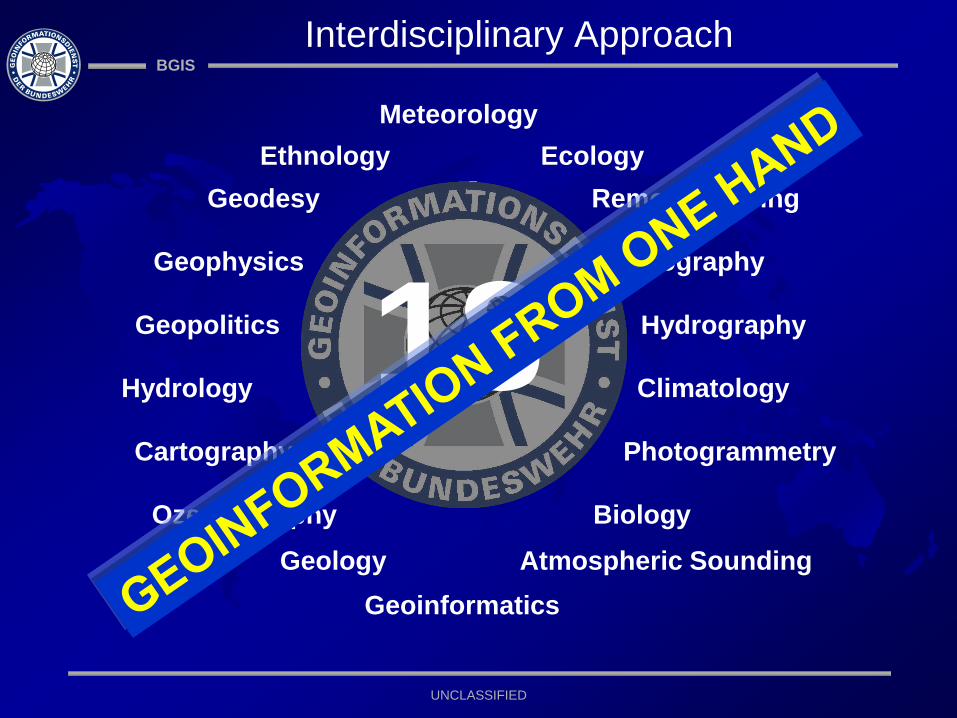
Terrain Analysis/
Data Management GeoInfo- Production Surveying
Establishing of the Theatre
Geospatial Database, Terrain
Analysis,
Production of GeoInfo-
Products
Surveying of airfields,
buildings,
Ground Control Information
Mass production
of products for the
theatre (reach back)
ISAF Geospatial Support Group (GSG)

BGIS
UNCLASSIFIED
Ref.: MC 0594 - Military Committee Policy on Meteorological and Oceanographic (METOC) Support to
NATO Forces
• IMETOC Concept was implemented in 2005, MC 0594 in 2011
• MC 0594 promulgates the guidance and the responsibilities of METOC
support to the full range of NATO operations, missions and all other NATO
activities
• IMETOC is to ensure provision of METOC support to fulfill joint and
combined users‘ requirements
• Most NATO Nations have dedicated Civil and/or military METOC
organizations, but the IMETOC Concept brings them together to ensure:
„ONE THEATRE,ONE FORECAST“
Integrated METOC (IMETOC) Support Concept

BGIS
UNCLASSIFIED
• Predefined responsibilities
• Limited national capacities to support all NATO operations, missions or
other activities Lead Nation Concept
• IMETOC Lead Nation (LN) is coordinator and provider of IMETOC
information
• Qualifying requirements of a prospective IMETOC LN sent out in
IMETOC Implementation Plan
• Assisting Nations (AN) assist the IMETOC LN with contributions
IMETOC
IMETOC
Lead Nation
ISAF
IMETOC
Lead Nations
NRF+
IMETOC
Lead Nation
BALK/MED
IMETOC
Lead Nation
Ocean Shield
USA FRA 2012 DEU GBR
e.g. by NATO OUP LYBIA DEU was according to the IMETOC Concept the LN.
Integrated METOC (IMETOC) Support Concept

BGIS
UNCLASSIFIED
2000+
20th Century
2010++
21st Century Requirements

BGIS
UNCLASSIFIED
2-D analogue
3-D small scaled
3-D large scaled
Interactive Simulation
Level of Detail
21st Century Requirements

BGIS
UNCLASSIFIED
Key Take Aways
Interdisciplinary Approach “a story of success”
Support to all Communities is key
Principle of Multinational Coordination
Future Challenges
BGIS
UNCLASSIFIED
The Bundeswehr Geoinformation Service
Questions?