BFS Technical Report 10 THE AQUATIC MACROPHYTES OF … · THE AQUATIC MACROPHYTES OF MADISON...
47
265 BFS Technical Report # 10 THE AQUATIC MACROPHYTES OF MADISON COUNTY: A PRELIMINARY SURVEY OF NINE SELECTED LAKES. SUBMITTED TO: Mr. SCOTT INGMIRE, PLANNER MADISON COUNTY County Office Building P.O. Box 606 Wampsville, NY 13163 SUBMITTED BY: WILLARD N. HARMAN MATTHEW F. ALBRIGHT SUNY ONEONTA BIOLOGICAL FIELD STATION 5838 State Highway 80 Cooperstown, NY 13326 February, 2001
Transcript of BFS Technical Report 10 THE AQUATIC MACROPHYTES OF … · THE AQUATIC MACROPHYTES OF MADISON...

265
BFS Technical Report # 10
THE AQUATIC MACROPHYTES OF MADISON COUNTY:
A PRELIMINARY SURVEY OF NINE SELECTED LAKES.
SUBMITTED TO:
Mr. SCOTT INGMIRE, PLANNER MADISON COUNTY
County Office Building P.O. Box 606
Wampsville, NY 13163
SUBMITTED BY:
WILLARD N. HARMAN MATTHEW F. ALBRIGHT
SUNY ONEONTA BIOLOGICAL FIELD STATION
5838 State Highway 80 Cooperstown, NY 13326
February, 2001

266
EXECUTIVE SUMMARY
During the ice-free season of2000, we surveyed the aquatic macrophytes! of nine selected lakes in Madison County, New York, in order to obtain a preliminary estimate ofthe distributions of the native and exotic plants in these waters and to assess herbivory on Myriophyllum spicatum, Eurasian water-milfoil (EWM). Additionally, two lakes, Lebanon Reservoir and Lower Leland Pond, received more detailed surveys. Table I (from the text) lists the environments studied, and some characteristics relevant to aquatic plant management while Table 2 identifies the specific locations of the lakes studied.
Table 1. Relevant characteristics of lakes studied. Lake Soil Surface Ca++ Secchi Trophic Regulated EWM3
Character1 Area2 mgll (m) Status Wetland2•3
(Hectares) Bradley Brook Deep glacial; 56 23.6 2.8 Eutrophic +
some fragipan. Eaton Reservoir Deep glacial; 100 24.1 5.6 Eutrophic +
fragipan. Hatch Lake Deep glacial; 54 28.5 4.6 Eutrophic +
fragipan. Lebanon Reservoir Deep glacial; 38 33.3 5.0 Eutrophic +
some fragipan. Lower Leland Pond Deep 22 79.4 2.6 Eutrophic +
glacialfluvial. Upper Leland Pond Deep 19 72.9 2.9 Eutrophic + +
glacialfluvial. Madison Lake Deep 17 49.3 4.8 Eutrophic
glacialfluvial. Tuscarora Lake Deep glacial; 128 29 2.0 Eutrophic +
some fragipan. Woodman Pond Deep 39 52.5 3.7 Eutrophic +
glacialfluvial.
Ifrom USDA, 1979. 2 from Ingmire, 2000. 3 Presence indicated by a "+".
Table 2. Locations oflakes studied (latitudes and longitudes) Bradley Brook Reservoir N42°49.910' W75 °39.251' Town of Eaton Eaton Reservoir N42°51.604' W75 °41.978' Towns of Eaton & Nelson Hatch Lake N42°50.059' W75°40.674' Town of Eaton Lebanon Reservoir N42°48.190' W75 °36.406' Town of Lebanon Lower Leland Pond N42°52.409' W75 °34.318' Town of Eaton Upper Leland Pond N42°52.768' W75 °34.339' Town of Eaton
! See Appendix B for definitions of technical terms.

267
Table 2. Continued. Madison Lake N42°54. 107' W75 °31.495' Town ofHamilton Tuscarora Lake N42°52.021 ' W75 °45.514' Town of Nelson Woodman Pond N42°51.182' W75 °34.115' Town of Eaton
Table 3 summarizes in more detail the physical and biotic nature of the waters studied that affect rooted macrophyte growth, and, therefore, provides insight for potential management strategies.
Table 3. Selected Madison County lakes indicating characteristics that affect rooted plant growth and, potentially, viable management strategies.
1 = Tributary Lakes (created by artificially dammed streams) 2 = Eutrophic Lakes 3 = Lakes with highly organic substrates or drainage areas (resulting in tea colored water) 4 = Hard water lakes 5 = Algae dominated lakes (where growth of rooted plants is inhibited by algal blooms) 6 = Macrophyte communities dominated by aggressive exotics 7 = Threatened by exotic introductions because ofunmonitored, easy access
Water Body 2 3 4 5 6 7
Bradley Brook Reservoir + + + Eaton Reservoir + + + Hatch Lake + + Lebanon Reservoir + + + + Lower Leland Pond + + + + + + Upper Leland Pond + + + + + Madison Lake + + Tuscarora Lake + + + Woodman Pond + + +
Aquatic plant management protocols should vary from one lake to another dependent on the expectations of the stakeholders and their concurrence regarding appropriate lake functions. Educational programs are recommended to assure that lake user expectations equal realistic plant management goals. Table 4 lists the water bodies investigated and suggests what we perceive as reasonable strategies based on our initial observations. As indicated, there may be a variety ofhistorical and cultural reasons to deviate from these suggestions. Table 4 includes only aquatic plant management goals that we believe are appropriate for each lake from an ecological perspective. Obviously, some sort of costlbenefit ratios must be developed in each case before resources are expended to attain the desired effects. Whole-lake management plans might also address many other important concerns that must be articulated with plant management goals, if reasonable results are to be obtained. We stand willing to provide more detailed suggestions for particular management situations when and if they are warranted.

268
Aerial photographs of these lakes at the height of the summer growing season would have facilitated our careful delineation of the extent of the aquatic plant beds. Unfortunately, such pictures were not feasible in 2000. Aerial photographs in July 200 I should correlate well with the distributions described in the text and figures and will provide an indication of the current distributions of rooted plants. All the hydrographic maps provided by Madison County (Ingmire, 2000) appeared to be accurate and are returned in this report as figures annotated with notes.
Table 4. Lakes correlated with commonly SOU2ht mana2ement 2oalsl. I = Reduction of nutrient loading 2 =Reduction of exotic rooted macrophyte biomass by harvesting 3 = Removal of rooted plants from navigation channels 4 = Protection from substrate disturbance from powerboats 5 = Protection from new exotic introductions2
6 = Hand harvesting by divers and benthic barriers to control/eliminate EWM 7 = Augmentation with weevils (Euhrychiopsis lecontei) 8 = Augmentation with moths (Acentria ephemerella) 9 =Winter drawdown to control rooted plant growth in shallow areas
Water Body 2 3 4 5 6 7 8 9
Bradley Brook Reservoir + + + +? + Eaton Reservoir + + + +? + Hatch Lake + + + Lebanon Reservoir + + + + + + Lower Leland Pond + + + + Upper Leland Pond + + + + + + Madison Lake + + + Tuscarora Lake + + +? + Woodman Pond +? + +
I In our professional opinions, actual goals should vary dependent on local conditions, historical utilization and interests, concerns and expectations of stakeholders. ? = potentially marginal concerns/solutions. 2Prophylactic measures to prevent introductions of a host of exotics such as zooplankton (e.g., spiny water-fleas [Bythotrephes cederstroemi]), zoobenthos (e. g., zebra mussels [Dreissena polymorphaDand fish (nekton) (e.g., alewives [Alosa pseudoharengusD, all of which are present in nearby lakes, are advisable for all waters. This table only considers the noxious plants mentioned.
Specific management suggestions are mentioned in the text where each environment is considered while our recommendation for herbivore augmentation is described in the "Discussion" section. The preliminary nature of these surveys should be taken into account when considering each recommendation. Local expectations, concerns, and goals as well as historical utilization, costlbenefit ratios and other whole lake management considerations must be factored in with all suggestions provided.

269
INTRODUCTION
The role of aquatic plants in freshwater lakes (modified from Harman, et al., 2000):
Practically all northeastern lakes support a diversity of large aquatic plants attached to the bottom (benthic macrophytes) which play an important role in maintaining the potable, recreational and aesthetic characteristics, as well as the ecological functioning of most lakes (Anon., 1990). These plants compete directly with algae in the water column (phytoplankton) for nutrients, thereby maintaining water clarity. They protect shorelines from erosion and stabilize deeper substrates limiting turbidity from silts and clays potentially mixable by physical disturbance. By preventing the resuspension of sediments which have nutrients adsorbed to them, algae growth is limited (Wetzel, 1983).
Macrophytes provide food and cover and/or supplement oxygen supplies for all of the organisms (i.e., fish, mammals, amphibians, reptiles and invertebrates) that make up shallow water (littoral) aquatic communities. They are the basis of aquatic food webs in these areas, providing indispensable links between the sun's energy and animals that eat plants which are, in turn, eaten by predators (Hutchinson, 1975). In these ways, plants regulate the size and character of game fish and waterfowl populations as well as impact other biotic resources we value.
In our region, there are a few introduced plant species (e.g., Eurasian water-milfoil [EWM; Myriophyllum spicatum], curly-leaved pondweed [Potamogeton crispus], and water chestnut [Trapa natans]) that aggressively out-compete our native flora in the presence of high nutrient loading. They destroy biodiversity causing the loss of some of the above-mentioned benefits. The dense beds commonly formed by these plants often reduce the recreational quality of lakes and are responsible for the great majority of the complaints heard from recreational lake users.
Aquatic plant management in the northeast (from Harman, et al., 2000):
Modem lake managers recognize the benefits of our native rooted plant communities and therefore, under all but emergency conditions, use techniques to control aggressive introductions while attempting to restore native plant diversity for its inherent values. Techniques can be divided into two types:
1. Those that improve the environment by minimizing nutrient loading, reducing littoral disturbance and preventing further introductions, and:
2. Those that directly impact plant populations.
Even aggressive exotics can become innocuous if cultural pollution (nutrient loading) is minimized. Whole lake and watershed management techniques to control runoff are

270
expensive, often politically charged, and must be seen as long-term investments. Nevertheless, they need to be addressed to assure unqualified success over time.
Introductions are most aggressive when native plants or substrates are disturbed. It is harder for exotics to achieve dominance if healthy natives already occupy a lake's bottom. Disturbance oflakeside lands also impacts littoral areas to the benefit of exotics directly by sediment deposition that reduces populations of native plants and indirectly by supplying associated nutrients. All things being equal, the fewer nutrients available for plant growth, the less plants will grow, reducing management problems. However, competitive interactions between planktonic algae and benthic plants may result in situations complicating management. If nutrients are available they will be utilized by algae or rooted macrophytes or some mix of the two. If rooted plants are completely removed, algae will grow unimpeded, clouding the water and inhibiting further macrophyte growth which results in destabilization of substrates and loss of food and cover for higher organisms. Therefore, efforts to manage non-native plants must be selective. When more exotic species are present, more extensive and costly management strategies are required. By far, most introductions to inland lakes have been traced to the activities of recreational navigation. Lakes with public access should have mechanisms in place to minimize new introductions.
Strategies directly impacting plant populations are normally categorized as: physical (e.g., harvesting, barriers placed on the bottom or water level manipulation), chemical (i.e., use of various herbicides) or biological (i.e., utilization of other organisms, usually herbivores). Based on the above discussion, it is assumed that lake management activities normally are directed at selected target species. It is neither feasible nor desirable to remove all plants from a body of water. However, if necessary, small areas such as channels and spaces around docks can be treated physically (barriers and hand pulling) for the convenience of individuals. Additionally, these same physical techniques can be used to manage EWM in a lake if undertaken early in an infestation (LaMere, 1999). In even more problematic situations mechanical harvesting on a larger scale may be necessary.
Several problems result from harve~ting and other means of physical removal of nuisance plants. Since the majority of exotic species are more competitive in disturbed situations, harvesting enhances exotic growth. Because harvesting is non-selective, native plants competing with the target species are also removed allowing exotics to grow even more vigorously. Additionally, herbivorous insects that potentially serve as natural biocontrol agents are removed, compounding the problem. Expenses increase since the more an area is harvested, the more it will need harvesting to assure trouble-free utilization of the site.
The use of herbicides has historically been an important tool in macrophyte control. Concerns with herbicides relate to their toxicity. They are poisons. All can kill non-target plants and many kill animals and can cause health problems to lake users. There are also a host of poorly understood, subtle and indirect effects on the biota, nutrient flow and food web relationships. Herbicides are available today that allow selective targeting of nuisance species. Sonar® (l-Methyl-3-phenyl-5-[-3(trifluoromethyl)phenyl]-4[IH]-pyridinane) is an example of a product that is used to control EWM while permitting most other plants to recolonize, re-establishing a

271
nearly complete native plant community. This, and similar products, must be carefully handled by permitted, professional applicators with an understanding of aquatic ecosystems. This is a matter of law for lakes "greater than one acre in size or with an outlet to surface waters" (NYSDEC, 2000a). Also, clearly specified targets should be part of plans developed with the involvement of affected stakeholders. There are still many problems to solve regarding maintenance of appropriate herbicide concentrations over time to attain control without killing non-target species.
Biological control protocols for aquatic plant management are just now being developed. They have great potential for ecologically friendly plant management. There is still more to learn, as agents become available for utilization. There are at least three native insect herbivores that can help control EWM in our lakes. Euhrychiopsis lecontei, the milfoil weevil, is present in most northeastern lakes and is being stocked to augment local populations in an attempt to control milfoil (Sheldon, 1997; Brandt, 2000). Acentria ephemerella, the milfoil moth, is being tested for similar use (Johnson, et al., 1998). Cricotopus myriophylli, the milfoil midge, is another organism that occurs naturally in our region (Fagnani and Harman, 1987) and attacks Eurasian milfoil in some situations (Macrae et al., 1990). These organisms, and others, may have a role in the reduction of milfoil allowing for the re-establishment of the native flora in the northern tier of the United States and Canada. Other organisms, such as East Asian grass carp, Ctenopharyngodon idella, have been used to good effect in some situations, particularly further south. Permitting issues often preclude their use in New York State (NYSDEC, 2000b).
Introductions of non-native herbivores often require permits in New York State. It should be recognized that in regulated wetlands, plant management activities of any kind require a permit from the NYS Department of Environmental Conservation and the US Army Corps of Engineers. Intensive monitoring to ascertain native herbivore damage and population densities should precede management decisions to implement plans for biocontrol introductions. To date, the evidence is tenuous that native herbivore populations, augmented or introduced, control target species reliably.
Efforts to manage aquatic macrophytf"s should be part of a coherent plan, no matter how informally documented. Involved groups need to precisely articulate goals and coordinate various activities. Physical control, herbicide use and biocontrol procedures are often incompatible and should not be used concurrently except under professional guidance.
Scope of work:
The SUNY Oneonta Biological Field Station (BFS) was contracted by Madison County to survey seven selected aquatic environments in the County to determine the assemblage ofplants comprising their aquatic plant communities and to perform a more detailed survey on one body of water that showed promise for treatment by herbivores to control Myriophyllum spicatum, Eurasian water-milfoil (EWM).

272
Methods:
We visited nine Madison County lakes during the months of May, June, July, and August 2000. Lakes were visited a variable number oftimes based on observations made. Mr. Scott Ingmire, Madison County Planner, provided initial points of contact for most of the lakes to facilitate our work. We visited each lake in either July or August, 2000 to determine macrophyte community makeup and to evaluate each for herbivore introductions. Depending on the size of the waters and available facilities, we used a canoe or a boat already on the lake. Using a boat already on the lake was preferred inasmuch as BFS canoes used would require disinfection by steam cleaning or with household bleach before and after immersion in each lake to prevent the spread of zebra mussels and other exotics. As it was, all other equipment and diver clothing was disinfected as we moved from lake to lake. Trips were arranged in such a way that when Eaton Reservoir was to be sampled, it was the last lake sampled on a trip, further reducing the chance of transporting zebra mussels from one lake to another.
Coastal Environmental Services, Inc. (undated) bathymetry maps, provided by the Madison County Planning Office (Ingmire, 2000), were used to annotate surface observations, plants found, and GPS data-points. The annotated maps are provided as figures throughout this report.
Aquatic macrophytes were identified with reference to Fassett (1972), Borman, et al. (1997), Hellquist and Crow (1980, 81, 82, 83, 84, 85), Ogden, et al. (1976), Brown (1979), and Schmidt and Kannenburg (1998), but our principal taxonomic authority was Crow and Hellquist (2000). Voucher specimens were collected for all lakes.
Species composition of Lebanon Reservoir and Lower Leland Pond macrophytes were determined by free divers through actual collection and estimation of amount the bottom covered (substrate percent cover per meter square) by each kind of plant (species). Eight transects were swum by divers in Lebanon Reservoir and five in Lower Leland Pond to characterize littoral vegetation. This enabled us to develop an understanding of the physical attributes (height, density, shape) of the plants in each community important to determine their value as cover for invertebrates, forage and game fish and to better understand littoral food web dynamics (ecosystem function) in the environments concerned. Plant community composition and relative dominance was described using six cover-abundance categories (0%-5%, 5%-25%, 25%-50%,50%-75%,75%-95%, and 95%-100%) for depths of one half, one, two, three, four and five meters (if water depth was that deep). Since many species are able to use near 100% of the substrate for their needs concurrently with other species, total percentages per area may exceed 100%.
Myriophyllum spicatum, Eurasian water-milfoil (EWM) was carefully examined in each lake in which it was found. Initially EWM at or near the surface was viewed macroscopically for signs of herbivory and for herbivores. Then stems of at least 25 cm were harvested blindly, i.e., selected from the basal end of the stem, which had been raked off the bottom, and then followed up to the tip before trimming that stem back to the desired length from the tip. The number of stems collected from each lake varied from 50 stems (Lower
273
Leland Pond} to nine stems (Tuscarora Lake) reflecting our initial determination of the potential for amelioration by the introduction of herbivores (based on our nonrandom macroscopic examination of the EWM). Stems were maintained under refrigeration until surveyed under a
dissection microscope. Plant and insect characteristics listed in Appendix A were used to identify insects and damage caused by the insects.
THE LAKES SURVEYED
Distribution and limnology
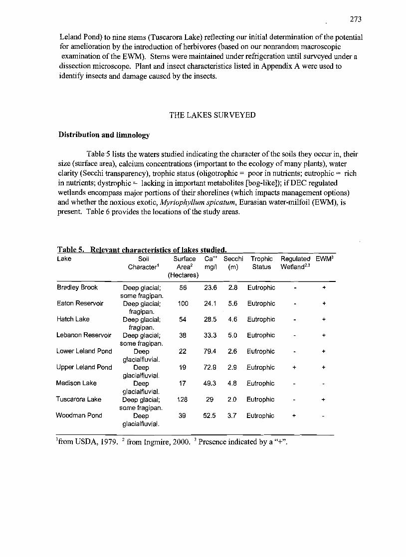
Table 5 lists the waters studied indicating the character of the soils they occur in, their size (surface area), calcium concentrations (important to the ecology of many plants), water clarity (Secchi transparency), trophic status (oligotrophic = poor in nutrients; eutrophic = rich in nutrients; dystrophic = lacking in important metabolites [bog-like]); if DEC regulated wetlands encompass major portions of their shorelines (which impacts management options) and whether the noxious exotic, Myriophyllum spicatum, Eurasian water-milfoil (EWM), is present. Table 6 provides the locations of the study areas.
Table 5. Relevant characteristics of lakes studied. Lake Soil Surface Ca++ Secchi Trophic RegUlated EWM3
Character1 Area2 mgtl (m) Status Wetland2,3
(Hectares)
Bradley Brook Deep glacial; 56 23.6 2.8 Eutrophic +
some fragipan. Eaton Reservoir Deep glacial; 100 24.1 5.6 Eutrophic +
fragipan. Hatch Lake Deep glacial; 54 28.5 4.6 Eutrophic +
fragipan. Lebanon Reservoir Deep glacial; 38 33.3 5.0 Eutrophic +
some fragipan. Lower Leland Pond Deep 22 79.4 2.6 Eutrophic +
glacialfluvial. Upper Leland Pond Deep 19 72.9 2.9 Eutrophic + +
glacialfluvial. Madison Lake Deep 17 49.3 4.8 Eutrophic
glacialfluvial. Tuscarora Lake Deep glacial; 128 29 2.0 Eutrophic +
some fragipan. Woodman Pond Deep 39 52.5 3.7 Eutrophic +
glacialfluvial.
1from USDA, 1979. 2 from Ingmire, 2000. 3 Presence indicated by a "+".

274
Table 6. Locations of waters studied (Latitudes and loniitudes) Bradley Brook Reservoir N42°49.910' W75°39.251' Town of Eaton Eaton Reservoir N42°51.604' W75 °41.978' Towns of Eaton & Nelson Hatch Lake N42°50.059' W75 °40.674' Town of Eaton Lebanon Reservoir N42°48.190' W75 °36.406' Town ofLebanon Lower Leland Pond N42°52.409' W75 °34.318' Town of Eaton Upper Leland Pond N42°52.768' W75 °34.339' Town of Eaton Madison Lake N42°54.l07' W75°31.495' Town of Hamilton Tuscarora Lake N42°52.021' W75 °45.517' Town of Nelson Woodman Pond N42°51.182' W75°34.1l5' Town of Eaton
Bradley Brook Reservoir:
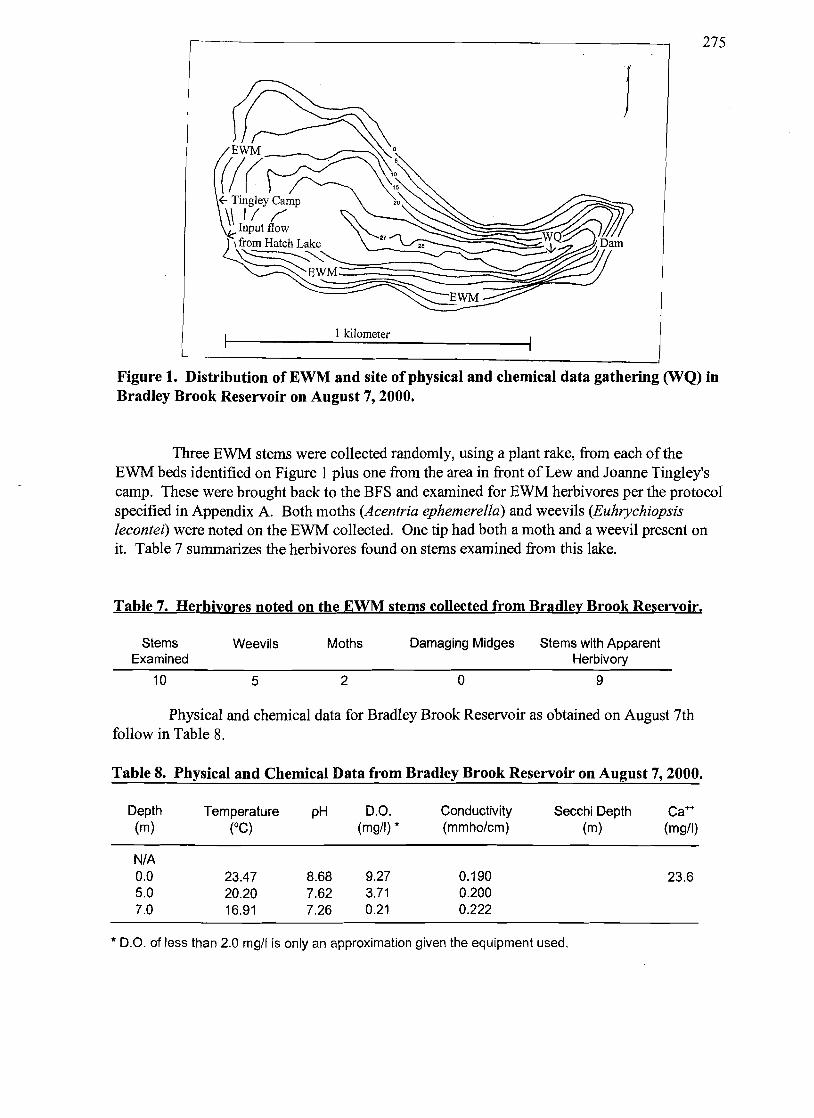
Bradley Brook Reservoir is located in the Town of Eaton (N42°49.91O', W75°39.25I') and is downstream from Hatch Lake to which it is connected by a short stream. It has a surface area of approximately 56 hectares (137 acres) and a maximum depth of 8.5 meters (27.9 feet). We visited on August 7th at which time the Secchi depth was 2.8 meters. Myriophyllum spicatum, Eurasian water-milfoil (EWM) grows over a substantial portion of the lake's perimeter, but without recreation impairing density or canopies. Colonel and Mrs. Lew Tingley made our survey on this lake possible by the access and boating support provided.
Figure 1 is a map ofthe lake showing the locations of the densest beds ofEWM approaching the surface. Also present was the non-canopy forming native, Myriophyllum sibiricum, northern water-milfoil (NWM). Cattails (Typha sp.) and some smartweed (Polygonum sp.) occupied the shorelines. There were no floating leafed pondweeds (e.g., water shield [Brasenia schreberi], bullhead lily [Nuphar sp.] or fragrant water lily [Nymphaea odorataJ) present. There was a diverse mix of native submerged aquatic plants present. These included clasping-leaved pondweed (Potamogeton richardsonii), leafY pondweed (Potamogeton epihydros), flat-stemmed pondweed (Potamogeton zostriformis), large-leave pondweed (Potamogeton amplifolius), coontail (Ceratophyllum echinatum and C. demersum), water stargrass (Zosterella dubia), waterweed (Elodea canadensis), tape-grass (Vallineria americana), slender water nymph (Najasflexilis), white water-crowfoot (Ranunculus trichophyllus), and stonewort (Nitella sp.).
Table 6. Latitude and longitude of Bradley Brook Reservoir collection sites noted in Figure 1.
Site Activity Location Dam GPS reference point
WQ Water quality data collected
275
J
1 kilometer
Figure 1. Distribution ofEWM and site of physical and chemical data gathering (WQ) in Bradley Brook Reservoir on August 7, 2000.
Thee EWM stems were collected randomly, using a plant rake, from each of the EWM beds identified on Figure I plus one from the area in front of Lew and Joanne Tingley's camp. These were brought back to the BFS and examined for EWM herbivores per the protocol specified in Appendix A. Both moths (Acentria ephemerella) and weevils (Euhrychiopsis lecontei) were noted on the EWM collected. One tip had both a moth and a weevil present on it. Table 7 summarizes the herbivores found on stems examined from this lake.
Table 7. Herbivores noted on the EWM stems collected from Bradley Brook Reservoir.
Stems Weevils Moths Damaging Midges Stems with Apparent Examined Herbivory
10 5 2 o 9
Physical and chemical data for Bradley Brook Reservoir as obtained on August 7th follow in Table 8.
Table 8. Physical and Chemical Data from Bradley Brook Reservoir on August 7, 2000.
Depth Temperature pH D.O. Conductivity Secchi Depth Ca++ (m) (0C) (mgtl) * (mmhotcm) (m) (mgtl)
NtA 0.0 23.47 8.68 9.27 0.190 23.6 5.0 20.20 7.62 3.71 0.200 7.0 16.91 7.26 0.21 0.222
* D.O. of less than 2.0 mgtl is only an approximation given the equipment used.

276
Given the large number of herbivores in Bradley Brook Reservoir and the presence of NWM along with the EWM, consideration should be given to implementing a program of EWM control using divers and barriers to physically remove and smother small beds and larger beds ofEWM respectively.
Eaton Reservoir:
Eaton Reservoir (N42°S1.604', W7So41.978'), whose shoreline is shared by the towns of Nelson and Eaton, is the one lake surveyed in this effort which is now infested with zebra mussels (Dreissena polymorpha). In spite of the fact that the infestation was just beginning when we first visited (as was determined by the consistently small size of all specimens encountered), the water clarity was notable (approximately five meters). The Reservoir was visited in early June and on August 10th. The maximum depth located was 13 meters (42.S feet) while the surface area is approximately 100 hectares (about 247 acres). Access on the first visit was via the NYSDEC maintained boat ramp, while access was provided for the second visit through the generosity of Mr. and Mrs. Art Burmaster.
The most commonly found plant was waterweed (Elodea canadensis). An exotic submerged pondweed, curly-leaved pondweed (Potamogeton crispus), was particularly evident in the June visit and rarely seen in the second visit, which is typical of this species' growing pattern in this latitude. An aggressive exotic, Myriophyllum spicatum, Eurasian water-milfoil (EWM), was found along with its non-canopy fonning native relative, Myriophyllum sibiricum, northern water-milfoil (NWM). Muskgrass (Chara sp.), stonewort (Nitella sp.), coontail (Ceratophyllum demersum), pusillus pondweed (Potamogeton pusil!us), and flat-stemmed pondweed (Potamogeton zostriformis) were all evident. Additionally, tape grass (Vallisneria americana), coontail (Ceratophyllum demersum), large-leaved pondweed (Potamogeton amplifolius), slender water nymph (Najasjlexilis), white water-crowfoot (Ranunculus trichophyllus), and the fragrant water lily (Nymphaea odorata). Cattails (Typha sp.), an aster (Aster sp.), and some purple loosetrife (an exotic; Lythrum salicaria) were found along the lake's edge.
Figure 2 is a map of the Reservoir showing the densest beds ofEWM. GPS coordinates for location sites are listed in Table 9.
Table 9. Latitude and loni:itude of Eaton Reservoir collection sites noted on Fii:ure 2.
Site Reservoir Center
Activity GPS location point
Location N42°S1.604', W7S041.978'
NW cove
Proximate SW Pond
Surface observations; Location with both milfoils Reportedly with dense EWM
N42°52.016', W7S042.639'
N42°S1.0IT, W7S042.435'

277
Table 9. Continued
WQ Water quality data collected
Dam GPS location point
/
1 kilometer
Figure 2. Distribution ofEWM and Northern Water-milfoil (NWM) and site of physical and chemical data gathering (WQ) in Eaton Reservoir on August 10,2000.
Ten EWM stems were collected randomly from various points in the reservoir during the August trip. These were brought back to the BFS and examined for EWNI herbivores per the protocol specified in Appendix A. No live moths (Acentria ephemerella) or weevils (Euhrychiopsis lecontei) were noted on the EWM collected although damage from the weevil was evident and both insect species were observed to be present in the lake from the examination of other stems collected. (The results of the random tip survey are believed to be a vagary of the small sample size used.) One specimen of the milfoil midge (Cricotopus myriophylli) was identified on the randomly collected stems. Table IO summarizes the herbivores found on randomly collected stems examined from Eaton Reservoir.
Table 10. Herbivores noted on the EWM sterns collected from Eaton Reservoir.
Stems Weevils Moths Damaging Midges Stems with Apparent Examined Herbivory
10 o o 1 7

278
Physical and chemical data for Eaton Reservoir as obtained on August 10th follow in Table 11.
Table 11. Physical and chemical data from Eaton Reservoir on AU2ust 10, 2000.
Depth Temperature pH D.O. Conductivity Secchi Depth Ca++
(m) (DC) (mgtl) * (mmhotcm) (m) (mgtl)
NtA 5.6 0.0 23.82 8.46 8.89 0.146 24.1 5.0 22.51 8.23 8.55 0.147 7.0 17.49 7.36 5.37 0.149 8.0 14.67 7.09 2.38 0.152 10.0 10.47 6.92 0.23 0.164 11.0 10.01 6.89 0.10 0.168
* D.O. of less than 2.0 mgtl is only an approximation given the equipment used.
The presence of the native water-milfoil as well as the large aquatic plant biomass comprised ofwaterweed pose issues for the use of the most popular EWM herbicide, Fluridone (widely sold as SONAR®). Fluridone will kill both NWM and waterweed. Eliminating NWM will eliminate two of the three EWM herbivores recognized as potentially controlling while killing the waterweed will leave vast areas of the lake's bottom without cover, facilitating substrate mixing with the water and the subsequent growth ofplanktonic algae which will reduce water clarity.
Hatch Lake:
Hatch Lake, in the Town of Eaton (N42°50.059' W75 °40.674'), feeds Bradley Brook Reservoir to which it is connected by a short stream. This private lake (no NYSDEC boat launch ramp) features good plant diversity and is about 54 hectares (135 acres). Various residents reported that it was stocked with bass, cisco, northern pike, and walleye. Plants in Hatch Lake were reportedly last harvested in 1997 (Tingley, 2000). The deepest area of the lake was sought to validate the bathymetric map provided by Madison County (Ingmire, 2000). Because ofa stiff wind and inadequate anchoring, the deepest area found was about 18 meters (60 feet). We visited on August 7th at which time our trip was facilitated by Mr. Lew Tingley and by Mr. Al Carpenter.
Figure 3 is a map of the lake showing the locations of the densest beds of Myriophyllum spicatum, Eurasian water-milfoil (EWM), approaching the surface. No surface canopies were present although they were reportedly present for a short period earlier in the season. Also present was the non-canopy forming native, Myriophyllum sibiricum, northern water-milfoil (NWM). The shorelines are occupied by cattail (Typha sp.). There were no floating leafed pond weeds (e.g., water shield [Brasenia schreberi], bullhead lily [Nuphar sp.] or fragrant water lily [Nymphaea odorata]) noted. There were, however, numerous submergent plants present: water star-grass (Zosterella dubia), pusillus pondweed (Potamogeton pusillus),

279
flat-stemmed pondweed (Potamogeton zosteriformis), slender water nymph (Najasjlexilis), coontail (Ceratophyllum demersum), white water-crowfoot (Ranunculus trichophyllus), tape grass (Vallisneria americana), muskgrass (Chara sp.), and waterweed (Elodea canadensis) as well as EWM and NWM. The milfoil weevil (Euhrychiopsis lecontei) extensively mined the EWM present.
J
1kilometer
Figure 3. Distribution of EWM and site of physical and chemical data gathering (WQ) in Hatch Lake on August 7,2000.
Table 12. Latitude and longitude of Hatch Lake collection sites noted in Figure 3.
Site Activity Location WQ Water quality N42°50.059', W75 °40.674'
data gathered
Three EWM stems were collected randomly, using a plant rake, from each of the EWM beds identified in Figure 3 plus one from the area in front of the camp run by Mr. Al Carpenter. These were brought back to the BFS and examined for EWM herbivores per the protocol specified in Appendix A. Both moths (Acentria ephemerella) and a weevil (Euhrychiopsis lecontei) were noted on the EWM collected. Table 13 summarizes the herbivores found on stems examined from this lake.

280
Table 13. Herbivores noted on the EWM stems collected from Hatch Lake.
Stems Weevils Moths Damaging Midges Stems with Apparent Examined Herbivory
10 1 3 o 8
Physical and chemical data for Hatch Lake as obtained on August 7th follow in Table 14.
Table 14. Physical and chemical data from Hatch Lake on August 7, 2000.
Depth (m)
Temperature (DC)
pH D.O. (mgtl) *
Conductivity (mmhotcm)
Secchi Depth (m)
CaH
(mgtl)
NtA 0 5 10
16.7
22.63 17.88 7.34 5.97
8.64 8.74 7.39 6.88
9.03 11.42 1.32 0.04
0.176 0.177 0.184 0.196
4.6 28.5
* D.O. of less than 2.0 mgtl is only an approximation given the equipment used.
Lebanon Reservoir:
Lebanon Reservoir is an artificial impoundment located in the Town of Lebanon, (N42°48.190', W75°36.406') which drains into Kingsley Brook. The surface area is about 38 hectares (93 acres). The deepest area is about 13.7 meters (45 feet) (Coastal Environmental Services, Inc., undated). We visited on May 7th, May 31 st, June 20th, July 3d, and August 10th. The Secchi transparency was 4.0 meters (13.1 feet) on June 20th and 5.0 meters (16.4 feet) on August 10th. We accessed the lake through the properties of various residents and camp owners and were provided boating services by Mr. Art Lehnery.
Emergent vegetation present included the water smartweed (Polygonum amphibium), purple loosestrife (Lythrum salicaria), arrowhead (Sagittaria sp.), and cattail (Typha spp.). Submergent species grew to a depth of three meters (about 16') and were represented by waterweed (Elodea canadensis), coontail (Ceratophyllum demersum), flat-stemmed pond weed (Potamogeton zosteriformis), muskgrass (Chara sp.), slender water nymph (Najas flexilis) , sago pond-weed (Stuckenia pectinata), water star-grass (Zosterella dubia), white water-crowfoot (Ranunculus trichophyllus), and tape-grass (Vallisneria americana) as well as two exotics, curly-leaved pondweed (Potamogeton crispus) and the aggressive exotic, Myriophyllum spicatum, Eurasian water-milfoil (EWM). Aquatic plant distributions and densities as found on July 3rd are summarized in Table 15.

281
surface
T4 :s:lt
GPS coordinates for location sites are listed in Table 16. Our diver swam eight transects from points indicated in Figure 4 towards the center of the lake.
Input f1ow~
T8~~ j
1 kilometer
Figure 4. Distribution of EWM and site of physical and chemical data gathering (WQ) in Lebanon Reservoir on July 3,2000.
Table 15. Aquatic macrophyte species present in Lebanon Reservoir in 2000 (see text, p. 15).
Depth: Y2 1 2 3 4 5
Transect #1: South edge ofdam towards center lake
Myriophyllum spicatum Ceratophyllum demersum Stuckenia pectinata Vallisneria americana
25-50% 5-25% 50-75%
0-5% 5-25%
75-95% 25-50% 0-5%
75-95% 50-75%

282
Table 15. Continued.
Depth: 1/2 1
Transect #2: "25 mph" sign towards center lake
Myriophyllum spicatum Najas flexilis Stuckenia pectinata Vallisneria americana
0-5%
0-5%
2
25-50% 0-5% 5-25% 5-25%
3
5-25% 5-25%
5-25%
4
5-25%
5
0-5%
Transect #3: Red shack towards center lake
Myriophyllum spicatum Potamogeton zosteriformis Stuckenia pectinata Vallisneria americana
95-100% 50-75% 0-5% 0-5% 5~5%
50-75%
5~5%
50-75%
5~5%
50-75% 50-75%
Transect #4: Campground towards center lake
Myriophyllum spicatum Ceratophyllum demersum Najas flexilis Potamogeton crispus Stuckenia pectinata Vallisneria americana Elodea canadensis
25-50%
5-25% 0-5%
5-25% 0-5%
75-95% 0-5% 0-5%
5-25%
50-75%
5-25%
50-75% 50-75%
Transect #5: Almas camp (Box 289c) towards center lake
Myriophyllum spicatum Potamogeton zosteriformis Stuckenia pectinata Vallisneria americana Najas flexilis Zosterella dubia Chara sp.
0-5%
0-5% 0-5% 0-5%
50-75% 5-25%
5-25%
5-25%
75-95%
0-5%
0-5%
50-75% 25-50%
Transect #6: Boat ramp towards center lake
Myriophyllum spicatum Elodea canadensis Potamogeton crispus Potamogeton zosteriformis
0-5%
0-5% 0-5%
25-50% 25-50% 0-5% 0-5%
75-95%
0-5%
50-75% 50-75%

283
Table 15. Continued.
Depth:
Stuckenia pectinata Vallisneria americana Najas flexilis Chara sp. Ceratophyllum demersum Polygonum amphibium
1/2
5-25%
1
25-50% 5-25% 25-50%
2
25-50% 5-25% 5-25%
3
0-5%
0-5%
4
0-5%
5
Transect #7: 1680 Private Drive #29 towards center lake
Myriophyllum spicatum Vallisneria americana Ceratophyllum demersum Polygonum amphibium
0-5% 50-75% 0-5%
75-95% 5-25%
75-95% 5-25%
75-95% 50-75%
0-5%
Transect #8: Beaver dammed creek feeding lake towards center lake
Myriopf.yllum spicatum 0-5% 75-95% 25-50% 75-95% 5-25% Potamogeton crispus 0-5% 5-25% 5-25% Stuckenia pectinata 25-50% Ceratophyllum demersum 50-75% Typha sp. 5-25% Ranunculus trichophyllus 5-25% Lythrnm salicaria
Table 16. Latitude and longitude of Lebanon Reservoir collection sites noted on Figure 4.
Site number Activity Location Tl Access; free diving
surface observations; start of transect #1.
T2 Access; free diving surface observations; start of transect #2.
T3 Access; free diving surface observations; start of transect #3.
T4 Access; free diving surface observations; start of transect #4.

284
Table 16. Continued.
T5 Access; free diving surface observations; start of transect #5.
T6 Access; free diving surface observations; start of transect #6.
T7 Access; free diving surface observations; start of transect #7.
T8 Access; free diving surface observations; start of transect #8.
CI Center of lake
WQ Water quality data collection
On July 3d, ten EWM stems were collected randomly (nine in one location), by a diver using a plant rake, from each of five of the transects previously identified (TI, T3, T4, T6, and T7). These were brought back to the BFS and examined for EWM herbivores per the protocol specified in Appendix A. Both a EWM moth (Acentria ephemerella) and a EWM midge (Cricotopus myriophylli) were noted on the EWM collected. Table 17 summarizes the herbivores found on sterns examined from this lake. While few herbivores were found in the samples collected, no samples were collected from the north-northwest bay (the bay with T8). While, in previous summers, the EWM in Lebanon Reservoir had been harvested regularly throughout the rest of the lake (which we assume accounts for the low herbivore numbers), this bay had not been harvested. The EWM in this bay was at the surface on 3 July, however, it was reduced to mere fragments in the bay by late July. Non random samples ofEWM taken in other locations after this EWM "crash" revealed a healthy population ofEWM weevils (Euhrychiopsis lecontei) which presumably migrated from this NNW bay after eliminating the EWM biomass in that bay.
Table 17. Herbivores noted on the EWM stems collected from Lebanon Reservoir.
Stems Weevils Moths Damaging Midges Stems with Apparent Examined Herbivory
49 o 1 1 10
Physical and chemical data for Lebanon Reservoir as obtained on August 10th follow in Table 18.

285
The EWM in Lebanon Reservoir could potentially be controlled with herbivores. A specific recommendation for augmentation ofexisting populations is included in the "Discussion" section of this Report.
Table 18. Physical and Chemical Data from Lebanon Reservoir on AU2ust 10, 2000.
Depth Temperature pH D.O. Conductivity Secchi Depth Ca++ (m) (DC) (mg/I) * (mmho/cm) (m) (mg/I)
N/A 5.0 0 23.97 8.61 8.96 0.193 33.3 5 15.48 7.94 9.94 0.202 6 13.32 8.00 10.00 0.200 7 11.02 7.09 2.47 0.201 10 7.87 7.08 0.19 0.199
13.0 6.92 6.92 0.14 0.198
* D.O. of less than 2.0 mg/I is only an approximation given the equipment used.
Lower Leland Pond:
Lower Leland Pond results from the dam on its southwest comer which appears to have consolidated two smaller bodies of water which are now represented by deep spots in this lake. It is also connected to Upper Leland Pond by a culvert under County Route 26. It is located in the Town ofEaton, (N420 52.409', W750 34.3l8') and drains directly into the canal system. The surface area is about 22 hectares (about 53 acres). The deepest area ofthis so-called "Pond" is a little more than 12 meters (40 feet) (Coastal Environmental Services, undated). It is, in fact, a lake. We visited on multiple occasions in August, 2000. The Secchi transparency was 2.6 meters (about 8 feet). We accessed the lake through the property ofMr. Bob Milner.
The emergent vegetation included water smartweed (Polygonum amphibium), cattail (Typha sp.), spike-rush (Eleocharis sp.) and water cress (Nasturtium sp.). Submergent species were diverse and grew to depths varying with location. Floating leaved submergents included both the white and yellow pond lilies (Nuphar variegata and Nymphaea odorata respectively) and American pondweed (Potamogeton nodosus). The true submergents were represented by flat-stemmed pond weed (Potamogeton zosteriformis), large-leaved pondweed (Potamogeton amplifolius), Illinois pondweed (Potamogeton illinoensis), variable pondweed (Potamogeton gramineus), muskgrass (Chara sp.), slender water nymph (Najasflexilis), sago pond-weed (Stuckenia pectinata), water star-grass (Zosterella dubia), bladderwort (Utricularia sp.), white water-crowfoot (Ranunculus trichophyllus), and tape-grass (Vallisneria americana) as well as the aggressive exotic, Myriophyllum spicatum, Eurasian water-milfoil (EWM). See Figure 5 and Table 19.
GPS coordinates for location sites are listed in Table 18. We swam five transects as described in Table 19 and delineated on Figure 5.

286
Table 19. Aquatic macrophyte species and their percent cover present in Lower Leland Pond in 2000 (see text, p. 20).
Depth: Y2 1 2 3 4 5
Transect #1: Milner Camp towards 35' depth
Chara sp. Myriophyllum spicatum Najas jlexilis Nuphar variegata Polygonum amphibium Potamogeton illinoensis Potamogeton natans Stuckenia pectinata Nasturnium sp. Vallisneria americana
75-95% 0-5% 5-25% 5-25% 5-25% 5-25% 5-25% 5-25% 0-5% 5-25% 5-25%
0-5% 0-5% 0-5%
0-5% 0-5%
0-5% 0-5%
Transect #2: Strong Camp to Milner Camp towards 35' depth
Chara sp. Myriophyllum spicatum Najas jlexilis Nuphar variegata Potamogeton amplifolius Potamogeton illinoensis Stuckenia pectinata Nasturnium sp. Vallisneria americana
5-25% 75-95% 5-25% 25-50% 75-95% 25-50% 0-5%
0-5% 0-5% 0-5% 0-5% 0-5% 0-5% 0-5% 0-5%
Transect #3: Joyce Camp towards 35' depth
Myriophyllum spicatum Najas jlexilis Potamogeton amplifolius Potamogeton illinoensis Stuckenia pectinata Vallisneria americana
0-5% 25-50% 0-5% 25-50% 25-50% 0-5% 0-5% 0-5% 5-25% 5-25% 0-5%
0-5% 5-25% 0-5% 0-5% 0-5% 0-5% 0-5% 5-25% 0-5%

287
Table 19. Continued.
Depth: Y2 1 2 3 4 5
Transect #4: Joyce Trailer towards island
Myriophyllum spicatum Najas flexilis Potamogeton amplifolius Potamogeton illinoensis Stuckenia pectinata Potamogeton zosteriformis Typha sp. Vallisneria americana
5-25% 0-5%
0-5%
5-25% 50-75%
5-25% 5-25%
5-25% 0-5%
75-95%
50-75% 25-50% 5-25% 0-5%
0-5%
0-5%
Transect #5: Grey Blockhouse towards 40' depth
Chara sp. Eleocharis sp. Myriophyllum spicatum Najas flexilis Nuphar variegata Nymphaea odorata Polygonum amphibium Potamogeton illinoensis Stuckenia pectinata Potamogeton zosteriformis Ranunculus trichophyllus Utricularia sp. Vallisneria americana Zosterella dubia
50-75% 0-5% 0-5% 0-5%
25-50% 0-5%
0-5%
0-5%
75-95%
0-5% 0-5% 0-5% 25-50%
0-5%
0-5% 0-5%
25-50%
5-25% 5-25%
0-5%
0-5% 0-5% 5-25% 0-5%
5-25% 0-5%
25-50%
0-5%
0-5%
0-5%
Table 20. Latitude and lonl:itude of Lower Leland Pond collection sites noted on Fil:ure 5.
Site Activity Location Milner Camp Waterfront
Strong Camp Waterfront
Joyce Camp Waterfront
Access; free diving; surface observations; start of transect #1. Free diving; surface observations; start of transect #2. Free diving; surface observations; start of transect #3.

288
Table 20. Continued.
Island Collection Site Free diving; surface observations.
Joyce Trailer Waterfront Free diving; surface observations; start of transect #4.
Grey Blockhouse Free diving; Waterfront surface observations;
start of transect #5. WQ Physical and chemical
data collection
The submerged macrophyte community in Lower Leland Pond was notable in that it was the only lake in which we observed EWM flowering in the summer of 2000. While this would appear to indicate a relatively robust, healthy population of EWM, examination of stems from differing locations on the lake revealed the presence of both herbivorous weevils (Euhrychiopsis lecontei) and moths (Acentria ephemerella). On August 16th, ten EWM stems were collected randomly, using a plant rake, from each of four transects (Transects 2,3,4 and 5) and from the island collection site. These were brought back to the BFS and examined for EWM herbivores per the protocol specified in Appendix A. Table 21 summarizes the herbivores found on stems examined from this lake.
Table 21. Herbivores noted on the EWM stems collected from Lower Leland Pond.
Stems Weevils Moths Damaging Midges Stems with Apparent Examined Herbivory
50 7 3 o 16
Physical and chemical data for Lower Leland Pond as obtained on August 11 th follow in Table 22.
Table 22. Physical and Chemical Data from Lower Leland Pond on Au~ust 11, 2000.
Depth (m)
Temperature (DC)
pH D.O. (mgtl) *
Conductivity (mmhotcm)
Secchi Depth (m)
Ca++
(mgtl)
NtA 0 5 6 10
13.3
25.26 11.15 8.20 5.47 5.30
8.30 7.69 7.24 7.12 7.05
9.05 6.39 0.58 0.18 0.13
0.426 0.449 0.451 0.455 0.458
2.55 79.4
* D.O. of less than 2.0 mgtl is only an approximation given the equipment used.

289
Input flow
W \
surface & flowering
JOY~ Camp Joyce
'Trailer
0.5 kilometer
Figure 5. Distribution of EWM and site of physical and chemical data gathering (WQ) in Lower Leland Pond during August 2000. Arrows with locations describing transect origins show directions of transects.
Upper Leland Pond:
Upper Leland Pond is a unique lake in that it exhibits the brown water typically associated with dystrophic (acidic) bodies of water while maintaining a neutral to high pH (7.08 to 8.30 on August 10th) and high calcium levels as evidenced by significant precipitate on its aquatic plants. Upper Leland Pond is located in the Town of Eaton, (N42052.768', W75034.339') and drains directly into Lower Leland Pond via a culvert under County Route

290
26. The surface area is about 19 hectares (about 47 acres). The deepest area is a little more than 15 meters (50 feet) (Coastal Environmental Services, Inc., undated). We visited on multiple occasions in August 2000. The Secchi transparency was 2.9 meters (a little over nine feet) on August 10th
• On each visit we accessed the lake through the property of Mr. John Borst who also provided us canoeing services.
The emergent vegetation was represented by cattails (Typha sp.), water-starwort (Callitriche sp.), arrowhead (Sagittaria sp.), pickeral weed (Pontederia cordata), and spike-rush (Eleocharis sp.) while floating leaved aquatic plants were well represented by yellow waterlily (Nuphar variegata), fragrant waterlily (Nymphaea odorata), and great duckweed (Spirodela polyrhiza). Submergent species were diverse and included bladderwort (Utricularia sp.) which is typically associated with brown waters as well as several pondweeds: variable pondweed (Potamogeton gramineus), hybridized variable-Illinois pondweed (Potamogeton gramineusIllinoensis), sago pondweed (Stuckenia pectinata), common water nymph (Najas guadalupensis), tape-grass (Vallisneria americana), water star-grass (Zosterella dubia), as well as the macroalgae muskgrass (Chara sp.), and the aggressive exotic, Myriophyllum spicatum, Eurasian water-milfoil (EWM), along with its non-canopy forming native relative, Myriophyllum sibiricum, northern water-milfoil (NWM). Patches ofEWM are noted on Figure 6. GPS coordinates for location sites are listed in Table 21.
Input flow
-.It
J
~Outflow to Leland Pond Lower
0.5 kilometer
>-------------------.-:..--_--1 Figure 6. Distribution of EWM and Northern Water-milfoil (NWM) and site of physical and chemical data gathering (WQ) in Upper Leland Pond during August 2000.

291
Table 23. Latitude and loneitude of Upper Leland Pond collection sites noted on Fieure 6.
Site Activity Location WQ Water quality
data collection. Culvert CuIvert to Lower Leland
Pond.
The submerged macrophyte community in Upper Leland Pond was notable in that camp residents first observed EWM to threaten the recreational quality of their lake in the summer of 2000. In the past, little or no EWM was noted. Our sampling revealed the presence of NWM as well as the presence of herbivorous weevils (Euhrychiopsis lecontei) and moths (Acentria ephemerella). On August 7ili
, ten EWM stems were collected randomly, using a plant rake, from around the periphery of the lake. These were brought back to the BFS and examined for EWM herbivores per the protocol specified in Appendix A. Table 24 summarizes the herbivores found on stems examined from Upper Leland Pond.
Table 24. Herbivores noted on the EWM stems collected from Upper Leland Pond.
Stems Weevils Moths Damaging Midges Stems with Apparent Examined Herbivory
10 4 4 o 9
Physical and chemical data for Upper Leland Pond as obtained on August 10th follow in Table 25.
•Table 25. Physical and Chemical Data from Upper Leland Pond on August 10, 2000.
Depth Temperature pH D.O. Conductivity Secchi Depth Ca++
(m) (DC) (mg/I) * (mmho/cm) (m) (mg/I)
N/A 2.85 0 26.00 8.30 9.51 0.459 72.9 5 9.74 7.39 2.17 0.468 10 6.00 7.11 0.19 0.468 14 5.88 7.08 0.10 0.466
* D.O. of less than 2.0 mg/l is only an approximation given the equipment used.
Madison Lake:
Madison Lake (N42D54.1 07'; W75D31.495') is a gem of a lake located in the Town of Madison not far enough away from NYS Route 20 to escape the sounds of traffic from that

292
road. Its proximity to this major roadway makes the lack of exotic plants remarkable. It is bordered by a significant, but unregulated, wetland on the southwest and has a reported depth in excess of23 meters (75 feet). The deepest location that we measured was 22.5 meters (74 feet) deep on this approximately 17 hectare (43 acre) lake.
Madison Lake was without a NYSDEC access or commercial access and without Myriophyllum spicatum, Eurasian wate:r-milfoil (EWM) when we sampled on August 9th. There is one aggressive exotic plant on the lake, but it is an emergent reed (Phragmites australis) which potentially threatens the other emergents, the cattails (Typha sp.), spike-rush (Eleocharis sp.), and reed canary grass (Pharlaris arundinacea) and water smartweed (Polygonum amphibium). This exotic reed was found in modest numbers that should make its removal feasible. Yellow waterlily (Nuphar variegata), fragrant waterlily (Nymphaea odorata), and American pondweed (Potamogeton nodosus) represented the floating leaved aquatic lilies. Submergent species were diverse and their community composition appeared pristine, i.e., no exotics were present and no plant dominated any significant area of the lake. Submerged plants present included the slender water nymph (Najas flexilis) , the non-canopy forming Myriophyllum sibiricum, northern water-milfoil (NWM), sago pond-weed (Stuckenia pectinata) , pusillus pondweed (Potamogeton pusillus), flat-stemmed pondweed (Potamogeton zosterijormis), variable pondweed (Potamogeton gramineus), clasping-leaved pondweed (potamogeton richardsonii), waterweed (Elodea canadensis), leafy liverwort (an aquatic moss, Drepanaodadus sp.), muskgrass (Chara sp.), tape-grass (Vallisneria americana), coontail (Ceratophyllum demersum) and water star-grass (Zosterella dubia). We accessed the lake through the property of Mr. Donald Tipsworth, who has a 25+ year history ofassociation with the lake, and through the Madison Central School property. Mr. Tipsworth graciously provided a canoe ride enabling our collection of plants, chemical, and physical data.
Figure 7 is a map ofMadison Lake. GPS coordinates for location sites are listed in Table 26. Table 27 displays chemical and physical parameters for the lake as of August 9th.
Table 26. Latitude and lon2itude of Madison Lake sites noted on Fi2ure 7.
Site Activity Location Tipsworth Camp Access; canoe
surface observations E. Shore via Central School Access; wading observations;
plant rake tossing WQ Water quality data
collection

293
J
0.5 kilometer
BATHYMETRYCOASTAL ENVIRONMENTAL MADISON LAKESERVICES, INC. SOURCE: SUNY RESEARCH
FOUNOA TlON, 19taPRINCETON, NEW JERSEY
Figure 7. Distribution of EWM in and site of physical and chemical data gathering (WQ) Madison Lake on August 9,2000.
Table 27. Physical and Chemical Data from Madison Lake on August 9.2000.
Depth (m)
Temperature (DC)
pH D.O. (mgtl) *
Conductivity (mmhotcm)
Secchi Depth (m)
Ca++
(mgtl)
NtA 0 5 10
22.3
23.81 15.36 6.33 5.27
8.65 7.98 7.23 6.88
9.58 9.54 0.37 0.02
0.225 0.238 0.240 0.252
4.8 49.3
* D.O. of less than 2.0 mgtl is only an approximation given the equipment used.
Tuscarora Lake:
Tuscarora Lake (N420 52.021', W750 45.514') is located in the Town of Nelson at an altitude of greater than 432 meters (1400 feet) which reportedly (Steinbach, 2000) makes it the highest reservoir in New York State. This canal system reservoir has a surface area of about 128 hectares (316 acres) and a reported depth of greater than 12.8 meters (42 feet) although the deepest location we could find was 11.2 meters (37 feet). There is a sizeable wetland associated with this lake at its southeastern edge. We visited on August 9th at which time Heidi and Matt Grevelding provided access assistance, and Dick Steinbach provided a boat ride, facilitating collection of chemical and physical data.

294
Tuscarora Lake has a diverse submerged plant population, but is without any pond lilies. There were some emergent plants: arrowhead (Saggitaria sp.) and water starwort (Callitriche sp.). Submerged plants observed to be growing in the reservoir on August 9th include the noxious exotic Myriophyllum spicatum, Eurasian water-milfoil (EWM), the slender water nymph (Najas jlexilis), sago pond-weed (Stuckenia pectinata), flat-stemmed pondweed (Potamogeton zosteriformis), American pondweed (Potamogeton nodosus), variable pondweed (Potamogeton gramineus), pusillus pondweed (Potamogeton pusillus), waterweed (Elodea canadensis), tape-grass (Vallisneria americana), coontail (Ceratophyllum demersum), and white water-crowfoot (Ranunculus trichophyllus). EWM was not at the surface anywhere on the lake at the time of our observations, however, in the northeastern bay to the reservoir, American pondweed was noted at the surface.
Figure 8 is a map ofTuscarora Lake. GPS coordinates for location sites are listed in Table 28.
Input flow
1
1 kilometer
Input flow
Figure 8. Distribution of EWM and American Pondweed (APW) and site of physical and chemical data gathering (WQ) in Tuscarora Lake on August 9,2000.

295
Table 28. Latitude and lon~itude of Tuscarora Lake collection sites noted on Fi~ure 8.
Site Activity Location Grevelding Camp Shore Access; plant raking
surface observations. Center Lake GPS location point.
Dam Access; plant raking . surface observations.
WQ Water quality monitoring.
American Pondweed Area Beds along shore to north & south.
Nine EWM stems were collected randomly, using a plant rake, from around the periphery of the lake. These were brought back to the Biological Field Station and examined for EWM herbivores per the protocol specified in Appendix A. Table 29 summarizes the herbivores found on stems examined from this lake.
Table 29. Herbivores noted on the EWM stems collected from Tuscarora Lake.
Stems Weevils Moths Damaging Midges Stems with Apparent Examined Herbivory
9 2 1 o 5
Chemical and physical data for the lake were collected near the deep point of the reservoir. Table 30 displays this data.
Table 30. Physical and chemical data from Tuscarora Lake on August 9: 2000.
Depth (m)
Temperature (0C)
pH D.O. (mgtl) *
Conductivity (mmhotcm)
Secchi Depth (m)
Ca++
(mgtl)
NtA 0 5 6 10 11
23.64 22.27 19.71 15.00 12.48
8.85 8.64 7.08 7.05 7.10
9.53 8.51 0.09 0.19 0.12
0.179 0.179 0.187 0.198 0.225
2.0 28.9
* D.O. of less than 2.0 mgtl is only an approximation given the eqUipment used.
296
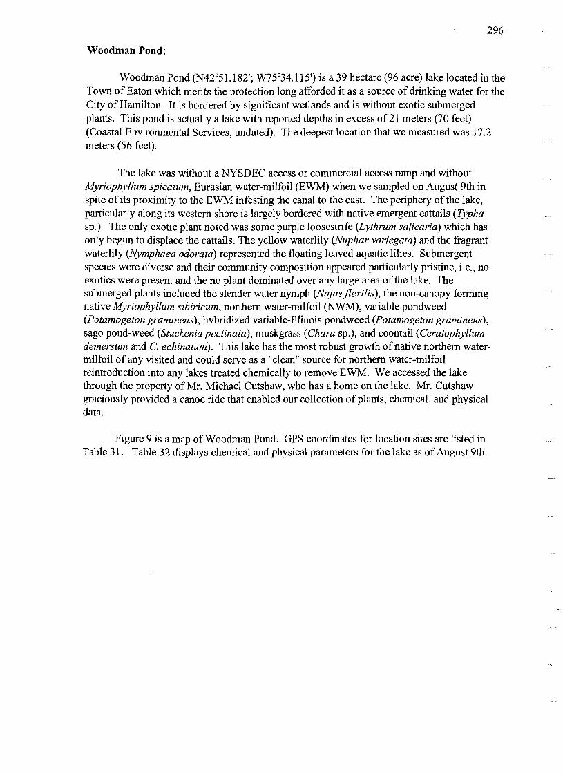
Woodman Pond:
Woodman Pond (N42°51.l82'; W75°34.1l5') is a 39 hectare (96 acre) lake located in the Town of Eaton which merits the protection long afforded it as a source of drinking water for the City of Hamilton. It is bordered by significant wetlands and is without exotic submerged plants. This pond is actually a lake with reported depths in excess of 21 meters (70 feet) (Coastal Environmental Services, undated). The deepest location that we measured was 17.2 meters (56 feet).
The lake was without a NYSDEC access or commercial access ramp and without Myriophyllum spicatum, Eurasian water-milfoil (EWM) when we sampled on August 9th in spite of its proximity to the EWM infesting the canal to the east. The periphery of the lake, particularly along its western shore is largely bordered with native emergent cattails (Typha sp.). The only exotic plant noted was some purple loosestrife (Lythrum salicaria) which has only begun to displace the cattails. The yellow waterlily (Nuphar variegata) and the fragrant waterlily (Nymphaea odorata) represented the floating leaved aquatic lilies. Submergent species were diverse and their community composition appeared particularly pristine, i.e., no exotics were present and the no plant dominated over any large area ofthe lake. The submerged plants included the slender water nymph (Najasjlexilis), the non-canopy forming native Myriophyllum sibiricum, northern water-milfoil (NWM), variable pondweed (Potamogeton gramineus), hybridized variable-Illinois pondweed (Potamogeton gramineus), sago pond-weed (Stuckenia pectinata), muskgrass (Chara sp.), and coontail (Ceratophyllum demersum and C. echinatum). This lake has the most robust growth of native northern watermilfoil of any visited and could serve as a "clean" source for northern water-milfoil reintroduction into any lakes treated chemically to remove EWM. We accessed the lake through the property ofMr. Michael Cutshaw, who has a home on the lake. Mr. Cutshaw graciously provided a canoe ride that enabled our collection of plants, chemical, and physical data.
Figure 9 is a map of Woodman Pond. GPS coordinates for location sites are listed in Table 31. Table 32 displays chemical and physical parameters for the lake as ofAugust 9th.

297
Canal
l'
l'
l'
l'
l'
l'
l'
l'
Canal 0.5 kilometer
J
Figure 9. Distribution ofEWM and northern water-milfoil (NWM) and site of physical and chemical data gathering (WQ) in Woodman Pond on August 9,2000.
Table 31. Latitude and lon2itude of Woodman Pond sites noted on Fi2ure 9.
Site Activity Location Cutshaw Home Access; canoe
surface observations. Canal on NE of Pond Potential source of exotic
introductions. WQ Water quality
data collection.
Table 32. Physical and Chemical Data from Woodman Pond on AU2ust 9,2000.
Depth (m)
Temperature (0C)
pH D.O. (mg/I) *
Conductivity (mmho/cm)
Secchi Depth (m)
Ca++ (mg/I)
N/A 0 5 10 15 17
24.30 15.39 6.86 6.46 6.37
8.48 7.92 7.06 7.02 7.02
9.35 8.92 0.10 0.25 0.20
0.298 0.356 0.374 0.383 0.385
3.7 52.5
* D.O. of less than 2.0 mg/I is only an approximation given the equipment used.

298
DISCUSSION
The nature of aquatic plant communities (modified from Harman, et al., 2000):
Individual species of rooted aquatic macrophytes have optimal conditions under which they thrive. Or, from another viewpoint, they are limited in their growth and distribution by light attenuation in the water column and pressure, both expressed as maximum depth of plant growth, suitable substrates, water chemistry, disturbance and competition with and predation by other organisms. Although each species is unique, many have considerably overlapping ranges of conditions under which they occur. This results in situations in which several species are often associated with each other, or naturally occur together, or in approximation to each other, in similar ways in every body of water in which they are found.
An excellent example is an association of floating-leaved plants which are restricted to shallow substrates high in organic matter (shorelines protected from wind and wave action). In hard-water lakes bullhead (yellow) and fragrant (white) water lilies are always associated, with the latter in slightly deeper water. They also are found in softer waters, but in that situation water-shield appears with them. When present the exotics, water chestnut (Trapa natans) and yellow floating heart (Nymph0 ides peltata) add to this community. If the location is well protected and growth of the aforementioned species is luxuriant, the site will be conducive to the growth of the duck-weeds (Lemna and Spirodela spp.) and water meal (Wolffia spp.), our smallest vascular plants.
We tentatively recognize four communities of aquatic plants; the aforementioned Nuphar muddy shallow-littoral community, the Vallisneria sandy mud mid-littoral community, the Stuckenia pectinata sand mid-littoral community and the Nitella muddy deep-littoral community (after Vertucci, et al., 1981). Our most aggressive exotics, EWM and curly-leaved pondweed are associated with·the latter groups and in eutrophic and/or disturbed situations can displace our native plants making up those communities resulting in the dense beds of weeds that create the biggest problems for lake users. Everyone involved in aquatic management activities should become familiar with these associations, learn to recognize and appreciate the diversity and beneficial roles played by our native plants, and gain an understanding of the unique requirements each needs to maintain its role in the protection of our aquatic ecosystems.
Ecological succession occurs naturally in all bodies of water. It's the process whereby one type of plant community, through its impact on the environment, actually changes conditions so that they become more optimal for an entirely new community, which eventually displaces the
Jfirst. Lake bottoms therefore change over time from rocky and silt free to muddy with a high organic content. Clear waters with low numbers of algae become more turbid as populations rise. Lakes supporting small amounts of plants rarely reaching the surface become those with surfaces covered with vegetation. All lakes over time, will become wetlands.
I

299
If these changes have and are taking place naturally in any particular body of water it should be accepted for its unique characteristics and overt management activities should be avoided. Increasing nutrient levels, the phenomena that drive the process, cannot practically be expected to be reduced below natural baseline levels. If, however, this process has been artificially enhanced by human activities to the point where undesirable situations prevail, then intervention is reasonable. None of the waters studied are in the first category although Woodman Pond is close. Management actions for both Woodman Pond and Madison Lake should involve protection from further disturbance.
Myriophyllum spicatum, Eurasian water-milfoil (EWM), Phenology and the Weather Pattern of Spring and Summer 2000
EWM is an evergreen rooted aquatic plant. Much of the summer's growth senesces each autumn, but while the long shoots are dying back a new lush, green stem approximately 20 cm (about eight inches) in length forms. This tip does not elongate much over winter. It may grow as much as a centimeter (.4 inch) a month if the ice is clear and not snow covered, but it might not grow at all until the water warms somewhat in spring. With the warming water, the EWM grows steadily. Its growth is not as rapid as that found in summer, but the EWM will overtop most native plants that have not grown in the autumn and winter.
EWM herbivores overwinter in the soils proximate to the waterbody with EWM (weevils, Euhrychiopsis lecontei), on the growing end of stems of coontail (Ceratophyllum demersum) in the water (moths, Acentria ephemerella), or on the stems ofEWM in the water (midges, Cricotopus myriophylli). None, however, cause any EWM damage until the water warms. Of the three insect herbivores, only the weevil has a significant number of generations each summer. In most cases, weevil numbers continue to increase over the warm months until either the EWM growing stem tips are reduced to less than 5% oftheir former biomass or until the water begins to cool in September (Johnson, 2000b).
The spring and summer of 2000 was notable for its cool, wet weather. We believe that this weather facilitated the growth of EWM without significant inhibition from herbivores until late June. This is our explanation for the reported increases in earlyEWM presence in six of the nine lakes surveyed. When we visited these lakes in early August, we were told of significant EWM beds only to find that the beds had died back or were in the process of being eaten by herbivores. Controlling EWM with herbivores will be subject to such cycles, but, as was seen in 2000, the herbivores do contribute to the control of EWM in most of these lakes (Batra, 1977; Menzie, 1981; Kangasniemi, 1983; MacRae, 2000; Kangasniemi, et al., 1992; Newman et al., 1997; Jester and Bozek, 1999; Mazzei et al., 1999).
Preserving overwinter habitat for weevils is important if the weevils are going to aid in controlling milfoil (Cofrancesco and Crosson, 1999; Johnson, 2000b). Based on what has been learned about the weevils' cool weather requirements, we make the following recommendations to facilitate successful weevil overwintering:

300
0/ No mowing or raking within four meters (12 feet) of the water's edge from 10 September until I June.
0/ No winter drawdowns on lakes until 15 November. 0/ Ifpossible, no raising lake levels from that found on I October until IS May.
Herbivore Augmentation Recommendation
For our research purposes, the lake to be augmented with the milfoil moth would, ideally, have
• few EWM herbivores (particularly moths),
• large EWM biomass,
• significant coontail biomass, • alternative milfoil moth food sources (e.g., native water-milfoils, coontail, or waterweed), and
• lake shore residents and local officials committed to a multiyear augmentation program with a willingness to forgo other EWM management strategies.
A lake with a paucity ofherbivores and significant EWM biomass is most likely to demonstrate EWM reduction after augmentation. Coontail growing tips are the preferred overwintering habitat for the milfoil moths. The presence of an alternative food source for the moths helps to ensure their survival at times when their consumption reduces EWM. A commitment of lake stakeholders ensures that alternative EWM control strategies, which might interfere with or obscure the results of an augmentation, are not implemented.
None of the lakes surveyed has all the desired characteristics; however, Lebanon Reservoir appears to have the most potential for a successful augmentation with milfoil moths. Lebanon Reservoir has the densest EWM beds of all the lakes surveyed. It has both milfoil weevils and milfoil moths (as do most of the other lakes surveyed), but it has limited shoreline ideal for milfoil weevil overwintering and that shoreline is largely confined to the northnorthwest cove. This limitation in milfoil weevil overwintering habitat and the direction of the prevailing winds makes it unlikely that milfoil weevils alone will ever satisfactorily control EWM in Lebanon Reservoir. Coontail exists in Lebanon Reservoir in locations with EWM. Additionally, while no native water-milfoils were found in the Reservoir, waterweed was dense in the area proposed for augmentation. Finally, the Lebanon Reservoir Lake Association has committed to refraining from harvesting and herbicide use for the length of our study.
If funding is available for the study, we propose to resurvey the lake in the vicinity of Transects 6 and 7 in early May 2001 and, based on the results of that survey, make augmentations of milfoil moths during May in dense EWM beds in two separate areas in the vicinity of those transects. We will also establish two control sites at the same depth and in proximity to each test site. We will monitor herbivore numbers in all four sites every two weeks from the time of our early May augmentation through September to track population spread. If results warrant, we may recommend monitoring in the summer of 2002 as well.

301
Management Concerns (modified from Harman, et al., 2000):
Because of their depth, shape, amounts of water moving through them, chemistry and amounts of nutrient loading, as well as watershed characteristics (bedrock and soil types, land cover and use), and their respective ecologies, the bodies of water we studied can be lumped into a few major categories regarding realistic management strategies. See Table 33.
It cannot be overstated that in the presence of excess nutrient loading (phosphorus and nitrogen) from watersheds both planktonic algae and rooted macrophytes will thrive. And the latter will cover all suitable substrates within the littoral zone (where light intensity is sufficient for growth). In none of the waters included in this study does that include the entire bottom. Users of recreational waters may be concerned about ''weeds,'' but they must recognize the benefits derived from rooted plants. (See Introduction: The role of aquatic plants in freshwater lakes.) These benefits will be lost if the majority of the rooted plants in an environment are eliminated. Planktonic algae populations will flourish (bloom), further inhibiting macrophyte growth by increasing turbidity and enabling the destabilization of substrates. Without reducing nutrient loading, which is usually an expensive, long-term, social and political exercise, algae or rooted plants will be abundant in shallow lakes. Direct elimination of the rooted plant community will result in an increase in algae populations and vice-versa.
Aquatic plant management depends on strategies that vary from one lake to another dependent on the expectations of the stakeholders and their concurrence regarding appropriate resource utilization. Educational programs are recommended to assure that stakeholder expectations equal realistic plant management goals. Table 34 lists the water bodies investigated and suggests what we perceive as reasonable goals based on our initial observations. As indicated, there may be historical and cultural reasons to deviate from these suggestions. Table 34 includes only aquatic plant management goals that we believe are appropriate for each lake from an ecological perspective. Obviously, some sort of costlbenefit ratios must be developed in each case before resources are expended to attain the desired effects. Stakeholders should keep in mind that whole lake management plans may well address many other important concerns that must be articulated with plant management goals if reasonable results are to be obtained. We stand willing to provide more detailed suggestions for particular management situations when and if they are warranted.

302
Table 33. Selected Madison County lakes indicating characteristics that affect rooted plant 2rowth and. potentially, viable mana2ement strate2ies.
I = Tributary Lakes (created by artificially dammed streams) 2 = Eutrophic Lakes 3 = Lakes with highly organic substrates or drainage areas (resulting in tea colored water) 4 = Hard water lakes 5 = Algae dominated lakes (where growth of rooted plants is inhibited by algal blooms) 6 = Macrophyte communities dominated by aggressive exotics 7 = Threatened by exotic introductions because ofunmonitored, easy access
Water Body 2 3 4 5 6 7
Bradley Brook Reservoir + + + Eaton Reservoir + + + Hatch Lake + + Lebanon Reservoir + + + + Lower Leland Pond + + + + + + Upper Leland Pond + + + + + Madison Lake + + Tuscarora Lake + + + Woodman Pond + + +
Table 34. Lakes correlated with commonly SOU2ht mana2ement 2oalsl. 1 = Reduction of nutrient loading 2 = Reduction of exotic rooted macrophyte biomass by mechanical harvesting 3 = Removal of rooted plants from navigation channels 4 = Protection from substrate disturbance from powerboats 5 = Protection from new exotic introductions2
6 = Hand harvesting by divers and benthic barriers to control/eliminate EWM 7 = Augmentation with weevils (Euhrychiopsis lecontei) 8 = Augmentation with moths (Acentria ephemerella) 9 = Winter drawdown to control rooted plant growth in shallow areas
Water Body 1 2 3 4 5 6 7 8 9
Bradley Brook Reservoir + + + +7 + Eaton Reservoir + + + +7 + Hatch Lake + + + Lebanon Reservoir + + + + + + Lower Leland Pond + + + + Upper Leland Pond + + + + + + Madison Lake + + + Tuscarora Lake + + +7 + Woodman Pond +7 + +
IIn our professional opinions, actual goals should vary dependent on local conditions, historical utilization and interests, concerns and expectations of stakeholders. ? = potentially marginal concerns/solutions.

303
2Prophylactic measures to prevent introductions of a host of exotics such as zooplankton (e.g., spiny water-fleas [Bythotrephes cederstroemiJ), zoobenthos (e. g., zebra mussels [Dreissena polymorphaJ) and fish (nekton) (e.g., alewives [Alosa pseudoharengusJ), all of which are present in nearby lakes, are advisable for all waters. This table only considers the noxious plants mentioned.

304
REFERENCES
Anon. 1990. Diet for a small1ake: A New Yorker's guide to lake management. NYSDEC and NYS Federation of Lake Associations.
Anon. Undated. Submerged aquatic weeds and algae guide. Elf Atochem North America.
Batra, S. W. T. 1977. Bionomics of the aquatic moth, Acentropus niveus (Olivier), a potential biological control agent for eurasian water-milfoil and hydrilla. New York Entomological Society, LXXXV(3) pp. 143-152.
Berg, C. O. 1966. Middle Atlantic States, pp. 191-237 in Frey, D. G. Limnology in North America. Univ. of Wisconsin Press. Madison.
Borman, S., R. Korth and J. Temte. 1997. Through the looking glass: A field guide to aquatic plants. Wisconsin Lakes Partnership, Merrill, Wisconsin.
Brant, C. 2000. Aquatic weevils unleashed as newest control in battle against Eurasian watermilfoil. EnviroScience Weevil Gazette. Feb 2000. Stow, Ohio.
Brown, L. 1979. Grasses, an identification guide. Houghton Mifflin Co., NY.
Coastal Environmental Services, Inc. Undated. Bathymetry of Bradley Brook Reservoir; Eatonbrook Reservoir; Hatch Lake; Upper Leland Pond; Lower Leland Pond; Lebanon Reservoir; Madison Lake; Tuscarora Lake; and Woodman Pond. Coastal Environmental Services, Inc. Princeton, N.J.
Fassett, N. C. 1972. A manual of aquatic plants. Univ. Wisconsin Press. Madison.
Fagnani, J. P. and W. N. Harman. 1987. The Chironomidae of Otsego Lake with keys to the immature stages of the subfamilies Tanypodinae and Diamesinae (Diptera). SUNY Oneonta Bio. Fld. Sta. Occ. Paper. #20. pp.l-235.
Harman, W. N., M. F. Albright, P. H. Lord and D. A. King. 1998. Panther Lake management plan facilitation: 1998 update of the distributions of nuisance plants. SUNY Oneonta Bio. Fld. Sta. Tech Rept. #4. pp.l-18.
Hannan, W. N., M. F. Albright, P. H. Lord and D. A. King. 2000. The nuisance aquatic macrophytes of Oswego County. Management Facilitation: 1998-9 update on the distributions ofplants in 15 selected aquatic environments. SUNY Oneonta Bio. Fld. Sta. Tech Rept. #7. Pp. 1-101.
iHellquist, C. B. and G. E. Crow. 1980,81, 82,83,84,85. Aquatic vascular plants of New England. Part1,2,3,4,5,6,7,8. New HampshireAgr. Exp.Sta. Bull. #515, 517,518, 520, 523, 524, 527, 528. Durham, NH.

305
Hutchinson, G. E., 1957. A treatise on limnology, Vol. III. Aquatic macrophytes and attached algae. John Wiley and Sons, Inc. New York.
Ingmire, S. 2000. Personal communication. Madison County Planning Department. Wampsville, NY.
Jester, L. L. and M. A. Bozek. 1999. Wisconsin Milfoil Weevil Project: 1996 - 1998 Results. Wisconsin Cooperative Fishery Research, University of Wisconsin - Stevens Point, WI.
Johnson, R. L. 2000a. Indigenous populations ofEuhrychiopsis, Acentria, and Cricotopus with implications for the biological control of Eurasian Water-milfoil in Aquatic Plant Management Society, Inc. 40 th Annual Meeting July 16-20,2000. San Diego, Ca.
Johnson, R. L. 2000b. Personal communication. Experimental Ponds Unit, Cornell University, Ithaca, NY.
Johnson, R. L., E. M. Gross and N. G. Hairston, Jr. 1998. Decline of the invasive submersed macrophyte Myriophyllum spicatum (Haloragaceae) associated with herbivory by larvae ofAcentria ephemerella (Lepidoptera). Aquatic Ecology 31 :273-282.
Kangasniemi, B. J. 1983. Observations on herbivorous insects that feed on Myriophyllum spicatum in British Columbia. Lake restoration, protection, and management proceedings of the second annual conference North American Lake Management Society October 2629, 1982, Vancouver, British Columbia. U.S. Environmental Protection Agency, Washington, D.C.
Kangasniemi, B., H. Speir, and P. Newroth. 1992. Review of Eurasian water-milfoil biocontrol by the milfoil midge. Proceedings, 27 th Annual Meeting, APCRP.
LaMere, S. A. 1999. Schroon Lake: A case study in the importance of early detection in the management of exotic species. LakeLine. Vol. 19. pp. 46-48, 51.
MacRae, I. 2000. Personal communication. Department of Entomology, University of Minnosota, Northwest Experiment Station, Crookston, MN.
Mazzei, K. C., R. M. Newman, A Loos, and D. W. Ragsdale. 1999. Developmental rates of the native milfoil weevil, Euhrychiopsis lecontei, and damage to Eurasian water-milfoil at constant temperatures. Biological Control. Vol. 16. pp. 139 - 143.
Menzie, C. A. 1981. Production ecology ofCricotopus sylvestris (Fabricus) (Dipteria: Chironomidae) in a shallow estuarine cove. Limnol. Oceanogr. 26(3). Pp.467-481.
Miller, M. E. 2000. Personal communication. Biological Field Station, SUNY-Oneonta, Cooperstown, NY.

306
Newman, R. M., M. E. Bonnan, and S. W. Castro. 1997. Developmental perfonnance of the weevil Euhrychiopsis lecontei on native and exotic water-milfoil host plants. Journal of the North American Benthological Society Vol. 16. Pp.627-634.
NYSDEC. 2000a. Pesticide Application Management. http://www.dec.state.ny.us/website/dshmJpesticid/appman.htrn#apas viewed on Nov 20, 2000.
NYSDEC. 2000b. Special Licenses and Pennits Related to Freshwater Fisheries. http://www.dec.state.ny.us/website/dfwmr/fisheriesyennits.html as viewed on Nov 20, 2000.
Ogden, E. C., 1. K. Dean, C. W. Boylen and R. B. Sheldon. 1976. Field Guide to the aquatic plants of Lake George, NY Museum Bull # 426: 1-65. Albany.
Schmidt,1. C. and 1. R. Kannenberg. 1998. How to identify and control water weeds and algae (5th edition). Applied Biochemicals. Milwaukee.
Sheldon, S. P. 1997a. Investigations on the potential use of an aquatic weevil to control Eurasian water milfoil. Journal of Lake and Reservoir Management. 13(1):79-88.
Sheldon, S. P. 1997b. Note on sampling a small, but important insect. Journal of Lake and Reservoir. 13(1):79-88.
Steinbach, R. 2000. Personal communication. Dam Road, Erieville, NY.
USDA. 1979. General Soil Map: Madison County, New York. USDA Soil Conservation Service, Cornell Univ. Agricultural Experimental Station.
Vertucci, F. A., W. N. Hannan and J. H. Peverly. 1981. The ecology of the aquatic macrophytes of Rat Cove, Otsego Lake, NY. SUNY Oneonta Bio. Fld. Sta., Occas. Pap. 8:1-210. SUNY Oneonta.
Wetzel, R. G. 1983. Limnology. 2nd Ed. Saunders. Philadelphia.

307
Appendix A.
Identification of herbivory on Myriophyllum ~picatum, Eurasian water-milfoil (EWM) stem samples.
Procedure
1. This procedure is abbreviated; use it with reference to descriptions for ./ EWM parts and ./ insect life stages
that follow it. 2. Note location, dates, stem collector and herbivore identifier on data sheet. 3. Pick up stem and examine carefully from growing end to basal end.
a. Look for aberrations in the normal sequence of longer to shorter internodal lengths examining leaves carefully in such areas. b. Look for numbers of missing leaves and any cut or missing lateral veins of dissected leaves. c. Examine growing end tip. d. Make notes on condition of stem and tip, and, under "Comments" make notes regarding algae or precipitate on stem.
4. Place stem on microscope stage and examine carefully from growing end to basal end. a. Pull apart leaves and/or lateral veins of dissected leaves giving the appearance of being stuck together. b. Pull apart any marked or discolored areas on the stem with dissecting probes (see "Stem" below).
5. Examine plastic bag, in which stem was stored, for herbivores. 6. Make notes on the condition of the leaves and note any animals present. 7. Dispose of the stem and the plastic storage bag separately in a garbage can.
EWM Plant Parts
Internodal lengths not consistently shorter going from basal end to apical meristem: herbivore damage at shorter internode (Kangasniemi, 1983; Johnson, 2000b).
Mined (hollowed, often brownish in color) for a length> 0.5 cm; often with obvious exit and entry holes: Euhrychiopsis lecontei damage (Kangasniemi, 1983).
Swollen discolored portion of stem either hollowed and empty or hollowed with pupae inside: Pupal Euhrychiopsis lecontei or (rarely) Acentria ephemerella (under stress) (Johnson,2000b).
Saddle or scoop shaped scar approximately as long as the stem is wide: Adult Euhlychiopsis lecontei damage (Johnson, 2000b).
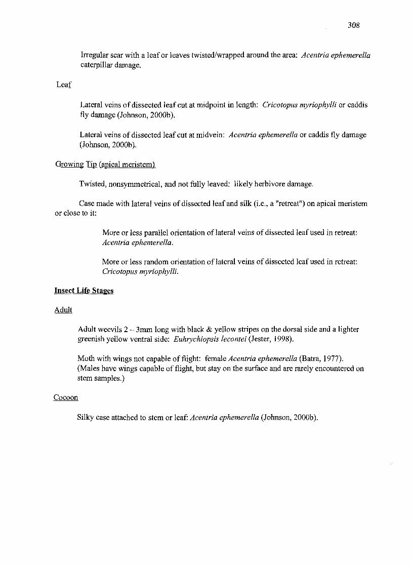
308
Irregular scar with a leaf or leaves twisted/wrapped around the area: Acentria ephemerella caterpillar damage.
Lateral veins of dissected leaf cut at midpoint in length: Cricotopus myriophylli or caddis fly damage (Johnson, 2000b).
Lateral veins of dissected leaf cut at midvein: Acentria ephemerella or caddis fly damage (Johnson,2000b).
Growing Tip (apical meristem)
Twisted, nonsymmetrical, and not fully leaved: likely herbivore damage.
Case made with lateral veins of dissected leaf and silk (i.e., a "retreat") on apical meristem or close to it:
More or less parallel orientation of lateral veins of dissected leaf used in retreat: Acentria ephemerella.
More or less random orientation of lateral veins of dissected leaf used in retreat: Cricotopus myriophylli.
Insect Life Stages
Adult weevils 2 - 3mm long with black & yellow stripes on the dorsal side and a lighter greenish yellow ventral side: Euhrychiopsis lecontei (Jester, 1998).
Moth with wings not capable of flight: female Acentria ephemerella (Batra, 1977). (Males have wings capable of flight, but stay on the surface and are rarely encountered on stem samples.)
Cocoon
Silky case attached to stem or leaf: Acentria ephemerella (Johnson, 2000b).

309
Larvae
Larvae with obvious gills: not a known Myriophyllum spicatum herbivore.
Larvae with five pairs ofprolegs and abdominal crochets (caterpillar) with sceloritized plates on head and closed spiracles with no gills: Acentria ephemerella (Batra, 1977).
Larvae found inside stem or adjacent to mining; brown or grey in color; head color noticeably darker than body: Euhrychiopsis lecontei (Miller, 2000).
Chironomid larvae < or = 0.5 cm, translucent cream colored, with alimentary canal twisted like Spirogyra spp.; possessing fine lateral setae and indistinct segmentation: Cricotopus myriophylli (Kangasniemi, 1983; Johnson, 2000b).
Orangish cream colored; elliptical (shaped like grains of rice); ~ 0.5mm x 0.4 mm (or ~ 1/3 the size of rice grains); typically one or two on or in apical meristem or on leaves ofthe node just beneath it: Euhrychiopsis lecontei (Creed and Sheldon, 1995; Sheldon, 1997b; Jester, 1998; Johnson, 2000b).
Pale yellowish-green clusters of round eggs around a lateral vein of a dissected leaf typically found about 25 to 50 cm down stem from growing tip: Acentria ephemerella (Johnson, 2000b; Miller, 2000).

310
Appendix B.
Glossary.
Adsorbed: Adhering in an extremely thin layer of molecules (as of gases, solutes, or liquids) to the surfaces of solid bodies or liquids with which they are in contact.
Apical: of, relating to, or situated at an apex (or tip).
Apical meristem: a meristem at the apex (or tip) of a root or shoot that is responsible for increase in length.
Augmentation: the act or process of adding to what already exists.
Bathymetry: the measurement of water depth at various places in a body of water.
Compensation point: depth at which plants use carbohydrates for life sustaining metabolism at a rate equal to their carbohydrate production rate by photosynthesis.
Dissected leaf: leaf with no blade; leaf comprised of only the leafmid-vein and lateral veins.
EWM: Eurasian water-milfoil, Myriophyllum spicatum, an exotic water-milfoil.
Emergents: plants rooted in shallow water and having most of the vegetative growth above water.
Exotic: not native to the place where found.
Innocuous: hannless.
Internode: an interval or part between two nodes on a stem.
Introduction: act of inserting something; something introduced; specifically, a new or exotic plant or animal.
Littoral: of, relating to, or situated or growing on or near a shore; that area of a lake with rooted plants growing.
Macrophyte: plants visible with the naked eye.
Meristem: a fonnative plant tissue usually made up of small cells capable ofdividing indefinitely and giving rise to similar cells or to cells that differentiate to produce the definitive tissues and organs.

311
mg/l: milligrams per liter: a measure of substance weight in a volume which equals parts per million.
mho: the inverse ofohm (see "mmho/cm" below).
Midge: a tiny fly; order: Diptera; family: Chironomidae.
Moth: any lepidopteran insect with antennae that are often feathery, with a stouter body, duller coloring, and proportionately smaller wings than the butterflies, and with larvae that are plant-eating caterpillars; order: Lepidoptera; family: Pyralidae.
Node: a point on a stem at which a leaf or leaves are inserted.
m: meter: a measure oflength equal to 3.28 feet.
mmho/cm: million mho's per centimeter: a measure of electroconductivity and an indirect measure of dissolved ions in the water.
NWM: Northern water-milfoil, Myriophyllum sibiricum, a native water-milfoil.
Potable: suitable for drinking.
Resuspension: the state of a substance when its particles are mixed repeatedly with water but remain undissolved in it; a system consisting of a solid dispersed in water usually in particles of larger than colloidal size.
Senescent: in a state of transition from full maturity to death.
Substrate: the base on which an organism lives e.g., "The soil is the substrate ofmost seed plants."
Turbidity: deficient in clarity or purity.
Vagary: an erratic, unpredictable, or extravagant manifestation, action, or notion.
Weevil: any insect of a superfamily (Curculionoidea) ofbeetles which have the head prolonged into a more or less distinct snout and which include many that are injurious especially as larvae to nuts, fruit, and grain or to living plants; especially, any ofa family (Curculionidae) having a well-developed snout curved downward with the jaws at the tip and clubbed usually elbowed antennae; order: Coleoptera; family: Curculionidae.