BFS Exploration Drill Program Complete · The program has involved drilling of 142 aircore...
25
ASX Release www.kaliumlakes.com.au Page 1 of 25 Thursday 3 May 2018 BFS Exploration Drill Program Complete Highlights • Bankable Feasibility Study (BFS) sonic monitoring bore installation and air-core geological programs have been successfully completed. • The 8,504m drill program continued to confirm the PFS Resource and Reserve Assumptions, reaffirming the Project’s high grade potassium results and indicating new aquifer targets. • Potassium results up to 11,100 mg/L - equivalent to a SOP grade of 24,736 mg/L. • Test pumping activities are ongoing, with results being utilised to update the BFS numerical hydrogeological modelling of the Ten Mile and Sunshine Stage 1 production areas. • More than 164 million litres of brine have been pumped since test pumping began, of which 83 million litres of brine have been pumped into the trial ponds. Monitoring bores are showing a stable water level response to this pumping. • The program is aimed at achieving future Measured Resources and Proved Reserves to support project financing requirements. Kalium Lakes Limited (KLL) announced today that the main Bankable Feasibility Study (BFS) sonic monitoring bore installation and air-core geological programs have been successfully completed at its Beyondie Sulphate Of Potash Project (BSOPP). Managing Director, Brett Hazelden, commented; “The program has continued to confirm the Pre-Feasibility Study Resource model within our initial Stage 1 Mining Lease Areas. We envisage these results will enable an upgrade of the deposit to include a future Measured Resource and Proved Reserve, which in turn will support the Bankable Feasibility Study and project financing.” “The current assumed Stage 1 Area has a mine life of 23 years at 75ktpa SOP, when utilising our existing Probable Reserve, which has enabled Kalium Lakes to have very detailed discussions with both domestic and international offtake parties and financial institutions,” he said.
Transcript of BFS Exploration Drill Program Complete · The program has involved drilling of 142 aircore...
ASX Release
www.kaliumlakes.com.au Page 1 of 25
Thursday 3 May 2018
BFS Exploration Drill Program Complete
Highlights
• Bankable Feasibility Study (BFS) sonic monitoring bore installation and air-core geological programs have been successfully completed.
• The 8,504m drill program continued to confirm the PFS Resource and Reserve Assumptions, reaffirming the Project’s high grade potassium results and indicating new aquifer targets.
• Potassium results up to 11,100 mg/L - equivalent to a SOP grade of 24,736 mg/L.
• Test pumping activities are ongoing, with results being utilised to update the BFS numerical hydrogeological modelling of the Ten Mile and Sunshine Stage 1 production areas.
• More than 164 million litres of brine have been pumped since test pumping began, of which 83 million litres of brine have been pumped into the trial ponds. Monitoring bores are showing a stable water level response to this pumping.
• The program is aimed at achieving future Measured Resources and Proved Reserves to support project financing requirements.
Kalium Lakes Limited (KLL) announced today that the main Bankable Feasibility Study (BFS) sonic monitoring bore installation and air-core geological programs have been successfully completed at its Beyondie Sulphate Of Potash Project (BSOPP). Managing Director, Brett Hazelden, commented; “The program has continued to confirm the Pre-Feasibility Study Resource model within our initial Stage 1 Mining Lease Areas. We envisage these results will enable an upgrade of the deposit to include a future Measured Resource and Proved Reserve, which in turn will support the Bankable Feasibility Study and project financing.” “The current assumed Stage 1 Area has a mine life of 23 years at 75ktpa SOP, when utilising our existing Probable Reserve, which has enabled Kalium Lakes to have very detailed discussions with both domestic and international offtake parties and financial institutions,” he said.

www.kaliumlakes.com.au Page 2 of 25
BFS Sonic Monitoring Bore and Air-core Geological Programs The sonic monitoring bore installation and air-core geological programs reflect KLL’s development strategy to upgrade the current Resources to Measured Resources and Proved Reserves to support project financing requirements, plus support the geological and hydrogeological modelling. This program focussed on the Ten Mile and Sunshine Stage 1 production areas (Figure 1) which will underpin the initial mine life, payback period and BFS outcomes. The program has involved drilling of 142 aircore exploration holes on transects totalling 7,794m of drilling. This has closed the drill spacing to between 265m and 422m at the Ten Mile and Sunshine deposits respectively and confirmed the geological extent of the target geology and brine mineralisation. A sonic drilling rig has followed up the aircore drilling to twin 10 key aircore holes, in order to obtain core for laboratory testing, and install monitoring bores for a total of 710m of drilling. Downhole geophysics (spectral gamma, conductivity and Borehole Magnetic Resonance (BMR)) has been completed on all monitoring bores to measure lithological changes and in-situ aquifer properties and will be calibrated to laboratory testing of core plugs to assist with Resource estimation. A similar methodology to what is used in the Petroleum industry to assist with estimating oil field resources. In simple terms BMR technology measures the behaviour of hydrogen nuclei when subjected to a magnetic field which can be related to the volume of water present as bound water (specific retention) and movable water (specific yield) quantities1 2. Notably, the BMR tool has been able to provide insight in to aquifer properties on a resolution across the palaeovalley sequence and bedrock lithologies not previously observed from test pumping, drilling or laboratory testing. The results indicate that in-situ specific yields of the basal sand and silcrete aquifer zones maybe between 8 and 25%, however these zones are significantly thicker than previously considered, the sandy lenses of the lower clay sequences have higher specific yields which were previously categorised as lacustrine clays, which will now be incorporated into to the deep aquifer resource. The drilling and geophysical surveys have also identified additional resources within the weathered zones of the sandstone and vesicular basalts encountered within the Stage 1 area. These zones will now be brought into the brine resource envelope. This data will be used to assist with the update to the Resources for the BFS. An additional production bore (SSSN03PB) has been installed within the weathered sandstone aquifer at Lake Sunshine and is currently undergoing long term test pumping. Figures 2, 3, 4 and 5 below show an outline of the current drill program locations, cross section of the resource and a BMR Log from SSSN02. Table 1 presents the bore information which has been collected since drilling commenced in January 2018. The results of the drilling program have been merged with all previous drilling and geophysical data to construct a geological model for the Stage 1 area. The model view of Ten Mile is presented in Figure 6.
1 Schlumberger ,1997, How to Use Borehole Magnetic Resonance, Oilfield Review, Summer 1997 2 NMR Services Australia, 2018, Evaluating Brine Deposits Using Borehole Magnetic Resonance, AEGC 2018

www.kaliumlakes.com.au Page 3 of 25
Figure 1 - Beyondie Sulphate of Potash Tenure and Staged Development
Figure 2 - Ten Mile Lake Exploration Program

www.kaliumlakes.com.au Page 4 of 25
Figure 3 - Lake Sunshine Exploration Program
Figure 4 – Stage 1 Mining Area Exploration Program

www.kaliumlakes.com.au Page 5 of 25
Figure 5 - BMR Log from SSSN02
Movable water is the specific yield volume (Blue).
Water volumes in clay bound and capillary bound pores are the specific retention volumes (Greens).
www.kaliumlakes.com.au Page 6 of 25
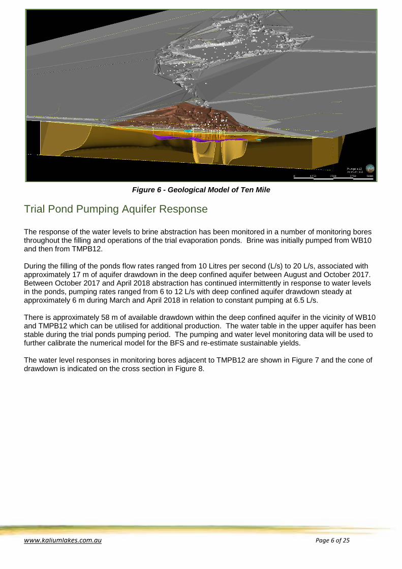
Figure 6 - Geological Model of Ten Mile
Trial Pond Pumping Aquifer Response The response of the water levels to brine abstraction has been monitored in a number of monitoring bores throughout the filling and operations of the trial evaporation ponds. Brine was initially pumped from WB10 and then from TMPB12. During the filling of the ponds flow rates ranged from 10 Litres per second (L/s) to 20 L/s, associated with approximately 17 m of aquifer drawdown in the deep confined aquifer between August and October 2017. Between October 2017 and April 2018 abstraction has continued intermittently in response to water levels in the ponds, pumping rates ranged from 6 to 12 L/s with deep confined aquifer drawdown steady at approximately 6 m during March and April 2018 in relation to constant pumping at 6.5 L/s. There is approximately 58 m of available drawdown within the deep confined aquifer in the vicinity of WB10 and TMPB12 which can be utilised for additional production. The water table in the upper aquifer has been stable during the trial ponds pumping period. The pumping and water level monitoring data will be used to further calibrate the numerical model for the BFS and re-estimate sustainable yields. The water level responses in monitoring bores adjacent to TMPB12 are shown in Figure 7 and the cone of drawdown is indicated on the cross section in Figure 8.

www.kaliumlakes.com.au Page 7 of 25
Figure 7 – Aquifer Water Level Response from Trial Pond Operations
Figure 8 - Cross Section of Ten Mile Kalium Lakes adheres to the JORC Code and Canadian Institute of Mining, Metallurgy and Petroleum Best Practice Guidelines for Resource and Reserve Estimation for Brines (CIM Guidelines). The Company has been part of the Association of Mining and Exploration Companies (AMEC) Potash Working Group which has developed guidelines to define brine Mineral Resources and Ore Reserves, which will increase the certainty, clarity and transparency in reporting of these resources.

www.kaliumlakes.com.au Page 8 of 25
Table 1 – Borehole Data
Hole Number Easting* Northing* Dip (°)
Azimuth (°)
Hole Depth
(m)
Key Intercepts and End of Hole Geology&
SSAC032 238340 7261318 90 0 7 Sandstone
SSAC033 238481 7261654 90 0 5 Sandstone
SSAC034 241523 7265061 90 0 60 16m of sand, sandstone
SSAC035 242796 7266865 90 0 66 Mudstone
SSAC036 244151 7267248 90 0 69 Basalt
SSAC037 244296 7267510 90 0 76 28m of weathered vesicular basalt, basalt
SSAC038 244516 7267313 90 0 66 30m of weathered vesicular basalt, basalt
SSAC039 244090 7267920 90 0 26 Sandstone
SSAC040 244854 7269177 90 0 42 7m of clayey sand, sandstone
SSAC041 244170 7269767 90 0 30 2m sand, sandstone
SSAC042 244308 7269452 90 0 56 6m of sand, silcrete
SSAC043 245717 7269914 90 0 53 13m of silty sand, sandstone
SSAC044 245953 7269783 90 0 75 37m of weathered vesicular basalt, basalt
SSAC045 245949 7269526 90 0 45 13m of weathered vesicular basalt
SSAC046 247863 7269882 90 0 52 6m of silcrete and sand, silcrete
SSAC047 247043 7269910 90 0 37 5m of fractured basalt, basalt
SSAC048 247442 7270641 90 0 55 2m of sand, sandstone
SSAC049 247162 7271081 90 0 69 12m of weathered vesicular basalt, basalt
SSAC050 247579 7270288 90 0 49 9m of clayey sand, sandstone
SSAC051 261751 7276749 90 0 67 18m of silty sand, quartzite
SSAC052 261875 7276513 90 0 39 9m of sand and silcrete, silcrete
SSAC053 261850 7276277 90 0 24 Sandstone
SSAC054 261639 7276962 90 0 63 Sandstone
SSAC055 258203 7273609 90 0 43 9m of sand, sandstone
SSAC056 258327 7273538 90 0 41 12m of sand, sandstone
SSAC057 258497 7273430 90 0 69 17m of clayey sand, sandstone
SSAC058 261455 7277135 90 0 78 11m of sand, sandstone
SSAC059 248075 7269537 90 0 68 Shale
SSAC060 246645 7270336 90 0 63 11m of weathered basalt, basalt
SSAC061 245574 7269996 90 0 66 16m of sand, siltstone
SSAC062 249314 7269793 90 0 53 30m of sand, sandstone
SSAC063 249256 7270021 90 0 12 Sandstone
SSAC064 242691 7267055 90 0 68 8m of sand, siltstone
SSAC065 243925 7265471 90 0 68 21m of weathered basalt, basalt
SSAC066 243390 7266181 90 0 65 10m of weathered basalt, basalt
SSAC067 248265 7270148 90 0 38 4m of sand, sandstone
SSAC068 248198 7270409 90 0 30 14m of sand, sandstone
SSAC069 256883 7273184 90 0 47 10m of sand and calcrete, sandstone
SSAC070 256880 7273373 90 0 47 6m of sand, sandstone
SSAC071 256823 7273708 90 0 42 3m of sand, sandstone
SSAC072 261460 7277140 90 0 53 4m of sand, sandstone

www.kaliumlakes.com.au Page 9 of 25
Hole Number Easting* Northing* Dip (°)
Azimuth (°)
Hole Depth
(m)
Key Intercepts and End of Hole Geology&
SSAC073 258726 7275741 90 0 40 9m of sand, sandstone
SSAC074 258655 7275386 90 0 13 Sandstone
SSAC075 258818 7275076 90 0 15 Sandstone
SSAC076 259041 7274804 90 0 26 Sandstone
TMAC045 230974 7254137 90 0 51 5m of silcrete, siltstone
TMAC046 230923 7254248 90 0 56 7m of silcrete, siltstone
TMAC047 230900 7254388 90 0 60 9m of silcrete, siltstone
TMAC048 230880 7254602 90 0 65 7m of clayey sand, siltstone
TMAC049 230911 7254514 90 0 54 7m of sand, siltstone
TMAC050 230941 7253691 90 0 68 3m of silcrete and sand, siltstone
TMAC051 232396 7254480 90 0 66 Siltstone
TMAC052 231968 7254794 90 0 57 4m of sandy clay
TMAC053 231849 7254896 90 0 78 4m of silcrete and sand, shale
TMAC054 230952 7255130 90 0 66 Siltstone
TMAC055 233131 7256954 90 0 85 24m of sand and silcrete
TMAC056 233146 7256729 90 0 59 4m of sand and silcrete
TMAC057 233114 7256293 90 0 78 13m of sand and silcrete, sandstone
TMAC058 233130 7255931 90 0 66 9m of sand and silcrete
TMAC059 233064 7257104 90 0 85 21m of sand and silcrete, sandstone
TMAC060 233001 7257196 90 0 67 11m of sand, sandstone
TMAC061 232927 7257276 90 0 66 11m of sand and silcrete, dolerite
TMAC062 233773 7256060 90 0 70 6m of sand, sandstone
TMAC063 233775 7256290 90 0 69 2m of sand, sandstone
TMAC064 233815 7256514 90 0 67 3m of sand and silcrete, silcrete
TMAC065 233753 7256708 90 0 77 7m of sand and silcrete, sandstone
TMAC066 234232 7256823 90 0 74 9m of sand and silcrete, silcrete
TMAC067 234196 7257105 90 0 70 2m of sand, sandstone
TMAC068 234663 7256174 90 0 73 4m of sand and silcrete, silcrete
TMAC069 234599 7256435 90 0 72 4m of sand, sandstone
TMAC070 233349 7257823 90 0 64 6m of sandy clay and silcrete, siltstone
TMAC071 233449 7257660 90 0 67 2m of silcrete, silcrete
TMAC072 232580 7256969 90 0 69 19m of clayey sand and silcrete, siltstone
TMAC073 232664 7257044 90 0 63 2m of sand, siltstone
TMAC074 232719 7257140 90 0 69 Siltstone
TMAC075 232082 7257053 90 0 66 Siltstone
TMAC076 232057 7257198 90 0 60 2m of silcrete, silcrete
TMAC077 233298 7255394 90 0 61 1m of silcrete and sand, silcrete
TMAC078a 232870 7255294 90 0 59 1m silcrete, silcrete
TMAC078b 232870 7255294 90 0 54 Silcrete
TMAC079 233918 7255679 90 0 62 5m of silcrete and sand, silcrete
TMAC080 233992 7255533 90 0 59 Siltstone
TMAC081 235130 7257211 90 0 74 6m of clayey sand and silcrete, siltstone
TMAC082 235509 7257560 90 0 71 16m of clayey sand, sandstone

www.kaliumlakes.com.au Page 10 of 25
Hole Number Easting* Northing* Dip (°)
Azimuth (°)
Hole Depth
(m)
Key Intercepts and End of Hole Geology&
TMAC083 236016 7258036 90 0 82 4m of sand, sandstone
TMAC084 236895 7258664 90 0 39 6m of sand, sandstone
TMAC085 236897 7258489 90 0 81 10m of sand, sandstone
TMAC086 236887 7258814 90 0 30 Sandstone
TMAC087 236440 7259824 90 0 69 Sandstone
TMAC088 235789 7256956 90 0 70 9m of sand, siltstone
TMAC089 233177 7257963 90 0 59 Silcrete
TMAC090 233099 7258086 90 0 59 Silcrete
TMAC091 233079 7258222 90 0 65 5m of silcrete, silcrete
TMAC092 233896 7257855 90 0 64 5m of silcrete, silcrete
TMAC093 233759 7257611 90 0 68 4m of silcrete and sand, silcrete
TMAC094 233967 7257182 90 0 86 19m of sand and silcrete, silcrete
TMAC095 234364 7257242 90 0 73 5m of silcrete, silcrete
TMAC096 232893 7255522 90 0 60 Silcrete
TMAC097 234219 7257373 90 0 79 8m of sand and silcrete, silcrete
TMAC098 234512 7257886 90 0 30 Sandstone
TMAC099 234853 7257549 90 0 81 12m of sand and silcrete, silcrete
TMAC100 235369 7257744 90 0 31 Calcrete and ferricrete
TMAC101 233185 7255793 90 0 63 4m of clayey sand, sandstone
TMAC102 233303 7255628 90 0 69 12m of sand, silcrete
TMAC103 233489 7255597 90 0 67 7m of silcrete, siltstone
TMAC104 233215 7254356 90 0 60 9m of silcrete and sand, dolerite
TMAC105 233514 7255223 90 0 65 5m of sand, sandstone
TMAC106 233651 7254433 90 0 54 6m of sand, sandstone
TMAC107 233785 7254077 90 0 51 8m of silcrete and sand, silcrete
TMAC108 233885 7253028 90 0 63 16m of fractured dolerite, siltstone
TMAC109 233831 7252726 90 0 75 30m of broken shale, shale
TMAC110 234789 7256052 90 0 79 6m of sand, silcrete
TMAC111 235568 7256813 90 0 66 Shale
TMAC112 236494 7259574 90 0 62 18m of sandstone, 24m of basalt, basalt
TMAC113 236211 7260316 90 0 58 33m of friable sandstone
TMAC114 235026 7258682 90 0 16 Sandstone
TMAC115 234139 7257618 90 0 76 12m of sand and silcrete, sandstone
TMAC116 233377 7258633 90 0 63 Siltstone
TMAC117 232270 7258638 90 0 57 6m of silcrete and sand, silcrete
TMAC118 232151 7258230 90 0 70 Siltstone
TMAC119 232106 7257727 90 0 65 4m of silcrete, siltstone
TMAC120 232072 7257356 90 0 67 6m of clayey sand and silcrete, siltstone
TMAC121 232070 7257494 90 0 66 5m of clayey sand and silcrete, siltstone
TMAC122 231295 7258994 90 0 93 34m of broken shale, shale
TMAC123 231403 7259277 90 0 51 Siltstone
TMAC124 229145 7259074 90 0 60 Mudstone
TMAC125 228869 7258856 90 0 60 Mudstone

www.kaliumlakes.com.au Page 11 of 25
Hole Number Easting* Northing* Dip (°)
Azimuth (°)
Hole Depth
(m)
Key Intercepts and End of Hole Geology&
TMAC126 232991 7259949 90 0 69 6m fault breccia, mudstone
TMAC127 233109 7259735 90 0 63 Mudstone
TMAC128 234100 7260871 90 0 10 Sandstone
TMAC129 223665 7261568 90 0 6 Dolerite
TMAC130 232798 7255922 90 0 61.5 6m of sandy clay and silcrete, silcrete
TMAC131 232580 7256674 90 0 66 17m of sandy clay and silcrete, silcrete
TMAC132 232641 7256319 90 0 67.5 7.5m of silcrete and sand, silcrete
SSSN01 244515 7267311 90 0 72 30m of weathered vesicular basalt, basalt
SSSN02 245575 7269992 90 0 72 16m of sand, gravel and silt, siltstone
SSSN03 249318 7269797 90 0 50 26m of sand, sandstone
SSSN04 256879 7273375 90 0 53 13m of weathered sandstone
SSSN05 261455 7277135 90 0 83 12m of sand, siltstone
SSSN06 258721 7275738 90 0 43 24m of sand, sandstone
TMSN01 230486 7254259 90 0 92 3m of sand, fractured mudstone
TMSN02 230884 7254601 90 0 74 2m of sand, sandstone
TMSN03 233103 7257019 90 0 89 23.5m of silcrete and sand, sandstone
TMSN04 233777 7256060 90 0 74 9m of sand and silcrete, sandstone
SSPB03 249324 7269797 90 0 40 26m of sand, sandstone * MGA Zone 51 & Key hydrogeological intercepts of aquifer zones or bedrock type
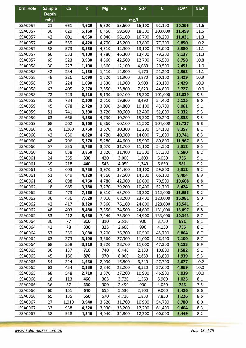
Table 3 – Assay Data
Drill Hole Sample Depth
Ca K Mg Na SO4 Cl SOP* Na:K
mbgl mg/L SSAC034 34 83 480 400 3,600 1,290 6,050 1,070 7.5 SSAC034 51 89 600 470 4,510 1,500 7,600 1,337 7.5 SSAC034 59 87 680 555 5,210 1,860 8,800 1,515 7.7 SSAC034 60 88 730 610 5,530 2,010 9,450 1,627 7.6 SSAC035 54 408 1,770 2,360 16,600 7,200 30,350 3,944 9.4 SSAC035 66 264 1,160 1,460 10,700 4,560 18,500 2,585 9.2 SSAC036 16 1,040 4,460 2,790 32,300 12,200 55,050 9,939 7.2 SSAC036 31 1,040 5,000 3,170 35,500 12,900 61,550 11,142 7.1 SSAC036 57 1,040 5,050 3,320 35,300 13,100 62,450 11,254 7.0 SSAC036 69 1,020 5,030 3,260 35,800 13,200 63,500 11,209 7.1 SSAC038 33 998 5,820 3,740 41,000 16,000 70,700 12,970 7.0 SSAC038 42 998 5,770 3,660 41,200 15,500 70,350 12,858 7.1 SSAC038 48 998 5,810 3,810 40,600 15,500 70,900 12,947 7.0 SSAC038 54 969 6,190 4,040 43,000 16,400 74,800 13,794 6.9 SSAC038 60 960 6,110 4,070 42,500 16,200 75,150 13,616 7.0 SSAC038 66 928 6,060 4,020 43,000 16,100 74,050 13,505 7.1 SSAC039 26 567 2,310 1,830 17,500 7,110 30,700 5,148 7.6 SSAC040 42 415 1,880 2,100 16,000 6,570 29,450 4,190 8.5 SSAC041 30 65 210 245 1,820 780 2,950 468 8.7 SSAC042 42 28 130 65 690 270 1,100 290 5.3 SSAC042 48 62 290 265 2,280 900 3,900 646 7.9 SSAC042 53 382 2,670 2,810 22,600 9,420 40,050 5,950 8.5

www.kaliumlakes.com.au Page 12 of 25
Drill Hole Sample Depth
Ca K Mg Na SO4 Cl SOP* Na:K
mbgl mg/L SSAC043 39 414 1,320 1,560 11,300 5,100 20,200 2,942 8.6 SSAC043 45 497 940 1,090 7,940 3,870 13,850 2,095 8.4 SSAC043 53 883 4,910 4,630 38,700 14,500 67,350 10,942 7.9 SSAC044 37 1,290 3,320 3,080 24,500 8,940 45,700 7,399 7.4 SSAC044 48 1,240 3,490 3,230 25,300 9,510 48,150 7,777 7.2 SSAC044 52 1,260 3,530 3,250 25,600 9,660 46,900 7,867 7.3 SSAC044 57 1,240 3,510 3,230 25,300 9,480 48,500 7,822 7.2 SSAC044 63 1,250 3,580 3,310 26,700 9,810 49,200 7,978 7.5 SSAC044 72 1,200 3,800 3,510 28,300 10,700 52,200 8,468 7.4 SSAC044 75 1,190 3,820 3,560 29,400 10,900 52,900 8,513 7.7 SSAC045 37 1,240 3,730 3,250 27,700 10,400 51,150 8,312 7.4 SSAC045 42 1,240 3,750 3,260 27,800 10,700 50,950 8,357 7.4 SSAC045 45 1,240 3,790 3,260 27,700 10,700 51,150 8,446 7.3 SSAC046 30 1,150 3,340 3,050 24,500 10,100 45,350 7,443 7.3 SSAC046 45 1,150 3,210 2,950 24,400 9,690 43,750 7,153 7.6 SSAC046 54 1,080 3,130 2,850 23,500 9,510 43,050 6,975 7.5 SSAC047 27 1,060 2,650 2,890 21,400 9,810 38,450 5,905 8.1 SSAC047 42 1,020 2,820 3,100 22,700 10,200 41,250 6,284 8.0 SSAC047 48 770 4,660 4,850 38,800 14,800 70,200 10,385 8.3 SSAC048 24 620 2,250 2,420 18,800 7,410 33,850 5,014 8.4 SSAC048 36 503 1,770 1,930 15,100 5,880 27,350 3,944 8.5 SSAC048 48 540 1,960 2,100 16,300 6,540 29,800 4,368 8.3 SSAC048 54 637 3,200 3,310 27,100 10,400 49,050 7,131 8.5 SSAC049 27 386 1,220 1,640 12,200 5,130 21,850 2,719 10.0 SSAC049 45 426 1,620 2,050 15,300 6,540 28,050 3,610 9.4 SSAC049 57 539 2,340 3,020 23,100 9,720 40,550 5,215 9.9 SSAC049 69 612 5,390 6,130 48,800 19,100 88,700 12,011 9.1 SSAC050 30 1,070 5,480 4,710 39,900 13,900 73,700 12,212 7.3 SSAC050 42 1,020 5,540 4,800 41,100 14,100 76,900 12,346 7.4 SSAC050 49 1,030 5,580 4,810 40,300 14,500 76,550 12,435 7.2 SSAC051 21 487 2,880 2,830 27,200 7,470 49,050 6,418 9.4 SSAC051 33 478 3,180 3,010 31,600 8,190 54,850 7,087 9.9 SSAC051 45 525 3,450 3,350 32,800 9,090 60,300 7,688 9.5 SSAC051 57 617 4,860 4,530 47,200 13,300 85,350 10,830 9.7 SSAC051 66 543 3,860 3,660 37,900 10,700 69,150 8,602 9.8 SSAC052 27 456 2,700 2,820 26,800 7,560 49,050 6,017 9.9 SSAC052 39 605 4,140 3,790 38,800 9,870 71,600 9,226 9.4 SSAC053 23 519 3,060 3,200 30,600 8,790 55,400 6,819 10.0 SSAC054 21 205 1,420 1,270 14,100 3,750 24,100 3,164 9.9 SSAC054 30 351 2,110 2,300 22,800 6,810 37,200 4,702 10.8 SSAC054 42 321 1,960 2,090 20,800 6,180 36,000 4,368 10.6 SSAC054 48 349 2,100 2,300 21,800 6,810 37,500 4,680 10.4 SSAC054 54 318 1,970 2,080 21,000 6,330 35,200 4,390 10.7 SSAC054 60 300 1,860 1,970 19,800 5,880 33,800 4,145 10.6 SSAC054 63 309 1,940 2,040 20,300 6,180 34,800 4,323 10.5 SSAC055 20 652 6,510 6,790 71,500 18,300 127,000 14,507 11.0 SSAC055 25 635 6,600 6,920 71,800 18,600 128,000 14,708 10.9 SSAC055 42 629 6,690 6,940 74,400 18,500 129,000 14,908 11.1 SSAC055 43 622 6,750 7,130 76,200 18,800 133,000 15,042 11.3 SSAC056 30 685 5,640 6,580 62,300 17,700 111,000 12,569 11.0 SSAC056 41 623 5,400 6,110 62,200 16,900 104,000 12,034 11.5
www.kaliumlakes.com.au Page 13 of 25
Drill Hole Sample Depth
Ca K Mg Na SO4 Cl SOP* Na:K
mbgl mg/L SSAC057 21 661 4,620 5,520 53,600 16,100 92,100 10,296 11.6 SSAC057 30 629 5,160 6,450 59,500 18,300 103,000 11,499 11.5 SSAC057 42 601 4,950 6,040 56,100 16,700 98,200 11,031 11.3 SSAC057 48 559 4,420 4,700 45,200 13,800 77,200 9,850 10.2 SSAC057 58 573 3,850 4,510 42,900 13,100 75,000 8,580 11.1 SSAC057 66 533 4,100 4,780 46,300 13,400 79,200 9,137 11.3 SSAC057 69 523 3,930 4,560 42,500 12,700 76,500 8,758 10.8 SSAC058 30 227 1,100 1,360 12,100 4,080 20,500 2,451 11.0 SSAC058 42 234 1,150 1,410 12,800 4,170 21,200 2,563 11.1 SSAC058 48 226 1,090 1,320 11,900 3,870 20,100 2,429 10.9 SSAC058 57 224 1,090 1,330 11,900 3,900 20,100 2,429 10.9 SSAC058 63 405 2,570 2,550 25,800 7,620 44,800 5,727 10.0 SSAC058 72 723 6,210 5,190 59,100 15,300 101,000 13,839 9.5 SSAC059 30 784 2,300 2,510 19,800 8,490 34,400 5,125 8.6 SSAC059 45 678 2,720 3,090 24,800 10,100 43,700 6,061 9.1 SSAC059 51 741 3,290 3,720 30,600 12,400 52,000 7,332 9.3 SSAC059 63 666 4,280 4,730 40,700 15,300 70,200 9,538 9.5 SSAC059 68 562 6,160 6,860 60,100 21,500 104,000 13,727 9.8 SSAC060 30 1,060 3,750 3,670 30,300 11,200 54,100 8,357 8.1 SSAC060 42 830 4,820 4,720 40,000 14,000 71,600 10,741 8.3 SSAC060 48 796 5,370 5,280 44,600 15,900 80,800 11,967 8.3 SSAC060 57 835 3,730 3,670 31,700 11,100 54,500 8,312 8.5 SSAC060 63 838 3,850 3,820 31,400 11,300 57,300 8,580 8.2 SSAC061 24 355 330 420 3,000 1,800 5,050 735 9.1 SSAC061 39 218 440 545 4,050 1,740 6,650 981 9.2 SSAC061 45 603 3,730 3,970 34,400 13,100 59,800 8,312 9.2 SSAC061 51 649 4,220 4,360 37,500 14,300 66,100 9,404 8.9 SSAC061 66 698 4,760 4,780 42,000 16,600 70,500 10,608 8.8 SSAC062 18 985 3,780 3,270 29,200 10,400 52,700 8,424 7.7 SSAC062 30 473 7,160 6,810 65,700 23,300 112,000 15,956 9.2 SSAC062 36 436 7,620 7,010 68,200 23,400 120,000 16,981 9.0 SSAC062 42 417 8,320 7,360 76,100 24,800 128,000 18,541 9.1 SSAC062 48 403 8,480 7,350 74,500 24,600 131,000 18,897 8.8 SSAC062 53 412 8,680 7,440 75,300 24,900 133,000 19,343 8.7 SSAC064 30 77 310 310 2,510 900 3,750 691 8.1 SSAC064 42 78 330 325 2,660 990 4,150 735 8.1 SSAC064 57 359 3,080 3,200 26,700 10,500 45,700 6,864 8.7 SSAC064 63 373 3,190 3,360 27,900 11,000 46,400 7,109 8.7 SSAC064 68 358 3,210 3,320 28,700 11,000 47,300 7,153 8.9 SSAC065 36 137 710 740 6,440 2,130 10,800 1,582 9.1 SSAC065 45 166 870 970 8,060 2,850 13,800 1,939 9.3 SSAC065 54 324 1,650 2,090 16,800 6,240 27,700 3,677 10.2 SSAC065 63 434 2,230 2,840 22,200 8,520 37,600 4,969 10.0 SSAC065 68 548 2,710 3,570 27,200 10,900 46,900 6,039 10.0 SSAC066 18 113 460 365 3,720 1,560 5,900 1,025 8.1 SSAC066 36 87 330 300 2,490 900 4,050 735 7.5 SSAC066 60 151 640 655 5,530 2,100 9,000 1,426 8.6 SSAC066 65 135 550 570 4,710 1,830 7,850 1,226 8.6 SSAC067 27 1,010 3,940 3,520 31,700 10,900 54,700 8,780 8.0 SSAC067 33 938 4,220 3,930 35,200 12,200 61,400 9,404 8.3 SSAC067 38 928 4,240 4,040 34,800 12,200 60,000 9,449 8.2

www.kaliumlakes.com.au Page 14 of 25
Drill Hole Sample Depth
Ca K Mg Na SO4 Cl SOP* Na:K
mbgl mg/L SSAC068 21 714 2,580 2,990 22,900 8,640 40,400 5,749 8.9 SSAC068 30 864 3,260 3,630 29,000 10,700 50,800 7,265 8.9 SSAC069 33 675 6,750 5,980 66,700 18,000 118,000 15,042 9.9 SSAC069 45 663 7,050 6,210 70,000 18,900 122,000 15,711 9.9 SSAC069 47 635 7,210 6,270 70,500 19,000 123,000 16,067 9.8 SSAC070 33 576 6,820 6,570 69,500 20,300 120,000 15,198 10.2 SSAC070 45 620 6,950 6,720 69,900 19,900 120,000 15,488 10.1 SSAC070 47 582 6,880 6,740 71,000 20,000 122,000 15,332 10.3 SSAC071 24 558 7,580 6,730 72,900 18,100 128,000 16,892 9.6 SSAC071 36 562 7,550 6,730 75,100 18,600 127,000 16,825 9.9 SSAC071 42 553 7,540 6,730 73,900 18,600 127,000 16,803 9.8 SSAC072 24 242 1,330 1,520 14,000 4,410 23,900 2,964 10.5 SSAC072 51 469 2,910 3,130 32,200 9,480 60,700 6,485 11.1 SSAC072 53 487 3,020 3,220 32,200 9,510 53,800 6,730 10.7 SSAC073 18 890 6,160 5,040 56,200 13,900 104,000 13,727 9.1 SSAC073 27 842 6,570 5,480 62,800 15,200 110,000 14,641 9.6 SSAC073 39 744 6,970 5,670 66,400 16,500 113,000 15,532 9.5 SSAC073 40 760 6,990 5,710 65,100 16,700 114,000 15,577 9.3 SSAC074 13 938 5,470 4,390 51,800 14,000 90,300 12,190 9.5 SSAC075 15 948 4,750 4,140 48,700 14,200 82,400 10,585 10.3 SSAC076 26 835 5,010 4,870 53,600 16,800 90,100 11,165 10.7 TMAC045 30 351 540 1,360 5,710 6,090 8,600 1,203 10.6 TMAC045 46 343 1,110 1,870 11,000 8,070 17,000 2,474 9.9 TMAC045 51 337 1,970 2,730 18,300 10,400 29,850 4,390 9.3 TMAC046 21 307 420 855 4,070 3,330 6,550 936 9.7 TMAC046 56 482 6,210 7,350 55,300 28,900 92,150 13,839 8.9 TMAC047 54 569 6,100 7,350 55,200 28,600 91,950 13,594 9.0 TMAC047 60 499 7,610 7,860 63,400 30,300 108,100 16,959 8.3 TMAC048 54 523 7,510 8,050 62,800 29,600 107,750 16,736 8.4 TMAC048 65 492 8,000 8,320 65,400 29,200 113,750 17,828 8.2 TMAC049 54 540 6,180 7,390 56,300 28,900 94,450 13,772 9.1 TMAC050 63 707 4,880 4,940 39,100 17,200 66,700 10,875 8.0 TMAC050 68 464 6,030 5,680 46,600 18,700 79,850 13,438 7.7 TMAC052 48 694 1,970 2,580 17,100 10,000 29,000 4,390 8.7 TMAC052 57 651 3,020 3,440 26,300 12,600 44,750 6,730 8.7 TMAC053 60 631 3,450 4,860 30,900 16,700 53,000 7,688 9.0 TMAC053 78 599 3,760 5,110 34,000 18,100 57,750 8,379 9.0 TMAC054 66 400 11,100 9,420 80,100 29,600 143,900 24,736 7.2 TMAC055 0.5 487 9,670 8,730 71,500 27,600 129,000 21,549 7.4 TMAC055 23 815 6,230 4,850 45,300 16,400 77,700 13,883 7.3 TMAC055 60 523 8,720 7,030 64,300 24,600 113,750 19,432 7.4 TMAC055 75 525 9,280 7,460 67,800 25,000 119,550 20,680 7.3 TMAC055 81 474 9,760 8,640 73,200 28,100 130,050 21,750 7.5 TMAC056 59 619 8,380 6,820 62,800 24,300 108,450 18,675 7.5 TMAC057 69 535 8,630 8,310 67,400 26,900 119,350 19,232 7.8 TMAC057 78 477 9,240 9,170 72,500 28,600 127,050 20,591 7.8 TMAC058 66 538 8,650 8,580 68,600 28,200 119,350 19,276 7.9 TMAC059 72 538 9,100 7,500 70,200 27,200 120,400 20,279 7.7 TMAC059 78 482 9,470 8,280 74,000 28,500 127,600 21,104 7.8 TMAC059 85 464 9,740 8,440 74,000 29,000 130,600 21,705 7.6 TMAC060 57 784 7,070 4,740 48,400 18,200 82,500 15,755 6.8

www.kaliumlakes.com.au Page 15 of 25
Drill Hole Sample Depth
Ca K Mg Na SO4 Cl SOP* Na:K
mbgl mg/L TMAC060 67 510 8,010 6,880 63,000 25,300 106,350 17,850 7.9 TMAC061 57 790 6,500 4,960 47,100 19,300 79,500 14,485 7.2 TMAC061 66 764 6,440 4,990 47,600 19,600 81,100 14,351 7.4 TMAC062 70 477 6,440 6,720 54,800 26,100 93,750 14,351 8.5 TMAC063 57 468 3,500 3,870 29,300 13,800 50,000 7,800 8.4 TMAC063 69 460 5,870 6,010 48,900 22,100 83,000 13,081 8.3 TMAC064 67 428 3,970 4,200 33,700 15,700 54,950 8,847 8.5 TMAC065 68 496 7,040 6,550 56,300 23,600 96,700 15,688 8.0 TMAC065 74 492 6,540 6,240 53,000 22,200 91,250 14,574 8.1 TMAC066 60 423 3,050 3,090 25,000 11,600 42,100 6,797 8.2 TMAC066 72 468 7,130 6,560 57,200 24,100 97,050 15,889 8.0 TMAC066 77 481 8,040 7,420 63,700 26,700 109,150 17,917 7.9 TMAC067 69 535 6,040 4,790 45,900 17,800 77,600 13,460 7.6 TMAC067 70 494 8,530 7,110 64,500 25,800 111,100 19,009 7.6 TMAC068 65 284 1,980 2,220 16,900 8,220 27,300 4,412 8.5 TMAC068 73 456 6,280 6,710 55,100 25,500 91,450 13,995 8.8 TMAC069 60 315 2,080 2,160 17,300 7,950 27,850 4,635 8.3 TMAC069 69 464 6,860 6,870 58,500 26,300 96,900 15,287 8.5 TMAC069 72 464 6,920 6,930 58,400 26,100 97,750 15,421 8.4 TMAC070 60 759 7,080 5,600 52,700 20,200 90,400 15,778 7.4 TMAC070 64 735 6,980 5,520 51,500 20,200 89,150 15,555 7.4 TMAC071 57 817 6,750 5,010 49,000 17,700 83,700 15,042 7.3 TMAC071 67 716 7,580 5,720 55,200 20,600 95,300 16,892 7.3 TMAC072 51 680 8,130 5,930 56,000 21,200 98,300 18,118 6.9 TMAC072 69 482 9,540 8,570 73,600 28,900 127,600 21,260 7.7 TMAC073 51 711 8,150 5,710 54,000 20,600 96,900 18,162 6.6 TMAC073 63 701 8,130 5,910 56,800 21,400 97,950 18,118 7.0 TMAC074 56 747 7,330 5,450 51,100 19,800 88,300 16,335 7.0 TMAC074 63 724 7,380 5,460 51,200 19,800 89,500 16,446 6.9 TMAC074 69 646 7,550 5,980 56,500 22,400 98,650 16,825 7.5 TMAC075 54 626 7,200 6,730 56,800 24,000 95,300 16,045 7.9 TMAC075 66 557 7,340 6,860 57,700 24,400 101,250 16,357 7.9 TMAC076 55 472 10,000 8,840 77,600 29,600 136,000 22,285 7.8 TMAC076 60 436 9,900 8,790 78,200 28,800 135,800 22,062 7.9 TMAC077 56 715 4,960 5,240 39,200 17,600 70,700 11,053 7.9 TMAC077 61 712 5,140 5,430 41,000 18,400 74,050 11,454 8.0
TMAC078a 12 795 6,740 5,770 50,000 19,100 90,300 15,020 7.4 TMAC078a 36 826 6,350 5,460 46,800 18,400 85,550 14,151 7.4 TMAC078a 54 829 6,550 5,610 49,100 19,200 87,500 14,597 7.5 TMAC078b 6 742 8,730 6,710 64,200 20,200 109,500 19,455 7.4 TMAC078b 12 551 10,900 8,200 79,200 23,200 137,200 24,290 7.3 TMAC078b 16 538 11,000 8,410 80,000 23,000 140,200 24,513 7.3 TMAC079 58 887 3,430 4,040 29,400 14,900 51,500 7,644 8.6 TMAC079 62 713 3,590 4,250 30,700 15,000 54,650 8,000 8.6 TMAC080 53 693 3,360 4,080 29,200 14,700 51,650 7,488 8.7 TMAC080 59 659 4,310 5,500 40,600 21,100 71,250 9,605 9.4 TMAC081 59 204 1,540 1,070 10,300 3,390 18,750 3,432 6.7 TMAC081 74 394 5,820 4,970 43,700 17,200 76,350 12,970 7.5 TMAC082 59 166 1,440 920 9,210 2,910 16,500 3,209 6.4 TMAC082 71 174 1,440 930 9,230 2,940 16,100 3,209 6.4 TMAC083 37 111 1,170 960 8,510 3,390 15,150 2,607 7.3

www.kaliumlakes.com.au Page 16 of 25
Drill Hole Sample Depth
Ca K Mg Na SO4 Cl SOP* Na:K
mbgl mg/L TMAC083 81 116 1,510 1,060 10,300 3,570 17,750 3,365 6.8 TMAC083 82 102 1,280 875 8,490 2,880 14,750 2,852 6.6 TMAC084 39 66 330 315 2,940 1,440 4,600 735 8.9 TMAC085 31 38 290 130 1,570 480 2,700 646 5.4 TMAC086 27 8 120 30 790 300 1,100 267 6.6 TMAC086 30 21 110 55 560 240 850 245 5.1 TMAC087 27 34 50 40 320 120 550 111 6.4 TMAC087 57 108 520 455 4,180 1,740 7,150 1,159 8.0 TMAC087 66 91 340 340 2,850 1,140 4,850 758 8.4 TMAC087 69 122 410 480 3,580 1,500 6,300 914 8.7 TMAC088 36 142 1,220 820 9,010 3,060 14,300 2,719 7.4 TMAC088 66 400 5,540 5,200 46,600 19,100 77,100 12,346 8.4 TMAC088 70 450 6,490 6,110 54,600 21,900 89,200 14,463 8.4 TMAC089 33 733 6,830 5,510 50,600 20,100 87,100 15,220 7.4 TMAC089 51 754 6,620 5,420 50,400 20,100 85,400 14,753 7.6 TMAC089 59 761 6,230 5,190 48,800 19,600 80,200 13,883 7.8 TMAC090 33 716 6,580 5,360 49,700 20,000 84,100 14,663 7.6 TMAC090 51 733 6,580 5,390 49,200 20,200 84,500 14,663 7.5 TMAC090 59 721 6,130 5,120 44,900 18,800 78,700 13,661 7.3 TMAC091 36 713 6,560 5,400 49,500 20,300 84,300 14,619 7.5 TMAC091 48 697 6,640 5,460 49,900 20,300 84,100 14,797 7.5 TMAC091 61 698 6,600 5,510 50,600 20,000 83,800 14,708 7.7 TMAC091 65 688 6,590 5,340 49,500 19,700 83,800 14,686 7.5 TMAC092 12 703 9,180 5,630 58,300 19,000 106,000 20,457 6.4 TMAC092 39 724 9,110 5,500 59,200 18,700 105,000 20,301 6.5 TMAC092 42 790 7,020 4,770 49,200 15,600 85,400 15,644 7.0 TMAC092 45 714 9,180 5,570 61,300 18,700 105,000 20,457 6.7 TMAC092 51 732 8,810 5,330 56,600 18,200 101,000 19,633 6.4 TMAC092 54 683 8,280 5,150 55,000 17,600 95,200 18,452 6.6 TMAC092 57 707 8,280 5,070 55,000 17,500 95,800 18,452 6.6 TMAC092 64 702 8,150 5,060 53,200 17,000 93,100 18,162 6.5 TMAC093 18 809 7,500 5,050 51,000 16,800 90,700 16,714 6.8 TMAC093 30 785 7,020 4,750 47,700 16,200 85,400 15,644 6.8 TMAC093 60 781 7,060 4,730 48,600 16,100 83,800 15,733 6.9 TMAC093 68 621 8,150 5,940 56,800 20,800 101,000 18,162 7.0 TMAC094 33 642 5,480 4,660 43,000 16,400 71,400 12,212 7.8 TMAC094 51 653 5,730 4,820 44,600 17,700 76,400 12,769 7.8 TMAC094 63 641 5,420 4,530 42,000 16,500 71,100 12,078 7.7 TMAC094 69 549 7,330 5,990 55,000 21,100 95,100 16,335 7.5 TMAC094 75 478 8,830 7,480 68,500 25,900 117,000 19,677 7.8 TMAC094 84 477 8,870 7,540 67,500 26,000 117,000 19,767 7.6 TMAC094 86 473 9,010 7,660 68,200 26,800 118,000 20,079 7.6 TMAC095 53 564 4,820 3,300 32,300 12,100 56,550 10,741 6.7 TMAC095 69 553 5,580 3,960 38,800 14,500 66,850 12,435 7.0 TMAC095 72 552 6,710 5,010 47,400 18,100 81,350 14,953 7.1 TMAC095 73 536 6,950 5,170 48,800 18,800 84,800 15,488 7.0 TMAC096 36 851 5,320 5,150 41,500 18,100 72,600 11,855 7.8 TMAC096 43 723 7,360 6,510 54,000 20,400 97,200 16,402 7.3 TMAC096 54 850 5,290 5,040 40,000 17,400 71,900 11,789 7.6 TMAC096 58 822 5,830 5,290 43,200 17,900 77,650 12,992 7.4 TMAC097 21 378 1,540 995 10,000 3,660 17,800 3,432 6.5

www.kaliumlakes.com.au Page 17 of 25
Drill Hole Sample Depth
Ca K Mg Na SO4 Cl SOP* Na:K
mbgl mg/L TMAC097 30 694 5,870 3,790 38,800 13,500 66,500 13,081 6.6 TMAC097 39 671 5,660 3,690 37,200 13,200 65,650 12,613 6.6 TMAC097 48 625 5,420 3,480 36,200 12,200 61,800 12,078 6.7 TMAC097 57 633 5,500 3,520 36,200 12,500 63,000 12,257 6.6 TMAC097 66 635 5,490 3,520 36,400 12,500 62,850 12,234 6.6 TMAC097 72 536 9,190 6,990 65,000 25,500 111,200 20,480 7.1 TMAC097 79 518 9,400 7,300 66,300 26,000 115,350 20,948 7.1 TMAC098 34 559 5,620 3,470 37,200 13,100 66,150 12,524 6.6 TMAC099 18 178 1,130 815 8,310 3,030 13,450 2,518 7.4 TMAC099 30 313 2,800 2,500 21,700 9,330 36,300 6,240 7.8 TMAC099 42 350 3,140 2,960 25,200 11,200 41,900 6,997 8.0 TMAC099 54 317 2,950 2,670 23,300 9,930 38,200 6,574 7.9 TMAC099 63 238 2,370 1,860 17,700 7,320 29,850 5,281 7.5 TMAC099 72 313 4,340 3,340 30,500 11,700 52,900 9,672 7.0 TMAC099 78 423 7,210 5,640 51,200 19,600 89,200 16,067 7.1 TMAC099 81 475 9,380 7,730 64,900 26,400 117,800 20,903 6.9 TMAC100 21 135 1,350 790 8,510 2,520 15,550 3,008 6.3 TMAC100 30 168 1,560 980 10,500 3,330 16,750 3,476 6.7 TMAC101 24 758 6,430 6,050 49,000 20,300 84,300 14,329 7.6 TMAC101 36 760 6,170 5,700 47,200 19,400 81,000 13,750 7.6 TMAC101 45 771 6,260 5,840 48,100 20,000 81,000 13,950 7.7 TMAC101 54 891 5,440 4,900 41,300 17,400 68,750 12,123 7.6 TMAC101 60 348 6,210 6,240 49,100 20,800 84,150 13,839 7.9 TMAC101 63 436 9,700 9,460 73,700 30,300 128,300 21,616 7.6 TMAC102 53 475 8,970 8,890 69,400 28,900 120,800 19,989 7.7 TMAC102 57 442 7,700 7,660 60,000 25,200 105,750 17,159 7.8 TMAC102 69 478 8,840 8,770 70,500 29,200 121,500 19,700 8.0 TMAC103 27 762 4,440 4,320 34,000 15,300 59,000 9,894 7.7 TMAC103 36 736 4,260 4,230 33,300 15,300 57,050 9,493 7.8 TMAC103 45 736 4,130 3,990 31,600 14,500 54,100 9,204 7.7 TMAC103 54 711 4,110 3,990 31,900 14,400 55,350 9,159 7.8 TMAC103 57 725 4,180 4,030 32,100 15,200 54,300 9,315 7.7 TMAC103 63 660 5,350 5,260 41,500 18,600 72,250 11,922 7.8 TMAC103 67 641 5,820 5,720 45,000 19,600 78,200 12,970 7.7 TMAC104 27 608 9,290 7,430 70,000 23,400 118,700 20,703 7.5 TMAC104 36 644 8,780 7,010 66,000 22,400 112,600 19,566 7.5 TMAC104 45 632 9,020 7,260 68,500 23,300 113,800 20,101 7.6 TMAC104 54 604 9,040 7,180 65,300 22,700 114,850 20,145 7.2 TMAC104 60 539 9,430 8,070 70,200 25,400 121,300 21,015 7.4 TMAC105 48 924 4,460 3,900 33,000 14,300 58,450 9,939 7.4 TMAC105 57 990 4,300 3,790 34,000 13,900 57,050 9,582 7.9 TMAC105 65 978 4,440 3,900 35,200 14,300 59,500 9,894 7.9 TMAC106 39 682 4,710 4,300 36,700 14,800 63,350 10,496 7.8 TMAC106 48 683 7,510 6,980 57,100 22,400 97,050 16,736 7.6 TMAC106 54 617 8,190 7,430 60,200 24,400 106,100 18,251 7.4 TMAC107 21 932 5,010 4,530 39,600 16,200 67,200 11,165 7.9 TMAC107 30 931 4,970 4,460 39,400 16,100 67,900 11,076 7.9 TMAC107 39 930 5,100 4,560 39,500 16,400 68,250 11,365 7.7 TMAC107 48 698 6,770 6,500 52,200 21,900 90,250 15,087 7.7 TMAC107 51 688 6,980 6,720 52,500 23,200 93,050 15,555 7.5 TMAC108 21 946 3,580 3,600 29,100 13,500 48,350 7,978 8.1

www.kaliumlakes.com.au Page 18 of 25
Drill Hole Sample Depth
Ca K Mg Na SO4 Cl SOP* Na:K
mbgl mg/L TMAC108 33 1,000 3,340 3,270 26,600 12,500 45,550 7,443 8.0 TMAC108 42 898 3,960 4,030 31,000 15,200 53,950 8,825 7.8 TMAC108 51 907 3,820 3,830 28,900 14,300 52,350 8,513 7.6 TMAC108 57 884 4,180 4,230 31,600 15,500 59,700 9,315 7.6 TMAC108 63 897 4,260 4,220 32,400 15,500 57,050 9,493 7.6 TMAC109 30 959 3,420 3,390 26,500 12,800 47,450 7,621 7.7 TMAC109 39 958 3,370 3,320 26,400 12,500 45,900 7,510 7.8 TMAC109 48 950 3,360 3,300 25,700 12,500 46,450 7,488 7.6 TMAC109 57 946 3,340 3,300 25,700 12,400 46,450 7,443 7.7 TMAC109 66 956 3,280 3,250 25,900 12,200 45,200 7,309 7.9 TMAC109 75 934 3,310 3,230 25,900 12,300 45,750 7,376 7.8 TMAC110 30 325 2,070 2,730 17,600 10,600 29,850 4,613 8.5 TMAC110 39 280 1,850 2,200 15,500 8,490 25,150 4,123 8.4 TMAC110 48 268 1,810 2,120 15,000 8,040 24,800 4,034 8.3 TMAC110 57 280 1,890 2,320 16,000 8,880 26,200 4,212 8.5 TMAC110 66 298 1,970 2,450 16,300 9,420 27,600 4,390 8.3 TMAC110 75 439 6,020 6,390 48,900 25,100 86,200 13,415 8.1 TMAC110 79 432 5,940 6,300 50,100 24,900 86,550 13,237 8.4 TMAC111 30 127 980 600 6,950 2,250 11,350 2,184 7.1 TMAC111 39 131 1,150 790 8,530 3,060 13,600 2,563 7.4 TMAC111 48 120 1,040 665 7,240 2,550 10,800 2,318 7.0 TMAC111 57 112 990 620 7,060 2,460 11,000 2,206 7.1 TMAC111 66 231 2,830 2,510 22,100 9,360 37,000 6,307 7.8 TMAC112 18 32 140 45 440 210 800 312 3.1 TMAC112 27 96 130 210 1,030 360 1,950 290 7.9 TMAC112 36 106 280 295 2,270 750 3,900 624 8.1 TMAC112 48 140 510 610 4,660 1,890 7,850 1,137 9.1 TMAC112 57 173 760 985 7,450 3,180 12,350 1,694 9.8 TMAC112 62 186 900 1,150 8,760 3,690 14,750 2,006 9.7 TMAC113 24 37 50 40 320 90 500 111 6.4 TMAC113 33 84 200 180 1,510 450 2,500 446 7.6 TMAC113 42 56 110 115 880 300 1,400 245 8.0 TMAC113 51 57 100 110 810 270 1,350 223 8.1 TMAC113 58 61 100 120 870 360 1,450 223 8.7 TMAC115 15 736 6,740 4,060 42,900 14,500 77,150 15,020 6.4 TMAC115 48 669 6,180 3,710 39,200 13,200 68,250 13,772 6.3 TMAC115 57 580 5,350 3,210 33,100 10,900 59,350 11,922 6.2 TMAC115 63 583 5,460 3,260 34,000 11,300 59,850 12,167 6.2 TMAC115 66 676 7,250 4,670 46,400 16,400 83,250 16,156 6.4 TMAC115 72 571 8,860 6,460 60,200 22,900 106,100 19,744 6.8 TMAC115 76 553 8,910 6,300 58,700 22,700 106,100 19,856 6.6 TMAC116 15 597 5,240 3,930 38,700 14,800 63,600 11,677 7.4 TMAC116 27 715 6,510 4,900 47,600 18,500 79,600 14,507 7.3 TMAC116 36 717 6,780 5,040 49,300 19,200 81,900 15,109 7.3 TMAC116 48 707 6,860 5,060 49,100 18,900 82,950 15,287 7.2 TMAC116 57 645 7,540 5,620 54,500 20,300 91,050 16,803 7.2 TMAC116 63 636 7,690 5,770 56,400 21,100 94,750 17,137 7.3 TMAC117 21 836 6,560 4,200 44,600 16,600 73,650 14,619 6.8 TMAC117 39 864 6,090 3,860 41,200 15,600 68,200 13,571 6.8 TMAC117 48 847 6,210 3,900 42,000 15,900 69,400 13,839 6.8 TMAC117 57 880 6,070 3,830 41,100 15,800 66,950 13,527 6.8

www.kaliumlakes.com.au Page 19 of 25
Drill Hole Sample Depth
Ca K Mg Na SO4 Cl SOP* Na:K
mbgl mg/L TMAC118 30 889 6,540 4,060 43,800 16,200 71,900 14,574 6.7 TMAC118 39 940 5,940 3,710 38,800 14,800 65,200 13,237 6.5 TMAC118 48 922 6,300 3,940 42,400 16,000 69,600 14,039 6.7 TMAC118 54 930 6,180 3,840 41,500 15,700 68,700 13,772 6.7 TMAC118 70 601 9,250 7,050 68,100 25,100 111,400 20,613 7.4 TMAC119 9 849 5,560 4,230 40,300 17,000 67,150 12,390 7.2 TMAC119 18 780 6,660 5,100 47,100 19,800 78,900 14,842 7.1 TMAC119 27 927 5,150 3,640 35,400 14,700 59,400 11,477 6.9 TMAC119 36 933 5,020 3,540 34,200 14,500 58,350 11,187 6.8 TMAC119 45 926 5,030 3,600 34,100 14,400 57,450 11,209 6.8 TMAC119 54 841 5,550 4,060 38,100 16,200 64,850 12,368 6.9 TMAC119 65 797 6,010 4,470 42,500 17,400 71,550 13,393 7.1 TMAC120 12 579 7,830 6,750 58,200 25,300 100,200 17,449 7.4 TMAC120 45 634 7,730 6,460 56,700 24,200 95,600 17,226 7.3 TMAC120 54 507 8,550 7,180 64,100 26,600 106,350 19,053 7.5 TMAC120 67 463 9,610 8,040 72,100 28,300 122,150 21,416 7.5 TMAC121 15 598 7,800 6,460 57,700 24,500 96,300 17,382 7.4 TMAC121 24 643 6,930 5,660 50,700 22,100 85,750 15,443 7.3 TMAC121 33 509 8,060 6,570 58,300 24,800 100,200 17,962 7.2 TMAC121 42 550 7,810 6,390 57,400 24,200 97,900 17,404 7.3 TMAC121 51 553 7,850 6,450 58,000 23,900 97,000 17,494 7.4 TMAC121 60 491 9,020 7,450 66,600 27,200 114,250 20,101 7.4 TMAC121 66 508 8,730 7,150 64,000 25,800 110,700 19,455 7.3 TMAC122 18 670 8,400 5,840 56,900 24,200 95,950 18,719 6.8 TMAC122 27 781 7,100 4,840 49,200 20,300 79,450 15,822 6.9 TMAC122 36 713 7,830 5,480 53,300 22,600 90,000 17,449 6.8 TMAC122 45 690 7,640 5,260 53,600 22,100 85,950 17,026 7.0 TMAC122 57 652 7,910 5,570 53,900 22,200 91,050 17,627 6.8 TMAC122 66 671 7,810 5,470 53,400 22,100 89,300 17,404 6.8 TMAC122 81 660 8,000 5,510 54,800 22,800 91,400 17,828 6.9 TMAC122 93 716 7,800 5,450 53,500 22,100 89,650 17,382 6.9 TMAC123 30 760 6,770 5,190 49,200 21,700 80,150 15,087 7.3 TMAC123 51 611 7,090 5,410 51,300 21,500 84,000 15,800 7.2 TMAC124 18 626 7,560 5,300 52,000 21,400 88,050 16,847 6.9 TMAC124 30 598 7,670 5,470 53,800 22,000 88,600 17,092 7.0 TMAC124 43 589 7,690 5,440 53,600 22,400 90,850 17,137 7.0 TMAC124 51 594 7,680 5,460 53,300 22,600 89,800 17,115 6.9 TMAC124 60 569 7,840 5,600 54,700 22,600 91,400 17,471 7.0 TMAC125 9 567 7,040 5,520 52,100 19,900 88,050 15,688 7.4 TMAC125 18 498 7,960 5,960 56,600 24,500 94,050 17,739 7.1 TMAC125 30 525 7,850 6,010 56,600 23,600 94,550 17,494 7.2 TMAC125 39 554 7,300 5,670 53,100 21,100 90,500 16,268 7.3 TMAC125 60 550 7,550 5,880 54,000 22,300 92,250 16,825 7.2 TMAC126 18 431 3,700 3,340 30,000 12,800 49,200 8,245 8.1 TMAC126 39 337 3,200 2,790 25,600 10,500 42,000 7,131 8.0 TMAC126 57 336 3,120 2,730 25,000 10,300 41,300 6,953 8.0 TMAC126 70 419 4,460 3,860 34,800 14,000 60,650 9,939 7.8 TMAC127 24 420 3,180 3,470 28,900 13,900 46,800 7,087 9.1 TMAC127 48 407 3,310 3,490 28,700 13,900 47,800 7,376 8.7 TMAC127 63 460 4,810 4,510 40,500 17,100 66,150 10,719 8.4
Note: a number of samples from TMAC128 to 132 are outstanding.
www.kaliumlakes.com.au Page 20 of 25
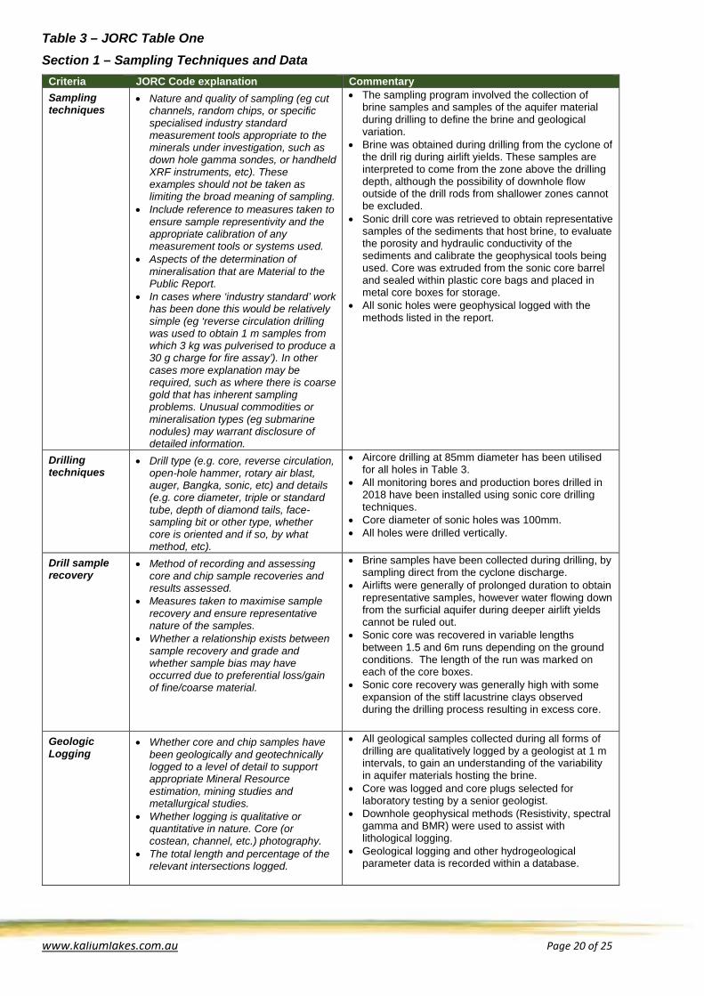
Table 3 – JORC Table One Section 1 – Sampling Techniques and Data
Criteria JORC Code explanation Commentary Sampling techniques
• Nature and quality of sampling (eg cut channels, random chips, or specific specialised industry standard measurement tools appropriate to the minerals under investigation, such as down hole gamma sondes, or handheld XRF instruments, etc). These examples should not be taken as limiting the broad meaning of sampling.
• Include reference to measures taken to ensure sample representivity and the appropriate calibration of any measurement tools or systems used.
• Aspects of the determination of mineralisation that are Material to the Public Report.
• In cases where ‘industry standard’ work has been done this would be relatively simple (eg ‘reverse circulation drilling was used to obtain 1 m samples from which 3 kg was pulverised to produce a 30 g charge for fire assay’). In other cases more explanation may be required, such as where there is coarse gold that has inherent sampling problems. Unusual commodities or mineralisation types (eg submarine nodules) may warrant disclosure of detailed information.
• The sampling program involved the collection of brine samples and samples of the aquifer material during drilling to define the brine and geological variation.
• Brine was obtained during drilling from the cyclone of the drill rig during airlift yields. These samples are interpreted to come from the zone above the drilling depth, although the possibility of downhole flow outside of the drill rods from shallower zones cannot be excluded.
• Sonic drill core was retrieved to obtain representative samples of the sediments that host brine, to evaluate the porosity and hydraulic conductivity of the sediments and calibrate the geophysical tools being used. Core was extruded from the sonic core barrel and sealed within plastic core bags and placed in metal core boxes for storage.
• All sonic holes were geophysical logged with the methods listed in the report.
Drilling techniques
• Drill type (e.g. core, reverse circulation, open-hole hammer, rotary air blast, auger, Bangka, sonic, etc) and details (e.g. core diameter, triple or standard tube, depth of diamond tails, face-sampling bit or other type, whether core is oriented and if so, by what method, etc).
• Aircore drilling at 85mm diameter has been utilised for all holes in Table 3.
• All monitoring bores and production bores drilled in 2018 have been installed using sonic core drilling techniques.
• Core diameter of sonic holes was 100mm. • All holes were drilled vertically.
Drill sample recovery
• Method of recording and assessing core and chip sample recoveries and results assessed.
• Measures taken to maximise sample recovery and ensure representative nature of the samples.
• Whether a relationship exists between sample recovery and grade and whether sample bias may have occurred due to preferential loss/gain of fine/coarse material.
• Brine samples have been collected during drilling, by sampling direct from the cyclone discharge.
• Airlifts were generally of prolonged duration to obtain representative samples, however water flowing down from the surficial aquifer during deeper airlift yields cannot be ruled out.
• Sonic core was recovered in variable lengths between 1.5 and 6m runs depending on the ground conditions. The length of the run was marked on each of the core boxes.
• Sonic core recovery was generally high with some expansion of the stiff lacustrine clays observed during the drilling process resulting in excess core.
Geologic Logging
• Whether core and chip samples have been geologically and geotechnically logged to a level of detail to support appropriate Mineral Resource estimation, mining studies and metallurgical studies.
• Whether logging is qualitative or quantitative in nature. Core (or costean, channel, etc.) photography.
• The total length and percentage of the relevant intersections logged.
• All geological samples collected during all forms of drilling are qualitatively logged by a geologist at 1 m intervals, to gain an understanding of the variability in aquifer materials hosting the brine.
• Core was logged and core plugs selected for laboratory testing by a senior geologist.
• Downhole geophysical methods (Resistivity, spectral gamma and BMR) were used to assist with lithological logging.
• Geological logging and other hydrogeological parameter data is recorded within a database.

www.kaliumlakes.com.au Page 21 of 25
Criteria JORC Code explanation Commentary Subsampling techniques and sample preparation
• If core, whether cut or sawn and whether quarter, half or all core taken.
• If non-core, whether riffled, tube sampled, rotary split, etc and whether sampled wet or dry.
• For all sample types, the nature, quality and appropriateness of the sample preparation technique.
• Quality control procedures adopted for all sub-sampling stages to maximise representivity of samples.
• Measures taken to ensure that the sampling is representative of the in situ material collected, including for instance results for field duplicate/ second-half sampling.
• Whether sample sizes are appropriate to the grain size of the material being sampled.
• All samples collected are kept cool, until delivery to the laboratory in Perth.
• Brine samples were collected in clean 500 ml bottles with little to no air.
• Field brine duplicates and laboratory standards and repeats have been completed.
Quality of assay data and laboratory tests
• The nature, quality and appropriateness of the assaying and laboratory procedures used and whether the technique is considered partial or total.
• For geophysical tools, spectrometers, handheld XRF instruments, etc, the parameters used in determining the analysis including instrument make and model, reading times, calibrations factors applied and their derivation, etc.
• Nature of quality control procedures adopted (e.g. standards, blanks, duplicates, external laboratory checks) and whether acceptable levels of accuracy (i.e. lack of bias) and precision have been established.
• Elemental analysis of brine samples are performed by a reputable Perth laboratory, the Burea-Veritas (BV) (formerly Amdel/Ultrace) mineral processing laboratories. BV is certified to the Quality Management Systems standard ISO 9001. Additionally they have internal standards and procedures for the regular calibration of equipment and quality control methods.
• Laboratory equipment are calibrated with standard solutions
• Analysis methods for the brine samples used are inductively coupled plasma optical emission spectrometry (ICP OES), Ion Selective Electrode (ISE), Inductive coupled plasma mass spectroscopy (ICP-MS), volumetrically and colourimetrically.
• The assay method and results are suitable for the calculation of a resource estimate.
• Check assays have been undertaken
Verification of sampling and assaying
• The verification of significant intersections by either independent or alternative company personnel.
• The use of twinned holes. • Documentation of primary data, data
entry procedures, data verification, data storage (physical and electronic) protocols.
• Discuss any adjustment to assay data.
• Field parameters of SG and total dissolved solids have been taken.
• Data concerning sample location was obtained out in the field, data entry then performed back in the Perth office to an electronic database and verified by Advisian.
• Assay data remains unadjusted.
Location of data points
• Accuracy and quality of surveys used to locate drill holes (collar and down-hole surveys), trenches, mine workings and other locations used in Mineral Resource estimation.
• Specification of the grid system used. • Quality and adequacy of topographic
control.
• Hole location coordinates obtained by GPS. • Reduced levels are to be surveyed with a more
accurate method in the future. • The grid system used was MGA94, Zone 51.
Data spacing and distribution
• Data spacing for reporting of Exploration Results.
• Whether the data spacing and distribution is sufficient to establish the degree of geological and grade continuity appropriate for the Mineral Resource and Ore Reserve estimation procedure(s) and classifications applied.
• Whether sample compositing has been applied.
• Drilling ensured a bore spacing of between 250m and 450m over the main palaeovalley in the 10 Mile and Sunshine areas respectively.

www.kaliumlakes.com.au Page 22 of 25
Criteria JORC Code explanation Commentary Orientation of data in relation to geological structure
• Whether the orientation of sampling achieves unbiased sampling of possible structures and the extent to which this is known, considering the deposit type.
• If the relationship between the drilling orientation and the orientation of key mineralised structures is considered to have introduced a sampling bias, this should be assessed and reported if material.
• Not applicable, considering the deposit type. • All drill holes are vertical given the flat lying structure
of a salt lake
Sample security
• The measures taken to ensure sample security.
• Samples are labelled and transported by KLP personnel to Perth. They are then hand delivered to BV laboratories by KLP personnel.
Audits or reviews
The results of any audits or reviews of sampling techniques and data.
• No audits or reviews have been completed
Section 2 – Reporting of Exploration Results Criteria JORC Code explanation Commentary Mineral tenement and land tenure status
• Type, reference name/number, location and ownership including agreements or material issues with third parties such as joint ventures, partnerships, overriding royalties, native title interests, historical sites, wilderness or national park and environmental settings.
• The security of the tenure held at the time of reporting along with any known impediments to obtaining a licence to operate in the area.
• The Beyondie Potash Project is 100% owned by Kalium Lakes Limited (KLP or Kalium Lakes) with project tenure held under granted exploration licences: E69/3306, E69/3309, E69/3339, E69/3340, E69/3341, E69/3342, E69/3343, E69/3344, E69/3345, E69/3346, E69/3347, E69/3348, E69/3349, E69/3351, E69/3352.
• KLP has a land access and mineral exploration agreement with the Mungarlu Ngurrarankatja Rirraunkaja (MNR) Aboriginal Corporation over tenures E69/3339, E69/3340, E69/3342, E69/3343, E69/3344, E69/3345, E69/3348, E69/3349 and E69/3351.
• KLP has an exploration and prospecting deed of agreement, and a Mining Land Access Agreement with the Gingirana Native Title Claim Group over tenures E69/3341, E69/3346, E69/3347 and E69/3352.
• KLP has Land Access Agreements with Gingirana and Birrilibbru (MNR) which provide for the consent to the grant of mining leases, ancillary tenure and approvals required for the BSOPP.
Exploration done by other parties
• Acknowledgment and appraisal of exploration by other parties.
• There has been no previous exploration at the Beyondie Potash Project.
Geology • Deposit type, geological setting and style of mineralisation.
• The deposit is a brine containing potassium and sulphate ions that could form a potassium sulphate salt. The brine is contained within saturated sediments below the lake surface and in sediments adjacent to the lake. The lake sits within a broader palaeovalley system that extends over hundreds of kilometres.
Drill hole Information
A summary of all information material to the understanding of the exploration results including a tabulation of the following information for all Material drillholes: • easting and northing of the drillhole
collar • elevation or RL (Reduced Level –
elevation above sea level in metres) of the drillhole collar
• dip and azimuth of the hole • downhole length and interception
depth • hole length.
• Information has been included in drill collar tables and bore logs appended to this report.
• All holes are vertical (dip -90, azimuth 0 degrees).

www.kaliumlakes.com.au Page 23 of 25
Criteria JORC Code explanation Commentary If the exclusion of this information is justified on the basis that the information is not Material and this exclusion does not detract from the understanding of the report, the Competent Person should clearly explain why this is the case.
Data aggregation methods
• In reporting Exploration Results, weighting averaging techniques, maximum and/or minimum grade truncations (eg cutting of high grades) and cut-off grades are usually Material and should be stated.
• Where aggregate intercepts incorporate short lengths of high grade results and longer lengths of low grade results, the procedure used for such aggregation should be stated and some typical examples of such aggregations should be shown in detail.
• The assumptions used for any reporting of metal equivalent values should be clearly stated.
• Not applicable due to exploration results being applicable to a brine and not a solid.
• No low or high grade cut-off grade has been implemented due to the consistent grade of the brine assay data.
Relationship between mineralisation widths and intercept lengths
• These relationships are particularly important in the reporting of Exploration Results.
• If the geometry of the mineralisation with respect to the drillhole angle is known, its nature should be reported.
• If it is not known and only the down hole lengths are reported, there should be a clear statement to this effect (e.g. ‘downhole length, true width not known’).
• Not applicable due to exploration results being applicable to a brine and not a solid.
Diagrams • Appropriate maps and sections (with scales) and tabulations of intercepts should be included for any significant discovery being reported These should include, but not be limited to a plan view of drill hole collar locations and appropriate sectional views.
• Refer to figures/tables in this announcement.
Balanced reporting
• Where comprehensive reporting of all Exploration Results is not practicable, representative reporting of both low and high grades and/or widths should be practiced to avoid misleading reporting of Exploration Results.
• All drilling and brine analysis results from the BFS program have been reported above, unless stated otherwise.
Other substantive exploration data
• Other exploration data, if meaningful and material, should be reported including (but not limited to): geological observations; geophysical survey results; geochemical survey results; bulk samples – size and method of treatment; metallurgical test results; bulk density, groundwater, geotechnical and rock characteristics; potential deleterious or contaminating substances.
• BMR water volumes have been corrected for hypersalinity using a hydrogen index correction. Laboratory calibration of the BMR derived hydraulic conductivity is pending however the results are not expected to significantly alter the current logs. BMR logs have been provided by Kinetic, a wireline logging services provider, using the BMR-60 tool developed by Qteq. The BMR-60 tool has a diameter of investigation of 230mm.
• All other relevant data is presented in the Beyondie Sulphate of Potash Project Pre-Feasibility Study report.
Further work • The nature and scale of planned further work (eg tests for lateral extensions or depth extensions or large-scale step-out drilling).
• Continued trial pond pumping from bores and trenches
• Additional test pumping at Lake Sunshine. • Infiltration and leach testing of lake sediments

www.kaliumlakes.com.au Page 24 of 25
Criteria JORC Code explanation Commentary • Diagrams clearly highlighting the
areas of possible extensions, including the main geological interpretations and future drilling areas, provided this information is not commercially sensitive.
• Revision of the Mineral Resources and Ore Reserves.
Competent Persons Statement The information in this ASX Announcement that relates to Exploration Results for The Beyondie Potash Project is based on, and fair represents, information compiled by Mr Adam Lloyd, who is a member of the Australian Institute of Geoscientists and International Association of Hydrogeologists. Mr Lloyd has verified and approved the data disclosed in the release, including the sampling, analytical and test data underlying the information. Mr Lloyd is employed by Advisian, an independent consulting company. Mr Lloyd has sufficient experience, which is relevant to the style of mineralisation and type of deposit under consideration and to the activity which he is undertaking to qualify as a Competent Person as defined in the 2012 Edition of the JORC “Australasian Code for Reporting of Exploration Results, Mineral Resources and Ore Reserves”. Mr Lloyd consents to the inclusion in this ASX Announcement of the matters based on his information in the form and context in which it appears. Compliance Statement The information in this document that relates to Mineral Resource and Ore Reserve Estimates has been extracted from the report(s) listed below.
- 3 October 2017: Pre-Feasibility Study with Maiden Ore Reserve Confirms Low Cost, Long Life and High Margin Beyondie SOP Project. (Including the attachment, JORC (2012) and NI 43-101 Technical Report, compiled by German Potash Experts and Competent Persons, K-UTEC AG Salt Technologies (K-UTEC)).
The report(s) are available to be viewed on the website at: www.kaliumlakes.com.au Kalium Lakes confirms that it is not aware of any new information or data that materially affects the information included in the original market announcements and, in the case of estimates of Mineral Resources, that all material assumptions and technical parameters underpinning the estimates in the relevant market announcement continue to apply and have not materially changed. The company confirms that the form and context in which the Competent Person’s findings are presented have not been materially modified from the original market announcement. Cautionary Statement Regarding Forward-Looking Information Statements regarding plans with respect to the Company’s mineral properties may contain forward looking statements. Statements in relation to future matters can only be made where the Company has a reasonable basis for making those statements. This announcement has been prepared in compliance with the current JORC Code 2012 Edition and the current ASX Listing Rules. The Company believes it has a reasonable basis for making the forward-looking statements on 3 October 2017, including any production targets, based on the information contained in the announcement and in particular the JORC 2012 and NI 43-101 Technical Report. All statements, trend analysis and other information contained in this document relative to markets for Kalium Lakes, trends in resources, recoveries, production and anticipated expense levels, as well as other statements about anticipated future events or results constitute forward-looking statements. Forward-looking statements are often, but not always, identified by the use of words such as “seek”, “anticipate”, “believe”, “plan”, “estimate”, “expect” and “intend” and statements that an event or result “may”, “will”, “should”, “could” or “might” occur or be achieved and other similar expressions. Forward-looking statements are subject to business and economic risks and uncertainties and other factors that could cause actual results of operations to differ materially from those contained in the forward-looking statements. Forward-looking statements are based on estimates and opinions of management at the date the statements are made. Kalium Lakes does not undertake any obligation to update forward-looking statements even if circumstances or management’s estimates or opinions should change. Investors should not place undue reliance on forward-looking statements. *** ENDS ***

www.kaliumlakes.com.au Page 25 of 25
Corporate Profile (as at 2 May 2018) Kalium Lakes Limited is an exploration and development company, focused on developing the Beyondie Sulphate Of Potash Project in Western Australia with the aim of producing Sulphate of Potash (SOP) for the domestic and international markets. The Beyondie SOP Project comprises 15 granted exploration licences, one granted miscellaneous licence, two mining lease applications and nine miscellaneous licence applications, covering an area of approximately 2,400 square kilometres. This sub-surface brine deposit will supply an evaporation and processing operation located 160 kilometres south east of Newman. The results of the Pre-Feasibility Study (PFS), announced on 3 October 2017, confirmed that the Project, is technically and financially robust. The key outcomes of the PFS are:
• Indicated Resource of 4.37 Mt @ 14,000 mg/l SOP at a cut-off grade of 3,500mg/l K and an Inferred Resource of 13.74 Mt @ 12,788 mg/l SOP at a cut-off grade of 3,500mg/l K.
• Maiden Probable Reserve of 2.66 Mt @ 14,210 mg/l SOP at a cut-off grade of 3,500mg/l K based solely within the Stage 1 Approval Footprint, which represents ~21% of total lake surface area within the tenement package.
• Development base case of 150 ktpa SOP, with the option to incrementally phase the project, through a ramp up from 75 ktpa to 150 ktpa SOP, to minimise operational and financial risks.
• Development base case pre-tax NPV10 of A$388M, IRR of 28.7%, average EBITDA of A$83 Mpa, EBITDA margin of 62%, a payback period of 3.7 years and Life of Mine (LOM) free cash flows of more than +A$1B, based on an initial 21 year LOM and a USA$500/t SOP sales price @ A$A/A$US exchange rate of 0.75.
• Estimated LOM Operating Cash Cost of A$244-253/t SOP FOB Geraldton or Fremantle Port. This places the BSOPP in the lowest quartile cost of global SOP production.
• Pre-production Capital Cost of A$220 million including a 78 kilometre gas pipeline for the base case or A$124 million for the phased ramp-up scenario.
• Potential additional revenue associated with recovery of magnesium by-products which have not been included in the current financial outcomes.
The Company is also a Joint Venture partner with BCI Minerals Limited (BCI) in the Carnegie Potash Project, a potash exploration project located approximately 220 kilometres north-east of Wiluna. Carnegie comprises one granted exploration licence and two exploration licence applications covering a total area of approximately 1,700 square kilometres. Kalium Lakes Limited ABN: 98 613 656 643 ASX: KLL Ordinary Shares on Issue: 169,793,465 Board of Directors: Chief Financial Officer and Joint Company Secretary: Frederick Kotzee Mal Randall Non-Executive Chairman Brett Hazelden Managing Director Rudolph van Niekerk Executive Director Joint Company Secretary: Gareth Widger Brendan O’Hara Non-Executive Director Contact Details: Share Registry: Kalium Lakes Limited Computershare Investor Services Pty Ltd Unit 1, 152 Balcatta Road Level 11, 172 St Georges Terrace BALCATTA WA 6021 Perth, WA 6000 Tel: (within Australia): 1300 850 505 PO Box 610 Tel: (outside Australia): +61 3 9415 4000 BALCATTA, WA 6914
Tel: +61 (0)8 9240 3200
Email: [email protected]
Web: www.kaliumlakes.com.au