Beyond Typology: Zaviye and T- Shape Buildings in the ... · century Ottoman architecture, it has...
25
Panagiotis Kontolaimos Beyond Typology: Zaviye and T- Shape Buildings in the Balkans. Some Thoughts on their Urban Context and their Possible Use(s) Terms and Functions: The Zaviye and the T-Shaped Structures Over the last decades the issue of the zaviye function and their connection with early Ottoman history has become a rather popular one, since it is associated with the early Ottoman building type clas- sified as T-Shaped. 1 However, one should be in position to make a distinction between the textual term zaviye and the actual standing T-Shaped buildings. The term zaviye is extensively (but not exclu- sively) used in Ottoman textual sources already from the 14 th century referring to buildings servicing dervishes and travelers. Later on, their target group was expanded to include locals and other –gener- ally speaking– people in need, with the exception of the “non pure” ones and the “sinners.” 2 So, while zaviye were originally addressing the needs of dervishes, soon after, it seems that they gained a wider social role for both locals and travelers, due to the food they pro- vided. The term zaviye is thus used to describe a multifunctional building where gatherings, charity and hospitality was taking place, 1 For the classical view towards zaviye and their potential role see Semavi Eyice, “İlk Osmanlı Devrinin Dini-İçtimai Bir Müessesesi Zaviyeler ve Zaviyeli-Camiler” (Zaviye and zaviye-mosques. A religious-social institution of the early Ottoman period), İstanbul Üniversitesi İktisat Fakültesi Dergisi 21 (1962): 1-80; Ömer L. Barkan, “Osmanli imperatorluğunda bir iskan ve kolonizasyon metodu olarak vakif- lar ve temlikler” (Vakif and transaction deeds as a method for settling and colonisa- tion for the Ottoman Empire), Vakiflar Dergisi 2 (1949-50): 279-386. For a general review on the relevant literature see Sedat Emir, “Erken Osmanli Mimarliginda Zaviyeler. Sirasız Metinler I: Tipoloji Elestirileri” (Zaviye in early Ottoman ar- chitecture. Texts and typology), Arredamento Mimarlik 263 (2012): 120-3. 2 Irène Beldiceanu–Steiner, Rechersches sur les acts des règnes des sultans Os- man, Orkhan et Murad I (Munich: 1967), 77, 85, 127, 143, 174, 213, 215, 244-7.
Transcript of Beyond Typology: Zaviye and T- Shape Buildings in the ... · century Ottoman architecture, it has...

Panagiotis Kontolaimos
Beyond Typology: Zaviye and T- Shape Buildings
in the Balkans. Some Thoughts on their Urban Context
and their Possible Use(s)
Terms and Functions: The Zaviye and the T-Shaped Structures
Over the last decades the issue of the zaviye function and their
connection with early Ottoman history has become a rather popular one, since it is associated with the early Ottoman building type clas-sified as T-Shaped.1 However, one should be in position to make a distinction between the textual term zaviye and the actual standing T-Shaped buildings. The term zaviye is extensively (but not exclu-sively) used in Ottoman textual sources already from the 14th century referring to buildings servicing dervishes and travelers. Later on, their target group was expanded to include locals and other –gener-ally speaking– people in need, with the exception of the “non pure” ones and the “sinners.”2 So, while zaviye were originally addressing the needs of dervishes, soon after, it seems that they gained a wider social role for both locals and travelers, due to the food they pro-vided. The term zaviye is thus used to describe a multifunctional building where gatherings, charity and hospitality was taking place,
1 For the classical view towards zaviye and their potential role see Semavi Eyice,
“İlk Osmanlı Devrinin Dini-İçtimai Bir Müessesesi Zaviyeler ve Zaviyeli-Camiler” (Zaviye and zaviye-mosques. A religious-social institution of the early Ottoman period), İstanbul Üniversitesi İktisat Fakültesi Dergisi 21 (1962): 1-80; Ömer L. Barkan, “Osmanli imperatorluğunda bir iskan ve kolonizasyon metodu olarak vakif-lar ve temlikler” (Vakif and transaction deeds as a method for settling and colonisa-tion for the Ottoman Empire), Vakiflar Dergisi 2 (1949-50): 279-386. For a general review on the relevant literature see Sedat Emir, “Erken Osmanli Mimarliginda Zaviyeler. Sirasız Metinler I: Tipoloji Elestirileri” (Zaviye in early Ottoman ar-chitecture. Texts and typology), Arredamento Mimarlik 263 (2012): 120-3.
2 Irène Beldiceanu–Steiner, Rechersches sur les acts des règnes des sultans Os-man, Orkhan et Murad I (Munich: 1967), 77, 85, 127, 143, 174, 213, 215, 244-7.
244 Panagiotis Kontolaimos
thus including but not necessarily being identical with the term ima-ret, known as the place were charity was practiced in the form of food distribution. Even so, no indication for the actual shape of nei-ther zaviye nor imaret is provided in any of the relevant texts. This is very logical, since those usually refer to uses and not to particular types of buildings.
On the other hand, the term T-Shaped building is used by scholars to describe a typology of buildings, characterized by the shape of their layout, which has the form of a reversed T.3 Although this type of building was extensively used in the 14th and 15th centuries, the term describing it is a rather modern construct. The buildings themselves demonstrate a remarkable ability to adapt to local conditions and needs, due to their simple form. In spite their structural similarities, in terms of layout, according to which they were grouped, T-Shaped buildings demonstrate a considerable number of individual charac-teristics, which, in combination with the rest of their architectural properties, form a set of data that every scholar should take in serious consideration. Apart from their layout, factors like their urban envi-ronment, architectural composition, and construction details play a great role in their understanding and interpretation.
By using this approach, we are aiming towards the spatial and temporal contextualization of some interesting examples from the Balkans that could be classified under the category T-Shaped build-ings. While reviewing 14th century Ottoman architecture, it has be-come apparent that, what links T-Shape buildings with the rest of the 14th century Ottoman architecture is their occasional multiple func-tions. Early Ottoman architecture in Bursa could be a useful example for demonstrating this tendency of local architecture in the time when zaviye were also erected. The Great Mosque of Hüdavendigar is a very good example since it combines in a solid building both the
3 Many names are tribute to this type of buildings with T-Shaped and Bursa
Type being more frequent. Later scholarly work also called them Convert Mos-ques, Mosques with side spaces, or even Cross-Axial Mosques. See Aptullah Kur-an, The Mosque in Early Ottoman Architecture (Chicago, London: University of Chicago Press, 1968), 71-136.

Balkan Studies 51 (2016) 245
functions of a praying hall and a religious school.4 It seems that, in the 14th century we are dealing with buildings that serve multiple of functions, something that makes T-Shaped buildings less excep-tional than it was believed. What seems to be the case is that zaviye started as structures of collective communal uses, some of which later on were overshadowed by the development of more effective Ot-toman institutions. The development of Ottoman vakɪf and their kül-liye in the Balkans after the last decade of the 14th century led to a gradual change, since külliye consisted of a group of single function buildings. Probably the older T-Shaped structures ultimately got one function, usually related to food provision or religion, and were incorporated into the new building assemblages. If we accept the multifunction of zaviye, perhaps we could ask whether there could have been other function(s) that used this T-Shape type of buildings. A positive answer to the question above ultimately leads to the issue of great variation among T-Shaped buildings erected in the Balkans in the second half of the 14th century.
Keeping in mind the above thoughts we will comment four exam-ples of T-Shaped buildings from the Balkans. Apart from their com-mon T-Shaped layout, other properties will be also discussed, such as their urban context, morphological and structural particularities and, finally, some interesting construction details. We hope that if we include this data, it is easier to demonstrate the range of differen-tiation and consequently perhaps their differentiated uses within the 14th century Ottoman Balkan social context.
The Gazi Evrenos Imaret in Komotini (northern Greece)
The first case study of T-Shaped building is found at the city of Komotini, which is sıtuated at the Western Thrace region in northern Greece. The city is placed on the northern part of a very fertile plain
4 For the architecture in Bursa, the work of Gabriel is a classical one. In the
same volume one can read in detail about the layout of zaviye of Murat I (Hüdaven-digar) in Ҫekirge, as well as about the use of Emir Han as the place of storage for the market weights. See Albert Gabriel, Une capitale turque: Brousse, Bursa (Paris: E. de Boccard, 1958), 52, 182.
246 Panagiotis Kontolaimos
and it is connected to the east by two paths: the coastal one (on the truck of roman Via Egnatia) and the one through the low mountains, which frame the plain from the east. Both of those paths unite shortly before they reach the fortified city, which was also well linked with the Bulgarian lands though Rodopi Mountains to the north. The al-most rectangular city was erected to the north of a small river, most probably during the 12th century as a fortified settlement, which the Ottomans expanded to the east, by erecting a T-Shaped building right at the spot there the joint streets were meeting the small riverbed.5 The building was erected perhaps around 1370 by Evrenos, the Ot-toman March Lord that captured the town and settled there for almost a decade.6 During his lifetime a mosque and a bath were also erected nearby, but if one judges from the domed shape of the mosque and the rather distant location of the bath, those buildings they do not form an initial unit with the T-Shaped structure.
The building examined here adapts to the visual language of a byzantine building, having been constructed in the so-called brick – enclosed system, very typical for byzantine architecture.7 The build-ing is not orientated towards Mecca, as one would have expected from a religious structure. It is divided in three parts with the central hall being wide open to the North though an arch. The same central
5 For the city of Komotini and its walls see G. Vassiliadis, «Το κάστρο της Κο-μοτηνής. Αρχιτεκτονική ανάλυση και τεκμηρίωση» (The castle of Komotini. Architectural analysis and documentation), in Byzantine Thrace. Evidence and Re-mains. Proceedings of the 4th International Symposium of Thracian Studies, Ko-motini 18-22 April 2007, ed. Ch. Bakirtzis, N. Zekos, and X. Moniaros (Amster-dam: A. M. Hakkert, 2011), 139-54.
6 For Evrenos and his connection with this building see Heath Lowry, Osmanlɪ dӧneminde Balkanlarɪn şekillenmesi 1350-1550 (The shaping of the Balkans in the Ottoman period 1350-1550) (Istanbul: Bahçeşehir Üniversitesi Yayɪnlarɪ, 2008), 80-4.
7 For a detailed description of the building and its connections with local building craftsmanship see S. Doukata, «Ιμαρέτ» (Imaret), in Η οθωμανική αρχιτεκτονική στην Ελλάδα (Ottoman Architecture in Greece), ed. Ersi Brouskari (Athens: Ministry of Culture, 2008), 324-6; Ch. Bakirtzis and P. Xydas, «Ιμαρέτ» (Imaret), in Κοσμική αρχιτεκτονική στα Βαλκάνια 1300-1500 και η διατήρησή της (Secular architecture in the Balkans 1300-1500 and its conservation), ed. Slobodan Curcic and Εvangelia Hatzitryfonos (Thessaloniki: University Studio Press, 1999), 294-5.
Balkan Studies 51 (2016) 247
hall is not as developed as in other examples of the same type, and does not seem to have had any installations that would testify for its religious use (like a mihrab for example). In addition, its southern section, where the supposed paying hall would have been, is, alt-hough discrete from the rest of the volume of the buildings, still very poorly developed for serving religious festivities.
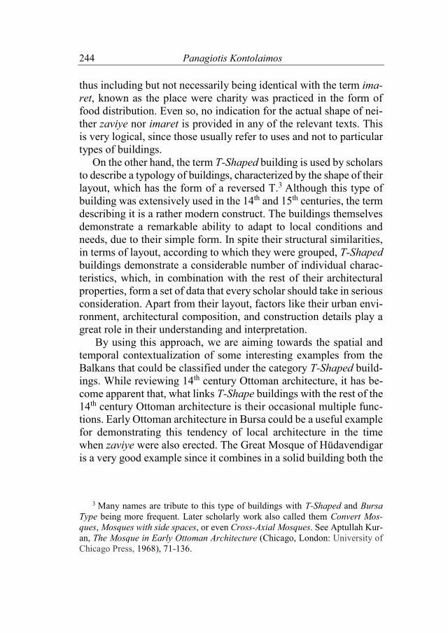
Figure 1. The present state of the imaret building in Komotini. One
can see the building’s northern and western facades, with the open eyvan-style entrance to the main hall and its byzantine-inspired construction technique with the extensive and elaborate use of brick and stone. (Photographed by D. Loupis, 2010).
248 Panagiotis Kontolaimos
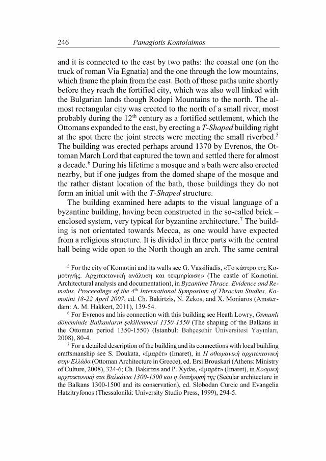
Figure 2. The layout of the imaret in Komotini. One can see both the slight size difference between the east and west side rooms and their relation to the main hall. (Image after Ch. Bakirtzis and P. Xydas, «Ιμαρέτ», redrawn by the author).
The other two parts of the building, the two side rooms, do not share the same size with the one to the west being significant smaller than the one to the east. The entrances of the two side rooms are dis-tinctly highlighted by their architectural ornamentation and the in-scriptions, that were ones placed right above them. Those doors are also located as close to the entrance arch as possible, and thus, an extended presence in the main hall is discouraged. This and the rel-atively small proportion of the central hall shows that the main ac-tivities of the building were taking place in the side rooms. The main hall seams to function as a semi-open entrance space, which would be used for more public events due to its visibility through the arch for anyone standing to the north of the building. All these data raise questions for the original use of the building. It is very clear that it wouldn’t be functional as a veneration venue. It seems to us that the first function of the building was rather non-religious. No matter how inviting the idea that this building might have been used as the personal residence of Evrenos might be, we have to reject it for two main reasons. The first is that, if we judge from the court of the sul-

Balkan Studies 51 (2016) 249
tans at the same time, the private life of the Ottoman ruler was dis-tinct from his political and institutional role. While the family of the sultan had its residence in the city of Dimetoka, the official court was held in Edirne.8 In the same way one could imagine Evrenos’ family living within the walls of the town and leaving this T-Shaped build-ing for more institutionalized uses.
The second reason why one should reject the idea of Komotini’s imaret being the personal house of Evrenos is simply because if one accepts the vision that public buildings are also the spatial crystalli-zation of abstract institutions, it does not seem likely to us that, within the warrior community of Evrenos, there would be a place for an institution that could justify a relevant building. Power within the supporters of Evrenos was totally personified and therefore movable with no need of “symbolic buildings” like a “palace.” The clans that supported Evrenos were not much accustomed to “abstract” power structures either.9 Most of them must have established themselves in the nearby plains, not even near the building under discussion. Con-sidering its non-religious function, this building would have been ideal as a seat of an akhi brotherhood. Those were urban institutions which include traders and craftsmen who had strict internal hierar-chy, close ties with the dervishes, and particularly important role in a town’s market in 14th century Anatolia.10 We know that they too hosted visitors and held ceremonies in communal venues such as the
8 Elizabeth Zachariadou, “The Sultanic Residence and the Capital: Didymo-
teichon and Adrianople,” in The Ottoman Empire, the Balkans, the Greek Lands: Toward a Social and Economic History, ed. Elias Kolovos et al. (Istanbul: The ISIS Press, 2007), 357-61.
9 For the early Ottoman society see Ελισάβετ Ζαχαριάδου, Ιστορία και θρύλοι των παλαιών σουλτάνων 1300-1400 (History and legends of the old sultans 1300-1400), (Athens: National Bank of Greece Cultural Foundation, 1999), and for the conditions of the capture of Thrace by the Ottomans see Georgios Vogiatzis, Η πρώιμη οθωμανοκρατία στη Θράκη. Άμεσες δημογραφικές συνέπειες (Early Otto-man period in Thrace. Imediate demographical consequences), (Athens: Herodotos, 1998), 171-225, 327-72.
10 Franz Taeschner, Zünfte und Bruderschaften im İslam, Texte zur Geschichte der Futuwwa (Münich: Artemis & Winkler Verlag, 1979), 229-35, 277-85.
250 Panagiotis Kontolaimos
zaviye.11 It is very likely that the building in Komotini was the seat of a brotherhood of the kind, whose members would form the first form of the local Ottoman market.
Therefore, in our opinion it is better to view this building as a venue of akhi with no particular religious ties. This is further supported by the fact that this building was never dedicated to the veneration of a şeyh, something which would have happened had it being related to any religious order. Furthermore, it was probably being at a time that not even Evrenos himself was converted to Islam and therefore reli-gion was not the main criterion for join in with the Ottomans.12 In this case, possibly, the larger of the two rooms could have housed those communal meetings, while the main arched hall would have been the place to address to the public. Furthermore, the small room could have been used for the feeding of the needy (and it is this func-tion, the one of an imaret, that would remain), and the residence of the keepers of the facility. In any case, food distribution must have been one of the core practices, giving its name to the building, which is even in our days called an imaret and was servicing as such till the early 20th century.
The fact that the earliest Ottoman bath in the region was erected some twenty five-thirty years after this building, most probably in-dicates that there was no extensive permanent Ottoman settlement around Komotini at around 1370 and that this building was the very core of the town’s urban development under the Ottomans.13 In this new concept of urbanity created at the time, both Christians and Muslims were being seen as integral parts so it is no surprise that,
11 Spyros Vryonis, Η παρακμή του μεσαιωνικού ελληνισμού στην Μικρά Ασία και η διαδικασία εξισλαμισμού 11ος-15ος αιώνες (The declinment of the medieval Greek population in Asia Minor and the prossess of Islamization 11th-15th centur-ies), (Athens: National Bank of Greece Cultural Foundation, 1996), 350-4.
12 Heath Lowry and İsmail Erünsal, The Evrenos Dynasty of Yenice-i Vardar: Notes and Documents (Istanbul: Bahçeşehir University Press, 2010), 83-5.
13 For the first bath in the region, erected at the nearby town of Didimoteichon at the end of the 14th century, see Machiel Kiel, “Two Little Known Monuments of Early and Classical Ottoman Architecture in Greek Thrace,” Balkan Studies 22 (1981): 127-46. Baths are a good indication for permanent establishment of an urban community. Their first appearance in Thrace significantly after the erection of the imaret implies a different function for early Ottoman settlements in the 14th century.

Balkan Studies 51 (2016) 251
unlike what was the case in Anatolia, all imarets in the Balkans ap-pear to host and serve people regardless of their religion.14 The Iskender Mosque or Cami-i şerif in Yannitsa (northern Greece)
The city of Yannitsa was originally established by Evrenos and flourished for centuries under his successors.15 The historical core of 14th-15th century Yannitsa has as an urban focus the mausoleum of Evrenos, still preserved today and restored in its late 19th century form.16 Yannitsa is located right on the way leading from Thessalo-niki to the north and west of the Balkan Peninsula. As one would expect from the final resting point of the great March Lord Evrenos, the city has been the hub of warriors from its founding time till the last decades of the 15th century. Its location was ideal for the early Ottoman expansion, something supported also by the local rise pro-duction and its ability to host and feed a great amount of people in its surrounding plain.17
The building under discussion is located at the very south part of the city, right by the main street connecting it with the west, namely Via Egnatia. The southern end of the town was framed by the ex-tended marsh lands existing in the region till middle of the 20th cen-tury. In other words, the building was erected at the edge of the city in a rather unhealthy area. Early 20th century photos show the soli-tude of its location, the way it must have been when the building was
14 Heath Lowry, In the Footsteps of Evliyâ Çelebi. The Seyahatnâme as Guide-
book (Istanbul: Bahçeşehir University Press, 2012), 1-8. 15 For the development of the city and the role of the Evrenos family see Lowry
and Erünsal, The Evrenos Dynasty, as well as Yasemin Umur, “Reconstructing Yenice-i Vardar: Patronage of the Evrenosoğlu Family,” MA thesis, Boğaziçi Uni-versity, 2008.
16 For the türbe of Evrenos and its recent restoration see Pashalis Androudis, “Restoration of the Mausoleum of Gazi Evrenos Bey in Giannitsa,” in Conserva-tion and Restoration of Ottoman Monuments in Greece, ed. Aimilia Stefanidou (Thessaloniki: University Studio Press, 2009), 389-405.
17 Umur, op. cit., 19, 74; Machiel Kiel, “Yenice-i Vardar. A Forgotten Turkish Cultural Center in Macedonia of the 15th and 16th century,” Studia Byzantina et Neohellenica Neerlandica 3 (1971): 300-29.
252 Panagiotis Kontolaimos
first erected. The building stands rather isolated, at a considerable distance from the historical core of the town of Yannitsa.
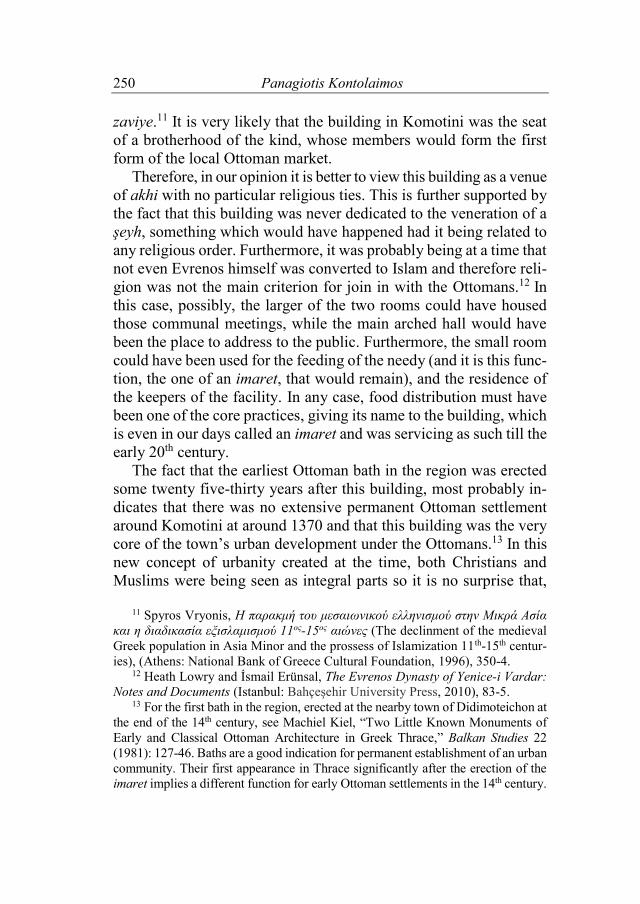
The historical form of this structure is known to us only from old pictures. Recent research has claimed that the main southern volume of the building that we see in the historical photographs is a later addition.18 The construction details of what remains from it today also supports this idea. Both the construction differences, as well as the totally different volume of the southern back part of the building, indicate that, they postdate the original structure, whose layout re-sembles the one of Komotini. It has the same three-part division, with a main central hall and two same size side rooms. However, similarities between the two buildings end here, as the building, in its initial form, was completely open towards the north, resembling more of a portico rather than a residential structure. The claim that the structure was not hosting someone is also supported by the fact that there is no indication of a hearth or a fire place, from what one can see at its present decadent state of preservation. The building is orientated towards Mecca, while its façade is facing north-west, where a succession of three arches (one in every part of the building, but now build up since the middle of the 20th century) kept hidden very little of the interior of the building.
18 Lowry and Erünsal, op. cit., 29-36.
Balkan Studies 51 (2016) 253
Figure 3. The Iskender Cami of Yannitsa in the early 20th century. Contemporary situation. The main eyvan entrance of the central hall is now blocked by a wall, altering the original “open” character of the structure. The volume of this main section is remarkably larger than the side one, visible here to the right around the small portico opening to it. (Image by the author, 2010).
We don’t know much about the internal lay out of the early phase
of the building.19 But what seems to be obvious is that since the por-tico-building was wide open towards the north-west, it wouldn’t make much sense to have internal divisions that would isolate the side rooms from the main hall. The original form of the oldest part of the
19 The building is still standing but heavily altered by later additions and gen-
eral misuse. The interior of the building has never been subject to any scientific inspection, much less restoration.
254 Panagiotis Kontolaimos
structure must have been that of a T-Shaped building, probably with no interior divisions and two low “Ottoman-style” side windows on its west and east sides. The main hall must have been projecting to-wards the south-east, exactly like in the example from Komotini. The side rooms are also considerably smaller than the main hall, unlike the case of Komotini. Their proportions in relation to the main hall clearly show that they do not consist the main space of the structure like in Komotini, but are rather supportive to the main central hall. Instead of interpreting this structure as a residence or an early Ot-toman Friday Mosque, its isolated location at the southern side of the city and the generally military character of Yannitsa that hosted it, must have made it ideal for a namazgah, namely a military open air praying hall, with the oldest part of the structure being the wall point-ing to Mecca. It has been erected in T-Shaped-portico layout to accommodate a number of people, perhaps in case of unsuitable weather conditions and it was later on turned into a mosque with the addition of its southern section, still visible today.
The dating of the building can as well be derived from its general shape and function. The fact that namazgah were erected on the city’s edges on the occasion of a large summit of soldiers before they marsh towards their attack aim, it can be claimed that the structure of Yan-nitsa was erected on the occasion of the Ottoman siege of Thessa-loniki, namely right before 1430.20 The scale and size of the structure fit very well with the gradual use of T-Shape buildings as congrega-tion mosques in the 15th century together with the current trends in Ottoman architecture. The proportions and size of the building, with the middle domed hall being emphasized and dominant over the other two side volumes, reminded us of the layout and proportions of the Üҫ Şerefeli mosque in Edirne, whose erection started, accor-ding to some scholars, at about the same time with the Yannitsa struc-ture, namely at late 1430’s.21 If those thoughts are valid, then the building in Yannitsa is directly linked with one of the early Ottoman
20 Mark Mazower, Salonica. City of Ghosts. Christians, Muslims, and Jews
1430-1950 (London: Harper Perennial, 2004), 27-30. 21 İnci Kuyulu, “Üҫ Şerefeli Cami,” in Erken Osmanlɪ Sanatɪ. Beyliklerin Mirasɪ
(Early Ottoman art. The heritage of the Beyliks), (Istanbul: 1999), 185-6.

Balkan Studies 51 (2016) 255
most illustrious architecture’s works as its forerunner. It is very like-ly that both buildings are also designed by the same architect, whose name remains so far unknown. Future restoration of the now col-lapsing building will reveal more on its architectural properties and virtues.
The zaviye of Mihaloĝlu Mahmut Bey in Ihtiman (Bulgaria)
This settlement was founded around 1370-71 by the followers of
the Mihaloĝlu clan.22 Mahmut Bey of the same clan was also the founder of the main pious foundation if the city, in operation already from the last years of the same century. The buildings that were in-cluded in this pious foundation, namely a han, a bath and the zaviye building, must have been completed by the last decade of the 14th century.23 Among them, the T-Shaped zaviye building is still to be found in the center of what must have been the core of 14th-15th cen-tury Ihtiman.
The building has a very typical T-Shape layout as we know it from similar examples dating in the same decade from Iznik.24 It is not orientated towards Mecca, like the one in Komotini, but its layout if fully symmetrical, giving its two side rooms the same dimensions. There are clear signs indicating the existence of fire places in the side rooms, while the building, unlike the other two examples we have examined so far, seems not to have had a wide “eyvan-style” opening on its façade but a rather normal wall with a door giving access to its internal space. The wall masonry does not appear to have had any
22 For more information on the Ottoman history of the settlement, see Machiel
Kiel, “Four Provincial Imarets in the Balkans and the Sources about them,” in Feeding People, Feeding Power: Imarets in the Ottoman Empire, ed. N. Ergin et al. (Istanbul: Eren Yayınları, 2007), 97-120; idem, “İhtiman,” Türkiye Diyanet Vakfı İslâm Ansiklopedisi 21 (2000): 571-2.
23 Mariya Kiprovska, “Ruins of Past Glory: The Earliest Standing Ottoman Building in Bulgaria,” accessed July 3, 2013, http://www.oahb.org/2009/05/06/ mihaloglu-mahmud-beys-complex/.
24 In the city of Iznik the Yakup Celebi zaviye, which still survives, dates at about 1380. The layout of this building reminds us a lot of the one in Ihtiman. See Eyice, “İlk Osmanlı Devrinin,” 66.
256 Panagiotis Kontolaimos
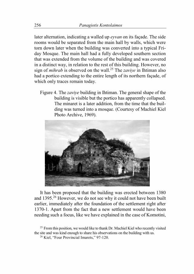
later alternation, indicating a walled up eyvan on its façade. The side rooms would be separated from the main hall by walls, which were torn down later when the building was converted into a typical Fri-day Mosque. The main hall had a fully developed southern section that was extended from the volume of the building and was covered in a distinct way, in relation to the rest of this building. However, no sign of mihrab is observed on the wall.25 The zaviye in Ihtiman also had a portico extending to the entire length of its northern façade, of which only traces remain today.
Figure 4. The zaviye building in Ihtiman. The general shape of the
building is visible but the portico has apparently collapsed. The minaret is a later addition, from the time that the buil-ding was turned into a mosque. (Courtesy of Machiel Kiel Photo Archive, 1969).
It has been proposed that the building was erected between 1380 and 1395.26 However, we do not see why it could not have been built earlier, immediately after the foundation of the settlement right after 1370-1. Apart from the fact that a new settlement would have been needing such a focus, like we have explained in the case of Komotini,
25 From this position, we would like to thank Dr. Machiel Kiel who recently visited
the site and was kind enough to share his observations on the building with us. 26 Kiel, “Four Provincial Imarets,” 97-120.

Balkan Studies 51 (2016) 257
this zaviye resembles a lot of the one in Komotini and Iznik and there-fore its possible dating between 1370 and 1380 would not be irration-al. The other two buildings of the pious foundation seem to have been erected at the end of the 14th century. Particularly the han, probably shared the same typology with the ones in Traianoupolis, near Evros River which is probably erected right before 1400.27
As in the case of Komotini, the initial use seems to have been the one of a zaviye of an akhi group, because there is no sigh or indica-tion that would imply a religious use. On the contrary, there are many signs that could support a rather non-religious use, such as fire places, which would help meetings to be held here and facilitate ac-commodation and food distribution. The sharp difference with the case in Komotini is the absence of an “eyvan-style” façade, but in our opinion the portico which ones existed at the entrance of the building in Ihtiman could have very well played this role, on the oc-casion of public events that required visibility. The Yɪldɪrɪm Beyazɪt Cami in Edirne (European Turkey)
The city of Edirne is located at the joint of three rivers, Evros, Tounja and Ardas, right at the heart of Thrace. The building that we are concerned with is called Yɪldɪrɪm Beyazɪt Cami. It was erected on the west side of the Tunca River, in the former residential byzan-tine suburb of Edirne called Ainos, soon before the defeat of the sul-tan in the battle of Ankara (1402).28 The location of the building is excellent due to the fact that is the joint spot of two different paths (from the north and west respectively) that join before entering the city. The building is erected in an extended T-Shaped form.29 This im-plies that the familiar shape of a reversed T is now supplemented by a
27 Lowry, Osmanlɪ dӧneminde, 32-5. 28 Semavi Eyice, “Bizans devrinde Edirne ve bu devire ait eserler” (Byzantine
Edirne and its monuments), in Edirne: Serhattaki Payıtaht (Edirne: A capital by the borders), ed. Emin N. Isli (Istanbul: Yapi Kredi Yayınları, 1998), 9-47; Aleka Gerolympos, “A Contribution to the Topography of the 19th Century Adrianople,” Balkan Studies 34 (1993): 49-72.
29 Eyice, “İlk Osmanlı Devrinin,” 66.

258 Panagiotis Kontolaimos
new part with three more spaces, forming thus a cross-like layout that reminds us of a typical middle and late byzantine church layout.
Due to that, the building has been interpreted for many years as an old byzantine church. This misinterpretation was also strength-ened by its construction style, which is very similar to the local 14th century byzantine churches, with an extensive use of bricks in the wall masonry.30 However, if one considers the fact that the orienta-tion of the building does not match with neither Christian or Muslim habits and that there are no construction or other signs (apart from some byzantine “spolia”) indicating that the building was remodeled from a church to a mosque, he would then reach the conclusion that the building is an early Ottoman structure, almost in the way we see it today.
Apart from its cross-like layout, the building has more peculiari-ties. It communicates with the nearby suburb through three doors. Two of them are placed on the eastern façade of the structure (the main entrance and a smaller one to its north), while the third one is placed to the west. If one examines the wall masonry around the western gate, he would immediately realize from the interrupted chain of side stone slabs that this entrance was opened at some point after the in-auguration of the building, by replacing and enlarging a window that existed on the same spot. The brick ornament above the door resem-bles the one existing over the rest of the windows and it is located exactly on the same height of the wall. The addition of a new en-trance to the structure gave direct access from the neighborhood to the main hall of the structure.
30 This traditional view started from scholars already from the beginning of the
20th century, like Cornelius Gurlitt. See Eyice, “Bizans devrinde Edirne,” 9-47.
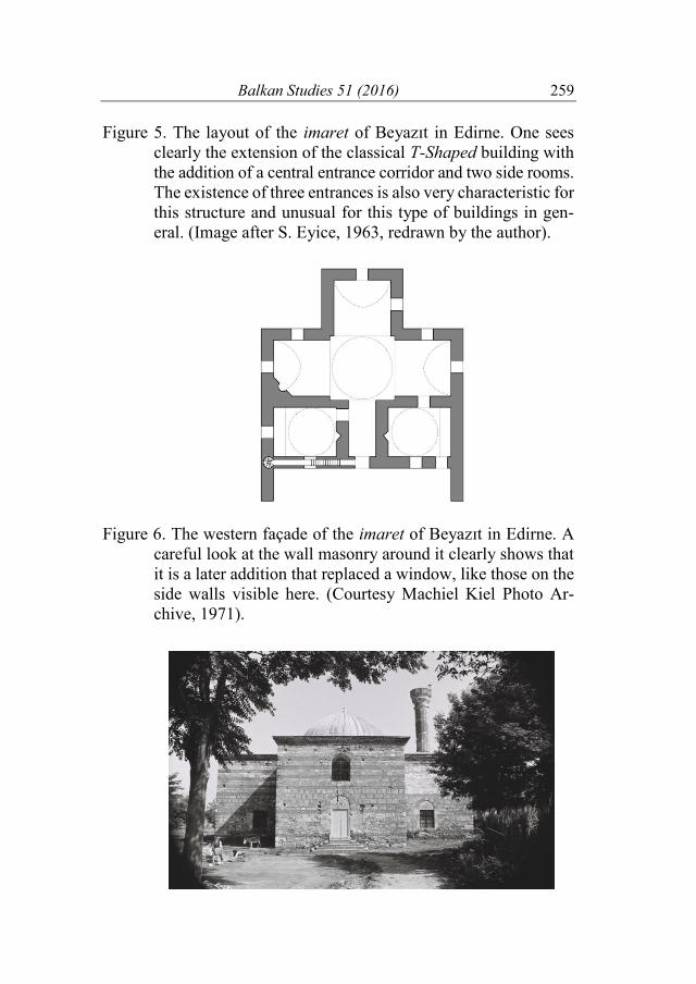
Balkan Studies 51 (2016) 259
Figure 5. The layout of the imaret of Beyazɪt in Edirne. One sees clearly the extension of the classical T-Shaped building with the addition of a central entrance corridor and two side rooms. The existence of three entrances is also very characteristic for this structure and unusual for this type of buildings in gen-eral. (Image after S. Eyice, 1963, redrawn by the author).
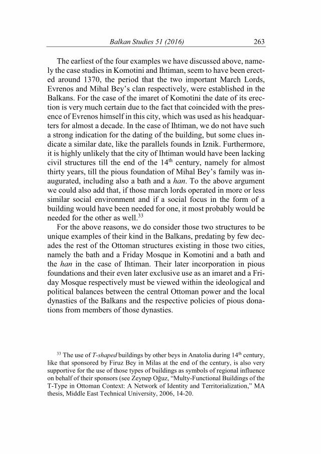
Figure 6. The western façade of the imaret of Beyazɪt in Edirne. A
careful look at the wall masonry around it clearly shows that it is a later addition that replaced a window, like those on the side walls visible here. (Courtesy Machiel Kiel Photo Ar-chive, 1971).

260 Panagiotis Kontolaimos
In other words, the function of this building presupposes three dif-ferent circulation patterns within it. One would either enter from the main gate and after passing by the doors of the auxiliary rooms would be found to the main hall or he would end up there by entering di-rectly from the western gate or, finally, he would enter from the small-er gate to the east into one of the auxiliary spaces and then move to the praying hall. This variation of accesses shows at least three oc-casions of use for the building. The first way would be used by pas-sengers since the main entrance would face the street and the yard of the pious foundation. The smaller gate would have been suitable for the ones wishing to accommodate themselves without necessarily practicing any religious deed, or participate in events taking place in one of the side rooms, related probably with discussions on religious issues. The gate to the west would have been particularly useful for the residents and must have been opened while the neighborhood to the west was becoming larger. That is, in any case, after the erection of this T-Shaped building.
The date of this modification cannot be certified. If one would like to propose a possible date, this should be related to the emer-gence and development of the nearby neighborhood, which seems to be taking place at the 15th century and according to all probability its first half, like it is the case for most of the major neighborhoods of the city.31 If one combines this element with the wider development of the region and the tendency to remove groups of mystic Islam away from Edirne proper after 1420, it becomes obvious that this venue attracted around it dervishes and their followers, which were seen under the rule of Mehmet I Ҫelebi and Murat II as potential threat for the social peace of the state, especially after the civil wars
31 Unfortunately, there are no tax records referring to 15th century Edirne but
the general development of the town as described by Gӧkbilgin indicates a devel-opment around the middle of that same century. See Tayyib M. Gӧkbilgin, “Edirne şehrinin kurucuları” (The founders of Edirne), in Edirne. Edirne’nin 600 fetih yıl-dönümü armağan kitabevı (Comemorative book of Edirne’s 600th conquest an-niversary), (Ankara: Türk Tarih Kurumu, 1965), 162; idem, XV-XVI Asırlarda Edirne ve Paşa Livası. Vakıflar–Mülkler–Mukataalar (Edirne and the Life of Pasa during 14th-16th centuries. Vakif, Mulk, and Mukata), (Istanbul: Ucler Basımevi, 1952), 23-7.

Balkan Studies 51 (2016) 261
and the movement of sheikh Bedreddin in early 15th century. Those would be settled in the periphery of the city or even away from it in places like Didimoteicho and Uzunkӧprü.32 In this case, it would make sense to imagine the growth of the neighborhood of Yɪldɪrɪm across the river after 1420. The western door of the building must have been opened at about this time. Perhaps also during the same phase a separate kitchen was erected and what is left of them is still visible to the east of the structure even today, transforming this struc-ture into a small scale külliye, servicing the developing neighbor-hood in its surroundings. Had the built ovens existed from the begin-ning, they would have been incorporated in the buildings just like we have seeing in other similar structures of the period.
Originally, the building must have been erected in a rather unin-habited area and used as a hub for dervishes, supported by Beyazɪt Yɪldɪrɪm, before it was turned into a Friday Mosque, while the two side rooms to the East with the internal connection to the main hall and entrance corridor must have been used for hosting people or as auxiliary spaces. So, the initial use of the structure would be focusing on hospice or travelers and accommodate people that would arrive in Edirne, while later, probably after 1420’s, a door was added to the west in order to serve the developing neighborhood near it, which was also generated by the presence of the local dervishes. The addi-tion of a kitchen quickly upgraded the facilities, fitting now to their new role.
From all the above, we hope that it becomes quite evident that the building was not build as a mosque, since it lacks the proper (or any specific) orientation, but rather as a kind of dervish lodge, local dwellers and passengers. It has creatively used the T-Shaped form because it provided the option of many small separated spaces, en-couraging different uses at the same time.
32 Vogiatzis, Η πρώιμη οθωμανοκρατία στη Θράκη, 279-81.

262 Panagiotis Kontolaimos
Conclusions
From what we have seen above, T-Shaped buildings were widely spread in the Balkans during the second half of the 14th century. The surviving examples are, by no doubt, a small part of what ones ex-isted. However, at the same time, this typology of buildings seems to have adapted into various uses, covering a whole spectrum of lo-calized needs, ranging from dervish lodge to a namazgah and a soup kitchen. This tendency to house more than one uses in a single struc-ture explains the differences between the examples we have exam-ined and in our opinion, indicates the site –specific character of those buildings. It is therefore absolutely essential to study those structures not in terms of building typology, but rather in combination with their social-geographical urban environment, namely, the location of those buildings in the very cities that host them together with their social background. For the newly established Ottoman settlements they mark the center of urban and social life (like in the case of Ih-timan), while in preexisting centers, they are generally situated at their periphery, but with good visibility and connectivity from the surroundings (like in the case of Edirne and Komotini). In few other cases in the Balkans, it seems that, this typology of buildings was adopted to even more exceptional uses like the one of a namazgah (most probably in the case of Yannitsa), something that only under-lines the largely experimental nature of the architecture of this pe-riod.
The term zaviye, which is mostly used in documents dating from the 14th century, seems to be a collective noun, referring to a number of uses that were housed in buildings, like the ones that scholars have classified as T-Shaped. The gradual development of the institutions of the Ottoman state during the 15th century detachment resulted to either the strengthening of the religious use of the original T-Shaped buildings (which would later have turned into Friday Mosques), or to the exclusive use of a T-Shaped building as a soup kitchen (like in the case of Komotini).
Balkan Studies 51 (2016) 263
The earliest of the four examples we have discussed above, name-ly the case studies in Komotini and Ihtiman, seem to have been erect-ed around 1370, the period that the two important March Lords, Evrenos and Mihal Bey’s clan respectively, were established in the Balkans. For the case of the imaret of Komotini the date of its erec-tion is very much certain due to the fact that coincided with the pres-ence of Evrenos himself in this city, which was used as his headquar-ters for almost a decade. In the case of Ihtiman, we do not have such a strong indication for the dating of the building, but some clues in-dicate a similar date, like the parallels founds in Iznik. Furthermore, it is highly unlikely that the city of Ihtiman would have been lacking civil structures till the end of the 14th century, namely for almost thirty years, till the pious foundation of Mihal Bey’s family was in-augurated, including also a bath and a han. To the above argument we could also add that, if those march lords operated in more or less similar social environment and if a social focus in the form of a building would have been needed for one, it most probably would be needed for the other as well.33
For the above reasons, we do consider those two structures to be unique examples of their kind in the Balkans, predating by few dec-ades the rest of the Ottoman structures existing in those two cities, namely the bath and a Friday Mosque in Komotini and a bath and the han in the case of Ihtiman. Their later incorporation in pious foundations and their even later exclusive use as an imaret and a Fri-day Mosque respectively must be viewed within the ideological and political balances between the central Ottoman power and the local dynasties of the Balkans and the respective policies of pious dona-tions from members of those dynasties.
33 The use of T-shaped buildings by other beys in Anatolia during 14th century, like that sponsored by Firuz Bey in Milas at the end of the century, is also very supportive for the use of those types of buildings as symbols of regional influence on behalf of their sponsors (see Zeynep Oğuz, “Multy-Functional Buildings of the T-Type in Ottoman Context: A Network of Identity and Territorialization,” MA thesis, Middle East Technical University, 2006, 14-20.
264 Panagiotis Kontolaimos
Epilogue
Before his death (1451), the Ottoman Sultan Murat II commis-sioned a building that it would have served as his final resting place in the city of Bursa, as part of the külliye which carries his name till today. While doing so, the sultan had described in advance the exact form of the future building and the function that every space of it would have served. The building was meant to have a square layout. It would have been covered by a roof supported by four internal pil-lars and four columns. The central part of its space, framed by the above structural elements, would have housed the royal tomb. Ex-actly above the royal tomb, the roof would have been open to allow the rain in. This central space, being the core of the structure, would have been surrounded by a gallery, which would have housed the riders of the Koran, who would perform their duties constantly, thus praying the name of the sultan. The building was completed after his death by his son Mehmet the Conqueror, according to the description and the wishes of his father and still stands today in the city of Bur-sa.34
The above story is very interesting if related to the question of the nature of early Ottoman architecture. If one would see its develop-ment passing exclusively by the continuation of older trends and building types, he would be disappointed. It seems that the experi-mental nature of the early Ottoman architecture was particularly en-couraging the creation of new forms or the creative adaptation of older ones. The above example demonstrates in the best way the strong relation between a structure and its planned future use and thus encourages us to see the products of early Ottoman architecture as a result of the above strong relation between specific needs and means and not necessarily only as repetition of older established forms.
One could assume that, in the same way that the above funeral building was intentionally conceived in all its details by its patron, earliest Ottoman structures imply a set of intentions that can be ob-served behind the particularities of their design. The approach that we adopted above, by viewing all our case studies within their spatial
34 Gabriel, Une capitale turque, 116-8.
Balkan Studies 51 (2016) 265
and social context, strongly agrees with the early Ottoman architec-tural tendencies to create site/social-specific buildings, erected for particular purposes, which, in later centuries, were usually remod-eled into typical Friday Mosques. We hope that, in the future, a similar approach towards early Ottoman architectural masterpieces will reveal many more interesting aspects of those historical struc-tures, which could help them serve as a true historical source for the region’s Ottoman past.