Bexar County and Bandera County - FEMA.gov · Prepared for: Bexar County and Bandera County (by...
72
Draft Environmental Assessment Report Prepared for: Bexar County and Bandera County (by Aarcher, Inc., Keller, Texas) Medina Children’s Home Tower Site, Bandera County, Texas 2009 Homeland Security Grant Program (HSGP) Project/Grant# 2009-SS-T9-0064 (9976) February 2012 Federal Emergency Management Agency Department of Homeland Security 500 C Street, SW Washington, DC 20472
-
Upload
duongnguyet -
Category
Documents
-
view
215 -
download
0
Transcript of Bexar County and Bandera County - FEMA.gov · Prepared for: Bexar County and Bandera County (by...

Draft Environmental Assessment Report
Prepared for: Bexar County and Bandera County (by Aarcher, Inc., Keller, Texas) Medina Children’s Home Tower Site, Bandera County, Texas 2009 Homeland Security Grant Program (HSGP) Project/Grant# 2009-SS-T9-0064 (9976) February 2012 Federal Emergency Management Agency
Department of Homeland Security 500 C Street, SW Washington, DC 20472
________________________________________________
ENVIRONMENTAL ASSESSMENT REPORT - PRIVILEGED DOCUMENT
Aarcher, Inc. Page ii
TABLE OF CONTENTS
1.0 Introduction 1.1 Project Description 1.2 NEPA Requirements
2.0 Purpose And Need 2.1 Purpose 2.2 Need
3.0 Alternatives 3.1 No Action Alternative 3.2 Proposed Action 3.3 Alternatives Considered And Dismissed
4.0 Affected Environment And Potential Impacts 4.1 Physical Resources
4.1.1 Geology, Soils, And Seismicity 4.1.2 Air Quality 4.1.3 Climate Change
4.2 Water Resources 4.2.1 Water Quality 4.2.2 Wetlands 4.2.3 Floodplains
4.3 Coastal Resources 4.4 Biological Resources
4.4.1 Threatened And Endangered Species And Critical Habitats 4.4.2 Wildlife And Fish 4.4.3 Migratory Birds
4.5 Cultural Resources 4.5.1 Historic Properties 4.5.2 American Indian/Religious Sites
4.6 Socioeconomic Resources 4.6.1 Environmental Justice 4.6.2 Hazardous Materials 4.6.3 Noise 4.6.4 Traffic 4.6.5 Public Services And Utilities 4.6.6 Public Health And Safety
4.7 Summary Table 5.0 Cumulative Impacts 6.0 Agency Coordination, Public Involvement And Permits 7.0 References 8.0 List Of Preparers

________________________________________________
ENVIRONMENTAL ASSESSMENT REPORT - PRIVILEGED DOCUMENT
Aarcher, Inc. Page iii
APPENDICES Exhibit 1: Site Photographs Exhibit 2: Site Vicinity Map Exhibit 3: Soil Survey Exhibit 4: Topographic Map Exhibit 5: USFWS Wetlands Map Exhibit 6: FEMA (Floodplain) Map Service Center Search Results Exhibit 7: Threatened and Endangered Species List Exhibit 8: US Fish & Wildlife and Wilderness and Wildlife Documentation Exhibit 9: SHPO Correspondence Exhibit 10: TCNS Notification Statement, Tribal Responses, and Certification Exhibit 11: Aerial Photograph Exhibit 12: NEPA Summary Report and Checklist
________________________________________________
ENVIRONMENTAL ASSESSMENT REPORT - PRIVILEGED DOCUMENT
Aarcher, Inc. Page 1
1.0 Introduction 1.1 Project Description
Bexar County proposes to construct a 180-foot tall (top of structure) self-support telecommunications tower (the Proposed Action) at Latitude 29.880944, Longitude -99.274889, at 21300 State Highway 16 North, Medina, Bandera County, Texas. Bexar County has been awarded funding under the 2009 Homeland Security Grant Program (HSGP) to fund the Proposed Action. The funding grant number is 2009-SS-T9-0064 (9976). Upon completion of construction, the facility will be owned by Bexar County but will be loaned to and managed, on a permanent basis, by Bandera County as a lease agreement. This program provides funding to public safety agencies to construct and implement equipment and programs that will increase and protect critical communications infrastructure in the event of a natural disaster, terrorism event, as well as during routine operations.
1.2 NEPA Requirements This Environmental Assessment (EA) has been prepared in accordance with the National Environmental Policy Acts (NEPA) of 1969, the President’s Council on Environmental Quality regulations to implement NEPA (40 Code of Federal Regulations Parts 1500-1508), and the Federal Emergency Management Agency (FEMA) regulations implementing NEPA (44 CFR Part 10). FEMA is required to consider potential environmental impacts before funding or approving actions and projects. The purpose of this EA is to analyze the potential environmental impacts of the Proposed Action. FEMA will use the findings in this EA to determine whether to prepare an Environmental Impact Statement (EIS) or a Finding of No Significant Impact (FONSI).
2.0 Purpose And Need 2.1 Purpose Bexar County objective is to have complete communication coverage throughout the area. This would involve managing routine daily radio traffic as well as emergency incident radio traffic for Bandera County. 2.2 Need Bexar County needs to provide radio communications coverage for public safety agency communication in areas that currently lack coverage or lack adequate coverage.
3.0 Alternatives 3.1 No Action Alternative

________________________________________________
ENVIRONMENTAL ASSESSMENT REPORT - PRIVILEGED DOCUMENT
Aarcher, Inc. Page 2
Under the No Action Alternative, no telecommunications tower would be constructed. This alternative would jeopardize public safety by allowing the continuation of the existing, inadequate level of radio communications for public safety agencies. 3.2 Proposed Action The Proposed Action will consist of the construction of a 180-foot total height self-support telecommunications tower at Latitude 29.880944, Longitude -99.274889, at 21300 State Highway 16 North, Medina, Bandera County, Texas. The Proposed Action would be used to manage routine daily radio traffic as well as emergency incident radio traffic. Additional, follow-on actions under future, alternate funding, will include:
• Placement of an approximate six foot by eight foot telecommunications equipment building at the base of the tower.
• Installation of electronic telecommunications equipment within the telecommunications equipment building.
• Installation of cabling leading from the telecommunications equipment building to the radio antennas.
• Installation of two way radio antennas mounted near the top of the tower. • Placement of a propane-powered emergency electrical generator and associated above-
ground storage tank outside of the telecommunications equipment building. • An existing 16-foot wide access road to the tower site will be improved within the
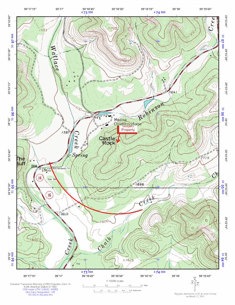
existing footprint by the Bandera County Road and Bridge Department. Upon completion of construction, the facility will be owned by Bexar County but will be loaned to and managed, on a permanent basis, by Bandera County as a lease agreement. The access road leading to the tower site is not part of this grant request. However, it is being included in the Proposed Action because of the proposed improvements to facilitate tower access. The Proposed Action area is located on top of a hill located south of, and on the campus of, the Medina Children’s Home (also known as Arms of Hope) in a wooded area. The Medina Children’s Home address is 21300 State Highway 16 North, Medina, Bandera County, Texas. Photographs of the Proposed Action area are included in Exhibit 1. A vicinity map of the Proposed Action area is included in Exhibit 2. 3.3 Alternatives Considered And Dismissed Alternative actions that were considered included colocation on existing telecommunications towers and colocations on existing buildings or other non-telecommunications structures such as elevated water tanks, freeway overpasses, and electrical transmission line support structures. These alternatives proved not to be feasible because of the following considerations:

________________________________________________
ENVIRONMENTAL ASSESSMENT REPORT - PRIVILEGED DOCUMENT
Aarcher, Inc. Page 3
• With regard to colocation on existing telecommunications towers, no towers of sufficient height were located within a target radius that would afford adequate coverage.
• With regard to colocation on existing non-tower structures, no structures of adequate height were identified that would enable adequate coverage.
These dismissed alternatives will not be discussed any further in this EA.
4.0 Affected Environment And Potential Impacts 4.1 Physical Resources
4.1.1 Geology, Soils, And Seismicity Under the No Action alternative, there would be no short or long-term impacts to soils, geologic resources, or seismic features. The Proposed Action area is located on top of a hill behind the Medina Children’s Home, in a wooded area. According to the United States Department of Agriculture, National Resources Conservation Service, the dominant soil type in the area of the Proposed Action consists of “Eckrant-Kerrville association,” characterized at the soil surface as rocky with cobbles, stones or boulders. In the area of the Proposed Action, the native soil profile consists of a cobbly clay from zero to four inches, a very cobbly clay from four to seven inches, bedrock from seven to ten inches, and depth of up to 20 inches to a restrictive structure of lithic bedrock. The parent material for the soil group is listed as Residuum weathered from limestone. Based on field observations, the proposed tower site is to be placed on an area of exposed bedrock. The Farmland Protection Policy Act (FPPA) (p.l. 97-98, Sec. 1539-1549; 7 U.S.C. 4201, et seq.) is intended to minimize the impact Federal programs have on unnecessary and irreversible conversion of farmland to nonagricultural uses. FPPA assures that Federal programs are administered to be compatible with various programs to protect farmland. For the purpose of FPPA, farmland definition includes prime farmland, unique farmland, and land of statewide or local importance; it is important to note that these definitions include land such as forestland, pastureland, or other land that is not in current production. The proposed project site is not considered prime farmland by the United States Department of Agriculture, National Resources Conservation Service. The elevation of the Proposed Action site is approximately 1,974 feet above mean sea level. The topography of the Proposed Action area is characterized as natural slopes ranging from approximately 20 to 40 percent. There are no published indications of faults in the vicinity of the site. Aarcher identified no groundwater during site investigations. The vegetation at the Proposed Action site consists of juvenile growth Juniper trees with sparse Oak growth with an open hilltop canopy.

________________________________________________
ENVIRONMENTAL ASSESSMENT REPORT - PRIVILEGED DOCUMENT
Aarcher, Inc. Page 4
Ground disturbance under this grant would be confined to the boring of the tower footings. The engineering for the proposed tower footings and shelter foundation has not yet been completed as of the date of this report. Typical tower footings are of poured concrete, and are typically approximately three to four feet in diameter, and thirty to forty feet in depth. Although an existing road will be improved for tower access, all propose construction work will occur within the existing roadway footprint. Utilities exist on the site and will not require any additional trenching. There are no proposed Best Management Practices for soil erosion because the entire site is bedrock and talus with no exposed soil. Any hazardous materials encountered or generated on site will be disposed of off-site according to current Federal and state regulations. Therefore, the Proposed Action will not have significant impacts impact geologic resources or soils. A copy of the Soil Survey is included in Exhibit 3; a topographic map is included in Exhibit 4.
4.1.2 Air Quality Under the No Action alternative, there would be no short- or long-term impacts to air quality. Air quality is regulated by the Clean Air Act (CAA) of 1970 (42 U.S.C. § 7401 et seq.) Air quality is further regulated through primary and secondary National Ambient Air Quality Standards (NAAQS) under the CAA. Air quality controls regions (AQCR) are classified by the US Environmental Protection Agency (EPA) based on whether the region meets or exceeds Federal primary or secondary NAAQS. There are seven criteria air pollutants classified by the EPA: carbon monoxide, lead, nitrogen dioxide, coarse particulates, fine particulates, ozone, and sulfur dioxide. An AQCR, or portion thereof, may be classified as being in attainment, non-attainment, or it can be unclassified for any one of the criteria pollutants. The Proposed Action site is located in Bandera County. Bandera County is not listed as a non-attainment area county. The use of heavy equipment and construction activities at the Proposed Action area may result in short term and de minimis impacts on air quality at or near the Proposed Action area. De minimis condition generally does not present a threat to human health or the environmental and generally would not be subject to a regulatory enforcement action. Construction-related air quality impacts may include dust from excavation activities and emissions from construction equipment and vehicles. The impacts will be limited to construction operation hours for the construction period and will not likely increase air pollutants. However, episodic impacts to air quality could occur once the proposed emergency backup generator is installed. Impacts to air quality are anticipated to be minimal because the emergency backup generator will run on propane fuel that produces negligible greenhouse gas emissions. Based on the limited area of disturbance for the Proposed Action and the limited construction timeline, the Proposed Action will have no significant impact to air quality resulting from construction activities.

________________________________________________
ENVIRONMENTAL ASSESSMENT REPORT - PRIVILEGED DOCUMENT
Aarcher, Inc. Page 5
4.1.3 Climate Change Under the No Action alternative, there would be no short- or long-term impacts to climate change. The Proposed Action area is located on top of a hill behind the Medina Children’s Home, in a wooded area. The Proposed Action will not involve the clearing of woodland. All proposed work with occur in existing open areas. Construction activities at the Proposed Action area may result in a temporary increase in vehicle traffic only during the Proposed Action construction. The increase in vehicle traffic may temporarily increase vehicle emissions in the Proposed Action area. Once operational, the Proposed Action area will be powered by electricity. However, episodic impacts to air quality could occur once the proposed emergency backup generator is installed. Impacts to air quality are anticipated to be minimal because the emergency backup generator will run on propane fuel that produces negligible greenhouse gas emissions. Based on the limited size of the Proposed Action area, the temporary nature of the construction activities, and the limited potential for emissions at the Proposed Action area, the Proposed Action would have no significant impact to climate change.
4.2 Water Resources
4.2.1 Water Quality Under the No Action alternative, there would be no short- or long-term impacts to water resources. The Clean Water Act (CWA) established the National Pollutant Discharge Elimination System (NPDES) in order to regulate wastewater discharges from point sources into water resources. Construction sites resulting in greater than one acre of disturbance are required under the NPDES to obtain EPA and/or state permits. The Texas Commission on Environmental Quality is the state agency that has assumed NPDES permitting for the State of Texas. Activities at the Proposed Action area will be below the one acre land disturbance limitation for NPDES permitting. There are no proposed Best Management Practices for soil erosion because the entire site is bedrock and talus with no exposed soil. The Proposed Action area is located on top of a hill behind the Medina Children’s Home, in a wooded area. No bodies of water are located on the Proposed Action area. Any hazardous substances encountered or used during construction activities for the Proposed Action will be disposed of off-site at an appropriate facility. Based on the lack of water bodies and the proposed proper disposal of hazardous materials off-site with regard to the Proposed Action area, the Proposed Action would have no significant impacts on water quality.
4.2.2 Wetlands

________________________________________________
ENVIRONMENTAL ASSESSMENT REPORT - PRIVILEGED DOCUMENT
Aarcher, Inc. Page 6
Under the No Action alternative, there would be no short- or long-term impacts to wetlands. The Proposed Action area is located on top of a hill behind the Medina Children’s Home, in a wooded area. Executive Order 11990 of the CWA (40CFR 230.3) defines wetlands as “those areas that are inundated or saturated by surface or ground water at a frequency and duration sufficient to support, and that under normal circumstances do support, a prevalence if vegetation typically adapted for life in saturated conditions. Wetlands generally include swamps, marshes, bogs and similar areas.” Aarcher reviewed National Wetlands Inventory wetlands maps from the United States Fish and Wildlife Services (USFWS) website: http://www.fws.gov/wetlands/redirect.html, to determine if the subject property is located within a wetland. In addition, Aarcher reviewed soil data from the U.S. Department of Agriculture website: http://websoilsurvey.nrcs.usda.gov/app/WebSoilSurvey.aspx . The soil type for the Proposed Action area does not meet the characteristics of a hydric soil, a necessary component of a wetland. Based on the map review and soil data, the Proposed Action will have no impacts on wetlands. A copy of the U.S. FWS Wetlands map is included in Exhibit 5.
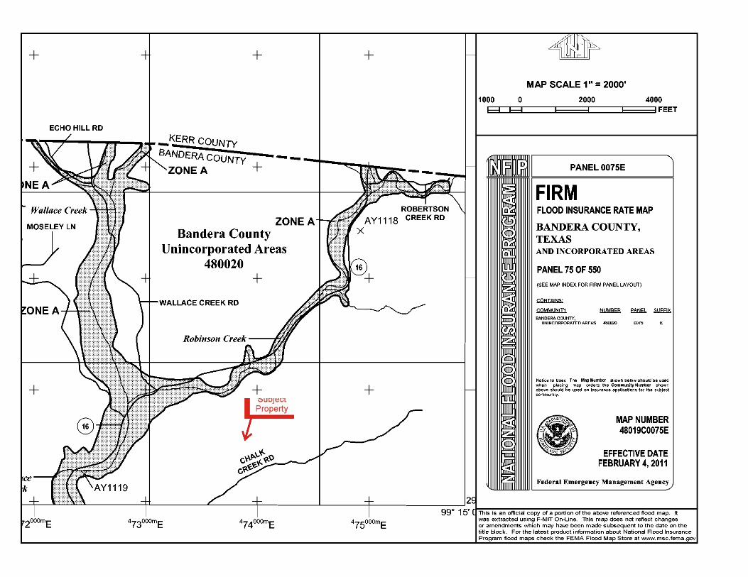
4.2.3 Floodplains Under the No Action alternative, there would be no short- or long-term impacts to floodplain areas. Executive Order 11988, Floodplain Management, requires federal agencies to take action to minimize occupancy and modification of the floodplain. Specifically, Executive Order 11988 prohibits federal agencies from funding construction in the 100-year floodplain (500-year floodplain for critical facilities) unless there are no practicable alternatives. The National Flood Insurance Program (NFIP) floodplain maps are used to identify the regulatory 100-year Floodplain. According to NFIP Floodplain map 48019C0075E (Effective Date February 4, 2011), the Proposed Action area is not located within the 100-year floodplain (Zone X). Zone X is defined as areas determined to be outside the 0.2% annual chance floodplain. Based on the map information, the Proposed Action would not impact or be impacted by the 100-year floodplain. A copy of the FEMA floodplain map is included in Exhibit 6. 4.3 Coastal Resources

________________________________________________
ENVIRONMENTAL ASSESSMENT REPORT - PRIVILEGED DOCUMENT
Aarcher, Inc. Page 7
Under the No Action alternative, there would be no short- or long-term impacts to coastal resources. The Coastal Zone Management Act was established in 1972 to preserve, protect, and (where possible) restore or enhance the resources of the coastal zones of the United States. The Proposed Action area is located on top of a hill behind the Medina Children’s Home, in a wooded area. The Proposed Action is not located within a coastal resource area, nor would it have an impact on a coastal resource area. The Proposed Action does not require a coastal use permit. 4.4 Biological Resources
4.4.1 Threatened And Endangered Species And Critical Habitats
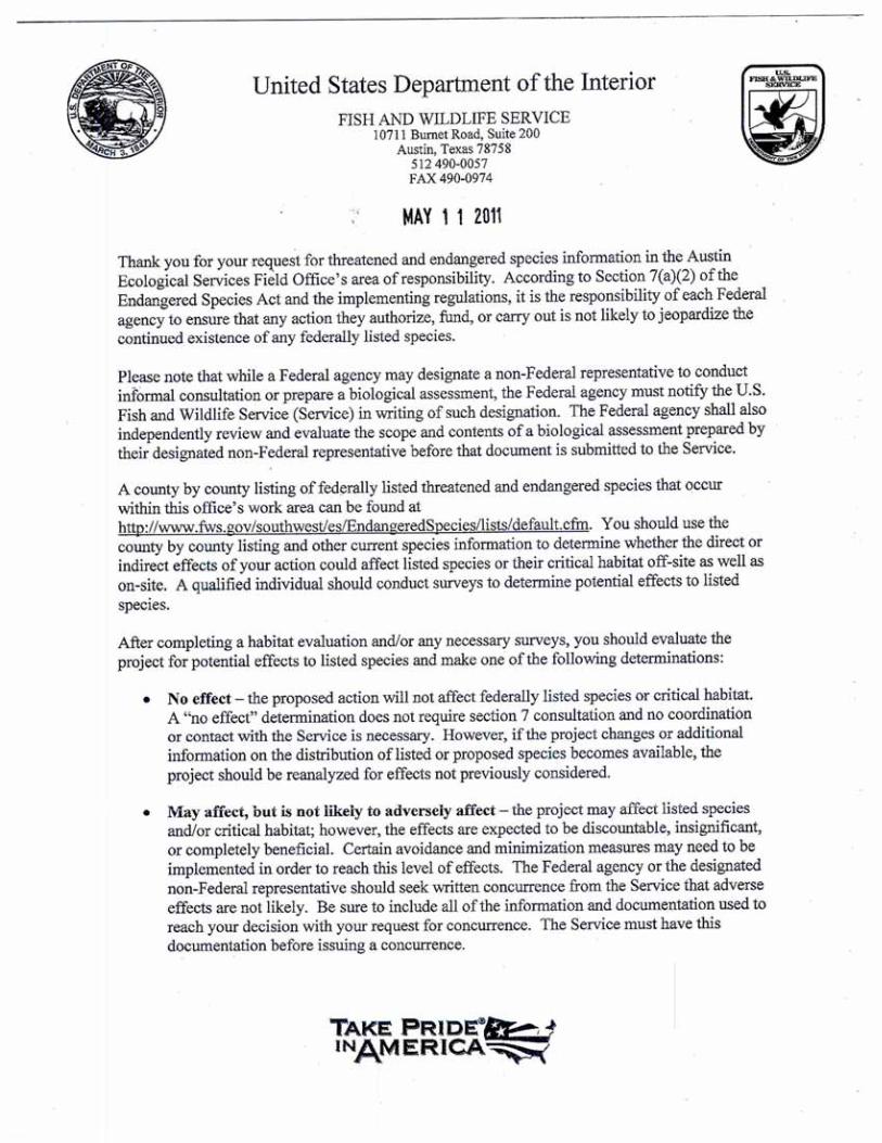
Under the No Action alternative, there would be no short- or long-term impacts to threatened or endangered species or critical habitats. Federal agencies are directed under Section 7 of the Endangered Species Act of 1973 (16 U.S.C. 1536a2) to utilize their authorities to enforce and carry out programs for the conservation of listed threatened and endangered species or designated critical habitats. Section 7 of the Act also sets out the consultation process, which is further implemented by regulation (50 CFR 402). The Proposed Action area is located on top of a hill behind the Medina Children’s Home, in a wooded area. U.S. Fish and Wildlife Service (USFWS) Threatened and Endangered Species lists for the Proposed Action area county were reviewed at the USFWS website: http://www.fws.gov/endangered. The Proposed Action area setting was compared to the profile of characteristic habitat for threatened and endangered species known to exist within the Proposed Action area county. USFWS information was reviewed to determine if the Proposed Action might affect designated critical habitats. State fish and wildlife agencies defer to the USFWS for evaluations of the presence of federally-listed threatened and endangered species resources. The following threatened or endangered species or critical habitats may be found in Bandera County:
• Black-Capped Vireo: Habitat consists of dense low thickets and oak scrub, mostly on rocky hillsides or steep ravine slopes in rugged terrain. The vegetation in the Proposed Action area consists of juvenile growth Juniper forest with little to no dense scrub.
• Golden-Cheeked Warbler: Habitat consists of Ashe juniper-scrub oak in broken terrain in canyons and slopes and closed canopy stands with plenty of old junipers and a sufficient proportion of deciduous oaks in the canopy containing junipers at least 40 years old. The vegetation at the Proposed Action area consists of juvenile growth Juniper trees with

________________________________________________
ENVIRONMENTAL ASSESSMENT REPORT - PRIVILEGED DOCUMENT
Aarcher, Inc. Page 8
sparse Oak growth with an open hilltop canopy. There is no old growth juniper or canopy level Oak at the Proposed Action area.
• Tobusch Fishhook Cactus: Habitat consists of alkaline soils in areas of herbaceous cover. The vegetation at the Proposed Action area consists of juvenile growth Juniper trees with sparse Oak growth with an open hilltop canopy. The immediate area of the Proposed Action has been largely cleared and consists of mostly hard limestone outcrops.
Based on the comparison of the Proposed Action area setting and the characteristic habitat of the above-listed threatened or endangered species, FEMA has determined that the Proposed Action would have no impact on threatened or endangered species or critical habitats. A list of threatened and endangered species or critical habitats found in the Proposed Action area county is included in Exhibit 7. A copy of the documents submitted to the USFWS and the USFWS response are included in Exhibit 8.
4.4.2 Wildlife And Fish Under the No Action alternative, there would be no short- or long-term impacts to wilderness areas or wildlife preserves. The Proposed Action area is located on top of a hill behind the Medina Children’s Home, in a wooded area. National Atlas on-line cartographic resources were reviewed at http://nationalatlas.gov/mapmaker to determine if the Proposed Action area is located in an officially designated wilderness area or wildlife preserve. The National Atlas comprises lands designated as wilderness areas and wildlife preserves by the Bureau of Land Management, the U.S. Fish and Wildlife Service, the U.S. Department of Agriculture Forest Service, or the National Park Service. Based on review of these resources, the Proposed Action will have no impact on wilderness areas of wildlife preserves. A copy of the National Atlas map search and the USFWS submittal response are included in Exhibit 8.
4.4.3 Migratory Birds Under the Migratory Bird Treaty Act, taking, killing or possessing migratory birds is unlawful. Migratory birds are a federal trust resource that the USFWS is authorized to protect, and has put forth recommendations for communication tower design and height to mitigate collision-related mortality. Mitigation measures outlined in the USFWS Interim Guidelines For Recommendations On Communications Tower Siting, Construction, Operation and Decommissioning issued by the USFWS will be implemented as practical for this Proposed Action.

________________________________________________
ENVIRONMENTAL ASSESSMENT REPORT - PRIVILEGED DOCUMENT
Aarcher, Inc. Page 9
Construction of the Proposed Action has been determined to be the best option because co-locating the communications equipment on an existing tower or other structure is not an available option. The Proposed Action will be a self-support tower and will not require guy wires. According to resource reviews, this Proposed Action location will not be sited in or near wetlands, other known bird concentration areas, in known migratory or daily movement flyways, or in habitat of threatened or endangered species. Based on the existing environmental conditions and the proposed tower design, the Proposed Action would have no impact migratory birds. 4.5 Cultural Resources
4.5.1 Historic Properties
Under the No Action alternative, there would be no short- or long-term impacts to historic properties. Federal agencies are required by Section 106 of the National Historic Preservation Act of 1966 (NHPA, 16 U.S.C. §§ 470 et seq.) and “Protection of Historic Properties” (36 CFR Part 800) to evaluate for potential effects of Proposed Actions on Historic properties. The FCC adopted the Nationwide Programmatic Agreement through order FCC 04-222 regarding the Section 106 National Historic Preservation Act Review Process. The order was signed on October 5, 2004 by the Advisory Council on Historic Preservation (ACHP) and the National Conference of State Historic Preservation Officers and amended Section 1.1307(a) (4) of the Commission's rules, 47 C.F.R. §1.1307(a) (4). In order for a new antenna support structure to be constructed, the FCC Form 620 New Tower Submission Packet must to be completed by or on behalf of Applicants. Before any construction or other installation activities at the Proposed Action area begin, the Packet (including Form 620 and attachments) is to be submitted to the State Historic Preservation Office (“SHPO”) or to the Tribal Historic Preservation Office (“THPO”), as appropriate. If the Applicant fails to provide the Submission Packet and complete the review process under Section 106 of the NHPA prior to start of construction this may result in violation of NHPA and the Commission’s rules. This process is not as a substitute for the “Nationwide Programmatic Agreement for Review of Effects on Historic Properties for Certain Undertakings Approved by the Federal Communications Commission,” dated September 2004, and the relevant rules of the FCC (47 C.F.R. §§ 1.1301-1.1319) and the ACHP (36 C.F.R. Part 800). The Proposed Action area is located on top of a hill behind the Medina Children’s Home, in a wooded area. Aarcher consulted the National Park Service NRIS data system, which inventories National Register of Historic Places-listed sites; reviewed the Texas Historical Commission on-line listings for Texas historic sites, performed a reconnaissance of the Area of Potential Effect,

________________________________________________
ENVIRONMENTAL ASSESSMENT REPORT - PRIVILEGED DOCUMENT
Aarcher, Inc. Page 10
performed an archaeological field test, and submitted to the Texas Historical Commission (SHPO) FCC Form 620 to support an NHPA Section 106 Review. Based on this research and the determination by the SHPO that the Proposed Action will have no effect on historic resources, the Proposed Action would have no impact on districts, sites, buildings, structures or objects significant in American history, architecture, archeology, engineering or culture, which are listed or are eligible for listing, in the National Register of Historic Places. In the event that archeological deposits, including any Native American pottery, stone tools, bones, or human remains, are uncovered, the project shall be halted and the applicant shall stop all work immediately in the vicinity of the discovery and take reasonable measures to avoid or minimize harm to the finds. All archeological findings will be secured and access to the sensitive area restricted. The applicant will inform FEMA immediately, FEMA will consult with the SHPO or THPO, and Tribes and work in sensitive areas cannot resume until consultation is completed and appropriate measures have been taken to ensure that the project is in compliance with the National Historic Preservation Act. A copy of the SHPO response letter is included in Exhibit 9.
4.5.2 American Indian/Religious Sites Under the No Action alternative, there would be no short- or long-term impacts to American Indian Tribes or Religious Sites. Consultation with Native American tribal groups and native Hawaiian organizations (NHO) regarding proposed projects and potential impacts to Native American religious sites is required under Section 106 of the NHPA and its implementing regulations, “Protection of Historic Properties” (36 CFR Part 800) and the Nationwide Programmatic Agreement on the Collocation of Wireless Antennas (adopted March 16, 2001), as well as the Nationwide Programmatic Agreement for Review of Effects on Historic Properties for Certain Undertakings Approved by the Federal Communications Commission effective March 7, 2005. On October 6, 2005 the FCC released a Declaratory Ruling (FCC 05-176) which clarified portions of the Nationwide Programmatic Agreement (NPA), addressing situations where a federally recognized Indian Tribe or Native Hawaiian Organization (NHO) has not responded to a Tower Construction Notification System (TCNS) notification, or to the applicant’s and Commission’s efforts to determine whether the Indian Tribe or NHO has an interest in participation in the review of the proposed project. The Proposed Action area is located on top of a hill behind the Medina Children’s Home, in a wooded area. Aarcher submitted inquiries to Indian Tribal authorities in the form of TCNS Submittal Number 75594. In addition, Aarcher sent follow-up letters to, telephoned, and/or e-mailed those tribes which had set their geographic preferences to determine if the proposed action would have an effect on Indian religious sites. Based on e-mail responses, letter responses, review of lists provided by tribes which detail the counties that they have an interest in

________________________________________________
ENVIRONMENTAL ASSESSMENT REPORT - PRIVILEGED DOCUMENT
Aarcher, Inc. Page 11
and telephone interviews with tribal authorities, the Proposed Action would have no impact on Indian religious sites. In the event that archeological deposits, including any Native American pottery, stone tools, bones, or human remains, are uncovered, the project shall be halted and the applicant shall stop all work immediately in the vicinity of the discovery and take reasonable measures to avoid or minimize harm to the finds. All archeological findings will be secured and access to the sensitive area restricted. The applicant will inform FEMA immediately, FEMA will consult with the SHPO or THPO, and Tribes and work in sensitive areas cannot resume until consultation is completed and appropriate measures have been taken to ensure that the project is in compliance with the National Historic Preservation Act. Copies of the TCNS filing and tribal correspondence are included in Exhibit 10. 4.6 Socioeconomic Resources
4.6.1 Environmental Justice Under the No Action Alternative, there would be no short- or long-term impacts to environmental justice. The Proposed Action area is located on top of a hill behind the Medina Children’s Home, in a wooded, very sparsely-populated area. Under Executive Order 12898, Federal agencies are required to environmental and human health condition in low-income and minority level communities. The purpose of EO 12898 is to enact Environmental Justice to prevent and correct the disproportionate and adverse effect of a Federal action on the low-income or minority level populations. The following demographics information was obtained from the U.S. Census Bureau website http://quickfacts.census.gov/qfd/index.html. Unemployment statistics were obtained from the United States Department of Labor Bureau of Labor Statistics website http://www.bls.gov/lau/. TABLE 1 - Family Income and Poverty Rates Location: Bandera County Texas 2010 Population 20,485 25,145,561 Percent White 80.9% 70.4% Percent African American 0.5% 11.8% Percent Hispanic or Latino 16.7% 37.6% Percent all other race and 2 or more races 2.9% 7.3% Percent less than 18 years old 19.6% 27.3% Percent 65 years old and over 20.1% 10.3% 2009 Per Capita Income $23,055 $24,318 2009 Poverty Rate (Percent below poverty level income) 14.2% 17.1% 2011 Unemployment Rate (Percent of civilian labor force) 7.2% 8.5%
________________________________________________
ENVIRONMENTAL ASSESSMENT REPORT - PRIVILEGED DOCUMENT
Aarcher, Inc. Page 12
The Proposed Action area is not located within a low income or minority community. The Proposed Action would have no impact on environmental justice in the Proposed Action area. The Proposed Action would be a major step in improving telecommunications infrastructure, enabling better communication between emergency and first responders in the event of an emergency. Consequently all residents would benefit from the Proposed Action.
4.6.2 Hazardous Materials The Proposed Action area is located on top of a hill behind the Medina Children’s Home, in a wooded area. Under the No Action alternative, there would be no short- or long-term impact to the Proposed Action area with regard to hazardous materials. Use of hazardous materials at the Proposed Action area will be limited to the following action:
• Fuel for heavy equipment and vehicles used during the construction process. Minimal wastes may be generated at the Proposed Action area during tower maintenance and construction. Any wastes generated will be properly disposed of off-site according to federal and state regulations. Based on the limited timeline for construction activities at the Proposed Action area and the limited potential for hazardous material releases and waste generation during construction and maintenance activities, the Proposed Action will have no significant impact with regard to hazardous materials.
4.6.3 Noise
Under the No Action alternative, there would be no short- or long-term impact to the Proposed Action area with regard to any increase in noise. Noise is generally referred to as unwanted sound which interferes with work, rest, communication, recreations, or sleep. During construction activities at the Proposed Action area, short-term noise increase from heavy equipment and vehicles involved in construction activities is to be expected. The Proposed Action area is located on top of a hill behind the Medina Children’s Home, in a very sparsely populated area. Once construction is completed, long-term noise is expected to be minimal and result primarily from site maintenance and the occasional backup power generator activation. Based on the limited timeline of construction activities and the limited noise production after construction is completed, the Proposed Action would have no significant impact with regard to any increase in noise at the Proposed Action area.
4.6.4 Traffic Under the No Action alternative, there would be no short- or long-term impact to the Proposed Action area with regard to any increase in traffic.

________________________________________________
ENVIRONMENTAL ASSESSMENT REPORT - PRIVILEGED DOCUMENT
Aarcher, Inc. Page 13
The Proposed Action area is located on top of a hill behind the Medina Children’s Home, in a wooded area. During construction activities at the Proposed Action area, short-term traffic increase from heavy equipment and vehicles involved in construction activities is to be expected. Once construction is completed, long-term traffic is expected to be minimal and result primarily from site maintenance. Based on the limited timeline of construction activities and the minimal traffic expected after construction is completed, the Proposed Action would have no significant impact with regard to any increase in traffic at the Proposed Action area.
4.6.5 Public Services And Utilities Under the No Action alternative, there would be no short- or long-term impact to public services and utilities. The Proposed Action area is located on top of a hill behind the Medina Children’s Home, in a wooded area, with public utilities currently limited to electricity. During construction activities at the Proposed Action area, short-term interruption of public and utility service has the potential to occur. In the long-term, the telecommunications infrastructure and communication utilities will be improved with the completion of the Proposed Action and follow-on actions. Construction related interruptions do not have the potential to cause long-term interruptions in public services and utilities. Based on the limited potential of short-term utility and public service interruptions, the Proposed Action will not have a significant impact on public services or utilities. The construction contractor will be responsible for adhering to the Texas One-Call Law.
4.6.6 Public Health And Safety Under the No Action alternative, no telecommunication tower would be constructed, thereby limiting communications between first responders and hindering aid to those affected by an emergency event. Under the No Action alternative there would be an impact on public health and safety. The Proposed Action area is located on top of a hill behind the Medina Children’s Home, in a wooded area. During construction activities at the Proposed Action area, potential health and safety concerns include the potential for workplace accidents. All OSHA regulation will be strictly adhered to during construction activities. Proper fencing and signage will be used in an effort to prevent accident or injury to the public or workers on site. Based on the use of preventive measures during construction at the Proposed Action area, the Proposed Action would have no significant impact on public health and safety. After construction has been completed, the Proposed Action would improve communication between emergency and first responders in the event of an emergency. Based on the potential for the Proposed Action to improve emergency communications, the Proposed Action would have a beneficial impact on public health and safety.

________________________________________________
ENVIRONMENTAL ASSESSMENT REPORT - PRIVILEGED DOCUMENT
Aarcher, Inc. Page 14
Summary Table
Table 2 – Summary of Impacts Affected Environment/Resource Area
Impacts Agency Coordination/Permits
Mitigation/Best Management Practices
Geology, Soils, Seismicity No Significant Impact N/A None Air Quality No Significant Impact N/A None Climate Change No Significant Impact N/A None Water Quality No Significant Impact N/A None Wetlands No Impact N/A None Floodplains No Impact N/A N/A Coastal Resources No Impact N/A N/A Threatened and Endangered Species/Critical Habitats
No Impact U.S. Fish and Wildlife consultation
None
Wildlife and Fish No Impact N/A N/A Migratory Birds No Impact N/A Adoption of U.S. Fish and
Wildlife Service mitigation measures as listed in Recommendations On Communications Tower Siting, Construction, Operation, and Decommissioning.
Historic Properties No Impact Texas State Historic Preservation Office Consultation
N/A
American Indian/Religious Sites
No Impact Native American Tribal Consultation
N/A
Environmental Justice No Impact N/A N/A Hazardous Materials No Significant Impact N/A None Noise No Significant Impact N/A None Traffic No Significant Impact N/A None Public Service and Utilities
No Significant Impact N/A Construction contractor will adhere to the Texas One-Call Law.
Public Health and Safety No Impact (potential beneficial impact)
N/A OHSA regulation followed at Proposed Action site, fencing and signage.
5.0 Cumulative Impacts
Under the No Action alternative, there would be no short- or long-term cumulative impacts at the Proposed Action area. Cumulative impacts are the impact on the environment which results from the incremental impact of an action when added to other past, present, and reasonably foreseeable future actions.
________________________________________________
ENVIRONMENTAL ASSESSMENT REPORT - PRIVILEGED DOCUMENT
Aarcher, Inc. Page 15
There would be no cumulative impacts to geology, soil, seismicity, water resources, wetlands, floodplains, coastal resources, wildlife and fish, threatened or endangered species, migratory birds, historic properties, American Indian or religious sites, air quality, noise, infrastructure, utilities, traffic, waste management or socioeconomic resources. Long-term benefits of the Proposed Action include improving communication between emergency and first responders in the event of an emergency, natural disaster or terrorist action.
6.0 Agency Coordination, Public Involvement, And Permits The following agencies were contacted and invited to comment regarding the Proposed Action:
• The Southern Ute Tribe, Ignacio, CO • The Comanche Nation, Lawton, OK • The Wichita and Affiliated Tribes, Anadarko, OK • The Tonkawa Tribe, Tonkawa, OK • The Mescalero Apache Tribe, Mescalero, NM • The Department of Arkansas Heritage • The Oklahoma Historical Society • The Texas Historical Commission • The U.S. Fish and Wildlife Service • The Texas State Historic Preservation Office • Bexar County, Office of Emergency Management • Bandera County, Office of Emergency Management • Texas Parks and Wildlife Commission
Public involvement occurred in the form of a Public Notice posted in the Bandera Bulletin on April 20, 2011. The Public Notice asked residents to notify Aarcher of any impact the Proposed Action may have on historic properties. Aarcher received no response to the Public Notice regarding historic properties. The availability of this EA will be advertised by public notice in the local weekly newspaper. Copies of the EA will be available locally. The public comment period will extend for a period of fifteen (15) days. The EA can also be viewed and downloaded from the FEMA’s website at http://www.fema.gov/plan/ehp/envdocuments/ea-region6.shtm. If no substantive comments are received, the EA will become final and the initial public notice will also serve as the final public notice. The EA will then be archived on FEMA’s website at http://www.fema.gov/library/. No Bandera County permits are required for the Proposed Action.

________________________________________________
ENVIRONMENTAL ASSESSMENT REPORT - PRIVILEGED DOCUMENT
Aarcher, Inc. Page 16
7.0 References
1. United States Department of Agriculture, National Resources Conservation Service
Web Soil Survey: http://websoilsurvey.nrcs.usda.gov/app/WebSoilSurvey.aspx
2. U.S. Fish and Wildlife Service National Wetlands Inventory: http://www.fws.gov/wetlands/redirect.html Endangered Species Program: http://www.fws.gov/endangered/
3. FEMA Floodplain Map Service Center: http://msc.fema.gov/webapp/wcs/stores/servlet/FemaWelcomeView?storeId=10001&catalogId=10001&langId=-1
4. National Atlas of the United States Mapmaker: http://nationalatlas.gov/mapmaker
5. U.S. Department of the Interior, National Parks Service National Register of Historic Places: http://nrhp.focus.nps.gov/natreghome.do?searchtype=natreghome
6. Texas Historical Commission Historic Sites Atlas: http://atlas.thc.state.tx.us/
7. U.S. Census Bureau Quick Facts: http://quickfacts.census.gov/qfd/index.html
8. Federal Communications Commission, Universal Licensing System: Tower Construction Notification System: http://wireless.fcc.gov/uls/index.htm?job=home
9. United States Department of Labor
Bureau of Labor Statistics: http://www.bls.gov/lau/
8.0 List Of Preparers • Bruce Hanford is the Regional Manager of Aarcher’s Southwest Regional Office, where he
is responsible for client satisfaction and oversight of all company projects. He currently serves as Program Manager for Phase One Environmental Site Assessments and NEPA Evaluations in the Southwest Region, and provides oversight for all Aarcher Phase I Environmental Site Assessments performed throughout the U.S. With over 16 years of Environmental Consulting experience, Mr. Hanford has managed and/or performed over 3000 Phase I Environmental Site Assessments in nine states. In addition, Mr. Hanford serves as an internal consultant assessing for liability under CERCLA regulations. Mr. Hanford has
________________________________________________
ENVIRONMENTAL ASSESSMENT REPORT - PRIVILEGED DOCUMENT
Aarcher, Inc. Page 17
performed Federal and state environmental regulation compliance audits at U.S. Army and National Guard facilities throughout the continental United States, and previously served as Project Manager and consultant for CERCLA potentially responsible party searches on behalf of the EPA and the Texas Commission on Environmental Quality. Mr. Hanford is a National Park Service Qualified Architectural Historian and exceeds the EPA’s qualifications for an Environmental Professional [40 CFR Part 312].
• Erin Heinemann is a Project Manager/Quality Control Manager for Aarcher’s Southwest Regional Office. Ms. Heinemann performs and manages Phase I Environmental Site Assessments, NEPA Screening Assessments, and visual site inspections. Ms. Heinemann has managed over 300 such assessments across Texas, Oklahoma, Louisiana, and Arkansas. She evaluates for effects to threatened and endangered species and their habitats and evaluates for effects to cultural resources. She has prepared FCC Form 620 and Form 621 submittals for the State Historic Preservation Offices and prepared NEPA Environmental Assessment Reports. In addition, she serves as liaison with State Historic Preservation Officers and tribal authorities in ten states, establishing with those parties protocols for evaluating the possible effects of proposed telecommunication tower projects. Ms. Heinemann holds a Bachelor of Science degree in Environmental Conservation. Ms. Heinemann worked for four years in various environmental laboratories in accordance with NELAC regulations. While at the laboratories, she performed various analyses of Metals and General Chemistry samples and co-wrote and updated Standard Operating Procedure documents.
• Brandi McTee is a Project Leader for Aarcher’s Southwest Regional Office. Ms. McTee performs Phase I Environmental Site Assessments and NEPA Environmental Screening Reports. She has performed over 200 such assessments in three states. Her duties include evaluating the complexity of project assignments and determining the required cartography and level of historical research. She issues Freedom of Information Act and Texas Open Records Act requests and evaluates federal and state technical environmental reports. Ms. McTee manages vendors and contractors who support Aarcher projects. Ms. McTee holds a Bachelor of Science degree in Environmental Science.
Government Contributors • Kevin Jaynes, CHMM, Regional Environmental Officer, FEMA Region 6 • Alan Hermely, Environmental Specialist, FEMA Region 6

Exhibit 1

ENVIRONMENTAL SITE ASSESSMENT REPORT - PRIVILEGED DOCUMENT
1. View from the proposed tower site, to the south.
2. View from the proposed tower site, to the east.

ENVIRONMENTAL SITE ASSESSMENT REPORT - PRIVILEGED DOCUMENT
3. View from the proposed tower site, to the north.
4. View from the proposed tower site, to the west.

ENVIRONMENTAL SITE ASSESSMENT REPORT - PRIVILEGED DOCUMENT
5. Proposed tower site (facing northwest).
6. Proposed tower site (facing south-southeast).

ENVIRONMENTAL SITE ASSESSMENT REPORT - PRIVILEGED DOCUMENT
7. Proposed path of 400 feet of new road.

Exhibit 2

Copyright © and (P) 1988–2009 Microsoft Corporation and/or its suppliers. All rights reserved. http://www.microsoft.com/streets/Certain mapping and direction data © 2009 NAVTEQ. All rights reserved. The Data for areas of Canada includes information taken with permission from Canadian authorities, including: © Her Majesty the Queen in Right of Canada, © Queen's Printer for Ontario. NAVTEQ and NAVTEQ ON BOARD are trademarks of NAVTEQ. © 2009 Tele Atlas North America, Inc. All rights reserved. Tele Atlas and Tele Atlas North America are trademarks of Tele Atlas, Inc. © 2009 by Applied Geographic Systems. All rights reserved.
vicinity map
0 mi 0.2 0.4 0.6 0.8

Exhibit 3

TBX
473430
473430
473440
473440
473450
473450
473460
473460
473470
473470
473480
473480
473490
473490
473500
473500
3305
570
3305
570
3305
580
3305
580
3305
590
3305
590
3305
600
3305
600
3305
610
3305
610
3305
620
3305
620
3305
630
3305
630
3305
640
3305
640
3305
650
3305
650
3305
660
3305
660
3305
670
3305
670
0 40 80 12020Feet
0 10 20 305Meters
±
29° 52' 53''
99°
16' 2
7''
29° 52' 49''
99°
16' 2
7''
29° 52' 49''
29° 52' 53''99
° 16
' 30'
'99
° 16
' 30'
'
Map Scale: 1:522 if printed on A size (8.5" x 11") sheet.
Soil Map—Bandera County, Texas
Natural ResourcesNatural ResourcesNatural ResourcesNatural ResourcesConservation ServiceConservation ServiceConservation ServiceConservation Service
Web Soil SurveyNational Cooperative Soil Survey
11/16/2011Page 1 of 3

MAP LEGEND MAP INFORMATION
Area of Interest (AOI)Area of Interest (AOI)
SoilsSoil Map Units
Special Point FeaturesBlowout
Borrow Pit
Clay Spot
Closed Depression
Gravel Pit
Gravelly Spot
Landfill
Lava Flow
Marsh or swamp
Mine or Quarry
Miscellaneous Water
Perennial Water
Rock Outcrop
Saline Spot
Sandy Spot
Severely Eroded Spot
Sinkhole
Slide or Slip
Sodic Spot
Spoil Area
Stony Spot
Very Stony Spot
Wet Spot
Other
Special Line FeaturesGully
Short Steep Slope
Other
Political FeaturesCities
Water FeaturesStreams and Canals
TransportationRails
Interstate Highways
US Routes
Major Roads
Local Roads
Map Scale: 1:522 if printed on A size (8.5" × 11") sheet.
The soil surveys that comprise your AOI were mapped at 1:24,000.
Warning: Soil Map may not be valid at this scale.
Enlargement of maps beyond the scale of mapping can causemisunderstanding of the detail of mapping and accuracy of soil lineplacement. The maps do not show the small areas of contrastingsoils that could have been shown at a more detailed scale.
Please rely on the bar scale on each map sheet for accurate mapmeasurements.
Source of Map: Natural Resources Conservation ServiceWeb Soil Survey URL: http://websoilsurvey.nrcs.usda.govCoordinate System: UTM Zone 14N NAD83
This product is generated from the USDA-NRCS certified data as ofthe version date(s) listed below.
Soil Survey Area: Bandera County, TexasSurvey Area Data: Version 8, Oct 26, 2009
Date(s) aerial images were photographed: Data not available.
The orthophoto or other base map on which the soil lines werecompiled and digitized probably differs from the backgroundimagery displayed on these maps. As a result, some minor shiftingof map unit boundaries may be evident.
Soil Map–Bandera County, Texas
Natural ResourcesConservation Service
Web Soil SurveyNational Cooperative Soil Survey
11/16/2011Page 2 of 3
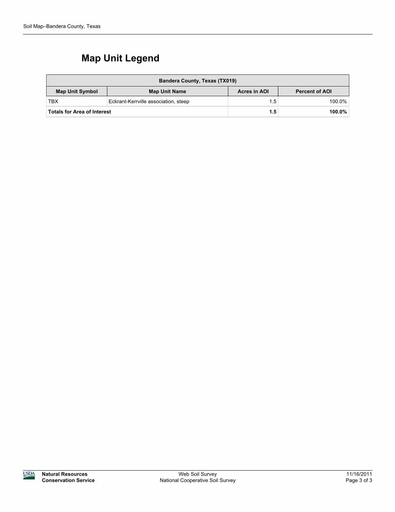
Map Unit Legend
Bandera County, Texas (TX019)
Map Unit Symbol Map Unit Name Acres in AOI Percent of AOI
TBX Eckrant-Kerrville association, steep 1.5 100.0%
Totals for Area of Interest 1.5 100.0%
Soil Map–Bandera County, Texas
Natural ResourcesConservation Service
Web Soil SurveyNational Cooperative Soil Survey
11/16/2011Page 3 of 3
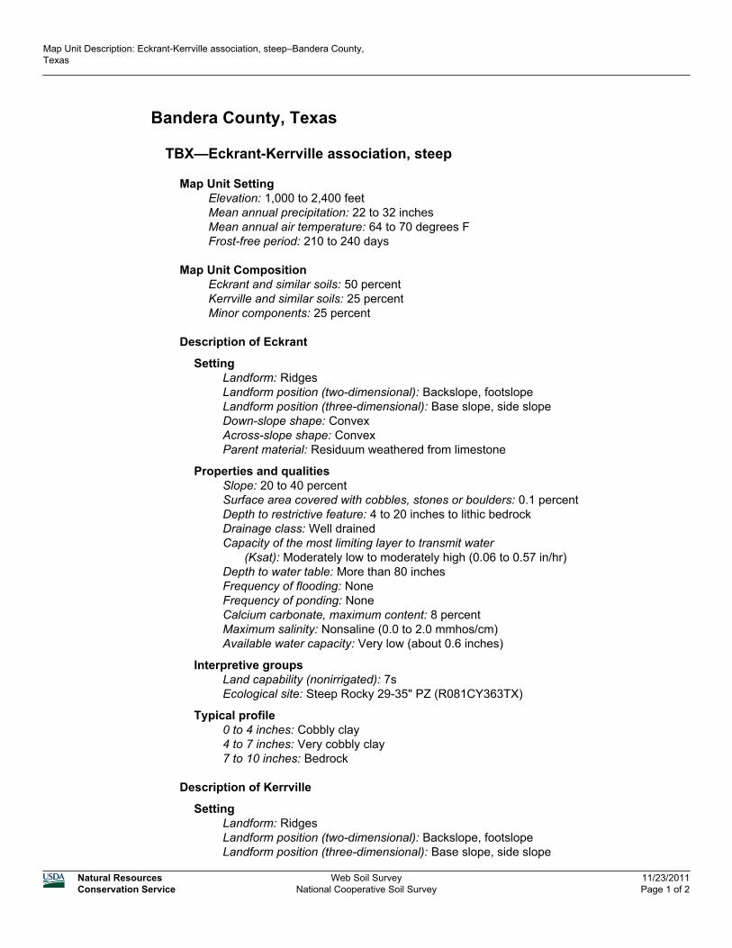
Bandera County, Texas
TBX—Eckrant-Kerrville association, steep
Map Unit SettingElevation: 1,000 to 2,400 feetMean annual precipitation: 22 to 32 inchesMean annual air temperature: 64 to 70 degrees FFrost-free period: 210 to 240 days
Map Unit CompositionEckrant and similar soils: 50 percentKerrville and similar soils: 25 percentMinor components: 25 percent
Description of Eckrant
SettingLandform: RidgesLandform position (two-dimensional): Backslope, footslopeLandform position (three-dimensional): Base slope, side slopeDown-slope shape: ConvexAcross-slope shape: ConvexParent material: Residuum weathered from limestone
Properties and qualitiesSlope: 20 to 40 percentSurface area covered with cobbles, stones or boulders: 0.1 percentDepth to restrictive feature: 4 to 20 inches to lithic bedrockDrainage class: Well drainedCapacity of the most limiting layer to transmit water
(Ksat): Moderately low to moderately high (0.06 to 0.57 in/hr)Depth to water table: More than 80 inchesFrequency of flooding: NoneFrequency of ponding: NoneCalcium carbonate, maximum content: 8 percentMaximum salinity: Nonsaline (0.0 to 2.0 mmhos/cm)Available water capacity: Very low (about 0.6 inches)
Interpretive groupsLand capability (nonirrigated): 7sEcological site: Steep Rocky 29-35" PZ (R081CY363TX)
Typical profile0 to 4 inches: Cobbly clay4 to 7 inches: Very cobbly clay7 to 10 inches: Bedrock
Description of Kerrville
SettingLandform: RidgesLandform position (two-dimensional): Backslope, footslopeLandform position (three-dimensional): Base slope, side slope
Map Unit Description: Eckrant-Kerrville association, steep–Bandera County,Texas
Natural ResourcesConservation Service
Web Soil SurveyNational Cooperative Soil Survey
11/23/2011Page 1 of 2

Down-slope shape: ConvexAcross-slope shape: ConvexParent material: Residuum weathered from limestone
Properties and qualitiesSlope: 20 to 30 percentSurface area covered with cobbles, stones or boulders: 0.1 percentDepth to restrictive feature: 20 to 40 inches to lithic bedrockDrainage class: Well drainedCapacity of the most limiting layer to transmit water
(Ksat): Moderately low to high (0.06 to 1.98 in/hr)Depth to water table: More than 80 inchesFrequency of flooding: NoneFrequency of ponding: NoneCalcium carbonate, maximum content: 90 percentAvailable water capacity: Low (about 3.4 inches)
Interpretive groupsLand capability (nonirrigated): 7sEcological site: Steep Adobe 29-35" PZ (R081CY362TX)
Typical profile0 to 6 inches: Clay loam6 to 14 inches: Clay loam14 to 40 inches: Clay loam40 to 60 inches: Bedrock
Minor Components
Unnamed, minor componentsPercent of map unit: 25 percent
Data Source Information
Soil Survey Area: Bandera County, TexasSurvey Area Data: Version 8, Oct 26, 2009
Map Unit Description: Eckrant-Kerrville association, steep–Bandera County,Texas
Natural ResourcesConservation Service
Web Soil SurveyNational Cooperative Soil Survey
11/23/2011Page 2 of 2
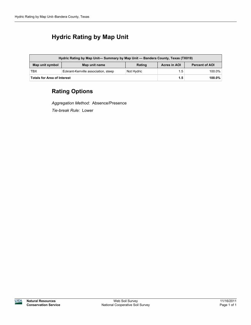
Hydric Rating by Map Unit
Hydric Rating by Map Unit— Summary by Map Unit — Bandera County, Texas (TX019)
Map unit symbol Map unit name Rating Acres in AOI Percent of AOI
TBX Eckrant-Kerrville association, steep Not Hydric 1.5 100.0%
Totals for Area of Interest 1.5 100.0%
Rating Options
Aggregation Method: Absence/Presence
Tie-break Rule: Lower
Hydric Rating by Map Unit–Bandera County, Texas
Natural ResourcesConservation Service
Web Soil SurveyNational Cooperative Soil Survey
11/16/2011Page 1 of 1

Exhibit 4
aaerin
Subject Stamp
aaerin
Oval
aaerin
Callout
1/2 mile visual APE

Exhibit 5

aaerin
Subject Stamp
aaerin
Typewritten Text
National Wetlands Inventory Quad: Echo Hill Ranch, Texas

Exhibit 6
aaerin
Subject Stamp

Exhibit 7

Species ReportsEnvironmental Conservation Online System
Species By County Report
The following report contains Species that are known to or are believed to occur in this county. Species with range unrefined past the state level are now excluded from this report. If you are looking for the Section 7 range (for Section 7 Consultations), please visit the IPaC application.
County: Bandera, TX
Last updated: November 16, 2011
ECOS Home | Contact Us
Group Name Population Status Lead Office Recovery Plan Name Recovery Plan Action Status Recovery Plan Stage
BirdsBlack-capped Vireo (Vireo atricapilla)
Endangered
Arlington Ecological Services Field Office
Black-capped Vireo (Vireo atricapillus) Recovery Plan
View Implementation Progress
Final
Golden-cheeked warbler (=wood) (Dendroica chrysoparia)
Endangered
Austin Ecological Services Field Office
Golden-cheeked Warbler
View Implementation Progress
Final
Flowering Plants
Tobusch fishhook cactus (Ancistrocactus tobuschii)
Endangered
Austin Ecological Services Field Office
Tobusch Fishhook Cactus
View Implementation Progress
Final
Export options: CSV | EXCEL | XML | PDF

Exhibit 8


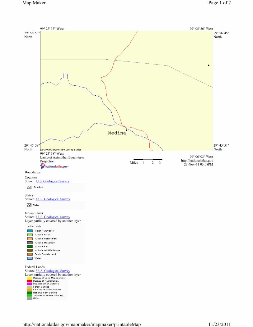
99° 23' 33'' West 99° 05' 56'' West 29° 56' 53'' North
29° 56' 45'' North
29° 45' 59'' North
29° 45' 51'' North
99° 23' 38'' West Lambert Azimuthal Equal-Area Projection Miles 1 2 3
99° 06' 03'' West http://nationalatlas.gov
23-Nov-11 03:08PM
BoundariesCountiesSource: U.S. Geological Survey
StatesSource: U. S. Geological Survey
Indian Lands Source: U. S. Geological SurveyLayer partially covered by another layer
Federal Lands Source: U. S. Geological SurveyLayer partially covered by another layer
Page 1 of 2Map Maker
11/23/2011http://nationalatlas.gov/mapmaker/mapmaker/printableMap
Medina

Wilderness Preservation System Areas Source: U. S. Geological SurveyLayer partially covered by another layer
Public Land Survey System Source: U. S. Geological Survey
Map Reference Cities and Towns Source: U.S. Geological Survey
Latitude/Longitude Source: U.S. Geological Survey
TransportationRoads Source: U.S. Geological Survey
WaterStreams and Waterbodies Source: U.S. Geological Survey
Page 2 of 2Map Maker
11/23/2011http://nationalatlas.gov/mapmaker/mapmaker/printableMap

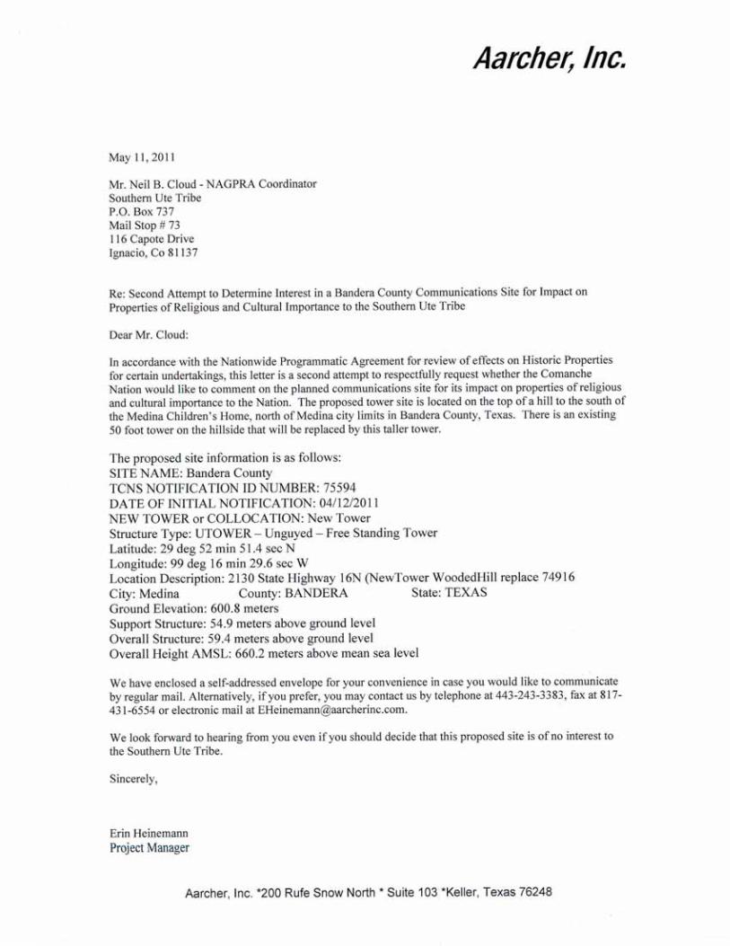
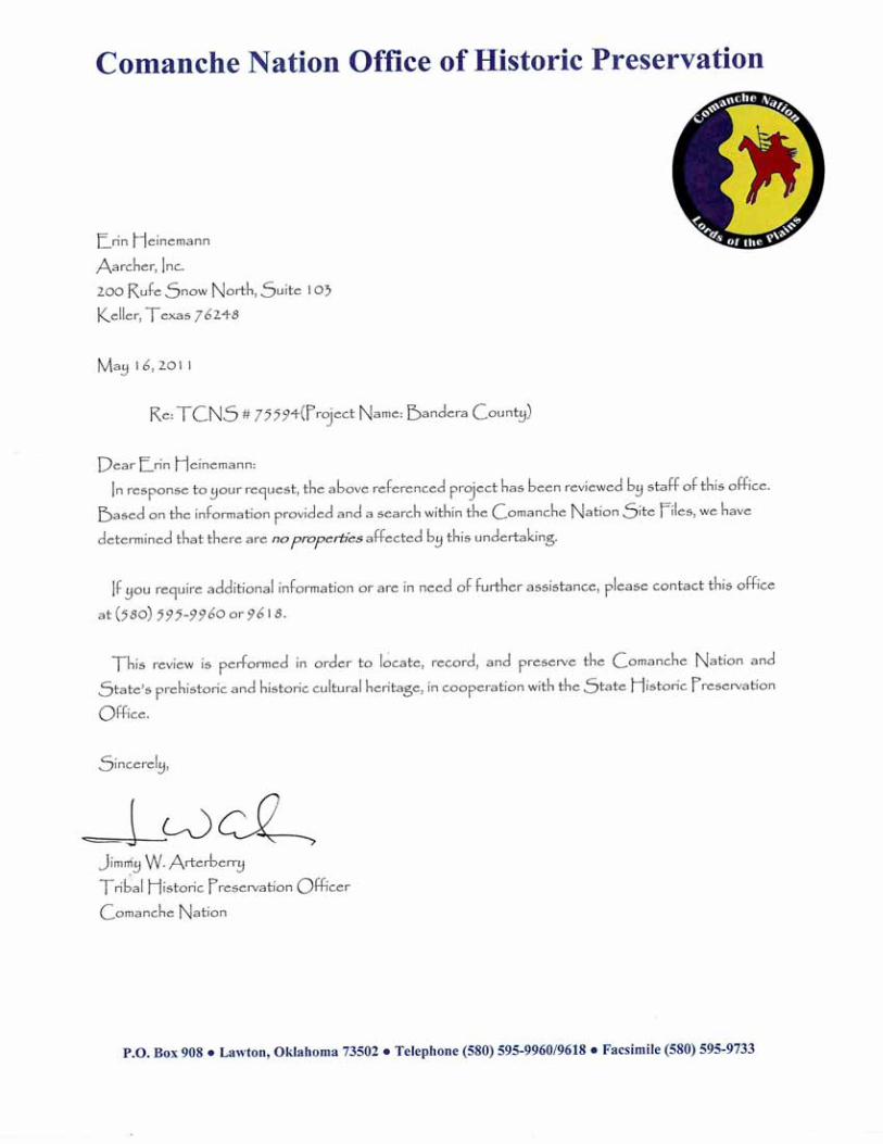
Exhibit 9


Exhibit 10

1
Erin Heinemann
From: [email protected]: Tuesday, April 12, 2011 3:32 PMTo: Erin HeinemannSubject: Proposed Tower Structure Info - Email ID #2777570
Dear Erin Heinemann,
Thank you for submitting a notification regarding your proposed construction via the TowerConstruction Notification System. Note that the system has assigned a unique Notification ID number for this proposed construction. You will need to reference this Notification ID number when you update your project's Status with us.
Below are the details you provided for the construction you have proposed:
Notification Received: 04/12/2011
Notification ID: 75594 Tower Owner Individual or Entity Name: Bandera County Consultant Name: Erin Heinemann Street Address: 200 Rufe Snow North Suite 103 City: Keller State: TEXAS Zip Code: 76248 Phone: 817-431-1593 Email: [email protected]
Structure Type: UTOWER - Unguyed - Free Standing Tower Latitude: 29 deg 52 min 51.4 sec N Longitude: 99 deg 16 min 29.6 sec W Location Description: 2130 State Highway 16N (NewTower WoodedHill replace74916 City: Medina State: TEXAS County: BANDERA Ground Elevation: 600.8 meters Support Structure: 54.9 meters above ground level Overall Structure: 59.4 meters above ground level Overall Height AMSL: 660.2 meters above mean sea level

1
Erin Heinemann
From: [email protected]: Friday, April 15, 2011 2:01 AMTo: Erin HeinemannCc: [email protected]; [email protected]: NOTICE OF ORGANIZATION(S) WHICH WERE SENT PROPOSED TOWER
CONSTRUCTION NOTIFICATION INFORMATION - Email ID #2779473
Dear Sir or Madam:
Thank you for using the Federal Communications Commission's (FCC) Tower Construction Notification System (TCNS). The purpose of this electronic mail message is to inform you that the following authorized persons were sent the information you provided through TCNS,which relates to your proposed antenna structure. The information was forwarded by the FCCto authorized TCNS users by electronic mail and/or regular mail (letter).
Persons who have received the information that you provided include leaders or their designees of federally-recognized American Indian Tribes, including Alaska Native Villages(collectively "Tribes"), Native Hawaiian Organizations (NHOs), and State Historic Preservation Officers (SHPOs). For your convenience in identifying the referenced Tribes and in making further contacts, the City and State of the Seat of Government for each Tribe and NHO, as well as the designated contact person, is included in the listing below.We note that Tribes may have Section 106 cultural interests in ancestral homelands or other locations that are far removed from their current Seat of Government. Pursuant to the Commission's rules as set forth in the Nationwide Programmatic Agreement for Review ofEffects on Historic Properties for Certain Undertakings Approved by the Federal Communications Commission (NPA), all Tribes and NHOs listed below must be afforded a reasonable opportunity to respond to this notification, consistent with the procedures setforth below, unless the proposed construction falls within an exclusion designated by the Tribe or NHO. (NPA, Section IV.F.4).
The information you provided was forwarded to the following Tribes and NHOs who have set their geographic preferences on TCNS. If the information you provided relates to a proposed antenna structure in the State of Alaska, the following list also includes Tribeslocated in the State of Alaska that have not specified their geographic preferences. For these Tribes and NHOs, if the Tribe or NHO does not respond within a reasonable time, you should make a reasonable effort at follow-up contact, unless the Tribe or NHO has agreed to different procedures (NPA, Section IV.F.5). In the event such a Tribe or NHO does not respond to a follow-up inquiry, or if a substantive or procedural disagreement arises between you and a Tribe or NHO, you must seek guidance from the Commission (NPA, Section IV.G). These procedures are further set forth in the FCC's Declaratory Ruling released onOctober 6, 2005 (FCC 05-176).
1. NAGPRA Coordinator Neil B Cloud - Southern Ute Tribe - Ignacio, CO - electronic mail and regular mailDetails: Under the following 6 conditions, the Southern Ute Indian Tribe does not need to review the proposed tower (PLEASE NOTE THAT THE FORM 620 IS MANDATORY IF THE PROPOSED TOWER NEEDS TO BE REVIEWED):
The Southern Ute Indian Tribe does NOT need to review proposed extensions to increase the height of already existing towers.
The Southern Ute Indian Tribe does NOT need to review proposed collocations on already existing towers.
The Southern Ute Indian Tribe does NOT need to review proposed structures that are to be placed on rooftops.
The Southern Ute Indian Tribe does NOT need to review proposed structures that are within a city's limits, if the proposed structure is to be located on a disturbed road that has

2
already been gravelled.
The Southern Ute Indian Tribe does NOT need to review proposed structures that are to be placed on pastures that have already been plowed or cultivated.
The Southern Ute Indian Tribe does NOT need to review proposed structures that are merely extensions inheight of an already existing structure.
For all other proposed areas, the Southern Ute Indian Tribe DOES NEED a copy of the Form 620. Please send the Form 620 via regular mail and be sure to INCLUDE THE FAX # of the company in order to receive a reply:
Neil B. Cloud, NAGPRA Coodinator, P.O. Box 737, Mail Stop #73, 116 Capote Drive, Ignacio, Colorado 81137
If the applicant/tower builder receives no response from the Southern Ute Indian Tribe within 30 days AFTER YOU HAVE SENT THE FORM 620 to the Tribe (including color photographs and resumes), then the Southern Ute Indian Tribe has no interest in participating in pre-construction review for the site.
2. THPO Assistant Kelly Glancy - Comanche Nation - Lawton, OK - regular mailDetails: The Comanche Nation Historic Preservation Office does not need to review proposedprojects under the following conditions; those that involve pre-existing above-ground feature additions or modifications, unless there is an increase in height, and those wherethe proposed project is within the city limits and proposed to be located on a previously disturbed site that has already been evaluated by the Comanche Nation.
If the proposed project does not meet the aforementioned conditions, the Comanche Nation Historic Preservation Office requires the following items; photographs taken of all 4 directions (north, south, east and west) from the center of the project site (where possible), legal description of the proposed site (i.e.; section, range, township, etc.) and any existing archeological/environmental reports or surveys relating to the site. We do not require, but request that you provide us with an aerial view of the proposed site if possible.
Due to the heavy volume of requests, we can no longer accept email requests.
Please send all materials to the Comanche Nation Historic Preservation Office, C/O Kelly Glancy, P.O. Box 908, Lawton, Oklahoma 73502 via regular or express mail, with a $500 review fee, per project (payable to the Comanche Nation Historic Preservation Office). Please note on the cashier s check/money order (or on an attachment), the TCNS Number/Project Name that the review fee is being provided for. Upon receipt of review fee,the Comanche Nation Historic Preservation Office will promptly respond to your review request.
Note: If the Comanche Nation Office of Historic Preservation has commented previously on the project under requested review, inform us of the date in the body of the review request, and you will not be assessed a review fee. If you are in need of additional information you may contact us directly at (580) 595-9960 or 9618 for clarification. In addition, this message serves as the 'Official' Notice from the Comanche Nation Historic Preservation Office and can be printed for your records, if necessary.
Thank you!
Sincerely,Jimmy Arterberry, THPO
3. TCNS Representative & GAP Technician Jason Prince - Wichita and Affiliated Tribes - Anadarko, OK - electronic mail and regular mail
If the applicant/tower builder receives no response from the Wichita and Affiliated Tribeswithin 30 days after notification through TCNS, the Wichita and Affiliated Tribes has no

3
interest in participating in pre-construction review for the proposed site. The Applicant/tower builder, however, must immediately notify the Wichita and Affiliated Tribes in the event archaeological properties or human remains are discovered during construction, consistent with Section IX of the Nationwide Programmatic Agreement and applicable law.
4. Tribal Administrator Joshua Waffle - Tonkawa Tribe - Tonkawa, OK - electronic mail
5. Tribal Historic Preservation Officer Holly B Houghten - Mescalero Apache Tribe - Mescalero, NM - electronic mail and regular mailDetails: The Mescalero Apache Tribe does not wish to review towers that are being placed upon existing buildings. For review of all other proposed towers located within the Mescalero Apache Tribe's traditional homelands, the Tribe will charge a $125.00 review fee. Please send this fee to the Historic Preservation Office, Mescalero Apache Tribe, P.O. Box 227, Mescalero, NM 88340. Please make the check payable to the Mescalero Apache Tribe and note on the check, or an attachment, the TCNS# or project name/numberthat the review fee is provided for. Upon receipt of the reveiw fee, the Mescalero Apache Tribe will promptly respond to your review request.
The information you provided was also forwarded to the additional Tribes and NHOs listed below. These Tribes and NHOs have NOT set their geographic preferences on TCNS, and therefore they are currently receiving tower notifications for the entire United States.For these Tribes and NHOs, you are required to use reasonable and good faith efforts to determine if the Tribe or NHO may attach religious and cultural significance to historic properties that may be affected by its proposed undertaking. Such efforts may include, butare not limited to, seeking information from the relevant SHPO or THPO, Indian Tribes, state agencies, the U.S. Bureau of Indian Affairs, or, where applicable, any federal agency with land holdings within the state (NPA, Section IV.B). If after such reasonable and good faith efforts, you determine that a Tribe or NHO may attach religious and cultural significance to historic properties in the area and the Tribe or NHO does not respond to TCNS notification within a reasonable time, you should make a reasonable effortto follow up, and must seek guidance from the Commission in the event of continued non-response or in the event of a procedural or substantive disagreement. If you determine that the Tribe or NHO is unlikely to attach religious and cultural significance to historic properties within the area, you do not need to take further action unless the Tribe or NHO indicates an interest in the proposed construction or other evidence of potential interest comes to your attention.
None
The information you provided was also forwarded to the following SHPOs in the State in which you propose to construct and neighboring States. The information was provided to these SHPOs as a courtesy for their information and planning. You need make no effort at this time to follow up with any SHPO that does not respond to this notification. Prior toconstruction, you must provide the SHPO of the State in which you propose to construct (orthe Tribal Historic Preservation Officer, if the project will be located on certain Triballands), with a Submission Packet pursuant to Section VII.A of the NPA.
6. SHPO Cathie Matthews - Department of Arkansas Heritage - Little Rock, AR - electronic mail
7. Deputy SHPO Ken Grunewald - Department of Arkansas Heritage - Little Rock, AR - electronic mail
8. SHPO Bob L Blackburn - Oklahoma Historical Society - Oklahoma City, OK - regular mail

4
9. Historian Linda Henderson - Texas Historical Commission - Austin, TX - electronic mail
If you are proposing to construct a facility in the State of Alaska, you should contact Commission staff for guidance regarding your obligations in the event that Tribes do not respond to this notification within a reasonable time.
Please be advised that the FCC cannot guarantee that the contact(s) listed above opened and reviewed an electronic or regular mail notification. The following information relating to the proposed tower was forwarded to the person(s) listed above:
Notification Received: 04/12/2011 Notification ID: 75594 Tower Owner Individual or Entity Name: Bandera County Consultant Name: Erin Heinemann Street Address: 200 Rufe Snow North Suite 103 City: Keller State: TEXAS Zip Code: 76248 Phone: 817-431-1593 Email: [email protected]
Structure Type: UTOWER - Unguyed - Free Standing Tower Latitude: 29 deg 52 min 51.4 sec N Longitude: 99 deg 16 min 29.6 sec W Location Description: 2130 State Highway 16N (NewTower WoodedHill replace74916 City: Medina State: TEXAS County: BANDERA Ground Elevation: 600.8 meters Support Structure: 54.9 meters above ground level Overall Structure: 59.4 meters above ground level Overall Height AMSL: 660.2 meters above mean sea level
If you have any questions or comments regarding this notice, please contact the FCC using the electronic mail form located on the FCC's website at:
http://wireless.fcc.gov/outreach/notification/contact-fcc.html.
You may also call the FCC Support Center at (877) 480-3201 (TTY 717-338-2824). Hours are from 8 a.m. to 7:00 p.m. Eastern Time, Monday through Friday (except Federal holidays).To provide quality service and ensure security, all telephone calls are recorded.
Thank you,Federal Communications Commission

1
Erin Heinemann
From: [email protected]: Monday, April 18, 2011 10:22 AMTo: Erin HeinemannCc: [email protected]; [email protected]: Reply to Proposed Tower Structure (Notification ID: 75594) - Email ID #2782684
Dear Erin Heinemann,
Thank you for using the Federal Communications Commission's (FCC) Tower Construction Notification System (TCNS). The purpose of this email is to inform you that an authorizeduser of the TCNS has replied to a proposed tower construction notification that you had submitted through the TCNS.
The following message has been sent to you from Tribal Administrator Joshua Waffle of the Tonkawa Tribe in reference to Notification ID #75594:
The following site(s) have been reviewed and to date (Monday, April 18, 2011) with currentresources, the Tonkawa Tribe has no known burial sites of the Tonkawa Indians. If any remains or artifacts are discovered please contact the appropriate Agencies and our TribalFacilities immediately. If the Tonkawa Tribes databases change in regards to the statement in this letter, a Tribal Representative will contact you.Respectfully,Joshua WaffleTribal Administrator Tonkawa TribePh 580 628 2561 124Fx 580 628 3375Cl 580 491 [email protected]
For your convenience, the information you submitted for this notification is detailed below.
Notification Received: 04/12/2011 Notification ID: 75594 Tower Owner Individual or Entity Name: Bandera County Consultant Name: Erin Heinemann Street Address: 200 Rufe Snow North Suite 103 City: Keller State: TEXAS Zip Code: 76248 Phone: 817-431-1593 Email: [email protected]
Structure Type: UTOWER - Unguyed - Free Standing Tower Latitude: 29 deg 52 min 51.4 sec N Longitude: 99 deg 16 min 29.6 sec W Location Description: 2130 State Highway 16N (NewTower WoodedHill replace74916 City: Medina State: TEXAS County: BANDERA Ground Elevation: 600.8 meters Support Structure: 54.9 meters above ground level Overall Structure: 59.4 meters above ground level Overall Height AMSL: 660.2 meters above mean sea level


1
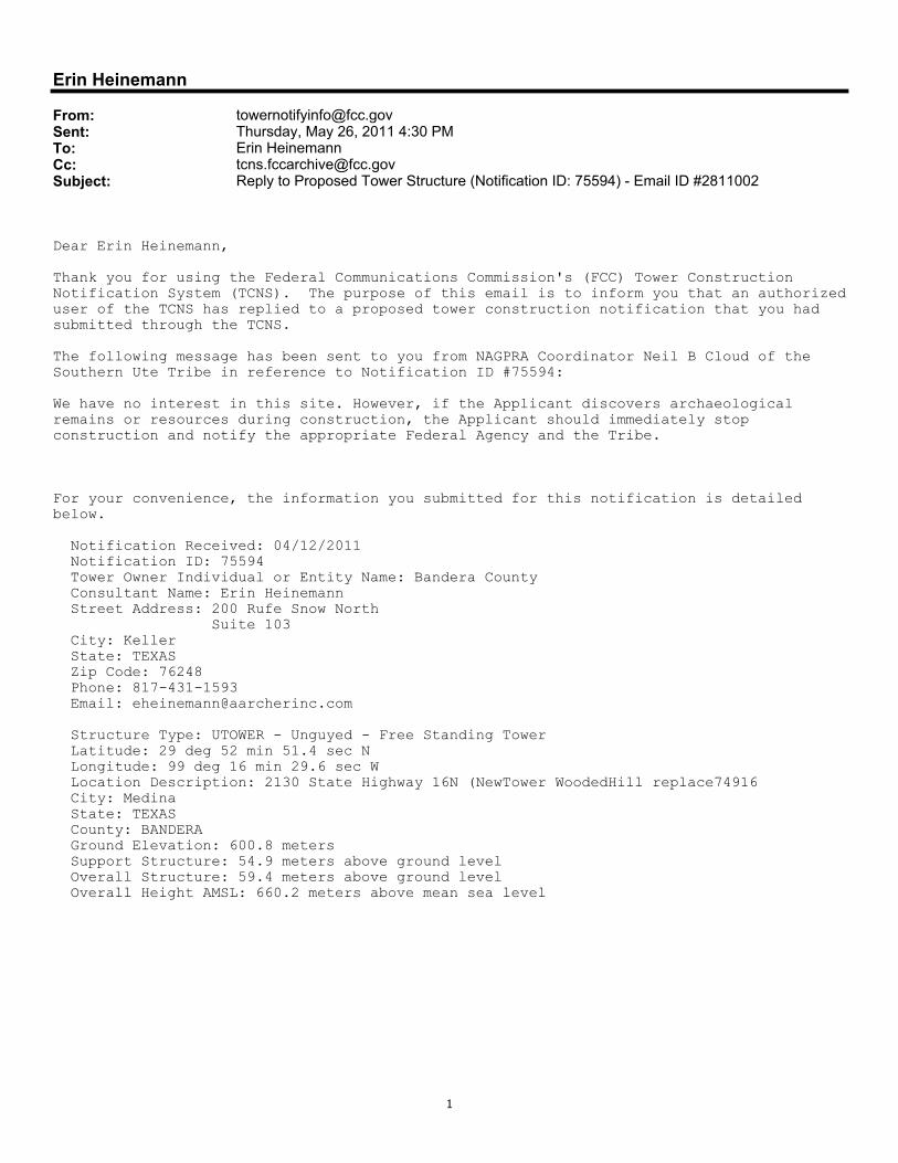
Erin Heinemann
From: [email protected]: Thursday, May 26, 2011 4:30 PMTo: Erin HeinemannCc: [email protected]: Reply to Proposed Tower Structure (Notification ID: 75594) - Email ID #2811002
Dear Erin Heinemann,
Thank you for using the Federal Communications Commission's (FCC) Tower Construction Notification System (TCNS). The purpose of this email is to inform you that an authorizeduser of the TCNS has replied to a proposed tower construction notification that you had submitted through the TCNS.
The following message has been sent to you from NAGPRA Coordinator Neil B Cloud of the Southern Ute Tribe in reference to Notification ID #75594:
We have no interest in this site. However, if the Applicant discovers archaeological remains or resources during construction, the Applicant should immediately stop construction and notify the appropriate Federal Agency and the Tribe.
For your convenience, the information you submitted for this notification is detailed below.
Notification Received: 04/12/2011 Notification ID: 75594 Tower Owner Individual or Entity Name: Bandera County Consultant Name: Erin Heinemann Street Address: 200 Rufe Snow North Suite 103 City: Keller State: TEXAS Zip Code: 76248 Phone: 817-431-1593 Email: [email protected]
Structure Type: UTOWER - Unguyed - Free Standing Tower Latitude: 29 deg 52 min 51.4 sec N Longitude: 99 deg 16 min 29.6 sec W Location Description: 2130 State Highway 16N (NewTower WoodedHill replace74916 City: Medina State: TEXAS County: BANDERA Ground Elevation: 600.8 meters Support Structure: 54.9 meters above ground level Overall Structure: 59.4 meters above ground level Overall Height AMSL: 660.2 meters above mean sea level

1
Erin Heinemann
From: [email protected]: Wednesday, June 01, 2011 2:32 PMTo: Erin HeinemannCc: [email protected]; [email protected]: Reply to Proposed Tower Structure (Notification ID: 75594) - Email ID #2815854
Dear Erin Heinemann,
Thank you for using the Federal Communications Commission's (FCC) Tower Construction Notification System (TCNS). The purpose of this email is to inform you that an authorizeduser of the TCNS has replied to a proposed tower construction notification that you had submitted through the TCNS.
The following message has been sent to you from Tribal Historic Preservation Officer HollyB Houghten of the Mescalero Apache Tribe in reference to Notification ID #75594:
After review of this communications project, it has been determined that the Mescalero Apache Tribe has no immediate concerns within the project area, and that the project will cause no adverse effects to cultural resources or areas of interest to the Mescalero Apache Tribe. If, however, the Applicant discovers archeological remains or resources during construction, the Applicant should stop construction and notify the appropriate Federal Agency and Tribe(s).
For your convenience, the information you submitted for this notification is detailed below.
Notification Received: 04/12/2011 Notification ID: 75594 Tower Owner Individual or Entity Name: Bandera County Consultant Name: Erin Heinemann Street Address: 200 Rufe Snow North Suite 103 City: Keller State: TEXAS Zip Code: 76248 Phone: 817-431-1593 Email: [email protected]
Structure Type: UTOWER - Unguyed - Free Standing Tower Latitude: 29 deg 52 min 51.4 sec N Longitude: 99 deg 16 min 29.6 sec W Location Description: 2130 State Highway 16N (NewTower WoodedHill replace74916 City: Medina State: TEXAS County: BANDERA Ground Elevation: 600.8 meters Support Structure: 54.9 meters above ground level Overall Structure: 59.4 meters above ground level Overall Height AMSL: 660.2 meters above mean sea level
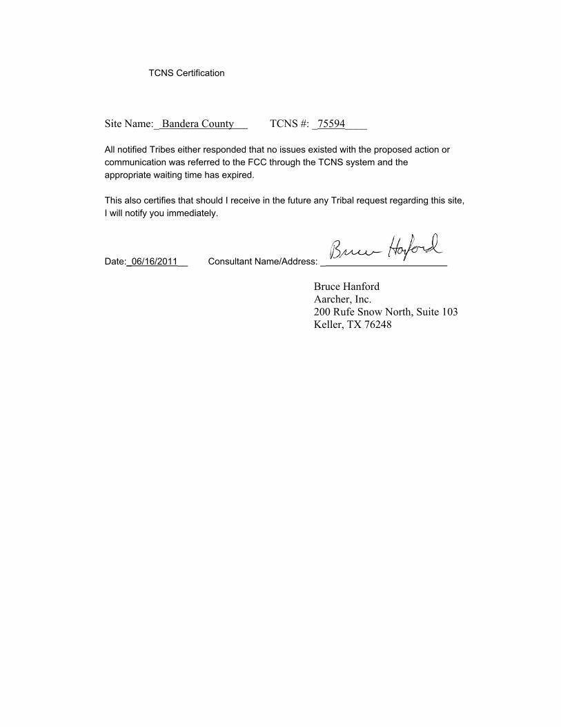
TCNS Certification
Site Name:_ Bandera County TCNS #: _75594____
All notified Tribes either responded that no issues existed with the proposed action orcommunication was referred to the FCC through the TCNS system and theappropriate waiting time has expired.
This also certifies that should I receive in the future any Tribal request regarding this site,I will notify you immediately.
Date:_06/16/2011__ Consultant Name/Address: _
Bruce Hanford Aarcher, Inc. 200 Rufe Snow North, Suite 103 Keller, TX 76248

Exhibit 11


Exhibit 12

NEPA Report by: Aarcher, Inc.
Site: Bandera County
FCC NEPA Significant Effect Checklist 47 CFR § 1.1307 (a) 1-8
Yes No 1. Officially designated wilderness area
Do map sources indicate the proposed action will be sited within a wilderness area? � �2. Officially designated wildlife preserve
Do map sources indicate the proposed action will be sited within a wildlife preserve? � �3. (i) Listed threatened or endangered species or designated critical
habitatWas evidence discovered that the proposed action would have a significant effect on listed threatened or endangered species or designated critical habitat?
(ii) Proposed endangered or threatened species or likely to result in the destruction or adverse modification of critical habitats Was evidence discovered that the proposed action would have a significant effect on proposed endangered or threatened species or is likely to effect critical habitats?
�
�
�
�4. Archaeological/Cultural Resources (districts, sites, buildings, structures
or objects, significant in American history, architecture, archeology, engineering or culture, that are listed, or eligible for listing, in the National Register of Historic Places) Was evidence discovered the proposed action could have a significant effect on Archaeological/Cultural Resources? � �
5. Indian Religious Site Was evidence discovered that the proposed action would be sited on an Indian Religious Site? � �
6. 100-Year Floodplain Is performance of an Environmental Assessment required because the subject property is within a 100-year floodplain and the proposed action is other than a co-location?
� �7. Construction will involve significant change in surface features (e.g.,
wetland fill, deforestation or water diversion) Was evidence discovered that the proposed action would have a significant effect on surface features? � �
8. Radiofrequency radiation Will the proposed action result in radiofrequency radiation in excess of the applicable health and safety guidelines? � �
9. Antenna towers and/or supporting structures to be equipped with high intensity white lights which are to be located in a residential neighborhood Was evidence discovered that the proposed action would have a significant effect on residential neighborhoods? � �
ENVIRONMENTAL ASSESSMENT REPORT - PRIVILEGED DOCUMENT