between Basin Development and Downstream … Basin Development and Downstream Environmental...
38
Jean-Philippe Venot, Bharat R. Sharma and Kamineni V. G. K. Rao The Lower Krishna Basin Trajectory: Relationships between Basin Development and Downstream Environmental Degradation 125 RESEARCH REPORT International Water Management Institute IWMI is a Future Harvest Center supported by the CGIAR
-
Upload
duongkhanh -
Category
Documents
-
view
215 -
download
0
Transcript of between Basin Development and Downstream … Basin Development and Downstream Environmental...
Jean-Philippe Venot, Bharat R. Sharma and Kamineni V. G. K. Rao
The Lower Krishna BasinTrajectory: Relationshipsbetween Basin Developmentand Downstream EnvironmentalDegradation
125
RESEARCHR E P O R T
I n t e r n a t i o n a lWater ManagementI n s t i t u t e IWMI is a Future Harvest Center
supported by the CGIAR

Research Reports
IWMI’s mission is to improve water and land resources management for food,livelihoods and nature. In serving this mission, IWMI concentrates on the integrationof policies, technologies and management systems to achieve workable solutionsto real problems—practical, relevant results in the field of irrigation and water andland resources.
The publications in this series cover a wide range of subjects—from computermodeling to experience with water user associations—and vary in content fromdirectly applicable research to more basic studies, on which applied work ultimatelydepends. Some research reports are narrowly focused, analytical and detailedempirical studies; others are wide-ranging and synthetic overviews of genericproblems.
Although most of the reports are published by IWMI staff and their collaborators,we welcome contributions from others. Each report is reviewed internally by IWMI’sown staff and Fellows, and by external reviewers. The reports are published anddistributed both in hard copy and electronically (www.iwmi.org) and where possibleall data and analyses will be available as separate downloadable files. Reports maybe copied freely and cited with due acknowledgment.
i
i
Research Report 125
The Lower Krishna Basin Trajectory:Relationships between Basin Developmentand Downstream EnvironmentalDegradation
Jean-Philippe Venot, Bharat R. Sharma andKamineni V. G. K. Rao
International Water Management InstituteP O Box 2075, Colombo, Sri Lanka
ii
ii
The authors: Jean-Philippe Venot is a PhD scholar with the International WaterManagement Institute, Hyderabad, India, and at the GECKO Laboratory of theUniversity of Paris X-Nanterre. He is also affiliated to the Centre for the Study ofRegional Development at the Jawaharlal Nehru University, New Delhi, as a casualstudent (e-mail: [email protected]). Bharat Sharma is Senior Researcher-I (WaterManagement) and Head of the International Water Management Institute, New Delhioffice, India (e-mail: [email protected]). Kamineni V. G. K. Rao is an independentconsultant and Head, Consultancy Services of Indwa Technologies Pvt. Ltd., 506, TopazBuilding, Panjagutta, Hyderabad 500 082, Andhra Pradesh, India (e-mail:[email protected]).
Acknowledgements: The authors extend their warmest thanks to the team of theInternational Water Management Institute, Hyderabad and New Delhi offices and to theteam of Indwa Technology Pvt. Ltd., Hyderabad, which made the present researchpossible through intensive data collection. Sincere thanks are also due to Mr. PradeepRaj of the State Groundwater Department of Andhra Pradesh, to Olivia Aubriot andFrédéric Landy for fruitful comments. Finally, we would like to thank John W. Gowing,Max Finlayson and Charlotte de Fraiture for thoughtful comments and remarks on earlierversions of this report. This research was supported by a grant from the AustralianCentre for International Agricultural Research (ACIAR).
Venot, J.-P.; Sharma, B. R.; Rao, K. V. G. K. 2008. The Lower Krishna Basin trajectory:Relationships between basin development and downstream environmental degradation.Colombo, Sri Lanka: International Water Management Institute. 36p. (IWMI ResearchReport 125)
/ river basin development / river basin management / downstream / environmentaldegradation / water allocation / water availability / water use / legal aspects / groundwaterirrigation / salinity / water quality / conflict / wetlands / Krishna Basin / India /
ISSN 1026-0862ISBN 978-92-9090-690-2
Copyright © 2008, by IWMI. All rights reserved.
Cover Photograph by Jean-Philippe Venot shows aquaculture ponds along the KrishnaRiver, in the estuary region. Otherwise stated, all pictures are from Jean-Philippe Venot.
Please send inquiries and comments to [email protected]
IWMI receives its principal funding from 58 governments, private foundations, andinternational and regional organizations known as the Consultative Group onInternational Agricultural Research (CGIAR). Support is also given by the Governmentsof Ghana, Pakistan, South Africa, Sri Lanka and Thailand.
iii
iii
Contents
Acronyms and Abbreviations iv
Summary v
Introduction 1
Human and Physical Setting of the Lower Krishna Basin 2
Basin Water Allocation in the Framework of Environmental Flows 3
The Drivers of Environmental Change in the Lower Krishna Basin 6
Linkages between Rural Development and Environmental Degradation 12
Discussion and Conclusions 19
Appendices 23
References 26

iv
Acronyms and Abbreviations
BCM Billion cubic metersCRZ Coastal Regulation ZoneET EvapotranspirationEWR Environmental Water Requirementsha hectareMAR Mean Annual RunoffMha Million hectaresMm3 Million cubic metersMPEDA Marine Products Export Development AuthoritySADA Shore Area Development Authority

v
Summary
Since the 1850s, the Krishna Basin in South Indiahas seen a dramatic development of irrigation andwater demand. In 1990-2000, consumptive wateruse accounted for 90.5% of the basin net inflow:warnings of basin closure (zero or minimal flow tothe ocean) emerge during dry periods. This paperlinks basin water development and downstreamenvironmental degradation. It shows that decreasingwater availability due to upstream water regulation;recent trends of increasing groundwater abstractionand aquaculture development in the Lower KrishnaBasin; and a fragmented institutional landscapehave led to environmental degradation manifestingitself by soil and groundwater salinization,increasing pollution, disappearing mangroves andwetland desiccation. The paper further illustratesthat natural resources management is oftendetermined by political and economic interests withlesser emphasis on equitable use of the resourcesor environmental sustainability of the ecosystem.The formal recognition of the environment as awater user in its own right would be a first steptowards improving the de-facto water allocationprocedures that prevail today. The paper calls forthe definition and implementation of an
environmental water provision based on a two-tierallocation system with assured discharges in theirrigation canals of the delta and to the ocean.Other measures facilitating integrated naturalresources management from the local level(regulating practices, drought-mitigationmechanisms) to the state level (integrated coastalmanagement, institutional support, devolutionprocess) and the basin level (integrated basinmanagement and water-allocation procedures) areneeded too. In the Krishna Basin, nearly all waterresources are committed to existing uses:allocating water to the environment will increase thepressure over water resources but this is the priceto pay to reconcile the social, economic andenvironmental objectives of a sustainabledevelopment. When a river basin is closing, anysupply augmentation projects would lead to a re-appropriation of water rather than to an increase ofthe total water availability. As this reallocation islikely to mainly take place on economic grounds,high attention is indeed to be given to equity andenvironmental preservation principles whenimplementing water allocation mechanisms for thesatisfaction of competing demands.
1
The Lower Krishna Basin Trajectory:Relationships between Basin Development andDownstream Environmental Degradation
Jean-Philippe Venot, Bharat R. Sharma and Kamineni V. G. K. Rao
water resources policies. This mainstreaming ledto the recognition of formal water allocationprocedures as the most adapted tools toreconcile the social, environmental and economicobjectives of sustainable development andintegrated water resources management. However,to date, most developing countries do not havewell-defined procedures for effective waterallocation and water policies generally only list“allocation priorities.” The Indian National WaterPolicy of 2002 provides guidelines for prioritizingwater allocation to different competing sectors,giving precedence to drinking water over irrigation,hydropower generation, industrial and navigationneeds. Environmental concerns mentioned underthe heading “ecology” are given fourth priority butnothing is said on how this should beimplemented (MoWR 2002).
This report is a case study on the KrishnaRiver Basin in South India. The basin haswitnessed intense water development resulting indownstream environmental degradation. Theobserved decline in discharge to the ocean sendsa strong signal: there is only little scope for furtherwater supply development, and further taming theKrishna waters will exacerbate environmentaldegradation. This report investigates the linkagesbetween rural development dynamics and thedownstream environment of the Krishna Basin inorder to understand when and how ruraldevelopment and environmental preservation come
Introduction
Water and infrastructural development to meetgrowing human consumptive uses has taken placewith little regard to the limits of availability ofrenewable resources. The result is significantdegradation of various ecosystems (Falkenmark etal. 2007). In the Krishna Basin, warnings ofenvironmental degradation due to long- and short-term rural dynamics have emerged in the lowerbasin which bears the brunt of any interventionfurther upstream. As upstream water use is notadjusted to reflect changes in water availability,environmental threats are likely to be furthersharpened.
There is increasing evidence of the adverseimpacts of water and land degradation on thelivelihoods of people (MEA 2005; Falkenmark et al.2007). Therefore, environmental concerns havestarted to gain strength and the notion ofenvironmental flows is establishing itself firmly. It isan attempt to find a compromise betweenproductive uses and some protection threshold. Butachieving this balance represents a considerablechallenge in many of the world’s river basins,especially in arid and semiarid areas of thedeveloping world, as population and associatedwater demands increase to sustain a broadereconomic development (ACC/ISGWR 1992;NCIWRDP 1999; WWAP 2003).
The United States of America, South Africaand Australia are countries where environmentalwater requirements have been mainstreamed in
2
or do not come into conflict and identify potentialareas of intervention to limit the degradation of thedownstream ecosystems of the Krishna Basin.
The section, Human and Physical Setting ofthe Lower Krishna Basin, presents the mainfeatures of the Lower Krishna Basin. The section,Basin Water Allocation in the Framework ofEnvironmental Flows, describes a methodology forwater allocation in the framework of environmentalflows in a data-scarce context and applies thismethodology to the Krishna Basin. It is mainlybased on literature review and secondary datacollection. The section, The Drivers ofEnvironmental Change in the Lower Krishna Basin,
provides a historical assessment of wateravailability and uses in the Krishna Basin. Itdepicts the rural dynamics and the institutionalcontext of the Lower Krishna Basin as some of themain driving forces of downstream environmentaldegradation. Based on field interviews and on acomprehensive review of the literature on the region,the section, Linkages between Rural Developmentand Environmental Degradation, describes thelinkages between agriculture, aquaculture and theenvironment in the Lower Krishna Basin. The finalsection, Discussions and Conclusions, provides aset of conclusions applicable to the Krishna Basinand other similar basins facing water scarcity.
Human and Physical Setting of the Lower Krishna Basin
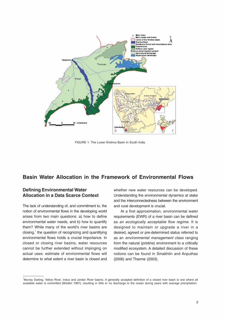
accommodates about 4 million inhabitantsdepending mainly on agriculture and aquaculture.Aquaculture is concentrated in the east of thedelta between the Kolleru Lake region and thecoastal fringe (Figure 1). The urban network isdense with many medium size cities of 0.5 to 1million inhabitants (Machilipatnam, Gudivada,Tenali, Vijayawada, etc.).
2. The Kolleru Lake, which is a freshwater inlandlake designated as a wetland of internationalimportance under the Ramsar convention in2002. It is located between the Krishna andGodavari river deltas. Limits shown in Figure 1are indicative: they do not correspond to theboundaries of the Ramsar site itself butcorrespond to a larger lowlying regiondesignated as the Kolleru Lake region.Aquaculture ponds are widespread in thisregion where half a million people live.
3. The coastal zone where mangroves and naturalvegetation have been progressively cut andreplaced by aquaculture ponds.
The Krishna Basin lies in southern peninsular India.The Krishna River originates in the Western Ghats,drains the dry areas of the Deccan Plateau, andforms a delta before discharging into the Bay ofBengal. The Krishna Basin drains an area of258,948 square kilometres (km2) (in three IndianStates: Andhra Pradesh, Karnataka andMaharashtra) and its climate is predominantlysemiarid. This report focuses on the impacts thatrural development dynamics witnessed in theKrishna Basin over the last 50 years have had onthe Lower Krishna basin, located in Andhra Pradesh(South India; Figure 1). The Lower Krishna Basinhas an area of 8,746 km2, a population densityhigher than 250 inhabitants per km2 (Appendix 1)and annual rainfall is in the range of 650 to 1,150millimeters (mm) (Appendix 2). There are three mainagro-ecosystems (Figure 1):
1. The Krishna Delta, where a large irrigation projectirrigates 540,000 hectares (ha) thanks to gravitycanals drawing water from a barrage on theKrishna River at Vijayawada. The delta
3
whether new water resources can be developed.Understanding the environmental dynamics at stakeand the interconnectedness between the environmentand rural development is crucial.
At a first approximation, environmental waterrequirements (EWR) of a river basin can be definedas an ecologically acceptable flow regime. It isdesigned to maintain or upgrade a river in adesired, agreed or pre-determined status referred toas an environmental management class rangingfrom the natural (pristine) environment to a criticallymodified ecosystem. A detailed discussion of thesenotions can be found in Smakhtin and Anputhas(2006) and Tharme (2003).
Basin Water Allocation in the Framework of Environmental Flows
1Murray Darling, Yellow River, Indus and Jordan River basins. A generally accepted definition of a closed river basin is one where allavailable water is committed [Molden 1997], resulting in little or no discharge to the ocean during years with average precipitation.
Defining Environmental WaterAllocation in a Data Scarce Context
The lack of understanding of, and commitment to, thenotion of environmental flows in the developing worldarises from two main questions: a) how to defineenvironmental water needs, and b) how to quantifythem? While many of the world’s river basins areclosing,1 the question of recognizing and quantifyingenvironmental flows holds a crucial importance. Inclosed or closing river basins, water resourcescannot be further extended without impinging onactual uses: estimate of environmental flows willdetermine to what extent a river basin is closed and
FIGURE 1. The Lower Krishna Basin in South India.

4
Defining an annual volume of water to be setaside for the environment (bulk allocation),according to arbitrarily predefined preservationobjectives, appears a futile exercise without soundecological meaning. Yet, such a desktopassessment method constitutes the first steptowards the recognition of the environment as awater user in its own right (Smakhtin et al. 2004).This basin-wide reconnaissance assessment isbased on a single arbitrary hydrological index (thedischarge to the ocean) and is considered to bemost appropriate at the planning level of waterresources development, notably in developingcountries where water governance structure isweak and hydrological and ecological data scarce(Tharme 2003; Smakhtin et al. 2007a). Based ona work by Smakhtin and Anputhas (2006), Table 1presents what would be the environmental annualwater requirements of the Krishna Basin, measuredat the head of the Krishna Delta in Vijayawada (thelast point of measure of the Krishna flow; Figure 1),according to different objectives of downstreamecosystem preservation.
are obtained by scaling down the regime observedbetween 1901 and 1947 (when little impoundmentand land use changes had affected the functioningof the Krishna Basin drainage network) by 81.7%(for a moderately modified system) and 91.6% (fora largely modified status) to match the thresholdspresented in Table 1.
Water Availability and EnvironmentalStatus of the Krishna Basin
Figure 2 gives the first indication of river basinclosure and downstream environmental degradation.It shows the decline of the Krishna River’sdischarge, measured at the head of the delta, inVijayawada. Before 1960, river discharge into theocean averaged 57 BCM per year and the thresholdof 48.5 BCM a year, defining a “natural ecosystem”(Table 1), was reached with 76% reliability. Since1965, the river discharge has steadily decreased toreach 10.8 BCM in 2000 while it was almost nil in2004. The lower panel in Figure 2 illustrates that
Table 1. Annual Environmental Water Requirements (EWR) for the Krishna Basin (flow measured at Vijayawada) for different“protection thresholds”.
Environmental Status Natural Slightly Moderately Largely Seriously Criticallyecosystem modified modified modified modified modified
EWR (% historical MAR)* 62.5 35.7 18.3 8.4 3.5 1.5
EWR (BCM/yr) 48.5 27.7 14.2 6.5 2.7 1.2
* The historical Mean Annual Runoff (MAR) has been evaluated at 77.6 Billion cubic meters (BCM) a year (CWC 2002)Source: Smakhtin and Anputhas (2006).
In arid and semi-arid regions affected by themonsoon, the seasonality and inter-annual variabilityof water flows are crucial for the functioning of waterdependent ecosystems. It is generally recognizedthat environmental flows should be defined againstthis backdrop of natural variability of flow regime(Dyson et al. 2003; Tharme 2003). Figure 2 showsrecommended monthly flow regimes to preserve theKrishna Basin in a moderately to largely modifiedenvironmental status (the two lowest acceptablestatuses as per the DWAF guidelines in SouthAfrica [DWAF 1999]). These monthly flow regimes
taming the Krishna waters also affected the flowregime of the river with a two-month delay in thepeak outflow and slightly increased runoff during thedry season (due to irrigation return flows). Instandard conditions, the average discharge to theocean observed between 1988 and 2000 (betweenthe last two major droughts) was 21.2 BCM/yr butthe threshold of 14.2 BCM/yr defining a moderatelymodified ecosystem was only reached with 60%reliability. Similarly, historical monthly flow regimesshow that the Krishna Basin is a moderately tolargely modified ecosystem.

5
The top panel in Figure 2 illustrates therecurrence of low-discharge events (1971-1972;1984-1988; 2001-2004) that resulted from a rainfalldeficit at the basin level. In the Krishna Basin,
rainfall 10% below average [as in 2001-2004] hasbeen recorded with a probability of occurrence of0.3 over the last 100 years and seven droughts ofmore than 3 years have been recorded over the
FIGURE 2. The closure of the Krishna Basin: A declining discharge to the ocean. Source : Adapted from Venot et al. (2007).

6
last century (CRU 2007). By 2001-2004, thedischarge to the ocean fell below 1.2 BCM/yr;a level that had never been recorded before butthe drought itself was not particularly unusual.Given continued upstream development of
irrigation infrastructure; this may predict futurewater availability in the Lower Krishna Basin.Long-term trends of environmental degradationare likely to be sharpened during low rainfallperiods.2
The Drivers of Environmental Change in the Lower Krishna Basin
Coastal ecosystems are sensitive to changes inwater availability and use (Ramsar ConventionSecretariat 2006) and the degradation of estuarineresources, due to a variety of human activitieswithin and outside the estuaries, has become amajor environmental concern in India (Bhatta andBhat 1998). This section argues that three mainforces led to environmental degradation in theLower Krishna Basin: ( i) a continuousdevelopment of the Krishna Basin water resourcesand a decrease in water availability in the lowerbasin; (ii) the rural dynamics of the Lower KrishnaBasin; and finally (iii) the institutional context ofnatural resources management in the LowerKrishna Basin.
Shifting Land and Waterscape in theKrishna Basin
History of Water Development in the KrishnaBasin
Water has been managed for centuries in theKrishna Basin. Originally, small-scale structuresallowed diversion of runoff from small streams andstorage in small tanks (Wallach 1985). The firstmajor water diversions took place in the KrishnaDelta from 1852 onwards, with a project designedto irrigate 240,000 ha. Between the 1850s and
1947, most efforts to promote irrigation focused onthe dry areas of the Deccan Plateau in the UpperKrishna Basin where British engineers built largegravity irrigation systems (refer to Mollinga (2003)for further description of the functioning and theproblems faced by these irrigation systems).
The pace of irrigation development in theKrishna Basin accelerated after independence withthe modernization of the Krishna Delta project(1954-1957) which, at present, irrigates 540,000 ha.Irrigation also expanded with the establishment ofseveral irrigation and hydropower projects:Nagarjuna Sagar (1967) and Srisailam (1983) inAndhra Pradesh; Bhadra (1953), Malaprabha(1973); Ghataprabha (1977) and Alamatti (1990) inKarnataka; Koyna (1964) and Ujjani (1981) inMaharashtra were the major ones.
At the end of the 1980s and in the early 1990s,improving the management and performance ofexisting irrigation systems was given furtherattention in South and Southeast Asia and the paceof large-scale infrastructure development slightlyslowed down (Barker and Molle 2005) (this is visiblein Figure 2 for the Krishna Basin). With theliberalization of the Indian economy in the early1990s, state investment in agriculture weakened(Landy 2006). However, local private and communityinitiatives continued in the dry areas of the basin andscattered groundwater-irrigated plots multiplied,sustained by subsidized electricity.
2The high discharge observed in 2005-2007 (29 BCM/yr) illustrates that the Krishna River Basin is under transition.

7
Since independence, total storage capacity (inlarge and medium reservoirs of the Krishna Basin)has been multiplied eightfold to reach about 54BCM in the early years of the 21st century. In themeantime, small-scale irrigation projects have alsoboomed and existing infrastructures regulate morethan the 75%-dependable flow (Biggs et al. 2007).Along with infrastructure development, surfaceirrigated areas nearly doubled from 1995-2000:they covered about 2.8 million hectares (Mha) in1996-2000. Groundwater irrigated areas have alsodoubled during the same period and covered about2 Mha in 1996-2000.3
Basin-wide Water Accounting
The water accounting presented in Figure 3 andAppendix 3 draws on the categories of water balanceproposed by Molden (1997) and use the samemethodology as presented in Venot et al.(forthcoming). It evaluates water depletion, defined asthe use or removal of water from a river basin thatrenders it unavailable for further use, according to five
categories: beneficial evapotranspiration (ET) from 1)irrigation, 2) rainfed agriculture, 3) domestic, industrialand livestock processes, 4) low benefit ET fromnatural vegetation, and 5) non-beneficial ET from bareland and reservoirs. Rainfall estimates are based onCRU dataset (CRU 2007); land-use statistics arecollected at the district level (GoAP 2006; GoK 2006;GoM 2005). The depletion from any kind of landcover is estimated as its evapotranspiration (ET),evaluated according to the Penman-Monteithmethodology (Allen et al. 1998) for irrigated crops andbased on Biggs (in review), Bouwer et al. (2007) andImmerzeel et al. (2007) for other land covers. Urbanand industrial uses have been computed according toVan Rooijen et al. (forthcoming), assuming water useefficiency of 70% in each sector. Livestock processis computed according to Peden et al. (2007). Weused average figures referring to periods of 10 years.
Figure 3 confirms that the main trend is a strongincrease of irrigation depletion that has more thandoubled from 17.1 BCM/year during 1955-1965 to44.3 BCM/year during 1990-2000 (see also Appendix3). This implied a 19%-rise of the total depletion over
3According to the Minor Irrigation Censuses of 1994 and 2001, the number of shallow tube wells in the Krishna Basin increased from35,000 to 515,000 between 1987 and 2001 while the number of deep tube wells increased from 14,000 to 82,000 during the sameperiod. Also, 1.1 million of dug wells were registered in 2001 (515,000 in 1987).
FIGURE 3. Historical water account of the Krishna Basin (1955-2000).

8
the period 1955-2000. The total depletion amountedto 181 BCM during 1990-2000, i.e., 88.5% of the netinflow to the Krishna Basin. Consequently, thedischarge to the ocean dramatically decreased andamounted only to 9.5% of the net inflow during 1990-2000 (2% of the net inflow was exported to otherbasins). This led to dramatic environmental changesin the Lower Krishna Basin. According to Smakhtinand Anputhas (2006), preserving the moderately tolargely modified ecosystem of the Krishna Basinwould require an environmental flow allocation of about6.5 to 14.2 BCM/yr (Table 1). This will point to a rateof water resources commitment of 92 to 96%.
Agrarian Dynamics in the LowerKrishna Basin
The Making of the ‘Farmer-Capitalists’ of theKrishna Delta
Large-scale irrigation in the Lower Krishna Basindates back to the 1850s with the construction ofa diversion weir at Vijayawada, at the head of thedelta. Irrigation development, notably from the turnof the twentieth century onwards, led toagricultural surplus production andcommercial ization and set the stage foragricultural growth (Rao 1985). This went togetherwith the emergence of a large class of prosperouspeasants or owner-cultivators who can best betermed “farmer-capitalists” (Upadhya 1988). Thesefarmers rapidly re-invested their agriculturalsurplus in grain trade and small-scale agro-processing industries (mainly rice mills) andmigrated to cit ies in pursuit of economicprosperity, higher education (for the youngsters)and political influence. In the post-Independencerural economy characterized by a stronginvolvement of the State (Landy 2006); the GreenRevolution (1965-1985) and the subsequentagricultural productivity boom highly benefited theLower Krishna Basin and strengthened the“capitalist tendencies in the agrarian economy [ofcoastal Andhra Pradesh …]”(Upadhya 1988:1379). Large landowners were the main
beneficiaries of this evolution and invested heavilyin urban manufacturing activities; agro-industries(inputs and agricultural machinery dealers,fertilizer plants); industries (cement factories) orspeculated in urban real estates. Smalllandowning families benefited from a trickle downeffect and began to diversify their activities too.Nevertheless, economic disparities betweenlanded and landless, relying on wage labor,increased. Economic diversification, integration ofagriculture to market, links between rural andurban activities are some of the main reasons forthe prominent role played by the coastal region inAndhra Pradesh polit ics. This historicallyprominent position notably translates itself intohigher and more rel iable access to waterresources (Venot et al. 2007).
The Indian Agrarian Crisis
In the mid 1980s, and further with the liberalizationof the Indian economy in the early 1990s, Stateinvestments in rural development policies sloweddown and the importance of the corporate sector inIndian agriculture increased (Landy 2006). This issaid to have pushed rural India into an agrariandistress (Suri 2006). The farmers of the LowerKrishna Basin faced problems of heavydependence on high-cost inputs; volatility of cropoutput; market fluctuations; lack of remunerativeprices; indebtedness, etc. These problemsworsened as agriculture got embedded in a broaderliberalized economy. The “farmer-capitalists” of theLower Krishna Basin looked for other economicopportunities: aquaculture was one of them and itsdevelopment had significant impacts on the rurallandscape of the Lower Krishna Basin.
The Blue Revolution: Landscape Changes inthe Lower Krishna Basin
In Andhra Pradesh, aquaculture development wasa State policy as far back as the mid-1970s andenjoyed strong support from the centralgovernment as well: the aim was to promote aBlue Revolution (Naganathan et al. 1995) to

9
enhance local livelihoods. Farmers and fishermenwere entitled governmental land4 and encouragedto form registered cooperative societies for fishand shrimp farming. Simultaneously, small“farmer-entrepreneurs” invested private funds onsmall areas of un-appropriated governmental land tobenefit from a booming aquaculture sector.Aquaculture development reached its peak in the1990s. The extension of the governmental andinstitutional support for both financial and technicalaspects of aquaculture (Anonymous 2005), theliberalization of the Indian economy, and thedecreasing profitability of agriculture and capturefisheries triggered a change in the social structureof the Lower Krishna Basin aquaculture.Cooperatives managed by local people did notsurvive as land speculation became common andland-prices rose rapidly. Attracted by the prospectof high revenues and being under economic andpolitical pressure, small farmers and fishermensold or leased out their land entitlements to richlocal entrepreneurs and outsider investors andoften became daily or monthly contracted laborers(Rama Rao et al. 2006). Villages and localadministrations easily delivered further landentitlements to entrepreneurs to developaquaculture on un-appropriated governmental landsand mangrove areas. This increased the pressureon the natural resources of the Lower KrishnaBasin. Social movements backed up by themobilization of the local elites (the “farmer-capitalists”) emerged. They aimed at limiting in-migration of outsider investors who could havecornered the sector. This pushed the governmentto legislate on shrimp farming in 1996 (SupremeCourt of India 1996) and to control aquaculturedevelopment more carefully.
The strong commitment of the “farmer-capitalists” of the Lower Krishna Basin limited thephenomenon of land concentration contrary to whathappened in the Godavari Delta where large-scaleindustrial shrimp production is common(Grandcolas 2006). In the Lower Krishna Basin, the
average size of aquaculture farms is about 0.75hectares and 95% of the farmers cultivate less than2 hectares (Fisheries Department [Unpublisheddocumentation]). These official figures, however, donot account for the informal land concentration thathas taken place through large-scale, yet illegal,leasing of land entitlements (field visits in April2006 and 2007 highlighted the existence of largeponds of more than 50 hectares managed byentrepreneurial farmers). There are large differencesin revenue among the population: local fishermen,who were involved in capture fisheries, havegenerally been driven out of business and manysmall farmers have seen their paddy field andgrazing areas encroached by aquaculture ponds.Pushed into poverty, many migrated towards citiesseeking various ancillary job-opportunities related toshrimp cultivation.
At the end of the 1990s, the development ofaquaculture had come out of the control of theconcerned governmental departments (Anonymous2005). In the Lower Krishna Basin, poormanagement practices resulted in the outbreak ofdiseases, and in soil and groundwater salinization.Despite increasing inputs, yield decreased(Anonymous 2005; MPEDA 2006). A SupremeCourt order of 1996 (Supreme Court of India 1996)banishing anything but traditional shrimp farmingfrom the Coastal Regulation Zone (Box 1)illustrates the will to slow down environmentaldegradation. But, implementing this order is adifficult task as it goes against the objective of theAndhra Pradesh Government to revive anaquaculture sector that has a crucial economicimportance for the State (GoAP 2001c; Anonymous2007; GoAP 2007a).5
Aquaculture has beneficial impacts in theLower Krishna Basin: it sustains many livelihoods,triggered the construction of road infrastructure totransport the production and opened up the costalzone. However, as observed in Karnataka, “theemergence of commercial aquaculture in estuaries[…] has resulted in the breakdown of traditional
4Transaction of these land entitlements (purchase, selling, leasing) is not allowed.5Aquaculture in Andhra Pradesh accounts for 10% of the total fish and shrimp production in India (GoAP 2007a) and 45% of allponds in Andhra Pradesh are located in the Lower Krishna Basin (Fisheries Department unpublished documentation).
10
methods of resource management and adverseimpacts on the coastal environment (Bhatta andBhat 1998).” The problem is to find a balancebetween aquaculture, agriculture and environmentalpreservation in the Lower Krishna Basin. Within theaquaculture sector itself, fish and shrimp farminghave to be considered differently as they do nothave the same impacts on population andenvironment.
Institutional Context
Brugere (2006) shows that conflicts over coastalresources and subsequent environmental degradationare predominantly the outcome of institutionalfailures. Mapping the institutions involved in the use,control and preservation of natural resources inregard to the Lower Krishna Basin is thus central tothe understanding of the drivers of environmentaldegradation. It reveals a fragmented institutionalframework (GoAP 2001c) with:
• Federal institutions enacting rules andregulations to be implemented in the differentIndian states: the Ministr ies of WaterResources, of Environment and Forests, ofAgriculture, and of Rural Development; theMarine Products Export DevelopmentAuthority, etc.
• State agencies: the Fisheries; Agriculture;Irrigation; Revenue; Environment, Forests,Science and Technology Departments of theState of Andhra Pradesh; the Andhra PradeshPollution Control Board; the Shore AreaDevelopment Authority; the AquacultureAuthority, etc. The roles and objectives ofthese governmental bodies are oftenoverlapping but conflicting on the long run(GoAP 2001c). The Fisheries Department, forexample, promotes aquaculture but doesnot cover the environmental degradationresulting from shrimp farming in the coastalarea or in protected reserves under thejurisdiction and the protection of the ForestDepartment. Agriculture is promoted by therelated department but faces acute competition
from aquaculture as land pressure is highthroughout the Lower Krishna Basin. TheGroundwater Department should preserve waterquality while aquifers are over-used for bothagriculture and aquaculture, etc.
• Judiciary bodies, such as the Supreme Courtof India and the High Court of Andhra Pradesh.They have to ensure that existing legislationsare effectively implemented. The absence ofproactive governmental role in mitigating theenvironmental impacts of rural developmentoften led to actions being imposed by theJudiciary as a result of public interest litigation(GoAP 2001c; see, for example, the SupremeCourt order of 1996 on shrimp farming in thecoastal regulation zone).
• The Krishna Water Disputes Tribunal hasallocated water to the three states sharing theKrishna waters (GoI-KWDT 1973, 1976). Thisdid not hinder irrigation development:infrastructures have been built with little regardto the limits of availability and sustainability ofwater resources (Venot et al. 2007).
• International, federal, state-wise conventions,regulations or legislations: the RamsarConvention; the Indian Forest Act (1972); theWildlife Protection Act (1972); the WaterPrevention and Control of Pollution Act (1974);the Environment Protection Act (1986); theCoastal Regulation Zone Notification (1991); theIndian Fisheries Act (1997); the CoastalAquaculture Authority Act (2005), etc. Most ofthese acts and regulations are aboutpreserving the environment. Few are effectivelyimplemented.
• Local institutions: Panchayats, farmers andfishermen’s associations, etc. Panchayats areresponsible for protection and sustainable useof resources while local associations press forthe demands of the users they represent andlobby to ensure their access over naturalresources for their direct economic benefits.
Local rural dynamics and new economicopportunities (e.g., aquaculture) have led tochanges in the institutional context in which

11
Box 1. The Coastal Regulation Zone notification of 1991 (GoI 1991).
This notification aims at protecting the near-coastal environment. The area under tidal influence allalong the coast, up to 500 meters inland, has been subdivided into three zones with different levelsof protection according to their proximity to the coast. Within the Coastal Regulation Zone (CRZ),activities such as building, industries, waste dumping, groundwater use, land reclamation, and resourceextraction have been banned or restricted if they already existed at the time of the notification.
However, fragmented institutional framework, lack of interaction among existing agencies involved inthe management of natural resources and understaffing act as impediments for the implementationof the CRZ notification. In Andhra Pradesh, for example, the CRZ regulation is overseen by the ShoreArea Development Authority (SADA) under the Environment, Forests, Science and TechnologyDepartment. It has limited staff and few senior officials at the State level, in Hyderabad, to monitordevelopment activities in respect of the notification. Local level regulation and enforcement have beendelegated to the District Collector office that is in charge of the overall economic development of thedistrict. As a result, the CRZ notification gets the last priority compared with many other pressingresponsibilities (GoAP 2001c).
In this context, the problems that had motivated the CRZ notification are still common: groundwateris unsustainably abstracted for coastal aquaculture; seawater progresses further inland; mangrovecovers disappear; pollution is increasing due to aquaculture effluents; and there are major problemsof drinking water supply (GoAP 2001c).
on the case of Water User Associations). What isrequired is further integration and coordinationamong the different institutions involved in resourcemanagement. Making the existing legal provisionscontext-specific and their implementation effectivecould be achieved by making these regulationsmore easily available; building up enforcementmechanisms; training officials in the use andimplementation of laws; and improving the still lowawareness of these policies among stakeholders,etc. (GoAP 2001c). New institutional arrangementshave to be devised: users should be at the centerof managerial decisions (GoAP 2001a) butcentralized interventions such as integrated coastalmanagement, the regulation of on-farm practices(Gowing et al. 2006), and the implementation offormal environmental water allocation are needed.This will impinge on existing water use and comeup against existing politico-economic powers but isneeded to ensure sustainable and equitabledevelopment in the Lower Krishna Basin.
resource extraction takes place in the LowerKrishna Basin. The legal and institutionalframework of natural resource managementbroadened in line with the recognition of theimportance of environmental preservation forsustainable development. Federal and state-levelactors emerged and impinged on what waspreviously the remit of local institutions. Thisinstitutional formalization aimed at better preservingecosystems but also led to a fragmentation of theinstitutional setting. This hindered effectiveimplementation and often led to further degradationof the environment. To offset this evolution, recentmoves encourage devolution processes (Brugere2006). Interventions that put users at the center ofmanagement policies are promoted (e.g.,Integrated Resources and ParticipatoryManagement (GoAP 2001a and 2001c)). But lackof technical and financial support and rent seekingbehaviour of the local rural elites often thwart theireffective implementation (see Mollinga et al. (2001)

12
Linkages between Rural Development and EnvironmentalDegradation
This section investigates the linkages between ruraldevelopment and environmental degradation in theLower Krishna Basin. First, we highlight the strongconnections between irrigation developmentpatterns and environmental change. Second, weinvestigate the nature of the connections betweencoastal resources extraction and environmentaldegradation. Finally, a case study on the KolleruLake, where acute conflicts between short-termfinancial gains and long-term environmentalsustainability exist, is presented. This sectionhighlights that all environmental threats cannot besolved by environmental water allocation: othermeasures are needed.
Surface Water and GroundwaterIrrigation: Impacts on the Aquifers
The Aquifer System of the Lower Krishna Basin
The Lower Krishna Basin has a multilayered aquifersystem, and hydrological studies have shown that
groundwater levels are shallow due to the influenceof the canal network (GoAP 2003). Seepage fromunlined canals and return flows from irrigation arethe main sources of recharge for the fresh shallowaquifer (0 to 30 meters) used for agricultural anddrinking purposes. The Krishna River is the mainsource of recharge for plains along the river channel.Deeper aquifers are generally brackish to saline andmainly recharged by slow seepage from upper levelsand the Krishna River itself during the monsoonalperiod (DRDA 1999). Figure 4 illustrates that theclosure of the irrigation canals (and the subsequentdecrease in surface irrigation) leads to an averagedecline of the water table by one to two meters ina month’s time. A 50%-decrease of the yield of thewells tapping the shallow aquifer has also beenobserved (GoAP 2003).
Long-term Trends: When AgricultureDevelopment Causes Groundwater Degradation
As observed in the entire Krishna Basin, farmersin the lower basin have increasingly tapped the
FIGURE 4. Decline of the water table in relation to canal closure. Source: GoAP (2003).
13
6In 2001, the Minor Irrigation Census and district statistical handbooks indicated that 19,000 wells were used in the Lower KrishnaBasin (this is more than twice the amount in 1987).
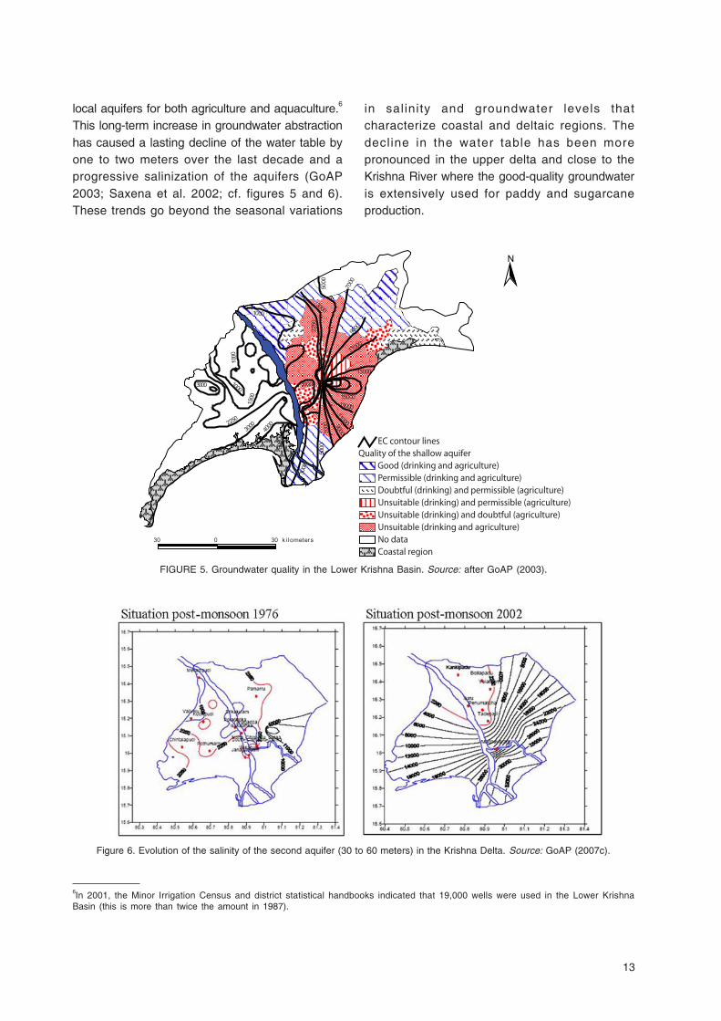
local aquifers for both agriculture and aquaculture.6
This long-term increase in groundwater abstractionhas caused a lasting decline of the water table byone to two meters over the last decade and aprogressive salinization of the aquifers (GoAP2003; Saxena et al. 2002; cf. figures 5 and 6).These trends go beyond the seasonal variations
in salinity and groundwater levels thatcharacterize coastal and deltaic regions. Thedecline in the water table has been morepronounced in the upper delta and close to theKrishna River where the good-quality groundwateris extensively used for paddy and sugarcaneproduction.
FIGURE 5. Groundwater quality in the Lower Krishna Basin. Source: after GoAP (2003).
Figure 6. Evolution of the salinity of the second aquifer (30 to 60 meters) in the Krishna Delta. Source: GoAP (2007c).

14
The salinization of the Lower Krishna Basinaquifers is due to two different processes. First, inthe inland region where groundwater use isintensive, the shallow freshwater aquifer has beendramatically depleted and fossil saline water,trapped during the deltaic formation in deeperaquifers, has reached the upper horizons (GoAP2003). Second, in the coastal zone and in the tail-end region of the Krishna Delta irrigation project,the decline in the water table led to seawaterintrusion likely to leave a permanent imprint ongroundwater quality. GoAP (2007c) describes alandward intrusion of the saltwater/freshwaterinterface of the second aquifer (30 to 60 metersdeep) by 10 to 20 kilometers inland over the lasttwo decades (Figure 6).
Finally, highly loaded return flows fromagriculture and aquaculture have also beenidentified as a main cause of pollution of surfacewater and groundwater in the delta. Agrochemicalresidues accumulate in the aquifers and nitratepollution can be observed in some pockets of thedelta (GoAP 2001b). These are major concerns ina region where most of the population, notably inthe coastal area, depend highly on freshgroundwater lenses tapped by hand pumps fordomestic purposes and by electric motors foragricultural activities (GoAP 2003).
7In 2003, for example, the east and west main canals of the Krishna Delta opened on July 17 and August 1, respectively. Until 2002,they usually opened during the second fortnight of June (Venot et al. 2007).
TABLE 2. Evolution of canal flows in the Krishna Delta project.
Period of time 1975-2000 2001 2002 2003 2004*
Average rainfall (mm) in the 844 776 702 661 819Krishna Basin
Canal discharge (BCM/yr) 6.15 6.96 5.46 3.88 2.81
* Despite average rainfall, canal discharges in 2004 have been low as most runoff had been committed upstream both to fill-upemptied reservoirs after a three-year drought and to supply large irrigation projects. Source: Superintending Engineer Krishna
Delta project (Vijayawada) and CRU (2007).
Short-term Changes: Impacts of Low IrrigationCanal Flows
The long-term trend of groundwater salinization hasbeen further sharpened during the recent spell ofdrought as lower flows in irrigation canals (Table 2)and in the Krishna River itself (Figure 2) causedlower seepages, lower recharge of the upper aquiferand further landward saline water intrusion.
In 2004, total surface water available in theKrishna Delta canals amounted to 45% of the long-term average observed between 1975 and 2000(Table 2). Soil and water salinity in a delta arenatural phenomena and local agricultural practiceshave long been adapted to these conditions(Gowing et al. 2006). However, lower and delayedcanal flows7 compelled farmers to change their landuse and cropping techniques (GoAP 2003). Theyleft some areas fallow, continued tappinggroundwater to irrigate the remaining cropped areaswhile return flows concomitantly decreased. Inspite of such adaptive strategies, paddy yieldshave been strongly affected by water scarcity andhence livelihoods. Figure 7 shows that in Kharif2003, yields 50 to 70% below average wererecorded in the tail-end regions of the KrishnaDelta irrigation project and in the coastal area,respectively. Farmers in other regions of the Lower

15
Krishna Basin have been less affected bydecreasing yields: the delay in canal water supplywas shorter and the scope for fresh groundwateruse higher (Figure 5).
Figure 7. Impacts of water scarcity on paddy yields in the Eastern Lower Krishna Basin Source: Adapted from mandal wise statistics
where brackish groundwater cannot be used fordomestic purposes (GoAP 2001b).
There is a clear need for measures of droughtmitigation and regulation of on-farm practices to
For many farmers, delayed water suppliesmeant a shift from a long duration paddy to ashort duration cultivar and higher input costsrarely offset by better prices or yields. Delayedsowing of the second crop (generally black gram,raised on residual moisture) also led to yieldlosses up to 50% (APWAM 2005). Manyfreshwater ponds located in the south and east ofthe Lower Krishna Basin and historically suppliedthrough the Krishna Delta irrigation canals havealso not been supplied all yearlong. This hasnegatively affected fish production in the region,and low water availability further jeopardizes thesustainability of aquaculture (GoAP 1998, 2002;Box 2). Finally, lower flows in the canals have ledto domestic water shortage in the coastal zone
lessen the environmental consequences of a dryperiod. Maintaining a minimal flow in the irrigationcanals of the Krishna Delta could be a first step.It is needed to sustain the local agriculture but itcould also indirectly contribute in the preservationof the Lower Krishna Basin environment. It wouldrecharge the local aquifers through seepages.Interestingly, as early as 1976, the first KrishnaWater Disputes Tribunal mentioned the role ofirrigation canal flows to limit salinization in theLower Krishna Basin and designed its allocationaccordingly (GoI-KWDT, 1973, 1976). Thisallocation could be a good basis for furtherrefinement of the Krishna Delta allotment given thebackdrop of increased cropping intensity andgroundwater abstraction.

16
Uses of Coastal Resources andEnvironmental Degradation
Reshaping the Coastal Landscape:Disappearing Mangroves
Relationships that communities nurture with theirenvironment progressively evolve with theidentification of new economic opportunities. Thearea of mangroves in the Lower Krishna Basindeclined as (i) they have long been used formultiple purposes (see MEA (2005) for differentpossible uses of mangroves) by a population of
about 30,000 people increasingly attracted by aprofitable brackish aquaculture sector; (ii) morerecently, their land status partially changed whenexploitation licenses for agriculture and brackishaquaculture were delivered by the local authorities(before 1997); and (iii) their management, longdevolved to the local Panchayats has beenentrusted to State level agencies such as thedepartments of forest and fisheries.
Between the mid-1970s and the early 2000s,mangrove covers had decreased by about 2,200hectares in the Lower Krishna Basin. In 2001,mangroves covered about 8,000 hectares (GoAP
8We considered average yields of 775, 4,000 and 5,000 kg/ha/crop for shrimp, fish and paddy farming, respectively. There are twocropping seasons for shrimp and paddy cultivation. Farm gate prices have been taken at US$7.5; 1.1 and 0.15 per kilogram ofshrimp, fish and paddy, respectively. Ponds and paddy fields evaporate 1,150 and 850 mm/year, respectively.
Box 2. Is there enough water to supply a booming aquaculture?
In 2003/2004; the Fisheries Department evaluated that 30,500 ha were under brackish shrimp farmingin the Lower Krishna Basin (two thirds of which were double cropped). Freshwater shrimp farming wastaken up, twice a year, on 2,000 hectares. Fish ponds covered 41,000 hectares. Evaporation in openwater bodies of the Lower Krishna Basin has been evaluated at 1,150 mm/year: ponds in the regiondeplete about 845 Mm3/yr (of which 494 Mm3/yr is freshwater, e.g., 13% of all water diverted in theKrishna Delta canals in 2003/2004). Aquaculture freshwater demand is higher than evaporativelosses. GoAP (2001c) estimates that total water requirements in freshwater shrimp and fish farmingare twice and three times higher than evaporative losses, respectively. In these conditions, the“aquaculture freshwater demand” in the Lower Krishna Basin would reach 1.5 BCM/yr, most of whichreturning to the aquifers or draining to neighboring fields.
Aquaculture ponds require reliable supplies: the aquaculture boom in the 1980s and 1990s has beensustained thanks to unconstrained water availability. Aquaculture farmers are likely to face lowerfreshwater supplies (as observed during the 2001-2004 drought). Return flows from agricultural areasthat have been long used for brackish aquaculture downstream will also decrease. Water shortagesare likely to become recurrent concerns for culture fishermen.
Allocating water to aquaculture is an economically sound policy: water productivity (defined as the ratioof gross output to evapotranspiration) of fish and shrimp ponds is about US$0.38 and 1 per cubicmeter, respectively (US$0.18/m3 in paddy fields)8. However, this would raise equity issues as (i) largefarmers are the main beneficiaries of the aquaculture sector, and (ii) this allocation would depriveagriculturalists in the Krishna Delta irrigation project. The objective of further expanding aquaculturein the state (GoAP 2001c) despite environmental issues does not seem sustainable on the long-term.The observed tendency to decreasing profitability (even if still higher than paddy cultivation) due tolower yields and market fluctuations (MPEDA 2006) also raises some questions.

17
2001c; FAO 2002). Mangrove areas are nowprotected and the creation of Coastal RegulationZones, in 1991, is a first step towards integratedcoastal management to regulate the exploitationof this fragile ecosystem (Box 1). However,implementation difficulties remain and mangrovesare still under the threat of several interconnectedprocesses: (i) overgrazing due to the reduction ofthe grazing areas and the increase in thepopulation for which livestock is a primary sourceof revenue (Grandcolas 2006), (ii) overexploitationof timber products (GoAP 2001c), (iii) conversionto shrimp ponds: FAO (2002) evaluated that 3 to5% of all shrimp ponds in Andhra Pradesh hadbeen dug in mangrove areas, this being about1,200 hectares in the Lower Krishna Basin (e.g.,more than half the mangrove areas thatdisappeared during the last three decades), (iv)alteration of t idal f lows in and out of themangroves and biota changes due to lower riverflows and the formation of a sand bar in the mouthof the delta (Selvam 2003), and (v) increasingpollution due to agriculture and aquaculture returnflows (notably from shrimp hatcheries; Ronnbacket al. 2003), etc.
Land Degradation and Salinization
Salinity problems are common features of coastalareas and deltaic environments (Gowing et al.2006). But aquifer salinization and aquaculturedevelopment observed during the last decade and arelative lack of drainage are likely to have sharpenedthe problem of soil salinization. APWAM (2005)evaluated that strongly saline and alkaline soilscovered 25,000 hectares in the Lower Krishna Basinwhile an extra 45,000 hectares had lower butsignificant salinity levels. Decreasing irrigation canalflows and low rainfall further sharpen this problem:adequate supplies are indeed increasingly neededfor flushing and leaching affected soils in the tail-endareas of the canals during dry periods but they arenot available. This leads to further land salinizationwhich requires high investments to be controlled(notably through re-configuration of the soil surface;and sub-surface drainage [APWAM 2005]).
Another source of land degradation is brackishaquaculture. First, soils are generally notadequately flushed and when done it is often withbrackish groundwater: they become highly salineand improper to other kinds of reclamation (GoAP2001b). Second, contamination of bacteria, fungiand viruses can lead to large-scale landdegradation as observed during 1994-1996 even ifshrimp farming remains mainly extensive(Ronnback et al. 2003). Third, saline percolationfrom ponds contaminates neighboring fields whichbecome unsuitable for paddy cultivation.Delineating different areas for aquaculture andagriculture could be a solution to some of theseproblems (Gowing et al. 2006).
Direct Impacts of Lower River Flows:Salinization and Erosion
There is evidence of increasing salinity in the riverchannels. The saline/freshwater interface in riverwater is progressively moving inland due to lowerfreshwater flows in the river (Saxena et al. 2003).This affects the small plains located along theriver. Finally, Smakhtin et al. (2007b) show thatthere is a tendency towards land losses to the seaas less water with lower sediment load reaches theocean. Maintaining a given discharge to the oceancould allow limiting these losses that haveremained restricted to small areas in the mouth ofthe Krishna River until now.
The Kolleru Lake: Acute Conflicts in anEndangered Wetland
The Kolleru Lake is a freshwater lake, located 35km inland, fed by several rivulets, and isconnected to the Krishna and Godavari irrigationsystems through several canals and drainssupplying water for drinking and agriculturalpurposes to the population. The wetland hasundergone dramatic changes during the last threedecades. Until the end of the 1970s, the localpopulation used to fish in the open freshwater bodyand take up seasonal cultivation of paddy around

18
the islands dotted over the wetland area and on theedges of the lake (Rama Rao et al. 2006).Agriculture was permitted in the lake bed areathrough occasional annual permits delivered by thegovernment (GoAP 2007b). From 1977 onwards,land entitlements in the lake bed were granted tolocal farmers and fishermen. Culture fisheriesquickly replaced the traditional capture fisheries.As generally observed in the Lower Krishna Basin,the role of local entrepreneurs has beentremendous in explaining the success ofaquaculture development: they heavily invested inthe sector by renting fishponds from local farmersand fishermen who were holding land entitlements(Rama Rao et al. [2006]; in the late 1990s almostall ponds in the Kolleru region were leased out[GoAP 2001c]).
Aware of the dramatic environmental changesaffecting the Kolleru Lake, the Government ofAndhra Pradesh took strong symbolic decisionsto protect the region. In 1999, the wetland wasdeclared a wildlife sanctuary under India’s Wildlife(Protection) Act of 1972. This decision wasstrongly opposed by fishermen and farmerslobbies who filed several Writ Petitions in theHigh Court of Andhra Pradesh, on the groundsthat this decision was threatening their livelihoods.However, in November 2002, the Kolleru Lake wasdesignated a wetland of international importanceunder the International Ramsar Convention (GoAP2007c). The protected area covers 308 km2 lyingbelow the five feet above sea level contour line.Despite the official recognition of the remarkablecharacter of the Kolleru Lake ecosystem,environmental degradation and lake encroachmentcontinued in the early 2000s. In 2006,aquaculture ponds covered between 10,300(Nageswara Rao et al. 2004) and 12,200 hectares(Anonymous 2007) of the protected area whileagriculture covered an additional 5,000 to 6,000hectares: about half the protected Ramsar areawas without encumbrance. Venot et al. (2007)illustrate the major changes of the landscape of
the Kolleru Lake through a comparison of twosatell i te images taken in 1977 and 2000,respectively. In the early 2000s, the only remainsof the once large wetland were some small areasof open water and some submerged vegetation.
Other environmental problems include:(i) increasing pollution due to aquaculture andagriculture return flows, effluents from neighboringagro-industries, and largely untreated sewage fromnearby urban centres; (ii) lack of drainage andsubsequent eutrophication of the lake, increasinglycovered with waterweed; (iii) decrease in, andcontamination of, the fish population of the lake;and (iv) increased siltation leading to floods (GoAP2001c; Anjaneyulu and Durga Prasad 2003; GoAP2007b). This also raises human health issues aswater related diseases develop (GoAP 2001c).
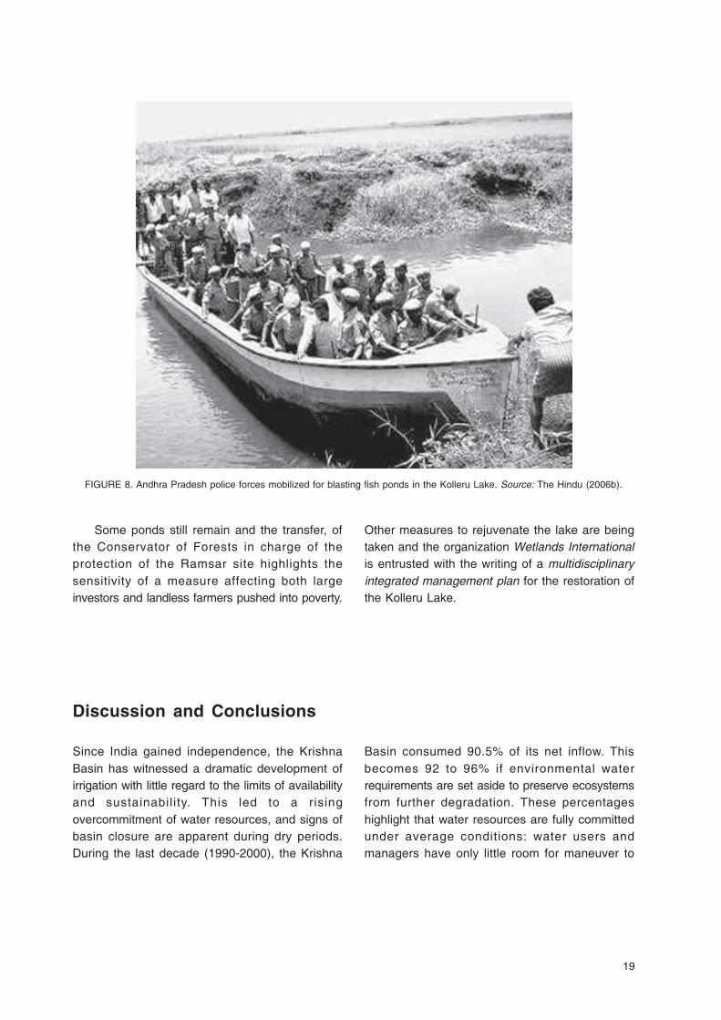
Protecting the lake ecosystem has long beenpresented as a government priority (GoAP 2001c).However, removing illegal fishponds from theprotected area has always been a sensitivequestion, opposed by a powerful lobby. While theAndhra Pradesh High Court of Justice passed anorder to remove illegal fish tanks in 2001 (TheHindu 2001), the measure has been delayedseveral times. Finally in February 2006, theSupreme Court of India passed an order toremove illegal encroachments in the lake (TheHindu 2006a). Once again, this decision wasstrongly opposed by fishermen and farmerslobbies. Landless farmers benefiting from landentitlements mobilized too as they would bedenied lease income if ponds were to bedemolished. Eventually, land entitlements in theRamsar area have been cancelled and it isestimated that about 19,500 hectares ofaquaculture ponds were demolished by June 15,2006 (GoAP 2007b). This required the involvementof police forces (The Hindu 2006b; Figure 8).Field visits in May 2007 confirm that most of theponds located in the protected area have beendemolished: open water areas have extended andmore birds have been observed lately.
19
Some ponds still remain and the transfer, ofthe Conservator of Forests in charge of theprotection of the Ramsar site highlights thesensitivity of a measure affecting both largeinvestors and landless farmers pushed into poverty.
Other measures to rejuvenate the lake are beingtaken and the organization Wetlands Internationalis entrusted with the writing of a multidisciplinaryintegrated management plan for the restoration ofthe Kolleru Lake.
FIGURE 8. Andhra Pradesh police forces mobilized for blasting fish ponds in the Kolleru Lake. Source: The Hindu (2006b).
Discussion and Conclusions
Since India gained independence, the KrishnaBasin has witnessed a dramatic development ofirrigation with little regard to the limits of availabilityand sustainability. This led to a risingovercommitment of water resources, and signs ofbasin closure are apparent during dry periods.During the last decade (1990-2000), the Krishna
Basin consumed 90.5% of its net inflow. Thisbecomes 92 to 96% if environmental waterrequirements are set aside to preserve ecosystemsfrom further degradation. These percentageshighlight that water resources are fully committedunder average conditions: water users andmanagers have only little room for maneuver to

20
cope with a drought and limit its socio-ecologicaland economic ill effects. Eventually, short-termadaptations and informal adjustments toaccommodate scarcity may lead to a degradationof the resource base (Scott et al. 2001) and thusaffect the environment. This has been tragicallyillustrated during the dry years of 2001 to 2004when the discharge to the ocean was almost zero;the rate of water commitment hiked to 99.6%without accounting for any environmental flows; andwater shortage affected livelihoods, notably in theKrishna Delta irrigation project and in the coastalregion. This is a likely harbinger of the future.
This report highlighted that river basin closurecomes with downstream environmental degradationthat manifests itself by increasing soil andgroundwater salinity, aquifers and surface waterpollution, shrinkage of mangrove covers and coastalwetland desiccation. Environmental degradation inthe Lower Krishna Basin has three main drivers:(i) the long-term tendency to decreasing wateravailability linked to ever-increasing agriculturaldevelopment and upstream water regulation; (ii) therural dynamics of the Lower Krishna Basin whereshort-term financial gains conflict with the long-termobjective of sustainable development; and(iii) finally, the fragmented institutional landscape ofnatural resources management in Andhra Pradesh.As basin closure intensifies the interconnectednessbetween water users and their environment (Molleet al. 2007), further water resources developmentwill tantamount to sectoral and regionalreappropriation of water. There is a need to findcompromises to meet competing and increasingwater demands. Supply augmentation projects toincrease water availability in the Lower KrishnaBasin through the transfer of water from theGodavari Basin are a partial response and holdshort-term promises. But, the transfer of 2.25 BCM/yr through the Polavaram project (NWDA 2007) tosupport agriculture, counterbalance the observeddecline in the discharge of the Krishna River andlimit environmental degradation does not seem tobring long-term solutions to the pending problemsthe region is facing. This volume is similar to therecent deficit observed between surface wateravailability in the Krishna Delta canals and their
allotment according to the Bachawat tribunalaward, and short of the 6.5 to 14.2 BCM/yearrecommended by Smakhtin and Anputhas (2006) toprotect local ecosystems from further degradation.Moreover, it is not specified if this volume is to bedischarged to the ocean or diverted to the irrigationcanals and the social, economic and ecologicalimpacts of the project have been largelyoverlooked (Biksham et al. 2007).
Mitigating the detrimental impacts of ruraldevelopment on downstream ecosystems will onlybeen achieved through an integrated management ofland, water and ecosystems at the basin scale(Falkenmark et al. 2007). The current Krishna WaterDisputes Tribunal is expected to reach a decisionconcerning the apportionment of the Krishna wateramong the three states of Andhra Pradesh,Karnataka and Maharashtra. In this context, thispaper calls for a formal allocation of water to be setaside for the purpose of environmental preservation.At first, an environmental provision could be definedon the basis of a two-tier allocation. First, a givendischarge in the irrigation canals of the KrishnaDelta to meet the agriculture and domestic demandof the local population and also the environmentalrequirements of groundwater recharge and saltleaching from the soil. The award of the first KrishnaWater Disputes Tribunal could be used as a firstbasis for further refinement given the backdrop ofincreased cropping intensity and groundwaterabstraction. Second, a fixed annual discharge to theocean, maintained by the Irrigation Department (asrecommended in GoAP 2001c), to limit seawaterintrusion in the river branches and preserve thefunctioning of coastal ecosystems. Thisenvironmental provision would have to be calculatedon the basis of a pre-defined compromise betweenthe condition of the ecosystems and the level ofhuman uses for competing demands. Averageallocations still leave problems of managementduring dry years. Once this basin-wide planning orreconnaissance-level assessment is generallyrecognized as necessary and benefit from a strongcommitment of the different users and managers;environmental provisions could evolve into a morecomplex set of environmental flow rules defined in apolycentric governance setup allowing participation
21
of all for an integrated management of naturalresources (for more precision on the rules, conceptsand methodologies that could be considered, seeTharme [2003]). This is notably observed in theUnited States of America, South Africa and Australia.
Other measures facilitating an integration of themanagement of natural resources, notably water,from the local to the basin level are needed.Strengthening the institutional context is crucial asgovernance systems that are required to support theinstitutional and managerial arrangements for theallocation of water resources in the framework ofenvironmental flows seem difficult to achieve(Falkenmark et al. 2007; Molle et al. 2007).Promoting integrated coastal management with, forexample, the delineation and effectiveimplementation of zones with different developmentand environmental objectives (cf. the CRZregulation); regulating on-farm practices; creatingadditional non-farm livelihood options; implementingdrought mitigation measures; facilitating thecoordination between departments; maintainingdatabase on wetlands, mangroves, soil and watersalinization; and promoting the role of the resourceusers in the decision-making process are some ofthe most commonly advocated measures (Brugere2006; Gowing et al. 2006). These measures will beeffective only if managers and decision makers arestrongly committed towards environmentalpreservation objectives (GoAP 2001c; Falkenmark etal. 2007). To what extent this will happen dependson the political ecology of the resources that areconsidered. The socioeconomic context in whichresource extraction takes place, the political and
social weight of the different stakeholders involved inthe use and control of natural resources and theirability to mobilize to press their demands is centralto foresee the environmental impacts of adevelopment path chosen among several options.There is a need to convince decision makers thatproviding environmental flows can produce long-termenvironmental, social and economic benefits. Thiswill be achieved only if the links between alteredflow regimes and losses in bio-systems anddependent livelihoods are highlighted and moreaccurately quantified (Bunn and Arthington 2002).The recent work of Smakhtin et al. (2007a) toassess the ecological status of Indian river basinsis a step forward in the data scarce environment ofIndia and need to be revisited on the basis ofscientific, experts, managers and local knowledge.Finally, there is a risk that preserving ecosystemswill be used as a justification for building new damsor new water transfers heightening the process ofoverbuilding (see, for example, Blanchon (2006) onthe South African case). The multiplication of small-scale water infrastructures for irrigation andgroundwater recharge in the dry areas of SouthIndia already finds an environmental justification asthese structures are said to create local wetlands(GoAP 2001c). However, they have a dramaticimpact on surface water availability and downstreamecosystems that are overlooked (Venot et al. 2007).As water allocation is likely to be driven byeconomic motives, high attention is to be given toequity and environmental preservation principleswhen designing water allocation mechanisms for thesatisfaction of competing demands.

23
Appendix 1Population density map of the Lower Krishna Basin.
Source: Maps are based on GoI (2001) data.

24
Appendix 2Average rainfall map of the Lower Krishna Basin.
Source: GoAP (2004a, 2004b).
25
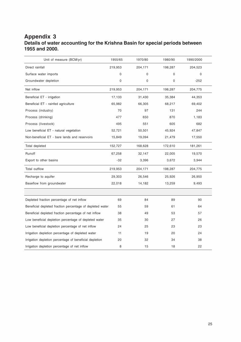
Appendix 3Details of water accounting for the Krishna Basin for special periods between1955 and 2000.
Unit of measure (BCM/yr) 1955/65 1970/80 1980/90 1990/2000
Direct rainfall 219,953 204,171 198,287 204,523
Surface water imports 0 0 0 0
Groundwater depletion 0 0 0 -252
Net inflow 219,953 204,171 198,287 204,775
Beneficial ET - irrigation 17,133 31,430 35,384 44,353
Beneficial ET - rainfed agriculture 65,982 66,305 68,217 69,402
Process (industry) 70 97 131 244
Process (drinking) 477 650 870 1,183
Process (livestock) 495 551 605 682
Low beneficial ET - natural vegetation 52,721 50,501 45,924 47,847
Non-beneficial ET - bare lands and reservoirs 15,849 19,094 21,479 17,550
Total depleted 152,727 168,628 172,610 181,261
Runoff 67,258 32,147 22,005 19,570
Export to other basins -32 3,396 3,672 3,944
Total outflow 219,953 204,171 198,287 204,775
Recharge to aquifer 29,303 26,546 25,926 26,950
Baseflow from groundwater 22,018 14,182 13,259 9,493
Depleted fraction percentage of net inflow 69 84 89 90
Beneficial depleted fraction percentage of depleted water 55 59 61 64
Beneficial depleted fraction percentage of net inflow 38 49 53 57
Low beneficial depletion percentage of depleted water 35 30 27 26
Low beneficial depletion percentage of net inflow 24 25 23 23
Irrigation depletion percentage of depleted water 11 19 20 24
Irrigation depletion percentage of beneficial depletion 20 32 34 38
Irrigation depletion percentage of net inflow 8 15 18 22
26
References
ACC/ISGWR (United Nations Administrative Coordination Council Inter-Secretariat Group on Water Resources).1992. The Dublin Statement and Report of the Conference. Prepared for the International Conference onWater and the Environment: Development Issues for the 21st Century, 26–31 January, Dublin.
Allen, R. G.; Pereira, L. S.; Raes, D.; Smith, M. 1998. Crop evapotranspiration - Guidelines for computing cropwater requirements. FAO Irrigation and drainage paper 56. Rome: FAO.
Anjaneyulu, Y.; Durga Prasad, M. K. (Eds). 2003. Kolleru-Environmental status (Past and Present. SultanBazaar: Hyderabad: B. S. Publications.
Anonymous. 2005. Concept paper on revival of shrimp aquaculture in Krishna District. Project document for afollow up of the FAO assisted project TCP/IND/2902(A) on Health Management of shrimp aquaculture inAndhra Pradesh.
Anonymous. 2007. Kolleru Lake profile. Available online at http://westgodavari.org/DRDA%20WEBSITE/KOLLERU%20WEBSITE/KOLLERUPROFILE.htm (accessed April 25, 2007).
APWAM (Andhra Pradesh Water Management Project). 2005. Proceedings of the First Annual Workshop heldat RARS, Tirupati. March 1-12, 2005. Hyderabad: Acharya N.G. Ranga Agricultural University.
Barker, R.; Molle, F. 2005. Evolution of irrigation in South and Southeast Asia. Comprehensive AssessmentResearch Report 5. Colombo, Sri Lanka: International Water Management Institute.
Bhatta, M.; Bhat, M. 1998. Impacts of aquaculture on the management of estuaries in India. EnvironmentalConservation 25(2): 109-121.
Biggs, T. W. Simplified models of evapo-transpiration from rainfed crops in Southern India. Agricultural andForest Meteorology. In Review.
Biggs, T. W.; Gaur, A.; Scott, C. A.; Thenkabail, P.; Rao, P. G.; Krishna, G. M.; Acharya, S.; Turral, H. 2007. Closingof the Krishna Basin: Irrigation, Streamflow Depletion and Macroscale Hydrology. IWMI Research Report 111.Colombo, Sri Lanka: International Water Management Institute.
Biksham, G.; Goud, V.; Ramakrishna, S. 2007. Perspectives on Polavaram: A Major Irrigation Project on Godavari.India: Independent Pub Group.
Blanchon, D. 2006. La politique de l’eau en Afrique du Sud: le difficile équilibre entre développement durableet valorisation optimale de la ressource. Revue Développement Durable et Territoires. Available online athttp://developpementdurable.revues.org/document1735.html (accessed July 10, 2007)
Bouwer, L. M.; Biggs, T. W.; Aarts, J. C. J. H. 2007. Estimates of spatial variation in evaporation using satellite-derived surface temperature and a water balance model. Hydrological Processes 22(5): 670-682.
Brugere, C. 2006. Can Integrated Coastal Management Solve Agriculture-Fisheries-Aquaculture Conflicts at theLand-Water Interface? A Perspective from New Institutional Economics. In Tuong, T. P.; Hoanh, C. T.; Gowing,J. W.; Hardy, B. (Eds), Environment and livelihoods in tropical coastal zones: managing agriculture-fishery-aquaculture conflicts. Oxford: CABI.
Bunn, S. E.; Arthington, A. H. 2002. Basic principles and ecological consequences of altered flow regime foraquatic biodiversity. Environmental Management 30(4): 492–507.
CRU (Climatic Research Unit, University of East Anglia). 2007. Monthly precipitation data. Information availableonline at http://www.cru.uea.ac.uk/~mikeh/datasets/global/ (accessed May 11, 2007).
CWC (Central Water Commission). 2002. Water and related Statistics. Water Planning and Projects Wing. NewDelhi, India: Central Water Commission.
DRDA (District Rural Development Agency). 1999. Groundwater resources and prospects-Krishna District.Hyderabad: GoAP.
27
Dyson, M.; Bergkamp, G.; Scanlon, J. (eds) 2003. Flow. The Essentials of Environmental Flows. Gland,Switzerland and Cambridge, UK: IUCN.
DWAF (Department of Water Affairs and Forestry. 1999. Resource directed measures for protection of waterresources. Volume 3: River ecosystems. Version 1.0. Institute of Water Quality Studies, Department of WaterAffairs and Forestry. Pretoria, South Africa: DWAF.
Falkenmark, M.; Finlayson, M. C; Gordon, L. J 2007. Agriculture, Water, and Ecosystems: Avoiding the costs of goingtoo far. In Molden, D. (Ed), Water for Food, Water for Life: A Comprehensive Assessment of Water Managementin Agriculture. London: Earthscan and Colombo, Sri Lanka: International Water Management Institute.
FAO (Food and Agriculture Organization of the United Nations). 2002. FAO Aqua-book 2002. Available onlineat http://aquaculture.tn.nic.in/pdf/FAO%20Aqua41-79.pdf (accessed April 25, 2007).
Fisheries Department. Statistical data on the extent of shrimp farming in Andhra Pradesh. Hyderabad: GoAP(unpublished documentation).
GoAP (Government of Andhra Pradesh). 1998. Handbook of Statistics - Krishna district. Machilipatnam, India:Chief Planning Officer, Krishna District.
GoAP. 2001a. Andhra Pradesh Vision 2020. Vol. I: Sectoral overview of water and water management.Hyderabad: GoAP.
GoAP. 2001b. Andhra Pradesh water vision 2020. Vol. II: Methods, Position paper and districts reports.Hyderabad: GoAP.
GoAP. 2001c. Andhra Pradesh Water Vision. Position paper No.3 - Strategic Overview of the aquatic ecology.Hyderabad: GoAP.
GoAP. 2002. Handbook of Statistics - Krishna district. Machilipatnam, India: Chief Planning Officer, Krishna District.
GoAP. 2003. Freshwater-saline water interrelationhip in the multi-aquifer system of the Krishna delta. R&Dproject Abridged version. Hyderabad: GoAP.
GoAP. 2004a. Handbook of Statistics - Guntur district. Guntur, India: Chief Planning Officer, Guntur District.
GoAP 2004b. Handbook of Statistics - Krishna district. Machilipatnam, India: Chief Planning Officer, Krishna District.
GoAP. 2006. Statistical Abstract of Andhra Pradesh 1955-56 to 2004-2005. Hyderabad, Andhra Pradesh: Ministryof Agriculture.
GoAP. 2007a. Fisheries Department Presentation on the Commissionerate of Fisheries. Available online athttp://www.aponline.gov.in/apportal/departments/departments.asp?dep=02&org=20 (accessed April 24, 2007).
GoAP. 2007b. Notes on agriculture and related activities. Available online at www.aponline.gov.in/Apportal/SocioSurvery0607/Chapters/5.%20Agriculture.doc (accessed April 24, 2007).
GoAP. 2007c. Presentation on the nature of coastal alluvial aquifer in the Krishna delta. Presentation held bythe Department of Groundwater at International Water Management Institute Workshop on GroundwaterExternalities. 5 September, 2006, Hyderabad.
GoI (Government of India). 1991. Notification under section 31 and section 32(v) of the Environment (Protection)Act, 1986 and Rule 5(3)(d) of the Environment (Protection) Rules, 1986 declaring coastal stretches asCoastal Regulation Zone (CRZ) and regulating activities in the CRZ. New Delhi: Ministry of Environment andForests, GoI.
GoI. 2001. All India Census. New Delhi: GoI.
GoI-KWDT (Government of India-Krishna Water Disputes Tribunal). 1973, 1976. The report and the furtherreport of the Krishna Water Disputes Tribunal with the decision. New Delhi.
GoK (Government of Karnataka). 2006. Statistical Abstract of Karnataka 2000-2001. Bangalore: Directorate ofEconomics and Statistics, GoK.

28
GoM (Government of Maharashtra). 2005. Statistical Abstract of Maharashtra State 1997-98 and 1998-99.Mumbai: Directorate of Economic and Statistics, GoM.
Gowing, J. W.; Tuong, T. P.; Hoanh, C. T. 2006. Land and water Management in Coastal Zones: Dealing withAgriculture-Aquaculture-Fishery Conflicts. In Tuong, T. P.; Hoanh, C. T.; Gowing, J. W.; Hardy, B. (Eds), Environmentand livelihoods in tropical coastal zones: managing agriculture-fishery-aquaculture conflicts. Oxford: CABI.
Grandcolas, D. 2006. Pêcheurs, Etat et Mondialisation, Stratégies des populations locales et gestion desressources naturelles : le cas du delta de la Godavari, inde du Sud. PhD thesis, University of Paris X-Nanterre (In French).
Immerzeel, W. W.; Gaur, A.; Droogers, P. 2007. Remote sensing and hydrological modeling of the Upper BhimaCatchment. Research Paper 3. The Netherlands: Future Water.
Landy, F. 2006. Un milliard à nourrir- Grain, Territoire et Politiques en Inde. Paris, France : Belin (In French).
MEA (Millennium Ecosystem Assessment). 2005. Ecosystems and Human Well-Being: Synthesis. WashingtonDC: Island press.
Molden, D. 1997. Accounting for water use and productivity. SWIM Paper 1. Colombo, Sri Lanka: InternationalWater Management Institute.
Molle, F.; Wester, P.; Hirsh, P. 2007. River Basin Development and Management. In Molden, D. (Ed), Water forFood, Water for Life: A Comprehensive Assessment of Water Management in Agriculture. London: Earthscanand Colombo, Sri Lanka: International Water Management Institute.
Mollinga, P. P.; Doraiswamy, R.; Engbersen, K. 2001. The implementation of participatory irrigation managementin Andhra Pradesh, India. International Journal of Water 1(3/4).
Mollinga, P. P. 2003. On the waterfront-water distribution, technology and agrarian change in a south Indiancanal irrigation system. New Delhi, India: Orient Longman.
MoWR (Ministry of Water Resources). 2002. National Water Policy. New Delhi, India: Ministry of WaterResources, GoI.
MPEDA (Marine Products Export Development Authority). 2006. Statistical data on the extent of shrimp and fishfarming in Andhra Pradesh. New Delhi: MPEDA. Unpublished documentation.
Naganathan, M.; Sivagnanam, K. J.; Rajendran, C. 1995. Blue revolution in a green belt. Economic and PoliticalWeekly 30(12):607-608.
Nageswara Rao, K.; Murali Krishna, G.; Hema Malini, B. 2004. Kolleru lake is vanishing-a revelation throughdigital processing of IRS-1D LISS-III sensor data. Current Science 86(9).
NWDA (National Water Development Agency). 2007. Information available at http://nwda.gov.in/indexmain.asp?linkid=84&langid=1 (accessed May 5, 2007).
NCIWRDP (National Commission for Integrated Water Resource Development Plan) 1999. Integrated waterresource development: a plan for action. Delhi: Ministry of Water Resources, GoI.
Peden, D.; Tadesse, G.; Misra, A. K. 2007. Water and Livestock for Human Development. In Molden, D. (Ed.),Water for Food, Water for Life: A Comprehensive Assessment of Water Management in Agriculture. London:Earthscan and Colombo, Sri Lanka: International Water Management Institute.
Rama Rao, J.; Jairath, J.; Umesh, P. 2006. Pollution through Aquaculture: Kolleru Wildlife Sanctuary. Economicand Political Weekly 41(7): 585-587.
Ramsar Convention Secretariat. 2006. Coastal management: Wetland issues in Integrated Coastal ZoneManagement. Ramsar handbooks for the wise use of wetlands, 3rd edition, Vol. 10. Gland, Switzerland:Ramsar Convention Secretariat.
29
Rao, G. N. 1985. Transition from subsistence to commercialised agriculture: a study of Krishna District ofAndhra 1850-1900. Economic and Political Weekly XX(25-26): A60-A69.
Ronnback, P.; Troell, M.; Zetterstrom, T.; Babau, D. E. 2003. Mangrove dependence and socio-economicconcerns in shrimp hatcheries of Andhra Pradesh, India. Environmental Conservation 30(4): 344-352.
Saxena, V. K.; Radhakrishna, I.; Krishna, K. V. S. S.; Nagini, V. 2002. Nitrate pollution in groundwater, Krishnadelta, India. In Thangarajan, M.; Rai, S. N.; Singh, V. S. (Eds) Proceedings of the International ConferenceIGC-2002. Oxford: Dindigul & New Delhi: IBH.
Saxena, V. K.; Singh, V. S.; Mondal, N. C.; Jain, S. C. 2003. Use of chemical parameters to delineation freshgroundwater resources in Potharlanka Island, India. Environmental Geoology 44: 516–521.
Scott, C. A.; Silva-Ochoa, P.; Florencio-Cruz, V.; Wester, P. 2001. Competition for water in the Lerma-Champalabasin - Economic and Policy implications of water transfers from agricultural to urban uses. In Hansen, A.;Van Afferden, M. (Eds), The Lerma-Champala watershed: Evaluation and Management. New York: KluwerAcademic/Plenum publisher.
Selvam, V. 2003. Environmental classification of mangrove wetlands of India. Current Science 84: 757-765.
Smakhtin, V.; Revenga, C.; Doll, P. 2004. Taking into account environmental water requirements in global-scalewater resources assessments. Comprehensive Assessment Research Report 2. Colombo, Sri Lanka:Comprehensive Assessment Secretariat.
Smakhtin, V.; Anputhas, M. 2006. An assessment of environmental flow requirements of Indian river basins. IWMIResearch Report 107. Colombo, Sri Lanka: International Water Management Institute.
Smakhtin, V.; Arunachalam, N.; Behera, S.; Chatterjee, A.; Das, S.; Gautam, P.; Joshi, G. D.; Sivaramakrishana,K. G.; Unni, K. S. 2007a. Developing procedures for assessment of ecological status of Indian river basinsin the context of environmental water requirements. IWMI Research report 114. Colombo, Sri Lanka:International Water Management Institute. 40p.
Smakhtin, V.; Gamage, N.; Bharati, L. 2007b. Hydrological and environmental issues of interbasin water transfersin India: A case of Krishna River Basin. IWMI Research Report 120. Colombo, Sri Lanka: International WaterManagement Institute.
Supreme Court of India. 1996. Judgment on Coastal Shrimp Aquaculture: S. Jaganath Vs. Union of India.Judgment of Kuldip Singh and Sagir Ahmed on December 11, 1996.
Suri, K. C. 2006. Political Economy of Agrarian Distress. Economic and Political Weekly 41(16): 1523-1529.
Tharme R. E. 2003. A global perspective on environmental flow assessment: emerging trends in thedevelopment and application of environmental flow methodologies for rivers. River Research andApplications 19: 397-441.
The Hindu. 2001. Kolleru Lake, a sanctuary: court. Article published in the July 31, 2001 edition.
The Hindu. 2006a. Panel wants Kolleru Lake cleared of encroachments. Article published in the February 15,2006 edition.
The Hindu. 2006b. Operation Kolleru resumes amid heavy security. Article published in the April 21, 2006 edition.
Upadhya, C. B. 1988. The Farmer-Capitalists of Coastal Andhra Pradesh. Economic and Political Weekly23(27& 28): 1376-82, 1433-42.
Van Rooijen, D. J.; Turral, H.; Biggs, T. W. Urban and industrial water use in the Krishna Basin. Irrigation andDrainage. Forthcoming.
Venot, J. P.; Turral, H.; Samad, M.; Molle, F. 2007. Shifting Waterscapes: Explaining Basin Closure in the LowerKrishna Basin, South India. IWMI Research Report 121. Colombo, Sri Lanka: International WaterManagement Institute.
30
Venot, J. P.; Sharma, B. R.; Rao, K. V. G. K. Krishna Basin development: Interventions to Limit DownstreamEnvironmental Degradation. Journal of Environment and Development. Forthcoming.
Wallach, B. 1985. British irrigation works in India’s Krishna Basin. Journal of Historical Geography 112: 155-173.
WWAP (World Water Assessment Program). 2003. Water for People - Water for Life, The United Nations WorldWater Development Report. Paris: UNESCO Publishing/Berghahn Books.

Research Reports
113. Applying the Gini Coefficient to Measure Inequality of Water Use in the OlifantsRiver Water Management Area, South Africa. James Cullis and Barbara vanKoppen. 2007.
114. Developing Procedures for Assessment of Ecological Status of Indian RiverBasins in the Context of Environmental Water Requirements. Vladimir Smakhtin,Muthukumarasamy Arunachalam, Sandeep Behera, Archana Chatterjee, SrabaniDas, Parikshit Gautam, Gaurav D. Joshi, Kumbakonam G. Sivaramakrishnanand K. Sankaran Unni. 2007.
115. Rural-Urban Food, Nutrient and Virtual Water Flows in Selected West AfricanCities. Pay Drechsel, Sophie Graefe and Michael Fink. 2007.
116. Agricultural Water Management in a Water Stressed Catchment: Lessons fromthe RIPARWIN Project. Matthew P. McCartney, Bruce A. Lankford and HenryMahoo. 2007.
117. Treadle Pump Irrigation and Poverty in Ghana. Adetola Adeoti, Boubacar Barry,Regassa Namara, Abdul Kamara and Atsu Titiati. 2007.
118. Evaluation of Historic, Current and Future Water Demand in the Olifants RiverCatchment, South Africa. Matthew McCartney and Roberto Arranz. 2007.
119. Changing Consumption Patterns: Implications on Food and Water Demand inIndia. Upali A. Amarasinghe, Tushaar Shah and Om Prakash Singh. 2007.
120. Hydrological and Environmental Issues of Interbasin Water Transfers in India:A Case of the Krishna River Basin. Vladimir Smakhtin, Nilantha Gamage andLuna Bharati. 2007.
121. Shifting Waterscapes: Explaining Basin Closure in the Lower Krishna Basin, SouthIndia. Jean-Philippe Venot, Hugh Turral, Madar Samad and François Molle. 2007.
122. Trees and Water: Smallholder Agroforestry on Irrigated Lands in Northern India.Robert J. Zomer, Deborah A. Bossio, Antonio Trabucco, Li Yuanjie, D. C. Guptaand V. P. Singh. 2007.
123. India’s Water Future to 2025–2050: Business-as-Usual Scenario and Deviations.Upali A. Amarasinghe, Tushaar Shah, Hugh Turral and B. K. Anand. 2007.
124. Institutions, Impact Synergies and Food Security: A Methodology with Resultsfrom the Kala Oya Basin, Sri Lanka. Rathinasamy Maria Saleth, Ariel Dinar,Susanne Neubert, Bandi Kamaiah, Seenithamby Manoharan, SarathAbayawardana, Ranjith Ariyaratne and Shyamalie de Silva. 2007.
125. The Lower Krishna Basin Trajectory: Relationships between Basin Developmentand Downstream Environmental Degradation. Jean-Philippe Venot, Bharat R.Sharma and Kamineni V. G. K. Rao. 2008.

SM
IWMI is a Future Harvest Centersupported by the CGIAR
Postal AddressP O Box 2075ColomboSri Lanka
Location127, Sunil MawathaPelawattaBattaramullaSri Lanka
Telephone+94-11-2880000
Fax+94-11-2786854
Websitehttp://www.iwmi.org
I n t e r n a t i o n a lWater ManagementI n s t i t u t e
ISSN 1026-0862ISBN 978-92-9090-690-2