Best Practice Guidelines for Aggregate Rehabilitation · PDF fileBest Practice Guidelines for...
79
Prepared For The Ontario Aggregate Resources Corporation Best Practice Guidelines for Aggregate Rehabilitation Projects Extracting the Benefits for Species At Risk and Rare Habitats
Transcript of Best Practice Guidelines for Aggregate Rehabilitation · PDF fileBest Practice Guidelines for...

Prepared For The Ontario Aggregate Resources Corporation
Best Practice Guidelines for Aggregate Rehabilitation Projects
Extracting the Benefits for Species At Risk and Rare Habitats
Prepared For The Ontario Aggregate Resources Corporation
Best Practice Guidelines for Aggregate Rehabilitation Projects
Extracting the Benefits for Species At Risk and Rare Habitats

Best Practice Guidelines for Aggregate Rehabilitation Projects:Extracting the Benefits for Species At Risk and Rare Habitats
Report Prepared For:
The Ontario Aggregate Resources Corporation
Report Prepared By:
Savanta Inc. 58 Welstead Drive St. Catharines, Ontario L2S 4B2 Canada
In Association With:
Gartner Lee Limited
Azimuth Environmental Consulting Inc.
February 2008

Acknowledgements
The preparation of this report has been completed as part of the Province’s Species at Risk Stewardship Fund. It has received funding from the province and matching funding from The Ontario Aggregate Resources Corporation (TOARC).The report has also greatly benefited from the involvement of several individuals, including:
David Beamer, MAAP
David Sterrett, TOARC
Jane Bowles, University of Western Ontario
Jim Broadfoot, Azimuth Environmental
Mark Browning, OMNR
Ken Elliott, OMNR
Kate Hayes, Savanta Inc.
James Kamstra, Gartner Lee Ltd
John Klironomos, University of Guelph
Doug Larson, University of Guelph
Sarah Lowe, Independent Consultant
Cover Photo Credits: Mark Browning, MNR; James Kamstra, GLL; Doug Sweiger, CWS; Benoit Jobin, CWS; Barb Boysen, MNR; and, TOARC
Assistance for this project was provided by the Ministry of Natural Resources.

Table of Contents
Acknowledgements EXECUTIVE SUMMARY ............................................................................................................. 11.0 INTRODUCTION........................................................................................................................ 22.0 THREATS TO SPECIES AT RISK AND BIODIVERSITY .................................................................... 73.0 SPECIES AT RISK AND THE AGGREGATE INDUSTRY................................................................... 94.0 REHABILITATION TO BENEFIT SPECIES AT RISK AND RARE HABITATS ..................................... 105.0 CANDIDATE HABITATS FOR REHABILITATION ......................................................................... 146.0 FOLLOW-UP MONITORING AND REPORTING ........................................................................ 397.0 SUMMARY.............................................................................................................................. 418.0 REFERENCES ........................................................................................................................... 41
FIGURESFigure 1 Eastern White Cedar Figure 2 Designated Areas Under the Aggregate Resources Act .......................................................... 2Figure 3 Distributions of Pits and Quarries and Hotspots for Rare Species, Rare Habitats and Species at Risk in Ontario ........................................................................ 10Figure 4 Milton Quarry Rehabilitation-1992 and 2001 photos ........................................................... 15Figure 5 Fletcher’s Creek former quarry exhibiting alvar characteristics ............................................ 17Figure 6 Young Dwarf Lake Iris seeded to Ontario quarry ................................................................... 19Figure 7 Dwarf Lake Iris in bloom ........................................................................................................ 19Figure 8 Cliff and Talus (background)- Lawless Quarry ........................................................................ 20Figure 9 Comparison of Modern versus Older Quarry Extraction ...................................................... 21Figure 10 Clylindrical Blazing Star .......................................................................................................... 23Figure 11 Wildwood Pit Complex .......................................................................................................... 25Figure 12 Fletcher’s Creek Quarry ........................................................................................................ 25Figure 13 Pawpaw ................................................................................................................................. 28Figure 14 Kerncliff Quarry with marsh in foreground, and cliff and talus in background ..................... 29Figure 15 Eastern Foxsnake ................................................................................................................... 31Figure 16 Eastern Milksnake ................................................................................................................. 32Figure 17 Common Hoptree ................................................................................................................. 34Figure 18 Blanding’s Turtle ................................................................................................................... 35Figure 19 Before and After Tallgrass Prairie Restoration ...................................................................... 37Figure 20 Dense Blazing Star ................................................................................................................. 38Figure 21 Monarch Butterfly ................................................................................................................. 38Figure 22 Vegetation Monitoring at Duntroon Quarry ........................................................................ 39Figure 23 Flowering Dogwood .............................................................................................................. 45Figure 24 Fern Leaf Yellow False Foxglove ............................................................................................ 53Figure 25 Canadian Tiger Swallowtail ................................................................................................... 53Figure 26 Swamp Rose Mallow ............................................................................................................. 71Figure 27 Prairie Smoke ........................................................................................................................ 73
APPENDICESAPPENDIX A. SPECIES AT RISK AND RARE SPECIES AND ASSOCIATED HABITATS ......................................... 46APPENDIX B. RANGE DISTRIBUTION OF SPECIES AT RISK AND RARE SPECIES IN ONTARIO ......................... 50APPENDIX C. PROFILES OF SELECT SPECIES AT RISK .................................................................................... 53APPENDIX D. INFORMATION SOURCES ........................................................................................................ 70APPENDIX E. BACKGROUND INFORMATION: RECOVERY PLANNING AND IMPLEMENTATION .................... 72

Best Practice Guidelines for Aggregate Rehabilitation Projects: Extracting the Benefits for Species At Risk and Rare Habitats
Figure 1 Eastern White Cedar (Photo Credit: Paul Richardson)
1
Best Practice Guidelines for Aggregate Rehabilitation Projects: Extracting the Benefits for Species At Risk and Rare Habitats
EXECUTIVE SUMMARYWhether managing existing operations or planning the rehabilitation of pits and quarries, there is a wide range of opportunities for the aggregate industry to contribute to the conservation and enhancement of Canada’s wealth of wildlife, our ‘biodiversity’.
The advent of the new provincial Endangered Species Act has sparked interest in the consideration of species at risk, in addition to rare species and rare habitats, in rehabilitation projects. Sites slated for closure, in addition to abandoned sites, may represent assets in the natural landscapes because they can be used to establish and/or to recreate habitats for species at risk and other more common wildlife.
This report offers a series of best restoration and management practices for rehabilitating former aggregate sites to achieve the goal of maximizing the biodiversity value (including species at risk) while minimizing maintenance costs. The recommendations are outlined within the context of the latest developments in recovery planning and implementation for species at risk, best management practices and ideas that the industry or its related clients may be able to follow or to build upon.
BEFORE YOU START: TOP 10 CHECKLIST (Refer to Section 4 and Appendix D for more detailed information sources)
Is the site within the range of any species at risk or rare habitats? It is reasonable to target a species for which there are recent records within about 20 km of the site.
Contact the Recovery Team for those species at risk believed to occur in the area.
Does the site contain suitable biological, hydrological, and geophysical conditions to create the desired habitat?
What is the condition of existing habitat features on the site?
What are the surrounding land uses? Is the site connected to an adjacent natural area and, if so, what kinds of vegetation are found in the intact/reference habitat?
How much land is available to restore?
Are there local genetic stocks of the species at risk readily available?
Translocation of any animals is strongly discouraged, unless under very exceptional circumstances.
Partner with qualified individuals and/or organizations (e.g. recovery teams; MNR; conservation authorities and groups) to review your rehabilitation plan.
Consider opportunities to partner with conservation organizations (e.g. land trusts) and/or through various programs (e.g. Ecological Gifts) to ensure the long-term management and conservation of the rehabilitated site.
1.
2.
3.
4.
5.
6.
7.
8.
9.
10.

2
Best Practice Guidelines for Aggregate Rehabilitation Projects: Extracting the Benefits for Species At Risk and Rare Habitats Best Practice Guidelines for Aggregate Rehabilitation Projects: Extracting the Benefits for Species At Risk and Rare Habitats
1.0 INTRODUCTIONAggregates include earth, gravel, sand, clay, limestone, dolostone, sandstone, shale, marble, and granite (Aggregate Resources Act, 1990). Gravel pits are those sites where sand and gravel is extracted from naturally Quarries are those sites where the solid bedrock, typically limestone or dolostone, is blasted and then crushed into fragments (Browning and Tan, 2002). Because aggregates are resources with a high bulk but low unit value, with transportation costs representing about 60% of the delivered cost, it is likely that aggregate extraction sites will remain close to major market areas in southern Ontario (OSSGA, undated; Browning and Tan, 2002). In fact, the Provincial Policy Statement (2005 PPS, section 2.5.2.1) encourages this close to market principle when protecting long-term supplies for extraction. Many of these areas either lie in very close proximity to or actually overlap with the present or historical range of species that are considered at risk in Ontario (ie. species at risk).
Figure 2 Designated Areas Under the Aggregate Resources Act
The process of aggregate extraction results in impacts on the natural environment and on associated wildlife so the industry is the subject of comprehensive policies and legislative guidance. The Aggregate Resources Act (ARA) came into force in 1990, replacing the former Pits and Quarries Act, and outlines the following purposes:
To provide for the management of the aggregate resources of Ontario;To control and regulate aggregate operations on Crown and private lands;
a.b.

Best Practice Guidelines for Aggregate Rehabilitation Projects: Extracting the Benefits for Species At Risk and Rare Habitats
3
Best Practice Guidelines for Aggregate Rehabilitation Projects: Extracting the Benefits for Species At Risk and Rare Habitats
To require the rehabilitation of land from which aggregate has been excavated; and,To minimize adverse impact on the environment in respect of aggregate operations (R.S.O. 1990, c. A.8, s.2).
The ARA requires the rehabilitation of aggregate pits/quarries and defines “rehabilitate” as “to treat land from which aggregate has been excavated so that the use or condition of the land, (a) is restored to its former use or condition, or (b) is changed to another use or condition that is or will be compatible with the use of adjacent land”. Recent research suggests that there are many opportunities for improvements in the traditional approaches to the rehabilitation of aggregate pits and quarries (Browning and Tan, 2002).
The ARA also provides a mechanism whereby former aggregate sites are systematically being rehabilitated from funds derived from aggregate licence fees. On an annual basis, ½ ¢ for each tonne of aggregate removed from licences in the Province is set aside to rehabilitate abandoned pits and quarries (the Abandoned Pit & Quarry Rehabilitation Fund). Former aggregate sites are deemed abandoned and are eligible for funding if they have not been subject to a licence or permit under the ARA since 1990. The Fund was administered by the MNR until 1997 when the Aggregate Resources Trust was established. Abandoned sites are now rehabilitated under the Management of Abandoned Aggregate Properties program (the MAAP program). Since 1990, over 450 hectares have been rehabilitated to various uses including agricultural and natural areas, all at no direct cost to the landowner.
There are currently few extraction sites in Ontario that have been deliberately restored to (re)create some form of targeted rare native habitat type or to benefit species at risk; however, there is a growing interest in moving towards identifying critical factors to ensuring the success of rehabilitation of aggregate pits and quarries to benefit native wildlife in Ontario. Recent efforts have focused on identifying what types of native habitat types have the greatest potential for successful rehabilitation on aggregate sites following extraction, and also what are the critical considerations for achieving this (Browning and Tan, 2002).
The restoration of ecosystems focuses on reestablishing biological diversity and resilience to a system and its life processes after they have been damaged or destroyed, typically as a result of human activities. Restoration occurs at a range of spatial and temporal scales and, in theory, should result in the recreation of the pre-disturbance conditions; however, in practice, this is not always possible (Hough, Woodland, Naylor, Dance Ltd, 1995). The reestablishment of some systems may require such a long recovery time and/or the reestablishment of such a large suite of conditions that their restoration is neither financially nor technically practical.
Furthermore, the restoration of habitats does not automatically ensure the establishment or persistence of resident wildlife, so the consideration of individual species and their needs, in addition to the functional aspects of ecosystems, is important. The restoration of some processes or species may not even be possible until other processes or species are restored, so the restoration of some species cannot be separated from the process of natural ecological restoration (Manning et al, 2006).
The audience of this report includes the holders of the more than 3,700 aggregate extraction licences and 3,400 permits across the province, in addition to all those having aggregate sites on their properties. There are significant opportunities for aggregate operations to avoid, minimize and/or mitigate adverse effects on the natural environment and to maximize positive ones. The aggregate industry has an excellent track record of environmental enhancement and of compiling
c.d.

4
Best Practice Guidelines for Aggregate Rehabilitation Projects: Extracting the Benefits for Species At Risk and Rare Habitats Best Practice Guidelines for Aggregate Rehabilitation Projects: Extracting the Benefits for Species At Risk and Rare Habitats
information and knowledge related to progressive rehabilitation of pit and quarry sites to agricultural, recreational, or commercial forestry types of post-extraction uses, in cooperation with MNR and, subsequently, with TOARC (Lowe, 1979, Mackintosh and Mozuraitis, 1982; Mackintosh and Hoffman, 1985; Hilditch et al, 1988; and, Yundt and Agaistis, 1992), and some efforts aimed at rehabilitation to benefit wildlife (Michalski et al, 1987). How-ever, there are many more opportunities to develop innovative restoration techniques and to seek collaborative partnerships with universities, not for profit organizations, the general public, and research institutions.
This document is not intended as a comprehensive guide for rehabilitation processes or practices in Ontario to benefit species at risk and rare habitat types; however, it does outline a methodology for planning and restoration, including the restoration of historic habitats or the formation of new landscape features and associated ecologies. Individuals interested in more detailed information related to the rehabilitation of aggregate pits and quarries should contact their local MNR office, the Ontario Aggregate Resources Corporation (TOARC) or the Ontario Stone, Sand, and Gravel Association (OSSGA) that maintains a record of consultants knowledgeable in such work.
Appropriate expert advice is essential to ensure that rehabili-tation plans are well designed and suitable for the biophysical conditions to which they apply. Reference to this report does not in any way absolve the user from the need to contact the appropriate government agencies, to adhere to any relevant policies and legislations, and to obtain any necessary permits.
1.1 Biodiversity, Species at Risk and Rare Habitats
The term ‘biodiversity’ is a short form for ‘biological diversity’ and includes all life forms - mammals, birds, reptiles, amphibians, fish, insects and other invertebrates, plants, fungi and microorganisms as well as the genetic diversity within these groups. Species at risk contribute to the biodiversity found in many different habitat types throughout Ontario and Canada.
Species at risk are those plants and animals in the wild that have been assessed as being at some level of risk of disappearing from the wild. Some have been designated under the following categories:
Extinct: a native species that no longer exists anywhere (e.g. Passenger Pigeon);Extirpated: a native species that no longer exists in the wild in Ontario, but occurs in other parts of the country or beyond (e.g. Illinois Tick-Trefoil);Endangered: a native species at high risk of extinction or extirpation in Ontario (e.g. Bird’s- foot Violet).
••
•
An Innovative Partnership
CEMEX has signed a 10-year agreement with BirdLife International, a global partnership of national non-governmental conservation organizations in over 100 countries and territories aimed at conserving wild birds and their habitats. The agreement is focused on ensuring the integration of the technical advice of the BirdLife International into the management and restoration of the over 400 quarry sites operated by CEMEX around the world to benefit and minimize impacts for bird populations at CEMEX sites.
CEMEX was founded in 1906 and is one of the three largest cement companies in the world and is engaged in the production, distribution, marketing and sales of cement, ready-mix concrete, aggregates, and cement and clinker.
http://www.cemex.com/sc/sc_bp.asp

Best Practice Guidelines for Aggregate Rehabilitation Projects: Extracting the Benefits for Species At Risk and Rare Habitats
5
Best Practice Guidelines for Aggregate Rehabilitation Projects: Extracting the Benefits for Species At Risk and Rare Habitats
Threatened: a native species that is at risk of becoming endangered in Ontario (e.g. Eastern Foxsnake).Special Concern: a native species that is at risk of becoming threatened or endangered because of a combination of biological characteristics and identified threats (e.g. Eastern Milksnake).
There are over 570 designated species at risk in Canada, with more than 200 or about 1/3 of them found in Ontario (Environment Canada, 2007a).
The recovery of species at risk and rare habitats is complex with an inherent need to understand not only the ecological needs of the individual species, but also its interrelationships with other species and its role within the ecosystem. Consideration of other factors such as: the historic and present range of the species; genetic compatibility of source material; and, the suitability of a given site for restoration and/or reintroduction of a species are also equally important. It is essential that any efforts to assist in the recovery of species at risk and/or rare habitats/ecosystems be fully coordinated with the appropriate Recovery Team. Additional background information on recovery planning and implementation related to species at risk is found in Appendix E.
Participation by all sectors of society, including the aggregate industry, is critical to the recovery of species at risk and rare habitats. The federal, provincial, and municipal governments, conservation authorities and the general public increasingly expect industry to reflect these contributions in its work. At the same time, industry leaders are recognizing the importance of their role in conserving species at risk and rare habitats. The aggregate industry includes some of the foremost industrial leaders in the implementation of landscape rehabilitation, and some of the newer and progressive rehabilitation efforts are encompassing species at risk consideration.
1.2 Provincially and Regionally Rare Species
Although the primary intent of this document is to encourage the rehabilitation of pits and quarries to benefit provincially and/or federally designated species at risk, other appropriate species of conservation concern that are considered rare either provincially or regionally should be considered as restoration targets. In many cases targeting additional species may be complementary, or even essential to species at risk that generally occur in the same habitat types, and targeting a wider range of species often contributes to making the project more fulfilling. This is also an effective strategy in that it helps to address the number one threat to biodiversity – habitat loss or degradation – through the creation and restoration of
•
•
What do an old landfill and bumblebees have in common?
A park for pollinators at a former dumpsite is being proposed by a group in Guelph, lead by Peter Kevan at the University of Guelph, to provide a home and food source for pollinators such as bees, butterflies and flies, but also hummingbirds. Pollinators contribute directly to the survival of many plants, including species at risk, and to overall biodiversity. Pollinator numbers have declined across North America, and this is a trend that should worry everyone from biologists to farmers to consumers, because a lot of crop production depends on pollination.
The hope of this project is to restore the site to a meadow with native plants specifically chosen to provide food and habitat for pollinators. This process has already started at the site through natural recovery and much of the site is now covered with grasses and flowering plants.
There are many opportunities in the restoration of aggregate sites to create habitat for pollinators and this will in turn benefit a number of species at risk such as plants that depend on pollinators.

6
Best Practice Guidelines for Aggregate Rehabilitation Projects: Extracting the Benefits for Species At Risk and Rare Habitats Best Practice Guidelines for Aggregate Rehabilitation Projects: Extracting the Benefits for Species At Risk and Rare Habitats
habitat. This, in turn, will help to avoid the tendency of more common species to become at risk if they are facing downward trends in overall numbers.
1.3 Biodiversity and Ecological Services
Historically, the natural environment has been managed and manipu-lated by human beings to maximize the services and associated eco-nomic benefits to be gained by these actions. Many aboriginal peoples used to manage habitats for specific purposes such as using fire to clear lands and to maintain or enhance conditions suitable for farming and hunting. Early European settlers managed habitats by draining wet-lands and clearing large tracts of land with the intention of maximizing arable land for agricultural purposes. In fact, Sanderson et al (2002) estimate that 83% of the land’s surface is now directly influenced by human beings.
By the turn of the 19th century, there was an increasing recognition of unsustainable losses resulting from the use of natural resources and the need to institute more comprehensive management strategies. Brown (1883) stated “…taking the Province (of Ontario) as a whole, there is probably one-half of the natural forest yet remaining. It is then not too late to adopt a system of forest management which shall ensure this source of wealth in perpetuity, by preventing reckless cut-ting, guarding against losses by fire,..and by encouraging the planting of trees where such planting would be profitable.” Phipps (1883) noted that while the amount to be spent on forest preservation or planting in one area would be about $50,000 per year for five years, the return would be $8 million in 25 years.
More recently, despite the inherent difficulties in quantifying the many services offered by species and natural habitats, there is an emerging recognition of their role in the provision not only of direct products such as wood, aggregate, etc but also in more indirect ecological services such as water quantity and quality improvements, carbon sequestration, pollination of crops, etc. One study estimated that the aggregated annual value of nature’s services is averaged at approximately $38 trillion USD (Balmford et al, 2002).
Another recent study estimated the value of native insects in the United States to be more than $57 billion, with $3.07 billion of that allocated to pollination services (Losey and Vaughan, 2006). Another landmark decision by the City of New York witnessed the allocation of $250-300 million (total project cost estimate: $1-1.5 billion versus $6-8 billion to build a traditional treatment plant) toward the acquisition of land and the establishment of conservation easements
Dufferin Aggregates and Rehabilitation
Dufferin Aggregates’ quarry in Milton was opened in 1962 and rehabilitation of the original plant site started in the late 1970s when the plant was moved into the quarry and continued in the quarry itself around 1985. To date, the program has focused on creating a cliff and slope landform around the edges of the quarry, and in reestablishing native vegetation communities through a combination of active planting and natural regeneration.
In the period dating from 1991-2004, over 57,000 trees and shrubshave been planted at the Milton quarry. Monitoring of the site and associated rehabilitation efforts has shown that a naturalized ecosystem can be established within about 10-15 years that provides good wildlife habitat, and the rehabilitated areas are developing into distinct cliff, forest, and lake/wetland communities. A wide variety and number of native species, including birds, amphibians, and insects, have been documented to use the site.
Dufferin Aggregates has also recently entered into a conservation agreement with Conservation Halton, with the ultimate goal of donating over 1,000 acres of rehabilitated lands and surrounding forest to public ownership and permanent protection.
Best Practice Guidelines for Aggregate Rehabilitation Projects: Extracting the Benefits for Species At Risk and Rare Habitats
7
Best Practice Guidelines for Aggregate Rehabilitation Projects: Extracting the Benefits for Species At Risk and Rare Habitats
in hydrologically sensitive areas to protect municipal drinking water reserves. (Dudley and Stolton, 2003). Finally, as part of the Walkerton Inquiry recommendations, the province of Ontario has undertaken a com-prehensive program to protect drinking water, including setting up a fund to acquire and protect key water recharge areas (Thorpe, pers. comm.).
The societal shift towards recognizing both the direct and indirect ecological services associated with biodiversity is gaining momentum as a key consideration in the importance of conserving and restoring habitats. Fundamental to this change is an acknowledgement that human beings depend on nature and that they are an integral part of ecosystems rather than being somehow detached and insulated from ecosystem processes and health.
2.0 THREATS TO SPECIES AT RISK AND BIODIVERSITYDespite the fact that the importance of biodiversity and associated species at risk are widely recognized, we are currently witnessing a global crisis where habitats and the species that they once supported are being lost at rates that are estimated to be 100 to 1,000 times the natural extinction rates (IUCN, 2007). The way in which any given group of species process resources, affect the physical environment, and interact with other species suggests that biodiversity is essential for the functioning and/or sustainability of an ecosystem. Many ecosystems around the world are currently undergoing dramatic changes in species composition due to the influence of human activity. These changes have, more often than not, led to a reduction in species diversity that, in turn, affects the efficiency with which materials are processed within an ecosystem and the functioning of the ecosystem itself. Human activities are the main driver behind the decline in biodiversity and result from a number of different threats. A threat is defined as:
“…any activity or process (both natural and anthropogenic) that has caused, is causing, or may cause harm, death, or behavioural changes to a species at risk, or the destruction, degradation, and/or impairment of its habitat, to the extent that population-level effects occur. In essence, it is any activity or process that imposes a stress on a species at risk population which contributes to, or perpetuates its decline or limits its recovery.” (Environment Canada, 2007).
The various threats affecting biodiversity and species at risk can be broken down into the following categories; however, it is important to note that the extent to which threats are an issue varies greatly from one species or population to another. Detail has only been included for the two most significant threats to species at risk in Ontario:
2.1 Habitat Loss or Degradation
Habitat loss or degradation includes reductions in the quantity or quality of habitat available to species and is considered the single greatest threat to endangered species and overall biodiversity in Canada, affecting 84 % of species at risk (Venter et al, 2006; Riley and Mohr, 1994). This threat also relates directly to the fact that some habitat types in Ontario are themselves at risk of being lost forever from Ontario’s landscape.
2.1.1 Habitat Loss and Degradation in South and Central Ontario
It is important to recognize that natural habitats are dynamic, meaning that even under natural circumstances they change over time; for example, without disturbance such as fire, prairie habitats will gradually develop into savannahs or forests. Other such examples of natural changes to

8
Best Practice Guidelines for Aggregate Rehabilitation Projects: Extracting the Benefits for Species At Risk and Rare Habitats Best Practice Guidelines for Aggregate Rehabilitation Projects: Extracting the Benefits for Species At Risk and Rare Habitats
habitat include beavers flooding meadows or forests that develop into marshes or swamps. It is only with the succession of habitats and continual change that a sufficient diversity is created to ensure that various habitats are available to support different species during all or part of their lifecycles. Even in forest systems, and other ecosystems, disturbance is an important determinant of diversity. For example, the development of gaps in forests allows for other species to establish. The optimum is an intermediate level of disturbance that helps achieve maximum diversity (i.e. intermediate disturbancehypothesis). The restoration of habitats should consider existingconditions on the site and across the landscape and attempt tocreate a sufficient level of habitat diversity to meet the needs ofa range of species throughout various stages of their lifecycles.
Since much of the prime agricultural land in Canada is found in southern Ontario, particularly southwestern Ontario, these areas have been subjected to substantial changes in the last two centuries including 80-90% loss of the original wetlands and forests in many places (StatsCan, 2007). Canadian lumber was also in great demandbeginning in the late 18th century for use in buildings ships, and later for lumber (State of Eastern Ontario’s Forests, 2007) and this translated to additional losses in natural habitat.
The combination of these activities resulted in the loss of more than80% of woodlands in southern Ontario since European settlement(MNR, 2007). By the early 1900s, the impacts of widespreaddeforestation and habitat changes including soil erosion andassociated loss of water quality were beginning to be recognized,and resulted in some early afforestation efforts. While overall forest cover in Ontario has increased since the period immedi-ately following European settlement, particularly where marginal farmland was settled and has since reverted to young forest through natural succession, this is not the case in intensively farmed areas of southern Ontario. Woodland habitats in southern Ontario are still very fragmented over their historical distribution and currentlyonly comprise 15% of the landscape, compared with a total 66%of Ontario that remains forested (MNR, 2002). Because naturalwoodlands may take many decades, or even centuries to mature,it is unlikely that the regrowth contains the same levels ofbiodiversity and interactions of woodlands that have been lost.
It is estimated that approximately 2.4 million ha of wetlands were found in southern Ontario in the 1800s; however, since then about 75% of these wetlands have been drained and lost to agricultural, recreational and urban development (Norman and Hogg, 2007; MNR, 2007; Snell, 1987). Trends from 1967 to 1982, largely as a result of the abandonment of agricultural land and associated reversion of natural cover, have recorded approximately 25,430 ha (or about 1695 ha/yr) of new or restored wetlands.
CEMEX and Biodiversity Conservation
The El Carmen project is a private trans-boundary conservation area encompassing deserts, grasslands, forests, and other biodiversity rich ecosystems-located along the border between Mexico and the United States. El Carmen is home to more than 500 species of plants, 400 species of birds, 70 species of mammals, and 50 types of reptiles and amphibians. The area is considered a global hotspot for biodiversity protection and is recognized as a trans-boundary ecosystem of global importance.
Since 2000, CEMEX has purchased over 120,000 hectares of land and has entered into conservation agreements with adjoining private landowners to secure an additional 60,000 hectares. CEMEX has also established a hands-on, field-based operation on both sides of the international border, giving priority to scientific work, habitat restoration, and wildlife management programs. All of this work is overseen by a technical advisory board made up of scientists, local landowners, and other representatives to help identify and implement research and restoration activities.
CEMEX is one of the three largest cement companies in the world.http://www.cemex.com/sc/sc_ec.asp

Best Practice Guidelines for Aggregate Rehabilitation Projects: Extracting the Benefits for Species At Risk and Rare Habitats
9
Best Practice Guidelines for Aggregate Rehabilitation Projects: Extracting the Benefits for Species At Risk and Rare Habitats
Finally, there were approximately 210,000 ha of prairies and savannahs in Ontario prior to European settlement (Bakowsky, pers comm.); however, these areas were some of the first lands to be used by early settlers because of the lack of trees and the relatively fertile soil. By the 20th century, most of the grasslands in southern Ontario had been converted for agricultural uses or urban development. Moreover, with the increasing trend towards fire suppression, many of the remaining areas have succeeded to shrub thickets and forested habitats. Today, less than 0.5% of original prairies and savannahs remain (Bakowsky and Riley, 1992; Tallgrass Ontario, 2001).
2.2 Exotic, Invasive, or Introduced Species/Genome
With increasing global trade there has been an associated escalation in the intentional and accidental introductions of species that are not native to North American freshwater, marine, and terrestrial habitats (Colautti et al, 2006). Recent estimates suggest that well over 1000 alien species have been introduced to Ontario (Darbyshire, pers. comm.). The impact of nuisance invasive species on Canada’s economy associated with both damage and control costs have been estimated at $ 7.5 billion (Cdn) per year (Dawson, 2002). Non-market related costs associated with invasive species include impacts on the habitat of and/or associated direct and indirect interactions with native species, contributing to the decline in species at risk and rare habitats.
2.3 Other Threats
Other threats that directly or indirectly affect the survival of species at risk are: changes in ecological dynamics or natural processes; disturbance or harm; pollution; biological resource use; accidental mortality; climate and natural disasters (Environment Canada, 2007).
The individual and cumulative impacts of these threats place many species and habitats at risk, and require an integrated and adaptive response that involves all segments of society in Ontario.
3.0 SPECIES AT RISK AND THE AGGREGATE INDUSTRYThere are approximately 3,700 pits and quarries under licence on private land in designated areas and close to 3,400 under permit on Crown land occupying a total area of about 176,417 hectares (132,887 hectares under licence and 43,529 ha under permit) in Ontario (TOARC, 2006 Statistical Update). Many of these sites either overlap or are located in close proximity to documented occurrences of species at risk (Figure 3). Some of these areas currently provide important habitat for species at risk, while others could potentially be restored to provide habitat for species at risk.
Appendices A and B provide a list of species at risk and rare species and associated habitats and range distributions in Ontario, that are considered to have a high potential to benefit from targeted rehabilitation of aggregate pits and quarries following extraction, while Appendix C provides profiles for individual species at risk that are relatively widespread in the province. These species at risk and rare species (Appendices A and B) were selected based on a number of criteria including:
The species occurs in southern and/or central Ontario where existing or potential aggregate sites are located;The species is known to use a habitat type that is considered to have a high potential for successful rehabilitation based on typical conditions found in aggregate pits/quarries following extraction;
•
•

10
Best Practice Guidelines for Aggregate Rehabilitation Projects: Extracting the Benefits for Species At Risk and Rare Habitats Best Practice Guidelines for Aggregate Rehabilitation Projects: Extracting the Benefits for Species At Risk and Rare Habitats
The species is currently known to occur on existing or former aggregate sites in Ontario or other parts of its range;The species can potentially be translocated successfully and there is support to do so from the MNR and the recovery teams (Appendix D); andThere are opportunities for targeted stewardship work (e.g. creation of hibernacula, basking areas, etc).
Figure 3 Distributions of Pits and Quarries and Hotspots for Rare Species, Rare Habitats and Species at Risk in Ontario
4.0 REHABILITATION TO BENEFIT SPECIES AT RISK AND RARE HABITATS
There are many opportunities for the aggregate industry to contribute to both national and provincial efforts to reverse the declining trends in both species at risk and rare habitats in Canada. Implementing or improving on existing standard practices are all efforts that will go a long way to benefiting species at risk and rare habitats in Ontario, in addition to providing both public relations and long-term management benefits. Examples of these practices are:
Site operation protocols that strive to maximize benefits to species at risk (e.g. creation of suitable temporary habitats during the extraction stage, such as hibernacula, nesting sites for reptiles, mammals and birds, etc.);
•
•
•
•
N
0 100 KM
Lake Huron
Georgian
Bay
Lake Erie
Lake OntarioToronto
Niagara Falls
Kingston
Ottawa
Windsor
Sarnia
Adapted from: Riley, J.L., M.J. McMurtry, P.J. Sorrill,T.D. Sorrill, and J.Henson. Big Picture: Identifying key natural areas and linkages in southern Ontario, compactdisc and poster. Natural Heritage Information Centre,Ontario Ministry of Natural Resources, and NatureConservancy of Canada, Toronto, Ontario. Location of Pits and Quarries (MNR)
Density of Species at Risk,Rare Species and Rare Habitats
Lower
Higher
Best Practice Guidelines for Aggregate Rehabilitation Projects: Extracting the Benefits for Species At Risk and Rare Habitats
11
Best Practice Guidelines for Aggregate Rehabilitation Projects: Extracting the Benefits for Species At Risk and Rare Habitats
Consulting with qualified experts such as local MNR staff and Recovery Teams (Appendix D) to identify high priority activities that will benefit species at risk, rare species, and rare habitats. Inclusion of species at risk ecological and habitat needs in Rehabilitation Plans.
4.1 Site Assessment
The general goal should be to create habitat that is suitable for native plants and animals; however, a more detailed objective of this guidance document is to target certain species and habitats that are recognized as being at some level of risk. Careful evaluation of the existing conditions must be undertaken to determine what types of habitat restoration are realistic. Post-extraction biophysical conditions are typically very different from conditions at the same site prior to extraction, therefore it is often not feasible to restore to original natural vegetation types. On the other hand, sites that were already highly altered when extraction began (such as active farmland) provide an opportunity to (re)create suitable habitat and native biodiversity.
One consideration, for plants at least, is to get a handle on the quality of the soil to be used in restoration. For example, there is increasing interest in symbiotic relationship between many fungi found in soils and native plants. These fungi help plants to become established and can increase their survival under harsh conditions. Also, different plant species require different fungi, and the absence of these fungi can limit what plants can be successful in an attempted restoration. In other words, introducing just about any soil will not necessarily work because the appropriate fungi may not be there (for detailed information sources on soils and fungi refer to Appendix D). A similar thing can be said about other organisms where the presence of one organism facilitates the success of another. Consideration not just of individual organisms but also of their relationship to and influence on other organisms and habitats is a key a part of a successful restoration effort.
If there has been a time lag between the end of the extraction and the proposed restoration, the site may be regenerating naturally and already providing important habitat so that an understanding of the existing conditions becomes critical to ensure that any proposed restoration does not inadvertently damage a ‘natural’ restoration process. However, it is also important to recognize that, even under these circumstances, sometimes it may be necessary to stop the natural restoration process, if the target is in a very different trajectory. For example, natural succession following severe disturbance can promote the growth of alien and invasive plants and animals and stopping this trajectory may be necessary. In general, the older the site, the more advanced is the successional state and the greater diversity of plants and animals that might be expected to be found in the particular habitat type (Browning and Tan, 2002).
A critical evaluation of the site following aggregate extraction is needed to determine whether it is a suitable candidate to target restoration to a rare habitat type and/or one that might benefit one or more species at risk. Careful consideration should be given to the following:
What are the characteristics and land uses of the surrounding area (i.e. urban, agricultural, old field, woodland, alvar, etc)? Is the site connected to an adjacent natural area or adjacent to water bodies, and if so what kinds of vegetation are found in the intact habitat?
How much land is available to restore to natural habitat?
What are the existing biological features that are found on both the site and surrounding area?
What native and natural vegetation types and habitats occur in the area?
•
•
1.
2.
3.
a.

12
Best Practice Guidelines for Aggregate Rehabilitation Projects: Extracting the Benefits for Species At Risk and Rare Habitats Best Practice Guidelines for Aggregate Rehabilitation Projects: Extracting the Benefits for Species At Risk and Rare Habitats
What species at risk or rare habitats are known to occur on or in the general vicinity of the site (within about 20 km)?
What vegetation types can be established on the site conditions (e.g. wetland, tallgrass prairie, open water, forest, alvar, etc)?
4. What are the geological and hydrological characteristics of the site and surrounding area
What are the terrain conditions of the area to be restored (e.g. drainage, slope, moraine, escarpments, plains, presence of exposed bedrock, prevailing micro-climatic conditions, etc)?
Is soil available and what is the quality (organic versus mineral, organic content, etc) of the soil? Was the native topsoil stockpiled following initial stripping so that it is available for restoration? Stockpiling of soil often greatly harms mycorrhizal1 fungi. In these cases, it may be necessary to obtain topsoil from a nearby site that will contain suitable fungi and mix it in with the soil. This will greatly improve the chances of a successful restoration.
What are the hydrologic conditions on the site? Has excavation taken place below the ground-water table? What are the general flow patterns since this will influence the type of habitat that can be established successfully? Seasonal water fluctuations? Is the site dry and/or wet and what kind of vegetation already exists?
Are there any obvious land or slope stability issues?
5. Are there opportunities to protect the rehabilitated site for conservation purposes and/or to enter into a conservation agreement with a suitable land trust such as the Nature Conservancy of Canada or many conservation authorities?
Answering these questions will help to identify a potential target habitat type for restoration, in addition to species at risk that may benefit from the initiative. It is very important to consider the aggregate site in the context of both its existing conditions and also the surrounding landscape in order to identify challenges and opportunities to achieving the end goal. General information sources are provided in Appendix D.
4.2 Candidate Species at Risk for Rehabilitation
All plant and animal species are dependent on specific types of habitat where they find the resources that they need for survival. Species at risk are frequently adapted to or dependent on a narrow range of habitat types, which is often part of the reason that they are rare in the first place. Pits and quarries are better suited to being restored to some habitat types over others, as discussed in the previous section. Similarly, some species at risk will have a greater potential to benefit from some habitat types over others, and some species at risk (such as most fish and molluscs) will have virtually no opportunity to benefit from created habitats, and these should not be targeted. Habitats that have the potential to support multiple species at risk should be restored where possible, since these would have the greatest chance of benefiting at least one of the species.
1 A fungus that forms a beneficial relationship (and with some species of plants is critical to its survival) with many native plants in Ontario. For more detail refer to Appendix D.
b.
c.
a.
b.
c.
d.

Best Practice Guidelines for Aggregate Rehabilitation Projects: Extracting the Benefits for Species At Risk and Rare Habitats
13
Best Practice Guidelines for Aggregate Rehabilitation Projects: Extracting the Benefits for Species At Risk and Rare Habitats
Appendix C provides individual profiles for species of risk that are generally widespread in Ontario and are believed to have the most potential of benefiting from rehabilitation of former aggregate sites. In addition to the species at risk that have been designated by COSSARO, other species in Ontario are at risk (i.e. rare) provincially or regionally, and these also should be considered as candidate species. Some of these species are included in Appendices A and B. In fact they may be more realistic targets for many aggregate restoration efforts.
4.2.1 Distribution of Species at Risk
Species at risk are unevenly distributed throughout the province with definite concentrations in some areas over others, and these generally coincide with the greatest development pressures. The Carolinian or deciduous forest zone along the north shore of Lake Erie has the greatest species diversity in the province and correspondingly, the greatest number of species at risk (Figure 3). This area has the warmest climate and mildest winters, which allows more species to survive; however, even within the Carolinian zone, many species may have a very limited range. The westernmost areas of Essex, Chatham-Kent, and Lambton Counties, for example harbour a number of species not occurring further east. Figure 3 shows the generalized distribution of species at risk in the province, particularly in respect to “hotspots” of species concentrations. “Hotspots” are those areas that have the greatest number of species at risk, rare species, and rare habitats.
Any restoration project will need to consider its geographical location if the goal is to improve habitat for species at risk. There is no point in creating a habitat in attempts of attracting a species that does not presently, or did not historically, occur in the vicinity. On the other hand, pits and quarries that are located in one of the “hotspots” have a greater potential to improve species at risk habitat, than those occurring outside of either the present or historical range of species at risk. Some species at risk are more widespread across the province and these may be the most realistic targets for areas outside of the “hotspots”. Eastern milksnake, Blanding’s turtle, Least Bittern and Butternut are examples of relatively widespread species at risk (see Appendix C).
It is reasonable to target a species for which there are recent records within about 20 km of the site. NHIC tracks all species at risk as well as other provincially significant species, and Appendix B provides details on ranges of both species at risk and rare species in Ontario, while Appendix D provides general sources of information for species at risk occurrence data.
4.2.2 Attracting Species at Risk to a Site
Species at risk can appear in a restored habitat by two means: passively allowing it to colonize or by direct introduction. The preferred approach is to create suitable habitat, then allow nature to take its course such that the species at risk will find their way to the site. The natural heritage features and associated species found in the immediately surrounding landscape will be crucial as to whether or not this is possible. If there is natural habitat found nearby, many species will be able to reoccupy restored sites given a sufficient amount of time. Species of birds, and plants whose seeds are wind dispersed, may be able to arrive to a relatively isolated site.

14
Best Practice Guidelines for Aggregate Rehabilitation Projects: Extracting the Benefits for Species At Risk and Rare Habitats Best Practice Guidelines for Aggregate Rehabilitation Projects: Extracting the Benefits for Species At Risk and Rare Habitats
Land based organisms, such as reptiles, are much less likely to reoccupy sites that are not connected to existing habitat patches, particularly if it requires crossing busy roads. Translocation of any animals is strongly discouraged, unless under very exceptional circumstances and with the full support of the Recovery Team and/or MNR (including acquiring and satisfying permit requirements). Studies indicate that there can be high mortality rates with translocated reptiles (Johnson et al, 2004).
In the case of many plant species at risk, the chances of (re)colonizing a given site on their own will be low unless there is a nearby population producing seed. Restoration of habitats may require seeding or transplanting in order to establish vegetation that includes the desired complement of species. A target plant species at risk might be included in this effort. Efforts should be made to source plants used in restoration from locally indigenous stock, which originate (i.e. grows naturally) no more than 100 km from the site. Plant material that originates from unknown sources such as unspecified commercial nursery stock should not be used. Material can originate from seed, cuttings, or if available, salvage operations. Failure to follow these basic guidelines may result either in the introduction of species into areas where they never occurred historically or the introduction of species that are not genetically suited to an area and that may cause significant impacts to the existing native populations through hybridization. Much remains to be learned about the genetics of many species at risk. Questions regarding the genetic suitability of materials proposed for introduction would best be directed to the OMNR and to the relevant Recovery Team(s).
While organisms such as plants can be propagated and transplanted, it is imperative, particularly with species at risk, that this option only be undertaken after discussion with the Ontario Ministry of Natural Resources and collaboration with the appropriate Recovery Team (Appendix D).
Profiles for species at risk that have relatively wide ranges in Ontario and are also considered to have a high potential for success in a well-planned rehabilitation of an aggregate site are provided in Appendix C.
5.0 CANDIDATE HABITATS FOR REHABILITATION The following habitat types have been identified as having the potential for rehabilitation in some abandoned pits and quarries, and are considered good candidates. The physical and biological characteristics of the habitats are discussed below along with some general guidelines for how these vegetation types may be restored. Potential candidate species at risk are listed for each respective habitat, including rare habitat types, and are provided in Appendix A.
The restoration of pits and quarries poses a number of challenges as there is often limited overburden and topsoil left to contribute to the establishment of vegetation. In the case of quarries, the remaining rock and shale faces and rubble left on the quarry floor are exposed to high summer temperatures and there can be significant issues associated with the management of non-native, invasive species. Newer pits and quarries pose an added challenge as modern extraction processes have become increasingly efficient, leaving less rubble and overall less physical diversity, so restoration may benefit from reintroducing a range of landforms (Hough, Woodland, Naylor, Dance Ltd, 1995).

Best Practice Guidelines for Aggregate Rehabilitation Projects: Extracting the Benefits for Species At Risk and Rare Habitats
15
Best Practice Guidelines for Aggregate Rehabilitation Projects: Extracting the Benefits for Species At Risk and Rare Habitats
Figure 4 Milton Quarry Rehabilitation - 1992 and 2001 photos (Photo Credit: Dufferin Aggregates)
16
Best Practice Guidelines for Aggregate Rehabilitation Projects: Extracting the Benefits for Species At Risk and Rare Habitats Best Practice Guidelines for Aggregate Rehabilitation Projects: Extracting the Benefits for Species At Risk and Rare Habitats
Despite these constraints and given enough time, there are many examples of former aggregate sites in Ontario that have developed into a range of more natural habitat types including: meadow, marsh, fen, shrub thicket swamp, mixed forest, tallgrass prairie, and alvars (Browning and Tan, 2002). The natural regeneration of these sites into various plant communities indicates that there is significant potential for aggregate pits and quarries to be actively restored if the right physical and biological elements are present or reestablished (Figure 4).
Any habitat restoration should make use of locally indigenous native plants or seed mixes. Using non-native seed mixes is generally discouraged except where there is a high potential for erosion and the plant species are not persistent (e.g. Annual Ryegrass). Non-native seed mixes are typically made up of a ‘nursery’ crop that is highly effective in ‘greening up’ sites but can also interfere with the successful establishment of native species (Beamer, 2007). Invasion by non-native species is often one of the biggest hurdles to successful restoration and aggressive species may have to be managed and controlled. The information presented below is not intended to be comprehensive but to provide some general guidelines and considerations to assist in identifying suitable habitat types (in some cases rare) and associated species at risk for targeted restoration work. Recognizing that each site has unique biophysical and chemical characteristics making it, more or less, suitable to any given habitat restoration, the following is a summary of considerations for habitats that are considered to have higher probabilities of success at former aggregate sites. Each habitat also requires varying degrees of initial capital investment and ongoing management and monitoring costs. Comments are offered on these aspects where data are available. Appendix B provides a greater amount of detail concerning the range occurrence of the species at risk and rare species listed under the various habitat types.
5.1 Alvars
An alvar is a type of open or semi-open vegetation that is found where shallow soils overlie limestone bedrock. Alvars are globally imperiled ecosystems, and all are considered to be rare in Ontario by the Natural Heritage Information Centre (2007). Alvars occur on limestone plains, often the same bedrock formations that are suitable for construction aggregates. Since abandoned and closed quarries can include
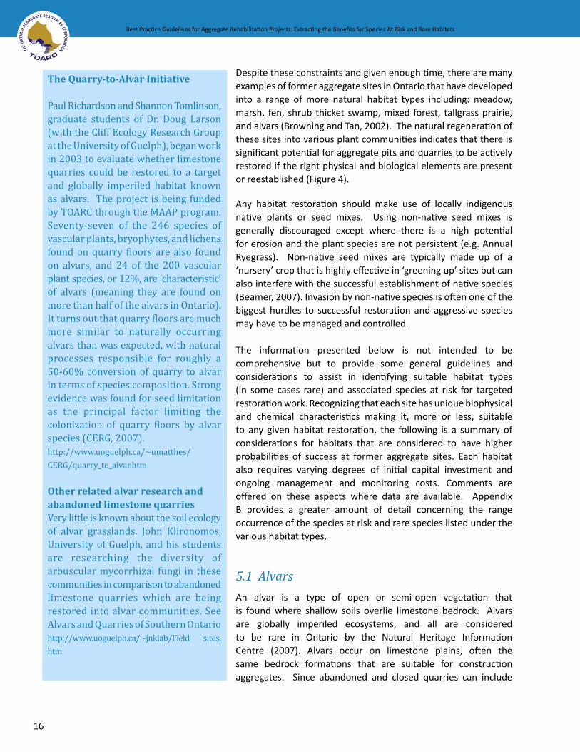
The Quarry-to-Alvar Initiative
Paul Richardson and Shannon Tomlinson, graduate students of Dr. Doug Larson (with the Cliff Ecology Research Group at the University of Guelph), began work in 2003 to evaluate whether limestone quarries could be restored to a target and globally imperiled habitat known as alvars. The project is being funded by TOARC through the MAAP program. Seventy-seven of the 246 species of vascular plants, bryophytes, and lichens found on quarry floors are also found on alvars, and 24 of the 200 vascular plant species, or 12%, are ‘characteristic’ of alvars (meaning they are found on more than half of the alvars in Ontario). It turns out that quarry floors are much more similar to naturally occurring alvars than was expected, with natural processes responsible for roughly a 50-60% conversion of quarry to alvar in terms of species composition. Strong evidence was found for seed limitation as the principal factor limiting the colonization of quarry floors by alvar species (CERG, 2007).http://www.uoguelph.ca/~umatthes/CERG/quarry_to_alvar.htm
Other related alvar research and abandoned limestone quarriesVery little is known about the soil ecology of alvar grasslands. John Klironomos, University of Guelph, and his students are researching the diversity of arbuscular mycorrhizal fungi in these communities in comparison to abandoned limestone quarries which are being restored into alvar communities. See Alvars and Quarries of Southern Ontario http://www.uoguelph.ca/~jnklab/Field sites.htm

Best Practice Guidelines for Aggregate Rehabilitation Projects: Extracting the Benefits for Species At Risk and Rare Habitats
17
Best Practice Guidelines for Aggregate Rehabilitation Projects: Extracting the Benefits for Species At Risk and Rare Habitats
areas of exposed bedrock, there may be good opportunities to restore or to create alvars.
CharacteristicsAlvars are defined as areas of thin soil over essentially flat limestone with trees absent or at least not forming a continuous canopy (Catling et al. 1975). Exposures of limestone pavement are frequent, sometimes with a pattern of cracks or grykes2. Plants that occur on alvars are subject to seasonal inundation of water and extreme summer drought. Following Ecological Land Classification (ELC) definitions (Lee et al. 1998) ‘open alvar’ has a tree or shrub cover of less than 25%, ‘shrub alvar’ has a shrub cover of 25% or greater, and treed alvar has a tree cover of 25 to 60%. Plant growth is often stunted because of sparse soil and summer drought. Typically, natural alvars support a community composition of about 20-25% of plant species that are characteristic of and largely restricted to alvars. Soil depth varies from none to about 15 cm. Some of the significant plant species grow on the very shallow soils that fringe on the bare rock outcrop.
Distribution in OntarioAlvars are most widespread on the extensive limestone plains that lie just south of the Canadian Shield including Smiths Falls, Napanee and Carden, as well as Manitoulin Island and the Bruce Peninsula. Smaller isolated alvars appear elsewhere in areas such as Pelee Island, Flamborough and Haldimand Plains.
Limiting FactorsThe presence of a suitable seed source is the principal factor limiting the colonization of quarry floors by alvar species (CERG, 2007). For this reason, the presence of alvar vegetation in the surrounding area can
2 Gryke: Enlarged fissures that separate blocks of limestone in a limestone pavement.
Figure 5 Fletcher’s Creek former quarry exhibiting alvar characteristics (Photo Credit: Paul Richardson)

18
Best Practice Guidelines for Aggregate Rehabilitation Projects: Extracting the Benefits for Species At Risk and Rare Habitats Best Practice Guidelines for Aggregate Rehabilitation Projects: Extracting the Benefits for Species At Risk and Rare Habitats
provide a seed source that should contribute to successful restoration to this habitat type. The persistence of an alvar plant community improves with increasing species richness (CERG, 2007). Suitable soil is not always available in abandoned quarries.
One of the challenges in establishing alvar vegetation on closed quarries will be competition from non-native invasive species, which may threaten to dominate the new community. The acquisition of a suitable, commercially available seed source may also be difficult. Highly disturbed alvars are frequently dominated by non-native species. Alvar plants are highly dependent on mycorrhizal symbioses, so that introducing appropriate mycorrhizal fungi will be very important.
SoilsIn older quarries that have been abandoned for some time and are already regenerating to native alvar the existing vegetation or soil should not be removed since the plants may contribute to the stability of the site and they may be an important seed source. The soil does not often require any amendments on sites older than 10 years; in cases of newer sites, a mixture of silica sand and compost (e.g. from mushroom farms) will add the necessary nutrients, fines and carbons. The depth of the amended soil should be variable, ranging from bare rock to 15 cm to allow for a range of species. Soil in some areas should not exceed 2 cm since some or the species will only grow on the shallowest soils. Do not fertilize, particularly with nitrogen, since this has been found to negatively affect plant growth in studies on alvars (CERG, 2007). Fertilizer addition (nitrogen and phosphorus) also typically has a negative effect on symbiotic mycorrhizal fungi, thus should not be used. Soils should be rich in arbuscular mycorrhizal3 fungi, which are commonly associated with herbaceous plants.
Increase habitat heterogeneity and reduce/avoid disturbance since the creation of a variety of large and small habitat types (crevices, fractures, rock piles, etc), and the use of rocky debris to create different microsites will all contribute to a greater amount of habitat diversity for wildlife. Human and other forms of disturbance should be minimized and this will help to ensure that species colonize the area faster. Consideration should be given to the use of signage to indicate that the restored habitat is a nature reserve.
HydrologyThe hydrology of alvars varies a great deal over the course of the season from near-flooded to near desiccation, with the former occurring primarily during the spring (March – June) and to a lesser extent in autumn (September – November). Because the soils are very shallow (often only a few cm), they have a limited ability to retain water and so they frequently dry out from June to September (Reshcke et al, 1999). Many alvar plants occur on very flat areas and depend on some seasonal flooding. If the terrain is all sloping the site may be excessively dry. More frequent ponding may develop into wetter habitats such as a marsh or fen. The amount and the timing of the water that floods a particular site must be evaluated to ensure that it is suitable for the (re)creation of alvar habitat. There are examples of quarry restoration actively managing hydrology, such as the Fletcher quarry and Milton limestone; however, it is easiest to try to develop a system that is self-maintaining.
3 Arbuscular mycorrhizal fungi are those that form associations with the vast majority of plants (most herbaceous and some woody plants). “Arbuscular” refers to the arbuscule, a structure that is formed inside plant cortical cells (this fungus does penetrate the root and the cortical cells). These fungi are members of the Phylum Glomeromycota, and there are no large fruiting structures. All structures are microscopic, and complete below ground (Klironomos, pers. comm.). For more detailed information sources refer to Appendix D.

Best Practice Guidelines for Aggregate Rehabilitation Projects: Extracting the Benefits for Species At Risk and Rare Habitats
19
Best Practice Guidelines for Aggregate Rehabilitation Projects: Extracting the Benefits for Species At Risk and Rare Habitats
Vegetation EstablishmentSpread a native and locally sourced seed mix or plant seedlings of a variety of alvar adapted plant species. Seed material may need to be collected and/or grown by experienced individuals. A monitoring program should be initiated to survey the success of individual species and to manage invasive plants early in the process. The planting program may need to be refined appropriately. The seeds from established plants in the restored area can be used to plant other areas targeted for rehabilitation. CERG (2007) has completed some definitive studies on alvar vegetation in Ontario (see case study: The Quarry-Alvar Initiative). Catling (1995) and Catling et al (1975) also provide a fairly comprehensive list of alvar plant species that are good candidates for establishing alvar. Note that most alvar plant species are not currently recognized as species at risk, nor provincially rare, however, many are restricted to this specialized habitat and qualify as regionally or locally significant and are good target species.
Species at Risk in Alvars Appendix B provides a greater amount of detail concerning the range occurrence of the species at risk and rare species that are considered to have a high potential success in rehabilitation of aggregate sites listed under the various habitat types.
Fauna Common NighthawkLoggerhead ShrikeYellow-breasted ChatBlue Racer(Eastern) Black RatsnakeEastern MilksnakeMassasauga Rattlesnake
PlantsClimbing Prairie RoseCommon HoptreeDwarf HackberryDwarf Lake IrisHill’s ThistleHoughton’s Goldenrod Juniper Sedge Lakeside Daisy
Other Provincially Rare Species (Not SAR)Rand’s Goldenrod Carolina Whitlow-grass Ozark DropseedPrairie Dropseed
•••••••
••••••••
••••
Figure 7Dwarf lakeIris in bloom(Photo Credit:Jane Bowles)
Figure 6 Young Dwarf
Lake Iris seeded toOntario quarry
(Photo Credit:Paul Richardson)

20
Best Practice Guidelines for Aggregate Rehabilitation Projects: Extracting the Benefits for Species At Risk and Rare Habitats Best Practice Guidelines for Aggregate Rehabilitation Projects: Extracting the Benefits for Species At Risk and Rare Habitats
5.2 Cliffs, Cracks, Crevices, Caves, and Talus
While cliffs, cracks, crevices, caves, and talus slopes all possess different habitat characteristics, they can all be manufactured at the same time so, for the purposes of restoration, they are discussed under one grouping. Many quarries contain steep rock faces that can be enhanced to these communities (Figures 8 and 14). Most active quarries now being closed have been discouraged from including steep rock faces from a safety perspective. There is a benefit to considering the establishment of these features in all rehabilitated quarries, especially if the rock faces can be left in a condition to mimic those that occur naturally.
Figure 8 Cliff and Talus (background)- Lawless Quarry (Photo Credit: TOARC)
CharacteristicsEcological Land Classification (ELC) distinguishes cliffs as having steep exposures of bedrock that are more than 3 m high, sharp to variably broken edges, faces, and rims, vegetation cover that ranges from patch to < 60 % tree cover, and an average substrate depth of < 15 cm. Talus are slopes of rock rubble at the base of cliffs, with coarse rocky debris making up > 50 % of substrate surface and an average substrate depth of < 15 cm, and a vegetation cover that ranges from patch to < 60 % tree cover. Crevices and caves are sheltered and have a patchy vegetation cover. All of these habitats are subject to extremes in temperature and moisture, so they are relatively harsh environments.
Distribution in OntarioCliffs, cracks, crevices, caves, and talus habitats are found primarily along the Niagara escarpment. These features can also occur elsewhere that sedimentary rock is exposed at the surface such as the limestone plains south of the Canadian Shield
Limiting FactorsDue to the efficiency of modern extraction techniques and requirements for sidesloping quarry faces in a rehabilitated state, much less rubble and overall physical diversity is left, so that the process of rehabilitation must first focus on (re)establishing a landform with as much physical diversity as possible (Figure 9). This

Best Practice Guidelines for Aggregate Rehabilitation Projects: Extracting the Benefits for Species At Risk and Rare Habitats
21
Best Practice Guidelines for Aggregate Rehabilitation Projects: Extracting the Benefits for Species At Risk and Rare Habitats
may require the blasting of quarry walls to create a greater variety of angles to allow different exposures to sunlight and shade. The (re)creation of ledges or benches, for example, facilitates colonization by plants (Ursic et al, 1997).
SoilsThe placement of suitable granular and finely crushed material that will then become lodged in crevices and along the ledges of (re)created quarry walls as a management strategy will provide a growth medium for vegetation. Providing a variety of depths and sizes of materials to make up the talus will ensure a range of habitat types for various species.
Figure 9 Comparison of Modern versus Older Quarry Extraction
HydrologyIn many cases these habitats are very dry and only receive moisture during precipitation events. However, seepage may be present in places and shaded areas in crevices may be moist and these areas may be ideal locations for the (re)establishment of vegetation.
VegetationVegetation is generally sparse on these rocky areas but where soil, shade and moisture are present plant growth can occur. Ferns can become established where conditions are moist and shady. As noted, the recreation of ledges contributes to the accumulation of organic matter and debris and facilitates the colonization by plant species (Ursic et al, 1997).
Species at Risk in Cliffs, Cracks, Crevices, Caves, and TalusAppendix B provides a greater amount of detail concerning the range occurrence of the species at risk and rare species that are considered to have a high potential success in rehabilitation of aggregate sites listed under the various habitat types.
Modern quarries have fewerbenches and less rubble (talus)
Modern Quarry
Toe
Overburden is strippedback and stockpiled
Crest
Predominent Shear Face
Accumulation oforganics (overburden)
Benching formed by water and wind erosion
and loose rock
Moss formation on cave floors
Talus developedfrom falling rock
MAAP (2008)Drawing by: Jesse Long
Older Quarry

22
Best Practice Guidelines for Aggregate Rehabilitation Projects: Extracting the Benefits for Species At Risk and Rare Habitats Best Practice Guidelines for Aggregate Rehabilitation Projects: Extracting the Benefits for Species At Risk and Rare Habitats
FaunaBlue RacerEastern (Black) RatsnakeEastern MilksnakeMassasauga Rattlesnake
Other Provincially Rare Species (Not SAR)Northern Long-eared Bat
Caves also are good habitats for a unique suite of invertebrates (mites, springtails) that are adapted to low-productivity habitats. Talus slopes can be used as hibernacula for some of the snake species at risk
5.3 Cultural Meadows and Thicket
Cultural habitats such as meadows and thickets are those that originate from human activities (e.g. agriculture, clear cutting, extraction, grazing) but have then been abandoned for a relatively short time unless they have established on shallow or poor soils. They are in the early stages of succession and in the absence of additional disturbance would likely develop into forested habitats. Cultural meadows and thickets are easier to create and maintain than most other habitats and can still provide benefits for some species at risk adapted to open habitats. Left unattended most dry gravel pits will naturally succeed into cultural meadows and thickets.
CharacteristicsCultural meadow is typically dominated by grasses and forbs. The type of soil, the underlying substrate, moisture, degree of disturbance, and nearby seed source will determine the dominant species. Typically the grasses are predominantly non-native while the forbs are a mix of native and non-native species. ELC distinguishes cultural meadow of being open with a tree and shrub cover of less than 25% while cultural thicket is dominated by shrubs that may be native or non-native covering at least 25%. Thicket develops at a later successional stage. The shrub species may be deciduous species, such as dogwoods or coniferous such as Red Cedar, Common Juniper and Eastern White Cedar.
Distribution in OntarioCultural meadows and thickets occur throughout Ontario.
Limiting FactorsCultural meadows will likely be dominated by non-native plant species, many of which may be highly invasive. Thickets can be dominated by undesirable non-native species such as buckthorns and autumn and/or Russian olive. In the absence of cutting or other disturbance, the cultural communities may eventually succeed to closed canopy woodland if the substrate and moisture regime are suitable.
SoilsCultural meadows will develop on a variety of soil types but the species complement and the rate of succession will vary accordingly. Meadow vegetation can persist for many years on the poor well-drained soils of some former pits. A mix of arbuscular mycorrhizal (AM) and ectomycorrhizal4 (EM) fungi should be present in the soil to help encourage the growth of herbaceous and woody plants.
4 Ectomycorrhizal fungi are those that form mycorrhizal associations with many groups of woody plants (mainly conifers but also some hardwoods). “Ecto” refers to the fact that the fungus penetrates the root but does not penetrate the root cells. The fungi are typically members of the Phyla Ascomycetes and Basidiomycetes, and they
••••
•

Best Practice Guidelines for Aggregate Rehabilitation Projects: Extracting the Benefits for Species At Risk and Rare Habitats
23
Best Practice Guidelines for Aggregate Rehabilitation Projects: Extracting the Benefits for Species At Risk and Rare Habitats
HydrologyCultural meadow and thicket habitats will develop on a variety of dry to mesic moisture regimes.
VegetationCultural meadows will develop on their own and will likely be dominated by non-native grasses and a variety of native and non-native forbs. Native species should be encouraged. Since some cultural meadows are structurally similar to tallgrass prairies, some of the species found in prairie habitats such as Little Blue-stem (Schizachyrium scoparium) Black-eyed Susan (Rudbeckia hirta) and Wild Bergamot (Monarda fistulosa), can potentially thrive. Meadows often provide abundant food plants for a variety of butterfly species including species at risk such as Monarchs. The species establishment should be monitored, and control measures, such as the use of herbicides, may be needed if aggressive non-native species such rhizomatous grasses such as Quack Grass (Elymus repens) and species such as Dog-strangling Vine (Vincetoxicum rossicum) or European Buckthorn (Rhamnus cathartica) threaten to overwhelm the meadow. Planting with some locally indigenous shrubs may be considered.
Species at Risk in Cultural Meadows and Thicket Appendix B provides a greater amount of detail concerning the range occurrence of the species at risk and rare species that are considered to have a high potential success in rehabilitation of aggregate sites listed under the various habitat types.
FaunaEastern MoleCommon Nighthawk Yellow-breasted ChatBlue Racer Butler’s GartersnakeEastern FoxsnakeEastern Hog-nosed SnakeEastern MilksnakeMonarch Butterfly
PlantsClimbing Prairie RoseDense Blazing Star
Other Provincially Rare Species (Not SAR)Small-flowered Agrimony Sullivant’s Milkweed TrumpetvineSpring AvensCylindrical Blazing StarSlender Mountain Mint
form large fruiting structures such as mushrooms and cups (Klironomos, pers. comm.). For more detailed information sources refer to Appendix D.
•••••••••
••
••
•••
Figure 10 Cylindrical Blazing Star(Photo Credit: Paul Richardson)

24
Best Practice Guidelines for Aggregate Rehabilitation Projects: Extracting the Benefits for Species At Risk and Rare Habitats Best Practice Guidelines for Aggregate Rehabilitation Projects: Extracting the Benefits for Species At Risk and Rare Habitats
5.4 Fen
Fens are a type of open or semi-open wetland where the primary source of water is mineral groundwater. Deep organic soils are often but not always present. While fens will not be easy to restore in many sites, Browning and Tan (2002) have observed the establishment of vegetation characteristics (e.g. cotton grass) of fen communities at a number of former aggregate pits and quarries such as Wildwood Pit complex and Fletcher Creek quarry (Figures 11 and 12). Pits and quarries that extract below the water table, or otherwise have groundwater influence near the surface may be suitable for fen rehabilita-tion. Older sites may contain one or more species characteristic of fens. The existence of fen species may not necessarily characterize it as a true fen, but certainly indicates that the site may warrant further fen rehabilitation.
CharacteristicsTypical fen vegetation is dominated by graminoids including sedges, rushes, some grasses, low shrubs and scattered trees such as tamaracks and white cedars. Rich fens are more nutrient rich occurring on alkaline soils, while poor fens are slightly acidic with a different suite of plant species. Ecological Land Classification (ELC) distinguishes the ‘open’ fens as having tree cover < 10% and shrub cover < 25%, ‘shrub’ fens as having tree cover < 10% and shrub cover > 25%, and ‘treed’ fens as having tree cover > 10% and shrub cover < 25%.
Distribution in OntarioFens are now quite rare and highly localized in most of southern Ontario but are more frequent on the Bruce Peninsula and Manitoulin Island. Fen species are often found in seeps and wet bluffs of river corridors in southern Ontario and may provide a seed source for establishment of such species in nearby gravel pits. Fens remain relatively common on the Canadian Shield.
Limiting FactorsFens can only be created on sites where there is flowing groundwater coming to the surface. One of the challenges in establishing fen vegetation on closed and former quarries will be competition from non-native invasive species, which may threaten to dominate the new community. Sourcing a commercial seed mix of predominantly native species may also prove to be difficult.
VegetationFen habitats are relatively rare in southern Ontario and may not be close enough for the seed of fens species to migrate to the rehabilitation site. Therefore, if an adequate supply of seed is not incorpo-rated into rehabilitation efforts, the passive immigration of locally occurring invasive, non-fen species may overcome the site.
The species selected for planting also depend on the hydrology of the wetland, and should be planted or seeded during the spring with assurances that the species are native and of local genetic stock. It is recommended that maximum efforts be made to vegetate an area by planting and/or seeding as soon as possible and to time restoration to ensure that the planting occurs at appropriate times of the year. Fen species are adapted to nutrient-poor soils although the inflowing ground water may be nutrient rich.

Best Practice Guidelines for Aggregate Rehabilitation Projects: Extracting the Benefits for Species At Risk and Rare Habitats
25
Best Practice Guidelines for Aggregate Rehabilitation Projects: Extracting the Benefits for Species At Risk and Rare Habitats
Figure 11 Naturally occuring calcareous fen at the Fletcher Creek Ecological Perserve (Photo Credit: Dr. Mike Waddington)
Figure 12 A section of the quarry at Fletcher Creek is rehabilitating on its own towards a calcareous fen vegetation community (Photo Credit: Dr. Mike Waddington)

26
Best Practice Guidelines for Aggregate Rehabilitation Projects: Extracting the Benefits for Species At Risk and Rare Habitats Best Practice Guidelines for Aggregate Rehabilitation Projects: Extracting the Benefits for Species At Risk and Rare Habitats
SoilsBecause fen communities are naturally low in nutrients, soil amendments (e.g. addition of straw or lignitic clay, or bark mulch) may be necessary with an emphasis on reducing levels of nitrogen and phosphorus in the soil. Nutrient-poor and relatively calcium-enriched soil appears to favour the development of certain fen species (Tallowin and Smith, 2001). Soils should be rich in arbuscular mycorrhizal fungi, as ectomycorrhizal plants are not typically found in this habitat type.
HydrologyOne of the key features to support fen vegetation is a sufficient quantity and quality of groundwater (Browning and Tan, 2002), so an analysis of both the quantity and quality of water, and seasonal fluctuations, that will support the fen is advised. It would be useful to develop a water budget or model to ensure that the timing and amount of water available is appropriate. The supply of water should be ‘passive’ (i.e. not require any sort of pump or other manmade system) and self-supporting; although there are examples of relatively passive management of water such as the use of stop logs on a dam at the Fletcher’s Creek quarry. It is equally important to consider the existing and future land uses in the surrounding watershed and to obtain some assurances that they will not change dramatically and, in so doing, potentially alter existing water quality and/or quantity characteristics (Erwin, 1990).
Species at Risk in FensAppendix B provides a greater amount of detail concerning the range occurrence of the species at risk and rare species that are considered to have a high potential success in rehabilitation of aggregate sites listed under the various habitat types.
FaunaBlanding’s TurtleSpotted TurtleEastern RibbonsnakeMassasauga Rattlesnake
PlantsTuberous Indian-plantain
5.5 Forest
Forest habitats are one of the more common forms of restoration used in aggregate rehabilitation; however, most past approaches to reforestation simply involved planting coniferous or in some cases deciduous plantations that provided limited value as habitat for native plants and animals because they had limited species’ diversity. While forest is the natural end point of succession for most terrestrial habitats in southern Ontario, establishing a diverse and mature forest that can support species at risk will take a human lifetime. On many sites however, there is likely to be some existing forest cover very near or perhaps adjacent to the site to be restored.
CharacteristicsEcological Land Classification (ELC) distinguishes a forest habitat as a terrestrial community with tree cover of greater than 60 %, whereas a woodland habitat is defined as a community with a tree cover of 35-60%. These communities are further divided into: coniferous (>75 % of total canopy cover is dominated by
••••
•

Best Practice Guidelines for Aggregate Rehabilitation Projects: Extracting the Benefits for Species At Risk and Rare Habitats
27
Best Practice Guidelines for Aggregate Rehabilitation Projects: Extracting the Benefits for Species At Risk and Rare Habitats
coniferous trees); deciduous (> 75% of total canopy cover is dominated by deciduous trees); and, mixed (conifer tree species > 25% and deciduous tree species > 25% of canopy cover).
Distribution in OntarioForests occur throughout Ontario but the most diverse deciduous forests occur in the Carolinian forest zone north of Lake Erie.
Limiting FactorsBecause of the age of mature trees and the time taken for some forest ground layer species to reach maturity, restoration of fully functioning forests is likely to take many decades, or even centuries. Successful forest restoration is only likely when there is a forested site found adjacent to the restoration site that can provide a seed source.
While reforestation to coniferous plantations appears to be easy to accomplish, there is often an extremely high mortality rate of deciduous seedlings as a result of browsing by deer, small mammals and rodents, and by insufficient moisture. Note also that plantations of a few species are very different in diversity, structure and function from a natural forest where most of the biodiversity and much of the biomass may be below ground. Natural forests take centuries to develop from preceding habitat types and although restoration activities may speed the process, the resulting habitat is likely to be very low in species’ diversity in the short-term.
There are a number of key considerations that may limit or even preclude forest habitat as a restoration goal for aggregate pits/quarries:
Soil depths less than 0.5 m over bedrock or permanent water table. Soil degradation is generally the primary limiting factor in the success of a forest restoration project on an aggregate property (Beamer, 2007; Elliott, pers. comm.), and the size of the quarry may make the importation of sufficient quantities of topsoil impractical; Long distance (> 100 m) of established forests that can provide a seed source; and Slopes steeper than 3:1.
SoilsTo establish a forest on a pit or quarry site will likely require soil amendments if there is no native topsoil available for restoration. A soil substrate will need to be introduced that has high organic matter, and moderate water holding capacity. PH of the soil can vary from slightly acidic to slightly basic. The soil should have a high fungal:bacterial ratio, and have a good mix of arbuscular and ectomycorrhizal fungi, that can support the growth of a wide variety of herbaceous and woody plants.
VegetationSelected species must be appropriate for the site conditions and may include the use of seedlings and/or direct seeding. Transplanting of salvaged trees, shrubs and herbaceous material may be considered in some instances. Progressive rehabilitation may provide an additional opportunity for a source of more mature species and associated soil.

28
Best Practice Guidelines for Aggregate Rehabilitation Projects: Extracting the Benefits for Species At Risk and Rare Habitats Best Practice Guidelines for Aggregate Rehabilitation Projects: Extracting the Benefits for Species At Risk and Rare Habitats
Species at Risk in ForestAppendix B provides a greater amount of detail concerning the range occurrence of the species at risk and rare species that are considered to have a high potential success in rehabilitation of aggregate sites listed under the various habitat types.
FaunaEastern (Black) Rat SnakeEastern Hog-nosed SnakeEastern MilksnakeJefferson’s Salamander
PlantAmerican ChestnutBlue AshButternutCucumber TreeEastern Flowering DogwoodKentucky Coffee-TreeRound-leaved Greenbriar
Other Provincially Rare Species (Not SAR)Pawpaw Burning BushBlack Gum Pin Oak Purple Joe PyeweedSchumard Oak
5.6 Marshes and Open or Shallow Waters
A marsh is a wetland dominated by emergent graminoid and herbaceous vegetation. Marshes can be a fairly simple habitat to create in gravel pits below the water table; in fact, if the slopes are suitable they often develop spontaneously, with or without open water associated with them (Figure 14). Erwin (1990) maintains that freshwater marsh creation is feasible and sets out considerations in the design and implementation. Rehabilitating a marsh in a former gravel pit or quarry will often be associated with an open or shallow water habitat, but may also be possible if there is a clay formation beneath the sand and gravel that is being extracted. The two are very compatible in providing habitat to a wide range of wildlife, including species at risk such as Blanding’s turtle and Eastern Ribbonsnake, both of which are currently found on former and active aggregate sites (Browning, pers. comm.).
CharacteristicsMarshes occur in shallow water that may be permanently or seasonally flooded but usually with moist conditions throughout the year. Marshes are highly productive, perhaps more productive than any other habitat type. Ecological Land Classification (ELC) distinguishes meadow marshes that are wet in spring and moist to dry in summer, from shallow marshes that have standing water most of the year. The dominant species vary from cattails, grasses, sedges, bulrushes or broad-leaved forbs. Marshes may have some
••••
•••••••
••••••
Figure 13 Pawpaw (Photo Credit: Jane Bowles)

Best Practice Guidelines for Aggregate Rehabilitation Projects: Extracting the Benefits for Species At Risk and Rare Habitats
29
Best Practice Guidelines for Aggregate Rehabilitation Projects: Extracting the Benefits for Species At Risk and Rare Habitats
trees or shrubs but their cover is less than 25%. Marshes can persist over long time periods or can be a transitional successional stage on the way to becoming swamp. Open water habitats are defined as those areas with a depth of water greater than 2 m and where submerged aquatic plants are generally sparse, while shallow water habitats are defined as those areas where the permanent water is usually up to 2 m deep and the total vegetation cover is > 25%, dominated mostly by submerged or floating-leaved species.
Figure 14 Kerncliff Quarry with marsh in foreground, and cliff and talus in background (Photo Credit: Mark Browning, MNR)
Distribution in OntarioMarshes, as well as open and shallow water habitats occur throughout Ontario.
Limiting FactorsThe slope of shorelines is an important consideration in establishing marshes. Steep shorelines will result in no or a very narrow marsh along the shoreline, whereas a gentle slope will allow a more extensive marsh to develop. As a general rule, the more shallows there are, the more productive the marshes will be. The type of substrate (sand, clay, organic) will influence the plant species that dominate. Diverse marshes often depend on fluctuating water tables and may have a tendency to become dominated by aggressive plant species such as cattails or Reed Canary Grass if water levels are stable. Non-native invasive plant species such as Common Reed, Hybrid Cattails or Purple Loosestrife may invade and dominate new or even established marshes. Common Reed (Phragmites) is particularly aggressive and hard to control. Seeding or planting with native species as soon as possible after site preparation will help to maximize native diversity and density. It will also help native species get a head start on non-native plants.

30
Best Practice Guidelines for Aggregate Rehabilitation Projects: Extracting the Benefits for Species At Risk and Rare Habitats Best Practice Guidelines for Aggregate Rehabilitation Projects: Extracting the Benefits for Species At Risk and Rare Habitats
SoilsThe type of substrate is not usually critical in establishing marsh vegetation but each plant species favours a particular soil type. In most cases, working with the existing substrate type is the preferred option from a cost perspective, so this should form part of the planning process to give consideration to the list of vegetation species that are suitable to these conditions. Marsh plants are typically associated with arbuscular mycorrhizal fungi, but are not generally considered to be highly dependent on these fungi for their growth and development.
HydrologyAvailability of sufficient wetness is the most important element necessary for the successful (re)creation of marsh habitat. An analysis of both the quantity and quality of water, and seasonal fluctuations, that will support the marsh vegetation is advised. It would be useful to develop a water budget or model to ensure that the timing and amount of water available is appropriate, but generally marsh can be established as long as ground is fairly level and wet for much of the growing season. A passive self-supporting water supply is best, which does not require pumping.
Grading of soil creating a low gradient along the waterline of a ponded area will promote marsh vegetation. Variable contouring of a marsh habitat must be determined by the hydrologic analysis, but should also consider the target species for the resulting habitat. For example, Blanding’s turtle use marsh habitats and are often found in shallow water, so they would require contours with both shallow water habitats, but also deeper or “open water” areas (> 2 m) for overwintering.
VegetationMarsh vegetation will likely soon establish on its own from wind blown seeds and/or those introduced by waterfowl, but it is often desirable to enhance this succession with a more diverse range of species to prevent domination by invasive species. The species selected for planting also depend on the hydrology of the wetland, and should be planted or seeded during the spring with assurances that the species are native and of local genetic stock. It is recommended that maximum efforts be made to vegetate an area by planting and/or seeding as soon as possible and to time restoration to ensure that the planting occurs at appropriate times of the year. Generally, species such as cattails, bulrushes and certain sedges will become established fairly readily on their own if the biophysical and hydrologic conditions are suitable; however, the floating aquatic plants such as: water lilies and pond lilies may take much longer to become established naturally but can be transplanted from locally indigenous sources. Vegetation should be monitored to determine if invasive species are threatening to overwhelm the site so that corrective action may be taken.
Species at Risk in Marshes or Open or Shallow Water HabitatsAppendix B provides a greater amount of detail concerning the range occurrence of the species at risk and rare species that are considered to have a high potential success in rehabilitation of aggregate sites listed under the various habitat types.
FaunaLeast BitternBlack TernBlanding’s TurtleEastern Ribbonsnake
••••

Best Practice Guidelines for Aggregate Rehabilitation Projects: Extracting the Benefits for Species At Risk and Rare Habitats
31
Best Practice Guidelines for Aggregate Rehabilitation Projects: Extracting the Benefits for Species At Risk and Rare Habitats
Eastern FoxsnakeJefferson SalamanderLake Erie WatersnakeMassasaugaMap Turtle Spotted TurtleStinkpot Turtle
PlantsSwamp Rose-mallow
Other Provincially Rare Species (Not SAR)Mulberry Wing Butterfly Grass-leaved Mud PlantainSouthern Tickseed Follicle SedgeSchweinitz’s SedgeHairy Lake SedgeRed-rooted Umbrella SedgeSchweinitz’s Umbrella SedgeWinged LoosestrifeOswego Tea Spatterdock American Lotus Arrow Arum Gattinger’s Panic GrassHalberd-leaved TearthumbVirginia Marsh St. Johnswort Yellow-eyed Grass
5.7 Rock Barrens
This community is dominated by non-woody vegetation where there is extensive exposed bare rock and irregular patchy shallow soil substrate. It differs from an alvar in both the type of rock and the hydrologic regime as well as the species it supports. Rock barrens can potentially be created or restored at abandoned pits or quarries along the southern fringe of the Canadian Shield if there is exposed bedrock.
CharacteristicsRock barrens consist of rolling Precambrian outcrops that appear at the surface. Moss and lichens are abundant on the rock. Soil is confined to irregular pockets in shallow depressions, which depending on depth or extent, supports scattered trees, shrubs and meadow vegetation. This vegetation has a warm microclimate and is droughty, that is, support plants that can withstand summer desiccation. Following Ecological Land Classification (ELC) definitions (Lee et al. 1998) ‘open rock barren’ has a tree or shrub cover of less than 25%, ‘shrub rock barren’ has a shrub cover of 25% or greater, and ‘treed rock barren’ has a tree cover of 25 to 60%.
•••••••
•
•••••••••••••••••
Figure 15 Eastern Foxsnake (Photo Credit: Jane Bowles)

32
Best Practice Guidelines for Aggregate Rehabilitation Projects: Extracting the Benefits for Species At Risk and Rare Habitats Best Practice Guidelines for Aggregate Rehabilitation Projects: Extracting the Benefits for Species At Risk and Rare Habitats
Distribution in OntarioRock barrens occur on the Canadian Shield. The most extensive rock barrens occur along the southern fringe from the east shore of Georgian Bay to the Frontenac Axis, and these provide habitat for a number of species at risk.
Limiting FactorsRock barren vegetation can develop where there is exposed Precambrian bedrock, and there may be a lack of soil.
VegetationSince existing rock barrens are likely to occur naturally, in close proximity to the aggregate site, there is likely to be a good seed source for tree, shrub and ground cover plants. Nevertheless planting of desired characteristic species is recommended because disturbed barrens are highly susceptible to colonization by non-native invasive plants. Due to the potential lack of soil to plant trees and shrubs into, seeding with tree and shrub seed may be a preferable option.
SoilsSoil may need to be placed in depressions on exposed rock outcrops to allow for establishment of vegetation. Soils are often sandy but should have an organic component to retain moisture as much as possible. Fungi that can support arbuscular, ecto- and ericoid5 mycorrhizal plants will be needed in this soil.
HydrologySurface water drainage is often by sheet flow. Because of sparse and shallow soil, most water drains off but collects in depressions where soil is present. Isolated wetlands (e.g. thicket swamp) may develop if depressions are sufficiently deep.
Species at Risk in Rock BarrenAppendix B provides a greater amount of detail concerning the range occurrence of the species at risk and rare species that are considered to have a high potential success in rehabilitation of aggregate sites listed under the various habitat types.Fauna
Common Nighthawk Eastern FoxsnakeEastern (Black) RatsnakeEastern Hog-nosed SnakeEastern MilksnakeMassasauga RattlesnakeFive-lined Skink
Other Provincially Rare Species (Not SAR)Northern Long-eared Bat Prairie Warbler Pitch PineShining Sumac
5 Ericoid mycorrhiza are a symbiotic relationship between fungi (Ascomycetes and Basidiomycetes) and the roots of specific plants (order Ericales). For more information sources on fungi, see Appendix D.
•••••••
••••
Figure 16 Eastern Milksnake (Photo Credit: Jane Bowles)

Best Practice Guidelines for Aggregate Rehabilitation Projects: Extracting the Benefits for Species At Risk and Rare Habitats
33
Best Practice Guidelines for Aggregate Rehabilitation Projects: Extracting the Benefits for Species At Risk and Rare Habitats
Rock barrens can potentially be created or restored at pits or quarries along the southern fringe of the Canadian Shield if there is exposed bedrock.
5.8 Sand Barrens and Sand Dunes
These communities consist of relatively sparse vegetation because they have developed on very well drained sands that do not hold moisture. Sand dunes are formed from shoreline and wind-related sand deposition combined on undulating ridges while sand barrens are not associated with current shorelines and are usually more level. Both can only support plants able to tolerate drought conditions.
CharacteristicsSand barrens and sand dunes both consist of sparse vegetation. Following Ecological Land Classification (ELC) definitions (Lee et al. 1998) ‘open sand barren’ and ‘open sand dune’ have a tree or shrub cover of less than 25%, ‘shrub sand barren’ have a shrub cover of 25% or greater, and ‘treed sand barren’ has a tree cover of 25 to 60%. Sand dunes and sand barrens are both subject to periodic disturbances in the form of strong winds, fire, or human causes that prevent eventual domination by woody vegetation.
Distribution in OntarioSand dunes are mostly associated with shorelines of very large lakes, in particular the Great Lakes. They are a rare feature in Ontario.
Limiting FactorsSand barrens and sand dunes would be difficult to maintain in the long term because over time the ground will likely stabilize allowing more organic soils and vegetation to accumulate. Some form of periodic disturbance will be necessary on most sites.
SoilsSand barrens can be created on sites having an abundance of sand and a lack of topsoil. Most plants in this habitat type are highly mycorrhizal dependent, and will require the presence of suitable arbuscular mycorrhizal fungi to ensure a high level of plant survival.
HydrologySurface water flows through so there is virtually no lateral flow and therefore this habitat is very dry.
Species at Risk in Sand Barrens or DunesAppendix B provides a greater amount of detail concerning the range occurrence of the species at risk and rare species that are considered to have a high potential success in rehabilitation of aggregate sites listed under the various habitat types.
FaunaBlanding’s Turtle (nest site)Five-lined SkinkEastern MilksnakeEastern Hog-nosed SnakeEastern FoxsnakeMonarch Butterfly
••••••
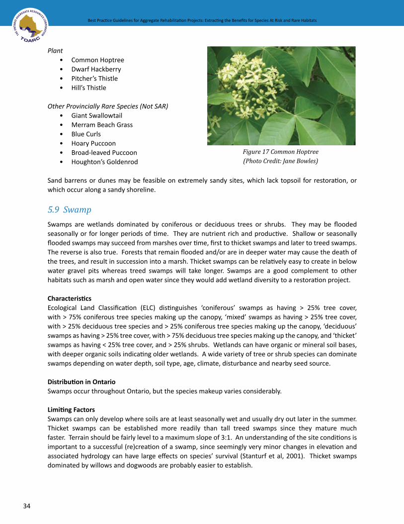
34
Best Practice Guidelines for Aggregate Rehabilitation Projects: Extracting the Benefits for Species At Risk and Rare Habitats Best Practice Guidelines for Aggregate Rehabilitation Projects: Extracting the Benefits for Species At Risk and Rare Habitats
PlantCommon HoptreeDwarf HackberryPitcher’s ThistleHill’s Thistle
Other Provincially Rare Species (Not SAR)Giant SwallowtailMerram Beach GrassBlue CurlsHoary PuccoonBroad-leaved PuccoonHoughton’s Goldenrod
Sand barrens or dunes may be feasible on extremely sandy sites, which lack topsoil for restoration, or which occur along a sandy shoreline.
5.9 Swamp
Swamps are wetlands dominated by coniferous or deciduous trees or shrubs. They may be flooded seasonally or for longer periods of time. They are nutrient rich and productive. Shallow or seasonally flooded swamps may succeed from marshes over time, first to thicket swamps and later to treed swamps. The reverse is also true. Forests that remain flooded and/or are in deeper water may cause the death of the trees, and result in succession into a marsh. Thicket swamps can be relatively easy to create in below water gravel pits whereas treed swamps will take longer. Swamps are a good complement to other habitats such as marsh and open water since they would add wetland diversity to a restoration project.
CharacteristicsEcological Land Classification (ELC) distinguishes ‘coniferous’ swamps as having > 25% tree cover, with > 75% coniferous tree species making up the canopy, ‘mixed’ swamps as having > 25% tree cover, with > 25% deciduous tree species and > 25% coniferous tree species making up the canopy, ‘deciduous’ swamps as having > 25% tree cover, with > 75% deciduous tree species making up the canopy, and ‘thicket’ swamps as having < 25% tree cover, and > 25% shrubs. Wetlands can have organic or mineral soil bases, with deeper organic soils indicating older wetlands. A wide variety of tree or shrub species can dominate swamps depending on water depth, soil type, age, climate, disturbance and nearby seed source.
Distribution in OntarioSwamps occur throughout Ontario, but the species makeup varies considerably.
Limiting FactorsSwamps can only develop where soils are at least seasonally wet and usually dry out later in the summer. Thicket swamps can be established more readily than tall treed swamps since they mature much faster. Terrain should be fairly level to a maximum slope of 3:1. An understanding of the site conditions is important to a successful (re)creation of a swamp, since seemingly very minor changes in elevation and associated hydrology can have large effects on species’ survival (Stanturf et al, 2001). Thicket swamps dominated by willows and dogwoods are probably easier to establish.
••••
••••••
Figure 17 Common Hoptree(Photo Credit: Jane Bowles)

Best Practice Guidelines for Aggregate Rehabilitation Projects: Extracting the Benefits for Species At Risk and Rare Habitats
35
Best Practice Guidelines for Aggregate Rehabilitation Projects: Extracting the Benefits for Species At Risk and Rare Habitats
Swamp rehabilitation on aggregate sites has been very uncommon and will require a longterm rehabilitation plan and will likely be dependent on progressive rehabilitation.
VegetationSwamp Thicket vegetation will likely soon establish on its own from wind blown seeds (succession of meadow marsh provided there is a suitable nearby seed source), but it is often desirable to enhance this succession with a more diverse range of species and to prevent domination by invasive species. The species selected for planting also depend on the hydrology of the wetland, and should be planted or seeded during the spring with assurances that the species are is native and of local genetic stock. It is recommended that maximum efforts be made to vegetate an area by planting and/or seeding as soon as possible and to time restoration to ensure that the planting occurs at appropriate times of the year. Seedlings or saplings can be planted. Willows and dogwood twigs can be planted when dormant as they will root easily. Vegetation should be monitored to determine if invasive species are threatening to overwhelm the site so that corrective action may be taken.
SoilsTo establish a swamp in a pit or quarry will likely require soil amendments similar to that of meadows and forests. The soil should be rich in organic matter, preferably a good quality loam that also has a rich microbial diversity. Dogwood Thicket swamp can grow on soil with relatively little organic material as long as there is sufficient moisture.
HydrologySwamps are generally adapted to extensive flooding in the spring and fall and drier conditions in the summer so a good understanding of the hydrologic conditions of the site is necessary (see Fen/Marsh habitats for details on hydrology). Occasionally, sites can be designed to incorporate water control structures to manipulate water levels and retain certain water depths. Even a 10 cm water level fluctuation can have a profound effect on plant communities
Species at Risk in SwampsAppendix B provides a greater amount of detail concerning the range occurrence of the species at risk and rare species that are considered to have a high potential success in rehabilitation of aggregate sites listed under the various habitat types.
FaunaBlanding’s TurtleSpotted TurtleEastern RibbonsnakeLake Erie WatersnakeMassasauga RattlesnakeJefferson’s Salamander
PlantsSwamp Rose-Mallow
Other Provincially Rare Species (Not SAR)Southern Tickseed
••••••
•
•Figure 18 Blanding’s Turtle(Photo Credit: Jane Bowles)

36
Best Practice Guidelines for Aggregate Rehabilitation Projects: Extracting the Benefits for Species At Risk and Rare Habitats Best Practice Guidelines for Aggregate Rehabilitation Projects: Extracting the Benefits for Species At Risk and Rare Habitats
Big Shellbark Hickory Pumpkin Ash Oswego Tea Black Gum Halberd-leaved Tearthumb Pin Oak
5.10 Tallgrass Prairie, Tallgrass Savannah, and Tallgrass Woodland
Tallgrass savannahs and woodlands are essentially tallgrass prairies with a partial canopy of trees that still allows sufficient sunlight to support the ground flora. Native grassland habitats are a globally imperiled ecosystem and are considered to be rare in Ontario (S1) (NHIC, 2007). Many species that depend on this habitat type are becoming equally imperiled as evidenced by the fact that of the 37 species of grassland birds monitored under the North American Breeding Bird Survey, 32 are demonstrating some level of decline in populations (McCracken, 2005).
Many aggregate pits are ideal sites for restoration to prairie due to the similarities of the sand pit substrate to that of tallgrass prairies, and also that it is relatively easier to rebuild the soil horizons of tallgrass prairies than some other habitat types, such as forests. Also, tallgrass species have deep roots to help them survive drought and fire. Therefore, hydro-seeding tallgrass prairie seed mixes on well drained sandy slopes may result in greater soil stability and erosion control than many other non-native seed mixtures.
CharacteristicsTallgrass prairies are defined as areas where the soil depth is generally greater than 15 cm, the soils are well-drained loams and sometimes sands, and they are subject to extremes in moisture conditions (moist or wet in spring and dry in summer). Prairie habitats depend on periodic fire in order to suppress invasion by trees and shrubs. Tallgrass prairie communities are typically dominated by tall, late season grasses such as Big Bluestem (Andropogon gerardii) and Indian Grass (Sorgastrum nutans), and there is usually a high diversity of sun-loving forbs. Scattered tree cover, particularly oaks, is often present in both tallgrass savannahs and tallgrass woodlands. Following Ecological Land Classification (ELC) definitions (Lee et al. 1998) ‘open tallgrass prairie’ has a tree or shrub cover of less than 25%, ‘tallgrass savannah’ has a tree cover of 25 to 35%, and ‘tallgrass woodland’ has a tree cover of greater that 35 to 60%.
Distribution in OntarioHistorically tallgrass prairies, tallgrass savannahs, and tallgrass woodlands occurred sporadically throughout the southern part of Ontario with the most extensive areas in the extreme southwest; however, currently only about 0.5% of the original remains in about 130 small remnant patches (Bakowsky and Riley, 1992). Most sites occur within the Carolinian forest zone but some remnants still occur as far east as the Rice Lake Plains in Northumberland County.
Limiting FactorsOne of the challenges of establishing tallgrass prairie, savannah, or woodland vegetation on former pits is competition from non-native invasive species, so seeding with native species should be conducted soon after site preparation to maximize diversity and density. Obtaining locally indigenous plant material may also prove difficult.
••••••

Best Practice Guidelines for Aggregate Rehabilitation Projects: Extracting the Benefits for Species At Risk and Rare Habitats
37
Best Practice Guidelines for Aggregate Rehabilitation Projects: Extracting the Benefits for Species At Risk and Rare Habitats
Figure 19 Before and After Tallgrass Prairie Restoration (Photo Credit: TOARC)
Prairie habitats are dependent on fire to persist in the long-term, therefore periodic prescribed burns or, at a minimum, mowing will be necessary to maintain this habitat.
SoilsWell-drained soil should be a prerequisite for attempting to establish tallgrass communities, since the vegetation primarily occurs on well-drained sandy soils. Do not add nitrogen to soil when planting prairie and meadow species because these species compete better with weeds when the nitrogen is low. These plants are also more mycorrhizal dependent than weeds, so as long as there is a good diversity of mycorrhizal fungi from a prairie source, then native prairie plants should do much better than weeds
VegetationObtain and apply a native and locally sourced tallgrass prairie seed mix that contains an array of plant species. Although it is tempting to use showy plants, species should not be established beyond their known ranges. Ensure that the seeds are collected and/or grown by experienced individuals. In general, grass species do best when seed mixes are used, whereas forb species are more successful when plugs are used (Browning, pers. comm.). A monitoring program should be initiated to survey the success of individual species at each site and to use this information to inform the extension of the planting program to other areas. The seeds

38
Best Practice Guidelines for Aggregate Rehabilitation Projects: Extracting the Benefits for Species At Risk and Rare Habitats Best Practice Guidelines for Aggregate Rehabilitation Projects: Extracting the Benefits for Species At Risk and Rare Habitats
from established plants in the restored area can also be used to plant other areas targeted for restoration. Figure 19 provides an example of a recently completed prairie restoration project by MAAP.
Species at Risk in Tallgrass HabitatsAppendix B provides a greater amount of detail concerning the range occurrence of the species at risk and rare species that are considered to have a high potential success in rehabilitation of aggregate sites listed under the various habitat types.
FaunaEastern MoleNorthern BobwhiteYellow-breasted ChatButler’s Gartersnake(Eastern) Black Rat SnakeEastern FoxsnakeEastern Hog-nosed SnakeEastern MilksnakeMassasauga RattlesnakeMonarch
PlantsClimbing Prairie RoseCommon HoptreeDense Blazing StarWillowleaf Aster
Other Provincially Rare Species (Not SAR)Small-flowered Agrimony Sullivant’s MilkweedWhorled Milkweed Smooth Yellow False FoxgloveFernleaf Yellow False FoxgloveSide-oats Grama Tall Coreopsis Round-leaved Tick-trefoil Bracted Tick-trefoil Hairy BedstrawBiennial GauraSpring AvensShrubby St. Johnswort Hairy Pinweed Rough Blazing StarCylindrical Blazing Star Yellow Flax Eastern LupineWinged LoosestrifeHill’s OakPrairie Buttercup
••••••••••
••••
•••••••••••••••••••••
Figure 20 Dense Blazing Star(Photo Credit: Jane Bowles)
Figure 21 Monarch Butterfly(Photo Credit: David Beamer)

Best Practice Guidelines for Aggregate Rehabilitation Projects: Extracting the Benefits for Species At Risk and Rare Habitats
39
Best Practice Guidelines for Aggregate Rehabilitation Projects: Extracting the Benefits for Species At Risk and Rare Habitats
Stiff GoldenrodOhio SpiderwortGiant Ironweed
6.0 FOLLOW-UP MONITORING AND REPORTING The monitoring of habitat restoration initiatives is a critical, although not legislated, component of the entire restoration process. Monitoring not only ensures that the project successfully meets its pre-set goals but also enables the early identification of shortcomings and the associated implementation of adaptive management strategies, if and when necessary. Monitoring reports are also helpful to other recreation and restoration efforts. Monitoring is frequently overlooked due to a range of reasons including insufficient funding, loss of interest, time and/or training and often results in either the longer term failure of the project or the use of techniques that have been demonstrated to fail (Browning, pers. comm.). For this reason, it is strongly recommended that monitoring and reporting be factored into the entire restoration plan.
Figure 22 Vegetation Monitoring at Duntroon Quarry (Photo Credit: CERG)
6.1 Monitoring and Adaptive Management of Restoration Projects
The early stages of a successful habitat restoration project can generally be evaluated based on both the survival of individual species and by the overall density and diversity of native species. The choice of suitable indicators for detecting the effectiveness of a restoration initiative must be carefully selected to ensure that they adequately address short and longer-term changes. General indicators may include such measures as: species diversity; plant density; and the percentage of native species (Lefler, 2006), while more specific methods to evaluate and to ensure success could include the following:
Pre-, mid-, and post – restoration photographic inventory (from same vantage point) to document change over time;
•••
•

40
Best Practice Guidelines for Aggregate Rehabilitation Projects: Extracting the Benefits for Species At Risk and Rare Habitats Best Practice Guidelines for Aggregate Rehabilitation Projects: Extracting the Benefits for Species At Risk and Rare Habitats
Surveying of elevations/contours to determine degree of compliance with design criteria versus the end result;Ground and surface water measurements to determine if the desired hydrologic conditions have been established (e.g. use of piezometers, staff gauges, etc);Evaluation of vegetation characteristics including species diversity, distribution, percent cover and amount of bare ground etc with species richness and percent cover generally being the most effective indicators of success. The Floristic Quality Index (FQI)6 is viewed as a very effective tool for measuring rehabilitation success at aggregate sites (Browning, pers. comm.; Oldham et al, 1995);Monitoring, control and management of invasive, exotic species;Soil quality is also a good thing to check periodically because it can give an indication of overall success (e.g. organic matter content, pH, basic nutrients, bacterial/fungal ratios and mycorrhizal diversity); Biological monitoring and sampling for target species;Consider keeping a small section as a control site, where active restoration is not done and this can be used as a reference site to determine if the manipulation is a success or not.
Monitoring the site at appropriate intervals to ensure the early detection of problems and to allow for adaptive management, and over a sufficient period of time to determine the strength or weaknesses of various techniques is critical.
There is a range of options for ensuring the long-term management and conservation of a rehabilitated site (e.g. Ecological Gifts Program, Land Trusts, etc). For more information, refer to Appendix D.
6.2 Reporting of the Outcomes of Habitat Restoration Projects
The reporting of the results of habitat restoration projects is equally important since the sharing of both successes and failures will help to ensure that the restoration of aggregate pits/quarries continues to improve, and also that the pit and quarry operators are given appropriate credit for their efforts (CERG, 2007). There are a wide range of forums, both informal and formal, where the results of habitat restoration initiatives can be reported.
Two particularly relevant groups to report the outcome of restoration projects include the following: MAAP (Management of Abandoned Aggregate Properties program) and the Natural Heritage Information Centre (NHIC – part of MNR). Other forums include:
1. Technical associations and conferences such as: a. Canadian Land Reclamation Association CLRA) (www.clra.ca) b. Niagara Escarpment Commission biannual conferences (NEC) – (www.escarpment.org/leading_edge/leadingedge.htm)
c. Society for Ecological Restoration (SER) (www.ser.org)
6 Floristic Quality Index (FQI): a standardized tool for assessing natural areas developed by Swink and Wilhelm (1994). The method replaces the more subjective measures of quality, such as “high” or “low”, with a more objective and quantitative index. The FQI is not intended to be used on its own but used in addition to other measures to evaluate the natural quality of a site.
•
•
•
••
••
Best Practice Guidelines for Aggregate Rehabilitation Projects: Extracting the Benefits for Species At Risk and Rare Habitats
41
Best Practice Guidelines for Aggregate Rehabilitation Projects: Extracting the Benefits for Species At Risk and Rare Habitats
2. Industry Associations such as: a. Ontario Stone, Sand, and Gravel Association (OSSGA) i. Bronze Plaque awards Program see (www.apao.com/bronze_plaque.htm)
3. Websites such as: a. Conservation Evidence (www.conservationevidence.com)
7.0 SUMMARYThe potential contributing role of the aggregate industry in efforts related to the recovery of at risk and rare species and habitats in Ontario is more important than ever before. There are few opportunities, particularly in southern Ontario, to not only (re)create large individual and cumulative tracts of land but also potentially to ensure their conservation in perpetuity. Those in the aggregate industry, the MNR and the public at large need to appreciate that important habitats exist in small and seemingly inhospitable places but are nevertheless important for the health and biodiversity of the planet. This handbook is meant to pull together what we know about the opportunities for significant habitat creation in former aggregate sites. There is much work still to be accomplished. Hopefully, this handbook will nurture debate and provide the resources for additional study and implementation efforts.
8.0 REFERENCESAggregate Resources Act. Ontario Regulation 244/97
Bakowsky, W. 2007. Natural Heritage Information Centre, Community Ecologist. Personal Communication, November 12, 2007
Bakowsky, W. and J. Riley. 1992. A Survey of the Prairies and Savannas of Southern Ontario. Thirteenth North American Prairie Conference.
Balmford, A, A. Bruner, P. Cooper, R. Costanza, S. Farber, R.E. Green, M. Jenkins, P. Jefferiss, V. Jessamy, J. Madden, K. Munro, N. Myers, S. Naeem, J. Paavola, M. Rayment, S. Rosendo, J. Roughgarden, K. Trumper, and R.K. Turner. 2002. Economic Reasons for Conserving Wild Nature. Science (297): 950-953.
Beamer, D. 2007. Implementing Innovative Habitat Restoration Techniques on Pits and Quarries.
Brown, W. 1883. Report of the Fruit Growers Association of Ontario for the year 1882.
Browning, M. 2007. Personal communication. Restoration and Rehabilitation Research Biologist, MNR. December 20, 2007.
Browning, M.H.R, and M.J. Tan. 2002. Rehabilitation of Aggregate Extraction Sites – Opportunities for Establishing Native Ecosystems. Science Report OLL RT. Rec. 104.04, OMNR – Wildlife Research and Development Section.
Catling, P.M. 1995. The extent of confinement of vascular plants to alvars in Southern Ontario. Canadian Field Naturalist 109(2):172-181.

42
Best Practice Guidelines for Aggregate Rehabilitation Projects: Extracting the Benefits for Species At Risk and Rare Habitats Best Practice Guidelines for Aggregate Rehabilitation Projects: Extracting the Benefits for Species At Risk and Rare Habitats
Catling, P.M., J.E. Cruise, K.L. McIntosh and S.M. McKay. 1975. Alvar vegetation in Southern Ontario. Ontario Field Biol. 29(2):1-25
Cliff Ecology Research Group (CERG). 2007. Website Accessed: November 27, 2007. http://www.uoguelph.ca/~umatthes/CERG/quarry_to_alvar.htm - Shannonsproject
Colautti, R., S. Bailey, C. van Overdiijk, K. Amundsen, and H. MacIsaac. 2006. Characterised and Projected Costs of Nonindigenous Species in Canada. Biological Invasions: 8: 45-59.
Cuddy, D. G. 1991. Vascular plants of eastern Ontario. Ontario Ministry of Natural Resources, Kemptville, Ontario, 80 pp.
Darbyshire, S. 2007. Presentation to the Ontario Terrestrial Invasive Plant Council General Meeting – Speaking With One Voice. October 26, Royal Botanical Gardens, Burlington.
Dawson, M. 2002. Plant Quarantine: A tool for preventing the introduction and spread of alien species harmful to plants. In R. Claudi, P. Nantel, E. Muckle-Jeffs (eds). Alien Invaders in Canada’s Waters, Wetlands and Forests: 243-251. Canadian Forest Service, Ottawa, Canada.
Dudley, N. and S. Stolton. 2003. Running Pure: The Importance of Forest Protected Areas to Drinking Water. A Research Report for the World Bank/WWF Alliance for Forest Conservation and Sustainable Use.
Elliott, K. 2007. Carolinian Forestry Specialist, MNR. Personal Communication, November 27, 2007.
Endangered Species Act. Bill 184. Royal Assent, May 17, 2007.
Environment Canada. 2007. Guidelines on Identifying and Mitigating Threats to Species at Risk – Draft.
Environment Canada. 2007a. Website accessed: October 31, 2007. http://www.sararegistry.gc.ca
Erwin, K.L. 1990. Freshwater Marsh Creation And Restoration in the Southeast in J. Kusler, and M.E. Kentula (eds). Wetland Creation And Restoration: The Status of the Science: 233-248. Island Press, Washington DC.
Hilditch, T., G.A. Sinclair, C.P. Hughes. 1988. Rehabilitation of Pits and Quarries for Forest Production. OMNR, Land Management Branch, 28 pages.
Hough, Woodland, Naylor, Dance Ltd and Gore and Storrie Ltd. 1995. Restoring Natural Habitats: A Manual for Habitat Restoration in the Greater Toronto Bioregion. Prepared for the Waterfront Regeneration Trust.
IUCN. 2007. Website accessed: October 23, 2007. http://www.iucn.org/themes/ssc/red_list_2004/GSAexecsumm_EN.htm
Johnson, R.R., B.D. Porchuk, and J.V. Gedir. 2004. Movement and Survival in Translocated Eastern Massasauga Rattlesnakes (Sisturus catenatus catenatus). Unpublished.

Best Practice Guidelines for Aggregate Rehabilitation Projects: Extracting the Benefits for Species At Risk and Rare Habitats
43
Best Practice Guidelines for Aggregate Rehabilitation Projects: Extracting the Benefits for Species At Risk and Rare Habitats
Klironomos, J. University of Guelph. Personal Communication by Email with Kate Hayes. January 12, 2008.
Lee, H., W. Bakowsky, J. Riley, J. Bowles, M. Puddister, P. Uhlig, and S. MacMurray. 1998. Ecological Land Classification for Southern Ontario: First Approximation and Its Application.
Lefler, L. 2006. Forest restoration outcomes: a case study from the regional municipality of Waterloo, Ontario. Leading Edge 2006.
Losey, J.E. and M. Vaughan. 2006. The Economic Value of Ecological Services Provided by Insects. BioScience (56) 4: 311-323.
Lowe, S.B. 1979. Trees and Shrubs for the Improvement and Rehabilitation of Pits and Quarries in Ontario. Ontario Ministry of Natural Resources. 71 pages.
OMNR, Southcentral Science Section, Science Development and Transfer Branch. SCSS Field Guide FG-02.
Mackintosh, E.E., and M.K. Hoffman. 1985. Rehabilitation of Sand and Gravel Pits for Fruit Production in Ontario. OMNR. Industrial Mineral Background Paper 6.
Mackintosh, E.E. and E.J. Mozuraitis. 1982. Agriculture and the Aggregate Industry. Rehabilitation of Extracted Sand and Gravel Lands to an Agricultural After-Use. OMNR. Industrial Mineral Background Paper 3.
Manning, A.D, D.B. Lindenmayer, J. Fischer. 2006. Stretch Goals and Backcasting: Approaches for Overcoming Barriers to Large-Scale Ecological Restoration. Restoration Ecology 14 (4): 487-492.
McCracken, J. 2005. Where the Bobolinks Roam: The Plight of North America’s Grassland Birds. Biodiversity (6) 3: 20-29.
Michalski, M.F.P., D.R. Gregory, and A.J. Usher. 1987. Rehabilitation of Pits and Quarries for Fish and Wildlife. Ontario Ministry of Natural Resources, Land Management Branch. 59 pages.
Ministry of Natural Resources. 2002. State of the Forests Report – 2001. Forest Information Series.
Ministry of Natural Resources. 2007. Website accessed: November 6, 2007. http://www.naturalspaces.mnr.gov.on.ca/Natural Heritage Information Centre. 2007. Website accessed: November 27, 2007. http://nhic.mnr.gov.on.ca/MNR/nhic/communities/comm_list_terrestrial.cfm
Norman, A. and A. Hogg. 2007. Where Did All the Wetlands Go? A.D. Latornell Symposium, Alliston, Ontario – November 16, 2007 presentation.
Oldham, M.J. 1993. Distribution and Status of the Vascular Plants of Southwestern Ontario. Ontario Min-istry of Natural Resources, Aylmer District.
Oldham, M.J., W.D. Bakowsky, and D.A. Sutherland. 1995. Floristic Quality Assessment for Southern Ontario. Natural Heritage Information Centre, OMNR, Peterborough, Ontario.

44
Best Practice Guidelines for Aggregate Rehabilitation Projects: Extracting the Benefits for Species At Risk and Rare Habitats Best Practice Guidelines for Aggregate Rehabilitation Projects: Extracting the Benefits for Species At Risk and Rare Habitats
Oldham, M.J. 1999. Natural Heritage Resources of Ontario: Rare Vascular Plants. Third Edition. Natural Heritage Information Centre, OMNR. Peterborough, Ontario. 53 Pages.
OSSGA - Ontario Stone, Sand, and Gravel Association. Undated. Importance of Aggregate Factsheet.
Phipps, R.W. 1883. Report of the Necessity of Preserving and Replanting Forests. Compiled at the Insistence of the Government of Ontario. TorontoReschke, C., Reid, R., Jones, J., Feeney, T, and Potter, Heather. 1999. Conserving Great Lakes Alvars. The Nature Conservancy; Chicago. 230 pp.
Riley. 1989. Distribution and Status of the Vascular Plants of Central Region, Ontario Ministry of Natural Resources. Parks and Recreational Areas Section, OMNR, Open File Ecological Report SR8902, Central Region, Richmond Hill, Ontario. XiX +110 pages.
Riley, J.L. and P. Mohr. 1994. The Natural Heritage of Southen Ontario’s Settled Landscapes. A Review of Conservation and Restoration Ecology for Land-Use and Landscape Planning. OMNR, Southern Region, Aurora, Science and Technology Transfer, Technical Report TR-001. 78 pp.
Sanderson, E.W., J.M. Levy, M.A. Redford, K.H. Wannebo, A.V and G Woolmer. 2002. The Human Footprint and the Last of Wild. Bioscience (52) 10: 891-904.
Snell, Elizabeth A. (1987) Wetland Distribution and Conversion in Southern Ontario. Environment Canada. Working Paper No. 48.
Stanturf, J. A, S. H. Schoenholtz, CJ Schweitzer, and J.P. Sheppard. 2001. Achieving Restoration Success: Myths in Bottomland Hardwood Forests. Restoration Ecology (9) 2: 189-200.
State of Eastern Ontario’s Forests. 2007. Website accessed: November 26, 2007. http://sof.eomf.on.ca/Introduction/History/history_of_eastern_ontario_forests_e.htm
StatsCan. 2007. Website accessed: November 26, 2007. http://www.statcan.ca/english/kits/hae2000/pdf/c5_1.pdf
Swink, F. and G. Wilhelm. 1994. Plants of the Chicago Region, 4th ed., Indiana Academy of Science, Indianapolis, 921 pp
Tallgrass Ontario. 2001. Factsheet 2: Fire and The Prairie.
Tallowin, J.R.B. and R.E.N. Smith. 2001. Restoration of a Cirsio-Molinietum Fen on an Agriculturally Improved Pasture. Restoration Ecology 9 (2): 167-178.
Taylor, T. 2007. Biodiversity Information Biologist, NHIC, MNR. Personal Communication by Email with Kate Hayes. January 3, 2008. Thorpe, B. 2007. Meeting with Kate Hayes. November 1. Project Manager for Sourcewater Protection Planning at CTC and TRCA.

Best Practice Guidelines for Aggregate Rehabilitation Projects: Extracting the Benefits for Species At Risk and Rare Habitats
45
Best Practice Guidelines for Aggregate Rehabilitation Projects: Extracting the Benefits for Species At Risk and Rare Habitats
Ursic, K, N.C. Kenkel, and D.W. Larson. 1997. Revegetation dynamics of cliff faces in abandoned limestone quarries. Journal of Applied Ecology (34): 289-303.
Venter, O., N. Brodeur, L. Nemiroff, B. Belland, I. Dolinsek, and J. Grant. 2006. Threats to Endangered Species in Canada. Bioscience: 56 (11): 903-910.
Yundt, S.E. and D.B. Augaitis. 1992. From pits to playgrounds. Aggregate extraction and pit rehabilitation in Toronto – a historical review. OMNR
Figure 23 Flowering Dogwood (Photo Credit: Jane Bowles)

COMMON NAMETAXON SCIENTIFIC NAME COSEWIC SARO Alvar Fen ForestRock
BarrensSwamp
Amphibians Jefferson's Salamander Ambystoma jeffersonianum THR THR
Birds Black Tern Chlidonius niger NAR SC
Birds Common Nighthawk Chordeiles minor THR NAR
Birds Least Bittern Ixobrychus exilis THR THR
Birds Loggerhead Shrike Lanius ludovicianus migrans END END-R
Birds Northern Bobwhite Colinus virginianus END END
Birds Whip-poor-will Caprimulgus vociferus NAR S4
Birds Yellow-breasted Chat Icteria virens virens SC SC
Insects Giant Swallowtail Papilio cresphontes NAR S3
Insects Monarch Danaus plexippus SC SC
Insects Mulberry Wing Butterfly Poanes massasoit NAR S3
Mammals Eastern Mole Scalopus aquaticus SC SC
Mammals Northern Long-eared Bat Myotis septentrionalis NAR S3
Reptiles Blanding's Turtle Emydoidea blandingii THR THR
Reptiles Blue Racer Coluber constrictor foxii END END-R
Reptiles Butler's Gartersnake Thamnophis butleri THR THR
Reptiles Eastern (Black) Rat Snake Elaphe obsoleta THR THR
Reptiles Eastern Foxsnake Elaphe gloydi THR THR
Reptiles Eastern Hog-nosed Snake Heterodon platirhinos THR THR
Reptiles Eastern Milksnake Lampropeltis triangulum SC SC
Reptiles Eastern Ribbonsnake Thamnophis sauritus SC SC
Reptiles Five-lined Skink Eumeces fasciatus END SC
Reptiles Lake Erie Watersnake Nerodia sipedon insularum END END
Reptiles Massasauga Sistrurus catenatus THR THR
Reptiles Northern Map Turtle Graptemys geographica SC SC
Reptiles Spotted Turtle Clemmys guttata END SC
Reptiles Stinkpot Turtle Sternotherus odoratus THR THR
Vascular Plants American Chestnut Castanea dentata END END
Vascular Plants American Lotus Nelumbo lutea NAR S2
??
?
? ? ? ?
?
?
??
? ?
?
???
? ? ?
? ? ? ? ?
?
??
??
? ? ? ?
???
??
? ? ? ? ? ?
? ? ? ? ?
? ? ? ? ?
? ? ? ? ? ?
? ? ?
? ? ?
? ?
? ? ? ? ? ? ? ?
?
? ? ?
?
?
?
Prairie Warbler Dendroica discolor NAR S3Bird
Cliffs,Cracks,
Crevices,Caves,& Talus
Marsh orOpen orShallowWaters
CulturalMeadows
and Thicket
SandBarrens
andSand
Dunes
TallgrasssPrairie,
TallgrassSavannah,
and TallgrassWoodland
Best Practice Guidelines for Aggregate Rehabilitation Projects: Extracting the Benefits for Species At Risk and Rare Habitats
APPENDIX A. SPECIES AT RISK AND RARE SPECIES AND ASSOCIATED HABITATS
END - endangered, END-R - endangered regulated, THR - threatened, SC - special concern, S1 - critically imperiled, S2 - imperiled, S3 - vulnerable, NAR - not at risk
46

Vascular Plants Arrow Arum Peltandra virginica
Vascular Plants Biennial Gaura Gaura biennis
Vascular Plants Big Shellbark Hickory Carya laciniosa
Vascular Plants Black Gum Nyssa sylvatica
Vascular Plants Blue Ash Fraxinus quadrangulata
Vascular Plants Bracted Tick-trefoil Desmodium cuspidatum
Vascular Plants Broad-leaved Puccoon Lithospermum latifolium
Vascular Plants Burning Bush Euonymus atropurpurea
Vascular Plants Butternut Juglans cinerea
Vascular Plants Carolina Whitlow-Grass Draba reptans
Vascular Plants Climbing Prairie Rose Rosa setigera
Vascular Plants Common Hoptree Ptelea trifoliata
Vascular Plants Cucumber Tree Magnolia acuminata
Vascular Plants Cylindrical Blazing Star Liatris cylindracea
Vascular Plants Dense Blazing Star Liatris spicata
Vascular Plants Dwarf Hackberry Celtis tenuifolia
Vascular Plants Dwarf Lake Iris Iris lacustris
Vascular Plants Eastern Flowering Dogwood Cornus florida
Vascular Plants Eastern Lupine Lupinus perrenis
Vascular Plants Fernleaf Yellow False-Foxglove Aureolaria pedicularia
Vascular Plants Follicle Sedge Carex folliculata
Vascular Plants Gattinger's Panic Grass Panicum gattingeri
Vascular Plants Giant Ironweed Vernonia gigantea
Vascular Plants Grass-leaved Mud-plantain Alisma gramineum
Vascular Plants Grooved Yellow Flax Linum sulcatum
Vascular Plants Hairy Bedstraw Gallium pilosum
Vascular Plants Hairy Lake Sedge Carex trichocarpa
Vascular Plants Hairy Pinweed Lechea villosa
Vascular Plants Halberd-leaved Tearthumb Polygonum arifolium
Vascular Plants Hill's Oak Quercus ellipsoidalis
NAR
NAR
NAR
NAR
SC
NAR
NAR
NAR
END
NAR
SC
THR
END
NAR
THR
THR
THR
END
NAR
NAR
NAR
NAR
NAR
NAR
NAR
NAR
NAR
NAR
NAR
NAR
S2
S2
S3
S3
SC
S3
S3
S3
END
S2
SC
THR
END-R
S3
THR
THR
THR
S2
S3
S3
S3
S3
S3
S3S4
S3
S3
S3
S3
S3
S3
?
?
??
??
??
?
?
?
?
?
???
???
?
??
??
??
?
?
?
?
?
?
?
?
?
?
?
?
?
COMMON NAMETAXON SCIENTIFIC NAME COSEWIC SARO Alvar Fen ForestRock
BarrensSwamp
Cliffs,Cracks,
Crevices,Caves,& Talus
Marsh orOpen orShallowWaters
CulturalMeadows
and Thicket
SandBarrens
andSand
Dunes
TallgrasssPrairie,
TallgrassSavannah,
and TallgrassWoodland
Best Practice Guidelines for Aggregate Rehabilitation Projects: Extracting the Benefits for Species At Risk and Rare Habitats
47
SPECIES AT RISK AND RARE SPECIES AND ASSOCIATED HABITATS
END - endangered, END-R - endangered regulated, THR - threatened, SC - special concern, S1 - critically imperiled, S2 - imperiled, S3 - vulnerable, NAR - not at risk

Vascular Plants Oswego Tea Monarda didyma
Vascular Plants Ozark Dropseed Sporobolis ozarkana
Vascular Plants Pawpaw Aximina triloba
Vascular Plants Pignut Hickory Carya ovalis
Vascular Plants Pin Oak Quercus palustris
Vascular Plants Pitch Pine Pinus rigida
Vascular Plants Pitcher's Thistle Cirsium pitcheri
Vascular Plants Prairie Buttercup Ranunculus rhomboideus
Vascular Plants Prairie Dropseed Sporobolis heterolepis
Vascular Plants Pumpkin Ash Fraxinus profunda
Vascular Plants Purple Joe Pye Weed Eupatorium purpureum
Vascular Plants Rand's Goldenrod Solidago simplex var. randii
Vascular Plants Red-rooted Umbrella Sedge Cyperus erythrorhizos
Vascular Plants Rough Blazing Star Liatris aspera
Vascular Plants Round-leaved Greenbriar Smilax rotundifolia
Vascular Plants Round-leaved Tick-trefoil Desmodium rotundifolium
Vascular Plants Schweinitz's Umbrella Sedge Cyperus schweinitzii
Vascular Plants Schweintitz's Sedge Carex schweinitzii
Vascular Plants Shining Sumac Rhus copallina
Vascular Plants Shrubby St. Johnswort Hypericum prolificum
Vascular Plants Side-oats Grama Bouteloua curtipendula
? ?
?
?
? ?
??
?
?
?
?
?
?
?
??
?
?
?
?
? ? ?
?
?
Vascular Plants Hill's Thistle Cirsium hillii
Vascular Plants Hoary Puccoon Lithospermum canescens
Vascular Plants Houghton's Goldenrod Solidago houghtonii
Vascular Plants Juniper Sedge Carex juniperorum
Vascular Plants Kentucky Coffee-tree Gymnocladus dioicus
Vascular Plants Lakeside Daisy Hymenoxys herbacea
??
?
??
?
?
?
Vascular Plants Merram Beach Grass Ammophila brevigulata
Vascular Plants Narrow leaved Mountain Mint Pycnanthemum tenuifolia
?
?
-
Vascular Plants Ohio Spiderwort Tradescantia ohioensis
NAR
NAR
NAR
NAR
NAR
NAR
END
NAR
NAR
NAR
NAR
NAR
NAR
NAR
THR
NAR
NAR
NAR
NAR
NAR
NAR
THR
NAR
SC
END
THR
THR
NAR
NAR
NAR
S3
S2
S3
S3
S3
S2S3
END
S3
S2
S2
S3
S3
S3
S2
THR
S2
S3
S3
S3S4
S2
S2
THR
S3
SC
END-R
THR
THR
S3
S3
S2
COMMON NAMETAXON SCIENTIFIC NAME COSEWIC SARO Alvar Fen ForestRock
BarrensSwamp
Cliffs,Cracks,
Crevices,Caves,& Talus
Marsh orOpen orShallowWaters
CulturalMeadows
and Thicket
SandBarrens
andSand
Dunes
TallgrasssPrairie,
TallgrassSavannah,
and TallgrassWoodland
Best Practice Guidelines for Aggregate Rehabilitation Projects: Extracting the Benefits for Species At Risk and Rare Habitats
SPECIES AT RISK AND RARE SPECIES AND ASSOCIATED HABITATS
END - endangered, END-R - endangered regulated, THR - threatened, SC - special concern, S1 - critically imperiled, S2 - imperiled, S3 - vulnerable, NAR - not at risk
48

Best Practice Guidelines for Aggregate Rehabilitation Projects: Extracting the Benefits for Species At Risk and Rare Habitats
49
SPECIES AT RISK AND RARE SPECIES AND ASSOCIATED HABITATS
s
Vascular Plants Spatterdock Nuphar advena S3
Vascular Plants Spring Avens Geum vernum S3
Vascular Plants Stiff Goldenrod Solidago rigida S3
Vascular Plants Sullivant’s Milkweed Asclepias sullivantii S2
Vascular Plants Swamp Rose-Mallow Hibiscus moschuetos SC
Vascular Plants Tall Coreopsis Coreopsis tripteris S2
Vascular Plants Trumpetvine Campsis radicans S2
Vascular Plants Tuberous Indian-plantain Arnoglossum plantagineum SC
Vascular Plants Virginia Marsh St. Johnswort Triadenum virginicum S3
Vascular Plants Whorled Milkweed Asclepias verticillata S2
Vascular Plants Willowleaf Aster Symphyotrichum praealtum THR
Vascular Plants Winged Loosestrife Lythrum alatum S3
Vascular Plants Yellow-eyed Grass Xyris difformis S3
?
?
?
??
? ?
?
?
? ?
?
?
?
??
?
Vascular Plants Small Yellow Flax Linum medium S3
Vascular Plants Small-flowered Agrimony Agrimonia parviflora S3S4
Vascular Plants Smooth Yellow False-Foxglove Aureolaria flava S3
Vascular Plant Southern Tickseed Bidens coronata
NAR
NAR
NAR
NAR
SC
NAR
NAR
SC
NAR
NAR
THR
NAR
NAR
NAR
NAR
NAR
NAR S2
?
??
?
? ?
COMMON NAMETAXON SCIENTIFIC NAME COSEWIC SARO Alvar Fen ForestRock
BarrensSwamp
Cliffs,Cracks,
Crevices,Caves,& Talus
Marsh orOpen orShallowWaters
CulturalMeadows
and Thicket
SandBarrens
andSand
Dunes
TallgrasssPrairie,
TallgrassSavannah,
and TallgrassWoodland
END - endangered, END-R - endangered regulated, THR - threatened, SC - special concern, S1 - critically imperiled, S2 - imperiled, S3 - vulnerable, NAR - not at risk
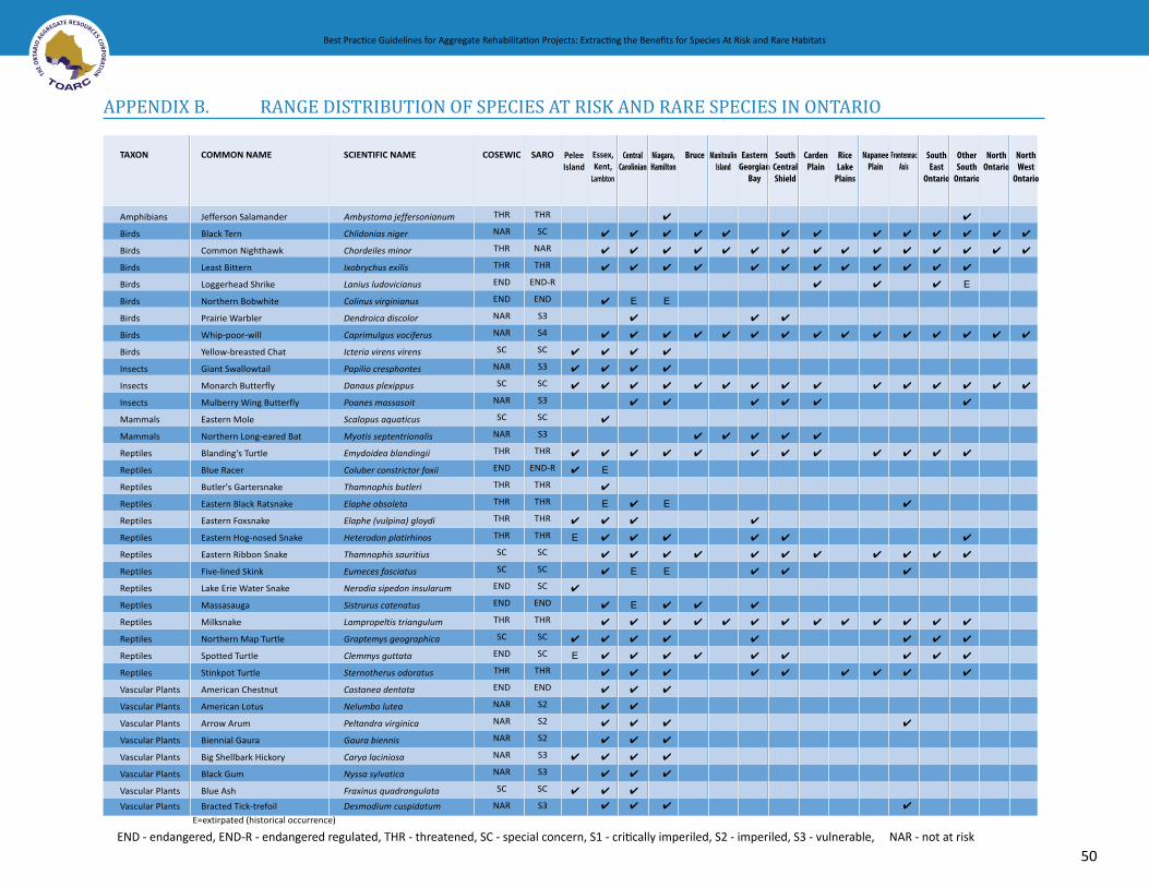
NorthOntario
?
?
?
?
CardenPlain
?
?
?
?
?
?
?
?
?
?
?
ManiIsland
toulin
?
?
?
?
?
?
OtherSouth
Ontario
?
?
?
?
E
?
?
?
?
?
?
?
?
?
?
RiceLake
Plains
?
?
?
?
?
NapaneePlain
?
?
?
?
?
?
?
?
?
?
NorthWest
Ontario
?
?
?
?
Bruce
?
?
?
?
?
?
?
?
?
?
?
FrontAxis
ennac
?
?
?
?
?
?
?
?
?
?
?
?
?
?
?
COSEWIC
THR
NAR
THR
THR
END
END
NAR
NAR
SC
NAR
SC
NAR
SC
NAR
THR
END
THR
THR
THR
THR
SC
SC
END
END
THR
SC
END
THR
END
NAR
NAR
NAR
NAR
NAR
SC
NAR
PeleeIsland
?
?
?
?
?
?
E
?
?
E
?
?
?
?
?
?
?
?
?
?
?
?
E
?
E
?
?
?
?
?
?
?
?
?
?
?
?
?
?
?
?
?
CentralCarolinian
?
?
?
E
?
?
?
?
?
?
?
?
?
?
?
E
E
?
?
?
?
?
?
?
?
?
?
?
?
Niagara,Hamilton
?
?
?
?
E
?
?
?
?
?
?
E
?
?
E
?
?
?
?
?
?
?
?
?
?
?
SouthEast
Ontario
?
?
?
?
?
?
?
?
?
?
?
TAXON
Amphibians
Birds
Birds
Birds
Birds
Birds
Birds
Birds
Birds
Insects
Insects
Insects
Mammals
Mammals
Reptiles
Reptiles
Reptiles
Reptiles
Reptiles
Reptiles
Reptiles
Reptiles
Reptiles
Reptiles
Reptiles
Reptiles
Reptiles
Reptiles
Vascular Plants
Vascular Plants
Vascular Plants
Vascular Plants
Vascular Plants
Vascular Plants
Vascular Plants
Vascular Plants
SCIENTIFIC NAME
Ambystoma jeffersonianum
Chlidonias niger
Chordeiles minor
Ixobrychus exilis
Lanius ludovicianus
Colinus virginianus
Dendroica discolor
Caprimulgus vociferus
Icteria virens virens
Papilio cresphontes
Danaus plexippus
Poanes massasoit
Scalopus aquaticus
Myotis septentrionalis
Emydoidea blandingii
Coluber constrictor foxii
Thamnophis butleri
Elaphe obsoleta
Elaphe (vulpina) gloydi
Heterodon platirhinos
Thamnophis sauritius
Eumeces fasciatus
Nerodia sipedon insularum
Sistrurus catenatus
Lampropeltis triangulum
Graptemys geographica
Clemmys guttata
Sternotherus odoratus
Castanea dentata
Nelumbo lutea
Peltandra virginica
Gaura biennis
Carya laciniosa
Nyssa sylvatica
Fraxinus quadrangulata
Desmodium cuspidatum
SARO
THR
SC
NAR
THR
END-R
END
S3
S4
SC
S3
SC
S3
SC
S3
THR
END-R
THR
THR
THR
THR
SC
SC
SC
END
THR
SC
SC
THR
END
S2
S2
S2
S3
S3
SC
S3
EasternGeorgian
Bay
?
?
?
?
?
?
?
?
?
?
?
?
?
?
?
?
?
SouthCentralShield
?
?
?
?
?
?
?
?
?
?
?
?
?
?
?
COMMON NAME
Jefferson Salamander
Black Tern
Common Nighthawk
Least Bittern
Loggerhead Shrike
Northern Bobwhite
Prairie Warbler
Whip-poor-will
Yellow-breasted Chat
Giant Swallowtail
Monarch Butterfly
Mulberry Wing Butterfly
Eastern Mole
Northern Long-eared Bat
Blanding's Turtle
Blue Racer
Butler's Gartersnake
Eastern Black Ratsnake
Eastern Foxsnake
Eastern Hog-nosed Snake
Eastern Ribbon Snake
Five-lined Skink
Lake Erie Water Snake
Massasauga
Milksnake
Northern Map Turtle
Spotted Turtle
Stinkpot Turtle
American Chestnut
American Lotus
Arrow Arum
Biennial Gaura
Big Shellbark Hickory
Black Gum
Blue Ash
Bracted Tick-trefoil
E=extirpated (historical occurrence)
Essex,Kent,
Lambton
Best Practice Guidelines for Aggregate Rehabilitation Projects: Extracting the Benefits for Species At Risk and Rare Habitats
APPENDIX B. RANGE DISTRIBUTION OF SPECIES AT RISK AND RARE SPECIES IN ONTARIO
END - endangered, END-R - endangered regulated, THR - threatened, SC - special concern, S1 - critically imperiled, S2 - imperiled, S3 - vulnerable, NAR - not at risk
50

Best Practice Guidelines for Aggregate Rehabilitation Projects: Extracting the Benefits for Species At Risk and Rare Habitats
RANGE DISTRIBUTION OF SPECIES AT RISK AND RARE SPECIES IN ONTARIO
END - endangered, END-R - endangered regulated, THR - threatened, SC - special concern, S1 - critically imperiled, S2 - imperiled, S3 - vulnerable, NAR - not at risk
?
?
?
?
?
?
?
?
?
?
?
?
?
?
?
?
?
?
?
?
?
?
?
?
?
?
?
?
?
?
?
?
?
?
?
?
?
?
?
?
NAR
NAR
END
NAR
SC
THR
END
NAR
THR
THR
THR
END
NAR
NAR
NAR
NAR
NAR
NAR
NAR
NAR
NAR
NAR
NAR
NAR
THR
NAR
SC
END
THR
THR
NAR
NAR
NAR
NAR
NAR
NAR
?
?
?
?
?
?
?
?
?
?
?
?
?
?
?
?
?
?
E
?
?
?
?
?
?
?
?
?
?
?
?
?
?
?
?
?
?
?
?
?
?
?
?
?
?
?
?
?
?
?
?
?
?
?
?
?
?
?
?
?
?
?
?
?
?
?
?
?
?
?
?
?
?
?
?
?
?
?
?
?
?
?
?
?
?
?
Vascular Plants
Vascular Plants
Vascular Plants
Vascular Plants
Vascular Plants
Vascular Plants
Vascular Plants
Vascular Plants
Vascular Plants
Vascular Plants
Vascular Plants
Vascular Plants
Vascular Plants
Vascular Plants
Vascular Plants
Vascular Plants
Vascular Plants
Vascular Plants
Vascular Plants
Vascular Plants
Vascular Plants
Vascular Plants
Vascular Plants
Vascular Plants
Vascular Plants
Vascular Plants
Vascular Plants
Vascular Plants
Vascular Plants
Vascular Plants
Vascular Plants
Vascular Plants
Vascular Plants
Vascular Plants
Vascular Plants
Vascular Plants
Lithospermum latifolium
Euonymus atropurpurea
Juglans cinerea
Draba reptans
Rosa setigera
Ptelea trifoliata
Magnolia acuminate
Liatris cylindracea
Liatris spicata
Celtis tenuifolia
Iris lacustris
Cornus florida
Lupinus perrenis
Aureolaria pedicularia
Carex folliculata
Panicum gattingeri
Vernonia gigantea
Alisma gramineum
Linum sulcatum
Gallium pilosum
Carex trichocarpa
Lechea villosa
Polygonum arifolium
Quercus ellipsoidalis
Cirsium hillii
Lithospermum canescens
Solidago houghtonii
Gymnocladus dioicus
Hymenoxys herbacea
Ammophila brevigulata
Pycnanthemum tenuifolia
Tradescantia ohioensis
Monarda didyma
Sporobolis ozarkana
Aximina triloba
Carya ovalis
S3
S3
END
S2
SC
THR
END-R
S3
THR
THR
THR
S2
S3
S3
S3
S3
S3
S3S4
S3
S3
S3
S3
S3
S3
THR
S3
SC
END-R
THR
THR
S3
S3
S2
S3
S2
S3
?
?
Broad-leaved Puccoon
Burning Bush
Butternut
Carolina Whitlow-Grass
Climbing Prairie Rose
Common Hoptree
Cucumber Tree
Cylindrical Blazing Star
Dense Blazing Star
Dwarf Hackberry
Dwarf Lake Iris
Eastern Flowering Dogwood
Eastern Lupine
Fernleaf Yellow False-Foxglove
Follicle Sedge
Gattinger's Panic Grass
Giant Ironweed
Grass-leaved Mud-plantain
Grooved Yellow Flax
Hairy Bedstraw
Hairy Lake Sedge
Hairy Pinweed
Halberd-leaved Tearthumb
Hill's Oak
Hill's Thistle
Hoary Puccoon
Houghton's Goldenrod
Kentucky Coffee-tree
Lakeside Daisy
Merram Beach Grass
Narrow-leaved Mountain Mint
Ohio Spiderwort
Oswego Tea
Ozark Dropseed
Pawpaw
Pignut Hickory
?
?
E=extirpated (historical occurrence)
NorthOntario
CardenPlain
ManiIsland
toulin OtherSouth
Ontario
RiceLake
Plains
NapaneePlain
NorthWest
Ontario
Bruce FrontAxis
ennacCOSEWIC PeleeIsland
CentralCarolinian
Niagara,Hamilton
SouthEast
Ontario
TAXON SCIENTIFIC NAME SARO EasternGeorgian
Bay
SouthCentralShield
COMMON NAME Essex,Kent,
Lambton
51

Best Practice Guidelines for Aggregate Rehabilitation Projects: Extracting the Benefits for Species At Risk and Rare Habitats
52END - endangered, END-R - endangered regulated, THR - threatened, SC - special concern, S1 - critically imperiled, S2 - imperiled, S3 - vulnerable, NAR - not at risk
RANGE DISTRIBUTION OF SPECIES AT RISK AND RARE SPECIES IN ONTARIO
?
?
?
?
?
END
NAR
NAR
NAR
?
?
?
?
?
?
?
?
?
?
Vascular Plants
Vascular Plants
Vascular Plants
Vascular Plants
Ranunculus rhomboideus
Sporobolis heterolepis
Fraxinus profunda
Eupatorium purpureum
END
S3
S2
S2
Prairie Buttercup
Prairie Dropseed
Pumpkin Ash
Purple Joe Pye Weed
NAR ? ? ?Vascular Plants Quercus palustris S3Pin Oak
???
?NAR
NAR
Vascular Plants
Vascular Plants
Pinus rigida
Cirsium pitcheri
S3
S2S3
Pitch Pine
Pitcher's Thistle
?
? ?
?
?
?
?
? ?
?
?
?
?
?
?
?
?
?
NAR
NAR
NAR
NAR
THR
NAR
NAR
NAR
NAR
NAR
NAR
NAR
NAR
NAR
NAR
NAR
NAR
NAR
NAR
SC
NAR
NAR
SC
NAR
NAR
THR
NAR
?
?
?
?
?
?
?
?
?
?
?
?
?
?
?
?
?
?
?
?
?
?
?
?
?
?
?
?
?
?
?
?
?
?
?
?
?
?
?
?
?
?
?
?
?
?
?
?
?
?
?
?
?
?
?
?
?
?
?
?
? ?
Vascular Plants
Vascular Plants
Vascular Plants
Vascular Plants
Vascular Plants
Vascular Plants
Vascular Plants
Vascular Plants
Vascular Plants
Vascular Plants
Vascular Plants
Vascular Plants
Vascular Plants
Vascular Plants
Vascular Plants
Vascular Plants
Vascular Plants
Vascular Plants
Vascular Plants
Vascular Plants
Vascular Plants
Vascular Plants
Vascular Plants
Vascular Plants
Vascular Plants
Vascular Plants
Vascular Plants
Vascular Plants
Solidago simplex var. randii
Cyperus erythrorhizos
Liatris aspera
Smilax rotundifolia
Desmodium rotundifolium
Cyperus schweinitzii
Carex schweinitzii
Rhus copallina
Hypericum prolificum
Quercus shumardii
Bouteloua curtipendula
Linum medium
Agrimonia parviflora
Aureolaria flava
Bidens coronata
Nuphar advena
Geum vernum
Solidago rigida
Asclepias sullivantii
Hibiscus moscheutos
Coreopsis tripteris
Campsis radicans
Arnoglossum plantagineum
Triadenum virginicum
Asclepias verticillata
Symphyotrichum praealtum
Lythrum alatum
Xyris difformis NAR
S3
S3
S3
S2
THR
S2
S3
S3
S3S4
S2
S2
S3
S3S4
S3
S2
S3
S3
S3
S2
SC
S2
S2
SC
S3
S2
THR
S3
S3
?
?
?
?
Rand's Goldenrod
Red-rooted Umbrella Sedge
Rough Blazing Star
Round-leaved Greenbrier
Round-leaved Tick-trefoil
Schweinitz's Umbrella Sedge
Schweintitz's Sedge
Shining Sumac
Shrubby St. Johnswort
Shumard Oak
Side-oats Grama
Small Yellow Flax
Small-flowered Agrimony
Smooth Yellow False-Foxglove
Southern Tickseed
Spatterdock
Spring Avens
Stiff Goldenrod
Sullivant’s Milkweed
Swamp Rose-mallow
Tall Coreopsis
Trumpetvine
Tuberous Indian-plantain
Virginia Marsh St. Johnswort
Whorled Milkweed
Willowleaf Aster
Winged Loosestrife
Yellow-eyed Grass
E=extirpated (historical occurrence)
?
?
?
NorthOntario
CardenPlain
ManiIsland
toulin OtherSouth
Ontario
RiceLake
Plains
NapaneePlain
NorthWest
Ontario
Bruce FrontAxis
ennacCOSEWIC PeleeIsland
CentralCarolinian
Niagara,Hamilton
SouthEast
Ontario
TAXON SCIENTIFIC NAME SARO EasternGeorgian
Bay
SouthCentralShield
COMMON NAME Essex,Kent,
Lambton

Best Practice Guidelines for Aggregate Rehabilitation Projects: Extracting the Benefits for Species At Risk and Rare Habitats
53
Best Practice Guidelines for Aggregate Rehabilitation Projects: Extracting the Benefits for Species At Risk and Rare Habitats
APPENDIX C. PROFILES OF SELECT SPECIES AT RISK
Figure 24 Fern Leaf Yellow False Foxglove (Photo Credit: Jane Bowles)
Figure 25 Canadian Tiger Swallowtail, while not rare, is a beautiful species that benefits from the rehabilitation of rare habitats, prairies and forests and is an indicator of ecosystem health (Photo Credit: David Beamer)

54
Best Practice Guidelines for Aggregate Rehabilitation Projects: Extracting the Benefits for Species At Risk and Rare Habitats Best Practice Guidelines for Aggregate Rehabilitation Projects: Extracting the Benefits for Species At Risk and Rare Habitats
Blanding’s TurtleEmydoidea blandingii Federal Status: Threatened Provincial Status: Threatened
Photo Credit: Rob Tervo, MNR
Description
Blanding’s Turtle is a medium sized turtle (carapace 13 - 20 cm long) with yellow flecks on the shell and a distinctive bright yellow chin and neck. The rear portion of the plastron (lower shell) is hinged on so it can close tightly. The carapace has a high dome shape.
Habitat
Blanding’s Turtle is essentially aquatic, but it does occur in a variety of wetland types such as ponds marshes, thicket swamp, treed swamp and sometimes in gravel pit or quarry ponds. Turtles often spend long hours sunning from favourite log in spring and autumn. They sometimes wander overland between wetlands, especially if the pond dries up. This turtle hibernates in mud at the bottom of ponds and wetlands. Females lay eggs in open areas away from water such as sandbars, or old fields where it can dig. It feeds on avariety of plant and animal matter.
Distribution
Widespread in much of southern Ontario including southern portions of the Canadian Shield
Threats
Habitat Loss or DegradationAccidental Mortality – females very susceptible to road mortality during egg laying seasonDisturbance or Persecution – predation of nests and females by subsidized predators
Stewardship Opportunities
Habitat Improvement• Create and maintain ponds with sloping marsh
shoreline or surrounding thicket swamp, • Mud bottoms in shallow water can provide suitable
hibernation habitat,• Provide sunning logs or rocks out from shoreline,• Open sandy areas around ponds can provide suitable
egg-laying sites.
Comments
Blanding’s Turtle sometimes occurs in ponds in quarries and gravel pits and therefore should be a fairly easy species to target if there are nearby wetlands already supporting a population. It is widespread in southern Ontario and occurs in a habitat that is relatively simple to create in below water gravel pits.
Source: Canadian Wildlife Service, 2004

Best Practice Guidelines for Aggregate Rehabilitation Projects: Extracting the Benefits for Species At Risk and Rare Habitats
55
Best Practice Guidelines for Aggregate Rehabilitation Projects: Extracting the Benefits for Species At Risk and Rare Habitats
Butler’s GartersnakeThamophis butleri Federal Status: Threatened Provincial Status: Threatened
Photo Credit: James Kamstra
Description
Butler’s Gartersnake has three yellow, or orange-yellow stripes running down the length of its body between broader black, brown or dark olive dorsal stripes. Often a small yellow spot is present on front of the eye or on top of the head. It is very similar in appearance to the familiar Eastern Gartersnake except that it has a proportionately smaller head and shorter neck. In addition the lateral yellow stripe of Butler’s is on scale row 3 and partly on rows 2 and 4, while the Eastern Gartersnake’s lateral stripe is on scale rows 2 and 3. Butler’s Gartersnake makes an ‘exaggerated’ side to side wriggling movement, compared to other snakes.
Habitat
Butler’s Gartersnake occur in open habitats with few trees. It likely originally occurred in tallgrass prairie and savannahbut currently also occurs in old fields and even vacant lots within urban areas in its limited range. It often occurs in close proximity to wetlands. Butler’s Gartersnake frequently hides beneath cover in the form of rocks, wood or even garbage. They can persist within relatively small patches of habitat. During the winter, this species hibernates underground, often communally.
Distribution
Butler’s Gartersnake has a very limited distribution in southern Ontario, chiefly in the vicinity of the the St. Clair and Detroit Rivers. Isolated populations have also been found at Luther Lake and on the Bothwell Sand Plain. This species has a limited global range, occurring only in parts of Michigan, Ohio, Indiana and Wisconsin.
Threats
Habitat Loss or DegradationAccidental MortalityDisturbance or Persecution
Stewardship Opportunities
Habitat Improvement• Create or restore tallgrass prairie or old field habitat,• Provide cover in the form of wood or rock piles,• Maintain open sunny conditions if vegetation becomes
too shaded by trees and shrubs,• Construct artificial snake hibernacula.
Comments
Butler’s Gartersnake is a good candidate as a target species within its limited range since it can occur in rather degraded old field habitat and has a small home range. It currently occurs in some former aggregate sites in extreme southwestern Ontario.
Source: Canadian Wildlife Service, 2004

56
Best Practice Guidelines for Aggregate Rehabilitation Projects: Extracting the Benefits for Species At Risk and Rare Habitats Best Practice Guidelines for Aggregate Rehabilitation Projects: Extracting the Benefits for Species At Risk and Rare Habitats
ButternutJuglans cinerea Federal Status: Endangered Provincial Status: Endangered
Photo Credit: James Kamstra
Description
Butternut is a small to medium-sized deciduous tree with compound leaves that are made up of 11 to 17 leaflets. The nut contains a single seed and measures about 4 to 6 cm in length. The nut is edible and has a shell with jagged ridges that is in turn coverd by a green and hairy husk. The butternut flowers from April to June and the male flowers are thick green catkins while the female flowers are shorter and wind-pollinated.
Habitat
Butternut grows best in rich, moist, and well-drained soils that are often found near streams, but it is also found on gravel sites and, in particular, limestone.
Distribution
In Canada, Butternut is relatively widespread and is found in southern Quebec, New Brunswick, and Ontario.
Threats
Habitat Loss or Degradation
Changes in Ecological Dyanamics or Natural Processes - butternut canker is the most serious and widespread threat to this species. It is easily recognised by dieback in the sunlit portion of the crown and elongated sunken branch and stem cankers which in spring exude a black fluid. The canker is associated with a very high mortality rate.
Stewardship Opportunities
Habitat Stewardship • Plant butternuts using seeds from healthier trees;
avoid trees that may be hybrids, • Use locally adapted seeds and ensure that habitat
conditions are suitable, • Conduct follow-up care including watering and ensure
appropriate monitoring and reporting to recovery team.
Comments
Butternut could be considered a target species for restoration through planting, which can help to maintain local populations on the landscape. However, heavy early losses are likely to occur from the Butternut canker fungus. It should only be planted from seeds of locally adapted healthier trees, and only on sites where it can grow vigorously with few other stresses (drought, shading).
Source: Canadian Wildlife Service, 2004

Best Practice Guidelines for Aggregate Rehabilitation Projects: Extracting the Benefits for Species At Risk and Rare Habitats
57
Best Practice Guidelines for Aggregate Rehabilitation Projects: Extracting the Benefits for Species At Risk and Rare Habitats
Climbing Prairie RoseRosa setigera Federal Status: Special Concern Provincial Status: Special Concern
Photo Credit: Allen Woodliffe
Description
The Climbing Prairie Rose is a shrub with arching or climbing branches that can be several meters long. Bright pink flowers are produced in late June to mid-July. Leaves are divided into three leaflets on flowering branches or into three or five leaflets on non-flowering branches or young plants. The fruit is a hip (typical of roses), spherical and reddish-orange.
Habitat
The Climbing Prairie Rose colonizes open habitats such as abandoned agricultural fields or unoccupied urban land. It appears to prefer sites with heavy soils but is occasionally found on sandy or shallow soils that dry out during part of the growing season.
Distribution
In Canada, the Climbing Prairie Rose occurs only in the western portion of the Carolinian zone, primarily in Essex and Kent counties, and on Walpole Island. There is a disjunct historic record from Prince Edward county.
Threats
Habitat Loss or DegradationExotic or Invasive SpeciesChanges in Ecological Dynamics
Stewardship Opportunities
Habitat Improvement• Create or restore and maintain old field, thicket and
savannah habitat • Transplant Climbing Prairie Rose into appropriate
habitats with support of Recovery Team.
Comments
Climbing Prairie Rose is probably one of the easiest species at risk to target for restoration because it is an early successional species that colonizes open and disturbed habitats that can be easily created and maintained on former aggregate sites. Plants can be grown from seed or cuttings. It should only be restored from seeds or cuttings from locally indigenous stock, and only within its limited range. This is a good candidate for tallgrass prairie or savannah restoration.
Canadian Wildlife Service, 2004

58
Best Practice Guidelines for Aggregate Rehabilitation Projects: Extracting the Benefits for Species At Risk and Rare Habitats Best Practice Guidelines for Aggregate Rehabilitation Projects: Extracting the Benefits for Species At Risk and Rare Habitats
Common Nighthawk Chordeiles minor Federal Status: Threatened Provincial Status: Not At Risk
Photo Credit: Jim Richards
Description
The Common Nighthawk is a medium sized bird, with long pointed wings that are held angled and raised. The species has quite a large, flattened head, large eyes and a large mouth, and a small bill. The adult is usually dark brown, with some black and white under the wings and buff-coloured bars on the underparts.
Habitat
Common Nighthawks are typically found in open habitats such as sand dunes, beaches, recently cleared areas, shortgrass prairies, pastures, marshes, lakeshores, gravel roads, rock barrens and outcrops, and quarries.
Distribution
The Canadian population of Common Nighthawk has been documented as breeding in all of the provinces and territories, except Nunavut. In Ontario, the species is found throughout the province except for the coastal regions of James Bay and Hudson Bay.
Threats
Habitat Loss or Degradation Changes in Ecological Dyanmics or Natural Processes Exotic or Invasive Species Accidental Mortality
Stewardship Opportunities
Habitat Stewardship • Prescribed burns of prairie habitat.
Habitat Improvement • Create and Restore habitats in correct range in Ontario.
Comments
Common Nighthawk is a good candidate for restoration work on aggregate sites because it occurs in a relatively wide range, and is known to occupy quarries.
Breeding Records in Ontario for Common Nighthawk (Environment Canada, 2007)
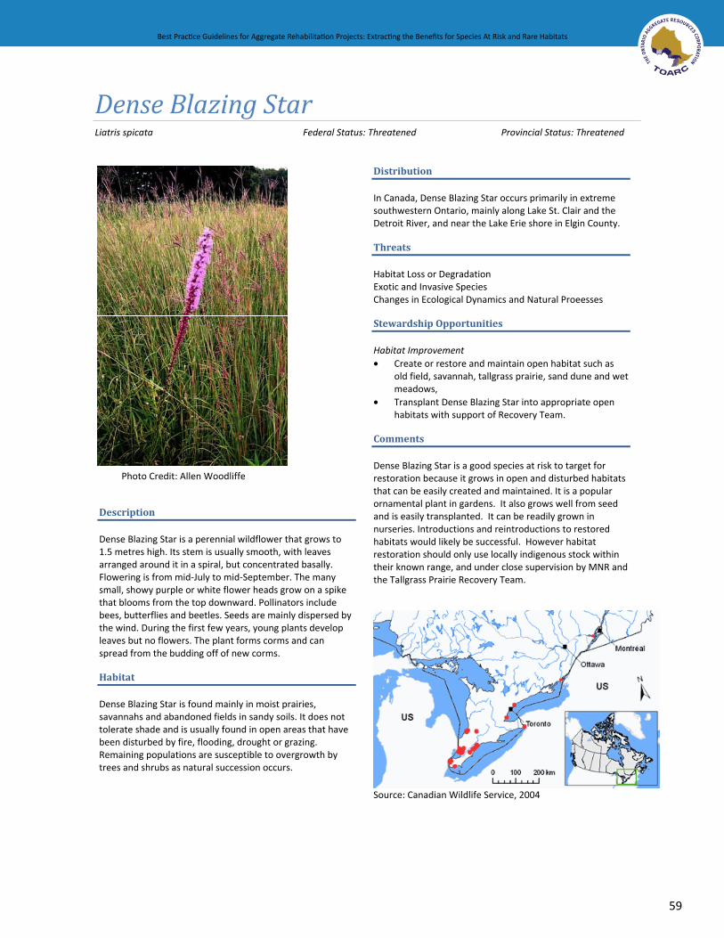
Best Practice Guidelines for Aggregate Rehabilitation Projects: Extracting the Benefits for Species At Risk and Rare Habitats
59
Best Practice Guidelines for Aggregate Rehabilitation Projects: Extracting the Benefits for Species At Risk and Rare Habitats
Dense Blazing Star Liatris spicata Federal Status: Threatened Provincial Status: Threatened
Photo Credit: Allen Woodliffe
Description
Dense Blazing Star is a perennial wildflower that grows to 1.5 metres high. Its stem is usually smooth, with leaves arranged around it in a spiral, but concentrated basally. Flowering is from mid-July to mid-September. The many small, showy purple or white flower heads grow on a spike that blooms from the top downward. Pollinators include bees, butterflies and beetles. Seeds are mainly dispersed by the wind. During the first few years, young plants develop leaves but no flowers. The plant forms corms and can spread from the budding off of new corms.
Habitat
Dense Blazing Star is found mainly in moist prairies, savannahs and abandoned fields in sandy soils. It does not tolerate shade and is usually found in open areas that have been disturbed by fire, flooding, drought or grazing. Remaining populations are susceptible to overgrowth by trees and shrubs as natural succession occurs.
Distribution
In Canada, Dense Blazing Star occurs primarily in extreme southwestern Ontario, mainly along Lake St. Clair and the Detroit River, and near the Lake Erie shore in Elgin County.
Threats
Habitat Loss or Degradation Exotic and Invasive Species Changes in Ecological Dynamics and Natural Proeesses
Stewardship Opportunities
Habitat Improvement • Create or restore and maintain open habitat such as
old field, savannah, tallgrass prairie, sand dune and wet meadows,
• Transplant Dense Blazing Star into appropriate open habitats with support of Recovery Team.
Comments
Dense Blazing Star is a good species at risk to target for restoration because it grows in open and disturbed habitats that can be easily created and maintained. It is a popular ornamental plant in gardens. It also grows well from seed and is easily transplanted. It can be readily grown in nurseries. Introductions and reintroductions to restored habitats would likely be successful. However habitat restoration should only use locally indigenous stock within their known range, and under close supervision by MNR and the Tallgrass Prairie Recovery Team.
Source: Canadian Wildlife Service, 2004

60
Best Practice Guidelines for Aggregate Rehabilitation Projects: Extracting the Benefits for Species At Risk and Rare Habitats Best Practice Guidelines for Aggregate Rehabilitation Projects: Extracting the Benefits for Species At Risk and Rare Habitats
Dwarf Hackberry Celtis tenuifolia Federal Status: Threatened Provincial Status: Threatened
Photo Credit: Allen Woodliffe
Description
Dwarf Hackberry is a small shrub that usually grows 1 to 4 m high but can reach up to 10 m. The bark is smooth grey but becomes ridged and knotted as the plant ages. The leaves are stiff and leathery, have three distinct veins and the edges of the leaf are toothed. The leaves are similar to the Common Hackberry tree but the shorter and proportionately broader. The edible fruit of the Dwarf Hackberry is round, orange-brown coloured, and contains a single seed. The fruit often remains on the shrub throughout the winter.
Habitat
Dwarf Hackberry grows in open woodlands in dry sandy soils often near lakeshores and on sand dunes. It also occurs on droughty soils over limestone bedrock near open woodlands. Dwarf Hackberry is sun-loving and drought-tolerant. It prefers disturbed sites and will gradually disappear from areas where it becomes shaded out.
Distribution
In Canada, Dwarf Hackberry is scattered in small populations in the Great Lakes region. It occurs on Point Pelee, Pelee Island, the southeast shore of Lake Huron and on the Napanee limestone Plain in southeastern Ontario.
Threats
Habitat Loss or DegradationChanges in Ecological Dyanamics or Natural Processes
Stewardship Opportunities
Habitat Improvement • Create or restore and maintain old field, thicket and
savannah habitat and prevent vegetation from overgrowing and shading out Dwarf Hackberry.
Comments
Dwarf Hackberry is good target species for restoration because it is thrives in open disturbed sites, such as old fields, that can be easily created and maintained. It can be propagated from seeds or cuttings but most Ontario populations are extremely small. It should only be restored from seeds or cuttings from locally indigenous stock, and only within its limited range. This is a good candidate for tallgrass savannah or alvar restoration.
Source: Canadian Wildlife Service, 2004

Best Practice Guidelines for Aggregate Rehabilitation Projects: Extracting the Benefits for Species At Risk and Rare Habitats
61
Best Practice Guidelines for Aggregate Rehabilitation Projects: Extracting the Benefits for Species At Risk and Rare Habitats
Dwarf Lake IrisIris lacustris Federal Status: Threatened Provincial Status: Threatened
Photo Credit: Doug Sweiger, CWS
Description
Dwarf Lake Iris is a wildflower with showy deep blue-purple flowers. The flowers are about 3-5 cm in width and each appears separately at the end of a short stem. They flower in late May to mid June. Dwarf Lake Iris lies close to the ground and seldom grows taller than 10 cm though the strap like leaves can be up to 18cm long. Although flowers are usually blue, lilac or white flowers are sometimes found.
Habitat
Dwarf Lake Iris occurs close to Great Lakes shorelines on sand or in thin soil over limestone-rich gravel or bedrock. It prefers open or semi-shaded areas and grows in cedar swamps, in clearings on forested sand dunes, and in alvars. Changing water levels can open new habitat for the plants.
Distribution
The Dwarf Lake Iris is endemic to the Great Lakes shorelines, primarily on Lakes Huron and Michigan. In Canada, it is found primarily on the Bruce Peninsula and Manitoulin Island.
Threats
Habitat Loss or Degradation due ot shoreline developmentDisturbance or Persecution – removal from the wild and transplanted to gardens
Stewardship Opportunities
Habitat Improvement• Protect and restore alvar habitat particularly near
natural shorelines,• Maintain habitat and woodland cover where Dwarf
Lake Iris is found as thinning trees can create unsuitable conditions,
• May be some opportunities to restore alvar habitat and introduce Dwarf Lake Iris through seeding.
Comments
Dwarf Lake Iris grows in open, semi-shaded areas and can be protected in conjunction with alvar ecosystems. If there are former quarries relatively near shorelines within their range, these could be restored to alvar habitat where propagation may be feasible.
Source: Canadian Wildlife Service, 2004

62
Best Practice Guidelines for Aggregate Rehabilitation Projects: Extracting the Benefits for Species At Risk and Rare Habitats Best Practice Guidelines for Aggregate Rehabilitation Projects: Extracting the Benefits for Species At Risk and Rare Habitats
Eastern Ribbonsnake – Great Lakes PopulationThamnophis sauritus Federal Status: Special Concern Provincial Status: Special Concern
Photo Credit: Allen Woodliffe
Description
The Eastern Ribbonsnake is a slim snake with three bright yellow, stripes running down the length of its body, which stand out against the dark brown or black background. The chin and throat are white to light tan coloured and the belly is pale. A chestnut stripe is on the sides of the belly . The Eastern Ribbonsnake closely resembles the more common Eastern Garter Snake in both colour and size but is more slender with a longer tails. The clear markings are more consistent than in the highly variable Eastern Garter Snake.
Habitat
The Eastern Ribbonsnake is semi-aquatic and most frequently found along the edges of shallow ponds, streams, marshes, swamps, or bogs bordered by dense vegetation. Abundant exposure to sunlight is also required and they also frequent meadows adjacent to wetlands. Adjacent upland areas may be used for nesting. They feed primarily on amphibians, particularly frogs. During the winter, Eastern Ribbonsnakes hibernate in rock crevices or animal burrows.
Distribution
Eastern Ribbon Snake is widespread in southern Ontario and locally fairly common in some areas such as the Bruce Peninsula, the eastern part of the Carolinian zone and along the southern fringe of the Canadian Shield.
Threats
Habitat Loss or Degradation Accidental Mortality Disturbance or Persecution
Stewardship Opportunities
Habitat Improvement • Restore and protect suitable wetland habitat (marsh,
swamp, bog), • Provide and maintain vegetated cover around wet-
lands,• Restore open upland habitat such as cultural meadow
or prairie in close proximity to wetlands, • Construct artificial snake hibernacula.
Comments
Because Eastern Ribbonsnake is widespread and occurs in habitats such as marsh and old field that are fairly easy to restore on aggregate sites, this is a species to target.
Source: Canadian Wildlife Service, 2004

Best Practice Guidelines for Aggregate Rehabilitation Projects: Extracting the Benefits for Species At Risk and Rare Habitats
63
Best Practice Guidelines for Aggregate Rehabilitation Projects: Extracting the Benefits for Species At Risk and Rare Habitats
Lakeside DaisyHymenoxys herbacea Federal Status: Threatened Provincial Status: Threatened
Photo Credit: Chris Zoladeski
Description
Lakeside Daisy is a low perennial herb that grows 8 to 10 cm in height. It is characterized by one or more leafy rosettes (a round cluster of leaves) that grow from a dense tuft at the bottom of the plant. It has narrow, dark green fleshy leaves. The leaves become moderately hairy as the plant matures. It produces a single bright yellow daisy-like flower at the end of a short stalk in early spring. Flower heads are approximately 2 cm wide, with yellow petals that bend downward at maturity.
Habitat
Lakeside Daisy grows in limestone cracks, or on tufts of low growing vegetation such as mosses. It is primarily found in alvars, particularly near shoreline of Lake Huron, on areas with sparse vegetation growing on a thin layer of soil over limestone or dolomite bedrock. Alvars are typically wet in spring and fall and dry in summer.
Distribution
The Lakeside Daisy is endemic to the Great Lakes shorelines, primarily on Lakes Huron and Michigan. In Canada, it is found only on the Bruce Peninsula and Manitoulin Island where it is known from approximately 40 locations.
Threats
Habitat Loss (e.g. shoreline development) or Degradation (e.g. trampling)Disturbance or Persecution (e.g. removal from wild to be transplanted to gardens)
Stewardship Opportunities
Habitat Improvement• Protect and restore alvar habitat particularly near
natural shorelines,• May be some opportunities to restore alvar habitat
and introduce Lakeside Daisy through seeding,• Enhance habitat by limiting vegetation succession (e.g.
by thinning large shading plants).
Comments
Lakeside Daisy grows primarily on shoreline alvars. If there are former quarries relatively near shorelines within their range, these could be restored to alvar habitat where propagation may be feasible. Thus, Lakeside Daisy is a good species at risk target for restoration because protecting its rare alvar habitat will benefit many other rare species as well.
Canadian Wildlife Service, 2004

64
Best Practice Guidelines for Aggregate Rehabilitation Projects: Extracting the Benefits for Species At Risk and Rare Habitats Best Practice Guidelines for Aggregate Rehabilitation Projects: Extracting the Benefits for Species At Risk and Rare Habitats
Least Bittern Ixobrychus exilis Federal Status: Threatened Provincial Status: Threatened
Photo Credit: Benoit Jobin, CWS
Description
The Least Bittern is a relatively small, brown bird belonging to the heron family that blends in well with the surrounding marsh vegetation where it is typically found. The adult male's underparts and the sides of its head and neck are a light yellow, the back of its neck is light brown; and the top of the head, the back and the tail are brownish-black. Its throat is whitish and the yellow bill has a dark ridge. The dark feathers are lighter on the adult females and even lighter on the juveniles.
Habitat
Least Bitttern are typically found in marshes with dense, tall vegetation, typically cattails, interspersed with open water. Marsh edges that are located immediately adjacent to open water are important for feeding.
Distribution
The Canadian population of Least Bittern has been documented in all of the provinces, except Prince Edward Island. Breeding occurs from southwest Manitoba to southwest New Brunswick, including southern Ontario.
Threats
Habitat Loss or Degradation Exotic or Invasive Species Pollution Accidental Mortality Disturbance or Persecution
Stewardship Opportunities
Habitat Protection • Surveys, Monitoring and Research, • Development and Implementation of Habitat
Management Plans.
Habitat Improvement • Create and Restore marshes in correct range in Ontario
(i.e. southern Ontario).
Comments
Least Bittern is a good candidate for restoration work on aggregate sites because it is relativelywide ranging.
Canadian Wildlife Service, 2004

Best Practice Guidelines for Aggregate Rehabilitation Projects: Extracting the Benefits for Species At Risk and Rare Habitats
65
Best Practice Guidelines for Aggregate Rehabilitation Projects: Extracting the Benefits for Species At Risk and Rare Habitats
Loggerhead Shrike Lanius ludovicianus migrans Federal Status: Endangered Provincial Status: Endangered
Photo Credit: Larry Kirtley
Description
The Loggerhead Shrike is a little smaller than a robin and is distinguished bya Zorro-like black face mask with a blue-grey head and back and a gray-white breast. The species has a black tail and black wings, all have prominent white flecks. The Northern Shrike (Lanius excupitor) is very similar, but is differentiated by its slightly larger size, paler colour, faint breast barring and the black mask does not extend over the top of the bill. The Northern Shrike is only present in southern Ontario in the winter, while the Loggerhead migrates southward at that time of year.
Habitat
Loggerhead Shrike occupies plains and grasslands with short vegetation and sparse scattered trees and shrubs. Today the species is found in remaining open grassland, pastureland and old fields with scattered shrubs. Preferred nesting shrubs include hawthorn, red cedar and spruce. They eat insects, preferring grasshoppers, crickets, dragonflies and beetles. They are even known to occasionally capture and eat snakes, mice, voles, and small birds. To capture prey, the Loggerhead Shrike dives low to the ground and deliver a quick blow with its strong hooked beak. A tell tale sign that a Loggerhead Shrike is present in the neighbourhood is if you see one of its prey stored on a thorn or barbed wire to eat later.
Distribution
Loggerhead Shrike is found in Manitoba, Ontario and Quebec. In Ontario, Loggerhead Shrikes now mainly inhabit the Napanee Plain and Carden Plain, with few remaining on Smith Falls Plain, the Bruce Peninsula or Manitoulin Island although some captive-raised iindividuals have been released in these areas. Loggerhead Shrikes were much more widespread in southern Ontario south of the Canadian Shield in the mid 1900s. There were less than 40 known breeding pairs in Ontario during the early 2000s.
Threats
Habitat Loss or Degradation Pollution Accidental Morality from Traffic
Stewardship Opportunities
Habitat Improvement • Protect, restore and maintain appropriate large open
habitat areas such as old agricultural fields and grasslands that have scattered shrubs for nesting. Maintaining open habitat conditions will require management techniques such as fire or grazing.
• Enhance habitat by ensuring preferred nesting shrubs, such as hawthorn, are present.
Comments
Loggerhead Shrike is a good species at risk to target during restoration activities because it inhabits open habitats on limestone plains with high aggregate potential and in areas where quarrying is taking place. Open grasslands and pastureland can be easily maintained with the appropriate management techniques (e.g. grazing, fire, etc).
Canadian Wildlife Service, 2004

66
Best Practice Guidelines for Aggregate Rehabilitation Projects: Extracting the Benefits for Species At Risk and Rare Habitats Best Practice Guidelines for Aggregate Rehabilitation Projects: Extracting the Benefits for Species At Risk and Rare Habitats
MassasaugaSistrurus catenatus Federal Status: Threatened Provincial Status: Threatened
Photo Credit: James Kamstra
Description
The Massasauga (also known as Eastern Massasauga Rattlesnake) is a stout-bodied, relatively small rattlesnake. Adults are typically 50 to 70 cm long. It has a triangular-shaped head and the tail ends in a small, well-developed rattle that creates a rattle or buzzing sound when the tail shakes. The typical pattern of the Massasauga consists of dark brown ‘hour-glass’ blotches on the back and three rows of alternating blotches on the sides over a grey background. The Massasauga is Ontario’s only venomous snake; however, it is a solitary and passive creature. It prefers to remain motionless and escape without being noticed.
Habitat
The Massasauga lives in a range of open habitats, where it hunts for small mammals and birds. They mostly forage in open wetlands such as fens and marshes but pregnant females will spend much of the active season in an open rocky area with suitable cover. Massasaugas use strikingly different habitats across their range — from tallgrass prairie, marshes to cedar bogs, rock barrens and shorelines — that provide sufficient cover for protection from predators and areas to bask for warmth. They primarily eat small mammals and songbirds but will also consume lizards, frogs, toads and other snakes. In winter, Massasaugas hibernate underground in damp sites such as crevices, sphagnum swamps, tree root cavities and crayfish burrows.
Distribution
In Canada, the Massasauga is found only in Ontario. It is found primarily along the eastern side of Georgian Bay and on the Bruce Peninsula. Two remnant populations occur north of Lake Erie: near Windsor and Wainfleet in the Niagara Peninsula.
Threats
Habitat Loss or Degradation Accidental mortality particularly from vehicles when crossing roadsPersecution because of perceived danger of venomous snake
Stewardship Opportunities
Habitat Improvement • Enhance habitat by creating gestation sites and
increasing cover (e.g. by providing wood planks, rock piles, large logs, brush piles)
• Establish hedgerows with rock piles that can provide cover and a wildlife movement corridors
• Create meadow marsh in below water pits, for foraging habitat.
• Establish barriers to keep snakes off roads or away from human use areas.
Comments
Some quarries or gravel pits within range can provide suitable cover in the form of carefully placed rock piles for gestating females. Meadow marsh can provide foraging habitat. Old field habitat may also be used if it is in proximity to other habitats used by Massasaugas
Human persecution remains a serious threat for the Massasauga. Thus, stewardship activities that also target public awareness / education are critical to the recovery of this species.
Canadian Wildlife Service, 2004
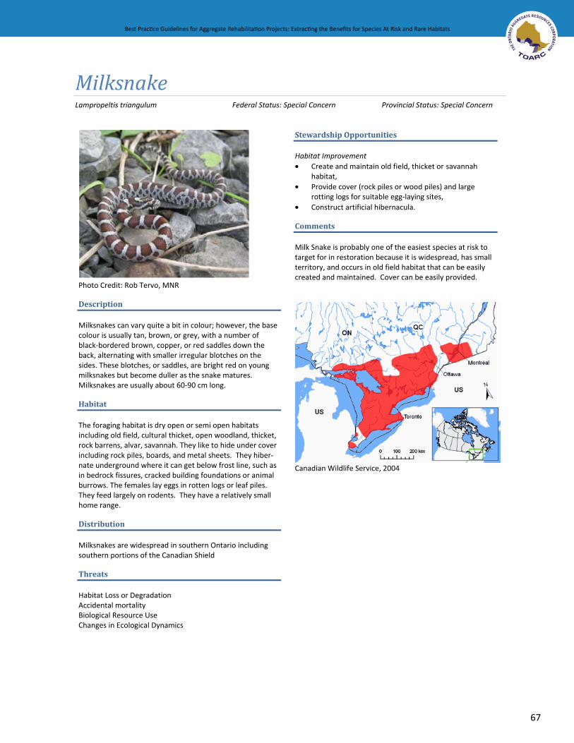
Best Practice Guidelines for Aggregate Rehabilitation Projects: Extracting the Benefits for Species At Risk and Rare Habitats
67
Best Practice Guidelines for Aggregate Rehabilitation Projects: Extracting the Benefits for Species At Risk and Rare Habitats
MilksnakeLampropeltis triangulum Federal Status: Special Concern Provincial Status: Special Concern
Photo Credit: Rob Tervo, MNR
Description
Milksnakes can vary quite a bit in colour; however, the base colour is usually tan, brown, or grey, with a number of black-bordered brown, copper, or red saddles down the back, alternating with smaller irregular blotches on the sides. These blotches, or saddles, are bright red on young milksnakes but become duller as the snake matures. Milksnakes are usually about 60-90 cm long.
Habitat
The foraging habitat is dry open or semi open habitats including old field, cultural thicket, open woodland, thicket, rock barrens, alvar, savannah. They like to hide under cover including rock piles, boards, and metal sheets. They hiber-nate underground where it can get below frost line, such as in bedrock fissures, cracked building foundations or animal burrows. The females lay eggs in rotten logs or leaf piles. They feed largely on rodents. They have a relatively small home range.
Distribution
Milksnakes are widespread in southern Ontario including southern portions of the Canadian Shield
Threats
Habitat Loss or Degradation Accidental mortality Biological Resource Use Changes in Ecological Dynamics
Stewardship Opportunities
Habitat Improvement • Create and maintain old field, thicket or savannah
habitat,• Provide cover (rock piles or wood piles) and large
rotting logs for suitable egg-laying sites, • Construct artificial hibernacula.
Comments
Milk Snake is probably one of the easiest species at risk to target for in restoration because it is widespread, has small territory, and occurs in old field habitat that can be easily created and maintained. Cover can be easily provided.
Canadian Wildlife Service, 2004

68
Best Practice Guidelines for Aggregate Rehabilitation Projects: Extracting the Benefits for Species At Risk and Rare Habitats Best Practice Guidelines for Aggregate Rehabilitation Projects: Extracting the Benefits for Species At Risk and Rare Habitats
MonarchDanaus plexippus Federal Status: Special Concern Provincial Status: Special Concern
Photo Credit: James Kamstra
Description
The Monarch butterfly is bright orange with heavy black veins interspersed and a wide black border containing two rows of white spots. The wingspan of the Monarch is typically about 10 cm. The Monarch caterpillars are striped yellow, black and white and grow to about 5 cm in length.
Habitat
Monarchs overwinter in Mexico and begin their migration north in late March-early April. They fly to the Gulf Coast where the females lay their eggs and it is this next generation that continues the migration north. In fact, it takes several generations to reach the northern range.
Monarchs in Canada exist primarily wherever milkweed occurs and wildflowers such as goldenrods and asters. The monarch caterpillar can only feed on milkweed so this is critical to their survival.
Distribution
The Canadian population of the Monarch is divided into three populations: western, central, and eastern. The eastern population includes those found in Ontario and is the largest of the three populations.
Threats
Habitat Loss or Degradation Predation Disturbance or Persecution
Stewardship Opportunities
Habitat Improvement • Create and restore meadow habitat that includes a range
of nectar-producing native wildflowers, • Allowing natural regeneration of milkweed will benefit
monarch caterpillars.
Comments
The monarch is a good candidate for restoration work on aggregate sites because it occurs in a relatively wide range . They are also tolerant of human activity and are often located in close proximity to urban areas.
Source: Canadian Wildlife Service, 2004
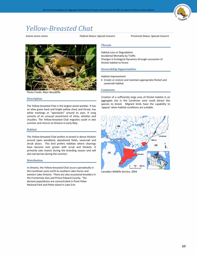
Best Practice Guidelines for Aggregate Rehabilitation Projects: Extracting the Benefits for Species At Risk and Rare Habitats
69
Best Practice Guidelines for Aggregate Rehabilitation Projects: Extracting the Benefits for Species At Risk and Rare Habitats
Yellow-Breasted Chat Icteria virens virens Federal Status: Special Concern Provincial Status: Special Concern
Threats
Habitat Loss or Degradation Accidental Mortality by Traffic Changes in Ecological Dynamics through succession of
unities
thicket habitat to forest
Stewardship Opport
Habitat Improvement• Create or restore and maintain appropriate thicket and
abitat. savannah h
Comments
Creation of a sufficiently large area of thicket habitat in an aggregate site in the Carolinian zone could
Photo Credit: Allen Woodliffe
Description attract this
pecies to breed. Migrant birds have the capability to ppear’ when habitat conditions are suitable.
sThe Yellow-breasted Chat is the largest wood warbler. It has an olive green back and bright yellow chest and throat, has white markings or “spectacles” around its eyes. It song consists of an unusual assortment of clicks, whistles and chuckles. The Yellow-breasted Chat migrates south in late summer and returns to Ontario in early May.
‘a
Habitat
The Yellow-breasted Chat prefers to breed in dense thickets around open woodland, abandoned fields, savannah and shrub alvars. This bird prefers habitats where clearings have become over grown with scrub and thickets. It primarily eats insects during the breeding season and will also eat berries during the summer.
Distribution
In Ontario, the Yellow-breasted Chat occurs sporadically in the Carolinian zone north to southern Lake Huron and western Lake Ontario. There are also occasional breeders in the Frontennac Axis and Prince Edward County. The densest populations are concentrated in Point Pelee National Park and Pelee Island in Lake Erie.
Canadian Wildlife Service, 2004

70
Best Practice Guidelines for Aggregate Rehabilitation Projects: Extracting the Benefits for Species At Risk and Rare Habitats Best Practice Guidelines for Aggregate Rehabilitation Projects: Extracting the Benefits for Species At Risk and Rare Habitats
APPENDIX D. INFORMATION SOURCESSpecies at Risk: Recovery Planning and Implementation
Recovery Teams: (http://www.sararegistry.gc.ca/sar/recovery/team_ch_e.cfm)Ministry of Natural Resources Species at Risk website:
(www.mnr.gov.on.ca/mnr/speciesatrisk/index.html)Federal Government’s Species at Risk Act public registry: (www.sararegistry.gc.ca)
Pit and Quarry Rehabilitation Techniques and Research The Ontario Aggregate Resources Corporation (www.toarc.com) Ministry of Natural Resources (http://www.mnr.gov.on.ca/MNR/aggregates/rehab.html)
Hydrology Ministry of the Environment - details on groundwater based on water well records (www.ene.gov.on.ca/envision/water/wells.htm) MNR’s Low Water Site - (http://www.mnr.gov.on.ca/MNR/water/p774.html)
Soils The National Soil Database is a useful source for information on soil, landscape and climatic conditions in Canada (http://sis.agr.gc.ca/cansis/nsdb/intro.html) Ministry of Agriculture, Food and Rural Affairs (www.omafra.gov.on.ca/english/landuse/facts/soil_survey.htm) Denholm, K.A. and L.W. Schut.1993. Field Manual for Describing Soils in Ontario. Centre for Soil Resource Evaluation: Guelph, Ont.
Soils, Fungi and Native Plants Klironomos Lab, University of Guelph (http://www.uoguelph.ca/~jnklab/) University of Western Australia: Soil Fungi (http://www.soilhealth.segs.uwa.edu.au/components/fungi) Soil Health - (http://www.soilhealth.com/fungi/)
Vegetation and Other WildlifeInformation on species at risk and significant habitat features that may be found in an area can be found by referring to: MNR’s Natural Heritage Information Centre (http://nhic.mnr.gov.on.ca/nhic_.cfm) Canadian Wildlife Service (http://www.sararegistry.gc.ca/sar/index/map_e.cfmLocal MNR offices (www.mnr.gov.on.ca/MNR/Csb/message/regions_map.html) Conservation authorities (http://conservation-ontario.on.ca/find/index.html) Breeding Bird Atlas of Ontario (http://www.birdsontario.org/atlas/index.jsp)
Conservation groups such as: Ducks Unlimited Canada (www.ducks.ca/) Tallgrass Ontario (www.tallgrassontario.org/) Nature Conservancy of Canada (www.natureconservancy.ca) Carolinian Canada (http://carolinian.org) Royal Ontario Museum: Species at Risk (www.rom.on.ca/ontario/risk.php) Local naturalists groups (e.g. Ontario Nature www.ontarionature.org) Native Plant Nurseries: Society for Ecological Restoration – list of native plant nurseries found in Ontario (www.serontario.org/publica.htm) North American Native Plant Society (NANPS) (www.nanps.org/sources.aspx)
••
•
••
•
•
•
•
•
••
•
••
••
•••••••
•

Best Practice Guidelines for Aggregate Rehabilitation Projects: Extracting the Benefits for Species At Risk and Rare Habitats
71
Best Practice Guidelines for Aggregate Rehabilitation Projects: Extracting the Benefits for Species At Risk and Rare Habitats
Ecological Land Classification System (http://publicdocs.mnr.gov.on.ca/View.asp?Document_ID=13224&Attachment_ID=25870)
Long-term Conservation and Stewardship of Rehabilitated Sites Ecological Gifts Program (www.on.ec.gc.ca/ecogifts/ecogifts-e.html) Ontario Land Trust Alliance (www.ontariolandtrustalliance.org/) Nature Conservancy of Canada (www.natureconservancy.ca)
•
•••
Figure 26 Swamp Rose Mallow (Photo Credit: Jane Bowles)

72
Best Practice Guidelines for Aggregate Rehabilitation Projects: Extracting the Benefits for Species At Risk and Rare Habitats Best Practice Guidelines for Aggregate Rehabilitation Projects: Extracting the Benefits for Species At Risk and Rare Habitats
APPENDIX E. BACKGROUND INFORMATION: RECOVERY PLANNING AND IMPLEMENTATIONUnder the federal Species at Risk Act (SARA) (2002) “species at risk” is defined as: an extirpated, endangered, or threatened species or a species of special concern. The provincial Endangered Species Act (2007) defines “species at risk” as: any plant or animal threatened by, or vulnerable to extinction. The former legislation applies principally to federally owned lands. The new provincial Act, which comes into full effect in June 2008, will be of direct interest to those who own and/or are responsible for the management of active and abandoned aggregate resources lands. Efforts are underway between federal and provincial authorities to harmonize the implementation of these Acts.
There are two scientific bodies that assess the status of species in Ontario: the national Committee on the Status of Endangered Wildlife in Canada (COSEWIC); and the provincial Committee on the Status of Species at Risk in Ontario (COSSARO). COSEWIC and COSSARO are made up of technical experts from across the country and province. The process for assessing and designating species at risk is formal and lengthy and not all species that are considered rare or threatened by extinction have been listed by COSEWIC and/or COSSARO.
The highest biodiversity in the province and most of Ontario’s species at risk are concentrated in southern Ontario, coinciding with the greatest population density and associated development pressures including existing and proposed aggregate pits and quarries. Maintaining biodiversity, including all native species and the interactions between them is essential for reaching greater sustainability. Conserving and recovering Ontario’s species at risk and rare habitats is vital to maintaining this biodiversity. The conservation of the natural environment involves both the protection and enhancement of existing natural features and functions, and the recreation of new ones where others have been lost. Much of the effort needed for biodiversity conservation focuses on species and habitats that are at risk; however, ensuring the conservation of the more common and widespread species and habitats is also very important to ensure that they do not become at risk themselves.
There are currently over 70 Recovery Teams in Ontario, made up of experts on the individual species and of ecosystems, including rare habitats that are at risk. These Recovery Teams are working to prepare recovery strategies and action plans that set out specific activities considered essential to the recovery of the ecosystems and individual species at risk. The recovery team also ensures that all activities for a species are coordinated among the agencies and partners involved, and directs the implementation of action plans.
The Natural Heritage Information Centre7 (NHIC) tracks not only species at risk but also a greater number of species that have been identified as provincially significant. All native species occurring in the province are given a ranking of S1 to S5; in total, NHIC tracks about 1750 species and 470 plant communities. S1 (imperiled), S2 (very rare) and S3 (rare) are considered provincially significant and NHIC tracks 1426 rare species and 154 S1-S3 rare vegetation communities (Taylor, pers. comm.). While most provincially significant mammal, bird, reptile, amphibian and fish species have been designated ‘at risk’ by COSSARO,
7 The Natural Heritage Information Centre is part of Ontario’s Ministry of Natural Resources Fish and Wildlife Branch. The NHIC acquires, maintains, updates, and makes available data on the province’s rare species, vegetation communities, and natural areas.

Best Practice Guidelines for Aggregate Rehabilitation Projects: Extracting the Benefits for Species At Risk and Rare Habitats
73
Best Practice Guidelines for Aggregate Rehabilitation Projects: Extracting the Benefits for Species At Risk and Rare Habitats
many others have not. Some of these species may also make suitable targets. Appendix C provides a source of information for determining the occurrence of rare species in Ontario.
In addition, regionally significant lists of plants and animals have been compiled for many municipalities, regions or site districts. Plant or animal species that are fairly common provincially may be rare or restricted within the target region. For example, floras providing regional status have been compiled for Ontario (Oldham 1999), southwestern Ontario (Oldham, 1993), southeastern Ontario (Cuddy 1991), and south central Ontario (Riley 1989). Targeting regionally significant species in addition to provincial species is encouraged, particularly in areas where there may be very few appropriate at risk species.
Figure 27 Prairie Smoke (Photo Credit: Matt Wheeler)

Prepared For The Ontario Aggregate Resources Corporation
Best Practice Guidelines for Aggregate Rehabilitation Projects
Extracting the Benefits for Species At Risk and Rare Habitats
Prepared By:Savanta Inc.
58 Welstead DriveSt. Catharines, Ontario
L2S 4B2 Canada
In Association With:Gartner Lee Limited
Azimuth Environmental Consulting Inc.