BEFORE THE PROPOSED HURUNUI DISTRICT PLAN … Plan Review/Expert... · 5 Walker S, Cieraad E,...
22
1 BEFORE THE PROPOSED HURUNUI DISTRICT PLAN HEARINGS PANEL IN THE MATTER of the Resource Management Act 1991 AND IN THE MATTER of the Proposed Hurunui District Plan 2015 SUBMITTER CANTERBURY REGIONAL COUNCIL STATEMENT OF EVIDENCE OF JEAN-MARIE LOUISE JACK ON BEHALF OF THE CANTERBURY REGIONAL COUNCIL BIODIVERSITY 8 April 2016
Transcript of BEFORE THE PROPOSED HURUNUI DISTRICT PLAN … Plan Review/Expert... · 5 Walker S, Cieraad E,...
1
BEFORE THE PROPOSED HURUNUI DISTRICT PLAN HEARINGS PANEL
IN THE MATTER of the Resource Management Act 1991
AND
IN THE MATTER of the Proposed Hurunui District Plan 2015
SUBMITTER CANTERBURY REGIONAL COUNCIL
STATEMENT OF EVIDENCE OF JEAN-MARIE LOUISE JACK ON BEHALF
OF THE CANTERBURY REGIONAL COUNCIL
BIODIVERSITY
8 April 2016

2
BACKGROUND AND EXPERIENCE
1 My full name is Jean-Marie Louise Jack. I have recently started work as a Senior
Land Resources Officer – Ecology for Canterbury Regional Council. Prior to this I
worked for four years as a Regional Council Biodiversity Officer working within the
Hurunui District, providing advice and facilitating funding support to landowners
undertaking works to protect or enhance biodiversity on their properties.
2 I hold a Doctorate of Ecology from Lincoln University, New Zealand.
3 My current role at Canterbury Regional Council (“CRC”) sits within the Science
Group within the Terrestrial Ecology Team and is responsible for providing scientific
expertise and advice on land resources management, the design and
implementation of land resources monitoring programmes, and to undertake
processing and analysis of land resources data.
4 I acknowledge that I have read and understand the Code of Conduct for Expert
Witnesses contained in the Environment Court Practice Note dated 1 December
2014. I have complied with it when preparing my written statement of evidence and I
agree to comply with it when I give my oral evidence.
5 Unless I state otherwise, this evidence is within my knowledge or sphere of
expertise and I have not omitted to consider material facts known to me that might
alter or detract from the opinions that I express.
SCOPE OF EVIDENCE
6 My evidence relates to Chapter 13 (Ecosystems and Indigenous Biodiversity) of the
Proposed District Plan (‘PDP’).
7 Matters covered in my evidence include:
a) The general state of known biodiversity across the region and within the Hurunui
District.
b) An overview of biodiversity work undertaken recently within the Hurunui District.
c) My observations of landowner awareness and ability to provide for the protection
or enhancement of biodiversity within the district.

3
8 The key documents that I have used, or referred to, in forming my opinion while
preparing this evidence are:
a) CRPS, particularly Chapter 9; Ecosystems and Indigenous Biodiversity;
b) Canterbury Biodiversity Strategy 2005; and
c) Canterbury Water Management Strategy 2010.
Executive summary
9 The Hurunui District includes a great diversity of ecosystems which will include
many areas of significant indigenous vegetation and habitat for indigenous fauna.
10 Today very little indigenous land cover remains within the lowland plains and inland
basins of the District making the integration and maintenance of biological diversity
(biodiversity) within these high-use areas of particular priority from a biodiversity
conservation perspective.
11 My observations within the Hurunui District is that recent economic drivers have
increased the development of the ‘marginal’ hill country, inland valleys and braided
river margins, resulting in losses of indigenous vegetation cover and consequently
the habitat of threatened fauna. Recent observations of biodiversity loss have
occurred following the transfer of land ownership, where new managers have
sought to further develop properties.
12 Having worked as a Biodiversity Officer within the District for over four years (2011-
2016) my discussions with landowners regarding biodiversity management indicate
that the vast majority agree on the need to protect and maintain the district’s
‘important’ biodiversity.
13 It is my observation that for landholders to successfully maintain biodiversity they
first and foremost require assistance to identify such values within their properties,
and then be provided guidance and support to effectively manage such areas or
species in order to sustainably manage them.
14 Landowners who are aware and understanding of biodiversity values within their
properties often wish to protect or enhance such values, however their decision to
do so is influenced by financial considerations or farming practicalities. Typically
outside assistance and resources are required to protect or enhance the biodiversity

4
values.
15 While we know there are landowners actively working to either legally or physically
protect and maintain significant indigenous biodiversity on their properties (i.e. QEII
covenants or fencing and pest control), we are uncertain to what extent these
actions are helping to maintain the District’s indigenous biodiversity, or whether
those areas being maintained are the most important examples of biodiversity in the
District.
Evidence
The biodiversity of the Hurunui District
16 The Hurunui District includes a great diversity of ecosystems including wetlands,
drylands, extensive tussock and shrublands, beech & podocarp forest, alpine and
rare ecosystems such as braided riverbeds, geothermal systems and limestone
outcrops1. Threatened species are present in many of these ecosystems including
the braided river habitats of the Hurunui and Waiau rivers, which are very important
for native fish and bird populations2. Many instances of significant indigenous
biodiversity and significant habitat of biodiversity will exist throughout the District,
with some of greater importance than others3.
17 Areas which were identified as priorities for recent Regional Council funding support
include the high country lakes, wetlands and intermontane streams of the Sumner
Lakes Complex, the native forest remnants and streams of the coastal hill country
1 McEwen (1987). Ecological regions and districts of New Zealand. 3rd ed. Wellington: Department of Conservation. Biological Resources Centre Publication No. 5
2 Department of Conservation (2006). Canterbury Conservancy’s intrinsic values catchment reports.
3 Note the difference between ‘significance’ and ‘importance’ – Significance is determined through the application of the Regional Policy Statement’s Guidelines for the application of Ecological Significance Criteria for Indigenous Vegetation and Habitats of Indigenous Fauna in Canterbury Region. Importance relates to a priority (best sites, rarest, least protected etc). An important site (rare threatened, poorly protected etc) is always going to be significant, but a significant site (such as extensive well protected not threatened beech forest) may be less important under an RMA context but still requires mitigation for any loss. Section 6(c) of the RMA requires the protection of areas of significant vegetation and significant habitats of indigenous fauna to be recognised and provided for. Depending on the importance of the values, loss of them should be avoided, remedied or mitigated.
5
between the Conway and Waiau river mouths, the wetlands, lagoons and estuaries
of North Pegasus Bay coast and more generally any wetlands and lowland streams
across the District.
18 Terrestrial biodiversity within the District is not limited to areas of indigenous
vegetation. Habitat for indigenous flora and fauna is present outside of indigenous
vegetation, for example Rough Gecko inhabit exotic shrublands, the Canterbury
gecko rocky outcrops and scree; banded dotterel braided riverbeds, floodplains or
open exotic pasture.
The current state of biodiversity in the Hurunui District
19 Indigenous vegetation of the District’s inland basins, plains and foothills have been
significantly reduced4. These areas are identified as the District’s most Threatened
Environments5 (Attachment 1a, 1b). The remaining indigenous vegetation within
these areas are in small, scattered fragments and waterways have been
significantly modified.
20 While the vast majority of indigenous vegetation cover was removed by historic
burning, vegetation clearance and wetland drainage prior to 1970, loss has
continued more recently, for example with irrigation development within the Amuri
Plain in the 80s and 90s. Analysis of the LCDB between 1996 and 2012 shows that
land cover of indigenous vegetation was reduced by 1700ha. This included 1100ha
of Manuka and/or Kanuka and 188ha of Broadleaved Indigenous Hardwoods5.
Notably, these reductions included areas of indigenous cover within the Acutely
Threatened land environments such as the Culverden basin (see Attachment 2
examples).
21 The districts wetlands, which once covered approximately 26,000ha have been
reduced to approximately 2% of the original area. A higher percentage remain in the
4 Land Cover Database (LCDB) Available online: https://lris.scinfo.org.nz/layer/412-lcdb-v40-deprecated/
5 Walker S, Cieraad E, Barringer J (2015). The Threatened Environment Classification for New Zealand 2012: a guide for users. Landcare Research Report LC2184. Available online: http://www.landcareresearch.co.nz/resources/maps-satellites/threatened-environment-classification.
6
high country (especially alpine areas), but in the lowlands, inland basins and along
the coastal fringes the proportion is lower, in some cases markedly so. Furthermore,
wetlands in these areas are relatively more depleted both in quality and extent,
making wetlands that remain in these areas even more significant6.
22 Several of the braided river bird species occurring within the District including
wrybill, black fronted tern and black billed gull are all listed as Threatened. While
surveys of these species are underway, it is too early to determine trends for
populations found within the District.
23 Increasing areas of forested (exotic) or undeveloped river margin land adjoining the
district’s rivers are being developed into intensively managed farmland (see
Attachment 2c). These areas have an important role in buffering of aquatic
ecosystems from effects of adjoining land use, and provide habitat for indigenous
flora and fauna in an otherwise highly modified landscape. In the period 2001 to
2008 1190 ha of forested or undeveloped river margin land adjoining the Waiau
River was converted to intensive agriculture. From 2008-2012 a further 555ha of
river margin was converted to intensive agricultural use7.
24 In addition to habitat loss and modification as a result of land-use and development,
animal and plant pests are key threats to the district’s biodiversity. These threats are
acknowledged within the Regional Pest Management Strategy8 which in addition to
pest species listed as Unwanted, Eradication, Containment or Restricted organisms,
identifies 17 further species which present significant risk specifically to biodiversity
values.
25 Notable plant pest species which displace indigenous vegetation and are particularly
invasive within the District’s braided river floodplains and coastal wetlands include
Old Mans Beard, Blackberry and Grey Willow. Of the many animal pests which will
be widespread across the District, feral deer, pigs, rats, wasps and mustelids
6 Environment Canterbury, Historic and current extent of Canterbury freshwater wetlands, and recent trends in remaining wetland areas, June 2010.
7 Environment Canterbury Technical Report (2015). Land use change on the margins of lowland Canterbury braided rivers, 1990-2012. Report No. R15/49. Available online: http://ecan.govt.nz/publications/Reports/land-use-change-margins-lowland-rivers.pdf
8 Regional Pest Management Strategy 2011-2015. Available online: http://ecan.govt.nz/publications/Plans/canterbury-regional-pest-management-strategy-2011-2015.pdf

7
present particular threat to populations of indigenous species. Apart from Animal
Health Board-led possum control for TB, control of these pest species by
landowners and agencies is largely on a site-led basis and un-coordinated on a
landscape scale.
26 Wilding conifers which threaten indigenous biodiversity values due to their invasive
nature were seen to increase in area between 2001/2 and 2011. During that time an
initial area of 797ha of wilding tree outlier presence grew to an area of 2,944ha.
Recent control efforts have subsequently reduced this area and surveys planned for
2017/18 will update the status of wilding conifer incidence, however it remains a
significant threat to biodiversity values.
27 These Council reports and database records do indicate and give examples of a
continuing decline of biodiversity within the District, consistent with regional9 and
national10 trends.
28 Areas known publically to be either under formal protection or which have recently
received grant monies to undertake physical protection or restorative works make
up only a small proportion of the most threatened land environments (Attachment 1c
& 3). Much of the threatened biodiversity occurs outside of formally protected areas
(DOC reserves, QEII covenants etc.).
Personal observations of biodiversity protection and loss
29 Recent economic drivers appear to have increased the development of the
‘marginal’ hill country, inland valleys and the margins of braided riverbeds resulting
in losses of indigenous vegetation cover within threatened land environs and the
degradation of spring-fed stream habitat (see Attachment 3 images).
30 Alongside observations of loss are those of biodiversity protection and enhancement
including the legal protection and removal of stock access to coastal podocarp
9 Canterbury Biodiversity Strategy (2005). Report Number: R08/13 ISBN: 978-1-86937-774-8. Available online: http://ecan.govt.nz/publications/Plans/BiodiversityStrategyFinalFeb08.pdf
10 World Wildlife Fund (2012). Beyond Rio – New Zealand’s environmental record since the original earth summit, World Wildlife Fund, Wellington. Available at: wwf.panda.org/downloads/2012_earth_summit_beyond_rio_nz.pdf
8
riparian forests, old growth kanuka forest and dryland remnants. Some areas are
also being purposefully managed to revert from agricultural land use to indigenous
vegetation cover (see Attachment 3 images).
31 While many landowners are establishing native vegetation along streams or within
less agriculturally productive pasture areas, these are typically fragmented and
would not be considered of equal biodiversity value as naturally occurring
indigenous vegetation with associated uncultivated soils.
32 These observations are anecdotal, simply providing evidence that both biodiversity
protection and loss are currently occurring within the District.
Biodiversity action by landowners
33 Having worked as a Biodiversity Officer within the District for four years I have
assisted landowners to undertake works to protect or enhance biodiversity on their
properties through the provision of advice and facilitated financial support through
the Council’s Biodiversity funding programmes. Since 2011 approximately 70 sites
within the District have been provided with detailed advice or funding from the
Regional Council’s Biodiversity Officers. Landowners of these sites have both
actively sought out the Council’s advice and support, or have been approached by
the Regional Council.
34 While some of these sites include areas of significant indigenous vegetation and
significant habitats of indigenous fauna, they do not include the full representation of
the district’s biodiversity and it is unknown if they are the most important1 examples
of their type due to the incomplete knowledge of the District’s biodiversity.
35 Most landowners agree the District’s ‘important’ biodiversity requires protection and
maintenance and it is common for landowners - both in the Hurunui and regionally –
to recognize the importance of, for example, indigenous forest stands, freshwater
flaxland swamps and threatened iconic fauna. However few are aware of the
significant values of old growth kanuka and matagouri on uncultivated soils,
unmodified spring-fed streams, buffering margins (flood plains) of the braided rivers,
intermittent marshes, dryland turf communities, or more cryptic species such as
indigenous snail or gecko. A common misconception of landowners is that native
9
plantings are of equal ecological value to that of naturally occurring vegetation on
uncultivated soils. Land managers are also generally unaware that indigenous fauna
may rely on diverse structural habitat within a farm, such as rough pasture margins,
woody debris, stone piles or undercut stream banks. Unfortunately some managers
inadvertently remove indigenous vegetation while seeking to comply with pest
management regulatory requirements, such as the grubbing of native tussock during
operations to remove the pest nasella plant.
36 Landowners who are aware and understanding of biodiversity values within their
properties are often well intentioned, however typically they require a level of
outside assistance and resources which are primarily available through the District
or Regional Council.
37 The Regional Council’s approach is to work with the Zone Committee, the District
Council and the local community to improve the community’s awareness of
biodiversity and its values and to provide advice and where appropriate funding
assistance. Guiding this work is the Canterbury Biodiversity Strategy, the Regional
Pest Management Strategy and the Canterbury Water Management Strategy. The
newly formed Zone Teams are seen as a key tool to improve the awareness of
landowners regarding biodiversity and to support their efforts to maintain
biodiversity.
Note on vegetation clearance rules
38 Given that we lack comprehensive information on the extent and condition of the
biodiversity values remaining in the District, general vegetation clearance rules (over
and above sites listed in a plan, if any) provide an important, if limited, assurance
that the District’s significant indigenous biodiversity is maintained with the use and
development of land. It is important to note that this assurance is limited as
significant indigenous vegetation alone or as habitat for significant indigenous fauna,
will not encompass the full suite of significant indigenous biodiversity within the
Hurunui District. Further significant biodiversity will be present outside of indigenous
vegetation (for example Rough Gecko inhabiting exotic scrub or rocky outcrops;
banded dotterel within braided riverbeds, floodplains or open exotic pasture, or
species within uncultivated soils).

10
Note on proposed Biodiversity Management Plans / Farm Plans as tools to manage biodiversity
39 The proposed Biodiversity Management Plans offer a comprehensive means to
protecting ecosystems and significant areas of indigenous vegetation within a
property. It is particularly important however that such plans provide for robust
monitoring, maintenance of values and auditing and review mechanisms of the plan.
40 Farm Environment Plans also have an ability to provide for biodiversity protection
and enhancement if their scope includes all aspects of activities which may affect
biodiversity – i.e. not just waterway or nutrient management.
41 For landowners/managers the process of developing plans addressing biodiversity
on their properties would be useful in terms of improving awareness and
understanding of biodiversity and providing an avenue to access biodiversity funding
and or advice.
…………………………….
Jean-Marie Louise Jack
8 April 2016

11
Attachments
Attachment 1: Landcover Maps Map 1a: Approximate current land cover of the Hurunui District (LCDBv4) 11
11 Land Cover Database (LCDB) Available online: https://lris.scinfo.org.nz/layer/412-lcdb-v40-deprecated/

12
Map 1b: The distribution of the District’s Threatened Environments12.
12 Threatened Environs Classification (TEC) The Threatened Environment Classification is a tool that helps to identify environments in which much of the native (indigenous) vegetation has been cleared and only a small proportion of what remains is legally protected. The Threatened Environment Classification is a practical tool that can be used to help identify places that are priorities for protection of indigenous biodiversity, to plan biodiversity protection activities, and/or to report achievements. It is relevant to biodiversity, community relations, and information management/GIS staff. The Threatened Environment Classification is a combination of three national databases: land environments (LENZ), land cover classes (LCDB2), and protected areas (PAN-NZ). The classification is an addition to LENZ and divides New Zealand into six categories of ‘threatened environments’. Each of the 500 LENZ Level IV environments was assigned one of six threat categories on the basis of past habitat loss (percentage indigenous cover remaining) and current legal protection. Landcare Research developed the tool and has run a series of workshops on its use.

13
Map 1c: An illustration of the known areas under formal protection

14
Attachment 2: Examples of reduced area of indigenous vegetation cover within inland basin Acutely Threatened land environment.
Map 2a: An area within the Culverden basin showing (shaded) the area identified in 1998 by the Department of Conservation as an area of National Significance, now converted to farmland. The area had been described as “An extensive area (70-80ha) of kanuka dominated woodland…of outstanding ecological value…the only large kanuka woodland on the western Amuri Plain. Thought to be the largest and most intact remnant on the plain.”
15
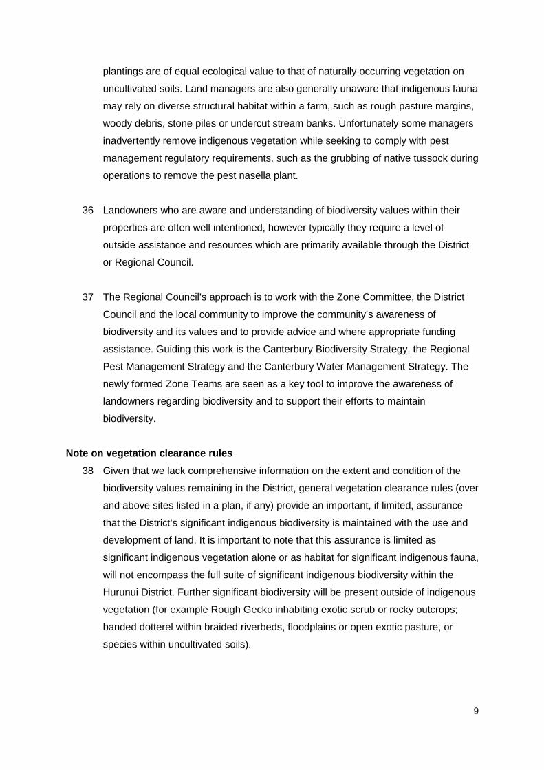
Map 2b: An area east of Culverden showing (shaded) part of the area identified in 1998 by the Department of Conservation as an area of National Significance, now mostly converted to farmland and intensive grazing the majority of indigenous vegetation and uncultivated soils no longer exist. This area was described as “A 200-300ha area of little modified grassland with thinly scattered kanuka shrubs. This area is of high conservation value because it is the largest area of uncultivated soil and undeveloped land on the Amuri Plain. Current grazing management appears to be compatible with native herbs and grasses…”
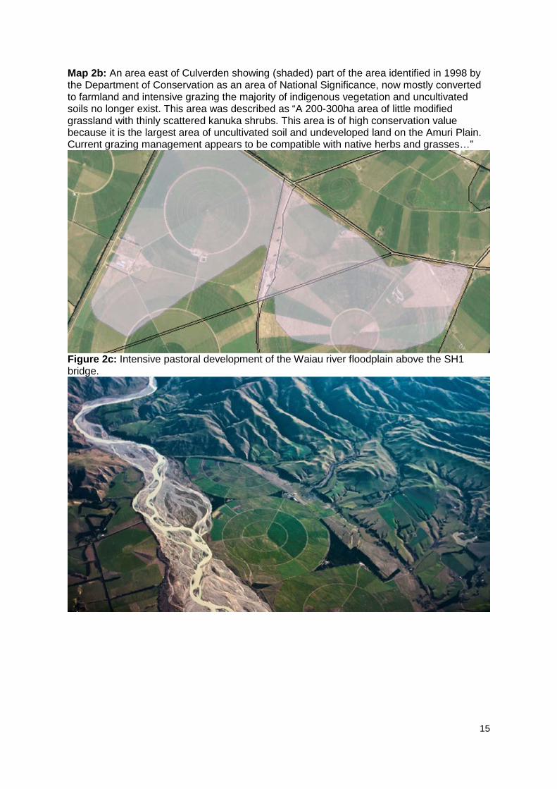
Figure 2c: Intensive pastoral development of the Waiau river floodplain above the SH1 bridge.

16
Attachment 3: Regional Council records of sites receiving funding for biodiversity protection
or enhancement since c.200513
13 Action 2.2 sites are of biodiversity restoration activity collated by Boffa Miskell
and supplied to Environment Canterbury in 2010 for incorporation in the Canterbury Biodiversity Strategy Action 2.2. Primarily these sites of biodiversity
works were funded via council administered grants but also from other community grants. EEF and CRM sites are those receiving Council funding support between 2010 and 2016 (These current funds are the Canterbury
Biodiversity Strategy Fund and the Immediate Steps CWMS Fund).

17
Attachment 3: Observations demonstrating instances of biodiversity protection & enhancement and instances of biodiversity loss within the Hurunui District 2010-2016.
Observations of Biodiversity Protection & Enhancement:
Figure 3a: Fencing of secondary regrowth kānuka and hardwood forest.
Figure 3b: Lake margin fenced in Sumner Lakes area.
18
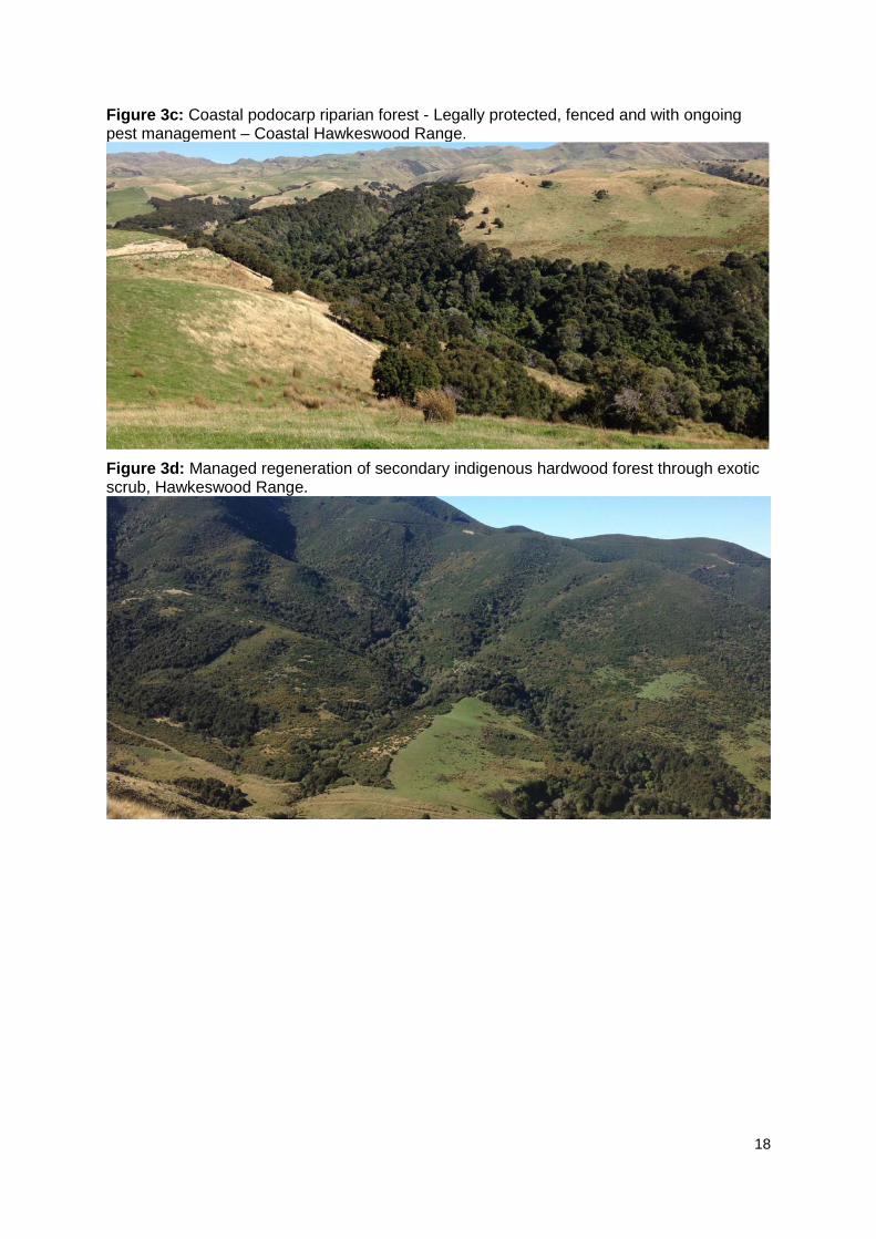
Figure 3c: Coastal podocarp riparian forest - Legally protected, fenced and with ongoing pest management – Coastal Hawkeswood Range.
Figure 3d: Managed regeneration of secondary indigenous hardwood forest through exotic scrub, Hawkeswood Range.
19
Observations of Biodiversity Loss:
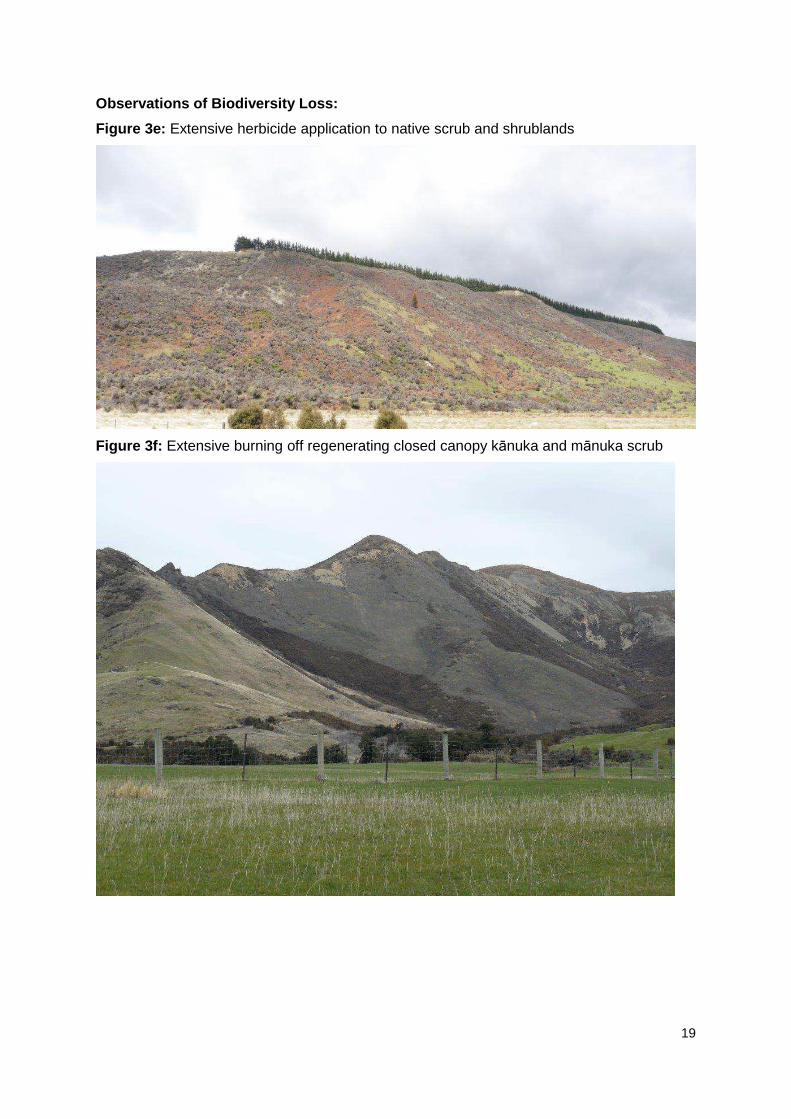
Figure 3e: Extensive herbicide application to native scrub and shrublands
Figure 3f: Extensive burning off regenerating closed canopy kānuka and mānuka scrub
20
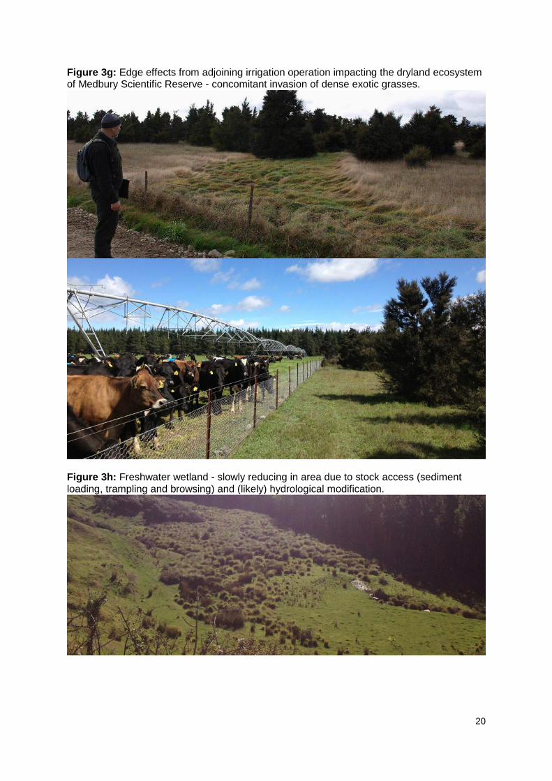
Figure 3g: Edge effects from adjoining irrigation operation impacting the dryland ecosystem of Medbury Scientific Reserve - concomitant invasion of dense exotic grasses.
Figure 3h: Freshwater wetland - slowly reducing in area due to stock access (sediment loading, trampling and browsing) and (likely) hydrological modification.

21
Figure 3i: Extensive spraying of regenerating beech forest and tall kanuka associations - note the spraying in the distance which removed At Risk LENZ vegetation cover.
Figure 3j: Clearance of regenerating forest and diverse shrubland mosaic for pine plantation - foothills adjoining Stonyhurst road. This was on an acutely threatened land environment (national priority 1), likely significant indigenous vegetation and habitat for fauna.

22
Figure 3k: Spring fed stream habitat degradation and reduced buffering area between intensive landuse and braided riverbed and floodplain habitats within inland basins.