BEDROCK STRUCTURAL INPUTS TO NEW-GENERATION GROUNDWATER...
4
BEDROCK STRUCTURAL INPUTS TO NEW-GENERATION GROUNDWATER FLOW SYSTEM (GFS) MAPPING IN UPLAND LANDSCAPES: A PROGRESS REPORT ON THE BET BET CATCHMENT STUDY, VICTORIA Jeremy M. James 1 , John W. Wilford 1 and Larysa Halas 1 1 CRC LEME, Geoscience Australia, GPO Box 378, Canberra, ACT 2601 INTRODUCTION There is a significant body of evidence, both within the mainstream scientific literature and anecdotally, to show that regolith-landforms, groundwater flow regimes and salinity within Australian erosional landscapes are influenced to varying degrees by the nature of the underlying fractured rock systems. The critical role played by bedrock compositional, rheological and structural variability in determining how a range of salinity-related catchment hydrogeological process such as recharge, subsurface flow and discharge operate can also be demonstrated across the full local- to regional-scale spectrum. For example, Ventriss et al (1982) and Engel et al (1987) noted that weathered basic dykes can induce saline seepage by forming hydraulic barriers to groundwater flow. Please et al (1990) and Lewis (1991) further showed that structural lineaments, dykes, quartz veins, quartzite units, fractures, faults and shears mapped from air photos and satellite imagery act as significant groundwater conduits or barriers. These features, together with sub-sediment bedrock highs often partition catchments into discrete flow systems with different salinity responses and management issues (e.g. Salama et al. 1993, Cresswell et al. 2003). Structural discontinuities may also facilitate saline base-flow from deeper aquifers to regolith stores and creeks (e.g. Clarke et al. 1998, Wilkes et al. 2004, Morgan & Jankowski 2004). Despite its obvious importance, the bedrock dimension has often been overlooked or not fully integrated into many upland studies, especially those aimed at understanding the various physical processes that influence where salt is likely to be stored or mobilised within the landscape. Much existing knowledge in this field is also restricted to detailed investigations of limited areal extent and resides in difficult-to-access commercial (‘grey’) literature. Whilst the nationally-adopted Groundwater Flow System (GFS) approach to salinity management (Coram 1998) is underpinned by both published geological mapping and conceptual hydrogeological models describing bedrock controls on salinity (Coram et al. 2000, Walker et al. 2003), most structural information is not shown spatially on existing GFS maps. With increasing focus on the need for science to support more strategic targeting of on-ground management actions at sub-catchment scales, a requirement exists for improved resolution GFS maps that incorporate spatially-explicit lithostructural detail, in addition to other relevant information on soils, regolith and landforms. This would provide a framework within which to better evaluate aquifer characteristics and potential salt migration pathways to the land surface and drainage networks. Focusing on MDBC-funded research undertaken within Bet Bet Catchment (Victoria), this progress report highlights contributions being made by structural mapping towards value-adding the existing GFS framework (James & Wilford 2006). This forms part of new approaches being evolved by Program 4 in collaboration with other agencies aimed at advancing understanding of GFS and salinity in upland landscapes of the Murray-Darling Basin (Wilford et al. 2006). STUDY AREA With an estimated salt load of ~15 483 t/yr, Bet Bet Catchment is a major contributor to end-of-valley salinity exports from the Loddon River System. Located within the Victorian central highlands, it displays the high degree of variability in regolith, landforms, geology and data coverage typical of uplands throughout the region. A significant proportion of the salt (~69 t/km 2 ) is sourced from the south-western (Lexton) sector of the catchment where saline seeps and associated degraded gullies are strongly-expressed in the landscape. In its northern sector, break-of-slope salinity occurs along the flanks of Mt Hooghly and Black Range (Kevin 1993). Shallow saline groundwater (up to 1800 mg/L) associated with a subsurface constriction in the lower Bet Bet Valley is also reported at 0.2-<1.5 m depth in farm bores and piezometers in the Timor West area (Day 1985). On published GFS mapping, the catchment is subdivided into local and/or intermediate flow systems in variably-weathered and fractured Palaeozoic metasedimentary and granitic bedrock and Cainozoic basaltic, alluvial and colluvial units of the Lachlan Fold Belt. Regolith 2006 - Consolidation and Dispersion of Ideas 171
Transcript of BEDROCK STRUCTURAL INPUTS TO NEW-GENERATION GROUNDWATER...
BEDROCK STRUCTURAL INPUTS TO NEW-GENERATION GROUNDWATER FLOW SYSTEM (GFS) MAPPING IN UPLAND
LANDSCAPES: A PROGRESS REPORT ON THE BET BET CATCHMENT STUDY, VICTORIA
Jeremy M. James1, John W. Wilford1 and Larysa Halas1
1CRC LEME, Geoscience Australia, GPO Box 378, Canberra, ACT 2601
INTRODUCTION There is a significant body of evidence, both within the mainstream scientific literature and anecdotally, to show that regolith-landforms, groundwater flow regimes and salinity within Australian erosional landscapes are influenced to varying degrees by the nature of the underlying fractured rock systems. The critical role played by bedrock compositional, rheological and structural variability in determining how a range of salinity-related catchment hydrogeological process such as recharge, subsurface flow and discharge operate can also be demonstrated across the full local- to regional-scale spectrum. For example, Ventriss et al (1982) and Engel et al (1987) noted that weathered basic dykes can induce saline seepage by forming hydraulic barriers to groundwater flow. Please et al (1990) and Lewis (1991) further showed that structural lineaments, dykes, quartz veins, quartzite units, fractures, faults and shears mapped from air photos and satellite imagery act as significant groundwater conduits or barriers. These features, together with sub-sediment bedrock highs often partition catchments into discrete flow systems with different salinity responses and management issues (e.g. Salama et al. 1993, Cresswell et al. 2003). Structural discontinuities may also facilitate saline base-flow from deeper aquifers to regolith stores and creeks (e.g. Clarke et al. 1998, Wilkes et al. 2004, Morgan & Jankowski 2004). Despite its obvious importance, the bedrock dimension has often been overlooked or not fully integrated into many upland studies, especially those aimed at understanding the various physical processes that influence where salt is likely to be stored or mobilised within the landscape. Much existing knowledge in this field is also restricted to detailed investigations of limited areal extent and resides in difficult-to-access commercial (‘grey’) literature. Whilst the nationally-adopted Groundwater Flow System (GFS) approach to salinity management (Coram 1998) is underpinned by both published geological mapping and conceptual hydrogeological models describing bedrock controls on salinity (Coram et al. 2000, Walker et al. 2003), most structural information is not shown spatially on existing GFS maps. With increasing focus on the need for science to support more strategic targeting of on-ground management actions at sub-catchment scales, a requirement exists for improved resolution GFS maps that incorporate spatially-explicit lithostructural detail, in addition to other relevant information on soils, regolith and landforms. This would provide a framework within which to better evaluate aquifer characteristics and potential salt migration pathways to the land surface and drainage networks. Focusing on MDBC-funded research undertaken within Bet Bet Catchment (Victoria), this progress report highlights contributions being made by structural mapping towards value-adding the existing GFS framework (James & Wilford 2006). This forms part of new approaches being evolved by Program 4 in collaboration with other agencies aimed at advancing understanding of GFS and salinity in upland landscapes of the Murray-Darling Basin (Wilford et al. 2006). STUDY AREA With an estimated salt load of ~15 483 t/yr, Bet Bet Catchment is a major contributor to end-of-valley salinity exports from the Loddon River System. Located within the Victorian central highlands, it displays the high degree of variability in regolith, landforms, geology and data coverage typical of uplands throughout the region. A significant proportion of the salt (~69 t/km2) is sourced from the south-western (Lexton) sector of the catchment where saline seeps and associated degraded gullies are strongly-expressed in the landscape. In its northern sector, break-of-slope salinity occurs along the flanks of Mt Hooghly and Black Range (Kevin 1993). Shallow saline groundwater (up to 1800 mg/L) associated with a subsurface constriction in the lower Bet Bet Valley is also reported at 0.2-<1.5 m depth in farm bores and piezometers in the Timor West area (Day 1985). On published GFS mapping, the catchment is subdivided into local and/or intermediate flow systems in variably-weathered and fractured Palaeozoic metasedimentary and granitic bedrock and Cainozoic basaltic, alluvial and colluvial units of the Lachlan Fold Belt.
Regolith 2006 - Consolidation and Dispersion of Ideas
171
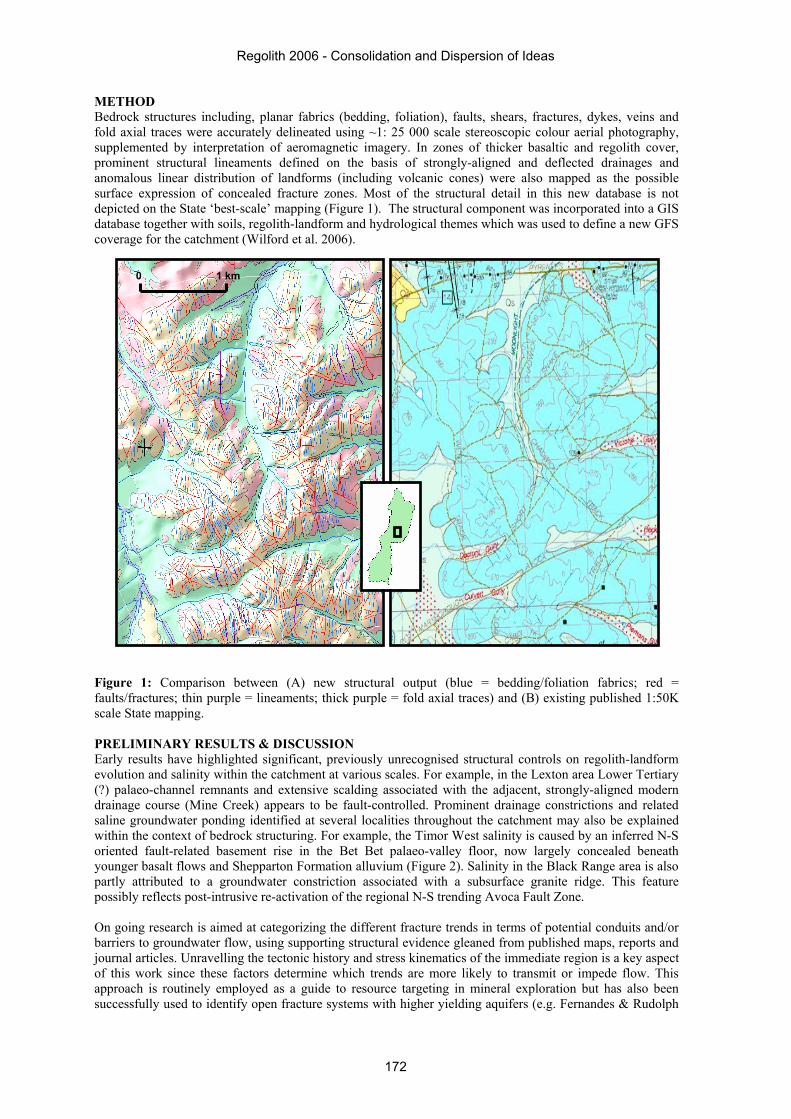
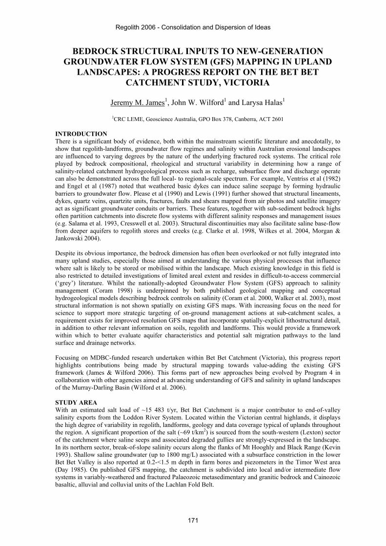
METHOD Bedrock structures including, planar fabrics (bedding, foliation), faults, shears, fractures, dykes, veins and fold axial traces were accurately delineated using ~1: 25 000 scale stereoscopic colour aerial photography, supplemented by interpretation of aeromagnetic imagery. In zones of thicker basaltic and regolith cover, prominent structural lineaments defined on the basis of strongly-aligned and deflected drainages and anomalous linear distribution of landforms (including volcanic cones) were also mapped as the possible surface expression of concealed fracture zones. Most of the structural detail in this new database is not depicted on the State ‘best-scale’ mapping (Figure 1). The structural component was incorporated into a GIS database together with soils, regolith-landform and hydrological themes which was used to define a new GFS coverage for the catchment (Wilford et al. 2006). Figure 1: Comparison between (A) new structural output (blue = bedding/foliation fabrics; red = faults/fractures; thin purple = lineaments; thick purple = fold axial traces) and (B) existing published 1:50K scale State mapping. PRELIMINARY RESULTS & DISCUSSION Early results have highlighted significant, previously unrecognised structural controls on regolith-landform evolution and salinity within the catchment at various scales. For example, in the Lexton area Lower Tertiary (?) palaeo-channel remnants and extensive scalding associated with the adjacent, strongly-aligned modern drainage course (Mine Creek) appears to be fault-controlled. Prominent drainage constrictions and related saline groundwater ponding identified at several localities throughout the catchment may also be explained within the context of bedrock structuring. For example, the Timor West salinity is caused by an inferred N-S oriented fault-related basement rise in the Bet Bet palaeo-valley floor, now largely concealed beneath younger basalt flows and Shepparton Formation alluvium (Figure 2). Salinity in the Black Range area is also partly attributed to a groundwater constriction associated with a subsurface granite ridge. This feature possibly reflects post-intrusive re-activation of the regional N-S trending Avoca Fault Zone. On going research is aimed at categorizing the different fracture trends in terms of potential conduits and/or barriers to groundwater flow, using supporting structural evidence gleaned from published maps, reports and journal articles. Unravelling the tectonic history and stress kinematics of the immediate region is a key aspect of this work since these factors determine which trends are more likely to transmit or impede flow. This approach is routinely employed as a guide to resource targeting in mineral exploration but has also been successfully used to identify open fracture systems with higher yielding aquifers (e.g. Fernandes & Rudolph
1 km 0
Regolith 2006 - Consolidation and Dispersion of Ideas
172
2000). Initial observations suggest that possible Cainozoic (post-basaltic) re-activation of older, Late Ordovician-Early Silurian (Benambran) structures is much more widespread than previously recognised. This is partly corroborated by recent research that highlights possible fault controls on deep lead palaeodrainage systems within the central highlands (Holdgate et al. 2006). It may also have important implications for groundwater flow within the catchment since some older, non-transmissive (i.e. tight) structures could have been re-activated to form more open conduits. This is being addressed in the current research by developing a scenario-based approach to fracture classification which takes into account different stress histories. Figure 2: Salinity associated with structurally-controlled bedrock constriction (Timor West area). Preliminary structural domain mapping based on fracture pattern, density, orientation and degree of interconnectivity has also proved useful in categorising the different GFS. For example, more highly weathered bedrock zones (e.g. Lexton area) appear to exhibit significantly lower fracture densities, while granitic systems in the north are more likely to be characterised by preferential flow along closely-spaced, sub-parallel NNW-SSE trending fracture sets. FUTURE DIRECTIONS As part of an integrated multi-scale approach, structural inputs are making a significant contribution to improving GFS maps and conceptual models for salinity hazard management and is now proving an important component in other P4 studies being undertaken in upland regions (e.g. Gardiner Creek Catchment, Victoria). The use of statistical analysis to help categorise fault/fracture trends is also currently being investigated along with field validation work. Integrating the structural data into catchment hydrological modelling in conjunction with the other project datasets will be an important aspect of future research. REFERENCES CLARKE C.J., GEORGE R.J., BELL R.W. & HOBBS R.J. 1998. Major faults and the development of dryland
salinity in the western wheatbelt of Western Australia. Hydrology and Earth Systems Sciences 2/1, 77-91.
CORAM J.E. (Ed.). 1998. National classification of catchments for land and river salinity control. Rural Industries Research and Development Corporation Report 98/78. Available at: www.rirdc.gov.au/reports/AFT/AGS-1A.pdf
TMI aeromagnetic
Regolith 2006 - Consolidation and Dispersion of Ideas
173
CORAM J.E., DYSON P.R., HOULDER P.A. & EVANS W.R. 2000. Australian Groundwater Flow Systems contributing to dryland salinity. Report prepared by the Bureau of Rural Sciences for the Dryland Salinity Theme of the National Land & Water Resources Audit. Available at: www.audit.ea.gov.au/ANRA/land/docs/national/Salinity_GFS_Report/REPORT/PDF/REPORT.PDF
CRESSWELL R.G., DAWES W.R., SUMMERELL G.K. & WALKER G.R. 2003. Assessment of salinity management options for Kyeamba Creek, New South Wales: data analysis and groundwater modelling. CSIRO Land and Water Technical Report 26/03.
DAY C. 1985. A study of the geomorphic, soil and geohydrological conditions of the Timor West/Black Ranges areas. DPI Victoria Technical Report.
ENGEL R., MCFARLANE D.J. & STREET G. 1987. The influence of dolerite dykes on saline seeps in south-western Australia. Australian Journal of Soil Research 25, 125-136.
FERNANDES A.J. & RUDOLPH D.L. 2001. The influence of Cenozoic tectonics on the groundwater-production capacity of fractured zones: a case study in São Paulo, Brazil. Hydrogeology Journal 9, 151-197.
HOLDGATE G.R., WALLACE M.W., GALLAGHER R.B., WITTEN B., STATS B. & WAGSTAFF B.E. 2006. Cenozoic fault control on ‘deep lead’ palaeoriver systems, Central Highlands, Victoria. Australian Journal of Earth Sciences 53, 445-468.
JAMES J.M. & WILFORD J.W. 2006. Potential bedrock controls on Groundwater Flow Systems and regolith-landform development in Bet Bet Catchment, Victoria: some implications for salinity processes and management. Australian Earth Sciences Convention 2006 Abstract.
KEVIN P.M. 1993. Groundwater and salinity processes in the uplands of the Loddon River Catchment. Centre for Land Protection Technical Report 5.
LEWIS M.F. 1991. Lineaments and salinity in Western Australia: carriers or barriers? In: Proceedings International Hydrol Water Resource Symposium, 2-4 October 1991, Perth, Australia. Institute of Engineers Australia, Barton, ACT, 202-209.
MORGAN K. & JANKOWSKI J. 2004. Saline groundwater seepage zones and their impact on soil and water resources in the Spicers Creek Catchment, central west New South Wales, Australia. Environmental Geology 46, 273-285.
PLEASE P.M., KNIGHT. & CORPUZ A. 1990. Role of large scale geological structures in groundwater driven salinity. Proceedings of Symposium on Management of Soil Salinity in South East Australia. Australian Society of Soil Science, Riverina Branch, 269-280.
SALAMA R.B., FARRINGTON P., BARTLE G.A. & WATSON G.D. 1993. The role of geological structures and relict channels in the development of dryland salinity in the wheatbelt of Western Australia. Australian Journal of Earth Sciences 40, 45-56.
VENTRISS H.B., COLLETT D.B. & BOYD D.W. 1982. Relationship between groundwater occurrence and a dolerite dyke in Northhampton area of Western Australia. In: Papers of Groundwater in Fractured Rock Conference, Canberra, Australia. Australian Water Resources Council Conference Series 5, 217-227.
WALKER G., GILFEDDER M., EVANS R., DYSON P. & STAUFFACHER, M. 2003. Groundwater Flow Systems Framework: essential tools for planning salinity management. Murray-Darling Basin Commission Report 14/03. Available at: www.clw.csiro.au/publications/general 2003/Groundwater_Flow_Systems_Full_Report.pdf
WILFORD J.W., JAMES J.M. & HALAS L. 2006. Advancing GFS in upland regions: new approaches for old landscapes. 10th Murray-Darling Basin Groundwater Workshop Proceedings, 1-9.
WILKES S.M., CLEMENT T.P. & OTTO C.J. 2004. Characterisation of the hydrogeology of the Augustus River Catchment, Western Australia. Hydrogeology Journal 12, 209-223.
Acknowledgements: The authors wish to thank MDBC for funding support. Special thanks to Colin Pain and Jonathon Clarke who reviewed this paper. This paper is published with the permission of the CEOs of CRC LEME and Geoscience Australia.
Regolith 2006 - Consolidation and Dispersion of Ideas
174