BEDROCK GEOLOGY OF GRANITE CITY … Mo nks u d 6 W ebst rG ov 7 Cahokia 8 Fr ench Vi lag ADJOINING...
1
ILLINOIS NATURAL RESOURCES DEPARTMENT OF 7000 FEET 1000 1000 0 2000 3000 4000 5000 6000 .5 1 KILOMETER 1 0 SCALE 1:24 000 1/2 1 0 1 MILE 1 2 3 4 5 6 7 8 64 50 158 ROAD CLASSIFICATION Primary highway, hard surface Secondary highway, hard surface Light duty road, hard or improved surface Unimproved road Interstate Route U.S. Route State Route MAGNETIC NORTH APPROXIMATE MEAN DECLINATION, 1996 TRUE NORTH / ° 1 2 Base map compiled by Illinois State Geological Survey from digital data provided by the United States Geological Survey. Topography compiled 1933. Revised and updated from imagery dated 1998. North American Datum of 1983 (NAD 83) Projection: transverse Mercator 10,000-foot ticks: Illinois (west zone) and Missouri (east zone) State Plane coordinate system, (transverse Mercator) 1,000-meter ticks: Universal Transverse Mercator grid, zone 15 Geology based on fieldwork by F. Brett Denny, 2003. Digital cartography by F. Brett Denny, Jane E. Domier, and John D. McLeod, Illinois State Geological Survey. This research was supported in part by the U.S. Geological Survey, National Cooperative Geologic Mapping Program under USGS award number 02HQAG0042. The Illinois State Geological Survey, the Illinois Department of Natural Resources, and the State of Illinois make no guarantee, expressed or implied, regarding the correctness of the interpretations presented in this document and accept no liability for the consequences of decisions made by others on the basis of the information presented here. The geologic interpretations are based on data that may vary with respect to accuracy of geographic location, the type and quantity of data available at each location, and the scientific/technical qualifications of the data sources. Maps or cross sections in this document are not meant to be enlarged. Released by the authority of the State of Illinois: 2003 BASE MAP CONTOUR INTERVAL 10 FEET NATIONAL GEODETIC VERTICAL DATUM OF 1929 1 Florissant 2 Columbia Bottom 3 Wood River 4 Clayton 5 Monks Mound 6 Webster Grove 7 Cahokia 8 French Village ADJOINING QUADRANGLES For more information contact: Illinois State Geological Survey 615 East Peabody Drive Champaign Illinois 61820-6964 (217) 244-2414 http://www.isgs.uiuc.edu BEDROCK GEOLOGY OF GRANITE CITY QUADRANGLE MADISON AND ST. CLAIR COUNTIES, ILLINOIS AND ST. LOUIS COUNTY, MISSOURI F. Brett Denny 2003 Rod R. Blagojevich, Governor Department of Natural Resources Joel Brunsvold, Director Illinois State Geological Survey William W. Shilts, Chief ST LOUIS FAULT ZONE 2085 81 2816 64 93 80 66 96 92 73 74 87 86 95 74 92 128 117 110 117 102 1000 114 103 375 350 325 300 300 ra Mv Mv My u u 95 117 Madison County Macoupin County Granite City Quadrangle 1:500,000 Oil and gas fields Coal mine area (coal has been removed) St. Clair County Petroleum and Coal Resources of Madison County (Resources have been removed) A. Yankeetown Sandstone and Renault Limestone: Yankeetown Sandstone: sand, shale, and chert. This unit contains very fine grained quartz- rich sand that can be white, red, and gray green. In places it has been silicified and has preserved as chert. Common sedimentary structure is stacked ripple bedded cherts that on close inspection yield very fine angular quartz sand. Shale is typically red claystone at the top of the unit but can also be variegated with greens and grays. This formation can grade into the underlying limestone.; Renault Limestone: limestone, sandy limestone, and limestone conglomerate. Limestone is light to medium gray containing oolites and fossils and diagnostic red crinoids. Mainly composed of packstones and grainstones this limestone is dominated by pelmatozoa. Quartz sand is found within this limestone and in places carbonate conglom erates o ccur at the base . B. Aux Vases Sandstone: sand and shale. This unit contains a clean, white, well sorted, quartz arenite that shows crossbedding and current ripples. Green shales and green clay drapes occur near the upper part of the sandstone. The lower part of the sand is calcareous and can be locally unconformable with the underlying unit. C. Ste. Genevieve Limestone: limestone and sand. Limestone containing oolites and crinoids are abundant. Oolitic crossbedded grainstones or oosparites are found in the upper parts of the formation. These limestone beds are light gray to white and contain calcium-rich carbonate. Near the upper part of the limestone approximately seven feet of very fine grained sand is present. The sand is light greenish gray, bioturbated, and has calcareous cement. The lower part of the unit is dominated by crinoidal packstones with tighlty packed coated grains and thin greenish shale laminae. Stylolites are common and chert is occasionally present. Greenish oncolites are seen in the lower beds. D. St. Louis Limestone: limestone and chert. This formation is dominated by lime-mudstones dark gray to light gray, with conchoidal fracture. Stylolites are common and facies of fossil wackestone and packstone are present. This unit is thin bedded and commonly contains white to dark gray chert nodules and stringers. Yellowish beds of dolostone and breccia also occur in the middle part of the formation. The colonial coral Acrocyathus is common near the lowe r portion of the limestone. St. Louis Limestone A B D 0-40 > 200 GRAPHIC COLUMN DESCRIPTION UNIT MEMBER and Bed FORMATION SERIES SYSTEM St. Genevieve Limestone 0-10 Aux Vases C 0-60 50 - 130 Spar Mountain Sandstone ? Valmeyeran Mississippian Quaternary and Holocene units not depicted on map Yankeetown Renault Units not depicted on map Chesterian 0-20 Line symbols: dashed where inferred Contact Fault: ball and bar on downthrown side Bedrock topography (elevation in feet) Engineering boring (depth in feet) Water well (depth in feet) Dry oil test (depth in feet) Oil test, show of oil (depth in feet) 475 2085 81 78 2085 Mississippian Chesterian Mississippian Yankeetown and Renault Mississippian Ste Genevieve and St. Louis Myra Mvu Valmeyeran Introduction Stratigraphy Economic Resources Structural Geology References Bedrock Geology of Granite City Quadrangle is part of a statewide 1:24,000 scale geologic mapping program by the Illinois Department of Natural Resources (State Geological Survey). This geologic map was funded in part through a grant by the United States Geologic Survey. Geologic maps may aid in the exploration for economic minerals including coal, petroleum, and natural gas and may facilitate regional planning. The Granite City 7.5' Quadrangle is just east of St. Louis, Missouri. The quadrangle lies on the western portion of the Illinois Basin in the Metro East St. Louis area. Bedrock does not outcrop on the Illinois portion of this quadrangle. Holocene and Quaternary units along the flood plain of the Mississippi River cover the entire Illinois portion of the map. This surficial material ranges in thickness from less than 50 feet near the Chain of Rocks Canal on the west portion of the map to approximately 125 feet along the eastern half. The Illinois portion of the quadrangle is underlain by the Ste. Genevieve Limestone and St. Louis Limestone throughout the majority of the quadrangle. Several data sources have been used to construct this map. Well records from files of the Illinois State Geological Survey were the primary source of data. No bedrock outcrops were observed in the Illinois portion of this quadrangle. All Quaternary and Holocene units have been removed from the map to portray the bedrock geology. Bedrock topographic surface contours at 25 feet intervals were generated and overlain on the geologic map. An estimate of unconsolidated or surficial material thickness may be estimated by subtracting the bedrock topography elevations from the surface elevations on the topographic base map. The oldest bedrock units sub-cropping beneath the surficial sediments is the Mississippian-age St. Louis Limestone. The St. Louis consists of lime-mudstone and algal limestones, but the whiter units are coarsely fossiliferous and contain brachiopods, bryozoans, coelenterates, and echinoderms. Limestone breccia and conglomerates are also present and sometimes are associated with glauconite and dolomite. The St. Louis commonly contains a few gray shale layers separating 5 to10-foot thick limestone beds. Gray to blue gray chert is present as thin lenticular layers to nodules. The St. Louis is fossiliferous with brachiopods and corals being most abundant. The overlying Ste. Genevieve Limestone is very similar in character to the St. Louis but may be differentiated by the presence of oolitic to peloidal limestones. The oolitic units may be cross bedded and represent a near-shore, higher energy depositional system than the underlying micritic and cherty St. Louis Limestone. The Ste. Genevieve may also contain a fine-grained calcareous sandstone bed that is called the Spar Mountain Sandstone. The type section for the Spar Mountain is in southeastern Illinois, over 100 miles away from this quadrangle. This sandstone unit, therefore, may not correlate with the Spar Mountain and may be related to inter- tonguing with the overlying Aux Vases Sandstone (Willman, et.al., 1975). Wells records from the southeastern portion of the map indicate, shale, sandstone, and limestone of the Yankeetown, Renault, and Aux Vase Formations are present. Without additional drilling in this area, a precise subcrop of these Chesterian units is difficult to project, and an accurate portrayal of these individual units on the map is impossible. These units are also dipping easterly; therefore, this package of rocks thin westerly and is not recognized west of this quadrangle. The Aux Vases Sandstone is fine to very fine grained calcareous sandstone to siltstone. Dark gray to green shales and siltstone are locally present and limestones have been described within this formation. In adjacent quadrangles this unit is commonly a sandstone and shale. This unit is unconformable with the underlying units. The Renault Formation is composed of a thin, relatively pure coarse-grained limestone that may be cross bedded and oolitic. The oolites may be pink, light green or white and in part the formation may be sandy at the base. The Yankeetown Formation is commonly sandstone, white to light gray to greenish-gray, fine- grained, and sub-angular to angular. In this and adjacent quadrangles, the top of the unit commonly is cherty and contains greenish-gray to red variegated shales. Oil Two oil tests have been made in the quadrangle. One of the wells (24-3N-10W) produced a show of oil in the Ordovician (Kimmswick Limestone). Oil is produced from several areas in the surrounding quadrangles (see inset map) and undiscovered accumulations of oil may be present in this quadrangle. Sand and Gravel Sand and gravel deposits may be available in overlying surficial deposits in the Illinois portion of the quadrangle (See Grimley, in prep. for more information.) The St. Louis Fault Zone was projected into the Granite City Quadrangle based on bedrock geologic map by Harrison (1997). The St. Louis Fault Zone was originally named by Frank (1948) who was the first to suggest the flow of the Mississippi River in this area was controlled by faults. Frank stated that the St. Louis Fault was a normal fault with dip slip down to the west. Harrison suggested that the St. Louis Fault Zone is a right-lateral, strike-slip fault with strata offset down to the western side of the fault. The structure is better developed southwest of the study area, but Harrison (1997) projects the fault zone into the northwestern part of the Granite City Quadrangle. Harrison also suggests that the two small earthquakes that registered 3.1 and 2.4 mq occurred along the St. Louis Fault Zone. This was the only indication of structure in the quadrangle. The regional dip is projected from subsurface cross sections in the area to be easterly at 1 to 2 degrees. Strike is north-south and may trend slightly north- northesterly where not effected by the St. Louis Fault Zone. Frank, A.J., 1948, Faulting on the northeast flank of the Ozarks (Missouri) [abs.]: Geological Society of America Bulletin, v. 59, no.12, p.1322. Grimley, in prep., Surficial Geologic Map of the Granite City 7.5 Minute Quadrangle, Illinois State Geological Survey, Champaign, Illinois, Illinois Geologic Quadrangle Series (IGQ), Granite City-SG. Harrison, R.W., 1997, Bedrock Geologic Map of the St. Louis 30'X60' Quadrangle Missouri and Illinois, U.S. Geological Survey map I-2533. Willman, H.B., et al., 1975, Handbook of Illinois Stratigraphy, Illinois State Geological Survey, Champaign, Illinois, Bulletin 95, 261 p.
Transcript of BEDROCK GEOLOGY OF GRANITE CITY … Mo nks u d 6 W ebst rG ov 7 Cahokia 8 Fr ench Vi lag ADJOINING...
ILLINOIS
NATURALRESOURCES
DEPARTMENT OF
7000 FEET1000 10000 2000 3000 4000 5000 6000
.5 1 KILOMETER1 0
SCALE 1:24 0001/ 21 0 1 MILE
1 2 3
4 5
6 7 864 50 158
ROAD CLASSIFICATION
Primary highway,hard surfaceSecondary highway,hard surface
Light duty road, hard orimproved surface
Unimproved road
Interstate Route U.S. Route State Route
MA
GN
ETI
C N
OR
TH
APPROXIMATE MEANDECLINATION, 1996
TRU
E N
OR
TH
/ °1 2
Base map compiled by Illinois State Geological Survey from digital data provided by the United States Geological Survey. Topography compiled 1933. Revised and updated from imagery dated 1998.
North American Datum of 1983 (NAD 83)Projection: transverse Mercator10,000-foot ticks: Illinois (west zone) and Missouri (east zone) State Plane coordinate system, (transverse Mercator)1,000-meter ticks: Universal Transverse Mercator grid, zone 15
Geology based on fieldwork by F. Brett Denny, 2003.
Digital cartography by F. Brett Denny, Jane E. Domier, and John D. McLeod, Illinois State Geological Survey.
This research was supported in part by the U.S. Geological Survey, National Cooperative Geologic Mapping Program under USGS award number 02HQAG0042.
The Illinois State Geological Survey, the Illinois Department of Natural Resources, and the State of Illinois make no guarantee, expressed or implied, regarding the correctness of the interpretations presented in this document and accept no liability for the consequences of decisions made by others on the basis of the information presented here. The geologic interpretations are based on data that may vary with respect to accuracy of geographic location, the type and quantity of data available at each location, and the scientific/technical qualifications of the data sources. Maps or cross sections in this document are not meant to be enlarged.
Released by the authority of the State of Illinois: 2003
BASE MAP CONTOUR INTERVAL 10 FEETNATIONAL GEODETIC VERTICAL DATUM OF 1929
1 Florissant2 Columbia Bottom3 Wood River4 Clayton5 Monks Mound6 Webster Grove7 Cahokia8 French Village
ADJOINING QUADRANGLES
For more information contact: Illinois State Geological Survey 615 East Peabody Drive Champaign Illinois 61820-6964 (217) 244-2414 http://www.isgs.uiuc.edu
BEDROCK GEOLOGY OF GRANITE CITY QUADRANGLEMADISON AND ST. CLAIR COUNTIES, ILLINOIS
AND ST. LOUIS COUNTY, MISSOURI
F. Brett Denny2003
Rod R. Blagojevich, GovernorDepartment of Natural Resources
Joel Brunsvold, DirectorIllinois State Geological Survey
William W. Shilts, Chief
ST
LOU
IS
FAU
LT
ZON
E
2085
81
2816
64
9380
6696
92
7374
87
86
95
74
92
128
117
110
117
102
1000114
103
375
350
325
300
300
ra
Mv
Mv
My
u
u
95117
Madison CountyMacoupin County
Granite CityQuadrangle
1:500,000
Oil and gas fields Coal mine area(coal has been removed)
St. Clair County
Petroleum and Coal Resources of Madison County
(Resources have been removed)
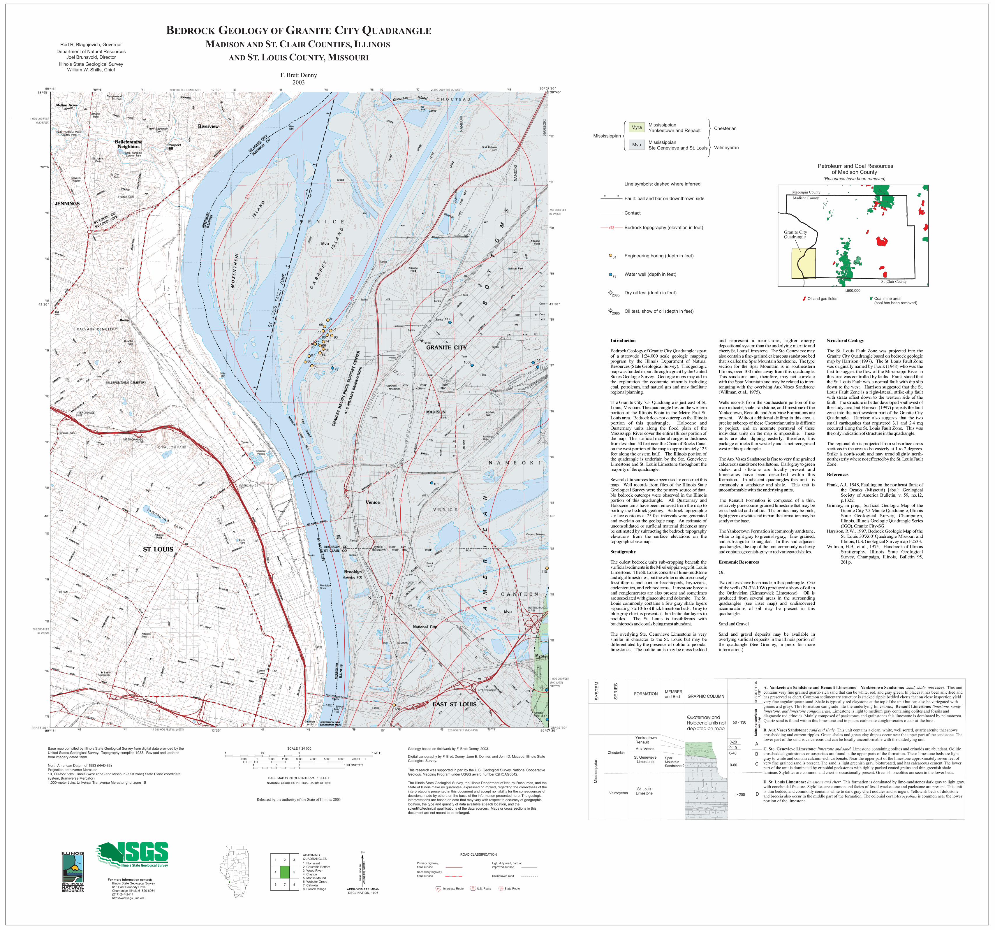
A. Yankeetown Sandstone and Renault Limestone: Yankeetown Sandstone: sand, shale, and chert. This unit contains very fine grained quartz- rich sand that can be white, red, and gray green. In places it has been silicified and has preserved as chert. Common sedimentary structure is stacked ripple bedded cherts that on close inspection yield very fine angular quartz sand. Shale is typically red claystone at the top of the unit but can also be variegated with greens and grays. This formation can grade into the underlying limestone.; Renault Limestone: limestone, sandy limestone, and limestone conglomerate. Limestone is light to medium gray containing oolites and fossils and diagnostic red crinoids. Mainly composed of packstones and grainstones this limestone is dominated by pelmatozoa. Quartz sand is found within this limestone and in places carbonate conglomerates occur at the base.
B. Aux Vases Sandstone: sand and shale. This unit contains a clean, white, well sorted, quartz arenite that shows crossbedding and current ripples. Green shales and green clay drapes occur near the upper part of the sandstone. The lower part of the sand is calcareous and can be locally unconformable with the underlying unit.
C. Ste. Genevieve Limestone: limestone and sand. Limestone containing oolites and crinoids are abundant. Oolitic crossbedded grainstones or oosparites are found in the upper parts of the formation. These limestone beds are light gray to white and contain calcium-rich carbonate. Near the upper part of the limestone approximately seven feet of very fine grained sand is present. The sand is light greenish gray, bioturbated, and has calcareous cement. The lower part of the unit is dominated by crinoidal packstones with tighlty packed coated grains and thin greenish shale laminae. Stylolites are common and chert is occasionally present. Greenish oncolites are seen in the lower beds.
D. St. Louis Limestone: limestone and chert. This formation is dominated by lime-mudstones dark gray to light gray, with conchoidal fracture. Stylolites are common and facies of fossil wackestone and packstone are present. This unit is thin bedded and commonly contains white to dark gray chert nodules and stringers. Yellowish beds of dolostone and breccia also occur in the middle part of the formation. The colonial coral Acrocyathus is common near the lower portion of the limestone.
St. LouisLimestone
A
B
D
0-40
> 200
GRAPHIC COLUMN
DE
SC
RIP
TIO
N
U
NITMEMBER
and BedFORMATION
SE
RIE
S
SY
STE
M
St. GenevieveLimestone
0-10Aux Vases
C0-60
50 - 130
Spar MountainSandstone ?
Valmeyeran
Mis
siss
ippi
an
Quaternary andHolocene units not depicted on map
YankeetownRenault
Uni
ts n
ot d
epic
ted
on m
ap
Chesterian
0-20
Line symbols: dashed where inferred
Contact
Fault: ball and bar on downthrown side
Bedrock topography (elevation in feet)
Engineering boring (depth in feet)
Water well (depth in feet)
Dry oil test (depth in feet)
Oil test, show of oil (depth in feet)
475
2085
81
78
2085
MississippianChesterian
MississippianYankeetown and Renault
MississippianSte Genevieve and St. Louis
Myra
Mvu Valmeyeran
Introduction
Stratigraphy
Economic Resources
Structural Geology
References
Bedrock Geology of Granite City Quadrangle is part of a statewide 1:24,000 scale geologic mapping program by the Illinois Department of Natural Resources (State Geological Survey). This geologic map was funded in part through a grant by the United States Geologic Survey. Geologic maps may aid in the exploration for economic minerals including coal, petroleum, and natural gas and may facilitate regional planning.
The Granite City 7.5' Quadrangle is just east of St. Louis, Missouri. The quadrangle lies on the western portion of the Illinois Basin in the Metro East St. Louis area. Bedrock does not outcrop on the Illinois portion of this quadrangle. Holocene and Quaternary units along the flood plain of the Mississippi River cover the entire Illinois portion of the map. This surficial material ranges in thickness from less than 50 feet near the Chain of Rocks Canal on the west portion of the map to approximately 125 feet along the eastern half. The Illinois portion of the quadrangle is underlain by the Ste. Genevieve Limestone and St. Louis Limestone throughout the majority of the quadrangle.
Several data sources have been used to construct this map. Well records from files of the Illinois State Geological Survey were the primary source of data. No bedrock outcrops were observed in the Illinois portion of this quadrangle. All Quaternary and Holocene units have been removed from the map to portray the bedrock geology. Bedrock topographic surface contours at 25 feet intervals were generated and overlain on the geologic map. An estimate of unconsolidated or surficial material thickness may be estimated by subtracting the bedrock topography elevations from the surface elevations on the topographic base map.
The oldest bedrock units sub-cropping beneath the surficial sediments is the Mississippian-age St. Louis Limestone. The St. Louis consists of lime-mudstone and algal limestones, but the whiter units are coarsely fossiliferous and contain brachiopods, bryozoans, coelenterates, and echinoderms. Limestone breccia and conglomerates are also present and sometimes are associated with glauconite and dolomite. The St. Louis commonly contains a few gray shale layers separating 5 to10-foot thick limestone beds. Gray to blue gray chert is present as thin lenticular layers to nodules. The St. Louis is fossiliferous with brachiopods and corals being most abundant.
The overlying Ste. Genevieve Limestone is very similar in character to the St. Louis but may be differentiated by the presence of oolitic to peloidal limestones. The oolitic units may be cross bedded
and represent a near-shore, higher energy depositional system than the underlying micritic and cherty St. Louis Limestone. The Ste. Genevieve may also contain a fine-grained calcareous sandstone bed that is called the Spar Mountain Sandstone. The type section for the Spar Mountain is in southeastern Illinois, over 100 miles away from this quadrangle. This sandstone unit, therefore, may not correlate with the Spar Mountain and may be related to inter-tonguing with the overlying Aux Vases Sandstone (Willman, et.al., 1975).
Wells records from the southeastern portion of the map indicate, shale, sandstone, and limestone of the Yankeetown, Renault, and Aux Vase Formations are present. Without additional drilling in this area, a precise subcrop of these Chesterian units is difficult to project, and an accurate portrayal of these individual units on the map is impossible. These units are also dipping easterly; therefore, this package of rocks thin westerly and is not recognized west of this quadrangle.
The Aux Vases Sandstone is fine to very fine grained calcareous sandstone to siltstone. Dark gray to green shales and siltstone are locally present and limestones have been described within this formation. In adjacent quadrangles this unit is commonly a sandstone and shale. This unit is unconformable with the underlying units.
The Renault Formation is composed of a thin, relatively pure coarse-grained limestone that may be cross bedded and oolitic. The oolites may be pink, light green or white and in part the formation may be sandy at the base.
The Yankeetown Formation is commonly sandstone, white to light gray to greenish-gray, fine- grained, and sub-angular to angular. In this and adjacent quadrangles, the top of the unit commonly is cherty and contains greenish-gray to red variegated shales.
Oil
Two oil tests have been made in the quadrangle. One of the wells (24-3N-10W) produced a show of oil in the Ordovician (Kimmswick Limestone). Oil is produced from several areas in the surrounding quadrangles (see inset map) and undiscovered accumulations of oil may be present in this quadrangle.
Sand and Gravel
Sand and gravel deposits may be available in overlying surficial deposits in the Illinois portion of the quadrangle (See Grimley, in prep. for more information.)
The St. Louis Fault Zone was projected into the Granite City Quadrangle based on bedrock geologic map by Harrison (1997). The St. Louis Fault Zone was originally named by Frank (1948) who was the first to suggest the flow of the Mississippi River in this area was controlled by faults. Frank stated that the St. Louis Fault was a normal fault with dip slip down to the west. Harrison suggested that the St. Louis Fault Zone is a right-lateral, strike-slip fault with strata offset down to the western side of the fault. The structure is better developed southwest of the study area, but Harrison (1997) projects the fault zone into the northwestern part of the Granite City Quadrangle. Harrison also suggests that the two small earthquakes that registered 3.1 and 2.4 mq occurred along the St. Louis Fault Zone. This was the only indication of structure in the quadrangle.
The regional dip is projected from subsurface cross sections in the area to be easterly at 1 to 2 degrees. Strike is north-south and may trend slightly north-northesterly where not effected by the St. Louis Fault Zone.
Frank, A.J., 1948, Faulting on the northeast flank of the Ozarks (Missouri) [abs.]: Geological Society of America Bulletin, v. 59, no.12, p.1322.
Grimley, in prep., Surficial Geologic Map of the Granite City 7.5 Minute Quadrangle, Illinois State Geological Survey, Champaign, Illinois, Illinois Geologic Quadrangle Series (IGQ), Granite City-SG.
Harrison, R.W., 1997, Bedrock Geologic Map of the St. Louis 30'X60' Quadrangle Missouri and Illinois, U.S. Geological Survey map I-2533.
Willman, H.B., et al., 1975, Handbook of Illinois Stratigraphy, Illinois State Geological Survey, Champaign, Illinois, Bulletin 95, 261 p.