Becker Morgan Group, Inc. 250 South Main Street, …...June 3, 2018 Mr. Christopher Duke Becker...
24
June 3, 2018 Mr. Christopher Duke Becker Morgan Group, Inc. 250 South Main Street, Suite 109 Newark, DE 19711 Dear Mr. Duke: The enclosed Traffic Impact Study (TIS) review letter for the Casapulla Farm (Tax Parcel 13-026.00-005.00) residential development has been completed under the responsible charge of a registered professional engineer whose firm is authorized to work in the State of Delaware. They have found the TIS to conform to DelDOT’s Development Coordination Manual and other accepted practices and procedures for such studies. DelDOT accepts this review letter and concurs with the recommendations. If you have any questions concerning this letter or the enclosed review letter, please contact me at (302) 760-2167. Sincerely, Troy Brestel Project Engineer TEB:km Enclosures cc with enclosures: Ms. Constance C. Holland, Office of State Planning Coordination Mr. Morris Deputy, Town of Middletown Mr. Andrew Parker, McCormick Taylor, Inc. DelDOT Distribution
Transcript of Becker Morgan Group, Inc. 250 South Main Street, …...June 3, 2018 Mr. Christopher Duke Becker...
June 3, 2018
Mr. Christopher Duke
Becker Morgan Group, Inc.
250 South Main Street, Suite 109
Newark, DE 19711
Dear Mr. Duke:
The enclosed Traffic Impact Study (TIS) review letter for the Casapulla Farm (Tax Parcel
13-026.00-005.00) residential development has been completed under the responsible charge of a
registered professional engineer whose firm is authorized to work in the State of Delaware. They
have found the TIS to conform to DelDOT’s Development Coordination Manual and other
accepted practices and procedures for such studies. DelDOT accepts this review letter and concurs
with the recommendations. If you have any questions concerning this letter or the enclosed review
letter, please contact me at (302) 760-2167.
Sincerely,
Troy Brestel
Project Engineer
TEB:km
Enclosures
cc with enclosures: Ms. Constance C. Holland, Office of State Planning Coordination
Mr. Morris Deputy, Town of Middletown
Mr. Andrew Parker, McCormick Taylor, Inc.
DelDOT Distribution

DelDOT Distribution
Brad Eaby, Deputy Attorney General
Robert McCleary, Director, Transportation Solutions (DOTS)
Drew Boyce, Director, Planning
Mark Luszcz, Chief Traffic Engineer, Traffic, DOTS
Pamela Steinebach, Assistant Director, Project Development North, DOTS
J. Marc Coté, Assistant Director, Development Coordination
T. William Brockenbrough, Jr., County Coordinator, Development Coordination
Peter Haag, Traffic Studies Manager, Traffic, DOTS
Kevin Canning, Canal District Engineer, North District
Matthew Vincent, Canal District Public Works Engineer, Canal District
David Dooley, Service Development Planner, Delaware Transit Corporation
Sireen Muhtaseb, New Castle Review Coordinator, Development Coordination
Pao Lin, New Castle Subdivision Manager, Development Coordination
Mark Galipo, Traffic Engineer, Traffic, DOTS
Anthony Aglio, Planning Supervisor, Statewide & Regional Planning
Claudy Joinville, Project Engineer, Development Coordination

June 3, 2019 Mr. Troy E. Brestel Project Engineer DelDOT Division of Planning P.O. Box 778 Dover, DE 19903 RE: Agreement No. 1773 Traffic Impact Study Services Task No. 1 Subtask 20A – Casapulla Farm
Dear Mr. Brestel:
McCormick Taylor has completed its review of the Traffic Impact Study (TIS) for the Casapulla
Farm residential development prepared by Becker Morgan Group, Inc. dated February 2019.
Becker Morgan Group prepared the report in a manner generally consistent with DelDOT’s
Development Coordination Manual.
The TIS evaluates the impacts of the proposed Casapulla Farm residential development. The site
is located on the southwest corner of Middle Neck Road (New Castle Road 444) and Warwick
Road (Delaware Route 299 / New Castle Road 443A). In 2018, the parcel was annexed into the
Town of Middletown, New Castle County, Delaware. The proposed development would consist
of 168 detached homes, 24 attached homes, and 240 apartments; all uses are designated as senior-
adult housing. Two full-access unsignalized driveways are proposed on Middle Neck Road. “Site
Access A” is to be located 2,200 feet west of Warwick Road, and “Site Access B” is to be located
700 feet west of Warwick Road. Construction is anticipated to be completed by 2025.
The subject land consists of one parcel totaling approximately 119 acres. The land is split zoned
R-2 (Residential) and R-3 (Multi-family Residential) within the Town of Middletown. No
rezoning is needed or sought to permit the proposed development.
Currently, there is one DelDOT project within the study area. The US 301 Mainline is an 11.3-
mile, four-lane, limited-access highway that starts approximately ¼ mile west of the
Maryland/Delaware state line and ends at Delaware Route 1 approximately ½ mile north of the
intersection of US Route 13 and Port Penn Road near the C&D Canal, north of Middletown. The
US 301 Mainline was opened to traffic in January 2019. Traffic counts conducted for the Casapulla
Farm TIS were completed before the US 301 Mainline was opened, but future volumes used in
the study were based in part on DelDOT’s Travel Demand Model that accounted for completion
of the US 301 Project. Aside from the proposed site driveways, all of the Casapulla Farm study
intersections were impacted by the US 301 Project.
Casapulla Farm June 3, 2019
Page 2
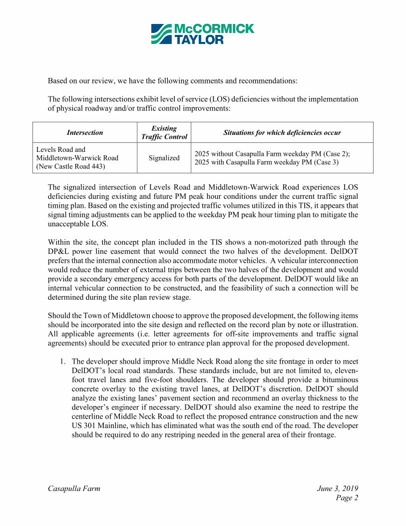
Based on our review, we have the following comments and recommendations:
The following intersections exhibit level of service (LOS) deficiencies without the implementation
of physical roadway and/or traffic control improvements:
Intersection Existing
Traffic Control Situations for which deficiencies occur
Levels Road and
Middletown-Warwick Road
(New Castle Road 443)
Signalized 2025 without Casapulla Farm weekday PM (Case 2);
2025 with Casapulla Farm weekday PM (Case 3)
The signalized intersection of Levels Road and Middletown-Warwick Road experiences LOS
deficiencies during existing and future PM peak hour conditions under the current traffic signal
timing plan. Based on the existing and projected traffic volumes utilized in this TIS, it appears that
signal timing adjustments can be applied to the weekday PM peak hour timing plan to mitigate the
unacceptable LOS.
Within the site, the concept plan included in the TIS shows a non-motorized path through the
DP&L power line easement that would connect the two halves of the development. DelDOT
prefers that the internal connection also accommodate motor vehicles. A vehicular interconnection
would reduce the number of external trips between the two halves of the development and would
provide a secondary emergency access for both parts of the development. DelDOT would like an
internal vehicular connection to be constructed, and the feasibility of such a connection will be
determined during the site plan review stage.
Should the Town of Middletown choose to approve the proposed development, the following items
should be incorporated into the site design and reflected on the record plan by note or illustration.
All applicable agreements (i.e. letter agreements for off-site improvements and traffic signal
agreements) should be executed prior to entrance plan approval for the proposed development.
1. The developer should improve Middle Neck Road along the site frontage in order to meet
DelDOT’s local road standards. These standards include, but are not limited to, eleven-
foot travel lanes and five-foot shoulders. The developer should provide a bituminous
concrete overlay to the existing travel lanes, at DelDOT’s discretion. DelDOT should
analyze the existing lanes’ pavement section and recommend an overlay thickness to the
developer’s engineer if necessary. DelDOT should also examine the need to restripe the
centerline of Middle Neck Road to reflect the proposed entrance construction and the new
US 301 Mainline, which has eliminated what was the south end of the road. The developer
should be required to do any restriping needed in the general area of their frontage.

Casapulla Farm June 3, 2019
Page 3
2. The developer should construct the full-movement “Site Access A” on Middle Neck Road,
approximately 2,200 feet west of Warwick Road. The proposed configuration is shown in
the table below.
Approach Existing Configuration Proposed Configuration
Eastbound
Site Access A Approach does not exist
One left-turn lane and
one right-turn lane
Northbound
Middle Neck Road One through lane
One through lane and
one bypass lane
Southbound
Middle Neck Road One through lane One shared through/right-turn lane
Initial recommended minimum turn / bypass lane lengths of the separate lanes are listed
below. The developer should coordinate with DelDOT’s Development Coordination
Section to determine final turn / bypass lane lengths during the site plan review.
Approach Left-Turn Lane Bypass Lane Right-Turn Lane
Eastbound
Site Entrance A N/A N/A 50 feet *
Northbound
Middle Neck Road N/A 215/110/50 feet ** N/A
Southbound
Middle Neck Road N/A N/A N/A
* Initial turn-lane length based on storage length (excluding taper) per queuing analysis, with 50-foot
minimum.
** Lengths shown are approach taper/departure taper/storage length, respectively. Initial bypass lane
lengths based on DelDOT’s Auxiliary Lane Worksheet.
3. The developer should construct the full-movement “Site Access B” on Middle Neck Road,
approximately 700 feet west of Warwick Road. The proposed configuration is shown in
the table below.
Approach Existing Configuration Proposed Configuration
Eastbound
Site Access B Approach does not exist
One left-turn lane and
one right-turn lane
Northbound
Middle Neck Road One through lane
One left-turn lane and
one through lane
Southbound
Middle Neck Road One through lane One shared through/right-turn lane
Casapulla Farm June 3, 2019
Page 4
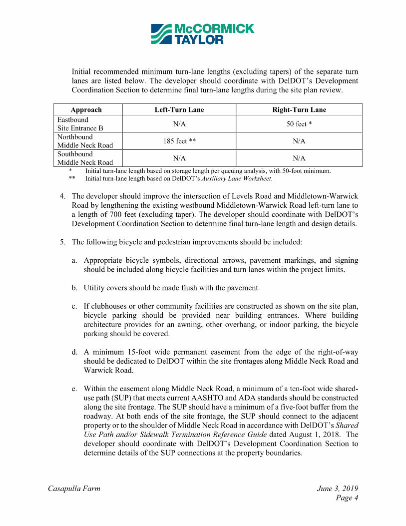
Initial recommended minimum turn-lane lengths (excluding tapers) of the separate turn
lanes are listed below. The developer should coordinate with DelDOT’s Development
Coordination Section to determine final turn-lane lengths during the site plan review.
Approach Left-Turn Lane Right-Turn Lane
Eastbound
Site Entrance B N/A 50 feet *
Northbound
Middle Neck Road 185 feet ** N/A
Southbound
Middle Neck Road N/A N/A
* Initial turn-lane length based on storage length per queuing analysis, with 50-foot minimum.
** Initial turn-lane length based on DelDOT’s Auxiliary Lane Worksheet.
4. The developer should improve the intersection of Levels Road and Middletown-Warwick
Road by lengthening the existing westbound Middletown-Warwick Road left-turn lane to
a length of 700 feet (excluding taper). The developer should coordinate with DelDOT’s
Development Coordination Section to determine final turn-lane length and design details.
5. The following bicycle and pedestrian improvements should be included:
a. Appropriate bicycle symbols, directional arrows, pavement markings, and signing
should be included along bicycle facilities and turn lanes within the project limits.
b. Utility covers should be made flush with the pavement.
c. If clubhouses or other community facilities are constructed as shown on the site plan,
bicycle parking should be provided near building entrances. Where building
architecture provides for an awning, other overhang, or indoor parking, the bicycle
parking should be covered.
d. A minimum 15-foot wide permanent easement from the edge of the right-of-way
should be dedicated to DelDOT within the site frontages along Middle Neck Road and
Warwick Road.
e. Within the easement along Middle Neck Road, a minimum of a ten-foot wide shared-
use path (SUP) that meets current AASHTO and ADA standards should be constructed
along the site frontage. The SUP should have a minimum of a five-foot buffer from the
roadway. At both ends of the site frontage, the SUP should connect to the adjacent
property or to the shoulder of Middle Neck Road in accordance with DelDOT’s Shared
Use Path and/or Sidewalk Termination Reference Guide dated August 1, 2018. The
developer should coordinate with DelDOT’s Development Coordination Section to
determine details of the SUP connections at the property boundaries.

Casapulla Farm June 3, 2019
Page 5
f. ADA compliant curb ramps and crosswalks should be provided at all pedestrian
crossings, including all site entrances. Type 3 curb ramps are discouraged.
g. Internal sidewalks for pedestrian safety and to promote walking as a viable
transportation alternative should be constructed within the development. These
sidewalks should each be a minimum of five-feet wide (with a minimum of a five-foot
buffer from the roadway) and should meet current AASHTO and ADA standards.
Internal sidewalks in the development should connect to the shared-use path along
Middle Neck Road.
h. Where internal sidewalks are located alongside of parking spaces, a buffer should be
added to prevent vehicular overhang onto the sidewalk.
Improvements in this TIS may be considered “significant” under DelDOT’s Work Zone Safety and
Mobility Procedures and Guidelines. These guidelines are available on DelDOT’s website at
http://deldot.gov/Publications/manuals/de_mutcd/index.shtml.
Please note that this review generally focuses on capacity and level of service issues; additional
safety and operational issues will be further addressed through DelDOT’s site plan review process.
Additional details on our review of this TIS are attached. Please contact me at (610) 640-3500 or
through e-mail at [email protected] if you have any questions concerning this
review.
Sincerely, McCormick Taylor, Inc.
Andrew J. Parker, PE, PTOE Project Manager Enclosure

Detailed TIS Review by
McCormick Taylor, Inc.
Casapulla Farm June 3, 2019
Page 6
General Information
Report date: February 2019
Prepared by: Becker Morgan Group, Inc.
Prepared for: Eastern States Development Group
Tax parcel: 13-026.00-005.00
Generally consistent with DelDOT’s Development Coordination Manual: Yes
Project Description and Background
Description: The proposed Casapulla Farm development consists of 168 detached homes, 24
attached homes, and 240 apartments; all uses are designated as senior-adult housing.
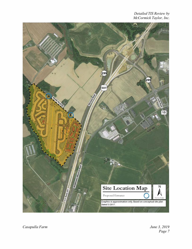
Location: The site is located on the southwest corner of Middle Neck Road (New Castle Road
444) & Warwick Road (Delaware Route 299 / New Castle Road 443A). In 2018, the parcel was
annexed into the Town of Middletown, New Castle County, Delaware. A site location map is
included on Page 7.
Amount of land to be developed: Approximately 119 acres
Land use approval(s) needed: Subdivision approval. The land is split zoned R-2 (Residential)
and R-3 (Multi-family Residential) within the Town of Middletown. No rezoning is needed or
sought to permit the proposed development.
Proposed completion year: 2025
Proposed access locations: Two full-access unsignalized driveways are proposed on Middle Neck
Road. “Site Access A” is located 2,200-feet west of Warwick Road, and “Site Access B” is located
700-feet west of Warwick Road.
Daily Traffic Volumes (per DelDOT Traffic Summary 2017):
• 2017 Average Annual Daily Traffic on Middle Neck Road: 801 vehicles/day
Detailed TIS Review by
McCormick Taylor, Inc.
Casapulla Farm June 3, 2019
Page 7

Detailed TIS Review by
McCormick Taylor, Inc.
Casapulla Farm June 3, 2019
Page 8
2015 Delaware Strategies for State Policies and Spending
Location with respect to the Strategies for State Policies and Spending Map of Delaware:
The majority of the proposed Casapulla Farm residential development is located within Investment
Level 4. A smaller portion of the development is located in Investment Level 3. Based on the site
plan, it appears that most of the land located in Investment Level 3 is reserved for open space and
wetland areas.
Investment Level 3
Investment Level 3 generally falls into two categories. The first category covers lands that are in
the long-term growth plans of counties or municipalities, but where development is not necessary
to accommodate expected short-term population growth. The second category includes lands that
are adjacent to fast-growing Investment Level 1 and 2 areas but are often impacted by
environmentally sensitive features, agricultural-preservation issues, or other infrastructure issues.
In these instances, development and growth may be appropriate in the near term, but the resources
on the site and in the surrounding area should be carefully considered and accommodated by state
Agencies and local governments with land-use authority.
Generally, Investment Level 3 areas should not be developed until surrounding Investment Level
1 and 2 areas are substantially built out. From a housing perspective, Investment Level 3 areas are
characterized by low density and rural homes. New housing developments in the short term would,
in most cases, represent leap-frog development, which is undesirable. Higher density housing in
Investment Level 3 areas is more appropriate once Level 2 areas are built out and utilities are
available.
Investment Level 4
Investment Level 4 areas are predominantly rural or agricultural and contain much of Delaware’s
open space and natural areas. These areas are home to agribusiness activities, farm complexes, and
small settlements/unincorporated communities that are often found at historic crossroads.
Investment Level 4 areas may also have scattered single-family detached residential homes.
Existing transportation facilities and services will be maintained by the state while they continue
to manage the transportation system in a manner that will support the preservation of the natural
environment and agricultural business. Construction of new homes is discouraged; housing
policies will focus on maintenance and rehabilitation of existing homes and communities. In
addition, the Department of Education does not support the construction of new educational
facilities in Investment Level 4 areas. The educational needs of Investment Level 4 areas would
likely need to be met through facilities located in Investment Level 1-3 areas.
In general, the state will limit its investments in public infrastructure systems; investments should
address existing public health, safety, or environmental risks, preserve rural character and natural
resources, and discourage further development that is unrelated to the area’s needs.
Proposed Development’s Compatibility with Strategies for State Policies and Spending:
The proposed Casapulla Farm development consists of 168 detached homes, 24 attached homes,
and 240 apartments; all uses are designated as senior-adult housing. The site is located on the

Detailed TIS Review by
McCormick Taylor, Inc.
Casapulla Farm June 3, 2019
Page 9
southwest corner of Middle Neck Road & Warwick Road in the Town of Middletown, New Castle
County, Delaware. The land to be developed is open space/farmland.
The Casapulla Farm development is located on a parcel that was added to the Town of Middletown
Comprehensive Plan as an area of Proposed Annexation (Residential). This amendment to the
Comprehensive Plan was reviewed as PLUS application 2016-09-01 and was approved by the
Town of Middletown in December 2016 (Ordinance 16-11-05). Subsequently, the parcel was
annexed to the Town of Middletown with R-2 (Residential) and R-3 (Multi-family residential)
zoning on September 10, 2018 (Ordinance 18-02-03).
Since the parcel has been certified as a new growth or annexation area, it is considered to comply
with the Strategies for State Policies and Spending.
Comprehensive Plan
Town of Middletown Comprehensive Plan: (Source: Town of Middletown Comprehensive Plan,
November 2012)
The November 2012 Town of Middletown Comprehensive Plan Future Land Use Map was
updated in December 2016 (Ordinance 16-11-05). This update changed the parcel from an “Area
of Concern” to “Proposed Annexation (Residential).”
Proposed Development’s Compatibility with Comprehensive Plan: The proposed Casapulla Farm residential development appears to comply with the Town of
Middletown’s Comprehensive Plan as well as the R-2 (Residential) and R-3 (Multi-family
residential) zoning.
Relevant Projects in the DelDOT Capital Transportation Program
Currently, there is one DelDOT project within the study area. The US 301 Mainline is an 11.3-
mile, four-lane, limited-access highway that starts approximately ¼ mile west of the
Maryland/Delaware state line and ends approximately ½ mile north of the intersection of US Route
13 and Port Penn Road near the C&D Canal, north of Middletown. The US 301 Mainline was
opened to traffic in January 2019. Traffic counts conducted for the Casapulla Farm TIS were
completed before the US 301 Mainline was opened, but future volumes used in the study were
based in part on DelDOT’s Travel Demand Model that accounted for completion of the US 301
Project. Aside from the proposed site driveways, all of the Casapulla Farm study intersections
were impacted by the US 301 Project.

Detailed TIS Review by
McCormick Taylor, Inc.
Casapulla Farm June 3, 2019
Page 10
Trip Generation
Trip generation for the proposed development was computed using comparable land uses and
equations contained in Trip Generation, Tenth Edition, published by the Institute of Transportation
Engineers (ITE). The following land uses were utilized to estimate the amount of new traffic
generated for this development:
• 168 senior-adult detached homes (ITE Land Use Code 251)
• 264 senior-adult attached homes (ITE Land Use Code 252)
Table 1
CASAPULLA FARM PEAK HOUR TRIP GENERATION
Land Use
Weekday AM
Peak Hour
Weekday PM
Peak Hour
In Out Total In Out Total
168 senior-adult detached homes 20 41 61 44 28 72
264 senior-adult attached homes 19 34 53 36 30 66
TOTAL TRIPS 39 75 114 80 58 138
Table 2
CASAPULLA FARM DAILY TRIP GENERATION
Land Use
Weekday
Daily
In Out Total
168 senior-adult detached homes 444 444 888
264 senior-adult attached homes 518 518 1036
TOTAL TRIPS 962 962 1924

Detailed TIS Review by
McCormick Taylor, Inc.
Casapulla Farm June 3, 2019
Page 11
Overview of TIS
Intersections examined:
1) Site Access A (western) & Middle Neck Road
2) Site Access B (eastern) & Middle Neck Road
3) Middle Neck Road & Warwick Road
4) Warwick Road & Southbound US 301 Ramps
5) Levels Road (New Castle Road 10) & Northbound US 301 Ramps
6) Levels Road & Middletown-Warwick Road (New Castle Road 443)
Conditions examined: 1) 2018 existing (Case 1)
2) 2025 without Casapulla Farm (Case 2)
3) 2025 with Casapulla Farm (Case 3)
Peak hours evaluated:
• Weekday AM and PM peak hours
Committed developments considered:
• Future no-build (Case 2) volumes are based on DelDOT’s Travel Demand Model to
account for 2025 volumes that reflect a shift in traffic due to the recently completed US
301 Mainline project.
Intersection Descriptions
The orientations of several study area roadways (North/South versus East/West) are inconsistent
in the TIS. In order to avoid further confusion, McCormick Taylor generally used the same
roadway orientations that were used in the TIS at each study intersection.
1) Site Access A & Middle Neck Road
Type of Control: proposed one-way stop (T-intersection)
Eastbound Approach: (Site Access A) proposed one shared left-turn/right-turn lane, stop
control
Northbound Approach: (Middle Neck Road) proposed one shared left-turn/through lane
and one bypass lane
Southbound Approach: (Middle Neck Road) proposed one shared through/right-turn lane
2) Site Access B & Middle Neck Road
Type of Control: proposed one-way stop (T-intersection)
Eastbound Approach: (Site Access B) proposed one shared left-turn/right-turn lane, stop
control
Northbound Approach: (Middle Neck Road) proposed one left-turn lane and one through
lane
Southbound Approach: (Middle Neck Road) proposed one shared through/right-turn lane

Detailed TIS Review by
McCormick Taylor, Inc.
Casapulla Farm June 3, 2019
Page 12
3) Middle Neck Road & Warwick Road
Type of Control: one-way stop (T-intersection)
Eastbound Approach: (Middle Neck Road) one shared left-turn/right-turn lane, stop
control
Northbound Approach: (Warwick Road) one shared left-turn/through lane
Southbound Approach: (Warwick Road) one shared through/right-turn lane
4) Warwick Road & Southbound US 301 Ramps
Type of Control: signalized (diamond interchange ramp terminal)
Eastbound Approach: (Warwick Road) one through lane, one bicycle lane, and one
channelized right-turn lane
Westbound Approach: (Levels Road) one left-turn lane and one through lane
Southbound Approach: (US 301 Southbound Off-Ramp) one left-turn lane, one shared
left-turn/through lane, and one channelized right-turn lane
Note: The US 301 Ramps were not open to traffic during the turning movement counts.
5) Levels Road & Northbound US 301 Ramps
Type of Control: one-way stop (diamond interchange ramp terminal)
Eastbound Approach: (Levels Road) one left-turn lane and two through lanes
Westbound Approach: (Levels Road) one through lane, one bicycle lane, and one
channelized right-turn lane
Northbound Approach: (US 301 Northbound Off-Ramp) one shared left-turn/through
lane and one channelized right-turn lane, stop control
Note: The US 301 Ramps were not open to traffic during the turning movement counts.
6) Levels Road & Middletown-Warwick Road
Type of Control: signalized
Eastbound Approach: (Middletown-Warwick Road) one left-turn lane, two through
lanes, and one right-turn lane
Westbound Approach: (Middletown-Warwick Road) one left-turn lane, two through
lanes, one bicycle lane, and one channelized right-turn lane
Northbound Approach: (Levels Road) one left-turn lane, one through lane, one bicycle
lane, and one channelized right-turn lane
Southbound Approach: (Levels Road) two left-turn lanes, one through lane, one bicycle
lane, and one channelized right-turn lane

Detailed TIS Review by
McCormick Taylor, Inc.
Casapulla Farm June 3, 2019
Page 13
Safety Evaluation
Crash Data: At the intersection of Middle Neck Road & Warwick Road, the Delaware Crash
Analysis Reporting System (CARS) data in the TIS covers November 7, 2015 – November 7,
2018. At the intersection of Levels Road & Middletown-Warwick Road, the CARS data covers
November 9, 2015 – November 9, 2018. The data includes crashes within a 0.10-mile radius of
each study intersection.
Crash data was not provided for the proposed site driveways. Additionally, crash data was not
provided for the US 301 Ramps intersections along Warwick Road/Levels Road as the
intersections were being constructed during the crash data study period.
The crash data includes incidents that occurred before the study area intersections were
reconfigured as part of the US 301 Mainline project. Therefore, the crash data included in the TIS
may not be representative of safety issues that may be present at this time.
During the study period, there were:
• 47 total reportable crashes
o 1 fatal crash
o 19 personal injury crashes
o 27 property damage only crashes
• 1 pedestrian crash (roadway construction worker)
• 0 pedalcycle crashes
• 1 crash involving alcohol or driving under the influence (DUI)
Intersection crash summaries are provided below. Each intersection was also evaluated to
determine the extent to which they meet relevant DelDOT, AASHTO, and MUTCD standards for
geometry and traffic control devices.
1) Middle Neck Road & Warwick Road
Within the three-year study period, two crashes occurred at this unsignalized intersection.
The first crash involved a vehicle that struck a roadway construction worker while the driver
traveled through a one-lane, flagger controlled work zone on Middle Neck Road. The crash
resulted in personal injuries. It appears that the driver’s actions were not a primary contributing
circumstance in the crash. This incident occurred on dry pavement under cloudy weather
conditions. Lighting conditions were reported as daylight.
The second incident was a sideswipe (same direction) crash that involved a disabled vehicle on
the shoulder of Warwick Road that was struck by a passing driver. The crash resulted in property
damage only. The primary contributing circumstance was driver inattention/distraction/fatigue.
This incident occurred on dry pavement under clear weather conditions. Lighting conditions were
dark – not lighted.
Detailed TIS Review by
McCormick Taylor, Inc.
Casapulla Farm June 3, 2019
Page 14
2) Warwick Road & Southbound US 301 Ramps
Crash data was not provided by DelDOT. This intersection was being constructed during the crash
data study period.
3) Levels Road & Northbound US 301 Ramps
Crash data was not provided by DelDOT. This intersection was being constructed during the crash
data study period.
4) Levels Road & Middletown-Warwick Road
Within the three-year study period, 45 crashes occurred at this signalized intersection.
Of the 45 total crashes, one resulted in a fatality (2%) and 18 resulted in personal injury (40%).
There were no crashes involving a pedestrian or a pedalcyclist. There was one alcohol related
crash.
Based on a Delaware Online news article (updated 9/4/2017), the fatal crash occurred on Sunday
September 3, 2017 at approximately 5:30pm. An SUV was traveling southbound on Middletown-
Warwick Road and failed to stop at a red traffic signal. The southbound SUV collided with two
vehicles that were both making eastbound left-turns from Warwick Road to northbound
Middletown-Warwick Road. The driver of one of the turning vehicles sustained fatal injuries in
the crash.
The collision types included 28 rear-end crashes (62%), ten angle crashes (22%), four sideswipe
(same direction) crashes (9%), two single-vehicle crashes (4%), and one head-on crash (2%). Of
the two single-vehicle crashes, one involved an impact attenuator/crash cushion and one involved
a traffic sign support.
The primary contributing circumstances included 18 cases of driver inattention/distraction/fatigue
(40%), ten cases of following too close (22%), seven cases of disregard traffic signal (16%), three
cases of improper lane change (7%), two cases of failure to yield right-of-way (4%), two cases of
made improper turn (4%), two cases of other primary contributing circumstance (4%), and one
case of speeding (2%).
The majority of the crashes occurred on dry pavement (93%). One crash occurred on wet pavement
(2%), one crash occurred on snow (2%), and one crash occurred on unknown pavement conditions
(2%).
The majority of the collisions occurred under daylight conditions (71%). Nine crashes occurred
under dark – lighted conditions (20%), two crashes occurred under dark – not lighted conditions
(4%), one crash occurred at dusk (2%), and one crash had unknown lighting conditions (2%).
Based on a field view conducted in April 2019, there is overhead roadway lighting installed in the
area of this intersection.
The majority of the crashes occurred under clear or cloudy weather conditions (89%). Two crashes
occurred during fog/smog/smoke (4%), one crash occurred during rain (2%), one crash occurred
during snow (2%), and one crash occurred during unknown weather conditions (2%).
Detailed TIS Review by
McCormick Taylor, Inc.
Casapulla Farm June 3, 2019
Page 15
Sight Distance: No significant sight distance issues were noted during an April 2019 field
investigation. The designer must verify that adequate sight distance will be provided for both
ingress and egress movements at the proposed site driveways. The remaining study intersections
were recently constructed or modified as part of the US 301 Mainline project.
Transit, Pedestrian, and Bicycle Facilities
Existing transit service: Based on the DART Bus Stop Map, the Delaware Transit Corporation
(DTC) does not currently operate any fixed-route transit bus service in the immediate area of the
proposed Casapulla Farm residential development. While routes 43, 47, and 302 do operate in the
general vicinity, the closest existing fixed-route transit stop is located approximately two miles
from the proposed development.
Planned transit service: No evidence of correspondence with DTC was found in the TIS.
McCormick Taylor attempted to contact a DTC representative to confirm future transit needs;
DTC did not respond or provide any comments.
Existing bicycle and pedestrian facilities: Several study area roadways are identified as
“Bicycling Routes” on the New Castle County Bicycle Map published by DelDOT. It is noted that
the bicycle map does not appear to be updated since the completion of the US 301 Mainline project.
Bicycle lane pavement markings have been added to the shoulders on Warwick Road near Middle
Neck Road. Bicycle lanes are also provided along Warwick Road/Levels Road through the US
301 Northbound and Southbound ramps intersections. Designated Bicycling Routes noted below:
• Middletown-Warwick Road
o Connector bicycle route with bikeway (over 10,000 vehicles daily)
• Levels Road
o Connector bicycle route with bikeway
There are no existing sidewalks or exclusive pedestrian facilities in the immediate areas of the
proposed site entrances on Middle Neck Road.
The Town of Middletown Comprehensive Plan includes an “Overall Community Goal” of “Enable
the safe and efficient flow of bicycle, pedestrian, and vehicle traffic throughout town.”
Planned bicycle and pedestrian facilities: No evidence of correspondence with DelDOT’s
Statewide and Regional Planning Section was found in the TIS. McCormick Taylor contacted a
representative of DelDOT’s Local Systems Planning Section to determine pedestrian and bicycle
accommodations for the proposed development. John Fiori requested a 10’ shared-use path along
Middle Neck Road. He requested that entrance improvements incorporate bicycle and pedestrian
facilities. He also indicated that easements would be required along the frontages.
Detailed TIS Review by
McCormick Taylor, Inc.
Casapulla Farm June 3, 2019
Page 16
Previous Comments In a review letter dated November 30, 2018, DelDOT indicated that the traffic count submission was acceptable as submitted. It appears that all substantive comments from DelDOT’s TIS Scoping Memorandum, Traffic Count Review, and other correspondence were addressed in the Final TIS submission. No evidence of correspondence with DTC or DelDOT’s Statewide and Regional Planning Section was found in the TIS. As such, coordination is still needed with the appropriate agencies regarding transit, bicycle, and pedestrian facilities.
General HCS Analysis Comments
(see table footnotes on the following pages for specific comments)
1) Both Becker Morgan and McCormick Taylor utilized Highway Capacity Software (HCS)
version 7 to complete the traffic analyses. McCormick Taylor used the most up-to-date
release of the software available at the time of the review (version 7.8). Becker Morgan
used version 7.4.
2) As per DelDOT’s Development Coordination Manual section 2.2.8.5.C, if an existing
turning movement volume was less than 100 vehicles per hour, McCormick Taylor
assumed an existing heavy vehicle percentage of 5%. It appears that Becker Morgan did
not follow this methodology.
3) As per HCM methodologies, Becker Morgan and McCormick Taylor applied percent
heavy vehicles (HV) by movement at two-way stop control intersections and HV by lane
group at signalized intersections. In general, existing HV were applied to future conditions
as well. For new intersections, 3% was assumed as per the DelDOT Development
Coordination Manual section 2.2.8.11.6.H.
4) For existing conditions, the TIS and McCormick Taylor determined overall intersection
peak hour factors (PHF) for each intersection. As per the DelDOT Development
Coordination Manual, existing PHFs are generally applied to future conditions as well.
Deviations are recorded in the detailed footnotes.
5) For analyses of signalized intersections, Becker Morgan and McCormick Taylor used a
base saturation flow rate of 1,750 pc/hr/ln per DelDOT’s Development Coordination
Manual section 2.2.8.11.6.I.
6) The TIS and McCormick Taylor used different signal timings when analyzing the
signalized intersections in some cases.
7) McCormick Taylor used field-measured roadway grades in all analyses. It appears that
Becker Morgan assumed 0% roadway grades throughout the study area.

Detailed TIS Review by
McCormick Taylor, Inc.
Casapulla Farm June 3, 2019
Page 17
Table 3
Peak Hour Levels of Service (LOS)
Based on Casapulla Farm Traffic Impact Study - February 2019
Prepared by Becker Morgan Group, Inc.
1 For both unsignalized and signalized analyses, the numbers in parentheses following levels of service are average
delay per vehicle, measured in seconds. For signalized analyses, LOS analysis results are given for only the overall
intersection delay. 2 The TIS used the HCS default PHF of 0.92. McCormick Taylor determined the PHF based on total intersection
volume and guidance contained in the DelDOT Development Coordination Manual. 3 The TIS recommends that the northbound approach be constructed with one shared left-turn/through lane and one
bypass lane. The HCS analysis in the TIS does not account for the potential delay reduction due to the proposed bypass
lane. Since this is a conservative analysis, McCormick Taylor used the same intersection geometry in the HCS analyses
as the TIS (one shared left-turn/thru lane).
Unsignalized Intersection 1
One-Way Stop (T-Intersection) LOS per TIS
LOS per
McCormick Taylor
Site Access A &
Middle Neck Road 2
Weekday
AM
Weekday
PM
Weekday
AM
Weekday
PM
2025 with Casapulla Farm (Case 3)
Eastbound Site Access A A (8.8) A (8.9) A (8.9) A (9.0)
Northbound Middle Neck – Left 3 A (7.4) A (7.5) A (7.4) A (7.5)
Detailed TIS Review by
McCormick Taylor, Inc.
Casapulla Farm June 3, 2019
Page 18
4 For both unsignalized and signalized analyses, the numbers in parentheses following levels of service are average
delay per vehicle, measured in seconds. For signalized analyses, LOS analysis results are given for only the overall
intersection delay. 5 The TIS used the HCS default PHF of 0.92. McCormick Taylor determined the PHF based on total intersection
volume and guidance contained in the DelDOT Development Coordination Manual.
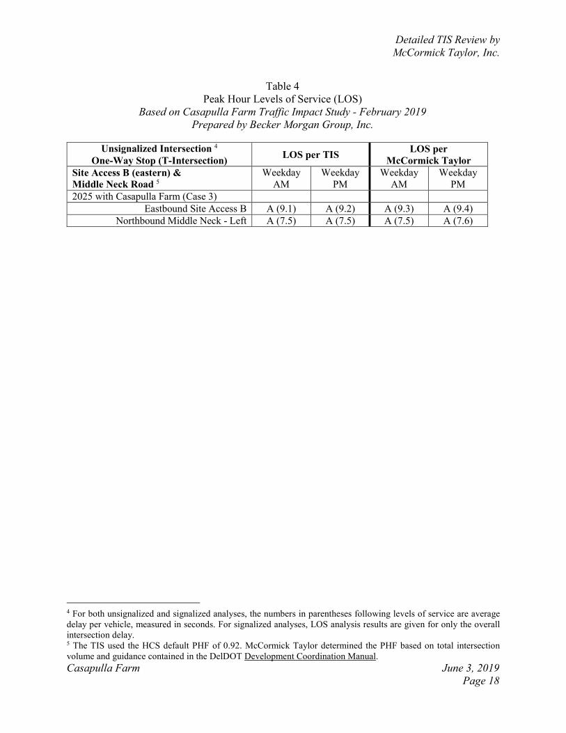
Table 4
Peak Hour Levels of Service (LOS)
Based on Casapulla Farm Traffic Impact Study - February 2019
Prepared by Becker Morgan Group, Inc.
Unsignalized Intersection 4
One-Way Stop (T-Intersection) LOS per TIS
LOS per
McCormick Taylor
Site Access B (eastern) &
Middle Neck Road 5
Weekday
AM
Weekday
PM
Weekday
AM
Weekday
PM
2025 with Casapulla Farm (Case 3)
Eastbound Site Access B A (9.1) A (9.2) A (9.3) A (9.4)
Northbound Middle Neck - Left A (7.5) A (7.5) A (7.5) A (7.6)

Detailed TIS Review by
McCormick Taylor, Inc.
Casapulla Farm June 3, 2019
Page 19
Table 5
Peak Hour Levels of Service (LOS)
Based on Casapulla Farm Traffic Impact Study - February 2019
Prepared by Becker Morgan Group, Inc.
6 For both unsignalized and signalized analyses, the numbers in parentheses following levels of service are average
delay per vehicle, measured in seconds. For signalized analyses, LOS analysis results are given for only the overall
intersection delay.
Unsignalized Intersection 6
One-Way Stop (T-Intersection) LOS per TIS
LOS per
McCormick Taylor
Middle Neck Road &
Warwick Road
Weekday
AM
Weekday
PM
Weekday
AM
Weekday
PM
2018 Existing (Case 1)
Eastbound Middle Neck A (9.8) B (10.1) A (9.9) B (10.3)
Northbound Warwick – Left A (7.4) A (7.5) A (7.5) A (7.6)
2025 without Casapulla Farm (Case 2)
Eastbound Middle Neck B (10.1) B (10.8) B (10.2) B (10.9)
Northbound Warwick – Left A (7.6) A (7.7) A (7.6) A (7.7)
2025 with Casapulla Farm (Case 3)
Eastbound Middle Neck B (11.1) B (11.9) B (11.3) B (12.1)
Northbound Warwick – Left A (7.7) A (7.9) A (7.7) A (7.9)
Detailed TIS Review by
McCormick Taylor, Inc.
Casapulla Farm June 3, 2019
Page 20
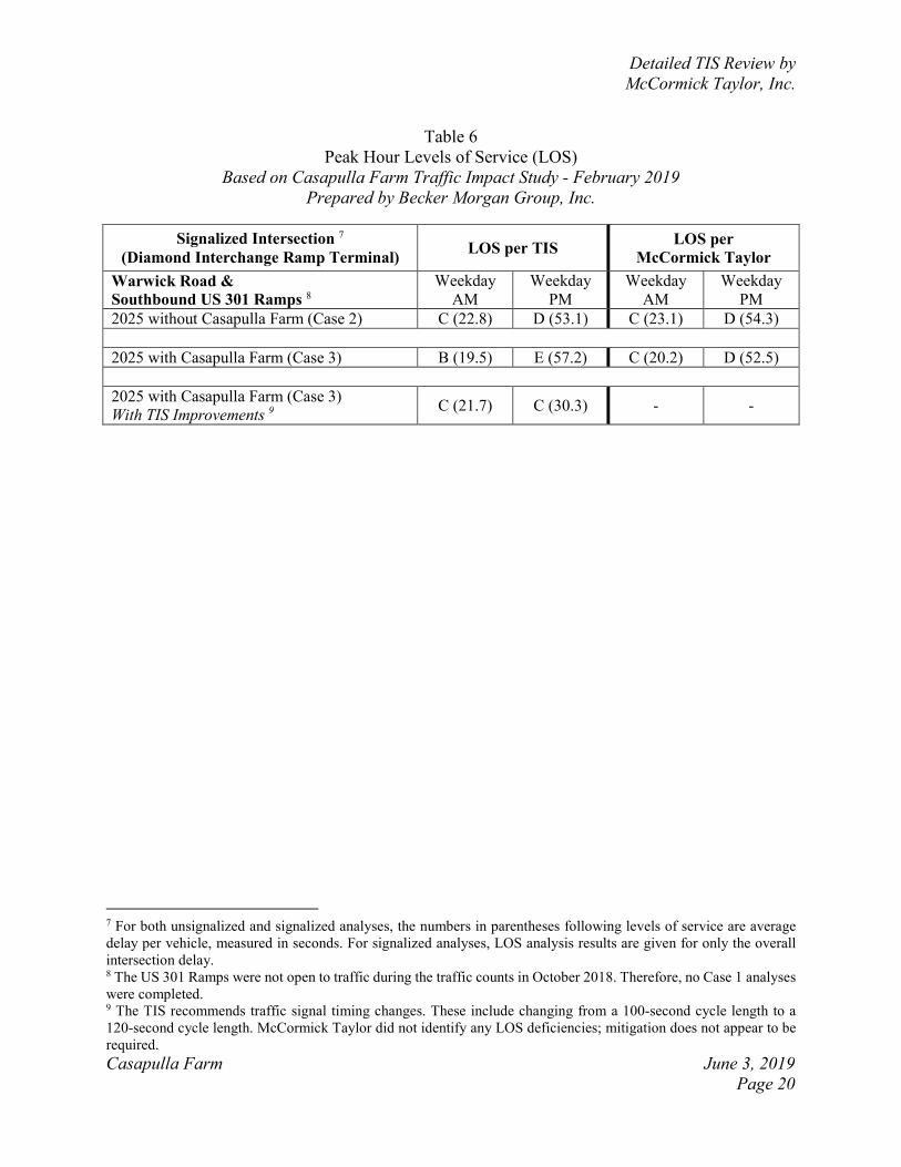
Table 6
Peak Hour Levels of Service (LOS)
Based on Casapulla Farm Traffic Impact Study - February 2019
Prepared by Becker Morgan Group, Inc.
7 For both unsignalized and signalized analyses, the numbers in parentheses following levels of service are average
delay per vehicle, measured in seconds. For signalized analyses, LOS analysis results are given for only the overall
intersection delay. 8 The US 301 Ramps were not open to traffic during the traffic counts in October 2018. Therefore, no Case 1 analyses
were completed. 9 The TIS recommends traffic signal timing changes. These include changing from a 100-second cycle length to a
120-second cycle length. McCormick Taylor did not identify any LOS deficiencies; mitigation does not appear to be
required.
Signalized Intersection 7
(Diamond Interchange Ramp Terminal) LOS per TIS
LOS per
McCormick Taylor
Warwick Road &
Southbound US 301 Ramps 8
Weekday
AM
Weekday
PM
Weekday
AM
Weekday
PM
2025 without Casapulla Farm (Case 2) C (22.8) D (53.1) C (23.1) D (54.3)
2025 with Casapulla Farm (Case 3) B (19.5) E (57.2) C (20.2) D (52.5)
2025 with Casapulla Farm (Case 3)
With TIS Improvements 9 C (21.7) C (30.3) - -
Detailed TIS Review by
McCormick Taylor, Inc.
Casapulla Farm June 3, 2019
Page 21
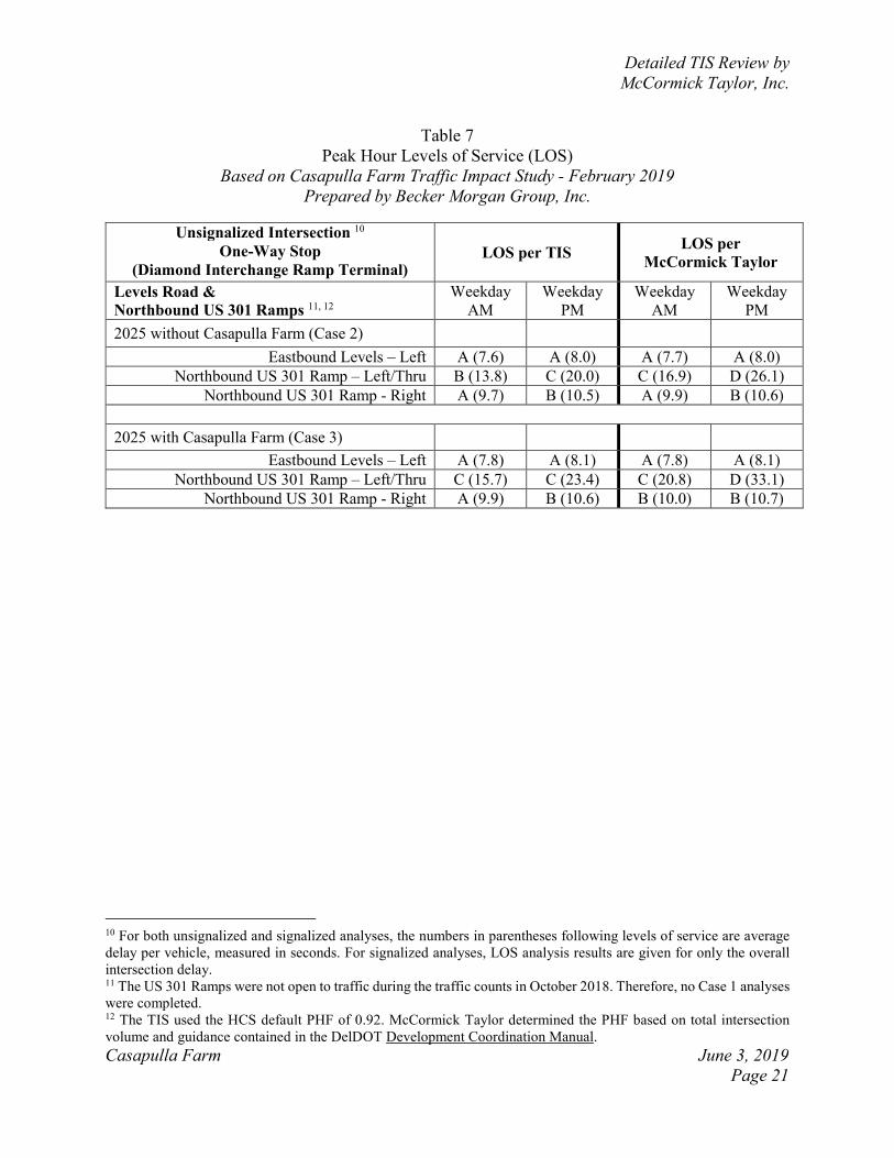
Table 7
Peak Hour Levels of Service (LOS)
Based on Casapulla Farm Traffic Impact Study - February 2019
Prepared by Becker Morgan Group, Inc.
10 For both unsignalized and signalized analyses, the numbers in parentheses following levels of service are average
delay per vehicle, measured in seconds. For signalized analyses, LOS analysis results are given for only the overall
intersection delay. 11 The US 301 Ramps were not open to traffic during the traffic counts in October 2018. Therefore, no Case 1 analyses
were completed. 12 The TIS used the HCS default PHF of 0.92. McCormick Taylor determined the PHF based on total intersection
volume and guidance contained in the DelDOT Development Coordination Manual.
Unsignalized Intersection 10
One-Way Stop
(Diamond Interchange Ramp Terminal) LOS per TIS
LOS per
McCormick Taylor
Levels Road &
Northbound US 301 Ramps 11, 12
Weekday
AM
Weekday
PM
Weekday
AM
Weekday
PM
2025 without Casapulla Farm (Case 2)
Eastbound Levels – Left A (7.6) A (8.0) A (7.7) A (8.0)
Northbound US 301 Ramp – Left/Thru B (13.8) C (20.0) C (16.9) D (26.1)
Northbound US 301 Ramp - Right A (9.7) B (10.5) A (9.9) B (10.6)
2025 with Casapulla Farm (Case 3)
Eastbound Levels – Left A (7.8) A (8.1) A (7.8) A (8.1)
Northbound US 301 Ramp – Left/Thru C (15.7) C (23.4) C (20.8) D (33.1)
Northbound US 301 Ramp - Right A (9.9) B (10.6) B (10.0) B (10.7)

Detailed TIS Review by
McCormick Taylor, Inc.
Casapulla Farm June 3, 2019
Page 22
Table 8
Peak Hour Levels of Service (LOS)
Based on Casapulla Farm Traffic Impact Study - February 2019
Prepared by Becker Morgan Group, Inc.
13 For both unsignalized and signalized analyses, the numbers in parentheses following levels of service are average
delay per vehicle, measured in seconds. For signalized analyses, LOS analysis results are given for only the overall
intersection delay. 14 The TIS applied a PHF of 0.92 for the PM peak hour analyses (all cases). Based on traffic count data, McCormick
Taylor applied a PHF of 0.97 to PM peak hour analyses (all cases). 15 The TIS recommends traffic signal timing changes. These include changing from a 120-second cycle length to a
150-second cycle length. The TIS also recommends extending the westbound Middletown-Warwick Road left-turn
lane from approximately 500-feet to approximately 700-feet (excluding taper). 16 In Improvement Option 2, McCormick Taylor recommends optimizing the traffic signal splits within the existing
120-second cycle length. A longer cycle length does not appear to be needed. McCormick Taylor recommends
extending the westbound Middletown-Warwick Road left-turn lane as described in the TIS.
Signalized Intersection 13 LOS per TIS LOS per
McCormick Taylor
Levels Road &
Middletown-Warwick Road 14
Weekday
AM
Weekday
PM
Weekday
AM
Weekday
PM
2018 Existing (Case 1) D (36.0) C (33.7) D (35.5) C (32.2)
2025 without Casapulla Farm (Case 2) D (49.3) F (102.2) D (48.6) F (82.3)
2025 with Casapulla Farm (Case 3) D (49.3) F (109.4) D (48.7) F (88.0)
2025 with Casapulla Farm (Case 3)
With TIS Improvements 15 D (35.8) D (54.9) - -
2025 with Casapulla Farm (Case 3)
With Improvement Option 2 16 - - D (44.8) D (47.3)