Karakteristik Geologi Teknik Tanah Residu Batuan Sedimen Kuarter ...


BEBERAPAPENGERTIAN DASAR

I. Geomorphology is the study of landforms
(Lobeck, 1939)
II. Geomorphology is the science of landforms
(Thornbury, 1954)
III. Geomorphology is the study which describes landforms and the process which their
formation, and investigates the interrelationship, of these forms and
process and their special arragement
(Van Zuidam, et. al., 1979)
FfPMdt
:::::
Landform (bentuklahan)Fungsi dariProsesMaterialPerubahan menurut waktu
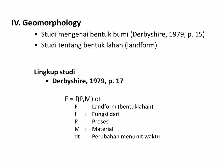
IV. Geomorphology
• Studi mengenai bentuk bumi (Derbyshire, 1979, p. 15)
• Studi tentang bentuk lahan (landform)
Lingkup studi• Derbyshire, 1979, p. 17
F = f(P,M) dt

Derbyshire membedakan 4 level dari studi geomorfologi
Level 1 : study of elements of the equation(studi tentang bentuklahan, proses, dan material, masing-masing secara terpisah)
Level 2 : Balancing the equationMencari hubungan timbal balik antara bentuklahan, proses, dan material pada suatu daerah tertentu pada saat tertentu pula
Level 3 : Differenciating the equationTermasuk dalam hal ini pengujian cara-cara mengetahui hubungan timbal balik antara ketiga elemen tersebut dan variasinya menurut waktu
Level 4 : Applying the equationPenggunaan manfaat dari ketiga level tsb di atas untuk maksud pengelolaaan lingkungan
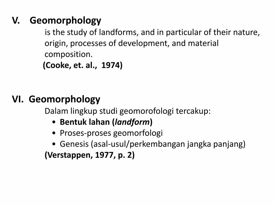
V. Geomorphology is the study of landforms, and in particular of their nature, origin, processes of development, and material composition. (Cooke, et. al., 1974)
VI. Geomorphology Dalam lingkup studi geomorofologi tercakup:
• Bentuk lahan (landform)• Proses-proses geomorfologi• Genesis (asal-usul/perkembangan jangka panjang)
(Verstappen, 1977, p. 2)

VII. Geomorphologyis the scientific study of landscapes and the processes that shape them. The science of geomorphology has two major goals.
1. One is to organize and systematize the description of landscapes by intellectually acceptable schemes of classification.
2. The other is to recognize in landscapes evidence for changes in the processes that are shaping them and have shaped them (Arthur Bloom)
http://www.uwm.edu/Course/416-403/geomorph_rs_apps.htm

Karmono Mangunsukardjo (1986) menjabarkan 4 aspek geomorfologi :
1. Studi mengenai bentuklahan, atau disebut dengan morfologi, mempelajari relief secara umum yang meliputi aspek :
a). MorfologiYakni aspek-aspek yang bersifat pemerian suatu daerah, antara lain teras sugai, beting pantai, kipas aluvial dan plato
b). MorfometriYakni aspek-aspek kuantitatif dari suatu daerah seperti kemiringan lereng, bentuk lereng, ketinggian, beda tinggi, kekerasan medan, bentuk lembah, tingkat pengikisan dan pola aliran

2. Studi mengenai proses geomorfologi,Yakni proses yang mengakibatkan perubahan bentuklahan dalam waktu pendek serta proses terjadinya bentuklahan yang mencakup morfogenesa, dengan aspek-aspek :
a). Morfo-struktur pasifmeliputi litologi (tipe dan struktur batuan) yang berhubungan dengan pelapukan
b). Morfo-struktur aktifberupa tenaga endogen
c). Morfo-dinamikberupa tenaga eksogen yang berhungan dengan tenaga angin, air, es, gerak masa batuan dan volkanisme

3. Studi geomorfologi yang menekankan pada evolusi pertumbuhanbentuklahan atau morfo-kronologi, menentukan dan memerikanbentuklahan dan proses yang mempengaruhinya dari segi umur relatifdan umur mutlak
4. Geomorfologi yang mempelajari hubungannya dengan lingkungan, studi ini mempelajari hubungan antara bentuklahan dengan unsur-unsur bentangalam seperti batuan, struktur geologi, tanah, air, vegetasi dan penggunaan lahan

Geomorphology should not be viewed as a product of lithosphere processes but as part of an integrated earth-surface system of interacting "sphere": lithosphere, hydorsphere, atmosphere, and biosphere. Geomorphology is an environmental science as much as it is a geologic science.

Landform (bentuklahan)Bentukan alam di permukaan bumi yang terjadi karena proses pembentukan tertentu
dan melalui serangkaian evolusi tertentu pula.
atau
Bagian dari permukaan bumi yang mempunyai bentuk khas sebagai akibat pengaruh
dari proses, struktur geologi, dan batuan selama periode waktu tertentu. Oleh karena
itu bentuklahan ditentukan oleh faktor-faktor topografi, struktur geologi, batuan, dan
proses eksogen.
atau
merupakan bentangan permukaan lahan yang mempunyai relief khas karena
pengaruh kuat dari struktur kulit bumi dan akbibat dari proses alam yang bekerja
pada batuan di dalam ruang dan waktu tertentu. Masing-masing bentuklahan
dicirikan oleh adanya perbedaan dalam hal struktur dan proses geomorfologi,
relief/topografi dan material penyusun/litologi (Strahler, 1983 dan Whiton, 1984).
Misal :
Teras sungai : proses sedimentasi oleh aktivitas sungai dan berkembang
sampai terbentuknya (evolusi)

Landscape (bentanglahan)Panorama atas suatu hamparan daratan yang terdiri dari berbagai keadaan alam baik alami maupun buatan manusia (artifisial).
TopografiMenyatakan ketinggian tempat di permukaan bumi dengan ukuran satuan ketinggian tertentu

TerrainMerupakan istilah yang diperuntukkan guna menyatakan keadaan medan suatu wilayah di permukaan bumi, baik keadaan reliefnya, vegetasi/penggunaan lahan, adanya sungai-sungai, rawa-rawa, sifat-sifat umum batuan dan lahan, dll. Istilah ini digunakan terutama untuk keperluan militer (PD I, II)
The collection, analysis, evaluation, and interpretation of geographicinformation on the natural and manmade features of the terrain, combinedwith other relevant factors, to predict the effect of the terrain on militaryoperations. Military Dictionary (DOD, NATO)
Digital Geomorphometry based on the use of DEMs is nowadays covered by the concept of terrain analysis (Wilson dan Gallant, 2000)

Digital Terrain Analysis The use of remote sensing satellite data for mapping various aspects of terrain, such as land cover, landuse, and soils. Software may then be utilized to derive terrain parameters, such as aspect, catchmentarea, and wetness index, which are then used to describe the morphology of the landscape and theinfluence of topography on environmental processes.
C:/Sleman/3_D/mobil_3D.sxd
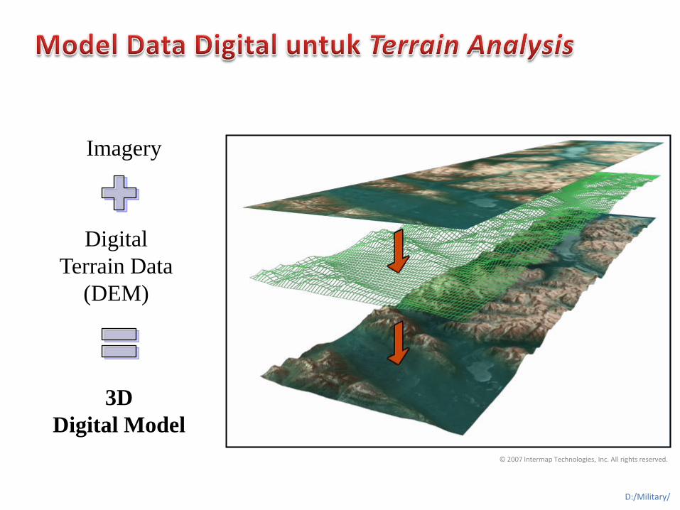
© 2007 Intermap Technologies, Inc. All rights reserved.
Imagery
Digital
Terrain Data
(DEM)
3D
Digital Model
D:/Military/

Morphometric parameters • elevation change gradients (slope)
• orientation gradients (aspect, steepest downhill slope, viewshed)
• curvature gradients (horizontal or tangent curvature)
• vertical or profile curvature (mean curvature
• combined gradients (tangential curvature).
3D AnalystC:/Sleman/3_D/srtm_slm_box

Generic landforms– Stream channel (Valley bottom) - Locations of water accumulation and transition; high number of upstream elements and
concave shapes.
– Ridge (Peak) - Locations of water run-off; lowest upstream contributing area and convex shapes.
– Slope - Sloping part with generally higher shape complexity.
– Plain (Terrace) - Flat areas of low relief and low shape complexity.
– Pit - Conical concave landform.
D:/military/tinkrsb_ras
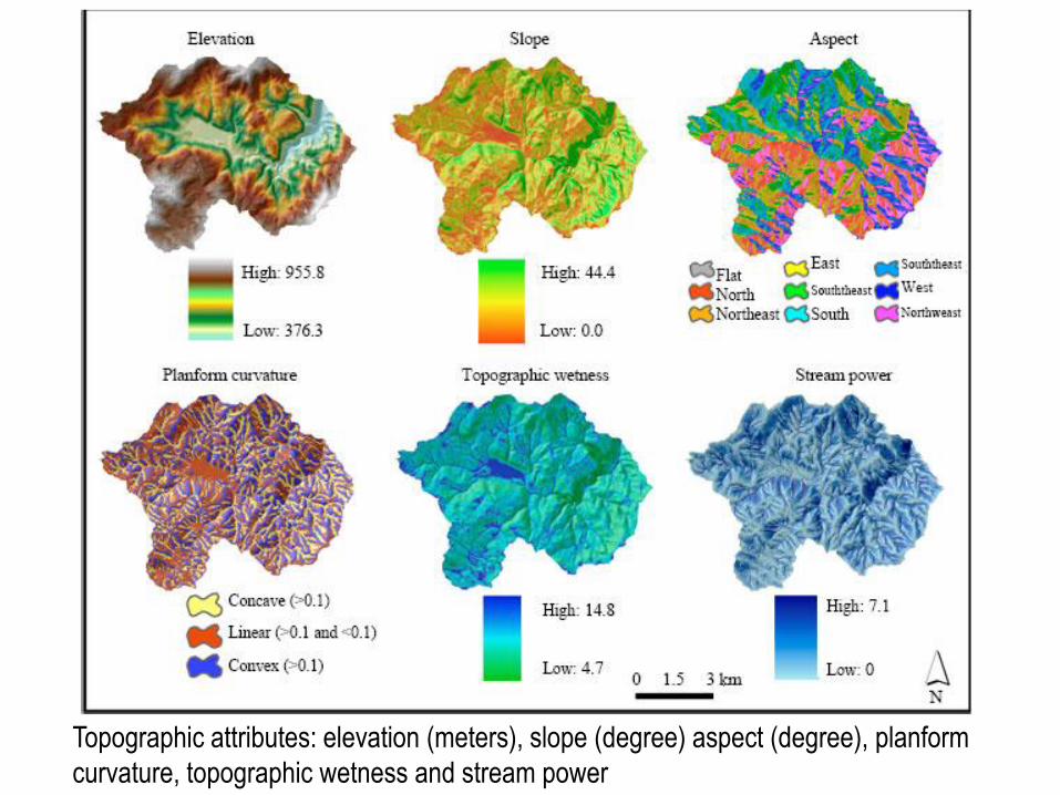
Topographic attributes: elevation (meters), slope (degree) aspect (degree), planform
curvature, topographic wetness and stream power

Topographic wetness and stream power indices were used to quantify flow
intensity and accumulation potential. Topographic wetness (also known as Compound
Topographic Index [CTI] or topographic moisture index) at a particular point on the
landscape is the ratio between the catchment area contributing to that point and the slope
at that point (Wilson and Gallant, 2000). Higher positive values are wetter and lower
negative values are drier and values are calculated as:

The Stream Power Index (SPI) is closely related to the topographic wetness index and is
used to estimate the erosive power of the terrain. Areas with large stream power
indices have a great potential for erosion. If total stream power is greater than that
required to transport the sediment available (supply limited), then there will be a net loss
in sediment and the stream will erode. If stream power is less (transport limited) than that
required, then there will be a net gain in sediment and the stream will aggrade. Values are
calculated as:
Stream power index = Catchment areaxtan β (Moore et al., 1993)
where β = Slope in degrees

GIS-Based Automated Landform Classification and Topographic, Landcover and Geologic Attributes of Landforms Around the Yazoren Polje, Turkey

Perencanaan dan Operasi Militer
Pemahaman karakteristik medan menentukan akses yang efektif
Drop Zone 1
Drop Zone 2
Target Objective

RELIEF

a. ReliefBentuk wilayah : keadaan tinggi rendah suatu wilayah di permukaan bumi ditinjau dari segi perbedaan tinggi dan kemiringannya (lereng)
atau Bentuk ketidakteraturan secara vertikal, baik dalam ukuran besar maupun kecil dari permukaan litosfer.
Misal :datar, landai , berombak, bergelombang, berbukit kubah(humocky), berbukit, bergunung.

HUBUNGAN RELIEF LERENG DAN BEDA TINGGI (US Soil Survey)
Relief Lereng (%) Beda tinggi (m)
Datar/hampir datar 0-2 <5
Berombak/Topografi landai 3-7 5-50
Berombak-bergelombang, topografi
miring
8-13 25-75
Bergelombang-berbukit, topografi
dengan lereng sedang
14-20 50-200
Perbukitan/topografi terjal 21-55 200-500
Pegunungan/topografi sangat terjal 56-140 500-1000
Pegunungan sangat curam >140 >1000
RELIEF :1. datar (D) 2. landai (L) 3. berombak (B) 4. bergelombang (Gb) 5. berbukit kubah (humocky)/Bk 6. berbukit (Bt) 7. bergunung (Gn)

HUBUNGAN RELIEF LERENG DAN BEDA TINGGI (Sunardi J., 1985)
Relief Lereng (%) Beda tinggi (m)
Datar 0-3 <5
Landai/berombak 5-8 5-10
Landai/Miring 8-15 10-25
Miring/berbukit 15-25 25-100
Miring terjal/ berbukit terjal 25-45 100-200
Terjal (berbukit terjal) 45-100 200-500
Sangat terjal (bergunung) >100 >500
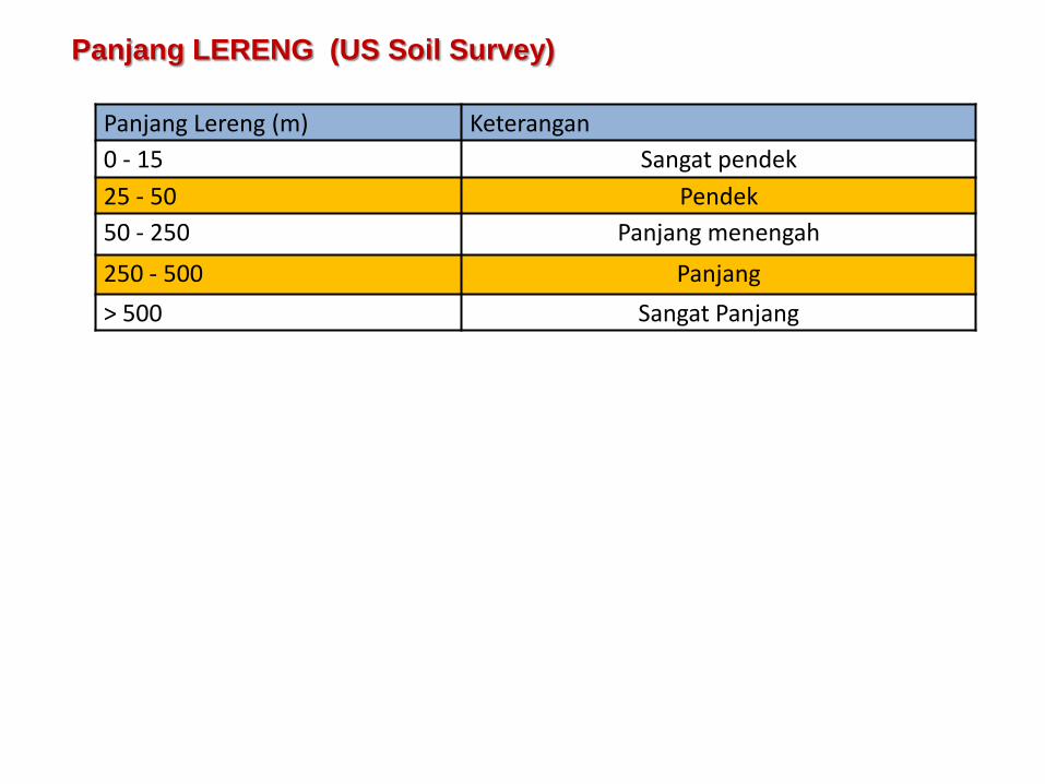
Panjang LERENG (US Soil Survey)
Panjang Lereng (m) Keterangan
0 - 15 Sangat pendek
25 - 50 Pendek
50 - 250 Panjang menengah
250 - 500 Panjang
> 500 Sangat Panjang

Landforms evolve through the slow erosional removal of weaker rock, leaving the more resistant rock standing as ridges or mountains. (Drawn by A. N. Strahler.)
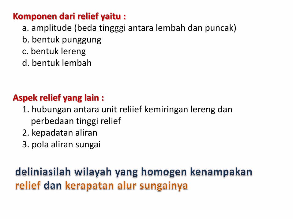
Komponen dari relief yaitu :a. amplitude (beda tingggi antara lembah dan puncak)b. bentuk punggungc. bentuk lerengd. bentuk lembah
Aspek relief yang lain :1. hubungan antara unit reliief kemiringan lereng dan
perbedaan tinggi relief2. kepadatan aliran3. pola aliran sungai
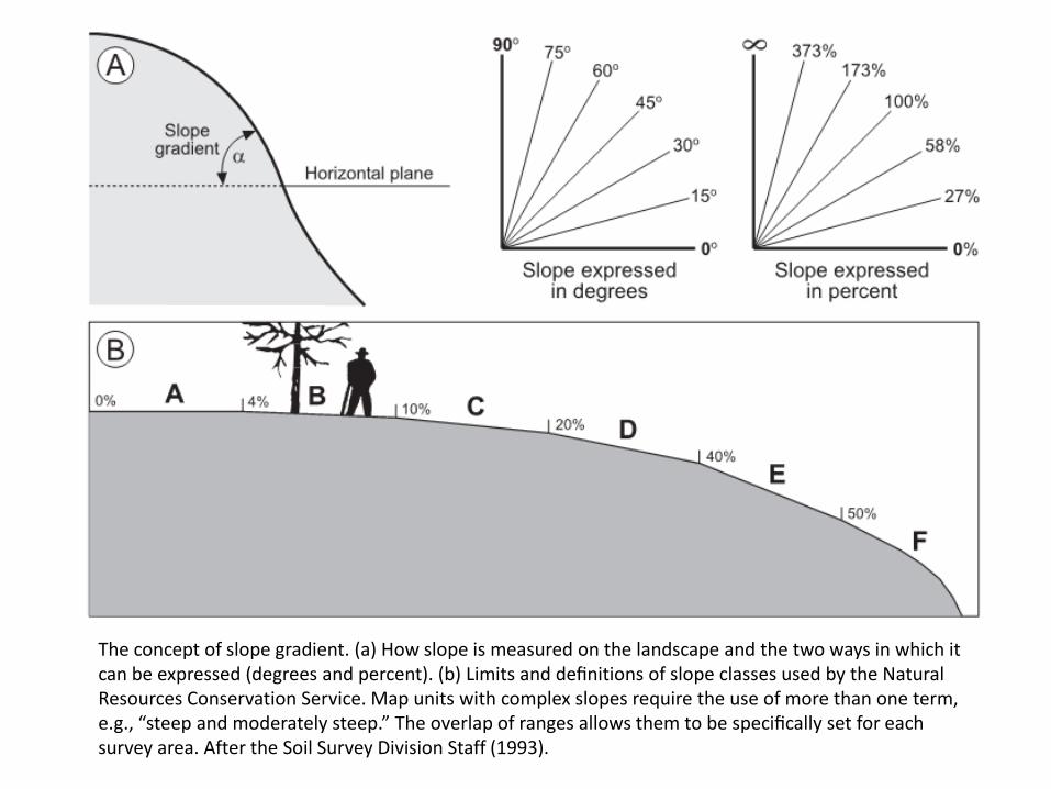
The concept of slope gradient. (a) How slope is measured on the landscape and the two ways in which it can be expressed (degrees and percent). (b) Limits and definitions of slope classes used by the Natural Resources Conservation Service. Map units with complex slopes require the use of more than one term, e.g., “steep and moderately steep.” The overlap of ranges allows them to be specifically set for each survey area. After the Soil Survey Division Staff (1993).

Geomorphic components of slopes in a landscape with an open drainage system. After Ruhe (1975b).(b) Two-dimensional components, i.e., the five elements of “fully developed” slopes.

Examples ofSimple (S), Compound (C), Complex (Cx) hillslope profiles, slope breaks (Br), as viewed in cross-section. After Ahnert (1970).

The nine basic geometric forms of hillslopes, with flowlines illustrating
how water and debris (theoretically) moves on them. After Ruhe (1975b) and Huggett (1975).

Pediment adalah lapisan tanah dasar / batuan dasar yang sangat landai (kemiringan sekitar 5°).
Tallus adalah fragmen batuan yang terakumulasi sebagai tumpukan didasar bukit atau tebing.

• Morfologi Positif:– Gunung (Mountain)
– Bukit (Hill)
– Kubah (Dome)
– Punggungan (Ridge)
• Morfologi Negatif– Lembah (Valley)
– Cekungan (Basin)

Komponen dari relief yaitu :a. amplitude (beda tingggi antara lembah dan puncak)b. bentuk punggungc. bentuk lerengd. bentuk lembah
Aspek relief yang lain :1. hubungan antara unit reliief kemiringan lereng dan
perbedaan tinggi relief2. kepadatan aliran3. pola aliran sungai

http://www.sciencedirect.com/science/article/pii/S0016706110003976
: Mountains
: Alluvial fans
: Valleys
: Wash drainage areas
(Reprinted with permission, Leighty (2004)


Pola aliran merupakan cerminan dari struktur dan tipe/ komposisi
batuan. Sedangkan kerapatan aliran mencerminkan resistensi dan
kekedapan batuan.
Studi tentang drainase pada foto udara atau data PJ meliputi 3
aspek :
1. tekstur drainase (drainage texture) atau kerapatan aliran
2. bentuk lembah (valley shape)
3. pola drainase (drainage pattern)

tekstur drainase merupakan kerapatan drainase (rasio
total panjang sungai dalam sebuah DAS) dan frekuensi
drainase (jumlah aliran sungai dalam DAS dibagi
dengan luas DAS).
1. Tekstur Drainase (drainage texture) atau Kerapatan Aliran

Tekstur drainase atau Kerapatan Aliran terutama dipengaruhi oleh tiga
faktor :
a) Iklim,
b) Relief
c) Karakter dari batuan dasar atau tanah (yaitu porositas dan
permeabilitas).
Kerapatan aliran dapat dideskripsikan sebagai:
• sangat halus (ultra fine),
• halus (fine),
• sedang (medium),
• kasar (coarse)
Kerapatan aliran mencerminkan resistensi dan kekedapan batuan.
Ex : Batuan beku/volkanik: gabro. granite

Batuan kompak dan permeabel
Batuan lunak dan impermeabel
Kerapatan aliran jarang
Kerapatan aliran rapat
Kerapatan aliran
Drainage textures: (i) Coarse and (ii) fine

Drainage density
Texture DD (km/km sq.) Conditions
Coarse (low) <8• Permeable or resistant
• Humid and well vegetated
Medium 8-20
• Permeable rksh.
• Rainfall
• well vegetated
Fine (high) 20-200
• Impermeable surface
• Low rainfall
• Little vegetation
Ultra fine >200
• Impermeable surface
• Low rainfall
• easily erodible rocks
• little vegetation
The interpretation of DD varies with map scale. Typically its measured on a scale of
1:24,000.
http://w3.salemstate.edu/~lhanson/gls210/gls210_streams3.htm

C = clayshale
SC = sandy or silty clay
Ss = sand or sandstone
Texture Common
Coarse gravel(ly)
Medium sand(y)
Fine clay(ey)

Drainase dikatakan internal ketika beberapa garis drainase terlihat di
permukaan dan sebagian besar di bawah permukaan (sub-surface),
misalnya batugamping (limestone) dan kerikil (gravel).
Drainase eksternal di mana jaringan drainase terlihat baik di permukaan.
Kerapatan drainase rendah pada batuan permeabel, seperti: tanah liat
(clays), serpih (shales).
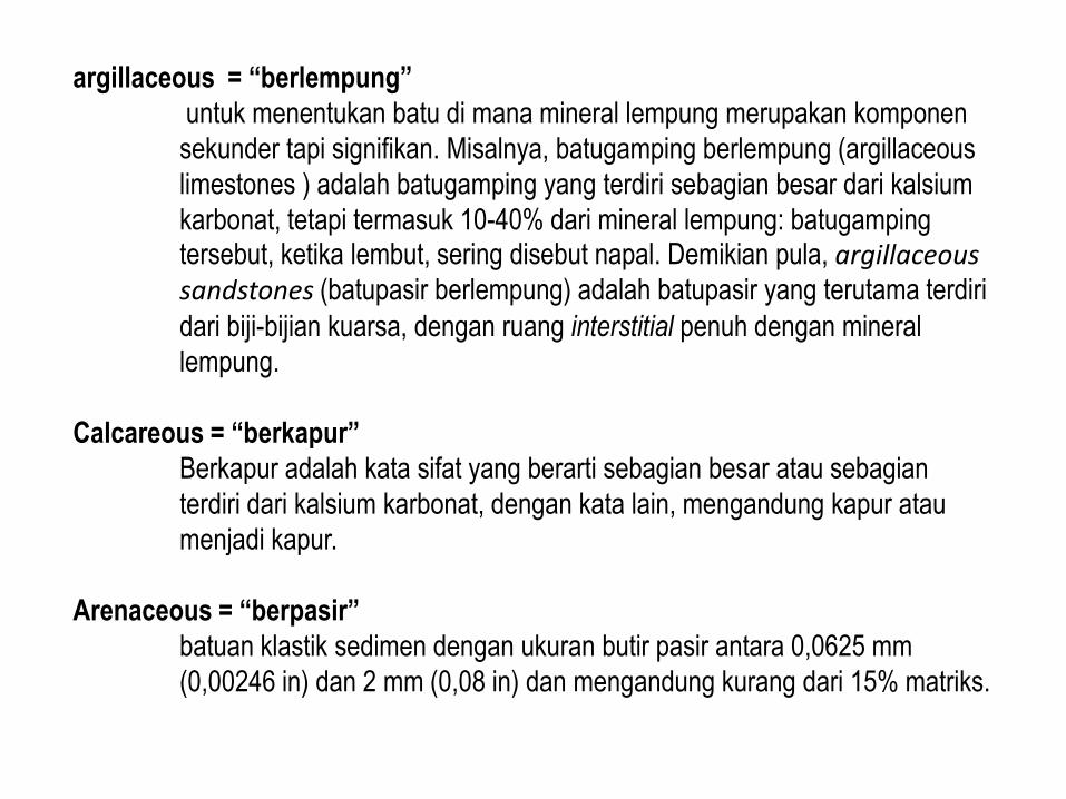
argillaceous = “berlempung”
untuk menentukan batu di mana mineral lempung merupakan komponen
sekunder tapi signifikan. Misalnya, batugamping berlempung (argillaceous
limestones ) adalah batugamping yang terdiri sebagian besar dari kalsium
karbonat, tetapi termasuk 10-40% dari mineral lempung: batugamping tersebut, ketika lembut, sering disebut napal. Demikian pula, argillaceous sandstones (batupasir berlempung) adalah batupasir yang terutama terdiri
dari biji-bijian kuarsa, dengan ruang interstitial penuh dengan mineral
lempung.
Calcareous = “berkapur”
Berkapur adalah kata sifat yang berarti sebagian besar atau sebagian
terdiri dari kalsium karbonat, dengan kata lain, mengandung kapur atau
menjadi kapur.
Arenaceous = “berpasir”
batuan klastik sedimen dengan ukuran butir pasir antara 0,0625 mm
(0,00246 in) dan 2 mm (0,08 in) dan mengandung kurang dari 15% matriks.


Bentuk lembah dapat bervariasi terkait dengan batuan dasar atau tanah.
• Bentuk V sering berkembang di pasir (sands) dan kerikil (gravels),
• Bentuk U berkembang di tanah lanau (silty soils).
• Bentuk lembah yang panjang dengan penampang membulat
menunjukkan tanah lempung (clayey soils) .
2. Bentuk lembah (valley shape)
Typical valley cross-sections : (i) V-shaped, (ii) U-shaped and (iii) gently rounded

3. Pola drainase (Drainage pattern)
adalah “spatial arrangement” dari sungai (streams).
Batuan miring
Batuan yang landai dan homogen
Batuan dengan struktur kekar dan sesar intensif
Struktur lipatan
pola aliran pararel
pola aliran dendritik
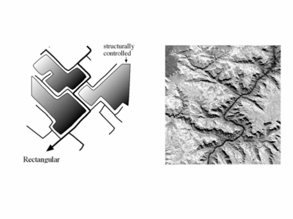
pola aliran rektanguler
pola aliran trellis
Pola aliran merupakan cerminan dari struktur dan tipe/ komposisi batuan.

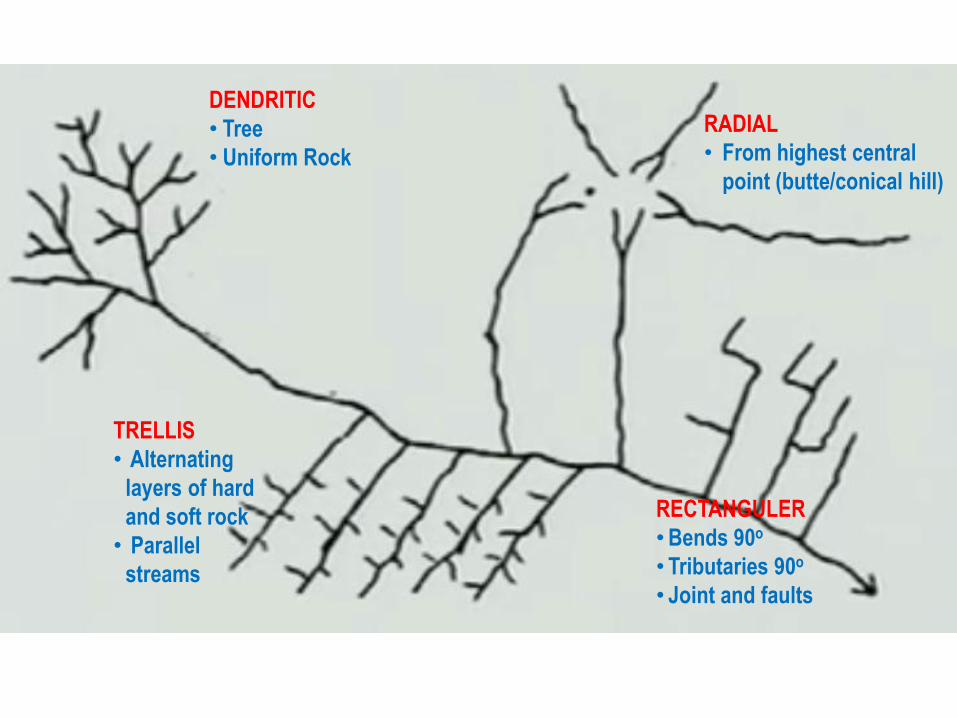
DENDRITIC
• Tree
• Uniform Rock
TRELLIS
• Alternating
layers of hard
and soft rock
• Parallel
streams
RADIAL
• From highest central
point (butte/conical hill)
RECTANGULER
• Bends 90o
• Tributaries 90o
• Joint and faults

Dendritic drainage pattern.- Also called trees like or arborescent. Most common
basic pattern. F is fine texture; C is coarse texture. No structural control. Occurs
on fine textured impervious material.
Von Bandat, “Aerogeology”


Modification- of dendritic pattern. Tributaries of fourth and third order show Pincer-like
curved forms. Occurs on igneos intrusions.
Anak sungai acara urutan keempat dan ketiga bentuk melengkung
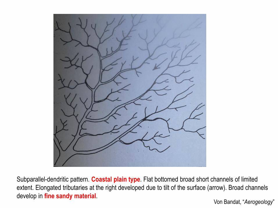
Subparallel-dendritic pattern. Coastal plain type. Flat bottomed broad short channels of limited
extent. Elongated tributaries at the right developed due to tilt of the surface (arrow). Broad channels
develop in fine sandy material.Von Bandat, “Aerogeology”

Von Bandat, “Aerogeology”
Dendritic-pinnate pattern.
There is no structural control. P is a plain surface: The material is sandy and clayey silt.
(Ripley Cy., Indiana, U. S. Dept. of Agriculture)

Von Bandat, “Aerogeology”
Dendritic-pectinate pattern. Featherlike design typical with loess. Parallel gullies with
pearshaped headwater basins. Main stream in flat bottomed valley. P is a loss surface
(After Belcher).

Von Bandat, “Aerogeology”
Modifications of dendritic pattern. Different designs develop in clayshale (C), sandy or silty clay
(SC), and sand or sandstone (Ss). The different is in shape, ramification, type, texture and length
of gullies. C is most ramified, tree-like, fine textured. S is more wide spaced, less ramified with
short straight gullies. SC is finer textured with longer ramified gullies; a type between C and S
(Sweetwater Cy., Wyoming, USGS)
Von Bandat, “Aerogeology”
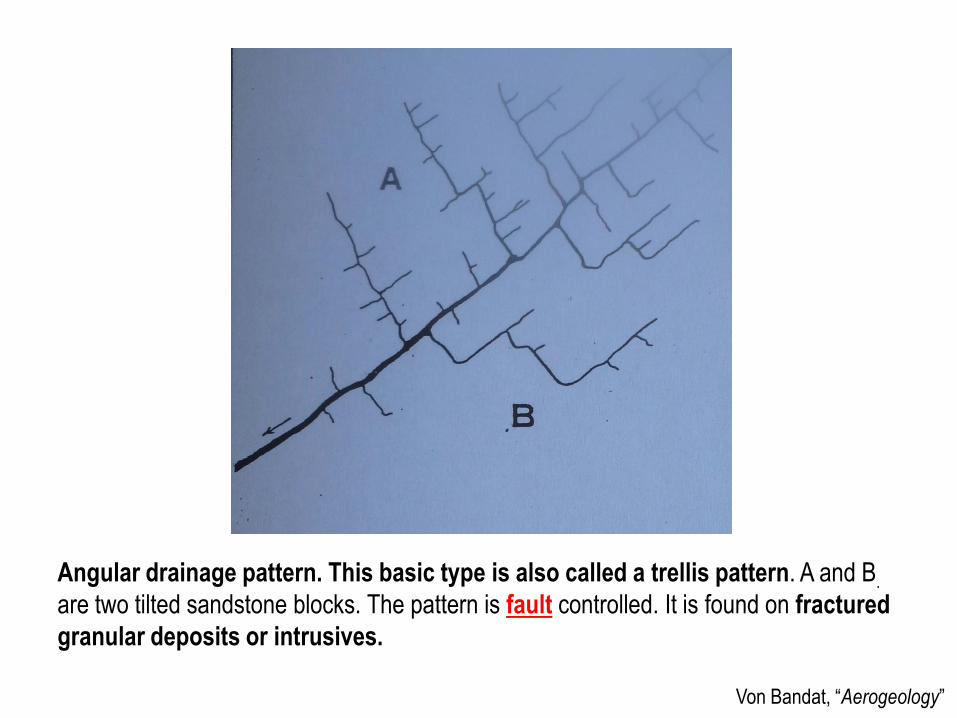
Angular drainage pattern. This basic type is also called a trellis pattern. A and B.
are two tilted sandstone blocks. The pattern is fault controlled. It is found on fractured
granular deposits or intrusives.


http://www.asu.edu/courses/gph111/Hydrology/Trellis.jpg

Von Bandat, “Aerogeology”
Angulate pattern, a modification of the angular pattern. The minor tributaries are parallel,
joining the main tributaries at obtuse angles. The pattern is fracture controlled and is found
mostly in granular sediments, like sandstones in near horizontal attitudes.

Von Bandat, “Aerogeology”
Contorted drainage pattern. The streams show reversed flow (arrows). The material is
sandstone. The control is structural.

Von Bandat, “Aerogeology”
Parallel patterns. This basic pattern develops on fine textured material with steep slopes.
Also along laminated formations of diffrent resistance, e.g., sand stone-shale belts, or on
tilted valley fills. It is most common along steep clay scarps with obsequents streams.

Von Bandat, “Aerogeology”
Subparallel pattern. The parallel tributaries join the main stream at an angle. This type is
common coastal plains in fine material, or on lava streams.

Von Bandat, “Aerogeology”
Radial drainage Pattern. The consequent streams flow from a central area in a radial design. The
design is from an Indonesian volcano. The material is fine textured tuff and granular tuff at G. This
basic pattern can be centrifugal (positive) on domes or uplifts and centripetal (negative) in basins.
Von Bandat, “Aerogeology”
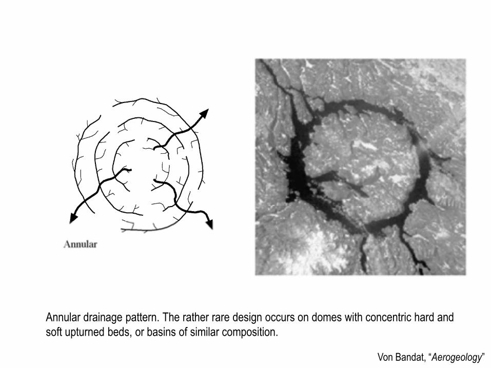
Annular drainage pattern. The rather rare design occurs on domes with concentric hard and
soft upturned beds, or basins of similar composition.


Von Bandat, “Aerogeology”
Radial, pincerlike-dendritic and annular drainage pattern on a small granite dome.
Dashed lines with arrow are hard upturned bedded sediment, ridges. The central
granite ridge with apex is at G. (Meade Cy., South Dakota)

Von Bandat, “Aerogeology”
Sinkhole pattern develops on soluble rocks like limestone, gypsum, dolomite. Sink are usually
roundish or oval shaped. Only short rudimentary surface channels develop. The shallow
basins are filled with residual clay.
Von Bandat, “Aerogeology”
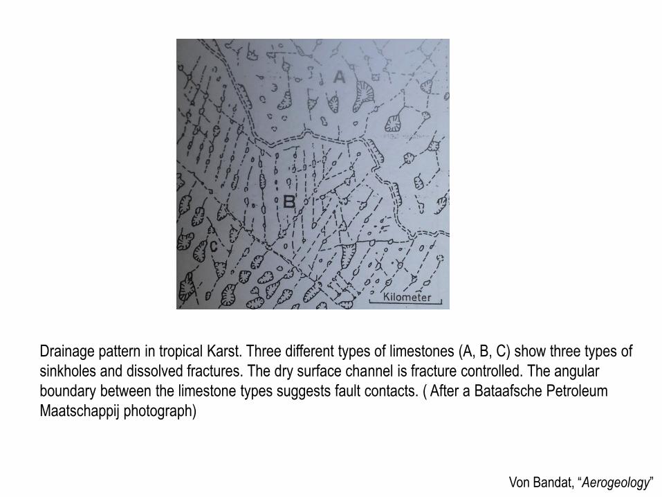
Drainage pattern in tropical Karst. Three different types of limestones (A, B, C) show three types of
sinkholes and dissolved fractures. The dry surface channel is fracture controlled. The angular
boundary between the limestone types suggests fault contacts. ( After a Bataafsche Petroleum
Maatschappij photograph)

Von Bandat, “Aerogeology”
Dichotomic pattern. The streams radiating from a common point in a fan shaped manner depositing granular material by branching and multiple bifurcation (dichotomy). This design is found on alluvial fans and deltas.

Von Bandat, “Aerogeology”
Anastomotic drainage pattern with meandering stream. Oxbow lakes (O) and meander scars ( M) are on abandoned channels. Because of the collateralcommuting food channels, the pattern is called anastomotic. This depository pattern in common on floodplains may be, in part, structure controlled.

This photograph shows a __________ stream channel
a. meandering
b. undercut
c. gradient
d. straight
e. braided

This image shows an area in the Appalachian Mountains in Pennsylvania. The type of drainage pattern that generally characterizes this region is __________
a. annular
b. Trellis
c. rectangular
d. dendritic
e. deranged

This photograph shows part of the Kalahari Desert [Africa]. The drainage pattern is evident as a series of dark and light stripes that follow patterns of fossil sand dunes from an ancient desert. Parallel channels intersect a larger stream following a fault on the left side of the image. Together, these geologic controls create a __________ drainage pattern.
a. trellis
b. rectangular
c. annular
d. radial
e. dendritic

This karst region in Slovenia represents which type of drainage pattern?
a. rectangular
b. radial
c. deranged
d. annular
e. dendritic
f. trellis