BC Omineca Fishing 2015
52
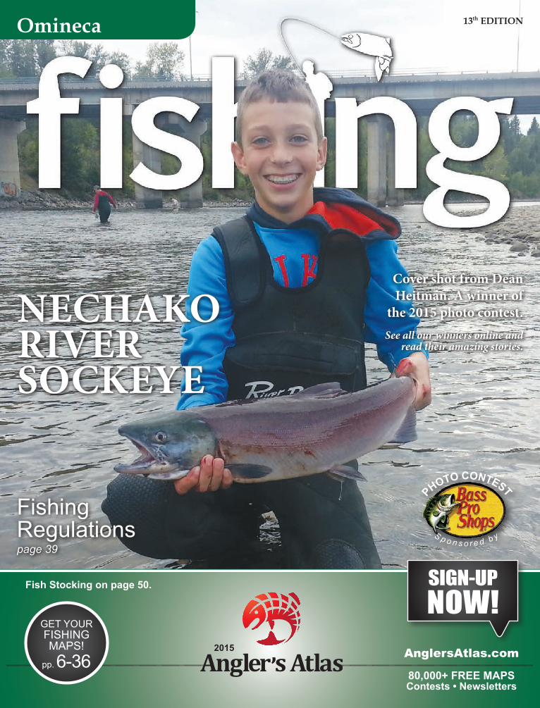
Omineca 13 th EDITION SIGN-UP NOW! 2015 GET YOUR FISHING MAPS! pp. 6-36 AnglersAtlas.com 80,000+ FREE MAPS Contests • Newsletters Fishing Regulations page 39 NECHAKO RIVER SOCKEYE Cover shot from Dean Heitman. A winner of the 2015 photo contest. See all our winners online and read their amazing stories. Fish Stocking on page 50. P H O T O C O N T E S T S p o n s o r e d b y
-
Upload
anglers-atlas -
Category
Documents
-
view
241 -
download
11
description
Central BC's finest lakes are showcased in this fishing guide, ranging from small trout stocked lakes to the large water of Stuart Lake.
Transcript of BC Omineca Fishing 2015
Omineca 13th EDITION
SIGN-UP NOW!
2015
GET YOUR FISHING MAPS!
pp. 6-36 AnglersAtlas.com
80,000+ FREE MAPS Contests • Newsletters
Fishing Regulations page 39
NECHAKORIVERSOCKEYE
Cover shot from Dean Heitman. A winner of
the 2015 photo contest.See all our winners online and
read their amazing stories.
Fish Stocking on page 50.
PHOTO CONTEST
S p o n s o r e d b y
INSIDE FRONT COVER
CANADIAN TIRE
www.canadiantire.caFor days like today TMPrince GeorGe 5008 Domano Boulevard 250-964-8258

Page 4Omineca Fishing 2015 Free maps at www.AnglersAtlas.com
Omineca Key map
The Omineca region is locat-ed in the north central inte-
rior of British Columbia. It is made up of the western edge of the Rocky Mountains, the
Interior Plateau around Prince George and Vanderhoof, and it extends northwest to the Omineca Mountain Range between Williston Reservoir and Takla Lake.This vast landscape offers
anglers some of the great-est freshwater fishing in the world with thousands of lakes and countless streams and rivers.
Ferguson Lake and Shane Lake are
found within the city of
Prince George, and both receive “catchable” size trout each year. These lakes are specially man-aged to create easily accessible fishing locations and are great places to catch to fish.This guide barely scratches the surface of lakes in the region. Visit AnglersAtlas.com for more maps of this region.
OMINECA FISHING 2015
PublisherSean Simmons
Production Co-ordinatorKathy Buhler
Contributors: Dan Moffat, Brian Smith, Lewis Johnson, Wayne Koftinoff, Alycia Mutual, Mark Parker, Ken Still, Arlene and Brian Ellison.
Advertising sales, printing and distribution managed by Glacier Media Inc.
Omineca Fishing 2015 is part of The Angler’s Atlas and is owned by Goldstream Publishing Inc.
Ste 210 - 500 Victoria St.Prince George, BCV2L 2J9(250) [email protected]
www.AnglersAtlas.com
Continuing this year is a complete listing of the BC Fishing Resorts and Outfitters Association member resorts, as well as the Regional Fishing
Regulations for the Omineca region. We have also updated the fish stocking infor-mation for the Omineca Region from the 2014 season. A lot of places to go fish!
Page 5Omineca Fishing 2015 Free maps at www.AnglersAtlas.com
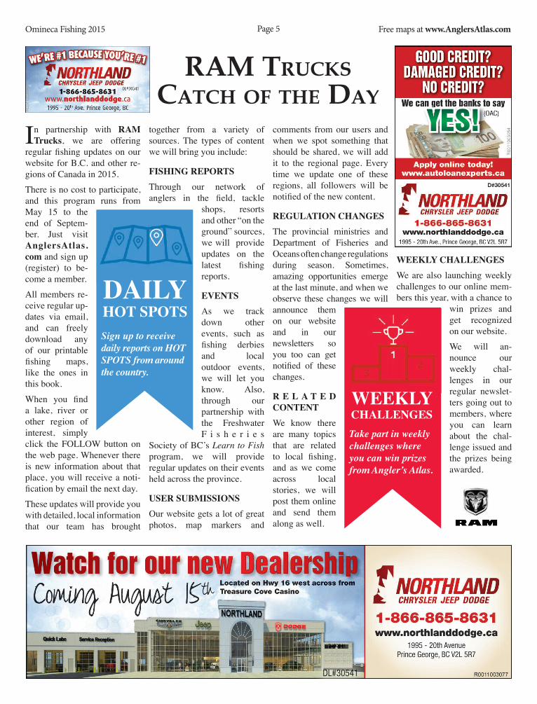
Ram TRucKscaTch Of The Day
In partnership with RAM Trucks, we are offering
regular fishing updates on our website for B.C. and other re-gions of Canada in 2015. There is no cost to participate, and this program runs from May 15 to the end of Septem-ber. Just visit AnglersAtlas.com and sign up (register) to be-come a member. All members re-ceive regular up-dates via email, and can freely download any of our printable fishing maps, like the ones in this book. When you find a lake, river or other region of interest, simply click the FOLLOW button on the web page. Whenever there is new information about that place, you will receive a noti-fication by email the next day. These updates will provide you with detailed, local information that our team has brought
together from a variety of sources. The types of content we will bring you include:
Fishing RepORTsThrough our network of anglers in the field, tackle
shops, resorts and other “on the ground” sources, we will provide updates on the latest fishing reports.
evenTsAs we track down other events, such as fishing derbies and local outdoor events, we will let you know. Also, through our partnership with the Freshwater F i s h e r i e s
Society of BC’s Learn to Fish program, we will provide regular updates on their events held across the province.
UseR sUBMissiOnsOur website gets a lot of great photos, map markers and
comments from our users and when we spot something that should be shared, we will add it to the regional page. Every time we update one of these regions, all followers will be notified of the new content.
RegUlATiOn ChAngesThe provincial ministries and Department of Fisheries and Oceans often change regulations during season. Sometimes, amazing opportunities emerge at the last minute, and when we observe these changes we will announce them on our website and in our newsletters so you too can get notified of these changes.
R e l A T e d COnTenTWe know there are many topics that are related to local fishing, and as we come across local stories, we will post them online and send them along as well.
WeeKlY ChAllengesWe are also launching weekly challenges to our online mem-bers this year, with a chance to
win prizes and get recognized on our website. We will an-nounce our weekly chal-lenges in our regular newslet-ters going out to members, where you can learn about the chal-lenge issued and the prizes being awarded.
Take part in weekly challenges where you can win prizes from Angler’s Atlas.
WeeKlY ChAllenges
Sign up to receive daily reports on HOT SPOTS from around the country.
dAilY hOT spOTs
Caution: Do not use this map for navigational purposes. This map may not reflect current conditions. Uncharted hazards may exist. Base Map ©Province of British Columbia.
Omineca Fishing 2015 Free maps at www.AnglersAtlas.comPage 6
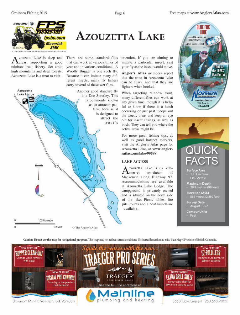
azOuzeTTa LaKe
Azouzetta Lake is deep and clear, supporting a good
rainbow trout fishery. Set amid high mountains and deep forests, Azouzetta Lake is a treat to visit.
There are some standard flies that can work at various times of year and in various conditions. A Woolly Bugger is one such fly. Because it can imitate many dif-ferent insects, many fly fishers carry several of these wet flies.
Another good standard fly is a Doc Spratley. This
is commonly known as an attractor pat-
tern, because it is designed to
attract the t r o u t ’ s
attention. If you are aiming to imitate a particular insect, cast your fly as the insect would move.
Angler’s Atlas members report that the trout in Azouzetta Lake can be fussy, and that they are fighters when hooked.
When targeting rainbow trout, many different flies can work at any given time, though it is help-ful to know if there is a hatch occurring or just past. Scope out the weedy areas and keep an eye out for insect casings, as well as birds. They can tell you where the active areas might be.
For more great fishing tips, as well as good hotspot markers, visit the Angler’s Atlas page for Azouzetta Lake, at www.angler-satlas.com/lake/99598.
lAKe ACCess
Azouzetta Lake is 67 kilo-metres northeast of
Mackenzie along Highway 97. Accommodations are available at Azouzetta Lake Lodge. The campground is privately owned and is situated on the north side of the lake. Picnic tables, fire pits, toilets and a boat launch are available.
© The Angler’s Atlas
Surface Area• 138 Hectares
(340 Acres)
Maximum Depth• 29.9 metres (98 feet)
Elevation (ASL)• 869 metres (2,850 feet)
Survey Date• August 1952
Contour Units• Feet
Quick Facts

Caution: Do not use this map for navigational purposes. This map may not reflect current conditions. Uncharted hazards may exist. Base Map ©Province of British Columbia.
Omineca Fishing 2015 Free maps at www.AnglersAtlas.comPage 7
BOBTaiL LaKe
Bobtail L a k e , formally known as Naltesby Lake, is part of the Chilako River system located southwest of Prince George.
There is a diversity of species in this lake including burbot, rain-bow trout, kokanee and whitefish.
The lake used to be part of the provincial stocking program run by the Freshwater Fisheries Society of BC. It was last stocked with rainbow trout in 2004.
Anglers who like to fly fish on this lake may find a Woolly Worm or an Egg-sucking Leech can be very effective, while gear fishers may want to try a small spinner or spoon. Float fishing with a small piece of egg sac or worm can be productive as well.
The Chilako River is a great fish-ery itself. Brian smith, author of Fly Fishing BC’s interior, says
t h a t the Chilako offers decent trout fishing, using Adams, midges, caddis, stoneflies and mudler patterns.
Please consult the BC Freshwater Fishing Regulations before head-ing out for quota information.
Flyfishers will want to keep an eye out for Brian Smith’s new book, published last year, called seasons of a Fly Fisher. Look for it in local bookstores.
lAKe ACCess
There are two main routes that will bring you to Bobtail
Lake from Prince George—the Bobtail Forest Service Road or the Pelican Forest Service Road.
To find the Bobtail FSR, trav-el west along Highway 16 for roughly 50 km, until you meet this road. Turn left (south) onto the Bobtail FSR, and follow for roughly 21 km, until you meet the Blackwater FSR. Turn left
again (south-east), and follow for another 25 km, at which point you will meet the north end of Bobtail Lake. This road follows the eastern shore of the lake, and there is a forest recreation site located along this stretch.
Another route is via the Pelican FSR. From Prince George, follow Highway 16 West for roughly 10 km, and turn left (south) onto the Blackwater Rd. (heading to West Lake). Continue along this road for 20 km until you meet the Pelican FSR, at which point you turn right (west). Follow the Pelican FSR for 35 km, until you meet the Blackwater FSR, where you will turn right (north). Continue along this road for roughly 15 km, where you will emerge at the south end of Bobtail Lake. The forest recre-ation site is on the left hand side, just after meeting the lake.
© The Angler’s Atlas
Surface Area• 841 Hectares
(2,078 Acres)
Maximum Depth• 20.1 metres (66 feet)
Elevation (ASL)• 813 metres (2,667 feet)
Survey Date• July 1968
Contour Units• Feet
Quick Facts
Caution: Do not use this map for navigational purposes. This map may not reflect current conditions. Uncharted hazards may exist. Base Map ©Province of British Columbia.
Omineca Fishing 2015 Free maps at www.AnglersAtlas.comPage 8
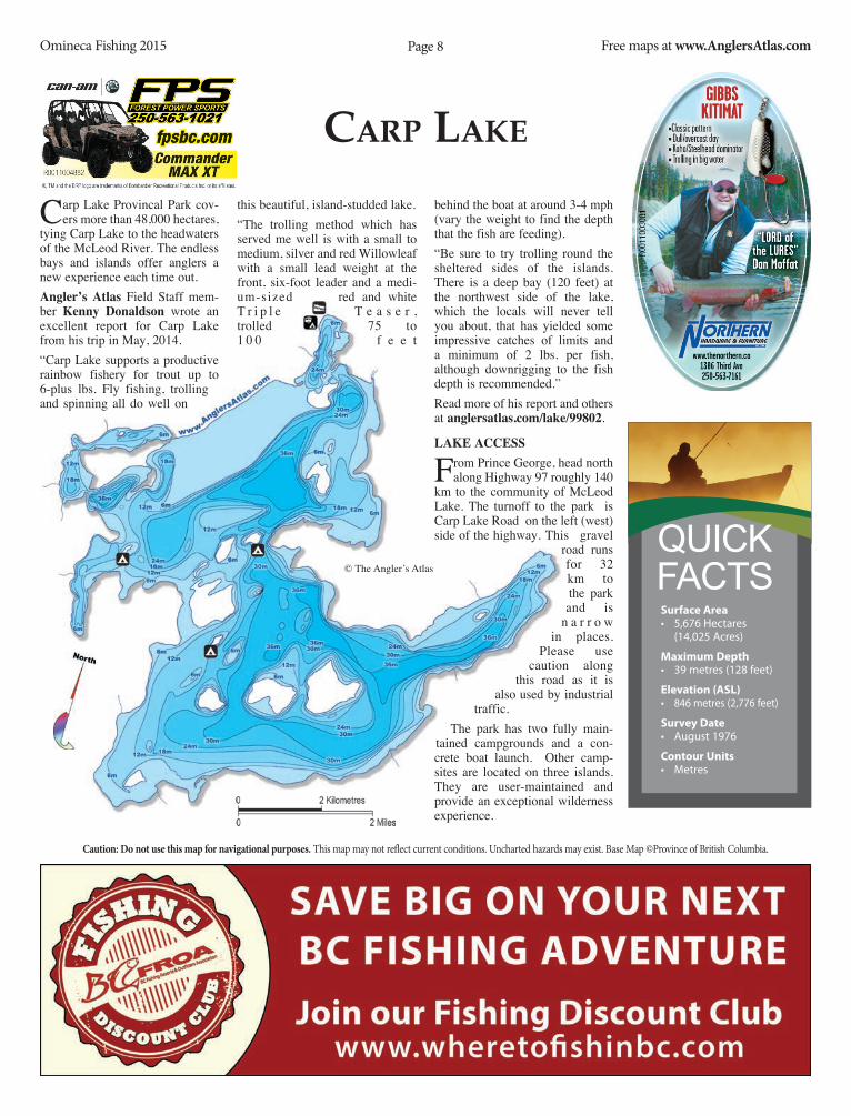
caRp LaKe
Carp Lake Provincal Park cov-ers more than 48,000 hectares,
tying Carp Lake to the headwaters of the McLeod River. The endless bays and islands offer anglers a new experience each time out. Angler’s Atlas Field Staff mem-ber Kenny donaldson wrote an excellent report for Carp Lake from his trip in May, 2014.“Carp Lake supports a productive rainbow fishery for trout up to 6-plus lbs. Fly fishing, trolling and spinning all do well on
this beautiful, island-studded lake.“The trolling method which has served me well is with a small to medium, silver and red Willowleaf with a small lead weight at the front, six-foot leader and a medi-um-sized red and white T r i p l e T e a s e r , trolled 75 to 1 0 0 f e e t
behind the boat at around 3-4 mph (vary the weight to find the depth that the fish are feeding).“Be sure to try trolling round the sheltered sides of the islands. There is a deep bay (120 feet) at the northwest side of the lake, which the locals will never tell you about, that has yielded some impressive catches of limits and a minimum of 2 lbs. per fish, although downrigging to the fish depth is recommended.”Read more of his report and others at anglersatlas.com/lake/99802.
lAKe ACCess
From Prince George, head north along Highway 97 roughly 140
km to the community of McLeod Lake. The turnoff to the park is Carp Lake Road on the left (west) side of the highway. This gravel
road runs for 32 km to the park and is
n a r r o w in places.
Please use caution along
this road as it is also used by industrial
traffic.The park has two fully main-
tained campgrounds and a con-crete boat launch. Other camp-sites are located on three islands. They are user-maintained and provide an exceptional wilderness experience.
Surface Area• 5,676 Hectares
(14,025 Acres)
Maximum Depth• 39 metres (128 feet)
Elevation (ASL)• 846 metres (2,776 feet)
Survey Date• August 1976
Contour Units• Metres
Quick Facts© The Angler’s Atlas


Caution: Do not use this map for navigational purposes. This map may not reflect current conditions. Uncharted hazards may exist. Base Map ©Province of British Columbia.
Omineca Fishing 2015 Free maps at www.AnglersAtlas.comPage 10
chuBB LaKe
Chubb Lake is located south of Prince George, just west of
Highway 97. This lake has good rainbow trout fishing and is one of the earlier lakes in the area to lose its ice cover. In 2014, the BC Freshwater Fisheries Society stocked 6,600 rainbow trout in Chubb Lake.
Gear fishers should consid-er a red Apex, a good standard lure that can work in a variety of c o n d i -t i o n s .
Small spinners can be a good choice as well.
Brian smith, author and photog-rapher, says that it is often worth-while to try chironomids in all their stages, from pupa to emerg-ing adult. Chironomids hatch
early and often, and larvae pat-terns are good searching pat-
terns. Adult patterns can be good choices for early mornings, cloudy days, and evenings.
Smith’s book, Fly Fishing B.C.’s
interior, is a great refer-
e n c e f o r
the Central Interior, complete with fly patterns. Smith’s insect knowl-edge and experience is put to good use, and the book is a must-have for Central Interior anglers. This, as well as his second book, seasons of a Fly Fisher, is avail-able at local bookstores.
Chubb Lake is considered one of the Omineca region’s family fishing waters. Family fishing lakes are usually good places to fish with children, offering easy access and good shore fishing opportunities.
All boaters should be aware that fishing regulations restrict the motor size on boats to 10 horse-power. Please consult the current fishing regulations before heading to the lake.
lAKe ACCess
From Prince George, head south along Highway
97, about nine km south of Hixon. Turn right (west) at Plett Road, which also has signage for Chubb Lake Bible Camp. While on this road, stay left at the first fork and head up the hill. The lake is about seven km down this road.
There is a forestry recre-ation site at the lake, with sixteen vehicle units, that is open year-round. The site is RV accessible and has a boat launch.
© The Angler’s Atlas
Surface Area• 67 Hectares
(166 Acres)
Maximum Depth• 14.6 metres (48 feet)
Elevation (ASL)• ~790 metres (~2,600 feet)
Survey Date• July 1961
Contour Units• Feet
Quick Facts

Caution: Do not use this map for navigational purposes. This map may not reflect current conditions. Uncharted hazards may exist. Base Map ©Province of British Columbia.
Omineca Fishing 2015 Free maps at www.AnglersAtlas.comPage 11
cOBB LaKe
Cobb Lake is about 70 km west of Prince George and is a
popular four-season fishing lake. The lake supports a healthy popu-lation of rainbow and brook trout and is regularly stocked by the Freshwater Fisheries Society of BC. In 2014, 20,000 brook trout and 10,000 rainbow trout were stocked in Cobb Lake.dan Moffat from northern hardware in Prince George, says that Cobb Lake is a really good spot year round. In the fall, there is little pressure on the lake, and the trout are fattening up for win-ter.As the weather cools down after the heat of summer, the fish are beginning to be more active again. In the spring and summer, Moffat notes that there are plenty of choices. “The lake is always good for small spinners,” he suggests. Anglers can also
try chironomids and flatfish.“Another option is a bobber and worm, fishing plain and simple,” he adds.When the ice comes off the lake in early May, pay attention to the emerging insects. Often, leeches and chironomids are early-season insects. As the summer progress-es, take some time to note dropoff areas and weeds as these are ideal dwelling places for trout.Cobb Lake is great for families because of its proximity to town and easy access.To learn more about fishing this lake, drop by northern hardware in downtown Prince George and talk to one of their helpful staff at the fishing coun-ter.
lAKe ACCess
From Prince George, f o l l o w
Highway 16 west for about 65 km, and then turn right (north) at Finnmore Road just before Cluculz Creek. Follow Finnmore Road for 6 km and you will see another road on the right (name unknown). This road is not plowed in the winter and may not be suitable for driving. Continue along this road for a short distance and the recreation site turn off (right) is just past the creek. You can access the lake from there.
© The Angler’s Atlas
Surface Area• 210 Hectares
(519 Acres)
Maximum Depth• 10 metres (33 feet)
Elevation (ASL)• 777 metres (2,549 feet)
Survey Date• October 1982
Contour Units• Metres
Quick Facts

Caution: Do not use this map for navigational purposes. This map may not reflect current conditions. Uncharted hazards may exist. Base Map ©Province of British Columbia.
Omineca Fishing 2015 Free maps at www.AnglersAtlas.comPage 12
Dina LaKes
Dina Lakes are located in the Heather - Dina Lakes
Provincial Park. While some facil-ities are available, they are rustic, and the lakes offer a chance to explore a wilderness setting. Dina Lakes are a popular canoe circuit as well as a popular angling des-tination. Dina Lakes #1, 2 and 3 are the prime fishing spots in this chain of 6 lakes. Rainbow and brook trout are both stocked in these lakes. While Dina lakes #1 and 2 have been stocked with trout for many years, Dina Lake #3 has been more recently rehabilitated to enhance the fish-ery and create a spawning stream. Once barren, Dina Lake #3 now supports a healthy trout fishery.Fly fishing early in the sea-son is ideal for this group of lakes. Try a glass-bead chironomid, which imitates a chi-ronomid in its pupa stage. These are slow mov-ing and w o r m -like. Try v a r i o u s sizes in black, olive and maroon shades. Cast your line out and let it sink. Retrieve slowly, using a very slow
hand-twist retrieve.Another pattern to try is a leech. Woolly Buggers, Beadhead Leeches and Marabou Leeches are some flies that may work at any time of the season. There are times when a leech can do the trick and nothing else seems to work. Keep leeches on hand in maroon and brown shades, as well as black.
lAKe ACCess
Dina Lake #1 is the only lake in the Dina Lakes chain that
i s access ib le by vehi-
c l e . T h e
other lakes in this popular canoe circuit can be reached by short portage. From Mackenzie, head north on Highway 39 about 10 kilometres. Turn onto the Parsnip West Forest Service Road. The gravel road is suitable for 2WD in dry weather, though 4WD is recommended in wet conditions.On the Parsnip Forest Service Road there is a sign at about the 31-kilometre point which indi-cates the way to the Dina Lake Forest Service recreation site, on Dina Lake #1. The recreation site is on the north side of the lake, with ten vehicle units, picnic areas and a boat launch. Campers are reminded to pack their own water
as there is no drinking water available at
these lakes.
© The Angler’s Atlas
Surface Area• 158 Hectares
(390 Acres)
Maximum Depth• 25 metres (82 feet)
Elevation (ASL)• 695 metres (2,280 feet)
Survey Date• August 1983
Contour Units• Metres
Quick Facts


Caution: Do not use this map for navigational purposes. This map may not reflect current conditions. Uncharted hazards may exist. Base Map ©Province of British Columbia.
Omineca Fishing 2015 Free maps at www.AnglersAtlas.comPage 14
DODge pOnD
In 2013, Prince George residents and tourists got a new place
to catch fish — Dodge Pond — located at the northland dodge Motorsports park. The pond was created when a gravel quarry used to build the racetrack hit a natural spring and filled with water. In May 2013, after permitting was obtained and preliminary sampling carried out, a thousand catchable size rainbow trout were released into the pond. Brent Marshall, owner of the pond, says as a child h e
enjoyed fishing with his father but has noticed fewer kids are partici-pating in the sport these days. “I am an avid fisherman,” says Marshall, “and just wanted to get children more into it.”“I want to see... the excitement on their faces when they reel in that rainbow trout. A moment a child will never forget.”The long term plan for the pond is to keep stocking it, to grow some big trout, and to continually have
children out there learning how to fish.There are several weekend events planned for the 2015 season, including some that are accessible to the public. “[We are planning] three huge kids fishing events as well as several events for scouts, companies and starting private excursions for Cancer Lodge resi-dents,” says Marshall. There are also motor sports that take place at the park, such as the motocross and the NHRA quarter mile racing. Anyone staying at the park for those events will also be able to enjoy fishing in the pond.
One final note—since it is a pri-vate pond, no fishing licence is required. To learn more about the pond, contact Landon
LeDuke at 250-640-9333.
UnBC liMnOlOgY ClAss
Another way the fish-ing pond connects
with the community is by providing UNBC fish and wildlife students an oppor-tunity to learn about fisher-ies sampling techniques.
During the winter months, a UNBC limnology class con-
ducted surveys of the pond, mea-suring dissolved oxygen concen-trations, total dissolved solids, and
other relevant data. The goal of the project is to determine how stock-ing the pond with fish affected the overall dyanmics of the pond, and if any new management techniques should be employed to maintain a healthy population of trout. Students who participated in the program said this was an excel-lent opportunity for them to obtain real world experience that comple-ments the theoretical instructions they receive at school.
pOnd ACCess
The pond is located at north-land dodge Motorsports
park, north of Prince George. Follow Highway 97 north for about 15 km to Chief Lake Road, and turn left (west). Continue along Chief Lake Rd. for another 10 km to Raceway Road. Turn right (north) here and the park entrance is about 250 metres from the turnoff.
Caution: Do not use this map for navigational purposes. This map may not reflect current conditions. Uncharted hazards may exist. Base Map ©Province of British Columbia.
Omineca Fishing 2015 Free maps at www.AnglersAtlas.comPage 15
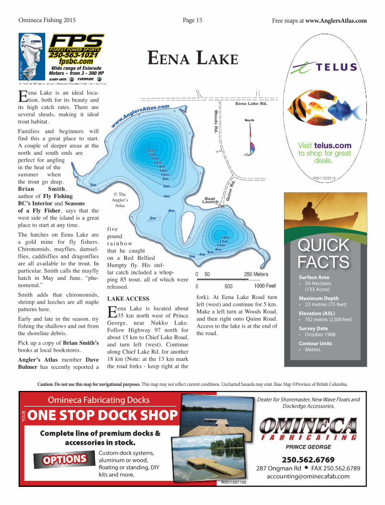
eena LaKe
Eena Lake is an ideal loca-tion, both for its beauty and
its high catch rates. There are several shoals, making it ideal trout habitat. Families and beginners will find this a great place to start. A couple of deeper areas at the north and south ends are perfect for angling in the heat of the summer when the trout go deep. Brian smith, author of Fly Fishing BC’s interior and seasons of a Fly Fisher, says that the west side of the island is a great place to start at any time.The hatches on Eena Lake are a gold mine for fly fishers. Chironomids, mayflies, damsel-flies, caddisflies and dragonflies are all available to the trout. In particular, Smith calls the mayfly hatch in May and June, “phe-nomenal.” Smith adds that chironomids, shrimp and leeches are all staple patterns here.Early and late in the season, try fishing the shallows and out from the shoreline debris. Pick up a copy of Brian smith’s books at local bookstores.Angler’s Atlas member dave Bulmer has recently reported a
five pound r a i n b o w that he caught on a Red Bellied Humpty fly. His stel-lar catch included a whop-ping 85 trout, all of which were released.
lAKe ACCess
Eena Lake is located about 35 km north west of Prince
George, near Nukko Lake. Follow Highway 97 north for about 15 km to Chief Lake Road, and turn left (west). Continue along Chief Lake Rd. for another 18 km (Note: at the 13 km mark the road forks - keep right at the
fork). At Eena Lake Road turn left (west) and continue for 5 km. Make a left turn at Woods Road, and then right onto Quinn Road. Access to the lake is at the end of the road.
© The Angler’s
Atlas
Surface Area• 54 Hectares
(133 Acres)
Maximum Depth• 23 metres (75 feet)
Elevation (ASL)• 762 metres (2,500 feet)
Survey Date• October 1988
Contour Units• Metres
Quick Facts

Caution: Do not use this map for navigational purposes. This map may not reflect current conditions. Uncharted hazards may exist. Base Map ©Province of British Columbia.
Omineca Fishing 2015 Free maps at www.AnglersAtlas.comPage 16
feRgusOn LaKe
Ferguson Lake is a small lake within the City of Prince
George, along the northeast edge of the city limits.
The lake has been stocked with brook trout for sev-eral years, but start-ing in 2007, the lake is being developed as an urban fishery. Each year since then, volun-teers from the Spruce City Wildlife Association released rainbow trout into Ferguson Lake.
The club developed this loca-tion into a popular local fish-ery for anglers and educators. In 2009, a larger dock was installed, and since then it has become a favourite local spot. It is easy to get to the dock and the fishing is great.
This lake has been designated a family fishing water by the Freshwater Fisheries society of BC. Family fishing waters are so named because they are easily accessible and the lakes boast ample opportunities to fish from shore or a pier.
lAKe ACCess
From Prince George, head north along Hwy 97 to
Kelly R d N o r t h , still within city limits. Turn left (west) onto North Kelly Road and con-tinue for approximately 1 km, then turn left onto Ferguson Lake Rd. Stay on this road (keeping right at the fork where it turns to gravel). The lake is located on the left side of road.
There is a small parking area and there is a dock on the lake.
It is i d e a l l y
s u i t e d for small watercraft, and no motors are permitted.
T h e l a k e is sur-rounded by a walking trail and nature preserve.
© The Angler’s Atlas
Surface Area• 19 Hectares
(47 Acres)
Maximum Depth• 6.1 metres (20 feet)
Elevation (ASL)• 777 metres (2,549 feet)
Survey Date• 2007
Contour Units• Metres
Quick Facts
Rustic charmRustic charmin the heart of natureti
in the heart of natureCall for seasonal specials!
1-800-663-7373 | TIGH-NA-MARA.COM

This isPrince Georgewww.tourismpg.com
Phot
o by
Jer
emy
Bekk
en
Put down your phone.Pick up your paddle.

Caution: Do not use this map for navigational purposes. This map may not reflect current conditions. Uncharted hazards may exist. Base Map ©Province of British Columbia.
Omineca Fishing 2015 Free maps at www.AnglersAtlas.comPage 18
fingeR LaKe
Finger Lake is approxi-mately a two-hour drive
from Prince George and is part of the Chilako River watershed. This remote lake is a perfect weekend getaway for the fam-ily and is ideal for fishing with children.
Wayne Koftinoff from Finger lake Resort says that the fish-ing is great. Several larger fish have been reported. Anglers can be rewarded with trout up to five pounds and a high catch rate. Popular spots on the lake include The Narrows, south of the second island, and The Deep Hole on the north finger. The many islands in the lake are great habitat, and anglers are never far from shore.
Koftinoff notes that trolling small spinners with a Willow Leaf is productive. “Using a sink tip or full sink with drag-onfly nymphs, Doc Spratleys or popular leech patterns are just as rewarding,” he says.
Koftinoff suggests that Finger Lake is a great family fishing destina-tion because “Kids catch fish!” The main dock is the site where a six-year old caught a three-pound trout. The two docks are easily accessible from the resort’s campsites and comfort-able cabins.
Koftinoff is enthusiastic about the other fishing opportunities nearby as well. Tatuk, Lavoie, Hay, Secord, Gluten, Duten, Hobson, Chief Grey and Cicuta Lakes are just some of the many trophy trout lakes in the area. He says that one of these nearby lakes produced a trout estimated to be 10 to 12 pounds. Keep in mind that many of these are hike-in lakes, and many are catch-and-release.
Finger lake Resort offers cab-ins and campsites, as well as boat rentals. The on-site store stocks lures, flies and bait, and
licenc-es are
available.
Vis i t www.FingerlakeResort.com for more information. or contact Wayne Koftinoff at 1-778.785.1114.Check out the web page for Finger Lake on the Angler’s Atlas website. See www.anglersatlas.com/lake/100119. While you are there, post your own tips, photos and stories about Finger Lake.
lAKe ACCess
From Prince George, head west along Highway 16 to
the town of Vanderhoof, and turn south onto the Kenny Dam Road. Follow this road, past the Saik’uz Reserve, to the Kluskus Forest Service Road—roughly 25 km from the Vanderhoof turnoff.
Turn left (south) onto the Kluskus FSR and continue for about 42 km, until you reach the turnoff at km 59 to the Gold Road on your left (south).
© The Angler’s Atlas
Surface Area• 877 Hectares
(2,167 Acres)
Maximum Depth• 12.5 metres (41 feet)
Elevation (ASL)• 757 metres (3,140 feet)
Survey Date• August 1973
Contour Units• Feet
Quick Facts

Caution: Do not use this map for navigational purposes. This map may not reflect current conditions. Uncharted hazards may exist. Base Map ©Province of British Columbia.
Omineca Fishing 2015 Free maps at www.AnglersAtlas.comPage 19
fRaseR LaKe
Fraser Lake is a popular destina-
tion for outdoor enthusiasts. Its unlimited recreational opportuni-ties, beautiful scenery and great parks are a good complement to the fabulous fishing.
Three beaches, including Beaumont Provincial Park, are great starting points for your fishing adventure. Kokanee, lake trout, burbot and rainbow trout are all present in Fraser Lake.
Because Fraser Lake is large and relatively deep, it does not suffer the summer doldrums as shal-lower lakes do. This makes for prime fishing all year.
When going after rainbow trout, Mark parker, from par 3 sports in the town of Fraser Lake, sug-gests that the best “all-around lures” will be the Willow Leaf and Wedding Band, or a small Apex in any colour. A small F7 flatfish
i s also suc-
cessful. Fly fishers will see best results with a muddler
minnow or a leech pattern.
Anglers targeting kokanee can also use a Willow Leaf and Wedding Band.
There are many excellent fishing spots on Fraser Lake due to the many small bays. Parker sug-gests that fly fishers will do best among the weedbeds. “The area around the river mouth is great for trout, and the Ormond Creek area has prime trout fishing too,” says Parker.
lAKe ACCess
There are several access points to Fraser Lake. Beaumont
Provincial Park and a Forest Service Recreation Site are just two possibilities for accomoda-tion.
Beaumont Provincial Park, accessed from Highway 16, pro-vides 49 private campsites with
open v i e w s of Fraser Lake. Facilities provided include flush toilets, water, wood, and sani-stations during the summer months.
The park also has a day-use area as well as a sandy beach for swimming. A new self-guided interpretive trail offers eight signs that provide information on plants, animals, and history of the area.
The Recreation Site on Peterson’s Beach also has a good boat launch. From Nautley, turn onto Stella Road and follow the direc-tions. Or, through the Stellako Reserve, turn onto Stella Road.
Parker also notes that there is an excellent day-use area right in the town of Fraser Lake along the highway. Picnic tables and a good boat launch are just a couple of the amenities provided there.
© The Angler’s
Atlas
Surface Area• 5,463 Hectares
(13,500 Acres)
Maximum Depth• 30.5 metres (100 feet)
Elevation (ASL)• 676 metres (2,220 feet)
Survey Date• August 1950
Contour Units• Feet
Quick Facts

Caution: Do not use this map for navigational purposes. This map may not reflect current conditions. Uncharted hazards may exist. Base Map ©Province of British Columbia.
Omineca Fishing 2015 Free maps at www.AnglersAtlas.comPage 20
haRT LaKe
Hart Lake is a great place to catch large trout,
and the numerous hatches throughout the season can be a fly fisher’s dream.dan Moffat, from northern hardware in Prince George, is enthusiastic about the fly fishing on Hart Lake. “It’s one of the best fly fishing lakes in the area,” he says.Early spring is prime time on Hart Lake, “as soon as the ice is 20 feet from shore,” says Moffat. He suggests leeches for an early season pattern. Moffat suggests chironomids as another option for indicator fishing. Tie the fly pattern on the end of a long leader and attach a small bobber (strike indicator) so the fly dangles just off the bottom, between six inches and two feet. Let the fly dangle for a while, giving the line an occasional twitch. You may need to check out a few different depths and locations before hitting the right hole. Chironomid fishing is often done at the 18-20 foot depths. Bloodworm and chironomid pat-terns can be interchanged.Moffat notes that mid-summer can be a tough go on Hart Lake, but the lake is not so shallow as to suffer through real summer dol-drums. “When the fish are on, it’s
o n e of the best lakes ever,” he says.In 2014, the Freshwater Fisheries society of BC released 7,500 trout in Hart Lake.For more information about fishing on Hart Lake, stop by northern hardware and talk with dan Moffat and the experi-enced fishing staff.
l A K e ACCess
Hart Lake is about 70 kilome-tres north of Prince George
along Highway 97 and lies within Crooked River Provincial Park. The lake is just east of the high-way, right before the town of Bear Lake. There is a parking lot located just off the highway, then follow a trail for 200 metres which brings you to the lake.
© The Angler’s Atlas
Surface Area• 56 Hectares
(138 Acres)
Maximum Depth• 8.7 metres (29 feet)
Elevation (ASL)• 715 metres (2,346 feet)
Survey Date• July 1982
Contour Units• Metres
Quick Facts


Caution: Do not use this map for navigational purposes. This map may not reflect current conditions. Uncharted hazards may exist. Base Map ©Province of British Columbia.
Omineca Fishing 2015 Free maps at www.AnglersAtlas.comPage 22
macKenzie LaKes
MacKenzie Lakes are located southwest of Prince
George. They are small lakes, with an average fishery, though some anglers report trout up to 25 inches.
On MacKenzie Lake #2 (East) there is a daily quota of 2 rain-bow trout. These regulations are intended to increase the average size of fish in the lake. Ideally, MacKenzie Lakes could become trophy trout lakes like Hart Lake, located north of Prince George. In 2014, the Freshwater Fisheries society of BC released 7,500 rainbow trout into MacKenzie Lakes.
During the summer months, the west lake is often preferred by many anglers as it is deeper. But in the spring and fall, the cool-er waters can make the fishing good in both lakes. Try trolling a Woolly Bugger or Doc Spratley. These generic flies are excellent searching patterns, good to use
to get an idea of what the fish are feeding on.
Angler’s Atlas members can “follow” their favourite lakes!
Get new information about your local lakes as soon as
it is posted. Have something to
say? Post to the
pages of your favou-rite lakes and share videos, current condi-tions and tips to help out your fel-low anglers. Visit www.anglersatlas.com for more informa-tion.
lAKe ACCess
To get to MacKenzie Lakes, head west out of Prince
George along Highway 16, to the Blackwater Road turnoff. Turn south and follow the Blackwater Road for about 30 km, past Baldy Hughes, until you meet the Mt. MacKenzie Lookout FSR. At this point you have a choice to make—which lake do you want to visit?
To get to MacKenzie Lake
East, turn left (east) along Mt. MacKenzie Lookout FSR and follow for about two km. Then turn right on a side road to take you to the east lake recreation site.
If your destination is MacKenzie Lake West, continue along Blackwater Road for another two km, and turn left on a side road that will take you to the recreation site.
Recreation sites are acces-sible by 2WD. The west campsite can be accessed via the
Blackwater FSR, but bear in mind that
access is steep and can be
t r i c k y
if the road is wet. The east campsite can be accessed via Mt. MacKenzie Lookout FSR and has a cartop boat launch.
© The Angler’s Atlas
Surface Area• 17 & 26 Hectares
(42 & 64 Acres)
Maximum Depth• 9 & 4.1 m. (30 & 13 ft.)
Elevation (ASL)• 853 metres (2,799 feet)
Survey Date• August 1984
Contour Units• Metres
Quick Facts

Caution: Do not use this map for navigational purposes. This map may not reflect current conditions. Uncharted hazards may exist. Base Map ©Province of British Columbia.
Omineca Fishing 2015 Free maps at www.AnglersAtlas.comPage 23
mORfee LaKe
Morfee Lake is a mere five minutes from downtown
Mackenzie. It is stocked annually with rainbow trout and is home to lake trout, chub and whitefish as well.
Morfee Lake is one of the region’s family fishing waters. This means that the lake is easily fished from shore or by boat, and is an ideal place for young or beginner anglers.
Beginners may want to consid-er going after chub. Though not the best for eating, chub can be caught fairly easily and may keep younger folks interested while they learn. Try using smaller sized hooks and rods. Target the lower depths with a small split shot above the hook.
The trout in Morfee Lake are from the Blackwater strain. They are aggressive and tend to be most active during the day. They prefer to forage in shallower water.
In his book, Fly Fishing B.C.’s interior, author
and photographer Brian smith reccommends using smaller nymphs in the fall than you would in the spring. Fish through areas of cover such as logs or weeds.
Smith also suggests that some larger, pale green patterns with larger eyes could be the trick for a slow day in many Interior lakes. Try keeping these patterns on hand with several sizes of nymph patterns.
Pick up Smith’s book at local bookstores. Also keep an eye out for Smith’s most recent book, seasons of a Fly Fisher, pub-lished in 2013.
lAKe ACCess
From Mackenzie town centre at the intersection of Mackenzie
Blvd and Centennial Drive, head down Centennial Drive 2.5 kilo-metres to Morfee Lake Road. Drive down this road to the lake.
There are sandy beaches and numerous opportunities for recre-ational activities. Accomodation is available in the town of Mackenzie, including a camp-ground.
Is Morfee Lake one of your favou-rite fishing holes? Stop by the Angler’s Atlas and tell us about it. See www.anglersatlas.com/lake/100826. Post your photos, map markers and more. While you are there, sign up to fol-low Morfee Lake, or any of your favourites, and be notified when someone posts new information to the lake page. See www.anglers-atlas.com for details.
© The Angler’s Atlas
Surface Area• 279 Hectares
(915 Acres)
Maximum Depth• 44.2 metres (145 feet)
Elevation (ASL)• 721 metres (2,366 feet)
Survey Date• June 1970
Contour Units• Feet
Quick Facts
Caution: Do not use this map for navigational purposes. This map may not reflect current conditions. Uncharted hazards may exist. Base Map ©Province of British Columbia.
Omineca Fishing 2015 Free maps at www.AnglersAtlas.comPage 24
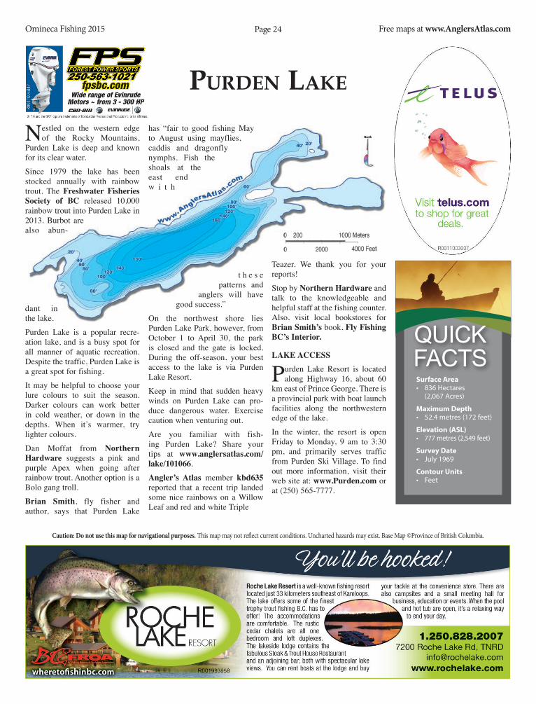
puRDen LaKe
Nestled on the western edge of the Rocky Mountains,
Purden Lake is deep and known for its clear water.
Since 1979 the lake has been stocked annually with rainbow trout. The Freshwater Fisheries society of BC released 10,000 rainbow trout into Purden Lake in 2013. Burbot are also abun-
dant in the lake.
Purden Lake is a popular recre-ation lake, and is a busy spot for all manner of aquatic recreation. Despite the traffic, Purden Lake is a great spot for fishing.
It may be helpful to choose your lure colours to suit the season. Darker colours can work better in cold weather, or down in the depths. When it’s warmer, try lighter colours.
Dan Moffat from northern hardware suggests a pink and purple Apex when going after rainbow trout. Another option is a Bolo gang troll.
Brian smith, fly fisher and author, says that Purden Lake
has “fair to good fishing May to August using mayflies, caddis and dragonfly nymphs. Fish the shoals at the east end w i t h
t h e s e patterns and
anglers will have good success.”
On the northwest shore lies Purden Lake Park, however, from October 1 to April 30, the park is closed and the gate is locked. During the off-season, your best access to the lake is via Purden Lake Resort.
Keep in mind that sudden heavy winds on Purden Lake can pro-duce dangerous water. Exercise caution when venturing out.
Are you familiar with fish-ing Purden Lake? Share your tips at www.anglersatlas.com/lake/101066.
Angler’s Atlas member kbd635 reported that a recent trip landed some nice rainbows on a Willow Leaf and red and white Triple
Teazer. We thank you for your reports!
Stop by northern hardware and talk to the knowledgeable and helpful staff at the fishing counter. Also, visit local bookstores for Brian smith’s book, Fly Fishing BC’s interior.
lAKe ACCess
Purden Lake Resort is located along Highway 16, about 60
km east of Prince George. There is a provincial park with boat launch facilities along the northwestern edge of the lake.
In the winter, the resort is open Friday to Monday, 9 am to 3:30 pm, and primarily serves traffic from Purden Ski Village. To find out more information, visit their web site at: www.purden.com or at (250) 565-7777.
Surface Area• 836 Hectares
(2,067 Acres)
Maximum Depth• 52.4 metres (172 feet)
Elevation (ASL)• 777 metres (2,549 feet)
Survey Date• July 1969
Contour Units• Feet
Quick Facts
Studio
Retoucher
Proofreader
Print Mgr.
Art Director
Copywriter
Creative Dir.
Acct. Mgmt.
Client
BY DATEAPPROVALS
CHRYSLER CANADAANGLERS ATLAS MAGAZINEPAD 151025NONE100%1” = 1”8” X 10.5”7” X 9.5”
3-19-2015 10:48 AMPREPRESS
LASER%Typesetting: Optic Nerve
This advertisement prepared by PUBLICIS
Art Director:Copywriter:
Print Mgr:Client Serv:
Colour:Fonts:
C. HILLMANC. DUFRESNEC. RUDY/A. KEELERNONE4CTT SLUG OTF, VENEER
100%
Client:Project:Docket:
Client Code:Built At:
Scale:V.O.:
Safety:
Date:Artist:
Output At:
Trim:Bleed:
100%
8” X 10.5”8.25” X 10.75”
CYAN, MAGENTA, YELLOW, BLACK
PAD_15_M_1025_ANGLERS_FP
IMAGE IS LINKED TO HI RES
REVs
1 4PDF
AD NUMBER/COMPONENT:
Title:Pubs:
Region/Layer Code:
DUE DATE: APRIL 2
PRODUCTION NOTES
TOWS 30,000 LBANGLERS ATLAS
LEGENDARY TOWING.
S:7”S:9.5”
T:8”T:10.5”
B:8.25”B:10.75”
PAD_15_M_1025_Anglers_FP.indd 1 4/6/15 2:38 PM

Studio
Retoucher
Proofreader
Print Mgr.
Art Director
Copywriter
Creative Dir.
Acct. Mgmt.
Client
BY DATEAPPROVALS
CHRYSLER CANADAANGLERS ATLAS MAGAZINEPAD 151025NONE100%1” = 1”16” X 10.5”15” X 9.5”
3-19-2015 10:48 AMPREPRESS
LASER%Typesetting: Optic Nerve
This advertisement prepared by PUBLICIS
Art Director:Copywriter:
Print Mgr:Client Serv:
Colour:Fonts:
C. HILLMANC. DUFRESNEC. RUDY/A. KEELERNONE4CTT SLUG OTF, VENEER, SENTICOSANSDT
100%
Client:Project:Docket:
Client Code:Built At:
Scale:V.O.:
Safety:
Date:Artist:
Output At:
Trim:Bleed:
100%
16” X 10.5”16.25” X 10.75”
CYAN, MAGENTA, YELLOW, BLACK
PAD_15_M_1025_ANGLERS_DPS
IMAGE IS LINKED TO HI RES
REVs
5 10PDF
AD NUMBER/COMPONENT:
Title:Pubs:
Region/Layer Code:
DUE DATE: APRIL 2
PRODUCTION NOTES
BIG ENOUGH TO HAUL ANY SIZE FISH STORYANGLERS ATLAS
BIG ENOUGH TO HAUL ANY SIZE FISH STORY.
Hook into Motor Trend’s 2015 half-ton pickup shootout winner and Canada’s longest-lasting line of pickups. Ram trucks are the best way to get you and your gear to the fi nest fi shing spots B.C. has to off er. Check us out at RAMOFFERS.CA and GOFISHBC.COM
S:15”
S:9.5”
T:16”
T:10.5”
B:16.25”
B:10.75”
FS:7.375” FS:7.375”
PAD_15_M_1025_Anglers_DPS.indd 1 4/6/15 2:36 PM
Studio
Retoucher
Proofreader
Print Mgr.
Art Director
Copywriter
Creative Dir.
Acct. Mgmt.
Client
BY DATEAPPROVALS
CHRYSLER CANADAANGLERS ATLAS MAGAZINEPAD 151025NONE100%1” = 1”16” X 10.5”15” X 9.5”
3-19-2015 10:48 AMPREPRESS
LASER%Typesetting: Optic Nerve
This advertisement prepared by PUBLICIS
Art Director:Copywriter:
Print Mgr:Client Serv:
Colour:Fonts:
C. HILLMANC. DUFRESNEC. RUDY/A. KEELERNONE4CTT SLUG OTF, VENEER, SENTICOSANSDT
100%
Client:Project:Docket:
Client Code:Built At:
Scale:V.O.:
Safety:
Date:Artist:
Output At:
Trim:Bleed:
100%
16” X 10.5”16.25” X 10.75”
CYAN, MAGENTA, YELLOW, BLACK
PAD_15_M_1025_ANGLERS_DPS
IMAGE IS LINKED TO HI RES
REVs
5 10PDF
AD NUMBER/COMPONENT:
Title:Pubs:
Region/Layer Code:
DUE DATE: APRIL 2
PRODUCTION NOTES
BIG ENOUGH TO HAUL ANY SIZE FISH STORYANGLERS ATLAS
BIG ENOUGH TO HAUL ANY SIZE FISH STORY.
Hook into Motor Trend’s 2015 half-ton pickup shootout winner and Canada’s longest-lasting line of pickups. Ram trucks are the best way to get you and your gear to the fi nest fi shing spots B.C. has to off er. Check us out at RAMOFFERS.CA and GOFISHBC.COM
S:15”S:9.5”
T:16”T:10.5”
B:16.25”B:10.75”
FS:7.375” FS:7.375”
PAD_15_M_1025_Anglers_DPS.indd 1 4/6/15 2:36 PM

Caution: Do not use this map for navigational purposes. This map may not reflect current conditions. Uncharted hazards may exist. Base Map ©Province of British Columbia.
Omineca Fishing 2015 Free maps at www.AnglersAtlas.comPage 28
shane LaKe
Prince George anglers can now enjoy two great fishing plat-
forms on Shane Lake, thanks to the c o l l a b o r a t i v e
efforts of t h e P o l a r
Coachman Fly Fishing Club, the Freshwater Fisheries Society of BC, the Habitat Conservation Trust Fund, the Ministry of Environment and the City of Prince George. The second platform was built on the western shore of the lake and is designed to make it easier to access deeper water from shore. This is especially helpful when the weather warms up and the trout go deep.This initiative was spearheaded by the late Bob Graham, who cham-pioned the process and made sure all the partners were aligned and moving forward. It is with great sadness that Bob is no longer with us to enjoy this dock. He passed away earlier this year. However, the club and The Angler’s Atlas have requested the City name the section of trail lead-ing to the dock in his honour. We at the Angler’s Atlas feel this is a suitable way to recognize the hard work Bob carried out to make this project a reality.
Fishing The lAKe
Shane Lake is very pro-ductive, with a lot of
food for the fish. As a result, the trout grow
fast. During the cooler
seasons, the fish are found
th roughou t the lake and
can be easily caught from the dock at the northeast edge of the lake. In the heat of summer, the fish will generally be found in the deeper water. Anglers can visit the new dock on the western shore or carry in a small boat to access the deeper sections of the lake. Several members of the Angler’s Atlas have shared their reports and stories on the site. Check out anglersatlas.com/lake/101195 for these great stories and photos!
lAKe ACCess
The lake is located within Forests For the World, a
park area managed by the City of Prince George. From down-town, take 15th Avenue towards the university, and turn right on Foothills Blvd. just before the hill. Follow Foothills about a kilome-tre to Cranbrook Hill Rd. on the left (west) side of the road. Follow Cranbrook Hill Road up the hill to Kueng Rd., on the left (south). Turn here and follow to the end of the road where the parking lot is located. The lake is a short, 10-15 minute walk from the parking lot. Canoes and small boats can be packed into the lake, or you can choose to fish right off the dock. To access the new dock, follow the trail along the northern shore of the lake and then turn left (south) onto another trail that follows the western shore of the lake.
© The Angler’s Atlas
Surface Area• 44 Hectares
(109 Acres)
Maximum Depth• 5.7 metres (19 feet)
Elevation (ASL)• 812 metres (2,664 feet)
Survey Date• October 1987
Contour Units• Metres
Quick Facts

Caution: Do not use this map for navigational purposes. This map may not reflect current conditions. Uncharted hazards may exist. Base Map ©Province of British Columbia.
Omineca Fishing 2015 Free maps at www.AnglersAtlas.comPage 30
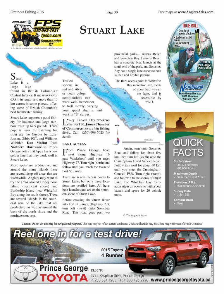
sTuaRT LaKe
Stuart Lake is a large lake found in British Columbia’s Central Interior. It measures over 65 km in length and more than 10 km across in some places, offer-ing some of British Columbia’s best freshwater fishing.Stuart Lake supports a good fish-ery for kokanee and large rain-bow trout up to 5 pounds. Three popular lures for catching big trout are the Coyote by Luhr-Jensen, Gibbs FST, and Williams Wobbler. dan Moffat from northern hardware in Prince George notes that Apex has a new colour line that may work well in Stuart Lake.Most spots are productive, and around the many islands there are several drop-off areas that are worthwhile. Anglers may want to try the areas around Honeymoon Island (northeast shore) and Battleship Island (near Whitefish Bay along the south shore). There are several islands in the south-east arm of the lake that are productive, as well as around the bays of the north shore and the northwestern arm.
Trolled spoons in red and silver or pearl colour combinations can work well. Remember to troll slowly, varying your speed slightly, and work in “S” curves.
Every Canada Day weekend the Fort st. James Chamber
of Commerce hosts a big fishing derby. Call (250) 996-7023 for details.
lAKe ACCess
From Prince George head west along Highway 16
past Vanderhoof until you meet Highway 27. Turn right (north) and follow until you reach the town of Fort St. James.
There are several access points to Stuart Lake, but only three loca-tions are profiled here. All have boat launches and are on the south-ern shore of Stuart Lake.
Before crossing the Stuart River into Fort St. James (Highway 27), turn left (west) onto Sowchea Road. This road goes past two
provincial parks—Paarens Beach and Sowchea Bay. Paarens Beach has a concrete boat launch at the south end of the park, and Sowchea Bay has a single lane concrete boat launch and limited parking.
The third access point is Whitefish Bay recreation site, locat-
ed about half way up the lake, and is
accessible by 2WD.
Again, turn onto Sowchea Road and follow for about five km, then turn left (south) onto the Cunningham Forest Service Road. Follow this road for about 40 km, until you meet the Cunningham-Camsell FSR. Turn right (north), and follow it to the shores of Stuart Lake. The Whitefish Bay recre-ation site is an open site with a boat launch and space for 20 vehicle units.
© The Angler’s Atlas
Surface Area• 36,423 Hectares
(90,000 Acres)
Maximum Depth• 96.6 metres (317 feet)
Elevation (ASL)• 678 metres (2,225 feet)
Survey Date• July 1953
Contour Units• Feet
Quick Facts


Caution: Do not use this map for navigational purposes. This map may not reflect current conditions. Uncharted hazards may exist. Base Map ©Province of British Columbia.
Omineca Fishing 2015 Free maps at www.AnglersAtlas.comPage 32
TaBOR LaKe
Tabor Lake, close to Prince George, is a great all-around
location. It is close to town and amenities, making it perfect for a quick trip after work or on weekends. Flies and lures both work well.
“Tabor is a great fishing lake,” says dan Moffat from northern hardware. Both flies and lures are good choices, and with so many hatches, anglers can feel free to experiment.
“Try Hotshots, or flat-fish, or any attract-ing gang troll,” Moffat suggests.
As for flies, “there are 40 dif-f e r e n t hatch-
es on Tabor Lake,” meaning that there is always something going on. There are so many different kinds of insects that fly fishers will easily find something that works.
If you want to stick with a stan-dard, leeches are good early-sea-
son patterns,
Moffat advises.
There are ample shore-fishing opportunities on Tabor Lake, making it an ideal place for kids to learn. There are no particular restrictions on the lake so chil-dren will have fun learning here.
For more information about Tabor and other regional lakes, stop by northern hardware in
Prince George and talk with dan Moffat and the knowl-
edgeable crew at the fishing counter.
lAKe ACCess
From Prince George, head east along Highway 16
about 15 km to Giscome Road on your right (south). There are two boat launches on Tabor Lake, a public boat launch at the north end of the lake, and a private boat launch at the Log House Restaurant and RV park, near the south end of the lake.
To get to the north boat launch, follow Giscome Road for roughly 2 km to Valhalla Rd., on your left (south) and turn here. At the end of this road is the public boat launch. Alternatively, you can continue along Giscome Road to Hedlund Road and follow the signs to the former Log House Restaurant.
© The Angler’s Atlas
Surface Area• 378 Hectares
(934 Acres)
Maximum Depth• 8.1 metres (27 feet)
Elevation (ASL)• 704 metres (2,310 feet)
Survey Date• June 1971
Contour Units• Feet
Quick Facts

Caution: Do not use this map for navigational purposes. This map may not reflect current conditions. Uncharted hazards may exist. Base Map ©Province of British Columbia.
Omineca Fishing 2015 Free maps at www.AnglersAtlas.comPage 33
TacheeDa LaKes
Tacheeda Lakes are part of the Parsnip River watershed,
which flows north into Williston Lake and eventually reaches the Arctic Ocean. This circuit of lakes is a pop-ular getaway. The lakes were stocked with rainbow trout sev-eral times since 1978, using dif-ferent strains of trout, includ-ing Dragon and Tunkwa Lake stocks.Dick Nite, the Triple Teezer and the Wedding Band are popular lures for
fishing
Tacheeda Lakes. For the Char fishery, try the One-Eyed Wiggler, made by GIBBS.When targeting kokanee, anglers may have luck with small lures. Wedding Rings are popular. Try using different colours, and experiment with flourescents. Kokanee are known to have a preference for red, so these colour combinations should pro-duce good results.Because Tacheeda Lakes are
quite deep, the summer doldrums are not an issue here. There are extensive bays and shoals, creat-ing ample trout habitat. In par-ticular, islands are a great place to start. Troll slowly and work out from here.
The re are three recre-
ation sites on the shores of this lake. The symbols
shown on the map are approxi-mate. Check out the Angler’s Atlas website for map mark-ers for Tacheeda Lakes at www.anglersatlas.com/lake/101360..New regulations are in effect for Tacheeda Lake: no fishing Nov 1-Apr 30, lake trout must be released, and no set lines are permitted.
lAKe ACCess
From Prince George, head north on Highway 97 for
about 90 km until you meet the Red Rocky Forest Service Road on the right (east). Follow this road for about half an hour and past Fishbone Lake. This road meets Tacheeda Lakes at the
southwestern shore, and winds along the length of both lakes. If you reach the Parsnip River you have gone too far.
Of special interest, just southeast of Tacheeda Lakes is an eco-logical reserve. Please remain conscious of activities that might disturb the reserve. Camping and quadding are not allowed.
Consult BC Parks for futher information about this and other ecological reserves. The website address is http://www.env.gov.bc.ca/bcparks/.Tacheeda Lakes are popular with local anglers, and we want to hear all about it. Visit www.anglersatlas.com/lakes1829. Post your favourite photos and fishing tips for Tacheeda Lakes.
© The Angler’s
Atlas
Surface Area• 591 Hectares
(1,460 Acres)
Maximum Depth• 59.4 metres (195 feet)
Elevation (ASL)• 726 metres (2,382 feet)
Survey Date• June 1961
Contour Units• Feet
Quick Facts

Caution: Do not use this map for navigational purposes. This map may not reflect current conditions. Uncharted hazards may exist. Base Map ©Province of British Columbia.
Omineca Fishing 2015 Free maps at www.AnglersAtlas.comPage 34
TaTuK LaKe
Ta t u k Lake is approximately a two-hour drive southwest from Prince George, in the heart of Finger-Tatuk Provincial Park. This lake boasts great kokanee and rainbow trout fishing.
Ken still from Tatuk lake Outfitters and Wilderness Resort says that Tatuk Lake is an excellent family destination, where kids can catch two-pound rainbows right off the dock. “It truly is an amazing fishery,” he says.
“When I use a fly rod, I have my best luck with a red Doc Spratley, trolled slow for rainbow and fast and farther out for kokanee,” says Still. He adds that standard lures such as Willows Leafs and Wedding Bands are good produc-ers.
For those going after kokanee, he suggests chrome and red Triple Teazers and Dick Nites, “but you
have to troll fairly fast.”
Try the west arm of the lake, which is steady through the summer months. Fishing off the islands and the east end is good in early September.
lAKe ACCess
From Prince George, head west along Highway 16 to the town
of Vanderhoof, and turn south onto the Kenny Dam Road. Follow this road, past the Saik’uz First Nation Reserve to the Kluskus Forest Service Road—roughly 25 km from the Vanderhoof turnoff.
Turn left (south) onto the Kluskus FSR and continue for about 42 km, until you reach the turnoff to Gold Road on your left (south). Proceed down this road until you meet the entrance to the resort. A forest recreation site is found along Gold Road, where the road meets the west end of the lake.
Alternatively, the Bobtail Forest
Service Road or the Pelican FSR can be used to travel to the eastern shore of Tatuk lake.
For maps of this area, log on to the Angler’s Atlas web site (www.AnglersAtlas.com) and download the Access Map for this lake—see the Vanderhoof Map Series.
Tatuk lake Outfitters and Wilderness Resort is a family operated business located on the northwest shore of the lake. The resort offers fully equipped cabins year round and provides outdoor enthusiasts with activities for all seasons, including guided hunts for big game. Visit their web site at: www.Tatuklake.comFor those anglers who prefer camping, there are two Forest Recreation Sites at the east and west ends of the lake.
© The Angler’s
Atlas
Surface Area• 1,894 Hectares
(4,680 Acres)
Maximum Depth• 40.8 metres (134 feet)
Elevation (ASL)• 922 metres (3,025 feet)
Survey Date• July 1971
Contour Units• Feet
Quick Facts
Page 35Omineca Fishing 2015 Free maps at www.AnglersAtlas.com
FULL PAGE

Caution: Do not use this map for navigational purposes. This map may not reflect current conditions. Uncharted hazards may exist. Base Map ©Province of British Columbia.
Omineca Fishing 2015 Free maps at www.AnglersAtlas.comPage 36
ViVian LaKe
Vivian Lake is a small jewel just north of Prince George.
Home to brook and rainbow trout, the lake is a popular des-tination for fishing, boating and swimming. The fish are big and the lake is perfect for some tried and true fly patterns and lures.
Brian ellison, from vivian lake Resort, noted that because the stocked trout do not reproduce, they put all their energy into get-ting bigger.
“Try a Ford Fender or a Wedding Ring in black or dark green,” said Ellison. He added that trolling is best in the area around the boat dock, right around the island, and in a shallower area just past the dock.
Fly fishers can try black leeches, chironomids and Doc Spratleys, again in dark colours. Ellison said that bloodworms are also good patterns for Vivian Lake. Head out about 200 feet and cast from there, or drift down around the far side across from the resort, around the bay area.
Ice fishers are in for a treat. This popular ice fishing destina-tion can be rewarding for patient anglers. It is helpful to remember that if you are drilling a hole, give it some time before dropping your line.
Arlene ellison says that there are
often anglers on the lake as soon as the ice is thick enough. Use the public access for winter fishing as the resort is closed from November to May.
Vivian Lake is stocked with brook and rainbow trout, and the lake is a family fish-ing water. Head out and talk to Arlene for more fishing tips, or stop by northern hardware and talk with Blair Moffatt for great ideas for fishing Vivian Lake.
lAKe ACCess
From Prince George, head north on Highway 97 to
Chief Lake Road. Turn left and drive straight out. Do not turn at the sign to Chief Lake; con-tinue straight. Approximately 5 kilometres after, the road turns to gravel. Vivian Lake Road is on the right hand side. Turn here and drive approximately a kilometre to the resort.
vivian lake Resort is a full-service resort with cabins, as well as single and group camp-sites. Amenities include firewood for sale, fire pits and pit toilets.
Showers are available. For more information about the resort, con-tact Arlene Ellison at (250) 967-0027.
Also visit the Angler’s Atlas website for great tips, current conditions, and map markers for Vivian Lake: www.anglersatlas.com/lake/101554.
© The Angler’s
Atlas
Surface Area• 45 Hectares
(110 Acres)
Maximum Depth• 8.2 metres (27 feet)
Elevation (ASL)• 779 metres (2,235 feet)
Survey Date• October 1968
Contour Units• Feet
Quick Facts


Sponsored byOmineca Fishing Regulations 2015-2017
Omineca Fishing 2015 Free maps at www.AnglersAtlas.comPage 39
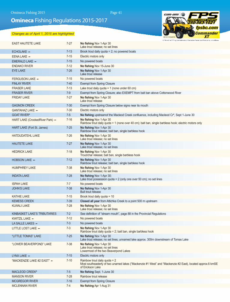
Changes as of April 1, 2015 are highlighted.
GENErAl ZONE A rEStrICtIONSset lining is only permitted in the lakes of Zone a (see tables for exclusions). set lines are restricted to one line with a single hook with a gap of not less than 3 cm (see pg 9). all set lines must be marked with the angler’s name, address and telephone number. see “Rules on Bait usage” (pg 9).No fishing (spring closure): in any stream of Zone a, apr. 1 to June 30. (see tables for exceptions).single barbless hook: must be used in all streams of Zone a, all year.Bait ban: applies to all streams of Zone a, all year. see page 9 for details. (see tables for exceptions).
NOtICE tO ANGlErSthe Ministry in partnership with the Habitat conservation trust Foundation, is conducting studies on bull trout in the upper Fraser/ Nechako watersheds. if you catch a bull trout with a coloured tag, please record and report the tag number, tag colour, date, time and location prior to releasing the fish unharmed. to report your catch of a tagged bull trout please contact the Fish and Wildlife Regional Office in Prince George at (250) 565-6135.
OMINECA WHItE SturGEONWhite sturgeon from the Nechako, stuart and the upper Fraser watersheds have been listed as endangered under the species at Risk act (saRa). it is illegal to fish for, kill, harm, or harass white sturgeon in the Omineca Region. Recovery actions have been underway since 2006; more than 15,000 juve-nile sturgeon have now been released into the Nechako River to help rebuild this critically endangered population. Habitat research is progressing with the release of more the 250,000 larval sturgeon in 2008 to help understand habitat needs and how to restore rearing areas for this critical life stage.Help from the public will also be necessary for recovery and the Nechako White sturgeon Recovery initiative requests that you report date and loca-tion of all sightings or incidental captures, particularly in the upper Nechako, Fraser Lake and stuart/takla Watersheds. if you observe or accidentally catch a sturgeon please call the Ministry of Forests, Lands and Natural Resource Operations at 250-565-6135, or go to either of these web sites: www.nechakowhitesturgeon.org or www.env.gov.bc.ca/omineca/esd/faw/sturgeon
DAIly AND ANNuAl CAtCH QuOtAS FOr SAlMON Please refer to the NOticE on page 4 for salmon Regulations.Possession QuotasPossession quotas = 2 daily quotas for most species. see tables for exceptions.Lake trout: possession quota = 1 daily quota.Bull trout (Dolly Varden): possession quota = 1 daily quota.
LAKE
SCA
RPDI
NA LAK
ES
GANTA
HAZ
McLEOD
MORFE
E
TUDY
AH
WILLIST
ON
RAINBOW TROUTEASTERN BROOK TROUTLAKE TROUTMOUNTAIN WHITEFISHGRAYLINGKOKANEEDOLLY VARDEN (BULL TROUT)LAKE WHITEFISHBURBOT
FISH
COME FISH MACKENZIE…
T: 250.997.3221 • E: [email protected]
the beautiful surroundings and watch for wildlife as you enjoy a day of fishing.
Our many surrounding lakes offer a wide variety of fish for all levels of angler.

Omineca Fishing 2015 Free maps at www.AnglersAtlas.com
Omineca Fishing Regulations 2015-2017 Sponsored by
Page 40
Changes as of April 1, 2015 are highlighted.
ZONE ADAIly CAtCH QuOtAS (see tables for exceptions)trout/char: 5, but not more than• 1 over 50 cm• 2 from streams• 3 lake trout• 1 bull trout (Dolly Varden)NOtE: Bull trout (Dolly Varden) may only be retained Oct. 16 to aug. 14.these fish may only be taken from lakes and only 30 - 50 cm in length. see below.and you must release:
Bull trout (Dolly Varden):• from streams, all year• from lakes, Aug. 15 to Oct. 15and you must release:Lake trout:• of any size, Sept. 15 to Oct. 31• under 30 cm all yeararctic grayling: catch and release onlyBurbot: 5kokanee: 10 (none from streams)White sturgeon: cLOsED tO aLL FisHiNGWhitefish: 15 (all species combined)
tAblE lEGENDsee the following tables for exceptions and additional regu-lations on specific waters. stocked Lake (not all stocked lakes listed, see p. 50)CW classified Waters Licence required to fish class i or class ii waters, see p. 8* including tributaries age Restricted Waters
aiRLiNE LakE 7-28 No fishing Nov 1-apr 30 Lake trout release; no set lines
aMaNita LakE 7-17 Electric motors only
aRctic LakE 7-23 No fishing Nov 1-apr 30 Lake trout release; no set lines
atticHika cREEk 7-39 Closed all year 500 m upstream & downstream of the thorn creek confluence Closed all year 500 m upstream & downstream of the kemess creek confluence
BEaR LakE (crooked River Park) 7-16 No powered boats
BEaVERLEY cREEk 7-10 Exempt from spring closure and from bait ban Youth/Disabled accompanied Water year round (see page 5 in the Provincial Regulations)
BEDNEsti LakE 7-12 No fishing Nov 1-apr 30 Lake trout release; no set lines
BLackWatER RiVER 7-10 see West Road River
BOBtaiL (Naltesby) LakE 7-12 kokanee daily quota = 5
BOW LakE 7-15 Brook trout daily quota = 10
BOWRON RiVER 7-7 Exempt from spring closure; no rainbow trout under 30cm
ButtERFLY LakE 7-15 Brook trout daily quota = 10
BYERs LakE 7-15 trout/char daily quota = 2
caMP LakE 7-15 Brook trout daily quota = 10; kokanee daily quota = 5
caNOE RiVER 7-2 Exempt from spring closure; rainbow trout release apr 1-June 30
caRiNa LakE 7-38 No fishing Nov 1-apr 30 Lake trout release; no set lines
caRP LakE 7-24 No fishing from marker buoys to the mouth of the McLeod River, apr 1-June 30
cHicHOuYENiLY cREEk 7-30 Exempt from spring closure; also EXEMPt from bait ban below signs near its mouth
cHiEF GRaY (Bitch) LakE 7-12 No fishing Nov 1-apr 30 Rainbow trout release; bait ban, single barbless hook
cHuBB LakE 7-10 Engine power restriction - 7.5 kw (10 hp)
cHucHi LakE 7-28 No fishing Nov 1-apr 30 Lake trout daily quota = 2; no set lines
cLucuLZ LakE 7-12 Lake trout release; no set lines
cROOkED RiVER 7-24 No fishing downstream (north) of the 200 Road bridge, apr 1-June 30 Rainbow trout release and exempt from spring closure upstream (south) of the 200 Road bridge, apr 1-June 30 Engine power restriction - 7.5 kw (10 hp)
cuNNiNGHaM LakE 7-25 No fishing Nov 1-apr 30 Lake trout possession quota = 2 (only one over 50 cm); no set lines
DaHL LakE 7-12 No powered boats
DaVis BaY (in Findlay Reach of Williston Lake)
7-37 Closed all year within a 500 m radius of the Davis Forest service Roadbridge. see Davis River
DaVis RiVER * 7-37 Closed all yearDEM LakE 7-25 No fishing Nov 1-apr 30
Lake trout release; no set lines
DiNa cREEk 7-30 Closed all yearDiNa LakE #1 7-30 Engine power restriction - 7.5 kw (10 hp)
DiNa LakE #2 7-30 Electric motors only
EaGLEt LakE 7-7 Burbot daily quota = 1
Sponsored byOmineca Fishing Regulations 2015-2017
Omineca Fishing 2015 Free maps at www.AnglersAtlas.comPage 41
Changes as of April 1, 2015 are highlighted.
East HautEtE LakE 7-27 No fishing Nov 1-apr 30 Lake trout release; no set lines
EcHOLakE 7-13 Brook trout daily quota = 2; no powered boats
EENa LakE 7-15 Electric motors only
EMERaLD LakE 7-15 No powered boats
ENDakO RiVER 7-12 No fishing Nov 15-June 30
EYE LakE 7-26 No fishing Nov 1-apr 30 Lake trout release
FERGusON LakE 7-15 No powered boats
FiNLaY RiVER 7-40 Exempt from spring closure
FRasER LakE 7-13 Lake trout daily quota = 1 (none under 60 cm)
FRasER RiVER 7-9 Exempt from spring closure; also EXEMPt from bait ban above cottonwood River
FRiDaY LakE 7-27 No fishing Nov 1-apr 30 Lake trout release
GaGNON cREEk 7-30 Exempt from spring closure below signs near its mouth
GaNtaHaZ LakE 7-30 Electric motors only
GOat RiVER* 7-5 No fishing upstreamof the Macleod creek confluence, including Macleod cr*, sept 1-June 30
HaRt LakE (crookedRiver Park) 7-16 No fishing Nov 1-apr 30 Rainbow trout daily quota = 1 (none over 40 cm); bait ban, single barbless hook; electric motors only
HaRt LakE (Fort st. James) 7-25 No fishing Nov 1-apr 30 Rainbow trout release; bait ban, single barbless hook
HatDuDatEHL LakE 7-26 No fishing Nov 1-apr 30 Lake trout release; no set lines
HautEtE LakE 7-27 No fishing Nov 1-apr 30 Lake trout release; no set lines
HEDRick LakE 7-18 No fishing Nov 1-apr 30 trout/char release; bait ban, single barbless hook
HOBsON LakE 7-12 No fishing Nov 1-apr 30 Rainbow trout release; bait ban, single barbless hook
HuMPHREY LakE 7-38 No fishing Nov 1-apr 30 Lake trout release; no set lines
iNData LakE 7-28 No fishing Nov 1-apr 30; Lake trout possession quota = 2 (only one over 50 cm); no set lines
isPaH LakE 7-7 No powered boats
JOHN’s LakE 7-38 No fishing Nov 1-apr 30 Bull trout release
katHiE LakE 7-15 Brook trout daily quota = 10
kEMEss cREEk 7-39 Closed all year from attichka creek to a point 500 m upstream
kLWaLi LakE 7-28 No fishing Nov 1-apr 30 Lake trout release; no set lines
kiNBaskEt LakE’s tRiButaRiEs 7-2 see definition of “stream mouth”, page 88 in the Provincial Regulations
kWitZiL LakE 7-12 No powered boats
La saLLE LakEs 7-3 No powered boats
LittLE LOst LakE 7-3 No fishing Nov 1-apr 30 Rainbow trout daily quota = 2; bait ban, single barbless hook
“LittLE tOMas” LakE 7-25 No fishing Nov 1-apr 30 Lake trout release; no set lines; unnamed lake approx. 300m downstream of tomas Lake
“LOWER BEaVERPOND” LakE 7-38 No fishing Nov 1-apr 30 Lake trout release; no set lines Lowermost of the two Beaverpond Lakes
LYNX LakE 7-15 Electric motors only
“MackENZiE LakE #2 East” 7-10 Rainbow trout daily quota = 2 Most southeasterly of two unamed lakes (“Mackenzie #1 West” and “Mackenzie #2 East), located approx.6 kmSE of Erickson Lake
MacLEOD cREEk* 7-5 No fishing sept. 1-June 30
MaNsON RiVER 7-28 Rainbow trout release
McGREGOR RiVER 7-16 Exempt from spring closure
McLENNaN RiVER 7-4 No fishing apr 1-aug 31

Omineca Fishing 2015 Free maps at www.AnglersAtlas.com
Omineca Fishing Regulations 2015-2017 Sponsored by
Page 42
Changes as of April 1, 2015 are highlighted.
McLEOD RiVER 7-24 artificial fly only, from carp Lake to War Falls (excludingWar Lake)
McMiLLaN cREEk 7-15 Exempt from spring closure and from bait ban; Youth/Disabled accompanied Water year round (see page 5 in the Provincial Regulations)
MiDDLE RiVER 7-26 Exempt from spring closure
MORFEE LakE (south) 7-30 Electric motors only
“Mt. MiLLiGaN” LakE 7-28 No fishing Nov. 1-apr. 30 Rainbow trout release; bait ban, single barbless hook; unnamed lake located approx.7.5 kms/sE of Mt. Milligan
MuGaHa cREEk 7-30 EXEMPt from bait ban; Youth/Disabled accompanied Water year round (see page 5 in the Provincial Regulations)
NakiNiLERak LakE 7-27 No fishing Nov. 1-apr. 30 Lake trout possession quota = 2 (only one over 50 cm); no set lines
NaLtEsBY LakE (Bobtail Lake) 7-12 kokanee daily quota = 5
NaRROW LakE 7-7 No fishing Nov. 1-apr. 30 Lake trout release; no set lines
NatiON aRM (Williston Lake) 7-30 No fishing west of a line between two boundary signs approx.500m downstream (east) of the Nation River bridge on the Finlay Forest service Road., apr 1-June 30 Bull trout release west of a line between two boundary signs approx. 500m downstream of the Nation River bridge on the Finlay Forest service Road (when open)
NautLEY RiVER 7-13 Exempt from spring closure
NatiON RiVER 7-30 see Nation arm (Williston Lake)
NEcHakO RiVER 7-12 Exempt from spring closure Rainbow trout release from cheslatta River to a boundary sign 5 km downstream and no rainbow trout under 35 cm from said downstream to Hwy #27 Bridge sign No fishing for white sturgeon Exempt from bait ban downstream of Foothills Boulevard bridge in Prince George
NEss LakE 7-15 kokanee daily quota=10
NuLki LakE 7-12 No fishing west of a line between signs on lakeshore near mouth of corkscrew creek, apr 1-May 31
OPatcHO LakE 7-9 No fishing Nov 1-apr 30 Rainbow trout daily quota = 1 (none over 40 cm); bait ban, single barbless hook
PaciFic LakE 7-16 No fishing Nov 1-apr 30 Lake trout release; no set lines
PaRsNiP RiVER 7-23 Exempt from spring closure
PiNcHi LakE 7-25 NOtE: see mercury warning, page 1 in this sectionPiNkERtON LakE 7-7 No fishing Nov 1-apr 30
Rainbow trout daily quota = 3; bait ban, single barbless hook
PORtaGE LakE 7-16 No fishing Nov 1-apr 30 Lake trout release; no set lines
PtaRMiGaN cREEk 7-5 Closed all year from falls to quarry bridge
PuRVis LakE 7-28 No fishing Nov 1-apr 30 Lake trout release; no set lines
saLMON RiVER 7-15 Exempt from spring closure
sHaNDY LakE 7-5 Electric motors only
sHERE LakE 7-4 Brook trout daily quota = 2
sLENDER LakE 7-6 No set lines
sLiM LakE 7-5 Electric motors only
sQuaRE LakE 7-16 No powered boats in crooked River Provincial Park (formerly “squaw” Lake)
“sQuaW” LakE 7-16 see square Lake
staLk LakEs 7-39 Bait ban
stELLakO RiVER CW 7-12 Open June 1-Nov 14; Class II water * when open (Steelhead Stamp not required) Rainbow trout release Fly fishing only between signs approx.250m and 4 km below the bridge near the François Lake outlet No powered boats from François Lake to the falls see Region 6 tables for restrictions applying to François Lake’s outlet area
stONY LakE 7-6 No set lines
stuaRt RiVER 7-15 Exempt from spring closure; rainbow trout release, apr 1-June 30
sWiFt cREEk 7-2 No fishing apr 1-aug 31 Closed all year from upstream side of weir to cNR bridge in Valemount
tacHEEDa LakEs (North and south) 7-16 No fishing Nov 1-apr 30 Lake trout release; no set lines

Sponsored byOmineca Fishing Regulations 2015-2017
Omineca Fishing 2015 Free maps at www.AnglersAtlas.comPage 43
Changes as of April 1, 2015 are highlighted.
McLEOD RiVER 7-24 artificial fly only, from carp Lake to War Falls (excludingWar Lake)
McMiLLaN cREEk 7-15 Exempt from spring closure and from bait ban; Youth/Disabled accompanied Water year round (see page 5 in the Provincial Regulations)
MiDDLE RiVER 7-26 Exempt from spring closure
MORFEE LakE (south) 7-30 Electric motors only
“Mt. MiLLiGaN” LakE 7-28 No fishing Nov. 1-apr. 30 Rainbow trout release; bait ban, single barbless hook; unnamed lake located approx.7.5 kms/sE of Mt. Milligan
MuGaHa cREEk 7-30 EXEMPt from bait ban; Youth/Disabled accompanied Water year round (see page 5 in the Provincial Regulations)
NakiNiLERak LakE 7-27 No fishing Nov. 1-apr. 30 Lake trout possession quota = 2 (only one over 50 cm); no set lines
NaLtEsBY LakE (Bobtail Lake) 7-12 kokanee daily quota = 5
NaRROW LakE 7-7 No fishing Nov. 1-apr. 30 Lake trout release; no set lines
NatiON aRM (Williston Lake) 7-30 No fishing west of a line between two boundary signs approx.500m downstream (east) of the Nation River bridge on the Finlay Forest service Road., apr 1-June 30 Bull trout release west of a line between two boundary signs approx. 500m downstream of the Nation River bridge on the Finlay Forest service Road (when open)
NautLEY RiVER 7-13 Exempt from spring closure
NatiON RiVER 7-30 see Nation arm (Williston Lake)
NEcHakO RiVER 7-12 Exempt from spring closure Rainbow trout release from cheslatta River to a boundary sign 5 km downstream and no rainbow trout under 35 cm from said downstream to Hwy #27 Bridge sign No fishing for white sturgeon Exempt from bait ban downstream of Foothills Boulevard bridge in Prince George
NEss LakE 7-15 kokanee daily quota=10
NuLki LakE 7-12 No fishing west of a line between signs on lakeshore near mouth of corkscrew creek, apr 1-May 31
OPatcHO LakE 7-9 No fishing Nov 1-apr 30 Rainbow trout daily quota = 1 (none over 40 cm); bait ban, single barbless hook
PaciFic LakE 7-16 No fishing Nov 1-apr 30 Lake trout release; no set lines
PaRsNiP RiVER 7-23 Exempt from spring closure
PiNcHi LakE 7-25 NOtE: see mercury warning, page 1 in this sectionPiNkERtON LakE 7-7 No fishing Nov 1-apr 30
Rainbow trout daily quota = 3; bait ban, single barbless hook
PORtaGE LakE 7-16 No fishing Nov 1-apr 30 Lake trout release; no set lines
PtaRMiGaN cREEk 7-5 Closed all year from falls to quarry bridge
PuRVis LakE 7-28 No fishing Nov 1-apr 30 Lake trout release; no set lines
saLMON RiVER 7-15 Exempt from spring closure
sHaNDY LakE 7-5 Electric motors only
sHERE LakE 7-4 Brook trout daily quota = 2
sLENDER LakE 7-6 No set lines
sLiM LakE 7-5 Electric motors only
sQuaRE LakE 7-16 No powered boats in crooked River Provincial Park (formerly “squaw” Lake)
“sQuaW” LakE 7-16 see square Lake
staLk LakEs 7-39 Bait ban
stELLakO RiVER CW 7-12 Open June 1-Nov 14; Class II water * when open (Steelhead Stamp not required) Rainbow trout release Fly fishing only between signs approx.250m and 4 km below the bridge near the François Lake outlet No powered boats from François Lake to the falls see Region 6 tables for restrictions applying to François Lake’s outlet area
stONY LakE 7-6 No set lines
stuaRt RiVER 7-15 Exempt from spring closure; rainbow trout release, apr 1-June 30
sWiFt cREEk 7-2 No fishing apr 1-aug 31 Closed all year from upstream side of weir to cNR bridge in Valemount
tacHEEDa LakEs (North and south) 7-16 No fishing Nov 1-apr 30 Lake trout release; no set lines
tatLatui LakE 7-39 Rainbow trout daily quota = 2
tcHENtLO LakE 7-28 No fishing Nov 1-apr 30 Lake trout possession quota = 2 (only one over 50 cm); no set lines
tEBButt LakE 7-13 Brook trout daily quota = 2; bait ban, single barbless hook
tHORN cREEk 7-39 Closed all year from attichika creek to a point 500 m upstream
tOMas LakE 7-25 No fishing Nov 1-apr 30 Lake trout release; no set lines
tOMias LakE 7-38 No fishing Nov 1-apr 30 Lake trout release; no set lines
tRaPPiNG LakE 7-9 Engine power restriction - 7.5 kw (10 hp)
tsaYta LakE 7-28 No fishing Nov 1-apr 30 Lake trout possession quota = 2 (only one over 50 cm); no set lines
tsitNiZ LakE 7-9 No powered boats
tuMucH LakE 7-5 Electric motors only
ViViaN LakE 7-15 Engine power restriction - 7.5 kw (10 hp)
uNNaMED LakE (kinglet Lake) located approximately100m west of Butterfly Lake
7-15 Brook trout daily quota = 10
uNNaMED LakE (Redstart Lake) located approximately200m south-west of Butterfly Lake
7-15 Brook trout daily quota = 10
WaR LakE 7-24 trout/char daily quota = 4 (not more than 3 char)
WEstON cREEk 7-30 Exempt from spring closure below signs near its mouth
WEst ROaD (“BLackWatER”) 7-10 trout daily quota = 1 (none under 30 cm); artificial fly only
RiVER’s tRiButaRiEs For regulations on the mainstem of the West Road River, see Region 5
WHitEFisH LakE 7-25 No fishing Nov 1-apr 30 Lake trout release; no set lines
WicHEEDa LakE 7-16 No fishing Nov 1-apr 30 Rainbow trout daily quota = 3; bait ban, single barbless hook
WiLListON LakE (in Zone a) 7-30 No rainbow trout under 30 cm; kokanee daily quota = 4
(includes waters 500 m east/upstream 7-37 Bait ban 500 m upstream and downstream of causeway Road July 1 - Oct. 30
of the causeway Road) 7-38 see Nation arm REMiNDER: arctic grayling release from tributaries See mercury warning on page 1 in this section, and definition of “stream mouth” on page 88 in the Provincial Regulations
WiLLOW RiVER 7-9 Exempt from spring closure; no rainbow trout under 30cm
WiNDY POiNt LakE 7-24 Electric motors only
WitcH LakE 7-28 No fishing Nov 1-apr 30 Lake trout release; no set lines
YELLOW HEaD LakE 7-1 No fishing Nov 1-apr 30 Lake trout release; no set lines

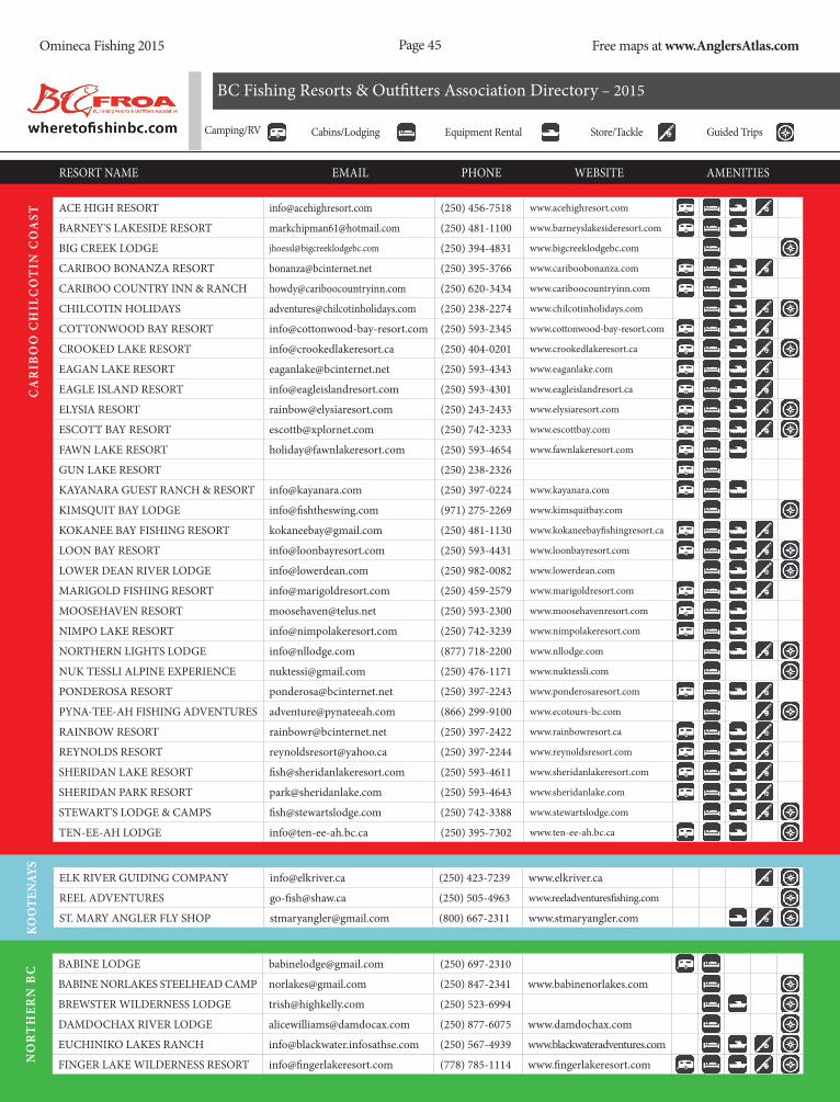
Page 45Omineca Fishing 2015 Free maps at www.AnglersAtlas.com
Camping/RV Cabins/Lodging Equipment Rental Store/Tackle Guided Trips
BC Fishing Resorts & Outfitters Association Directory – 2015
RESORT NAME EMAIL PHONE WEBSITE AMENITIES
ACE HIGH RESORT [email protected] (250) 456-7518 www.acehighresort.com
BARNEY'S LAKESIDE RESORT [email protected] (250) 481-1100 www.barneyslakesideresort.com
BIG CREEK LODGE [email protected] (250) 394-4831 www.bigcreeklodgebc.com
CARIBOO BONANZA RESORT [email protected] (250) 395-3766 www.cariboobonanza.com
CARIBOO COUNTRY INN & RANCH [email protected] (250) 620-3434 www.cariboocountryinn.com
CHILCOTIN HOLIDAYS [email protected] (250) 238-2274 www.chilcotinholidays.com
COTTONWOOD BAY RESORT [email protected] (250) 593-2345 www.cottonwood-bay-resort.com
CROOKED LAKE RESORT [email protected] (250) 404-0201 www.crookedlakeresort.ca
EAGAN LAKE RESORT [email protected] (250) 593-4343 www.eaganlake.com
EAGLE ISLAND RESORT [email protected] (250) 593-4301 www.eagleislandresort.ca
ELYSIA RESORT [email protected] (250) 243-2433 www.elysiaresort.com
ESCOTT BAY RESORT [email protected] (250) 742-3233 www.escottbay.com
FAWN LAKE RESORT [email protected] (250) 593-4654 www.fawnlakeresort.com
GUN LAKE RESORT (250) 238-2326
KAYANARA GUEST RANCH & RESORT [email protected] (250) 397-0224 www.kayanara.com
KIMSQUIT BAY LODGE [email protected] (971) 275-2269 www.kimsquitbay.com
KOKANEE BAY FISHING RESORT [email protected] (250) 481-1130 www.kokaneebayfishingresort.ca
LOON BAY RESORT [email protected] (250) 593-4431 www.loonbayresort.com
LOWER DEAN RIVER LODGE [email protected] (250) 982-0082 www.lowerdean.com
MARIGOLD FISHING RESORT [email protected] (250) 459-2579 www.marigoldresort.com
MOOSEHAVEN RESORT [email protected] (250) 593-2300 www.moosehavenresort.com
NIMPO LAKE RESORT [email protected] (250) 742-3239 www.nimpolakeresort.com
NORTHERN LIGHTS LODGE [email protected] (877) 718-2200 www.nllodge.com
NUK TESSLI ALPINE EXPERIENCE [email protected] (250) 476-1171 www.nuktessli.com
PONDEROSA RESORT [email protected] (250) 397-2243 www.ponderosaresort.com
PYNA-TEE-AH FISHING ADVENTURES [email protected] (866) 299-9100 www.ecotours-bc.com
RAINBOW RESORT [email protected] (250) 397-2422 www.rainbowresort.ca
REYNOLDS RESORT [email protected] (250) 397-2244 www.reynoldsresort.com
SHERIDAN LAKE RESORT [email protected] (250) 593-4611 www.sheridanlakeresort.com
SHERIDAN PARK RESORT [email protected] (250) 593-4643 www.sheridanlake.com
STEWART'S LODGE & CAMPS [email protected] (250) 742-3388 www.stewartslodge.com
TEN-EE-AH LODGE [email protected] (250) 395-7302 www.ten-ee-ah.bc.ca
CA
RIB
OO
CH
ILC
OT
IN C
OA
ST
ELK RIVER GUIDING COMPANY [email protected] (250) 423-7239 www.elkriver.ca
REEL ADVENTURES [email protected] (250) 505-4963 www.reeladventuresfishing.com
ST. MARY ANGLER FLY SHOP [email protected] (800) 667-2311 www.stmaryangler.com
KOO
TEN
AYS
BABINE LODGE [email protected] (250) 697-2310
BABINE NORLAKES STEELHEAD CAMP [email protected] (250) 847-2341 www.babinenorlakes.com
BREWSTER WILDERNESS LODGE [email protected] (250) 523-6994
DAMDOCHAX RIVER LODGE [email protected] (250) 877-6075 www.damdochax.com
EUCHINIKO LAKES RANCH [email protected] (250) 567-4939 www.blackwateradventures.com
FINGER LAKE WILDERNESS RESORT [email protected] (778) 785-1114 www.fingerlakeresort.comNO
RT
HER
N B
C

Page 46Omineca Fishing 2015 Free maps at www.AnglersAtlas.com
Camping/RV Cabins/Lodging Equipment Rental Store/Tackle Guided Trips
BC Fishing Resorts & Outfitters Association Directory – 2015
RESORT NAME EMAiL phONE wEBSiTE AMENiTiES
FRONTiER FARwEST LODGE [email protected] (877) 846-9153 www.bulkleysteelhead.com
GLACiER GUiDiNG [email protected] (250) 877-1994
LAKES DiSTRiCT AiR AND FiShiNG [email protected] (250) 692-3229 www.LDair.ca
MOBERLY LAKE RESORT & MARiNA [email protected] (250) 782-6425 www.moberlylakemarinaandresort.ca
NADiNA LAKE LODGE [email protected] (250) 695-6788 www.loveburnslake.com
NEChAKO LODGE & AViATiON [email protected] (250) 412-2665 www.nechakolodge.com
OOKpiK wiLDERNESS LODGE [email protected] (250) 697-2502 www.ookpiklodge.com
pELLY pEAK wiLDERNESS LODGE [email protected] (250) 503-0060
SKEENA MEADOwS wiLDLiFE pRES. [email protected] (250) 842-6400 www.skeenameadows.com
STEELhEAD VALhALLA LODGE [email protected] (250) 847-1806 www.steelheadvalhallalodge.com
SUSKEENA LODGE [email protected] (250) 847-1806 www.sustutriver.com
TERRACE SpORTFiShiNG ADV. [email protected] (250) 635-3521 www.terracesportfishing.com
TETAChUCK wiLDERNESS LODGE [email protected] (403) 799 4652 www.tetachucklodge.com
VAN TiNE GUiDiNG & OUTFiTTiNG [email protected] (250) 695-6677 www.pondosybay.com
No
rt
her
N B
C
7 hALF DiAMOND RANCh [email protected] (250) 378-2616 www.guestranchbc.com
AKEhURST LAKE FiShiNG RESORT [email protected] (250) 377-7615 www.brownsbayresort.com
BARE LAKE LODGE [email protected] (604) 792-4293 www.barelakelodge.com
BEAVER LAKE RESORT [email protected] (250) 762-2225 www.beaverlakesresort.com
BONE CREEK wiLDERNESS RETREAT [email protected] (250) 434-9671 www.bonecreek.ca
CAVERhiLL LODGE [email protected] (250) 672-9806 www.caverhilllodge.com
ChATAwAY LAKES RESORT [email protected] (250) 378-0105 www.chatawaylakes.com
ChUTE LAKE RESORT [email protected] (250) 493-3535 www.chutelakeresort.com
CiRCLE w hi hUM FiShiNG CAMp [email protected] (250) 373-2636 www.circlew.com
CORBETT LAKE LODGE [email protected] (250) 378-4334 www.corbettlake.ca
DEE LAKE RESORT [email protected] (250) 212-2129 www.deelakeresort.com
DOUGLAS LAKE RANCh [email protected] (800) 663-4838 www.douglaslake.com
hi hUM LAKE FiShiNG RESORT [email protected] (250) 459-2306 www.hihiumlake.com
hYAS LAKE FiShiNG CAMp (250) 319-1404
JOhNSON LAKE RESORT [email protected] (250) 434-4111 www.johnsonlakeresort.com
LAMBERTON’S KNOUFF LAKE RESORT [email protected] (250) 578-8155 www.knoufflake.com
LiTTLE FORT FLY AND TACKLE [email protected] (250) 677-4366 www.littlefort.com
M&M’s FiShiNG AND hUNTiNG RESORT [email protected] (604) 710-6686 www.skyhilodge.ca
MEADOw LAKE FiShiNG CAMp [email protected] 604-629-9860 www.meadowlakefishing.com
MiLE hiGh RESORT [email protected] (866) 371-2606 www.milehighresort.com
NEhALLiSTON FiShiNG LODGE [email protected] (250) 677-4209
piMAiNUS FiShiNG CAMp [email protected] (250) 768-5538
pOSTiLL LAKE LODGE [email protected] (877) 623-6982 www.postilllake.com
ROChE LAKE RESORT [email protected] (250) 828-2007 www.rochelake.com
STAR LAKE FiShiNG RESORT [email protected] (250) 674-8494 www.starlakefishingresort.com
SURREY LAKE FiShiNG RESORT [email protected] (866) 523-9778 www.surreylake.com
ThUYA LAKES LODGE [email protected] (250) 372-6867 www.thuyalakes.com
TUNKwA LAKE FiShiNG RESORT [email protected] (250) 523-9697 www.tunkwalakeresort.com
th
om
pso
N o
ka
Na
ga
N

Page 47Omineca Fishing 2015 Free maps at www.AnglersAtlas.com
BC SPORT FISHING GROUP [email protected] (877) 796-3345 bcsportfishinggroup.com
BENT RODS GUIDING AND FISHING CO. [email protected] (604) 794-5976 www.bentrods.ca
BON CHOVY FISHING CHARTERS [email protected] (604) 763-5460 www.bonchovy.com
ERIK’S ANGLING ADVENTURES [email protected] (604) 556-4807 www.flyguidebc.com
FRASER RIVER LODGE [email protected] (800) 665-6206 www.fraserriverlodge.com
PITT RIVER LODGE [email protected] (250) 378-2616 www.pittriverlodge.com
STS GUIDING SERVICE [email protected] (604) 671-3474 www.guidebc.com
VAN
COU
VER
COAS
T M
TN.
BEARCOVE COTTAGES SPORTFISHING [email protected] (877) 949-7939 www.bearcovecottages.ca
BROWN’S BAY RESORT [email protected] (250) 286-3135 www.brownsbayresort.com
HIDDEN COVE LODGE [email protected] (250) 956-3916 www.hiddencovelodge.com
NIMMO BAY RESORT [email protected] (800)-837-4354 www.nimmobay.com
OGILVIE OUTFITTING [email protected] (250) 752-5887 www.ogilvieoutfitting.com
RUGGED POINT LODGE [email protected] (250) 332-5220 www.ruggedpointlodge.com
THE RAMBLING FISHERMAN [email protected] (250) 203-7564 www.ramblingfisherman.comVAN
CO
UV
ER IS
LAN
D
Camping/RV Cabins/Lodging Equipment Rental Store/Tackle Guided Trips
BC Fishing Resorts & Outfitters Association Directory – 2015
RESORT NAME EMAIL PHONE WEBSITE AMENITIES
WENDEGO LODGE [email protected] (250) 819-1713 www.wendegolodge.com
WHITE MOOSE RESORT (250) 459-2258 www.whitemooseresort.comTH
-OK

Page 48Omineca Fishing 2015 Free maps at www.AnglersAtlas.com
BP150997
facebook.com/bassproshops twitter.com/bass_pro_shopsROAM FREE AT BASSPRO.COM or TRACKERBOATS.COM
WHEN THE OUTDOORS IS YOUR FIRST PRIORITY,
TRUST THE EXPERTSBass Pro Shops® has all the hunting and fishing equipment you’ll ever need. TRACKER® Boats
are the world’s #1-selling boats because outdoorsmen trust us to get them where they’re going
smoothly and efficiently. We’re the friendly experts who understand the outdoors, inside and out,
because having fun outdoors is why we’re here. Combined, we’ve been serving outdoorsmen for
over 75 years…and the best is yet to come.
To Find A Store Near You,
Visit basspro.com

Page 49Omineca Fishing 2015 Free maps at www.AnglersAtlas.com
BP150997
facebook.com/bassproshops twitter.com/bass_pro_shopsROAM FREE AT BASSPRO.COM or TRACKERBOATS.COM
WHEN THE OUTDOORS IS YOUR FIRST PRIORITY,
TRUST THE EXPERTSBass Pro Shops® has all the hunting and fishing equipment you’ll ever need. TRACKER® Boats
are the world’s #1-selling boats because outdoorsmen trust us to get them where they’re going
smoothly and efficiently. We’re the friendly experts who understand the outdoors, inside and out,
because having fun outdoors is why we’re here. Combined, we’ve been serving outdoorsmen for
over 75 years…and the best is yet to come.
To Find A Store Near You,
Visit basspro.com

Page 50Omineca Fishing 2015 Free maps at www.AnglersAtlas.com
2014 OMiNEca FisH stOckiNG REPORtWaterbody Name SpecieS releaSed
43 MILE POTHOLE RB 1,500
BERMAN RB 5,000
BOOT RB 1,700
BOW RB 750
BRUCE EB 4,000
BURDEN RB 13,200
BUTTERFLY RB 2,400
BUTTERNUT RB 3,500
BYERS EB 1,500
CAMP KO 5,200
CAMP RB 2,000
CASEY RB 2,500
CHIEF GRAY RB 5,200
CHUBB RB 6,600
CLEAR RB 3,000
COBB EB 20,000
COBB RB 10,000
CRYSTAL EB 5,000
CRYSTAL RB 5,000
DINA #1 RB 20,000
DINA #2 EB 10,000
DINA #3 RB 2,500
DINA #7 RB 1,000
Waterbody Name SpecieS releaSed
ECHO EB 3,000
EENA RB 10,000
EMERALD RB 3,500
FERGUSON RB 3,000
GANTAHAZ EB 15,000
GRIZZLY EAST RB 6,000
HART RB 7,500
HOBSON RB 18,000
KATHIE RB 4,000
KWITZIL EB 1,500
KWITZIL RB 1,500
LINTZ RB 23,760
LITTLE LOST RB 1,000
LOST EB 1,500
LYNX RB 2,000
MCKENZIE EAST RB 5,000
MCKENZIE WEST RB 2,500
NELSON RB 1,800
NESS KO 31,500
NESS RB 20,000
NULKI RB 10,000
OPATCHO RB 4,050
OTIPEMISEWAK RB 1,500
Waterbody Name SpecieS releaSed
PORTAL RB 1,500
PURDEN RB 10,000
SAWMILL RB 1,000
SHANE RB 3,000
SHERE EB 2,000
SQUARE RB 2,500
TEARDROP RB 8,000
TORY RB 1,000
TUREEN RB 5,000
VERDANT EB 5,000
VIVIAN EB 10,000
VIVIAN RB 5,000
WITNEY RB 2,500
Stock Species Codes: EB —Eastern Brook Trout (Char) KO—Kokanee RB—Rainbow Trout Visit www.GoFishBC.com for more stocking details.
Stock Species Codes:
EB Eastern Brook Trout (Char)
KO Kokanee
RB Rainbow Trout
For more information on Fish Stocking in British Columbia, visit:
www.GoFishBC.com
Without licence fees, there’d be a lot less fish.When you buy a fishing licence, you help the Freshwater Fisheries Society of BC stock more than 800 lakes a year. You also help fund our research, conservation and education programs, plus create more fishing spots close to home. So thanks for doing your part. You’re making fishing in BC better than ever. To learn more and get the latest stocking reports, visit us at gofishbc.com

Page 51Omineca Fishing 2015 Free maps at www.AnglersAtlas.com