Bays Precinct strategic Framework rePort to the nsw...
90
BAYS PRECINCT STRATEGIC FRAMEWORK REPORT TO THE NSW GOVERNMENT BAYS PRECINCT TASKFORCE VOLUME 1 AUGUST 2012
Transcript of Bays Precinct strategic Framework rePort to the nsw...

Bays Precinct strategic FrameworkrePort to the nsw government
Bays Precinct taskForcevolume 1
august 2012

Bays Precinct taskForce memBershiP:
Department of Premier and Cabinet Dianne leeson (chair) kathryn Pearson
NSW Treasury louise courtney
Department of Planning and Infrastructure Juliet grant
Transport for NSW mark ozinga tim Dewey
Sydney Ports Corporation grant gilfillian marika calfas
Roads and Maritime Services michael wright
Sydney Harbour Foreshore Authority Di talty Paul robinson
City of Sydney graham Jahn am
Leichhardt Municipal Council Peter conroy rochelle Porteous
Community Representative Jane marceau lesley lynch
Bays Precinct strategic Framework report to the nsw government Bays Precinct taskfiorce © nsw Department of Premiers and cabinet governor macquarie tower level 39, 1 Farrer Place syDney nsw 2000
www.dpc.nsw.gov.au
cover image circa 2008

Bays Precinct strategic Framework rePort to the nsw government
Bays Precinct taskForceaUgUst 2012

BAYS PRECINCT TASKFORCE REPORT AUGUST 20122
taBLe oF contents
ExEcutivE Summary 4
Bays Precinct Taskforce 4
Taskforce Recommendations 5
Strategic Planning Principles 7
1.introduction 8
What is the Bays Precinct? 8
The Evolving Bays Precinct 10
Bays Precinct Taskforce 11
Terms of Reference 12
2.currEnt activitiES in thE BayS PrEcinct 13
Current Activities 13
Current Planning Context 18
Government’s Commercial Commitments 19
3.Balancing land uSE nEEdS 20
Port and Industrial Maritime Land Use Needs 20
Commercial and Recreational Boating Needs 23
Foreshore access 24
The Local Community Needs 25
Transport Uses and Needs 27
Future Needs 28
4.KEy FindingS oF thE taSKForcE 31
Key Findings 32
5.StratEgic land uSE FramEworK 34
Finding 1 – Bays precinct provides essential port shipping and maritime boating services 34
waterways 34
residential development 38
Finding 2 – Public ownership and future proofing 40
Finding 3 – Traffic and transport 41
traffic impacts on local communities 41
transport assets in the Bays Precinct 42
Finding 4 – Urban Renewal Opportunities 43
Finding 5 – Improving public access and public domain 44
open space 44
Foreshore access 44
Finding 6 – Consolidating uses to create opportunities 45
Finding 7 – Improving management of the Precinct lands 47
residential interface 47
environment 47
heritage 47
Planning Framework 48
transparency and Process 49

BAYS PRECINCT TASKFORCE REPORT AUGUST 2012 3
6.StratEgic Planning PrinciPlES 51
7.SuB-PrEcinct rEPortS 55
Glebe Island and White Bay 55
context 55
taskforce recommendations 56
status of Development at key sites 57
White Bay Power Station 62
context 62
taskforce recommendations 63
Rozelle Rail Yards 64
context 64
taskforce recommendations 64
Rozelle Bay 65
context 65
taskforce recommendations 66
status of Development at key sites 68
Blackwattle Bay 70
context 70
taskforce recommendations 71
status of Development at key sites 73
Glebe Island Bridge 75
context 75
taskforce recommendations 76
8.conSultation Summary 78
Outline of consultation 78
Community And Stakeholder Feedback 78
round one – overview Forums 78
round two – working Forums 80
round three – summary workshops 81
online Forum Feedback 82
Industry Feedback 83
9.concluSion and rEcommEndationS 84
Recommendations 84
aPPEndicES (see volume 2) 86

BAYS PRECINCT TASKFORCE REPORT AUGUST 20124
eXecUtive sUmmary
the Bays Precinct (the Precinct) comprises the 94 hectares of the waterways of four connected bays west of Darling harbour (Johnstons, white, rozelle and Blackwattle Bays) and 80 hectares of adjoining and largely government owned land. it is rare to have such a significant asset so close to a capital city centre.
the Precinct is a unique and strategically important piece of sydney’s harbour and foreshore lands. it hosts a range of economically significant port and maritime uses with opportunities for future development close to the centre of sydney over the short, medium and longer terms. significant parts of the Precinct, such as the rozelle rail yards, are currently underutilised but are of critical value from a metropolitan perspective.
the area is of special interest from a local and community perspective with its potential to meet a wider range of open space, community and sub-regional development needs, and the interface of the bays to densely populated residential areas and conservation areas.
the future of the Bays Precinct is important to both the local residential and business community, to the wider population of sydney and new south wales and to visitors to the state. a key challenge in developing a land use framework for the Precinct is to balance the economic and regional needs of broader sydney with protection of local residential amenity, enhancement of recreational and open space and foreshore access and urban renewal. it is important that careful decisions are made for the best possible use of these valuable lands.
Bays Precinct taskForcein may 2011, the minister for Planning and infrastructure announced that the Bays Precinct taskforce would be reconvened to provide the nsw government strategic advice on the land use issues within the Precinct and a framework for moving forward.
the taskforce was directed to build on the extensive consultation process that was carried out in 2009-10 to gather information and ideas on the future of the Bays Precinct, to draft principles to guide future planning of the Precinct and to identify short, medium and long term land use opportunities.
the terms of reference of the taskforce are to:
• review the outcomes of stage one Bays Precinct work and consultations
• Devise and implement an effective consultative process to enable local and regional stakeholders to have informed input into the strategic framework for the Bays Precinct
• identify current and emerging issues affecting the Precinct
• identify short, medium and long-term issues and constraints and requirements to address these
• advise on appropriate land uses having regard to strategic transport, port, maritime and waterfront precinct priorities for adjacent local areas and communities, metropolitan sydney and nsw
• report and recommend to government on a strategic framework and strategic planning principles for the Bays Precinct by 30 July 2012.

BAYS PRECINCT TASKFORCE REPORT AUGUST 2012 5
the taskforce was chaired by the Department of Premier and cabinet and included representation from Leichhardt city council, city of sydney, and a nominated community representative, in addition to nsw government agency representatives from the Department of Planning and infrastructure, roads and maritime services, sydney Ports corporation, nsw transport, sydney harbour Foreshore authority and nsw treasury.
in responding to the terms of reference, this report presents an overview of the current activities within the Bay Precinct and the needs and issues of key stakeholders identified by the taskforce through a needs analysis, undertaken with assistance from the nsw government architect’s office, and a series of community consultation forums and industry consultation.
the report includes a series of recommendations that build on the taskforce’s key findings and consideration of a range of strategic issues by the taskforce members over the last six months. the taskforce has not undertaken detailed site or sub-precinct planning, nor engaged directly with current site operators, in respect of their specific development opportunities. where there were differences of opinion amongst taskforce members over strategic land use issues, and individual development opportunities, it has been noted in the report.
taskForce recommenDationsthe taskforce recommendations respond to the terms of reference, specifically the requirement to advise on appropriate land uses, and to report on and recommend to government a strategic framework and strategic planning principles for the Bays Precinct.
the taskforce members support the ongoing allocation of the Bays Precinct for port and maritime uses over the medium term (25 years), while pursuing urban renewal opportunities that can deliver on employment, cultural and recreational needs, and realising longstanding objectives for improving access to the foreshores and waterways for the local and sydney community.
the local councils and local community are seeking better engagement with the nsw government in planning and development decisions, particularly in regard to the relative costs and benefits of the port and maritime uses intensifying in the precinct, and in environmental assessment of development to ensure the environment and amenity of sydney harbour and adjoining communities is respected.
the taskforce recommendations are:
Public Ownership
1. Publicly owned foreshore lands and harbour waters be retained in public ownership.
Planning Framework
2. retain sydney harbour reP, sreP 26, sydney LeP 2005, and the adopted master Plans, as the key planning instruments for management of development in the Bays Precinct waterways and lands.
3. the strategic planning principles for the Bays Precinct developed by the taskforce be adopted and applied to decision-making in the Bays Precinct.
4. where the government’s current review of the planning system may repeal sreP 26 and sydney harbour reP, the aims and objectives, and land use controls of these policies, and including the strategic planning principles developed by the taskforce should be retained in new state, regional or local planning instruments.
5. the land use framework for the Bays Precinct be reviewed periodically in line with metropolitan Planning Policy review.
Lease Periods
6. Decisions in regard to new lease periods for commercial use of lands and waterways be reflective of the type of land uses, commercial and operational risk, capital investment, and any contribution of a proposal to the delivery of public benefits. the process for making all leasing decisions should be consistent with government policy on process and probity.
7. new lease periods be limited to a maximum of 30 years. any proposal for a lease in excess of 30 years include independent review and commercial advice, and be subject to ministerial approval.
Glebe Island and White Bay
8. glebe island and white Bay continue to be used for commercial port and maritime related purposes, including cruise facilities, bulk trade and a variety of intermittent operational and land/water interface uses, and operate having regard to their location in central sydney and proximity to adjacent local communities.
9. Development of a new dedicated port access road to service port needs at glebe island and white Bay and to provide access to the white Bay Power station be supported.

BAYS PRECINCT TASKFORCE REPORT AUGUST 20126
White Bay Power Station
10. the adaptive reuse of the white Bay Power station for mixed use, providing commercial, community, and educational purposes be pursued as a matter of priority, with careful consideration that redevelopment not conflict with or compromise ongoing flexibility in port and maritime operations.
11. nsw government investigate and test development scenarios for the white Bay Power station site, including adjacent lands extending to the foreshore, in consultation with the local councils, the nsw heritage office and the private sector.
Rozelle Rail Yards
12. Protect rozelle rail yards as a significant asset for delivery of future regional transport requirements.
13. when future transport requirements at rozelle rail yards are clarified, the nsw government, in consultation with Leichhardt council, investigate and test opportunities for mixed use development within the rozelle rail yards, providing recreation, commercial and residential uses that integrate surrounding communities.
Rozelle Bay
14. rozelle Bay continue development for recreational, commercial and industrial boating, tourism, and maritime operational purposes.
Blackwattle Bay
15. Blackwattle Bay continue development for maritime, commercial and recreational boating, and tourism purposes.
16. nsw government investigate the opportunity to relocate the bulk aggregate terminal and concrete batching operations at Blackwattle Bay to glebe island, in consultation with both local councils, recognising the potential benefits to Blackwattle Bay and the need to address potential impacts of these operations on glebe island on the surrounding local communities.
17. where relocation of the bulk terminal and concrete batching plant may be achieved the nsw government investigate and test urban renewal scenarios for the Blackwattle Bay precinct in consultation with the local councils and community.
Public Access and Public Domain
18. nsw government investigate potential opportunities and priorities for increased public access to operational port and maritime sites within the Bays Precinct, in consultation with the site operators, both local councils and the local community, and prepare an implementation plan for delivery over the short, medium and long term.
19. nsw government, in consultation with local councils and site operators, review the protocols for managing the connectivity to, and interfaces with, adjoining uses - including matters of operational best practice, landscape treatments, fencing, amenity, lighting and view corridors.
Traffic and Transport
20. an integrated traffic and transport plan for the Precinct be prepared to guide future development associated with urban renewal initiatives.
21. the two portals between rozelle rail yards and white Bay under victoria road be retained as a potential active transport corridor to service future increases in transport demands of the Precinct.
22. nsw government undertake a comprehensive analysis of the costs and transport access benefits of retaining versus removing the glebe island Bridge infrastructure, having regard to future development scenarios, in consultation with the key stakeholders, both local councils, and including independent specialist advice.

BAYS PRECINCT TASKFORCE REPORT AUGUST 2012 7
Development for New and Alternate Uses
23. encourage new development within the Bays Precinct that can co-locate with ongoing port and maritime uses, to provide for the needs of sydney as a global city and the needs of the adjacent communities.
24. rezoning of lands within and surrounding the Bays Precinct for residential uses not be supported, where the introduction of new residential development would compromise flexibility and operation of the deep water berths for commercial port and maritime uses over the long term.
25. any future proposal for residential development as a minor component of urban renewal must be carefully considered, in respect of its impact on the long-term flexibility in port and maritime operations or public open space uses.
26. any future residential development in the Bays Precinct should include a component of affordable rental housing consistent with nsw government policy.
The Waterways
27. the continued use of the waterways for a variety of commercial and recreational activities be supported.
28. nsw government prepare a waterway management plan for Blackwattle Bay and rozelle Bay in consultation with local councils, the waterways users, stakeholders and the community to build on current boat safety plans to provide for equitable use of the waterway by all user groups, guide on water infrastructure locations, and minimise the risk of mobilisation of contaminated sediments by vessels.
29. Development of additional public boat ramps and improved commercial and recreational boating facilities to improve direct access to the sydney harbour waterways for local community, residents of sydney and nsw, and international tourists be supported and potential new facilities be investigated in the preparation of the water management plan.
30. on-water development for marinas, moorings and other structures in the waterway be managed to ensure both commercial and recreational boating opportunities and foreshore access are not compromised.
strategic PLanning PrinciPLesthe taskforce has developed strategic planning principles to guide future development within the Precinct. the strategic Planning Principles build on principles and objectives that exist in current planning policy documents and the input of local councils and local communities. they are recommended as principles for consideration by consent authorities in assessing development applications and for inclusion in future planning instruments.
the principles address key areas of:
• public interest and future proofing
• waterways
• land use
• economic sustainability
• traffic and transport
• public domain, open space and foreshores
• built form and design
• heritage
• community and culture
• environment
• community consultation
the full list of the recommended strategic Planning Principles appears in chapter 6.

BAYS PRECINCT TASKFORCE REPORT AUGUST 20128
what is the Bays Precinct?the Bays Precinct (the Precinct) comprises the waterways and foreshores of four connected bays west of Darling harbour (Johnstons, white, rozelle and Blackwattle Bays). the anzac and glebe island Bridges divide the 94 hectares of the Precinct’s waterways into two key zones, the port zone at Johnstons and white Bay and the maritime zone at rozelle and Blackwattle Bay (refer Figure 1).
the Precinct is a unique and strategically important piece of sydney’s harbour foreshore and hosts a range of current uses and opportunities for future development close to the centre of sydney.
in addition to the foreshore and waterway areas, the Bays Precinct includes approximately 80 hectares of land that is of significance to the state, due to its location on sydney harbour, but also due to the importance of the port and maritime activities that occur within the Precinct. the precinct lands are defined in schedule 2 of state environmental Planning Policy (state and regional Development) 2011.
Unique among sydney harbour foreshore areas, almost all the lands are owned by nsw government authorities, principally sydney Ports corporation, roads and maritime services, sydney harbour Foreshore authority and state Property authority.
Located two kilometres from the central Business District, the Bays Precinct is bound by the densely populated inner west suburbs of Balmain, rozelle, Lilyfield, annandale, glebe, Ultimo and Pyrmont.
the Precinct is fragmented by major road and light rail corridors that pass by and through the lands. the anZac Bridge and city west Link is the major western entry to central sydney. the connecting victoria road is also a major route for vehicles and commercial transport and importantly accommodates significant volumes of buses that provide public transport for the local and broader region. the sydney metro Light rail also passes by the Bays Precinct providing an important public transport facility. the rozelle rail yards have strategic potential to support the future m4 extension and may have a role in facilitating other long term transport initiatives.
1. introDUction
Artist impression of the Cruise Passenger Terminal

Figure 1 Bays Precinct study area – Government Architect’s Office
BAYS PRECINCT TASKFORCE REPORT AUGUST 2012 9
the area is of special interest because it fulfills unique operational and recreational needs and has the potential to meet a wider range of operational, open space and development needs. the Precinct is where adjacent new and long standing residential, waterfront industrial, waterfront commercial, recreational and cultural interests of different scales come together.
on water, it is where kayak, runabout, super yacht, barge, bulk carrier, and cruise ship mix. it is where public use of the waterway and national security obligations of the Maritime Transport and Offshore Faciltiies Securities Act 2003 and the Customs Act 1901 co-exist.
the Precinct waterways have good navigational characteristics. glebe island and white Bay are of state significance because of the deep water commercial wharfage with landside support under public ownership. these are the last remaining lands in sydney harbour capable of serving a wide variety of cargo, trading and industrial maritime needs.
From a lands perspective the Precinct is equally diverse. there are substantial areas of well buffered industrial land whilst other areas such as white Bay are located in close proximity to some of the oldest dwellings in the country. Port activities support our state economy from an operational trade, tourism and employment perspective.
a range of commercial and industrial maritime uses support recreational and commercial boating on the harbour. the Precinct includes areas of passive recreation, boat ramps and marinas and popular venues such as the sydney Fish market.
the Precinct also includes the rozelle rail yards, white Bay Power station and the glebe island Bridge, (the latter two being significant heritage items), along with significant industrial and transport infrastructure that is no longer in use and lands that are currently predominantly vacant and unused.

BAYS PRECINCT TASKFORCE REPORT AUGUST 201210
the evoLving Bays Precinctthe Bays Precinct has undergone important land and water use changes over the last half century.
glebe island and white Bay have been used as a commercial port for over 100 years and continue to be used as a commercial port.
the wharves of glebe island were developed from 1912 following the demolition of the city abattoir and implemented over the following decades. cargoes handled at glebe island in this period include grains, timber, wheat, containers and motor vehicles. white Bay provided space for sydney’s first container facility, developed from 1967. stevedoring operations transferred from white Bay to Darling harbour in 2003 with stevedoring operations on site ceasing in 2004.
the white Bay Power station is listed on the nsw state heritage register. construction commenced in 1912 to provide power to sydney’s rail and tram network, it was the longest serving and last metropolitan power station.
Principal changes to the Precinct have been:
• white Bay Power station – decommissioned in 1983
• opening of the anZac Bridge in 1995 and the decommissioning of the glebe island Bridge in which had been operating since 1903
• rozelle rail yards – cessation of rail operations in 1997
• white Bay – cessation of P&o stevedoring and container operations in 2004 and opening of a cruise passenger terminal scheduled for 2013
• glebe island – cessation of car import operations in 2008 when car imports were relocated to Port kembla
• increase in commercial and recreational maritime activities at rozelle and Blackwattle Bays
• increase in resident population in close proximity to the Port
• shift in local demographic characteristics.
the strategic direction of the Precinct has been the subject of discussion, debate and reports over the past 15 years and more. in recognition of the industrial and infrastructure uses and the waterfront uses required of the land, non waterfront uses including hotels and residential use have been prohibited.
over the last five years, extensive consultation has taken place regarding the future uses of the Precinct. a range of developments have been approved providing for significant investment in the Precinct, including the cruise Passenger terminal at white Bay and the sydney superyacht marina at rozelle Bay. Leichhardt council believes the consultation has been without the inclusion of all stakeholders and has led to ad hoc decisions.
the future of the Bays Precinct is important to both the local residential and business community, to the wider population of sydney and new south wales and to visitors to the state. it is important that careful decisions are made for the best possible use of these valuable lands. the area is currently managed by several nsw government agencies that need to work together and with both local councils and the community to ensure that the best result is obtained for all, over the short, medium and longer terms.
there are a number of key challenges for government:
• Preserving the long term strategic capability of lands by managing development and lease arrangements.
• Protecting the port and maritime role of the Precinct while also providing a framework of land uses that allows for introduction of a range of other commercial and community-focused uses including open space, recreational facilities and community and cultural facilities
• maximising public benefits from the use of the lands now and into the future by identifying opportunities for redevelopment or strategic change of use
• ensuring that the local community, Precinct stakeholders and local government are involved in future planning decisions.

BAYS PRECINCT TASKFORCE REPORT AUGUST 2012 11
Bays Precinct taskForcein 2007, the former nsw government created the Bays Precinct taskforce to guide and inform the planning of the area. at that time, the government announced a cessation of car imports to glebe island. earlier in 2003, the government had announced the cessation of sydney harbour for container and bulk cargo handling. this resulted in the relocation of the P&o operations from white Bay in 2004.
these decisions provided a significant drive for strategic review of the Bays Precinct. since 2008, sydney Ports corporation has had an agreement with the nsw government that it would restrict leases for land at glebe island and white Bay to a maximum end date of 31 December 2020, pending the outcome of the strategic review of the Bays Precinct.
an extensive and open consultation process was carried out in 2009-2010 to gather information and ideas on the future of the Bays Precinct to be used to develop a set of draft principles to guide future planning of the Precinct and to identify short, medium and long term land use opportunities. the report on the outcomes of the 2009-2010 consultations appears in appendix one. the Bays Precinct community reference group was established in 2009 to provide advice to the taskforce about community needs, aspirations and concerns for the Precinct.
commUnity reFerence groUP
the community reference group (crg) comprised 32 local residents and business people, Leichhardt and city of sydney councils, precinct groups and the principal nsw government agencies responsible for activities and decisions about use of the Bays Precinct area. Discussions and work by the crg covered the period from august 2009 to march 2010 and was continued by interested community groups after that period.
the crg sought to produce principles that would govern planning and land and water use decision-making in the Bays Precinct into the long term and foreseeable future. the group decided on 11 key objectives and 58 recommendations as principles associated with the objectives although the outcomes were not endorsed by all participants. appendix two includes the complete list. these have informed the Principles recommended in this report.
in may 2011, the minister for Planning and infrastructure announced that the Bays Precinct taskforce would be reconvened to provide the nsw government with strategic advice on land use issues within the Precinct and a framework for moving forward.
the Bays Precinct taskforce was directed to build on the important work undertaken with the community during 2009-2010. the minister invited the city of sydney, Leichhardt municipal council and a community representative to become members of the Bays Precinct taskforce.
the taskforce was asked to consult with the community in its considerations and provide an opportunity for the community to input into a strategic land use framework for the Bays Precinct for the next 25 years and beyond. the taskforce officially reconvened in December 2011.

BAYS PRECINCT TASKFORCE REPORT AUGUST 201212
terms oF reFerencethe Bays Precinct taskforce is chaired by Department of Premier and cabinet, with representatives from sydney harbour Foreshore authority, nsw treasury, Department of Planning and infrastructure, transport for nsw, sydney Ports corporation, roads and maritime services, the city of sydney, Leichhardt council and a community representative (see appendix three for the list of taskforce members).
the terms of reference of the taskforce are to:
• review the outcomes of Stage 1 Bays Precinct work and consultations
• devise and implement an effective consultative process to enable local and regional stakeholders to have informed input into the strategic framework for the Bays Precinct
• identify current and emerging issues affecting the Precinct
• identify short, medium and long-term issues and constraints and requirements to address these
• advise on appropriate land uses having regard to strategic transport, port, maritime and waterfront precinct priorities for adjacent local areas and communities, metropolitan Sydney and nSw
• report and recommend to government on a strategic framework and strategic planning principles for the Bays Precinct by 30 July 2012.
the work of the taskforce to be guided by:
• the Bays Precinct - report on outcomes stage 1 consultation Process (February 2011)
• submissions made on the Bays Precinct - stage 1 consultation process report
• the economic, employment, cultural, environmental and recreational needs of adjacent local areas and communities, metropolitan sydney and nsw
• regional and local transport infrastructure requirements and the need to consider current Bays Precinct traffic and transport constraints
• the unique attributes of the Bays Precinct as the last remaining foreshore area of the natural deepwater port of sydney harbour, and as a key element in meeting the ongoing port and maritime needs of metropolitan sydney and nsw
• recognition that glebe island and white Bay will be used for ongoing and future port related uses
• existing studies, reports and strategies developed for the Precinct, including any relevant reports documented by Leichhardt municipal council and city of sydney.
For the purpose of this report, short term is defined as within zero to five years, medium term is within five to 25 years and long term is defined as 25 years and beyond.
community, industry and stakeholder consultation was carried out in may and June 2012. Further detail about the consultation appears in chapter 8. there was consensus on many issues including the importance of the Precinct’s deep-water berths and general, if not qualified, support for ongoing port and maritime uses. Discussion tended to focus on questions of process and engagement with the community, the need for improved and more coordinated management of the lands as a face of sydney and the need for better integration with surrounding communities and the role these lands can play as a resource to the community.
in addressing the terms of reference, and in response to issues arising through consultation, this report presents an overview of the current uses, needs and issues, an outline of each of the sub-precincts including identifying opportunities to deliver better outcomes, recommends a land use strategy and planning principles to guide both land and water development, and also provides recommendations for improving the nsw government’s management of the lands and waterways and its engagement with the community as the Bays Precinct continues to evolve.

PYRMONT
GLEBEANNANDALE
LILYFIELD
ROZELLE
IRON COVE
BALMAIN
ROZELLE BAY
VICTORIA ROAD
ANZAC BRIDGE
THE CRESCENT
CITY
BLACKWATTLE BAY
WHITE BAY
JOHNSTONS BAY
WEST LINK
BAYS SUB-PRECINCTS White Bay
Glebe Island
White Bay Power Station
Rozelle Railyards
Rozelle Bay - commercial maritime
Blackwattle Bay - commercial & recreational
Glebe Island Bridge
Study area
Figure 2 Bays Precinct sub-Precincts – Government Architect’s Office
NORTH
BAYS PRECINCT TASKFORCE REPORT AUGUST 2012 13
cUrrent activities there is a range of land uses in the Precinct including ports-related industry and employment, maritime waterfront use, water-based public recreation, commercial and mixed use, industrial, regional and local transport infrastructure.
waterway use in the Bays Precinct is generally for port activity, commercial maritime including charter vessel operations and recreational boating.
Further detail about the current uses in each of the sub-precincts is contained in chapter 7 sub-Precinct reports.
2. cUrrent activities in the Bays Precinct
Summary oF PaSt and currEnt uSES in thE BayS PrEcinct
sUB-Precinct Location cUrrent Uses
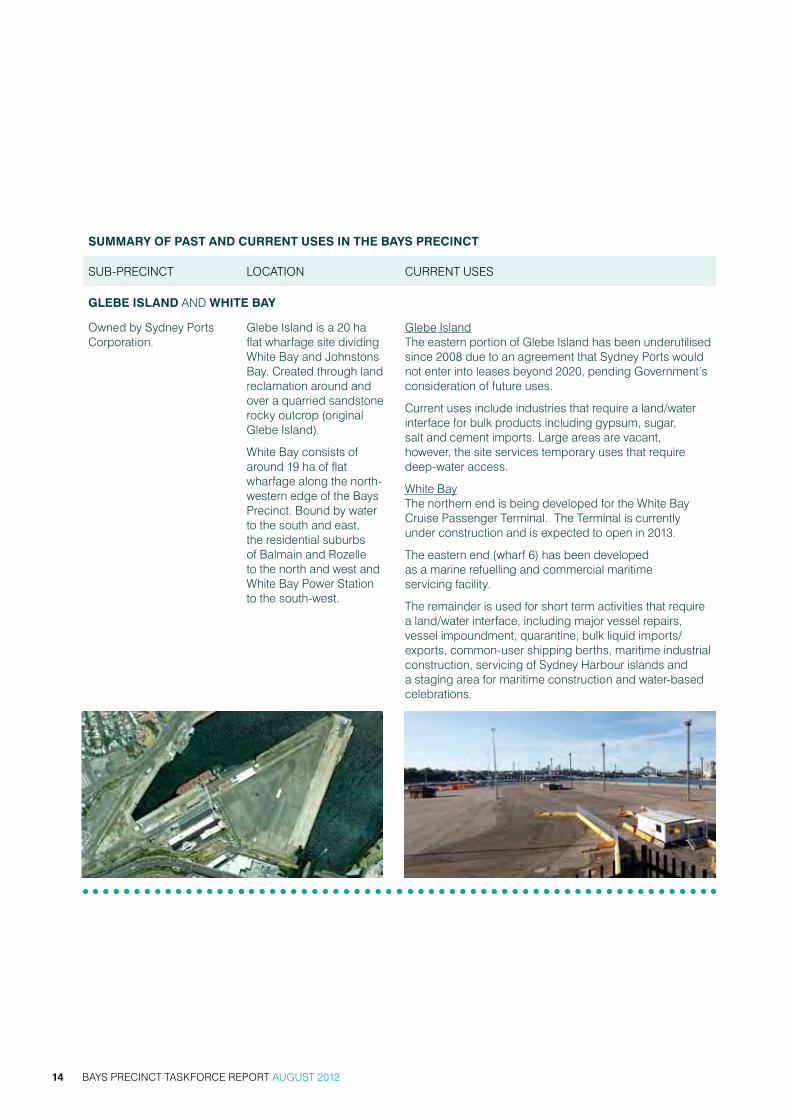
glEBE iSland anD whitE Bay
owned by sydney Ports corporation.
glebe island is a 20 ha flat wharfage site dividing white Bay and Johnstons Bay. created through land reclamation around and over a quarried sandstone rocky outcrop (original glebe island).
white Bay consists of around 19 ha of flat wharfage along the north-western edge of the Bays Precinct. Bound by water to the south and east, the residential suburbs of Balmain and rozelle to the north and west and white Bay Power station to the south-west.
glebe island the eastern portion of glebe island has been underutilised since 2008 due to an agreement that sydney Ports would not enter into leases beyond 2020, pending government’s consideration of future uses.
current uses include industries that require a land/water interface for bulk products including gypsum, sugar, salt and cement imports. Large areas are vacant, however, the site services temporary uses that require deep-water access.
white Bay the northern end is being developed for the white Bay cruise Passenger terminal. the terminal is currently under construction and is expected to open in 2013.
the eastern end (wharf 6) has been developed as a marine refuelling and commercial maritime servicing facility.
the remainder is used for short term activities that require a land/water interface, including major vessel repairs, vessel impoundment, quarantine, bulk liquid imports/exports, common-user shipping berths, maritime industrial construction, servicing of sydney harbour islands and a staging area for maritime construction and water-based celebrations.
BAYS PRECINCT TASKFORCE REPORT AUGUST 201214

Summary oF PaSt and currEnt uSES in thE BayS PrEcinct
sUB-Precinct Location cUrrent Uses
whitE Bay PowEr Station
owned by sydney harbour Foreshore authority (shFa).
Located on a 3.4 ha parcel of land bound by victoria road to the west, robert street to the north and white Bay wharf and rail access to the south-east.
vacant and unused. no use or redevelopment of this site is currently proposed although work is underway to identify options for adaptive re-use. has been used for a range of television and movie sets.
a program of remediation works is scheduled to begin in the second half of 2012.
rozEllE rail yardS
majority of land is owned by nsw government agencies including sydney harbour Foreshore authority, sydney Ports corporation and railcorp.
19 ha site located in the western reaches of the Bays Precinct, bound by rozelle and Lilyfield to the north and west, annandale to the south and victoria road to the east.
Partially vacant and unused. Part of the site accommodates the light rail corridor and stations.
reserved as a key transport corridor for infrastructure projects such as potential extension of the m4 east motorway and a new access road into glebe island and white Bay. identified as an important site to provide construction for major public projects and suitable for stabling and maintaining rolling stock for future transport initiatives including light rail.
there are long term opportunities to provide for a mix of commercial and recreational uses.
shFa manage short-term leases over parts of the site for industrial and storage related businesses.
BAYS PRECINCT TASKFORCE REPORT AUGUST 2012 15

Summary oF PaSt and currEnt uSES in thE BayS PrEcinct
sUB-Precinct Location cUrrent Uses
rozEllE Bay
majority of land is owned by roads and maritime services (rms).
has a land edge area of around 8.5 ha and is bound by the city west Link to the north, the crescent to the west and the waters of rozelle Bay to the south and east.
maritime-based commercial activities such as recreational boating facilities, boat repair facilities and marine industrial uses. the area hosts the superyacht marina, which currently has an application to develop its land base, and is the location of rms (maritime) offices.
BlacKwattlE Bay (BridgE road)
the land edge has diverse ownership. B1, B2 and B3 sites along Bridge road opposite wentworth Park are owned by roads and maritime services.
the sydney secondary college site in taylor street, glebe is owned by the nsw Department of education and communities.
Located to the south of the Precinct and covers a land area of around 7 ha.
sites B1 and B2 are used for charter boat mooring, effluent pump out and tender and barge mooring and are proposed to be redeveloped for commercial, retail and charter boat use, with the site developers now pursuing the inclusion of a function centre.
site B3 is used by hanson as a concrete batching plant and truck parking area.
BAYS PRECINCT TASKFORCE REPORT AUGUST 201216
Summary oF PaSt and currEnt uSES in thE BayS PrEcinct
sUB-Precinct Location cUrrent Uses
BlacKwattlE Bay (BanK StrEEt)
the primary site is the sydney Fish market site owned by state Property authority.
the 8 other sites in Bank street have a diverse ownership including shFa (1 site), rms (3 sites).
sydney Fish market is located at Bank street, Pyrmont, at Blackwattle Bay to the south and east of the Precinct, and the 8 other sites are located at the western end of Bank street towards the anzac Bridge covering a land area of around 2.8 ha.
sydney Fish market is an established sydney retail and wholesale institution operated under a cooperative arrangement. it has a small trawler fleet moored in Blackwattle Bay, seafood cooking school, food and beverage outlets and parking.
the remaining sites are currently used for industrial and business uses and passive recreational boating.
glEBE iSland BridgE
owned by roads and maritime services.
across Johnstons Bay from Pyrmont to glebe island.
Predominantly un-used and in poor condition. there is currently no access to pedestrians or vehicular traffic (except for special events) and normally rests in the open position. the western portal of the Bridge has restricted water access due to its proximity to the commercial shipping berths at glebe island (Berths 1 & 2).
BAYS PRECINCT TASKFORCE REPORT AUGUST 2012 17

SP2 Railways
SP2 RailwaysSP2Road
RE1
RE1
B2B2
B
B3B3
R1
B3
B3
R1
RE1
B4
B4
SHC
SHC
SHC
RE1
RE1
RE1
RE1
RE1
RE1
R1
R1
R1
R1
R1
RE1
B4
RE1RE1
B4
SP2Railways
Ha rris
Street
Bank Street
John Street
d igal Avenue
Bulwara
Roa d
Saunders Street
Distillery Drive
Western Distributor
Tambua
Street
Jones Street
Miller Lane
Moun t S
treet
Litt le M
ount Street
Miller Street
Bow
man St
reet
Quar
ry Ma
ster
Drive
Pate
SP2
Road
SP2
Rai
lway
s
SP2Road
SP2 Railways
SP2 Railways
SP2Road
SP2Road
SP2EducationalEstablished
RE1
RE1
B
B3
RE1RE1RE1
B4
RE1
B4
B3
B3
B3
R1
B4
B4
B4
B4
RE1
RE1
B4
B2
R1
B4
SHC
CW
SHC
SHC
SHC
SHC
SHC
SHC
RE1
R1
R1
SP2
PYRMONT
GLEBEANNANDALE
LILYFIELD
ROZELLE
IRON COVE
BALMAIN
ROZELLE BAY
VICTORIA ROAD
ANZAC BRIDGE
THE CRESCENT
CITY
BLACKWATTLE BAY
WHITE BAY
JOHNSTONS BAY
WEST LINK
cUrrent PLanning conteXtthe Bays Precinct waterways and lands have been recognised in successive policies over a long period as being of state and regional significance. the significance relates to both the Precinct’s location on sydney harbour and in respect of the port and maritime uses carried out on the lands.
the two key planning instruments that set the statutory framework for development in the Bays are:
• Sydney Regional Environmental Plan 26 – City West (‘sreP 26’)
• Sydney Regional Environmental Plan (Sydney Harbour Catchment) 2005 (‘the harbour reP’).
sreP 26 prioritises the ongoing use of Bays Precinct lands for a range of commercial port activities, water-based commercial and recreational uses, and allows for new mix of uses that will generate employment close to the cBD. the Policy recognises the importance of transport infrastructure to meet demands of development and seeks to provide opportunities for public access to the foreshores to be incorporated as part of the Precinct redevelopment. Planning controls in sreP 26 for the Pyrmont area have been devolved to the sydney Local environmental Plan (LeP) 2005.
the harbour reP provides principles that apply to development on the natural asset of sydney harbour recognising its ecological, scenic, visual and cultural value. the plan recommends the retention of foreshore land to meet existing and future demand for working harbour uses and like sreP 26, promotes additional recreational boating opportunity and public access to the foreshores.
Figure 3 Bays Precinct Land Use and Zoning – Government Architect’s Office
General residential
Public recreation
Mixed use (CoS)
Industrial (Leichhardt)
Local centre
Commercial core
Special activities
Infrastructure
Ports & employment (SREP 26)
Waterfront use (SREP 26)
Maratime waters (SREP- - Sydney Harbour Catchment 2005)
Water recreation (SREP - Sydney Harbour Catchment 2005)
Environmental protection (SREP - Sydney Harbour Catchment 2005)
Study area
Sources: Sydney Local Environment Plan 2011- DraftLeichhardt Local Environment Plan 2012- DraftSydney Regional Environment Plan 26 - City West 1992Sydney Harbour Catchment REP 2005
BAYS PRECINCT TASKFORCE REPORT AUGUST 201218

recognising the state significance of the Bays Precinct, the minister for Planning and infrastructure is the consent authority for the majority of development under several state planning instruments, while landowning agencies have authority to approve some infrastructure development on their lands and a variety of exempt and complying policy conditions apply.
while sreP 26 and the harbour reP provide robust aims and objectives in relation to the role of the Precinct to guide development, there are a myriad of other state and local policies applying across the Bays Precinct. the policy that applies in any one instance may depend on location, proposed land use activity, cost of development, industry type or who the land owning agency or development proponent is. the myriad of overlapping policies is not transparent to the community. the complexity of the planning framework applying in this Precinct has been a significant concern raised by the local community in various consultation forums addressing the future of the Bays Precinct undertaken over recent years.
the taskforce notes that in July 2011 the nsw government began a comprehensive review of the state’s planning system, including the Environmental Planning and Assessment Act 1979 (eP&a act). this review aims to change what has been characterised as an overly regulated, highly legalistic and process driven system to a planning system that is simpler and more transparent, and is focused on upfront strategic planning with community participation at the forefront accompanied with a more flexible performance based assessment system.
the outcomes of this review will be determined in the second half of 2012, and will provide a platform for reform of the planning framework for development within the Bays Precinct.
government’s commerciaL commitmentsDevelopment and investment in the Bays Precinct has been progressing in line with the objectives and planning controls in sreP 26 and the harbour reP. while the recent global financial crisis has stalled or delayed some projects, there are ongoing commitments to development within the Precinct for port services and commercial and recreational boating.
the nsw government is committed to ongoing use of white Bay Berths 5 and 4 (for secondary berthing) for cruise passenger facilities and construction of the new terminal is underway.
significant sites within the Bays Precinct are subject to commercial lease arrangements (including agreements to lease) over the short (0-5 year) medium (5-15 year and 15 – 25 year) and long term (25+year). Details of the lease periods are contained appendix Four.
the length of new leases at rozelle Bay and Blackwattle Bay has been controversial with the community, in particular two agreements to Lease that provide for lease term up to 50 years. while the lease terms provided in these agreements have been negotiated to allow for the amortization of the capital investment required for construction of the proposed developments, community members have expressed concerns regarding not just the length of the leases but the process for approval and lack of publicly available information to justify the lease term lengths.
while the developments on these sites deliver a range of community benefits including foreshore access and are consistent with planning principles developed by the community, the community is concerned that the lease terms are too long to allow ongoing flexibility with respect to the use of the important Precinct waterfront lands. the length of the lease periods needs to be appropriately balanced with the level of capital investment required and the public benefit to be delivered.
the community is also concerned about the approval of further applications in the absence of any approved planning principles and a strategic framework for the Bays Precinct. Leichhardt council has called for a moratorium on any current or new applications ahead of the finalisation of the taskforce’s strategic planning principles and recommendations. this matter is addressed more fully in chapter 5 strategic Land Use.
BAYS PRECINCT TASKFORCE REPORT AUGUST 2012 19

the Precinct is required to meet wide-ranging needs relating to its use as a ports-related employment zone and for waterfront, commercial, industrial and recreational maritime activities. these uses require high environmental and amenity standards in line with expectations for the use of sydney harbour.
current planning policy instruments divide the waterways into two key zones - larger commercial port shipping focused at white Bay and glebe island and smaller commercial charter boating and powered and non-powered recreational boating uses within the inner Bays (Blackwattle and rozelle Bays).
Port anD inDUstriaL maritime LanD Use neeDsaustralia is an island nation dependent on international trade. around 99 per cent of australia’s international trade is transported by sea. while sydney’s port trade was originally focused on sydney harbour with large areas of the foreshores dedicated to industrial and port related activities, today we have a more decentralised port structure and much of the former sydney harbour port facilities have been developed for other urban purposes including significant waterfront residential development.
sydney has the benefit of possessing two commercial ports. Port Botany handles containerised goods and bulk liquids and gases whilst sydney harbour, which includes glebe island and white Bay, is mainly used for bulk material products, cruise passenger terminals, including the one under construction at white Bay and various port support operations. sydney Ports corporation advises that Port Botany is forecast to be at capacity with containers and bulk liquids/gases over the next 20-30 years and therefore does not have capacity to cater for the port operations of glebe island and white Bay.
today, sydney harbour provides the home for sydney’s domestic and international cruise industry with facilities at circular Quay and the new facilities at white Bay.
glebe island is currently the principal centre for receiving, storing and distributing dry bulk goods to service the sydney metropolitan construction and food and beverage markets. this location enables the provision of highly efficient supply chains for key economic and employment industries in sydney. For example, the sugar processed at glebe island supplies approximately 70 per cent of sydney’s refined sugar market. sugar is packaged on-site at glebe island into retail and wholesale bags and converted into liquid sugar. it is used for food and beverage manufacturing operations and for sale at supermarkets.
BAYS PRECINCT TASKFORCE REPORT AUGUST 201220
3. BaLancing LanD Use neeDs now anD in the FUtUre
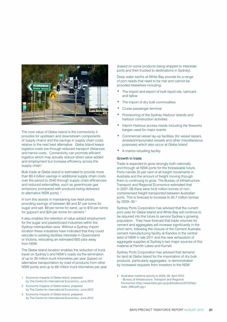
the core value of glebe island is the connectivity it provides for upstream and downstream components of supply chains and the savings in supply chain costs relative to the next best alternative. glebe island keeps logistics costs low through reduced transport distances and hence costs. connectivity can promote efficient logistics which may actually reduce direct value added and employment but increase efficiency across the supply chain.1
Bulk trade at glebe island is estimated to provide more than $0.4 billion savings in additional supply chain costs over the period to 2040 through supply chain efficiencies and reduced externalities, such as greenhouse gas emissions (compared with products being delivered to alternative nsw ports). 2
in turn this assists in maintaining low retail prices, providing savings of between $6 and $7 per tonne for sugar and salt, $9 per tonne for sand, up to $10 per tonne for gypsum and $24 per tonne for cement.3
it also enables the retention of value added employment for the sugar and plasterboard industries within the sydney metropolitan area. without a sydney import location these industries have indicated that they could relocate to existing facilities interstate in Queensland or victoria, relocating an estimated 600 jobs away from nsw.
the glebe island location enables the reduction of truck travel on sydney’s and nsw’s roads via the elimination of up to 39 million truck kilometres per year (based on alternative transportation by road of products from other nsw ports) and up to 66 million truck kilometres per year
1 economic impacts of glebe island, prepared by the centre for international economics, June 2012
2 economic impacts of glebe island, prepared by the centre for international economics, June 2012
3 economic impacts of glebe island, prepared by the centre for international economics, June 2012
(based on some products being shipped to interstate ports and then trucked to destinations in sydney).
Deep water berths at white Bay provide for a range of port needs that need to be met and cannot be provided elsewhere including:
• the import and export of bulk liquid oils, lubricant and tallow
• the import of dry bulk commodities
• cruise passenger terminal
• Provisioning of the sydney harbour islands and harbour construction activities
• interim harbour access needs including the fireworks barges used for major events
• commercial vessel lay-up facilities (for vessel repairs, arrested/impounded vessels and other miscellaneous purposes) which also occur at glebe island
• a marine refuelling facility.
Growth in trade
trade is expected to grow strongly both nationally and through all nsw ports for the foreseeable future. Ports handle 25 per cent of all freight movements in australia and the amount of freight moving through them is continuing to grow. the Bureau of infrastructure, transport and regional economics estimated that in 2007–08 there were 54.6 million tonnes of non-containerised freight transported between australian ports. this is forecast to increase to 92.7 million tonnes by 2029–30.4
sydney Ports corporation has advised that the current port uses for glebe island and white Bay will continue to be required into the future to service sydney’s growing population. they have forecast that trade volumes for cement and aggregates will increase significantly in the short term, following the closure of the cement australia cement manufacturing facility at kandos in the central west of nsw in late 2011 and the near exhaustion of aggregate supplies at sydney’s two major sources of this material at Penrith Lakes and kurnell.
sydney Ports corporation has advised that demand for land at glebe island for the importation of dry bulk products, particularly aggregates, is demonstrated by increased requests from investors to the nsw
4 australian maritime activity to 2029–30, april 2010 - Bureau of infrastructure, transport and regional economics (http://www.bitre.gov.au/publications/2010/files/stats_008.pdf) pg v
BAYS PRECINCT TASKFORCE REPORT AUGUST 2012 21

6 7
6 national Ports strategy December 2010 – infrastructure australia and the national transport commission (http://www.ntc.gov.au/filemedia/reports/PortsstrategyJan11.pdf)
7 nsw Long term transport master Plan Discussion Paper February 2012 – transport for new south wales, pg 77.
government to secure and develop land at the site for both existing and new dry bulk trades.
growth in the sydney and nsw population will not only drive an ongoing need for expanding port capacity, but also investment in new technologies and infrastructure to improve efficiencies in all our port and logistics chains.
the ports and freight supply chains involve long-life assets. optimal private investment and use of these depends on all levels of government providing certainty of their intentions, for example, on provision and use of port lands, and road and rail systems. operators of ports and freight distributors need certainty and predictability for commercial decision-making.
the national Land Freight strategy Discussion Paper, prepared by infrastructure australia in February 2011, identifies that productivity and competitiveness of the economy are inhibited by constraints to freight. it reinforces the significant growth projections for freight, with some projections being for a trebling of freight by 2050.
it states: “general freight is likely to grow near population centres. however, population growth and urban consolidation can place pressure on routes used by freight vehicles and on freight precincts, particularly if there are major changes in the locations of residential lands.”5
glebe island and white Bay have a higher order strategic value for sydney and nsw than the immediate bulk import needs. with its deep water berths and available back up land in government ownership and dedicated for port uses, this area has the flexibility to cater for the long term future needs of sydney and nsw – needs which cannot necessarily be foreshadowed at this time. the port needs for sydney have been through many changes over time demonstrating that an ability to cater for future unknown changes is paramount. any reassignment of these lands for alternate non-port related uses would impact on the ability to cater for sydney’s future port requirements. once reassigned to alternate uses, port land would be difficult to recover.
illustrative of this is the fact that the only commercial deep-water berth with supporting operational land remaining east of the sydney harbour Bridge, is the overseas Passenger terminal at circular Quay. the many port lands that did exist east of the Bridge have been converted to residential, commercial and open space. as a result, without access to the garden island naval base, sydney now finds it faces difficulties in catering for the growth in the cruise industry and the increasing size of cruise ships, many of which can no longer pass under sydney harbour Bridge. the extent of this growth was unforeseen as recently as 10 years ago.
5 nsw Long term transport master Plan Discussion Paper February 2012 – transport for new south wales, pg 24.
nationaL anD state Port anD Freight strategies
in 2011 infrastructure australia and the national transport commission released the national Ports strategy6 to “drive the development of efficient, sustainable ports and related freight logistics that together balance the needs of a growing australian community and economy with the quality of life aspirations of the australian people.” the strategy aims to create a coordinated approach from all levels of government to planning for ports, their road and rail links.
at the state level, port and freight planning is underway with the release of the nsw Long term transport master Plan Discussion Paper in February 2012 and the sydney metropolitan strategy Discussion Paper in may 2012.
the sydney metropolitan strategy Discussion Paper identifies that sydney must provide cost effective industrial land to keep business costs low and to boost competitiveness in local, national and international markets. the nsw Long term transport master Plan Discussion Paper highlights that the demand for goods and services within nsw will result in a possible trebling of australia’s total freight task by 2050. ensuring that goods move efficiently supports the economic growth of the state and can result in cheaper goods for consumers. in 2010-11, the freight and logistics industry’s share of nsw’s $420 billion gross state Product was around 12.1 per cent, or $51 billion.7
the nsw government is also developing a nsw Ports and Freight strategy to provide clear direction on port and freight planning and investment for the nsw government, industry and the community. the nsw Ports and Freight strategy will ensure capacity exists to accommodate forecast trade growth as well as improving the competitiveness, efficiency and sustainability of nsw ports and freight to enable them to respond to emerging challenges.
the nsw Port and Freight strategy will align with the national Port and Freight strategies and focus on delivering a freight transport system that supports the prosperity of nsw through efficient transport connections. glebe island and white Bay will continue to have a pivotal role in the nsw freight strategy.
BAYS PRECINCT TASKFORCE REPORT AUGUST 201222

the hawke rePort
Demand for cruise travel is growing significantly faster than expected and it is anticipated that in addition to the new (predominantly domestic) cruise terminal at white Bay, additional capacity for large international ships is required east of the sydney harbour Bridge.
in 2011 the Federal minister for Defence commissioned the hawke report to provide independent advice in relation to future use of the naval docks at garden island to accommodate cruise demands. the report looked at five long-term options, two of which included glebe island and white Bay providing naval docking and operations in place of facilities at garden island. these options came at a considerable cost to nsw, to relocate and provide facilities suitable for the navy at glebe island and white Bay.
in July 2012, the Federal government announced an expansion of the number of berths for visiting cruise ships at garden island with three visits in the coming cruise season and another three the next.
commerciaL anD recreationaL Boating neeDssydney has one of the most attractive and popular working and recreational harbours in the world. over the last few decades, there has been a significant increase in charter vessels, pleasure craft, recreational boating and fishing associated with increasing standards of living, tourism growth and recreation centered on the harbour. in 2010 there were 18,000 registered recreational vessels in the sydney harbour catchment, up from an estimated 16,000 in 19998.
this has resulted in a demand for the construction and maintenance of private and commercial wharves, jetties and pontoons, supply of fuel and chandlery, repair and anti-fouling of boats and mechanical servicing and repairs. with roads and maritime services predicting the 2010 figure is likely to increase to 28,000 by 2026 based on population growth, the demand for further facilities will grow.9 this does not mean however that demand can be infinitely met.
in addition to operations that support commercial and recreational boating, the sydney heritage Fleet is a community based non-profit organisation that undertakes servicing and restoration work on heritage vessels.
all of these uses need to be accommodated in sydney harbour.
the rapid gentrification of harbour foreshore industrial and working maritime lands primarily for residential living over the last decade, leaves rozelle Bay and Blackwattle Bay as one of the last remaining areas in sydney harbour suitable for and able to support the growing maritime industry, buffered from surrounding residential uses and accessible by major road infrastructure.
the suitability of rozelle Bay and Blackwattle Bay for concentrated maritime use stems from the proximity of the Bays to central sydney (where most tours and charters take place), the availability of developable former industrial land, the protected nature of the waterway from swell and the easy road access on the land side.
8 maritime industries’ Demand for Foreshore Land and water space, J.t. rolls, april 1999.
9 nsw Boat ownership & storage report, nsw maritime, 2010
BAYS PRECINCT TASKFORCE REPORT AUGUST 2012 23

in addition to growth in recreational power boat use, there continues to be growth in non-powered craft including rowing, canoe, kayak and dragon boat use within rozelle and Blackwattle Bays for both club and non-club use. these sports have grown strongly from a relatively low base and do not require high costs to participate. the growth in motorised and non-motorised recreational boating is placing increasing pressure on the provision of additional safe and easily accessible launching facilities (boat ramps), storage and on shared use of waterways.
the precinct planning strategy has been to locate public focus activities – charter boat operations in conjunction with the sydney Fish market and its fishing fleet at Blackwattle Bay, and locate private focus activities – marinas, dry boat storage, maritime industrial and boat repairs at rozelle Bay. this general distinction of focus is reflected in the rozelle and Blackwattle Bay 2002 master Plan and has the general support of the taskforce.
Foreshore Access
the nsw government has a longstanding vision to connect rushcutters Bay to rozelle Bay with a continuous public foreshore promenade. new developments like Jacksons Landing and Barangaroo assist in achieving this outcome. there are many policy documents that support delivering this long standing aim including Foreshore Promenade Policy for Land within SHFA boundary: Pyrmont and Blackwattle Bay (2003) and the Sharing Sydney Harbour Access Plan 2003)10.
while significant steps have been taken to deliver on this vision, including the redevelopment of foreshore parks and foreshore access paths around both Pyrmont and glebe, there are missing links within the Bays Precinct, where access arrangements are fragmented and access on the foreshore is not continuous.
this matter has been a priority issue for the local community during the taskforce consultations and in the recommendations of the previous crg. the taskforce believes that operational and safety considerations should be resolved wherever possible to facilitate public access to the Precinct foreshore.
Despite some constraints on access at rozelle Bay where there are various industrial maritime operators, the rozelle Bay and Blackwattle Bay master Plan 2002 provided for redevelopment of these Bays to enable delivery of these missing links and create a recreational loop similar to the Bay run at iron cove.
the anzac Bridge currently provides a high level pedestrian and cycle link as part of this developing recreational loop. whilst the community and both local councils acknowledge that the paths on the anzac Bridge provide links for both commuter and recreational pedestrians and cyclists, connected to the regional networks, they have expressed strong support for retaining glebe island Bridge as a low level link that will complete the foreshore access vision, providing a more pleasant and direct access to the cBD. this link has been identified in their inner sydney regional Bike Plan.
10 Department of infrastructure, Planning and natural resource – subject to a 5 year funding plan until 2013.
BAYS PRECINCT TASKFORCE REPORT AUGUST 201224

Public access to the working port areas at white Bay and glebe island is regulated by the Maritime Transport and Offshore Facilities Securities Act 2003 and Customs Act 1901. these acts restrict access by the public to secure port areas when vessels are at berth. separation distances are required to be approved by the commonwealth office of transport security. Under sydney Ports’ current approved maritime security Plans covering glebe island and white Bay, public access is prohibited within 30 metres of a vessel at berth (on both the land and water sides). at heightened security levels, this access restriction can be increased further.
the LocaL commUnity neeDsthe Bays Precinct is located two kilometres from the central Business District and is bound by the inner west suburbs of Balmain, rozelle, Lilyfield, annandale, glebe, Ultimo and Pyrmont. Like all inner city suburbs, these areas are densely populated. the residential areas are some of the oldest in australia, containing fine grain subdivision, and providing an urban character that is protected by heritage conservation provisions.
the community acknowledges the port and maritime role of the Precinct, but is concerned with impacts on the amenity of their communities and also make the case that these lands contribute to a range of local needs including public open space, recreation places with water access, employment opportunities close to home, better public transport and better access to the cBD.
the community has questioned the need for all of the port and maritime lands to be retained for industrial related port and maritime activities, and seeks a framework of land uses that allows for the introduction of a range of community-focused uses including dedicated open space, recreational facilities and community and cultural facilities.
Leichhardt council has advised the taskforce that it has significant deficiencies in the amount of open space for its residents. Leichhardt council’s recreational open space study calculated an open space ratio of 1.83 hectares per 1000 people which is low compared to the sydney average but commensurate with other inner city council areas. the most significant deficiencies are in the localities of Leichhardt and annandale.
while the suburbs of Balmain, rozelle, Birchgrove and glebe enjoy the benefits of harbourside locations with expansive vistas and significant local and regional open spaces at the waterfront (including Bicentennial Park, Ballast Point Park and callan Park) access to the Bays Precinct land is very limited.
BAYS PRECINCT TASKFORCE REPORT AUGUST 2012 25
Artist impression of Cruise Passenger Terminal

Leichhardt council is seeking 25 per cent of the Bays Precinct lands to be dedicated as open space and community uses to address their open space deficiency.
amongst its land use proposals for the Precinct, Leichhardt council has proposed the establishment of a multi-purpose synthetic playing field at white Bay, south of Donnelly and east of Booth street; and to build tennis, basketball and netball courts on the former rozelle railway marshalling yards.
the Leichhardt community and cultural Plan 2011-2021 seeks to connect people to each other, connect people to place, develop community strengths and capabilities, enliven the arts and cultural life and promote health and wellbeing. council suggests the Bays Precinct can play a significant role in achieving these outcomes including providing pedestrian and cycling connections between Lilyfield and annandale ‘knitting’ those suburbs back together.
PoPULation anD key DemograPhic changes
the city of sydney and Leichhardt council local government areas have both seen increases in population over time.
Population 2006
Population 2011
change 2006-2011
city of sydney 165,596 183,494 17,898
Leichhardt council 51,554 55,651 4097
the city of sydney’s population grew by 10.8 per cent from 2006 to 2011 while Leichhardt council’s population grew by 7.9 per cent in the same time period. the sydney metropolitan area also grew in population from 2006 to 2011 by 258,216 people or 6.8 per cent (from 3.82 million in 2006 to 4.08 million in 2011).
Both areas are densely populated. in 2011, the city of sydney had a population density of 6344 persons per square kilometre while Leichhardt council had 4948 persons per square kilometre. this compares to the sydney metropolitan area, which has 390 persons per kilometre.
among couple and single parent families in the sydney metropolitan region, one-third are two-parent with children under 15 years of age, the same proportion as in Leichardt (32.9 per cent). the proportion of two-parent with young children is much lower in the city of sydney (16.5 per cent). the percentage of lone person households in city of sydney (39.9 per cent) and in Leichhardt (29.5 per cent) is higher than for the sydney metropolitan area figure of 22.3 per cent.
in Leichhardt the population within the 0-4 years age group has increased at a rate higher than the sydney metropolitan average.
Source: Regional Population Growth, Australia, 2006 to 2011 (Catalogue No. 3218.0)
BAYS PRECINCT TASKFORCE REPORT AUGUST 201226

transPort Uses anD neeDsthe Bays Precinct has major arterial roads at its boundaries and traversing across the Precinct. these roads provide the main western gateway to central sydney via the anzac Bridge and are heavily congested in the morning and afternoon peak periods, victoria road alone carries an average 75,000 vehicles each week day. maintaining efficiency in this road network and efficiency at key intersections is essential to broader sydney traffic requirements.
the rozelle rail yards form part of the Bays Precinct and are an important transport asset. they accommodate the sydney metro Light rail which services the Lilyfield, annandale, glebe and Pyrmont localities providing access to the Precinct lands at Blackwattle Bay and rozelle Bay. the inner west Light rail extension to Dulwich hill is scheduled to begin operating in early 2014 as the first step in the nsw government’s plans to extend light rail in sydney. the rozelle rail yards are also needed to cater for future transport requirements, the m4 east motorway as well as a new port access road to glebe island and white Bay from the city west Link road. this road would remove port traffic from James craig road and robert street, Balmain and would also enable improved access to the white Bay Power station.
the remainder of the Precinct is serviced by the sydney bus network and ferries. a number of metrobus, limited stop and local bus services service the Precinct, with a focus on victoria road which has 19 bus routes carrying an average of 40,000 passengers across the anzac Bridge each day. these bus services provide connections to the sydney cBD, inner west and Parramatta. in 2011 the two metrobus services carried 3.9 million passengers.
the ferry terminal in closest proximity to the Bays Precinct is Balmain east, which has access to ferry services along the Parramatta river, lower north shore and sydney cBD.
the special commission of inquiry into sydney Ferries (the walker inquiry) recommended that in planning the redevelopment of the foreshore, consideration be given to possibilities for ferries and possibly a new ferry shipyard. white Bay was specifically mentioned as a specific site for a new ferry wharf. the need for ferry services within the Precinct and broader sydney is currently being considered as part of the implementation of the Fixing sydney Ferries program to restore, improve and expand services, upgrade wharves and develop a plan to guide investment in services and assets.
road access to rozelle Bay, glebe island and white Bay is provided via victoria road and the crescent (off city west Link road). cycle access to and through the Precinct is provided in both on-road and dedicated cycle paths that connect with the regional bike network.
the community and Leichhardt council are concerned that use of the Bays Precinct lands should not add to traffic on the local streets, particularly in the area of robert street, rozelle. council believes Port uses need to have a dedicated access and not use the residential roads.
given the constraints on the surrounding arterial system, the taskforce considers it is essential that consideration of future land use development options include integrated traffic, transport and access plans to guide future development, catering for demand, and ensuring that impacts on surrounding residential streets and intersections are appropriately managed, and promote public transport.
BAYS PRECINCT TASKFORCE REPORT AUGUST 2012 27

FUtUre neeDsthe taskforce was established to recommend a strategic framework for the Bays Precinct for the next 25 years and beyond. the main focus of the report is in the short to medium term (within a 25 year period) however it has also taken into account the future needs of the Precinct 25 years and beyond.
while it is not possible to accurately predict and plan for future needs beyond 25 years, it is prudent to ‘future proof’ the Precinct by ensuring that decisions made in the short to medium term do not preclude changes of use resulting from a wide range of factors such as changes in demand resulting from population growth, changes in technology and changes within ports and maritime industry practices.
retaining public ownership of the Bays Precinct lands and effectively managing the lease terms of operators is essential to ensure long term flexibility required with respect to the evolving use of these strategic assets.
the Bays Precinct is at the fringe of the sydney global arc, which extends from sydney airport, through the cBD, north to chatswood and macquarie Park, and is the focus of investment and economic development
in sydney. the Precinct is adjacent to the sydney central Business District and Pyrmont and Ultimo as well as in close proximity to the health and education precinct focused on Broadway, sydney and Uts Universities and growing tertiary level health research capacity. it is also within close proximity to the Barangaroo commercial development.
the Precinct will continue to offer significant opportunities to play an important role in maintaining and enhancing sydney’s role as a global city. the local community groups, industry representatives and taskforce acknowledge this significant potential. For the foreseeable future, a significant part of that role is in providing port and maritime services for the global city. in the longer term, new employment generating activity in the Precinct might more directly complement sydney’s role as a global city particularly sydney’s emerging role as a financial, professional services and tourism hub of australia and the south east asian region.
community feedback to the taskforce has consistently looked forward with a view to the Bays Precinct providing “higher order” land uses associated with global sydney and contributing to the cultural life of sydney, within the short to medium term. there is a strong sentiment
BAYS PRECINCT TASKFORCE REPORT AUGUST 201228
Image circa 2008

from the community that the Bays Precinct, particularly white Bay Power station, could provide a hub for “green” research and development technologies along with technology museums, art galleries and cultural facilities.
any new uses and new development, including opportunities for commercial development and community and cultural facilities will need to address the traffic and access constraints of the Precinct. capacity on the surrounding road network and public transport infrastructure and services will be a key constraint on the scope and density of new development. the nsw government’s current work to prepare a Long term transport master Plan for nsw, due to be released shortly, is expected to include transport strategies that will influence accessibility to and through this area.
commUnity vision For DockLanDs styLe revitaLisation
some parts of the community seek nsw government commitment to major redevelopment of the Precinct and in particular glebe island and white Bay, similar to the recent revitalisation of the Docklands in melbourne. there are fundamental differences between the Docklands site and the Bays Precinct. the Docklands site represented a small part of melbourne’s operational port that was no longer functional for port trade due to limitations of large cargo ships entering the upper reaches of the port. the port trade at Docklands was relocated within expanding melbourne port facilities providing an opportunity for a significant shift in land-use and re-development at the Docklands.
Unlike the Docklands site, the deep water berths at glebe island and white Bay remain functional and are home to a range of port functions for sydney harbour that do not have alternate locations at this time. maintaining flexibility over the long term in the use of the deep-water berths remains a priority for sydney and nsw, and is supported by many parts of the community and industry. the challenge for the Bays Precinct is to identify opportunities for redevelopment that can co-exist with the function of deep-water berths now and in the future.
the Bays Precinct within metroPoLitan syDney
it is anticipated that sydney’s population will continue to grow significantly and change in its composition, requiring additional and more diverse types of new homes, new jobs and new physical and social infrastructure. metropolitan strategies plan to accommodate population growth and strengthen economic development, while protecting the lifestyle, heritage and environment that makes sydney unique.
a new metropolitan strategy is being developed for sydney to update the current plan and link it to the government’s other long-term plans – the nsw Long term transport master Plan and the state infrastructure strategy.
the Bays Precinct lands have been recognised by successive metropolitan strategies as key employment lands that provide vital working harbour functions supporting central sydney and the nsw economy. notwithstanding this, there is likely to be continued pressure from development, industry to allocate Bays Precinct lands for residential and commercial development.
the Department of Planning and infrastructure have advised that in the inner west subregion, about 250 hectares of industrial land has been rezoned for other purposes over the last 19 years including large waterfront land parcels such as Ballast Point, the agL site at Breakfast Point and along the rhodes Peninsula. therefore it is important to carefully consider any rezoning of employment or industrial lands in this area in terms of the subregion’s ongoing ability to support economic growth, provide cost-efficient services to the growing community and local employment.
there is ongoing demand for commercial space in central sydney, despite the recent global economic downturn and current vacancy rates of 9.6 per cent. in the short to medium term the Barangaroo development will increase office floor space supply significantly in the cBD, together with other significant projects within the global arc. it is not necessary to look for additional sites such as the Bays Precinct for commercial offices in the near future. however, options for commercial office development in the Bays Precinct could be considered, for the longer term, as one of the places where the sydney cBD could expand, providing the significant access and infrastructure issues can be resolved.
BAYS PRECINCT TASKFORCE REPORT AUGUST 2012 29

inFrastrUctUre strategies
the nsw government is investing in critical infrastructure and maintaining the effectiveness of the state’s asset base with the aim of growing and strengthening the state economy and supporting essential services for the people of new south wales.
in 2012-13, the government will release strategies and plans to meet the state’s infrastructure and planning challenges over the next 20 years. as part of this, infrastructure nsw will release the 20-year nsw state infrastructure strategy. reforms and initiatives proposed will address blockages and impediments to infrastructure delivery and improve policies and processes to continuously drive value for money throughout the capital lifecycle.
the government is developing three significant long term plans to inform future Budget priorities:• the metropolitan strategy for sydney• the nsw Long term transport master Plan• the 20-year nsw state infrastructure strategy.
Priorities will be recommended for the road network, public transport services, freight rail movements and pedestrian flows for sydney and regional new south wales.
infrastructure delivery needs (roads, rail, light rail, parks etc) will need to be considered in terms of known infrastructure priorities and, for state funded projects, the availability of funding within the Budget process. the nsw government seeks to ensure that capital related resource allocation decisions are well timed, offer value for money, provide sound management of risks and are consistent with government priorities and objectives.
Source: Budget Paper No. 4 – Infrastructure Statement 2012-13.
BAYS PRECINCT TASKFORCE REPORT AUGUST 201230

BAYS PRECINCT TASKFORCE REPORT AUGUST 2012 31
4. key FinDings oF the taskForce
the taskforce has been meeting regularly since December 2011 to identify and consider strategic land use issues for the Bays Precinct. During its work and consultation process, the taskforce found the local community, including business operators, are both mobilised and informed on planning and development issues within the Precinct and are seeking active engagement in decision making.
the land use issues identified by the taskforce are broadly consistent with the issues identified during the 2009-10 consultations and the report of the crg.
maJor issUes regarDing LanD Uses From the commUnity consULtation workshoPs
• glebe island should be used for higher level uses
• restore headland to public green space and head of Bays for public use as opportunity arises
• accommodate bulk trades elsewhere
• Don’t restrict public access to glebe island
• Disagreement about the level of working harbour area
• increase non-working harbour activities in the area to improve public access
• Provide continuous public access to the foreshore around the Precinct
• minimum 20 metre setback is required
• implement transport improvements to accommodate any new developments
• Provide a designated port road for heavy traffic
• Provide new ferry services to white Bay and rozelle
• Provide light rail services to white Bay
• Put the m4 under the harbour and use the rozelle rail yards for light rail
• Quarantine heavy rail routes for future use
• re-open glebe island Bridge for pedestrians, cyclists and potentially a public transport link.
the community’s concerns include the process for ongoing engagement of the community in government decision-making, transparency of decision-making surrounding lease commitments, the application of the planning framework within the Bays Precinct specific development proposals and the need for greater rigour in governments’ management of the lands. these have been reflected in a number of key findings and subsequent recommendations of the taskforce.
these individual development proposal concerns are addressed in chapter 7 sub-Precinct reports.
there is general agreement among all stakeholders that certainty is required for both businesses operating within the Precinct and for the local community in regard to future development.
in response to the taskforce terms of reference and the issues raised by the community and industry stakeholders, the taskforce has developed:
1. a series of key Findings
2. a series of recommendations providing a strategic Land Use framework
3. strategic Planning Principles to guide future development decisions
4. recommendations for further studies and planning work within the Precinct to deliver outcomes within the short medium and longer term.

BAYS PRECINCT TASKFORCE REPORT AUGUST 201232
key FinDingsthe taskforce consideration of strategic land use matters reached the following key findings:
Finding 1 The Bays Precinct lands and waterways remain an important strategic asset for Sydney NSW and Australia, providing essential port shipping and maritime boating services in Sydney Harbour. Commercial maritime activities need to be retained alongside recreational boating. The deep water berths with adjacent industrial land holdings, buffered from surrounding residential communities, are unique in Sydney Harbour and should be retained for the significant opportunities they provide. These assets are necessary in order to meet current and future needs of NSW, Sydney and the communities who live near, work at and visit the Bays.
Finding 2 Retaining the publicly owned lands and waterways in public ownership and managing the lease terms of operators is essential in ensuring long term flexibility in the evolving use of these strategic assets.

BAYS PRECINCT TASKFORCE REPORT AUGUST 2012 33
Finding 3 The Precinct is at the western gateway to central Sydney and plays a key part of the wider metropolitan transport network with major roads including the Anzac Bridge, City West Link and Victoria Road and the light rail corridor passing by and through the Precinct. The Rozelle Rail Yards have strategic potential to support the future M4 extension. Traffic and public transport accessibility are key issues for the local community. The opportunities and challenges in delivering traffic and public transport infrastructure required to better service both port and maritime development, surrounding communities and to unlock urban renewal opportunities are significant.
Finding 4 Where it does not conflict with Finding 1 and Finding 3, new development opportunities and adaptive reuse of key vacant and underutilised sites including the White Bay Power Station and Rozelle Rail Yards, is overwhelmingly supported, to meet the evolving needs of Sydney as a global city and the needs of the immediate local communities.
Finding 5 There are opportunities for public access to the foreshore areas to be greatly improved, creating shared access links and improved public domain within and around the Bays Precinct. Implementation of the existing Master Plans will progressively deliver new open space, public domain areas and access links, however Government could do more to consider opening its operational port and maritime lands for public access, subject to safety, security, regulatory and other considerations.
Finding 6 There may be opportunities for consolidation to Glebe Island of the port and industrial type uses that are not commensurate with public access, to both improve operational efficiencies for these uses and to open new development and access opportunities elsewhere within the Bays. Short-term opportunities have been identified and new opportunities may arise over time when current uses and lease terms expire.
Finding 7 The community of local residents and business, port and maritime businesses and the industry groups are all seeking certainty to future development, with a management approach by Government, in partnership with stakeholders, that recognise the importance of the Bays as both part of Sydney’s iconic harbour and as part of the surrounding local communities.

the strategic Land Use recommendations build on the findings of the taskforce, to identify preferred land uses in the Precinct over the medium and longer term.
Finding 1 – Bays Precinct ProviDes essentiaL Port shiPPing anD maritime Boating services
The Bays Precinct lands and waterways remain an important strategic asset for Sydney NSW and Australia, providing essential port shipping and maritime boating services in Sydney Harbour. Commercial maritime activities need to be retained alongside recreational boating. The deep water berths with adjacent industrial land holdings, buffered from surrounding residential communities, are unique in Sydney Harbour and should be retained for the significant opportunities they provide. These assets are necessary in order to meet current and future needs of NSW, Sydney and the communities who live near, work at and visit the Bays.
Waterways
the taskforce is unanimous in supporting the ongoing working harbour functions of the Bays waterways although Leichhardt council support is conditional on the working harbour uses not adversely impacting the surrounding residential areas. Physically the Bays are divided into two sections - Johnstons Bay and white Bay east of the anzac Bridge and rozelle Bay and Blackwattle Bay forming the inner bays. this provides opportunities to separate the large port related shipping from smaller commercial and recreational boating.
the community is concerned that the future of rowing and dragon boat use is at risk in the context of growing demand for motorised recreational boating. rowing as a recreational and competitive sport has a long tradition dating from the late 19th century in these bays and the community is strongly supportive of its continuation.
the taskforce and community recognise the need for active management of the waterways to ensure safe and equitable access for all users, guiding the location of waterways infrastructure, while protecting water quality and minimising disturbance of contaminated sediments in the Bays that have resulted from sydney’s industrial history (refer Figure 4).
roads and maritime services has implemented a Boating safety guide for rozelle Bay and Blackwattle Bay to ensure safe access to the waterway for all users. the guide has been discussed with all recreational groups and commercial operators who regularly use the Bays.
recommendations:
• the continued use of the waterways for a variety of commercial and recreational activities be supported.
• on-water development for marinas, moorings and other structures in the waterway be managed to ensure both commercial and recreational boating opportunities and foreshore access are not compromised.
• nSw government prepare a waterway management plan for Blackwattle Bay and rozelle Bay in consultation with both local councils, the waterways users, stakeholders and the community to build on current boat safety plans to provide for equitable use of the waterway by all user groups, guide on water infrastructure locations, and minimise the risk of mobilisation of contaminated sediments by vessels.
BAYS PRECINCT TASKFORCE REPORT AUGUST 201234
5. strategic LanD Use Framework

working harBoUr
the term “working harbour” has not been well defined in policy documents. For the purpose of the taskforce considerations and this report, the use of the waterways to support “working harbour” are the range of services that support our working city. this includes commercial and maritime shipping and boating, harbour operational services and transport services. support of the working harbour is not to the exclusion of recreational boating, and does not diminish the importance of the waterway as an important natural asset providing environmental, scenic and amenity value.
Commercial Port and Maritime
the deep water berths at glebe island and white Bay are currently used for import and export of bulk material products and a new cruise Passenger terminal, currently under construction. the berths also provide maritime and port operational capacity for harbour servicing, vessel layup for maintenance and repair, arrested/impounded vessels and a range of other essential, but intermittent functions.
submissions to the taskforce from operators of the bulk terminals and sydney Ports corporation highlight the importance of the location of facilities within sydney harbour, which enables the provision of highly efficient supply chains for key economic and employment industries in sydney. it keeps logistic costs and hence the cost of goods low through reduced land transport distances.
several studies and inquiries into the location of maritime services in sydney harbour have concluded that, there are no alternative locations for many of these key activities in sydney harbour. Port Botany is nominated for container and bulk liquids/gases and is forecast to be at capacity with containers and bulk liquids/gases over the next 20-30 years and therefore does not have the capacity to cater for any of the port operations located at glebe island and white Bay.
D
B
R
PYRMONT
GLEBEANNANDALE
LILYFIELD
ROZELLE
BALMAIN
ROZELLE BAY
VICTORIA ROAD
THE CRESCENT
CITY
BLACKWATTLE BAY
WHITE BAY
JOHNSTONS BAY
WEST LINKNORTH
BAYS WATER USE
Port activity
Recreational
Commercial
Dragon boat launch - existing
Rowing club - existing
Potential public boat ramp
Dragon boats - existing
Rowing boats - existing
D
B
1. All water vessel access through eastern channel of Glebe Island Bridge only
R
Figure 4 waterway uses – Government Architect’s Office
BAYS PRECINCT TASKFORCE REPORT AUGUST 2012 35

the port and maritime commercial uses are recognised by the taskforce as being essential to the nsw economy and there is general support for the deep-water berths at glebe island and white Bay to be retained to accommodate port related shipping needs as well as conditional support for the consolidation of port related activities from Blackwattle Bay to glebe island. it is recognised that ongoing and future port and maritime uses must operate respecting their location in central sydney and proximity to adjacent local communities. any intensification of bulk terminals, to accommodate expected growth in these industries, will require significant investment in the site and development will need to be subject to detailed planning and comprehensive environmental assessment.
similarly, it will be important to safeguard ongoing efficient port and maritime operations by carefully managing rezoning and redevelopment of adjoining and nearby areas to minimise potential conflicts.
the priority for development should be for uses that are dependent on the foreshore location and access to the waterway.
while sydney Ports corporation have provided data and information on the economic benefits of the use of glebe island and white Bay, Leichhardt council advise that it would not support change or intensification of port uses, including any relocations within the Precinct, unless evidence-based cost/benefit analysis demonstrates that the port functions are the best use, and that amenity of its local residents would not be compromised. this position is supported by the community representative.
the community representative advised the taskforce that the local community “recognise the desirability of retaining maritime activities in the Bays Precinct. it also wishes, however, to make clear its continued view that industrial port activities are not compatible with close proximity to densely populated residential areas”.
recommendations:
• glebe island and white Bay continue to be used for commercial port and maritime related purposes, including cruise facilities, bulk trade and a variety of intermittent operational and land/water interface uses, and operate having regard to their location in central Sydney and proximity to adjacent local communities.
• Blackwattle Bay continue development for maritime, commercial and recreational boating, and tourism purposes.
• rozelle Bay continue development for recreational, commercial and industrial boating, tourism, and maritime operational purposes.
• Encourage new development within the Bays Precinct that can co-locate with ongoing port and maritime uses, to provide for the needs of Sydney as a global city and the needs of the adjacent communities.
BAYS PRECINCT TASKFORCE REPORT AUGUST 201236

BAYS PRECINCT TASKFORCE REPORT AUGUST 2012 37
PYRMONT
GLEBEANNANDALE
LILYFIELD
ROZELLE
BALMAIN
ROZELLE BAY
VICTORIA ROAD
THE CRESCENT
CITY
BLACKWATTLE BAY
WHITE BAY
JOHNSTONS BAY
WEST LINK
NORTH
BAYS LAnd USe
Glebe Island - dry bulk handling and storage
Cruise passenger terminal & refuelling
Port operations
Mixed use/ adaptive reuse of White Bay Power Station
Mixed use / transport infrastructure
Mixed use/ maritime uses
Potential public boat ramp
Open space
Existing open space
Figure 5 Land uses – Government Architect’s Office

Recreational boating
the policies contained in sreP 26 and sydney harbour reP that encourage opportunities for expanding facilities to provide improved access to the waterfront and water for residents is supported. while there is support for additional public boat ramps for access to the water, some community members were concerned with the scale of approved boat storage facilities.
the taskforce has identified a number of potential locations for expanded recreational boating access, with the provision of public common user boat ramps with accompanying storage areas and trailer parking. this includes Bank street (underway), rozelle Bay and on glebe island adjacent to the glebe island Bridge (although any impact on commercial port activities would need to be considered) for powered and non-powered craft. the city of sydney notes that additional paddlecraft access ramps and storage facilities could also be considered in the adjoining annandale and glebe foreshores.
recommendation:
• development of additional public boat ramps and improved commercial and recreational boating facilities to improve direct access to the Sydney harbour waterways for local community, residents of Sydney and nSw, and international tourists be supported and potential new facilities be investigated in preparation of the water management plan.
Residential development
the taskforce suggests residential use is not a priority in the Precinct, due to the potential impact such use would have on port and industrial type uses, and the inherent long-term alienation of public land involved with residential development. significant buffers exist between the port and industrial uses and surrounding residential communities, in most areas, which is unusual in sydney harbour.
residential development is not consistent with the objectives of the current land use zoning for Bays Precinct, and rezoning to allow residential development at this time is not supported by the taskforce. however, there may be opportunities in the medium to long term to consider a component of residential development as part of urban renewal, particularly at the rozelle rail yards.
residential development of the immediate foreshore areas is not supported and careful consideration would need to be given to any proposal including a component of residential development, in regard to long term impact on current and future priority commercial port and maritime uses.
the city of sydney, Leichhardt council and community representatives do not support any residential development in any part of the Precinct’s foreshore lands where the port is continuing to function, and where other community and employment related uses are considered a higher priority, but agree with possibilities in the long term for residential as a secondary use over the rozelle rail yards.
BAYS PRECINCT TASKFORCE REPORT AUGUST 201238

the government agencies represented on the taskforce also do not support any residential development on or adjacent lands where the port is continuing to function but suggest that the appropriateness of residential development as a minor component of urban renewal elsewhere should be investigated and tested on a case by case basis, and not ruled out at this time.
recommendations:
• rezoning of lands within and surrounding the Bays Precinct for residential uses not be supported, where the introduction of new residential development would compromise flexibility and operation of the deep water berths for commercial port and maritime uses over the long term.
• any future proposal for residential development as a minor component of urban renewal must be carefully considered, in respect of its impact on the long term flexibility in port and maritime operations or public open space uses.
Leichhardt council has identified their desire for the precinct to provide key worker housing. affordable rental housing for key workers such as teachers, policemen and women, nurses etc is a significant issue as many of these key workers work in the inner city where housing costs are high. the taskforce members support this intention.
the nsw government is currently reviewing the affordable housing policy with the assistance of an affordable housing taskforce. the work of the taskforce to date has been aimed at investigating the opportunities to make changes in the policy framework from the current universal development incentives policy, to a policy environment that allows local councils to accommodate their local affordable housing needs.
Delivery of housing for a diverse population is a key direction of the city of sydney’s Sustainable Sydney 2030, and the city has a target of 7.5 per cent of all housing to be affordable housing by 2030. the city of sydney suggests 15 per cent of new housing be affordable housing to meet this target.
recommendation:
• any future residential development in the Bays Precinct include a component of affordable rental housing consistent with nSw government policy.
nsw government review oF aFForDaBLe hoUsing PoLicy
house prices in sydney have increased to a level where its housing market is one of the most expensive in the world, particularly around sydney harbour and areas north and east of the harbour. housing affordability is recognised as an economic issue with many key workers, vital to a diverse and competitive economy.
the nsw government is currently preparing a new policy to help drive and deliver affordable rental housing in local communities, and including key worker housing. an affordable housing taskforce, comprising experts from the industry, the community housing sector, councils and government agencies is advising the Department of Planning and infrastructure in regard to new policy and its implementation.
the policy environment is changing from the current sePP providing universal development incentives to private sector developers to locally based planning that take into account the potential impacts of a new affordable rental housing development on existing areas and communities as well as their commercial attractiveness in local housing markets.
the taskforce is due to release an interim report shortly that will outline key actions and recommendations for development of the new policy that examines ways to encourage local councils to actively plan to help accommodate their local affordable housing needs.
a draft policy framework will be developed and placed on exhibition for public comment. Further information on this matter is available through the Department of Planning and infrastructure website. www.planning.nsw.gov.au.
BAYS PRECINCT TASKFORCE REPORT AUGUST 2012 39

Finding 2 - PUBLic ownershiP anD FUtUre ProoFing
Retaining the publicly owned lands and waterways in public ownership and managing the lease terms of operators is essential in ensuring long term flexibility in the evolving use of these strategic assets.
the taskforce recognises the need to maintain long term flexibility in the use of the Bays Precinct lands, but also that development within the Precinct will require significant capital investment, particularly given the community and government’s expectation that development meet high environmental standards reflective of the Bays Precinct waterfront location in central sydney.
the local community and both councils have voiced significant concern about the length of some lease commitments within rozelle Bay and Blackwattle Bay, reaching to 50 years and beyond. Justification for such lengthy lease terms is not evident to the community.
while the lease periods for individual developments will be negotiated on a case by case basis, and the taskforce has noted the community concern that lease periods be reflective of the capital investment in the site, the community has requested greater transparency in the review and approval of leases before execution. notwithstanding the need for commercial confidentiality to be respected, improving public access to this information is supported.
Leichhardt council argues short-term leases should be the “norm” (three to five years) and long-term leases such as 25 years should be the exception. council also suggest all existing leases should be reviewed upon expiration and where appropriate not extended.
the taskforce notes that negotiation of lease terms in respect of government lands is to be undertaken in accordance with government policy and policy of the relevant agencies, which includes guidance on negotiation process and probity matters. Lease periods are influenced by a range of factors including:
• capital investment required for development of the site
• the type of land use proposed and anticipated rate of return to the proponent
• the extent of public benefit provided by development
• commercial and operational risk and the lending environment.
the taskforce recognises that there will be development and use of Bays Precinct lands that require significant capital investment and will require some long term lease arrangements. the taskforce supports an upper limit of 30 years which will provide a balance of certainty to developers and operators while maintaining long-term flexibility in the use of the deep water berths and adjacent lands for changing needs of nsw, sydney and local communities.
where leases are proposed in excess of 30 years, the taskforce recommends that the proposed lease terms be subject to independent review and commercial advice, and ministerial approval. Leichhardt council would prefer an approach that provided sunset clauses to all leases resulting in a definitive point in time for future planning in the precinct. this has not been supported by the broader taskforce members as such an approach imposes an artificial constraint on government’s ability to attract investment into the nsw economy, would be a disincentive to ongoing investment by businesses in their site and their operations, and is not consistent with achieving the objectives of the taskforce’s Finding 1.
the local community representative and Leichhardt council suggests lease decisions, particularly any independent review of proposed longer term leases, include stakeholder engagement and be made publicly available.
recommendations:
• Publicly owned foreshore lands and harbour waters be retained in public ownership.
• decisions in regard to new lease periods for commercial use of lands and waterways be reflective of the type of land uses, commercial and operational risk, capital investment, and any contribution of a proposal to the delivery of public benefits. the process for making all leasing decisions should be consistent with government policy on process and probity.
• new lease periods be limited to a maximum of 30 years. any proposal for a lease in excess of 30 years include independent review and commercial advice, and be subject to ministerial approval.
BAYS PRECINCT TASKFORCE REPORT AUGUST 201240

Finding 3 – traFFic anD transPort
The Precinct is at the western gateway to central Sydney and plays a key part of the wider metropolitan transport network with major roads including the Anzac Bridge, City West Link and Victoria Road and the light rail corridor passing by and through the Precinct. The Rozelle Rail Yards have strategic potential to support the future M4 extension. Traffic and public transport accessibility are key issues for the local community. The opportunities and challenges in delivering traffic and public transport infrastructure required to better service both port and maritime development, surrounding communities and to unlock urban renewal opportunities are significant.
traffic and transport impacts on the local community and improvements to local traffic and services were key issues raised by the community in the taskforce consultations. the city of sydney, Leichhardt council and local community all suggest consideration be given to expanded local pedestrian, bicycle, ferry, bus and potentially light rail networks (closer than the current Lilyfield and rozelle light rail stations). they suggest that glebe island Bridge be reused as part of any local transport and access reconnection proposal.
the nsw government is currently preparing a Long term transport master Plan for nsw which will bring together road, rail, and freight strategies under one document for the first time. the report is due to be released shortly and will include the government’s priorities for improvements to the regional traffic, transport and freight networks and will influence long term accessibility to the Precinct and capacity to accommodate development.
the nsw government is implementing the Fixing sydney Ferries program to restore, improve and expand services, upgrade wharves and develop a plan to guide investment in services and assets in sydney harbour. the review will include consideration of the Bays Precinct and surrounding local areas.
Traffic impacts on local communities
the community has been clear in the taskforce consultation that it wants no new activities or development to be approved without simultaneous provision of the necessary transport infrastructure. the area experiences congestion as well as a high volume of commuter traffic as the Precinct accommodates the anzac Bridge and arterial roads, which provide the western gateway to sydney’s main employment centres of the sydney central Business District and north sydney.
Both local councils want to ensure traffic, parking and transport considerations are addressed at the front end of the planning and development process and are integrated into land use considerations. the taskforce has included these important matters in its recommended strategic planning principles. Like all development proposals, traffic and transport capacity and development impacts are addressed as part of environmental assessment under the environmental Planning and assessment act (eP&a act), in consultation with the community.
sydney Ports suggest a dedicated road is required providing direct access from the city west link (through the rail yards on the northern side of city west Link and via portals under victoria road) to the glebe island and white Bay port area to carry port related traffic. the impact of a new intersection on the arterial road network will need to be considered, however, a new port road would remove port traffic from the current access roads, the latter of which has been a major concern of the Balmain local community and Leichhardt council. the road, if approved, could also provide a new and improved solution to servicing of the cruise terminal and white Bay Power station sites.
recommendation:
• development of a new dedicated port access road to service port needs at glebe island and white Bay and to provide access to the white Bay Power Station be supported.
BAYS PRECINCT TASKFORCE REPORT AUGUST 2012 41

Transport assets in the Bays Precinct
the Bays Precinct has a number of assets that are important to current and future local and regional transport provision. the predominantly vacant lands of the former rozelle rail yards are recognised by all taskforce members as an important asset for providing regional transport connections to the west of the cBD. the rail yards currently accommodate part of the inner-west light rail line and in the future may provide for extension of the m4 motorway and/or further public transport initiatives.
at a local level the rail yards could form part of a future active transport corridor incorporating public transport, road, pedestrian and cycle access to new development and new land uses at white Bay Power station, rozelle Bay and the adjacent areas.
recommendations:
• Protect rozelle rail yards as a significant asset for delivery of future regional transport requirements.
• the two portals between rozelle rail yards and white Bay under victoria road be retained as a potential active transport corridor to service future increases in transport demands of the Precinct.
the city of sydney, Leichhardt council and local community have all raised transport as a key issue that needs to be addressed, with consideration to be given to expanded pedestrian, bicycle, ferry, bus and potentially light rail networks closer than the current Lilyfield and rozelle light rail stations.
transport opportunities for the Precinct will be guided by the nsw Long term transport master Plan, due to be released shortly, which will include transport strategies that will influence accessibility to and through this area. the nsw government is also currently implementing the Fixing sydney Ferries program to restore, improve and expand services, upgrade wharves and develop a plan to guide investment in services and assets, which will include consideration of the Bays Precinct.
Both local councils and the community have expressed strong commitment to retention of glebe island Bridge as a pedestrian, cycle and potential light rail access connecting white Bay and glebe island to Pyrmont and the cBD. the retention and or removal of glebe island Bridge is an issue that generated significant discussion within the taskforce and with the local community and boating industry.
From a land use perspective, there are no significant land use changes expected within the short to medium term that would provide a significant new demand for a second pedestrian link across the Bays via the disused glebe island Bridge. the anzac Bridge provides a pedestrian and cycle link over the Bays, however it is the view of both local councils and the community that this existing link is not suitable for recreational pedestrians or cyclists and a second at-grade bridge utilising the glebe island Bridge infrastructure is required.
From a boating perspective, there is a strong preference to either remove the Bridge as it is seen as a navigational hazard, or to leave the Bridge in an open position (open to maritime traffic) as the default position.
there are relative advantages and disadvantages to both scenarios and these are discussed in detail in the sub-precinct report on this matter.
recommendation:
• nSw government undertake a comprehensive analysis of the costs and transport access benefits of retaining versus removing the glebe island Bridge infrastructure, having regard to future development scenarios, in consultation with the key stakeholders, both local councils, and including independent specialist advice.
BAYS PRECINCT TASKFORCE REPORT AUGUST 201242

Finding 4 – UrBan renewaL oPPortUnities
Where it does not conflict with Finding 1 and Finding 3, new development opportunities and adaptive reuse of key vacant and underutilised sites including the White Bay Power Station and Rozelle Rail Yards is overwhelmingly supported, to meet the evolving needs of Sydney as a global city and the needs of the immediate local communities.
Both local councils and the community overwhelmingly support adaptive re-use of the white Bay Power station in the short to medium term.
the white Bay Power station is an important heritage asset and presents a unique opportunity for a creative adaptive re-use of the building fabric, to provide a commercial and cultural centre for the Bays Precinct incorporating improved public access, public domain and integration with the foreshore. Leichhardt council suggest redevelopment of the site could provide an important juncture for active transport networks linking camerons cove, rozelle rail yards, victoria road and glebe island Bridge to Pyrmont and central sydney.
when transport requirements at the rozelle rail yards are clarified there may be opportunity for development along this corridor providing open space and recreation needs of the adjacent communities, with commercial and residential development, and creating links through the site to “knit” the communities of Lilyfield and annandale together, which has been a long standing aim of Leichhardt council.
the urban renewal opportunities identified by the taskforce are discussed in more detail in the sub-precinct reports. Urban renewal and introduction of commercial and community uses will not be limited to the white Bay Power station and rozelle rail yards. Blackwattle Bay has significant renewal opportunity, and while individual site redevelopment initiatives over the last 5-10 years have not been realised, relocation of some activities from the Precinct would open the Precinct to new and broader renewal opportunity. this is discussed under Finding 6 and in the sub-precinct report of Blackwattle Bay.
over the longer term, new uses may be introduced at sites across the Bays Precinct that can co-locate with ongoing use of the deep water berths for maritime and commercial port uses. in considering any opportunity for renewal, careful consideration will need to be given to the potential impact of new land uses on the precinct and adjoining communities and in particular the capacity of the local and regional transport network to support the development.
an integrated traffic and transport plan will be required for the Precinct that guides future development when significant change of land use is being considered. such a plan should focus on promoting public transport usage, including opportunities for new public transport, enhancing cycle and pedestrian networks, catering for demand and managing impacts on surrounding residential streets and considering disabled access in new transport initiatives in the Precinct.
recommendations:
• the adaptive reuse of the white Bay Power Station for mixed use, providing commercial, community, and educational purposes be pursued as a matter of priority, with careful consideration that redevelopment not conflict with or compromise ongoing flexibility in port and maritime operations.
• nSw government investigate and test development scenarios for the white Bay Power Station Site, including adjacent lands extending to the foreshore, in consultation with the local councils, the nSw heritage office and the private sector.
• when future transport requirements at rozelle rail yards are clarified, the nSw government, in consultation with leichhardt council, investigate and test opportunities for mixed use development within the rozelle rail yards, providing recreation, commercial and residential uses that integrate surrounding communities.
• an integrated traffic and transport plan for the Precinct be prepared to guide future development associated with urban renewal initiatives.
BAYS PRECINCT TASKFORCE REPORT AUGUST 2012 43

Finding 5 – imProving PUBLic access anD PUBLic Domain
There are opportunities for public access to the foreshore areas to be greatly improved, creating shared access links and improved public domain within and around the Bays Precinct. Implementation of the existing Master Plans will progressively deliver new open space, public domain areas and access links, however Government could do more to consider opening its operational port and maritime lands for public access, subject to safety, security, regulatory and other considerations.
Open space
the taskforce has not identified any lands within the Precinct suitable for rezoning as additional public open space in the short term, however there are progressive delivery and new opportunities to expand public access and public domain within the Precinct and to the foreshore. there may be opportunities in the medium and longer term, as land uses change, to introduce new open space, particularly in redevelopment of white Bay Power station and rozelle rail yards.
the taskforce supports innovative approaches to delivery of open space, including Leichhardt council’s suggestion that new development include consideration of open space on rooftops. the topography in parts of the Bays provides unique opportunities to layer development and maximise use of land while including open space opportunities. specific uses could be identified and delivered as part of development (e.g. tennis courts) or alternately an open space capacity be provided for future delivery.
Leichhardt council is seeking 25 per cent of the Bays Precinct lands to be allocated for community use for open space and recreational purposes, in response to its deficiencies in the amount of open space for its residents.
it has proposed the establishment of a multi-purpose synthetic playing field at white Bay, south of Donnelly and east of Booth street and to build tennis, basketball and netball courts on the former rozelle railway marshalling yards. Leichhardt council and the community advocate open space to be provided at the points and heads of the Bays.
the Bank street open space zone is the only area zoned for public open space in the Bays Precinct, however there are substantial open space areas within the Bays area, notably Bicentennial Park and the open space along the foreshores of Blackwattle Bay, rozelle Bay and Pyrmont. the Leichhardt council target of 25 per cent of the 80 hectares of government owned Bays Precinct lands cannot be achieved while maintaining the commercial port and maritime uses. however, there are opportunities in the medium and longer term, as land uses change, to introduce new open space, public domain areas and community uses, particularly in the redevelopment of the white Bay Power station and rozelle rail yards.
nsw government has offered Leichhardt council the temporary transfer of the care, control and management of the playing fields at glover street in callan Park with discussions continuing over the use of playing fields along Balmain road, which will add a number of playing fields for the Leichhardt community. areas of passive open space and community buildings are being progressively made available in callan Park, which will add significant amounts of open space and opportunities for council to deliver recreational and cultural facilities for its residents.
Foreshore access
improving foreshore access has been a long held objective of both state planning policies and those of local councils and communities. this important principle has been included in the taskforce strategic planning principles to be addressed by new development. consistent with the objectives of the various master plans for the Bays, redevelopment of many Precinct sites provides significant new opportunities to expand foreshore access.
BAYS PRECINCT TASKFORCE REPORT AUGUST 201244
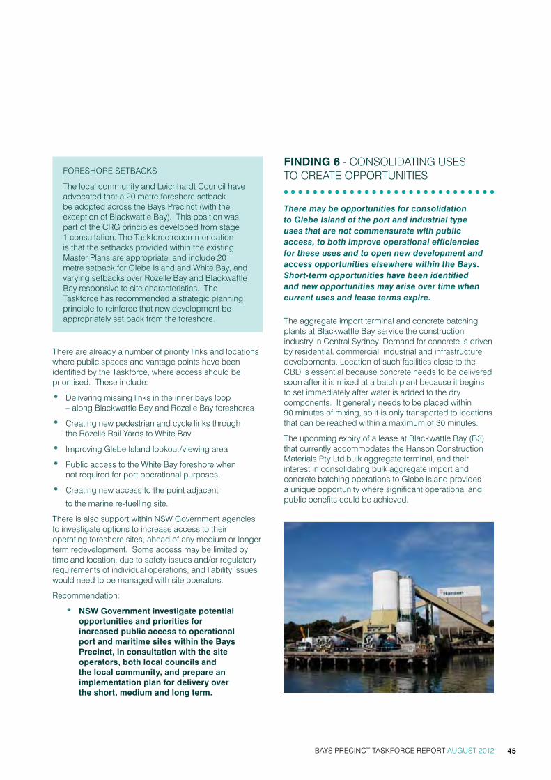
Foreshore setBacks
the local community and Leichhardt council have advocated that a 20 metre foreshore setback be adopted across the Bays Precinct (with the exception of Blackwattle Bay). this position was part of the crg principles developed from stage 1 consultation. the taskforce recommendation is that the setbacks provided within the existing master Plans are appropriate, and include 20 metre setback for glebe island and white Bay, and varying setbacks over rozelle Bay and Blackwattle Bay responsive to site characteristics. the taskforce has recommended a strategic planning principle to reinforce that new development be appropriately set back from the foreshore.
there are already a number of priority links and locations where public spaces and vantage points have been identified by the taskforce, where access should be prioritised. these include:
• Delivering missing links in the inner bays loop – along Blackwattle Bay and rozelle Bay foreshores
• creating new pedestrian and cycle links through the rozelle rail yards to white Bay
• improving glebe island lookout/viewing area
• Public access to the white Bay foreshore when not required for port operational purposes.
• creating new access to the point adjacent
to the marine re-fuelling site.
there is also support within nsw government agencies to investigate options to increase access to their operating foreshore sites, ahead of any medium or longer term redevelopment. some access may be limited by time and location, due to safety issues and/or regulatory requirements of individual operations, and liability issues would need to be managed with site operators.
recommendation:
• nSw government investigate potential opportunities and priorities for increased public access to operational port and maritime sites within the Bays Precinct, in consultation with the site operators, both local councils and the local community, and prepare an implementation plan for delivery over the short, medium and long term.
Finding 6 - consoLiDating Uses to create oPPortUnities
There may be opportunities for consolidation to Glebe Island of the port and industrial type uses that are not commensurate with public access, to both improve operational efficiencies for these uses and to open new development and access opportunities elsewhere within the Bays. Short-term opportunities have been identified and new opportunities may arise over time when current uses and lease terms expire.
the aggregate import terminal and concrete batching plants at Blackwattle Bay service the construction industry in central sydney. Demand for concrete is driven by residential, commercial, industrial and infrastructure developments. Location of such facilities close to the cBD is essential because concrete needs to be delivered soon after it is mixed at a batch plant because it begins to set immediately after water is added to the dry components. it generally needs to be placed within 90 minutes of mixing, so it is only transported to locations that can be reached within a maximum of 30 minutes.
the upcoming expiry of a lease at Blackwattle Bay (B3) that currently accommodates the hanson construction materials Pty Ltd bulk aggregate terminal, and their interest in consolidating bulk aggregate import and concrete batching operations to glebe island provides a unique opportunity where significant operational and public benefits could be achieved.
BAYS PRECINCT TASKFORCE REPORT AUGUST 2012 45

relocation of these activities to glebe island is consistent with the sreP objectives and is permissible under the port and employment zoning. any development for operations at glebe island will need to recognize the importance of its location on sydney harbour and its proximity to local communities, and would be subject to comprehensive environmental assessment under the eP&a act.
the relocation would remove these uses from close proximity of Pyrmont residents and provide significant advantages in internalising truck movements at glebe island, that currently use public roads for the movement of dry bulk goods across the Precinct.
Leichhardt council acknowledges the potential benefits of locating a bulk aggregate terminal and concrete batching operations from Blackwattle Bay. Leichhardt council and the local community representatives believe that any decision regarding these matters should be informed by an independent evidence based analysis of the options. Leichhardt believes that any investigation should include consideration of the following factors:
• traffic and transport considerations including:
> the option to retain the glebe island Bridge
> future cycle and pedestrian networks
• amenity of the surrounding uses
• Future foreshore access, open space and recreation opportunities
• impact on adaptive reuse of the white Bay Power station
the relocation presents an opportunity to consolidate government landholdings in Blackwattle Bay to support urban renewal opportunities. should the relocation be achieved, master plans for the Bank street sites reaching from glebe island Bridge to sydney Fish market should be revisited. redevelopment may introduce a range of new development and new uses to this Precinct and deliver a range of public benefits including improved foreshore access.
Bulk liquid operators at white Bay and maritime industrial uses at rozelle Bay may also be appropriately relocated to glebe island. in the longer term, this approach consolidates bulk shipping and industrial activity that is not commensurate with public access to glebe island, freeing up lands across the Bays Precinct to achieve public access at the foreshore, and improve the opportunity to attract investment in renewal that can deliver a range of public benefits.
recommendations:
• nSw government investigate the opportunity to relocate the bulk aggregate terminal and concrete batching operations at Blackwattle Bay to glebe island, in consultation with both local councils, recognising the potential benefits to Blackwattle Bay and the need to address potential impacts of these operations on glebe island on the surrounding local communities.
• where relocation of the bulk terminal and concrete batching plant may be achieved the nSw government investigate and test urban renewal scenarios for the Blackwattle Bay precinct in consultation with the local councils and community.
BAYS PRECINCT TASKFORCE REPORT AUGUST 201246
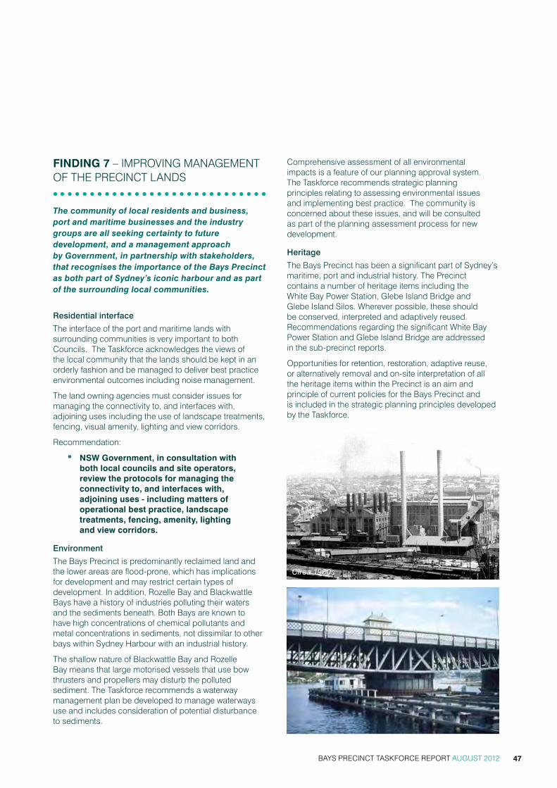
Finding 7 – imProving management oF the Precinct LanDs
The community of local residents and business, port and maritime businesses and the industry groups are all seeking certainty to future development, and a management approach by Government, in partnership with stakeholders, that recognises the importance of the Bays Precinct as both part of Sydney’s iconic harbour and as part of the surrounding local communities.
Residential interface
the interface of the port and maritime lands with surrounding communities is very important to both councils. the taskforce acknowledges the views of the local community that the lands should be kept in an orderly fashion and be managed to deliver best practice environmental outcomes including noise management.
the land owning agencies must consider issues for managing the connectivity to, and interfaces with, adjoining uses including the use of landscape treatments, fencing, visual amenity, lighting and view corridors.
recommendation:
• nSw government, in consultation with both local councils and site operators, review the protocols for managing the connectivity to, and interfaces with, adjoining uses - including matters of operational best practice, landscape treatments, fencing, amenity, lighting and view corridors.
Environment
the Bays Precinct is predominantly reclaimed land and the lower areas are flood-prone, which has implications for development and may restrict certain types of development. in addition, rozelle Bay and Blackwattle Bays have a history of industries polluting their waters and the sediments beneath. Both Bays are known to have high concentrations of chemical pollutants and metal concentrations in sediments, not dissimilar to other bays within sydney harbour with an industrial history.
the shallow nature of Blackwattle Bay and rozelle Bay means that large motorised vessels that use bow thrusters and propellers may disturb the polluted sediment. the taskforce recommends a waterway management plan be developed to manage waterways use and includes consideration of potential disturbance to sediments.
comprehensive assessment of all environmental impacts is a feature of our planning approval system. the taskforce recommends strategic planning principles relating to assessing environmental issues and implementing best practice. the community is concerned about these issues, and will be consulted as part of the planning assessment process for new development.
Heritage
the Bays Precinct has been a significant part of sydney’s maritime, port and industrial history. the Precinct contains a number of heritage items including the white Bay Power station, glebe island Bridge and glebe island silos. wherever possible, these should be conserved, interpreted and adaptively reused. recommendations regarding the significant white Bay Power station and glebe island Bridge are addressed in the sub-precinct reports.
opportunities for retention, restoration, adaptive reuse, or alternatively removal and on-site interpretation of all the heritage items within the Precinct is an aim and principle of current policies for the Bays Precinct and is included in the strategic planning principles developed by the taskforce.
Circa 1960s
BAYS PRECINCT TASKFORCE REPORT AUGUST 2012 47

Planning Framework
the planning framework for the Precinct has been an ongoing issue of concern to the community and has been raised in previous consultation with the crg and in the recent stage two consultation. the community has sought the development of an integrated strategic plan for the whole Precinct incorporating strategic planning principles.
the land uses recommendations in this report are generally consistent with those set out in sreP 26 city west, the harbour reP and the sydney LeP and therefore no immediate review is considered necessary. with the anticipated changes to the planning system, the land uses can be confirmed via a new strategic land use instrument. it would be appropriate to include the strategic planning principles developed by the taskforce in the new planning instruments if adopted.
a series of master Plans currently apply to Bays Precinct lands. however the community is concerned that the master Plans have no status when development proposals are considered under various state significant policies. the taskforce supports the current master Plans as an appropriate guide to development within the Precinct and that the master Plans be considered by approval and consent authorities in development assessment.
opportunities for major land use changes within a precinct will trigger a review of the relevant master Plans. the city of sydney has identified that review of the Bank street master Plan may be appropriate within the short term to address some inconsistencies and review development opportunities in that sub-precinct, particularly where relocation of the bulk aggregate terminal and the concrete batching operations were to be achieved.
recommendations:
• retain Sydney harbour rEP, SrEP 26, Sydney lEP 2005, and the adopted master Plans, as the key planning instruments for management of development in the Bays Precinct waterways and lands.
• the strategic planning principles for the Bays Precinct developed by the taskforce be adopted and applied to decision making in the Bays Precinct.
• where the government’s current review of the planning system may repeal SrEP 26 and Sydney harbour rEP, the aims and objectives, and land use controls of these policies, and including the strategic planning principles developed by the taskforce be retained in new state, regional or local planning instruments.
• the land use framework for the Bays Precinct be reviewed periodically in line with metropolitan Planning Policy review.
Working Forum 2 – Glebe
BAYS PRECINCT TASKFORCE REPORT AUGUST 201248

D
B
R
ANZAC BRIDGE
PYRMONT
GLEBEANNANDALE
LILYFIELD
ROZELLE
BALMAIN
ROZELLE BAY
VICTORIA ROAD
THE CRESCENT
CITY
BLACKWATTLE BAY
WHITE BAY
JOHNSTONS BAY
WEST LINK
NORTH
Land Use
Glebe Island dry bulk handling and storage
Cruise passenger terminal & marine refuelling facility
Port operations
Mixed uses
Mixed use/ maritime uses
Open space
Mixed use/ adaptive reuse of White Bay Power Station
Potential public boat ramp area
Water Use
Port activity
Recreational
Commercial
Recreational craft launch points
Foreshore access
Existing pedestrian/ cycle links
Potential foreshore access non-port days
Potential pedestrian/ cycleway
Connections and transport
Light Rail- existing
Light Rail- extenstion to Dulwich Hill
Possible transport infrastructure
Connections to foreshore
Bus routes - existing
Existing open space
Proposed access roads
Port entry
Proposed fence separating public boat ramp & Glebe island port area
M4- existing
M4- potential extension
BAYS PRECINCT TASKFORCE REPORT AUGUST 2012 49
Figure 6 Land use opportunities – Government Architect’s Office

Transparency and Process
the government owned lands within the Precinct will continue to be managed by the existing government agency landowners, however, it is recognised by the taskforce that they will need to work together to manage ongoing change within the Precinct and deliver recommendations within this report for realising improved public access and improved management of those lands.
Both Leichhardt council and the city of sydney seek to ensure that the local community and local government are involved in future planning and decision making in an open, transparent and evidence-based approach. they seek ongoing roles for the two councils and the community in the implementation of accepted taskforce recommendations.
the community desire for greater transparency about decisions within the Precinct will be assisted by the e-planning website being developed by the Department of Planning and infrastructure, which will provide information on the status of planning proposals, applications and developments based on the local government area to make it more accessible. rather than having to visit many different websites to collate relevant local information, the application retrieves data from a variety of existing sources and provides it for users in the one place. the website is due to go live in the second half of 2012.
this powerful online tool will be beneficial for external stakeholders who will be able to access development information in one location. this web tool is considered to significantly improve the transparency and availability of information regarding development applications.
in regard to transparency in the granting of leases, there is an acknowledged need for commercial negotiations between government and commercial operators to follow standard commercial in confidence procedures when going through expressions of interest and negotiations for the lease of sites. this will remain a key requirement. however, where government policy allows, the taskforce supports the principle that processes be more transparent to the community and stakeholders.
BAYS PRECINCT TASKFORCE REPORT AUGUST 201250

BAYS PRECINCT TASKFORCE REPORT AUGUST 2012 51
6. strategic PLanning PrinciPLes
the strategic Planning Principles have been developed based on input from a range of sources including:
• the stage 1 consultation process.
• community reference group outcomes.
• the stage 2 consultation carried out may-June 2012
• input from Leichhardt council, city of sydney and the relevant landowning agencies.
the planning principles being recommended by the taskforce are generally consistent with objectives and aims in a range of existing planning instruments and policy documents applying to the site. they are recommended as principles for consideration by consent authorities in assessing development applications, and to be included in future planning instruments
Public Interest and Future Proofing
1. recognise and protect the Bays Precinct as a public resource by ensuring planning and development promote the social and economic welfare of the community.
2. retain the publicly owned lands in public ownership to ensure long-term flexibility in the use the Bays Precinct assets.
Waterway
1. recognise, protect, enhance and maintain the waterways as an outstanding natural asset of sydney and a focal point of the public domain of the Bays Precinct.
2. maintain deep water berths for commercial port, shipping and maritime uses and operations to meet existing and future demands for sydney and nsw.
3. Preserve and manage use of the waterways for active and passive recreational boating users.
Land Use
1. encourage new development that:
• balance regional and local economic, social, recreational and environmental needs;
• provide a distinctiveness and character consistent with the Bays Precinct’s sydney harbour location and that reflects the Precinct’s history;
• activate the foreshores day and night; and
• are dependent upon foreshore location and access to waterway.
2. commercial port and maritime uses operate in a way that recognises their location in a city environment and mitigates impacts on the amenity of existing residents and businesses in the adjoining communities.
3. ensure non-working harbour uses are compatible with ongoing working harbour functions and do not alienate the foreshores from public ownership and active use.
4. residential development is not a priority within the Precinct and must be carefully considered in terms of its impact on the long-term flexibility of port and maritime operations.
5. ensure any new residential development provided as part of urban renewal is diverse in type, providing for both market and affordable rental housing.
Economic Sustainability
1. encourage new development that contributes to maintaining and enhancing sydney as a global city by providing for economic growth, economic productivity, job opportunities and tourism.
2. Provide for commercial port and maritime uses within the Bays Precinct to ensure prosperous working harbour.

BAYS PRECINCT TASKFORCE REPORT AUGUST 201252
Traffic and Transport
1. ensure consideration is given to transport impacts and how they can be managed in assessing new major activities or developments.
• integrate traffic, transport and access as part of any future development and land use considerations focussing on:
• promoting public transport usage including opportunities for new public transport including ferries, light rail and car share;
• enhancing pedestrian and cycle networks linking key activity areas with transport over the broader region;
• catering for demand and ensuring that traffic impacts on surrounding residential streets and intersections are appropriately managed; and
• considering access for disabled persons in new transport initiatives on the site.
2. Provide efficient transport and access solutions to support future port uses including the segregation of port traffic from residential areas. this includes consideration for a new port access road from city west Link road directly to the glebe island and white Bay port area.
Public domain, open Space and Foreshores
1. maintain and extend public access to and along the foreshore, including access to open space corridors for pedestrian and cyclists except where health and safety, security, regulatory provisions and public liability restrict access.
2. Public access within the Precinct be linked with public transport and existing public access points in the surrounding precincts.
3. encourage addition of high quality public domain, open space and a range of recreational opportunities for both local community and visitors.
4. restore the heads of bays for public use as opportunity arises.
Built Form and Design
1. ensure development reflects the industrial and maritime nature of the built form of the Precinct and manifests design excellence by:
• developing/redeveloping at a compatible scale at interfaces with adjacent existing neighbourhoods;
• ensuring bulk, scale and location of buildings considers local views into, over, through and from within the Precinct, and conserves and where possible extends significant views;
• developing diverse architectural responses, with buildings having a diverse design, fine grain pattern, with active frontages and articulated elevations; and
2. implementing principles of ‘view sharing’ where relevant.
3. ensure new development within the port and maritime precincts recognises the foreshore location and city environment in which is located, in terms of built form and design.
4. ensure new buildings are appropriately setback from the waterfront.

BAYS PRECINCT TASKFORCE REPORT AUGUST 2012 53
Artist impression of Sydney Boathouse
Circa 1960s
Heritage
1. recognise the significance of the Bays Precinct as part of sydney’s maritime, port and industrial history.
2. conserve, interpret and adaptively re-use existing and potential key heritage items.
Community and Culture
1. encourage a culturally rich and vibrant Precinct for the benefit of the local and regional communities.
2. integrate appropriate community, cultural, and education facilities into the Precinct that are compatible with the working harbour.
Environment
1. encourage ecologically sustainable development of the Precinct, in particular:
• climate positive
• water cycle management
• Decentralised power
• Low carbon precinct
• minimise waste
• green roofing
2. Demonstrate the sustainable sourcing and use of resources and materials in the design, construction, maintenance servicing and environmental performance of new development.
Community Consultation
1. ensure that local community, Precinct stakeholders and local government are involved in future planning decisions.

Bays Precinct Taskforce - Community consultation 2 - may 2012 - 2
sub-precincts
nOrTH
AnALysis
White Bay
Glebe island
White Bay Power station
rozelle railyards
rozelle Bay - commercial maritime
Blackwattle Bay - commercial & recreational
Glebe island Bridge
study area
Bays Precinct Taskforce - Community consultation 2 - May 2012 - 2
�������
��������������
���������
�������
���������
�������
�����������
�������������
������������
������
������
�����
���������������
���������
�������������
�����
����
Sub-precincts
NORTH
ANALYSIS
White Bay
Glebe Island
White Bay Power Station
Rozelle Railyards
Rozelle Bay - commercial maritime
Blackwattle Bay - commercial & recreational
Glebe Island Bridge
Study area
Figure 7 Bays sub-Precincts – Government Architect’s Office
BAYS SUB-PRECINCTS White Bay
Glebe Island
White Bay Power Station
Rozelle Railyards
Rozelle Bay - commercial maritime
Blackwattle Bay - commercial & recreational
Glebe Island Bridge
BAYS PRECINCT TASKFORCE REPORT AUGUST 201254

BAYS PRECINCT TASKFORCE REPORT AUGUST 2012 55
7. sUB-Precinct rePorts
gLeBe isLanD anD white Bay
Context
glebe island and white Bay have been used as a commercial port facility for 100 years. the land is owned and managed by sydney Ports corporation, a nsw state owned corporation. the site in total occupies 39.7 hectares and currently has eight working berths (refer images 1 & 2).
glebe island and white Bay provide the last remaining deep-water berths with backup land for commercial port uses in sydney harbour. the shipping berths and the land area are currently utilised for:
• the unloading of bulk cement, gypsum, sugar, salt, oils and lubricant and loading of tallow
• commercial vessel lay-up (for vessel repairs, arrested / impounded vessels and other purposes)
• harbour island access
• general maritime use such as the fireworks barges, harbour construction staging and access
• cruise passenger shipping with a new cruise passenger terminal due to be operational in 2013
• marine refuelling and servicing.
the site is zoned ‘Port and employment’ under sydney regional environmental Plan no.26 – city west (sreP 26 – city west). the glebe island and white Bay master Plan was prepared under sreP 26 for the site and is now a deemed development control plan that guides future development.
the glebe island silos are listed on the sydney Ports s.170 heritage register as being of state significance.
Artist impression of the Cruise Passenger Terminal
Image 1 – Glebe Island, view looking southwest

BAYS PRECINCT TASKFORCE REPORT AUGUST 201256
Taskforce Recommendations
the taskforce has recommended glebe island and white Bay continue to be used for commercial port and maritime related purposes, including cruise facilities, bulk trade, essential operational uses and short term activities.
it is essential that these uses are developed and managed having regard to any potential impacts on the amenity of adjacent local communities and being reflective of their location on sydney harbour. the taskforce has recommended protocols that manage the interface of these uses with surrounding communities be reviewed, including matters of operational best practice, landscape treatments, fencing, amenity, lighting and view corridors.
the taskforce has recognised that there are opportunities for increased public access over operational lands at white Bay, within the constraints of the working port and maritime functions, with the opportunity to provide shared foreshore access from the eastern tip of white Bay to the white Bay Power station including the area around and into the cruise Passenger terminal.
however, additional public access at glebe island is not considered possible due to operational and safety constraints. the taskforce has recommended that the extent and form of public access through the precinct, connecting to local networks will be investigated in consultation with both Leichhardt council and community and the site operators.
as input to those investigations, sydney Ports corporation has identified the elevated viewing area at glebe island, which currently exists but is difficult to access. this public lookout has potential to be an important public domain element in a new public access network, providing views over the deck and operations at glebe island to Pyrmont and the cBD. making this public domain area safer and more accessible is reliant on delivery of the proposed new port access road via rozelle rail yards, which has the support of all taskforce members.
the taskforce has recognised the potential for an active transport corridor along rozelle rail yards and into white Bay over the long term, which would improve access connections across the precinct and surrounding communities and open urban renewal opportunities. the taskforce has recommended that the two corridors under victoria road be protected for transport purposes.
the local community and both councils support the opportunity for a new ferry terminal at white Bay, and the community suggests the ferry service is essential to deliver on transport deficiencies within the surrounding residential areas of rozelle and Balmain. the government is currently implementing the Fixing sydney Ferries program to restore, improve and expand ferry services, upgrade wharves and develop a plan to guide investment in services and assets across the harbour.
in regard to a new ferry service at white Bay, it is considered unlikely that catchment figures from surrounding residential areas would support an additional ferry service without significant activation of additional uses, such as the cruise Passenger terminal and activities at a renewed white Bay Power station.
the taskforce has recommended a waterway management plan be prepared to build on existing boat safety and navigational planning to ensure equitable and safe access to the waterways for all users among other objectives. Provision for operation of ferry services to white Bay now or in the future, should be considered as part of that plan, and guided by the considerations of the Fixing the Ferries Program.
roads and maritime services has requested land and waterfront access adjacent to the western abutment of the glebe island Bridge be considered for additional recreational boating facilities. this area has direct access to the water and space available for boat trailer parking. there is concern that the proposal is may create conflict with the port uses and also may interfere with navigation through the channel. these issues will need to be investigated and also form part of the waterway management plan considerations.

BAYS PRECINCT TASKFORCE REPORT AUGUST 2012 57
Status of Development at Key Sites
(a) White Bay Wharf 6 - marine refuelling Facility
Lots 3 + 4 DP 875201
Leased to Bailey’s marine Fuels to 2020 (part of the site is in the process of being sub-leased to caltex).
the marine refuelling and supply facility at white Bay Berth 6 opened in april 2010. the facility provides a refuelling, servicing and maintenance facility for operational and recreational boating owners.
the need for a second refuelling location in the western harbour was generated by the closure of the ferry refuelling operation at the caltex Ballast Point fuel depot in 2002. the closure of this facility meant that ferries then had to refuel at the Bailey’s refuelling facility located in Pyrmont. the Pyrmont facility was unsuitable as a long term solution to cater for the growth in recreational vessels and the sudden increase in commercial ferries using the site.
the environmental assessment for the new refuelling facility at white Bay considered alternative locations in sydney harbour to replace the unsuitable location of the then existing refuelling site at Pyrmont. the alternative sites included Ballast Point at Birchgrove, which at that time was identified in plans by sydney harbour Foreshore authority and nsw maritime as a marine refuelling facility, however is now a park. white Bay and glebe island were identified as superior to the alternative sites.
measures implemented to limit the impact of the facility include a night-time prohibition on truck movements,
operational noise level limits and additional conditions relating to safety, air, light and odour impacts, traffic impacts, water quality and visual impacts.
a modification to the existing planning approval for the site is currently with the Department of Planning and infrastructure for determination. the modification application seeks to increase the number of temporary moorings, increase the period of occupation of the moorings, and introduce de-fouling and anti-fouling activities to the site’s existing operations.
the community wants the marine refuelling facility to be located to an alternative site at the expiry of its current lease in 2020 to enable the white Bay headland to be turned into public green space. at a minimum, the community seeks the lease extension period to be limited to enable negotiation for community access to the foreshore to be resolved, and relocation of the facility in the medium term.
Image 2 – White Bay Berths and Cruise Passenger Terminal site, view looking northeast

BAYS PRECINCT TASKFORCE REPORT AUGUST 201258
(b) White Bay Wharves 4 and 5 - cruise Passenger terminal
Lot 1 DP 875201, Lot 4 DP 875201, Lot 10 DP 1008507, Lot 3 DP 879549, Lot 1 DP 1063454, Lot 10 DP 1065973
construction and operation of the white Bay cruise Passenger terminal was approved in February 2011. the relocation of the Darling harbour no. 8 cruise Passenger terminal to white Bay Berth 5, with an overflow facility at the adjacent Berth 4, is in accordance with the recommendation from the nsw government Passenger cruise terminal steering committee. the site was chosen for the following reasons.
• the facility will be contained within an existing port precinct and hence will utilise existing valuable port infrastructure, including deep-water berths and shipping channels.
• the site provides a high level of control, which will assist in enforcing maritime security legislative requirements.
• two cruise passenger ships can be berthed at the same time with the use of the adjacent berth at white Bay 4, which allows sydney to continue to provide berths for up to three passenger ships in sydney harbour at any one time.
• the site includes adequate space for the efficient and safe management of embarking/ disembarking passengers and the provisioning of the cruise vessels.
the cruise Passenger terminal includes facilities for operation as a function centre, which would operate in a similar way to the function facilities that existed at the previous Darling harbour no 8 venue. Leichhardt council is opposed to the function centre use.
Public access will be permitted to the wharf apron at the white Bay cruise Passenger terminal on days when the facility is not being used for port activities as well as opportunities for community events and functions at the white Bay cruise Passenger terminal, utilising the cruise terminal building and foreshore area.
Passenger vehicle access to the terminal (i.e. taxis, private vehicles and coaches) will be via James craig road, requiring intersection upgrade works at the city west Link, and then via a new internal port road to the terminal. at present, providoring and staff access will be from robert street, Balmain, but in the long term could be provided by the port access road under victoria road, recommended by sydney Ports corporation.
(c) White Bay Wharves 1-4
Lots 1 and 3 DP 1063454, Lot 10 DP 1065973, Lot 3 DP 879549, Lot 10 DP 1008507, Lots 1, 2 and 4 DP 875201
not leased on a long term basis. short term intermittent uses occur in the area.
this part of white Bay is currently used for a number of activities that require a land/water interface. white Bay is currently used as a lay-up berth for vessel repairs or for arrested / impounded vessels, for the transfer of bulk liquids between sea and land and a mix of industrial maritime activities including the provisioning of sydney harbour islands, firework barges and maritime-related harbour construction activity.
there is an ongoing need for these port operational and land/water interface uses and there is no alternate location for them in sydney harbour or Botany Bay at this time.
the new access road for the cruise Passenger terminal passes through these sites.

BAYS PRECINCT TASKFORCE REPORT AUGUST 2012 59
(d) Glebe Island
Glebe Island Silo and Glebe Island Wharves 7 & 8 (Former grain terminal and current gypsum, sugar and cement terminal)
Lot 11 DP 1065973, Lot 10 DP 1065973, Pt Lot 2 DP 879459
Leased by cement australia, sugar australia and gypsum resources australia until 2020.
Glebe Island (Southern Wharves)
Lots 10 and 11 DP 1065973, Lots 1, 2 and 3 DP 542648, Lot 8 DP 1001928, Lot 12 DP 603148, Lots 1 and 2 DP 1063454, Lot 1 DP 874686, Pt Lot 2 DP 879549
not leased on a long term basis. short term intermittent uses occur in the area.
these sites have been significantly underutilised since 2008 due to an agreement that sydney Ports corporation would not enter into leases beyond 2020 pending the conclusion of the work of the taskforce. companies have expressed interest in renewing leases and entering into new leases for existing and new trades at glebe island for the receiving, storage and distribution of dry bulk products that supply sydney markets.
glebe island is currently utilised for the transfer from vessel, storage and land distribution of bulk material products, including sugar, cement, gypsum, salt, oils, lubricant and tallow. these products are transported
from/to interstate or overseas locations. thirty silos are used for sugar and cement storage. gypsum is stored in a modern, purpose-built facility.
Sydney Ports argues Glebe Island is an ideal central location for the supply of these bulk material products which are destined principally for the Sydney market. Figure 8 shows the origin and destination of the bulk material products handled at Glebe Island and White Bay. Transportation costs represent a significant portion of the product revenues (estimated at between 25 to 35 per cent). For this reason, Glebe Island provides an efficient supply chain by minimising the transport costs in the distribution of the dry bulk products throughout Sydney.
Until June 2011, aggregates (sand and gravel) were shipped from Shellharbour to Blackwattle Bay. This material is now transported by road, but the company involved is keen to resume transporting the product by sea to Glebe Island, if they can secure a deep-water berth to service a larger vessel.
Cement is used in the manufacture of concrete in concrete batching plants. Glebe Island is positioned in a central location for the supply of cement to over fifty concrete batching plants located throughout Sydney, with a majority proportion of the Glebe Island product being sent to batching plants at Blackwattle Bay, Pyrmont and Artarmon. 70% of the Glebe Island product is delivered in the local metropolitan area, accounting for only 14% of the total truck kilometres travelled by trucks transporting
Figure 8 Origin and destination for bulk material products handled at Glebe Island & White Bay – Sydney Ports Corporation

BAYS PRECINCT TASKFORCE REPORT AUGUST 201260
Figure 9 Destination of cement manufacturing centres in Sydney (showing existing batching plants and current and future infrastructure projects) – Sydney Ports Corporation
Figure 10
Figure 12
Figure 11
Figure 13
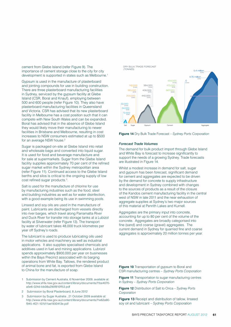
BAYS PRECINCT TASKFORCE REPORT AUGUST 2012 61
cement from Glebe Island (refer Figure 9). The importance of cement storage close to the city for city development is supported in states such as Melbourne.1
Gypsum is used in the manufacture of plasterboard and jointing compounds for use in building construction. There are three plasterboard manufacturing facilities in Sydney, serviced by the gypsum facility at Glebe Island (CSR, Boral and Knauf), employing between 500 and 600 people (refer Figure 10). They also have plasterboard manufacturing facilities in Queensland and Victoria. CSR has advised that its new plasterboard facility in Melbourne has a cost position such that it can compete with New South Wales and can be expanded. Boral has advised that in the absence of Glebe Island they would likely move their manufacturing to newer facilities in Brisbane and Melbourne, resulting in cost increases to NSW consumers estimated at up to $500 for an average NSW house.2
Sugar is packaged on-site at Glebe Island into retail and wholesale bags and converted into liquid sugar. It is used for food and beverage manufacture and for sale at supermarkets. Sugar from the Glebe Island facility supplies approximately 70 per cent of the refined sugar market within the Sydney metropolitan area (refer Figure 11). Continued access to the Glebe Island berths and silos is critical to the ongoing supply of low cost refined sugar products.3.salt is used for the manufacture of chlorine for use by manufacturing industries such as the food, steel and building industries as well as for water disinfection, with a good example being its use in swimming pools.
Linseed and soy oils are used in the manufacture of paint. Lubricants are discharged from vessels directly into river barges, which travel along Parramatta river and Duck river for transfer into storage tanks at a Lubizol facility at silverwater (refer Figure 13). the transport by water of lubricant takes 48,000 truck kilometres per year off sydney’s roads.
the lubricant is used to produce lubricating oils used in motor vehicles and machinery as well as industrial applications. it also supplies specialised chemicals and additives used in fuel and mining applications. Lubrizol spends approximately $900,000 per year on businesses within the Bays Precinct associated with its barging operations from white Bay. tallows, the rendered product of animal bone and fat, is exported from glebe island to china for the manufacture of soap.
1 submission by cement australia, 6 november 2009, available at: http://www.shfa.nsw.gov.au/content/library/documents/f1be4070-a5e6-024d-bb08a290f810ff53.pdf
2 submission by Boral Plasterboard, 8 June 2012
3 submission by sugar australia , 21 october 2009 available at: http://www.shfa.nsw.gov.au/content/library/documents/f1e62a90-f945-4f21-107d11ae1930413e.pdf
Forecast Trade Volumes
the demand for bulk product import through glebe island and white Bay is forecast to increase significantly to support the needs of a growing sydney. trade forecasts are illustrated in Figure 14.
whilst a modest increase in demand for salt, sugar and gypsum has been forecast, significant demand for cement and aggregates are expected to be driven by the demand for concrete to supply infrastructure and development in sydney combined with changes to the sources of products as a result of the closure of the kandos cement manufacturing facility in the central west of nsw in late 2011 and the near exhaustion of aggregate supplies at sydney’s two major sources of this material at Penrith Lakes and kurnell.
aggregates are the primary input into concrete, accounting for up to 80 per cent of the volume of the concrete. aggregates are broadly categorised into fine (sand) and coarse (gravel) aggregates. the current demand in sydney for quarried fine and coarse aggregates is approximately 20 million tonnes per year.
DRY BULK TRADE FORECAST (TONNES)
142,000
442,000
667,000
5.4 million
4.75 million
0
180,000 406,000
470,000
200,000
384,000
454,000
2040
2040 2040
2040
2015
2015
2040
2015 2015
2015
(now)
(now)
(now) (now)
(now)
72,000
64,000
32,000
Salt Sugar Gypsum Cement Aggregate
Figure 14 Dry Bulk trade Forecast – Sydney Ports Corporation
Figure 10 Transportation of gypsum to Boral and CSR manufacturing centres – Sydney Ports Corporation
Figure 11 transportation to sugar manufacturing centres in sydney – Sydney Ports Corporation
Figure 12 Distribution of salt to orica – Sydney Ports Corporation
Figure 13 receipt and distribution of tallow, linseed soy oil and lubricant – Sydney Ports Corporation

BAYS PRECINCT TASKFORCE REPORT AUGUST 201262
white Bay Power station
Context
the former coal-fired white Bay Power station was built by the nsw Department of railways in three stages from 1912 to power the tram and railway network and was the last metropolitan power station to operate (refer image 3). having passed into the control of the electricity commission of nsw in 1953, it was eventually purchased from Pacific Power in 2000 following its decommissioning in 1983.
During the 1990s generating machinery and switching gear was removed and the building was partly decontaminated. it is now owned by the sydney harbour Foreshore authority. the nearby white Bay hotel was purchased in 2010 after a fire destroyed the building. with high social and heritage significance, these combined sites represent a substantial adaptive reuse opportunity with community, commercial, and educational outcomes.
The Power Station is not in use however it has been used for a range of television and movie sets.
the site is zoned Ports and employment under sreP no 26. this Plan permits employment generating uses. residential uses are not consistent with the current zone objectives. sreP no 26 specifies that a master plan is required for the site prior to the granting of development approval.
the white Bay Power station is listed as a heritage item in national, state and local policy.
Lot 2, 3, 4 & 6 DP 1063454, Lot 40 DP 791553
• heritage Listing no. 10807 national trust
• heritage Listing no. 019512 national estate
• heritage item no. 01015 - nsw heritage act
• heritage item no. 11 - sreP 26
• heritage item no.74 - s170 Pacific Power
• heritage item - s170 shFa,
a conservation management Plan (cmP) was approved by the nsw heritage council in 2004 and was subsequently updated in 2011. the revised cmP is currently with the nsw heritage office for review.
Image 3 – White Bay Power Station, view looking west

BAYS PRECINCT TASKFORCE REPORT AUGUST 2012 63
shFa has maintenance obligations under the Heritage Amendment Regulation 1999 for “minimum standards of maintenance and repair”; and under the Work Health and Safety Act 2011 for “remediation of hazardous materials”.
there are no current proposals for use or redevelopment of the site as remediation works are required to address asbestos, synthetic mineral fibre, lead paint and lead containing dust. this basic remediation, addressing the immediate issues of hazardous materials and protecting the heritage fabric of the building, will be subject to a tender process and the first stage of works required will be undertaken in the second half of 2012.
Taskforce Recommendations
the taskforce has recommended that the adaptive reuse of white Bay Power station is an urban renewal opportunity that should be pursued as a matter of priority. reuse of the site for a range of commercial, community and educational uses could provide a new focus to the Bays Precinct representative of its history, and is supported by all taskforce members, industry groups and the local communities.
the renewal opportunity includes potential to provide a significant public domain space in front of the Power station with access to the waterfront, while retaining the new port road and future opportunities for pedestrian, cycle and transport access.
however, any adaptive re-use will be costly and will likely require significant financial support to make it viable, either through government funding and provision of commercial opportunities at the white Bay Power station site.
there are a number of physical challenges to the re-use of the site such as the turbine hall, which is the main heritage feature of the building. the turbine hall is a large void from floor to roof and has limited commercial uses as a retained space, and like similar recycled turbine halls around the world (for example the tate modern in London), cultural uses housed in construction external to the void is a typical strategy.
the city of sydney has outlined a vision for the white Bay Power station precinct as a cultural hub for the inner west with use as a performance space, gallery space including temporary or interim spaces for creative workshops and artist studios. in the longer term, the station could become a museum or art gallery reflecting its unique heritage and iconic building form and capitalising on the expansive spaces available internally.
with appropriate remediation, the white Bay Power station offers opportunities for a range of temporary uses, including the possibility for key cultural activities such as the Biennale, sydney Festival, film making and art exhibitions. other sites in sydney including the wharf 2/3 at walsh Bay, cockatoo island and eveleigh rail yards could be used as a model for these events. ideas raised by the community during the stage one consultation process included adaptive re-use for education facilities such as a taFe college, museum or cultural uses, retail uses including fresh food markets, cafes and bars, commercial uses, recreation and entertainment uses and environmentally sustainable initiative such as a renewable energy generating power station.
the current zoning also limits the future use of the site. residential uses are not consistent with the sreP 26 zone objectives because proximity to the Port and its related noise and 24 hour operation was considered incompatible with residential uses.
the taskforce has recommended a range of development scenarios be developed and tested in consultation with both local councils and the heritage office. Preliminary work undertaken by shFa on various development scenarios will be a starting point for further investigations. the private sector would also have a role in contributing to the development of ideas for adaptive reuse, commercial feasibility and project delivery.
all taskforce members agree that traffic and transport constraints are significant and need to be addressed in conjunction with surrounding land uses. the limited capacity of robert street presents a significant challenge for the future use of the Power station. the new port access road proposed by sydney Ports to service glebe island and white Bay off the city west Link road, offers opportunities for access to the Power station to utilise this new connection and keep additional traffic on robert street to a minimum.
the taskforce has recommended that the corridors under victoria road connecting the white Bay Power station site to rozelle rail yards be protected for future road and transport access. Leichhardt council suggest the white Bay Power station could provide a pedestrian, cycle hub for the Bays Precinct.
in the short term the taskforce suggests public access could be considered over lands in front of the Power station as part of the taskforce recommendation for government investigations for improving public access.

BAYS PRECINCT TASKFORCE REPORT AUGUST 201264
roZeLLe raiL yarDs
Context
the rozelle rail yards site is owned by a number of nsw government agencies including the sydney harbour Foreshore authority.
Lots 2, 3, 4 and 5 in DP 1001928.
the land is zoned Ports and employment under sreP 26. employment generating land uses are permitted. residential use is not consistent with the current zone objectives.
the site is relatively isolated. an escarpment limits access to the north and city west Link road forms the southern boundary (refer image 4).
the site is currently protected as a key transport corridor, accommodating sydney light rail lines and stations and providing future opportunity for stabling of light rail vehicles, as a portal for the possible extension of the m4 east motorway, as a pedestrian cycleway, and part of the alignment (underground and surface stabling) for a potential future metro line.
two light rail stations (Lilyfield and rozelle Bay) are within easy access of the site and an established residential area adjoins the northern boundary of the site.
the site is currently tenanted by semi-industrial businesses including manufacturing, transport and storage companies, on short-term leases.
Taskforce Recommendations
there is clear agreement amongst the taskforce members that the rail yards need to be retained for future regional and local transport uses with both councils and the community noting potential concerns from any impacts on future transport uses in the Precinct. the taskforce has recommended protection of the portals under victoria road for future road and transport access.
however there is potential for urban renewal in the longer term that would integrate transport development in the rail yards with surrounding communities, contribute to council and community requirements for open space, improve linkages between Lilyfield and annandale and provide for a mix of commercial and residential development.
the taskforce supports innovative approaches to delivery of open space, including Leichhardt council’s suggestion that new development include consideration of open space on rooftops. the topography in rozelle rail yards provides opportunities to layer development and maximize use of land while including open space opportunities.
specific uses could be identified and delivered as part of development (e.g. tennis courts) or alternately an open space capacity could be provided for future delivery. a pedestrian/cycle corridor could be extended to white Bay and could also be considered with any adaptive re-use of the white Bay Power station.
once the long term transport requirements are identified and can be clearly accommodated by retaining the appropriate corridors then planning should begin on the future use of the remainder of the site.
the taskforce has endorsed suggestions from the Leichhardt council and community reference group that any housing include an appropriate component of affordable rental housing which is in short supply in areas close to the city where many relatively low income workers provide essential services (e.g. police, teachers, nurses).
Image 4 – Rozelle Railyards (view looking west)

BAYS PRECINCT TASKFORCE REPORT AUGUST 2012 65
roZeLLe Bay
Context
rozelle Bay is the western most Bay within the Bays Precinct. given most adjacent land is still in public ownership and the absence of residential development along substantial portions of the Bay’s foreshore, it continues to be suitable for a mix of commercial, industrial and recreational maritime uses.
the land is zoned ‘waterfront Use’ under sydney regional environmental Plan no.26 – city west (sreP 26 – city west). the land is identified within the Foreshores and waterways area boundary under sydney regional environmental Plan (sydney harbour catchment) 2005 (sreP 2005). the site has also been identified as part of the ‘Bays Precinct’ state significant site within the state environmental Planning Policy (state and regional Development) 2011, (srD sePP).
Development is guided by the Rozelle and Blackwattle Bay Master Plan 2002, which was prepared to guide the public and consent authorities on the implementation of appropriate forms of development around the two bays including the type, scale and form of development. the key objectives of the master Plan are to:
• Provide for development of water based commercial and recreational activities
• allow for a range of commercial maritime facilities
• Promote public access to extend existing public access networks
• create and enhance views and links.
the northern and western foreshores of rozelle Bay are located within Leichhardt Local government area
(Lga), whilst the southern side of rozelle Bay is within the city of sydney Lga.
the Bay is identified as one of the last remaining working parts of sydney harbour and use of the Bay for a range of maritime purposes over an extended period contributes to sydney’s economic development.
roads and maritime services (rms) owns all land along the northern and western foreshore. this land is currently used for maritime-based commercial activities such as recreational boating facilities, boat repair facilities and marine industrial uses. the rms office building accommodates the rms’ maritime Division and operational facilities for the rms fleet. although it includes a public wharf, the site is secured out of business hours and hence has limited public access to the foreshore.
many of these uses were facilitated through development agreements signed with individual maritime businesses in 2003 following a public tender process. these agreements provide businesses with the right to lease land from rms once their sites have been developed in line with the guidance provided in the master Plan. at present, construction has been completed and leases issued for two sites.
the southern foreshore of rozelle Bay has a large area of open space known as Bicentennial Park. Bicentennial Park is on reclaimed land formerly owned by rms (known at the time as the maritime services Board), which leased the area to a number of timber companies. Following community campaigns for waterfront parks, rms dedicated the land to council and the park was opened in two stages in 1988 and 1995 respectively (refer image 5 above).
Image 5 – Rozelle Bay view looking southwest

BAYS PRECINCT TASKFORCE REPORT AUGUST 201266
a key feature of the southern section of the foreshore is a publicly accessible pedestrian and cycle path which extends along the entire southern foreshore of the Bay. opportunities or the need to alter land use in this area are minimal, therefore discussion of the ongoing uses and their functional needs focuses on the land located along the northern and western foreshore of the Bay.
Boating safety is paramount in both rozelle and Blackwattle Bays. Boating numbers will increase as maritime commercial developments and new recreational boating facilities are delivered and boat ownership continues to grow. rms has implemented a number of arrangements to improve boating safety in these bays including:
• clearly demarcating areas for rowing/dragon boats and for yacht anchorage
• instituting a four knot, no-wash zone in both Bays
• giving outbound vessels right of way through the single open glebe island Bridge channel
• closing the western glebe island Bridge channel to minimise conflict with shipping at glebe island
• installing yellow flashing lights at glebe island Bridge to indicate that large vessels have priority through the channel.
Due to the historic industrial uses of the Bay, it is known to have high concentrations of pollutants. there is concern amongst the community regarding pollution/contamination levels and a strong drive for this information to be accessible to the public.
if sufficient information is not available, the community want independent research on the pollution/ contamination levels of the Bay. the community expressed a desire for the draft of vessels using rozelle Bay to be restricted to ensure no seabed disturbance and to protect non-motorised craft uses.
there is a risk of inappropriate water-based activities increasing mobilisation of these contaminated sediments. to minimise this risk, the taskforce has recommended a waterway management plan be prepared to manage all users of the waterway, including looking at issues concerning the draft of vessels and disturbance to the sediments. this is similar to the rms plan currently being developed for homebush Bay.
Taskforce Recommendations
there is general agreement amongst the taskforce members that maritime recreational and commercial uses are important to the larger metropolitan recreational boating and other maritime needs and should continue at rozelle Bay.
the community and both local councils wish to achieve continuous foreshore access from rozelle Bay through to glebe island, and to actively explore return of the head of the bay for public domain.
the current location of the shared pedestrian/cycle path along the realigned James craig Drive and the crescent is consistent with the rozelle and Blackwattle Bay master Plan and provides key connections throughout the Precinct without impacting upon existing and proposed maritime uses. the inclusion of foreshore access for pedestrians within both the sydney Boathouse and sydney superyacht marina will complement this and provide an additional pedestrian interface with the waterway (refer figure 15 below).
existing and proposed maritime industrial uses at the north-western end of the Bay do not allow for public foreshore access due to work, health and safety risks and site security restrictions. however, these uses meet a demonstrated demand for maritime industrial and construction services in a location which is uniquely suited to their operations and in accordance with the master Plan.
there is an opportunity to improve the public amenity of rms land at the western end (or head) of the Bay, which would also provide better pedestrian/cycling linkages to Bicentennial Park.
Figure 15 existing, Proposed and Potential Pedestrian/cycle Paths around rozelle Bay – Roads and Maritime Services
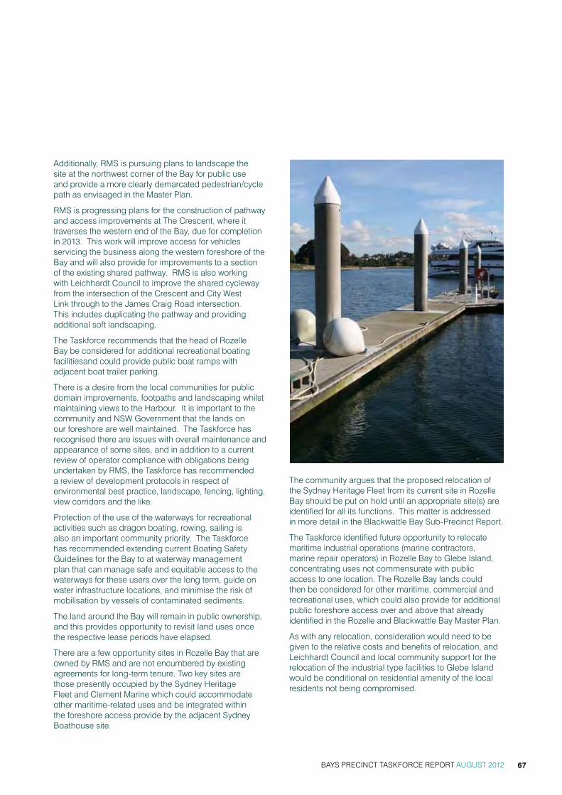
BAYS PRECINCT TASKFORCE REPORT AUGUST 2012 67
additionally, rms is pursuing plans to landscape the site at the northwest corner of the Bay for public use and provide a more clearly demarcated pedestrian/cycle path as envisaged in the master Plan.
rms is progressing plans for the construction of pathway and access improvements at the crescent, where it traverses the western end of the Bay, due for completion in 2013. this work will improve access for vehicles servicing the business along the western foreshore of the Bay and will also provide for improvements to a section of the existing shared pathway. rms is also working with Leichhardt council to improve the shared cycleway from the intersection of the crescent and city west Link through to the James craig road intersection. this includes duplicating the pathway and providing additional soft landscaping.
the taskforce recommends that the head of rozelle Bay be considered for additional recreational boating facilitiesand could provide public boat ramps with adjacent boat trailer parking.
there is a desire from the local communities for public domain improvements, footpaths and landscaping whilst maintaining views to the harbour. it is important to the community and nsw government that the lands on our foreshore are well maintained. the taskforce has recognised there are issues with overall maintenance and appearance of some sites, and in addition to a current review of operator compliance with obligations being undertaken by rms, the taskforce has recommended a review of development protocols in respect of environmental best practice, landscape, fencing, lighting, view corridors and the like.
Protection of the use of the waterways for recreational activities such as dragon boating, rowing, sailing is also an important community priority. the taskforce has recommended extending current Boating safety guidelines for the Bay to at waterway management plan that can manage safe and equitable access to the waterways for these users over the long term, guide on water infrastructure locations, and minimise the risk of mobilisation by vessels of contaminated sediments.
the land around the Bay will remain in public ownership, and this provides opportunity to revisit land uses once the respective lease periods have elapsed.
there are a few opportunity sites in rozelle Bay that are owned by rms and are not encumbered by existing agreements for long-term tenure. two key sites are those presently occupied by the sydney heritage Fleet and clement marine which could accommodate other maritime-related uses and be integrated within the foreshore access provide by the adjacent sydney Boathouse site.
the community argues that the proposed relocation of the sydney heritage Fleet from its current site in rozelle Bay should be put on hold until an appropriate site(s) are identified for all its functions. this matter is addressed in more detail in the Blackwattle Bay sub-Precinct report.
the taskforce identified future opportunity to relocate maritime industrial operations (marine contractors, marine repair operators) in rozelle Bay to glebe island, concentrating uses not commensurate with public access to one location. the rozelle Bay lands could then be considered for other maritime, commercial and recreational uses, which could also provide for additional public foreshore access over and above that already identified in the rozelle and Blackwattle Bay master Plan.
as with any relocation, consideration would need to be given to the relative costs and benefits of relocation, and Leichhardt council and local community support for the relocation of the industrial type facilities to glebe island would be conditional on residential amenity of the local residents not being compromised.

BAYS PRECINCT TASKFORCE REPORT AUGUST 201268
Status of Development at Key Sites
numbers given to each site correspond to those outlined within the rozelle and Blackwattle Bay master Plan. Preferred land use is what is identified in the master Plan.
(a) Rozelle Bay Site R1 Sydney City Marine and R2B Longitude
Leased till 2063 (no option).
sydney city marine provides services for commercial and recreational boats and the (15900m2) site is fully developed. the location and extent of this site and industrial nature of the operations prevents foreshore access between the glebe island Bridge and the rms operation centre. the site also accommodates the separate ‘Longitude’ building, which is presently used for maritime businesses and commercial offices. the site has been developed in accordance with the principles of the rozelle and Blackwattle master Plan.
(b) Rozelle Bay R4 - Sydney Superyacht Marina
Leased until 2060 to sydney superyacht marina Pty Ltd (ssm), which provides berthing for visiting super yachts and will include an accompanying land-based facility yet to be constructed including workshops, wet berth services, and parking for 160 cars.
suggested development standards in the master Plan include maximum site coverage of 50 per cent and maximum height r2(d) 11m; r4 11m.
ssm entered into an agreement with rms in 2010, which provides for a lease to 2060 once the development is complete. consent for the waterside development was issued by the Department of Planning and infrastructure. the proponent has subsequently submitted proposed modifications which are currently being assessed by the Department. the main facility on land has not been approved but provides for pedestrian foreshore access and is intended to be built over five stages from 2012. the proposed foreshore access accords with the rozelle and Blackwattle Bay master Plan.

BAYS PRECINCT TASKFORCE REPORT AUGUST 2012 69
(c) Rozelle Bay R3 - Sydney Boathouse
30 year lease once works have been completed with 25 year option to sydney Boathouse (rozelle Bay Pty Ltd, markham corp Pty Ltd, investec Bank and cobra group) if phase three is built and the works exceed $55 million.
sydney Boathouse signed an agreement with rms in 2003 for the 19420m2 site, providing a right to a 30-year lease at completion of the development. sydney Boathouse is an approved dry stack boat storage facility, which will include waterfront retail, workshop, marina and office space. concerns were raised by the community in relation to the development application, as both the architectural design and office and retail components of the development exceed master Plan guidelines, however consent has been issued.
whilst the marina component has already been completed, the land-based development is intended to be built over a number of phases required to commence by 2014.
the site will provide for public foreshore access, subject to some operational restrictions. Foreshore access accords with the rozelle and Blackwattle Bay master Plan.
(d) Rozelle Bay R6, R7 and R8 - Various contractors R6 (6540m2), R7 (6840m2), R8 (6550m2)
the sites are currently subject to a range of short occupation licences or medium to long term agreements or leases. the sites are currently used for a range of general mixed marine, industrial maritime, marine repair and other uses. some tenancies are poorly maintained and where the sites are not subject to long term tenure, provide opportunities for redevelopment for alternate maritime uses, more commensurate with public access.
Preferred land uses under the master Plan are for general mixed marine, the heritage Fleet, marine contractors, marine repairs and parking and loading areas. suggested development standards in the master Plan are for 29 per cent maximum site coverage for all sites, maximum height of 11 metres for all sites and water depth of between 2-5 metres.
the rms corner site is presently used by Devine marine but not subject to any long-term tenure agreements. Devine marine (uses a range of vessels including crane barges).
australian wharf and Bridge is a maritime contractor who undertake construction, maintenance and refurbishment of maritime structures.
waterway constructions (maritime contractor that undertakes construction, maintenance and refurbishment of maritime structures) entered into agreements with rms in 2003, which provides for an initial lease term of 10 years once works are complete.
Polaris marine provides a range of salvage, towage, mooring and construction services and has completed development of the site (pursuant to the 2003 development agreement with rms) and now leases the site until 2028.
Artist impression of Sydney Boathouse

BAYS PRECINCT TASKFORCE REPORT AUGUST 201270
seawind catamarans is a specialist business that berths multihull yachts and entered into an agreement with rms for a lease term of 40 years once works are complete. whilst the water-based marina component has been developed adjacent to the site, the land-based development has not commenced.
rms Lot 28 is currently occupied on a short-term basis by clement marine, a maritime industrial contractor, and there is an opportunity to provide ongoing maritime industrial uses or other maritime uses on this site.
rms Lot 24 is currently used by a number of short-term tenants for storage purposes, and as there is no long-term lease applicable to this site, there is an opportunity to provide for other maritime related uses.
BLackwattLe Bay
Context
Blackwattle Bay contains deep water and adjoins Pyrmont at the western fringe of the sydney cBD. given most adjacent land is still in public ownership and the absence of residential development along substantial portions of the Bay’s foreshore, it continues to be suitable as a maritime base for commercial and recreational purposes.
the western side of the Bay sits in the suburb of glebe and is largely residential in character (refer image 6). a shared foreshore pathway starts midway along the western foreshore and extends beyond the Bay and along the southern foreshore of rozelle Bay. sydney secondary college is located in the south-western corner of the Bay. at present the school does not provide public access along the foreshore.
the landholdings along the eastern and southern foreshore are within the suburb of Pyrmont and are generally commercial in use with fragmented ownership or comprise vacant public land.
Part of the land is zoned ‘waterfront Use’ under sydney regional environmental Plan no.26 – city west (sreP 26 – city west). Part of the land is zoned under central sydney Local environmental Plan 2005 Ultimo Pyrmont as non residential and Public recreation. the land is identified within the Foreshores and waterways area
Image 6 – Blackwattle Bay, view looking southeast

BAYS PRECINCT TASKFORCE REPORT AUGUST 2012 71
boundary under sydney regional environmental Plan (sydney harbour catchment) 2005 (sreP 2005).
the site has also been identified as part of the ‘Bays Precinct’ state significant site within the state environmental Planning Policy (state and regional Development) 2011, (srD sePP).
the city of sydney has a draft local planning instrument applying to part of the Bays lands in the Pyrmont, the central sydney LeP 2012, which will change the zoning to commercial core B3.
the southern foreshore of the Bay, at Bridge road, is subject to the requirements of the rozelle and Blackwattle Bay master Plan, prepared to guide the public and consent authorities on the implementation of appropriate forms of development around the two Bays. the key objectives of the master Plan are to:
• Provide for development of water based commercial and recreational activities
• allow for a range of commercial maritime facilities
• Promote public access to extend existing public access networks
• create and enhance views and links.
the eastern foreshore of the Bay, along Bank street, is subject to the requirements of the Bank street master Plan, which has key objectives to:
• Promote a wide range of uses, particularly business development including tourist, leisure, commercial, retail and office development consistent with Ultimo-Pyrmont’s proximity to the sydney cBD, harbour locations and transport infrastructure.
• ensure that the total amount of employment-generating development is compatible with the traffic capacity.
• encourage sustainable transport modes.
• Provide public access to all parts of the public domain.
• Provide a variety of public areas and recreational opportunities.
• Provide for facilities that accommodate or are ancillary to recreation opportunities relating to use of the public domain.
there are a number of private sites within the precinct including the hymix concrete Batching Plant (37-39 and 41-45 Bank street, Pyrmont), Bidvest australia (31-35 Bank street, Pyrmont) and Poulos Bros seafood (21-29 Bank street, Pyrmont).
Taskforce Recommendations
the taskforce supports the continued development of Blackwattle Bay as a maritime, commercial and recreational boating and tourism precinct.
there is support within the local communities at Pyrmont and glebe and from the city of sydney to relocate the bulk aggregate and concrete batching operations from Blackwattle Bay and realise the significant opportunity for each site around the Bay to be redeveloped in a manner that satisfies the functional needs of the Bay, enhances the public domain around the Bay and also contributes to maritime based commercial activities (objectives of both applicable master Plans).
the taskforce has recommended that nsw government investigate opportunities to relocate the bulk aggregate terminal and concrete batching operations at Blackwattle Bay to glebe island, in consultation with both local councils, recognising the potential benefits to Blackwattle Bay and the need to address potential impacts of these operations on glebe island on the surrounding local communities. Further, where relocation may be achieved, nsw government investigate and test development scenarios for the Blackwattle Bay precinct in consultation with both local councils and the community.
while Leichhardt council acknowledges the potential benefits of locating a bulk aggregate terminal and concrete batching operations from Blackwattle Bay, Leichhardt council and the local community representatives believe that any decision regarding these matters should be informed by an independent evidence based analysis of the options. Leichhardt believes that any investigation should include consideration of the following factors:
• traffic and transport considerations including:
> the option to retain the glebe island Bridge
> future cycle and pedestrian networks
• amenity of the surrounding uses
• Future foreshore access, open space and recreation opportunities
• impact on adaptive reuse of the white Bay Power station
there have been several redevelopment plans for the sydney Fish market site over the last decade, none of which have been realised. relocation of aggregate and concrete batching operations would open the potential for consideration of a broader group of government and private lands to form part of a larger renewal opportunity and deliver on the objectives of longstanding master plans, including significantly improved public foreshore access. investigation of long term development
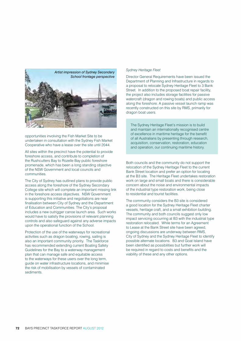
BAYS PRECINCT TASKFORCE REPORT AUGUST 201272
opportunities involving the Fish market site to be undertaken in consultation with the sydney Fish market cooperative who have a lease over the site until 2044.
all sites within the precinct have the potential to provide foreshore access, and contribute to completion of the rushcutters Bay to rozelle Bay public foreshore promenade, which has been a long standing objective of the nsw government and local councils and communities.
the city of sydney has outlined plans to provide public access along the foreshore of the sydney secondary college site which will complete an important missing link in the foreshore access objectives. nsw government is supporting this initiative and negotiations are near finalisation between city of sydney and the Department of education and communities. the city’s proposal includes a new outrigger canoe launch area. such works would have to satisfy the provisions of relevant planning controls and also safeguard against any adverse impacts upon the operational function of the school.
Protection of the use of the waterways for recreational activities such as dragon boating, rowing, sailing is also an important community priority. the taskforce has recommended extending current Boating safety guidelines for the Bay to a waterway management plan that can manage safe and equitable access to the waterways for these users over the long term, guide on water infrastructure locations, and minimise the risk of mobilisation by vessels of contaminated sediments.
Sydney Heritage Fleet
Director general requirements have been issued the Department of Planning and infrastructure in regards to a proposal to relocate sydney heritage Fleet to 3 Bank street. in addition to the proposed boat repair facility, the project also includes storage facilities for passive watercraft (dragon and rowing boats) and public access along the foreshore. a passive vessel launch ramp was recently constructed on this site by rms, primarily for dragon boat users.
the sydney heritage Fleet’s mission is to build and maintain an internationally recognised centre of excellence in maritime heritage for the benefit of all australians by presenting through research, acquisition, conservation, restoration, education and operation, our continuing maritime history.
Both councils and the community do not support the relocation of the sydney heritage Fleet to the current Bank street location and prefer an option for locating at the B3 site. the heritage Fleet undertakes restoration work on large and small boats and there is considerable concern about the noise and environmental impacts of the industrial type restoration work, being close to residential and tourist facilities.
the community considers the B3 site is considered a good location for the sydney heritage Fleet charter vessels, heritage craft, and a small exhibition building. the community and both councils suggest only low impact servicing occurring at B3 with the industrial type restoration relocated. while terms for an agreement to Lease at the Bank street site have been agreed, ongoing discussions are underway between rms, city of sydney and the sydney heritage Fleet to identify possible alternate locations. B3 and goat island have been identified as possibilities but further work will be required in regard to costs and benefits and the viability of these and any other options.
Artist impression of Sydney Secondary School frontage perspective

BAYS PRECINCT TASKFORCE REPORT AUGUST 2012 73
Status of Development at Key Sites
numbers given to each site correspond to those outlined within the rozelle and Blackwattle Bay master Plan. Preferred land use is what is identified in the master Plan.
(a) Blackwattle Bay B3 - Hanson Concrete Batching Plant Lot 5 DP 1064339 (6095m2)
the site is owned by rms and leased to hanson construction materials as a bulk aggregate terminal. the current lease expires in 2013 with a 5-year option. the site provided berths for ships supplying bulk aggregate to the site and supplying hymix concrete Batching Plant around the corner in Bank street. the site is no longer serviced from the water and all aggregate is trucked in, stored and distributed from the terminal.
the termination of the lease period in 2013 provides an opportunity in the short term to consider alternate maritime uses on this site, particularly uses that are dependent on waterfront access. Preferred uses are commercial maritime and recreational uses. suggested development standards in the master Plan include maximum site coverage of 50 per cent and maximum height 10.5 metres.
the city of sydney and local community have identified an opportunity to remove existing structures at B3 and reuse the site for the restored charter vessels of the sydney heritage Fleet, principally charter vessel operation for heritage craft including a small exhibition building.
redevelopment of the site will provide the foreshore link between any foreshore access constructed on the adjoining sydney secondary college site to the west and the proposed development at Blackwattle Bay marina to the east. there is also an opportunity to improve the pedestrian link and signage to glebe Light rail station or wentworth Park Light rail.
the city of sydney is likely to seek a 2-3 metre setback from Bridge road, rather than 1 metre as in designated in the master Plan, to ensure cycle access can be provided along Bridge road.
(b) Blackwattle Bay B1 + B2 - Blackwattle Bay Marina - Lot 4 DP 1064339 (6568m2) Lot 3 DP 1064339 (2248m2)
the sites are owned by rms. site B1 and B2 have an agreement to Lease which provides for a 35 year tenure following completion of construction. no landside or waterside development approvals are in place at this time. there is potential of an extension of one year for every $0.6m of ‘Unforeseen circumstances’ costs to a maximum of 10 years.
the master Plan provisions require maximum site coverage 51 per cent and maximum height of 14.5 metres (crane 19.5m).
there is no heritage listing however a conservation plan requires the retention of the remnant coal loader and the brick walls on Bridge road.
the Department of Planning and infrastructure has received a development proposal from Blackwattle Bay marina for the B1 and B2 sites. Director general requirements have been issued in response to the proposal for the construction of two commercial/retail use structures, a function centre, energy plant and associated car parking. the preliminary environmental assessment for the proposed development states that public access will be provided via a path that transverses the site along the foreshore and links with the adjoining sydney Fish market foreshore promenade to the east.
similar to the B3 site, the city of sydney is likely to seek a 2-3 metre setback from Bridge road rather than 1 metre as in designated in the master Plan to ensure cycle access can be provided along Bridge road.
Development of this site is a key issue for the local community. the community is concerned with the “creep” of ancillary uses being proposed, particularly a function centre that they do not regard as being related to the waterfront commercial charter boating use. the community is particularly concerned about traffic and parking impacts associated with the proposal and with maintaining views to the water from wentworth Park.
Artist impression of Blackwattle Bay Marina

BAYS PRECINCT TASKFORCE REPORT AUGUST 201274
(c) Sydney Fish Market - 56-60 Pyrmont Bridge Road, Pyrmont Lots 1 DP 74155, Lot 2 DP 125720, Lot 1 DP 734622, Part Lot 2 DP 826351, Lot 1 DP 836351, Part Lot 1 DP 125720
the 33,830m2 site is owned by the state Property authority and leased to the sydney Fish market till 2044.
the sydney Fish market is a major domestic and tourist destination. the facility was established in the 1960’s and while the site attracts around 2 million visitors a year, capital investment in the site has been limited and the site and buildings are in poor physical condition. the Fish market provides both warehouse and retails services, but suffers from poor functionality and poor vehicle access and circulation. the majority of product is trucked to the site in refrigerated trucks and the dependence of the Fish market on waterway access is significantly diminishing,
Development approval was granted in 2011 for the expansion of the existing operations which included redevelopment of the car park and waterfront areas to include a shared (cycle/pedestrian) path along the foreshore. the sydney Fish market cooperative has not progressed that redevelopment, despite an offer of funding from the nsw government.
were the nsw government to initiate a review of development opportunities in the precinct, it would be appropriate to include the sydney Fish market site, and look at long term opportunities both with and without the Fish market, and opportunities for retaining the retail components of the Fish market and relocating wholesale operations.
the city of sydney and local community suggest redevelopment of the Fish market buildings could utilise the current exhibition halls from Darling harbour that will soon be dismantled. the city has also suggested a common user wharf and pontoon for power craft and paddle craft to visit the Fish market.
(d) Open Space and vacant lands 1A, 1-3, 5-11 & 17-19 Bank Street, Pyrmont
Lot DP 85206, Lot DP 188671 (189.6 m2) 1B rms Lot 2 DP 1064339 (1510 m2)
1a owner: roads and maritime services
Lot 1 DP 1089643, Lot 2 DP 1089643, Lot 1 DP 439245 (1324 m2) 1-3 Bank street owner: sydney harbour Foreshore authority and currently vacant.
Lot 20 DP 803159 (5612 m2), Lot 19 DP 803159 (1601 m2), Lot 21 DP 803159 (613 m2), Lot 22 DP 803159 (3015m2), Lot DP 803160, Lot 6 DP 803160 (1804 m2)
owner: roads and maritime services and currently being used for a range of temporary uses.
the sites are home for passive boating and waterfront park, non-power boat storage, parking and an access ramp. Passive and active open space and non-power water sports and storage are to be developed in conjunction with adjoining land owned by rms.
Discussions are ongoing between shFa and rms for the amalgamation of adjoining sites under a single ownership to streamline redevelopment as public open space including passive recreational boating activities and other maritime related community uses.

BAYS PRECINCT TASKFORCE REPORT AUGUST 2012 75
gLeBe isLanD BriDge
Context
the glebe island Bridge is an electrically operated low-level steel swing bridge constructed in 1903 and designed to link tram and motorised traffic from the western suburbs to the city centre, while also providing for vessel movement from rozelle and Blackwattle Bays including large ships for the timber industry and a fishing fleet which operated upstream of the Bridge. the larger Pyrmont Bridge at Darling harbour has a similar design and operating mechanism.
the Bridge structure is 108 metres long overall and connected to the land by two artificially formed abutments. it has two fixed steel truss spans 24.7 metres long (refer image 7). the central swing-span is an inverted arch truss, which varies in depth from 4.3 metres at the centre and 2.7 metres at the ends, giving two clear 18.3 metre clear waterways.
Based on initial plans of the Bridge, the clearance provided between the centre of the arch truss and the high tide level is approximately 4.7 metres.
the Bridge was removed from service in 1995 with the opening of the anZac Bridge and no longer forms part of the road network. while it has been used for marathon and cycle events in recent years, it is now permanently in an open position to accommodate vessel movement from rozelle and Blackwattle Bays. over 200 vessels a day now rely on access through this passage, including a range of commercial vessels, super yachts and other recreational vessels.
the Bridge is owned by rms, which is responsible for its operation, management, maintenance and repair. rms also owns the sea-bed upon which the Bridge’s piers rest, forming part of the sydney harbour title. the western abutment is owned by rms. the eastern abutment is crown Land managed by the crown Lands Division within the nsw Department of Primary industries
the Bridge is zoned under the sePP state and regional Development (sreP 26 and sreP sydney harbour catchment) and is also listed as a heritage item under different instruments including:
• heritage item no.4301666 s170 rms
• heritage item no. 4560015 s170 sPc (embankment)
• heritage item 68 sreP sydney harbour catchment (state significance)
• heritage item Leichhardt council LeP
• heritage Listed national estate
• heritage Listed national trust
in 2005, rms (then rta) undertook a detailed structural assessment of the Bridge. the findings of this assessment rated the Bridge to be in very poor condition. Findings included:
• Between 30 and 45 per cent of the structural steel is in poor or very poor condition and requires replacement or repair
• a breakdown of the waterproofing on the deck surface has resulted in corrosion of structural base plates under the Bridge
• the majority of timber safety fenders have rotted through and snapped, requiring full replacement to protect them from vessel impact directly against the central pier
• 760 square metres of the sandstone piers require repair or replacement.
this assessment was confirmed in a 2009 report, which also raised specific concerns over the timber protection platform beneath the central span of the Bridge.
the condition of the Bridge has further deteriorated since this time. in January 2012, the wooden access platform under the western span of the Bridge collapsed. the platform was removed from the water for safety reasons, however it has since been noted that one of the Bridge approach dolphins is also close to collapse.
Image 7 – Glebe Island Bridge, to the north of the Anzac Bridge, in the open position
BAYS PRECINCT TASKFORCE REPORT AUGUST 201276
rms spends approximately $100,000 per annum on maintenance of the Bridge. minor maintenance works to the main structure were undertaken between september and november 2011 and included paint removal, cleaning, inspection and repainting.
Taskforce Recommendations
a number of development options and opportunities have been identified in relation to the Bridge. the taskforce members have different views over the refurbishment, removal or replacement of the Bridge.
the taskforce believes that further studies need to be undertaken to assess the costs and benefits of removing or retaining the Bridge for a pedestrian and cycle link to support the long-term redevelopment of the Bays Precinct and to inform future decisions by the nsw government on this matter. the taskforce has therefore recommended that the government undertake a comprehensive analysis of the costs and benefits of retaining versus removing the glebe island Bridge infrastructure, having regard to future transport needs associated with urban renewal scenarios, in consultation with the councils and key stakeholders, and including independent specialist advice.
Both councils and the community have been clear in their support for the retention and refurbishment of the Bridge. the city of sydney has identified a long-term opportunity to provide a pedestrian connection cycleway over the Bridge. this is noted in the Draft City of Sydney Development Control Plan 2010 and in the Leichhardt Council Bicycle Strategy 2007. the city of sydney has identified the Bridge as providing a future bi-directional light rail connection from glebe island and potentially Balmain east and the cruise Passenger terminal to the city via the Fish market station. the Bridge was originally designed to carry a tramway and standard gauge rail lines exist throughout white Bay wharves connecting them to the former rozelle rail yards about one kilometre away which may provide stabling for the future light rail network.
the community seeks to retain the Bridge for a mix of reasons including its heritage value, for its protection of small recreational craft (kayaks, row boats and dragon boats) in Blackwattle Bay and rozelle Bay, its ability to be upgraded for pedestrian and cycle access and for potential light rail connectivity. the bridge provides protection of the waterway in that it restricts the size of vessels that can enter the rozelle and Blackwattle Bay area and the Bridge abutments may provide wash protection from sydney harbour.
nsw government agencies including rms argue that given the land use framework proposes no change to commercial or industrial port uses within the vicinity
of glebe island, white Bay and rozelle Bay in the short to medium term, there is no demonstrable need for a second public recreational link via the glebe island Bridge. they also note that the location of the Bridge creates a navigation risk, resulting in poor sight lines for vessels moving in and out of the Bays. there are a number of businesses within both rozelle and Blackwattle Bay who rely upon the use of vessels, including charter vessels, catamarans, super yachts and crane barges that exceed the 4.7 metre draft clearance of the glebe island Bridge when closed.
a consultation report prepared earlier this year appears in appendix Five. this summarises the nature of some of the business interests relying upon clear access through the Bridge channel and some of their other concerns. key findings included support for the 2002 rozelle and Blackwattle Bay master Plan and a general recognition of the unique qualities of the two Bays to accommodate maritime uses.
many of the uses in Blackwattle and rozelle Bay were not present prior to 1995 when the Bridge was decommissioned and positioned in preference to vessel traffic. For instance, a number of charter vessel businesses are now established in Blackwattle Bay. charter vessels rely to some extent on unfettered access to sydney harbour in order to respond to client requests, often at short notice.
Likewise, businesses such as sydney superyacht marina (established after the 2000 olympics) provide a personalised service for clients based around flexibility of movement. this business model, and that of other businesses such as sydney city marine (2010) and seawind catamarans (2012), could be challenged if Bridge access were constrained.
a number of waterfront contractors are also located in the western end of rozelle Bay, which provides marine construction services throughout sydney harbour. these businesses rely on the use of tall crane barges, which are required to respond to emergency jobs at all hours.
closure of the Bridge (even on a temporary basis) has implications for navigation safety. experiencing some congestion at peak times, the approaches on either side of the Bridge would however be able to support a small number of waiting vessels as there is no clear anchor zone on either side of the Bridge.
the Bridge structure itself is also of concern to vessels. the timber fendering bordering both channels is failing and is unlikely to withstand vessel impact. a vessel striking the fendering due to a minor navigation error may also strike the central pier itself, with a risk to human life and potential for damage or collapse of elements of the Bridge.

BAYS PRECINCT TASKFORCE REPORT AUGUST 2012 77
Due to the proximity of the large berths at glebe island, the western channel of the Bridge has been closed to vessel traffic since at least 1995. the sydney city marine boat yard (formerly sydney slipways) was established in 2010 and would also complicate the use of this channel.
Refurbishment of the Bridge
this option retains a heritage asset and provides for pedestrian, bike and potentially future light rail and access. however refurbishment of the Bridge limits the size of vessels with a draft of 4.7 metres or more that can be brought into the two bays and has a significant cost. given the high rate of vessel movement through the existing channel, it would be difficult to limit to specified Bridge opening times.
on the other hand, the Bridge provides a possible light rail connection from glebe island and beyond to the city, which would add considerable value to redevelopment opportunities for the white Bay Power station and glebe island itself in the long term. it would easily link into the existing light rail network at Fish market station on city of sydney land (former wattle street depot site).
retention of the Bridge and abutments may provide other benefits including wash protection (through the extensive viaduct abutments and large craft slowing down) for the proposed Dragon Boat club launching site at 1 Bank street and provides wash protection for the sydney heritage Fleet if it is located at 3 Bank street as it projects out into the channel under the anzac Bridge.
rms has estimated that refurbishment of the Bridge to the standard of Pyrmont Bridge would cost $33.3million, based on costings provided as part of an independent study commissioned in 2008. the key components of this figure included:
• cleaning and painting of steelwork
• Fender restoration and repairs
• electrical/mechanical restoration
• Preliminaries and demolition
other significant costs include new surfacing, sandstone restoration. there was also a substantial project contingency given the age of structure and the associated risks involved.
refurbishment of the Bridge would also involve ongoing operating costs – estimated to be approximately $300,000 year. this figure is based on costs provided by shFa for the Pyrmont Bridge (including operator salaries but adjusted to exclude toilets and escalator maintenance costs). Leichhardt council has suggested that boat users within the Bays contribute to the cost of operating the glebe island Bridge.
Removal of the Bridge
Demolition of the Bridge would address navigation and maintenance issues but is at odds with aspirations to use it for pedestrian/cycle use. it would also provide an opportunity to reconfigure any remaining elements of the Bridge and/or reshape the eastern abutment to provide parkland and extend the harbour foreshore walk from Johnstons Bay into Blackwattle Bay. there would be opportunities to re-use parts of the Bridge as an on site heritage interpretation.
Preliminary cost estimates indicate a substantial cost associated with complete removal of the Bridge, including the abutments. Full removal is likely to cost around $25 million. removal of the Bridge structures only (i.e. excluding the abutments) could bring the cost down to $15 million.
rms has also commissioned manly hydraulics Laboratory (mhL) and Dr stuart taylor, a leading expert on contamination in sydney harbour, to assess whether the removal of the Bridge and/or abutments would help to flush out contaminated sediments in the two Bays. this work is currently underway.
Replacement of the Bridge
replacement of the Bridge would potentially offer similar social benefits as refurbishment. however, it is unlikely that a new fixed pedestrian/cycle bridge would provide adequate height clearance to accommodate vessel movements required by businesses.
For instance, an approach utilising the existing abutments (the upper surface of which is approximately 9 metres above the high tide mark) would be unlikely to provide a clearance in excess of 11metres. this would increase the number of businesses able to access the two Bays, however, would still restrict many super yachts, crane barges, sailing yachts and some charter vessels. a more significant bridge span extending from both shorelines may be able to increase this clearance by several metres but is still likely to exclude many vessels and be at a significant cost.

BAYS PRECINCT TASKFORCE REPORT AUGUST 201278
8. consULtation sUmmary
oUtLine oF consULtationcommunity, business and industry consultation about the future of the Bays Precinct was carried out in may and June 2012 to provide an input into the taskforce report, building on the stage one consultation process in 2009, which aimed to gather information and ideas to develop a set of draft principles to guide future planning and to identify short, medium and long term land use opportunities for the Bays Precinct. reports on the three rounds of community workshops were published online at www.shfa.nsw.gov.au. a report on the outcomes of the stage two consultation appears in appendix six.
commUnity anD stakehoLDer FeeDBack a series of community workshops were held to brief community members on the taskforce’s work and the report to the nsw government. an online discussion forum also ran from may-June 2012.
the workshops were conducted in three rounds with community members invited to choose one, two or all three of the rounds:
1. the overview forums included background presentations and small workshops and were held on may 16, 19 and 23.
2. the working forums built on the background and included community workshops and dialogue and were held on June 2, 4 and 6.
3. the summary workshops reported back on community input and were held on June 20, 21 and 23.
a broad range of representation from the community was sought with both general and personal invitations sent using a variety of media including:
• Letterbox drop of a flyer to 45,000 local households
• advertisements in the inner west courier
• email invitation to previous workshop and online forum participants
• email invitation to identified stakeholders
• Facebook and online forum posts.
the consultation process was designed to be iterative. outcomes from each session, reported in overview reports from each round, further informed both the work of the taskforce and the design of the next round of engagement. this approach ensured that there was flexibility in the session design and transparency in the information dissemination whilst still achieving the required outcome of the consultation.
Round One – Overview Forums
the focus of the first round workshops was to inform participants about the current activities and plans being implemented and considered by the different agencies operating within the Precinct and provide opportunities for comments about priority issues.
Presentations were made by members of the taskforce to provide participants with a range of information to assist them in understanding the diverse needs and opportunities associated with the Bays Precinct. Presentations were made by:
• government architect’s office on the Bays Precinct needs analysis
• Department of Premier and cabinet on the role and functions of the taskforce
• city of sydney on council’s planning principles and the opportunities for the area
• Leichhardt municipal council on council’s planning principles and the opportunities for the area
• sydney Ports corporation on the current and future needs of the port industry in the sydney area and the role the Bays Precinct plays
• roads and maritime services on maritime needs, proposed future developments and boat safety programs
• sydney harbour Foreshore authority on the white Bay Power station and the rozelle rail yards
• community representative on the Bays Precinct task Force, Professor Jane marceau, on community consultation to date and the needs of the community.

BAYS PRECINCT TASKFORCE REPORT AUGUST 2012 79
a total of 125 people attended the first three overview forums. key issues that emerged from the discussion included:
• traffic and public transport
• open space and access
• Port and maritime needs
• other land uses (such as residential and industrial)
• heritage and reuse
• economic issues
• Planning and decision-making process
• community benefit
• site specific issues.
site specific issues arose about parts of the Precinct such as:
• glebe island Bridge
• Blackwattle Bay
• glebe island and white Bay
• the white Bay Power station
• rozelle rail yards
• the sydney Fish market.
Working Forum 2 – Glebe

BAYS PRECINCT TASKFORCE REPORT AUGUST 201280
Round Two – Working Forums
the round two workshops focused on gathering input to draft principles and discussion around sub-precincts within the Bays Precinct.
more detailed information from participants was sought through interactive activities designed to seek input and feedback on key issues and themes that emerged from round one. Particular focus was on the draft taskforce principles and the ideas around sub-precinct areas.
the workshop forums included:
• introduction and scene setting by the facilitator
• Presentation by the Department of Premier and cabinet, on project background and development of principles
• workshop on the draft principles
• workshop on the sub-precincts
• reporting back on the sub-precinct discussion.
a total of 105 people attended the three working forums.
Participants were invited to provide feedback on the draft taskforce principles through interactive small group discussion. the draft Principles discussed were categorised under the following themes:
• Public interest and future proofing
• waterway
• Land use
• economic sustainability
• traffic and transport
• Public domain, open space and foreshores
• Built form and design
• heritage
• community and culture
• environment
• governance
During the small group discussions, some participants offered suggestions for specific wording changes. Participants also provided comment on the community representative’s suggested planning principles. an overriding theme of this discussion was the need for a master Plan or strategic Plan document, which sets the framework for the future of the Precinct in a fully coordinated and coherent way.
Discussions were based around the following sub-precincts, as a result of the areas of interest identified in the round one sessions:
• Blackwattle Bay and glebe island Bridge
• glebe island and white Bay
• rozelle rail yards and white Bay Power station
• rozelle Bay.
Copy of the flyer
The Bays Precinct comprises Blackwattle Bay, Rozelle Bay, Glebe Island, White Bay, White Bay Power Station and Rozelle Rail Yards.
The NSW Government has established the Bays Precinct Taskforce to advise on a strategic framework for the Bays Precinct for the next 25 years and beyond.
You are invited to attend a series of workshops to be briefed on the Taskforce’s work to date and to contribute to the Taskforce’s report back to the NSW Government. The report is to be submitted by 30 July 2012.
BAYS PRECINCT – THE NEXT 25 YEARS AND BEYOND
BAYS PRECINCT SYDNEY

BAYS PRECINCT TASKFORCE REPORT AUGUST 2012 81
Round Three – Summary Workshops
the results of the first two workshops informed the third round which focused on identifying opportunities and gaps in the information obtained and the actions needed to move forward. the round three sessions focused on acknowledging the areas of agreement around broad strategic positions but noting that there were many areas of operational disagreement. after an extensive Q&a session, participants were asked to identify actions that could bring the operational aspects closer together.
a total of 89 people attended the summary workshops. Participants were invited to suggest actions which might bring the position of the government and community closer together. areas where there were identifiable gaps were distilled from the previous two rounds, but it was emphasised that this was not a definitive list:
• Leasing
• Use of glebe island and white Bay
• working harbour
• Public access
• Public spaces
• setbacks
• transport
• Planning framework and governance
• rozelle Bay
• Blackwattle Bay
• glebe island Bridge
During each workshop, participants were given the opportunity to ask questions about various topics. these questions generally focused on the following themes in all three workshops:
• community benefit
• environment
• Planning and development
• Leases
• Land uses
• Public transport.
Overview Forum 1 – Balmain

BAYS PRECINCT TASKFORCE REPORT AUGUST 201282
Online Forum Feedback
an online forum ran from may to June 2012 at thebaysprecinct.net.au. community members were invited to submit their views on future priorities for the area, as well as any gaps in the draft vision.
a total of 19 respondents provided feedback to the question about the top five priorities for the Bays Precinct resulting in a range of priorities including:
• Public access to the foreshore
• access links and connections for pedestrians and cyclists
• access links and connections for public transport
• open space and recreation
• Design and built form
• heritage
• Port and maritime uses
• water recreations
seven respondents provided feedback to the question about whether there are any issues or topics missing from the vision that should be included. their feedback includes:
• Provide eco-villages to add to the vibrancy of the area as an alternative to port and cruise liner activity
• maximise values important to the community, which are water access, views and recreational usage and minimise the impact of other waterfront usage
• acknowledge the need that with an increase in population, in particular residential density, there will be a greater need for people to access open space and the foreshore
• reinstate previous tramways through the area.
• maximise the use of berth space to enable a rapid turnaround of vessels (with the exception of cruise ships) rather than mooring craft such as fireworks barges.
• Provide art spaces including workshops and recording and practice workshops. the ‘switching house’ section of the white Bay Power house is an opportunity to create such spaces.
Overview Forum 1 – Balmain

BAYS PRECINCT TASKFORCE REPORT AUGUST 2012 83
inDUstry FeeDBackan industry forum was held on June 14 to allow peak industry groups to provide feedback directly to the taskforce members. industry representatives were invited to provide written submissions by 30 June 2012 on key issues and future priorities.
the Forum was attended by representatives from the Urban taskforce, australian institute of architects, national trust, institute of architects, heritage council, tourism and transport Forum, infrastructure Partnerships australia, sydney Business chamber, ecotransit, shipping australia, sydney maritime Forum, Boating industry of australia, the Pedestrian council as well as taskforce members.
the forum did not included the individual site owners/ occupiers such as hanson, sydney Fish markets and the sydney super yacht marina in relation to individual development opportunities.
attendees were invited to consider the opportunities they could identify in the area. issues raised included:
• concerns about the continued approach to share paths for pedestrians and cyclists.
• the need for Port related facilities including ‘lay up’, towage, berthing, waterfront contractors and construction companies that require water accessible areas.
• current and future uses for charter vessels.
• economic future for private craft including super yachts and the dry stack facility.
• Future of the glebe island Bridge including its use as a low cost transport solution with separated pedestrian and cycleway.
• adaptive re-use of heritage items.
• consideration of rozelle rail yards and concerns that transport corridors need to be preserved so not to preclude future uses.
• need for connectivity to manage future growth.
• support for the Ports use of glebe island and white Bay.
• support of a working harbour but acknowledgement is needed of the close interface with residential areas and the subsequent impacts.
• current traffic congestion problems and what happens to port traffic.
• need for public transport to be accessible.
• open space needs.
• need for transport to be addressed before development is allowed.
• need to look at the Fish markets site as a major asset and plans for future transport services.
• need for a connection to funding sources for sites such as the white Bay Power station that may require commercial development to create community facilities.
• Land link to harbour islands, cockatoo and goat, through white Bay is an important consideration.
• concept of buffering to consider separation from close residents should be considered.
• improved access and transport and traffic through dedicated port roads.
• rozelle should be used for repair and storage of boats as boat storage demand far exceeds supply in sydney harbour.
• Blackwattle and rozelle Bays are important for recreational facilities.
• glebe island Bridge is increasingly a high volume boating thoroughfare and the Bridge is a ‘blind spot’ and boaters are concerned about continued obstruction of this major navigational channel.
• the relative importance of recreational activity and housing provision compared to economic activity.

BAYS PRECINCT TASKFORCE REPORT AUGUST 201284
9. recommenDations
the taskforce has developed a series of recommendations that respond to the terms of reference, specifically the requirement to advise on appropriate land uses having regard to strategic transport, port, maritime and waterfront precinct priorities for adjacent local areas and communities, metropolitan sydney and nsw and to report on and recommend to government a strategic framework and strategic planning principles for the Bays Precinct.
the recommendations comprise a mix of policy positions and specific actions for consideration by the nsw government.
recommenDationsPublic Ownership
1. Publicly owned foreshore lands and harbour waters be retained in public ownership.
Planning Framework
2. retain sydney harbour reP, sreP 26, sydney LeP 2005, and the adopted master Plans, as the key planning instruments for management of development in the Bays Precinct waterways and lands.
3. the strategic planning principles for the Bays Precinct developed by the taskforce be adopted and applied to decision-making in the Bays Precinct.
4. where the government’s current review of the planning system may repeal sreP 26 and sydney harbour reP, the aims and objectives, and land use controls of these policies, and including the strategic planning principles developed by the taskforce should be retained in new state, regional or local planning instruments.
5. the land use framework for the Bays Precinct be reviewed periodically in line with metropolitan Planning Policy review.
Lease Periods
6. Decisions in regard to new lease periods for commercial use of lands and waterways be reflective of the type of land uses, commercial and operational risk, capital investment, and any contribution of a proposal to the delivery of public benefits. the process for making all leasing decisions should be consistent with government policy on process and probity.
7. new lease periods be limited to a maximum of 30 years. any proposal for a lease in excess of 30 years include independent review and commercial advice, and be subject to ministerial approval.
Glebe Island and White Bay
8. glebe island and white Bay continue to be used for commercial port and maritime related purposes, including cruise facilities, bulk trade and a variety of intermittent operational and land/water interface uses, and operate having regard to their location in central sydney and proximity to adjacent local communities.
9. Development of a new dedicated port access road to service port needs at glebe island and white Bay and to provide access to the white Bay Power station be supported.
White Bay Power Station
10. the adaptive reuse of the white Bay Power station for mixed use, providing commercial, community, and educational purposes be pursued as a matter of priority, with careful consideration that redevelopment not conflict with or compromise ongoing flexibility in port and maritime operations.
11. nsw government investigate and test development scenarios for the white Bay Power station site, including adjacent lands extending to the foreshore, in consultation with the local councils, the nsw heritage office and the private sector.
Rozelle Rail Yards
12. Protect rozelle rail yards as a significant asset for delivery of future regional transport requirements.
13. when future transport requirements at rozelle rail yards are clarified, the nsw government, in consultation with Leichhardt council, investigate and test opportunities for mixed use development within the rozelle rail yards, providing recreation, commercial and residential uses that integrate surrounding communities.
Rozelle Bay
14. rozelle Bay continue development for recreational, commercial and industrial boating, tourism, and maritime operational purposes.

BAYS PRECINCT TASKFORCE REPORT AUGUST 2012 85
Blackwattle Bay
15. Blackwattle Bay continue development for maritime, commercial and recreational boating, and tourism purposes.
16. nsw government investigate the opportunity to relocate the bulk aggregate terminal and concrete batching operations at Blackwattle Bay to glebe island, in consultation with both local councils, recognising the potential benefits to Blackwattle Bay and the need to address potential impacts of these operations on glebe island on the surrounding local communities.
17. where relocation of the bulk terminal and concrete batching plant may be achieved the nsw government investigate and test urban renewal scenarios for the Blackwattle Bay precinct in consultation with the local councils and community.
Public Access and Public Domain
18. nsw government investigate potential opportunities and priorities for increased public access to operational port and maritime sites within the Bays Precinct, in consultation with the site operators, both local councils and the local community, and prepare an implementation plan for delivery over the short, medium and long term.
19. nsw government, in consultation with local councils and site operators, review the protocols for managing the connectivity to, and interfaces with, adjoining uses - including matters of operational best practice, landscape treatments, fencing, amenity, lighting and view corridors.
Traffic and Transport
20. an integrated traffic and transport plan for the Precinct be prepared to guide future development associated with urban renewal initiatives.
21. the two portals between rozelle rail yards and white Bay under victoria road be retained as a potential active transport corridor to service future increases in transport demands of the Precinct.
22. nsw government undertake a comprehensive analysis of the costs and transport access benefits of retaining versus removing the glebe island Bridge infrastructure, having regard to future development scenarios, in consultation with the key stakeholders, both local councils, and including independent specialist advice.
Development for New and Alternate Uses
23. encourage new development within the Bays Precinct that can co-locate with ongoing port and maritime uses, to provide for the needs of sydney as a global city and the needs of the adjacent communities.
24. rezoning of lands within and surrounding the Bays Precinct for residential uses not be supported, where the introduction of new residential development would compromise flexibility and operation of the deep water berths for commercial port and maritime uses over the long term.
25. any future proposal for residential development as a minor component of urban renewal must be carefully considered, in respect of its impact on the long-term flexibility in port and maritime operations or public open space uses.
26. any future residential development in the Bays Precinct should include a component of affordable rental housing consistent with nsw government policy.
The Waterways
27. the continued use of the waterways for a variety of commercial and recreational activities be supported.
28. nsw government prepare a waterway management plan for Blackwattle Bay and rozelle Bay in consultation with local councils, the waterways users, stakeholders and the community to build on current boat safety plans to provide for equitable use of the waterway by all user groups, guide on water infrastructure locations, and minimise the risk of mobilisation of contaminated sediments by vessels.
29. Development of additional public boat ramps and improved commercial and recreational boating facilities to improve direct access to the sydney harbour waterways for local community, residents of sydney and nsw, and international tourists be supported and potential new facilities be investigated in the preparation of the water management plan.
30. on-water development for marinas, moorings and other structures in the waterway be managed to ensure both commercial and recreational boating opportunities and foreshore access are not compromised.

BAYS PRECINCT TASKFORCE REPORT AUGUST 201286
aPPenDices
appendix 1 stage 1 consultation report
appendix 2 community reference group - key objectives and recommendations
appendix 3 List of Bays Precinct taskforce members
appendix 4 Bays Precinct Land ownership and Land tenure
appendix 5 consultation report key maritime Businesses in Blackwattle and rozelle Bay
appendix 6 report on the outcomes of stage 2 consultation (kJa)
other BackgroUnD inFormationthe following documents are additional relevant background information and can be accessed online (together with a range of other background information) on the Bays Precinct Document Library on the website of the sydney harbour Foreshore authority at:
http://www.shfa.nsw.gov.au/sydney-our_places_and_projects-our_projects-Bays_Precinct-Bays_Precinct_Document_Library.htm
• Future of the Bays Precinct - submissions Part a and Part B
• Bays Precinct stakeholder Presentations by the city of sydney, Leichhardt council, community representative - Jane marceau, sydney Ports corporation, Department of Planning and infrastructure, sydney harbour Foreshore authority, roads and maritime services
• Leichhardt council - recreation and open space needs study
• Leichhardt council - Draft integrated transport Plan -4 year Plan march 2012
• Leichhardt council - Draft integrated transport Plan -10 year strategy march 2012
• Leichhardt community cultural Plan 4 -year service Delivery Plan 2011-2015
• Leichhardt community cultural Plan 10 year strategic Plan 2011 - 2021
• nsw industry and investment - Four key supply chains - opportunities for innovation
• summary from Department of Planning and infrastructure major Project Development applications in Bays Precinct
• summary from Department of Planning and infrastructure strategic Documents applicable to Bays Precinct
• Bays Precinct - working Forum - outcomes report - 130612
• Bays Precinct outcomes report - overview Forum _Final 280512
• white Bay Power station conservation management Plan volume 1
• master Plan for rozelle and Blackwattle Bays maritime Precincts - 2002

Bays Precinct strategic Framework report to the nsw government Bays Precinct taskfiorce © nsw Department of Premiers and cabinet governor macquarie tower level 39, 1 Farrer Place syDney nsw 2000
www.dpc.nsw.gov.au
Printed august 2012
Disclaimer: while every reasonable effort has been made |to ensure that this document is correct at the time of printing, the state of new south walesk its agents and employees, disclaim any and all liability to any person in respect of anything or the consequences of anything done or omitted to be done in reliance upon the whole or any part of this document.

BAYS PRECINCTBLACKWATTLE BAYGLEBE ISLANDGLEBE ISLAND BRIDGEROZELLE BAYROZELLE RAIL YARDSWHITE BAYWHITE BAY POWER STATION