Baypark to Bayfair link upgrade posters - NZ …...significant state highway. Discarded...
17
Baypark to Bayfair link upgrade The investigation phase for the Baypark to Bayfair link upgrade project (formerly known as Maunganui- Girven intersection improvements) is now complete. The project originally focussed on improvements to the Maunganui- Girven roundabout but to provide a long term solution it was identified that the Te Maunga roundabout also needed to be addressed. The preferred solution provides improvements from Baypark (State Highway 2 / State Highway 29 intersection at the Te Maunga roundabout) to Bayfair (Maunganui Road / Girven Road / Matapihi Road intersection). Today is about taking you through the process to explain the preferred solution for the Baypark to Bayfair link, including the recommended measures to reduce the environmental effects. Welcome Please feel free to ask questions. We are seeking your views on the project and the future use of the public walkway from Matapihi Road to Bayfair Reserve. There is a feedback period running until 5 August. Feedback forms are provided for you.
Transcript of Baypark to Bayfair link upgrade posters - NZ …...significant state highway. Discarded...

Baypark to Bayfair link upgrade
The investigation phase for the Baypark to Bayfair link upgrade project (formerly known as Maunganui-Girven intersection improvements) is now complete.The project originally focussed on improvements to the Maunganui-Girven roundabout but to provide a long term solution it was identified that the Te Maunga roundabout also needed to be addressed.
The preferred solution provides improvements from Baypark (State Highway 2 / State Highway 29 intersection at the Te Maunga roundabout) to Bayfair (Maunganui Road / Girven Road / Matapihi Road intersection).
Today is about taking you through the process to explain the preferred solution for the Baypark to Bayfair link, including the recommended measures to reduce the environmental effects.
Welcome
Please feel free to ask questions. We are seeking your views on the project and the future use of the public walkway from Matapihi Road to Bayfair Reserve.
There is a feedback period running until 5 August. Feedback forms are provided for you.

Baypark to Bayfair link upgrade
What are we trying to achieve?The objectives of the project are to:• Improvethereliabilityofjourneytimesandreduce
congestionforallroadusers
• Improvesafetyformotorists,cyclistsandpedestrians
• ImprovethefreightroutetothePortofTauranga
• Separatethelocalandstatehighwaytraffic
• Improveaccessforpublictransportandtourism
Objectives

Baypark to Bayfair link upgrade
Why are the improvements necessary?The difficulties with the current layout are:Congestion – the Maunganui-Girven roundabout creates
a choke point causing delays on SH2 which has an impact on
the traffic flow.
State highway requirements – SH2 is a high volume
route which carries a lot of through-traffic. There is a large
amount of local traffic turning at both intersections which
affects the flow of the state highway traffic.
Train crossings – each day approximately 26 trains cross
at Matapihi Road impacting on the traffic flow and in the
future the number of train movements are expected to rise.
Safety – the Maunganui-Girven roundabout has a poor
crash history, particularly with respect to pedestrians
and cyclists.
Port of Tauranga – a high proportion of the traffic through
this area is going to and from the Port of Tauranga (more than
2000 heavy commercial vehicles per day), which is vital to
New Zealand’s economy.
Challenges

Baypark to Bayfair link upgrade
The progress of the project
TimelineM
aung
anui-G
irven Road intersection
Investigation into the
Maunganui-Girven Road intersection
started.
December 2010
Scoping study of at-grade (ie. ground level
improvements such as traffic signals or a signalised
roundabout) and grade-separated solutions (eg.
flyover). Six options considered in detail.
July 2012
Opt
ion 3
A introduced to the public
Option 3A developed and introduced to
the public.
November 2013
Seco
nd public open day heldThree grade-separated solutions
presented for public feedback.
April 2013
First
public open day heldFirst public open day held to collect feedback
on the existing issues and constraints of the intersection.
March 2011
Three options selectedFrom the six options
considered the Transport Agency confirmed three
grade-separated solutions that met national strategic
route requirements.
February 2013
MGI /
Te Maunga roundabout
Understanding of the MGI / Te Maunga roundabout relationship.
January 2012
Detailed investigations of Options 1, 2
and 3 continues.
May 2013
Opt
ion
3A se
lected as preferred option
Investigation concludes that
Option 3A is the preferred option.
June 2014
Te M
aung
a study conducted
June 2011
Scop
ing
stud
y of at-grade and grade-separated solutions
Detailed investigations

Why is Option 3A the best solution?
Bayfair
Baypark Stadium
Truman Lane
Exeter Street(left in/out)
Owens Place Titoki Place
TAURANGA EASTERN LINK
Girv
en R
oad
Te Maunga Lane
Jack
son
Stre
et
(left
in/o
ut)
Gloucester Road
Conc
ord A
venu
e
(left
in/ou
t)
Mat
apih
i Ro
ad
Maunganui RoadMaunganui Road
Maunganui Road
State Highway 2
State Highw
ay 29
ELEVATED FLYOVERSON/OFF RAMPSRELOCATED RAILWAYLOCAL ROADSSTATE HIGHWAYWALKING / CYCLING ACCESS
A number of options were considered to address the long-term traffic volumes on this section of state highway. All of the options were tested for the ability to improve traffic flow, provide value for money and limit social and environmental impacts.
Option 3A is a combination of Options 2 and 3 that were previously presented. It was selected because it is the best long-term transport solution for the corridor particularly in terms of removing the effects of the rail movements on the traffic flow.
The expected cost for the project is $102 million.
What is Option 3A?• FromtheTaurangaEasternLink,SH2willcontinueunder
aflyoverthatwilltakeSH29overtherailwaylineandthe Te Maunga intersection.
• AnelevatedflyoverwilltakeSH2overtheMaunganui-Girven intersection. The existing roundabout will be replaced by a signalised intersection.
• TherewillbedirectaccessfromSH29toBayparkandTrumanLane(theformofthisintersectionisyettobeconfirmed).
• TheEastCoastMainTrunkrailwaylinewillberelocatedinto the designated corridor, to behind Owens Place.
• AsharedpedestrianandcyclepathwillbeprovidedbetweenOwensPlaceandTrumanLane,fromMaunganuiRoadtoTeMaungaLaneandattheMaunganui-Girvenintersection. Pedestrians will cross with signals and cyclists will have dedicated cycle lanes.
The solution
Baypark to Bayfair link upgrade
Baypark to Bayfair link upgrade
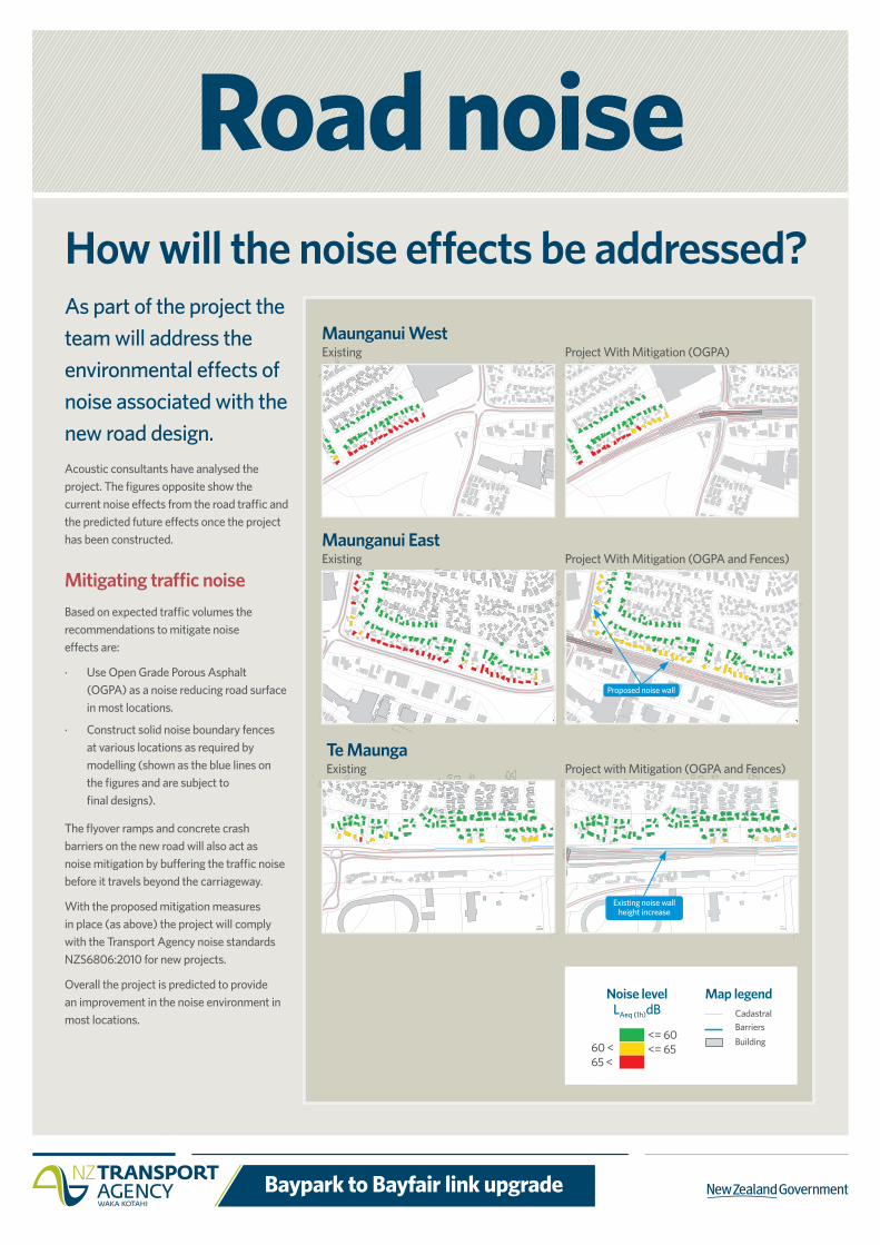
Road noiseHow will the noise effects be addressed?As part of the project the team will address the environmental effects of noise associated with the new road design.Acoustic consultants have analysed the project. The figures opposite show the current noise effects from the road traffic and the predicted future effects once the project has been constructed.
Mitigating traffic noiseBased on expected traffic volumes the recommendations to mitigate noise effects are:
· Use Open Grade Porous Asphalt (OGPA) as a noise reducing road surface in most locations.
· Construct solid noise boundary fences at various locations as required by modelling (shown as the blue lines on the figures and are subject to final designs).
The flyover ramps and concrete crash barriers on the new road will also act as noise mitigation by buffering the traffic noise before it travels beyond the carriageway.
With the proposed mitigation measures in place (as above) the project will comply with the Transport Agency noise standards NZS6806:2010 for new projects.
Overall the project is predicted to provide an improvement in the noise environment in most locations.
Maunganui WestExisting Project With Mitigation (OGPA)
Maunganui East Existing Project With Mitigation (OGPA and Fences)
Te Maunga Existing Project with Mitigation (OGPA and Fences)
Proposed noise wall
Existing noise wall height increase
Noise levelLAeq (1h)dB
60 <65 <
<= 60<= 65
Map legendCadastralBarriersBuilding

Baypark to Bayfair link upgrade
What happens to the railway lineThe East Coast Main Trunk (ECMT) railway will be moved within the designated rail corridor, behind the Owens Place commercial area. The rail designation has been in place since the early 1980s.
The tracks are being moved due to impact that trains have on traffic movement and safety at the Maunganui-Girven roundabout and Te Maunga roundabout.
The project team is aware of the environmental impacts that the relocation will have on neighbouring residents in Liftan Place and Russley Drive. Mitigation measures are planned to reduce the impacts.
Rail relocationST
ATE
HIGH
WAY
29
TRUMAN LANE
TAURANGA EASTERN LINK
GLOUCESTER ROAD
GIRVEN ROAD
OMANU GOLF CLUB
MATA
PIHI
ROA
D
DAOR IUNAGNUAM
DAOR MAHSREVEExisting rail corridor
New rail corridor
Map showing rail relocation
Bayfair
BayPark

Baypark to Bayfair link upgrade
How will cyclists and pedestrians be catered for?
Between Bayfair and BayparkPedestrian access to Baypark from Maunganui Road will be provided via ramps that cross SH2 and the railway line.
There will also be a pedestrian path from the end of Owens Place through to Truman Lane.
Te Maunga Lane A pedestrian pathway at ground level will be provided alongside Maunganui Road to Te Maunga Lane.
Walking and cyclingGi
rven
Roa
d
Bayfair
Truman Lane
Te Maunga Lane
Baypark
The needs of cyclists and pedestrians have been considered in detail for the preferred option.
Maunganui road, Girven road and Matapihi roadIn the preferred option the current underpass under Maunganui Road will be removed. This is because the underpass would need to be extended and the length would create an unsafe environment with limited visibility.
A signalised pedestrian crossing will be provided at ground level to replace the underpass.
CyclewayWalkway
CyclewayGround level walkway

Baypark to Bayfair link upgrade
Discarded options and feedback
Truman Lane
Conc
ord A
venu
e
(left
in/ou
t)
Bayfair
Baypark Stadium
Exeter Street(left in/out)
Owens PlaceTitoki Place
Girv
en R
oad
Jack
son
Stre
et
(left
in/o
ut)
Te Maunga Lane
TAURANGA EASTERN LINK
Mat
apih
i Ro
ad
Stat
e High
way 29
Maunganui RoadMaunganui Road
Maunganui Road
State Highway 2
Gloucester Road
ELEVATED FLYOVERSEXISTING RAILWAYLOCAL ROADSSTATE HIGHWAY
Option 1
Option 1 had substantial housing purchase and did not solve the safety and traffic issues of the railway line.
Bayfair
Baypark Stadium
Truman Lane
Exeter Street(left in/out)
Owens Place Titoki Place
Girv
en R
oad
Te Maunga Lane
TAURANGA EASTERN LINK
Mat
apih
i Ro
ad
Maunganui RoadMaunganui Road
Maunganui Road
State Highway 2
Baypark Stadium
Jack
son
Stre
et
(left
in/o
ut)
Stat
e High
way 29
ELEVATED FLYOVERSRELOCATED RAILWAYLOCAL ROADSSTATE HIGHWAY
Gloucester Road
Conc
ord A
venu
e
(left
in/ou
t)
Option 2
Option 2 had railway line relocation which avoided requiring housing on Maunganui Road but didn’t remove the rail crossing at SH29. State highway movements would continue to be affected by rail movements.
Bayfair
Baypark Stadium
Truman Lane
Exeter Street(left in/out)
Owens Place Titoki Place
TAURANGA EASTERN LINK
Te Maunga Lane
Girv
en R
oad
Jack
son
Stre
et
(left
in/o
ut)
Gloucester Road
Conc
ord A
venu
e
(left
in/ou
t)
Stat
e H
ighw
ay 2
9
Mat
apih
i Ro
ad
Maunganui RoadMaunganui Road
Maunganui Road
State Highway 2
ELEVATED FLYOVERSON/OFF RAMPSRELOCATED RAILWAYLOCAL ROADSPOTENTIAL ACCESS ROADSTATE HIGHWAYOption 3
Option 3 provided a long term solution by separating the state highway from the railway and included the connection to Truman Lane but would impact on the existing operations on Owens Place by attracting through-traffic (rat running).
During the early stages of the investigation, many different options were considered, including at-grade (at ground level) solutions. It was concluded that at-grade options would not provide sufficient life before requiring further upgrades, or the necessary level of service for a nationally significant state highway.
Discarded grade-separated optionsSince the public Open Day in April 2013 four grade-separated (above ground level, like Hewlett’s Road flyover) options have been considered in detail. They were assessed against their ability to deliver the long term benefits – efficiency, safety and value for money.
Option 3A has been identified as the preferred option. The three grade-separated options which were discarded, and reasons why, are shown below.

Baypark to Bayfair link upgrade
Earthworks managementConstruction of the Baypark to Bayfair link upgrade will require consents for earthworks.
Phase one will be the railway construction with approximately 30,000m3 to 50,000m3 of earthworks.
Phase two will be the road construction with approximately 200,000m3 to 250,000m3 of earthworks.
Stormwater managementStormwater that comes from the road will fall into one of two catchments; one will be treated in a pond at Matapihi Road and the other in a pond alongside State Highway 29.
These will catch and treat most of the road runoff before being discharged into the council drainage systems. These drains will eventually be discharged to the Tauranga Harbour under an existing stormwater consent held by the Tauranga City Council.
Construction managementConstruction management plans will be prepared to outline how the temporary effects from construction will be managed; including noise and dust, stormwater erosion and sediment, vibration and traffic.
Construction stagingThe construction staging will be confirmed prior to construction. A possible construction scenario is:
Stage 1: Build new railway, including relocating Transpower poles and other services as needed, install noise and vibration mitigation, fencing, and relocate trains to new track alignment.
Stage 2: Build new road on old railway land and build new SH29 link over railway.
Stage 3: Temporary relocation of traffic to new road, build flyover at Girven Road and build bridge over SH2 to SH29.
Stage 4: Complete roading works on eastern side of flyover, complete Maunganui-Girven intersection changes and tie into the Tauranga Eastern Link.
Bayfair
Baypark Stadium
Truman Lane
Exeter Street(left in/out)
Owens Place Titoki Place
TAURANGA EASTERN LINK
Girv
en R
oad
Te Maunga Lane
Jack
son
Stre
et
(left
in/o
ut)
Gloucester Road
Conc
ord A
venu
e
(left
in/ou
t)
Mat
apih
i Ro
ad
Maunganui RoadMaunganui Road
Maunganui Road
State Highway 2
State Highw
ay 29
ELEVATED FLYOVERSON/OFF RAMPSRELOCATED RAILWAYLOCAL ROADSSTATE HIGHWAYWALKING / CYCLING ACCESSStage 1 - Relocate railway
CONSTRUCTION ZONE
Bayfair
Baypark Stadium
Truman Lane
Exeter Street(left in/out)
Owens Place Titoki Place
TAURANGA EASTERN LINK
Girv
en R
oad
Te Maunga Lane
Jack
son
Stre
et
(left
in/o
ut)
Gloucester Road
Conc
ord A
venu
e
(left
in/ou
t)
Mat
apih
i Ro
ad
Maunganui RoadMaunganui Road
Maunganui Road
State Highway 2
State Highw
ay 29
ELEVATED FLYOVERSON/OFF RAMPSRELOCATED RAILWAYLOCAL ROADSSTATE HIGHWAYWALKING / CYCLING ACCESSStage 3 - Bridges, East ramps
CONSTRUCTION ZONE
Bayfair
Baypark Stadium
Truman Lane
Exeter Street(left in/out)
Owens Place Titoki Place
TAURANGA EASTERN LINK
Girv
en R
oad
Te Maunga Lane
Jack
son
Stre
et
(left
in/o
ut)
Gloucester Road
Conc
ord A
venu
e
(left
in/ou
t)
Mat
apih
i Ro
ad
Maunganui RoadMaunganui Road
Maunganui Road
State Highway 2
State Highw
ay 29
ELEVATED FLYOVERSON/OFF RAMPSRELOCATED RAILWAYLOCAL ROADSSTATE HIGHWAYWALKING / CYCLING ACCESSStage 4 - Completion works
CONSTRUCTION ZONE
Bayfair
Baypark Stadium
Truman Lane
Exeter Street(left in/out)
Owens Place Titoki Place
TAURANGA EASTERN LINK
Girv
en R
oad
Te Maunga Lane
Jack
son
Stre
et
(left
in/o
ut)
Gloucester Road
Conc
ord A
venu
e
(left
in/ou
t)
Stage 2 - Widen SH2 West, SH29CONSTRUCTION ZONE
ELEVATED FLYOVERSON/OFF RAMPSRELOCATED RAILWAYLOCAL ROADSSTATE HIGHWAYWALKING / CYCLING ACCESS
Mat
apih
i Ro
ad
Maunganui Road
Maunganui Road
State Highway 2
State Highw
ay 29
Maunganui Road
Construction

Baypark to Bayfair link upgrade
Where do we go from here?ConsentsThere are several consents under the Resource Management Act that will be necessary for the project:
• AnAlterationtoDesignationfortheroadupgrade will be sought later this year, along with the required resource consents from the Bay of Plenty Regional Council for construction earthworks and works on potentially contaminated land.
• Approvalfortherailwaylinetie-inatthenorthend of the golf course.
• Resourceconsentforearthworksfortherailwayline relocation.
• Relocationofthetransmissionlinesinthe railway corridor.
An authority for finding / damaging unrecorded archaeological material will be required from Heritage New Zealand. The Transport Agency will, as has been done for all other construction projects, have an agreement with the relevant hapu about monitoring the earthworks phase of the project.
FundingThe Transport Agency will seek funding for the design which is expected to begin later this year.
Design and constructionConstruction will begin once detailed designs have been completed and construction funding has been approved. Relocating the railway will be part of the enablingworksandislikelytotake9-12months.Once the railway has been relocated the road improvements are expected to take two to three years, due to the necessity to programme work and allow traffic movements throughout construction.
Next steps
Please give us your feedback on the project by 5 August by either leaving the forms with us now, posting it back to Beca at PO Box 903 Tauranga or emailing [email protected].
Feedback

Baypark to Bayfair link upgrade
The SH2 Eastern CorridorThe SH2 Eastern Corridor aims to provide an efficient and reliable route for freight to and from the Port of Tauranga.The Tauranga Eastern Corridor includes the Maunganui-Girven and Te Maunga intersections, Hewletts Road and the Tauranga Eastern Link.
The Tauranga Eastern Link project is due to be operational by late 2015 and is predicted to deliver a 24 minute return journey time saving between Paengaroa and the Te Maunga (SH2/SH29) intersection and will improve reliability for freight traffic to the Port.
The Maunganui-Girven and Te Maunga (SH2/SH29) intersections
currently experience delays during peak periods and are affected by rail movements. These delays will impact on the travel time through the SH2 Eastern Corridor.
The preferred option will deliver a greater level of efficiency and safety and will provide an effective and more resilient network for the future.
Northern corridor
Western corridor
Eastern corridor
Port of Tauranga
RotoruaRotoruaKawerau
Putaruru
Tokoroa
Mangakino
Te Teko
Edgecumbe
Te Kaha
WhakataneWhakatane
OpotikiOpotikiTaneatua
Paengaroa
Papamoa
Maketu
Matata
Mt Maunganui
Katikati
Waihi Beach
Te Puke
Western Bay of Plenty
Western Bay of Plenty
Whangaparoa
Eastern Bay of Plenty
Eastern Bay of Plenty
TaurangaTauranga
The bigger picture

Baypark to Bayfair link upgrade
Visual impact - how will it look?
AfterBefore
Maunganui Road looking east towards Girven Road
Girven Road looking towards Maunganui Road
Matapihi Road looking towards Maunganui Road
Maunganui Road looking east towards SH29/2 interchange
VisualCareful consideration will be required during the design phase to limit the dominance of the structures. Proposed visual mitigation measures include:
• Verticalconcretewallscanbedesignedwithpatterningwhichrespondsto the local environment (similar to the walls of the overpass structures on the Tauranga Eastern Link (TEL)).
• Designtoallowmaximumamountofdaylightunderstructures.
• Carefuldesignforunderneaththestructuressuchastheapplicationofcolouredlighting,texturesandstreetfurnituretomakespacesandroutes more inviting for people to use.
• Plantingofspacesandroadedges,includinggrassingorsimplepatternsofmixedplantingratherthanblanketscreenplanting.
After
After
After
Before
Before
Before
The preferred option includes two elevated structures which will change the way the area currently looks.

Baypark to Bayfair link upgrade
Trains regularly carry bulk goods along this section of railway to and from Mount Maunganui. The following measures to reduce the impacts will include:
Reducing noise• A3.5metrehightracksidenoisebarrierforapproximately
200 metres ending near Matapihi Road.
• Withthelandowners’agreementa2.5mnoisebarrierwillbe erected as the boundary fence for the two properties nearest Matapihi Road to maintain line of sight for train drivers, motorists and pedestrians.
Reducing vibration• Ballastmattingwillbeinstalledtoreducevibrationfor
approximately400metresalongasectionsouthofMatapihi Road.
Improving safety• FullbarriercontrolarmsonbothsidesoftheMatapihi
Road carriageway with barrier control for pedestrians.
• Directionalelectronicbellsarebeingconsideredaspartofthedesign(inconsultationwiththeRoyalNZFoundationfortheBlind).
• Installationofsafety-netfencingalongtheThirteenthFairwayofthegolfcourse.
Environmental mitigation measures for both noise, vibration and safety are to be part of the final design for Option 3A.
Rail environment
Noise levelLAeq(1h)dB
60 <65<
<= 60<=65
Map legendCadastralBarriersRailwayBuilding
Noise wall
Safety-netfencing
Electronicwarning
bell
Approximateextent of ballast mat
Mitigation measures for the rail environment

Baypark to Bayfair link upgrade
Walkway at Liftan Place
Single level homes Set-back Reserve access Rail corridor
Noi
se m
itiga
tion
Boun
dary
fenc
e
Daylightin
g 2.7 m + 45°
2.0
m (t
yp.)
3.5 m
2.5 m
2.5 m (typ.)
What happens to the walkway from Matapihi Road to Bayfair Reserve?The consequence of installing the noise walls for the mitigation of the railway effects is that the current public grassed walkway between Matapihi Road and the Bayfair Reserve may feel quite enclosed.
Many options for making the walkway safer, or alternatively removing the walkway and turning the area into planting to create more garden, are being considered.
Noise wall design examples
Typical cross-section of the Liftan Place walkway
We are interested in your views on the walkway at Liftan Place. Please give us your feedback by 5 August by either leaving the forms with us now, posting it back to Beca at PO Box 903 Tauranga or emailing it to [email protected].
Feedback
Reserve entrance closed• Fenceacrosseitherendofthe
entrance leg.• Areacouldbeplantedwithlowstature
native planting, or incorporated into the adjacent residential lots.
Reserve entrance open• Noplantingorrestrictionstoviews
through the reserve entrance.• Nolightingtoencouragepeopleinto
the walkway after dark.
Baypark to Bayfair link upgrade
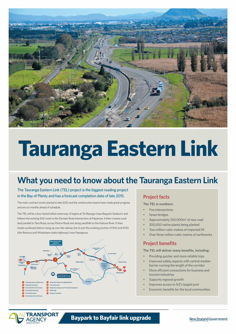
What you need to know about the Tauranga Eastern Link
Tauranga Eastern LinkThe Tauranga Eastern Link (TEL) project is the biggest roading project in the Bay of Plenty and has a forecast completion date of late 2015.The main contract works started in late 2010 and the construction teams have made great progress
and are six months ahead of schedule.
The TEL will be a four-laned tolled motorway. It begins at Te Maunga (near Baypark Stadium) and
follows the existing SH2 route to the Domain Road intersection at Papamoa. It then crosses rural
land parallel to Tara Road, across Parton Road and along sandhills to the Kaituna River. It then
heads southeast before rising up over the railway line to join the existing junction of SH2 and SH33
(the Rotorua and Whakatane state highways) near Paengaroa.
Project benefitsThe TEL will deliver many benefits, including:
• Providingquickerandmorereliabletrips• Improvedsafetyaspectswithcentralmedian
barrier running the length of the corridor • Moreefficientconnectionsforbusinessand
tourism industries • Supportsregionalgrowth• ImprovesaccesstoNZ’slargestport• Economicbenefitsforthelocalcommunities
Project factsThe TEL in numbers:
• Fiveintersections• Sevenbridges• Approximately550,000m2 of new road • 300,000nativeplantsbeingplanted• Twomillioncubicmetresofimportedfill• Overthreemillioncubicmetresofearthworks
1. Te Maunga and new resident access
2. Mangatawa interchange
3. Kairua Road (left in/left out only)
Domain Road interchange
4. Parton Road overpass
4. Future Papamoa East interchange
1
2
3
4
5
6
1. Kaituna River bridge and realigned Bell Road
Toll collection point
7. Maketu Road underpass and Te Tumu Road realignment
ECMT bridge
8. Paengaroa roundabout
7
8
9
10
11
Main project o�ce and Visitor
Information Centre
Proposed Rangiurubusiness
park
TE MAUNGA
PAENGAROA
TE PUKE
BAYPARK STADIUM
BAYFAIR
Maunganui Road
Truman Lane
Domain Road
Tara Road
Parton Road
Bell Road
PAPAMOA
State Highway 2(current)
Kaituna RiverPah Road
Kaituna Road (new)
Te Tumu Road
Maketu Road12 3 4
5 7
6
8
910
11
Viewing binoculars on Papamoa Hills summit
Baypark to Bayfair link upgrade
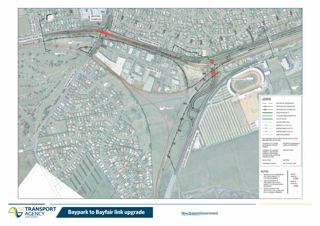
DATA OBTAINED FROM OTHERS AND INCLUDED IN THESEDRAWINGS ARE AS FOLLOWS:
TAURANGA CITY COUNCIL PROPERTY BOUNDARIES &WESTERN BOP DISTRICT AERIAL PHOTOGRAPHYCOUNCIL
TAURANGA CITY COUNCIL, SERVICE PLANSPOWER Co, VECTOR GAS,CHORUS, FX NETWORKS,TELSTRA CLEAR, VODAFONE,TRANSFIELD UFBB.
LEVEL DATUM MOTURIKI
COORDINATE SYSTEM BAY OF PLENTY 2000
LEGEND
PROPOSED MGI DESIGNATION
EXISTING TEL DESIGNATION
PROPOSED RAIL DESIGNATION
PEDESTRIAN ROUTE
FF4 BARRIER FULL FACE TL4
SF4 BARRIER SINGLE FACE TL4
SF5 BARRIER SINGLE FACE TL5
WIRE ROPE BARRIER
MSE RETAINING WALL
AT GRADE PEDESTRIAN ROUTE
CYCLIST ROUTE
Scale (A1)
Scale (A3)Reduced
Original
1:2500
1:5000
NOTES:1. DESIGN LAYOUT IS PRELIMINARY
ONLY AND IS SUBJECT TO FURTHER REFINEMENT
2. LAND REQUIREMENT IS PRELIMINARY ONLY AND IS SUBJECT TO FURTHER DESIGN REFINEMENT
3. CRASH CUSHIONS TO BE INSTALLED AT THE LEADING END OF ALL CONCRETE BARRIERS