Bavarian Ministry of Finance AAA - The contribution of the AdV in an increasing European Spatial...
31
Bavarian Ministry of Finance AAA - The contribution of the AdV in an increasing European Spatial Data Infrastructure - the German Way Markus Seifert Bavarian Administration for Surveying and Cadastre General Assembly of the Permanent Committee on Cadastre (PCC), 12.6.-14.6.2007, Hamburg
-
Upload
godwin-jacobs -
Category
Documents
-
view
215 -
download
0
Transcript of Bavarian Ministry of Finance AAA - The contribution of the AdV in an increasing European Spatial...
Bavarian Ministry of Finance
AAA - The contribution of the AdV in an increasing European Spatial Data Infrastructure - the German Way
Markus SeifertBavarian Administration for Surveying and Cadastre
General Assembly of the Permanent Committee on Cadastre (PCC), 12.6.-14.6.2007, Hamburg

2
Bavarian Ministry of Finance
Personal Background
• Member of the DVW Working Group on geoinformation− Delegate to FIG Com 7
• Head of the SDI office in Bavaria− Establishment of a SDI in Bavaria
• Head of the project team “SDI Standards” of the AdV− Responsible for developing and mainenance of the new
integrated cadastre model ALKIS
• Representaive of the AdV to the OpenGeospatial Consortium (OGC)
− AdV becomes a technical member of OGC
• Head of the German delegation to ISO/TC 211
• Member of the Drafting Team “Data Specification” at INSPIRE
3
Bavarian Ministry of Finance
Content
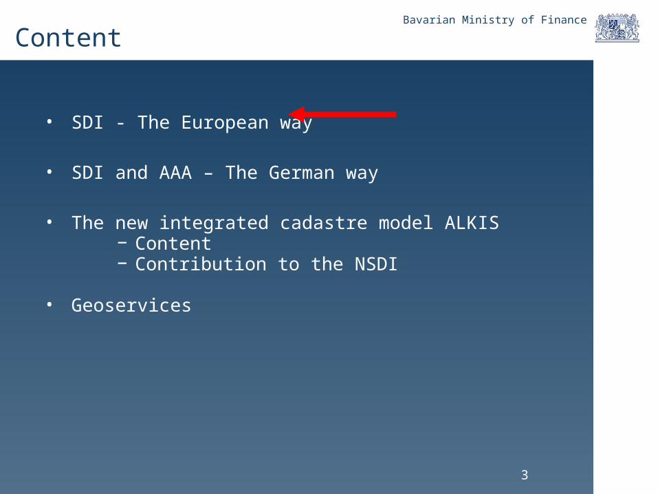
• SDI - The European way
• SDI and AAA – The German way
• The new integrated cadastre model ALKIS− Content− Contribution to the NSDI
• Geoservices
4
Bavarian Ministry of Finance
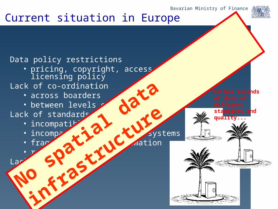
Current situation in Europe
Data policy restrictions• pricing, copyright, access rights, licensing policy
Lack of co-ordination• across boarders• between levels of government
Lack of standards and their use• incompatible information• incompatible information systems• fragmentation of information• redundancy
Lack of data
EU has islands of data of different standards and quality...
No spatial d
ata infra
structure
5
Bavarian Ministry of Finance
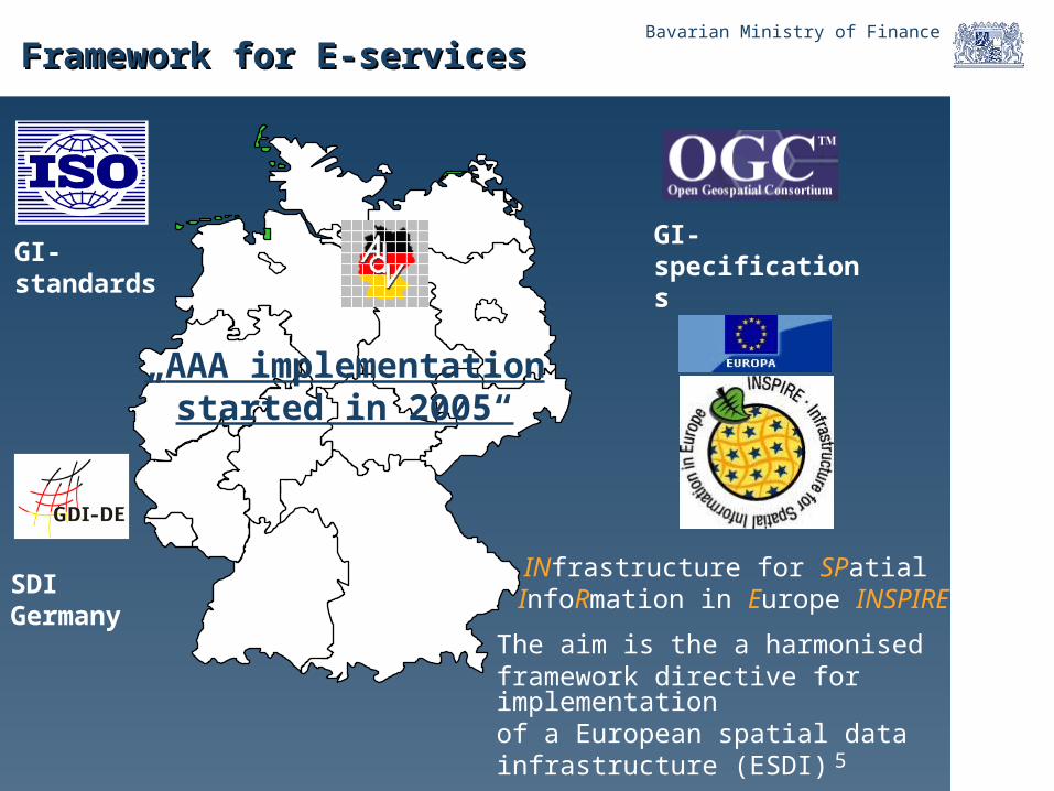
Framework for E-servicesFramework for E-services
„AAA implementation started in 2005“
The aim is the a harmonised framework directive for implementation of a European spatial datainfrastructure (ESDI)
INfrastructure for SPatial InfoRmation in Europe INSPIRE
GI-standardsGI-specifications
SDI Germany
6
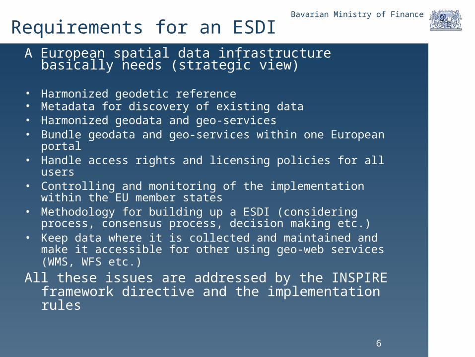
Bavarian Ministry of Finance
Requirements for an ESDIA European spatial data infrastructure basically
needs (strategic view)
• Harmonized geodetic reference• Metadata for discovery of existing data• Harmonized geodata and geo-services• Bundle geodata and geo-services within one European
portal• Handle access rights and licensing policies for all users • Controlling and monitoring of the implementation within the
EU member states• Methodology for building up a ESDI (considering process,
consensus process, decision making etc.)• Keep data where it is collected and maintained and make it
accessible for other using geo-web services (WMS, WFS etc.)
All these issues are addressed by the INSPIRE framework directive and the implementation rules

7
Bavarian Ministry of Finance
Requirements for INSPIRE
Upcoming work for EU member states during the IR review phase
Approximate
start date
Approximate
end date
Event Suggested actors
2007-05 2007-07 SDIC/LMO consultation of draft Generic Conceptual Model Experts in data modelling
2007-05 2007-07 SDIC/LMO consultation on draft Definition and scope of Annex Themes
Thematic experts
2007-06 2007-09 SDIC/LMO consultation on draft IR for Discovery and View Services Experts in metadata, catalogue service and WMS
2007-06 2007-09 Call for candidate specifications for Annex I spatial themes Thematic experts
2007-06 2007-09 Call for candidate specifications for Annex II and III spatial themes Thematic experts
2007-06 2007-09 Call for SDICs/LMOs for participation in data specification development
SDIC/ LMO
2007-06 2007-09 User requirements survey Thematic experts
2007-07 2007-10 SDIC/LMO consultation on draft Methodology for Specification Development
Thematic experts, experts in data modelling
2007-07 2007-10 Methodology testing Experts in data modelling
2007-10 2007-12 SDIC/LMO consultation on draft IR for Monitoring and Reporting Experts in services
2007-12 2008-03 SDIC/LMO consultation on draft IR for Coordinates Transformation Services
Experts on coordinate reference systems and

8
Bavarian Ministry of Finance
Content
• SDI - The European way
• SDI and AAA – The German way
• The new integrated cadastre model ALKIS− Content− Contribution to the NSDI
• Geoservices

9
Bavarian Ministry of Finance
The National Geodatabase – Reference Data
ALKAutomated Real Estate Map
Quite a lot of redundant information
ALBAutomated Real Estate Register
Offical Topographic and Cartographic Information System ATKIS Geodetic Reference Points
AFIS-ALKIS-ATKISApplication Schema

10
Bavarian Ministry of Finance
Information
receive:
(reconstruction)(reconstruction)
datadata
(farmalising)(farmalising)
send:
Information
„„my car“my car“
datadata(Transfer)(Transfer)
„„his car“his car“
carcar
Data modelling: Data and Information

11
Bavarian Ministry of Finance
Information
Transmitter: Reveiver:
DataData DataData(Transfer)(Transfer)
(formalising)(formalising) (reconstruction)(reconstruction)
Information
c a r c a r
Metadata:Class „car“:Attribute „producer“Attribute „price“Attribute „colour“Attribute „production year“Attribute „condition“Attribute „current milage“Attribute „notation“
Data modelling: Data and Information
12
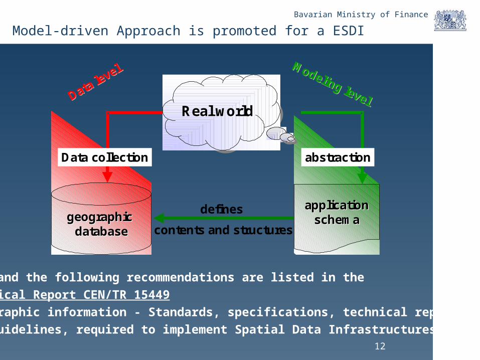
Bavarian Ministry of Finance
Modeling level
Modeling levelData level
Data level
applicationapplicationschemaschemageographic geographic
databasedatabase
defines
contents and structures
Real worldReal Real worldworld
abstractionData collection
Model-driven Approach is promoted for a ESDI
This and the following recommendations are listed in the
Technical Report CEN/TR 15449
“Geographic information - Standards, specifications, technical reports
and guidelines, required to implement Spatial Data Infrastructures”
13
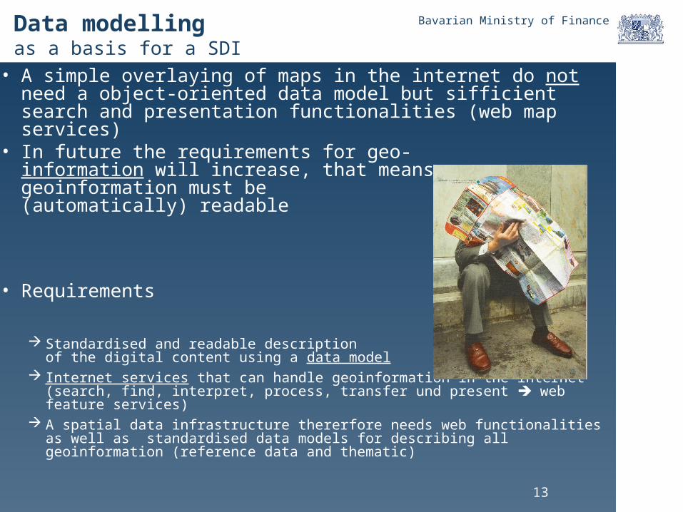
Bavarian Ministry of FinanceData modellingas a basis for a SDI
• A simple overlaying of maps in the internet do not need a object-oriented data model but sifficient search and presentation functionalities (web map services)
• In future the requirements for geo- information will increase, that meansgeoinformation must be(automatically) readable
• Requirements
Standardised and readable description of the digital content using a data model
Internet services that can handle geoinformation in the internet (search, find, interpret, process, transfer und present web feature services)
A spatial data infrastructure thererfore needs web functionalities as well as standardised data models for describing all geoinformation (reference data and thematic)
14
Bavarian Ministry of Finance
Preconditions for a SDI (data modelling view)• Model-driven approach for describing the data • Semantic harmonization of the existing data as far as
possible and sufficient (feature catalogues)• Application of the ISO standards for data modelling
and encoding • Implementation of metadata information systems for discovery
and access to the data
• Implementation of interoperable web services for
data access distribution (ISO, OGC)• Operational issues (registries etc.) • Legal issues (data sharing, IPR etc.)• Pricing
AAA data model
Contribution of the AAA Model to the European SDI

15
Bavarian Ministry of Finance
Content
• SDI - The European way
• SDI and AAA – The German way
• The new integrated cadastre model ALKIS− Content− Contribution to the NSDI
• Geoservices
16
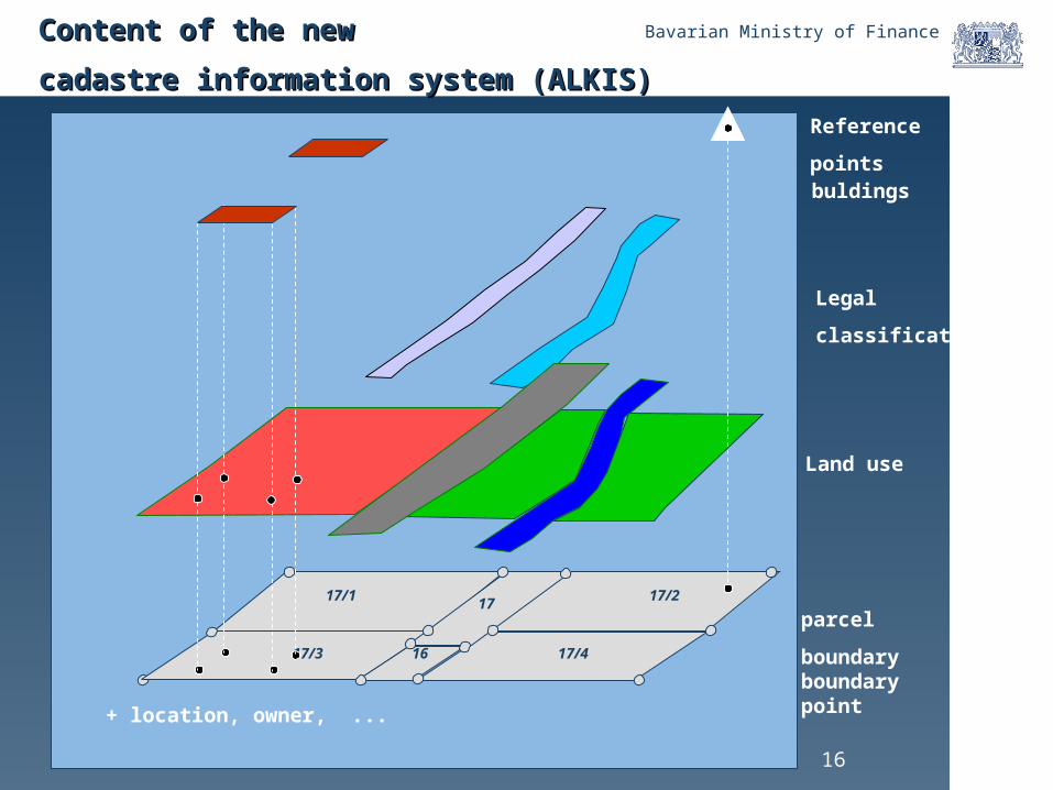
Bavarian Ministry of Finance
17/1
17/3
17/2
17/4
17
16
parcel
boundaryboundary point
Content of the new Content of the new
cadastre information system (ALKIS)cadastre information system (ALKIS)
Legal
classification
Land use
+ location, owner, ...
Reference
pointsbuldings
17
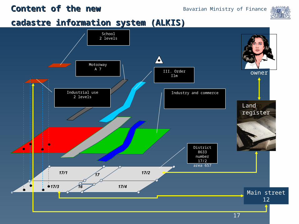
Bavarian Ministry of Finance
17/1
17/3
17/2
17/4
17
16
owner
MotorwayA 7
III. OrderIlm
Industry and commerce
District 8633number 17/2
area 657
School2 levels
Industrial use2 levels
Land register
Main street12
Content of the new Content of the new
cadastre information system (ALKIS)cadastre information system (ALKIS)

18
Bavarian Ministry of Finance
<<feature>>
Flurstück
+ Land:Integer
+ Gemarkungsnum mer:Integer+ Flurstücksnumm er:Flurstücksnum merID/+ Fl urstückskennzeichen:S tring
+ Am tliche Fläche:Real+ Flurnumm er[0..1]: Integer
+ Zeitpunkt der Entstehung[0. .1] :Date+ Abweichender Rechtszustand[0. .1] :Boolean
+ Rechtsbehelfsverfahren[0..1]:Bool ean+ Objektkoordinaten[0..1]: ObjektkoordinatenID+ Sonsti ge E igenschaf ten[0.. *]:Sonsti ge E igenschaf tenID
+ Flurstücksfol ge[0. .1] :S tring
Katasterunterlagef rom Package Ant ragsverwal tung
<<feature>>
Lage mit Gebäudenummer
+ Verschlüsselte Lagebezeichnung[0..1]: verschlLageID+ Unverschlüsselte Lagebezeichung[0..1]:St ring+ Hausnum mer[0. .1] :S tring
+ Pseudonumm er[0..1]:S tring+ Laufende Num mer[0..1]:St ri ng
<<feature>>
Tatsächliche Nutzung überlagernd
+ Funktion: Integer+ Art: Integer
+ Nam e[0. .*] :S t ring
<<feature>>
Gebäude
+ Gebäudefunkti on:Integer+ Nam e[0. .*] :S t ring
+ Nutzung[0. .*] :NutzungID+ Bauweise[0. .1] :Integer
+ Anzahl der Geschosse[0. .1] :Integer+ Hochhaus[0. .1] :Boolean+ Höhe Gebäude[0..1]: Integer
+ Besondere Dachausprägung[0..1]: Integer+ Zustand[0..1]: Integer
+ Geschossf läche[0. .1] :Integer+ Grundfläche[0. .1] :Integer
+ Um bauter Raum [0. .1] :Integer+ Baujahr[0.. *]:Date+ Lage zur E rdoberf läche[0..1]: Integer
+ Dachart[0..1]:St ring+ Dachgeschoß ausbau[0..1]: Integer
<<feature>>AA_NREO
<<feature>>
AA_REO
<<Data Type>>Flurstücksnum merID
+ Zähler:S tring
+ Nenner:St ring
<<Data Type>>Sonst ige E igenschaftenID
+ Schlüssel :S tring+ Fläche des Abschnit ts:St ri ng
+ Angaben zum Abschnit t (unst rukturi ert ):S tring+ Angaben zum Abschnit t - S tell e:S tring
+ Angaben zum Abschnit t - Numm er:S tring+ Angaben zum Abschnit t - Bemerkung:S tring
Es darf nur eine der At tributartenHausnummer oder Pseudonum mervorhanden sein.
Es darf nur eine der At tributartenverschlüsselte Lagebezeichnung
oder unverschlüsselteLagebezeichnung vorhanden sein.
hat
0. .*
gehört zu
0. .*
zeigt auf
0. .*
hat
1. .*
steht in Beziehung mit
0. .*
gehört zu
0. .*
zeigt auf
0. .*
gehört zu
1
<<feature>>
Bauteil
+ Art: Integer+ Lage zur E rdoberf läche[0..1]: Integer
Bedingungenusw.
Cadastral data model described with UMLCadastral data model described with UML
19
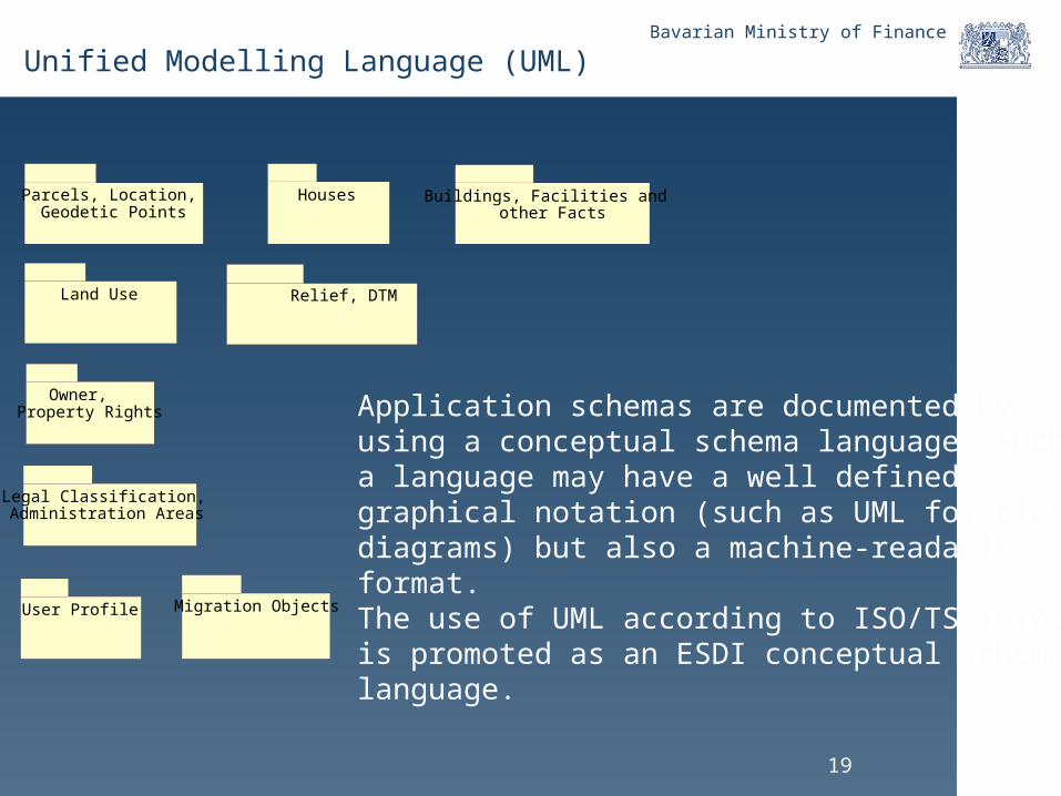
Bavarian Ministry of Finance
Unified Modelling Language (UML)
Application schemas are documented by using a conceptual schema language. Such a language may have a well defined graphical notation (such as UML for classdiagrams) but also a machine-readable format. The use of UML according to ISO/TS 19103 is promoted as an ESDI conceptual schema language.
Parcels, Location, Geodetic Points
Owner, Property Rights
Houses
Land Use
Buildings, Facilities and other Facts
Relief, DTM
Legal Classification, Administration Areas
User Profile Migration Objects
20
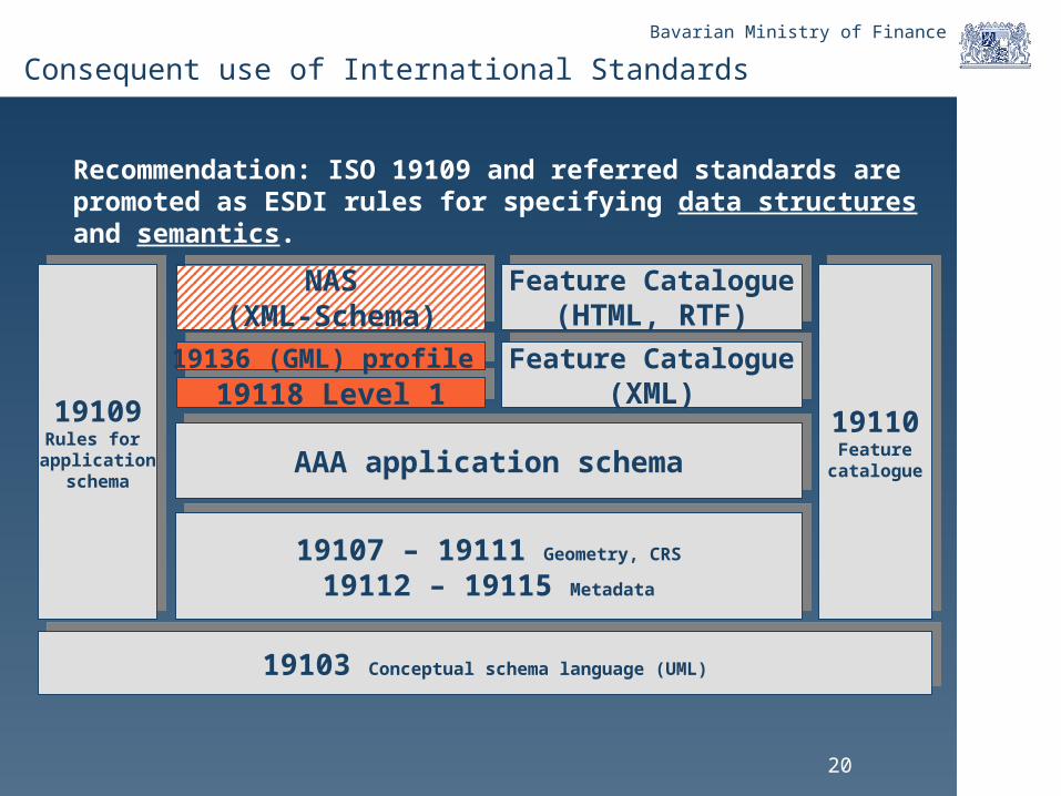
Bavarian Ministry of Finance
Consequent use of International Standards
Recommendation: ISO 19109 and referred standards are promoted as ESDI rules for specifying data structures and semantics.
19103 Conceptual schema language (UML)19103 Conceptual schema language (UML)
19109Rules for
applicationschema
19109Rules for
applicationschema
19110Feature
catalogue
19110Feature
catalogue
19107 – 19111 Geometry, CRS
19112 – 19115 Metadata
19107 – 19111 Geometry, CRS
19112 – 19115 Metadata
AAA application schemaAAA application schema
NAS(XML-Schema)
NAS(XML-Schema)
Feature Catalogue(XML)
Feature Catalogue(XML)
Feature Catalogue(HTML, RTF)
Feature Catalogue(HTML, RTF)
19118 Level 119118 Level 1
19136 (GML) profile 19136 (GML) profile
21
Bavarian Ministry of Finance
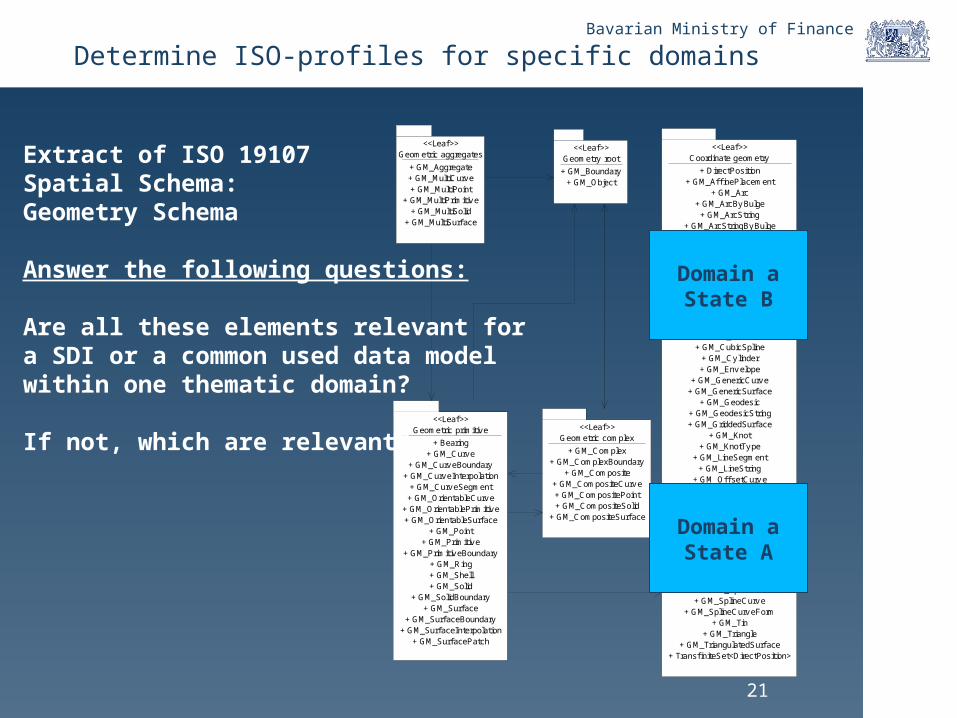
Determine ISO-profiles for specific domains
Geometric primitiv e<<Leaf >>
+ Bearing+ GM_Curv e
+ GM_Curv eBoundary+ GM_Curv eInterpolation
+ GM_Curv eSegment+ GM_OrientableCurv e
+ GM_OrientablePrimitiv e+ GM_OrientableSurf ace
+ GM_Point+ GM_Primitiv e
+ GM_Primitiv eBoundary+ GM_Ring+ GM_Shell+ GM_Solid
+ GM_SolidBoundary+ GM_Surf ace
+ GM_Surf aceBoundary+ GM_Surf aceInterpolation
+ GM_Surf acePatch
Geometric complex<<Leaf >>
+ GM_Complex+ GM_ComplexBoundary
+ GM_Composite+ GM_CompositeCurv e+ GM_CompositePoint+ GM_CompositeSolid
+ GM_CompositeSurf ace
Coordinate geometry<<Leaf >>
+ DirectPosition+ GM_Af f inePlacement
+ GM_Arc+ GM_ArcBy Bulge
+ GM_ArcString+ GM_ArcStringBy Bulge
+ GM_BSplineCurv e+ GM_BSplineSurf ace
+ GM_BSplineSurf aceForm+ GM_Bezier
+ GM_BicubicGrid+ GM_BilinearGrid
+ GM_Circle+ GM_Clothoid
+ GM_Cone+ GM_Conic
+ GM_CubicSpline+ GM_Cy linder+ GM_Env elope
+ GM_GenericCurv e+ GM_GenericSurf ace
+ GM_Geodesic+ GM_GeodesicString+ GM_GriddedSurf ace
+ GM_Knot+ GM_KnotTy pe
+ GM_LineSegment+ GM_LineString
+ GM_Of f setCurv e+ GM_ParametricCurv eSurf ace
+ GM_Placement+ GM_PointArray+ GM_PointGrid+ GM_PointRef+ GM_Poly gon
+ GM_Poly hedralSurf ace+ GM_Poly nomialSpline
+ GM_Position+ GM_Sphere
+ GM_SplineCurv e+ GM_SplineCurv eForm
+ GM_Tin+ GM_Triangle
+ GM_TriangulatedSurf ace+ Transf initeSet<DirectPosition>
Geometry root<<Leaf >>
+ GM_Boundary+ GM_Object
Geometric aggregates<<Leaf >>
+ GM_Aggregate+ GM_MultiCurv e+ GM_MultiPoint
+ GM_MultiPrimitiv e+ GM_MultiSolid
+ GM_MultiSurf ace
Extract of ISO 19107Spatial Schema: Geometry Schema
Answer the following questions:
Are all these elements relevant fora SDI or a common used data modelwithin one thematic domain?
If not, which are relevant?
Domain aState A
Domain aState B
22
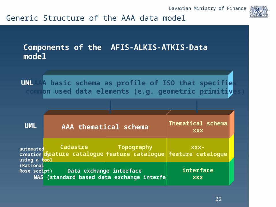
Bavarian Ministry of Finance
Components of the AFIS-ALKIS-ATKIS-Data model
Data exchange interfaceNAS (standard based data exchange interface)
AAA basic schema as profile of ISO that specifiescommon used data elements (e.g. geometric primitives)
UML
Cadastrefeature catalogue
automated creation byusing a tool (Rational Rose script)
Topographyfeature catalogue
AAA thematical schemaUML
interfacexxx
xxx-feature catalogue
Thematical schemaxxx
Generic Structure of the AAA data model

23
Bavarian Ministry of Finance
AAA_BasicClasses<<Leaf>>
+ AA_AdVStandardModell+ AA_PMO
+ AA_Fachdatenobjekt+ AA_Fachdatenverbindung
+ AA_Lebenszeitintervall+ AA_Modellart
+ AA_NREO+ AA_Objekt
+ AA_ObjektOhneRaumbezug+ AA_REO+ AA_UUID+ AA_ZUSO
+ URI
AAA_IndependantGeometry<<Leaf>>
+ AU_Flaechenobjekt+ AU_Geometrie
+ AU_KontinuierlichesLinienobjekt+ AU_Linienobjekt
+ AU_Objekt+ AU_Punktobjekt
AAA_CommonUsedGeometry<<Leaf>>
+ AG_Flaechenobjekt+ AG_Geometrie
+ AG_Objekt+ AG_Linienobjekt+ AG_Punktobjekt
AAA_Catalogue<<Leaf>>
+ AC_FeatureType+ AC_ObjektTypenBezeichnung
+ AC_Objektartenbereich+ AC_Objektartengruppe
+ AC_Thema+ AC_Themenart
AAA_PresentationObjects<<Leaf>>
+ AP_FPO+ AP_GPO
+ AP_HorizontaleAusrichtung+ AP_LPO+ AP_LTO+ AP_PPO+ AP_PTO+ AP_TPO
+ AP_VertikaleAusrichtung
AAA_Spatial Schema<<Leaf>>
+ AA_Flaechengeometrie+ AA_Liniengeometrie
+ AA_PunktLinienThema+ AG_ObjektMitGemeinsamerGeometrie
+ AU_ObjektMitUnabhaengigerGeometrie+ TA_CurveComponent
+ TA_MultiSurfaceComponent+ TA_PointComponent
+ TA_SurfaceComponent
AAA_PointCollection<<Leaf>>
+ AD_GitterCoverage+ AD_PunktCoverage
+ AD_ReferenzierbaresGitter+ AD_Wertematrix
AAA_ProjectControlling<<Leaf>>
+ AA_Antrag+ AA_Antragsart
+ AA_BesondereMeilensteinkategorie+ AA_Dokumentationsbedarf+ AA_Gebuehrenparameter
+ AA_Meilenstein+ AA_Projektsteuerung
+ AA_Projektsteuerungsart+ AA_Projektsteuerungskatalog
+ AA_Vorgang+ AA_VorgangInProzess
+ AA_Vorgangsart
AAA_Operations<<Leaf>>
+ AA_Art_Themendefinition+ AA_Auftrag
+ AA_Ergebnis+ AA_Instanzenthemen+ AA_Themendefinition
AAA_UserProfile<<Leaf>>
+ AA_Benutzer+ AA_Benutzergruppe
General structure of a feature
Structure of a featurecatalogue
Geometry
Operations
Presentation
Use cases
Baseline for thematic application schemas:The AAA Basic Schema
24
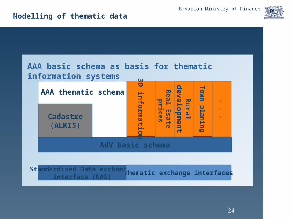
Bavarian Ministry of Finance
AdV basic schema
Standardised Data exchance interface (NAS)
Thematic exchange interfaces
AAA thematic schema
Cadastre(ALKIS)
3D in
form
ation
Real E
sate p
rices
Ru
ral d
evelop
men
t
To
wn
plan
ing
- - -AAA basic schema as basis for thematic information systems
Modelling of thematic data

25
Bavarian Ministry of Finance
Content
• SDI - The European way
• SDI and AAA – The German way
• The new integrated cadastre model ALKIS− Content− Contribution to the NSDI
• Geoservices
26
Bavarian Ministry of Finance
Geo Web Services
• All web services are implemented under consideration of the activities of SDI-Germany
• AdV defined a profile of the Web Map Server specification, determine some further definitions to fill degrees of freedom, e.g: - CRS
- Raster format- etc.
• A WFS-G (Gazetteer service) will be implementated for
providing coordinates for buildings
• A catalogue service for discovering and harvesting metadata will be implementated based on ebRIM or CSW DE profile
• For operational implementation of the SDI Germany a registry will be applied
• For examples see www.gdi.bayern.de
Bavarian Ministry of Finance
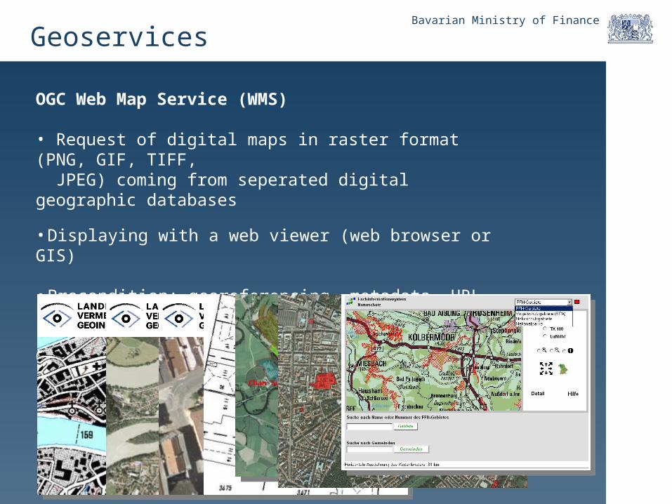
OGC Web Map Service (WMS)
• Request of digital maps in raster format (PNG, GIF, TIFF, JPEG) coming from seperated digital geographic databases
• Displaying with a web viewer (web browser or GIS)
• Precondition: georeferencing, metadata, URL
• Functionalities: GetCapabilities, GetMap, GetFeatureInfo
Geoservices

Bavarian Ministry of Finance
OGC Web Feature Service (WFS)
• Request to geo resources in vector format (attributes and geometry)
• Displaying with a web viewer (web browser or GIS)
• Precondition: Georeferencing, metadata, URL
• Functionalities: GetCapabilities, DiscribeFeatureType, GetFeature
• Extension: Transaction-WFS (read only and update)
Geoservices
Bavarian Ministry of Finance
Online Presentation
Geo web services:
www.gdi.bayern.de
E-services related on cadastre:
www.geoportal.bayern.de
30
Bavarian Ministry of Finance
Conclusions
• The AAA data model with the basic schema offers a thematic-independent and generic model framework that can be a baseline for modelling of other thematic domain data models. That will help to standardise the geoinformation in Germany.
• A SDI for geoinformation (not just geodata) needs an exact and transparent definition of the sharable data. Therefore the same methodology as defined with the AAA data model can be used. Doing this a national geo database can be established.
• The AdV offers support by using the UML tools for defining the data model and deriving the data exchange interface. Specific guidelines have been published on the AdV home page. The AdV guaranties maintenance at least until 2012.
• The success of the AAA data model bases on the consequent use of international GI standards from ISO.
• Geoservices will help to provide cadastral information and can be integrated within variable applications of e-government solution.
31
Bavarian Ministry of Finance
For more information see www.adv-online.de
Questions?