Battle Hill Farm Forest Park - Greater Wellington Regional Council
6
6.2 Battle Hill Farm Forest Park 6.2.1 Legal status Title held: Wellington Regional Council Legislative status: Administered under Local Government Act 2002, the park includes scenic reserve under the Reserves Act 1977 Territorial Authority: Porirua City Council The park comprises five adjacent lots acquired in July 1987 and held in fee simple. Two anomalies in the legal boundary line deserve note. Firstly, the 3.2 kilometre straight line on the park’s northern boundary is interrupted by a re-entrant strip corresponding to a truncated remnant of “paper road”. Secondly, the historic cemetery, together with an access strip, is excluded from the park, although physically incorporated within it. On 29 October 1988 the park was designated a regional recreation reserve by Hutt County Council and this designation continues in the Porirua City Council District Plan. Battle Hill Farm Forest Park is subject to the existing Transmission Gully route designation. A native bush remnant on the western boundary is gazetted as scenic reserve under the Reserves Act 1977. Refer to Appendix 2 for legal descriptions of land parcels. 6.2.2 Background Battle Hill Farm Forest Park (Battle Hill) is situated on the Paekakariki Hill Road in the Horokiri Valley. It is the smallest of the regional parks, covering 500 hectares. The park is rich in Māori and European history. Various tributaries of the Horokiri Stream cross Battle Hill. Its terrain encompasses rolling land on the valley floor with high steep hills on the east, extending to the Akatarawa Forest boundary. The eastern hills are covered in plantation forestry with a small remnant of native lowland forest on the lower face. The remainder of the park is mainly in pasture. In fact, it is one of the last remaining extensive pastoral properties in the area, preserving the land use pattern established in the area a century ago. Battle Hill is the site where, in August 1846, government forces tried to storm the temporary pa in pursuit of Te Rangihaeata. The pa was constructed on an almost unassailable razorback ridge near the summit of Battle Hill. The government forces were unsuccessful as Te Rangihaeata was never captured but he was forced to live out the remaining 10 years of his life in exile. The small forest remnant of 35 hectares, located to the north of the park entrance, is dominated by tawa and titoki, with kohekohe on the upper slopes. In swampy lower areas kahikatea, pukatea and swamp maire are present. Located in this remnant forest is Rhabdothamnus solandri – an orange flowered shrub pollinated only by honey eaters (bellbird and tui) that are present in the park. Battle Hill is an attraction for walking, mountain biking, horse riding, picnicking and camping. From the main entrance a number of tracks give access to the battle site and lead toward the rear of the park and up the eastern slopes. It is also used for sports events and film locations. The park provides an opportunity for people to experience an operational, productive farming unit. Hundreds of school children, community groups and corporate groups visit and participate in its upkeep each year. PARKS NETWORK PLAN JULY 2011 43
Transcript of Battle Hill Farm Forest Park - Greater Wellington Regional Council

6.2 BattleHillFarmForestPark
6.2.1 Legalstatus
Title held: Wellington Regional Council
Legislative status: Administered under Local Government Act 2002, the park includes scenic reserve under the Reserves Act 1977
Territorial Authority: Porirua City Council
The park comprises five adjacent lots acquired in July 1987 and held in fee simple. Two anomalies in the legal boundary line deserve note. Firstly, the 3.2 kilometre straight line on the park’s northern boundary is interrupted by a re-entrant strip corresponding to a truncated remnant of “paper road”. Secondly, the historic cemetery, together with an access strip, is excluded from the park, although physically incorporated within it.
On 29 October 1988 the park was designated a regional recreation reserve by Hutt County Council and this designation continues in the Porirua City Council District Plan.
Battle Hill Farm Forest Park is subject to the existing Transmission Gully route designation.
A native bush remnant on the western boundary is gazetted as scenic reserve under the Reserves Act 1977.
Refer to Appendix 2 for legal descriptions of land parcels.
6.2.2 Background
Battle Hill Farm Forest Park (Battle Hill) is situated on the Paekakariki Hill Road in the Horokiri Valley. It is the smallest of the regional parks, covering 500 hectares. The park is rich in Māori and European history.
Various tributaries of the Horokiri Stream cross Battle Hill. Its terrain encompasses rolling land on the valley floor with high steep hills on the east, extending to the Akatarawa Forest boundary. The eastern hills are covered in plantation forestry with a small remnant of native lowland forest on the lower face. The remainder of the park is mainly in pasture. In fact, it is one of the last remaining extensive pastoral properties in the area, preserving the land use pattern established in the area a century ago.
Battle Hill is the site where, in August 1846, government forces tried to storm the temporary pa in pursuit of Te Rangihaeata. The pa was constructed on an almost unassailable razorback ridge near the summit of Battle Hill. The government forces were unsuccessful as Te Rangihaeata was never captured but he was forced to live out the remaining 10 years of his life in exile.
The small forest remnant of 35 hectares, located to the north of the park entrance, is dominated by tawa and titoki, with kohekohe on the upper slopes. In swampy lower areas kahikatea, pukatea and swamp maire are present. Located in this remnant forest is Rhabdothamnus solandri – an orange flowered shrub pollinated only by honey eaters (bellbird and tui) that are present in the park.
Battle Hill is an attraction for walking, mountain biking, horse riding, picnicking and camping. From the main entrance a number of tracks give access to the battle site and lead toward the rear of the park and up the eastern slopes. It is also used for sports events and film locations. The park provides an opportunity for people to experience an operational, productive farming unit. Hundreds of school children, community groups and corporate groups visit and participate in its upkeep each year.
PARKS NETWORK PLAN JULY 2011 43
Battle Hill was bought from the Crown in 1987 to provide recreational access to a working farm, with the additional benefit of being able to secure access into Greater Wellington owned indigenous and exotic forests adjacent to the park.
The first management plan was approved in the early 1990s. Since that time, management and concept plans have been developed for improving the tracks and infrastructure as well as environmental restoration and plantings. A number of volunteers are involved with predator control in the park.
The proposed Transmission Gully motorway will cut the park in two, separating the farm and forest remnant from the production forest. This will have an impact on park use, and potentially, the leasehold viability of the farm. Greater Wellington will ensure that access to both future areas of the park will be retained for farming, operational and recreational activities.
For more information refer to the resource statement documents.
6.2.3 Parkkeycharacteristics
Land
• Ecological links between Pauatahanui and the Hutt Valley through Puketiro Forest and Akatarawa Forest
• Horokiri Stream, a tributary to the Pauatahanui Inlet and wetland (areas of significant conservation value)
• Bush remnant containing a rare plant Rhabdothamnus solandri
• Best practice examples of retiring land and restoring wetlands and assists towards the health of the Pauatahanui Inlet and Porirua Harbour management.
People
• Site of an historic event, a battle between Ngāti Toa Rangatira and New Zealand Government forces
• A sustainable working farm environment, which is historically significant, that can be accessed by the general public, to observe, learn and participate
• Education opportunities (working farm and catchment management)
• Popular horse riding and mountain biking area
• Basic camping and picnicking in a rural environment
• Productive landscape (commercial plantation forestry)
• Ken Gray Centre (primary function as an education centre).
6.2.4 Managementfocus
The focus for Battle Hill Farm Forest Park is to:1. Protect and interpret the historical and
ecological sites located in the park2. Provide a working farm experience for
all visitors3. Provide education on sustainable farming
and forestry practices4. Allow for limited camping opportunities 5. Provide a backdrop for compatible
recreation activities 6. Ensure access links across the park
are retained when Transmission Gully motorway is developed
7. Implement sustainable farm management plan actions.12
12 SustainableFarmPlansarebeingpreparedforeachofthemajorfarmedareasintheregionalparks.TherecommendationsofthesewillassistGreaterWellingtontomakedecisionsaboutwhatareasremainfarmed,whatareasshouldberetiredorputintoalternativeuse.
PARKS NETWORK PLAN JULY 201144
6.2.5 SpecificpoliciesforBattleHill
Biodiversity and ecosystems
a. To source plants from the Tararua and the Sounds-Wellington ecological districts, with reference to the species list provided by the Wellington Botanical Society when planting the Battle Hill native bush remnant (Scenic Reserve).
b. To have particular regard for the high priority indigenous areas when determining ecosystem protection and enhancement priorities as listed in Table 3.
Landscape and geological features
c. To protect the park’s key landscape features and values from inappropriate use and development. Key landscape features include:• The European style pastoral character • The combination of unbroken pastured
river flats, to forested steeplands of the eastern hills and the ridgeline
• Heritage areas, including farmyard and cemetery
• Patchwork of mature specimen trees and native vegetation
• Native bush remnant.
Land management
d. To permit the use of aircraft for farming, management purposes or emergency purposes within the park.
e. To prohibit the construction of wind turbines within the Battle Hill Farm Forest Park.
f. To recognise a potential route for a wind farm access road and ancillary underground services in conjunction with existing and/or future logging roads.
Explanation: In 2009 the adopted Battle Hill Farm Forest Park Management Plan prohibited construction of wind turbines (or blade flyover) within the park boundary. This provision has been included in this Plan. However, the Plan includes a specific policy to allow wind farm
development within Akatarawa Forest, adjacent to Battle Hill Farm Forest Park. There is the potential for a wind farm access road and ancillary underground services to be developed through Battle Hill Farm Forest Park at or about the 350 metre contour in conjunction with the upgrading of existing, and the provision of new, logging roads. The construction of one access road capable of serving both purposes of a logging road and a wind farm access will minimise adverse effects and be an efficient use of resources.
Visitor services
g. To use The Abbot Homestead grounds and The Ken Gray Education centre as the main focal points for visitor activity.
Partnership in parks
h. To recognise Ngāti Toa Rangatira relationship to the park through:• The requirement of their participation
in any Resource Management Act planning matters
• Involvement in the identification, protection and preservation of information and knowledge relating to significant heritage sites and values of the park
• Participation in assessment of the significant features of the park
• Investigating options with Ngāti Toa Rangatira to enable them to exercise their role as kaitiaki over sites of significance; with particular emphasis on the battle site.
i. To liaise with, in regards to decision making, Porirua City Council on the management and use of the land to provide an integrated approach to environmental management, including stream and harbour catchment programmes and district wide recreational activities.
j. To ensure that any new partnerships contribute to advocacy, restoration or education outcomes for Battle Hill Park.
PARKS NETWORK PLAN JULY 2011 45
Table3‑Significantindigenousenvironmentalareasandfeatures‑BattleHillFarmForestPark
AreA Description reAsons for significAnce
native Bush remnant
(referenced in porirua city District plan as ses 139)
35 hectare remnant block of coastal native vegetation located in the western part of Battle Hill.
threatened species:
contains last self-sustaining population of the rare plant, Rhabdothamnus solandri in the region.
Habitat values, particularly in conjunction with adjacent neighbouring bush block.
swampy gully Wetland and restoration plantings
Approximately 10 hectares of progressively restored wetland located on a tributary of the Horokiri stream
native restoration, using appropriate locally sourced species with future habitat values.
rehabilitation of ecosystem integrity through maintenance of water quality and habitats.
Horokiri stream, tributaries and riparian plantings (1.5 hectares of restored riparian plantings)
Horokiri stream and tributaries drain the hills above transmission gully and the Horokiri Valley into the pauatahanui inlet.
provide habitat for a number of rare or threatened native fish and macroinvertebrate species, including long finned eel and giant kokopu, lamprey and koura.
Assist in maintaining water quality and ecosystem health within the catchments.
puketiro forest riparian remnant
17.5 hectares puketiro forest riparian remnants; within plantation forestry
contains regionally rare or threatened species or scarce habitats.
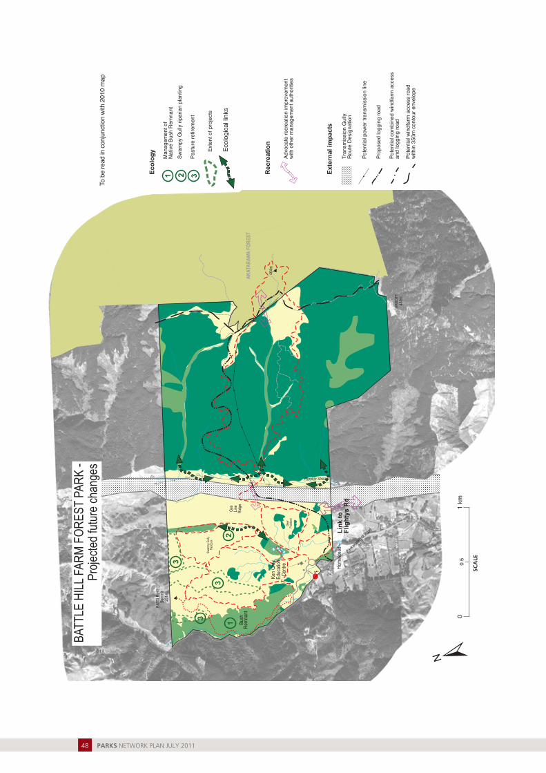
6.2.6 Projectedchanges
Refer to the Map 6 (following pages).• Work towards better recreational linkages
between Akatarawa Forest and Belmont Regional Park through Battle Hill Farm Forest Park.
• Implement a sustainable farm plan including retirement of pasture, nutrient budgets, fencing of waterways and native re-vegetation.
• Work towards improvements in forest health of native bush remnant.
• Proposed logging roads.• Potential wind farm access road
and ancillary underground services. • Work with the New Zealand Transport
Agency with regards to the Transmission Gully route and other agencies to: (a) ensure recreation and management access links across the park and (b) advocate for a non-motorised/shared track from the park towards Haywards Hill Road.
6.2.7 Parkmaps
The following pages contain: • Map 5: Battle Hill Farm Forest Park in 2010• Map 6: Battle Hill Farm Forest Park
projected future changes.
Formoreinformation
Battle Hill Sustainable Farm Plan (Hanford, 2009)
Battle Hill Farm Forest Park Resource Statement (Greater Wellington, 2006)
Design Report: Battle Hill Farm (Bowman, 1988)
Battle Hill House Report: conservation assessment (Bowman, 1991)
Graves, Battle Hill: conservation plan (Bowman, 2006)
PARKS NETWORK PLAN JULY 201146

Bush
Rem
nant
Gas
Line
Rid
ge
AK
ATA
RAW
A FO
RES
T
Horokiri Stream
BATT
LE H
ILL
Sum
mit
251m
464m
Ken
Gra
yEd
ucat
ion
Cen
tre Hom
este
ad
Dee
rPa
ddoc
k
Paeka
karik
i Hill R
oad
Swam
py G
ully
Padd
ock
ABBO
TT43
3m
Farm
gra
zing
Lice
nce
Pony
Clu
b
Park
Fac
ilitie
s: T
rack
s
Shar
ed tr
ack
Wal
king
trac
k
Nat
ural
Fea
ture
sN
atur
al v
eget
atio
n
Plan
tatio
n fo
rest
Past
ure
/ gra
ss
Hig
h po
int
Riv
ers
and
stre
ams
Natu
ral a
nd m
an m
ade
pond
s
Park
Fac
ilitie
s: G
ener
al
Maj
or E
ntra
nce
with
sig
nM
inor
Ent
ranc
e w
ith m
ap b
oard
Activ
ity C
entre
has
:In
form
atio
n di
spla
ysC
ar p
ark
Picn
ic a
rea
Toile
ts
Leas
es a
nd L
icen
ces
Cam
ping
Gro
und
Pads
for o
pen
fires
Her
itage
Fea
ture
Pony
Clu
b
Oth
er F
eatu
res
Roa
d
Fore
stry
road
Gat
e
Build
ing
Publ
ic R
eser
ves
(ext
erna
l to
park
)
Pow
er p
ylon
s lin
esPu
blic
road
No
dogs
in p
ark
(Ref
er to
Rul
es)
0.5
1 km
0
BATT
LE H
ILL
FAR
M F
OR
EST
PAR
Kin
201
0
His
toric
grav
es
Col
onia
lFa
rm
Battl
e Si
te
PARKS NETWORK PLAN JULY 2011 47
Bush
Rem
nant
Gas
Line
Rid
ge
AK
ATA
RAW
A FO
RES
T
Horokiri Stream
BATT
LE H
ILL
Sum
mit
251m
464m
Ken
Gra
yEd
ucat
ion
Cen
tre Hom
este
ad
Dee
rPa
ddoc
k
Paeka
karik
i Hill R
oad
Swam
py G
ully
Padd
ock
ABBO
TT43
3m
Rec
reat
ion
Advo
cate
recr
eatio
n im
prov
emen
twi
th o
ther
man
agem
ent a
utho
ritie
s
Ecol
ogy
Man
agem
ent o
fN
ativ
e Bu
sh R
emna
ntSw
ampy
Gul
ly ri
paria
n pl
antin
g
Past
ure
retir
emen
t
1 2 3
Exte
nt o
f pro
ject
s
Ecol
ogic
al li
nks
Exte
rnal
impa
cts
Tran
smis
sion
Gul
lyR
oute
Des
igna
tion
Pote
ntia
l pow
er tr
ansm
issi
on li
ne
Pote
ntia
l win
dfar
m a
cces
s ro
adw
ithin
350
m c
onto
ur e
nvel
ope
Prop
osed
logg
ing
road
Pote
ntia
l com
bine
d w
indf
arm
acc
ess
and
logg
ing
road
Link
toFl
ight
ys R
d
21
3
3
3
0.5
1 km
0
BATT
LE H
ILL
FAR
M F
OR
EST
PAR
K -
Proj
ecte
d fu
ture
cha
nges
To b
e re
ad in
con
junc
tion
with
201
0 m
ap
PARKS NETWORK PLAN JULY 201148