Bath and North East Somerset Council BATH · bath and North east somerset council appointed Urban...
14
UI No: 3596 Date: 09/2010 BATH BUILDING HEIGHTS STRATEGY Bath and North East Somerset Council
Transcript of Bath and North East Somerset Council BATH · bath and North east somerset council appointed Urban...

UI No: 3596 Date: 09/2010
BATH Building HeigHts strategy
Bath and North East Somerset Council

RepoRt pReseNteD by URbaN INItIatIves
statUs FINaL RepoRt
IssUe No. 03
Date IssUeD 29 septeMbeR 2010
FILe NaMe 3596_20100929_buildingHeightsstrategy_v8_pG.indd
aUtHoR sophie Moreton, Matthias Wunderlich, preeti Gulati
RevIeWeD by pRoject DIRectoR
Roisin barrett
appRoveD by DesIGN DIRectoR
Kelvin campbell
© 2010 Urban Initiatives Ltd. all rights reserved this report has been prepared for the exclusive use of the commissioning party and unless otherwise agreed in writing by Urban Initiatives Limited, no other party may copy, reproduce, distribute, make use of, or rely on the contents of the report. No liability is accepted by Urban Initiatives Limited for any use of this report, other than for the purposes for which it was originally prepared and provided.
opinions and information provided in this report are on the basis of Urban Initiatives Limited using due skill, care and diligence in the preparation of the same and no explicit warranty is provided as to their accuracy. It should be noted and is expressly stated that no independent verification of any of the documents or information supplied to Urban Initiatives Limited has been made
1 Fitzroy squarelondon W1t 5Het +44 (0)20 7380 4545f +44 (0)20 7380 4546www.urbaninitiatives.co.uk
contents3596
batH bUILDING HeIGHts
stRateGy
tHe teaM:
URbaN INItIatIves
pRoject DIRectoR:
RoIsIN baRRett
FINaL RepoRt
29 septeMbeR 2010
Executive Summary . . . . . . . . . . . . . . . . . . . . 5
1 Introduction . . . . . . . . . . . . . . . . . . . . . . . . . . 9background . . . . . . . . . . . . . . . . . . . . . . . . . . . . . . 9
Role and status of the strategy . . . . . . . . . . . . . . 9
study area . . . . . . . . . . . . . . . . . . . . . . . . . . . . . . . 9
Report format . . . . . . . . . . . . . . . . . . . . . . . . . . . 11
Who has been involved in the development of the strategy? . . . . . . . . . . . . . . . . . . . . . . . . . . . . . . . 11
policy context. . . . . . . . . . . . . . . . . . . . . . . . . . . . 11
World Heritage Designation . . . . . . . . . . . . . . . . 11
World Heritage site setting study (WHsss). . . 12
World Heritage Management plan 2003 - 2009 12
bath city-wide character appraisal supplementary planning Document (spD) august 2005 . . . . . . . . . . . . . . . . . . . . . . . . . . . . . . . . . . . 12
2 The Bath context . . . . . . . . . . . . . . . . . . . . . 15topography and landscape. . . . . . . . . . . . . . . . . 15
Historical evolution . . . . . . . . . . . . . . . . . . . . . . . 17
Heritage assets . . . . . . . . . . . . . . . . . . . . . . . . . . 23
building heights. . . . . . . . . . . . . . . . . . . . . . . . . . 25
Height, topography + buildings heights. . . . . . . 26
Landmarks. . . . . . . . . . . . . . . . . . . . . . . . . . . . . . 27
views. . . . . . . . . . . . . . . . . . . . . . . . . . . . . . . . . . . 30
Fabric and Function. . . . . . . . . . . . . . . . . . . . . . . 31
planning and development context . . . . . . . . . . 34
3 Building heights strategy . . . . . . . . . . . . . . 39building Height – understanding the general concepts . . . . . . . . . . . . . . . . . . . . . . . . . . . . . . . . 39
General Height and exceptional Height . . . . . . 39
Defining building Height in bath . . . . . . . . . . . . 41
principles of building height strategy . . . . . . . . 41
approach tailored to bath. . . . . . . . . . . . . . . . . . 43
Guiding building Height in bath . . . . . . . . . . . . . 45
Zone 1 - Georgian city. . . . . . . . . . . . . . . . . . . . . 47
Zone 2 - Immediate setting of Georgian city. . . 49
Zone 3 - valley floor . . . . . . . . . . . . . . . . . . . . . . 51
Zone 4 – Hillslopes . . . . . . . . . . . . . . . . . . . . . . . 55
Zone 5 – plateaux . . . . . . . . . . . . . . . . . . . . . . . . 57
4 Glossary . . . . . . . . . . . . . . . . . . . . . . . . . . . 59
5 References . . . . . . . . . . . . . . . . . . . . . . . . . . 59
Appendix A: building height analysis . . . . . . . . . . . . . . . . . . . 61
Appendix B: assessment of oUv in relation to height . . . . . 71
Appendix C: view appraisal . . . . . . . . . . . . . . . . . . . . . . . . . . . 81
Appendix D:High Level character appraisal. . . . . . . . . . . . . 91

5BatH BuIlDInG HEIGHTS STuDy
execUtIve sUMMaRy
the overall purpose of the strategy is to provide a framework within which decisions can be made about the appropriate height of new buildings in bath. It will be used as a development management tool and, has been compiled in such a way that it can be transformed into a supplementary planning Document.
bath is intrinsically linked to its landscape setting with spectacular topography offering stunning views of the city which enable an appreciation of its visual coherence and richness of its Georgian townscape. equally there are views of the surrounding hills and plateaux from within the city. this study undertook a detailed views analysis and understanding of the existing heights, architecture and landmarks of bath. the strategy is informed by a range of other
baseline parameters such as historical evolution, topography and planning constraints.
based on this analysis five zones were identified within the study area. the building Height strategy is based on heritage asset analysis and provides guidance on the appropriate height of new development for each of these zones to ensure the protection of the outstanding Universal values (oUv) which define the World Heritage site, whilst allowing the growth of bath to meet housing needs and realising opportunities for business investment.
The beauty and richness of the townscape, landscape and heritage of Bath are universally recognised by its designation as a World Heritage Site. With an intricate and long history Bath remains a living city with the demands of a growing population. It is paramount that its rich character is not compromised when accommodating this growth.bath and North east somerset council appointed Urban Initiatives to prepare this building Height strategy for the area of bath covered by the World Heritage site designation.

6
AREA AREA DEfInITIon
RATIonAlE/ConTExT oBjECTIvES HEIGHT RECommEnDATIonS CRITERIA foR upwARD moDIfIERS
CRITERIA foR DownwARD moDIfIERS
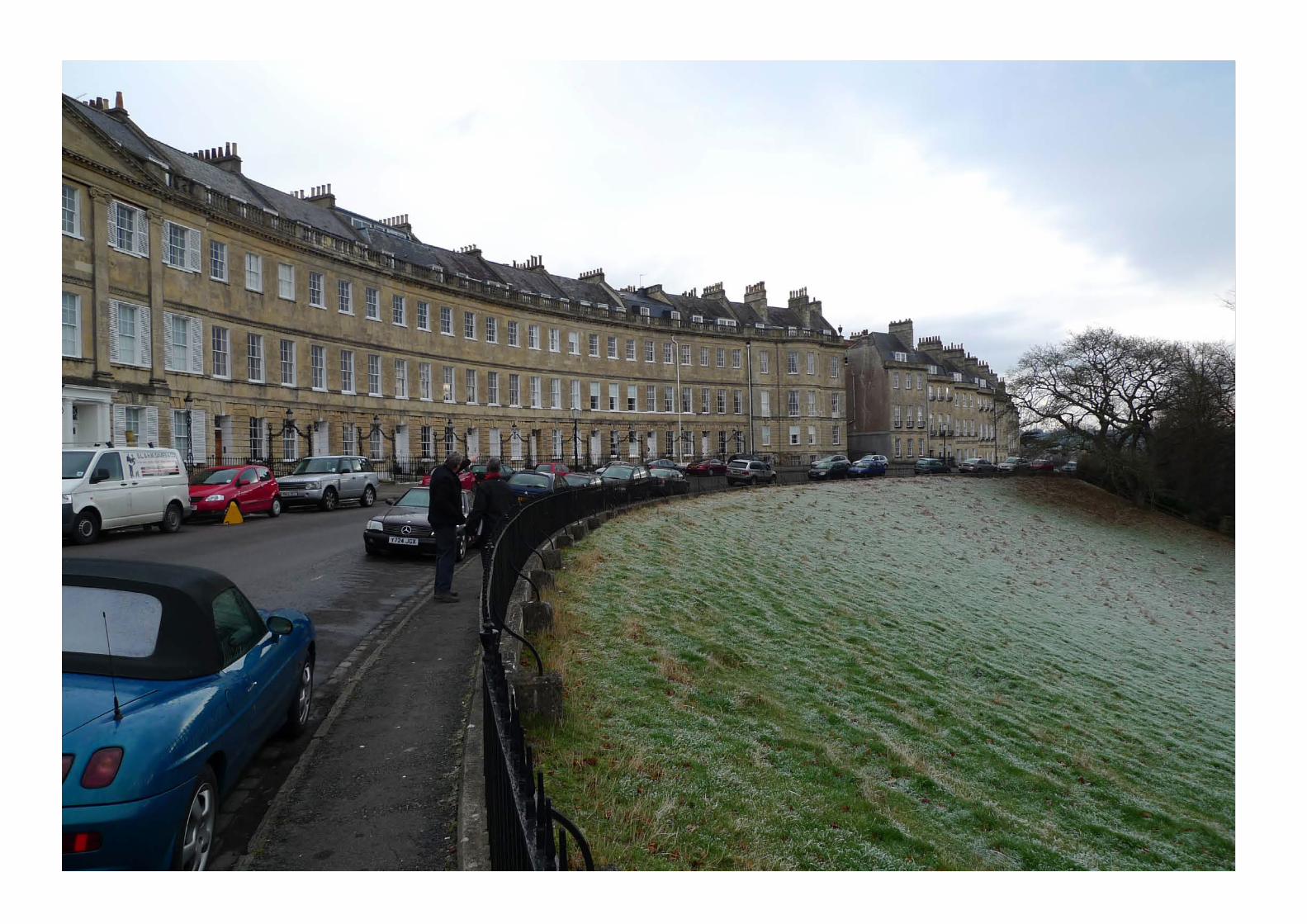
Georgian City (figure 3 .2)
Development sites in the Georgian city, as recorded by 1852 plan of bath (adjusted to remove redeveloped sites).
Much of the oUv refers to Georgian bath in terms of:
Georgian fabric and location of city •contained within a valley.
the relationship between the built •environment, topography and the landscape.
the typical pattern of the Georgian •urban form of street blocks and terraces.
to preserve and/or enhance the •character and appearance of the Georgian city.
building shoulder height should not be less •than or exceed the prevailing cornice height of nearby Georgian buildings.
one additional setback storey behind parapet •within the roofscape is generally acceptable. Roofscape should normally take its design cues from nearby Georgian buildings (including parapet, pitch, sub-division and materials).
Rear extensions and buildings in interior of •urban blocks generally should be lower than principal buildings along the street.
the overall height should not be less than or •exceed the overall prevailing height of nearby Georgian buildings.
Not recommended. • Not recommended. •
Immediate setting of Georgian City (figure 3 .3)
character areas adjacent to the Georgian city that provide the immediate setting to Georgian city as recognised by the oUv.
Urban areas containing some •Georgian elements, but generally developed since Georgian times.
character is defined by built form •interspersed with large areas of open land and with significant tree cover.
the landscape setting of Georgian •development and the immediate context / backdrop to many oblique aerial views onto Georgian city.
to preserve and/or enhance the •landscape setting of the Georgian city in terms of its openness, degree and type of landscape features, siting and orientation of development and visual relationships between built form and landscape.
to maintain the visual coherence of •the Georgian city by avoiding visually outstanding buildings.
building shoulder height of new development •should not exceed shoulder height of nearby buildings.
the overall height should not exceed the •overall height of nearby buildings.
In suburban single •storey residential areas 1 additional storey may be possible providing the resulting building does not intrude in views and preserves or enhances the green character of the area.
It may be necessary •for the height to be less than the shoulder height of nearby buildings in response to heritage assets and to prevent intrusion in views.
valley floor (figure 3 .4)
Flat valley floor below the 30m contour line not already designated as Georgian city or Immediate setting of the Georgian city.
the heritage assets in the valley •floor are limited and much altered over time. It is visually distinct from the Georgian city with a fragmented townscape and a variety of building heights.
opportunity to maximise •development potential while ensuring the protection of the oUv of the Georgian city and its primacy within the urban form.
the Georgian city centre with its •compact urban form provides the highest densities in bath and should provide a good model for new urban development.
to preserve and/or enhance the •landscape setting of the Georgian city in terms of its openness, degree and type of landscape features, siting and orientation of development and visual relationships between built form and landscape
to maintain the visual coherence of •the Georgian city by avoiding visually outstanding buildings.
to protect, manage and plan •appropriately for a green and treed river corridor in support of the oUv and sNcI designation of the river and its corridor.
to maximise the regeneration potential •of the valley floor and support sustainable development.
building shoulder height should be 4 storeys. •one additional setback storey within the roofscape is likely to be acceptable.
1 additional storey •may be acceptable along Lower bristol Road except where it is in close proximity to existing 2-3 storey residential areas.
1 additional storey •may be appropriate fronting public space and marking key locations such as corners or gateways and mixed use centres.
It may be necessary •for the height to be less than 4 storeys in response to heritage assets, residential amenity and to prevent intrusion in views.

7BatH BuIlDInG HEIGHTS STuDy
AREA AREA DEfInITIon
RATIonAlE/ConTExT oBjECTIvES HEIGHT RECommEnDATIonS CRITERIA foR upwARD moDIfIERS
CRITERIA foR DownwARD moDIfIERS
Hillslopes (figure 3 .5)
Hill slopes are defined as the area above the 30m contour line up to the edge of plateaux.
Hillslopes are visually present •from within the city, including the Georgian city and form the backdrop to many views.
character is defined by built form •interspersed with large areas of open land and with significant tree coverage with open countryside prevailing on the upper halves of hillslopes.
to preserve and/or enhance the •character and appearance of green hillslopes and skylines as an integral element of the oUv.
to enhance views into the Georgian city. •
building shoulder height of new development •should not exceed prevailing shoulder height in the area.
the overall height should not exceed the •prevailing overall height in the area.
In suburban single •storey residential areas 1 additional storey may be possible providing the resulting building does not intrude in views and retains or enhances the green character of the area.
It may be necessary •for the height to be less than the shoulder height of nearby buildings in response to heritage assets and to prevent intrusion in views.
plateaux (figure 3 .6)
contour lines at the edges of the plateaux of Lansdown, bathampton Down, claverton Down, odd Down, combe Down
(excludes southdown plateau as it is almost completely developed with suburban development)
Development on plateaux has •expanded along routes and around historic villages.
Development on the plateaux is •usually not visible in views from locations in the valley, on hill slopes or even plateaux. this reinforces the oUv and character of bath as a city contained by the countryside and hidden in a valley.
Development that would be high •enough to be visible above the tree cover, or too close to the edge of plateaux, would be detrimental to the oUv.
to protect and enhance the green and •tree covered appearance of plateaux.
to prevent visual intrusion of •development into views from the urban fabric out towards the hills.
to prevent visual intrusion of •development into views from hills and plateaux onto the Georgian city and wider bath and its setting.
building shoulder height of 2 storeys. •
one additional setback storey is generally •acceptable.
at the University of bath campus the •recommended shoulder height is 4 storeys.
1 additional storey •could be acceptable where it aids legibility, for example local centres, creates better ewnclosure or provides regeneration benefits and does not intrude into views onto plateaux by exceeding the height of the tree cover.
1 - 2 additional storeys •above 4 storeys may be acceptable within the University campus providing the buildings do not detract in townscape and panoramic views of the Georgian city and are not visible in any important views particularly in the views from alexandra park.
Not recommended. •


9BatH BuIlDInG HEIGHTS STuDy
INtRoDUctIoN1
BaCkgrouNdbath and North east somerset council appointed Urban 1.1
Initiatives to prepare this building Height strategy for the area of bath covered by the World Heritage site designation. the building Height strategy is based on heritage asset analysis and provides area-based guidance on the appropriate height of new development to ensure the protection of the outstanding Universal values (oUvs) which define the World Heritage site, whilst allowing the growth of bath to meet housing needs and realising opportunities for business investment.
the building Height strategy forms part of the evidence base 1.2
for bath and North east somerset’s core strategy, which is currently being prepared. the building Height strategy has been informed by the wealth of information on the heritage of bath, including the World Heritage site setting study, World Heritage site Management plan (2003) and bath city-Wide character appraisal spD, august 2005.
rolE aNd STaTuS of THE STraTEgythe overall purpose of the strategy is to provide a framework 1.3
within which decisions can be made about the appropriate height of new buildings in bath. It will be used as a development management tool and, as such, will be one consideration in the determination of planning applications. the recommen-dations in this strategy will need to be balanced against all other considerations that may influence building height such as the provision of homes and business floor space to meet economic regeneration imperatives, urban design, character of conservation areas and setting of listed buildings. In addition the strategy has been compiled in such a way that it can be used as the basis for a supplementary planning Document.
STudy arEathe study area is the boundary of the World Heritage site, as 1.4
shown in Figure 1.1.

10
figure 1.1: Study area
STUDY AREA

11BatH BuIlDInG HEIGHTS STuDy
rEporT formaTthis report is set out in a number of sections that cover the 1.5
following:
the bath context �the building Heights strategy �Glossary and References �appendices �
to keep the main document easy to read the detailed evidence 1.6
base used to inform the strategy has been included in a series of appendices.
WHo HaS BEEN INvolvEd IN THE dEvElopmENT of THE STraTEgy?
a group of council and external stakeholders representing 1.7
heritage, regeneration, landscape, planning policy, development management, architecture, urban design, housing, bath University and residents along with elected Members attended two workshop sessions at key stages in the development of the project. their input has been invaluable in informing this final strategy and a full account of their comments can be found in the consultation report, which accompanies this strategy.
polICy CoNTExTthe building Heights strategy is an independent evidence base 1.8
to inform the development of policy, rather than supporting a particular policy direction. However, a number of documents in particular have provided valuable information sources and these are listed and summarised below.
World HErITagE dESIgNaTIoNbath was designated a World Heritage site in 1987 in 1.9
recognition of a place with outstanding universal values.
outstanding universal value, here on referred to as ‘oUv,’ 1.10
means ‘cultural and/or natural significance which is so exceptional as to transcend national boundaries and to be of common importance for present and future generations of all humanity.’ (paragraph 49 of the operational Guidelines for the Implementation of the World Heritage convention, UNesco).
the city of bath is of oUv for the following cultural attributes:1.11
the Roman remains, especially the temple of sulis Minerva �and the baths complex (based around the hot springs at the heart of the Roman city of aquae sulis, which have remained at the heart of the city’s development ever since) are amongst the most famous and important Roman remains north of the alps, and marked the beginning of bath’s history as a spa town.
the Georgian city reflects the ambitions of john Wood senior, �Ralph allen and Richard “beau” Nash to make bath into one of the most beautiful cities in europe, with architecture and landscape combined harmoniously for the enjoyment of the spa town’s cure takers.
the Neo-classical style of the public buildings (such as the �assembly Rooms and the pump Room) harmonises with the grandiose proportions of the monumental ensembles (such as Queen square, circus and Royal crescent) and collectively reflects the ambitions, particularly social, of the spa city in the 18th century.
the individual Georgian buildings reflect the profound �influence of palladio, and their collective scale, style and the organisation of the spaces between buildings. It demonstrates the success of architects such as the john Woods, Robert adam, thomas baldwin and john palmer in transposing palladio’s ideas to the scale of a complete city; a city situated in a hollow in the hills and built to a picturesque landscape aestheticism which creates a strong garden city feel, more akin to the 19th century garden cities than the 17th century Renaissance cities.
Top: The Circus, an example of a monumental ensemble
Bottom: The roman Baths

12
World HErITagE maNagEmENT plaN 2003 - 2009
the Management plan was produced as a partnership 1.19
document by b & Nes council and english Heritage. It was prepared in response to a need to actively manage World Heritage sites. a replacement plan is currently underway.
the Management plan is to be used by, and to co-ordinate the 1.20
activities of, the council and the many other individuals and organisations involved in the management of the World Heritage site.
the Management plan was particularly useful in understanding 1.21
the wide range of issues affecting the World Heritage site.
BaTH CITy-WIdE CHaraCTEr appraISal SupplEmENTary plaNNINg doCumENT (Spd) auguST 2005
this supplementary planning Document (spD) presents the 1.22
results of the bath city-wide character appraisal which was carried out in 2004 and 2005. the study was prepared to assist a range of stakeholders in understanding the character of the city, its setting and its component parts. It also provides the context for more detailed assessments which will be needed to inform specific proposals and for studies such as the bath conservation area character appraisal.
the spD identifies 22 character areas within bath and provides 1.23
a detailed character appraisal including physical influences, architectural details, materials, streets and civic spaces, features, landmarks and views and cultural influences within these character areas.
the document was very useful in baseline analysis and 1.24
understanding the character and significance of bath. this building Height strategy adopts the character areas as defined by the spD. It particularly benefited from the analysis of building height, typologies, character and assessment of landmarks by character area.
Full details of bath’s value set out under the four inscription 1.12
criteria for World Heritage sites can be found in the city of bath World Heritage site statement of oUv.
Given the UNesco requirement to permanently protect the 1.13
heritage within a World Heritage site an understanding of bath’s oUv and in particular how sensitive these values are in relation to changes in building height was an important element of the baseline work for this strategy.
In summary, out of the four cultural attributes listed above it 1.14
is the Georgian city as a whole and its individual buildings or set pieces and the landscape setting that are most sensitive to changes in building height. potential impacts of out of scale buildings include detracting from:
18th century architecture, from the coherence of 18th century �ensembles and façades;
the typical scale and grain of Georgian development and its �relationship with, and setting in, the landscape;
the overall collective coherence of the Georgian city; �
the perception and experience of the historic city and its �landscape and topographical setting which is particularly sensitive for views from and onto the 18th century city and its landscape and topographic setting, and historic road views;
a full assessment of the implications of the building height on 1.15
the oUv is included in appendix 2.
World HErITagE SITE SETTINg STudy (WHSSS)
the World Heritage site setting study (WHsss) was prepared in 1.16
october 2009 by the council to define the key characteristics of the setting, study the extent of the setting and provide guidance of how to carry out impact assessments.
the study considers three types of setting:1.17
Landscape and topographic setting; �visual setting; and �Historical setting. �
the study has been particularly useful for the building Heights 1.18
study in understanding the importance of views in defining the character of bath and their role in bath’s oUv.
Top: Widcombe
Bottom: Twerton

13BatH BuIlDInG HEIGHTS STuDy
figure 1.2 Character areas
Weston1
Weston park, sion Hill and Upper 2
Lansdown
Fairfield park and Larkhall3
Newbridge, combe park and 4
Lower Weston
Lower Lansdown and camden5
Grosvenor and Lambridge6
brassmill Lane, Locksbrook and 7
Western Riverside
city centre8
bathwick9
Widcombe and Kennet & avon 10
canal
bathampton11
twerton, Whiteway, southdown 12
and Moorlands
bear Flat and oldfield park13
pulteney Road14
North Road and cleveland Walk15
bathampton slopes16
beechen cliff and alexandra park17
entry Hill, perrymead and prior 18
park
bathampton Down and claverton 19
Down
odd Down20
Foxhill21
combe Down22