Batemans Bay Bridge replacement project
46
Batemans Bay Bridge replacement project Community consultation report for the Urban Design and Landscape Plan Transport for NSW | September 2021
Transcript of Batemans Bay Bridge replacement project

Batemans Bay Bridge replacement project Community consultation report for the Urban Design and Landscape Plan
Transport for NSW | September 2021

THIS PAGE LEFT INTENTIONALLY BLANK ISBN: 978-1-922549-28-0

iii | Batemans Bay Bridge replacement project UDLP consultation report
Batemans Bay Bridge replacement – artist’s impression.
Executive summary
Transport for NSW (Transport) is building a replacement bridge over the Clyde River at
Batemans Bay, and demolishing the existing bridge. The NSW Government is funding the
$274 million project.
The replacement bridge will improve freight access, reduce traffic delays in peak periods at
the Kings and Princes Highway intersection, reduce economic and social impacts by
removing the current lift span bridge, and will improve traffic, pedestrian and cyclist
connections in and around Batemans Bay.
The UDLP describes how the new design elements of the Project will look and provides
important information about design refinements carried out since the exhibition of earlier
reports and preliminary designs.
A major consideration in the Project’s UDLP was to provide flexible spaces that would not
prohibit future development or activation initiatives. Areas of the southern and northern
Clyde River foreshores being upgraded are designed to be implemented as part of project
completion by early 2023, weather permitting.
The UDLP defines key design features of the landscaping, including foreshore designs, and
will:
Optimise the amount of green and parking spaces
Provide more recreational and children’s play areas
Provide better pedestrian, cyclist, and river user access to water and amenities
Open up opportunities for events
Deliver new cultural features including a public mural and sculpture.

iv | Batemans Bay Bridge replacement project UDLP consultation report
A key Project requirement is the preparation of the UDLP which has taken into consideration
important factors relating to environmental mitigation, landscape management and the
heritage and cultural values of the local setting.
In recognition of the community focus on improved foreshores as part the Project, and in
support of community feedback received in the EIS Submissions Report, Transport for NSW
implemented and coordinated a Foreshore Advisory Committee (FAC). The FAC met and
discussed foreshore improvements on six occasions between October 2018 and May 2019.
As part of the finalisation of the UDLP, FAC suggestions were considered and where possible
were applied to the final foreshore designs for wider community consultation.
Feedback was sought from the local Council, key stakeholder groups and the wider
community in relation to the urban design and landscape design components of the Project.
The four-week consultation period for the UDLP took place between Monday 17 June and
Friday 12 July 2019.
Purpose of this report
This community consultation report relates to the Batemans Bay Bridge Urban Design and
Landscape Plan (UDLP) and should be read in conjunction with that document.
This report provides a summary of the community and stakeholder consultation carried out
during the display of the UDLP. The report provides information about the consultation
process, feedback received and how this feedback will be addressed in the further design
development of the Project.
Submissions received
A total of 62 submissions were received during the exhibition period. Submissions were
received by email, online survey or in person during staffed displays or information
sessions.
Common issues raised in submissions
There were a number of issues raised in the submissions, broadly categorised as:
1. Bridge design
2. Northern Foreshore
Boat ramp
Landscaping and green space
Pedestrian and cyclist access
Parking and traffic flow
Playground
Mural
Other facilities
v | Batemans Bay Bridge replacement project UDLP consultation report
3. Southern Foreshore
Sculpture
Greenspace and beach access
Event space
Wharf and floating pontoon
Viewing and fishing platform
Boat ramp
Parking and traffic flow
Pedestrian and cyclist access
Other facilities
4. Not in scope
5. Community consultation
Next steps
The design of the Batemans Bay Bridge replacement project has been finalised.
The feedback received during the display of the Urban Design and Landscape Plan informed our
approach to the urban design and landscaping and foreshore design and amenities.

vi | Batemans Bay Bridge replacement project UDLP consultation report
Contents
Executive summary ............................................................................ 3
Purpose of this report......................................................................................................................... 4
Submissions received ........................................................................................................................ 4
Next steps .......................................................................................................................................... 5
1 Introduction .................................................................................... 8
1.1 Project background ..................................................................................................................... 8
1.2 Urban Design and Landscape Plan ............................................................................................ 9
1.3 Purpose of this report ............................................................................................................... 10
2 Consultation approach ................................................................ 12
2.1 Consultation objectives ............................................................................................................. 12
2.2 How consultation was carried out ............................................................................................. 13
3 Submissions and responses ....................................................... 15
3.1 Bridge design ............................................................................................................................ 15
3.2 Northern Foreshore .................................................................................................................. 16
3.3 Southern Foreshore .................................................................................................................. 25
3.4 Community consultation ............................................................................................................ 37
4 Online interactive survey ............................................................. 38
Survey results .................................................................................................................................. 38
5 Next steps ................................................................................... 41
Appendix A ....................................................................................... 42
Northern Foreshore ..................................................................................................................... 432
Appendix B ...................................................................................... 43
Southern Foreshore..................................................................................................................... 443
Appendix C ....................................................................................... 44
New Floating Pontoon ................................................................................................................. 454

vii | Batemans Bay Bridge replacement project UDLP consultation report
Appendix D ....................................................................................... 45
Southern Foreshore Fishing & Viewing Platform ...................................................................... 465
Appendix E ....................................................................................... 46
Bridge Design ................................................................................................................................ 46
8 | Batemans Bay Bridge replacement project UDLP – Community Consultation Report
1 Introduction
1.1 Project background
The Batemans Bay Bridge replacement project (the Project) consists of a new four lane bridge, two lanes each direction, to the west of the existing bridge, and removal of the existing bridge. The Project will improve access to Batemans Bay and surrounding areas, allow access for larger trucks, reduce traffic delays and improve the Kings Highway / Princes Highway intersection.
Important components of the Project include modifications to areas of the northern and southern foreshores of the Clyde River that are impacted during construction of the new bridge and removal of the existing bridge. This includes parking facilities, recreational areas, local road adjustments, access to the foreshore for pedestrians, cyclists and river users, landscaping and design considerations to allows for current and future cultural, business and recreational opportunities.
The NSW Government is funding the $274 million upgrade, the majority of the proposal is subject to assessment under Division 5.1 (formerly Part 5) of Environmental Planning and Assessment Act 1979 (EP&A Act).
Community feedback has been sought at stages throughout the project to help inform the design of the new bridge and foreshore areas as part of the Project. Between Friday 4 August and Friday 1 September 2017 the preferred option was displayed to the public with 253 respondents providing feedback on topics of visual design, intersections, pedestrian and cyclist access and the foreshore boating and fishing facilities.
A review of environmental factors (REF) was prepared for the Batemans Bay Bridge replacement on November 2017. The Project REF was placed on public display between 8 November and 7 December 2017 for community and stakeholder comment. A submissions report, dated May 2018, was prepared to respond to issues raised.
An environmental impact statement (EIS) was also published for the Project in November 2017, as a small part of the Project is located in an area to which State Environmental Planning Policy No. 14 – Coastal Wetlands (SEPP 14) (now repealed) applied. Development consent for this part of the Project was issued by Eurobodalla Shire Council in May 2018.
In addition, the following addendum REF documents and REF Consistency Reviews have been approved for the Project:
Batemans Bay Bridge replacement – former bowling club demolition Addendum REF 1
(September 2018)
Batemans Bay Bridge replacement REF Consistency Review 1 – Kings Highway slip lanes and
utility adjustment works (January 2019)
Batemans Bay Bridge replacement – precast ancillary facility Addendum REF 2 (March 2019)
Batemans Bay Bridge replacement REF Consistency Review 5 – Stockpile on Kings Highway
(April 2019)
Batemans Bay Bridge replacement REF Consistency Review 4 – Pier 1 temporary working
platform and temporary Bailey bridge (May 2019)
Batemans Bay Bridge replacement REF Consistency Review 3 – Detailed design changes 1
(October 2019)
Batemans Bay Bridge replacement – New floating pontoon Addendum REF 3 (May 2020)

9 | Batemans Bay Bridge replacement project UDLP – Community Consultation Report
1.2 Urban Design and Landscape Plan
A key Project requirement is the preparation of the UDLP which takes into consideration
important factors relating to environmental mitigation, landscape management and the
heritage and cultural values of the local setting.
The UDLP supports the Project’s detailed design and the commitments made in the EIS
Report, the REF and the, REF Submissions Report and related addendum REF documents
and consistency reviews.
The UDLP describes how the new design elements of the Project will look and provides
important information about design refinements carried out since the exhibition of the REF,
EIS and preliminary designs.
The UDLP is not part of Eurobodalla Shire Council’s Batemans Bay Waterfront Master Plan
and Activation Strategy, which is a flagship project for the council to identify opportunities to
activate the Batemans Bay Waterfront along a strategically planned foreshore in the future.
Council displayed the draft Waterfront Master Plan and Activation Strategy in July 2020 for
community input. Council’s draft strategy has been informed by Transport’s plans for the
Batemans Bay Bridge replacement project.
A major consideration in the Project’s UDLP was to provide flexible spaces that would not
prohibit future development or activation initiatives. Areas of the southern and northern
Clyde River foreshores being upgraded are designed to be implemented as part of project
completion by early 2023, weather permitting. Transport for NSW understands Eurobodalla
Shire Council’s Batemans Bay Waterfront Master Plan and Activation Strategy is a council
initiative to identify opportunities to activate the Batemans Bay Waterfront along a
strategically planned foreshore in the future.
The UDLP defines key design features such as local road modifications, parking, pathways,
toilet and other facilities, landscaping and foreshore amenity. It is an important consultation
document, outlining key information that has guided the detailed design phase of the Project.
The urban and landscape design objectives are to:
1. Achieve a Project that fits sensitively with the existing landscape characteristics and
scenic qualities of the Batemans Bay Bridge and Clyde River setting
2. Achieve an integrated design form and character that optimises the natural and built
adjoining areas
3. Achieve a design that efficiently utilises elements that optimise visual opportunities and
require minimal maintenance
4. Protect the integrity of the heritage and cultural values of the Batemans Bay Bridge
location
5. Contribute to the accessibility and connectivity in and around Batemans Bay CBD and
the Clyde River foreshores
6. Create a Project that facilitates future development and revitalisation of the Batemans
Bay foreshores.
In recognition of the community focus on improved foreshores as part the Project, and in
support of community feedback received in the EIS Submissions Report, Transport for NSW
implemented and coordinated a Foreshore Advisory Committee (FAC). The FAC met and

10 | Batemans Bay Bridge replacement project UDLP – Community Consultation Report
discussed foreshore improvements on six occasions between October 2018 and May 2019.
As part of the finalisation of the UDLP, FAC suggestions were considered and where possible
were applied to the final foreshore designs for wider community consultation.
Feedback was sought from the local Council, key stakeholder groups and the wider
community in relation to the urban design and landscape design components of the Project.
The four-week consultation period for the UDLP took place between Monday 17 June and
Friday 12 July 2019.
1.3 Purpose of this report
This community consultation report is an Appendix to the Batemans Bay Bridge Urban Design
and Landscape Plan (UDLP) and should be read in conjunction with that document.
This report provides a summary of the community and stakeholder consultation carried out
during the display of the UDLP. The report provides information about the consultation
process, feedback received and how this feedback will be addressed in the further design
development of the Project.
Foreshore Advisory Committee (FAC)
The Foreshore Advisory Committee had an important role in advising the Project on the
foreshore designs that were included in the community consultation process.
The FAC consisted of key stakeholder group representatives and selected community
members, who were assisted by technical advice from local and state government
organisations and the project contractor, John Holland.
Key stakeholder groups represented on the committee included representatives from
Eurobodalla Shire Council, fishing and boating groups, local Aboriginal groups, disability
groups, the wider community and local business operators. FAC members also sought
and documented the advice and views from their networks.
The FAC proposed the northern foreshore be a natural landscape with a more urban
approach for the southern foreshore, all of which provide better connection to the river and
town centre.
The committee’s considerations provided the basis for the designs displayed during
community consultation.
Public exhibition
The UDLP was exhibited on the Project website in June and July 2019, and staffed pop-up
displays were held at the Batemans Bay CBD foreshore, the project’s Community Display
Centre, and the Village Centre shopping complex in the Batemans Bay CBD in late June
2019.
Unstaffed displays were located at the Community Display Centre in Batemans Bay,
Eurobodalla Shire Council offices in Moruya, and at the Batemans Bay Library located at
Hanging Rock.
Attendees at these pop-up displays were able to view hard copies of the UDLP and were

11 | Batemans Bay Bridge replacement project UDLP – Community Consultation Report
provided with information about how to access the online version and provide feedback via
an online interactive community survey.
Details about the UDLP and community feedback period were the focus of a brochure and
postcard, mailed widely across the Batemans Bay area and issued to the almost 700
stakeholders on the project’s email distribution database in June 2019. The brochure and
postcard were uploaded to the Project website in early June 2019.
A media event was held on the Batemans Bay southern foreshore on 14 June 2019,
where the NSW Minister for Transport and Roads and Member for Bega, the Hon. Andrew
Constance MP, announced the community consultation period, and a media release was
issued.
Direct consultation
Emails were sent to the Project’s community database on 14 June 2019. The Project
database contains 700 email addresses for people who have previously expressed an
interest in receiving email updates about the Project.
The Project team distributed brochures and postcards to businesses and residents located
close to the Project. The documents contained an invitation to view the UDLP online and
provided details on how feedback could be submitted. These cards also contained details
about upcoming staffed displays to view the UDLP in hard copy. A copy of the postcard is
included below.

12 | Batemans Bay Bridge replacement project UDLP – Community Consultation Report
While the Foreshore Advisory Committee was made up of a wide range of stakeholder
groups, additional targeted information sessions were held with further key stakeholder
groups to provide information on the UDLP and gather feedback, including:
Table 1: Key stakeholder meetings held during UDLP display
Stakeholder group Date of meeting Number of
attendees
Accessibility Two meetings on 1 July 2019 5
Aboriginal Elders 17 June 2019 3
Tourism & Event Organisers 2 July 2019 3
Mothers & Play Groups 4 July 2019 3
2 Consultation approach
2.1 Consultation objectives
The UDLP was placed on public display from Monday 17 June 2019 to Friday 12 July
2019.
The purpose of the community consultation was to:
Inform community members and stakeholders about the design refinements made since
publication of the EIS, REF – and related addendum REF documents and consistency

13 | Batemans Bay Bridge replacement project UDLP – Community Consultation Report
reviews – and through the Foreshore Advisory Committee process
Seek comment, feedback, ideas and suggestions from the community to be
considered to further refine the Project’s urban and landscape design including the
foreshores
Provide an opportunity for the community to meet with the project team to ask
questions about the Project and provide feedback on the UDLP
Expand the Project’s existing database of community members and stakeholders for
Transport for NSW to engage with through the construction of the Batemans Bay
Bridge replacement
Provide information about next steps in the Project.
2.2 How consultation was carried out
A number of events and consultation activities were delivered so members of the community
could learn more about the Project, meet the project team, and have their say. A list of the
key activities is provided in Table 2-1.
Community members were encouraged to provide feedback, leave comments, and make
submissions at information sessions or via mail, email or phone contact with the project
team. The community was able to contact the project team by:
Email: [email protected]
Phone: 1800 870 119 (toll free)
Website: https://www.rms.nsw.gov.au/projects/batemans-bay-bridge/index.html
Mail: Batemans Bay Bridge replacement project, 2 Vesper Street, Batemans Bay NSW 2536
Table 2-1: Consultation activities
Activity type Details of activity
Media event and media
release
A media event was held in Batemans Bay on 14 June 2019 where the NSW Minister for Transport and Roads and Bega MP, Andrew Constance, announced the community consultation period. A media release was distributed to all major regional publications on 14 June 2019 encouraging local community members and stakeholders to get involved in the consultation process.
Brochure and postcard
A community brochure and postcard were distributed via a letterbox drop across Batemans Bay and were emailed to the Project email distribution list in the week commencing 14 June 2019.
Static displays
An A3-sized colour printout of the UDLP along with multiple copies of the brochure and postcard were displayed at Batemans Bay Library (Hanging Rock), the Project’s Community Display Centre (Batemans Bay) and the Eurobodalla Shire Council offices (Moruya) from 14 June to 12 July 2019.
14 | Batemans Bay Bridge replacement project UDLP – Community Consultation Report
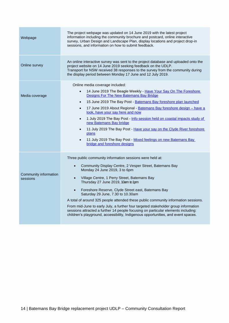
Webpage
The project webpage was updated on 14 June 2019 with the latest project information including the community brochure and postcard, online interactive survey, Urban Design and Landscape Plan, display locations and project drop-in sessions, and information on how to submit feedback.
Online survey
An online interactive survey was sent to the project database and uploaded onto the project website on 14 June 2019 seeking feedback on the UDLP. Transport for NSW received 38 responses to the survey from the community during the display period between Monday 17 June and 12 July 2019.
Media coverage
Online media coverage included:
14 June 2019 The Beagle Weekly - Have Your Say On The Foreshore Designs For The New Batemans Bay Bridge
15 June 2019 The Bay Post - Batemans Bay foreshore plan launched
17 June 2019 About Regional - Batemans Bay foreshore design – have a look, have your say here and now
1 July 2019 The Bay Post - Info session held on coastal impacts study of new Batemans Bay bridge
11 July 2019 The Bay Post - Have your say on the Clyde River foreshore plans
11 July 2019 The Bay Post - Mixed feelings on new Batemans Bay bridge and foreshore designs
Community information sessions
Three public community information sessions were held at:
Community Display Centre, 2 Vesper Street, Batemans Bay Monday 24 June 2019, 3 to 6pm
Village Centre, 1 Perry Street, Batemans Bay Thursday 27 June 2019, 10am to 1pm
Foreshore Reserve, Clyde Street east, Batemans Bay Saturday 29 June, 7.30 to 10.30am
A total of around 325 people attended these public community information sessions.
From mid-June to early July, a further four targeted stakeholder group information sessions attracted a further 14 people focusing on particular elements including: children’s playground, accessibility, Indigenous opportunities, and event spaces.

15 | Batemans Bay Bridge replacement project UDLP – Community Consultation Report
3 Submissions and responses
Submissions were received from a range of sources including community members,
businesses, authorities, schools, government agencies and special interest groups.
A total of 62 submissions were received during the exhibition period. Submissions were
received by email, online survey or in person during staffed displays or information sessions.
Table 3-1: Method and number of submissions received
Method received Number of submissions
Email 17
Online survey response 38
In person (including key issues raised by
multiple people at information sessions)
7
The following tables detail the issues raised in submissions received during the consultation period and the project team’s responses to each issue.
3.1 Bridge design
Table 3.1-1: Submissions relating to bridge design
Submission reference number
Issue/s Response
1.1
A request was received in relation to safeguards being included that would prevent people from fishing or jumping into the river.
Regulatory signage and pedestrian barriers will be provided on the bridge to discourage people from climbing, throwing or jumping from the bridge. The height of the bridge is 12m-16m above water level which will also deter fishing and jumping. The southern foreshore will incorporate a new fishing platform and stair access to water level. (Refer to Appendix E)
1.2 1.5
Some suggestions were received regarding lighting. A suggestion was made that bridge lights should be colourful, and a comment submitted that any new lights do not conflict with lights required in event spaces.
Feature lighting is still being considered and will be evaluated based on a balance of community feedback and potential safety, technical and maintenance impacts.

16 | Batemans Bay Bridge replacement project UDLP – Community Consultation Report
1.3 A submission was received requesting drinking facilities at both ends of the bridge.
Stainless steel polished sculptural drinking fountains for people will be located near the bridge on both foreshores. The drinking fountains will have an integrated drinking bowl for pets closer to ground level.
1.4 A request to consider the finish of the handrails along the bridge, how do they feel for people with disabilities?
The shared user path includes a handrail that is compliant with Australian Standards in accordance with the Disability Discrimination Act 1992 (AS1428.1-2001). All handrails will be rounded and made from stainless steel with a smooth finish.
3.2 Northern Foreshore
Changes referred to in the table below are shown in Appendix A

17 | Batemans Bay Bridge replacement project UDLP – Community Consultation Report
Table 3.2-1: Submissions relating to the Northern Foreshore
Boat ramp
Submission reference number
Issue/s Response
2.1.1 2.1.2 2.1.3 2.1.4 2.1.5 2.1.6 2.1.7 2.1.8 2.1.9 2.1.10 2.1.11 2.1.12 2.1.13 2.1.14 2.1.15
There were 14 requests received in relation to upgrading Old Punt Road boat ramp, including: widening the ramp to two lanes, inclusion of a boat tie-up mechanism and pontoons, increased boat trailer parking, boat trailer waiting area, wash down and fish-cleaning facilities, and lighting, permeable paving in trailer parking. Five of these suggestions included a request for silting to be addressed.
Although the Old Punt Road (northern) boat ramp will not be directly impacted by the Batemans Bay Bridge replacement and is outside the scope of the project, Transport for NSW will further investigate improvements to the design of this boat ramp and boat holding facilities. The community will be updated on the boat ramp as the investigation progresses. A boat trailer turning pathway and more boat trailer parking are part of the final design. Urban sensitive permeable paving will be incorporated in the boat trailer parking area. A fish cleaning table and lighting will be reinstated at the boat ramp.
Landscaping and green space Submission reference number
Issue/s Response
2.2.1 A submission was received in relation to providing access to power outlets at Korners Park for use at public events.
The event space on the southern foreshore includes access to power supply as part of the design for use at public events.
2.2.2 2.2.5 5.5
Feedback was provided in relation to the
The design has been improved, providing for a larger Aboriginal interpretive area. This area will include use of materials that have cultural significance to local Aboriginal people.

18 | Batemans Bay Bridge replacement project UDLP – Community Consultation Report
proposed Aboriginal interpretive area in Korners Park. The requests included enlarging the area, including a closed fireplace, space for traditional ceremonies, dancing, and storytelling with interpretive signage, and use of existing rock material with cultural significance.
The area is designed to be versatile and support traditional ceremonies. Required approvals and/or permits will need to be obtained from local Council and fire management authorities for special events.
2.2.3 A request was received to consider changing the alignment of a footpath inside Korners Park to minimise potential impacts to the grassed area, caused by pedestrians taking short cuts.
The intent of the urban design for the curved footpath along the foreshore is to make the walk more interesting, to encourage people to meander between the various features proposed for the upgraded Korners Park. There is also an alternative path adjacent to the carpark and road which provides a more direct route between the parking, toilet and BBQ facilities.
2.2.4 A request was received for evergreen trees to be used resulting in less leaf litter, and pedestrian hazards from seed pods.
The majority of trees to be planted in Korners Park will be native species to reinforce natural ecologies and enhance the overall aesthetic of the area. Evergreen tree species will be predominantly adopted in landscaping design.
2.2.6 A submission was received in relation to providing large open spaces at Korners Park. The submission supported the idea of an open grassed area that would allow for events and retain the
A grassed area of approximately 700 square metres of free community space for large events and activities will be provided at Korners Park. To the east of the children’s playground area at Korners park, another open grassed space of approximately 350 square metres is also included. The design has considered various factors including: passive surveillance of the children’s playground; inclusion of the Aboriginal interpretive area; and the interests of other community groups, optimising use of available space on the foreshore.

19 | Batemans Bay Bridge replacement project UDLP – Community Consultation Report
versatility of the park.
2.2.7 A request was received to improve the artistic value of the Korners Park shelters.
The existing covered shelters and two covered picnic tables will be reinstated at Korners Park as part of the Project.
2.2.8 4.13
Feedback was received in relation to the location of new water quality basin. Feedback included a suggestion to relocate the basin as well as concern that the basin would be dominant, with stagnate water potentially resulting in mosquito breeding and may also be unappealing and unsafe.
Water quality basins have been designed to meet NSW water quality objectives for the Clyde River and provide best practice to minimise impacts to the Clyde River and surrounding wetlands listed under the State Environmental Planning Policy 14. Each basin will have an informal shape and will be graded to blend in with the surrounding landscape. The basins will be fenced to prevent public access. They will mostly be hidden from view using plants around the perimeter, complementing the visual amenity of the area. The basins are unlikely to provide a mosquito breeding environment due to design features including open water and steep banks which reduce mosquito habitat sites. The basin water levels will vary over time, in turn creating habitat for mosquito predators.
Pedestrian and cyclist access
Submission reference number
Issue/s Response
2.3.1 2.3.2 4.13
Requests were received for an update to the design to reduce the walking distance to properties east of the bridge. Another submission referred to the need to ensure visibility of the Wharf Road pedestrian crossing and include traffic calming measures for pedestrian safety.
In addition to a ramp along Wharf Rd to connect to the bridge shared user path, stairs are provided to allow more immediate access between the bridge and foreshore. The curved approach of the highway exit to Wharf Road together with the new roundabout is an effective combination for slowing traffic. The pedestrian crossings have been located based on pedestrian desire lines and to maximise sight distances. Pedestrian warning signs and speed restrictions are incorporated in the design to bring attention to the pedestrian crossing and highlight the local road environment.

20 | Batemans Bay Bridge replacement project UDLP – Community Consultation Report
2.3.3 A comment was received regarding the location of the footpaths that could result in pedestrians taking unsafe shortcuts near the bridge embankment.
A pedestrian safety fence has been included in the design between the shared user path and bridge embankment to prevent unsafe access and encourage use of the pathway. Direct pathways are provided to improve functionality including access to the bridge, car parking and bus parking bay. The intent of the alternative curved footpaths is to make the walk more interesting, to encourage people to meander between the various features proposed for the upgraded Korners Park.
2.3.4 A comment was received regarding some pathways being too narrow and less attractive.
The pathway dimensions included in the foreshore design are in accordance with the Austroads design guidelines.
2.3.5 A comment was received regarding the pathway access to the car-parking area adjacent to Korners Park. The comment was in relation to the pathway being only an access to parking bays, and that vehicles would overhang the pathway.
The design now incorporates a wheel stop for each parking bay adjacent to the shared path to mitigate the potential for parked vehicles to overhang pathway corridors.
2.3.6 A submission was received in relation to the pathway design and distances excluding or discouraging people with mobility challenges accessing the bridge.
The new three metre shared path will be constructed along the eastern side of the new bridge. It will include ramps to tie into existing pedestrian pathways and the northern and southern river foreshores. At the northern and southern bridge abutments there will also be stairs that connect the foreshore areas to the bridge for those wishing to walk onto the bridge. The shared pathway and ramps either side of the bridge will also be three metres wide and have been designed to cater for people with limited mobility. The grades of the ramp have been developed in accordance with accessibility requirements under the Disability Discrimination Act 1992.
2.3.7 A comment was received regarding the need for efficient access from the northern foreshore across the bridge and into
Direct pathways are provided in the final design for the northern foreshore to improve functionality including access to the bridge, car parking and bus parking bay. The pathway will be connected under the new bridge between Old Punt Road and Wharf Road. Stairs are included at the northern and southern foreshores to access the three metre shared path over the bridge. The intent of some of the other pathways on the northern

21 | Batemans Bay Bridge replacement project UDLP – Community Consultation Report
the CBD for people to easily access food and drinking facilities.
foreshore is to make the walk more interesting.
Parking and traffic flow Submission reference number
Issue/s Response
2.4.1 4.13
A submission was received with questions about traffic flow on and near the new roundabout near the Old Punt Road boat ramp. Another submission offered an alternative configuration of Wharf and Old Punt roads for access.
The northern foreshore design has been developed through consultation with the Foreshore Advisory Committee. This includes a shared pathway, additional parking, a separated one-way access for vehicle and trailer parking, access to the existing boat ramp, public facilities including toilets and shelters, and a through road connection between Wharf Road and Old Punt Road that includes a roundabout for safe access for vehicles and boat trailers. The roundabout allows for vehicles exiting the boat ramp and car park to turn safely onto Old Punt Road while allowing for continuous traffic flow for through traffic.
2.4.2 2.4.5 4.13
Submissions were received regarding the number of proposed parking facilities. One comment proposed that the parking would not be sufficient and no bus parking was provided. Another submission offered alternative suggestions for parking configurations.
The vision for the northern foreshore developed in consultation with the Foreshore Advisory Committee is for a more natural environment where a balance is found between soft landscaping finishes for recreational use such as picnic areas and hard surfaces like pavement and concrete for parking, roadways and footpaths. Two additional car parking and two additional boat trailer parking bays have been provided in the final design. The northern carpark was redesigned to minimise the impact on parkland while increasing the number of boat and trailer and carparks. A six-metre-high retaining wall included in the design allows for about 400 square metres of impacted parkland to be returned to the northern foreshore for use as recreational space.
A bus layover area will be provided on the northern foreshore.
2.4.3 4:13
Requests were received that the design ensures parking does not restrict vehicle movements on Old Punt Road during peak boat ramp use.
Parking is separated from the Old Punt Road traffic lanes and will not restrict vehicle movements along the road during peak periods.
2.4.4 A submission The new Wharf Road access ramp has been designed to include

22 | Batemans Bay Bridge replacement project UDLP – Community Consultation Report
was received regarding the design of the Wharf Road access ramp and potential impacts on vehicle speed, safety, vehicle noise and emissions.
safety measures, consider vehicle speed limits, and consider future traffic volumes. A detailed operational noise modelling assessment was carried out and where required, noise mitigation measures are being provided.
Playground Submission reference number
Issue/s Response
2.5.1 2.5.2 2.5.3 2.5.4 2.5.5 2.5.6 2.5.7 2.5.8 2.5.9
Nine submissions were received in relation to the playground in Korners Park. All submissions agreed the need for a unique and safe facility that consists mostly of natural elements.
The vision for the northern foreshore is for a natural environment and this will flow through to the playground area. Eurobodalla Shire Council will design and deliver the playground. Safety will be integrated into the overall design and more information will be provided as the design progresses.
Mural
Submission reference number
Issue/s Response
2.6.1 2.6.2 2.6.3 2.6.4 2.6.5 2.6.6 2.6.7
Seven submissions were received in relation to the proposed mural. All submissions suggested the mural illustrate the history of the area including suggestions recognising industry and production. Four submissions requested the mural give significance to the ongoing Indigenous
Following feedback from the community and Foreshore Advisory Committee the inclusion of a public art mural displayed on the wall of the northern abutment of the new bridge has been determined. The six metre tall northern abutment will have a natural concrete finish serving as a blank canvas for the integration of a mural commissioned by Transport for NSW and inspired by stories of the Clyde River collected from the local Aboriginal community. A Cultural Heritage Specialist has been engaged to gather stories from knowledge holders within the local Aboriginal Community to inspire the theme of the mural. Transport for NSW will work with Eurobodalla Shire Council’s Public Art Advisory Committee as the mural is developed. The artwork is part of the project’s commitment to celebrate the region’s heritage and cultural values. Transport’s vision for the mural is to celebrate the rich connection to the Clyde River and

23 | Batemans Bay Bridge replacement project UDLP – Community Consultation Report
history of the area.
Batemans Bay that is held by the Aboriginal Community and share these stories with the wider community through the public art initiative.
Viewing platform
Submission reference number
Issue/s Response
2.8.1 A request was received to relocate the existing shelters further away from the viewing platform to avoid crowding, and to ensure optimum views.
The design has been improved by relocating the shelters further away from the viewing platform.
Other facilities
Submission reference number
Issue/s Response
2.7.1 A request was received to include tables and seating underneath the bridge on both foreshores.
New seating will be included under the northern abutment of the new bridge. Seating will not be installed underneath the new bridge abutment on the southern foreshore. This area will be a flexible space that can be used for markets and other events. Seating is provided on the southern foreshore in other locations.
2.7.2 2.7.4
Two submissions were received in relation to drinking facilities. The submissions requested drinking facilities for people and pets at both ends of the bridge.
Stainless steel polished sculptural drinking fountains for people will be located near the bridge on both foreshores. The drinking fountains will have an integrated drinking bowl for pets closer to ground level.
2.7.3 A request was received for user-friendly rubbish disposal facilities to be provided near Old Punt Road.
The design has been improved by adding a rubbish bin near the Old Punt Road boat ramp area.
4.1 A request was received to include a large archway
An archway is not consistent with the urban design theme adopted for this area and will not be incorporated.

24 | Batemans Bay Bridge replacement project UDLP – Community Consultation Report
entrance at the northern approach to the new bridge as a welcome to the NSW South Coast.
4.14 A request was received to improve the intersection of Old Punt Rd and Wray Street.
The intersection of Old Punt Road and Wray Street will not be impacted as part of this project.
4.15 4.16
Two requests were received to include an elevator.
The project team has investigated an option to include elevators as part of the design. A number of issues were identified, including; increased maintenance requirements and costs, remote location of elevator could encourage anti-social behaviour, placement of elevators would result in reduced parking and community space. As a result of these considerations, there is no plan to include an elevator at this time.
4.17 A request was received for signage used across the foreshore to include accessibility considerations for people who are vision impaired.
Tactile Ground Surface Indicators (TGSI’s) will be installed at street crossings for people with vision impairment, to provide warning of hazards and directional information to aid navigation of the urban environment. Toilet facilities will include braille signs.

25 | Batemans Bay Bridge replacement project UDLP – Community Consultation Report
3.3 Southern Foreshore
Changes referred to in the table below are shown in Appendices B, C and D.
Table 3.3-1: Submissions relating to the Southern Foreshore
Sculpture
Submission reference number
Issue/s Response
3.1.1 3.1.2 3.1.3 3.1.4 3.1.5 3.1.6 3.1.7 3.1.8
One submission requested the existing bridge be retained. Seven submissions were received in relation to the proposed sculpture on the southern foreshore. Five of those submissions requested the sculpture pay
The existing bridge would be removed to provide greater uninterrupted access to the Clyde River and Batemans Bay for vessels. Leaving the bridge in place as a pedestrian bridge or other tourist feature would require the lift span of the bridge to remain closed resulting in boats with a height over 3.5 metres not able to travel under the bridge at any time. The existing bridge is in poor condition and would require ongoing costly maintenance. Removal of the existing bridge would also offer improved public access to the foreshore on the north and south riverbanks providing opportunities for new community spaces. The community were clear during the consultation period that they wanted a sculpture that tributed the old bridge.

26 | Batemans Bay Bridge replacement project UDLP – Community Consultation Report
homage to, or be made up of, parts of the old bridge. A couple of the submissions requested children’s play activities be incorporated into the artwork, or that it incorporates a water element.
Working collaboratively with Eurobodalla Shire Council’s Public Art Advisory Committee, a sculpture has been commissioned. The brief for the sculpture included community feedback which was taken into account during selection of the artist.
Green space and beach access
Submission reference number
Issue/s Response
3.2.2 A request was received to include an additional children’s playground closer to the Boat Shed building on Clyde Street east.
An existing children’s playground located outside of the project construction area in Clyde Street west will be retained. No additional playground is included in the new design for the southern foreshore. A new naturally themed playground will be constructed on the northern foreshore.
3.2.3 3.2.4
Two requests were received to make the small beach on the southern foreshore to the west of the T-wharf more accessible. One request included relocation of the large granite steps near the fishing and viewing platform, nearer to the small protected beach area.
Access to the beach area near the Clyde Street boat ramp will be provided. The new large stone steps at the viewing platform will remain in the new design.
3.2.1 3.2.5 3.2.6
Three submissions were received in relation to trees on the southern foreshore. Submissions requested for more trees for natural shade and beauty, for evergreen plantings that create minimum leaf and seed/pod litter, and retaining the peppercorns where possible.
The vision for the southern foreshore is for a more urban space that can be used for markets and other public events. There was a balance struck between soft landscaping finish and the required hard surfaces like pavement and concrete. Existing car parking and boat trailer parking will be maintained. Peppercorns and Burrawangs will be kept where possible together with additional native tree plantings.

27 | Batemans Bay Bridge replacement project UDLP – Community Consultation Report
3.2.7 A request was received regarding seating for people with disabilities. The proposed seating should have gaps so people who may be in wheelchairs won’t have to sit at the end of long bench seats.
Accessibility has been incorporated into the design of the proposed seating with a dedicated area for two wheelchairs included.
3.2.8 A request was received to improve the artistic value of shelters.
The existing shelter will be reinstated. In addition to existing seating there will be two feature short walls designed for comfortable seating and two informal seats.
3.2.9 A submission was received about the water quality basin being inappropriately located near tourist accommodation facilities, which could result in mosquito breeding.
Water quality basins have been designed to meet NSW water quality objectives for the Clyde River and provide best practice to minimise impacts to the Clyde River and surrounding wetlands listed under the State Environmental Planning Policy 14. Each basin will have an informal shape and will be graded to blend in with the surrounding landscape. The basins will be fenced to prevent public access. They will mostly be hidden from view using plants around the perimeter, complementing the visual amenity of the area. The basins are unlikely to provide a mosquito breeding environment due to design features including open water and steep banks which reduce mosquito habitat sites. The basin water levels will vary over time, in turn creating habitat for mosquito predators.
Event space
Submission reference number
Issue/s Response
3.3.1 A request was received to ensure provision of ample parking near Clyde Street boat ramp if the adjacent area is used for markets and other events.
Existing car parking and boat trailer parking numbers are maintained in the foreshore design. Additional car parking at the western end of Clyde street west will be incorporated in the final design.
3.3.2 A request was received for multiple water outlet options and additional power outlets including three-phase and standard power. This could be positioned
Power and water outlets will be provided in the services corridor at this location. The services corridor will be connected to the toilet block and access will be managed and maintained by Eurobodalla Shire Council.

28 | Batemans Bay Bridge replacement project UDLP – Community Consultation Report
regularly along the paved area where pop-up stalls may be located.
3.3.3 3.3.4
Two submissions were received in relation to providing a stage area.
Construction of a permanent stage or a raised grassed area would reduce flexibility in the common user area. The design of a level paved area provides more opportunities and caters to a wider variety of community interest groups.
3.3.5
A request was received to limit the number of trees near the event space.
The vision for the southern foreshore is for a more formal space that can be used for markets and other events. The number of trees near the event space are limited, however some tree planting is included to provide shade while maintaining views.
3.3.6 A request was received to consider incorporating some lockable storage spaces underneath the bridge span.
Including lockable storage under the new bridge introduces an unacceptable security risk and has not been incorporated into the final design.
3.3.7 A request was received to consider how rubbish disposal will be collected by a truck, particularly for large public events.
The final design has taken into account large vehicle access for rubbish removal.
New floating pontoon During the UDLP consultation process in June 2019, the community and stakeholders were presented with a concept design for the construction of new floating pontoons extending from the existing T-Wharf oriented parallel to the foreshore to increase berthing capacity. The community and stakeholder feedback received informed the development of a modified design to retain the existing T-Wharf and adjust the downstream project boundary to accommodate for construction of a new floating pontoon on the southern foreshore. The new floating pontoon will be an independent structure built downstream of the existing T-Wharf and will deliver better connection between the town and river for all types of vessels, while providing a major increase in space for casual berthing of marine vessels. The existing T-Wharf will also be retained and can continue to be used in its current capacity.
The new floating pontoon design was developed to meet the needs of the local community and users of the Clyde River in terms of amenity, capacity, accessibility and long-term usability of recreational facilities and the foreshore area more broadly. The floating pontoon will also achieve the project REF’s commitment to provide berthing space for marine vessels that would be too large to travel under the new Batemans Bay Bridge due to its fixed height. More information on the concept design for the new floating pontoon is available in the Batemans Bay Bridge replacement – New floating pontoon Addendum REF 3 (May 2020) on the project website.
Submission reference number
Issue/s Response
3.4.1 3.4.11
A request was received to ensure access for a diverse
The design for the new floating pontoon includes a free board height of 350mm to 450mm which will allow access for a diverse range of users.

29 | Batemans Bay Bridge replacement project UDLP – Community Consultation Report
range of users in relation to the height of the pontoon decks.
3.4.2 3.4.19 3.4.12
A request was received to ensure safety issues were addressed. A request was received about ensuring any new pontoons are of high quality. A request was received not to install steps below the pontoon to mitigate potential safety issues.
The new floating pontoon will be designed to a high quality and to meet current Australian safety standards. Safety features including handrails and guardrails have been incorporated into the design of the structure The 350mm to 450mm free board height of the new floating pontoon ensures that the pontoon can be accessed without submerged steps. Notwithstanding, emergency access ladders will be provided in accordance with Australian safety standards.
3.4.3 A request was received to ensure the new wharf allowed for access for cruise boat tenders.
Retention of the existing T-Wharf and constructing a new floating pontoon on the southern foreshore will increase berthing capacity for various types of vessels, including cruise ship tenders, close to the Batemans Bay CBD.
3.4.4 3.4.6 3.4.10 3.4.5
Several pieces of feedback requested that the pontoon design should allow for access and launching of small vessels.
The design of the new floating pontoon will allow for the berthing of small vessels.
3.4.7 A request was received to ensure construction of the new wharf maintained access to the existing dive boat mooring.
The existing T-wharf will not be impacted by the new floating pontoon.
3.4.8 A request was received to install pylons inside the new pontoons for the safety of people accessing or exiting watercraft tied to the wharf.
Where feasible, edges of the new floating pontoon will be free from piles or the piles will be set flush alongside the pontoon to provide unobstructed access for vessels to berth while also ensuring safe access between the pontoon and vessels.
3.4.9 A question was received regarding which entity will be responsible for maintenance of the structure due to damage by boats.
The pontoon will be maintained by Transport for NSW. The pontoon has been designed to consider mooring loads, fenders will be provided to minimise impact damage to the pontoon and vessels.
3.4.13 A request was received to include rubber “d-fender” to
Fender types will be considered as part of the floating pontoon design.

30 | Batemans Bay Bridge replacement project UDLP – Community Consultation Report
mitigate potential safety issues.
3.4.14 A request was received to include storage at the new wharf.
Storage is not included in the design for the new floating pontoon due to potential security risks.
3.4.15 A question was received about the need for a davit system and whether people would require special implements to use the facility.
The design for the new floating pontoon includes provision for the future or temporary installation of a davit system to assist people with a disability to access vessels.
3.4.16 A request was received for further investigation into a safe and simple alternative method of attaching rope to the wharf other than standard cleating.
To cater for a variety of vessel types and sizes, the new pontoon will incorporate a range of vessel securing options which may include cleats, bollards and piles.
3.4.17 A request was received for power and appropriate lighting at the facility.
Lighting will be provided for the new floating pontoon. The design for the new floating pontoon includes provision for utility services in the future.
3.4.18 A submission was received about the marine approach to the wharf. The submission noted the wharf would be more attractive with appropriate welcome signage in English and local Aboriginal language.
Welcome messaging will be incorporated in the design. Messaging will be developed in consultation with Eurobodalla Shire Council. Transport will consider opportunities to incorporate local Aboriginal language in the messaging.
3.4.20
A submission was received which outlined the technical and safety requirements for cruise ship tenders, and requested further detail on the new Batemans Bay wharf facility dimensions and inclusions. The submission advised seamless movement from boat tender to pontoons would allow passengers
The new floating pontoon will be designed to a high quality and to meet current Australian safety standards. Where feasible, edges of the new floating pontoon will be free from piles or the piles will be set flush alongside the pontoon to provide unobstructed access for vessels to berth while also ensuring safe access between the pontoon and vessels. The 6m width of the pontoon allows for temporary ramps and steps to provide assisted access to taller vessels. To cater for a variety of vessel types and sizes, the new pontoon will incorporate a range of vessel securing options which may include cleats, bollards and piles.

31 | Batemans Bay Bridge replacement project UDLP – Community Consultation Report
with limited mobility to visit the CBD area and local attractions.
3.4.21
A submission was received proposing a configuration of three separate wharves with pontoons, each providing different access. The wharves would accommodate existing users, as well as cruise ship tenders, sea planes and various small watercraft.
The design of the new pontoon includes the flexibility for extension in the future as growth in demand for facilities occurs. The pontoon being located further downstream from the existing T-wharf will allow boats that prefer a fixed structure to continue to use the T-Wharf. The pontoon has been designed to not exclude access by small sea planes. Sea plane operators and any other commercial vessels would be responsible for arranging required approvals should they wish to pursue use of the facility. The pontoon detailed design is currently progressing and further information will be provided to the community in coming months.
Viewing and fishing platform
Submission reference number
Issue/s Response
3.5.1 3.5.6 3.5.7 3.5.8
Four submissions were received that requested the fishing and viewing platform be extended further over the Clyde River. Additionally, one of the requests was for the granite steps to be extended.
The foreshore design has been improved by installing additional granite blocks adjacent the viewing and fishing platform to provide access to the water level at Lowest Astronomical Tide (LAT).
3.5.2 3.5.4 3.5.9
Three submissions were received requesting additional facilities be made available near the new fishing and viewing platform including: fish cleaning table, lighting, rubbish bins, and water supply.
The existing Clyde Street west fish cleaning table, water supply, and rubbish bin will be retained as part of the project. Appropriate foreshore lighting will be in place.
3.5.3 One request was received to turn the platform by 90 degrees so that the area facing the water is increased.
Instead of changing the orientation of the platform, granite steps are included in the platform design to allow for a range of users to access the river and increases the area provided to face to water.
3.5.5
One request was received to include
The fishing platform is located on the site of the southern abutment of the old bridge, thus acknowledging the location of

32 | Batemans Bay Bridge replacement project UDLP – Community Consultation Report
a part of the old bridge in the platform design.
the old bridge. There will be a tribute to the old bridge in other elements of the foreshore, particularly the sculpture proposed for the southern foreshore.
3.5.10 A request was received to include a metal cover over the viewing and fishing platform, at the same height as the old bridge deck to provide an understanding of the height, scale and trajectory of the old bridge. This could include roof supports with open sides, made from the old bridge beams in a lattice design similar to the bottom of the old bridge.
Including a roof or pergola over the platform was considered in the design. However, it was determined that a roof would introduce undesirable elements including a roosting area for pelicans, interference with fishing, and could result in a foreshore that feels cluttered and therefore will not be included in the final design. A separate sculpture will be installed to honour the existing bridge.
3.5.11 A submission was received to include historical signage recognising this area for continual use as a river crossing
Signage will be provided in foreshore areas including for historical components. The type and location of signage is being developed in consultation with Eurobodalla Shire Council.
3.5.12
Concerns were raised over whether the bridge will be accessible for visitors and whether the viewing platform will attract visitors to the foreshore.
Viewing opportunities will be available from the three metre shared path on the new bridge which is accessible using ramps and stairs from the foreshores. When the existing bridge is removed and the viewing and fishing platforms are installed there will be many new and interesting views on and near both foreshores.
Clyde Street west boat ramp
Submission reference number
Issue/s Response
3.6.1 3.6.7
Submissions were received in relation to the number of boat trailer parking spaces at the Clyde Street boat ramp.
Existing boat trailer and car parking spaces will be maintained in the current foreshore design.
3.6.2 3.6.5 3.6.9
Requests were received to increase the
Swept path analysis has been carried out as part of design to check the boat trailer turning area. The ramps and all other features will be reinstated to the requirements of Eurobodalla

33 | Batemans Bay Bridge replacement project UDLP – Community Consultation Report
turning space for parking boat trailers.
Shire Council.
3.6.3 A request was received to ensure a boat wash down area with available water supply.
A boat wash down area has not been included in the design. The existing fish cleaning table and water supply facilities will be maintained at the boat ramp.
3.6.4 A submission requested that final detailed designs be discussed with boat ramp users and Council to ensure user needs are met.
The Foreshore Advisory Committee included representatives from local fishing and boating groups to ensure consideration of boat ramp users during development of the detailed design. Eurobodalla Shire Council has also been consulted as a key stakeholder for the Project.
3.6.6 3.6.8
A request was received for pontoons to be included at boat ramps to ensure safety during boat launch and retrieval. Another request was received for the design to include an area where small watercraft can prepare and enter the river without damage to vessels.
The existing heritage ramps adjacent to beach access will be retained to assist with access for small watercraft. The new floating pontoon would provide access for a variety of watercraft.
4.4 A request was received for more boat trailer parking at Clyde Street west boat ramp.
Two additional boat trailer and car parking spaces will be included at the Clyde Street west boat ramp, providing a total of 15 spaces.
Parking and traffic flow
Submission reference number
Issue/s Response
3.8.1 3.8.2
Submissions were received regarding accessibility parking and drop-off areas, particularly for parking to be located close to toilets and other facilities and for space to be provided for longer
Existing bus parking is provided on Clyde Street, which will allow for access for people with disabilities. The foreshore design has been developed through consultation with the Foreshore Advisory Committee. The southern foreshore design includes a total of 23 off street car parking bays and one accessible space adjacent to the existing toilet block on the western side of the existing bridge. Note, the accessible parking space includes a ramp to provide safe and appropriate access.
34 | Batemans Bay Bridge replacement project UDLP – Community Consultation Report
buses transporting people with disabilities.
Identified standard length car parks are provided for accessibility for people with disabilities. Gaps will be part of the kerbing, designed to minimise barriers for people with disabilities.
3.8.3 A submission was received questioning the requirement for a new Clyde Street east roundabout. The submission commented that the roundabout would not achieve traffic flow outcomes, may obstruct some larger vehicles and activities, and limit supply and service trucks.
The roundabout was designed to account for buses and larger vehicles. The roundabout is mountable to enable vehicles with trailers and longer vehicles to pass through easily. A swept path analysis undertaken as part of the design process reviewed the turning space and pathway around the new roundabout. The roundabout was included to provide the opportunity for light vehicles to complete a mid-block turn. Provision of a turnaround facility for larger vehicles is provided at the western end of Clyde Street.
4.3 A request was received for parallel parking on the southern side of Clyde Street east, nearest the highway, for camper trailers and caravans.
A balance has been struck between soft landscaping finish and hard surfaces like pavement and concrete in the foreshore design and does not include the provision of additional parallel parking spaces for camper trailers or caravans. Large vehicle parking spaces will be retained at the existing location on Vesper Street.
p4.9 A request was received to retain right angled parking at the western end of Clyde Street west.
Additional car parking at the western end of Clyde street west will be incorporated in the final design.
4.10 A submission was received requesting a change to angled parking in Clyde Street east to 90 degree angle parking because the heavy highway traffic will no longer occur. The submission also requested a lower speed limit in Clyde Street east where there are pedestrian crossings.
Transport is working with Council to investigate these changes.
3.8.4 4.11
Submissions were received about bus and other parking
The existing bus stop and parking will remain in place. Access will be via North Street, any changes to bus or other parking arrangements will be managed by Council.
35 | Batemans Bay Bridge replacement project UDLP – Community Consultation Report
in Clyde Street east. Submissions were concerned that the removal of direct access from the Princes Highway to Clyde Street impacts local, intrastate and interstate buses; loading bay; taxi movements. The submission requested further consultation in relation to an alternative location.
Pedestrian and cyclist access
Submission reference number
Issue/s Response
3.9.1 A submission was received in relation to the pathway design and distances excluding or discouraging people with mobility challenges accessing the bridge.
The new three metre shared path will be constructed along the eastern side of the new bridge. It will include ramps to tie into existing pedestrian pathways and the northern and southern river foreshores. At the northern and southern bridge abutments there will also be stairs that connect the foreshore areas to the bridge for those wishing to walk onto the bridge. The shared pathway and ramps either side of the bridge will also be three metres wide and have been designed to cater for people with limited mobility. The grades of the ramp have been developed in accordance with accessibility requirements under the Disability Discrimination Act 1992.
4.5 A request was received to extend the shared path north along the Princes Highway to Lincoln Downs Resort and then to Batemans Bay Public School to improve safety and connectivity.
As part of the project the shared pathway will extend no further north than the roundabout intersection of the Kings and Princes highways. This feedback will be considered by Transport for NSW in potential future active transport initiatives.
4.6 4.7
Requests were received to extend the shared pathway on Clyde Street.
A footpath is part of the design and will be constructed from the eastern side of Clyde street to the toilet facility on the western side of the bridge abutment along Clyde Street.

36 | Batemans Bay Bridge replacement project UDLP – Community Consultation Report
Other facilities
Submission reference number
Issue/s Response
3.7.1 A request was received to include urinals in the male toilet facilities.
The design of the toilet facilities is consistent with projected requirements and is considered adequate for this location.
3.7.2 A submission was received to include tables and seating underneath the bridge.
Picnic tables and seating are provided under the northern abutment of the bridge. The area under the southern abutment of the bridge has been designed for events and markets and is in close proximity to the boat trailer turning path of the Clyde Street west boat ramp. Seating on the southern foreshore has been placed east of the bridge, with some trees for shade. Existing sheltered seating on the southern foreshore will also be maintained.
3.7.3 A comment was received about the toilet facilities being inadequate, particularly when events may take place.
The design of the toilet facilities is consistent with projected requirements and is considered adequate for this location. Event organisers can arrange for temporary toilets to cater for larger events if required.
3.7.4
Drinking facilities for pets should be included near water fountains.
Stainless steel polished sculptural drinking fountains for people will be located near the bridge on both foreshores. The drinking fountains will have an integrated drinking bowl for pets closer to the ground.
4.2 A request was received to include a sign posted mangrove boardwalk from the Clyde River to Vesper Street.
The Project design allows for future potential tourist amenities. This feedback will be provided to Council. Any additional signage would be managed by Council.
4.8 A submission was received suggesting improved electronic wayfinding measures for motorists and pedestrians be included in the final design, and discussed further.
Electrical conduits will be installed as part of the final design which would allow for electronic wayfinding signage in the future.
4.15 4.16
Two requests were received to include an elevator.
The project team has investigated an option to include elevators as part of the design. A number of issues were identified, including; increased maintenance requirements and costs, remote location of elevator could encourage anti-social behaviour, placement of elevators would result in reduced parking and community space. As a result of these

37 | Batemans Bay Bridge replacement project UDLP – Community Consultation Report
considerations, there is no plan to include an elevator at this time.
4.17 A request was received for signage used across the foreshore to include accessibility considerations for people who are vision impaired.
Tactile Ground Surface Indicators (TGSI’s) will be installed at street crossings for people with vision impairment, to provide warning of hazards and directional information to aid navigation of the urban environment. Toilet facilities will include braille signs.
4.18 A request was received to include an ocean pool.
There is no plan to include an ocean pool.
3.4 Community consultation
Table 3.4-1: Submissions relating to areas outside of project scope
Submission reference number
Issue/s Response
5.1
A submission was received about the make-up and role of the FAC and the process involved in the UDLP community consultation.
The FAC carried out an important role advising the Project on the foreshore designs included in the community consultation display. Key stakeholder groups represented on the committee included representatives from Eurobodalla Shire Council, fishing and boating groups, local Aboriginal groups, disability groups, the wider community and local business operators, who were assisted by technical advice from Transport for NSW, Council, various government organisations, and the project contractor John Holland. FAC members also sought and documented the advice and views from their networks
5.2 5.3
Two comments were received in positive support of the UDLP.
Noted.
5.4 A submission was received about Council’s submission to the UDLP.
Comments and responses made by Council and other stakeholders are included in this document.
5.6 Feedback was provided that the UDLP community consultation process was inadequate.
Transport employs a range of communication tools to engage with the community and provide opportunities for the community to have their say as outlined in section 2-2 of this report.
5.7 A request was received that the Project work with Council and foreshore users to agree on the final design.
The Project continues to work closely with key stakeholders on the final design.
5.8 One comment was received that did not support the UDLP.
Noted.

38 | Batemans Bay Bridge replacement project UDLP – Community Consultation Report
4 Online interactive survey
Transport for NSW received a total of 38 submissions to the online interactive survey questions,
some of which were anonymous.
The online interactive survey provided an opportunity to make comments and provide feedback.
Online interactive survey comments and feedback have been included in the submissions and
responses table in section 3 of this report.
The online interactive survey was available during the display period between Monday 17 June 2019
and Friday 12 July 2019. The survey included questions about the key components of the Project’s
Urban Design and Landscape Plan, and in particular some of the key elements of the northern and
southern foreshores. This included viewing platforms, a mural, Aboriginal interpretive area, sculpture,
children’s playground, appropriate plantings, and interesting pathways.
Survey results
Question 1 - Respondents were asked to what extent they agreed that the proposed urban
design and landscape plan complements the existing landscape and scenic qualities and characteristics of the northern and southern foreshores of Batemans Bay. Three people agreed with that statement, four people disagreed and one person neither agreed nor disagreed.
Question 2 - Respondents were asked to what extent they agreed that the addition of floating
pontoons to the existing T-wharf achieved the Project's objective of providing greater casual berthing areas and accessibility between the southern foreshore and the river. Five people agreed with that statement, two people disagreed and two people neither agreed nor disagreed.
Agree37%
Disagree50%
Neither13%
Agree56%
Disagree22%
Neither22%

39 | Batemans Bay Bridge replacement project UDLP – Community Consultation Report
Question 3 – Respondents were asked to what extent they agreed that the proposed car and
boat trailer parking spaces in the southern and northern foreshore design provided an appropriate balance with the green spaces. Two people agreed with that statement, two people disagreed and two people neither agreed nor disagreed (of which one person left a comment).
Question 4 – Respondents were asked to what extent they agreed that the viewing decks on the
northern and southern side, located on each abutment of the current bridge, met the Project's objective to provide more community space to the foreshore while paying tribute to the former structure. Eight people agreed with that statement, five people disagreed and one person neither agreed nor disagreed.
Question 5 – Respondents were asked if they had any anecdotal experiences or knowledge about
the history of the river crossing or this region, that they believed should inform the design of the public mural or the Aboriginal interpretive area on the northern side. Seven people responded with their ideas, one preferring no mural. The comments and ideas given by participants included: o Use of local Indigenous language and history o I would like there to be a strong Indigenous influence on many aspects of the bridge and
related works o Tribute to the old ferry that crossed the Clyde River o Recognition of Indigenous history alongside the European history of the area. Recognition of
timber, oyster, fishing, and tourism industries as well as the historical importance of shipping to the Batemans Bay area
o Ensuring the mural was in accordance with local public art policy.
Question 6 – Respondents were asked if they had any thoughts on how the sculpture/artwork on
the southern side of the river should tribute the existing bridge. Four people responded with their ideas. The comments and ideas given by participants include: o Use some of the metal from the old bridge and have a local make the sculpture o Incorporate an interactive water playground area o Retain the old bridge for heritage value o Use parts of the old bridge in the sculpture.
Agree34%
Disagree33%
Neither33%
Agree57%
Disagree36%
Neither…

40 | Batemans Bay Bridge replacement project UDLP – Community Consultation Report
Question 7 – Respondents were asked to what extent they agreed that the proposed pedestrian,
cycle paths and intersection crossings met the Project’s objective to improve pedestrian and cyclist access in and around the foreshore area. Three people responded to this question.
Question 8 – Respondents were asked to what extent they agreed that the additional foreshore
amenities met the Project’s objective to improve the facilities on both the northern and southern foreshore? One person agreed with that statement, one person disagreed and one person neither agreed nor disagreed.
Question 9 – Respondents were asked what style of playground they or their children would
prefer. Six people responded with their preference.
Question 10 – Respondents were asked what boat ramp features were important to them and to
other boat users they know in their community. Eight people responded with their ideas and these are summarised below. o Request for improvement to Wray Street intersection o Request for rubbish disposal improvements o Boat trailer parking should not restrict vehicle movements along Old Punt Road o Request for boat ramp to include two lanes, pontoons, fish cleaning table, wash down area,
preparation area, and increased parking o Request for easy access to the river for non-powered watercraft such as canoes and kayaks.
Agree 33%
Disagree33%
Neither34%
Agree33%
Disagree33%
Neither34%
Themed play (eg. nautical, sea
creatures, colourful, other)
67%
Timber/nature based play
33%

5 Next steps
The design of the Batemans Bay Bridge replacement project has been finalised.
Feedback from the Foreshore Advisory Committee, and the Urban Design and Landscape Plan
community consultation, has informed our approach to urban design and landscaping for the
Batemans Bay Bridge replacement project.
Transport for NSW will continue to keep the community informed of progress during the construction of the Project.
If you have any questions relating to the UDLP or this report, please contact the project team on 1800 870 119.
Construction of the Project is expected to be complete in 2023.

Appendix A
Northern Foreshore

Appendix B
Southern Foreshore

Appendix C
New Floating Pontoon
New L-shaped floating pontoon on Batemans Bay’s southern foreshore located downstream of the existing T-Wharf, with the Batemans Bay Bridge replacement in the background – artist’s impression subject to detailed design.
Aerial view of the new L-shaped floating pontoon location, the pontoon is subject to detailed design.

Appendix D
Southern Foreshore Fishing & Viewing Platform

Appendix E
Bridge Design
Regulatory signage to discourage throwing/climbing/jumping
ISBN: 978-1-922549-28-0