BASIS OF REVIEW FOR ENVIRONMENTAL RESOURCE PERMITS ... · ERP BOR and Chapter 40E-4 (rules...
107
ERP BOR Effective: May 20, 2012 i Summary of Amendments To Basis of Review for Environmental Resource Permit Application Within The South Florida Water Management District (Originally Adopted Through Rule 16K-4.035 On May 12, 1977) AMENDED : December 15, 1977: Generally to address conceptual approval applications and the information requirements applicable thereto. Effective: January 16, 1978 July 10, 1980: To refine clarify and expand the criteria contained in Basis. Effective: August 11, 1980 July 10, 1981: A recodification of District rules to Title 40E, and to repeal Title 16K. Effective: September 9, 1981 January 1982: To include water quality criteria. Effective: February 1, 1982 October 1982: To redefine title and to clarify agency practice, especially for stormwater quality, pursuant to Chapter 373, F.S: and to an agreement between the Department of Environmental Regulation and the South Florida Water Management District, dated February 3, 1982. Effective: December 1, 1982 January 1986: To revise significant portions of Basis (e.g. retention and detention criteria, solid waste disposal sites and all water quality criteria). Effective: May 1, 1986 May 1986: To revise conceptual approval provisions included in Basis to reflect changes to Chapter 40-E on this subject. Effective: July 1, 1986. February 12, 1987: To adopt Appendix 6 on above-ground impoundments. Effective: March 24, 1987. January 8, 1987: To adopt Appendix 7 on isolated wetlands. Effective: April 15, 1987. March 10, 1994: To reorganize the Basis as part of a larger effort to reorganize rules and criteria, to adopt the gradient approach as a means of determining adequate lake-wetland separation, to remove any seeming discretionary language, to clarify and to update numerous Basis sections which experience had shown to be unclear or outmoded. Effective: August 11, 1980. August 10, 1995: To redefine title and to reorganize the Basis as part of a statewide effort to achieve a coordinated and consistent permitting approach among the water management districts and the Florida Department of Environmental Protection; to reflect the elimination of both dredge and fill permits
Transcript of BASIS OF REVIEW FOR ENVIRONMENTAL RESOURCE PERMITS ... · ERP BOR and Chapter 40E-4 (rules...

ERP BOR Effective: May 20, 2012
i
Summary of Amendments To Basis of Review for Environmental Resource
Permit Application Within The South Florida Water Management District
(Originally Adopted Through Rule 16K-4.035 On May 12, 1977) AMENDED: December 15, 1977:
Generally to address conceptual approval applications and the information requirements applicable thereto. Effective: January 16, 1978
July 10, 1980: To refine clarify and expand the criteria contained in Basis. Effective: August 11, 1980
July 10, 1981:
A recodification of District rules to Title 40E, and to repeal Title 16K. Effective: September 9, 1981
January 1982: To include water quality criteria. Effective: February 1, 1982
October 1982: To redefine title and to clarify agency practice, especially for stormwater quality, pursuant to Chapter 373, F.S: and to an agreement between the Department of Environmental Regulation and the South Florida Water Management District, dated February 3, 1982. Effective: December 1, 1982
January 1986:
To revise significant portions of Basis (e.g. retention and detention criteria, solid waste disposal sites and all water quality criteria). Effective: May 1, 1986
May 1986:
To revise conceptual approval provisions included in Basis to reflect changes to Chapter 40-E on this subject. Effective: July 1, 1986.
February 12, 1987:
To adopt Appendix 6 on above-ground impoundments. Effective: March 24, 1987.
January 8, 1987: To adopt Appendix 7 on isolated wetlands. Effective: April 15, 1987.
March 10, 1994: To reorganize the Basis as part of a larger effort to reorganize rules and criteria, to adopt the gradient approach as a means of determining adequate lake-wetland separation, to remove any seeming discretionary language, to clarify and to update numerous Basis sections which experience had shown to be unclear or outmoded. Effective: August 11, 1980.
August 10, 1995: To redefine title and to reorganize the Basis as part of a statewide effort to achieve a coordinated and consistent permitting approach among the water management districts and the Florida Department of Environmental Protection; to reflect the elimination of both dredge and fill permits

ERP BOR Effective: May 20, 2012
ii
and surface water management permits, and the replacement of them with Environmental Resource Permits (ERP); to expand the Environmental Criteria section to incorporate the statewide ERP criteria; and to include provisions governing the establishment and use of mitigation banks. Effective: October 3, 1995.
November 14, 1996: To incorporate mitigation ratios based on percent coverage of melaleuca in wetlands, and to provide an incentive program for landowners to remove melaleuca. Effective: January 1, 1997.
April 13, 2000: To incorporate minor amendments to various sections, as part of the “ERP Glitch Rule.” Effective: May 28, 2000.
July 13, 2000: To incorporate revised side slope criteria into wet retention/detention area dimensional criteria. Effective: August 16, 2000.
December 14, 2000: To incorporate into mitigation bank financial responsibility mechanisms, language regarding co-beneficiaries. Effective: January 17, 2001.
April 11, 2002: To clarify what types of ponds and ditches alterations would not be required to comply with certain BOR provisions; and to expand BOR text about off-setting cumulative impacts, to bring that text into agreement with recently-passed amendments to Paragraph 373.414(8)(b), F.S. Effective: June 26, 2002.
February 13, 2003: To amend “Appendix 6 Above Ground Impoundments,” to specify that inspection reports must be retained by the permittee and made available to District staff upon request, and to expand the language of the typical special condition for all above ground impoundments. Effective: April 6, 2003.
February 13, 2003: To delete or revise language objected to by the Joint Administrative Procedures Committee (JAPC). Effective: April 14, 2003.
July 10, 2003: To amend sections 10.1 and 10.2 to modify construction completion certification requirements, to include the requirements to use forms 0881A and 0881B, and to explain the situations in which each form is to be used. Effective: September 16, 2003.
October 13, 2004: To amend Section 4.2.8 to revise the drainage basins to be considered when performing a cumulative impact analysis from those shown in Figure 4.2.8-1 to those shown in Figure 4.4-1. Effective: December 7, 2004.
December 2005: Adopt amendments to Rules 40E-4.091, F.A.C., which incorporates the Basis of Review for Environmental Resource Permits within the SFWMD, to facilitate conversion of construction permits to the operation phase, to make minor corrections to Appendix 6, and to add references to previously adopted mitigation bank and financial assurance forms. Effective: February 12, 2006.

ERP BOR Effective: May 20, 2012
iii
June 14, 2006: Amend Chapters 40E-1, 40E-4, 40E-61 and 40E-400, F.A.C., to incorporate provisions to allow for noticing, delivery and receipt of documents through electronic media (ePermitting). Effective: October 1, 2006.
October 12, 2006 Major Items: Amended Section 4.3.2 BOR for Environmental Resource Permits to clarify that the Uniform Mitigation Assessment Method (UMAM) adopted in Chapter 62-345, FAC, is applicable to applications received on or after February 2, 2004, pursuant to Section 373.414(18), F.S. Effective: November 20, 2006.
November 9, 2006 Major Items:
Amended Chapters 40E-1 and 40E-4 and Section 4.3.8 BOR for Environmental Resource Permits to incorporate the conservation easement and the restrictive covenant forms, and to incorporate conservation language for plats. Effective: January 23, 2007.
July 22, 2007 Major Items: Appendix 2 of the BOR was amended to correct minor errors. (The revisions to Chapter 40E-4 were to update references to the current BOR and to Sections 4.2.8, 4.3.8.) Effective: July 22, 2007
June 6, 2008 Minor Item: Typographical error changes made: Page 90 9.1 typo letter: (h) changed to (i). Per Office of Counsel, no rule development process needed for minor error.
9.1 General Requirements – (a) The District considers the following entities acceptable to satisfy permit limiting
condition 40E-4.381(1)(i): November 2009 Major Items: ERP BOR and Chapter 40E-4 (rules 40E-4.021 and 40E-4.091): These amendments delete the Bald Eagle from the Listed Wildlife Species Table 4.2.7-1 of the BOR and add references to the Bald Eagle to address secondary impacts to the functions of wetlands or uplands for the nesting of Bald Eagles. The proposed rule amendments also update obsolete references to endangered, listed and threatened species.
• Effective Date: November 11, 2009 July 1, 2010 Major Items: Melaleuca Eradication Elimination Rule: Amendments to Rule 40E-4.091, F.A.C., and Section 4.3.9 of the Basis of Review for Environmental Resource Permit Application within the South Florida Water Management District (BOR) to delete Section 4.3.9 BOR - “Mitigation Reduction Through a Melaleuca Eradication Program”.
• Effective Date: July 1, 2010 July 4, 2010 Updates – Conservation Easement – Local Governments Rule Update
Chapters Amended: Rules 40E-1.659, 40E-4.091, F.A.C., and Section 4.3.8 of the Basis of Review for Environmental Resource Permit Applications within the South Florida Water Management District (BOR). Summary: To incorporate Form Numbers 1190-1192, 1194-1197, and 1318, “Conservation Easement Form for Local Governments”, by reference in the BOR and to amend the BOR to incorporate said forms. Effective Date: July 4, 2010

ERP BOR Effective: May 20, 2012
iv
August 20, 2010 – Corrections: Minor corrections were made and incorporated to the BOR and Rules referenced below, which did not require rulemaking. Furthermore, since the effective date reflects a rule adopted through rulemaking, the effective date of the Rule will remain as noted below:
40E-0 (Effective Date: March 22, 2009)
40E-40 (Effective Date: July 19, 2007)
BOR – ERP (Effective Date: July 4, 2010
40E-1 (Effective Date: July 4, 2010)
40E-41 (Effective Date: October 21, 2001)
40E-4 (Effective Date: July 4, 2010)
40E-400 (Effective Date: October 18, 2009)
December 15, 2011 – Corrections: ERP Glitch Rule: The District reviewed its environmental resource permitting rules in accordance with Section 120.74, Fla. Stat., which requires agencies to review its rules every two years to identify and correct deficiencies, clarify and simplify its rules, delete unnecessary or obsolete rules, delete rules that are redundant of statutes, seek to improve efficiency, reduce paperwork, or decrease costs to government and the private sector, and determine whether the rules should be continued without change or should be amended or repealed to reduce the impact on small business while meeting the stated objectives of the rule.
As a result, the District identified a number of rules in need of correction, modification or updating. These amendments update the District’s rules to be consistent with statutory amendments, incorporate forms in the rules which require their use, hyperlink to forms and materials incorporated by reference, and amend forms to update titles and organizational structure, include the District’s address and ePermitting address, and include incorporation language. May 20, 2012 Updates: Basis of Review for Environmental Resource Permits in addition to Chapter Rules: 40E-1, 40E-4, 40E-400 F.A.C., were amended to reduce the number of copies applicants are required to submit and increase the duration of conceptual permits from 2 years to 5, thereby reducing regulatory burdens. The amendments also delete definitions and exemptions that are duplicative of Florida Statutes. Effective Date: May 20, 2012

ERP BOR Effective: May 20, 2012
v
(Pages V – X are reserved)

BASIS OF REVIEW FOR ENVIRONMENTAL RESOURCE PERMITS Effective: May 20, 2012
1 ERP BOR (5/20/2012)
BASIS OF REVIEW FOR ENVIRONMENTAL RESOURCE PERMIT APPLICATIONS WITHIN
THE SOUTH FLORIDA WATER MANAGEMENT DISTRICT May 20, 2012
1.0 Introduction 2.0 Definitions 3.0 General Review Requirements 4.0 Environmental Criteria 5.0 Water Quality Criteria 6.0 Water Quantity Criteria 7.0 Water Management System Design and Construction Criteria 8.0 Required Design Information and Assumptions 9.0 Operating Entity Requirements 10.0 Surface Water Management System Certification and Operation 1.0 INTRODUCTION 1.1 Objectives - Under Part IV of Chapter 373, F.S., and Chapters 40E-4, 40E-40, and 40E-400, F.A.C., the District is responsible for the permitting of construction, alteration, operation, maintenance, removal and abandonment of surface water management systems within its jurisdictional boundaries. The objective of this document is to identify the permit review criteria and information used by District staff when reviewing permit applications. The objective of the permit application review process is to insure that the permit authorizes activities which are not harmful to the water resources of the District and are not inconsistent with water resource objectives of the District. This document has been adopted by reference in paragraph 40E-4.091(1)(a), F.A.C. 1.2 Application Review Process - The District issues four types of environmental resource permits: conceptual approvals and individual permits pursuant to Chapter 40E-4, F.A.C., standard permits pursuant to Chapter 40E-40, F.A.C., and general permits (no notice or noticed) pursuant to Chapter 40E-400, F.A.C. Conceptual and individual mitigation bank permits are also types of environmental resource permit. Although the processes for these three permits differ administratively, District staff review submitted information in the same manner, using the same basic technical procedures. 1.2.1 Application Form An applicant for an environmental resource individual, standard, or general permit for the construction, alteration, operation, maintenance, removal and abandonment of a surface water management system, including dredging and filling, shall supply all information identified in Rules 40E-4.101, 40E-40.112, or 40E-400.211, F.A.C., as

BASIS OF REVIEW FOR ENVIRONMENTAL RESOURCE PERMITS Effective: May 20, 2012
2 ERP BOR (5/20/2012)
applicable to the specific project. The District welcomes the submittal of any additional information which the applicant feels will assist the District with its review. Since review time is dependent on information sufficiency, it is to the applicant's benefit to timely submit information to allow application review to proceed without delay. District staff is available on request for non-binding, pre-application meetings to offer assistance in application preparation. 1.3 Criteria Objectives - The criteria contained herein were established with the primary goal of meeting District water resource objectives as set forth in Chapter 373, F.S. Performance criteria are used where possible. Other methods of meeting overall objectives and which meet the conditions for issuance set forth in Rules 40E-4.301 and 40E-4.302, F.A.C., will be considered by staff or presented to the District Governing Board, or its designee, for consideration. Compliance with the criteria herein constitutes a presumption that the project proposal is in conformance with the conditions for issuance set forth in Rules 40E-4.301 and 40E-4.302, F.A.C. 1.4 Simultaneous Reviews - It is recommended that the applicant seek simultaneous reviews from all federal, state, regional or local governmental agencies with jurisdiction over the proposed project. It is also in the best interest of the applicant to contact all interested and affected persons prior to submitting a formal environmental resource permit application. Advance communication facilitates the permitting process. The applicant is encouraged to submit summaries of meetings and copies of responses from interested persons with the application. 2.0 DEFINITIONS 2.1 "Banker" - An entity that creates, operates, manages, or maintains a Mitigation Bank pursuant to a Mitigation Bank Permit. 2.2 "Control device" - Element of a discharge structure which allows the gradual release of water under controlled conditions. Sometimes referred to as the bleed-down mechanism, or "bleeder". 2.3 "Control elevation" - The lowest elevation at which water can be released through the control device. 2.4 "Creation" - The establishment of new wetlands or surface waters by conversion of other land forms. 2.5 "Department" - The Department of Environmental Protection.

BASIS OF REVIEW FOR ENVIRONMENTAL RESOURCE PERMITS Effective: May 20, 2012
3 ERP BOR (5/20/2012)
2.6 "Detention" - The delay of stormwater runoff prior to discharge into receiving waters. 2.7 "Detention volume" - The volume of open surface storage behind the discharge structure between the overflow elevation and control elevation. 2.8 "Ecological Value" - The value of functions performed by wetlands and other environmentally sensitive areas. These functions include providing habitat for wildlife, corridors for wildlife movement, food chain support, groundwater recharge, water storage and flow attenuation, and water quality enhancement. 2.9 "Elevation" - Height in feet above mean sea level according to National Geodetic Vertical Datum (NGVD). 2.10 "Endangered species" - Those animal species which are listed in Rule 68A-27.003, F.A.C. (as amended December 16, 2003), and those plant species which are listed as endangered in 50 C.F.R. 17.12 (as amended April 8, 2004), when such plants are found to be located in a wetland or other surface water. 2.11 "Enhancement" - Improving the ecological value of wetlands, other surface waters, or uplands that have been degraded in comparison to their historic condition. 2.12 "Estuary" - A semienclosed, naturally existing coastal body of water which has a free connection with the open sea and within which seawater is measurably diluted with fresh water derived from riverine systems. 2.13 "Existing nesting or denning" - As used in Section 4.2.7, means an upland site is currently being used for nesting or denning, or is expected, based on reasonable scientific judgement, to be used for such purposes based upon past nesting or denning at the site. 2.14 "Historic discharge" - The peak rate at which runoff leaves a parcel of land by gravity in an undisturbed/natural state, or the legally allowable discharge in effect at the time of permit application. 2.15 "Impervious" - Land surfaces which do not allow, or minimally allow, the penetration of water. Examples include building roofs, normal concrete and asphalt pavements, and some fine grained soils such as clays. 2.16 "Isolated Wetland" - Any wetland without a direct hydrologic connection to a lake, stream, estuary, or marine water. 2.17 "Lagoon" - A naturally existing coastal zone depression which is below mean high water and which has permanent or ephemeral communications with the sea, but which is protected from the sea by some type of naturally existing barrier.

BASIS OF REVIEW FOR ENVIRONMENTAL RESOURCE PERMITS Effective: May 20, 2012
4 ERP BOR (5/20/2012)
2.18 "Listed Species" - Those animal species which are endangered, threatened or of special concern and are listed in Rules 68A-27.003 (as amended December 16, 2003), 68A-27.004 (as amended May 15, 2008), and 68A-27.005, F.A.C. (as amended November 8, 2007), and those plant species listed in 50 Code of Federal Regulation 17.12 (as amended April 8, 2004), also incorporated by reference in paragraph 40E-4.091(1)(b), F.A.C., when such plants are found to be located in a wetland or other surface water. 2.19 "Mitigation" - An action or series of actions to offset the adverse impacts that would otherwise cause a regulated activity to fail to meet the criteria set forth in sections 4.2 and 4.2.8.2. Mitigation usually consists of restoration, enhancement, creation, preservation, or a combination thereof. 2.20 "Mitigation Bank" - A project undertaken to provide for the withdrawal of mitigation credits to offset adverse impacts. 2.21 "Mitigation Bank Permit" - A permit issued to a banker to construct, operate, manage and maintain a Mitigation Bank. 2.22 "Mitigation Credit" - A unit of measure which represents the increase in ecological value resulting from restoration, enhancement, preservation, or creation activities. 2.23 "Mitigation Service Area" - The geographic area within which Mitigation Credits from a Mitigation Bank may be used to offset adverse impacts of activities regulated under Part IV of Chapter 373, F.S. 2.24 "Other Surface Waters" - Means surface waters as described and delineated pursuant to Section 62-340.600, F.A.C., as ratified by Section 373.4211, F.S., other than wetlands. 2.25 "Overflow elevation" - Design elevation of a discharge structure at which, or below which, water is contained behind the structure, except for that which leaks out, or bleeds out, through a control device down to the control elevation. 2.26 "Preservation" - The protection of wetlands, other surface waters or uplands from adverse impacts by placing a conservation easement or other comparable land use restriction over the property or by donation of fee simple interest in the property. 2.27 "Regional Watershed" - As used in subsection 4.4, a regional watershed means a watershed as delineated in Figure 4.4-1. 2.28 "Regulated activity" - The construction, alteration, operation, maintenance, abandonment or removal of a surface water management system, including dredging and filling, regulated pursuant to Part IV, Chapter 373, F.S.

BASIS OF REVIEW FOR ENVIRONMENTAL RESOURCE PERMITS Effective: May 20, 2012
5 ERP BOR (5/20/2012)
2.29 "Restoration" - Converting back to a historic condition those wetlands, surface waters, or uplands which currently exist as a land form which differs from the historic condition. 2.30 "Retention" - The prevention of stormwater runoff from direct discharge into receiving waters; included as examples are systems which discharge through percolation, exfiltration, filtered bleed-down and evapotranspiration processes. 2.31 "Retention/detention area (dry)" - Water storage area with bottom elevation at least one foot above the control elevation of the area. Sumps, mosquito control swales and other minor features may be at a lower elevation. 2.32 "Retention/detention area (wet)" - A water storage area with bottom elevation lower than one foot above the control elevation of the area. 2.33 "Seawall" - A manmade wall or encroachment, except riprap, which is made to break the force of waves and to protect the shore from erosion. 2.34 "Species of Special Concern" - Those animal species listed in Rule 68A-27.005, F.A.C. 2.35 "Staff Report" - A written report prepared by District Staff advising the Governing Board, or its designee, of its conclusions and recommendations based on review of an application. The description of the project in the staff report shall take precedence over application data contained in District permit files, since numerous project changes are often made by applicants during application processing, the results of which may only be reflected in the staff report. Staff reports may be prepared for general permits. In addition, staff reports serve as notice of proposed agency action. 2.36 "Surface Water Management System" or "System" - A stormwater management system, dam, impoundment, reservoir, appurtenant work or works, or any combination thereof. The terms "surface water management system" of "system" include areas of dredging or filling as defined by Section 373.403(13) and (14), F.S., respectively. 2.37 "Threatened species" - Those animal species listed in Rule 68A-27.004 (as amended May 15, 2008), F.A.C., and those plant species which are listed as threatened in 50 Code of Federal Regulations 17.12 (as amended April 8, 2004), when such plants are found to be located in a wetland or other surface water. 2.38 "Water management areas" - Areas to be utilized for the conveyance, treatment or storage of storm water. 2.39 "Wetlands" - Those areas that are inundated or saturated by surface water or ground water at a frequency and a duration sufficient to support, and under normal circumstances do support, a prevalence of vegetation typically adapted for life in

BASIS OF REVIEW FOR ENVIRONMENTAL RESOURCE PERMITS Effective: May 20, 2012
6 ERP BOR (5/20/2012)
saturated soils. Soils present in wetlands generally are classified as hydric or alluvial, or possess characteristics that are associated with reducing soil conditions. The prevalent vegetation in wetlands generally consists of facultative or obligate hydrophytic macrophytes that are typically adapted to areas having soil conditions described above. These species, due to morphological, physiological, or reproductive adaptation, have the ability to grow, reproduce, or persist in aquatic environments or anaerobic soil conditions. Florida wetlands generally include swamps, marshes, bayheads, bogs, cypress domes and strands, sloughs, wet prairies, riverine swamps and marshes, hydric seepage slopes, tidal marshes, mangrove swamps and other similar areas. Florida wetlands generally do not include longleaf or slash pine flatwoods with an understory dominated by saw palmetto. The landward extent of wetlands shall be delineated pursuant to Sections 62-340.100 through 62-340.550, F.A.C., as ratified by Section 373.4211, F.S. 3.0 GENERAL REVIEW REQUIREMENTS 3.1 Development of Regional Impact - Projects which are or presumptively may be a Development of Regional Impact (DRI) pursuant to Section 380.0651, F.S., may not in all cases meet local government DRI requirements. Therefore, it is strongly recommended that the applicant procure a final approved Development Order (DO) issued by the affected local government prior to initiating permitting proceedings with the District. Exceptions to this recommendation occur in the following situations:
(a) When the applicant has a signed Preliminary Development Agreement with the Florida Department of Community Affairs which allows a specified portion of the proposed development to proceed prior to the issuance of a DO, pursuant to Section 380.06(8), F.S., or
(b) When the applicant has received a Binding Letter of Interpretation
Determination from the Florida Department of Community Affairs which finds that the project is not required to comply with the DRI review requirements of Section 380.06, F.S., or
(c) When the applicant has applied for conceptual agency review pursuant to
Section 380.06(9), F.S., concurrently with the filing of a DRI Application for Development Approval (ADA) and any applicable Local Government Comprehensive Plan amendments pursuant to Section 380.06(9), F.S.
3.2 Water and Wastewater Service –
(a) Potable water, irrigation and wastewater facilities must be identified. An applicant for an environmental resource permit must provide information on how these services are to be provided. If wastewater disposal is

BASIS OF REVIEW FOR ENVIRONMENTAL RESOURCE PERMITS Effective: May 20, 2012
7 ERP BOR (5/20/2012)
accomplished on-site, additional information shall be requested regarding separation of waste and surface water management systems.
(b) For environmental resource permits, if on-site consumptive water use
withdrawals are also proposed for which a District water use permit is required, the environmental resource and water use permits must be processed simultaneously. These requirements are dependent upon site specific water resource limitations. It is recommended that the applicant contact District staff prior to filing an application to determine whether the proposed project necessitates simultaneous environmental resource and water use permitting.
3.3 Phased Projects – Projects which are to be developed in phases will require the submission of a master plan of the applicant's contiguous land holdings. The primary interest of the District is to insure continuity between phases, satisfactory completeness of individual phases should the project be incomplete as planned, and preservation of adjacent property owners' rights. This includes adjacent property owners created by the sale of incomplete phases. See Rule 40E-4.305, F.A.C., for further information regarding conceptual approval permits. 3.4 Pre-Application Meetings – Pre-application meetings are encouraged, as are submissions of explanatory information such as site plans, topographic information, vegetation maps and soils information, which may be useful to the Staff in their preliminary review. Staff representations made at pre-application meetings are not binding on the District. 4.0 ENVIRONMENTAL CRITERIA It is the intent of the Governing Board that the criteria in subsections 4.2 through 4.3.8 be implemented in a manner which achieves a programmatic goal, and a project permitting goal, of no net loss in wetland and other surface water functions. This goal shall not include projects that are exempt by statute or rule, or which are authorized by a noticed general permit. Unless exempt by statute or rule, permits are required for the construction, alteration, operation, maintenance, abandonment and removal of systems so that the District can conserve the beneficial functions of these wetlands or other surface waters. 4.1 Wetlands and other Surface Waters - Wetlands are important components of the water resource because they often serve as spawning, nursery and feeding habitats for many species of fish and wildlife, and because they often provide important flood storage, nutrient cycling, detrital production, recreational and water quality functions. Other surface waters such as lakes, ponds,
BASIS OF REVIEW FOR ENVIRONMENTAL RESOURCE PERMITS Effective: May 20, 2012
8 ERP BOR (5/20/2012)
reservoirs, other impoundments, streams, rivers and estuaries also often provide such functions, and in addition may provide flood conveyance, navigation and water supply functions to the public. Not all wetlands or other surface waters provide all of these functions, nor do they provide them to the same extent. A wide array of biological, physical and chemical factors affect the functioning of any wetland or other surface water community. Maintenance of water quality standards in applicable wetlands and other surface waters is critical to their ability to provide many of these functions. Unless exempted by statute or rule, permits are required for the construction, alteration, operation, maintenance, abandonment and removal of systems so that the District can conserve the beneficial functions of these communities. The term "systems" includes dredged or filled areas. When used in section 4.0 of the Basis of Review, "wetlands and other surface waters" means those areas as delineated pursuant to the methodology in Chapter 62-340, F.A.C. as ratified in section 373.4211, F.S., and incorporated by reference in paragraph 40E-4.091(1)(g), F.A.C. 4.1.1 Environmental Conditions for Issuance The District addresses the conservation of these beneficial functions in the permitting process by requiring applicants to provide reasonable assurances that the following conditions for issuance of permits, set forth in Rules 40E-4.301 and 40E-4.302, F.A.C., are met. Applicants must provide reasonable assurance that:
(a) A regulated activity will not adversely impact the value of functions provided to fish and wildlife and listed species by wetlands and other surface waters (paragraph 40E-4.301(1)(d), F.A.C.)(see subsection 4.2.2);
(b) A regulated activity located in, on, or over wetlands or other surface
waters, will not be contrary to the public interest, or if such an activity significantly degrades or is located within an Outstanding Florida Water, that the regulated activity will be clearly in the public interest (paragraph 40E-4.302(1)(a), F.A.C.) (see subsections 4.2.3 through 4.2.3.7);
(c) A regulated activity will not adversely affect the quality of receiving waters
such that the water quality standards set forth in chapters 62-4, 62-302, 62-520, 62-522, and 62-550, F.A.C., including any anti-degradation provisions of paragraphs 62-4.242(1)(a) and (b), subsections 62-4.242(2) and (3), and Rule 62-302.300, F.A.C., and any special standards for Outstanding Florida Waters and Outstanding National Resource Waters set forth in subsections 62-4.242(2) and (3), F.A.C., will be violated (paragraph 40E-4.301(1)(e), F.A.C.).
(d) A regulated activity located in, adjacent to or in close proximity to Class II
waters or located in waters classified by the Department as approved, restricted, or conditionally restricted for shellfish harvesting as set forth in

BASIS OF REVIEW FOR ENVIRONMENTAL RESOURCE PERMITS Effective: May 20, 2012
9 ERP BOR (5/20/2012)
Chapter 5L-1, F.A.C., will comply with the additional criteria in subsection 4.2.5 of the Basis of Review (paragraph 40E-4.302(1)(c), F.A.C.;
(e) The construction of vertical seawalls in estuaries and lagoons will comply
with the additional criteria in subsection 4.2.6 of the Basis of Review; (paragraph 40E-4.302(1)(d), F.A.C.)
(f) A regulated activity will not cause adverse secondary impacts to the water
resources (paragraph 40E-4.301(1)(f), F.A.C.) (see subsection 4.2.7); (g) A regulated activity will not cause unacceptable cumulative impacts upon
wetlands and other surface waters (paragraph 40E-4.302(1)(b), F.A.C.) (see subsections 4.2.8 through 4.2.8.2);
4.2 Environmental Review Criteria – Compliance with the conditions for issuance in subsection 4.1.1 will be determined through compliance with the criteria explained in subsections 4.2 - 4.3.8 of this Basis of Review. 4.2.1 Elimination or Reduction of Impacts The degree of impact to wetland and other surface water functions caused by a proposed system, whether the impact to these functions can be mitigated and the practicability of design modifications for the site, as well as alignment alternatives for a proposed linear system, which could eliminate or reduce impacts to these functions, are all factors in determining whether an application will be approved by the District. Design modifications to reduce or eliminate adverse impacts must be explored, as described in subsection 4.2.1.1. Any adverse impacts remaining after practicable design modifications have been implemented may be offset by mitigation as described in subsections 4.3 – 4.3.8. An applicant may propose mitigation, or the District may suggest mitigation, to offset the adverse impacts caused by regulated activities as identified in sections 4.2 - 4.2.8.2. To receive District approval, a system cannot cause a net adverse impact on wetland functions and other surface water functions which is not offset by mitigation. 4.2.1.1 Except as provided in subsection 4.2.1.2, if the proposed system will result in adverse impacts to wetland functions and other surface water functions such that it does not meet the requirements of sections 4.2.2 through 4.2.3.7, then the District in determining whether to grant or deny a permit shall consider whether the applicant has implemented practicable design modifications to reduce or eliminate such adverse impacts.

BASIS OF REVIEW FOR ENVIRONMENTAL RESOURCE PERMITS Effective: May 20, 2012
10 ERP BOR (5/20/2012)
The term "modification" shall not be construed as including the alternative of not implementing the system in some form, nor shall it be construed as requiring a project that is significantly different in type or function. A proposed modification which is not technically capable of being done, is not economically viable, or which adversely affects public safety through the endangerment of lives or property is not considered "practicable". A proposed modification need not remove all economic value of the property in order to be considered not "practicable". Conversely, a modification need not provide the highest and best use of the property to be "practicable". In determining whether a proposed modification is practicable, consideration shall also be given to the cost of the modification compared to the environmental benefit it achieves. 4.2.1.2 The District will not require the applicant to implement practicable design modifications to reduce or eliminate impacts when:
(a) The ecological value of the function provided by the area of wetland or other surface water to be adversely affected is low based on site specific analysis using the factors in subsection 4.2.2.3, and the proposed mitigation will provide greater long term ecological value than the area of wetland or other surface water to be adversely affected, or
(b) The applicant proposes mitigation that implements all or part of a plan that
provides regional ecological value and that provides greater long term ecological value than the area of wetland or other surface water to be adversely affected.
4.2.1.3 Should such mutual consideration of modification and mitigation not result in a permittable system, the District must deny the application. Nothing herein shall imply that the District may not deny an application for a permit as submitted or modified, if it fails to meet the conditions for issuance, or that mitigation must be accepted by the District. 4.2.2 Fish, Wildlife, Listed Species and their Habitats Pursuant to paragraph 4.1.1(a), an applicant must provide reasonable assurances that a regulated activity will not impact the values of wetland and other surface water functions so as to cause adverse impacts to:
(a) The abundance and diversity of fish, wildlife and listed species; and (b) The habitat of fish, wildlife and listed species.
In evaluating whether an applicant provided reasonable assurances under subsection 4.2.2, deminimis effects shall not be considered adverse impacts for the purposes of this subsection.

BASIS OF REVIEW FOR ENVIRONMENTAL RESOURCE PERMITS Effective: May 20, 2012
11 ERP BOR (5/20/2012)
As part of the assessment of the impacts of regulated activities upon fish and wildlife and their habitats, the District will provide a copy of all notices of applications for standard, general, individual, and conceptual approval permits which propose regulated activities in, on or over wetlands or other surface waters to the Florida Fish and Wildlife Conservation Commission for review and comment. In addition, the District staff may solicit comments from the Florida Fish and Wildlife Conservation Commission regarding other applications to assist in the assessment of potential impacts to wildlife and their habitats, particularly with regard to listed wildlife species. Where proposed activities have a potential to impact listed marine species, the District will provide a copy of the above-referenced types of applications to the Department of Environmental Protection, Office of Protected Species. The need for a wildlife survey will depend upon the likelihood that the site is used by listed species, considering site characteristics and the range and habitat needs of such species, and whether the proposed system will impact that use such that the criteria in subsection 4.2.2 -4.2.2.3 and subsection 4.2.7 will not be met. As part of assessing the likelihood of use of a site by listed species, the District will consult scientific literature. Survey methodologies employed to inventory the site must provide reasonable assurances regarding the presence or absence of the subject listed species. 4.2.2.1 Compliance with subsections 4.2.2 - 4.2.3.7, 4.2.5 - 4.3.8 will not be required for regulated activities in isolated wetlands less than one half acre in size, unless:
(a) The wetland is used by threatened or endangered species.
(b) The wetland is located in an area of critical state concern designated pursuant to Chapter 380, F.S., or
(c) The wetland is connected by standing or flowing surface water at seasonal
high water level to one or more wetlands, and the combined wetland acreage so connected is greater than one half acre.
(d) The District establishes that the wetland to be impacted is, or several such
wetlands to be impacted are, cumulatively, of more than minimal value to fish and wildlife based on the factors in subsection 4.2.2.3.
4.2.2.2 Alterations in wholly owned ponds that were completely constructed in uplands and which are less than one acre in area and alterations in drainage ditches that were constructed in uplands will not be required to comply with the provisions of subsections 4.2.2 -4.2.2.3, 4.2.3 - 4.2.3.7, 4.2.5 - 4.3.8 unless those ponds or ditches provide significant habitat for threatened or endangered species. This means that, except in cases where those ponds or ditches provide significant habitat for threatened or endangered species, the only environmental criteria that will apply to those ponds or ditches are those included in subsections 4.2.4 - 4.2.4.5 and 4.2.2.4. This provision shall only apply to those ponds and ditches which were constructed before a permit was required under Part IV, Chapter 373, F.S. or were constructed pursuant to a permit

BASIS OF REVIEW FOR ENVIRONMENTAL RESOURCE PERMITS Effective: May 20, 2012
12 ERP BOR (5/20/2012)
under Part IV, Chapter 373, F.S. This provision does not apply to ditches constructed to divert natural stream flow.
4.2.2.3 The assessment of impacts expected as a result of proposed activities on the values of functions that any wetland or other surface water provides to fish, wildlife, and listed species will be based on a review of pertinent scientific literature, ecologic and hydrologic information, and field inspection. When assessing the value of such functions, the factors which the District will consider are:
(a) Condition - this factor addresses whether the wetland or other surface water is in a high quality state or has been the subject of past alterations in hydrology, water quality, or vegetative composition. However, areas impacted by activities in violation of a District or Department rule, order, or permit adopted or issued pursuant to Chapter 373, F.S. or Part VIII, Chapter 403, F.S. (1984, as amended), will be evaluated as if the activity had not occurred.
(b) Hydrologic connection - this factor addresses the nature and degree of off-
site connection which may provide benefits to off-site water resources through detrital export, base flow maintenance, water quality enhancement or the provision of nursery habitat.
(c) Uniqueness - this factor addresses the relative rarity of the wetland or
other surface water and its floral and faunal components in relation to the surrounding regional landscape.
(d) Location - this factor addresses the location of the wetland or other
surface water in relation to its surroundings. In making this assessment, the District will consult reference materials such as the Florida Natural Areas Inventory, Local Government Comprehensive Plans, and maps created by governmental agencies identifying lands with high ecological value.
(e) Fish and wildlife utilization - this factor addresses use of the wetland or
other surface water for resting, feeding, breeding, nesting or denning by fish and wildlife, particularly those which are listed species.
4.2.2.4 Pursuant to paragraph 4.1.1(a), an applicant must provide reasonable assurance that the regulated activity will not change the hydroperiod of a wetland or other surface water, so as to adversely affect wetland functions or other surface water functions as follows:
(a) Whenever portions of a system, such as constructed basins, structures, stormwater ponds, canals, and ditches, are reasonably expected to have the effect of reducing the depth, duration or frequency of inundation or saturation in a wetland or other surface water, the applicant must perform

BASIS OF REVIEW FOR ENVIRONMENTAL RESOURCE PERMITS Effective: May 20, 2012
13 ERP BOR (5/20/2012)
an analysis of the drawdown in water levels or diversion of water flows resulting from such activities and provide reasonable assurance that these drawdowns or diversions will not adversely impact the functions that wetlands and other surface waters provide to fish and wildlife and listed species.
(b) Increasing the depth, duration, or frequency of inundation through
changing the rate or method of discharge of water to wetlands or other surface waters or by impounding water in wetlands or other surface waters must also be addressed to prevent adverse effects to functions that wetlands and other surface waters provide to fish and wildlife and listed species. Different types of wetlands respond differently to increased depth, duration, or frequency of inundation. Therefore, the applicant must provide reasonable assurance that activities that have the potential to increase discharge or water levels will not adversely affect the functioning of the specific wetland or other surface water subject to the increased discharge or water level.
(c) Whenever portions of a system could have the effect of altering water
levels in wetlands or other surface waters, applicants shall be required to: monitor the wetland or other surface waters to demonstrate that such alteration has not resulted in adverse impacts; or calibrate the system to prevent adverse impacts. Monitoring parameters, methods, schedules, and reporting requirements shall be specified in permit conditions.
4.2.3 Public Interest Test In determining whether a regulated activity located in, on, or over surface waters or wetlands is not contrary to the public interest, or if such an activity significantly degrades or is within an Outstanding Florida Water, that the regulated activity is clearly in the public interest, the District shall consider and balance, and an applicant must address, the following criteria:
(a) Whether the regulated activity will adversely affect the public health,
safety, or welfare or the property of others (subparagraph 40E-4.302(1)(a)1., F.A.C.);
(b) Whether the regulated activity will adversely affect the conservation of fish
and wildlife, including endangered or threatened species, or their habitats (subparagraph 40E-4.302(1)(a)2., F.A.C.);
(c) Whether the regulated activity will adversely affect navigation or the flow
of water or cause harmful erosion or shoaling (subparagraph 40E-4.302(1)(a)3., F.A.C.);

BASIS OF REVIEW FOR ENVIRONMENTAL RESOURCE PERMITS Effective: May 20, 2012
14 ERP BOR (5/20/2012)
(d) Whether the regulated activity will adversely affect the fishing or recreational values or marine productivity in the vicinity of the activity (subparagraph 40E-4.302(1)(a)4., F.A.C.);
(e) Whether the regulated activity will be of a temporary or permanent nature
(subparagraph 40E-4.302(1)(a)5., F.A.C.);
(f) Whether the regulated activity will adversely affect or will enhance significant historical and archaeological resources under the provisions of section 267.061, F.S. (subparagraph 40E-4.302(1)(a)6., F.A.C.); and
(g) The current condition and relative value of functions being performed by
areas affected by the proposed regulated activity (subparagraph 40E-4.302(1)(a)7., F.A.C.).
4.2.3.1 Public Health, Safety, or Welfare or the Property of Others. In reviewing and balancing the criterion regarding public health, safety, welfare and the property of others in paragraph 4.2.3(a), the District will evaluate whether the regulated activity located in, on, or over wetlands or other surface waters will cause:
(a) An environmental hazard to public health or safety or improvement to
public health or safety with respect to environmental issues. Each applicant must identify potential environmental public health or safety issues resulting from their project. Examples of these type of issues include: mosquito control; proper disposal of solid, hazardous, domestic or industrial waste; aids to navigation; hurricane preparedness or cleanup; environmental remediation, enhancement or restoration; and similar environmentally related issues. For example, the installation of navigational aids may improve public safety and may reduce impacts to public resources.
(b) Impacts to areas classified by the Department as approved, conditionally
approved, restricted or conditionally restricted for shellfish harvesting. Activities which would cause closure or a more restrictive classification or management plan for a shellfish harvesting area would result in a negative factor in the public interest balance with respect to this criterion.
(c) Flooding or alleviate existing flooding on the property of others. There is at
least a neutral factor in the public interest balance with respect to the potential for causing or alleviating flooding problems if the applicant meets the water quantity criteria in section six of this Basis of Review.
(d) Environmental impacts to the property of others. For example, the
construction of a ditch that results in drawdown impacts to a wetland on an adjacent property would be an environmental impact to the property of others. The District will not consider impacts to property values or taxes.

BASIS OF REVIEW FOR ENVIRONMENTAL RESOURCE PERMITS Effective: May 20, 2012
15 ERP BOR (5/20/2012)
4.2.3.2 Fish and Wildlife and their Habitats The District's public interest review of that portion of a proposed system in, on, or over wetlands and other surface waters for impacts to "the conservation of fish and wildlife, including endangered or threatened species, or their habitats" is encompassed within the required review of the entire system under subsection 4.2.2. An applicant must always provide the reasonable assurances required under subsection 4.2.2. 4.2.3.3 Navigation, Water Flow, Erosion and Shoaling In reviewing and balancing the criterion on navigation, erosion and shoaling in paragraph 4.2.3(c), the District will evaluate whether the regulated activity located in, on or over wetlands or other surface waters will:
(a) Significantly impede navigability or enhance navigability. The District will consider the current navigational uses of the surface waters and will not speculate on uses which may occur in the future. Applicants proposing to construct bridges or other traversing works must address adequate horizontal and vertical clearance for the type of watercraft currently navigating the surface waters. Applicants proposing to construct docks, piers and other works which extend into surface waters must address the continued navigability of these waters. An encroachment into a marked or customarily used navigation channel is an example of a significant impediment to navigability. Applicants proposing temporary activities in navigable surface waters, such as the mooring of construction barges, must address measures for clearly marking the work as a hazard to navigation, including nighttime lighting. The addition of navigational aids may be beneficial to navigation. If an applicant has a U.S. Coast Guard permit issued pursuant to 14 U.S.C. Section 81 (1993), 33 C.F.R. Section 62 (1993) for a regulated activity in, on or over wetlands or other surface waters, submittal of this permit with the application may assist the applicant in addressing this criterion.
(b) Cause or alleviate harmful erosion or shoaling. Applicants proposing
activities such as channel relocation, artificial reefs, construction of jetties, breakwaters, groins, bulkheads and beach renourishment must address existing and expected erosion or shoaling in the proposed design. Each permit will have a general condition which requires applicants to utilize appropriate erosion control practices and to correct any adverse erosion or shoaling resulting from the regulated activities.
(c) Significantly impact or enhance water flow. Applicants must address
obstructions to sheet flow by assessing the need for structures which minimize the obstruction such as culverts or spreader swales in fill areas.

BASIS OF REVIEW FOR ENVIRONMENTAL RESOURCE PERMITS Effective: May 20, 2012
16 ERP BOR (5/20/2012)
Compliance with the water quantity criteria found in subsection 4.2.2.4 shall be an important consideration in addressing this criterion.
4.2.3.4 Fisheries, Recreation, Marine Productivity In reviewing and balancing the criterion regarding fishing or recreational values and marine productivity in paragraph 4.2.3(d), the District will evaluate whether the regulated activity in, on, or over wetlands or other surface waters will cause:
(a) Adverse effects to sport or commercial fisheries or marine productivity. Examples of activities which may adversely affect fisheries or marine productivity are the elimination or degradation of fish nursery habitat, and change in ambient water temperature, change in normal salinity regime, reduction in detrital export, change in nutrient levels or other adverse affects on populations of native aquatic organisms.
(b) Adverse effects or improvements to existing recreational uses of a wetland
or other surface water. Wetlands and other surface waters may provide recreational uses such as boating, fishing, swimming, skiing, hunting and birdwatching. An example of potential adverse effects to recreational uses is the construction of a traversing work, such as a road crossing a waterway, which could impact the current use of the waterway for waterskiing and boating.
4.2.3.5 Temporary or Permanent Nature When evaluating the other criteria in subsection 4.2.3, the District will consider the frequency and duration of the impacts caused by the proposed activity. Temporary impacts will be considered less harmful than permanent impacts of the same nature and extent. 4.2.3.6 Historical and Archaeological Resources In reviewing and balancing the criterion regarding historical and archaeological resources in paragraph 4.2.3(f), the District will evaluate whether the regulated activity located in, on, or over wetlands or other surface waters will impact significant historical or archaeological resources. The District will provide copies of all conceptual, individual, standard and general permit applications to the Division of Historical Resources of the Department of State and solicit their comments regarding whether the regulated activity may adversely affect significant historical or archaeological resources. The applicant will be required to perform an archaeological survey and to develop and implement a plan as necessary to demarcate and protect the significant historical and archaeological resources, if such resources are reasonably expected to be impacted by the regulated activity. 4.2.3.7 Current Condition and Relative Value of Functions

BASIS OF REVIEW FOR ENVIRONMENTAL RESOURCE PERMITS Effective: May 20, 2012
17 ERP BOR (5/20/2012)
When evaluating other criteria in subsection 4.2.3, the District will consider the current condition and relative value of the functions performed by wetlands and other surface waters affected by the proposed regulated activity. Wetlands and other surface waters which have had their hydrology, water quality or vegetative composition permanently impacted due to past legal alterations or occurrences, such as infestation with exotic species, usually provide lower habitat value to fish and wildlife. However, if the wetland or other surface water is currently degraded, but is still providing some beneficial functions, consideration will be given to whether the regulated activity will further reduce or eliminate those functions. The District will also evaluate the predicted ability of the wetlands or other surface waters to maintain their current functions as part of the proposed system once it is developed. Where previous impacts to a wetland or other surface water are temporary in nature, consideration will be given to the inherent functions of these areas, relative to seasonal hydrologic changes, and expected vegetative regeneration and projected habitat functions if the use of the subject property were to remain unchanged. When evaluating impacts to mitigation sites which have not reached success pursuant to subsection 4.3.6, the District shall consider the functions that the mitigation site was intended to offset, and any additional delay or reduction in offsetting those functions that may be caused by impacting the mitigation site. Previous construction or alteration undertaken in violation of Chapter 373, F.S., or District rule, order or permit will not be considered as having diminished the condition and relative value of a wetland or other surface water. 4.2.4 Water quality Pursuant to paragraph 4.1.1(c), an applicant must provide reasonable assurance that the regulated activity will not violate water quality standards in areas where water quality standards apply. Reasonable assurances regarding water quality must be provided both for the short term and the long term, addressing the proposed construction, alteration, operation, maintenance, removal and abandonment of the system. The following requirements are in addition to the water quality requirements found in section five of this Basis of Review. 4.2.4.1 Short Term Water Quality Considerations The applicant must address the short term water quality impacts of a proposed system, including:
(a) Providing turbidity barriers or similar devices for the duration of dewatering and other construction activities in or adjacent to wetlands or other surface waters.
(b) Stabilizing newly created slopes or surfaces in or adjacent to wetlands and
other surface waters to prevent erosion and turbidity.

BASIS OF REVIEW FOR ENVIRONMENTAL RESOURCE PERMITS Effective: May 20, 2012
18 ERP BOR (5/20/2012)
(c) Providing proper construction access for barges, boats and equipment to
ensure that propeller dredging and rutting from vehicular traffic does not occur.
(d) Maintaining construction equipment to ensure that oils, greases, gasoline,
or other pollutants are not released into wetlands or other surface waters. (e) Controlling the discharge from spoil disposal sites. (f) Preventing any other discharge or release of pollutants during construction
or alteration that will cause water quality standards to be violated. 4.2.4.2 Long Term Water Quality Considerations The applicant must address the long term water quality impacts of a proposed system, including:
(a) The potential of a constructed or altered water body to violate water quality standards due to its depth or configuration. For example, the depth of water bodies must be designed to insure proper mixing so that the water quality standard for dissolved oxygen will not be violated in the lower levels of the water body, but the depth should not be so shallow that the bottom sediments are frequently resuspended by boat activity. Water bodies must be configured to prevent the creation of debris traps or stagnant areas which could result in violations of state water quality standards.
(b) Long term erosion, siltation or propeller dredging that will cause turbidity
violations. (c) Prevention of any discharge or release of pollutants from the system that
will cause water quality standards to be violated. 4.2.4.3 Additional Water Quality Considerations for Docking Facilities Docking facilities are potential sources of pollutants to wetlands and other surface waters. To provide the required reasonable assurance that water quality standards will not be violated, the following factors must be addressed by an applicant proposing the construction of a new docking facility, or the expansion of or other alteration of an existing docking facility that has the potential to adversely affect water quality:
(a) Hydrographic information or studies shall be required for docking facilities of greater than ten boat slips. Hydrographic information or studies also may be required for docking facilities of less than ten slips, dependent upon the site-features described in paragraph 4.2.4.3(b) below. In all

BASIS OF REVIEW FOR ENVIRONMENTAL RESOURCE PERMITS Effective: May 20, 2012
19 ERP BOR (5/20/2012)
cases, the need for a hydrographic study, and the complexity of the study, will be dependent upon the specific project design and the specific features of the project site.
(b) The purpose of the hydrographic information or studies is to document the
flushing time (the time required to reduce the concentration of a conservative pollutant to ten percent of its original concentration) of the water at the docking facility. This information is used to determine the likelihood that the facility will accumulate pollutants to the extent that water quality violations will occur. Generally, a flushing time of less than or equal to four days is the maximum that is desirable for docking facilities. However, the evaluation of the maximum desirable flushing time also takes into consideration the size (number of slips) and configuration of the proposed docking facility; the amplitude and periodicity of the tide; the geometry of the subject waterbody; the circulation and flushing of the waterbody; the quality of the waters at the project site; the type and nature of the docking facility; the services provided at the docking facility; and the number and type of other sources of water pollution in the area.
(c) The level and type of hydrographic information or studies that will be
required for the proposed docking facility will be determined based upon an analysis of site-specific characteristics. As compared to sites that flush in less than four days, sites where the flushing time is greater than four days generally will require additional, more complex levels of hydrographic studies or information to determine whether water quality standards can be expected to be violated by the facility. The degree and complexity of the hydrographic study will be dependent upon the types of considerations listed in paragraph 4.2.4.3.(b), including the potential for the facility, based on its design and location, to add pollutants to the receiving waters. Types of information that can be required include site-specific measurements of: waterway geometry, tidal amplitude, the periodicity of forces that drive water movement at the site, and water tracer studies that document specific circulation patterns.
(d) The applicant shall document, through hydrographic information or
studies, that pollutants leaving the site of the docking facility will be adequately dispersed in the receiving water body so as to not cause violations of water quality standards based on circulation patterns and flushing characteristics of the receiving water body.
(e) In all cases, the hydrographic studies shall be designed to document the
hydrographic characteristics of the project site and surrounding waters. All hydrographic studies must be based on the factors described in paragraphs (a)-(d) above. An applicant should consult with the District prior to conducting such a study.

BASIS OF REVIEW FOR ENVIRONMENTAL RESOURCE PERMITS Effective: May 20, 2012
20 ERP BOR (5/20/2012)
(f) Fueling facilities shall be located and operated so that the potential for spills or discharges to surface waters and wetlands is minimized. Containment equipment and emergency response plans must be provided to ensure that the effects of spills are minimized.
(g) The disposal of domestic wastes from boat heads, particularly from
liveaboard vessels, must be addressed to prevent improper disposal into wetlands or other surface waters. A liveaboard vessel shall be defined as a vessel docked at the facility that is inhabited by a person or persons for any five consecutive days or a total of ten days within a 30 day period.
(h) The disposal of solid waste, such as garbage and fish cleaning debris,
must be addressed to prevent disposal into wetlands or other surface waters.
(i) Pollutant leaching characteristics of materials such as pilings and anti-
fouling paints used on the hulls of vessels must be addressed to ensure that any pollutants that leach from the structures and vessels will not cause violations of water quality standards given the flushing at the site and the type, number and concentration of the likely sources of pollutants.
4.2.4.4 Temporary Mixing Zones A temporary mixing zone for water quality during construction or alteration may be requested by the applicant. The District shall review such request pursuant to Rules 62-4.242 and 62-4.244(5), F.A.C., in accordance with the Operating Agreement Concerning Regulation Under Part IV, Chapter 373, F.S. adopted by reference in paragraph 40E-4.091(1)(c), F.A.C. 4.2.4.5 Where Ambient Water Quality does not Meet State Water Quality Standards If the site of the proposed activity currently does not meet state water quality standards, the applicant must demonstrate compliance with the water quality standards by meeting the provisions in 4.2.4.1, 4.2.4.2, and 4.2.4.3, as applicable, and for the parameters which do not meet water quality standards, the applicant must demonstrate that the proposed activity will not contribute to the existing violation. If the proposed activity will contribute to the existing violation, mitigation may be proposed as described in subsection 4.3.1.4. 4.2.5 Class II Waters; Waters Approved for Shellfish Harvesting The special value and importance of shellfish harvesting waters to Florida's economy as existing or potential sites of commercial and recreational shellfish harvesting and as a nursery area for fish and shellfish is recognized by the District. In accordance with paragraph 4.1.1(d), the District shall:

BASIS OF REVIEW FOR ENVIRONMENTAL RESOURCE PERMITS Effective: May 20, 2012
21 ERP BOR (5/20/2012)
(a) Deny a permit for a regulated activity in Class II waters which are not approved for shellfish harvesting unless the applicant submits a plan or proposes a procedure to protect those waters and waters in the vicinity. The plan or procedure shall detail the measures to be taken to prevent significant damage to the immediate project area and the adjacent area and shall provide reasonable assurance that the standards for Class II waters will not be violated;
(b) Deny a permit for a regulated activity in any class of waters where the
location of the system is adjacent or in close proximity to Class II waters, unless the applicant submits a plan or proposes a procedure which demonstrates that the regulated activity will not have a negative effect on the Class II waters and will not result in violations of water quality standards in the Class II waters; and
(c) Deny a permit for a regulated activity that is located directly in Class II or
Class III waters which are classified as approved, restricted, conditionally approved or conditionally restricted for shellfish harvesting. This provision shall not apply to maintenance dredging of navigational channels, the construction of shoreline protection structures, the installation of transmission and distribution lines for carrying potable water, electricity or communication cables in rights-of-way previously used for such lines, for clam and oyster culture, and for private, single family boat docks that meet the following criteria for installation in such waters:
1. There shall be no more than two boats moored at the dock; 2. No overboard discharges of trash, human or animal waste, or fuel
shall occur at the dock; 3. Any non-water dependent structures, such as gazebos or fish
cleaning stations, shall be located on the uplands; 4. Prior to the mooring of any boat at the dock, there shall be existing
structures with toilet facilities located on the uplands; 5. Any proposed shelter shall not have enclosed sides; 6. The mooring area shall be located in waters sufficiently deep to
prevent bottom scour by boat propellers; and 7. Any structures located over grassbeds shall be designed so as to
allow for the maximum light penetration practicable. 4.2.6 Vertical seawalls

BASIS OF REVIEW FOR ENVIRONMENTAL RESOURCE PERMITS Effective: May 20, 2012
22 ERP BOR (5/20/2012)
(a) The construction of vertical seawalls in estuaries or lagoons is prohibited unless one of the following conditions exists:
1. The proposed construction is located within a port as defined in
Section 315.02, F.S., or Section 403.021, F.S.; 2. The proposed construction is necessary for the creation of a
marina, the vertical seawalls are necessary to provide access to watercraft, or the proposed construction is necessary for public facilities;
3. The proposed construction is to be located within an existing
manmade canal and the shoreline of such canal is currently occupied in whole or in part by vertical seawalls; or
4. The proposed construction is to be conducted by a public utility
when such utility is acting in the performance of its obligation to provide service to the public.
(b) When considering an application for a permit to repair or replace an
existing vertical seawall, the District shall generally require such seawall to be faced with riprap material, or to be replaced entirely with riprap material unless a condition specified in subparagraphs 1.-4. above exists. Nothing in this subsection shall be construed to hinder any activity previously exempt or permitted, or those activities permitted pursuant to Chapter 161, F.S.
4.2.7 Secondary Impacts Pursuant to paragraph 4.1.1(f), an applicant must provide reasonable assurances that a regulated activity will not cause adverse secondary impacts to the water resource, as described in paragraphs (a) through (d), below. Aquatic or wetland dependent fish and wildlife are an integral part of the water resources which the District is authorized to protect under Part IV, Chapter 373, F.S. Those aquatic or wetland dependent species which are listed as threatened, endangered or of special concern and the Bald Eagle (Haliaeetus leucocephalus), which is protected under the Bald and Golden Eagle Protection Act (16 U.S.C. 668-668d), are particularly in need of protection. A proposed system shall be reviewed under this criterion by evaluating the impacts to: wetland and surface water functions identified in subsection 4.2.2.3, water quality, upland habitat for Bald Eagle (Haliaeetus leucocephalus), aquatic or wetland dependent listed species, and historical and archaeological resources. De minimis or remotely related secondary impacts will not be considered. Applicants may propose measures such as preservation to prevent secondary impacts. Such preservation shall comply with the land preservation provisions of subsection 4.3.8. If such secondary impacts can not be prevented, the applicant may propose mitigation measures as provided for in

BASIS OF REVIEW FOR ENVIRONMENTAL RESOURCE PERMITS Effective: May 20, 2012
23 ERP BOR (5/20/2012)
subsections 4.3 through 4.3.8. This secondary impact criterion consists of the following four parts:
(a) An applicant shall provide reasonable assurance that the secondary impacts from construction, alteration, and intended or reasonably expected uses of a proposed system will not cause violations of water quality standards or adverse impacts to the functions of wetlands or other surface waters, as described in subsection 4.2.2. Impacts such as boat traffic generated by a proposed dock, boat ramp or dry dock facility, which causes an increased threat of collision with manatees; impacts to wildlife from vehicles using proposed roads in wetlands or surface waters; impacts to water quality associated with the use of septic tanks or propeller dredging by boats and wakes from boats; and impacts associated with docking facilities as described in paragraphs 4.2.4.3(f) and (h), will be considered relative to the specific activities proposed and the potential for such impacts. Impacts of groundwater withdrawals upon wetlands and other surface waters that result from the use of wells permitted pursuant to Chapters 40E-2 and 40E-3, F.A.C., shall not be considered under rules adopted pursuant to Part IV, Chapter 373, F.S., since these impacts are considered in the consumptive use permit application process.
Secondary impacts to the habitat functions of wetlands associated with adjacent upland activities will not be considered adverse if buffers, with a minimum width of 15' and an average width of 25', are provided abutting those wetlands that will remain under the permitted design, unless additional measures are needed for protection of wetlands used by Bald Eagles (Haliaeetus leucocephalus) for nesting or listed species for nesting, denning, or critically important feeding habitat. The mere fact that a species is listed does not imply that all of its feeding habitat is critically important. Buffers shall remain in an undisturbed condition, except for drainage features such as spreader swales and discharge structures, provided the construction or use of these features does not adversely impact wetlands. Where an applicant elects not to utilize buffers of the above described dimensions, buffers of different dimensions, measures other than buffers or information may be proposed to provide the required reasonable assurance. De minimis or remotely related secondary impacts such as changes in air quality due to increased vehicular traffic associated with road construction will not be considered unacceptable.
(b) An applicant shall provide reasonable assurance that the construction,
alteration, and intended or reasonably expected uses of a system will not adversely impact the ecological value of uplands to Bald Eagles (Haliaeetus leucocephalus) and aquatic or wetland dependent listed

BASIS OF REVIEW FOR ENVIRONMENTAL RESOURCE PERMITS Effective: May 20, 2012
24 ERP BOR (5/20/2012)
animal species for enabling existing nesting or denning by these species, but not including:
1. Areas needed for foraging; or 2. Wildlife corridors, except for those limited areas of uplands
necessary for ingress and egress to the nest or den site from the wetlands or other surface water;
Table 4.2.7-1 identifies those aquatic or wetland dependent listed species that use upland habitats for nesting or denning. For those aquatic or wetland dependent listed animal species for which habitat management guidelines have been developed by the U.S. Fish and Wildlife Service (USFWS) or the Florida Fish and Wildlife Conservation Commission (FWC), compliance with these guidelines will provide reasonable assurance that the proposed system will not adversely impact upland habitat functions described in paragraph (b). For those aquatic or wetland dependent listed animal species for which habitat management guidelines have not been developed or in cases where an applicant does not propose to use USFWS or FWC habitat management guidelines, the applicant may propose measures to mitigate adverse impacts to upland habitat functions described in paragraph (b), provided to aquatic or wetland dependent listed animal species. Secondary impacts to the functions of wetlands or uplands for nesting of Bald Eagles (Haliaeetus leucocephalus) will not be considered adverse if the applicant holds a valid permit pursuant to paragraph 68A-16.002(1)(a), F.A.C. (May 15, 2008), or a valid authorization as described in paragraph 68A-16.002(1)(c), F.A.C. (May 15, 2008) for the same activities proposed by the applicant under Part IV of Chapter 373, F.S., or if the applicant demonstrates compliance with the FWC Eagle Management Guidelines incorporated by reference in Rule 68A-16.002, F.A.C. (May 15, 2008).
(c) In addition to evaluating the impacts in the area of any dredging and filling
in, on, or over wetlands or other surface waters, and as part of the balancing review under subsection 4.2.3, the District will consider any other relevant activities that are very closely linked and causally related to any proposed dredging or filling which will cause impacts to significant historical and archaeological resources.
(d) An applicant shall provide reasonable assurance that the following future
activities will not result in water quality violations or adverse impacts to the functions of wetlands and other surface waters as described in subsection 4.2.2.:

BASIS OF REVIEW FOR ENVIRONMENTAL RESOURCE PERMITS Effective: May 20, 2012
25 ERP BOR (5/20/2012)
1. Additional phases or expansion of the proposed system for which plans have been submitted to the District or other governmental agencies; and
2. On-site and off-site activities regulated under Part IV, Chapter 373,
F.S., or activities described in section 403.813(2), F.S., that are very closely linked and causally related to the proposed system.
As part of this review, the District will also consider the impacts of the intended or reasonably expected uses of the future activities on water quality and wetland and other surface water functions. In conducting the analysis under paragraph (d)2., above, the District will consider those future projects or activities which would not occur but for the proposed system, including where the proposed system would be considered a waste of resources should the future project or activities not be permitted. Where practicable, proposed systems shall be designed in a fashion which does not necessitate future impacts to wetland and other surface water functions. If future phases or project expansion have the potential to cause adverse secondary impacts, applicants must provide sufficient conceptual design information to provide reasonable assurance that these impacts can be successfully eliminated or offset. System expansions and future system phases will be considered in the secondary impact analysis, and if the District determines that future phases of a system involve impacts that appear not to meet permitting criteria, the current application shall be denied unless the applicant can provide reasonable assurance that those future phases can comply with permitting criteria. One way for applicants to establish that future phases or system expansions do not have adverse secondary impacts is for the applicant to obtain a conceptual approval permit for the entire project.
TABLE 4.2.7-1 LISTED WILDLIFE SPECIES THAT ARE AQUATIC OR WETLAND DEPENDENT
AND THAT USE UPLAND HABITATS FOR NESTING OR DENNING
Fishes Species of Special Concern Rivulus marmoratus (mangrove rivulus; rivulus)
Reptiles Endangered Chelonia mydas mydas (Atlantic green turtle) Crocodylus acutus (American crocodile) Dermochelys coriacea (leatherback turtle; leathery turtle) Eretmochelys imbricata imbricata (Atlantic hawksbill turtle) Kinosternon bauri (striped mud turtle) LISTED ONLY IN LOWER KEYS
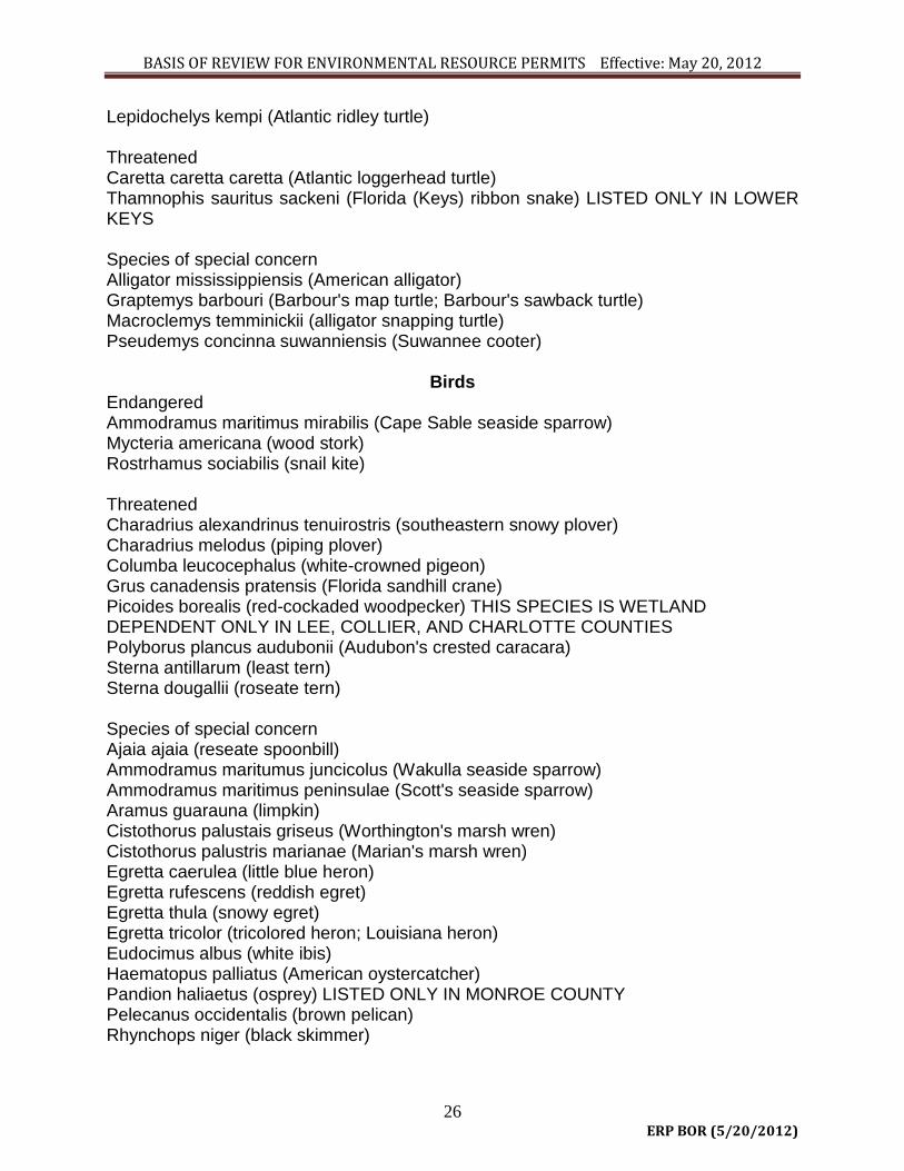
BASIS OF REVIEW FOR ENVIRONMENTAL RESOURCE PERMITS Effective: May 20, 2012
26 ERP BOR (5/20/2012)
Lepidochelys kempi (Atlantic ridley turtle) Threatened Caretta caretta caretta (Atlantic loggerhead turtle) Thamnophis sauritus sackeni (Florida (Keys) ribbon snake) LISTED ONLY IN LOWER KEYS Species of special concern Alligator mississippiensis (American alligator) Graptemys barbouri (Barbour's map turtle; Barbour's sawback turtle) Macroclemys temminickii (alligator snapping turtle) Pseudemys concinna suwanniensis (Suwannee cooter)
Birds Endangered Ammodramus maritimus mirabilis (Cape Sable seaside sparrow) Mycteria americana (wood stork) Rostrhamus sociabilis (snail kite) Threatened Charadrius alexandrinus tenuirostris (southeastern snowy plover) Charadrius melodus (piping plover) Columba leucocephalus (white-crowned pigeon) Grus canadensis pratensis (Florida sandhill crane) Picoides borealis (red-cockaded woodpecker) THIS SPECIES IS WETLAND DEPENDENT ONLY IN LEE, COLLIER, AND CHARLOTTE COUNTIES Polyborus plancus audubonii (Audubon's crested caracara) Sterna antillarum (least tern) Sterna dougallii (roseate tern) Species of special concern Ajaia ajaia (reseate spoonbill) Ammodramus maritumus juncicolus (Wakulla seaside sparrow) Ammodramus maritimus peninsulae (Scott's seaside sparrow) Aramus guarauna (limpkin) Cistothorus palustais griseus (Worthington's marsh wren) Cistothorus palustris marianae (Marian's marsh wren) Egretta caerulea (little blue heron) Egretta rufescens (reddish egret) Egretta thula (snowy egret) Egretta tricolor (tricolored heron; Louisiana heron) Eudocimus albus (white ibis) Haematopus palliatus (American oystercatcher) Pandion haliaetus (osprey) LISTED ONLY IN MONROE COUNTY Pelecanus occidentalis (brown pelican) Rhynchops niger (black skimmer)

BASIS OF REVIEW FOR ENVIRONMENTAL RESOURCE PERMITS Effective: May 20, 2012
27 ERP BOR (5/20/2012)
Mammals
Endangered Felis concolor coryi (Florida panther) Microtus pennsylvanicus dukecambelli (Duke's saltmarsh vole; Florida saltmarsh vole) Myotis grisescens (gray bat) Myotis sodalis (Indiana bat) Odocoileus virginianus clavium (Key deer; toy deer) Oryzomys argentatus (silver rice rat) Sylvilagus palustris hefneri (Lower Keys marsh rabbit) Threatened Mustela vison evergladensis (Everglades mink) Sciurus niger avicennia (Big Cypress fox squirrel; mangrove fox squirrel) Ursus americanus floridanus (Florida black bear) Species of special concern Orytzomys palustris sanibeli (Sanibel Island rice rat) Sorex longirostris eionis (Homosassa shrew) 4.2.8 Cumulative Impacts Pursuant to paragraph 4.1.1(g), an applicant must provide reasonable assurances that a regulated activity will not cause unacceptable cumulative impacts upon wetlands and other surface waters within the same drainage basin as the regulated activity for which a permit is sought. The impact on wetlands and other surface waters shall be reviewed by evaluating the impacts to water quality as set forth in subsection 4.1.1(c) and by evaluating the impacts to functions identified in subsection 4.2.2. If an applicant proposes to mitigate these adverse impacts within the same drainage basin as the impacts, and if the mitigation fully offsets these impacts, the District will consider the regulated activity to have no unacceptable cumulative impacts upon wetlands and other surface water, and consequently the condition for issuance in section 4.1.1(g), will be satisfied. For purposes of performing a cumulative impact analysis, drainage basins shall be those depicted on Figure 4.4-1. When adverse impacts to water quality or adverse impacts to the functions of wetlands and other surface water, as referenced in the paragraph above, are not fully offset within the same drainage basin as the impacts, then an applicant must provide reasonable assurance that the proposed system, when considered with the following activities, will not result in unacceptable cumulative impacts to water quality or the functions of wetlands and other surface waters, within the same drainage basin:
(a) Projects which are existing or activities regulated under Part IV, Chapter 373, F.S., which are under construction, or projects for which permits or determinations pursuant to Sections 373.421, F.S., have been sought.

BASIS OF REVIEW FOR ENVIRONMENTAL RESOURCE PERMITS Effective: May 20, 2012
28 ERP BOR (5/20/2012)
(b) Activities which are under review, approved, or vested pursuant to Section
380.06, F.S., or other activities regulated under Part IV, Chapter 373, F.S., which may reasonably be expected to be located within wetlands or other surface waters, in the same drainage basin, based upon the comprehensive plans, adopted pursuant to Chapter 163, F.S., of the local governments having jurisdiction over the activities, or applicable land use restrictions and regulations.
Those activities listed in paragraphs (a) and (b) which have similar types of adverse impacts to those which will be caused by the proposed system will be considered. (All citations in paragraphs (a) and (b) refer to provisions of Florida Statutes.) Whenever mitigation located within the same drainage basin fully offsets the proposed impacts to wetland functions as described in section 4.2.2 and to water quality, then the regulated activity does not result in unacceptable cumulative impacts within the same drainage basin. The cumulative impact evaluation is conducted using an assumption that reasonably expected future applications with like impacts will be sought, thus necessitating equitable distribution of acceptable impacts among future applications. 4.2.8.1 Cumulative impacts are considered unacceptable when the proposed system, considered in conjunction with the past, present, and future activities as described in 4.2.8, as set forth in subsection 4.1.1(c), would result in a violation of state water quality standards or significant adverse impacts to functions of wetlands or other surface waters, identified in subsection 4.2.2, within the same drainage basin when considering the basin as a whole. 4.2.8.2 Applicants may propose measures such as preservation to prevent cumulative impacts. Such preservation shall comply with the land preservation provisions in subsection 4.3.8. If unacceptable cumulative impacts are expected to occur, the applicant may propose mitigation measures as provided for in sections 4.3 through 4.3.8.

BASIS OF REVIEW FOR ENVIRONMENTAL RESOURCE PERMITS Effective: May 20, 2012
29 ERP BOR (5/20/2012)
4.3 Mitigation – Protection of wetlands and other surface waters is preferred to destruction and mitigation due to the temporal loss of ecological value and uncertainty regarding the ability to recreate certain functions associated with these features. Mitigation will be approved only after the applicant has complied with the requirements of subsection 4.2.1 regarding practicable modifications to eliminate or reduce adverse impacts. However, any mitigation proposal submitted by an applicant shall be reviewed concurrently with the analysis of any modifications pursuant to subsection 4.2.1. This section establishes criteria to be followed in evaluating mitigation proposals. Mitigation as described in sections 4.3 – 4.3.8 is required only to offset the adverse impacts to the functions as identified in sections 4.2 - 4.2.9. caused by regulated activities. In certain cases, mitigation cannot offset impacts sufficiently to yield a permittable project. Such cases often include activities which significantly degrade Outstanding Florida Waters, adversely impact habitat for listed species, or adversely impact those wetlands or other surface waters not likely to be successfully recreated. Applicants are encouraged to consult with District staff in pre-application conferences or during the application process to identify appropriate mitigation options. 4.3.1 Types of Mitigation Mitigation usually consists of restoration, enhancement, creation, or preservation of wetlands, other surface waters or uplands. In some cases, a combination of mitigation types is the best approach to offset adverse impacts resulting from the regulated activity. 4.3.1.1 In general, mitigation is best accomplished through creation, restoration, enhancement, or preservation of ecological communities similar to those being impacted. However, when the area proposed to be impacted is degraded, compared to its historic condition, mitigation is best accomplished through creation, restoration, enhancement or preservation of the ecological community which was historically present. Mitigation involving other ecological communities is acceptable if impacts are offset and the applicant demonstrates that greater improvement in ecological value will result. 4.3.1.2 In general, mitigation is best accomplished when located on-site or in close proximity to the area being impacted. Off-site mitigation will only be accepted if adverse impacts are offset and the applicant demonstrates that:
(a) On-site mitigation opportunities are not expected to have comparable long-term viability due to such factors as unsuitable hydrologic conditions or ecologically incompatible existing adjacent land uses or future land uses identified in a local comprehensive plan adopted according to Chapter 163, F.S.; or

BASIS OF REVIEW FOR ENVIRONMENTAL RESOURCE PERMITS Effective: May 20, 2012
30 ERP BOR (5/20/2012)
(b) Off-site mitigation would provide greater improvement in ecological value than on-site mitigation.
One example of a project that would be expected to meet the criteria of paragraphs (a) or (b) above is a linear project which cannot effectively implement on-site mitigation due to documented right-of-way constraints. 4.3.1.3 Mitigation through participation in a mitigation bank shall be in accordance with subsection 4.4. 4.3.1.4 In instances where an applicant is unable to meet water quality standards because existing ambient water quality does not meet standards and the system will contribute to this existing condition, mitigation for water quality impacts can consist of water quality enhancement. In these cases, the applicant must implement mitigation measures that will cause net improvement of the water quality in the receiving waters for those parameters which do not meet standards. 4.3.1.5 To offset adverse secondary impacts from regulated activities to habitat functions that uplands provide to Bald Eagles (Haliaeetus leucocephalus) for nesting and to listed species evaluated as provided in paragraph 4.2.7(b), mitigation can include the implementation of management plans, participation in a wildlife mitigation park established by the FWC, or other measures. Measures to offset adverse secondary impacts on wetlands and other surface waters resulting from use of a system can include the incorporation of culverts or bridged crossings designed to facilitate wildlife movement, fencing to limit access, reduced speed zones, or other measures designed to offset the secondary impact. 4.3.1.6 Except as provided in subsection 373.414(6), F.S., mitigation for certain mining activities shall be in accordance with subsection 373.414(6), F.S. 4.3.1.7 Mitigation or reclamation required or approved by other agencies for a specific project will be acceptable to the District to the extent that such mitigation or reclamation fulfills the requirements of sections 4.3-4.3.8 and offsets adverse impacts of the same project in accordance with the criteria in sections 4.2-4.2.8.2 4.3.1.8 Innovative mitigation proposals which deviate from the standard practices described in sections 4.3-4.3.6 may be proposed by an applicant; however, to receive District approval they must offset the adverse impacts to the functions identified in sections 4.2-4.2.8.2 caused by the regulated activities. The donation of money is not considered to be an acceptable method of mitigation, unless cash payments are specified for use in a District or Department of Environmental Protection endorsed environmental preservation, enhancement or restoration project and the payments initiate a project or supplement an ongoing project. The project or portion of the project funded by the donation of money must offset the impacts of the proposed system. 4.3.2 Mitigation Ratio Guidelines

BASIS OF REVIEW FOR ENVIRONMENTAL RESOURCE PERMITS Effective: May 20, 2012
31 ERP BOR (5/20/2012)
a. For applications received on or after February 2, 2004, except as provided in Rule 62-345, F.A.C., Sections 4.3.2 - 4.3.2.4 are superseded by Chapter 62-345, F.A.C. b. Subsections 4.3.2 - 4.3.2.4 establish ratios for the acreage of mitigation required compared to the acreage which is adversely impacted by regulated activities. Ranges of ratios are provided below for certain specific types of mitigation, including creation, restoration, enhancement and preservation. Mitigation ratios for wetlands which have a 50% or greater coverage of melaleuca (Melaleuca quinquenervia), will be determined pursuant to subsection 4.3.2.4. and other provisions of this section. The difference between the ranges of ratios provided for mitigation types is based on the degree of improvement in ecological value expected from each type. Creation and restoration are assigned the lowest range of ratios as these activities, when successfully conducted, add new wetlands or other surface waters which provide the same or similar functions as the area being adversely impacted. The range of ratios established for enhancement is higher than that for creation and restoration, as the area being enhanced currently provides a degree of the desired functions, and this type of mitigation serves to increase, rather than create, those functions. Preservation differs from the other types of mitigation in that it does not serve to improve the existing ecological value of an area in the short term. However, preservation does provide benefits as it can ensure that the values of the preserved area are protected and maintained in the long term, particularly when these values are not fully protected under existing regulatory programs. Therefore, the range of ratios established for preservation is higher than those for other types of mitigation. These ratios are provided as guidelines for preliminary planning purposes only. The actual ratio needed to offset adverse impacts may be higher or lower based on a consideration of the factors listed in subsections 4.3.2.1 through 4.3.2.4. For example, in instances where the proposed system results in only a small loss of ecological value in the impacted area, such as cases involving impacts to areas of low ecological value or cases where the proposed system results in a small reduction of ecological value of the impacted area, then the actual mitigation ratio would normally be in the lower end of or below the range. For other types of mitigation, ratios will be determined based upon the reduction in quality and relative value of the functions of the areas adversely impacted as compared to the expected improvement in quality and value of the functions of the mitigation area. 4.3.2.1 Creation, Restoration and Enhancement When considering creation, restoration and enhancement as mitigation, the following factors will be considered to determine whether the mitigation proposal will offset the proposed impacts and to determine the appropriate mitigation ratio:
(a) The reduction in quality and relative value of the function of the areas
adversely impacted, including the factors listed in subsection 4.2.2.3, as compared to the proposed improvement in quality and value of the functions of the area to be created, restored or enhanced.
(b) Any special designation or classification of the affected area.

BASIS OF REVIEW FOR ENVIRONMENTAL RESOURCE PERMITS Effective: May 20, 2012
32 ERP BOR (5/20/2012)
(c) The presence and abundance of nuisance and exotic plants within the area to be adversely impacted.
(d) The hydrologic condition of the area to be adversely impacted and the
degree to which it has been altered relative to the historic condition. (e) The length of time expected to elapse before the functions of the area
adversely impacted will be offset. (f) The likelihood of mitigation success. (g) For mine reclamation activities subject to Chapter 211, F.S., Part II,
whether the ratio is consistent with the mine reclamation plan submitted pursuant to Chapter 378, F.S.
4.3.2.1.1 Creation and restoration have the potential to result in similar benefits, if they can be successfully accomplished. Therefore, the ratio ranges given below for these two types of mitigation are the same. Restoration is usually preferred over creation as it often has a greater chance of success due to soil characteristic, hydrologic regime, landscape position or other factors that favor re-establishment of wetland or other surface water communities. Restoration ratios will generally be at the lower end of the ratio ranges within the guidelines below. The following ratio guidelines will be used to estimate the acreage of wetland restoration or creation required:
(a) Mangrove swamps, cypress swamps, and hardwood swamps - 2:1 to 5:1 (acres created or restored: acres impacted).
(b) Saltwater marshes and freshwater marshes - 1.5:1 to 4:1 (acres created
or restored: acres impacted. 4.3.2.1.2 The ratio guidelines for use in the estimation of the acreage of wetland enhancement will range from 4:1 to 20:1 (acres enhanced: acres impacted). 4.3.2.2 Preservation
(a) Preservation of important ecosystems can provide an improved level of protection over current regulatory programs. The District will consider as mitigation the preservation, by donation or conservation easement or other comparable land use restriction, of wetlands, other surface waters, or uplands. Conservation easements or restrictions must be consistent with the requirements of subsection 4.3.8. In many cases it is not expected that preservation alone will be sufficient to offset adverse impacts. Preservation will most frequently be approved in combination with other mitigation measures.

BASIS OF REVIEW FOR ENVIRONMENTAL RESOURCE PERMITS Effective: May 20, 2012
33 ERP BOR (5/20/2012)
(b) When considering preservation as mitigation, the following factors will be considered to determine whether the preservation parcel would offset the proposed impacts and to determine the appropriate mitigation ratio.
1. The reduction in quality and relative value of the functions of the
areas adversely impacted, including those factors listed in subsection 4.2.2.3, as compared to the quality and value of the functions of the area to be preserved and the additional protection provided to these functions by the proposed preservation. Factors used in determining this additional level of protection include the extent and likelihood that the land to be preserved would be adversely impacted if it were not preserved, considering the protection provided by existing regulations and land use restrictions.
2. Any special designation or classification of the affected area. 3. The presence and abundance of nuisance and exotic plants within
the area to be adversely impacted. 4. The ecological and hydrological relationship between wetlands,
other surface waters, and uplands to be preserved. 5. The extent to which proposed management activities on the area to
be preserved promote natural ecological conditions, such as natural fire patterns.
6. The proximity of the area to be preserved to areas of national,
state, or regional ecological significance, such as national or state parks, Outstanding Florida Waters, and other regionally significant ecological resources or habitats, such as lands acquired or to be acquired through governmental or non-profit land acquisition programs for environmental conservation, and whether the areas to be preserved include corridors between these habitats.
7. The extent to which the preserved area provides habitat for fish and
wildlife, especially listed species. 8. Any special designation or classification of the area to be
preserved. 9. The extent of invasion of nuisance and exotic species within the
area to be preserved.
(c) Wetland and other surface water preservation ratios. Since wetlands and other surface waters are, to a large extent, protected by existing

BASIS OF REVIEW FOR ENVIRONMENTAL RESOURCE PERMITS Effective: May 20, 2012
34 ERP BOR (5/20/2012)
regulations, the ratio guideline for preservation of wetlands and other surface waters is substantially higher than for restoration and creation. The ratio guideline for wetland and other surface water preservation will be 10:1 to 60:1, (acreage wetlands and other surface waters preserved to acreage impacted).
(d) Upland preservation ratios. Many wildlife species that are aquatic or
wetland dependent spend critical portions of their life cycles in uplands. Uplands function as the contributing watershed to wetlands and are necessary to maintain the ecological value of those wetlands. Because of these values, the preservation of certain uplands may be appropriate for full or partial mitigation of wetland impacts, and impacts to uplands that are used by listed aquatic or wetland dependent species as described in subsection 4.2.7(b). The ratio guideline for upland preservation will be 3:1 to 20:1 (acreage of uplands preserved to acreage impacted).
4.3.2.3 To the extent that the area to be preserved offsets the adverse impact and otherwise meets the requirements of this section, wetland, other surface water, or upland habitat which is proposed to be preserved in order to prevent secondary or cumulative impacts can be considered as part of the mitigation plan to offset other adverse impacts of the system. 4.3.2.4
(a) When District staff evaluate mitigation proposals for melaleuca-dominated wetlands, the following factors, in addition to those in subsections 4.3.2.1 and 4.3.2.2, will be considered to determine whether the mitigation will offset the proposed impacts and to determine the appropriate mitigation ratio:
1. Location and proximity of the property to native habitat including the
ecological condition of the adjacent lands; and 2. Degree of melaleuca infestation;
(b) Mitigation ratio guidelines for wetlands which have a 50% or greater
coverage of melaleuca shall be as follows:
1. Creation/Restoration 0.25:1 to 0.75:1 2. Enhancement 0.7:1 to 3.0:1 3. Wetland Preservation 1.7:1 to 9.0:1 4. Upland Preservation 0.5:1 to 3.0:1

BASIS OF REVIEW FOR ENVIRONMENTAL RESOURCE PERMITS Effective: May 20, 2012
35 ERP BOR (5/20/2012)
(c) Melaleuca within the wetland to be impacted shall be mapped in units not larger than 1/2 acre which differentiate coverages of 50%-75% and 76%-100%. The landowner may elect to measure coverage in more detail. The District shall allow the use of larger mapping units when the landowner can demonstrate that:
1. 1/2 acre mapping units will impose an economic hardship due to
the large size of the wetland impact areas; and 2. Mapping in larger units will not result in additional acreage
qualifying for the ratios in this subsection. The coverage of melaleuca shall be defined as the absolute percentage of the area in question that lies under the crown of a melaleuca tree with a one inch or greater trunk diameter at breast height. The crown of each melaleuca tree shall be considered a solid shape without regard for holes or openings among the leaves and branches. Any valid vegetative sampling method shall be acceptable for estimating melaleuca coverage, including visual observation, use of random sample points, a grid of points, or line or belt transects. (See Bonham, C.D. 1989, Measurements for Terrestrial Vegetation for guidance in estimating coverage.) Aerial photography may be used to complement on-the-ground estimates of melaleuca coverage for large tracts.
(d) Mitigation ratios for wetlands which have less than a 50% coverage of
melaleuca shall be determined pursuant to the guidelines set forth in sections 4.3.2.1.1, 4.3.2.1.2 and 4.3.2.2.
4.3.3 Mitigation Proposals 4.3.3.1 Applicants shall provide reasonable assurance that proposed mitigation will:
(a) Offset adverse impacts due to regulated activities; and (b) Achieve mitigation success by providing viable and sustainable
ecological and hydrological functions. 4.3.3.2 Applicants shall submit detailed plans describing proposed construction, establishment, and management of mitigation areas. These plans shall include the following information, as appropriate for the type of mitigation proposed:
(a) A soils map of the mitigation area and other soils information pertinent to the specific mitigation actions proposed.
(b) A topographic map of the mitigation area and adjacent hydrologic
contributing and receiving areas.

BASIS OF REVIEW FOR ENVIRONMENTAL RESOURCE PERMITS Effective: May 20, 2012
36 ERP BOR (5/20/2012)
(c) A hydrologic features map of the mitigation area and adjacent hydrologic
contributing and receiving areas. (d) A description of current hydrologic conditions affecting the mitigation area. (e) A map of vegetation communities in and around the mitigation area. (f) Construction drawings detailing proposed topographic alterations and all
structural components associated with proposed activities. (g) Proposed construction activities, including a detailed schedule for
implementation. (h) A vegetation planting scheme if planting is proposed, and schedule for
implementation. (i) Sources of plants and soils used in wetland creation. (j) Measures to be implemented during and after construction to avoid
adverse impacts related to proposed activities. (k) A management plan comprising all aspects of operation and maintenance,
including water management practices, vegetation establishment, exotic and nuisance species control, fire management, and control of access.
(l) A proposed monitoring plan to demonstrate mitigation success. (m) A description of the activities proposed to control exotic and nuisance
species should these become established in the mitigation area. The mitigation proposal must include reasonable measures to assure that these species do not invade the mitigation area in such numbers as to affect the likelihood of success of the project.
(n) A description of anticipated site conditions in and around the mitigation
area after the mitigation plan is successfully implemented. (o) A comparison of current fish and wildlife habitat to expected habitat after
the mitigation plan is successfully implemented. (p) For mitigation plans with projected implementation costs in excess of
$25,000.00, an itemized estimate of the cost of implementing mitigation as set forth in subsection 4.3.7.7.
4.3.4 Monitoring Requirements for Mitigation Areas

BASIS OF REVIEW FOR ENVIRONMENTAL RESOURCE PERMITS Effective: May 20, 2012
37 ERP BOR (5/20/2012)
Applicants shall monitor the progress of mitigation areas until success can be demonstrated as provided in subsection 4.3.6. Monitoring parameters, methods, schedules, and reporting requirements will be specified in permit conditions. 4.3.5 Protection of Mitigation Areas Applicants shall propose and be responsible for implementing methods that assure that mitigation areas will not be adversely impacted by incidental encroachment or secondary activities which might compromise mitigation success. 4.3.6 Mitigation Success Due to the wide range of types of projects which may be proposed for mitigation, specific success criteria will be determined on a case-by-case basis. Mitigation success will be measured in terms of whether the objectives of the mitigation can be realized. The success criteria to be included in the permit conditions will specify the minimum requirements necessary to attain a determination of success. The mitigation shall be deemed successful by the District when all applicable water quality standards are met, the mitigation area has achieved viable and sustainable ecological and hydrological functions and the specific success criteria contained in the permit are met. If success is not achieved within the timeframe specified within the permit, remedial measures shall be required. Monitoring and maintenance requirements shall remain in effect until success is achieved. 4.3.7 Financial Responsibility for Mitigation As part of compliance with paragraph 40E-4.301(1)(j), F.A.C., where an applicant proposes mitigation, the applicant shall provide proof of financial responsibility to:
(a) Conduct the mitigation activities; (b) Conduct any necessary management of the mitigation site; (c) Conduct monitoring of the mitigation; and (d) Conduct any necessary corrective action indicated by the monitoring.
4.3.7.1 Applicants Not Subject to Financial Responsibility Requirements The following applicants shall not be subject to the financial responsibility requirements in subsections 4.3.7-4.3.7.9:
(a) Applicants whose mitigation is deemed successful pursuant to subsection 4.3.6 of this Basis of Review prior to undertaking the construction activities authorized under the permit issued pursuant to Part IV, Chapter 373, F.S.

BASIS OF REVIEW FOR ENVIRONMENTAL RESOURCE PERMITS Effective: May 20, 2012
38 ERP BOR (5/20/2012)
(b) Applicants whose mitigation is estimated to cost less than $25,000.00. (c) Federal, state, county and municipal governments, state political
subdivisions, investor-owned utilities regulated by the Public Service Commission, and rural electric cooperatives.
(d) Mitigation banks which comply with the financial responsibility provisions
of section 4.4.10 of this Basis of Review. 4.3.7.2 Amount of financial responsibility The amount of financial responsibility provided by the applicant shall be in an amount equal to 110 percent of the cost estimate determined pursuant to subsection 4.3.7.8 below, for each phase of the mitigation plan submitted under the requirements of sections 4.3 - 4.3.8.
4.3.7.3 Documentation The permit applicant shall provide draft documentation of the required financial responsibility mechanism described below, and shall submit to the District the executed or finalized documentation within the time frames specified in the permit. 4.3.7.4 General Terms for Financial Responsibility Mechanisms In addition to the specific provisions regarding financial responsibility mechanisms set forth in subsection 4.3.7.6 below, the following, as they relate to the specific mechanism proposed, shall be complied with:
(a) The form and content of all financial responsibility mechanisms shall be approved by the District.
(b) The mechanisms shall name the District as sole beneficiary or shall be
payable solely to the District. However, any local pollution control program acting pursuant to Section 403.182, F.S., may be a co-beneficiary of the financial assurance mechanism. The original financial responsibility mechanism shall be retained by the District.
(c) The financial responsibility mechanisms shall be established with a state
or national bank, savings and loan association, or other financial institution licensed in this state. In the case of letters of credit, the letter of credit must be issued by an entity which has authority to issue letters of credit and whose letter of credit operations are regulated and examined by a

BASIS OF REVIEW FOR ENVIRONMENTAL RESOURCE PERMITS Effective: May 20, 2012
39 ERP BOR (5/20/2012)
federal or state agency. In the case of a surety bond, the surety bond must be issued by a surety company registered with the state of Florida.
(d) The financial responsibility mechanisms shall be effective on or prior to the
date that the activity authorized by the permit commences and shall continue to be effective through the date of notification of final release by the District in accordance with subsection 4.3.7.7.2 below of this Basis of Review.
(e) A co-beneficiary as provided in subsection (b) shall provide written notice
to the District prior to withdrawing or transferring any portion of the funds therein.
(f) The financial responsibility mechanisms shall provide that it cannot be
revoked, terminated or cancelled without first providing an alternative financial responsibility mechanism which meets the requirements of subsections 4.3.7-4.3.7.9. Within 90 days of receipt by the permittee of actual or constructive notice of revocation, termination or cancellation of a financial responsibility mechanism or other actual or constructive notice of cancellation, the permittee shall provide an alternate financial responsibility mechanism which meets the requirements of subsections 4.3.7 - 4.3.7.9.
4.3.7.5 If the permittee fails to comply with the terms and conditions of the permit, subsection 4.3.7 or fails to complete the mitigation and monitoring within the timeframes specified in the permit conditions or any extension thereof, such failure shall be deemed a violation of chapter 40E-4, F.A.C., and the permit issued thereunder. In addition to any other remedies for such violation as the District may have, the District, upon notice as provided in the mechanism or if none, upon reasonable notice, may draw upon the financial mechanism. 4.3.7.6 Financial Responsibility Mechanisms Financial responsibility for the mitigation, monitoring and corrective action for the project may be established by any of the following methods, at the discretion of the applicant:
(a) Performance bond (Form No. 1105), December 2011, incorporated by reference
in paragraph 40E-4.091(1)(a), F.A.C.; (b) Irrevocable letter of credit (Form No. 1106), December 2011, incorporated by
reference in paragraph 40E-4.091(1)(a); (c) Trust fund agreement;
(d) Deposit of cash or cash equivalent into an escrow account; (e) An audited annual financial statement submitted by a Certified Public Accountant
representing that the applicant has a tangible net worth equal to or in excess of the cost of the mitigation plan. For purposes of this subparagraph, “tangible net worth” means total assets, not including intangibles such as goodwill and right to

BASIS OF REVIEW FOR ENVIRONMENTAL RESOURCE PERMITS Effective: May 20, 2012
40 ERP BOR (5/20/2012)
patents or royalties, minus total liabilities, computed in accordance with generally accepted accounting principles;.
(f) A demonstration that the applicant meets the financial test and corporate guarantee requirements set forth in 40 C.F.R. Section 264.143(f) incorporated by reference in paragraph 40E-4.091(1)(f), F.A.C. Where the referenced test is used to provide evidence of financial resources necessary to conduct mitigation activities the term "closure and post-closure cost estimates" as set forth therein, shall be construed to mean "mitigation cost estimates."
(g) Guarantee bond; (h) Insurance certificate; or
(i) A demonstration that the applicant meets the self-bonding provisions set forth at 30 C.F.R. Section 800.23 incorporated by reference in paragraph 40E-4.091(1)(i), F.A.C. Where the referenced provisions are used to provide evidence of financial responsibility to conduct mitigation activities, the term "surface coal mining and reclamation operations," as set forth therein, shall be construed to mean "mitigation activities."
4.3.7.7 Cost Estimates For the purposes of determining the amount of financial responsibility that is required by this subsection, the applicant shall submit a detailed written estimate, in current dollars, of the total cost of conducting the mitigation, including any maintenance and monitoring activities and the applicant shall comply with the following:
(a) The cost estimate for conducting the mitigation and monitoring shall include all associated costs for each phase thereof, including earthmoving, planting, structure installation, maintaining and operating any structures, controlling nuisance or exotic species, fire management, consultant fees, monitoring activities and reports.
(b) The applicant shall submit the estimates, together with verifiable documentation, to the District along with the draft of the financial responsibility mechanism.
(c) The costs shall be estimated based on a third party performing the work and supplying materials at the fair market value of the services and materials. The source of any cost estimates shall be indicated.
4.3.7.7.1 Partial Releases The permittee may request the District to release portions of the financial responsibility mechanism as phases of the mitigation plan, such as earth moving or other construction or activities for which cost estimates were submitted in accordance with subsection 4.3.7.7 are successfully completed. The request shall be in writing and include documentation that the phase or phases have been completed and have been paid for or will be paid for upon release of the applicable portion of the financial responsibility

BASIS OF REVIEW FOR ENVIRONMENTAL RESOURCE PERMITS Effective: May 20, 2012
41 ERP BOR (5/20/2012)
mechanism. The District shall authorize the release of the portion requested upon verification that the construction or activities have been completed in accordance with the mitigation plans. 4.3.7.7.2 Final Release Within thirty (30) days of the District determining that the mitigation is successful in accordance with subsection 4.3.6, the District shall so notify the permittee and shall authorize the return and release of all funds held or give written authorization to the appropriate third party for the cancellation or termination of the financial responsibility mechanism. 4.3.7.8 Financial Responsibility Conditions For applicants subject to the financial responsibility of subsections 4.3.7 - 4.3.7.9, the District will include the following conditions on the permit.
(a) A permittee must notify the District by certified mail of the commencement
of a voluntary or involuntary proceeding under Title XI (Bankruptcy), U.S. Code naming the permittee as debtor within 10 business days after the commencement of the proceeding.
(b) A permittee who fulfills the requirements of subsections 4.3.7 - 4.3.7.9 by obtaining a letter of credit, performance bond or other form of surety providing the same level of financial responsibility will be deemed to be without the required financial assurance in the event of bankruptcy, insolvency or suspension or revocation of the license or charter of the issuing institution. The permittee must reestablish in accordance with subsections 4.3.7 - 4.3.7.9 a financial responsibility mechanism within 60 days after such event.
(c) When transferring a permit in accordance with Rule 40E-4.351, F.A.C., the new owner or person with legal control shall submit documentation to satisfy the financial responsibility requirements of subsections 4.3.7 - 4.3.7.9. The prior owner or person with legal control of the project shall continue the financial responsibility mechanism until the District has approved the permit transfer and substitute financial responsibility mechanism.
4.3.7.9 Financial Responsibility Mechanisms For Multiple Projects A applicant may use a mechanism specified in subsection 4.3.7.6 above to meet the financial responsibility requirement for multiple projects. The financial responsibility mechanism must include a list of projects and the amount of funds assured for each project. The mechanism must be no less than the sum of the funds that would be necessary in accordance with subsection 4.3.7.2 above, as if separate mechanisms had

BASIS OF REVIEW FOR ENVIRONMENTAL RESOURCE PERMITS Effective: May 20, 2012
42 ERP BOR (5/20/2012)
been established for each project. As additional permits are issued which require mitigation, the amount of the financial responsibility mechanism may be increased in accordance with subsection 4.3.7.2, above and the project added to the list. 4.3.8 Real Property Conveyances
(a) All conservation easements and restrictive covenants pursuant to Section 704.06, F.S., shall be granted in perpetuity without encumbrances, unless such encumbrances do not have the potential to adversely affect the ecological viability of the mitigation. All liens against the area preserved pursuant to Section 704.06, F.S., shall be released, subordinated to, or joined with the conservation easement or restrictive covenant. Conservation easements and restrictive covenants shall be consistent with Section 704.06, F.S.; and shall contain restrictions that ensure the ecological viability of the site.
(b) Plat restrictions proposed to meet the requirements of Section 704.06,
F.S., and Section 4.3.2.2 must contain the language contained in Section 704.06(1)(a)-(h), F.S. In order to provide reasonable assurance of the preservation of the protected area in accordance with the permit in perpetuity, plat language shall provide the District a third-party right to enforce the restrictions of Section 704.06, F.S., and shall further provide that the Section 704.06, F.S., plat restrictions cannot be altered, released or revoked without the prior written consent of the District.
(c) The following conservation easement forms are incorporated by reference
in paragraph 40E-4.091(1)(a), F.A.C.: Form No. 1190, Deed of Conservation Easement (Standard), December
2011; Form No. 1191, Deed of Conservation Easement (Standard Passive Recreational), December 2011; Form No. 1192, Deed of Conservation Easement (Standard Riparian), December 2011; Form No. 1194, Deed of Conservation Easement (Third Party Standard), December 2011;
Form No. 1195, Deed of Conservation Easement (Third Party Passive Recreational), December 2011;
Form No. 1196, Deed of Conservation Easement (Third Party Riparian), December 2011;

BASIS OF REVIEW FOR ENVIRONMENTAL RESOURCE PERMITS Effective: May 20, 2012
43 ERP BOR (5/20/2012)
Form No. 1197, Restrictive Covenant (Standard), December 2011;
Form No. 1318, Deed of Conservation Easement (Local Governments), December 2011.
(d) All real property conveyances shall be in fee simple and by statutory
warranty deed, special warranty deed, or other deed, without encumbrances that adversely affect the integrity of the preservation objectives. The District shall also accept a quit claim deed if necessary to aid in clearing minor title defects or otherwise resolving boundary questions.
4.4 Mitigation Banking - 4.4.1 Intent 4.4.1.1 The Environmental Reorganization Act of 1993 directed the District to adopt rules governing the creation and use of mitigation banks to offset adverse impacts caused by activities regulated under Part IV of Chapter 373, F.S. This section, in addition to other rules promulgated under Part IV of Chapter 373, F.S., is intended to meet this requirement. 4.4.1.2 The District recognizes that, in certain instances, adverse impacts of activities regulated under Part IV of Chapter 373, F.S., can be offset through participation in a Mitigation Bank. This rule provides criteria for this mitigation alternative to complement existing mitigation criteria and requirements. This section does not supersede any other criteria and requirements in rules promulgated under Part IV of Chapter 373, F.S. 4.4.1.3 The District intends that Mitigation Banks be used to minimize mitigation uncertainty associated with traditional mitigation practices, provide greater assurance of mitigation success, and optimize opportunities to restore any degraded habitats which may be incorporated into the bank. It is anticipated that the consolidation of multiple mitigation projects into larger contiguous areas will provide greater assurance that the mitigation will yield long-term, sustainable, regional ecological benefits. Mitigation Banks should emphasize restoration and enhancement of degraded ecosystems and the preservation of uplands and wetlands as intact ecosystems rather than alteration of landscapes to create wetlands. The establishment and use of mitigation banks in or adjacent to areas of national, state, or regional ecological significance is encouraged, provided the area in which the mitigation bank is proposed to be located is determined appropriate for mitigation banking and the bank meets all applicable permit criteria. 4.4.1.4 Nothing in this section shall affect the mitigation requirements set forth in any mitigation bank agreement or any permit issued pursuant to Chapter 84-79, Laws of Florida, or Part IV of Chapter 373, F.S., prior to the effective date of this section. If a permittee wishes to substantially modify a mitigation bank previously established by agreement or permit, the permittee must comply with this section. This section does not

BASIS OF REVIEW FOR ENVIRONMENTAL RESOURCE PERMITS Effective: May 20, 2012
44 ERP BOR (5/20/2012)
prohibit an applicant from proposing project-specific pre-construction mitigation, or off-site mitigation, without establishing a Mitigation Bank pursuant to this section. 4.4.2 Use of a Mitigation Bank 4.4.2.1 Use of a Mitigation Bank is appropriate, desirable, and a permittable mitigation option when the Mitigation Bank will offset the adverse impacts of the project; and
(a) Oon-site mitigation opportunities are not expected to have comparable long-term viability due to such factors as unsuitable hydrologic conditions or ecologically incompatible existing adjacent land uses or future land uses identified in a local comprehensive plan adopted according to Chapter 163, F.S.; or
(b) Use of the Mitigation Bank would provide greater improvement in
ecological value than on-site mitigation. 4.4.2.2 In some cases, a combination of on-site mitigation and participation in a Mitigation Bank will be appropriate to offset adverse impacts of a project. 4.4.3 Criteria for Establishing a Mitigation Bank The following criteria shall be met to establish a Mitigation Bank: 4.4.3.1 The banker shall provide reasonable assurance that the proposed Mitigation Bank will:
(a) Improve ecological conditions of the regional watershed; (b) Provide viable and sustainable ecological and hydrological functions for
the proposed mitigation service area; (c) Be effectively managed in perpetuity; (d) Not destroy areas with high ecological value; (e) Achieve mitigation success; and (f) Be adjacent to lands which will not adversely affect the long-term viability
of the Mitigation Bank due to unsuitable land uses or conditions. 4.4.3.1.2 The banker shall also provide reasonable assurance that any surface water management system constructed within the mitigation bank area will meet the conditions of issuance of Chapters 40E-4, 40E-40, 40E-41 or 40E-400, F.A.C. as applicable.

BASIS OF REVIEW FOR ENVIRONMENTAL RESOURCE PERMITS Effective: May 20, 2012
45 ERP BOR (5/20/2012)
4.4.3.2 A Mitigation Bank may be implemented in phases if each phase independently meets the requirements of subsections 4.4.3.1 and 4.4.3.1.2 above. 4.4.3.3 The banker shall:
(a) Have sufficient legal or equitable interest in the property to meet the requirements of section 4.4.9; and
(b) Meet the financial responsibility requirements of section 4.4.10.
4.4.4 Permit Applications for an Individual or Conceptual Approval Environmental Resource Permits for a Mitigation Bank Any person or entity proposing to establish a Mitigation Bank must apply for an Environmental Resource Permit. An application for an Individual or Conceptual Approval Environmental Resource Permit for a mitigation bank shall constitute an application for any related activity which would require a permit authorized under Chapters 40E-4, 40E-40, 40E-41 and 40E-400, F.A.C. Therefore, a separate application for a permit to construct a surface water management system proposed as part of the mitigation bank is not required. Environmental Resource Permit applications to establish or conceptually approve a Mitigation Bank shall be processed according to Chapter 120, F.S. To provide the District with reasonable assurances that the proposed Mitigation Bank will meet the criteria in this section, each permit application submitted to the District shall include the information needed to review any permit required under Chapters 40E-4, 40E-40, 40E-41 and 40E-400, F.A.C. and the information specified below as appropriate for the project: 4.4.4.1 A description of the location of the proposed Mitigation Bank which shall include:
(a) A map at regional scale showing the project area in relation to the regional watershed and proposed mitigation service area;
(b) A vicinity map showing the project area in relation to adjacent lands and
offsite areas of ecologic or hydrologic significance which could affect the long term viability or ecological value of the bank;
(c) An aerial photograph identifying boundaries of the project area; (d) A highway map showing points of access to the Mitigation Bank for site
inspection; and (e) A legal description of the proposed Mitigation Bank.
4.4.4.2 A description of the ecological significance of the proposed Mitigation Bank to the regional watershed in which it is located.
BASIS OF REVIEW FOR ENVIRONMENTAL RESOURCE PERMITS Effective: May 20, 2012
46 ERP BOR (5/20/2012)
4.4.4.3 A description and assessment of current site conditions which shall include:
(a) A soils map of the project area; (b) A topographic map of the project area and adjacent hydrologic
contributing and receiving areas; (c) A hydrologic features map of the project area and adjacent hydrologic
contributing and receiving areas; (d) Current hydrologic conditions in the project area; (e) A vegetation map of the project area; (f) Ecological benefits currently provided to the regional watershed by the
project area; (g) Adjacent lands, including existing land uses and conditions, projected land
uses according to comprehensive plans adopted pursuant to Chapter 163, F.S., by local governments having jurisdiction, and any special designations or classifications associated with adjacent lands or waters; and
(h) A disclosure statement of any material fact which may effect the
contemplated use of the property.
4.4.4.4 A mitigation plan describing the actions proposed to establish, construct, operate, manage and maintain the Mitigation Bank which shall include:
(a) Construction-level drawings detailing proposed topographic alterations and all structural components associated with proposed activities;
(b) Proposed construction activities, including a detailed schedule for
implementation; (c) The proposed vegetation planting scheme and detailed schedule for
implementation; (d) Measures to be implemented during and after construction to avoid
adverse impacts related to proposed activities; (e) A detailed long term management plan comprising all aspects of
operation and maintenance, including water management practices, vegetation establishment, exotic and nuisance species control, fire management, and control of access; and

BASIS OF REVIEW FOR ENVIRONMENTAL RESOURCE PERMITS Effective: May 20, 2012
47 ERP BOR (5/20/2012)
(f) A proposed monitoring plan to demonstrate mitigation success.
4.4.4.5 An assessment of improvement or changes in ecological value anticipated as a result of proposed mitigation actions which shall include:
(a) A description of anticipated site conditions in the Mitigation Bank after the mitigation plan is successfully implemented;
(b) A comparison of current fish and wildlife habitat to expected habitat after
the mitigation plan is successfully implemented; and (c) A description of the expected ecological benefits to the regional
watershed. 4.4.4.6 Evidence of sufficient legal or equitable interest in the property which is to become the Mitigation Bank to meet the requirements of section 4.4.9. 4.4.4.7 Draft documentation of financial responsibility meeting the requirements of section 4.4.10, and utilization of the following Mitigation Bank Financial Assurance forms, which are incorporated by reference in paragraph 40E-4.091(1)(a), F.A.C.,:
Form No. 1019, December 2011, Mitigation Bank Performance Bond to Demonstrate Construction/Implementation Financial Assurance; Form No. 1020, December 2011, Mitigation Bank Irrevocable Letter of Credit to Demonstrate Construction/Implementation Financial Assurance; Form No. 1021, December 2011, Mitigation Bank Standby Trust Fund Agreement to Demonstrate Construction/Implementation Financial Assurance; Form No. 1022, December 2011, Mitigation Bank Trust Fund Agreement to Demonstrate Construction/Implementation Financial Assurance; Form No. 1023, December 2011, Mitigation Bank Trust Fund Agreement to Demonstrate Perpetual Management Financial Assurance; Form No. 1024, December 2011, Mitigation Bank Standby Trust Fund Agreement to Demonstrate Perpetual Management Financial Assurance.
4.4.4.8 A person or entity who wishes to obtain an estimation of the legal and financial requirements necessary for a mitigation bank, information necessary for evaluation of an application for an individual permit for a mitigation bank, and potential credits to be awarded pursuant to a mitigation bank individual permit may apply for a mitigation bank

BASIS OF REVIEW FOR ENVIRONMENTAL RESOURCE PERMITS Effective: May 20, 2012
48 ERP BOR (5/20/2012)
conceptual approval. An application for a mitigation bank conceptual approval must contain the information listed in 4.4.4.1-8 above. 4.4.5 Establishment of Mitigation Credits 4.4.5.1 Based upon the information submitted by the applicant, and an assessment of the proposed Mitigation Bank pursuant to the criteria in this section, the District will assign a number of Mitigation Credits to the proposed Mitigation Bank, or phases thereof. 4.4.5.2 A Mitigation Credit is a unit of measure which represents the increase in ecological value resulting from restoration, enhancement, preservation, or creation activities. For purposes of establishing a standard unit of measure, one Mitigation Credit is equivalent to the ecological value gained by the successful creation of one acre of wetland. Mitigation Credits assigned for enhancement, restoration or preservation of wetlands or uplands will be based on the extent of improvement in ecological value resulting from these activities relative to that obtained by successfully creating one acre of wetland. In determining the degree of improvement in ecological value, the following factors will be considered:
(a) The extent to which target hydrologic regimes can be achieved and maintained.
(b) The extent to which management activities promote natural ecological
conditions, including natural fire patterns. (c) The proximity to areas of national, state, or regional ecological
significance, such as national or state parks, Outstanding National Resource Waters, Outstanding Florida Waters, and other regionally significant ecological resources or habitats, such as lands acquired or to be acquired through governmental or non-profit land acquisition programs for environmental conservation, and the establishment of corridors to those resources or habitats.
(d) The quality and quantity of wetland or upland restoration, enhancement,
preservation, or creation. (e) The ecological and hydrological relationship between wetlands and
uplands in the Mitigation Bank. (f) The extent to which the Mitigation Bank provides habitat for fish and
wildlife, especially habitat for species listed as threatened, endangered or of special concern, or provides habitats which are unique for that mitigation service area.

BASIS OF REVIEW FOR ENVIRONMENTAL RESOURCE PERMITS Effective: May 20, 2012
49 ERP BOR (5/20/2012)
(g) The extent to which the lands that are to be preserved are already protected by existing state, local or federal regulations or land use restrictions.
(h) The extent that lands to be preserved would be adversely affected if they
were not preserved. (i) Any special designation or classification of the affected waters and lands.
4.4.5.3 No credit shall be available for freshwater wetland creation until the success of the created wetlands is demonstrated. 4.4.5.4 Some Mitigation Credits may be withdrawn prior to meeting all of the performance criteria specified in the individual permit. The number of credits and schedule for release shall be determined based upon the performance criteria for the Mitigation Bank, and the success criteria for each mitigation activity. A Mitigation Bank will be credited with its maximum number of Mitigation Credits only after meeting the mitigation success criteria specified in the permit. However, no credits shall be released prior to meeting the requirements of Section 4.4.9. 4.4.5.5 Mitigation Credits available for withdrawal may be transferred, sold or used subject to the provisions of this section. 4.4.5.6 If at any time the banker is not in material compliance with the terms of the individual permit, no Mitigation Credits may be withdrawn. Mitigation Credits shall again be available for withdrawal if the banker comes back into compliance. 4.4.5.7 The individual permit shall contain a ledger listing the number and type of Mitigation Credits in the Mitigation Bank. The ledger will provide the maximum number and type of Mitigation Credits which would be available for withdrawal when the Mitigation Bank meets all of the performance criteria in the permit. 4.4.5.8 Mitigation Credits may be sold whole or in part at the banker's discretion. Mitigation Credits may be sold or resold until they are used to offset adverse impacts. 4.4.5.9 The District shall maintain a ledger of the Mitigation Credits available in each Mitigation Bank. Mitigation Credits shall be withdrawn as a non-substantial modification of the individual permit. To withdraw Mitigation Credits, the permit applicant must document that Mitigation Credits have been reserved, sold or transferred to the permit applicant, and that the Mitigation Credits have been withdrawn from the Mitigation Bank. If the agency permitting the impact determines that use of the Mitigation Credits proposed by the applicant is appropriate to offset the adverse impacts, it shall notify the District. Upon receipt of this notice, the District shall determine if a sufficient number and type of Mitigation Credits are available, withdraw the Mitigation Credits, and notify the agency permitting the impact and the banker in

BASIS OF REVIEW FOR ENVIRONMENTAL RESOURCE PERMITS Effective: May 20, 2012
50 ERP BOR (5/20/2012)
writing of the withdrawal of the Mitigation Credits and the remaining balance of Mitigation Credits.
4.4.5.10 When the Department is the banker, the Department shall maintain its own ledger. The Department shall annually submit a report of the Mitigation Credits sold, transferred, or used from its Mitigation Bank to the District. 4.4.6 Contribution of Lands A permit applicant may contribute land to a Mitigation Bank if:
(a) The adverse impacts to be offset by the land donation are within the mitigation service area of the Mitigation Bank, except as provided in Section 4.4.8.4;
(b) The land will offset adverse impacts of the proposed project; (c) The land is adjacent to or will become a District approved Mitigation Bank; (d) The land will improve or enhance the ecological value of a District
approved Mitigation Bank; (e) The land will be encumbered pursuant to the requirements of section
4.4.9; and (f) The grantee of the conservation easement or fee simple interest agrees to
accept such conveyance. 4.4.7 Contribution of Funds Funds may be contributed to a Mitigation Bank by purchasing Mitigation Credits from the banker. 4.4.8 Mitigation Service Area 4.4.8.1 A Mitigation Service Area will be established for each Mitigation Bank in the individual permit. Except as provided herein, Mitigation Credits may only be withdrawn to offset adverse impacts in the Mitigation Service Area. The extent of the Mitigation Service Area will depend upon whether adverse impacts within the Mitigation Service Area can be adequately offset by the Mitigation Bank. 4.4.8.2 A Mitigation Service Area may be larger than the regional watershed if adverse impacts to wetlands outside the regional watershed could be adequately offset by the Mitigation Bank because of local ecological or hydrological conditions. A Mitigation Service Area may be smaller than a regional watershed, such as in an aquatic preserve, Outstanding Florida Water, or Area of Critical State Concern, if adverse impacts

BASIS OF REVIEW FOR ENVIRONMENTAL RESOURCE PERMITS Effective: May 20, 2012
51 ERP BOR (5/20/2012)
throughout the regional watershed could not be offset by the Mitigation Bank because of local ecological or hydrological conditions. 4.4.8.3 Mitigation Service Areas may overlap and multiple Mitigation Service Areas may be approved for a regional watershed. 4.4.8.4 In addition to projects located wholly within the Mitigation Service Area of a Mitigation Bank, the following projects are eligible to use a Mitigation Bank if the requirements in section 4.4.2 are met:
(a) Projects with adverse impacts partially located within the Mitigation Service Area.
(b) Linear projects, such as roadways, transmission lines, distribution lines,
pipelines, or railways. (c) Projects with total adverse impacts of less than one-half acre in size.
4.4.8.5 When Mitigation Credits are applied to offset adverse impacts within the regional watershed, the mitigation credit requirement shall be the same as that specified for mitigation on the project site. 4.4.8.6 When Mitigation Credits are applied to offset adverse impacts outside the regional watershed, the mitigation credit requirement may be higher than that specified for mitigation on the project site, if necessary to adequately offset the adverse impacts of the project. 4.4.9 Land Use Restrictions on Mitigation Banks 4.4.9.1 Before Mitigation Credits may be used from a Mitigation Bank or any phase of a Mitigation Bank, the banker shall either (1) cause a fee interest to be conveyed to the District, or (2) cause a conservation easement to be conveyed to both the Department of Environmental Protection and the District. The grantor may convey a conservation easement to additional grantees provided that such conveyance is consistent with the preservation requirements of the permit. Mitigation Banks on Federally owned land shall be encumbered in perpetuity by conservation easements or other mechanisms ensuring preservation in accordance with the individual permit. 4.4.9.2 All conservation easements shall be granted in perpetuity without encumbrances, unless such encumbrances do not adversely affect the ecological viability of the Mitigation Bank. All conservation easements shall be of a form and content sufficient to ensure preservation of the Mitigation Bank according to the permit, and shall, at a minimum, meet the requirements and restrictions of Section 704.06, F.S., except as provided in the individual permit, and meet the requirements of subsection 4.4.9.9.

BASIS OF REVIEW FOR ENVIRONMENTAL RESOURCE PERMITS Effective: May 20, 2012
52 ERP BOR (5/20/2012)
4.4.9.3 All real property conveyances shall be in fee simple and by statutory warranty deed, special warranty deed, or other deed, without encumbrances that adversely affect the District's title to the Mitigation Bank property or preservation of the Mitigation Bank according to the permit. The District shall accept a quit claim deed if necessary to aid in clearing minor title defects or otherwise resolve a boundary question in the Mitigation Bank. 4.4.9.4 The grantor of the property or conservation easement shall provide the following unless the District determines such items are not necessary to ensure preservation of the Mitigation Bank according to the permit:
(a) A survey of the property or the area within the conservation easement. The survey must be certified by a land surveyor registered in the State of Florida as meeting the requirements of the District, and the minimum technical standards set forth by the Florida Board of Professional Land Surveyors in Chapter 21 HH-6, F.A.C., pursuant to Section 472.027, F.S.
(b) A certified appraisal of the market value of the property or interest to be
conveyed to determine the appropriate amount of title insurance. (c) Assurance of the marketability of the interest in real property being
acquired in the form of a marketable title commitment and owner's title policy (ALTA Form B) in an amount at least equal to the fair market value, as established in subsection 4.4.9.4(b), of the real property. The coverage, form and exceptions of the title insurance policy shall ensure that the Mitigation Bank will be preserved according to the individual permit.
(d) If a fee simple interest is being conveyed, a Phase I environmental audit
identifying any environmental problems which may affect the liability of the District and any additional audits as are necessary to disclose the presence of any substance or condition that could subject the District to liability.
4.4.9.5 The grantor shall pay the documentary revenue stamp tax and all other taxes or costs associated with the conveyance, including the cost of recording the deed or easement and any other recordable instruments required by the District, unless prohibited or exempt by law, as a condition of the receipt of the conveyance. 4.4.9.6 All real estate taxes and assessments which are or which may become a lien against the property shall be satisfied of record by the grantor before or at closing. If required by Section 196.295, F.S., the grantor shall place funds in escrow with the county tax collector. 4.4.9.7 The grantor shall remove all abandoned personal property and solid waste from the property that reduces the proposed ecological value of the property, will adversely

BASIS OF REVIEW FOR ENVIRONMENTAL RESOURCE PERMITS Effective: May 20, 2012
53 ERP BOR (5/20/2012)
affect the construction, implementation or management of the bank, or poses a liability risk to the District, as a condition of receipt of the conveyance. 4.4.9.8 The grantor shall provide in the conservation easement that the banker and the District shall have access to the property to perform all acts necessary to ensure compliance with the individual permit and any permits issued under this Part. 4.4.9.9 The banker shall record the conservation easement or property deed within 30 days of issuance of the individual permit, or as otherwise required in the individual permit. The banker shall submit to the District a certified copy of the recorded conservation easement or property deed within 30 days of recording. 4.4.10 Financial Responsibility 4.4.10.1 To provide reasonable assurances that the proposed Mitigation Bank will meet the requirements of this section and the associated permit conditions, non-governmental bankers shall provide proof of financial responsibility for: (1) the construction and implementation phase of the bank, and (2) the long term management of the bank, as required in this section. Governmental entities shall provide proof of financial responsibility pursuant to Section 4.4.10.8. The amount of financial responsibility provided in the mechanisms required in this section shall be based on the cost estimates determined pursuant to Section 4.4.10.6. 4.4.10.2 Financial Responsibility Documentation. The applicant shall provide draft documentation of the required financial responsibility mechanisms described below with the permit application, and shall submit to the District the executed or finalized documentation within the time frames specified in the permit. The provisions of this section shall also apply for any modifications to the individual permit.
4.4.10.3 General Terms for Financial Responsibility Mechanisms In addition to the specific provisions regarding financial responsibility mechanisms for construction and implementation in subsection 4.4.10.4 and long term management in subsection 4.4.10.5, the following terms shall be complied with:
(a) The financial mechanisms shall name the District as sole beneficiary or shall be payable to the District. If the financial responsibility mechanism is of a type which is retained by the beneficiary according to industry standards, it shall be retained by the District.
(b) The financial institution issuing or maintaining the financial responsibility
mechanism must have the legal authority to conduct such operations and must be regulated and examined by a Federal agency or the State of Florida. If insurance is provided to the financial institution by a Federal

BASIS OF REVIEW FOR ENVIRONMENTAL RESOURCE PERMITS Effective: May 20, 2012
54 ERP BOR (5/20/2012)
agency, the amount of insurance shall not be less than the amount of financial responsibility required by this section. Surety or guarantee bonds must be issued by a surety company registered with the State of Florida.
(c) No person shall withdraw or transfer any portion of the monies provided
for financial responsibility without first obtaining prior written approval from the District, which shall be granted provided that such withdrawal or transfer does not reduce the amount of financial responsibility below the cost requirements in Sections 4.4.10.4(c) and 4.4.10.5(b), as applicable.
(d) The financial responsibility mechanisms shall not expire or terminate prior
to completion of the applicable permit conditions. (e) The financial responsibility mechanisms shall not be terminated or
cancelled by the banker. Within 90 days of receipt of a notice of cancellation of a financial responsibility mechanism or other actual or constructive notice of cancellation, the banker shall provide an alternate financial responsibility mechanism which meets the requirements of this section.
(f) If the Mitigation Bank has failed to comply with the terms and conditions of
the permit, the District upon reasonable notice may draw upon the financial mechanism.
4.4.10.4 Financial Responsibility for Construction and Implementation
(a) No financial responsibility shall be required where the construction and implementation of the Mitigation Bank, or a phase thereof, is completed and successful prior to the withdrawal of any credits.
(b) Financial responsibility for the construction and implementation of each
phase of the Mitigation Bank may be established by guarantee bonds, performance bonds, insurance certificates, irrevocable letters of credit, trust fund agreements, or securities. If bonds or an irrevocable letter of credit are used as the financial mechanism, a standby trust fund shall be established, in a form meeting standard industry practices, in which all payments under the bonds or letter of credit shall be directly deposited.
(c) The amount of financial responsibility established shall equal the cost of
construction and implementation of each phase of the Mitigation Bank which is being implemented, pursuant to Section 4.4.10.6. When a current phase has been completely constructed, implemented and is trending towards success according to the terms of the permit, the respective amount of financial responsibility shall be released.

BASIS OF REVIEW FOR ENVIRONMENTAL RESOURCE PERMITS Effective: May 20, 2012
55 ERP BOR (5/20/2012)
(d) The financial responsibility mechanism shall become effective at least 60 days prior to initiation of construction of the next phase of the Mitigation Bank, or as otherwise required by the individual permit prior to initiation of implementation and construction of the subject phase.
4.4.10.5 Financial Responsibility for the Long Term Management
(a) A banker shall establish a trust fund agreement to provide financial responsibility for the long term management of the Mitigation Bank, or phase thereof. Trust fund agreements shall be submitted in a format which meets standard industry practices.
(b) The amount of financial responsibility shall equal the cost of long term
management, pursuant to Section 4.4.10.6, for all previously constructed phases and the current phase for which credits have been approved for withdrawal.
(c) The trust fund agreement shall be effective and fully funded at least 60
days prior to the withdrawal of credits from the Mitigation Bank, or phase thereof, or as otherwise provided in the individual permit prior to the withdrawal of credits.
4.4.10.6 Cost Estimates
(a) For the purposes of determining the amount of financial responsibility that is required in this section, the banker shall submit a detailed written estimate, in current dollars, of the total cost of construction and implementation and long term management of the Mitigation Bank.
(b) The cost estimate for construction and implementation shall include all
costs associated with completing construction and implementation of the Mitigation Bank, or phase thereof, including earthmoving, planting, structure installation, consultant fees, monitoring activities and reports.
(c) The cost estimate for the long term management of the Mitigation Bank
shall be based on the costs of maintaining and operating any structures, controlling nuisance or exotic species, fire management, consultant fees, monitoring activities and reports, and any other costs associated with long term management. The amount of financial responsibility shall equal the cost of long term management for all previously constructed phases and the current phase for which the withdrawal of credits is imminent.
(d) The banker shall submit the estimates, together with verifiable
documentation, to the District along with the proof of financial responsibility.

BASIS OF REVIEW FOR ENVIRONMENTAL RESOURCE PERMITS Effective: May 20, 2012
56 ERP BOR (5/20/2012)
(e) The costs shall be estimated based on a third party performing the work at
the fair market value of services. The source of any cost estimates shall be indicated.
4.4.10.7 Cost Adjustments
(a) The banker shall, every two years, adjust the amount of financial responsibility provided for construction, implementation, and long term management. Every two years the banker shall submit to the District a cost adjustment statement accompanied by supporting documentation. Construction, implementation, and long term management costs shall be listed separately. The District shall review the cost adjustment statement and supporting documentation to determine if it reflects all construction, implementation, and long term management costs. The District shall approve the cost adjustment statement if all such costs are reflected.
(b) At each cost adjustment, the banker shall revise the construction
and implementation cost estimate for inflation and changes in the costs to complete the current phase of the Mitigation Bank.
(c) At each cost adjustment, the banker shall revise the long term
management cost estimate for inflation and changes in the costs to carry out the long term management conditions of the permit.
(d) Revised cost estimates shall be used as the basis for modifying the
financial mechanism. If the value of the financial mechanism is less than the total amount of the current construction and implementation and long term management cost estimates, the banker shall, upon District approval of the cost adjustment statement, increase the value of the financial mechanism to reflect the new estimate within 60 days. If the value of the funding mechanism is greater than the total amount of the current cost estimate, the banker may reduce the value of the funding mechanism to reflect the new estimate upon receiving District approval of the cost adjustment statement.
(e) The District shall require adjustment of the amount of financial
responsibility provided for construction, implementation or long term management at times other than the cost adjustment period when the costs associated with compliance with the permit conditions exceed the current amount of financial responsibility and such financial assurances are deemed necessary to ensure compliance with the permit conditions.
4.4.10.8 Financial Responsibility for Governmental, Non-Department, Mitigation Banks

BASIS OF REVIEW FOR ENVIRONMENTAL RESOURCE PERMITS Effective: May 20, 2012
57 ERP BOR (5/20/2012)
(a) Governmental entities other than the Department shall demonstrate that they can meet the financial responsibility requirements for construction and implementation in Section 4.4.10.4 by any of the mechanisms in Section 4.4.10.4 above, or by other financial mechanisms which meet the requirements of this section.
(b) Governmental entities other than the Department shall establish a trust
fund for the long term management of the Mitigation Bank in accordance with Section 4.4.10.5 above. The trust fund agreement for long term management may be funded as Mitigation Credits are withdrawn, provided that the trust fund agreement is fully funded when all Mitigation Credits are withdrawn. Governmental entities shall comply with the cost adjustment provisions in Section 4.4.10.7.
4.4.11 Individual or Conceptual Approval Environmental Resource Permit for a Mitigation Bank If the Mitigation Bank proposal meets the criteria in this section, the District shall issue either an individual permit or a Conceptual Approval to the banker. 4.4.11.1 The individual permit authorizes the implementation and operation of the Mitigation Bank and sets forth the rights and responsibilities of the banker for the implementation, management, maintenance and operation of the Mitigation Bank. The individual permit shall include the following:
(a) A description of the Mitigation Service Area.
(b) The maximum number of Mitigation Credits available for use when the Mitigation Bank, or phase thereof, is deemed successful, the type of Mitigation Credits awarded, and the number and schedule of Mitigation Credits available for use prior to success.
(c) The success criteria by which the Mitigation Bank will be evaluated.
(d) The financial responsibility mechanism(s) which must be employed by the
banker including the procedure for drawing on the financial mechanisms by the District, and provisions for adjustment of the financial responsibility mechanism.
(e) Requirements for the execution and recording of the conservation
easement or conveyance of the fee interest as provided in section 4.4.9.
(f) A ledger listing Mitigation Credits available in the Mitigation Bank.
(g) A schedule for implementation of the Mitigation Bank, and any phases therein.

BASIS OF REVIEW FOR ENVIRONMENTAL RESOURCE PERMITS Effective: May 20, 2012
58 ERP BOR (5/20/2012)
(h) The long term management requirements for the Mitigation Bank.
(i) The conditions required pursuant to Chapters 40E-4, 40E-40, 40E-41 or
40E-400, F.A.C., as applicable, for construction and operation of any surface water management system proposed within the Mitigation Bank.
4.4.11.2 An individual permit issued in accordance with 4.4.11 shall automatically expire five years from the date of issuance if the banker has not recorded a conservation easement or conveyed fee simple interest, as appropriate, over the real property within the Mitigation Bank, or phase thereof, in accordance with the individual permit, or, when no property interest is required to be recorded, the individual permit shall automatically expire if no construction has been commenced pursuant thereto. Except as provided above, an individual permit shall be perpetual unless revoked or modified.
4.4.11.3 A Mitigation Bank Conceptual Approval estimates the legal and financial requirements necessary for the Mitigation Bank, information necessary for evaluation of the application for an individual permit for the mitigation bank, and potential Mitigation Credits to be awarded pursuant to the individual permit. The Mitigation Bank Conceptual Approval does not authorize the use or withdrawal of Mitigation Credits, or any construction within the Mitigation Bank. The level of detail provided in the Mitigation Bank Conceptual Approval will depend on the level of detail submitted with the application. A Mitigation Bank Conceptual Approval shall be valid for a term of five years from the date of issuance. 4.4.12 Surrender, Transfer, or Modification of an Individual or Conceptual Approval Environmental Resource Permits for a Mitigation Bank 4.4.12.1 A banker may apply to surrender an individual permit, or permitted phase thereof, by submitting a written request to the District. The written request must identify which phase of the Mitigation Bank will be surrendered, indicate the extent of mitigation work performed in that phase, and describe the conservation property interest encumbering that phase. The District shall authorize release from an individual permit when no credits have been sold and relinquishment of the phase would not compromise the ecological value of the remaining portions of the Mitigation Bank. 4.4.12.2 If a property interest has been conveyed as provided in Section 4.4.9 for an individual permit which is surrendered as provided in Section 4.4.12.1 above, the District shall convey the property interest back to the grantor of that interest. 4.4.12.3 If a surface water management system has been constructed or altered within the Mitigation Bank, the banker shall obtain any permits required pursuant to Chapters 40E-4, 40E-40, 40E-41 and 40E-400, F. A. C., to abandon the surface water management system.

BASIS OF REVIEW FOR ENVIRONMENTAL RESOURCE PERMITS Effective: May 20, 2012
59 ERP BOR (5/20/2012)
4.4.12.4 To transfer an individual permit, the banker shall meet the requirements of Rule 40E-1.6107, F.A.C., and the entity to which the permit will be transferred must provide reasonable assurances that it can meet the requirements of sections 4.4.9 and 4.4.10. 4.4.12.5 An Individual Environmental Resource Permit for a Mitigation Bank can be issued as a modification to a Mitigation Bank Conceptual Approval. 4.4.13 Department of Environmental Protection Mitigation Banks The Department may construct, operate, manage, and maintain a Mitigation Bank pursuant to this section after obtaining an individual permit from the District. 4.4.13.1 The Department may apply to establish a Mitigation Bank by submitting a Mitigation Bank plan which meets the applicable permitting criteria of this section, in one of the following formats:
(a) A Mitigation Bank plan identifying one or more parcels of lands to be acquired for mitigation site(s).
(b) A Mitigation Bank plan identifying one or more parcels of land in which the
Department has a legal or equitable interest. 4.4.13.2 The Department shall maintain the land within the Regional Mitigation Bank pursuant to the terms of the individual permit. Any change in the land use shall require a modification of the Mitigation Bank Permit. 4.4.13.3 Notwithstanding any other provision of this Chapter, the Department may sell, transfer, or use Mitigation Credits prior to acquiring the proposed mitigation site as set forth in its individual permit. 4.4.13.4 Department Financial Responsibility A portion of the funds contributed to a Department Mitigation Bank from the sale of credits shall be dedicated for the construction and implementation of the Mitigation Bank, and a portion of the funds shall be dedicated for the long-term management of the bank as set forth in the individual permit. Funds derived from the sale of Mitigation Credits which are not necessary for the construction, implementation, and long-term management of a Department Regional Mitigation Bank shall be dedicated for the initiation of other Department Mitigation Banks, or expansion of other Department land acquisition or restoration projects which improve regional ecological conditions. 4.4.13.5 Procedures for Establishment of Mitigation Banks

BASIS OF REVIEW FOR ENVIRONMENTAL RESOURCE PERMITS Effective: May 20, 2012
60 ERP BOR (5/20/2012)
Mitigation Banks established by the Department shall be permitted pursuant to the procedures encompassed in the Operating Agreement Concerning Regulation Under Part IV, Chapter 373, F.S. adopted by reference in Rule 40E-4.091, F.A.C.

BASIS OF REVIEW FOR ENVIRONMENTAL RESOURCE PERMITS Effective: May 20, 2012
61 ERP BOR (5/20/2012)

BASIS OF REVIEW FOR ENVIRONMENTAL RESOURCE PERMITS Effective: May 20, 2012
62 ERP BOR (5/20/2012)
4.5 Formal Determination of Landward Extent of Wetlands and other Surface Waters - Pursuant to subsection 373.421(2), F.S., the Governing Board has established a procedure by which a real property owner, an entity that has the power of eminent domain, or any person who has a legal or equitable interest in real property may petition the District for a formal determination for that property. A formal wetland determination means the District will determine the locations on the property of the landward extent (boundaries) of the wetlands and other surface waters defined by Chapter 62-340, F.A.C., as ratified in Section 373.4211, F.S., and incorporated by reference in paragraph 40E-4.091(1)(g), F.A.C. 4.5.1 Procedure To petition for a formal determination, the petitioner must submit to the District the following:
(a) One copy of completed Form No. 0972, Petition for a Formal Wetland and Surface Water Determination, April 2012, incorporated by reference in paragraph 40E-4.091(1)(a), F.A.C., including one copy of all items required by the form; and
(b) The appropriate non-refundable formal determination fee pursuant to section
40E-1.607, F.A.C. Within 30 days of receipt of a petition for a formal determination, the District shall notify the petitioner of any missing or insufficient information in the petition documentation submitted which may be necessary to complete review of the petition. The District shall complete the determination and shall issue a notice of intended agency action within 60 days after the petition is deemed complete. The District shall publish the notice of intended agency action on the petition in a newspaper of general circulation in the county or counties where the property is located. Sections 120.57 and 120.569, F.S., apply to formal determinations made pursuant to this section. Any person whose substantial interests will be affected by the District's proposed action on the petition may request an administrative hearing on the proposed action pursuant to section 40E-1.511, F.A.C. If no request for an administrative hearing is filed, the Executive Director will then take final action on the petition for the formal determination. The Executive Director will only issue a formal determination if the petitioner has satisfied all the requirements of section 4.5. A person requesting a formal determination may withdraw the petition without prejudice at any point before final agency action. 4.5.2 Types of Formal Determinations
BASIS OF REVIEW FOR ENVIRONMENTAL RESOURCE PERMITS Effective: May 20, 2012
63 ERP BOR (5/20/2012)
A petitioner can request a formal determination consisting of a certified survey, an approximate delineation, or combinations thereof, as described below.
(a) The survey of the extent of wetlands and other surface waters shall be certified pursuant to chapter 472, F.S., to meet the minimum technical standards in chapter 61G17-6, F.A.C. A petitioner seeking a certified surveyed delineation shall have a land surveyor registered in the State of Florida survey the verified boundaries of wetlands and other surface waters, and shall have the surveyor or surveyor's representative accompany the District representative on the delineation verification described in subsection 4.5.3. The certified survey shall also contain a legal description of, and acreage contained within, the boundaries of the property for which the determination is sought. The boundaries of wetlands and other surface waters shall be witnessed to the property boundaries, and shall be capable of being mathematically reproduced from the survey. The petitioner shall submit one copy of the survey, along with one copy of the survey depicted on aerial photographs, to the District to complete the petition.
(b) An approximate delineation shall consist of a boundary produced by using
global positioning system (GPS), a boundary drawn on rectified aerial photographs, a geo-reference image produced from a boundary drawn on a non-rectified aerial photograph, or any combination thereof.
1. A range of variability shall be determined for all approximate
delineations by comparing a number of specific boundary points indicated on the aerial photograph, or located by GPS, to field located boundary points. The District shall determine the number and location of comparison sites using the total linear feet of delineated boundary such that the total number of sites reflects at least one site for every 1000 feet of delineated boundary. No fewer than three boundary point comparisons shall be performed for each approximate delineation. For GPS approximate delineations, the petitioner shall conduct a specific purpose survey, as defined in chapter 61G17-6, F.A.C., to show the relationship of field located boundary points to the GPS located boundary points. The range of variability shall be the greatest deviation measured at the comparison boundary points. An approximate delineation method cannot be used if the range of variability is equal to or greater than plus or minus 25 feet.
2. An aerial photograph shall serve as the basis for an approximate
delineation only when the aerial photograph accurately depicts the boundaries of the wetlands and other surface waters by a clear expression of vegetative or physical signatures as verified by

BASIS OF REVIEW FOR ENVIRONMENTAL RESOURCE PERMITS Effective: May 20, 2012
64 ERP BOR (5/20/2012)
groundtruthing. If a submitted aerial photograph does not provide an accurate depiction, then the landward extent of wetlands and other surface waters shall be delineated by flagging the boundary, and the formal determination shall be produced using GPS or a certified survey.
3. Following any verification and adjustment as required in subsection
4.5.3, the petitioner shall submit one copy of the following to complete the petition: a hand drawn delineation on a rectified aerial photograph; the geo-referenced image of the delineation and aerial photograph with the delineation; or the GPS depiction of the delineation on an aerial photograph.
4. When a subsequent permit application includes regulated activities
within 200 feet of the landward extent of the range of variability of an approximate delineation at a given location, the applicant shall establish in the field the exact boundary of the wetlands and other surface waters at that location.
4.5.3 Locating the Surface Waters and Wetlands Boundary Line If the property is 10 acres or greater in size, the petitioner or petitioner's agent shall initially delineate the boundaries of wetlands and other surface waters by either flagging the boundary for a certified survey or GPS, or estimating the extent of wetlands and other surface waters on aerial photographs, prior to the District's inspection of the site. A District representative will then verify the location of the boundary line and indicate to the petitioner any necessary adjustments in the initial delineation needed to reflect an accurate boundary. For properties less than 10 acres in size, the petitioner is not required to approximate the delineation. 4.5.4 Duration The formal determination shall be binding for five years provided physical conditions on the property do not change so as to alter the boundaries of wetlands and other surface waters during that period. 4.5.5 Formal Determinations for Properties with an Existing Formal Determination Within sixty days prior to the expiration of a formal determination, the property owner, an entity that has the power of eminent domain, or any other person who has a legal or equitable interest in the property may petition for a new formal determination for the same parcel of property and such determination shall be issued, approving the same extent of surface waters and wetlands in the previous formal determination, as long as physical conditions on the property have not changed, other than changes which have been authorized by a permit pursuant to this part, so as to alter the boundaries of surface waters or wetlands and the methodology for determining the extent of surface

BASIS OF REVIEW FOR ENVIRONMENTAL RESOURCE PERMITS Effective: May 20, 2012
65 ERP BOR (5/20/2012)
waters and wetlands ratified by Section 373.421, F.S., has not been amended since the previous formal determination. 4.5.6 Nonbinding Determinations The District may issue informal nonbinding pre-application determinations or otherwise initiate nonbinding determinations on its own initiative. 5.0 WATER QUALITY CRITERIA 5.1 State Standards - Projects shall be designed and operated so that off-site discharges will meet State water quality standards, as set forth in Chapter 62-302, F.A.C. 5.2 Retention / Detention Criteria - 5.2.1 Volumetric Requirements
(a) Retention, detention, or both retention and detention in the overall system, including swales, lakes, canals, greenways, etc., shall be provided for one of the three following criteria or equivalent combinations thereof:
1. Wet detention volume shall be provided for the first inch of runoff
from the developed project, or the total runoff of 2.5 inches times the percentage of imperviousness, whichever is greater.
2. Dry detention volume shall be provided equal to 75 percent of the
above amounts computed for wet detention. 3. Retention volume shall be provided equal to 50 percent of the
above amounts computed for wet detention. Retention volume included in flood protection calculations requires a guarantee of long term operation and maintenance of system bleed-down ability. Examples of such guarantee include evidence of excellent soil percolation rates, such as coastal ridge sands, or an operations entity which specifically reserves funds for operation, maintenance and replacement (example: Orange County MSTU). (NOTE: Orange County subdivision regulation criteria for retention - published by Orange County in Orange County Subdivision Regulations - may be utilized for Orange County MSTU projects in lieu of District retention criteria where retention volumes exceed one half inch. This information is hereby published by reference and incorporated into this rule.)

BASIS OF REVIEW FOR ENVIRONMENTAL RESOURCE PERMITS Effective: May 20, 2012
66 ERP BOR (5/20/2012)
(b) Systems with inlets in grassed areas will be credited with up to 0.2 inches
of the required wet detention amount for the contributing areas. Full credit will be based on a ratio of 10:1 impervious area (paved or building area) to pervious area (i.e. the grassed area) with proportionately less credit granted for greater ratios.
5.2.2 Land Use and Coverage Criteria
(a) Commercial or industrial zoned projects shall provide at least one half inch of dry detention or retention pretreatment as part of the required retention / detention, unless reasonable assurances can be offered that hazardous materials will not enter the project's surface water management system. Such assurances include, for example, deed restrictions on property planned for re-sale, type of occupancy, recorded lease agreements, local government restrictive codes, ordinances, licenses, and engineered containment systems.
(b) Projects having greater than 40% impervious area and which discharge
directly to the following receiving waters shall provide at least one half inch of dry detention or retention pretreatment as part of the required retention/detention. Receiving waters being addressed are:
1. Lake Okeechobee and the Kissimmee River. 2. Water bodies designated as Class I or Class II waters by the
Florida Department of Environmental Protection. 3. Canals back-pumped to Lake Okeechobee or to the Conservation
areas, or proposed for back-pumping. 4. Other areas, such as the Savannas in St. Lucie and Martin
Counties; the Six Mile Cypress Strand; the Big Cypress area of Collier County; and lands acquired by the District pursuant to Section 373.59, F.S. Water Management Lands Trust Fund (Save Our Rivers); mitigation bank lands, as set forth in Section 4.4.
5. Outstanding Florida Waters as defined in Chapter 62-302, F.A.C.;
and Aquatic Preserves as created and provided for in Chapter 258, F.S.
6. Water bodies within a District permitted public water supply wellfield
cone-of-depression which are not separated from the aquifer by strata at least ten feet thick and having an average saturated hydraulic conductivity of less than 0.1 foot per day; where the cone-of-depression is defined by one of the following:

BASIS OF REVIEW FOR ENVIRONMENTAL RESOURCE PERMITS Effective: May 20, 2012
67 ERP BOR (5/20/2012)
a. in those areas of the District where no local wellfield
protection ordinance has been adopted by the local governing body, the one foot drawdown line as expressed in the water table aquifer under conditions of no rainfall and 100 days of pumpage at the permitted average daily pumpage rate (where significant canal recharge is indicated, canal recharge representative of a 1 in 100 year drought will be considered);
b. Chapter 27, Article XIII, Wellfield Protection Ordinance,
Broward County Code of Ordinances, last amended September 28, 1999. This information is incorporated by reference in paragraph 40E-4.091(1)(a), F.A.C.
c. Dade County Wellfield Protection Ordinance contour
showing maximum limits (Section 24-43 Protection of Public Potable Water Supply Wells; Chapter 24 Environmental Protection; Code of Metropolitan Dade County, Florida). This information is incorporated by reference in paragraph 40E-4.091(1(a), F.A.C.
(c) Water surface and roofed areas can be deducted from site areas only for
water quality pervious/impervious calculations. The water surface area meeting dimensional criteria may also be subtracted from the total site area when making final water quality treatment volume calculations.
(d) In cases of widening existing urban public highway projects, the District
shall reduce the water quality requirements, if the applicant provides documentation which demonstrates that all reasonable design alternatives have been considered, and which provides evidence that the alternatives are all cost-prohibitive.
(e) Projects located within cones of depression - Retention/detention area
locations shall not reduce hydraulic recharge distances to public water supply wells in excess of 2 percent, nor shall wet retention/detention areas be closer to public water supply wells than 300 feet.
5.3 Incorporation of Natural Areas and Existing Water Bodies – 5.3.1 Natural Water Bodies and Existing Water Bodies Natural areas and existing water bodies may be used for retention/detention purposes when not in conflict with environmental (see subsection 4.2.2.4), water quality, (see Sections 4.2.4 - 4.2.4.5 herein) or public use considerations. Candidate areas for such purposes include:

BASIS OF REVIEW FOR ENVIRONMENTAL RESOURCE PERMITS Effective: May 20, 2012
68 ERP BOR (5/20/2012)
(a) Previously degraded areas, (b) Man made areas such as borrow pits, for example, (c) Extensive areas which have the ability to absorb impacts easily, (d) Areas incorporated into a system with mitigation features.
5.4 Underground Exfiltration Systems –
(a) Systems shall be designed for the retention volumes specified in Section 5.2.1 for retention systems, exfiltrated over one hour for retention purposes, prior to overflow, and based on test data for the site. (Note: such systems will not be acceptable on projects to be operated by entities other than single owners or entities with full time maintenance staff.)
(b) A safety factor of two or more shall be applied to the design to allow for
geological uncertainties. (c) A dry system is one with the pipe invert at or above the average wet
season water table. 5.5 Sewage Treatment Percolation Ponds – Above ground percolation pond dikes shall not be within 200 feet of water management lakes or 100 feet of dry retention/detention areas, or the applicant must provide reasonable assurance that effluent will not migrate into the water management lakes or detention areas. Reasonable assurance may be provided by: (a) Documentation of volume and rate of application of effluent to the percolation ponds, and (b) Submittal of net flow analyses. 5.6 Criteria for Creation of Water Bodies – The creation of water bodies shall meet both of the following criteria:
(a) Entrapped salt water, resulting from inland migration of salt water or penetration of the freshwater/salt water interface, will not adversely impact existing legal water users.
(b) Excavation of the water body shall not penetrate a water-bearing formation exhibiting poorer water quality for example, in terms of chloride concentrations.

BASIS OF REVIEW FOR ENVIRONMENTAL RESOURCE PERMITS Effective: May 20, 2012
69 ERP BOR (5/20/2012)
5.7 Impervious Areas – Runoff shall be discharged from impervious surfaces through retention areas, detention devices, filtering and cleansing devices, or subjected to some other type of Best Management Practice (BMP) prior to discharge from the project site. For projects which include substantial paved areas, such as shopping centers, large highway intersections with frequent stopped traffic, and high density developments, provisions shall be made for the removal of oil, grease and sediment from storm water discharges. 5.8 Stagnant Water Conditions – Configurations which create stagnant water conditions such as hydraulically dead end canals are to be avoided, regardless of the type of development. 5.9 Water Quality Monitoring – All new drainage projects will be evaluated based on the ability of the system to prevent degradation of receiving waters and the ability to conform to State water quality standards (see Chapters 62-4, and 62-302, F.A.C.). 5.9.1
(a) There are areas within the District where water quality considerations are extremely important, because of the sensitivity of the area. These areas include:
1. Lake Okeechobee and the Kissimmee River. 2. Water bodies designated as Class I or Class II waters by the
Florida Department of Environmental Protection. 3. Canals back-pumped to Lake Okeechobee or to the Conservation
areas, or proposed for back-pumping. 4. Sensitive areas, such as the Savannas in St. Lucie and Martin
Counties, the Six Mile Cypress Strand and Estero Bay Aquatic Preserve in Lee County and the Big Cypress area of Collier County.
5. Outstanding Florida Waters as defined in Chapter 62-302, F.A.C.
(b) New developments which plan to utilize sensitive areas for disposal of
stormwater will be given more detailed evaluation by the District Staff. In
BASIS OF REVIEW FOR ENVIRONMENTAL RESOURCE PERMITS Effective: May 20, 2012
70 ERP BOR (5/20/2012)
addition, new projects entailing a more intensified land use, such as industrial parks, and planning to discharge to a sensitive receiving water, directly or indirectly, shall be required to institute a water quality monitoring program if the applicant is unable to provide adequate assurances (by such means as routing drainage of areas where polluting materials would be located away from the surface water management system; developing restrictive covenants, or similar documents, which would have the effect of prohibiting polluting materials on the project site; or proposing other methods of assurance) that degradation of the receiving body water quality will not occur. The following listing of land use intensity is in ascending order.
1. Wetlands (including transition zones adjacent thereto)
2. Forested lands 3. Rangeland 4. Agricultural 5. Urban and built-up land
5.9.2 Monitoring is required for sites with high pollutant generating potential, such as industrial sites, and Class I and II solid waste disposal sites. 5.9.3 There are two reasons for requiring water quality monitoring by permittees, as follows:
(a) Such data can be used to determine if the pollution abatement practices incorporated into the design for the drainage system are functioning properly.
(b) In some cases there may be a real and immediate concern regarding
degradation of quality in the receiving waters, regardless of the apparent pollutant removal efficiency of the drainage system.
5.9.4 The reason for the monitoring requirement will be stated in the Staff Report for each Permit. Also included in the permit will be the monitoring and reporting schedules and the parameters of interest. Each monitoring program will be designed specifically for the land use or individual project in question and will include applicable surface and ground water sampling. Staff shall specify applicable project specific parameters such as those listed in Chapter 62-302, F.A.C. The applicant shall use a Florida Department of Health certified laboratory for all water quality analysis. The District recommends that the applicant submit final results from the laboratory. Examples of records to be supplied are as follows: sample date, sample location with D for discharge or N for no

BASIS OF REVIEW FOR ENVIRONMENTAL RESOURCE PERMITS Effective: May 20, 2012
71 ERP BOR (5/20/2012)
discharge, water discharge rates (cfs) and concentration values of indicated elements or compounds, date and time of analysis. 5.9.5 As a general rule, monitoring required of permittees will be confined to points within their boundaries. If additional sampling is needed in order to assess off-site impacts of the projects, the responsible party (the permittee or District) will be named in the permit. The determination of the responsible party will be based upon the accessibility of the monitoring site to the permittee. 5.9.6 Applicants are advised that Staff Reports written and Permits issued for projects not requiring monitoring at this time will normally include a statement to the effect that water quality monitoring may be required in the future. This should not be construed as an indication that the District is contemplating the implementation of a program of intensive water quality monitoring by all permittees. If water quality problems develop in specific areas, however, permittees will be put on notice in this manner that they may have to determine the quality of the water which they are discharging. 5.10 Solid Waste Facilities –
(a) Surface water management systems for Class I and II solid waste facilities, as defined by Chapter 62-701, F.A.C., shall be so designed, constructed, and operated as to maintain the integrity of the landfill at all times (during construction, operation, closure and post closure). Applicant must provide assurances that:
1. All flows will be conveyed at non-erosive velocities,
2. The project is designed to minimize erosion.
(b) Design features in support of this requirement include features such as:
1. Slopes adequate to promote runoff but not affect slope stability,
2. Intermediate benches or swales which reduce runoff velocities and
limit erosion, 3. Vegetation of closed portion of landfill.
(c) Class I and II landfill projects shall provide adequate assurance that
leachate will not enter the surface water management system. This assurance may be provided through affirmative demonstration that the requirement of Chapter 62-701, F.A.C. for design and emplacement of liners, leachate collection systems, and treatment and disposal of leachate will be met.

BASIS OF REVIEW FOR ENVIRONMENTAL RESOURCE PERMITS Effective: May 20, 2012
72 ERP BOR (5/20/2012)
(d) Borrow pits shall not be included in the surface water management system unless the applicant can affirmatively demonstrate that leachate will not enter the borrow pit, and that the water quality standards in Chapters 62-4 and 62-302, F.A.C. will be met.
(e) Dewatering operations at active, unlined landfills will not be permitted. (f) For Class I and II landfills the District shall require additional Best
Management Practices, such as:
1. Detention in excess of the quantities stated in Section 5.2.
2. Dry detention areas. 3. Dry conveyance swales with adequate dimensions to permit
maintenance. 4. Filter mechanisms for additional water quality enhancement prior to
discharge. 5. Skimmers in front of discharge structures to restrict discharge of
floatable materials. 6. Screw gates on water control structures capable of restricting
discharge of poor quality surface water. 7. Vegetation of appropriate portions of the water management
system, such as conveyance swales.
(g) To provide information for assessing the need for Best Management Practices at a specific site, District staff will require a hydrogeologic investigation that shall, at a minimum, provide information on:
1. The hydrogeologic properties of the formations underlying the
landfill, including aquifer and characteristics, groundwater elevations and direction and rate of groundwater flow,
2. Location of existing wells within one-half mile of the site perimeter,
3. Locations and specifications of existing or proposed monitor wells,
4. The location and chemical composition of any known leachate
plumes.

BASIS OF REVIEW FOR ENVIRONMENTAL RESOURCE PERMITS Effective: May 20, 2012
73 ERP BOR (5/20/2012)
(h) Applicants should consult with District staff prior to or at pre-application Technical Advisory Committee meetings to determine the specific requirements which will apply for a particular project.
6.0 WATER QUANTITY CRITERIA 6.1 General – This document refers, in common engineering language, to flood and drought frequency impacts interchangeably with rainfall frequency. The Applicant is cautioned however that water resource impacts are of interest in the permit process, and that additional calculations may be required to identify other combinations of site conditions and rainfall frequencies which might result in impacts of the specified frequency. Examples include designs affected by spring tides, fluctuating tides and fluctuating receiving water stages. 6.2 Discharge Rate – Off-site discharge rate is limited to rates not causing adverse impacts to existing off-site properties, and:
(a) Historic discharge rates, or
(b) Rates determined in previous District permit actions, or (c) Rates specified in District criteria (see Appendix 2).
6.3 Design Storm – Unless otherwise specified by previous District permits or District criteria, a storm event of 3 day duration and 25 year return frequency shall be used in computing off-site discharge rates. Applicants are advised that local drainage districts or local governments may require more stringent design storm criteria. An applicant who feels its project is subject to unusual site specific conditions may, as a part of the permit application process, request an alternate discharge rate. 6.4 Flood Protection of Building Floors – Building floors shall be at or above the 100 year flood elevations, as determined from the most appropriate information, including Federal Flood Insurance Rate Maps. Both tidal flooding and the 100 year, 3 day storm event shall be considered in determining elevations. Lower floor elevations will be considered for agricultural buildings which are non-residential and are not routinely accessed by the public. For example, agricultural structures such as barns or equipment sheds would normally qualify for a lower finished floor elevation. Applicants are cautioned that potential water quality impacts caused by

BASIS OF REVIEW FOR ENVIRONMENTAL RESOURCE PERMITS Effective: May 20, 2012
74 ERP BOR (5/20/2012)
flooding of contents housed in a structure will be considered in allowing a reduced finished floor elevation. 6.5 Flood Protection of Roads and Parking Lots – Many local governments have criteria for the protection of roads and parking lots from flooding.
(a) In cases where criteria are not specified by the local government with jurisdiction, the following design criteria for drainage and flood protection shall be used:
frequency - 5 years duration - 1 day (road centerlines)
1 hour (parking lots served by exfiltration systems)
(b) If the local government with jurisdiction has set flood protection criteria for roads and parking lots within commercial projects, the District will not require the applicant to meet District road and parking lot flood protection criteria. This shall only be allowed for commercial projects which are to remain single owner projects. Such criteria may provide lesser degrees of flood protection than required under District criteria. Projects which are not permitted pursuant to District criteria will be special conditioned, as notice to the Permittee and local government, that a substandard design has been permitted. The applicant shall, however, meet District criteria for water quality, off-site discharge and building floor elevations.
(c) In each basin, the minimum roadway crown elevation shall be at least 2
feet higher than the control elevation, in order to protect the road subgrade.
6.6 Flood Plain Encroachment – No net encroachment into the floodplain, between the average wet season water table and that encompassed by the 100 year event, which will adversely affect the existing rights of others, will be allowed. 6.7 Historic Basin Storage – Provision must be made to replace or otherwise mitigate the loss of historic basin storage provided by the project site. 6.8 Offsite Lands – Onsite works such as swales and dikes shall be used to allow the passage of drainage from offsite areas to downstream areas. Diking of project development areas or other

BASIS OF REVIEW FOR ENVIRONMENTAL RESOURCE PERMITS Effective: May 20, 2012
75 ERP BOR (5/20/2012)
equivalent methods shall be used to contain water at or above stages identified in the project discharge computations. 6.9 Minimum Drainage –
(a) Residential projects shall have systems with the calculated ability to discharge by surface flow or subsurface percolation at least 3/8 inch per day during or subsequent to the storm of the allowable discharge frequency and duration, so that lowering of the water surface elevations within the water management system to the maximum depth compatible with the environmental protection or other constraints as described in 6.10, will occur in 12 days or less.
(b) 1. Commercial and industrial projects to be subdivided for sale, where
the initial permittee will not build the entire system, are required to have installed by the initial permittee, as a minimum,
a. The required water quality system for one inch of runoff
detention or one half inch of runoff retention in the master system for the total developed site. The individual sites must provide the remainder (2.5" x % impervious - one inch) which may be in exfiltration trench. The master system must be in a legally defined common area. The master system cannot utilize exfiltration trench.
b. A stormwater collection and conveyance system to
interconnect the retention/detention system with the outfall, with access points to the system available to each individual lot or tract. The system shall be sized to limit discharge under design conditions to the allowable discharge.
2. Projects permitted in such manner will require deed restrictions
which identify to lot or tract purchasers:
a. The amount of additional on-site storm water management system necessary to provide flood protection for specific design events,
b. Any additional retention/detention required for water quality purposes, and
c. The assumed per cent impervious, or impervious area used in design calculations.
6.10 Overdrainage and Water Conservation – Systems shall be designed to:

BASIS OF REVIEW FOR ENVIRONMENTAL RESOURCE PERMITS Effective: May 20, 2012
76 ERP BOR (5/20/2012)
(a) Maintain existing water table elevations in existing wellfield cones of depression, and
(b) Preserve site environmental values (see Section 4.0), and (c) Not waste freshwater, and (d) Not lower water tables which would adversely affect the existing rights of
others, and (e) Preserve site ground water recharge characteristics.
6.11 Detention and Control Elevations – Detention and control elevations shall be set to accomplish 6.10 and are subject to the following criteria:
(a) Wetland protection elevations, (b) Consistency with surrounding land and project control elevations and
water tables, (c) Possible restrictions by other agencies to include tree protection and
landscape ordinances, (d) Consistency with water use permits, and (e) A maximum depth of six feet below natural ground.
6.12 Lake-Wetland Separation – Lakes which potentially may adversely affect wetland areas shall be separated from the wetland preservation, creation, or restoration areas by a minimum distance as determined by the following criteria:
(a) A separation distance (shortest distance between the wetland jurisdictional line and the edge of water in the proposed water body at the proposed control elevation) producing a gradient less than or equal to 0.005 using the difference in the elevation of the jurisdictional boundary of the wetland and the basin control elevation to calculate the driving head. Staff will consider elevations differing from the jurisdictional boundary of the wetland to calculate the driving head. The applicant will be required to submit monitoring data or other relevant hydrologic data from the site to substantiate the reason for using a different starting elevation. Existing conditions alone will not be considered sufficient reason to use a different elevation if there is evidence that activities on or adjacent to the project

BASIS OF REVIEW FOR ENVIRONMENTAL RESOURCE PERMITS Effective: May 20, 2012
77 ERP BOR (5/20/2012)
site may be responsible for lowering water tables which may be currently having an adverse impact on the subject wetlands. In these cases, preservation of the wetlands cannot be assured by simply maintaining the existing conditions.
(b) If the gradient resulting from any separation distance and the driving head
as defined above is between 0.005 and 0.015, then calculations will be required which demonstrate that the drawdown in the adjacent wetland(s) will be of a magnitude which will not result in adverse impacts on the wetland. A drawdown of more than 12 vertical inches in a 90-day period with no recharge shall be presumed to be an adverse impact.
(c) If the gradient is equal to or greater than 0.015, then construction of an
impermeable barrier or other equivalent action must be taken to mitigate for the impact of the proposed excavation between the wetland and the excavation.
(d) The District will review modeling results which demonstrate that a gradient
equal to or greater than 0.015 will not have an adverse impact on the adjacent wetland. Model input data shall be derived from a detailed soil profile constructed from a minimum of three separate sampling locations with permeability testing results on selected samples. Two-dimensional modeling may be necessary to represent the site geometry.
6.13 Water Supply Sources -
An evaluation of the impact of the proposed surface water management system on sources of water supply must be submitted with the surface water management application. Cumulative impacts which may result from the construction and operation of the proposed surface water management system must be evaluated in conjunction with the cumulative withdrawals of existing legal uses of water.
7.0 WATER MANAGEMENT SYSTEM DESIGN AND CONSTRUCTION CRITERIA
7.1 Discharge Structures –
(a) All design discharges shall be made through structural discharge facilities.
Earth berms shall be used only to disperse or collect sheet flows from or to ditches, swales, etc., served by discharge structures.
(b) Discharge structures shall be fixed so that discharge cannot be made
below the control elevation, except that emergency devices may be installed with secure locking devices. Use of emergency devices must be coordinated with District personnel prior to opening or as soon as possible thereafter. The District's Executive Director is authorized to specify the use of emergency devices pursuant to rule 40E-1.611, F.A.C.

BASIS OF REVIEW FOR ENVIRONMENTAL RESOURCE PERMITS Effective: May 20, 2012
78 ERP BOR (5/20/2012)
(c) Discharge structures must be non-operable unless approved otherwise. (d) The District recommends that discharge structures include gratings for
safety and maintenance purposes. The use of trash collection screens is desirable.
(e) Discharge structures shall include a baffle system to encourage discharge
from the center of the water column rather than the top or bottom. Discharge structures from areas with greater than 50 percent impervious area or from systems with inlets in paved areas shall include a baffle, skimmer, or other mechanism suitable for preventing oil and grease from discharging to or from retention/detention areas.
(f) Direct discharges, such as through culverts, stormdrain, and weir
structures, will be allowed to receiving waters which by virtue of their large capacity, or configuration are easily able to absorb concentrated discharges. Such receiving waters include existing storm sewer systems and man-made ditches, canals and lakes.
(g) Indirect discharges, such as overflow and spreader swales, are required
where the receiving water or its adjacent supporting ecosystem might be degraded by a direct discharge. The discharge structure would therefore discharge, for example, into the overflow or spreader swale, which in turn would release the water to the actual receiving water. Such receiving waters include, for example, natural streams, lakes, wetlands and land naturally receiving overland sheetflow. Spreader swales shall be of a length sufficient to reduce discharge velocities to the receiving waters to historic rates or rates less than two feet per second.
(h) Pumped systems will only be allowed for single owner or governmental
agency operation entities, unless perpetual operation ability can be assured.
7.2 Control Devices/Bleed-down Mechanisms for Detention Systems-
(a) District criteria require that gravity control devices shall be sized based upon a maximum design discharge of one half inch of the detention volume in 24 hours. The devices shall incorporate dimensions no smaller than 6 square inches of cross sectional area, two inches minimum dimension, and 20 degrees for "V" notches. Systems which are limited by a discharge structure with an orifice no larger than the minimum dimensions described herein shall be presumed to meet the discharge quantity criteria except for projects which are required to have zero

BASIS OF REVIEW FOR ENVIRONMENTAL RESOURCE PERMITS Effective: May 20, 2012
79 ERP BOR (5/20/2012)
discharge. Applicants are advised that local drainage districts or local governments may have more stringent gravity control device criteria.
(b) Gravity control devices shall be of a "V" or circular shaped configuration
whenever possible, to increase detention time during minor events. (c) Pumped control devices, if pump discharge is permitted, shall be sized
based on a design discharge of 20 percent of the detention volume in one day.
7.3 Dry Retention/Detention Areas (Not Applicable to Natural or Mitigation Wetland Areas) –
(a) Dry retention/detention areas shall have mechanisms for returning the groundwater level in the area to the control elevation. The bleed-down rate for these systems is the same as in section 7.2.(a), herein.
(b) Mosquito control ditches or other appropriate features for such purpose,
shall be incorporated into the design of dry retention/detention areas. (c) The design of dry retention/detention areas shall incorporate
considerations for regular maintenance and vegetation harvesting procedures.
7.4 Wet Retention/Detention Area Dimensional Criteria (As Measured at or from the Control Elevation) –
(a) Area - 0.5 acre minimum (b) Width - 100 feet minimum for linear areas in excess of 200 feet length.
Irregular shaped areas may have narrower reaches but shall average at least 100 feet.
(c) Depth - Shallow, littoral areas are desirable for water quality enhancement
purposes. Such areas are defined for purposes of this criteria as the portion of wet retention/detention bodies shallower than 6 feet as measured from below the control elevation. The minimum shallow, littoral area shall be the lesser of 20 percent of the wet retention/detention area or 2.5 percent of the total of the retention/detention area (including side slopes) plus the basin contributing area. It is recommended that 25 to 50 percent of the wet retention/detention area be deeper than 12 feet.
(d) Side slopes for wet retention/detention and attenuation areas - for
purposes of public safety, water quality enhancement and maintenance, all wet retention /detention areas shall be designed with side slopes no steeper than 4:l (horizontal:vertical) from top of bank out to a minimum

BASIS OF REVIEW FOR ENVIRONMENTAL RESOURCE PERMITS Effective: May 20, 2012
80 ERP BOR (5/20/2012)
depth of two feet below the control elevation, or an equivalent substitute. Constructed side slopes steeper than 3.5:1 (horizontal:vertical) shall be considered a substantial deviation during the consideration of operation permit issuance. Side slopes shall be topsoiled, and stabilized through seeding or planting from 2 feet below to 1 foot above the control elevation to promote vegetative growth. Side slope vegetation growth survival shall be a consideration of operation permit issuance. Side slope dimensional criteria for above ground impoundments are set forth in Appendix 6.
(e) Alternative Side Slope Criteria for Golf Course Wet Retention/Detention
Areas Adjacent to Tee Areas, Bunkers, and Greens - The design and final constructed side slopes adjacent to tee areas, bunkers, and greens contiguous to golf course wet retention/detention areas shall be no steeper than 2:1 (horizontal:vertical) for the area above the permitted control elevation. For purposes of this rule, the tee area is limited to an area specifically constructed and designated as the location from which a golfer makes his/her first shot toward a designated hole. The green is the area of shortest grass around the hole. Bunkers (sand traps) consist of a prepared area of ground, often a hollow, from which turf or soil has been removed and replaced with sand-like material.
For those portions of the wet retention/detention areas adjacent to tee areas, bunkers, and greens with final constructed side slopes steeper than 3.5:1 (horizontal:vertical), the final constructed side slopes below the control elevation shall not be steeper than 8:1 (horizontal:vertical) to a depth of two feet below the control elevation or equivalent substitute. Side slopes shall be topsoiled and stabilized through seeding or planting from 2 feet below to 1 foot above the control elevation. Side slope vegetation growth survival shall be a consideration of operation permit issuance.
(f) Bulkheads - Bulkheads shall be allowed for no more than 40 percent of
the shoreline length, but compensating littoral zone must be provided based on appropriate maximum allowable side slope including local government requirements.
7.5 Maintenance Access and Easements – Minimum perimeter maintenance and operation easements of 20 feet width at slopes no steeper than 4:l (horizontal:vertical) shall be provided beyond the control elevation water line. These easements shall be legally reserved to the operation entity and for that purpose by dedication on the plat, deed restrictions, easements, or other equivalent documents, so that subsequent owners or others may not remove such areas from their intended use. Water management areas, including 20 foot wide maintenance easements at a minimum, shall be connected to a public road or other location from which operation and maintenance access is legally and physically available.

BASIS OF REVIEW FOR ENVIRONMENTAL RESOURCE PERMITS Effective: May 20, 2012
81 ERP BOR (5/20/2012)
7.6 Exfiltration Systems – Exfiltration systems must conform with the following:
(a) Pipe diameter - 12" minimum
(b) Trench width - 3' minimum
(c) Rock in trench must be enclosed in filter material, at least on the top and sides.
(d) Maintenance sumps in inlets.
8.0 REQUIRED DESIGN INFORMATION AND ASSUMPTIONS 8.1 Antecedent Conditions – Antecedent conditions shall be average wet season elevations for water table or other water surfaces. 8.2 Rainfall – Distributions and intensities consistent with one or more of these Reference Sources:
(a) SFWMD Technical Memorandum, Frequency Analysis of One and Three Day Rainfall Maxima for central and southern Florida, Paul Trimble, October 1990 and the following distribution table:
Time
(hours)
Cumulative Percentage of
Peak One Day Rainfall
0 0
24 14.6
48 35.9
58 57.2
100% One Day Rainfall
59 62.8
59.5 67.8 59.75 82.8
60 101.5
60.5 108.8
61 112.6
62 117.7
72 135.9

BASIS OF REVIEW FOR ENVIRONMENTAL RESOURCE PERMITS Effective: May 20, 2012
82 ERP BOR (5/20/2012)
(b) Actual gage data analyzed by accepted statistical methods, (c) U.S. Department of Agriculture, Soil Conservation Service, "Rainfall
Frequency Atlas of Alabama, Florida, Georgia and South Carolina for Durations from 30 Minutes to 24 Hours and Return Periods from 1 to 100 years" (1973).
(d) Florida Department of Transportation "Drainage Manual" (Second Edition,
revised 1978) Revised Rainfall Intensity Curves per Directive No. 0736-01-79.
8.3 Evapotranspiration – Amounts can be estimated as follows:
(a) Groundwater depth 0 to 1' - 0.3" ET/day (b) Groundwater depth 1' to 2.5' - 0.2" ET/day (c) Groundwater depth 2.5' to 4' - 0.1" ET/day (d) Groundwater depth below 4' - 0" ET/day
8.4 Storage – 8.4.1 Open Surface If open surface storage is to be considered in the review, the Applicant shall submit stage-storage computations. If open surface storage plus discharge is to be considered, the stage- discharge computations shall also be submitted. Actual rather than allowable discharges shall be used in routing. For the more extreme events, such as 100 year frequency, discharge should be ignored because the high tail water stage in the receiving water effectively prevents any but a negligible discharge. In such cases a mass accounting of on-site water will suffice, if the applicant can demonstrate that no adverse impacts will occur to adjacent areas. 8.4.2 Ground The Soil Conservation Service has made the following estimate of soil storage capability for the normal sandy soils found within the District in their average natural state:
Depth to Water Table Cumulative Water Storage 1' 0.6" 2' 2.5" 3' 6.6" 4' 10.9"

BASIS OF REVIEW FOR ENVIRONMENTAL RESOURCE PERMITS Effective: May 20, 2012
83 ERP BOR (5/20/2012)
(a) For the same sandy soils which have been compacted intentionally or
incidental to earthwork operations, the cumulative storage shall be reduced 25 percent. An applicant may submit site-specific soil storage capability data.
(b) Groundwater storage beneath impervious surfaces generally appears
impractical to any great degree because of the trapped air which water cannot displace. It further appears impractical below four feet depths, except in high sandy coastal ridge areas, because of the relationship between infiltration rates and runoff rates in most parts of south Florida.
8.5 Infiltration and Percolation – 8.5.1 Ground Surface Ground surface infiltration will be reviewed on the basis of commonly accepted procedures such as those of Soil Conservation Service (see U.S. Department of Agriculture, Soil Conservation Service Technical Paper No. 149, "A Method for Estimating Volume and Rate of Runoff in Small Watersheds" (1973), and U.S. Department of Agriculture, Soil Conservation Service Technical Release No. 55, "Urban Hydrology for Small Watersheds" (1975); or Rational Method (see Florida State Department of Transportation, "Drainage Manual" (2nd Edition, rev. 1978)); or standard Civil Engineering textbooks), unless test data are submitted to justify other procedures. 8.5.2 Subsurface Subsurface exfiltration will be reviewed only on the basis of representative or actual test data submitted by the Applicant. Test parameters such as elevation, location, and soils, shall be consistent with those of the designed system. The Dade County Department of Environmental Resource Management and Florida Department of Transportation are suggested as reference sources to Applicants for test procedures and design and maintenance performance of subsurface exfiltration systems. 8.6 Runoff – The usual methods of computation are as follows:
(a) Rainfall minus losses and storage. (b) Soil Conservation Service (see U.S. Department of Agriculture, Soil
Conservation Service, "National Engineering Handbook, Section 4, Hydrology" -1972), with extra attention to hydrologic accounting of water table conditions. Peak factors used for natural systems shall not exceed "257" unless project specific site conditions warrant use of a larger peak factor.

BASIS OF REVIEW FOR ENVIRONMENTAL RESOURCE PERMITS Effective: May 20, 2012
84 ERP BOR (5/20/2012)
(c) Rational method, for water quality retention/detention purposes.
8.7 Receiving Water Stage – 8.7.1 Regulated Systems Applicants are advised that design and maintained stage elevations are available either from the respective local jurisdiction or the District. Stages for the District's system for frequencies other than the design will be estimated by the District upon request from the Applicant. 8.7.2 Non-regulated Systems It is recommended that the Applicant compute receiving water stages for such systems from the best available data and submit the results to the District for review and concurrence before utilizing such results in further computations. 8.7.3 Any System Variable tailwater stages shall be considered if they have a significant influence on the design. 8.8 Discharge – 8.8.1 Allowable Discharges For the purpose of meeting maximum allowable discharges, peak discharges shall be computed as the maximum average discharge over a time period equal to the time of concentration of the contributory area, unless project specific conditions warrant an alternate methodology. 8.8.2 Non-urban Gravity Systems Rural gravity systems which are to be connected to District facilities are reviewed on the basis of the discharge culvert operating at a fixed head loss to meet the allowable discharge rate. This basis is justified by the estimate that the upstream headwater generated by rural runoff will be unable to collect at the upstream culvert end appreciably faster than the rate at which the receiving water rises. The fixed head loss amounts are 0.5' except in south Dade County (south of Canal C-2) where the value is 0.2'. 9.0 OPERATING ENTITY REQUIREMENTS 9.1 General Requirements –

BASIS OF REVIEW FOR ENVIRONMENTAL RESOURCE PERMITS Effective: May 20, 2012
85 ERP BOR (5/20/2012)
(a) The District considers the following entities acceptable to satisfy permit limiting condition 40E-4.381(1)(h):
1. Local governmental units including counties or municipalities, or
Municipal Service Taxing Units. 2. Active Chapter 298, F.S. water control districts or drainage districts,
or Chapter 190, F.S. Community Development Districts or Chapter 170, F.S. Special Assessment Districts.
3. Non-profit corporations including homeowners associations,
property owners associations, condominium owners associations or master associations.
4. The property owner or developer as Permittee is normally not
acceptable as a responsible entity if the property is to be sold to various third parties. However, the property owner or developer will be acceptable under one of the following circumstances:
a. The property is wholly owned by said Permittee and is
intended to be so retained. This would apply to a farm, corporate office or single industrial facility for example.
b. The ownership of the property is retained by the Permittee
and is either leased or rented to third parties such as in the case of most shopping centers, apartments or mobile home park lots.
(b) To satisfy permit limiting condition paragraph 40E-4.381(1)(h), F.A.C., the
Permittee must supply appropriate written proof, such as either by letter or resolution from the governmental entity that the governmental entity will accept the operation and maintenance of all the surface water management system components; or draft corporation/association documents prior to staff report approval. For Class I and II solid waste sites the entity will be responsible for perpetual maintenance of the surface water management system after closure of the facility.
9.2 Association Requirements – 9.2.1 If a Homeowners or Property Owners Association or Master Association is proposed, the Permittee must submit the draft Articles of Incorporation and the Declaration of Protective Covenants or Deed Restrictions, as well as a reference map if referred to in the documents, for review and staff approval of the provisions meeting the requirements of this section. The Permittee must submit a recorded copy of the Deed Restrictions and associated exhibits, a filed copy of the Articles of Incorporation and a

BASIS OF REVIEW FOR ENVIRONMENTAL RESOURCE PERMITS Effective: May 20, 2012
86 ERP BOR (5/20/2012)
copy of the Certificate of Incorporation prior to or simultaneous with the submittal of the Construction Completion/Construction Certification statement. 9.2.2
(a) If a Condominium Association is proposed, the Permittee must submit the draft Articles of Incorporation and the Declaration of Condominium, as well as a reference map if referred to in the documents, for review and staff approval of the provisions meeting the requirements of this section. The Permittee must submit a recorded copy of the Declaration of Condominium and associated exhibits, a filed copy of the Articles of Incorporation and a copy of the Certificate of Incorporation prior to or simultaneous with the submittal of the Construction Completion/Construction Certification statement.
(b) Compliance with the requirements of this section does not relieve the
permittee of its duty to comply with the applicable provisions of Florida laws, specifically Chapters 617 or 718, F.S.
9.2.3 The Association must have the following general powers and attributes, which shall be reflected in the Articles of Incorporation or other documents of record:
(a) Own and convey property. (b) Operate and maintain common property, specifically the surface water
management system as permitted by the South Florida Water Management District including all lakes, retention areas, culverts and related appurtenances.
(c) Establish rules and regulations. (d) Assess members and enforce said assessments. (e) Sue and be sued. (f) Contract for services (if the Association contemplates employing a
maintenance company) to provide the services for operation and maintenance.
(g) The Association must have as members all the homeowners, lot owners,
property owners or unit owners. (h) The Association shall exist in perpetuity; however, if the Association is
dissolved, the Articles of Incorporation must provide that the property consisting of the surface water management system and the right of access to the property containing the surface water management system

BASIS OF REVIEW FOR ENVIRONMENTAL RESOURCE PERMITS Effective: May 20, 2012
87 ERP BOR (5/20/2012)
shall be conveyed to an appropriate agency of local government. If it is not accepted, then the surface water management system must be dedicated to a similar non-profit corporation.
9.2.4 The Association must have the following covenants and restrictions, which shall be set forth in the Declaration of Protective Covenants, Deed Restrictions, Declaration of Condominium, or other recorded document which sets forth the Association's rules and regulations:
(a) That it is the responsibility of the Association to operate and maintain the surface water management system.
(b) The surface water management system is owned by the Association or
described therein as common property. (c) That there be a method of assessing and collecting the assessment for
operation and maintenance of the surface water management system. (d) That any proposed amendment to the association's documents, which
would affect the surface water management system (including environmental conservation areas and the water management portions of the common areas) must be submitted to the District for a determination of whether the amendment necessitates a modification of the environmental resource or surface water management permit. If a modification is necessary, the District will so advise the permittee. The amendment affecting the surface water management system may not be finalized until any necessary permit modification is approved.
(e) That the rules and regulations be in effect for at least 25 years with
automatic renewal periods thereafter. (f) If wetland mitigation monitoring will be required and the operational entity
will be responsible to carry out this obligation, the rules and regulations shall state that it will be the association's responsibility to complete the task successfully, including meeting all conditions associated with mitigation maintenance and monitoring.
(g) A Notice of Environmental Resource Permit or Surface Water
Management Permit Form No. 1189, incorporated by reference in subsection 40E-4.101(2), F.A.C., shall be recorded in the public records of the County(s) where the property is located. The Registered Agent for the Association shall maintain copies of all permitting actions for the benefit of the association.
(h) The District has the right to take enforcement action, including a civil
action for an injunction and penalties, against the association to compel it

BASIS OF REVIEW FOR ENVIRONMENTAL RESOURCE PERMITS Effective: May 20, 2012
88 ERP BOR (5/20/2012)
to correct any outstanding problems with the surface water management system facilities or in mitigation or conservation areas under the responsibility or control of the association.
9.2.5 Deviation from or modification to, the association requirements can only be based upon:
(a) Intervening local government requirements of a more stringent nature such as the requirement of a maintenance agreement and posting of bond by the developer.
(b) The uniqueness of the project requiring an alternative entity. Such
alternative entity must be evaluated upon an individual basis with any and all necessary agreements or easements in effect before approval will be given.
9.2.6 Phased projects shall be subject to the following additional requirements:
(a) If a master property owner's association is proposed for a project which will be constructed in phases, and subsequent phases will utilize the surface water management system for the initial phase or phases, the association must be created with the ability to accept future phases into the association.
(b) If the development scheme contemplates independent associations for
different phases, but proposes an interdependent water management system for the different phases, one of the following alternatives must be chosen by the applicant for setting up the operating entities:
1. A master association must be formed which includes all of the
various associations within the project, with the master association having the responsibility and legal ability to operate and maintain the surface water management system for the entire project.
2. If no master association is proposed, each entity which will operate
and maintain a portion of an integrated surface water management system must have cross easements for drainage, ingress and egress capabilities, and the ability to enter and maintain the various portions, should any sub association fail to operate and maintain the portion of the surface water management system within their boundaries. A definition of operation and maintenance responsibilities between the entities shall be included in any such document.
(c) If the master association delegates primary responsibility for operating the
portion of the surface water management system to a sub association, all

BASIS OF REVIEW FOR ENVIRONMENTAL RESOURCE PERMITS Effective: May 20, 2012
89 ERP BOR (5/20/2012)
association documents shall clearly define that the master association has ultimate authority and responsibility to enter, maintain and operate the surface water management system should any sub association fail to do so.
(d) If the project contains a golf course, the owner/operator must be a
member of the association. Association documents must reflect this relationship.
10.0 SURFACE WATER MANAGEMENT SYSTEM CERTIFICATION AND
OPERATION 10.1 Construction Completion Certification
(a) Within 30 days of completion of the surface water management system construction, a Florida licensed professional engineer shall certify that the construction was completed and that the system was constructed in substantial conformance with the plans and specifications approved by the District. The above requirement shall be met by submittal of a completed and executed Environmental Resource/Surface Water Management Permit Construction Completion Certification Form No. 0881A, December 2011, incorporated by reference in paragraph 40E-4.361(1)(b), F.A.C., or equivalent.
(b) The District recognizes that Form No. 0881A does not apply to all water management systems. If Form No. 0881A does not apply to a particular system, then a certification confirming the constructed dimensions of that system, such as lengths, diameters and elevations must be provided. The following certification statement must also appear on the certification report:
I HEREBY NOTIFY THE DISTRICT OF THE COMPLETION OF CONSTRUCTION OF ALL THE COMPONENTS OF THE SURFACE WATER MANAGEMENT FACILITIES FOR THE ABOVE REFERENCED PROJECT AND CERTIFY THAT THEY HAVE BEEN CONSTRUCTED IN SUBSTANTIAL CONFORMANCE WITH THE PLANS AND SPECIFICATIONS PERMITTED BY THE DISTRICT. [A COPY OF THE APPROVED PERMIT DRAWINGS IS ATTACHED WITH DEVIATIONS NOTED, IF APPLICABLE.] I HEREBY AFFIX MY SEAL THIS _____ DAY OF ________, ______. (REFERENCE 373.117, 373.419 F.S.)
(c) If no deviations are detected by the certifying engineer, copies of the approved permit drawings need not be submitted.
(d) The District will accept Environmental Resource/Surface Water Management
Permit Construction Completion Certification Form No. 0881B, December 2011, incorporated by reference in paragraph 40E-4.361(1)(b), F.A.C., or equivalent, for surface water management systems with wet

BASIS OF REVIEW FOR ENVIRONMENTAL RESOURCE PERMITS Effective: May 20, 2012
90 ERP BOR (5/20/2012)
retention/detention areas for projects permitted prior to October 3, 1995 provided that:
1. Existing side slopes are no steeper than 2:1 (horizontal:vertical) from top of bank out to a minimum depth of two feet below the control elevation, except at headwalls, and/or other structural connections;
2. The surface water management system currently functions as intended, consistent with the permitted surface water management system, including level of water quality treatment, level of flood protection, and storm attenuation;
3. The wet retention/detention area side slopes have been adequately maintained and stabilized to support the operation of the surface water management system;
4. All other components and facilities associated with the permitted surface water management system are certified as being constructed in substantial conformance with the plans and specifications permitted by the District;
5. Form 0881B is signed and sealed by a Florida licensed Professional Engineer.
10.2 Construction Completion Certification for Phased Projects – In addition to the above, certification of phases within a project will be acceptable if:
(a) The backbone drainage facilities have been constructed and certified; or (b) The professional engineer or other individual authorized by law has
provided documentary evidence that the certified phase can function satisfactorily and permanently independent of the backbone system.
10.3 Operation Phase Becoming Effective – The operation phase of a project shall not become effective until the construction or provision of the required mitigation/compensation is complete.

BASIS OF REVIEW FOR ENVIRONMENTAL RESOURCE PERMITS Effective: May 20, 2012
APPENDICES Appendix 2 Allowable Discharges for South Florida Water Management District
Canals Appendix 3 Urban Retention/Detention Appendix 6 Above Ground Impoundments NOTE: Appendices 2, 3, and 6, above, were previously adopted and incorporated into the document entitled "Basis of Review for Surface Water Management Permit Applications Within the South Florida Water Management District - March, 1994". Appendices 1, 4, 5, 7 and 8 of that document have been repealed.

BASIS OF REVIEW FOR ENVIRONMENTAL RESOURCE PERMITS Effective: May 20, 2012
2-1
Appendix 2 SFWMD - ALLOWABLE DISCHARGE FORMULAS
Canal Allowable Runoff Design Frequency
C-1 Q = (112 + 31) A √A 10 year
C-2 Essentially unlimited inflow by gravity connections southeast of Sunset Drive:
54 CSM northwest of Sunset Drive 200 year +
C-4 Essentially unlimited inflow by gravity connections east
of S.W. 87th Avenue 200 year +
C-6 Essentially unlimited inflow by gravity connections east
of FEC Railroad 200 year +
C-7 Essentially unlimited inflow by gravity connection 100 year + C-8 Essentially unlimited inflow by gravity connection 200 year + C-9 Essentially unlimited inflow by gravity connection
east of Red Road; 20 CSM pumped, unlimited gravity with development limitations west of Red Road or Flamingo Blvd.
100 year +
C-10 --------------------------------------------- 200 year + C-11 20 CSM west of 13A;40 CSM east of 13A ------------ C-12 90.6 CSM 25 year C-13 75.9 CSM 25 year C-14 69.2 CSM 25 year C-15 70.0 CSM 25 year C-16 62.6 CSM 25 year C-17 62.7 CSM 25 year C-18 41.6 CSM 25 year C-19 57.8 CSM ------------ C-23 31.5 CSM 10 year C-24 30.25 CSM 10 year C-25 Q = (47 + 28) A (Under Review)
√A 10 year
C-38 31.1 CSM (subject to restrictions of Basin Rule) 10 year C-40, 41, 41A 35.4 CSM 10 year Hillsboro Canal (east of S-39)
35 CSM 25 year
North New River (east of S-34)
70.8 CSM 25 year
Everglades Ag. Area (all canals)
20 CSM 5 year
L-28 11.8 CSM ----------- C-51 35 CSM east of Turnpike; 27 CSM west of Turnpike
(subject to restrictions of Basin Rule) 10 year
C-100, 100A, 100B, 100C, 100D:
Q = (104 + 43) A √A 10 year
C-102 Q = (119 + 25) A √A 10 year
C-103N, C103-S Q = (107 + 39) A √A 10 year
C-110 Q = (137 + 9) A 10 year

BASIS OF REVIEW FOR ENVIRONMENTAL RESOURCE PERMITS Effective: May 20, 2012
2-1
√A C-111 Q = (117 + 29) A
√A 10 year
C-113 Q = (104 + 3) A √A 10 year
Definitions: Q = Allowable runoff in cfs (cubic feet per second) CSM = cfs per square mile A = Drainage area in square miles

BASIS OF REVIEW FOR ENVIRONMENTAL RESOURCE PERMITS Effective: May 20, 2012
3-1

BASIS OF REVIEW FOR ENVIRONMENTAL RESOURCE PERMITS Effective: May 20, 2012
6-1
APPENDIX 6
ABOVE GROUND IMPOUNDMENTS 1.0 INTRODUCTION 1.1 Purpose This Appendix to the South Florida Water Management District's Basis of Review for Surface Water Management Permit Applications has been prepared to elaborate on the criteria and standards applicable to above ground impoundments in accordance with the definition and requirements for "dams" in Part IV of Chapter 373, F.S. The content herein is not intended to be all inclusive of all possible situations, but is intended to provide guidelines and basic performance criteria wherever possible on design criteria for the situations commonly encountered for most typical south Florida situations. Because dam performance is a function of construction, operation and maintenance as well as design, information on those subjects is included. The basic responsibility for dam performance remains vested in the owner or permittee through appropriate representation by his engineer in accordance with State laws. 1.2 Classification Upon request or application receipt District staff will classify impoundments or dams as "Major" or "Minor" for application review purposes in accordance with the following provisions: 1.2.1 Major - Impoundments located where failure would cause significant damage to the property of other than the permittee, could involve loss of human life, would create a public health hazard, or would cause irreversible environmental or water quality damage; maximum water depths above surrounding ground levels would generally exceed four feet. 1.2.2 Minor - Impoundments generally located in rural areas where failure would generally limit significant damage to the property of the permittee, would not involve loss of human life, would not create a public health hazard, and would not cause irreversible environmental or water quality damage; maximum water depths above surrounding ground levels would generally be limited to four feet, except where dam break analysis influence lines (six inch depth and two feet per second velocity) are limited to the land of the permittee and others, including the public, are not involved. It may be necessary that the permittee's land be legally restricted by such means as a unity of title to insure perpetual single ownership.

BASIS OF REVIEW FOR ENVIRONMENTAL RESOURCE PERMITS Effective: May 20, 2012
6-2
1.3 Certification responsibility 1.3.1 Major impoundments are considered to be individually engineered structures involving the disciplines of geotechnical, soils, foundation, and/or structural engineering and are therefore required to be certified in accordance with State law by individuals or firms expert in such disciplines. 1.3.2 Minor impoundments are considered to be general site improvements and may therefore be certified in accordance with State law as part of the overall surface water management system by individuals or firms with expertise in disciplines such as general civil and/or agricultural engineering. 1.4 Information submittals 1.4.1 Major impoundments require the submittal of all design, construction, operation and maintenance information necessary for complete review of the impoundment. Information to be submitted in addition to design calculations includes: a. Proposed construction schedule b. Safe filling and draining schedules c. Design of seepage and water level monitoring programs d. Operation and maintenance manual e. Influence lines for dam break analysis (6 inch depth and 2 feet per second velocity) f. Emergency response and evacuation plan (if appropriate) Review by the District will be done for purposes of confirming that reasonable assurances are offered that the intent of District policies and general engineering principles will be met. The review is not intended to supplant the certifying engineer's initiative, judgement, expertise, experience and/or responsibility. When necessary the District may retain outside expertise to participate in the review. 1.4.2 Minor impoundments require only the submittal of the usual surface water management permit information as enumerated in Appendix 1 (according to any specific standards herein) unless unusual circumstances exist. It is understood that the certifying engineer may perform calculations, tests, etc. for his/her own purposes or to meet State law and which may not be submitted. 2.0 DESIGN GUIDELINES 2.1 Major impoundments 2.1.1 Structural stability - All elements and appurtenant works for impoundments shall be designed for all possible conditions up to and including maximum water depths and in accordance with generally accepted engineering principles for such works, which

BASIS OF REVIEW FOR ENVIRONMENTAL RESOURCE PERMITS Effective: May 20, 2012
6-4
include consideration of site preparation, construction materials, geological conditions, storm conditions, settlement, erosion, operation and maintenance and vandalism. More specific guidelines are as follows: 2.1.1.1 Dikes - shall be designed based on field test data of subsurface conditions and actual procedures and materials to be used in construction. Seepage and piping shall be considered and cutoff walls and toe drains included where necessary. Dimensions shall be such as to allow maintenance by normal equipment. Recommended side slopes for vegetated earth should be no steeper than 2 1/2:1 (horizontal to vertical) for external slopes and 3:1 (horizontal to vertical) for internal slopes. Top widths should be of sufficient width to allow safe vehicular access and no less than twelve feet. Dike toes should be continually accessible by vehicle by relatively level to berms of at least ten feet width. Dikes and toe berms should be widened at strategic points for vehicular turnaround or where necessary to load stockpiled material to be used for dike repair. 2.1.1.2 Structures - Discharge and other structures should be located to be accessible from the top of the dike during storm conditions for emergency operation and maintenance if necessary. They should be of permanent low maintenance materials, preferably reinforced concrete. The location and design should be such that dike integrity is maintained. Trash racks, seepage rings and vandalism protection should be included. A preferable design would consist of an inlet box which does not interfere with normal dike sideslopes and a conduit under the dike to an outfall endwall. Erosion protection, energy dissipators, etc. would be necessary at strategic points including the outfall. 2.1.2 Hydraulics - Unless more stringent criteria should apply because of other jurisdictional standards or unusual risks, the minimum District standards are as follows: 2.1.2.1 Maximum water depth as determined by routing a three day precipitation (distributed according to the Basis of Review, Section 4.2) through the inflow and outflow structures with rainfall on the reservoir. Three day precipitation amounts may vary between thirty six and fifty six inches depending on site specific conditions and risk management considerations. District staff will advise on request. 2.1.2.2 Design water depth - As determined by routing the project allowable discharge design event through the inflow and outflow structures with rainfall on the reservoir. The three day 25 year event should typically be used as a minimum. 2.1.2.3 Minimum freeboard above maximum water depth - Three feet minimum or that required to prevent overtopping or failure due to hurricane force winds as derived from the South Florida Building Code. 2.1.2.4 Discharge structure - Basis of Review allowable discharge for reservoir at maximum water depth with 100 year tailwater flood elevation, or Basis of Review allowable discharge for reservoir at design water depth and non-limiting tailwater, unless more accurate site specific tailwater elevations are applicable and substantiated by the applicant.

BASIS OF REVIEW FOR ENVIRONMENTAL RESOURCE PERMITS Effective: May 20, 2012
6-4
2.1.2.5 Return overflow - Impoundments must contain an outflow discharge structure which returns water to the area from which inflow occurs. Therefore a separate structure will be necessary for pump filled impoundments to allow return flow under the conditions of maximum or design water depths in the reservoir with pumps continuing to operate. For gravity filled impoundments this structure will actually be the inflow structure since reservoir and project stages will be the same. 2.1.2.6 Emergency discharge gates - Discharge structures should include emergency gates which can only be opened with District permission. Return overflow structures must include emergency gates to be operated at the discretion of the permittee or at the direction of the District. 2.1.2.7 Pumps-The pumps used to fill impoundment serving multiple owners, when allowed, should be multiple pumps of the same sizes to allow interchange of parts. Electric pumps should have standby fuel operated power systems. 2.1.2.8 Seepage collection systems - A safety factor of three shall be utilized for hydraulic conveyance design purposes. 2.1.3.4 Floodplain encroachment and setbacks - Impoundments shall not be located within floodplains or shall otherwise provide compensation and setbacks as provided in Section 3.2.1.5 in the Basis of Review. Impoundments located in flat areas of diffused flow shall have the toe of dikes set back at least fifty feet from property lines to allow historic sheet flow to move around the impoundments. Greater dimensions or swale construction may be required if steep slopes, very large contributing areas, etc. would cause that dimension to be inadequate. Smaller dimensions may be allowed if the applicant can demonstrate smaller dimensions will suffice. 2.1.4 Environmental and water quality - The provisions of the Basis of Review apply. Since many impoundments are utilized for wetland management and/or mitigation, it may be necessary to set control elevations and emergency gate bottoms above natural ground levels in order to prevent wetland overdrainage. 2.1.5 Emergency repair material - Appropriate amounts of type, quantity and location of emergency repair materials shall be included in design plans. 2.2 Minor impoundments 2.2.1 Structural stability - The same general comments apply as for Major impoundments with specific guidelines as follow:

BASIS OF REVIEW FOR ENVIRONMENTAL RESOURCE PERMITS Effective: May 20, 2012
6-5
2.2.1.1 Dikes - Designs shall be in accordance with commonly accepted engineering principles and State laws. Dikes external to the permittee's property shall meet the dimensional and access criteria for Major impoundments to the degree necessary to meet the intent of Section 1.2.1. Internal dikes may be of lesser standards, but sideslopes should be no steeper than 2:1 (horizontal to vertical) and top widths no less than five feet. 2.2.1.2 Structures - Discharge and other structures should be as for Major impoundments. 2.2.2 Hydraulics - The same general comments apply as for Major impoundments with specific standards as follow: 2.2.2.1 Maximum water depth - The maximum water depth equals the design water depth as described for Major impoundments. 2.2.2.2 Minimum freeboard above maximum water depth - Equal to the maximum water depth dimensions but not less than two feet, no more than three feet. 2.2.2.3 Discharge structure - Basis of Review allowable discharge for reservoirs at design water depth and non-limiting tailwater, unless more accurate site specific tailwater elevations are applicable and substantiated by the applicant. 2.2.2.4 Return overflow - Same as for Major impoundments. 2.2.2.5 Emergency discharge gates - Same as for Major impoundments except installation is optional. 2.2.2.6 Pumps - Same as for Major impoundments. 2.2.2.7 Seepage collection systems - Optional. 2.2.3 Floodplain encroachment and setbacks - Same as for Major impoundments. 2.2.4 Environmental and water quality - Same as for Major impoundments. 2.2.5 Emergency repair material - Optional. 3.0 CONSTRUCTION Construction certification is a requirement of all permits for both Major and Minor impoundments, and it is therefore the responsibility of the certifying engineer to satisfy himself/herself and the State laws as to construction compliance with design. Changes to permitted design would require the need for As-Built plans to satisfy certification.

BASIS OF REVIEW FOR ENVIRONMENTAL RESOURCE PERMITS Effective: May 20, 2012
6-8
Major changes, including changes to permit authorization or special or limiting conditions would require a permit modification prior to implementation. The District expects continual construction observation to be the minimum requirement necessary to evidence ability to perform certification on Major impoundments. Certification must indicate that construction has been satisfactorily completed so that routine operation and maintenance may commence. 4.0 OPERATION AND MAINTENANCE 4.1 Reporting Inspection of impoundment conditions, repairs, etc. will be a continuing process required by permit special condition. Inspection reports are to be retained by the permittee and copies made available to the District upon request. It is the basic responsibility of the permittee to initiate interim reporting and/or more detailed reporting to the District as conditions change, emergencies or problems arise, etc. It is expected that Major impoundments will be reported in accordance with the operation and maintenance manual and emergency response and evacuation plan adopted at the time of permit issuance, with updates as necessary. 4.2 Primary subjects of interest 4.2.1 Major impoundments 4.2.1.l Dikes and seepage collection system a. Vegetation conditions b. Erosion c. Evidence of boils, piping, unusual seepage d. Slope stability, surface cracking e. Settlement f. Travelway conditions 9. High and low water marks h. Presence of aquatic vegetation in supposed dry areas i. Monitoring system condition and monitoring data j. Adequacy and condition of emergency repair material k. Short and long term repair and modification recommendations 4.2.1.2 Structures and pumps a. Materials conditions b. Operational conditions c. Evidence of vandalism d. Settlement and erosion e. Freedom from trash problems f. Short and long term repair and modification recommendations

BASIS OF REVIEW FOR ENVIRONMENTAL RESOURCE PERMITS Effective: May 20, 2012
6-8
4.2.1.3 Impoundment area a. Vegetation changes b. Evidence of encroachment and misuse of land 4.2.1.4 Emergency response plan a. Land use changes in area of influence b. Topographic changes causing change in area of influence c. Changes in participants, addresses, phone numbers, etc. involved in
emergency response plan d. Evidence of contact update with involved emergency management
officials 4.2.2 Minor impoundments 4.2.2.1 Dikes a. Vegetation conditions b. Erosion, settlement, cracking, stability c. Short term repair and modification recommendations 4.2.2.2 Structures and pumps a. Structural conditions b. Operational conditions c. Short term repair and modification recommendations 4.2.2.3 Impoundment area a. Vegetation changes b. Evidence of encroachment and misuse of land 4.3 Typical special condition 4.3.1 Upon completion of construction, and on an annual basis (in March of each year), the permittee shall have an inspection performed to assess the structural adequacy of all above-ground dikes, control structures, levees and berms behind which water is to be contained and where failure could impact off-site areas. A professional engineer registered in the State of Florida shall perform each inspection and prepare each report. These reports shall be signed and sealed by the professional engineer performing the inspection, kept on file by the permittee and made available to the South Florida Water Management District (SFWMD) personnel upon request. If deficiencies are found that will affect the performance of the impoundment, a report which is signed and sealed by the engineer performing the inspection shall be submitted to the District

BASIS OF REVIEW FOR ENVIRONMENTAL RESOURCE PERMITS Effective: May 20, 2012
6-8
which includes, but is not limited to, the proposed technique and schedule for repair of any deficiencies noted. 5.0 REFERENCES Agencies with impoundment experience and publications: a. U.S. Army Corps of Engineers b. U.S. Department of Interior, Bureau of Reclamation c. U S Department of Agriculture, Soil Conservation Service