BASIC SPOTTERS’ FIELD GUIDE - WX4NHC Amateur …w4ehw.fiu.edu/spotter guide basic noaa.pdf ·...
22
U.S. DEPARTMENT OF COMMERCE National Oceanic and Atmospheric Administration National Weather Service BASIC SPOTTERS’ FIELD GUIDE BASIC SPOTTERS’ FIELD GUIDE BASIC SPOTTERS’ FIELD GUIDE BASIC SPOTTERS’ FIELD GUIDE NOAA PA 97050 N A T I O N A L O C E A N I C A N D A T M O S P H E R I C A D M I N I S T R A T I O N U . S . D E P A R T M E N T O F C O M M E R C E
Transcript of BASIC SPOTTERS’ FIELD GUIDE - WX4NHC Amateur …w4ehw.fiu.edu/spotter guide basic noaa.pdf ·...
U.S. DEPARTMENT OF COMMERCENational Oceanic and Atmospheric Administration
National Weather Service
BASIC SPOTTERS’ FIELD GUIDEBASIC SPOTTERS’ FIELD GUIDEBASIC SPOTTERS’ FIELD GUIDEBASIC SPOTTERS’ FIELD GUIDE
NOAA PA 97050
NA
TIO
NA
L O
CEA
NIC AND ATMOSPHERIC ADMIN
ISTR
AT
ION
U.S
. DEPARTMENT OF COMM
ERC
E

Cover Photo - National Severe Storms Laboratory
BASIC SPOTTERS’ FIELD GUIDE
U.S. DEPARTMENT OF COMMERCENational Oceanic and Atmospheric Administration
National Weather Service
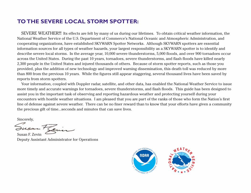
TO THE SEVERE LOCAL STORM SPOTTER:
SEVERE WEATHER!!! Its effects are felt by many of us during our lifetimes. To obtain critical weather information, theNational Weather Service of the U.S. Department of Commerce’s National Oceanic and Atmospheric Administration, andcooperating organizations, have established SKYWARN Spotter Networks. Although SKYWARN spotters are essentialinformation sources for all types of weather hazards, your largest responsibility as a SKYWARN spotter is to identify anddescribe severe local storms. In the average year, 10,000 severe thunderstorms, 5,000 floods, and over 900 tornadoes occuracross the United States. During the past 10 years, tornadoes, severe thunderstorms, and flash floods have killed nearly2,300 people in the United States and injured thousands of others. Because of storm spotter reports, such as those youprovided, plus the addition of new technology and improved warning dissemination, this death toll was reduced by morethan 800 from the previous 10 years. While the figures still appear staggering, several thousand lives have been saved byreports from storm spotters.
Your information, coupled with Doppler radar, satellite, and other data, has enabled the National Weather Service to issuemore timely and accurate warnings for tornadoes, severe thunderstorms, and flash floods. This guide has been designed toassist you in the important task of observing and reporting hazardous weather and protecting yourself during yourencounters with hostile weather situations. I am pleased that you are part of the ranks of those who form the Nation’s firstline of defense against severe weather. There can be no finer reward than to know that your efforts have given a communitythe precious gift of time...seconds and minutes that can save lives.
Sincerely,
Susan F. ZevinDeputy Assistant Administrator for Operations
NA
TIO
NA
L O
CEA
NIC AND ATMOSPHERIC ADMIN
ISTR
AT
ION
U.S
. DEPARTMENT OF COMM
ERC
E
Use of this Guide:The information contained in this guide is provided as a reference to supplement the National Weather Service’s spotter training film and
slide series. It is not sufficient to qualify you as a SKYWARN spotter. This guide has been compiled for use by trained spotters in the field(both fixed and mobile spotters) and communication specialists who receive and relay the reports. The safety tips contained in this guideare geared primarily for mobile spotters, but the technical concepts that are outlined are applicable to spotters of all types. This guide isnot a general handout for the public. As a result of its specialized subject matter, a number of technical terms are used. Their meanings areexplained in the text. Many of the photos used in this guide were taken in the Great Plains area of the United States where visibilities usuallyare good. Spotters in other areas of the country, especially the southern states, may have difficulty seeing some of the thunderstorm’sfeatures because of poor visibility caused by terrain, trees, heavy rainfall, or low clouds.
Definitions and Terminology
Severe local storms occur in all parts of the continental UnitedStates in an average year. As part of their training, storm spottersshould be aware of severe storm definitions and terminology used bythe National Weather Service.
Watch — Conditions are favorable for the severe weather event inor near the watch area. Watches are issued for tornadoes, severethunderstorms, and flash floods.
Warning — The severe weather event is imminent or occurring inthe warned area. Warnings are issued for tornadoes, severethunderstorms, flash floods, and river flooding.
Severe Thunderstorm — A storm that produces hail 3/4 inch indiameter or larger and/or wind gusts of 58 mph or more.
Tornado — A violently rotating column of air attached to athunderstorm and in contact with the ground.
Funnel Cloud — A rotating, funnel-shaped cloud extendingdownward from a thunderstorm base.
Downburst — A strong downdraft with an outrush of damagingwind on or near the ground.
Flash Flood — A rapid rise in water, usually within 12 hours of aperiod of heavy rain or other causative agent (i.e., dam break).
Severe Weather Reporting CriteriaMany types of weather information are needed from storm
spotters; however, some types of information are much moreimportant than others. Strict adherence to the reporting criteriaallows vital information to be communicated as soon as possible.Also, some of the reporting criteria should receive higher prioritycommunication than others. You should report the following weatherevents.
Urgent PriorityTornadoFunnel cloudRotating wall cloudFlash flooding
High PriorityHail 3/4-inch diameter or largerWind speed greater than 58 mphPersistent non-rotating wall cloudRainfall 1 inch or more per hour
Lower Priority
Hail 1/2-inch diameter or largerWind speed greater than 40 mphCloud features suggesting storm organizationOther locally-defined criteria
NOTE: When reporting 1/2-inch diameter hail, do not use the term“marble” since marbles can come in a variety of sizes. In areas proneto severe weather, some offices may not need reports of 1/2-inch hail.Contact your local NWS office for specific adjustments to the criteriasuggested above.
Receiving Hazardous WeatherInformation
Spotters, both point and mobile, should have access to reliablehazardous weather information. Many spotters have access toamateur radio networks. These networks will likely have one or moreradio operators stationed at NWS offices for providing radar and othermeteorological information to the net. Spotter networks not affiliatedwith amateur radio groups should consider having one or moremembers monitor NOAA Weather Radio and other outlets for weatherinformation. These networks may wish to select a liaison person whocould work with nearby amateur radio groups or the local NWS office.
Another means of receiving hazardous weather information is theEmergency Managers Weather Information Network (EMWIN). EMWINis a low-cost, low-speed data stream of NWS products (warnings,observations, etc.) provided as a service to local emergency managers.The signal may be received directly from the GOES weather satellites,processed for local use, and/or rebroadcast to the surrounding area onVHF radio. Numerous EMWIN systems are coming on line across thecountry, which should allow both point and mobile spotters access tocritical NWS information. This in turn should allow for more efficientoperation of spotter networks in the area.
1

Thunderstorm Hazards andSafety Tips
Flash FloodsFlash flooding is a major killer. Many flash floods occur at night,
which makes them more difficult to see. As a storm spotter, you mayencounter flash floods at any time. Heeding the following flash floodsafety rules may save your life.
• DO NOT attempt to drive or walk across a flooded roadwayor low water crossing. Nearly half of all flash flood deaths arevehicle-related. Moving water 2 feet deep will carry awaymost cars.
• If your vehicle becomes caught in high water and stalls, leave itimmediately and seek higher ground if you can do so safely.Rapidly rising water may sweep a vehicle and its occupantsaway.
• Be especially careful at night when flash floods are harderto recognize.
LightningLightning occurs in all thunderstorms and is also a significant
threat to life (figure 1). Storm spotters are especially vulnerable tobeing struck by lightning since they are often in prime strikelocations, such as in open fields or on hilltops. The followinglightning safety rules are important.
• Lightning tends to strike the tallest object in an area...make sureit is not you. Remain in your vehicle or an indoor locationwhenever possible.
• If you must go outside, crouch down to make yourself a poorlightning target. Do not lie flat on the ground since you willbe more likely to be severely shocked if lightning strikesclose to you.
2
Figure 1: Cloud-to-ground lightning. Photo - Courtesy Roger Edwards.
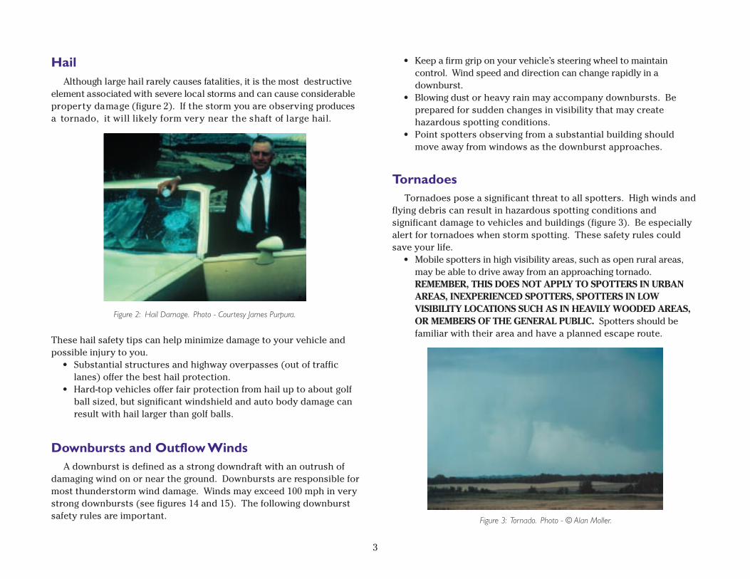
HailAlthough large hail rarely causes fatalities, it is the most destructive
element associated with severe local storms and can cause considerableproperty damage (figure 2). If the storm you are observing producesa tornado, it will likely form very near the shaft of large hail.
These hail safety tips can help minimize damage to your vehicle andpossible injury to you.
• Substantial structures and highway overpasses (out of trafficlanes) offer the best hail protection.
• Hard-top vehicles offer fair protection from hail up to about golfball sized, but significant windshield and auto body damage canresult with hail larger than golf balls.
Downbursts and Outflow WindsA downburst is defined as a strong downdraft with an outrush of
damaging wind on or near the ground. Downbursts are responsible formost thunderstorm wind damage. Winds may exceed 100␣ mph in verystrong downbursts (see figures 14 and 15). The following downburstsafety rules are important.
• Keep a firm grip on your vehicle’s steering wheel to maintaincontrol. Wind speed and direction can change rapidly in adownburst.
• Blowing dust or heavy rain may accompany downbursts. Beprepared for sudden changes in visibility that may createhazardous spotting conditions.
• Point spotters observing from a substantial building shouldmove away from windows as the downburst approaches.
TornadoesTornadoes pose a significant threat to all spotters. High winds and
flying debris can result in hazardous spotting conditions andsignificant damage to vehicles and buildings (figure 3). Be especiallyalert for tornadoes when storm spotting. These safety rules couldsave your life.
• Mobile spotters in high visibility areas, such as open rural areas,may be able to drive away from an approaching tornado.REMEMBER, THIS DOES NOT APPLY TO SPOTTERS IN URBANAREAS, INEXPERIENCED SPOTTERS, SPOTTERS IN LOWVISIBILITY LOCATIONS SUCH AS IN HEAVILY WOODED AREAS,OR MEMBERS OF THE GENERAL PUBLIC. Spotters should befamiliar with their area and have a planned escape route.
3
Figure 3: Tornado. Photo - © Alan Moller.
Figure 2: Hail Damage. Photo - Courtesy James Purpura.
4
the development stage may begin as higher based altocumulusclouds. As moisture becomes more plentiful, the base of the stormmay lower.
b. Mature Stage (figure 5) — This is the strongest and mostdangerous stage of the storm’s life cycle. At this stage, the stormcontains both upward and downward moving air currents (updraftsand downdrafts) with precipitation in the downdraft area. Thedowndraft results from precipitation evaporating, which causescooling. To a lesser extent, the falling precipitation itself createsdownward drag. When the cool downdraft hits the ground, it spreadsout and forms a gust front, which may include damaging winds calleda downburst. At the top of the storm, the updraft rapidly deceleratesand clouds spread out and form an anvil. If the updraft is strong, a“bubble” of cloud, called an “overshooting top,” will be pushed abovethe anvil. Spotters should pay particular attention to a storm with anovershooting top since the area beneath the top is a preferred areafor severe weather formation.
c. Dissipating Stage (figure 6) — Eventually, excessive precipitationand downdraft will weaken the updraft. Downdrafts dominate thestorm and any overshooting top disappears. At the surface, the gustfront will move away from the storm and cut off the inflow of energyinto the storm. This is indicative of the dissipating stage.
• If you can’t avoid an oncoming tornado, you should take shelterin a substantial building, ditch, ravine, or other low spot (but becautious of flash flooding).
Safe Viewing TipsMobile spotters should try to view a storm from its right flank.
This will usually provide the best viewing angle, the best contrast, andit will generally keep spotters out of the storm’s path. For stormsmoving to the northeast, the best viewing location is from the southor southeast. With east or southeast moving storms, a viewing anglefrom the south or southwest (respectively) is preferred althoughspotters will need to be more conscious of the storm’s movement andhave an escape route available.
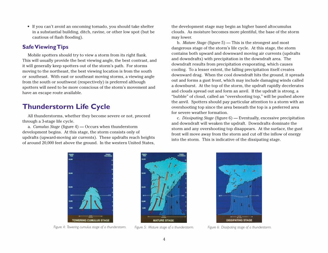
Thunderstorm Life CycleAll thunderstorms, whether they become severe or not, proceed
through a 3-stage life cycle.a. Cumulus Stage (figure 4) — Occurs when thunderstorm
development begins. At this stage, the storm consists only ofupdrafts (upward-moving air currents). These updrafts reach heightsof around 20,000 feet above the ground. In the western United States,
Figure 5: Mature stage of a thunderstorm. Figure 6: Dissipating stage of a thunderstorm.Figure 4: Towering cumulus stage of a thunderstorm.
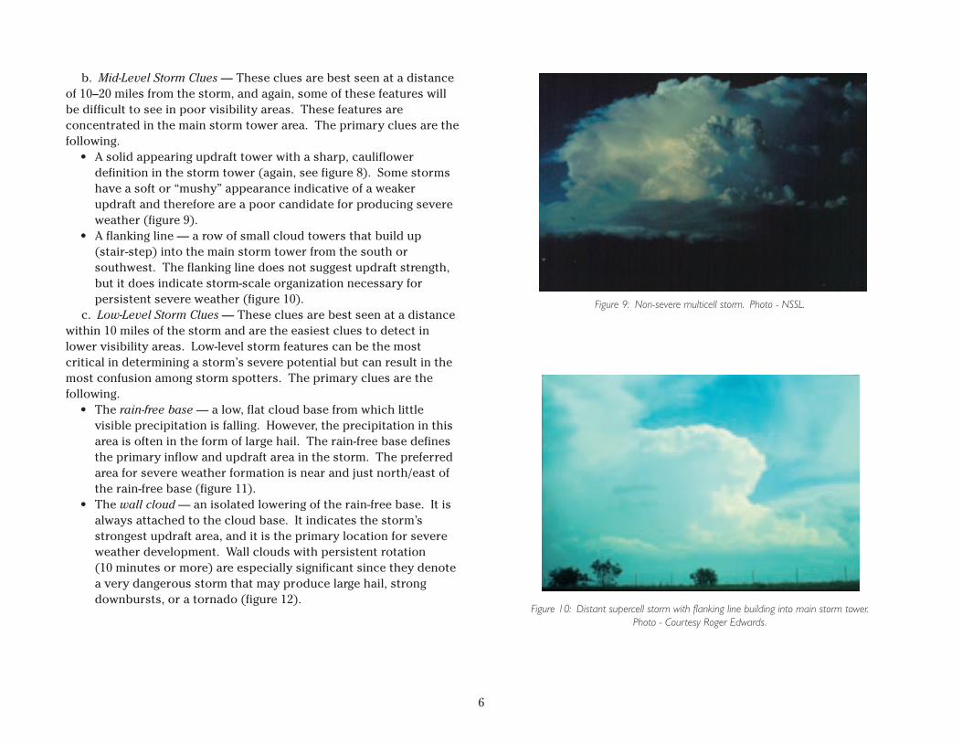
Visual Indications of Updraft Strengthand Organization
Several visual clues will help the spotter determine if a storm hassevere weather potential. These clues are evident in the upper,middle, and lower levels of the storm. The spotter should payparticular attention to these clues, especially when watching morethan one storm at a time.
a. Upper-Level Storm Clues — These clues are best seen at adistance of 30–40 miles from the storm, so they may be difficult to seein poor visibility areas. The primary clues are a large overshootingtop that persists for more than 10 minutes and an anvil with sharpand well-defined edges (figure 8). Storms with weaker updrafts willusually have an anvil that is thin, wispy, and fuzzy.
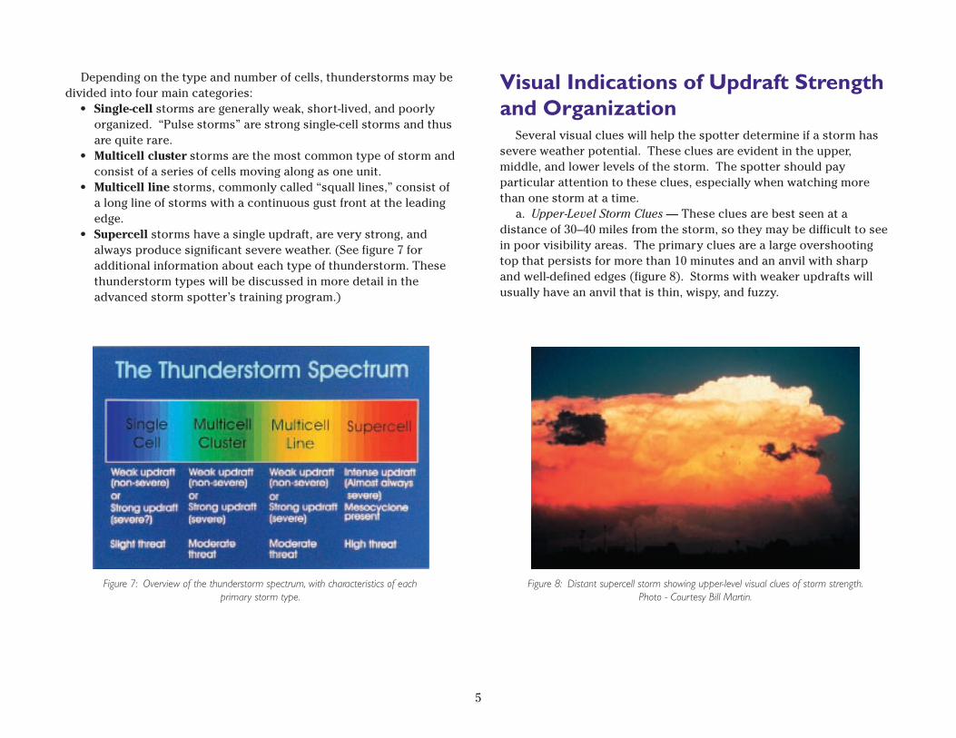
Depending on the type and number of cells, thunderstorms may bedivided into four main categories:
• Single-cell storms are generally weak, short-lived, and poorlyorganized. “Pulse storms” are strong single-cell storms and thusare quite rare.
• Multicell cluster storms are the most common type of storm andconsist of a series of cells moving along as one unit.
• Multicell line storms, commonly called “squall lines,” consist ofa long line of storms with a continuous gust front at the leadingedge.
• Supercell storms have a single updraft, are very strong, andalways produce significant severe weather. (See figure 7 foradditional information about each type of thunderstorm. Thesethunderstorm types will be discussed in more detail in theadvanced storm spotter’s training program.)
5
Figure 7: Overview of the thunderstorm spectrum, with characteristics of eachprimary storm type.
Figure 8: Distant supercell storm showing upper-level visual clues of storm strength.Photo - Courtesy Bill Martin.
6
Figure 9: Non-severe multicell storm. Photo - NSSL.
Figure 10: Distant supercell storm with flanking line building into main storm tower.Photo - Courtesy Roger Edwards.
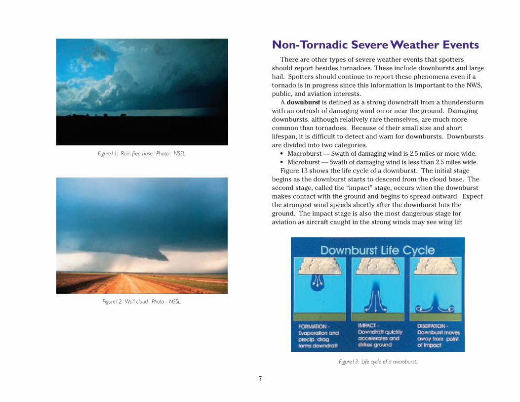
b. Mid-Level Storm Clues — These clues are best seen at a distanceof 10–20 miles from the storm, and again, some of these features willbe difficult to see in poor visibility areas. These features areconcentrated in the main storm tower area. The primary clues are thefollowing.
• A solid appearing updraft tower with a sharp, cauliflowerdefinition in the storm tower (again, see figure 8). Some stormshave a soft or “mushy” appearance indicative of a weakerupdraft and therefore are a poor candidate for producing severeweather (figure 9).
• A flanking line — a row of small cloud towers that build up(stair-step) into the main storm tower from the south orsouthwest. The flanking line does not suggest updraft strength,but it does indicate storm-scale organization necessary forpersistent severe weather (figure␣ 10).
c. Low-Level Storm Clues — These clues are best seen at a distancewithin 10 miles of the storm and are the easiest clues to detect inlower visibility areas. Low-level storm features can be the mostcritical in determining a storm’s severe potential but can result in themost confusion among storm spotters. The primary clues are thefollowing.
• The rain-free base — a low, flat cloud base from which littlevisible precipitation is falling. However, the precipitation in thisarea is often in the form of large hail. The rain-free base definesthe primary inflow and updraft area in the storm. The preferredarea for severe weather formation is near and just north/east ofthe rain-free base (figure␣ 11).
• The wall cloud — an isolated lowering of the rain-free base. It isalways attached to the cloud base. It indicates the storm’sstrongest updraft area, and it is the primary location for severeweather development. Wall clouds with persistent rotation(10 minutes or more) are especially significant since they denotea very dangerous storm that may produce large hail, strongdownbursts, or a tornado (figure 12).
7
Figure12: Wall cloud. Photo - NSSL.
Non-Tornadic Severe Weather EventsThere are other types of severe weather events that spotters
should report besides tornadoes. These include downbursts and largehail. Spotters should continue to report these phenomena even if atornado is in progress since this information is important to the NWS,public, and aviation interests.
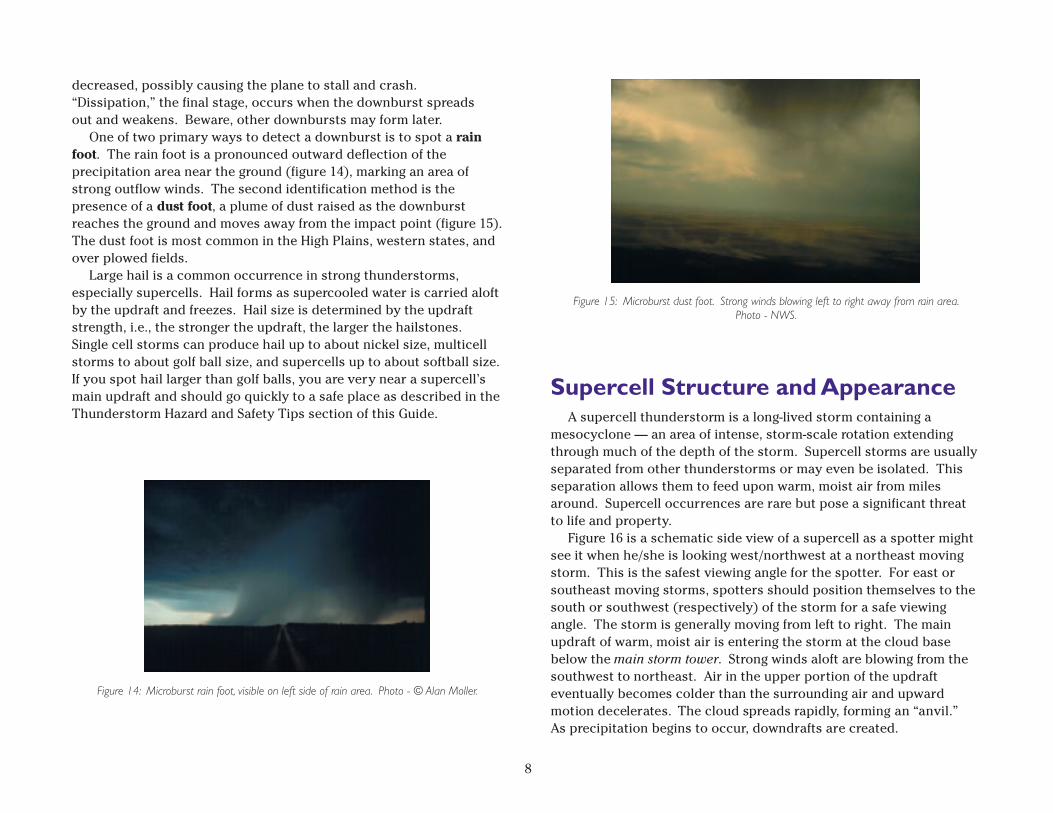
A downburst is defined as a strong downdraft from a thunderstormwith an outrush of damaging wind on or near the ground. Damagingdownbursts, although relatively rare themselves, are much morecommon than tornadoes. Because of their small size and shortlifespan, it is difficult to detect and warn for downbursts. Downburstsare divided into two categories.
• Macroburst — Swath of damaging wind is 2.5 miles or more wide.• Microburst — Swath of damaging wind is less than 2.5 miles wide.Figure 13 shows the life cycle of a downburst. The initial stage
begins as the downburst starts to descend from the cloud base. Thesecond stage, called the “impact” stage, occurs when the downburstmakes contact with the ground and begins to spread outward. Expectthe strongest wind speeds shortly after the downburst hits theground. The impact stage is also the most dangerous stage foraviation as aircraft caught in the strong winds may see wing lift
Figure11: Rain-free base. Photo - NSSL.
Figure13: Life cycle of a microburst.
8
Figure 15: Microburst dust foot. Strong winds blowing left to right away from rain area.Photo - NWS.
decreased, possibly causing the plane to stall and crash.“Dissipation,” the final stage, occurs when the downburst spreadsout and weakens. Beware, other downbursts may form later.
One of two primary ways to detect a downburst is to spot a rainfoot. The rain foot is a pronounced outward deflection of theprecipitation area near the ground (figure 14), marking an area ofstrong outflow winds. The second identification method is thepresence of a dust foot, a plume of dust raised as the downburstreaches the ground and moves away from the impact point (figure 15).The dust foot is most common in the High Plains, western states, andover plowed fields.
Large hail is a common occurrence in strong thunderstorms,especially supercells. Hail forms as supercooled water is carried aloftby the updraft and freezes. Hail size is determined by the updraftstrength, i.e., the stronger the updraft, the larger the hailstones.Single cell storms can produce hail up to about nickel size, multicellstorms to about golf ball size, and supercells up to about softball size.If you spot hail larger than golf balls, you are very near a supercell’smain updraft and should go quickly to a safe place as described in theThunderstorm Hazard and Safety Tips section of this Guide.
Figure 14: Microburst rain foot, visible on left side of rain area. Photo - © Alan Moller.
Supercell Structure and AppearanceA supercell thunderstorm is a long-lived storm containing a
mesocyclone — an area of intense, storm-scale rotation extendingthrough much of the depth of the storm. Supercell storms are usuallyseparated from other thunderstorms or may even be isolated. Thisseparation allows them to feed upon warm, moist air from milesaround. Supercell occurrences are rare but pose a significant threatto life and property.
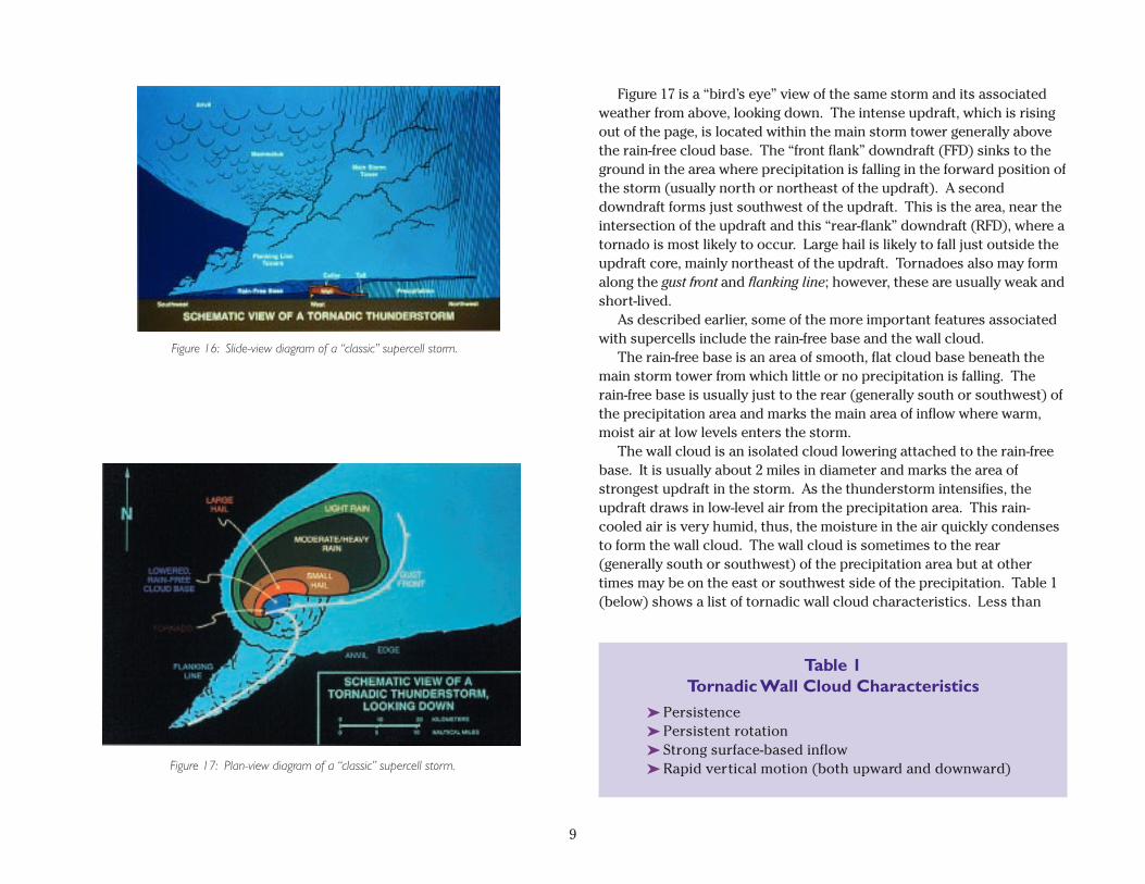
Figure 16 is a schematic side view of a supercell as a spotter mightsee it when he/she is looking west/northwest at a northeast movingstorm. This is the safest viewing angle for the spotter. For east orsoutheast moving storms, spotters should position themselves to thesouth or southwest (respectively) of the storm for a safe viewingangle. The storm is generally moving from left to right. The mainupdraft of warm, moist air is entering the storm at the cloud basebelow the main storm tower. Strong winds aloft are blowing from thesouthwest to northeast. Air in the upper portion of the updrafteventually becomes colder than the surrounding air and upwardmotion decelerates. The cloud spreads rapidly, forming an “anvil.”As precipitation begins to occur, downdrafts are created.
9
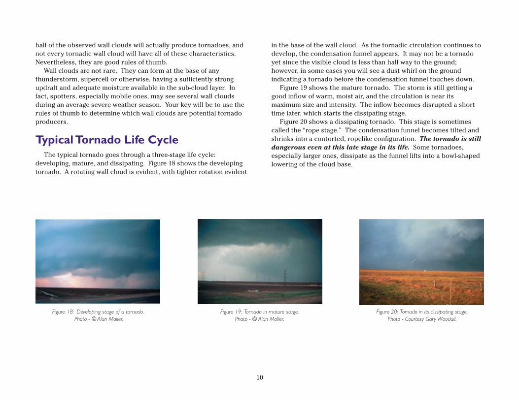
Figure 17: Plan-view diagram of a “classic” supercell storm.
Figure 16: Slide-view diagram of a “classic” supercell storm.
Table 1Tornadic Wall Cloud Characteristics
➤␣ Persistence➤␣ Persistent rotation➤␣ Strong surface-based inflow➤␣ Rapid vertical motion (both upward and downward)
Figure 17 is a “bird’s eye” view of the same storm and its associatedweather from above, looking down. The intense updraft, which is risingout of the page, is located within the main storm tower generally abovethe rain-free cloud base. The “front flank” downdraft (FFD) sinks to theground in the area where precipitation is falling in the forward position ofthe storm (usually north or northeast of the updraft). A seconddowndraft forms just southwest of the updraft. This is the area, near theintersection of the updraft and this “rear-flank” downdraft (RFD), where atornado is most likely to occur. Large hail is likely to fall just outside theupdraft core, mainly northeast of the updraft. Tornadoes also may formalong the gust front and flanking line; however, these are usually weak andshort-lived.
As described earlier, some of the more important features associatedwith supercells include the rain-free base and the wall cloud.
The rain-free base is an area of smooth, flat cloud base beneath themain storm tower from which little or no precipitation is falling. Therain-free base is usually just to the rear (generally south or southwest) ofthe precipitation area and marks the main area of inflow where warm,moist air at low levels enters the storm.
The wall cloud is an isolated cloud lowering attached to the rain-freebase. It is usually about 2 miles in diameter and marks the area ofstrongest updraft in the storm. As the thunderstorm intensifies, theupdraft draws in low-level air from the precipitation area. This rain-cooled air is very humid, thus, the moisture in the air quickly condensesto form the wall cloud. The wall cloud is sometimes to the rear(generally south or southwest) of the precipitation area but at othertimes may be on the east or southwest side of the precipitation. Table 1(below) shows a list of tornadic wall cloud characteristics. Less than
half of the observed wall clouds will actually produce tornadoes, andnot every tornadic wall cloud will have all of these characteristics.Nevertheless, they are good rules of thumb.
Wall clouds are not rare. They can form at the base of anythunderstorm, supercell or otherwise, having a sufficiently strongupdraft and adequate moisture available in the sub-cloud layer. Infact, spotters, especially mobile ones, may see several wall cloudsduring an average severe weather season. Your key will be to use therules of thumb to determine which wall clouds are potential tornadoproducers.
Typical Tornado Life CycleThe typical tornado goes through a three-stage life cycle:
developing, mature, and dissipating. Figure 18 shows the developingtornado. A rotating wall cloud is evident, with tighter rotation evident
10
Figure 19: Tornado in mature stage.Photo - © Alan Moller.
Figure 18: Developing stage of a tornado. Photo - © Alan Moller.
in the base of the wall cloud. As the tornadic circulation continues todevelop, the condensation funnel appears. It may not be a tornadoyet since the visible cloud is less than half way to the ground;however, in some cases you will see a dust whirl on the groundindicating a tornado before the condensation funnel touches down.
Figure 19 shows the mature tornado. The storm is still getting agood inflow of warm, moist air, and the circulation is near itsmaximum size and intensity. The inflow becomes disrupted a shorttime later, which starts the dissipating stage.
Figure 20 shows a dissipating tornado. This stage is sometimescalled the “rope stage.” The condensation funnel becomes tilted andshrinks into a contorted, ropelike configuration. The tornado is stilldangerous even at this late stage in its life. Some tornadoes,especially larger ones, dissipate as the funnel lifts into a bowl-shapedlowering of the cloud base.
Figure 20: Tornado in its dissipating stage.Photo - Courtesy Gary Woodall.
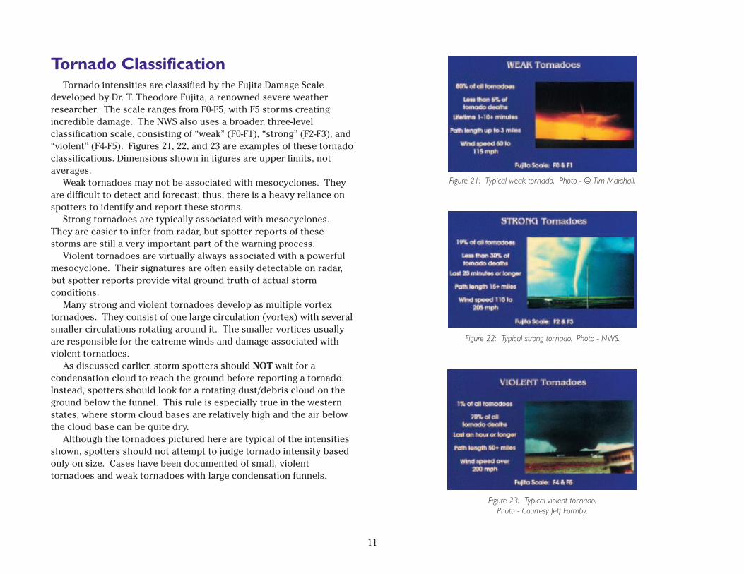
Tornado ClassificationTornado intensities are classified by the Fujita Damage Scale
developed by Dr. T. Theodore Fujita, a renowned severe weatherresearcher. The scale ranges from F0-F5, with F5 storms creatingincredible damage. The NWS also uses a broader, three-levelclassification scale, consisting of “weak” (F0-F1), “strong” (F2-F3), and“violent” (F4-F5). Figures 21, 22, and 23 are examples of these tornadoclassifications. Dimensions shown in figures are upper limits, notaverages.
Weak tornadoes may not be associated with mesocyclones. Theyare difficult to detect and forecast; thus, there is a heavy reliance onspotters to identify and report these storms.
Strong tornadoes are typically associated with mesocyclones.They are easier to infer from radar, but spotter reports of thesestorms are still a very important part of the warning process.
Violent tornadoes are virtually always associated with a powerfulmesocyclone. Their signatures are often easily detectable on radar,but spotter reports provide vital ground truth of actual stormconditions.
Many strong and violent tornadoes develop as multiple vortextornadoes. They consist of one large circulation (vortex) with severalsmaller circulations rotating around it. The smaller vortices usuallyare responsible for the extreme winds and damage associated withviolent tornadoes.
As discussed earlier, storm spotters should NOT wait for acondensation cloud to reach the ground before reporting a tornado.Instead, spotters should look for a rotating dust/debris cloud on theground below the funnel. This rule is especially true in the westernstates, where storm cloud bases are relatively high and the air belowthe cloud base can be quite dry.
Although the tornadoes pictured here are typical of the intensitiesshown, spotters should not attempt to judge tornado intensity basedonly on size. Cases have been documented of small, violenttornadoes and weak tornadoes with large condensation funnels.
11
Figure 21: Typical weak tornado. Photo - © Tim Marshall.
Figure 22: Typical strong tor nado. Photo - NWS.
Figure 23: Typical violent tor nado.Photo - Courtesy Jeff Formby.
Tornado Look-AlikesOne of the biggest challenges in tornado spotting is determining
whether you are seeing the “real thing” or a tornado look-alike. Twokey features present with a tornado are a debris cloud near theground and organized rotation about a vertical axis.
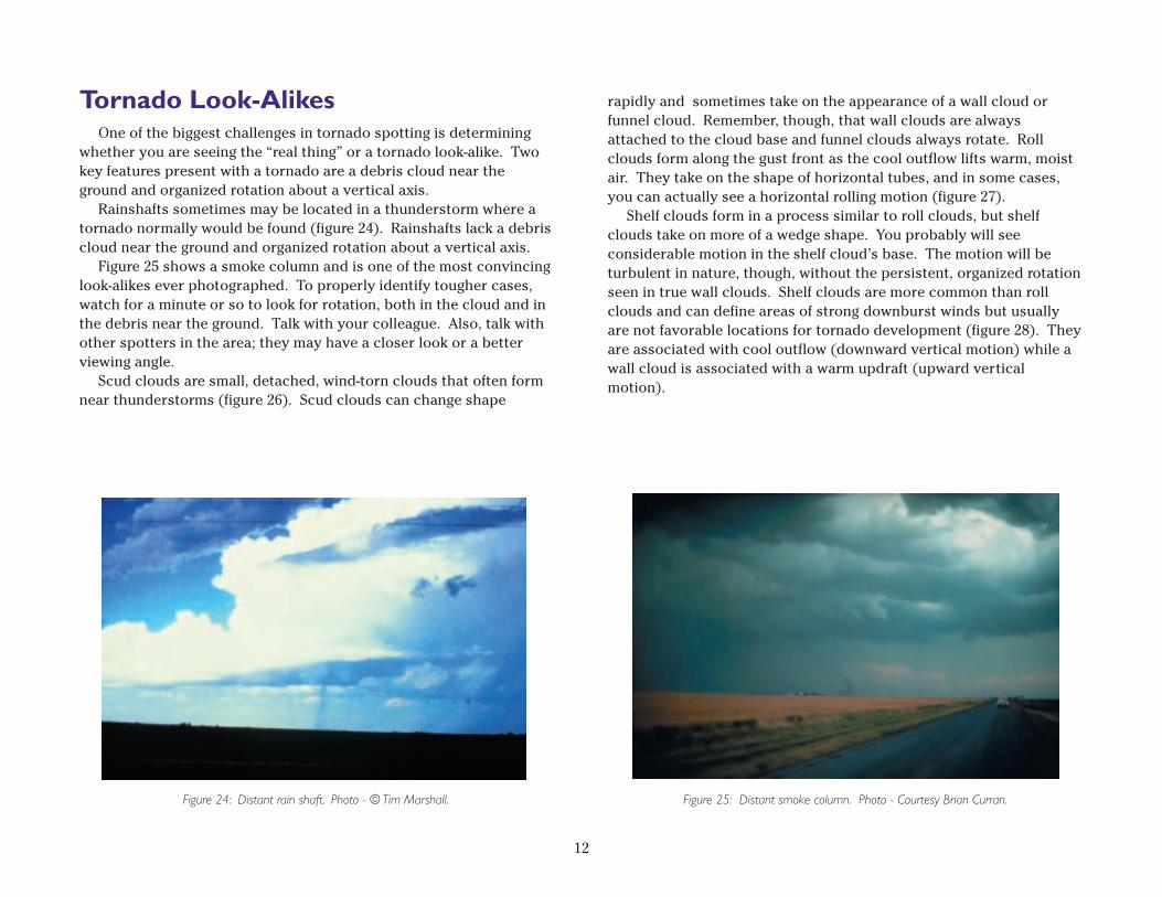
Rainshafts sometimes may be located in a thunderstorm where atornado normally would be found (figure 24). Rainshafts lack a debriscloud near the ground and organized rotation about a vertical axis.
Figure 25 shows a smoke column and is one of the most convincinglook-alikes ever photographed. To properly identify tougher cases,watch for a minute or so to look for rotation, both in the cloud and inthe debris near the ground. Talk with your colleague. Also, talk withother spotters in the area; they may have a closer look or a betterviewing angle.
Scud clouds are small, detached, wind-torn clouds that often formnear thunderstorms (figure 26). Scud clouds can change shape
rapidly and sometimes take on the appearance of a wall cloud orfunnel cloud. Remember, though, that wall clouds are alwaysattached to the cloud base and funnel clouds always rotate. Rollclouds form along the gust front as the cool outflow lifts warm, moistair. They take on the shape of horizontal tubes, and in some cases,you can actually see a horizontal rolling motion (figure 27).
Shelf clouds form in a process similar to roll clouds, but shelfclouds take on more of a wedge shape. You probably will seeconsiderable motion in the shelf cloud’s base. The motion will beturbulent in nature, though, without the persistent, organized rotationseen in true wall clouds. Shelf clouds are more common than rollclouds and can define areas of strong downburst winds but usuallyare not favorable locations for tornado development (figure␣ 28). Theyare associated with cool outflow (downward vertical motion) while awall cloud is associated with a warm updraft (upward verticalmotion).
12
Figure 25: Distant smoke column. Photo␣ - Courtesy Brian Curran.Figure 24: Distant rain shaft. Photo␣ - © Tim Marshall.
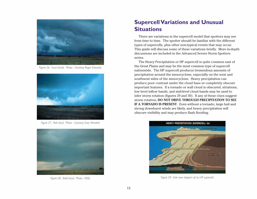
Supercell Variations and UnusualSituations
There are variations in the supercell model that spotters may seefrom time to time. The spotter should be familiar with the differenttypes of supercells, plus other non-typical events that may occur.This guide will discuss some of these variations briefly. More in-depthdiscussions are included in the Advanced Severe Storm Spottersseries.
The Heavy Precipitation or HP supercell is quite common east ofthe Great Plains and may be the most common type of supercellnationwide. The HP supercell produces tremendous amounts ofprecipitation around the mesocyclone, especially on the west andsouthwest sides of the mesocyclone. Heavy precipitation canproduce poor contrast under the cloud base or completely obscureimportant features. If a tornado or wall cloud is obscured, striations,low level inflow bands, and mid-level cloud bands may be used toinfer storm rotation (figures 29 and 30). If any of these clues suggeststorm rotation, DO NOT DRIVE THROUGH PRECIPITATION TO SEEIF A TORNADO IS PRESENT. Even without a tornado, large hail andstrong downburst winds are likely, and heavy precipitation willobscure visibility and may produce flash flooding.
13
Figure 27: Roll cloud. Photo - Courtesy Gary Woodall.
Figure 28: Shelf cloud. Photo - NSSL.
Figure 26: Scud clouds. Photo - Courtesy Roger Edwards.
Figure 29: Side view diagram of an HP supercell.
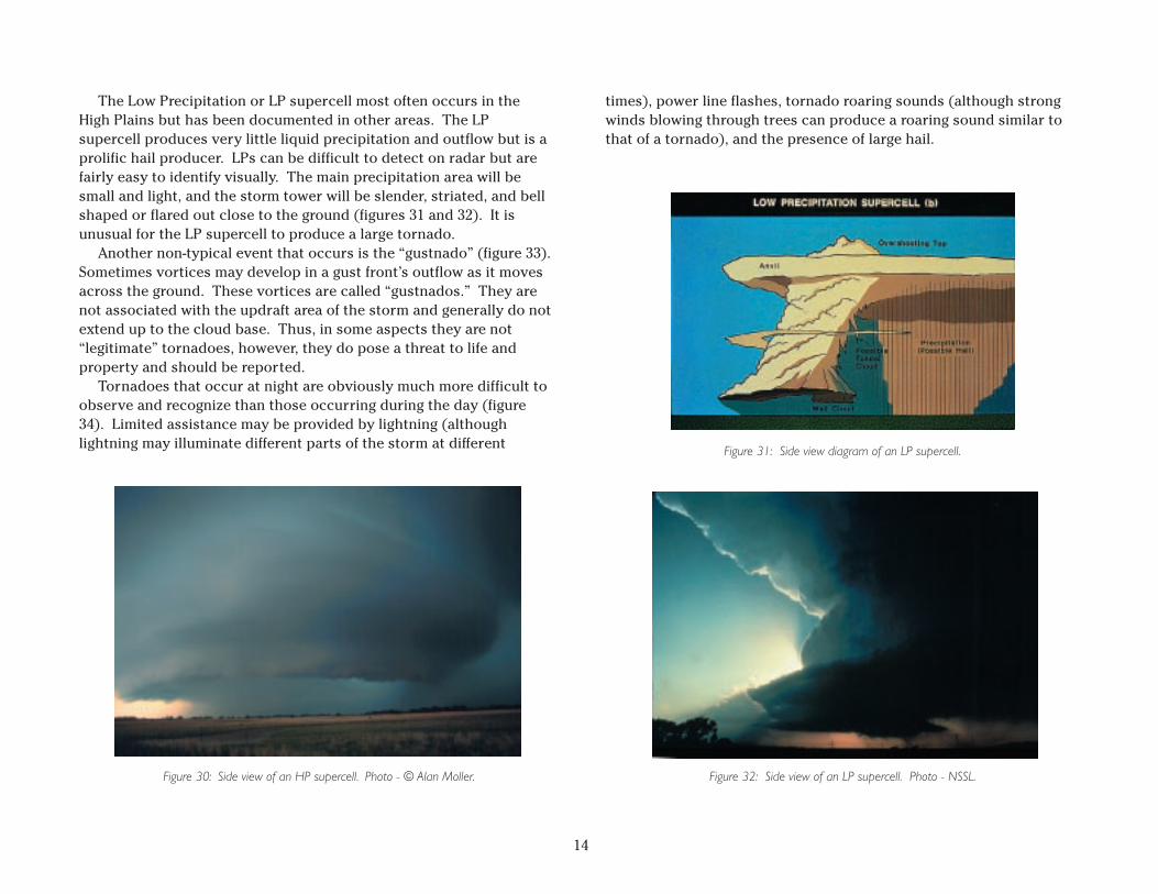
The Low Precipitation or LP supercell most often occurs in theHigh Plains but has been documented in other areas. The LPsupercell produces very little liquid precipitation and outflow but is aprolific hail producer. LPs can be difficult to detect on radar but arefairly easy to identify visually. The main precipitation area will besmall and light, and the storm tower will be slender, striated, and bellshaped or flared out close to the ground (figures 31 and 32). It isunusual for the LP supercell to produce a large tornado.
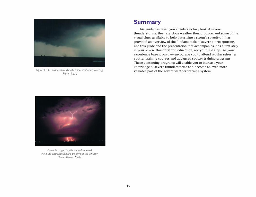
Another non-typical event that occurs is the “gustnado” (figure 33).Sometimes vortices may develop in a gust front’s outflow as it movesacross the ground. These vortices are called “gustnados.” They arenot associated with the updraft area of the storm and generally do notextend up to the cloud base. Thus, in some aspects they are not“legitimate” tornadoes, however, they do pose a threat to life andproperty and should be reported.
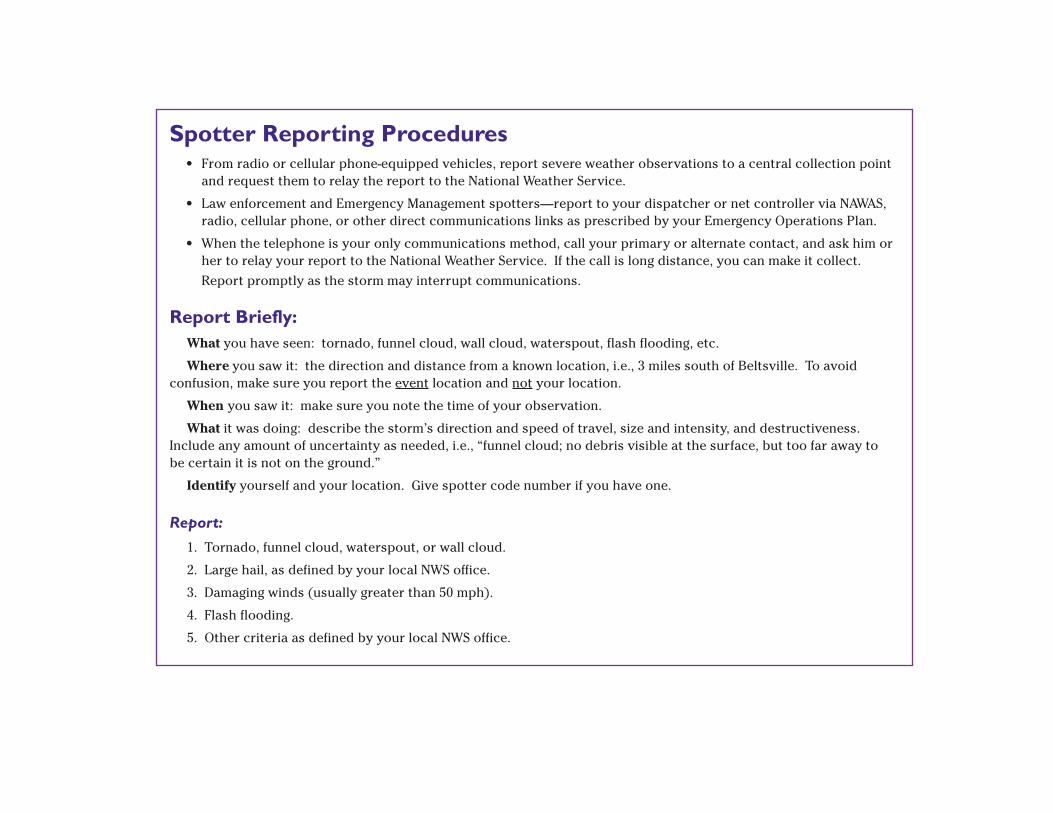
Tornadoes that occur at night are obviously much more difficult toobserve and recognize than those occurring during the day (figure34). Limited assistance may be provided by lightning (althoughlightning may illuminate different parts of the storm at different
Figure 30: Side view of an HP supercell. Photo - © Alan Moller.
Figure 31: Side view diagram of an LP supercell.
Figure 32: Side view of an LP supercell. Photo - NSSL.
times), power line flashes, tornado roaring sounds (although strongwinds blowing through trees can produce a roaring sound similar tothat of a tornado), and the presence of large hail.
14
SummaryThis guide has given you an introductory look at severe
thunderstorms, the hazardous weather they produce, and some of thevisual clues available to help determine a storm’s severity. It hasprovided an overview of the fundamentals of severe storm spotting.Use this guide and the presentation that accompanies it as a first stepin your severe thunderstorm education, not your last step. As yourexperience base grows, we encourage you to attend regular refresherspotter training courses and advanced spotter training programs.These continuing programs will enable you to increase yourknowledge of severe thunderstorms and become an even morevaluable part of the severe weather warning system.Figure 33: Gustnado visible directly below shelf cloud lowering..
Photo - NSSL.
Figure 34: Lightning-illuminated supercell.Note the suspicious feature just right of the lightning.
Photo - © Alan Moller.
15

Notes
______________________________________________________________________
______________________________________________________________________
______________________________________________________________________
______________________________________________________________________
______________________________________________________________________
______________________________________________________________________
______________________________________________________________________
______________________________________________________________________
______________________________________________________________________
______________________________________________________________________
______________________________________________________________________
______________________________________________________________________
______________________________________________________________________
______________________________________________________________________
______________________________________________________________________
______________________________________________________________________
______________________________________________________________________
______________________________________________________________________
______________________________________________________________________
Figure CreditsCover and Title Page - Photo by National Severe Storms Laboratory
(NSSL).Figure 1 - Courtesy Roger Edwards.Figure 2 - Courtesy James Purpura.Figure 3 - © Alan Moller.Figures 4 - 7 - NOAA.Figure 8 - Courtesy Bill Martin.Figure 9 - NSSL.Figure 10 - Courtesy Roger Edwards.Figure 11 - NSSL.Figure 12 - NSSL.Figure 13 - NOAA.Figure 14 - © Alan Moller.Figure 15 - NWS.Figure 16 - NOAA.Figure 17 - NOAA.Figure 18 - © Alan Moller.Figure 19 - © Alan Moller.Figure 20 - Courtesy Gary Woodall.Figure 21 - © Tim Marshall.Figure 22 - NWS.Figure 23 - Courtesy Jeff Formby.Figure 24 - © Tim Marshall.Figure 25 - Courtesy Brian Curran.Figure 26 - Courtesy Roger Edwards.Figure 27 - Courtesy Gary Woodall.Figure 28 - NSSL.Figure 29 - NOAA.Figure 30 - © Alan Moller.Figure 31 - NOAA.Figure 32 - NSSL.Figure 33 - NSSL.Figure 34 - © Alan Moller.
16
Spotter Reporting Procedures• From radio or cellular phone-equipped vehicles, report severe weather observations to a central collection point
and request them to relay the report to the National Weather Service.
• Law enforcement and Emergency Management spotters—report to your dispatcher or net controller via NAWAS,radio, cellular phone, or other direct communications links as prescribed by your Emergency Operations Plan.
• When the telephone is your only communications method, call your primary or alternate contact, and ask him orher to relay your report to the National Weather Service. If the call is long distance, you can make it collect.
Report promptly as the storm may interrupt communications.
Report Briefly:What you have seen: tornado, funnel cloud, wall cloud, waterspout, flash flooding, etc.
Where you saw it: the direction and distance from a known location, i.e., 3 miles south of Beltsville. To avoidconfusion, make sure you report the event location and not your location.
When you saw it: make sure you note the time of your observation.
What it was doing: describe the storm’s direction and speed of travel, size and intensity, and destructiveness.Include any amount of uncertainty as needed, i.e., “funnel cloud; no debris visible at the surface, but too far away tobe certain it is not on the ground.”
Identify yourself and your location. Give spotter code number if you have one.
Report:
1. Tornado, funnel cloud, waterspout, or wall cloud.
2. Large hail, as defined by your local NWS office.
3. Damaging winds (usually greater than 50 mph).
4. Flash flooding.
5. Other criteria as defined by your local NWS office.