Basic geology course, Papua New Guinea, 5-22 June 1989
95
CCOP/SOPAC Training Report 21 July 1989 BASIC GEOLOGY COURSE, PAPUA NEW GUINEA 5-22 June 1989 Russell Howorth l Techsec Prepared for: Committee for Co-ordination of Joint Prospecting for Mineral Resources in South Pacific Offshore Areas (CCOP/SOPAC) Contributed by: ESCAP/UNDP RAS/86/l25 Development of South Pacific Institutional Capability in Marine Minerals and Technology (CCOP/SOPAC)
Transcript of Basic geology course, Papua New Guinea, 5-22 June 1989

CCOP/SOPAC Training Report 21
July 1989
BASIC GEOLOGY COURSE, PAPUA NEW GUINEA
5-22 June 1989
Russell Howorthl
Techsec
Prepared for: Committee for Co-ordination of Joint Prospecting for Mineral Resources in South Pacific Offshore Areas (CCOP/SOPAC)
Contributed by: ESCAP/UNDP RAS/86/l25 Development of South Pacific Institutional Capability in Marine Minerals and Technology (CCOP/SOPAC)

Training Report 21
BASIC GEOLOGY COURSE, PAPUA NEW GUINEA
5-22 JUNE, 1989
Russell Howorth
Training Co-ordinator, CCOP/SOPAC

OBJECTIVE
A three-week course in basic geology for staff of the Department of Minerals and Energy, Papua New Guinea, was held in Port Moresby from 5-22 June, 1989.
The purpose of the course was to introduce the participants who are employed in a wide variety of technical and scientific positions within the department to geology in all its aspects as an interdisciplinary scientific study of the Earth. An introduction was also given to the practical skills of utilising and making maps and cross sections to represent three dimensions.
A total of 23 participants (see list below) attended the course which ran for 13 days; Monday, 19 June was a public holiday. There were 12 days for instruction and the last day was devoted to assessment. Generally the mornings were spent on lectures and the afternoons on practical map exercises. The daily programme (see below) was organised as follows; 08.15-10.00, 10.30-12.00, 13.1514.30, and 15.00-16.15. Sheets of Self Assessment Questions were handed out and reviewed daily.
The Appendix to this report is the Course Notebook which includes the course notes, self assessment questions, map exercises and test sheets.
PARTICIPANTS
Jack ABRAHAMS Geological Services Branch Thomas ADIGUMA Geological Services Branch Lawrence ANTON Geological Services Branch Maburu BUROM Geological Services Branch Mogia DOM Geological Services Branch Vele GAVU Small Scale Mining Branch Kila KILA Petroleum Branch Patricia KILA Mines Division Laboratory Jonathan KUDUON Volcanological Observatory Branch Haiveta LAE Mines Division Laboratory Paul MAMBEI Petroleum Branch Mark MANDIBI Petroleum Branch Clement MATUPIT Volcanological Observatory Branch Sarufa MAUPUA Petroleum Branch Mathew MOIHOI Geological Services Branch Steven MOVA Mines Division Laboratory Stanley PONO Petroleum Branch Luther SIPISON Volcanological Observatory Branch Patrick SOARE Petroleum Branch Nicholas TIMULAN Geological Services Branch Arnold UMBA Small Scale Mining Branch Sape UWANO Minerals Branch Leo YALLON Minerals Branch

DAILY PROGRAMME
June 5 Monday Introduction to the course.
Basic concepts of geology as an interdisciplinary science, Principle of Uniformitarianism, Goelogical Time Scale, real and relative time.
Exercises on topographic maps; north points, line scales, word scales and representative fractions.
June 6 Tuesday Shape, size and other general physical parameters of the Earth.
Properties of P and S seismic waves, use of seismic waves to determine general internal structure of the Earth, definition of core, mantle and crust.
Self Assessment Questions:1 (SAQ: 1)
Drawing topographic cross sections from contours, use and abuse of vertical scale exaggeration.
Cross sections of Lou Island, with and without vertical exaggeration.
June 7 Wednesday SAQ: 2
Primary physical features of the Earth and their distribution.
Physical features of the Pacific Basin; deep sea floor, East Pacific Rise, ocean fracture zones, island arcs and trenches, marginal basins, mid-oceanic islands (seamounts and guyots).
Contouring spot height data.
Grid references, exercises on Port Moresby 1:100000 topographic sheet.
June 8 Thursday SAQ: 3
Video: Geological Time.
General distribution of rock types in, and around the Pacific Basin, in continental,

oceanic and island arc areas.
stable and unstable areas of the outer part of the Earth, principle of isostasy.
Horizontal strata on maps and on cross sections, Law of superposition.
Tilted strata, direction of true dip and the use of structural contours (strike lines).
June 9 Friday SAQ: 4
Earthquakes; global distribution, elastic rebound theory, epicentre, focal depth, magnitude and felt intensity, types and operation of seismometers, method of locating the source of an earthquake.
Volcanism: global distribution, origin of magma dependent on depth (pressure), temperature and composition of rocks. Migration paths of magmas to surface, types of volcanoes (basaltic, andesitic and rhyolitic) and differences between them.
Video: The birth of a volcano.
ORAL TEST: 1
June 12 Monday SAQ: 5
Introduction to plate tectonics: basic assumptions and types of plate boundaries.
Structure of a divergent (seafloor spreading) boundary (eg East Pacific Rise). Uniformity and symmetry of spreading and control on age of oceanic crust and sediment thickness.
Structure of convergent boundaries, identification of subduction zones (eg Tonga-Kermadec arc/trench system and western seaboard of South America). Convergent boundaries as areas of mountain building.
Structure of transform fault boundaries, left and right lateral slip, example joining zones of convergence and divergence (Denali Faul t Zone), example joining zones of divergence and divergence (San Andreas Fault Zone), example joining zones of convergence and convergence (Hunter Fracture Zone-Fiji).

Three point structural contour map exercises, determination of true dip and true dip direction, plotting outcrop patterns using structural and topographic contours.
June 13 Tuesday SAQ 6
Plate boundaries around the Pacific Plate.
Cross section from east to west through the
Pacific Basin from South America to Asia.
Origin of marginal basins, active and inactive marginal basins in the Southwest Pacific.
Crust and mantle versus lithosphere and' asthenosphere (low velocity zone).
Origin of the low velocity zone as a zone of partial melting, its importance to the plate tectonic theory as the zone upon which the plates of lithosphere move horizontally relative to the rest of the Earth.
Sea floor magnetic data as evidence for seafloor spreading, its historical importance.
Origin of magnetic anomaly patterns across East Pacific Rise. How they are used to date the sea floor and the rate of its formation. Age of world I s ocean crust (65% of surface of the Earth) no more than 200 Myrs less than 5% of the age of the Earth.
Video: Plate Tectonics.
June 14 Wednesday SAQ: 7
Early history of the Earth, accretion as a cold mass, chemical zonation as heat builds up in interior, average composition of meteorites, core, mantle and crust.
Origin and evolution of the lithosphere, hydrosphere, atmosphere and biosphere.
Interactions between the lithosphere, hydrosphere, atmosphere and biosphere.
Introduction to oceanography, the hydrological cycle, importance of temperature, salinity and density variations in the oceans.

The thermocline, controls on its position, importance of upwelling of bottom water as a source of nutrients.
Influence of physical oceanography on biological activity in the oceans.
Grid reference and three borehole excercises combined.
June 15 Thursday SAQ: 8
Surface temperature, salinity and density variations in the oceans.
Lower atmosphere wind pattern and the role of the coriolis effect.
Surface circulation patterns in the oceans, especially in the Pacific Ocean, physiographic and lower atmosphere surface wind controls.
El Nino/Southern Oscillation Phenomenon. Chemistry of the oceans, origins and cyclical nature of the elements (ions) contributing to the saltiness.
Relative changes of sea level; magnitudes and timing, rates of change of sea level: changes caused by global climate in the geological past, changes caused by tectonic uplift or downwarp, changes caused by seafloor subsidence and the formation of coral atolls.
Future man-made possible changes of sea level caused by the "Greenhouse Effect".
Map Exercises: 3
June 16 Friday SAQ: 9
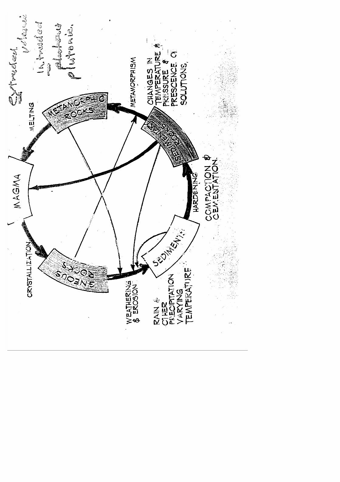
Introduction to the rock cycle. petrology, mineralogy and crystallography.
Definitions of a rock and mineral, problems with precise mineral definition.
Scale change from outcrop, to rock specimens, minerals, to atomic structure of minerals, sampling problems and geological interpretation constraints.
Rock cycle, major rock families, hand specimen

classification of rocks. Classifications as a means of communication, constraints.
Map Exercises: 3
ORAL TEST: 2
June 20 Tuesday SAQ: 10
Atomic structure, formation of ions (cations and ions), ionic form of common elements in crust.
Silica tetrahedron, structure and chemistry of major silicate mineral groups; olivines, pyroxenes, amphiboles, micas.
Feldspars, the major silicate group, concept of solid solution series, variation in composition of the feldspars especially plagiocalse feldspars.
Other important mineral groups; oxides, carbonates, sulphides, and native elements (including examples of each).
Application of the petrological microscope to the study of rock thin sections.
Hand specimen properties of minerals; Moh' s Hardness Scale.
Map Exercises: 4
June 21 Wednesday SAQ: 11
Hand specimen properties of minerals continued; cleavage, fracture, colour, streak, lustre, diaphaneity, specific gravity (density).
Classification of igneous rocks based on colour, density, crystal size and mineralogy.
Classification of sedimentary rocks based on grain size, grain shape, sorting and mineralogy. Common non-detrital sedimentary rocks.
Classification of metamorphic rocks; geothermal gradient and pressure gradient with depth, regional metamorphic rocks; con tact/thermal metamorphic rocks; fault breccias.

Common relationships between rocks for telling relative time.
Map Exercises: 4 Question (v) cross section.
June 22 Thursday SAQ: 12
SAQ:
13
Oral Test: 3 09.45-10.15
Written Test 10.45-11.30
Map Test 13.15-14.45
Closure Function 16.00-

APPENDIX: Course Handbook

BASIC GEOLOGY COURSE, PAPUA NEW GUINEA
5-22 JUNE, 1989
Russell Howorth
Training Co-ordinator, CCOP/SOPAC
Course Notes; compiled from various sources but principally "The Earth" by Press and Seiver (2nd Ed) and "Perspectives of the Earth" Australian Academy of Sciences.
Self Assessment Question Sheets
Map Exercises
Test Sheets


GEOLOGICAL SURVEY OF PAPUA NEW GUINEA
Basic Geology Course, 5-23 June, 1989
SELF ASSESSMENT QUESTIONS: 1
1 Show the following distances as lines across the page, give the
scales used, and make sure each line extends at least two-thirds the way across your paper:
(i) 950km (ii) 700m (iii) 66km (iv) 16km (v) 20m
Give answers as word scales.
2 For each word scale in Question 1 give the representative fraction.
3 Draw line scales to agree with the following representative fractions:
(i) 1:10000 (ii) 1:25000 (iii) 1:50000 (iv) 1:100000 (v) 1: 1000000
4 What is the approximate magnetic declination in Papua New Guinea?
5 Draw a sketch to show the relationship between true north, grid north, and magnetic north in Papua New Guinea.
6 Draw a contour map to represent a square pyramid with a base 70mm by 70mm and a height of 70mm.
7 Draw a vertical cross section through the centre of the pyramid and parallel to one the sides of the base.
8 Draw a contour map of a cone having a base of 50mm radius and a height of 70mm.
9 Draw a vertical cross section through the centre of the cone. 10 Draw a contour map to represent a hemisphere with a radius of 50mm, the equatorial section being the base. (Hint: draw a vertical cross section first between the centre and the margin of the hemisphere.
GEOLOGICAL SURVEY OF PAPUA NEW GUINEA
Basic Geology Course, 5-23 June, 1989
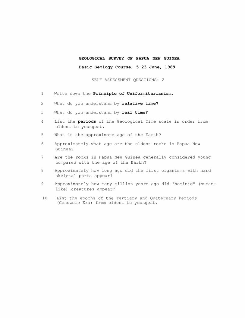
SELF ASSESSMENT QUESTIONS: 2
1 Write down the Principle of Uniformitarianism.
2 What do you understand by relative time?
3 What do you understand by real time?
4 List the periods of the Geological Time scale in order from oldest to youngest.
5 What is the approximate age of the Earth?
6 Approximately what age are the oldest rocks in Papua New Guinea?
7 Are the rocks in Papua New Guinea generally considered young compared with the age of the Earth?
8 Approximately how long ago did the first organisms with hard skeletal parts appear?
9 Approximately how many million years ago did "hominid" (human- like) creatures appear?
10 List the epochs of the Tertiary and Quaternary Periods (Cenozoic Era) from oldest to youngest.

GEOLOGICAL SURVEY OF PAPUA NEW GUINEA
Basic Geology Course, 5-23 June, 1989
SELF ASSESSMENT QUESTIONS: 3
1 Draw a sketch to show how the circumference of the Earth was
first calculated.
2 What is the correct name for the shape of the Earth?
3 What is the difference in length between the polar diameter and the equatorial diameter?
4 Give the average density of the Earth.
S The Earth is a homogeneous body TRUE/FALSE
6 Distinguish between the way in which the particles vibrate in;
(i) a seismic P-wave, (ii) a seismic S-wave.
7 Which seismic waves travel fastest, and what are their approximate velocities in crustal rocks?
8 (i) P-wavws travel through liquids TRUE/FALSE (ii) S-waves travel through liquids TRUE/FALSE
9 What happens to the velocity of seismic P-waves when;
(i) they travel into a partially liquid (molten) rock, (ii) they travel into rocks of higher density.
10 Do earthquake waves travel through the Earth in straight lines?


GEOLOGICAL SURVEY OF PAPUA NEW GUINEA
Basic Geology Course, 5-23 June, 1989
SELF ASSESSMENT QUESTIONS: 9
1 Which two chemical elements are most abundant in the solar
system?
2 What is the approximate chemical composition of the Earth, as assumed from meteorite composition?
3 What are the three possible sources of heat to warm up a cold accreting planet Earth?
4 Why is the Earth in a unique position in the solar system when the presence of water on the surface is considered?
5 How is the core thought to have formed?
6 What is the approximate mass and volume of the Earth in the core, the mantle, and the crust?
7 Where is the water on the surface of the Earth thought to have originally come from?
8 Approximately when did photosynthetic algae first appear on Earth, and what important role did they play in the chemical evolution of the oceans and the atmosphere?
9 Briefly explain the origin of the ozone layer in the upper atmosphere, and why does it play an important role in relationship to human life on Earth?
10 The chemical reactions which take place during photosynthesis can be reversed. Explain how this is important to the idea of the "Greenhouse Effect" in the atmosphere with regard to the increase in the burning of forests and fossil fuels?

GEOLOGICAL SURVEY OF PAPUA NEW GUINEA
Basic Geology Course, 5-23 June, 1989
SELF ASSESSMENT QUESTIONS: 10
1 What is the range of temperatures in the surface layers of the
ocean?
2 What is the average salinity range in the surface layers of the ocean?
3 What is the average density range in the surface layers of the ocean?
4 Where is the larger proportion of the bottom water mass in the Pacific Ocean formed?
5 What is the thermocline and how does it vary with latitude?
6 How is the distribution of life in the surface layers of the ocean controlled by circulation patterns?
7 What is the coriolis effect and how does it effect ocean surface what circulation?
8 Explain three ways in which relative sea level change may
occur naturally?
9 Explain what is meant by the "Greenhouse Effect", and indicate two ways in which it may cause a rise of sea level.
10 What is the range of predicted sea level rise in the next 100 years?

GEOLOGICAL SURVEY OF PAPUA NEW GUINEA
Basic Geology Course, 5-23 June, 1989
SELF ASSESSMENT QUESTIONS: 11
1 Sketch a diagram showing the Rock Cycle?
2 Give a definition of a rock.
3 Give a definition of a mineral.
4 Give a brief hand specimen description of a plutonic rock?
5 What is the name given to the process by which one rock is converted into another rock under conditions of high temperature, pressure or both?
6 What is the name given to the process by which rocks are physically and chemically broken down when exposed at the surface of the Earth?
7 Explain a common problem faced by a geologist when a sample (or samples) are selectively taken from a field area.
8 What is the name given to the microscope used by a geologist?
9 What is the approximate abundance by weight, of the eight most common elements in the earth's crust?
10 What is the silica tetrahedron?

GEOLOGICAL SURVEY OF PAPUA NEW GUINEA
Basic Geology Course, 5-23 June, 1989
SELF ASSESSMENT QUESTIONS: 12
1 What is the electrical charge and relative weight of a proton,
a neutron, and an electron in the atomic nucleus?
2 What is an ion, distinguish between an anion and a cation?
3 Explain why oxygen is an anion.
4 Explain why silicon is a cation?
5 What is the silica tetrahedron?
6 List the major groups of silicate minerals.
7 Distinguish between primary and secondary silicate minerals.
8 List three non-silicate mineral groups, give an example of a common mineral in each group.
9 Draw a sketch cross section through the petrological microscope, showing the position of the polariser and the analyser.
10 At what thickness are silicate minerals transparent?

GEOLOGICAL SURVEY OF PAPUA NEW GUINEA
Basic Geology Course, 5-23 June, 1989
SELF ASSESSMENT QUESTIONS: 13
1 List the common physical properties of minerals.
2 What criteria are commonly used to describe igneous rocks?
3 What criteria are commonly used to describe sedimentary rocks?
4 What criteria are commonly used to describe metamorphic rocks?
5 What is a solid solution series?
6 What is polymorphism?
7 Give values for the approximate geothermal gradient AND pressure gradient with increasing depth in the Earth.
8 What is a cataclastic rock?
9 What is an ultramafic rock?
10 Give the grain size boundaries between;
a) sand and gravel b) sand and silt c) silt and clay


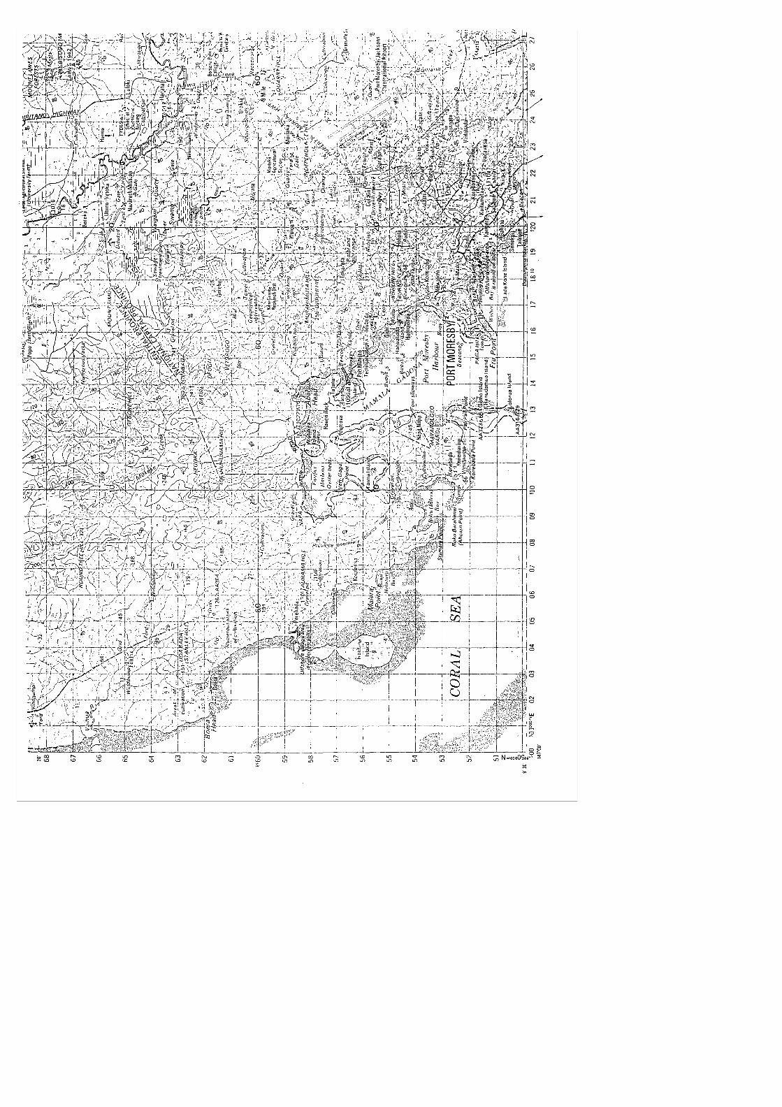
8 On the Port Moresby map, what are the grid references of each
end of the causeway linking Tatana Island to the mainland?
9 On the Port Moresby map locate the area defined by the following grid line intersections:
1554 2054
1551 2051
What would be the scale of a map showing this area if this area was to nearly fill an A4 sheet of paper?
10 The contours and physical features of the Port Moresby area generally define a particular orientation (trend, alignment) of the topography in the Port Moresby area. What is the orientation?


(i) Construct a map on an A4 sheet of paper at a suitable
scale.
(ii) Find the dip and dip direction of the coal seam.
(iii) If a hole was drilled at grid reference 910020, which is at 900m elevation, would the coal seam be intersected and if so at what depth?


GEOLOGICAL SURVEY OF PAPUA NEW GUINEA
Basic Geology Course, 5-23 June, 1989
MAP EXERCISES: 3
1 On Map 3 the location of outcrop of an aquifer is shown at A,
B; and C.
(i) Calculate the direction of true dip and the amount of true dip of the aquifer, assuming it to be a plane dipping surface.
(ii) Plot the outcrop of the aquifer over the area covered by the map.
{iii)Does the aquifer occur below the ground at localities X, Y, and Z, and if so at what depth?
2 On Map 5 are shown the positions of three vertical boreholes
at A, B, and C.
At A the hole intersected an upper coal seam (CS 1) at 50m depth and a lower coal seam (CS 2) at 450m depth.
At B, the hole intersected the lower coal seam (CS 2) only, at a depth of 150m.
At C, the hole intersected the lower coal seam (CS 2) only, at a depth of 250m.
(i) Calculate the true dip and true dip direction of the lower coal seam.
(ii) Plot the outcrop of the lower coal seam.
{iii) Assuming the upper coal seam is always 400m vertically above the lower seam, plot the outcrop of the upper seam.


GEOLOGICAL SURVEY OF PAPUA NEW GUINEA
Basic Geology Course, 5-23 June, 1989
MAP EXERCISES: 4
1 You are a geologist recently recruited by a mining company and to test you out, the chief geologist decides to give you an exercise on map interpretation using one of the company's old copper prospecting licence areas.
He gives you the map of the licence area (attached) which covers approximately 15-16 square kilometres of heavily bushed country. The scale of the map is 1:25000, true north is shown, contours are in metres. The creek generally showed well above background grades for stream sediment copper analysis.
After careful examination of the air photos an approximately east-west fault is suspected which was then confirmed by outcrop in the creek at X. The fault appeared vertical and was estimated to have 200m throw up to the south.
Outcrop of a 10m thick stratabound, massive pyritechalcopyrite oredody was found at A, B, and C.
Assume that the orebody is regular in thickness and is planar, answer the following questions.
(i) What is the direction of true dip and the amount of true dip of the orebody?
(ii) Show the inferred position of the outcrop of the orebody on both sides of the fault.
(iii)Clearly indicate where the orebody does NOT occur below ground surface.
(iv) To test your interpretation it is suggested to drill vertical holes. For each of the 10 possible sites chosen (marked with a dot on the map), would you expect to intersect the orebody 1 and if so at what depth? Give your answers in metres.
1 ....... 2 ....... 3 .......4 ...... 5 .. .
6 ....... 7 ....... 8 .......9 ...... 10 . .
(v) Draw a vertical cross section with no vertical exaggeration from the northeast to the southwest corners of the map.


GEOLOGICAL SURVEY OF PAPUA NEW GUINEA
Basic Geology Course, 5-23 June, 1989
ORAL TEST: 1
1 What is the name for the horizontal angle between true north and grid north?
(Magnetic declination)
2 If the word scale of a map is 1cm to 5km, what is the scale expressed as a representative fraction?
(1:500000)
3 What is the approximate density of the Earth?
(5.5g/cc)
4 Two places are 5cm (50mm) apart on a map with a scale of 1:10000. How far apart are the places on the ground?
(500 metres)
5 What physical feature commonly occurs at the crest of a rhyolite or andesite volcano?
(caldera or crater)
6 What feature or rock type commonly occurs on the top of a guyot (flat-topped sea mount)?
(coral reef, reef, limestone)
7 What is the name of the instrument which records earthquake waves?
(seismometer)
8 Which seismic waves will not travel through liquids?
(S-waves)
9 Which seismic waves travel fastest?
(P-waves?
10 Which physical feature, island arc or trench commonly occurs closest to the deep sea floor?
(trench)

11 What is the position on the surface of the Earth directly
above an earthquake called?
(epicentre)
12 What are lines on a map which join places of equal elevation above sea level called?
(contours)
13 Approximately how thick is the continental crust?
(30-35km)
14 Where would you expect the greater variety of rock type, in the continental crust or the oceanic crust?
(continental crust)
15 What is the name for the crust-mantle boundary?
(Moho, Mohorovic discontinuity)
16 What is the average density of the upper part of the mantle?
(3.3g/cc)
17 Approximately how many years ago did the earliest hard-shelled organisms first appear on Earth?
(600 million years)
18 What is the name given to the geological law which states that the oldest part of a sequence of sedimentary rocks is usually at the bottom?
(Law of Superposition)
19 What is the geological word which refers to the fact that the crust appears to float on the upper mantle?
(isostasy)
20 What is the name given to a sequence of two or more sedimentary layers?
(strata)


GEOLOGICAL SURVEY OF PAPUA NEW GUINEA
Basic Geology Course, 5-23 June, 1989
ORAL TEST: 2
1 Name any three large plates making up the surface of the
Earth.
(Pacific, Antarctic, Australian/Indian, Asia/Europe, North America, South America, Africa)
2 Is the base of the plates the Moho?
(No)
3 What instrument is used at sea to determine magnetic anomaly patterns?
(Magnetometer)
4 What type of volcanic rocks is commonly produced at sea floor spreading centres?
(Basalt)
5 Name an active seafloor spreading centre in the Papua New Guinea exclusive economic zone?
(Manus Basin, Woodlark Basin)
6 Which direction is subduction occurring in the Solomon Islands?
(East, Northeast)
7 Deep focus earthquakes occur only in subduction zones?
(Yes)
8 What is the name given to the temperature at which magnetic materials become magnetised on cooling?
(Curie temperature)
9 Name the most abundant chemical element (by weight) in the Earth?
(Iron)


GEOLOGICAL SURVEY OF PAPUA NEW GUINEA
Basic Geology Course, 5-23 June, 1989
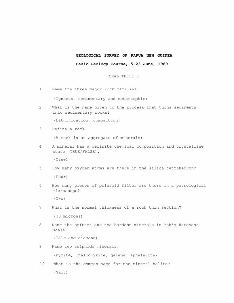
ORAL TEST: 3
1 Name the three major rock families.
(Igneous, sedimentary and metamorphic)
2 What is the name given to the process that turns sediments into sedimentary rocks?
(Lithification, compaction)
3 Define a rock.
(A rock is an aggregate of minerals)
4 A mineral has a definite chemical composition and crystalline state (TRUE/FALSE).
(True)
5 How many oxygen atoms are there in the silica tetrahedron?
(Four)
6 How many pieces of polaroid filter are there in a petrological microscope?
(Two)
7 What is the normal thickness of a rock thin section?
(30 microns)
8 Name the softest and the hardest minerals in Moh's Hardness Scale.
(Talc and diamond)
9 Name two sulphide minerals.
(Pyrite, chalcopyrite, galena, sphalerite)
10 What is the common name for the mineral halite?
(Salt)

11 What is the chemical composition of quartz?
(Silicon dioxide)
12 Name two hand specimen physical properties of minerals other than hardness.
(Cleavage, fracture, colour, streak, lustre, diaphaneity, specific gravity/density)
13 Name three common plutonic rocks.
(Granite, diorite, gabbro).
14 Name two minerals commonly abundant in basalts.
(Pyroxene and feldspar)
15 What gas is released when dilute hydrochloric acid reacts with limestone?
(Carbon dioxide)
16 What is the name of a sedimentary rock made up of gravel size particles?
(Conglomerate)
17 What happens to the grain size of a sediment with increasing distance of transport?
(It becomes finer grained)
18 A schist is a very high grade regional metamorphic rock (TRUE/FALSE)
(False)
19 What is the name for an igneous intrusion which is often narrow and vertical and cuts across other rocks?
(Dyke)
20 What is the name for reef limestone when it is metamorphosed?
(Marble)