Bannister, Bryant, Gell, Elizabeth, Hannah, John_Tree Ring Dates ...
73
_/\.TREE-RING r( FROM DATES ARIZONA N-Q VERDE- SHOW LOW- ST. JOHNS AREA Bryant Bonnist er Elizabeth A. M. Ge ll Jo hn W. Hannah LABORATOR Y OF TR EE -R IN G RESEAR CH THE UNIVE R SITY OF ARIZONA T UCS ON 196 6 ., • co l orado SprlnQt
Transcript of Bannister, Bryant, Gell, Elizabeth, Hannah, John_Tree Ring Dates ...

_/\.TREE-RING r( FROM
DATES
ARIZONA N-Q VERDE- SHOW LOW- ST. JOHNS AREA
Bryant Bonnist er
Eli zabeth A. M. Gel l
John W. Hannah
LABORATOR Y OF T R EE - RIN G RESEAR CH
THE UNIVE R SITY OF ARIZONA
T UCS ON
196 6
.,
• co lorado SprlnQt
Tree-Ring Dates from Arizona N - Q
Verde - Sho'tV' Low - St. Johns Area
Bryant Bannister Elizabeth A.M. Gell
John H. Hannah
Laboratory of Tree-Ring Research
The University of Arizona
Tucson
1966
_j
PREFACE
This is the third of a projected series of preliminary reports on archaeological tree-ring dates from the Southwest. With the eventual objective of preparing a synthesis of Southv1estern dendrochronology, all archaeological specimens novl housed in the Laboratory of Tree-Ring Research are being systematically reviewed and re-analyzed on a site-by-site basis. ~ro grants, GS-247 and GS-908, al17arded to The University of Arizona by the National Scien~e Foundation have made this project possible and are most gratefully acknowledged.
He sincerely appeal to archaeologists who make use of this report to offer critical comment and to point out errors, and ~·Te earnestly solicit additional information regarding site locations, proveniences, alternate site names, descriptions, and other data that will enhance the scientific value of our final synthesis. Only by the sharing of personal experience and knowledge of those who have worked in the field will our record ever approach complete• ness.
Although I have assumed overall administrative responsibility for the project, the real heart of our program has been ably directed by Jeffrey s. Dean l17ho has supervised all specimen dating work, and by vlilliam J. Robinson who has been in charge of the archaeological aspects of the study. All specimen analyses presented in this report 't-Tere conducted by John ~1. Hannah and site information was assembled by Elizabeth A. M. Gell. The illustrations were drm11n by Forrest H. Meader and Miss Candace Lane again cheerfully handled the typing chores. Prior to the initiation of this project David A. Breternitz reorganized the Laboratory's tree-ring collections and helped formulate many of the procedures utilized in our current research. To all these people, and to the many archaeologists and dendrochronologists upon whose work our results are based, I am deeply indebted.
The spirit of this series of publications is that of a Fourth Beam Expedition; performed this time in the laboratory and the files. He hope the Fifth Expedition will be conducted in the field.
Tucson, Arizona December 12, 1966
ii
Bryant Bannister
TABLE OF CONTENTS
PREFACE
LIST OF FIGURES
INDEX OF CROSS-REFERENCE OF SITE DESIGNATIONS
INTRODUCTION
THE CURRENT REPORT
ORGANIZATION OF RESEARCH
PRESENTATION OF DATA
EXPLANATION OF SYMBOLS
TREE-RING DATES FROM ARCHAEOLOGICAL SITES
-~: Indicates undated sites
Map Reference Number
N-1. N-2. N-3. N-4. N-5. N-6.
0-1. 0-2.-0-3. o-4. 0-5. 0-6. 0-7. 0-8. 0-9. 0-10. 0-11. 0-12. 0-13. 0-14. 0-15. 0-16. o-11. 0-18. 0-19. 0-20. 0-21. 0-22. 0-23. 0-24.
Tuzigoot King's Ranch Ruin NA 5177B NA 4352T Prescott - Misc. I Fairground Ruin
Brovm Springs Bull Pen Ranch Site Camp Verde Hill Ruin Honanki Kittridge Ruin Middle Verde Ruin Montezuma Castle Verde Salt Mine Hinneman Pithouse Richard's Cave Palatki Panorama Ruin Payson - Misc. I Verde - Misc. I Sedona - Misc. I Rye Creek Ruin NA 5318 Bridgeport Ruin NA 1269 Jackson Ranch Site Calkin's Ranch Site Gray Back Cave Oak Creek Cave Oak Creek - Misc. I
iii
12 15
*
17
* *
*
*
* -1:
*
* -;':
18
ii
v
vi
1
1
2
2
4
12

TABLE OF CONTENTS, continued
TREE-RING DATES FROM ARCHAEOLOGICAL SITES, continued
;': Indicates Undated sites
Hap Reference Number
REFERENCES
0-25. 0-26. 0-27~ 0<~28.
0-29. 0-30. 0-31. 0-32.
P-1. P-2. P-3. P-4. P-5. P-6. P-7. P-8. P-9. P-10. P-11. P-12. P-13. P-14 P-15. P-16.
Q-1. Q-2. Q-3. Q-4. Q-5. Q-6. Q-7. Q-8. Q-9. Q-10. Q-11. Q-12.
Page Springs Verde 15:15 (GP) White Hill Chavez Pass Kinnikinnick Pueblo Pollock Site Pershing Site Verde - Misc. II
Arizona P:7:1 (ASM) Shumtv-ay Site Bear Ruin Forestdale Ruin Bluff Site Chevlon Ruin Cibecue Ruin Pinedale Ruin Holbrook - Misc. I Forestdale Hormon Temple SholV'lO'tV' Ruin Taylor - Misc. I Fourmile Ruin Red Rock House Grasshopper Ruin Tundastusa
St. Johns - Misc. I Black Axe Ruin Site 30 (CNHM) Mineral Creek Pueblo St. Johns 16:9 (GP) St. Johns 16:10 (GP) Table Rock Pueblo Carter Ranch Site Broken K Pueblo Arizona Q:6:12 (ASM) Flattop Site Hay Hollmv- Site
*
19 20 22 24 26
27 28 29 31 34
"1:
* 35
* 38 39
48 49 51
* * 53
* 55 56 57 58 59
* *
- - - - - - - - - - - - - - - - - - - - - - - - - - - - - -
iv
60
LIST OF FIGURES Page
Fig. 1 Location of Sites in Arizona N 6
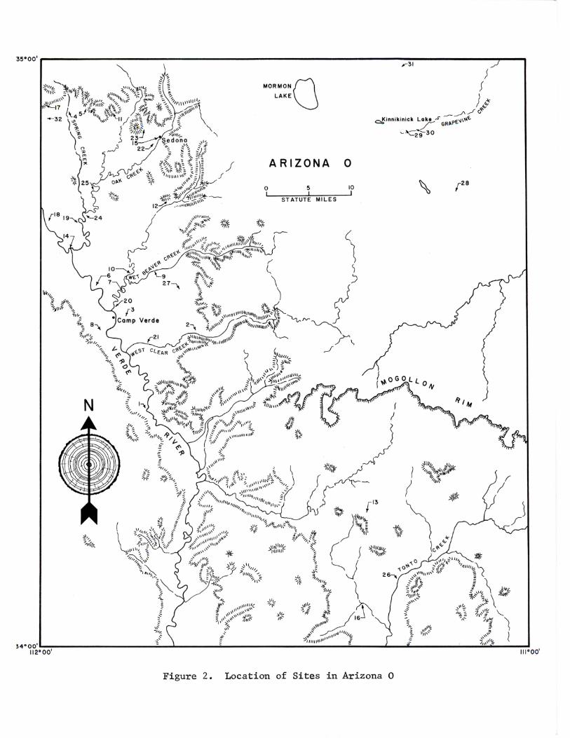
Fig. 2 Location of Sites in Arizona 0 7
Fig. 3 Location of Sites in Arizona p 8
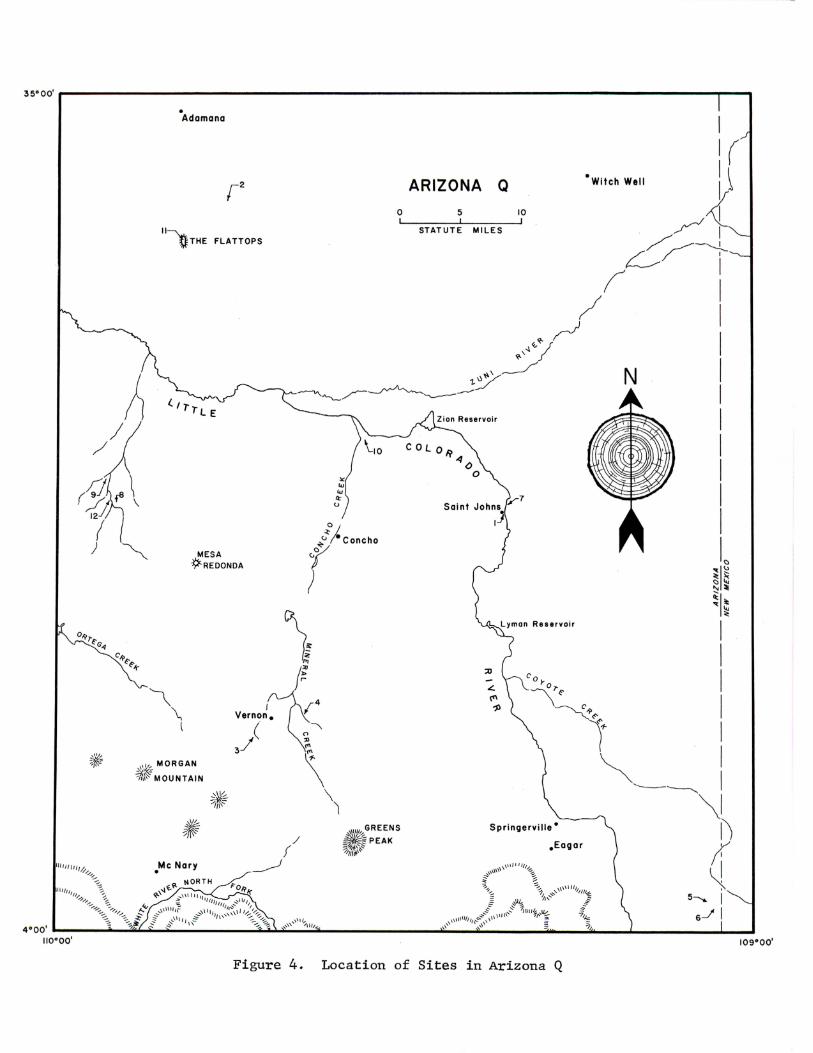
Fig. 4 Location of Sites in Arizona Q 9
Fig. 5 Sequence of Chronological Components in Arizona. N~Q 10
v
INDEX OF CROSS-REFERENCE OF SITE DESIGNATIONS
* Indicates primary site reference
Arizona N:2:1 (ASM) --- - --Arizona 0:15:1 (ASM) Arizona P:7:1 (ASM) -Arizona P:12:2 (ASM) Arizona P:l2:3 (ASM) Arizona P:l2:4 (ASM) Arizona P:l2:6 (ASM) Arizona P:l4:1 (ASH) - - - -Arizona P: 14: 14 (ASM) Arizona P:16:1 (ASH) - - - -Arizona P:l6:2 (ASM) Arizona P:l6:9 (ASM) Arizona P:l6:20 (ASM) Arizona Q:l:l (ASH) -Arizona Q:6:12 (ASM)
Bear Ruin - - - -Black Axe Ruin Bluff Site Bridgeport Ruin - - - - - - - - -Broken K Pueblo - - - - -Brown Springs - - - - - -Bull Pen Ranch Site
Calkin 1 s Ranch Site -Camp Verde Hill Ruin Carter Ranch Site - - -Chavez Pass - - - - - -Chevlon Ruin - - - -Cibecue Ruin - - - - - - - -Coyote Creek No. 3 Coyote Creek Reservoir
Fairground Ruin - - - - -Flattop Site - - - - - -Forestdale Mormon Temple Forestdale Ruin - -Fourmile Ruin - - -
Grasshopper Ruin - - - -Gray Back Cave
Hay Hollow Site - -Holbrook - Misc. I Holbrook 12:2 (GP) Holbrook 12:3 (GP) Holbrook 12:11 (GP) Holbrook 12:39 (GP) -Honanki - - - - - -Huning Site - - - -
- See King's Ranch Ruin See Rye Creek Ruin
See Pinedale Ruin - - See ShmvJ.mv Ruin - - See
See See
- See
Fourmile Ruin Shumt-Tay Site Grasshopper Ruin Red Rock House
- - - - See Bear Ruin - - See Forestdale Ruin
- See Tundastusa See Bluff Site See Black Axe Ruin
-----!:
* - - - ~~
- * ----i:
- - - '1:
- - * - - - *
- .. - - * - - See St. Johns 16:9 (GP)
- See St. Johns 16:10 (GP)
- *
* - ~·:
~·:
- * - ~·:
- See Shotvlo"t-1 Ruin See Fourmile Ruin
- See Pinedale Ruin - See Shumway Site
- - - - See Showlow Ruin
vi
INDEX OF CROSS-REFERENCE, continued
Jackson Ranch Site - - - - - - - - - - - -Jordan's Ranch Ruin See NA 1269
King's Ranch Ruin Kinnildnnick Pueblo Kittridge Ruin - -
Middle Verde Ruin - - - -Mineral Creek Pueblo - - - - - -Montezuna Castle - - - - - -
NA 518 - - - - - - - - -NA 659 N.A 979 NA 1003 NA 1006 - - - -NA 1022 NA 1026 NA 1251 - - - -NA 1255 NA 1258 NA 1261 NA 1269 NA 1276 NA 1278 A NA 1587 NA 1629 NA 2385 NA 2448 - - - -NA 2733 - - - -NA 2931 NA 3205 NA 3206 NA 3209 NA 3210 NA 3340 NA 3945 A NA 4007 C NA 4317 - - - -NA 4352 T NA 4490
- - - - "#'(
*
~·:
See Oak Creek Cave - - See
See See
- See See See See See See
- See
*
Chavez Pass Bridgeport Ruin Shm-1loH Ruin Pinedale Ruin Black Axe Ruin Chevlon Ruin Palatki Honanld Bridgeport Ruin Tuzigoot
- See Jackson Ranch Site - See - See
See See
- See
Montezuma Castle King's Ranch Ruin Kinnildnnick Pueblo Calkin's Ranch Site Bull Pen Ranch Site
- See Tuzigoot See Verde Salt l1ine See Honanki See Honanki See Palatki
- See Palatki - See Fairground Ruin
See Hinneman Pithouse See Richard's Cave See Pollock Site
- - - - - See Kittridge Ruin NA 4725 - - - - - - - - - - See Flattop Site NA 5111 NA 5177 B - - - -NA 5318 NA 5348 (?) NA 5390 NA 5817 - - - -NA 7207
Oak Creek Cave - -Oak Creek - Misc. I
- - - - See Panorama Ruin
See Brown Springs - - - - - See Bull Pen Ranch Site
- - See Pollock Site - See Pershing Site
-----~'~
vii
INDEX OF CROSS-REFERENCE, continued
Page Sprincs - -Pa1atld - - - -Panorama Ruin Payson - Hisc. I Pershing Site - - - -Pinedale Ruin - - - - - - - - -Pollock Site - - -Prescott - Misc. I - -
Red Rock House - -Richard's Cave - - -Risenger Ranch Ruin I Rye Creek Ruin - -
Sedona - Misc. I -ShOl-rlm-r Ruin - - - - - - - - -Shum-ray Site - - - - - - - - - -Site 30 (CNHM) Soda Springs Ranch -St. Johns - Misc. I St. Johns 16:9 (GP) - - - -
_____ ,..•:
- *
----~(
See Palatld
"f':
~·:
----"i':
See Hhite Hill - - - - "i'<
"'J't
St. Johns 16:10 (GP) Stone Axe Ruin - - - - - - - - - - - - See Black Axe Ruin SH Huseum 3-10 .. -Svl Museum 3-11 - -
- - - - - - - - See St. Johns 16:9 (GP) - -- - - -- - See St. Johns 16:10 (GP)
Table Rock Pueblo Taylor - Misc. I Tcubuitcalobi Topachovi Tundastusa - - - -Tuzigoot - -
Verde - Hisc. I Verde - Hisc. II -Verde Salt Mine Verde 3: 3 (GP) Verde 4:1 (GP) -- - - - - - - -Verde 5:1 (GP) - - - - - -Verde 15:15 (GP) Verde 15: 30 (GP)
vlliipple Ruin - - -White Hill - - - - -l-linneman Pithouse
----"i':
- - - - - - See Chavez Pass - See Chavez Pass - - "/:
----"i':
- - - - * - See Kinnikinnick Pueblo
See Chavez Pass - - See Hontezuma Castle - - ";~
- See Rye Creek Ruin
- - - - See Sho\·TlOl-7 Ruin
- * - *
ASH - Arizona State Museum site survey
GP - Gila Pueblo site survey
NA - Museum of Northern Arizona site survey
CNHM- Chicago Natural History Museum site survey (now Field Museum)
viii
INTRODUCTION
The Laboratory of Tree-Ring Research has been serving as a repository for archaeological wood and charcoal specimens since 1916 l~hen A.E. Douglass began seeking prehistoric w·ood in an effort to extend his modern ring chronologies into the past. While his primary interest was in compiling an ex• tensive dendroclimatic record to facilitate long range weather prediction studies, the collection and eventual dating of hundreds of pieces of prehistoric wood was of inestimable value to archaeoloeists.
Dendrochronology provides the most precise prehistoric temporal control in the world. Determination of the cutting date of artifactual and architectural materials made of wood is of the greatest importance to culture historians. At the present time Southwestern archaeologists have over 2000 years of continuous records. From a beginning of an initial group of relatively fel~ crossdated beams from the soutm~es tern United States, detailed regional records have been compiled for most of this area and parallel studies are being or have been developed in the Arctic, the Great Plains, California, Mexico, Europe and western Asia.
Douglass acquired more than 10,000 laboratory specimens during a 45 year period. Small groups of dates derived by him and his staff appeared at intervals in diverse publications, most of them in the Tree-Ring Bulletin. Then, in 1951, Terah L. Smiley reviewed the existing collection and published a summary of reliable sites and dates. This was a major advancement of the state of knowledge and has been the standard reference in the field.
By the beginning of the present decade it had become apparent that a new evaluation of archaeological specimens was necessary. A vast number of additional specimens had been collected and many new and better study techniques had been developed. In addition, at various times over the years, other institutions which maintained collections of dendrochronological materials had turned them over to the Laboratory of Tree-Ring Research for preservation and study. The original Douglass collection has been augmented by the acqui• sition of collections from Gila Pueblo, the Laboratory of Anthropology at Santa Fe, and the Museum of Northern Arizona. The aggregate group now numbers about 100,000 specimens and the time seems right to attempt an up-to-date synthesis of archaeological tree-ring dating.
THE CURRENT PROJECT
In July 1963, the Laboratory of Tree-Ring Research received a National Science Foundation grant to cover the costs involved in reassessing and reworking all of the specimens in its collection. This study has been productive beyond expectations and a renelval grant was received in July of 1965 to carry this l-Tork to completion.
The development of more sophisticated techniques of sample preparation, analysis, and interpretation has now made it possible to achieve a high level of efficiency in the production of dates. The current project involves a systematic restudy of pertinent parts of the collection VTith the basic aims of: (1) checking past lvork, (2) obtaining as many new dates as possible, (3) extracting the chronological parameters necessary for prehistoric climatic
interpretation, and (4) organ1z1ng the resultant data. To this end a series of preliminary publications presenting a summary of the available information about the sites and the derived dendrochronological information is being produced. This paper, Tree-Ring Dates from Arizona N-Qj Verde--Showlm-T--St. Johns Area, is the third of these. A complete list of titles in this series appears on the inside of the back cover. Specialized chronological data of interest to dendrochronologists, such as standardized indices and plotted growth curves l'lill appear at intervals in the Tree-Ring Bulletin.
This series should be of great importance to Southwestern archaeologists. With all prehistoric materials checked for provenience, dating, and possible duplication, the available dendrochronological controls for each site are exactly determined. The provenience of dated specimens within a site and the temporal ordering of sites tdthin a geographic area are presented as precisely as possible. In most cases, existing published dates from individual sites have been corroborated; a fe~'l have been changed. In many cases, new dates have been obtained for these units which serve to augment the range and detail of chronological control. In addition, many specimens from new sites have been dated. Some of these are products of recent excavations; others, whose characteristics presented various procedural problems in the past, are now datable because of the knO't'lledge derived from an intensive dendrochronological study of the geographic and temporal units involved.
These new data are translatable into the finest of prehistoric temporal controls. For example, the chronological data from the various quadrangles, largely derived frO'm short occupancy sites with a localized geographic distribution, present an unequaled opportunity for studies of cultural attributes and change. Ceramic and architectural development, settlement patterns, population movements, demographic estimates, and numerous other studies can be undertaken with a precision previously impossible. The information derived by this project will be instrumental in any future synthesis of Southwestern archaeology.
ORGANIZATION OF RESEARCH
At the beginning of this project a procedural decision was made to organize the material on an areal basis with the archaeological site as the basic unit of study and to gr oup the sites into arbitrary regional units which would allol·7 thorough intensive analyses. The sites have been studied indi• vidually, and as a group, by comparing all the sites within a quadrangle. The quadrangles, which correspond to those established by the Survey system of the Arizona State Museum (Hasley 196L.~), encompass 1 degree of longitude and 1 degree of latitude. This grouping has allowed the building of firm regional tree-ring chronologies and has resulted in increased understanding of local ring variation which in turn has permitted more dating of individual specimens.
PRESENTATION OF DATA
Although the Laboratory's records include all archaeological sites from which tree-ring specimens have been collected, data are presented in thi s r eport only f or sites with dat ed specimens. Hot'lever, both dated and undated sites are shown in Figs. 1-4 and listed in the Table of Contents on page iii. The information available to the Laboratory on the dated sites is very uneven.
-2-
In the past 40 years, many tree-ring specimens were collected for the primary purpose of chronology building and, as a consequence, the archaeological characteristics of the collection site were frequently recorded only in general terms. In some cases, the location of the site has been lost as a result of incomplete records or as a result of acceptance of specimens for chronology purposes without the details of archaeological provenience. Some sites have been placed in quadrangles only by inference on the part of the present staff and may, in fact, belong to a different area entirely. However, every effort has been made to obtain as much information as possible.
In a limited number of cases, specimens for which records exist have not been identified in the collections. The probleffis thus created are not great as these specimens are usually only a few of m&.r.y from a site. If they were previously dated, however, t~ey are not so considered in this report. Occasionally, the lost specimens repre;ent the total collection from a site and, as a consequence, the site does not appear in the reports. No such instances occur in Arizona N-Q.
To summarize the data presented, a chart has been prepared (Fig. 5) to represent the sequence of dated sites and structures. The components are ranked from late to early according to the latest outside dates only and the chart is not intended to be used to chronologically position the listed sites. Temporal placement of sites must depend upon careful assessment of both archaeological and dendrochronological evidence.
The following notes help to explain the categories used in the presentation of data:
~: The Laboratory has chosen, often arbitrarily, what it believes to be the most common designation of a site.
Alternate name and number: Many sites have been known by various names in the literature or in local usage. ~funy sites also carry two or more institutional designations. In this category, an attempt has been made to list all such alternates that have been applied to the site.
Loca~: Sites are located on maps (Figs. 1-4) as ~·Tell as by a brief descriptive note. In some cases, the Laboratory records give more precise locations, particularly for recently excavated sites, but for the purposes of this report the location given was deemed sufficient. Some sites are presented with only approximate locations.
Description: Information about the site is taken from published reports and readily available knowledge. No exhaustive search to obtain unpublished notes was made.
Source of Collection: The individual and/or institution, and the date of collection are listed to enable readers to assess the provenience data.
References: All known published sources for archaeological data pertaining to the site (Site Description) and the sources for previous publication of dates (Published Dates) from the site are given.
Dates: The dates are presented in chronological sequence and by provenience subgroupings when known. Catalogue numbers are given for future reference and
-3-
specific identification of the dated specimens. GP indicates a Gila Pueblo catalogue number, f indicates a }fuseum of Northern Arizona catalogue number, and RG indicates a Laboratory of Anthropology catalogue number. All other numbers were assigned by the Laboratory of Tree-Ring Research. Every effort has been made during analysis to eliminate duplication of dates derived from the same piece of original l-Tood. The identification of duplication has been done solely on ring characteristics except in cases where the provenience data specify duplication or for pieces that obviously ftt together. The latter case is prevalent in large ruins that were sampled by more than one institution. In all cases of duplication, only one date appears in the list and the catalog number is that of the best chronological piece.
Comment: The comments are based on the tree-ring evidence. A more sophisticated interpretation of the dates is reserved for the archaeologist who is analyzing the site as a whole.
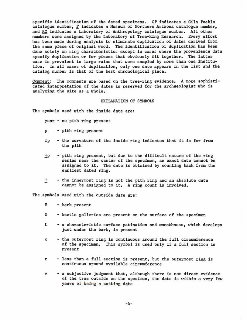
EXPlANATION OF SYMBOLS
The symbols used l-Tith the inside date are:
year - no pith ring present
p - pith ring present
fp the curvature of the inside ring indicates that it is far from the pith
i~ pith ring present, but due to the difficult nature of the ring series near the center of the specimen, an exact date cannot be assigned to it. The date is obtained by counting back from the earliest dated ring.
-:- the innermost ring is not the pith ring and an absolute date cannot be assigned to it. A ring count is involved.
The symbols used l-Tith the outside date are:
B - bark present
G - beetle galleries are present on the surface of the specimen
L - a characteristic surface patination and smoothness, which develops just under the bark, is present
c - the outermost ring is continuous around the full circumference of the specimen. This symbol is used only if a full section is present
r - less than a full section is present, but the outermost ring is continuous around available circumference
v - a subjective jud~ent that, although there is not direct evidence of the true outside on the specimen, the date is l-Tithin a very fel-T years of being a cutting date
-4-
vv there is no way of estimating how far the last ring is from the true outside
+ - one or more rings may be missing near the end of the ring series 't-lhose presence or absence cannot be determined because the specimen does not extend far enough to provide an adequate check
++ - a ring count is necessary due to the fact that beyond a certain point the specimen could not be dated
The symbols B, G. L, c and r indicate cutting dates in order of decreasing confidence, unless a + or -:-:- is also present.
The symbols L, G, and B may be used in any combination Hith each other or with the other symbols except v and vv. The r and c symbols are mutually exclusive, but may be used with L, G, B, + and +l-. The v and vv are also mutually exclusive and may be used with the + and -l-+. The + and +l- are mutually exclusive but may be used in combination with all the other symbols.
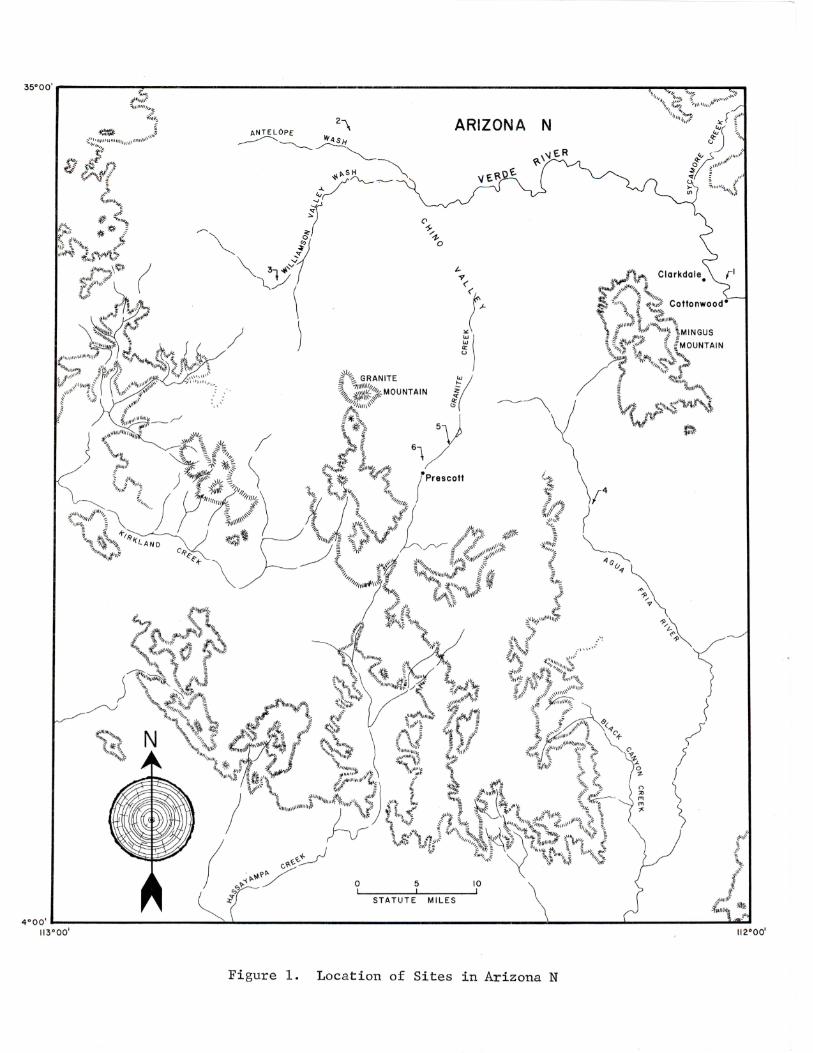
Figure 1. Location of Sites in Arizona N
35•oo',-----------------------------------------------------------------------------------------~~--------------------~----, ,.-31
N
Fi gur e 2 .
MORMONQ LAKE
ARIZONA
0 5
STATUTE MILES
0
10
; f ) "'~
_ __.-A ./ v~ ~Kinnikinlck Lake "' oE"'~E - / GRI:.C
~ 'C~30
I r
) J ~
\ J
Location of Sites in Arizona 0

35°00'r--------------------------------r------~------------------------------------------------,
WEST SUNSET
! /
)
) )
\ (
I
Figure 3.
COLORADO
0
.--/
5
STATUTE MILES
9"'.Holbrook
10
/
.Pinedale
Location of Sites in Arizona P
0: w > ...J
35°00'P---------------------------------------------------------------------------------------------~--,
J /
A
•Ad amana
II~ '!j,f THE FLATTOPS
''r; L E
MESA ~REDONDA
,\'~ MORGAN
~\\~~ MOUNTAIN
Figure 4.
ARIZONA Q • Witch Well
0 5 10 STATUTE MILES
Loca tion of Sites in Arizona Q
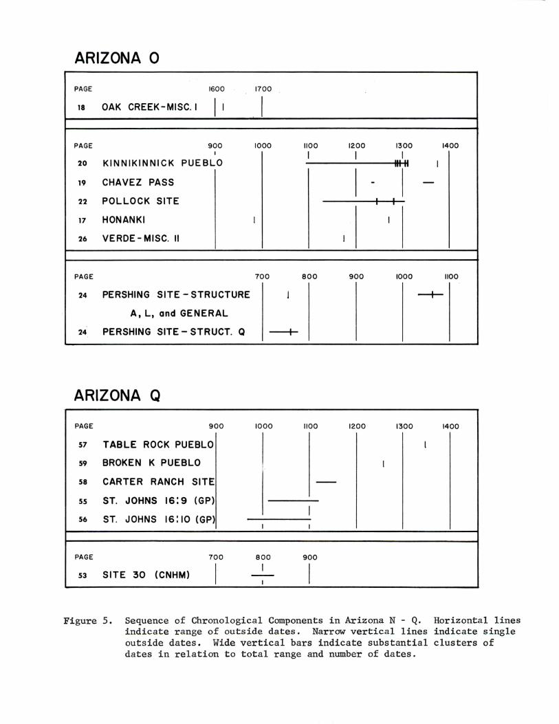
ARIZONA 0
PAGE 1600 1700
18 OAK CREEK-MISC. I I' . I PAGE 900 1000 1100 1200 1300 1400
I I I I 20 KINNIKINNICK PUEBLO Ill II I
19 CHAVEZ PASS - -22 POLLOCK SITE
17 HONANKI I I
26 VERDE- MISC. II I
PAGE 700 800 900 1000 1100
24 PERSHING SITE- STRUCTURE I --+-A, L, and GENERAL
24 PERSHING SITE- STRUCT. Q I
ARIZONA Q
PAGE 900 1000 1100 1200 1300 1400
51 TABLE ROCK PUEBLO I
59 BROKEN K PUEBLO I
58 CARTER RANCH SITE --55 ST. JOHNS 16:9 (GP)
56 ST. JOHNS 16:10 (GP) I
I I
PAGE 700 800 900
(CNHM) I I
I 53 SITE 30 --I
Figure 5. Sequence of Chronologica l Components in Arizona N - Q. Horizontal lines indicate range of outside dates. Narrow vertical lines indicate single outside dates. Wide vertical bars indicate substantial clusters of dates in relation to total range and number of dates.
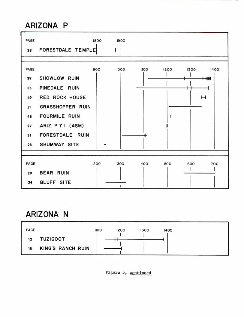
ARIZONA P
PAGE 1800
38 FORESTDALE TEMPLEI
PAGE 900
39 SHOWLOW RUIN
35 PINEDALE RUIN
49 RED ROCK HOUSE
51 GRASSHOPPER RUIN
48 FOURMILE RUIN
'17 ARIZ. P:7:1 (ASM)
31 FORESTDALE RUIN
28 SHUMWAY SITE
PAGE 200
29 BEAR RUIN
34 BLUFF SITE
ARIZONA N
PAGE 1100
12 JUZIGOOT
1s KING 1S RANCH RUIN
-
1900
I I
1000
300
I
1200 I
1100
II
I
400
1300
I
Figure 5, continued
1200
I
I
I
II
500
1400
I
1300 1400
I I
IIIII II I
I I I
H
600 700
I I
I I
TREE-RING DATES FROM ARCHAEOLOGICAL SITES
Tuzigoot
MAP REFERENCE: N-1
ALTERNATE NAME/NUMBER: NA 1261, NA 2733
LOCATION:
The site is about t>vo miles east of Clarkdale and two miles north of Cottonwood. It is about 400 yards from the Verde River on the top and slopes of a sharp ridge near Peck's Lake.
DESCRIPTION:
This is an extensively excavated masonry pueblo with an overall length of about 500 ft. and a maximum width of about 100 ft. The initial rooms 'tvere on top of the ridge. These 'tvere razed and replaced by others. Growth by accretion of room blocks proceeded down the slopes and finally ended in three outlying room blocks of less than ten rooms each. The area between the main room block and the outlying unit to the north served as a plaza area. Eighty-six rooms were excavated and 411 burials recovered from thick trash deposits on the slopes. Ceramics included a large percentage of plain gray, brown and red sherds with a small proportion cf decorated 'tvare including several Hopi, Black-on-orange and Blackon-yellO'~v types, Hhite Hountain Red Hare, late Black-on-'tvhite types from the Flagstaff area, and late Prescott types. Notable among the decorated sherds are Jeddito Black-on-yellow, lValnut Black-on-uhite, Flagstaff Black-on-vThite and Prescott Black-on-gray.
SOURCE OF COLLECTION:
Louis R. Caywood and E.H. Spicer in 1933-34 for the Arizona State Museum and the Archaeological Committee of the Yavapai County Chamber of Commerce.
REFERENCES:
Site Description: Ca~vood and Spicer 1935
Published Dates: Smiley 1951
DATES:
Group I, Room 2 (?)
TZG-72c 1352p .. 1386vv
Group I, Room 12
TZG- 73-2,4 1263f p - 1366vv
-12-
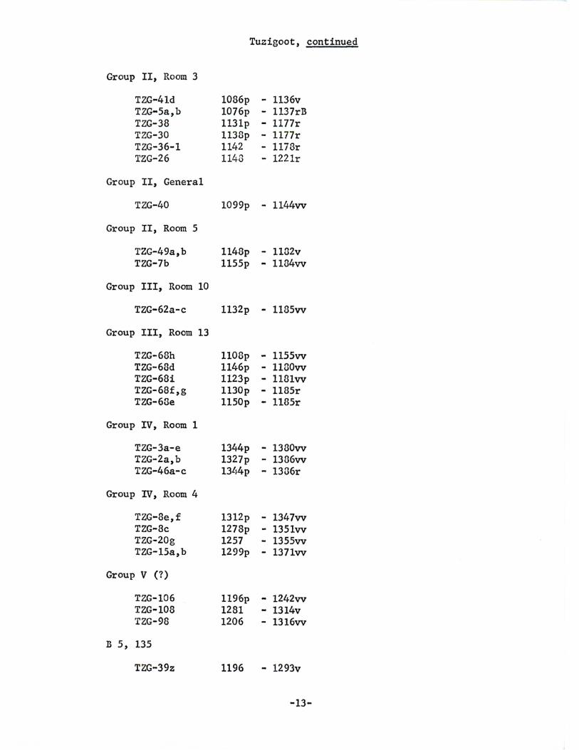
Group II, Room 3
TZG-41d TZG-Sa,b TZG-38 TZG-30 TZG-36-1 TZG-26
Group II, General
TZG-40
Group II, Room 5
TZG-49a,b TZG-7b
Group III, Room 10
TZG-62a-c
Group III, Room 13
TZG-68h TZG-63d TZG·68i TZG-68f,g TZG-68e
Group IV, Room 1
TZG-3a-e TZG-2a,b TZG-46a-c
Group IV, Room 4
TZG-8e,f TZG-8c TZG-20g TZG-lSa,b
Group V (?)
TZG-106 TZG-108 TZG-98
B 5, 135
TZG-39z
1086p 1076p 113lp 1138p 1142 1143
Tuzigoot, continued
- 1136v - 1137rB - 1177r - 1177r - 1178r - 1221r
1099p - 1144vv
1148p - 1182v 1155p - 1184vv
1132p - 1185vv
1108p - 1155vv 1146p - 1130vv 1123p - 1181vv 1130p - 1185r 1150p - 1185r
1344p - 1380vv 1327p - 1336vv 13l~4p - 1336r
1312p 1278p 1257 1299p
- 1347vv - 1351vv - 1355vv - 137lvv
1196p - 1242vv 1281 - 1314v 1206 - 1316vv
1196 - 1293v
-13-
Tuzigoot, continued
cm·n1ENT:
In their analysis of the architectural history of Tuzigoot, Caywood and Spicer (1935: 38-40) outline three building periods for the pueblo. The earliest period is stratigraphically below later construction and does not seem to be represented by the tree-ring dates. The second period, estimated at £!.• A.D. 1200, is t~ell represented by t he tree-ring dates from Group II and Gr oup III. The final construction, placed in the late 14th century, is indicated by dates from Group IV and, less precisely, from Groups I and v.
-14-
King's Ranch Ruin
MAP REFERENCE: N-2
ALTERNATE NAHE/Nl.Jl1BER: NA 1587, Arizona N: 2: 1 (ASH)
LOCATION:
The site is about 35 miles north of Prescott on a g~avel terrace cverlockins the east bank of Chino Creek. It is about 1/2 mile below the mouth of Halnut Creek and about 10 miles north't-1est of the confluence of Chino Creek l-lith the Verde River.
DESCRIPI' ION:
This is a pueblo l·Tith mud and boulder l·Talls. There are tlvelve ground floor rooms and a second story existed over at least part of the ruin. An earlier rectangular pithouse l'1as found under two of the masonry rooms and a second one was located in the burial area to the east of the pueblo. Room 6, which provided all of the tree-ring dates, was centrally located and was one of the best-preserved and most typical of the pueblo rooms. Decorated ceramics l-7ere mostly Prescott Black-on-gray and a little intrusive Flagstaff Black-on-trhite and Kayenta Polychrome.
SOURCE OF COLLECTION:
Eduard H. Spicer, Louis R. Caywood and J. t·T. Simmons for the Arizona State Museum and the Yavapai County Chamber of Commerce in 1932.
REFERENCES:
Site Description: Spicer and Ca~vood 1936
Published Dates: Baldt-1in 1939; Smiley 1951
DATES:
Room 6
COMNENT:
l<R-3 I<R-30 I<R-55 KR-46 KR-35 I<R-31 KR-1
1108fp - 1130vv 1109£p - 1163vv lllOfp - 118lvv 1093£p - 1200vv 1115£p - 1202vv 1125fp - 1204v 1125p - 1204r
The dates all come from a single room of the pueblo structure. No specimens l-7ere dated from the earlier pithouse occupation. The tentative tree-ring dates placing the pueblo in the mid-11th century reported by Spicer and Ca~vood (1936: 13) have been discarded and the construction
-15-

of Room 6 and its associated room block placed at A.D. 1204 by the present analysis. Many of the samples reported by Baldt'lin (1939) were found to be duplicates of other specimens, thereby reducing the total number of dates.
-16-
Honanki
MAP REFERENCE: 0-4
ALTERNATE NAME/NUMBER: NA 1255, NA 3205, NA 3206
LOCATION:
Honanki is on the east bank of the central fork of Spd.ng Creek slightly south of where it runs bet ween Secret Mountain and Castle Mountain. This drainage is l-7est of Oak Creek Canyon and is a tributary of it.
DESCRIPI' ION:
The site consists of a rm·T of 30 to 40 thickly plastered masonry rooms including a possible circular kiva. They are located along the base of an overhanging cliff. Some rooms had a second story. The deposit was fairly rich in material culture including perishables. Ceramics include plain and corrugated pottery, some black-on~white and black-on-red ware.
SOURCE OF COLLECTION:
Florence Hawley Ellis in 1932.
REFERENCES:
Site Description: Fe,-Tkes 1898: 558-573
Published Dates: None
DATES:
Top of north-south wall
COMMENT:
V-64 F-61
888p 1197p
983vv - 127lrB
The single cutting date represents the Pueblo III occupation, but does not give a satisfactory range to the occupation.
-17-
Oak Creek - Misc. I
MAP REFERENCE: 0-24
ALTERNATE NAHE/NUMBER: None kno'm
LOCATION:
The site is in lov1er Oak Creek Canyon, a northern tributary of the Verde River.
DESCRIPI'ION:
No description is available for the site.
SOURCE OF COLLECTION:
A Mr. Stone donated the specimen to the Museum of Northern Arizona in 1935.
REFERENCES:
Site Description: None
Published Dates: None
DATES:
F-4217 1546p - 1617vv
COMl'lE'NT :
This date is extremely interesting. There were no occupied pueblos kno'm in the Verde in the 17th century and the possibility remains that this date may represent either Yavapai or Hopi depending on the site characteristics.
-18-
Chavez Pass
MAP REFERENCE: 0-23
ALTERNATE NAME/NUMBER: NA 659, Topachovi, Tcubuitcalobi, Verde 4:1 (GP)
LOCATION:
This laree ruin is a.bout 30 miles southwest of Wi:1slow· and about 20 milev southeast of Hermon Lake. It is on a hig~1 mesa north of the road which runs south fr-om u.s. 66 past Heteor Crater to state route 65.
DESCRIPTION:
The site consists of a laree mesa-top pueblo built of lava rock. It has 100 to 200 rooms on the eround floor built in tw·o house groups around bvo courts. Ceramics llere 88% Alameda Brown tiT are, several black-on-white types, and a little Jeddito Black-on-orange, Jeddito Black-on-yell~r and Hhite Nountain Red t\Tare.
SOURCE OF COLLECTION:
A.E. Douglass and John C. NcGregor for the Laboratory of Tree-Ring Research.
REFERENCES:
Site Description: Fe't-1kes 1904: 32-34; Colton 1946: 71-72
Published Dates: Douglass 1935, 1938
DATES:
COHMENT:
CHP-14 CHP-15 CHP-17 CHP-12
1163fp - 1235vv 1169fp • 1238vv 1307fp - 1345vv 1248 - 1367vv
The feu dates, none of them cutting dates, cannot be considered to adequately place such a large ruin as Chavez Pass. Douglass published tt-1o specimens at 1381 which cannot no't-7 be identified, possibly due to outer ring loss in storage.
-19-
Kinnikinnick Pueblo
MAP REFERENCE: 0-29
ALTERNATE N~ffi/NUMBER: NA 1629, Verde 3:3 (GP)
LOCATION:
The site is about 30 miles southeast of Flagstaff, on Anderso~ Mesa, on the rim of a canyon tributsry to Grapevine Canyon.
DESCRIPTION:
Kinnikinnick Pueblo is a masonry ruin lvith a large easterly and a smaller westerly room block of some 60 ground floor rooms, some of which were at least two stories high. Parts of at least five burials l·lere recovered in an arroyo bank south of the eastern room blocl~. These were in association with Jeddito Black-on-yelloH, Jeddito Polychrome and Kinnikinnick Brovm pottery vessels. Ceramics in the pueblo included a large proportion of brown plain l·Tare, and a fe"t-7 sherds of Hopi yellm-1 and orange types, local late black-on-white types and Fourmile Polychrome. One room was excavated and provided nearly all specimens reported here.
SOURCE OF COLLECTION:
A.E. Douglass and John C. McGregor obtained the Jane series on the surface in 1940. Milton Wetherill, Sidney Conner and Theodore Stern of the Museum of Northern Arizona excavated Room 3 on the northwest side of the pueblo in 1940.
REFERENCES:
Site Description: Colton 1946; Conner 1943; Hilson, lVinston and Berger 1961
Published Dates: Douglass 1947; McGregor 1942; Smiley 1951
DATES:
General
F-4147 KNK-3 ICNK-7 KNK-1 KNK-6 KNK-4b
Room 3
F-4900 F-4948 F-5156 F-4889
1243p - 1269r 1253£p - 1279vv 1257fp - l284vv l249fp - 1293r 1264fp - 1294v 1275fp - 1312vv
1055fp - 1095vv 1050p - 1115vv 1082fp - 1129vv
997fp - 1167vv
-20-
F-5127 F-5038 F-4951 F-4968
1136fp - 1181vv 1162 - 1205vv 1176p - 1238r 1150fp - 1242vv
Kinnikinnick Pueblo, continued
Room 3, continued
F-5251 1146fp - 1244vv F-4940 1123 - 1297vv F-5135 1225p - 1254vv F-4980 1230p - 1300+r F-4978 1206p - 1255r F-4924 1241 - 1301vv F-4950 1147p - 1257r F-5162 127lp - 1301r F-5147 1212fp - 1257vv F-5106 1271p - 1303vv F-4915 1141fp - 1270vv F-5124 1257 - 1303vv F-5077 1243p - 1270r F-5140 1251 - 1303vv F-4976 1234p - 1273vv F-4919 1241 - 1304r F-5143 1247 - 1275vv F-4982 1272p - 1304r F-4953 1215p - 1278r F-5236 1239p - 1304r F-5076 1244 - 1279vv F-4886 1220p - 1305r F-5187 1246p - 1279vv F-5025 1227p - 1305r F-5253 1236p - 1280vv F-4998 1230p - 1306r F-5040 1233p - 1234r F-4895 1249p - 1308r F-5195 1230p - 12134vv F-4898 1266p - 1303r F-5093 124lp - 1285v F-4913 1236p - 1308r F-5165 1235 - 1285r F-4914 12413p - 1308r F-5220 1230p - 1287vv F-4936 125l}p - 1308r F-5247 1242 - 1287v F-4975 1242 - 1308r F-41391 1229p - 1280rB F-5026 1255p - 1308r F-4925 1249p - 1288v F-5039 1234p - 1308r F-5100 1231p - 1290r F-5046 1261p - 1308r F-5145 1245 - 1290r F-5083 1258 - 1308r F-5210 1247 - 1290r F-5149 1235 - 1308r F-5155 1244 - 1291vv F-5235 1262p - 1308r F-5182 1242p - 129lv F-4894 1197p - 1310v F-5163 1255 - 1293r F-4910 1264p - 1310r F-5094 1243p - 1294r F-5029 1260p - 1310r F-4957 1247p - 1294r F-5167 1261 • 1310rB F-5095 1222 - 1296vv F-4888 1249fp - 131lvv F-l~952 1223p - 1296r F-5161 1310fp - 1374vv
COMMENT:
The single room which furnished most of the specimens has a surprising range of cutting dates. These, however, cluster at A.D. 1308 which likely indicate the construction of this one room. Earlier and later dates in the fill suggest that the construction of Room 3 was somewhere in the middle of the occupation rather than at either end. Hhether the pre-1303 cutting dates from Room 3 were re-used timbers or chance in-elusions in the fill woul d depend on their context.
- 21-
Pollock Site
MAP REFERENCE: 0-30
ALTERNATE NANE/NillffiER: NA 4317, NA 5817
LOCATION:
The site is about 40 miles east of Flagstaff, at the mouth of Kinnikinnick Canyon on the east slope of Anderson Hesa.
DESCRIPTION:
The ruin has tl-10 distinct parts. One (NA 4317) is a masonry pueblo of at least 30 rooms l1ith small courts or large rooms forming part of the main mass. The second portion (NA 5817), located 300 yards away, is a group of rectangular room outlines. The only excavated outline contained a pithouse. Ceramics include a very high proportion of plain ware. The pithouse is considered to be earlier.
SOURCE OF COLLECTION:
University of Illinois Archaeological Field School, directed by John C. McGregor in 1953 and 1955.
REFERENCES:
Site Description: HcGregor 1955, 1956
Published Dates: None
DATES:
NA 4317, Room 3 (Kiva)
F-6054D 1069p - 1150vv F-6049 1168p - 1225vv F-6019 1198p - 1277vv F-6032 1165 - 1280vv F-6041 1232 - 128lvv
NA 4317, Room 9
F-6112 1247p - 1292v
NA 4317, Room 11
F-6087 F-6089 F-6124B F-6092
920p - 1129vv 1155fp - 1182v 116lfp - 1183vv 1200±p - 127lvv
-22-
Pollock Site, continued
NA 4317, Burial 3
F-6037 1135 - 1236vv F-6042 1195p - 1244vv F-6030 1197 - 1254vv F-6043 1138p - 1272vv F-6035B 1184p - 1274-Hvv F-6036 1158 - 1284vv F-6035A 1186p - 1284vv F-6024 1168p - 1284v F-6018 1113p - 1286v
NA 4317, Above Burial 6
F-6107 1232 - 1236vv
l{A 4317, Burial 7
F-6125 1180p - 1280vv
NA 4317, A-9
F-6028 1194p - 1277vv
NA 4317, TE B 6
F-6102 1185p - 1282vv
NA 5817, Room 1
F-6113 1160 - 1244++vv F-6115 1162 - 1262vv F-6114 1242 - 1303vv
Provenience Unknown
F-6773 1160i_-p - 1243r
COHMENT:
Host of the dates from NA l~317 fall in the last half of the 13th century. Since none of these are cutting dates, the concentration cannot be considered as accurate placement of the site, but does provide a base age. The few dates from NA 5317 suggest that the structure involved may be slightly younger than NA 4317.
- 23-
Pershing Site
MAP REFERENCE: 0-:n
ALTERNATE NANE/NUMBER: NA 7207
LOCATION:
The site is 37 miles southeast of Flagstaff, about two miles from Anderson Spring, just west of Anderson Mesa.
DESCRIPTION:
Excavated portions of the ruin include 11 pithouses, four partial pithouses w·ith shared t-1alls and tuo kivas. The ceramics include a high proportion of brown plain t·rith a feu sherds of Tusayan Corrugated, Kana-a Black-on-lV'hite, and early Blacl~ Mesa Black-on-white.
SOURCE OF COLLECTION:
University of Illinois Archaeological Field School, directed by John c. HcGregor in 1958 and 1960.
REFERENCES:
Site Description: McGregor 1953, 1961
Published Dates: None
DATES:
Pithouse A
F-6210 F-6201 F-6202 F-6200
Structure L
F-6274
Structure Q
F-6266 F-6257 F-6258 F-6251 F-6242 F-6244 F-6259 F-6268 F-6269 F-6254 F-6252
690p 962+ 991
755vv - 1049vv - 1083v
1028p - 10G5v
985 - 1042vv
665p -722fp -714p -722p -723p -690p -704p -73lp -722p -720p -725p -
715vv 754-l-vv 759vv 760v 760r 760r 760r 760r 760r 766vv 775r
-24-
No Provenience
COMHENT:
F-6231 F-6233 F-6238 F-6214
Pershin~ Site, continued
986p - 1032v 1010p - 1063v
991p - 1063r 981fp - 1064vv
This site was considered to have been occupied near the time of the eruption of Sunset Crater. The dates, except those of Structure Q, '\-Tould not conflict '\-lith this viet·7. Structure Q, hotvever, has a probable construction date of A.D. 760 with later repair, and must represent the occupation responsible for the small amounts of l~na-a Black-on-white found during excavation.
-25-

Verde - Mise. II
HAP REFERENCE: 0-32
ALTERNATE NAME/NU11BER: None knoun
LOCATION:
The site is located 20 miles northeast of Jerome, Arizona.
DESCRIPTION:
This is a cliff dwelling, but no other information is available.
SOURCE OF COLLECTION:
C.R. Risenger, a builder in Jerome, submitted the specimen to the Laboratory of Tree-Ring Research in 1928.
REFERENCES :
Site Description: None
Published Dates: None
DATES:
VER-1 1064p - 1173rB
CONMENT:
The location of this ruin, and the fact that Mr. Risenger's name has been associated "tvith Honanki, suggest that this specimen may have come from Honanki, or possibly Palatki. Unfortunately, the actual provenience has been lost.
-26-
Arizona P: 7: 1 (ASH)
MAP REFERENCE: P-1
ALTERNATE NA11E/NUHTIER: None knovm
LOCATION:
The site is about 28 miles south of Holbrook on the Holbrook-Heber highway, 0.3 miles north of Sitgreaves National Forest boundary.
DESCRIPTION:
A masonry pueblo, the ruin covered an area about 50 X 100 m. Cultural remains were abundant. Specimens came from Room 1 which had burned. The site w·as apparently pot-hunted w·ith a bulldozer during road construction.
SOURCE OF COLLECTION:
High'tvay salvage by the Ar:i.zona State Museum directed by 't-1. ~·1. Hasley.
REFERENCES:
Site Description: None
Published Dates: None
Q~:
Room 1
HHR-1 1066p - 1195vv
Surface
HHR.-5 1079p - 1200vv
COl-ll•IENT:
The dates fall within the period estimated during excavation.
-27-
Shutm-Tay Site
MAP REFERENCE: P-2
ALTERNATE NAME/NUMBER: Arizona P:l2:6 (ASM), Holbrook 12:39 (GP)
LOCATION:
In the Silver Creek drainage, 12.3 miles north of Show Low·.
DESCRIPT XON:
A round pithouse was sectioned by a road cut. It uas excavated into native soil, no rocks were seen, and the ~-Talls ~-Tere plastered. Burned logs Here found on the floor. Several hearths ~-Tere in the innnediate vicinity, and the depth of culture was about 2 m. Lino gray, plain and smudged brown ~-Tare sherds uere found. About a-To-thirds of the structure was removed by the road cut before the survey collection was made.
SOURCE OF COLLECTION:
Arizona State Museum survey by Emil H. Haury in 1940 and Gila Pueblo survey by E.B. Sayles in 1941.
REFERENCES:
Site Description: None
Published Dates: Smiley 1951
DATES:
Floor of pithouse
COMMENT:
FST-50 FST-45 FST-48 FST-44
877p - 932vv 820p - 934v 894p - 938v 897p - 938v
The dates appear to be later than the ceramic assemblage suggests, but the sample may 't-Tell be incomplete.
-28-
Bear Ruin
MAP REFERENCE: P-3
ALTERNATE NAME/Nm1BER: Arizona P:l6:1 (ASM)
LOCATION:
The site is in the Forestdale Valley appr oximately 8 mi l es south of Sho-v; Lot·l, Ar i zona and one mile southeast of Forestdale trading post, on the Fort Apache Indian Reservation. It is on the highest of five terraces on the east (left) bank of Forestdale Creek about four miles above its confluence ·with Corduroy Creek, a tributary of Carrizo Creek.
DESCRIPTION:
About half of the village, consisting of 13 round and square pithouses, tN1o storage rooms, and one circular great kiva, llas excavated. Ceramic remains t·1ere almost entirely plain brown, red and smudged types. A fet-T sherds of Hhite Mound Blaclc:-on-white, Mogollon Red-on-brown, and Gila Butte Red-on-buff t-Tere found.
SOURCE OF COLLECTION:
University of Arizona Field School directed by Emil lJ. Haury, in 1939 and 1940.
REFERENCES:
Site Description: Haury 1940a, 1950
Published Dates: Douglass 1941; Haury 1940a, 1940b; Smiley 1951
DATES:
House 1, southeast post
FST-19 550p - 606vv
House 1, north post
FST-15
House 1
FST-5 FST-1
House 4
FST-16 FST-36
596fp - 662vv
579fp - 649vv 580fp - 668vv
526 - 597vv 578fp - 623vv
-29-
House 4, floor
Kiva
FST-20 FST-33
FST-63
Structure A:5:7
FST-14
COMMENT:
Bear Ruin, continued
600 - 643vv 579fp - 702~H-vv
628fp - 657vv
496 - 563vv
Most of the dates from the Bear Ruin fall in the 7th century without any clustering or cutting dates. All the pieces have an unlmO'~m number of rings gone from the outside. The presence of Hhite Hound Black-on-white, dated elsewhere at post-A.D. 725, suggests that the occupation of this village continued into at least the first half of the 8th century.
-30-

Forestdale Ruin
HAP REFERENCE: P-4
ALTERNATE NAHE/NUMBER: Arizona P:l6:2 (ASM)
LOCATION:
The site is in the Forestdale Valley approximately eight miles south of Show Low·, and one mile southeast of Forestdale trading post, on the Fort Apache Indian Reservation. The ruin is on the left bank of Forestdale Creek, a few· hundred yards do't'mstream from the Bear Ruin. Both sites are about four miles above the confluence of Forestdale Creek with Corduroy Creek, a tributary of Carrizo Creek.
DESCRIPriON:
The Forestdale Ruin is a 21 room masonry pueblo, 't-tith a small kiva and a circular stoneualled great kiva located about 25 m. southt-1est of the room block. The great kiva had a stair entry to the southeast and several rooms attached to its outside wall. About 10 rooms and the great kiva were excavated. The site is estimated to be early Pueblo III in age and to represent the Carrizo and Linden phases (?). It has been partially destroyed by stream erosion.
SOURCE OF COLLECTION:
University of Arizona Archaeological Field School directed by Emil tv. Haury in 1940 and 1941.
REFERENCES:
Site Description: Haury 1950
Published Dates: Haury 1940b; Smiley 1951
DATES:
Room 1
FST-52
Room 2
FST-93 FST-92 FST-94
Room 7
FST-54
Room 7A
FST-61
1050p - 1103vv
1055 1059 1059p
- 1089vv - 1093vv - 1093vv
1048p - 1095vv
1061fp - 1107vv
-31-
Forestdale Ruin, continued
Room 16
FST-107 FST-185 FST-316
Room 18
1021p - 1066vv 1058 - 1088vv 1032fp - lllOvv
FST-305 1076fp - 1099vv FST-77 1057 - 1104v
Room 19
FST-315 FST-74 FST-308
Room 20
1052p - 1082vv 1060£p - 1104vv 1056p - 1106vv
FST-111 1051 - llOOv FST-314 1077 - 1103vv
Room 20, Floor
FST-171 FST-176 FST-175 FST-174 FST-172
Room 21
1055 - 1087vv 1063 - 1096vv 1069£p - llOOvv 1076fp - 1102vv 1071 - 1104vv
FST-312 1069 - 1102vv
Kiva 1 (Great Kiva)
FST-60 FST-70 FST-62 FST-56 FST-55a FST-58 FST-57 FST-59
Kiva 2 (?)
FST-66B
Storage Pit 2
FST-87 FST-90
966fp - 1008vv 964fp - 1069·+vv
1017fp - 1070vv 1056fp - 1088vv 1055fp - 1102vv 1061£p - 1105vv 1063fp - 1114vv 1060£p - 1115vv
999 - 1035vv
1061 - 1096vv 1060p - 1106r
-32-
Forestdale Ruin, continued
Storage Pit 2, continued
FST-85 FST-86 FST-88 FST-91
Storage Pit 3
FST-98 FST-97
1069fp - 1107vv 106lfp - 1107vv 1072 - lllOvv 1074p - lllOvv
1053p 1039
- 1087vv - 1093v
Southwest Broadside
FST-197 FST-183 FST-177 FST-179 FST-178
98lfp - 1052vv 1057 - 1080vv 1057p - 1084vv 1063 - 1084vv 1070 - 1096vv
Southwest Broadside under w·all of Room 20
FST-120 FST-121
106lfp - llOOvv 1037 - 1102vv
Pueblo, sub 1 and 2
FST-73A 1048p - lllOr FST-73B 1070fp - lllOv FST-75 1072 - lllOvv FST-76 1072 - lllOvv FST-78a,b 108lfp - llllr
Fill outside south wall
FST-79 1076fp - 1104vv
CONMENT:
All the dates, with six early exceptions, fall in the 35-year period between A.D. 1030 and 1115. The only cutting dates also fall toward the end of this range. The tendency of the non-cutting dates to concentrate in the first decade of the 12th century, as well as the cutting dates, indicates construction of the pueblo in that decade with construction, or possible repair, of the Great Kiva sometime after A.D. 1115.
-33-
Bluff Site
MAP REFERENCE: P-5
ALTERNATE NA}ffi/NUMBER: Arizona P:l6:20 (ASM)
LOCATION:
The site is on a bluff just east of and above the Forestdale Valley, about eight miles south of Shotr Low, and one mile southeast of Forestdale trading poBt en the Fort Apache Indian Reservation. It is about 1.5 miles downstream from the Bear Ruin, and is about three miles above the confluence of Forestdale Creek and Corduroy Creek, a tributary of Carrizo Creek.
DESCRIP.r!ON:
An early pithouse village of approximately 30 houses and a great kiva dug into bedrock. House shapes included both circular and sub-rectangular types 't-Tith some slab-lined. The ceramics were 95% Alma Plain with a fe'tr sherds of other brown plain w·are, scored, and smudged types.
SOURCE OF COLLECTION:
University of Arizona Archaeological Field School directed by Emil w. Haury, in 1941 and 1944.
REFERENCES:
Site Description: Haury and Sayles 1947; Haury 1950
Published Dates: Douglass 1942, 1944; Haury 1942; Haury and Sayles 1947; Smiley 1951
DATES:
House 6
FST-164 257
Great Kiva (House 5)
COMMENT:
FST-289 FST-231 FST-230 FST-332 FST-261 FST-260
201 147p 267p 227p 259p 258p
- 298vv
- 238vv - 278vv - 303rB - 307vv - 32lvv - 322vv
All previous publications of the dates from the Bluff Site have listed a greater number of dates than those presented here. This is due, in the main, to the elimination of duplicates, although some previously dated specimens from other proveniences have not been verified by present analysis. Despite these changes, however, the placement of the site in time has not been substantially altered.
-34-
Pinedale Ruin
MAP REFERENCE: P-8
ALTERNATE NAME/NUMBER: NA 1006, Arizona P:l2:2 (ASM), Holbrook 12:11 (GP)
LOCATION:
The site is about 16 miles west of Show Lmv and 1/2 mile s outheast of Pinedale, Arizona . It is one mile v1es t of Mortenson l'lash, a tributary of Silver Creek whi ch runs north to the Little Colorado River.
DESCRIPTION:
A large Pueblo IV ruin of the Pinedale and Canyon Creek phases, consisting of two masonry units in an open pine forest. One is a large rectangular area surrounded by a rm1 of single-story rooms. The other is a more compact pueblo of multiple story rooms around a rectangular plaza. It included a small rectangular kiva. An additional wing, several rooms in breadth, extended about 100 feet east of the northeast corner of the Pueblo. All of the testing and tree-ring specimens represent the compact room block. Burned rooms 'tvere few. Pottery types included many corrugated types, Pinedale Black-on-red, and Pinedale Polychrome. Fewkes removed some burials from the east midden.
SOURCE OF COLLECTION:
Emil ~1. Haury for the Third Beam Expedition in 1929.
REFERENCES:
Site Description: Few'kes 1904; Haury and Hargrave 1931; Spier 1919
Published Dates: Douglass 1935, 1938; Haury and Hargrave 1931; Smiley 1951
DATES:
p 1, Room 1
PIN-1402 PIN-1446 PIN-1249 PIN-1412 PIN-1400 PIN-1404 PIN-1455
p 1, Room 2
PIN-1384 PIN-1387 PIN-1382 PIN-1323
llllfp - 117lvv 1235 - 1305v 123lp - 1305r 1246fp - 1305r 1256fp - 1305rB 127lfp .. 1305r 128lfp - 1305r
1029 - 1068vv 1068fp - 1177vv 1161fp - 1209vv 1190fp - 1226vv
-35-
PIN-1242 PIN-1379 PIN-1386 PIN-1385
1212fp - 1235vv 1198fp - 1236vv 1209fp - 126lvv 1230 - 1279vv
Pinedale Ruin, continued
p 1, Room 2, continued
PIN-1365 1166 - 1284vv PIN-1309 1154p - 1288r .PIN-1378 1261.±p - 1289v
p 2, Room 1
PIN-1284 1073 - 1103vv PIN-1302 1219fp - 1246vv PIN-1290 1246fp - 1274vv PIN-1301 1257fp - 1282vv PIN-1255 1266fp - 1302vv PIN-1256 1245 - 1305vv PIN-1295 1289fp - 1331vv PIN-1304 1322fp - 1358vv PIN-1264 1325fp - 1358vv
Kiva A
PIN-1557 1033fp - 1134vv PIN-1469 1012 - 1140vv PIN-1556d 1113fp - 1166vv PIN-1507B 1141fp - 1174vv PIN-1502 1139fp - 1178vv PIN-1558 1143 - 1208vv PIN-1540 1190fp - 1227vv PIN-1492 1280 - 1248vv PIN-1544 1206fp - 1250vv PIN-1504 1212 - 1256v PIN-1487 1220fp • 1264v PIN-1527 1203fp - 1272vv PIN-1522 1248fp - 1285vv PIN-1498 1259fp - 1285vv PIN-1482 1266fp - 1289vv PIN-1525 1264fp - 1290vv PIN-1529 1265fp - 1292vv PIN-1499 1249fp - 1296vv
No Provenience
COMMENT:
PIN-1588 1092fp - 1138vv PIN-1591 1219p - 1267vv PIN-1589 1240 - 1302vv PIN-1590 1252fp - 1305rB
PIN-1380 1245p - 1291vv PIN-1310 1236fp - 1322+v
PIN-1277 1343p - 1369vv PIN-1285 1347p - 1371vv PIN-12 71 13L;Op - 13 7 5vv PIN-1275 1346 - 1376vv PIN-1260 1337p - 1377vv PIN-1276 1322fp - 1378vv PIN-1272 1335p - 1378vv PIN-1293 1340 - 1378vv PIN-1287 1343 - 1378vv
PIN-1530 1260 - 1296vv PIN-1508 1261 - 1296v PIN-1503 1248fp - 1298vv PIN-1489 1249 - 1298r PIN-1535 1256fp - 1298r PIN-1479 1229fp - 1299vv PIN-1554 1274fp - 1299vv PIN-1515 1275fp - 1301vv PIN-1550 1255p - 1303vv PIN-1510 1237fp - 1309vv PIN-1552 1269 - 1309vv PIN-1543 1266 - 1311vv PIN-1556a 1275fp - 1319vv PIN-1500 1267fp - 1320vv PIN-1486 1219fp - 1321vv PIN-1524 1295p - 1324r PIN-1518 1272fp - 1331v PIN-1526 1275fp - 1333vv
The dates derived from the collection obtained at this large ruin are from only three rooms and a single kiva. Of these, only the construction of P 1, Room 1 is firmly placed by cutting dates at A.D. 1305. The dates from both P 1, Room 2 and Kiva A indicate construction in the period
-36-
Pinedale Ruin, continued
A.D. 1275 to about 1325 which is in good agreement l'lith the estimated placement of the Pinedale phase which these units represent. Unit P 2, Room 1 has the latest dates from the site ranging into the latter half of the 14th century. These sucgest construction during the Canyon Creelc phase, evidence for l·Thich vTas noted during excavation.
-37-
Forestdale Mormon Temple
MAP REFERENCE: P-10
ALTERNATE NANE/NUMBER: None lmolm
LOCATION:
The site is in the Forestdale Valley approximately e ight n iles south of Show Low and one mile southeast of Forestdale trading post, on the Fort Apache Indian Reservation. The site is about one mile dmmstream from the Arizona State Museum camp near the Bear Ruin. This is about three miles above the confluence of Forestdale Creek with Corduroy Creek, a tributary of Carrizo Creek.
DESCRIPTION:
Historical records sho\'1 that a Mormon settlement l-Tas founded in the valley in 1878 and then abandoned in 1880 as rumors spread that it was Indian land. Then it was resettled in 1881 with tl-Tenty families moving in. It l-Tas finally vacated in the \·Tinter of 1882-83. The specimens were obtained from a partly ruined log structure 't-Thich supposedly 't·Tas the temple.
SOURCE OF COLLECTION:
Collected by Frederick H. Scantling of the University of Arizona Archaeological Field Camp in 1939.
REFERENCES:
Site Description: Scantling 1940
Published Dates: Scantling 1940
DATES: --
COMMENT:
MT-1 MT-2 MT-3 HT-4
1787 1763p 1806p 1784p
- lG8lrL - 188lrL - 188lrL - 1881rL
The tree-ring dates and the historical records confirm the construction of this log structure in A.D. 1381.
-38-
Shoulcw Ruin
MAP REFERENCE: P-11
ALTERNATE NAME/NUMBER: NA 1003, Arizona P:l2:3 (ASM), Holbrook 12:2 (GP), Hhipple Ruin, Huning Site
LOCATION:
The Sho:tJlovT Ruin is 55 m:!.les south of Holbrook, in the town of Show Low·, on the tvest side of Shmv Low Creek, a tributary of Silver Creek and the Little Colorado River.
DESCRIPTION:
This is an "E11 shaped masonry pueblo, mostly of one story, v1ith possibly 200 rooms. The northeast corner rooms were apparently abandoned and stripped, and most of the remainder of the Pueblo burned. Twenty-nine rooms t-Tere tested, many of lvhich provided tree-ring specimens. Ceramics indicated a two phase occupation. The lm-1er level contained Tularosa Black•on-'t-Thite, Pinedale Black-on-red, St. Johns Polychrome and McDonald Corrugated. The upper level contained Fourmile Polychrome, ShovTlm-1' Polychrome and Gila Polychrome. The site has been extensively pothunted and built over before and after excavation.
SOURCE OF COLLECTION:
E.l~. Haury and L.L. Hargrave for the Third Beam Expedition in 1929.
REFERENCES :
Site Description: Bandelier 1892; Haury and Hargrave 1931; Hough 1903; Spier 1919
Published Dates: Douglass 1935, 1938; Haury and Hargrave 1931; Smiley 1951
DATES:
T 1
HHP-25 1164fp - 1193vv HHP-41 1296fp - 1333v WHP-35 1209fp - 1242vv WHP-39 1308fp - 1337vv \VHP-13 1205fp - 1257vv WHP-9 1292fp - 1338vv HHP-16 124lfp - 1263v HHP-33 1317fp - 1349vv HHP-44 1232fp - 1265vv tmP-23 1310 - 1360vv HHP-43 1239fp - 1275vv WHP-4 134lfp - 1366vv \JHP-34 1244fp - 1304vv HHP-28 1315£p - 1367vv WHP-11 1267fp - 1305v HHP-29 1320fp - 1367vv HHP-20 12S4fp - 1312vv WHP-1 1312fp - 1370v
-39-
T 1, R 1
HHP-760 t-mP-788 t>HIP-745 WHP-805 t-JHP-822 HHP-764 l-THP-786 vlHP-756 l·THP-798 WHP-757 WHP-774 vmP-783
T 1, R 2
HHP-683 l-JHP-682 HHP-681
Showlow Ruin, continued
121lfp - 1238vv 1219fp - 1249vv 1213fp - I274vv 1202fp - 1278vv 1248fp - 1278vv 1243fp - 1298vv 1230fp - 1300vv 127lfp - 1302vv 126lfp - 1313vv 1277fp - 1322vv 1244fp - 134lvv 1316fp - 13l~4vv
1282 - 1315vv 1333 - 1369v 1339 - 1379rn
vlHP-773 WHP-809 WHP-775 WHP-751 v1HP-7L•9 HHP-770 HHP-811 HHP-755 HHP-818 WHP-747 lJHP-803 t'lHP-G12 HHP-753
T 1, South room (?)
l-JHP-1211 HHP-1212 HHP-1220
T 2
vTHP-77 HHP-96A HHP-51 t-mP-72 HHP-69 HHP-52 HHP-68 HHP-76 HHP-75 HHP-70 H'HP-71 HHP-148c HHP-139 SH0-20 SH0-18 HHP-67 l1HP-82B SH0-17 HHP-116
1129fp - 1214vv 1305fp - 1337vv 1314fp - 1353vv
1144fp - 1176vv 1130p - 1195vv 1142fp - 1197vv 1170fp - 1202vv 1202 - 1230vv 1194fp - 1232vv 1148fp - 1233vv 1197fp - 1237vv 1225fp - 1260vv 1232fp - 1266vv 1244fp - 1267vv 1244p - 1268vv 1232fp - 1277vv 1230fp - 1280vv 1236fp - 1281vv 1267fp - 1300vv 1242fp - 1301vv 1236fp - 1318vv 1227fp - 1329vv
-40-
WHP-82C WHP-64 WHP-59 WHP-79A vTHP-81 tmP-55 tmP-111 HHP-56 t-THP-144 HHP-102 tmP-113 l-JHP-141B lVHP-54 HHP-47A HHP-47B HHP-115 HHP-140 HHP-119B HHP-143
1294fp - 1345vv 1308 - 1345vv 1304fp - 1354vv 1361fp - 1357vv 1321fp - 1360vv 1315fp - 1361vv 1301 - 1365vv 1325 - 1369B 1316 - 1369vv 1301fp - 1369rB 1310p - 1369rB 1314p - 1373vv 1320p - 1375v
1293fp - 1343vv 1304p - 1346vv 1306p - 1346r 1307p - 1347vv 1308p - 1348vv 1296p - 1349vv 1320p - 1350v 1322p - 1353r 1319p - 1353v 1324p - 1353rB 1320p - 1353r 1340fp - 1363vv 1332fp - 1367vv 1314p - 1373v 1331 - 1373vv 1328fp - 1373v 1319f p - 1373v 133lp - 1375v 1336fp - 1375v
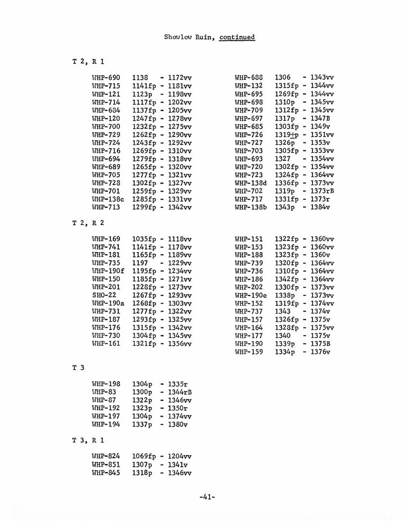
T 2, R 1
HHP-690 HHP-715 WHP-121 WHP-714 WHP-634
. l-lHP-120 HHP-700 HHP-729 HHP-724 lffiP-716 HHP-694 WHP-689 WHP-705 tlHP-728 WHP-701 iffiP-138c lTHP-713
T 2, R 2
WHP-169 l1HP-741 HHP-181 lTHP-735 i'ffiP-190£ WHP-150 lffiP-201 SH0-22 HHP-190a llHP-731 HHP-187 lTHP-176 WHP-730 HHP-161
T 3
HHP-198 tJHP-83 HHP-87 lTHP-192 HHP-197 HHP-194
T 3, R 1
HHP-824 WHP-851 WHP-845
Shm1lm·1 Ruin, continued
1138 .. 1172vv 114lfp - 1181vv 1123p - 1198vv 1117fp - 1202vv 1137fp - 1205vv 1247fp - 1278vv 1232fp - 1275vv 1262fp - 1290vv 1243£p - 1292vv 1269fp - 1310vv 1279fp - 1318vv 1265fp - 1320vv 1277fp - 1321vv 1302fp - 1327vv 1259fp - 1329vv 1285fp - 1331vv 1299fp - 1342vv
1035fp - 1118vv 1141fp - 1178vv 1165fp - 1189vv 1197 - 1229vv 1195fp .. 1234vv 1185fp - 1271vv 1228fp - 1273vv 1267£p - 1293vv 1268£p - 1303vv 1277£p - 1322vv 1293fp - 1325vv 1315fp - 1342vv 1304£p .. 1345vv 1321£p - 1356vv
1304p - 1335r 1300p - 1344rB 1322p .. 1346vv 1323p - l350r 1304p - 1374vv 1337p - 1380v
1069£p - 1204vv 1307p - 1341v 1318p - 1346vv
-41-
WHP-688 llHP-132 WHP-695 lVHP-698 lvHP-709 WHP-697 WHP-685 WHP-726 lVHP-727 WHP-703 WHP-693 WHP-720 WHP-723 WHP-138d WHP-702 WHP-717 WHP-138b
WHP-151 WHP-153 HHP-188 lvHP-739 HHP-736 WHP-186 HHP-202 HHP-190e HHP-152 H'HP-737 WHP-157 llHP-164 tvHP-177 HHP-190 WHP-159
1306 - 1343vv 1315fp - 1344vv 1269fp - 1344vv 1310p - 1345vv 1312fp - 1345vv 1317p - 1347B 1303fp - 1349v 1319±P - 1351vv 1326p - 1353v 1305fp - 1353vv 1327 - 1354vv 1302£p - 1354vv 1324£p - 1364vv 1336fp - 1373vv 1319p - 1373rB 1331fp - 1373r 1343p - 1384v
1322£p - 1360vv 1323fp - 1360vv 1323£p - 1360v 1320fp - 1364vv 1310fp - 1364vv 1342fp - 1364vv 1330fp - 1373vv 1338p - 1373vv 1319fp - 1374vv 1343 - 1374v 1326fp - 1375v 1328fp - 1375vv 1340 - 1375v 1339p - 1375B 1334p - 1376v
Show1ow Ruin, continued
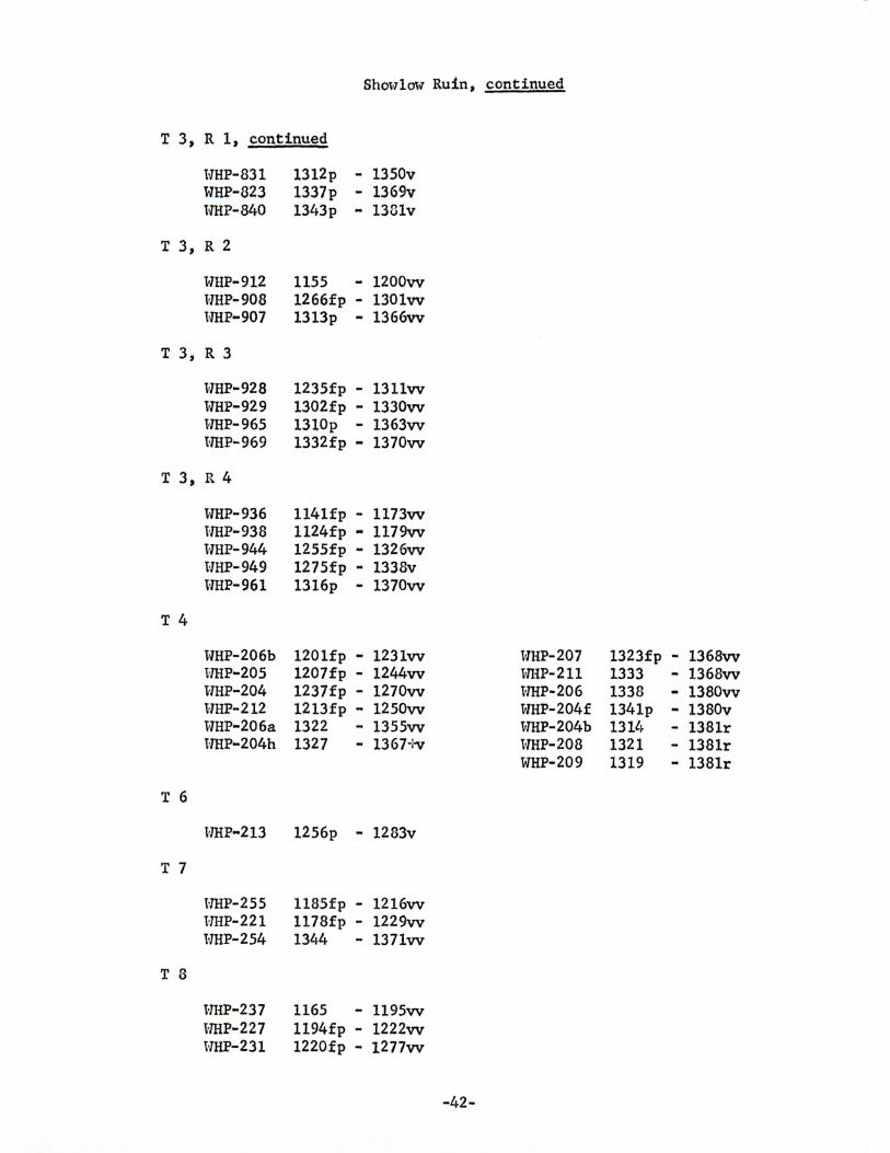
T 3, R 1, continued
WHP-831 WHP-823 HHP-840
T 3, R 2
WHP-912 HHP-908 lffiP-907
T 3, R 3
vmP-928 WHP-929 HHP-965 lffiP-969
T 3, R 4
T 4
T 6
T 7
T 8
WHP-936 l·lHP-938 lVHP-944 HHP-949 lVHP-961
tmP-206b HHP-205 HHP-204 HHP-212 WHP-206a tmP-204h
vmP-213
HHP-255 HHP-221 HHP-254
HHP-237 HHP-227 WHP-231
1312p - 1350v 1337p - 1369v 1343p - 1381v
1155 - 1200vv 1266fp - 130lvv 1313p .. 1366vv
1235fp - 13llvv 1302fp - 1330vv 1310p - 1363vv 1332fp .. 1370vv
1141fp - 1173vv 1124fp - 1179vv 1255fp - 1326vv 1275fp - 1338v 1316p - 1370vv
1201fp - 1231vv 1207fp - 1244vv 1237fp - 1270vv 1213fp - 1250vv 1322 - 1355vv 1327 - 1367+v
1256p - 1283v
1185fp - 1216vv 1178fp - 1229vv 1344 - 1371vv
1165 - 1195vv 1194fp - 1222vv 1220fp - 1277vv
-42-
HHP-207 WHP-211 vlHP-206 WHP-204£ WHP-204b t-THP-208 WHP-209
1323fp - 1368vv 1333 - 1368vv 1338 - 1380vv 134lp - 1380v 1314 - 1381r 1321 - 1381r 1319 - 1381r
Shoulo't-1 Ruin, continued
T 8, continued
T 9
HHP-226 HHP-238 HliP-260 HHP-246 HHP-230
1355fp - 1278v 1349p - 1374vv 1331p - 1375vv 1289fp - 1376r 1330fp - 1378vv
vlHP-247 1331fp - 1363vv H'HP-248 1342p - 1370vv
T 10
HHP-253 1167fp - 1198vv
T 11, R 1
SH0-27 H'HP-549 HHP-538 HHP-528 HHP-526 HHP-525 HHP-540 l-lHP-527 HHP-537 t-mP-501 HHP-666
T 11, R 2
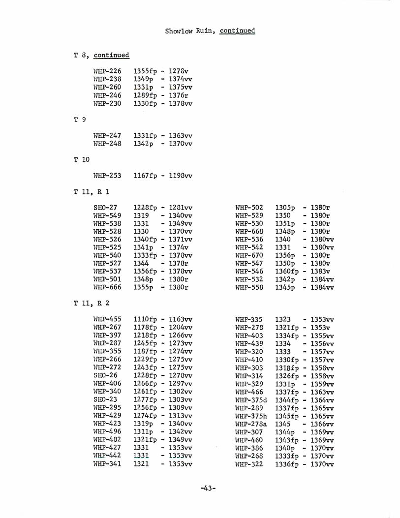
HHP-455 mrP-267 HHP-397 HHP-287 HHP-355 liHP-266 Hl-IP-272 SH0-26 TVHP-406 HHP-340 SH0-23 HHP-295 HHP-429 HHP-423 HHP-496 HHP-482 HHP-427 HHP-442 WHP-341
1228fp - 1281vv 1319 - 1340vv 1331 - 1349vv 1330 - 1370vv 1340fp - 1371vv 1341p - 1374v 1333fp - 1378vv 1344 - 1378r 1356fp - 1378vv 1348p - 1380r 1355p - 1380r
lllOfp - 1163vv 1178fp - 1204vv 1218fp - 1266vv 1245fp - 1273vv 1187fp - 1274vv 1229fp - 1275vv 1243fp - 1275vv 1228fp - 1278vv 1266fp - 1297vv 126lfp - 1302vv 1277fp - 1303vv 1256fp - 1309vv 1274fp - 1313vv 1319p - 1340vv 131lp - 1342vv 132lfp - 1349vv 1331 - 1353vv 1331 - 1353vv 1321 - 1353vv
-43-
lVHP-502 WHP-529 WHP-530 HHP-668 WP-536 WHP-542 HHP-670 l-lHP-547 l'lHP-546 l.J'HP-532 WHP-558
WHP-335 HHP-278 lVHP-403 lVHP-439 HHP-320 HHP-410 tVHP-303 WHP-314 WHP-329 vlHP-466 HHP-375d lVHP-289 lVHP-375h WHP-278a WHP-307 WHP-460 lVHP-386 lVHP-268 HHP-322
1305p - 1380r 1350 - 1380r 1351p - 1380r 1348p - 1380r 1340 - 1380vv 1331 - 1380vv 1356p - 1380r 1350p - 1380v 1360fp - 1383v 1342p - 1384vv 1345p - 1384vv
1323 - 1353vv 1321fp - 1353v 133l~fp - 1355vv 1334 - 1356vv 1333 - 1357vv 1330fp - 1357vv 1318fp - 1358vv 1326fp - 1358vv 1331p - 1359vv 1337fp - 1363vv 1344fp - 1364vv 1337fp - 1365vv 1345fp - 1365vv 1345 - 1366vv 1344p - 1369vv 1343fp - 1369vv 1340p - 1370vv 1333fp - 1370vv 1336fp - 1370vv
Shm~low Ruin, continued
T 11, R 2, continued
vlHP-473 1332fp - 1370vv WHP-352 1342 - 1378r lVHP-484 1345fp - 1370vv WHP-375a 1340p - 1378r t-JHP-294 1337fp - 137lw WHP·375c 1346 - 1378r HHP-475 1353 - 1371vv H'HP-375e 1359fp - 1378r l'ffiP-321 1339p - 1372vv WHP-375f 1340 - 1378r HHP-310 1329fp - 1373vv WHP-375g 1356fp - 1378r HHP-336 1337 - 1373vv WHP-385 1358 - 1378v WHP-495 1348p - 1373vv WHP-435 1358fp - 1378vv HHP-296 1353fp - 1374vv HHP-461 133lp - 1378r HHP-359 133lfp - 1375vv WHP-465 1362p - 1378r HHP-344 1325fp - 1375vv WHP-469 1338p - 1378v WHP-421 1350p - 1375vv vTHP-413 1357fp - 1380vv WHP-493 1359fp - 1375v vlHP-437 1345p - 1380r HHP-446 1343fp - 1375vv WHP-458 1337 - 1380vv HHP-488 1344p - 1376v WHP-309 1342fp - 138lrB l-JHP-443 1350fp - 1377vv WHP-299 1346fp - 1382r HliP-468 1352p - 1377vv WHP-318 1317fp - 1382r l-IHP-500 1341p - 1377vv tmP-331 1333fp - 1382r lvHP-265 1338p - 1378vv vlHP-379 1350fp - 1382r vmP-317 1327p - 1378v WHP-491 1355fp - 1382vv WHP-275 1345fp - 1378r tVHP-395 1350p - 1383r HHP-306 1344fp - 1378r vlHP-402 1357p - 1383r HHP-276 1317p - 1373r tVHP-445 1361fp - 1383vv l-IHP-325 1327p - 1373v WHP-450 1363fp - 1383vv HHP-327 1356fp - 1378vv WHP-487 1344fp - 1383vv HHP-388 1326 - 1373v l-IHP-396 1356p - 1384v WHP-342 1352 - 1378r HHP-405 1353 - 1384r
WHP-457 1361fp - 1384vv
T 11, R 3
HHP-580 1334 - 1356vv WHP-579 1357fp - 1374vv l-JHP-578 1334fp - 1361vv HHP-565 1336fp - 1377vv vlHP-567 133lfp - 1361vv WHP-564 1347fp - 1378vv WHP-571 1345p - 1367vv WHP-569 1334fp - 1378vv WHP-568 1348fp - 1363vv WHP-5D3 1358p - 1380vv HHP-572 1343p - 1369vv WHP-581 1354 - 1381vv WHP-577 1345fp - 1373vv vlHP-573 1359fp - 1383vv
T 11, R 4
vlHP-635 1276fp - 1320v HHP-630 1282p - 1334vv lvHP-627 1321fp - 1353vv HHP-607 1238p - 1361vv HHP-629 1340p - 1363r l-IHP-633 1345p - 1360v HHP- 642 1309p - 1368vv WHP-622 1328p - 1378r
-44-
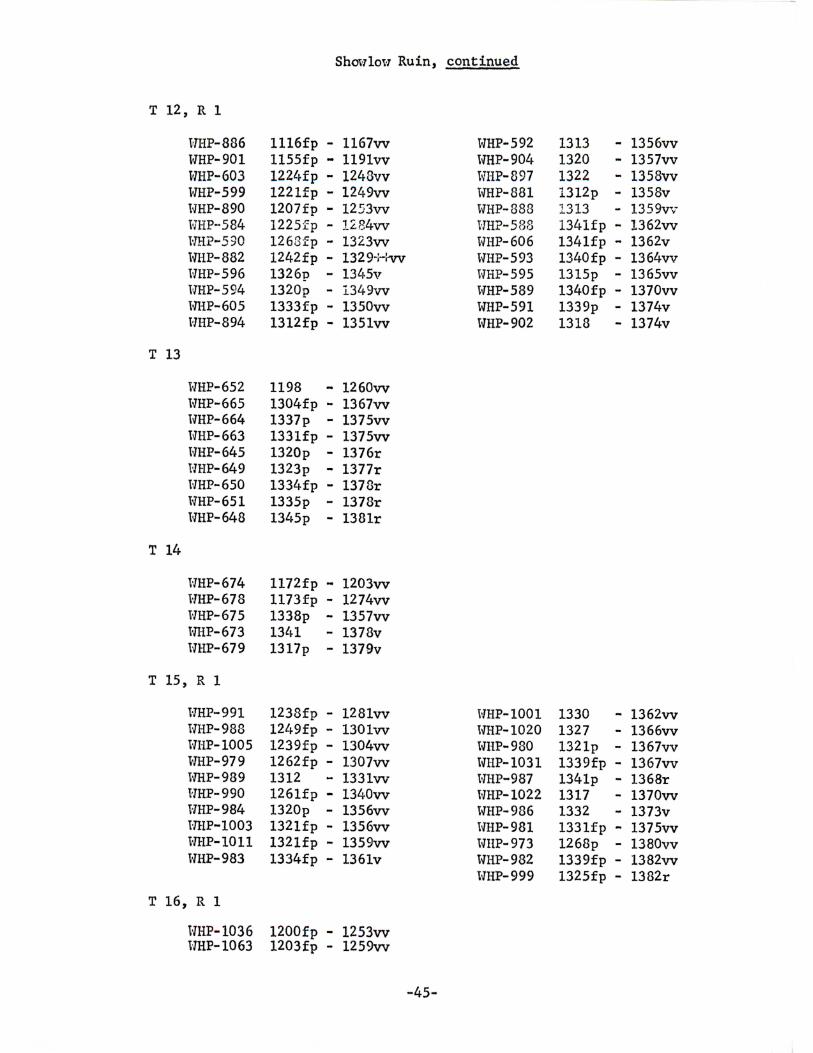
Shcm1ot·7 Ruin, continued
T 12, R 1
HHP-886 1116fp - 1167vv WHP-592 1313 - 1356vv WHP-901 1155fp .. 119lvv WHP-904 1320 - 1357vv WHP-603 122l•fp - 1248vv HHP-897 1322 - 1358vv WHP-599 122lfp - 1249vv WHP-881 1312p - 1358v HHP-890 1207fp - 1253vv WHP-888 1313 - 1359\T',r HHP··584 1225fp - l284vv vlHP-588 1341fp - 1362vv HH?-590 1263fp - 1323vv WHP-606 1341fp - 1362v WHP-882 1242fp - 1329-Hvv WHP-593 1340fp - 1364vv tmP-596 1326p - 13l.•5v WHP-595 1315p - 1365vv vlHP-594 1320p - l349vv WHP-589 1340fp - 1370vv HHP-605 1333fp - 1350vv WHP-591 1339p - 1374v HHP-894 1312fp - 1351vv WHP-902 1318 - 1374v
T 13
WHP-652 1198 - 1260vv tmP-665 1304fp - 1367vv lVHP-664 1337p - 1375vv HHP-663 1331fp - 1375vv HHP-645 1320p - 1376r HI-IP-649 1323p - 1377r tVHP-650 1334fp - 1378r WHP-651 1335p - 1378r vlHP-648 1345p - 1381r
T 14
HHP-674 1172fp - 1203vv HHP-678 1173fp - 1274vv WHP-675 1338p - 1357vv t-lHP-673 1341 - 1378v HHP-679 1317p - 1379v
T 15, R 1
HHP-991 1238fp - 1281vv -vmP-1001 1330 - 1362vv tVHP-988 12l~9fp - 130lvv HHP-1020 1327 - 1366vv lVHP-1005 1239fp - 1304vv WHP-980 1321p - 1367vv WHP-979 1262fp - 1307vv WHP-1031 1339fp - 1367vv WHP-989 1312 - 1331vv HI-IP-987 1341p - 1368r UHP-990 126lfp - 1340vv HI-IP-1022 1317 - 1370vv HHP-984 1320p - 1356vv WHP-986 1332 - 1373v HHP-1003 1321fp - 1356vv HHP-981 133lfp - 1375vv HHP-1011 132lfp - 1359vv HHP-973 1268p - 1380vv tVHP-983 1334fp - 136lv HHP-982 1339fp - 1382vv
HHP-999 1325fp - 1382r
T 16, R 1
WHP-1036 1200fp - 1253vv HHP-1063 1203£p - 1259vv
-45-
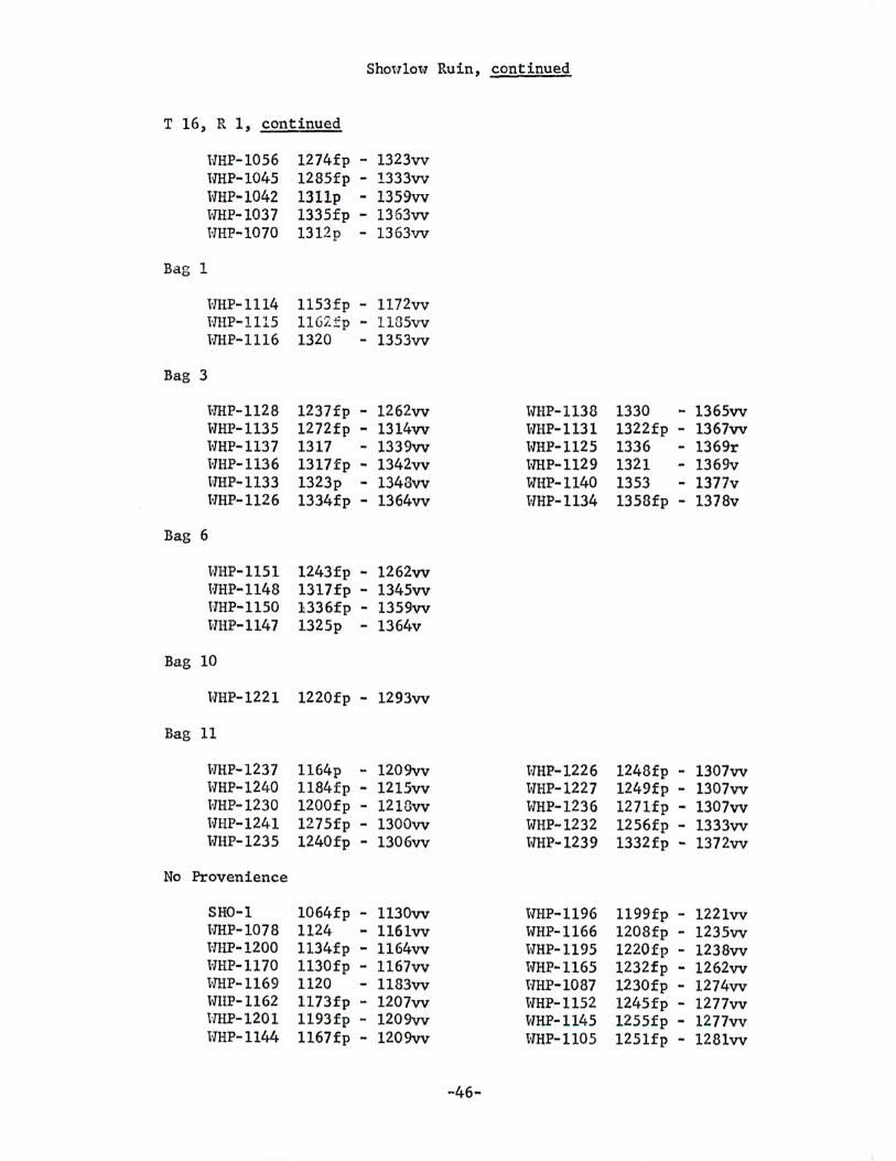
Shou1ol-7 Ruin, continued
T 16, R 1, continued
TmP-1056 HHP-1045 WHP-1042 lffiP-1037 HHP-1070
Bag 1
HHP-1114 HHP-1115 vmP-1116
Bag 3
vmP-1128 WHP-1135 HHP-1137 HHP-1136 vmP-1133 HHP-1126
Bag 6
HHP-1151 HHP-1148 t-THP-1150 HHP-1147
Bag 10
HHP-1221
Bag 11
HHP-1237 WHP-1240 HHP-1230 tmP-1241 HHP-1235
No Provenience
SH0-1 HHP-1078 WHP-1200 HHP-1170 lffiP-1169 WUP-1162 HHP-1201 WHP-1144
1274fp - 1323vv 1285fp - 1333vv 131lp - 1359vv 1335fp - 1363vv 1312p - 1363vv
1153fp - 1172vv 1162.£p - ll85vv 1320 - 1353vv
1237fp - 1262vv 1272fp - 1314vv 1317 - 1339vv 1317fp - 1342vv 1323p - 1343vv 1334fp - 1364vv
1243fp - 1262vv 1317fp - 1345vv 1336fp - 1359vv 1325p - 1364v
1220fp - 1293vv
1164p - 1209vv 1184fp - 1215vv 1200fp - 1218vv 1275fp - 1300vv 1240fp - 1306vv
1064fp - 1130vv 1124 - 116lvv 1134fp - 1164vv 1130fp - 1167vv 1120 - 1183vv 1173£p - 1207vv 1193fp - 1209vv 1167£p - 1209vv
-46-
WHP-1138 1330 - 1365vv HHP-1131 1322fp - 1367vv HHP-1125 1336 - 1369r lffiP-1129 1321 - 1369v WHP-1140 1353 - 1377v vlHP-1134 1358fp - 1378v
lvHP-1226 1248fp - 1307vv HHP-1227 1249fp - 1307vv vlHP-1236 1271fp - 1307vv WHP-1232 1256fp - 1333vv t-IHP-1239 1332fp - 1372vv
vlHP-1196 1199fp - 1221vv WHP-1166 1208fp - 1235vv WHP-1195 1220fp - 1238vv WHP-1165 1232fp - 1262vv HHP-1087 1230fp - 1274vv WHP-1152 1245fp - 1277vv WHP-1145 1255fp - 1277vv WHP-1105 1251fp - 1281vv
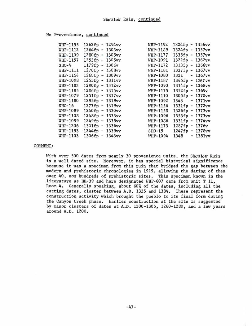
Shoulow Ruin, continued
No Provenience, continued
H'HP-1155 1262fp - 1294vv HHP-1192 1324fp - 1356vv lVHP-1112 1264fp - 1303vv WHP-1189 1324fp - 1357vv HHP-1109 1280fp - 1305vv lmP-1177 1335fp - 1357vv HliP-1157 1253fp - 1305vv WHP-1091 1322fp - 1362vv SH0-4 1179fp - 1306v WHP-1172 1313f p - 1366vv HHP-1111 1270fp - E08vv t-THP-1181 1337fp - 1367vv HHP-1154 l260fp - 1309vv HHP-1080 1331 - 1367vv HHP-1098 1255fp - 1311vv WHP-1187 1345fp - 1367 vv HHP- 1183 1290£p - 1312vv WHP-1090 1314fp - 1368vv HHP-1185 1286fp - l 315vv WHP-1175 1352fp - 1369v WHP-1079 125lfp - 1317vv WHP-1110 1305fp - 1370vv HHP-1180 1295fp - 1319vv WHP-1092 1343 - 1371vv SH0-16 1277fp - 1319vv WHP-1156 133lfp - 1372vv HHP-1089 1240fp - 1330vv vlHP-1158 1326fp - 1373vv t-lHP-1108 1248fp - 1333vv WHP-1096 1353fp - 1373vv WHP-1099 1249fp - 1335vv WHP-1086 133lfp - 1374vv l.[HP-1206 1301fp - 1336vv WHP-1173 1287fp - 1376v HHP-1153 1244fp - 1339vv SH0-15 1247fp - 1378vv HHP-1103 1306fp - 1343vv WHP-1094 1348 - 138lvv
COMMENT:
Hith over 500 dates from nearly 30 provenience units, the Sho\·Tlo"l-7 Ruin is a well dated site. Moreover, it has special historical significance because it "~>7as a specit:~en from this ruin that bridged the gap between the modern and prehistoric chronologies in 1929, allmving the dating of then over 40, now hundreds of prehistoric sites. This specimen knmvn in the literature as HH-39 and here designated WHP-607 came from unit T 11, Room 4. Generally speaking, about 60% of the dates, including all the cutting dates, cluster between A.D. 1335 and 1384. These represent the construction activity nhich brought the pueblo to its final form during the Canyon Creek phase. Earlier construction at the site is suggested by minor clusters of dates at A.D. 1300-1305, 1260-1280, and a few years around A.D. 1200.
-47-
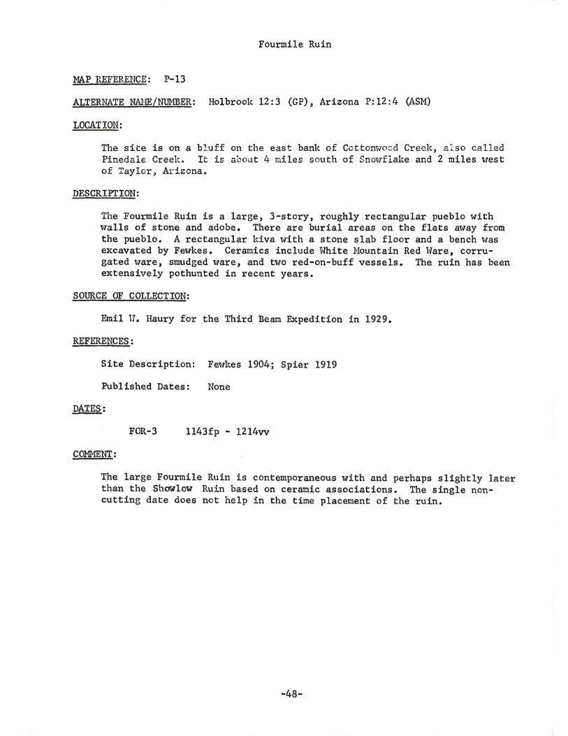
Fourmile Ruin
MAP REFERENCE: P-13
ALTERNATE NANE/NUMBER: Holbrook 12:3 (GP), Arizona P:l2:4 (ASM)
LOCATION:
The site is on a bJ.uff on the east bank of Cottom.,rosd Creek, a l so called Pinedale Creek. It is about 4 miles south of Snow·flake and 2 miles v7est of Taylor, Arizona.
DESCRIPTION:
The Fourmile Ruin is a large, 3-story, roughly .rectangular pueblo with walls of stone and adobe. There are burial areas on the flats away from the pueblo. A rectangular kiva lvith a stone slab floor and a bench was excavated by Fewkes. Ceramics include White Mountain Red Ware, corrugated v;rare, smudged ware, and two red~on-buff vessels. The ruin has been extensively pothunted in recent years.
SOURCE OF COLLECTION:
Emil H. Haury for the Third Beam Expedition in 1929.
REFERENCES:
Site Description: Fewkes 1904; Spier 1919
Published Dates: None
DATES:
FOR-3 1143fp - 1214vv
COMMENT:
The large Fourmile Ruin is contemporaneous with and perhaps slightly later than the Showlow Ruin based on ceramic associations. The single noncutting date does not help in the time placement of the ruin.
-48-
Red Rock House
MAP REFERENCE: P-14
ALTERNATE NAJm/NUMBER: Arizona P:l4:14 (ASM)
LOCATION:
About four miles southwest of Grasshopper and three miles west of Salt River Dral>T, on the w·este:rn banl~ and near the head of an eastern tributary of Oak Creek, a tributary of the Salt River.
DESCRIPTION:
This is a cliff dwelling with about 12 to 15 rooms and half a dozen storerooms built against the curving back wall of the cave,. At least two rooms had a second story. Walls are of heavily plastered masonry. Lintels, roof beams, and boards are "Tell preserved. Ceramics include White Hountain Red Hare, Pinto Polychrome, Gila Polychrome, Pinto Black-on-red, and obliterated corrugated.
SOURCE OF COLLECTION:
lv. J. Robinson and J .s. Dean for the Laboratory of Tree-Ring Research in 1964.
REFERENCES:
Site Description: Hough 1930: 7-8
Published Dates: None
DATES:
First Story, Room 1
RRH-2 1303
First Story, Room 2
RRH-4 RRH-5
1221+ 1281
- 1345L
- 1346L - 1345LB
First Story, storeroom behind room 2
RRH-6 1203p - 1346rL
First Story, room in front of room 3
RRH-9 1313 - 1349vv
First Story, storeroom behind room 4
RRH-12 1303p - 1346L
-49-
Red Rock House, continued
Second Story level, Room 3
RRH-7 1324 - 13621
Second Story level, Room 4
RRH-11 1273.± - 13611
Surface
RRH-14 1310p - 1356r
CONMENTS:
This cliff ruin is similar in many aspects to the Canyon Creek Ruin (Haury 1934) and has a large second story room (Room 3) which may be a kiva. The inner rO'tv of ground level rooms was built in A.D. 1345-1346 and there is a suggestion that an outer row, novr collapsed, may have been built sometime after A.D. 1349. The second story was added above Rooms 3 and 4 in A.D. 1361-1362.
-so-
Grasshopper Ruin
MAP REFERENCE: P-15
ALTERNATE NA11E/NUMBER: Arizona P: 14: 1 (ASM)
LOCATION:
The ruin at Grasshopper is 10 miles t-lest of Cibect:e en t ne Fort Apache Indian Reservation. I t is on both sides of the Sal t River Dratv, a northern ~ributary of the Salt River.
DESCRIPTION:
This pueblo contains more than 500 masonry rooms, some of which were two stories high. Rooms are grouped in two major blocl:::s, bne on either side of the creek. These are surrounded by a number of smaller room blocks with 20 to 30 rooms. There is a great kiva within the tvesterri room block, and a number of smaller kivas. Several burial areas surround the area. Cermaics include tvhite Nountain Red Ware, Gila Polychrome, Cibecue Polychrome, Pinedale Black-on-t-7hite, and corrugated w·are.
SOURCE OF COLLECTION:
University of Arizona Archaeological Field School, 1963-1966.
REFERENCES:
Site Description: Hough 1919, 1920, 1930; Spier 1919; Thompson and Longacre 1966
Published Dates: None
DATES:
Oven . 1, Fill
GRS-18 GRS-19
Oven 2
GRS-10 GRS-11 GRS-14 GRS-15 GRS-9 GRS-13 GRS-8 GRS-6
Room 8
GRS-3
1217p 1231
- 1277vv - 1278vv
1179fp - 1242vv 1197 - 1263rG 1214.±P - 1274vv 1215 - 1279vv 1237 - 128lvv 122l±p - 1294vv 1235 - 1306+vv 1252fp - 1330vv
1254fp - 1309vv
-51-
Grasshopper Ruin, continued
Room 11, Level 2
GRS-27
Room 18
GRS-145 GRS-143 GRS-160 GRS .. 153
Room 19
GRS-218 GRS-220 GRS-166
Room 21
GRS-217 GRS-219
Corridor Roof
1275fp - 1333vv
1144fp - 1206vv 1149fp - 1233vv 1207fp - 1269vv 1287fp - 1347vv
1223p - 1252vv 1257fp - 1301vv 1283fp - 13llvv
1237fp - 1267vv 1250 - 1288vv
GRS-201 1243fp - 1315vv
Great Kiva, Fill
GRS-100 GRS-88 GRS-102
1146fp - 1205vv 1262fp - 132lvv 1307.:_[-p ... 1347vv
Great Kiva, Test 29a
GRS-20 1293p - 1336vv
Great Kiva, Test 29g, level 5
GRS-51 1195fp - 1287vv
C0Ml1ENT:
The Grasshopper Ruin is currently under investigation by The University of Arizona Archaeological Field School and conclusions regarding the site have not been formulated. The dates indicate a 14th-century placement for those sections of the ruin thus far exca7ated.
-52-

Site 30 (CNHM)
~~p REFERENCE: Q-3
ALTERNATE NAME/NUHBER: None knolm
LOCATION:
Three miles south of Vernon, Arizona and several hundred yards west of Vernon Creek.
DESCRIPTION:
The site consists of eight irregularly shaped pithouses with the diameter varying bet"t"Teen 2. 65 and 5. 3 m. and the depth varying betv1een • 45 and 1. 95 m. The dwellings w·ere apparently stripped and burned. Pottery types include Alma Plain, San Francisco Red, Woodruff Smudged, and very small amounts of Lino Gray, Lino Smudged, Kiatuthlanna Black-on-white, Mimbres Boldface Black-on-l-lhit~, vJhite Mound Black-on-w'hite, and Three Circle Red-on-white.
SOURCE OF COLLECTION:
Chicago Natural History Museum Southwest Archaeological Expedition, directed by Paul S. Martin, in 1957.
REFERENCES:
Site Description: Martin and Rinaldo 1960a
Published Dates: None
DATES:
Pithouse A, Trench
ULC-32b,c 758p - Gl3v
Pithouse A, East wall
ULC-9 a,b 729 - 809vv
Pithouse A, East 't-7all, roof beam
ULC-28 733p - 782vv ULC-27 725 - 817vv ULC-32 739 - 820v ULC-31 759p - 822v
Pithouse F, Floor
ULC-66 748 - 820vv
-53-
Site 30 (CNBM), continued
Pithouse F, Floor post
ULC-67 673p - 798vv ULC-68 745p - 804vv ULC-69a,b 725 - 806vv
Pithouse F, Roof
UI..C-55-1 72lp - 776vv
Pithouse G, Roof
ULC-61 740p - 797vv ULC-64 730p - 802vv
No Provenience
ULC-71 745p - 812vv
COMMENT:
The dates from this pithouse village do not cluster l·7ell. The fact, however, that most of the dates fall in the early 9th century and that the latest date from two structures is near A.D. 820 suggests a building period in the second quarter of the 9th century.
-54-
St. Johns 16:9 (GP)
MAP REFERE~: Q-5
ALTERNATE NAME/NUMBER: Coyote Creel~ No. 3, SW Museum 3•10
LOCATION:
The site is about 15 miles southeast of Springerville, benveen 1/2 and 3/4 miles tvest of the .Arizona-NetV' Mexico state line. The site is on the nor th rim of the canyon containing Coyote Creel,, a northern tributary of the Little Colorado River.
DESCRIPTION:
This is a masonry pueblo containing 40 to 50 rooms. Ceramics found include Reserve Black-on-white, Tularosa Black-on-white, Hingate Black-on red, and corrugated t·Tares. The specimens were collected from debris left by pothunting.
SOURCE OF COLLECTION:
Deric O'Bryan for Gila Pueblo in 1947.
REFERENCES:
Site Description: None
Published Dates: None
DATES:
COMMENT:
GP-6175 GP-6186 GP-6134 GP-6176 GP-6174 GP-6178 GP-6173
994 - 1012vv 933 - 1063vv 989 - 1069vv
1016 - 1088vv 1017p - 1113vv 1048fp - 1117vv 1070fp - 1119vv
The specimens were obtained from materials thrmvn out by pothunters and have no provenience control and are very fragmentary. The dates are earlier than the age suggested by ceramics.
-55-
St. Johns 16:10 (GP)
MAP REFERENCE: Q-6
ALTERNATE NAME/NUMBER: Coyote Reservoir, Sl-1 Museum 3-11
LOCATION:
The site is on a rock ledge above the south bank of Coyote Creek, a northern tributary of the Little Colorado River. It is very near the Arizona-New Mexico state line and is about 1/4 mile east of St. Johns 16:9.
DESCRIPTION:
The site is a small four room house cluster. St. Johns Polychrome (?) sherds were found on the site. The specimens 't'lere taken from an eroded cut in the northeast corner of the site where fill for Coyote Reservoir dam had been secured.
SOURCE OF COLLECTION:
Deric O'Bryan for Gila Pueblo in 1947.
REFERENCES:
Site Description: None
Published Dates: None
DATES:
Northeast corner of the site
COMHENT:
GP-6040 GP-6027 GP-6036 GP-6044 GP-6030 GP-6028 GP-6031 GP-6043 GP-6035
913fp - 967vv 932fp - 912vv 957fp - 1003vv 930fp - 1007vv 955fp - 1017vv
1031 - 1069v 1020 - 1083vv 1040p - 1086v 1062fp - llOlvv
The specimens came from an eroded section of the ruin and lack provenience control. The range of dates can be explained for such a small site only by substantial outer ring loss of the specimens.
-56-
Table Rock Pueblo
MAP REFERENCE: Q-7
ALTERNATE NA!-IE/NUMBER: None known
LOCATION:
The site is located about one mile east of St. Johns. It is on top and between two low natural hills of sandstone about 500 ft. east of the Little Colorado River.
DESCRIPI'ION:
This is a Pueblo IV masonry one-story pueblo consisting of 60 to 100 rooms and at least two kivas. Fifty rooms and the kivas were excavated. The latter were rectangular, uith benches across one end. Ceramics include plain brown, red, and corrugated sherds as t-7ell as Fourmile Polychrome, Gila Polychrome, Tonto Polychrome and white-on-red sherds in association with intrusive sherds from the Hopi and Zuni areas. There is a radiocarbon date of A.D. 1345+ 50 years (P.S. Martin, personal connnunication).
SOURCE OF COLLECTION:
Chicago Natural History Museum Southwest Archaeological Expedition, directed by Paul s. Martin, in 1958.
REFERENCES:
Site Description: ~mrtin and Rinaldo 1960b
Published Dates: None
DATES:
ULC-74 1235p - 1346vv
COMMENT:
The single tree-ring date and the radiocarbon date are in remarkable agreement. Neither date, however, adequately delimits the time range of the site.
·57-
Carter Ranch Site
MAP REFERENCE: Q·8
ALTERNATE NANE/NUMBER: None known
LOCATION:
The site is nine m:u.es east of Sn01;1flake, and l es s t :'1.an one mi le sout !-t't-7est of Point of the Nou!!tain Hesao The nite is near Hay Hollow Wash o
DESCRIPTION:
The site is a Pueblo III masonry pueblo with 39 rooms built in a rectangular block which includes a small plaza. Hithin the plaza are a large D-shaped kiva, a large storage pit and a small rectangular kiva with a platform. A detached circular great kiva lies 10 m. to the northw·est of the north '·ling# Ceramics include Snolv-flake Black-on-white and small amounts of several early polychrome types.
SOURCE OF COLLECTION:
Chicago Natural History Museum Southwest Archaeological Expedition, directed by Paul s. ~mrtin, in 1961.
REFERENCES:
Site Description: Martin ~ al. 1964
Published Dates: None
DATES:
Room 6
CAR-3 1071p - 1113r
Room 15, (Floor II, roof beams)
CAR-10 CAR-ll
1059p 1043p
- 1116c - 1130v
Trench G, Square 3, Level 3
COMMENT:
CAR-5 CAR-4
1026p 1051
- 1142v -1156v
The fe,·T dates do not alloll precise placement of the occupation at the Carter Ranch Site. There is a suggestion that the south rooms in the pueblo were under construction ~· A.D. 1116-1118 from two cutting dates and that occupation continued until after A.D. 1156.
-58-
Broken K Pueblo
MAP REFERENCE: Q-9
ALTERNATE NAME/Nill1BER: None kno~m
LOCATION:
The site is in the drainage of Hay Hollow· Wash, 11 mileos east of Snowfl ake, Arizona.
DESCRIPTION:
This is a rectangular, single story masonry pueblo 't-Tith about 95 rooms. Ceramics included Snm-1flake Black-on-'t-Thite, Tularosa Black-on-white, Shoulow Black-on-red, St. Johns Polychrome, Springerville Polychrome, and HcDonald corrugated.
SOURCE OF COLLECTION:
Chicago Natural History Museum Soutm'1est Expedition, directed by Paul s. Martin in 1961-1963.
REFERENCES:
Site Description: Hill 1966
Published Dates: None
DATES:
Room 11, North-south roof beam
ULC-75 1208p - 1259vv
COMHEN".C:
This single date is inadequate to delimit the span of occupation of the ruin ·which has been estimated at A.D. 1150 to 1280 (Hill 1966).
-59-
REFERENCES
Baldw·in, Gordon c.
1939 Dates from King's Ruin. Tree-Ring Bulletin, Vol. 5, No. 3, pp. 23-24. Tucson.
Bandelier, A.F.
1892 Fir:al Report of I::1'!2Stigations Anong the Indians of the Southweste~n Uni~ed States, Carried on mainly in the Years from 1880 to 1885. Archaeological hstitute of America, John lVilson and Son, Cambridge.
Ca~vood, Louis R. and Edward Ho Spicer
1935 Tuzigoot: The Excavation and Repair of a Ruin on the Verde River Near Clarkdale, Arizona. Privately Mimeographed.
Colton, Harold S.
1946 The Sinagua. Museum of Northern Arizona, Bul~ No. 22. Flagstaff.
Conner, Sidney
1943 Excavations at Kinnikinnick, Arizona. American Antiquity, Vol. 8, No. 4, pp. 376-379. Menasha.
Douglass, A.E.
1935 Dating Pueblo Bonito and Other Ruins of the Southwest. National GeograQhic Society, Contributed Technical Papers, Pueblo Bonito Series, No. 1. l-lashington.
1933 Southwestern Dated Ruins: V. Tree-Ring Bulletin, Vol. 5, No. 2, pp. 10-13. Tucson.
1941 Age of Forestdale Ruin Excavated in 1939. Tree-Ring Bulletin, Vol. 8, No. 1, pp. 7-8. Tucson
1942 Checking the Date of Bluff Ruin, Forestdale: A Study in Technique. Tree-Ring Bulletin, Vol. 9, No. 2, pp. 2-7.
1944 Tabulation of Dates for Bluff Ruin, Forestdale, Arizona. TreeRing Bulletin, Vol. 11, No. 2, pp. 10-16. Tucson.
1947 Photographic Tree-Ring Chronologies and the Flagstaff Sequence. Plateau, Volo 14, No. 2, pp. 10-16. Flagstaff.
Fewkes, Jesse Walter
1398 Archeological Expedition to Arizona in 1895. Seventeenth Annual Report of the Bureau of American Ethnology, pp. 520-742, Hashington.
-60-
1904 Two Summer's Hark in the Pueblo Ruins. Twenty-Second Annual Repor.t of the Bureau of American Ethnology_, pp. 3-195. Uashington.
Haury, Emil U.
1934
1940a
1940b
The Canyon Creel~ Ruin and the Cliff Dwellings of the Sierra Ancha. Medallion PaEers, No. 14. Gila Pueblo, Globe.
Excavations in the Forestdale Valley, East-Central Arizona. Ur.i versity of Arizona Bulletin, Vol. 11, No. 4~ ~.L§.s~~ce Bu1-letin, No. 12, Tucsoil.
New Tree-Ring Dates from the Forestdale Valley, East-Central Arizona. T~ee-Ring Bull~, Vol . 7, No. 2, pp. 14-16. Tucson.
1942 Some Implications of the Bluff Ruin Dates. Tree-Ring Bulletin, Vol. 9, No. 2, pp. 7-3. Tucson.
1950 A Sequence of Great ICivas in the Forestdale Valley, Arizona. In For the Dean, Erik K, Reed and Dale s. King, editors. Hohokam Huseums Association and Southt-Testern Monuments Association. Tucson and Santa Fe.
Haury, Emil l·l, and Lyndon L. Hargrave
1931 Recently Dated Pueblo Ruins in Arizona. Smithsoni&n Miscellaneous Collections, Vol. 32, No. 11. Washington,
Haury, Emil t-1. and E.B. Sayles
1947 An Early Pit House Village of the Mogollon Culture: Forestdale Valley, Arizona. University of Arizona Bulletin, Vol. 18, No. 4, Social Science Bulletin, No. 16. Tucson,
Hill, Janes N.
1966 A Prehistoric Community in Eastern Arizona. of Anthropology, Vol. 22, No. 1, pp. 9-30.
Southl-Testern Journal Albuquerque~
Hough, Halter
1903 Archeological Field Hark in Northeastern Arizona. The MuseumGates Expedition of 1901. Annual Report of the U.S .• National Museum for 1901, pp. 279-358. Hashington.
1919 Archeological Exploration in Arizona. Collections, Vol. 70, No. 2, pp, 90-93.
Smithsonian Miscellaneous Hashing ton.
1920 Archeological Excavations in Arizona. Smithsonian Miscellaneous Collections, Vol. 72, No. 1, pp. 64-66. Washington.
1930 Exploration of Ruins in the Hhite Mountain Apache Indian Reservation, Arizona. Proceedings, U.S. National Huseum, Vol. 78, Art. 13. tvashington,
-61-
McGregor, John C.
1942 Dates from Kinnildnnicl~ Pueblo. Jree-Ring Bulletin, Vol. 8, No. 3, pp. 21-23. Tucson.
1955 A Sinagua Kiva. Plateau, Vol. 27, No. 3, pp. 11-17. Flagstaff.
1956 The 1955 Pollock Site Excavation. Plateau, Vol. 23, No. 3, pp. 49-54. Flagstaff.
1958 The Pershing Sitec Pl~J:.~~' Vol. 31, Noo 2, pp. 33-36. Flagstaff.
1961 The Pershing Site in Northern Arizona. Plateau, Vol. 34, No. 1, pp. 23-27. Flagstaff.
Hartin, Paul s. and John B~ Rinaldo
1960a
1960b
Excavations in the Upper Little Colorado Drainage, Eastern Arizona. Fieldiana: Anthropology, Vol, 51, No. 1. Chicago.
Table Rock Pueblo, Arizona. Fieldiana: Anthropology, Vol. 51, No. 2. Chicago.
:Hartin, Paul s., John B. Rinaldo, tUlliam A. Longacre, Leslie G. Freeman, Jr., James A. Brown, Richard H. Hevly and M.E. Cooley
1964 Chapters in the Prehistory of Eastern Arizona, II. Fieldiana: Anthropology, Vol. 55. Chicago.
Scantling, Frederick 11.
1940 Tree-Ring Dates from a Mormon Church. Tree-Ring Bulletin, Vol. 7, No. 2, p. 14. Tucson.
Smiley, Terah L.
1951 A Summary of Tree-Ring Dates from Some Southwestern Archaeological Sites. University of Arizona Bulletin, Vol. 22, Laboratory of Tree-Ring Research Bulletin, No. 5. Tucson.
Spicer, Ed't-rard H. and Louis R. Cayt-Tood
1936 ~-10 Pueblo Ruins in West Central Arizona. University of Arizona Bulletin, Vol. 7, No. 1, Social Science Bulletin, No. 10. Tucson.
Spier, Leslie
1919 Ruins in the Hhite Mountains, Arizona. Anthropological Papers of the American Museum of Natural History, Vol. 18, Part 5. New York.
Thompson, Raymond H. and tvilliam A. Longacre
1966 The University of Arizona Archaeological Field School a t Grass hopper, East Central Arizona. The Kiva, Vol. 31, No. 4, pp. 255-275.. Tucson.
-62-
Hasley, t-Jilliam lv.
1964 The Archaeological Survey of the Arizona State Museum. Arizona State Museum, The University of Arizona. Tucson~
Uilson, John P., Jon H. Hinston and Alan J. Berger
1961 Burials at Kinnikinnick Pueblo. Plateau, Vol. 34, No. 1, pp. 23-32. Flagstaff.
-63-
PREVIOUS QUADRANGLE REPORTS
TREE-RING DATES FROM ARIZONA K: Puerco--lVide Ruin-Ganado Area, by Bryant Bannister, John W. Hannah, and Hilliam J. Robinson. 1966.
TREE-RING DATES FROM ARIZONA E: Chinle--De Chelly-Red Rock Area, by Bryant Bannister, Jeffrey S. Dean, and Elizabeth A.M. Gell. 1966.


![INDEX [] · 2005-10-25 · 5 Bryant, John F, 27 Bryant, Levi Clinton, Sr, 109 Bryant, Lillie S, 101 Bryant, Linster, 101 Bryant, Litha L, 109 Bryant, Louisa M, 111 Bryant, Mary, 101](https://static.fdocuments.in/doc/165x107/5f4498e1f4a6be5e1a48d4d2/index-2005-10-25-5-bryant-john-f-27-bryant-levi-clinton-sr-109-bryant.jpg)