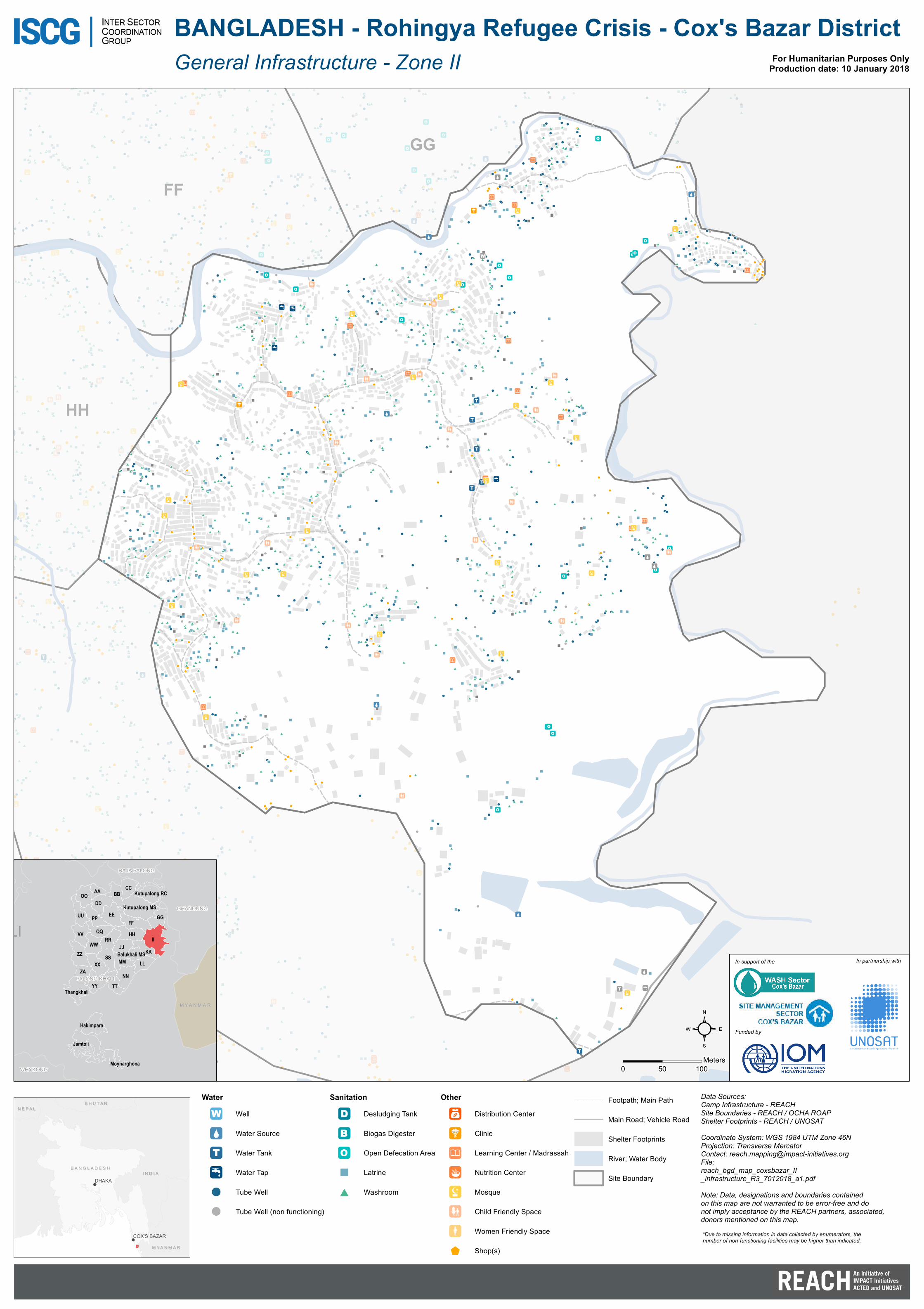
BANGLADESH - Rohingya Refugee Crisis - Cox's Bazar District fileFF GG HH KK LL BALUKHALI MS...
1
FF GG HH LL BANGLADESH - Rohingya Refugee Crisis - Cox's Bazar District Data Sources: Camp Infrastructure - REACH Site Boundaries - REACH / OCHA ROAP Shelter Footprints - REACH / UNOSAT Coordinate System: WGS 1984 UTM Zone 46N Projection: Transverse Mercator Contact: [email protected] File: reach_bgd_map_coxsbazar_II _infrastructure_R3_7012018_a1.pdf Note: Data, designations and boundaries contained on this map are not warranted to be error-free and do not imply acceptance by the REACH partners, associated, donors mentioned on this map. For Humanitarian Purposes Only Production date: 10 January 2018 C hi t t ag o n g BANGLADESH BANGLADESH BHUTAN BHUTAN MYANMAR MYANMAR INDIA INDIA NEPAL NEPAL DHAKA COX'S BAZAR LI PALONG KHALI GHANDUNG WHYKONG RAJA PALONG II FF EE ZZ JJ NN HH XX PP VV TT SS YY DD ZA LL RR OO CC BB UU QQ KK GG WW MM AA Jamtoli Kutupalong MS Thangkhali Hakimpara Kutupalong RC Balukhali MS Moynarghona MYANMAR MYANMAR Water Well Water Source Water Tank Water Tap Tube Well Tube Well (non functioning) Sanitation Desludging Tank Biogas Digester Open Defecation Area Latrine Washroom Other Distribution Center Clinic Learning Center / Madrassah Nutrition Center Mosque Child Friendly Space Women Friendly Space Shop(s) Footpath; Main Path Main Road; Vehicle Road Shelter Footprints River; Water Body Site Boundary *Due to missing information in data collected by enumerators, the number of non-functioning facilities may be higher than indicated. General Infrastructure - Zone II In support of the Funded by In partnership with 0 50 100 Meters
Transcript of BANGLADESH - Rohingya Refugee Crisis - Cox's Bazar District fileFF GG HH KK LL BALUKHALI MS...
FF
GG
HH
KK
LL
BALUKHALIMS
BANGLADESH - Rohingya Refugee Crisis - Cox's Bazar District
Data Sources:Camp Infrastructure - REACHSite Boundaries - REACH / OCHA ROAPShelter Footprints - REACH / UNOSATCoordinate System: WGS 1984 UTM Zone 46NProjection: Transverse MercatorContact: [email protected]:reach_bgd_map_coxsbazar_II_infrastructure_R3_7012018_a1.pdfNote: Data, designations and boundaries containedon this map are not warranted to be error-free and donot imply acceptance by the REACH partners, associated,donors mentioned on this map.
For Humanitarian Purposes OnlyProduction date: 10 January 2018
C h i t t a g o n g
B A N G L A D E S HB A N G L A D E S H
B H U T A NB H U T A N
M Y A N M A RM Y A N M A R
I N D I AI N D I A
N E P A LN E P A L
DHAKA
COX'S BAZAR
PALONG KHALI
PALONG KHALI
GHANDUNG
WHYKONG
RAJA PALONG
II
FFEE
ZZJJ
NN
HH
XX
PP
VV
TT
SS
YY
DD
ZALL
RR
OOCC
BB
UU
KK
GG
WW
MM
AA
Jamtoli
Kutupalong MS
Thangkhali
Hakimpara
Kutupalong RC
Balukhali MS
Moynarghona
M Y A N M A RM Y A N M A R
WaterWell
Water Source
Water Tank
Water Tap
Tube Well
Tube Well (non functioning)
SanitationDesludging Tank
Biogas Digester
Open Defecation Area
Latrine
Washroom
OtherDistribution Center
Clinic
Learning Center / Madrassah
Nutrition Center
Mosque
Child Friendly Space
Women Friendly Space
Shop(s)
Footpath; Main Path
Main Road; Vehicle Road
Shelter Footprints
River; Water Body
Site Boundary
*Due to missing information in data collected by enumerators, thenumber of non-functioning facilities may be higher than indicated.
General Infrastructure - Zone II
In support of the
Funded by
In partnership with
0 50 100Meters