BANGLADESH DIGITAL MAPPING ASSISTANCE PROJECT (BDMAP...
156
JAPAN INTERNATIONAL COOPERATION AGENCY (JICA) SURVEY OF BANGLADESH (SOB) BANGLADESH DIGITAL MAPPING ASSISTANCE PROJECT (BDMAP) Final Report March 2012 Asia Air Survey Co., Ltd. Aero Asahi Corporation No. BD CR(5) 12-2
Transcript of BANGLADESH DIGITAL MAPPING ASSISTANCE PROJECT (BDMAP...

JAPAN INTERNATIONAL COOPERATION AGENCY (JICA)SURVEY OF BANGLADESH (SOB)
BANGLADESH DIGITAL MAPPING ASSISTANCE PROJECT(BDMAP)
Final Report
March 2012
Asia Air Survey Co., Ltd.Aero Asahi Corporation
No.
BD
CR(5)
12-2


Exchange Rate
US$ 1 = BDT 1.144 = Yen 81.96

0 20 40 60 80 100 km
Scale Bar
90°
88°
89°
91°
92°
93°
25°
26°
27°
23°
24°
21°
22°
1:50,000 scale existing topographic map sheet
International boundary
Target 5 cities for 1:5,000 scale digital topographic mapping:
Chittagong, Barisal, Khulna, Sylhet, Rajshahi
Location Map


Bangladesh Digital Mapping Assistance Project (BDMAP) Final Report
List of Abbreviation
List of Abbreviations
AVR Automatic Voltage Regulator
BDMAP Bangladesh Digital Mapping Assistance Project
BMs Bench Marks
Brig. General Brigadier General
CAD Computer Aided Design
Col. Colonel
DEM Digital Elevation Model
DRGA Debt Relief Grant Assistance
DTM Digital Terrain Model
EVM Earned Value Management
M/M Man Month
GIS Geographic Information System
GPS Global Positioning System
GSI Geospatial Information Authority of Japan
(former Geological Survey Institute of Japan)
IDMS Improvement of Digital Mapping System in Bangladesh
JCC Joint Coordination Committee
JICA Japan International Cooperation Agency
JAXA Japan Aerospace Exploration Agency
L/C Letter of Credit
Lt. Col. Lieutenant Colonel
OS Operation System
PDM Project Design Matrix
RESTEC Remote Sensing Technology Center of Japan
SOB Survey of Bangladesh
SPI Schedule Performance Index
UPS Uninterruptible Power Supply System
3D 3 dimension


Bangladesh Digital Mapping Assistance Project (BDMAP) Final Report
Photos
Photos
Meeting between SOB and BDMAP
Basic training of Computer and software
Technical training of digital plotting
Lecture of project management
Training of eccentric survey
Establishment of air photo signal and
GPS observation by the staff of SOB


Bangladesh Digital Mapping Assistance Project (BDMAP) Final Report
Contents
i
Contents
Location Map
List of Abbreviation
Photos
Page
Chapter 1 Outline of the Project 1-1 1.1 Background of the Project 1-2
1.2 Project purpose and outputs 1-3
1.2.1 Overall goal 1-3
1.2.2 Project purpose 1-3
1.3 Project site 1-3
1.4 Project implementation system 1-3
1.5 Points to be considered in the implementation of the Project 1-4
Chapter 2 Important Assumptions of BDMAP 2-1 2.1 Important assumptions of BDMAP 2-2
2.2 Issues on the important assumptions and its situation 2-2
2.2.1 Necessary budget to produce digital map and database will be
continuously allocated to SOB 2-2
2.2.2 SOB has enough ability to conduct IDMS in other technical areas which
are not covered by JICA transfer technical project 2-3
2.2.3 Trained staff of SOB is retained in their department during the project
implementation 2-3
2.2.4 Procurement of necessary equipment is done according to the schedule
of SOB 2-3
2.2.5 Aerial photo is taken according to the schedule by SOB 2-5
2.2.6 Adequate number of technical staff of SOB will be assigned 2-5
2.2.7 Renovation for enough work space in SOB will be executed according
to the schedule by SOB 2-6
2.3 Influence caused by the change of the important assumptions and
countermeasures by BDMAP and SOB 2-6
2.3.1 Countermeasures for “SOB has enough ability to conduct IDMS in other
technical areas are not covered by JICA technical transfer project 2-6
2.3.2 Countermeasures for “Procurement of necessary equipment is done
according to the schedule by SOB” 2-7

Bangladesh Digital Mapping Assistance Project (BDMAP) Final Report
Contents
ii
2.3.3 Countermeasures for “Aerial photo is taken according to the schedule
by SOB” 2-8
2.3.4 Countermeasures for “Adequate number of technical staff of SOB will
be assigned” 2-9
Chapter 3 Outline of the Activities and Outputs of BDMAP 3-1 3.1 Outline of the activities of BDMAP (1st year) 3-2
3.1.1 Explanation and discussion of Inception Report 3-2
3.1.2 Changes of the important assumptions and preparation of the revised
Inception Report 3-2
3.1.3 Setting up of the project office 3-3
3.1.4 Procurement of equipment 3-3
3.1.5 Check of the aerial photography plan and preparation of the revised
flight plan 3-3
3.1.6 Preparation of ground control points plan 3-3
3.1.7 Preparation of sheet index plan 3-4
3.1.8 Preparation of sheet numbering plan 3-4
3.1.9 Preparation of specifications for 1:25,000 scale digital topographic map 3-5
3.1.10 Preparation of 1:25,000 scale sample map 3-5
3.1.11 Preparation of specifications of the process and products of digital
mapping 3-6
3.1.12 Technical training of digital plotting 3-6
3.1.13 Technical training of aerial triangulation 3-7
3.1.14 Technical training of digital compilation 3-7
3.1.15 Lecture of basic of survey and mapping, and basic training of computer 3-7
3.1.16 Paper test and practical test 3-7
3.1.17 Intensive lecture on the theory of aerial triangulation and
photogrammetry 3-8
3.1.18 Technical training of geoid model 3-8
3.1.19 Activities for the utilization of the outputs of IDMS 3-8
3.1.20 Counterpart training in Japan 3-8
3.1.21 Preparation of project progress report I 3-9
3.2 Outline of the outputs of BDMAP (1st year) 3-9
3.3 Materials used for the technical training in BDMAP (1st year) 3-10
3.4 Outline of the outputs of IDMS (1st year) 3-11
3.4.1 Tender for aerial photography 3-11
3.4.2 Tender for the procurement of photogrammetric equipment and software 3-11
3.4.3 Technical training by SOB 3-11
3.5 Outline of the activities of BDMAP (2nd year) 3-12
3.5.1 Discussion and amendment of plan of operation of BDMAP (2nd year) 3-12
Bangladesh Digital Mapping Assistance Project (BDMAP) Final Report
Contents
iii
3.5.2 Technical training of aerial triangulation 3-12
3.5.3 Technical training of DEM and orthophoto production 3-13
3.5.4 Technical training of digital plotting 3-13
3.5.5 Technical training of GIS basic data production 3-13
3.5.6 Technical training of digital compilation 3-13
3.5.7 Evaluation of technical training of digital plotting 3-13
3.5.8 Modification of specifications for 1:25,000 scale digital topographic
maps 3-13
3.5.9 Lecture on project management 3-14
3.5.10 Technical training of the establishment of air photo signal 3-14
3.5.11 Modification of aerial photography plan and ground control point plan 3-14
3.5.12 Technical training of pricking and eccentric survey 3-14
3.5.13 Arrangement of the existing GPS points and BMs data 3-15
3.5.14 Estimation of the productivity of digital plotting and so on 3-15
3.5.15 Preparation of the work schedule (EVM) of IDMS 3-15
3.5.16 Support for mid-term evaluation 3-15
3.5.17 First seminar 3-16
3.5.18 Counterpart training in Japan 3-16
3.5.19 Preparation of project progress report II 3-16
3.6 Outline of the outputs of BDMAP (2nd year) 3-16
3.7 Outline of the activities of IDMS (2nd year) 3-18
3.7.1 Aerial photography 3-18
3.7.2 Ground control point survey 3-18
3.7.3 Pricking of height points 3-18
3.7.4 Procurement and setting up of photogrammetric equipment and software 3-18
3.7.5 Factory training and site training by the contractor 3-19
3.7.6 First seminar 3-19
3.8 Outline of the activities of BDMAP (3rd year) 3-19
3.8.1 Activities for the planning and management of IDMS 3-19
3.8.2 Activities for the quality control of IDMS 3-19
3.8.3 Activities for the schedule control of IDMS 3-20
3.8.4 Activities for the trouble shooting of IDMS 3-20
3.8.5 Preparation of operation manual (Final version) 3-21
3.8.6 Second seminar 3-21
3.8.7 Publicity activities 3-21
3.8.8 Support for the terminal evaluation 3-22
3.8.9 Counterpart training in Japan 3-22
3.8.10 Preparation of final report 3-22
3.9 Outline of the outputs of BDMAP (3rd year) 3-22
3.10 Outline of the outputs of IDMS (3rd year) 3-23
Bangladesh Digital Mapping Assistance Project (BDMAP) Final Report
Contents
iv
3.10.1 Aerial triangulation 3-23
3.10.2 Digital plotting 3-24
3.10.3 DEM production 3-25
3.10.4 Orthophoto production 3-26
3.10.5 GIS basic data production 3-27
3.10.6 Digital compilation (Production of digital topographic maps) 3-28
3.10.7 Procurement of satellite image data and training by the contractor 3-29
Chapter 4 Implementation Schedule of BDMAP 4-1 4.1 Original plan of BDMAP 4-2
4.2 Modification of the implementation schedule and activities of BDMAP 4-3
4.3 Original and actual schedule of BDMAP and IDMS 4-4
Chapter 5 Inputs of BDMAP 5-1 5.1 Inputs of BDMAP (1st year) 5-2
5.2 Inputs of BDMAP (2nd year) 5-2
5.3 Inputs of BDMAP (3rd year) 5-3
5.4 Inputs of whole BDMAP (1st year~3rd year) 5-4
Chapter 6 Actual Assignment Periods of the Experts of BDMAP 6-1 6.1 Actual assignment periods of the experts of BDMAP (1st year) 6-2
6.2 Actual assignment periods of the experts of BDMAP (2nd year) 6-2
6.3 Actual assignment periods of the experts of BDMAP (3rd year) 6-3
6.4 Actual assignment periods of the experts of whole BDMAP
(1st year~3rd year) 6-4
Chapter 7 Counterpart Training in Japan 7-1 7.1 Participants and period of counterpart training in Japan 7-2
7.2 Purpose and contents of counterpart training in Japan 7-2
7.3 Visiting places 7-3
Chapter 8 Equipment Used for BDMAP and IDMS 8-1 8.1 Equipment and software procured by BDMAP 8-2
8.2 Equipment and software prepared by BDMAP 8-2
8.3 Equipment and software procured by SOB 8-3
Chapter 9 Implementation Procedure of BDMAP 9-1 9.1 Issues on the implementation of BDMAP and IDMS 9-2
9.1.1 Lack of the experience of actual work of digital photogrammetric
mapping of the staff of SOB 9-2

Bangladesh Digital Mapping Assistance Project (BDMAP) Final Report
Contents
v
9.1.2 Lack of the planning capability of the staff of SOB 9-2
9.1.3 Lack of the project management capability of the staff of SOB 9-3
9.1.4 Lack of the trouble shooting capability of the staff of SOB 9-3
9.1.5 Sense of self-independence of the staff of SOB 9-4
9.2 Implementation procedure of BDMAP 9-4
9.2.1 Improvement of the basic capability focusing on the basics of computer
operation and photogrammetric mapping 9-4
9.2.2 Weight on the actual work and on-the-job training 9-5
9.2.3 Buildup of the project management capability 9-6
9.2.4 Planning and implementation of IDMS by the staff of SOB by
themselves 9-7
9.2.5 To solve the issues and troubles as much as possible at the beginning
stage of IDMS 9-7
9.2.6 Basic concept of “Plan→Do→Check→Action” 9-8
9.2.7 Communication among the sections of IDMS 9-8
9.3 Lessons learned through the implementation of BDMAP and IDMS 9-9
9.3.1 For the implementation of the project, not only the technical capability,
but also planning and management capability are essential 9-9
9.3.2 Lecture and training are not enough for capacity development 9-9
9.3.3 Theory can not be automatically applied to the actual work (Project) 9-10
9.3.4 Engagement in the actual work is the best teacher 9-12
9.3.5 Humans learned only from one’s failures 9-12
9.4 Recommendations 9-13
9.4.1 Work schedule of IDMS and improvement of the productivity 9-13
9.4.2 Attention on the 90 % syndrome of the work 9-14
9.4.3 Future main work, organization and distribution of personnel of SOB 9-15
9.4.4 Alteration of generations of the staff of SOB 9-15
9.4.5 Improvement of the consciousness of the staff of SOB 9-16
Chapter 10 Amendment of PDM 10-1 10.1 Original PDM (PDM Version 0.1) 10-2
10.2 First amendment of PDM (PDM Version 2.0) 10-2
10.3 Second amendment of PDM (PDM Version 3.0) 10-3
Chapter 11 JCC and Seminar 11-1 11.1 Holding of JCC 11-2
11.1.1 First JCC meeting 11-2
11.1.2 Second JCC meeting 11-3
11.1.3 Third JCC meeting 11-4
11.1.4 Fourth JCC meeting 11-5

Bangladesh Digital Mapping Assistance Project (BDMAP) Final Report
Contents
vi
11.2 Seminar 11-6
11.2.1 First seminar 11-7
11.2.2 Second seminar 11-8
Chapter 12 Minutes of Meeting 12-1 12.1 Minutes of meeting on the inception report for BDMAP (1st year) 12-2
12.2 Minutes of meeting on the plan of operation for BDMAP (2nd year) 12-2
12.3 Minutes of meeting on the plan of operation for BDMAP (3rd year) 12-3
12.4 Record of discussion on 8 December 2009 12-4
12.5 Minute of meeting on the draft final report 12-5
Figures
Figure 1.4.1 Implementation structure of BDMAP and IDMS
Figure 4.3.1 Original and actual schedule of BDMAP and IDMS
Tables
Table 3.10.1 Production of aerial triangulation as of the end of February 2012
Table 3.10.2 Production of digital plotting as of the end of February 2012
Table 3.10.3 Production of DEM production as of the end of February 2012
Table 3.10.4 Production of orthophoto production as of the end of February 2012
Table 3.10.5 Production of GIS basic data production as of the end of February 2012
Table 3.10.6 Production of digital cartography as of the end of February 2012
(Production of digital topographic map)
Table 4.2.1 Alteration of implementation schedule of BDMAP
Table 8.1.1 Equipment and software procured by BDMAP
Table 8.2.1 Equipment and software prepared by BDMAP
Table 8.3.1 Equipment and software procured by SOB
Table 9.2.1 Original plan and actual implementation of BDMAP and IDMS

Bangladesh Digital Mapping Assistance Project (BDMAP) Final Report
Contents
vii
Appendix
Appendix 3.1 Estimated Work Schedule of 1:25,000 Scale Digital Mapping
Appendix 3.2 Estimated Work Schedule of 1:5,000 Scale Digital Mapping
Appendix 3.3 Progress and SPI of 1:25,000 Scale Digital Plotting
Appendix 3.4 Aerial Triangulation Block for 1:25,000 Scale Digital Mapping
Appendix 3.5 Production of 1:25,000 Scale Digital Plotting
Appendix 3.6 Index to Sheets of Bangladesh (Scale 1:25,000)
Appendix 3.7 Index to Sheets of Sylhet (Scale 1:5,000)
Appendix 3.8 Index to Sheets of Rajshahi (Scale 1:5,000)
Appendix 3.9 Index to Sheets of Khulna (Scale 1:5,000)
Appendix 3.10 Index to Sheets of Barisal (Scale 1:5,000)
Appendix 3.11 Index to Sheets of Chittagong (Scale 1:5,000)
Appendix 3.12 1:25,000 Scale Digital Topographic Map prepared by IDMS (Reduced Version)
Appendix 10.1 PDM (Version 0.1, 24 November 2008)
Appendix 10.2 PDM (Version 2.0, 6 August 2009)
Appendix 10.3 PDM (Version 3.0, 23 November 2011)
Appendix 12.1 Minutes of Meeting on Inception Report for Bangladesh Digital Mapping
Assistance Project
Appendix 12.2 Minutes of Meeting on Plan of Operation for Bangladesh Digital Mapping
Assistance Project (2nd Year)
Appendix 12.3 Minutes of Meeting on Plan of Operation for Bangladesh Digital Mapping
Assistance Project (3rd Year)
Appendix 12.4 Record of Discussion on 8 December 2009
Appendix 12.5 Minutes of meeting on Draft Final Report for Bangladesh Digital Mapping
Assistance Project (BDMAP)


Bangladesh Digital Mapping Assistance Project (BDMAP) Final Report
Chapter 1 Outline of the Project
1-1
Chapter 1 Outline of the Project

Bangladesh Digital Mapping Assistance Project (BDMAP) Final Report
Chapter 1 Outline of the Project
1-2
Chapter 1 Outline of the Project
The outline of BDMAP and IDMS are as follows:
1.1 Background of the Project
Survey and mapping in Bengal Region was started by the Survey of India under the British rule.
After the independence of Bangladesh from Pakistan, a regional office of the Survey of Pakistan
for East Pakistan was reorganized as Survey of Bangladesh (SOB). Due to the reason of a
history in survey and mapping in Bangladesh, following problems were the bottlenecks of
survey and mapping in Bengal Region.
1) No geodetic datum point in Bangladesh.
2) Geodetic control points were not distributed homogeneously.
3) Leveling network was divided into two parts by the Padma River.
The first Japanese technical cooperation program in the field of survey and mapping in
Bangladesh was the topographic mapping and bathymetric survey for the construction of Megna
Bridge at the several years after the independence of Bangladesh.
After that, the Government of Japan has executed following technical cooperation programs
continuously to Survey of Bangladesh.
1) Feasibility study on establishing national geodetic network
2) Installation of advanced map printing equipment
3) The study on urban information management for greater Dhaka City
4) Dispatching long term and short term experts
5) Geographic and mapping training in Japan
The present 1:50,000 scale national base maps covering whole territory of Bangladesh has been
prepared at approximately 60~70 years ago, and were not updated excepting partial updating.
Considering the increase of demands of new maps, the Government of Bangladesh decided to
prepare new 1:25,000 scale digital topographic maps covering whole territory and 1:5,000 scale
digital topographic maps covering 5 major cities (Improvement of Digital Mapping System in
Bangladesh : IDMS) suing DRGA fund.
The Government of Japan decided to support this Project on a technical aspect and also planning
and management aspects, and technical cooperation program “Bangladesh Digital Mapping
Assistance Project (BDMAP)” was started from August 2009.

Bangladesh Digital Mapping Assistance Project (BDMAP) Final Report
Chapter 1 Outline of the Project
1-3
1.2 Project purpose and outputs
The overall goal and project purpose of “Bangladesh Digital Mapping Assistance Project”
(BDMAP) is set down as follows. The details of BDMAP are shown in Appendix 10.1 “PDM
of BDMAP (Version 0.1, 24 November 2008) and Appendix 10.2 “PDM of BDMAP (Version
2.0, August 2009)”.
1.2.1 Overall goal
SOB implements the Project of “Improvement of Digital Mapping System of Survey of
Bangladesh” (IDMS: 1:25,000 scale digital topographic mapping covering whole Bangladesh
territory and 1:5,000 scale digital topographic mapping at major 5 cities).
1.2.2 Project purpose
Technical staff of SOB will develop their skills enough to implement the digital mapping in the
scale of 1:5,000 and 1:25,000 of IDMS.
1.3 Project site
The project sites of IDMS are as follows:
1) 1:25,000 scale digital topographic mapping area
Whole Bangladesh territory: Approximately 144,000 km2
2) 1:5,000 scale digital topographic mapping area
Major 5 cities Sylhet 178 km2
Rajshahi 185 km2
Chittagong 575 km2
Khulna 329 km2
Barisal 148 km2
Total 1,417 km2
1.4 Project implementation system
The project implementation system of BDMAP and IDMS is shown in Figure 1.4.1
“Implementation Structure of BDMAP and IDMS”.

Bangladesh Digital Mapping Assistance Project (BDMAP) Final Report
Chapter 1 Outline of the Project
1-4
BDMAP Project Team Long-term Expert
Short-term Expert
Survey of Bangladesh
IDMS Project Team
Digital plotting section
GIS section
Cartography section
Administration section
Printing section
Joint Coordination Commitee
Local Engineer
Local Company in Bangladfesh
JICA Bangladesh Office Ministry of DefenceEconomic Relation Department (ERD)Japanese Embassy in Bangladesh
BDMAP
IDMS
Contractor of aerial photography
Contractor of photogrammetric equipment
Figure 1.4.1 Implementation structure of BDMAP and IDMS
1.5 Points to be considered in the implementation of the Project
The target of IDMS is to produce 1:25,000 and 1:5,000 scale digital topographic mapping by
SOB, and the target of BDMAP is to support the activities of SOB for the smooth
implementation of IDMS by SOB. Therefore, IDMS and BDMAP have a close relationship
with each other, and the schedule and activities of BDMAP has to be modified according to the
progress of IDMS flexibly.
Especially, the schedule of procurement of photogrammetric equipment and software, aerial
photography and renovation of working space has a great impact to the work schedule and
activities of BDMAP. Therefore, during implementation of BDMAP, it is necessary to check
and monitor the progress of IDMS always, and modify the schedule and activities of BDMAP to
meet the change in the progress and schedule of IDMS.
In case of a big project such as IDMS, many issues will arise during the implementation of the
project and it is necessary to solve the issues immediately to minimize the delay in the schedule
of the project.
Generally, it is difficult to execute the project on schedule. Therefore, checking and monitoring

Bangladesh Digital Mapping Assistance Project (BDMAP) Final Report
Chapter 1 Outline of the Project
1-5
of the progress of the project and early trouble shooting are the important factors for the
implementation of the project.


Bangladesh Digital Mapping Assistance Project (BDMAP) Final Report
Chapter 2 Important Assumption of BDMAP
2-1
Chapter 2 Important Assumptions of BDMAP
Bangladesh Digital Mapping Assistance Project (BDMAP) Final Report
Chapter 2 Important Assumption of BDMAP
2-2
Chapter 2 Important Assumptions of BDMAP
The important assumptions and the issues on the implementation of BDMAP are as follows:
2.1 Important assumptions of BDMAP
The important assumptions of BDMAP that were defined on PDM (Version 0.1, 24 November
2008) by the JICA Preliminary Study Team are as follows:
1) Necessary budget to produce digital map and database will be continuously allocated to
SOB.
2) The other technical areas which are not subjects of JICA technical transfer project also have
enough ability to conduct IDMS.
3) Trained staff of SOB is retained in their department during the project implementation.
4) Procurement of necessary equipment is done according to the schedule by SOB.
5) Aerial photo is taken according to the schedule by SOB.
6) Adequate number of technical staff of SOB will be assigned.
Furthermore, the BDMAP set down an additional important assumption as follow:
7) Renovation of enough working space for IDMS will be executed according to the schedule
by SOB.
2.2 Issues on the important assumptions and its situation
The issues and situation concerning the above-mentioned seven (7) important assumptions were
as follows:
2.2.1 Necessary budget to produce digital map and database will be continuously allocated to
SOB
It was judged that the budget for the implementation of IDMS was secured by the Government
of Bangladesh.

Bangladesh Digital Mapping Assistance Project (BDMAP) Final Report
Chapter 2 Important Assumption of BDMAP
2-3
2.2.2 SOB has enough ability to conduct IDMS in other technical areas which are not covered by
JICA transfer technical project
Not only the technical skill of digital photogrammetric mapping, but also the project planning
and management capabilities are essential for the smooth implementation of IDMS. However,
the staff of SOB does not sufficient capability of project planning and management for the
implementation of big project such as IDMS.
The purpose of BDMAP is to execute the technical transfer of digital photogrammetric mapping
to the staff of SOB so that they can execute the digital photogrammetric mapping of IDMS.
The purpose of IDMS is to prepare the 1:25,000 scale digital topographic maps covering whole
country and 1:5,000 scale digital topographic maps covering 5 major cities except Dhaka city
and to supply the outputs of IDMS to users.
Therefore, it was judged that the build up and level up of project planning and management
capabilities of the staff of SOB was absolutely necessary for the smooth implementation of
IDMS by SOB.
2.2.3 Trained staff of SOB is retained in their department during the project implementation
Several persons have been removed from IDMS or newly joined to IDMS during the
implementation of IDMS from September 2009 up to the end of February 2012. However, no
serious problems occurred by these personnel changes.
2.2.4 Procurement of necessary equipment is done according to the schedule by SOB
According to the original plan of IDMS, the procurement of photogrammetric equipment and
software will be completed by the end of November 2009, and the technical training by BDMAP
will be executed from around the beginning of December 2009 using the equipment and
software that will be procured by SOB.
However, the tender for the procurement of photogrammetric equipment and software has been
decided as a cancel on October 2009 by the Government of Bangladesh and fresh tender (2nd
tender) was executed by SOB. Unfortunately, this fresh tender (2nd tender) also has been
decided as a cancel by the Government of Bangladesh on May 2010, and new fresh tender (3rd
tender) has been executed by SOB immediately after the decision by the Government of
Bangladesh.
Bangladesh Digital Mapping Assistance Project (BDMAP) Final Report
Chapter 2 Important Assumption of BDMAP
2-4
This new fresh tender (3rd tender) was approved by the Government of Bangladesh and the
contract between SOB and the contractor was concluded in October 2010. The schedule of
delivery and setting up of the photogrammetric equipment and software agreed between SOB
and the contractor was as follow:
1) Delivery and setting up of photogrammetric equipment and software:
From the end of December 2010
2) Delivery and setting up of digital compilation and GIS equipment and software:
From the middle of January 2011
3) Delivery and setting up of server:
From the end of February 2011
Note: According to the contract between SOB and the contractor, the site training by the
contractor will be executed immediately after completion of the delivery and setting up
of equipment and software.
However, due to the reason of the delay of L/C procedure and so on, the schedule of delivery
and setting up of photogrammetric equipment and software and so on was estimated as
mentioned below at the end of February 2011.
1) Setting up of air conditioner, UPS and AVR
From the end of February 2011 to the middle of March 2011
2) Setting up of photogrammetric equipment and software
From the middle of March 2011 to the middle of April 2011
3) Setting up of LAN
From the end of March 2011 to the middle of April 2011
4) Site training in SOB
From the middle of April 2011 to the middle of May 2011
However, the actual schedule of delivery and setting up of equipment and software and site
training delayed approximately one (1) month from the above-mentioned schedule.
Accordingly, the procurement of photogrammetric equipment and software was delayed
approximately 18 months from the original schedule (End of November 2009).

Bangladesh Digital Mapping Assistance Project (BDMAP) Final Report
Chapter 2 Important Assumption of BDMAP
2-5
2.2.5 Aerial photo is taken according to the schedule by SOB
At the time of the starting of BDMAP on September 2009, the tender for aerial photography was
already had been executed by SOB, and SOB was waiting for the approval by the Government
of Bangladesh.
According to the original schedule of IDMS, the aerial photography will be started from around
December 2009. However, this tender for aerial photography was finally decided as a cancel
by the Government of Bangladesh on October 2009.
SOB executed the fresh tender (2nd tender) for aerial photography immediately after the decision
by the Government of Bangladesh, and this fresh tender (2nd tender) was approved by the
Government of Bangladesh and the contract between SOB and the contractor was concluded on
October 2010.
The preparation work for aerial photography such as aerial photography planning and
preparation of the necessary permission for aerial photography was started from the beginning of
November 2010. Two aircrafts arrived at Dhaka air port and the actual aerial photography
works were started from the beginning of December 2010.
Accordingly, the schedule of aerial photography delayed approximately twelve (12) months
from the original schedule (December 2009).
2.2.6 Adequate number of technical staff of SOB will be assigned
Necessary numbers of staff were assigned for the implementation of IDMS by SOB. However,
the issues are the technical level and experience of digital photogrammetric mapping of the staff
of SOB.
The young generation of the staff of SOB, such as a newly recruited staff of SOB, do not have
enough experience in actual works of survey and mapping, or completely no experience in
actual works of survey and mapping including photogrammetric mapping. However, young
generation has knowledge and an experience in computer operation on some level and it was
considered that they may have a adaptability of computer operation of digital photogrammetric
mapping.
Meanwhile, the old generation of the staff of SOB does not have enough basic knowledge of
computer, or completely no experience in computer operation.
Considering the work volume of IDMS, SOB had to assign many staff of SOB to IDMS. The

Bangladesh Digital Mapping Assistance Project (BDMAP) Final Report
Chapter 2 Important Assumption of BDMAP
2-6
total number of staff necessary for the implementation of IDMS was considered as
approximately 200 persons for aerial triangulation, digital plotting, DEM and orthophoto making,
GIS basic data production and digital compilation.
However, the human resources of SOB for digital photogrammetric mapping were limited.
Therefore, SOB had to assign newly recruited staff and old generation staff to IDMS to secure
the total number of personnel necessary for the implementation of IDMS even though some of
the staff has no experience in actual work and basic knowledge on survey and mapping, and
computer operation.
Therefore, BDMAP had to execute basic training of survey and mapping, especially
photogrammetric mapping, and also computer operation to the staff of SOB before starting the
actual technical training of digital photogrammetric mapping to the staff of SOB.
2.2.7 Renovation for enough work space in SOB will be executed according to the schedule by
SOB
The renovation of work space for IDMS was completed by the end of December 2009 and these
working spaces were used for the technical training and lecture by BDMAP and SOB.
2.3 Influence caused by the change of the important assumptions and
countermeasures by BDMAP and SOB
The changes of the important assumptions of BDMAP and its influences are summarized as
follows:
2.3.1 Countermeasures for “SOB has enough ability to conduct IDMS in other technical areas
which are not covered by JICA transfer technical project ”
Due to the reasons of lacking of project planning and management capabilities of the staff of
SOB, following issues were found during the technical training to the staff of SOB and the
implementation of IDMS.
1) Staff of SOB could not make an implementation plan of IDMS including project
implementation schedule by themselves.
2) Staff of SOB could not execute the project management of IDMS by themselves.
3) Staff of SOB could not make a technical training program and manage the training program

Bangladesh Digital Mapping Assistance Project (BDMAP) Final Report
Chapter 2 Important Assumption of BDMAP
2-7
by themselves.
Therefore, BDMAP decided to execute the lecture and practical training of the project planning
and management to the staff of SOB through the implementation of the 2nd year of BDMAP as
follows:
1) The implementation plan of each section of IDMS was made by the section in charge and
team leaders, and BDMAP assisted the preparation of implementation plan.
2) The lecture of project planning and management was executed to the main staff of IDMS.
3) The technical training program was made by the section in charge and team leaders, and
BDMAP assisted the preparation of technical training program and management of
technical training.
2.3.2 Countermeasures for “Procurement of necessary equipment is done according to the
schedule by SOB”
Due to the delay in the procurement of photogrammetric equipment and software by
approximately eighteen (18) months, following were occurred on the technical training to the
staff of SOB.
1) The photogrammetric equipment and software which will be procured by SOB was not able
to be used for the technical training to the staff of SOB. Therefore, it was difficult to
execute the technical training to the staff of SOB according the original plan of BDMAP.
2) BDMAP decided to bring the digital plotting systems from Japan for the technical training
to the staff of SOB. However, due to the reason of the limited number of digital plotting
systems to be able to be used for the technical training to the staff of SOB, the technical
training time (Actual training hours) per one person was less comparing to the original plan
of BDMAP.
3) The digital plotting systems that were brought from Japan by BDMAP were not the same as
the final digital plotting systems which were procured by SOB. Therefore, an additional
training to master the operation of the final digital plotting systems was necessary
immediately after the completion of setting up the photogrammetric equipment and
software to SOB and before starting actual work of IDMS.
4) Due to the delay of the procurement of photogrammetric equipment and software, the
equipment and software to be procured by SOB were not yet decided during the
implementation of technical training to the staff of SOB. Therefore, it was difficult to

Bangladesh Digital Mapping Assistance Project (BDMAP) Final Report
Chapter 2 Important Assumption of BDMAP
2-8
prepare the operation manuals for the software and equipment to be used at the
implementation of IDMS by SOB. Therefore, the tentative operation manuals were
prepared and the technical training to the staff of SOB was executed based on these
tentative operation manuals.
Concerning the above-mentioned issues, BDMAP took the following countermeasures to solve
these issues as much as possible.
1) Five (5) sets of desktop computers procured by BDMAP were decided to be used for the
technical training to the staff of SOB, and the digital plotting software, aerial triangulation,
DEM and orthophoto software were brought from Japan by BDMAP. Other software and
computers were prepared by SOB.
2) BDMAP prepared eight (8) sets of digital plotting system to be used for the technical
training of digital plotting, aerial triangulation, DEM and orthophoto making on the 1st year
of BDMAP. However, due to further delay of procurement of photogrammetric equipment
by SOB, four (4) sets of digital plotting systems were added for the efficient technical
training to the staff of SOB on the beginning of the 2nd year of BDMAP. Finally, total
twelve (12) sets of digital plotting systems were used for the technical training to the staff of
SOB.
3) The software for the digital plotting, DEM and orthophoto making and aerial triangulation,
which were procured by SOB, was different from the software used for technical training to
the staff of SOB by BDMAP. Therefore, it was necessary to execute an additional training
to the staff of SOB to become familiar with the new software of digital plotting, aerial
triangulation and so on after completion of the installation of equipment and software to
SOB. However, due to the delay of the delivery of equipment and software and site
training by the contractor, BDMAP had not enough time for the additional training to the
staff of SOB in the 2nd year of BDMAP.
4) The operation manuals prepared in the 2nd year of BDMAP were the preliminary version due
to the reason of the delay of the procurement of photogrammetric equipment and software
by SOB. Final version of operation manuals was prepared in the 3rd year of BDMAP after
the delivery and installation of photogrammetric equipment and software to SOB by the
contractor.
2.3.3 Countermeasures for “Aerial photo is taken according to the schedule by SOB”
Due to the delay of the start of aerial photography by SOB, following issues occurred for the
implementation of IMDS Project.

Bangladesh Digital Mapping Assistance Project (BDMAP) Final Report
Chapter 2 Important Assumption of BDMAP
2-9
1) Actual works of IDMS delayed by approximately 12 months.
2) There were no digital aerial photos which can be used for the technical training to the staff
of SOB such as digital plotting, aerial triangulation and so on.
Concerning the above-mentioned issues, BDMAP took the following countermeasures to solve
these issues.
1) To minimize the delay in the schedule of IMDS Project, pricking of the existing BMs
started from the 1st year of BDMAP so that aerial triangulation can be started immediately
after the completion of aerial photography.
2) The sample aerial photos and ground control point survey results were brought from Japan
to Bangladesh for the technical training of digital plotting and aerial triangulation and so on
by BDMAP. Also, the aerial photos and ground control point survey results of “1:5,000
scale digital photogrammetric mapping at Dhaka Metropolitan Area” were used for
technical training to the staff of SOB.
2.3.4 Countermeasures for “Adequate number of technical staff of SOB will be assigned”
IMDS Project is a huge digital photogrammetric mapping project for SOB and the total number
of staff to be engaged in IDMS was estimated as approximately 200 persons.
Due to the limited human resources of SOB, SOB had to assign newly recruited staff and also
the staff who had no experience of digital photogrammetric mapping to IDMS. Therefore,
following issues were occurred at the time of technical training to the staff of SOB by BDMAP.
1) Due to the lack of the basic knowledge of photogrammetric mapping, some staff of SOB
could not understand the explanation of technical matters.
2) Due to the lack of the basic knowledge of computer, it was necessary to execute the basic
training of computers and software before starting the technical training of digital mapping.
Concerning above-mentioned issues, BDMAP took the following countermeasures to solve these
issues.
1) BDMAP decided to execute the lecture of basics of survey and mapping including
photogrammetric mapping by Japanese Experts and also local engineers hired by BDMAP
in the 1st year of BDMAP.

Bangladesh Digital Mapping Assistance Project (BDMAP) Final Report
Chapter 2 Important Assumption of BDMAP
2-10
2) Before starting the technical training of digital photogrammetric mapping, BDMAP decided
to execute the lecture and practical training of basis of computer and software to the staff of
SOB in the 1st year of BDMAP.

Bangladesh Digital Mapping Assistance Project (BDMAP) Final Report
Chapter 3 Outline of the Activities and Outputs of BDMAP
3-1
Chapter 3 Outline of the Activities and Outputs of BDMAP

Bangladesh Digital Mapping Assistance Project (BDMAP) Final Report
Chapter 3 Outline of the Activities and Outputs of BDMAP
3-2
Chapter 3 Outline of the Activities and Outputs of BDMAP
The outline of the activities and outputs of BDMAP (1st year~3rd year) are as follows:
3.1 Outline of the activities of BDMAP (1st year)
The outline of the activities of BDMAP (1st year) are as follows:
3.1.1 Explanation and discussion of Inception Report
Based on the Inception Report prepared in Japan, schedule and contents of the activities and so
on were explained and discussed between SOB and BDMAP at the beginning of the 1st year of
BDMAP.
However, this Inception Report was necessary to be modified due to the changes of the
important assumptions of BDMAP which were occurred at the beginning of the 1st year of
BDMAP. Therefore, the revised Inception Report was prepared by BDMAP and explained to
SOB and the activities of the 1st year of BDMAP were executed based on this revised Inception
Report.
3.1.2 Changes of the important assumptions and preparation of the revised Inception Report
At the beginning of the 1st year of BDMAP, the tenders for aerial photography, and procurement
of photogrammetric equipment and software were decided as a cancel by the Government of
Bangladesh.
Therefore, it was judged that the activities of the 1st year of BDMAP could not be executed
according to the plan mentioned in the Inception Report of BDMAP due to the change of the
important assumptions of BDMAP.
Facing this issue, BDMAP prepared the revised activity plan of the 1st year of BDMAP through
the discussion with JICA Bangladesh Office and SOB. Based on the results of discussion, the
revised Inception Report was prepared by BDMAP and explained to SOB. The activities of the
1st year of BDMAP were executed based on this revised Inception Report.
The details of the discussion of the Inception Report are shown in Appendix 12.1 “Minutes of
Meeting on Inception Report of Bangladesh Digital Assistance Project”.
Bangladesh Digital Mapping Assistance Project (BDMAP) Final Report
Chapter 3 Outline of the Activities and Outputs of BDMAP
3-3
3.1.3 Setting up of the project office
SOB arranged the office space for BDMAP on the ground floor of the main building of SOB.
Size of this room is approximately 10 m×10 m length. Cleaning and renovation of the room
was executed by SOB and air conditioning, exhaust fan, electric light, internet, desks and chairs
were provided by SOB.
BDMAP procured necessary office equipment and materials, and also procured computers, copy
machine, plotter and so on which were necessary for the activities of BDMAP.
3.1.4 Procurement of equipment
BDMAP procured the necessary equipment and software such as computers, printer, plotter and
so on which are necessary for the activities of BDMAP. Procurement of the equipment was
executed by the tender to the Bangladesh companies according to the regulation of JICA. The
equipment and software procured by BDMAP are described in Chapter 8 “Equipment Used for
BDMAP and IDMS”.
3.1.5 Check of the aerial photography plan and preparation of the revised flight plan
The tender of aerial photography was already executed by SOB, and SOB was waiting an
approval from the Government of Bangladesh at the time of BDMAP arrived in Bangladesh.
However, SOB requested BDMAP to check the specifications of aerial photography and also the
flight plan which were proposed by the candidate contractor.
Based on the request from SOB, BDMAP prepared the comments and submitted them to SOB
on 6 October 2009. The items pointed out by BDMAP were as follows:
1) Percentage of side lap
2) Relation between NFZ (Non Flight Zone) and flight lines proposed by the candidate
contractor
Based on the comments by BDMAP, new aerial photography plan was prepared by the staff of
SOB under the instruction of BDMAP. Through this work, the knowledge of aerial
photography planning was transferred to the staff of SOB.
3.1.6 Preparation of ground control points plan
The ground control points plan necessary for the implementation of aerial triangulation was

Bangladesh Digital Mapping Assistance Project (BDMAP) Final Report
Chapter 3 Outline of the Activities and Outputs of BDMAP
3-4
prepared by the staff of SOB under the instruction of BDMAP.
Generally, aerial photography plan and ground control points plan will be prepared using
1:50,000 scale printed topographic maps as a base map. However, target area of aerial
photography and ground control point survey of IDMS is very huge as approximately 144,000
km2. The size of maps to be used for planning of aerial photography and ground control points
will be approximately 3 m×3 m, even though the existing 1:250,000 scale topographic maps are
used.
Therefore, BDMAP decided that all necessary information such as the location of the existing
GPS points, BMs, flight lines and so on will be shown on Google Earth. Based on the
information on Google Earth, new flight plan and ground control point plan was made using
AutoCAD and ArcMap.
The technique of utilization of Google Earth and AutoCAD for the preparation of flight plan,
and ground control point plan was transferred to the staff of SOB through this work.
3.1.7 Preparation of sheet index plan
Sheet index plan for 1:25,000 scale and 1:5,000 scale digital topographic maps was prepared by
the staff of SOB under the instruction of BDMAP. The sheet index plan for 1:25,000 scale and
1:5,000 scale digital topographic maps was officially approved by SOB in the 3rd year of
BDMAP.
The sheet index of 1:25,000 scale and 1:5,000 scale digital topographic maps are shown in
Appendix 3.6 “Index to Sheets of Bangladesh (Scale 1:25,000)”, Appendix 3.7 “Index to Sheets
of Sylhet (Scale 1:5,000)”, Appendix 3.8 “Index to Sheets of Rajshahi (Scale 1:5,000)”,
Appendix 3.9 “Index to Sheets of Khulna (Scale 1:5,000)”,Appendix 3.10 ”Index to Sheets of
Barisal (Scale 1:5,000)” and Appendix 3.11 “Index to Sheets of Chittagong (Scale 1:5,000)”.
3.1.8 Preparation of sheet numbering plan
In parallel with the preparation of sheet index plan for 1:25,000 scale and 1:5,000 scale digital
topographic maps, sheet numbering plan for 1:25,000 scale and 1:5,000 scale digital topographic
maps was prepared by the staff of SOB under the instruction of BDMAP. The sheet numbering
plan for 1:25,000 scale and 1:5,000 scale digital topographic maps was officially approved by
SOB in the 3rd year of BDMAP.
The sheet numbering plan for 1:25,000 scale and 1:5,000 digital topographic maps are shown in
Appendix 3.6 “index to Sheets of Bangladesh (Scale 1:25,000)”~Appendix 3.11 “Index to
Bangladesh Digital Mapping Assistance Project (BDMAP) Final Report
Chapter 3 Outline of the Activities and Outputs of BDMAP
3-5
Sheets of Chittagong (Scale 1:5,000)”.
3.1.9 Preparation of specifications for 1:25,000 scale digital topographic maps
For the implementation of technical training of digital Photogrammetric mapping, it was
necessary to decide the specifications of digital topographic maps such as map style, map
symbol, items to be shown on the digital topographic maps, minimum size of data acquisition
and so on.
Therefore, the specifications for 1:25,000 scale digital topographic maps (Draft version) were
prepared by the staff of SOB under the instruction of BDMAP before starting the technical
training. The technical training of digital plotting in the 1st year of BMDAP was executed
based on this specifications (Draft version).
However, due to the reason of lacking in the actual work experience of 1:25,000 scale digital
photogrammetric mapping using aerial photos, most of the staff of SOB could not grasp the
image of 1:25,000 scale digital topographic maps to be prepared by IDMS.
Therefore, the specifications of 1:25,000 scale digital topographic maps (Draft version) were
modified many times during the implementation of technical training in the 1st year and 2nd year
of BDMAP. Finally, in the 3rd year of BDMAP, the final version of technical specifications of
1:25,000 scale digital topographic maps was prepared by the staff of SOB and approved
officially by SOB.
3.1.10 Preparation of 1:25,000 scale sample map
The size of symbols, colors, line width, size of text and so on has to be checked on the 1:25,000
scale digital topographic map. If not, it is difficult to judge whether the size of map symbols,
line width, color and so on are suitable for 1:25,000 scale digital topographic maps or not.
For this purpose, the sample map of 1:25,000 scale digital topographic map was prepared by the
staff of SOB under the instruction of BDMAP using the 1:5,000 scale digital topographic data of
Dhaka City area which were prepared by JICA and SOB in 2004.
Based on the sample map, the size of symbols, line width, colors and so on were checked.
Based on the results of checking, the specifications of 1:25,000 scale digital topographic maps
were modified.

Bangladesh Digital Mapping Assistance Project (BDMAP) Final Report
Chapter 3 Outline of the Activities and Outputs of BDMAP
3-6
3.1.11 Preparation of specifications of the process and products of digital mapping
SOB has various types of technical specifications concerning survey and mapping. However,
these technical specifications were prepared in the old days, and the contents of some of the
technical specifications are already old fashioned and does not coincide with the modern
technology of survey and mapping.
Furthermore, these technical specifications are prepared item by item of survey and mapping (i.e.
aerial photography, GPS survey, leveling and so on), and there is no technical specifications
covering whole digital photogrammetric mapping from planning up to digital plotting and
compilation.
Therefore, it was judged that technical specifications of the process and products of digital
photogrammetric mapping are essential for the staff of SOB for the planning and implementation
of digital photogrammetric mapping. BDMAP prepared the draft of technical specifications for
digital photogrammetric mapping and requested SOB to check and modify this considering the
situation of SOB and so on.
The lower grade staff of SOB is not so fluent in English. Therefore, the technical
specifications for digital photogrammetric mapping were translated into Bengali by the
cooperation with the local engineers hired by BDMAP and the staff of SOB.
3.1.12 Technical training of digital plotting
According to the original plan of BDMAP, technical training to the staff of SOB was planned to
be executed using the equipment and software which will be procured by SOB. The technical
training to the staff of SOB was planed to be started from the beginning of December 2009.
However, due to the decision to cancel of the tender for the procurement of photogrammetric
equipment and software by the Government of Bangladesh, technical training of digital plotting
was executed using the equipment and software prepared by BDMAP in the 1st year of BDMAP
as mentioned in Chapter 2 “Important Assumptions of BDMAP”.
Due to the reason of the numbers of available digital plotting system, hours of technical training
per one person was approximately 1/10 of the original plan. Considering this situation, the
technical training of digital plotting was aimed at the fundamental technique of digital plotting
as mentioned below:
1) Height measurement by 3D using digital plotting system
2) Data acquisition of line data such as road, railway, river and so on

Bangladesh Digital Mapping Assistance Project (BDMAP) Final Report
Chapter 3 Outline of the Activities and Outputs of BDMAP
3-7
3) Data acquisition of area data such as vegetation, lake and pond, village boundary and so on
3.1.13 Technical training of aerial triangulation
The fundamental technique of aerial triangulation is the height measurement by 3D using digital
plotting system. Therefore, the technical training of aerial triangulation was started from the
height measurement by 3D using digital plotting system same as digital plotting.
The technical training of aerial triangulation was executed using the aerial triangulation system
prepared by BDMAP in the 1st year of BDMAP. The aerial photo images and ground control
point survey data of 1:5,000 scale digital mapping in Dhaka City area in 2004 by JICA and SOB,
and also the data prepared by BDMAP in Japan were used for the technical training of aerial
triangulation.
3.1.14 Technical training of digital compilation
The knowledge and basic operation of GIS and CAD software was transferred to the staff of
digital compilation section in the 1st year of BDMAP.
Also, a 1:25,000 scale sample map, using the 1:5,000 scale digital topographic data of Dhaka
City area, was prepared by the staff of digital compilation section under the instruction of
BDMAP.
3.1.15 Lecture of basic of survey and mapping, and basic training of computer
Due to the limited human resources of SOB, many of the staff of SOB has no knowledge of the
basic of survey and mapping, especially photogrammetric mapping, and also the basic of
computer. Therefore, before starting the technical training of digital mapping, it was necessary
to execute basic training concerning the knowledge of survey and mapping and the basic
operation of computer and software to the staff of SOB who are lacking the experience and
knowledge of survey and mapping and computer.
For this purpose, lecture for the basic of photogrammetric mapping, and practice of computer
operation were executed by BDMAP in the 1st year of BDMAP. After the completion of
lecture and practical training by BDMAP, SOB executed lecture and practical training by
themselves continuously.
3.1.16 Paper test and practical test
One (1) months after starting of training, practical test for the height measurement by 3D and

Bangladesh Digital Mapping Assistance Project (BDMAP) Final Report
Chapter 3 Outline of the Activities and Outputs of BDMAP
3-8
paper test for the basic of survey and mapping were executed on the end of January 2010. The
second practical test for the height measurement by 3D and paper test for the basic of survey and
mapping were executed on 9 and 10 of March 2010.
3.1.17 Intensive lecture on the theory of aerial triangulation and photogrammetry
For the planning and implementation of photogrammetric mapping, the knowledge of the theory
of photogrammetry and aerial triangulation are essential. However, most of the staff of SOB
has only the knowledge and experience of some part of photogrammetric mapping, and does not
have an overall knowledge and experience of topographic mapping by photogrammetric method.
Considering this situation, BDMAP executed intensive lecture on the theory of photogrammetry
and aerial triangulation to the main staff of SOB as follows:
1) First time lecture 12 December 2009~24 December 2009 4 days
2) Second time lecture 28 February 2010~4 March 2010 4 days
3.1.18 Technical training of geoid model
Considering the flat topographic feature in Bangladesh, the digital topographic maps to be
prepared by IDMS have to keep the enough height accuracy. For this purpose, it is
recommended to establish the height control points for aerial triangulation as much as possible.
There are two methods to decide the height of control points for aerial triangulation. One is to
decide the height of control point by direct or in-direct leveling from the existing BMs.
Another is to decide the height of control point by GPS survey. To determine the height value
from the national leveling network system by GPS survey, the precise geoid model is essential.
The technical training of the precise geoid model preparation to the staff of geodesy of SOB was
executed by the short-term expert of JICA.
3.1.19 Activities for the utilization of the outputs of IDMS
For the effective utilization of the outputs of IDMS by the governmental and non-governmental
organizations in Bangladesh, the suggestion and recommendation were made by the long-term
expert of JICA.
3.1.20 Counterpart training in Japan
The counterpart training in Japan was executed for the following purposes:

Bangladesh Digital Mapping Assistance Project (BDMAP) Final Report
Chapter 3 Outline of the Activities and Outputs of BDMAP
3-9
1) To understand the role and contents of work of governmental survey and mapping
organization in Japan. Based on the understanding, future organization and scope of work
of SOB and so on will be considered.
2) To understand the planning and management method of topographic mapping by
photogrammetric method.
The details of the counterpart training in Japan are described in Chapter 7 “Counterpart Training
in Japan”.
3.1.21 Preparation of project progress report I
At the end of the activities of the 1st year of BDMAP, project progress report I was prepared by
BDMAP and submitted and explained to SOB.
3.2 Outline of the outputs of BDMAP (1st year)
The outline of the outputs of BDMAP (1st year) are as follows:
1) Report
a) Inception Report for Bangladesh Digital Mapping Assistance Project (1st Year)
b) Outline of digital plotting
c) Bangladesh Digital Mapping Assistance Project (BDMAP) 1st Year, Project Progress
Report I
2) Training plan
a) Technical training plan for digital plotting
b) Training plan for aerial triangulation
3) Results of paper test and practical test on January 2010
a) Results of practical test of height measurement by 3D
b) Results of paper test for survey and mapping
4) Results of paper test and practical test on March 2010
a) Results of practical test of height measurement by 3D
b) Results of paper test for survey and mapping
5) Aerial photography plan
a) Flight plan for 1:25,000 scale digital mapping

Bangladesh Digital Mapping Assistance Project (BDMAP) Final Report
Chapter 3 Outline of the Activities and Outputs of BDMAP
3-10
b) Flight plan for 1:5,000 scale digital mapping (Sylhet, Rajshahi, Chittagong, Khulna
and Barisal)
6) Sheet index plan
a) 1:25,000 scale digital topographic map sheet index plan (Draft)
b) 1:5,000 scale digital topographic map sheet index plan (Draft)
7) Sheet numbering plan
a) 1:25,000 scale digital topographic map sheet numbering plan (Draft)
b) 1:5,000 scale digital topographic map sheet numbering plan (Draft)
8) Ground control point plan
a) Ground control point distribution plan for 1:25,000 scale digital topographic mapping
b) Ground control point distribution plan for 1:5,000 scale digital topographic mapping
(Sylhet, Rajshahi, Chittagong, Khulna and Barisal)
9) Operation manual
a) Operation manual of digital plotting (Preliminary version)
b) Operation manual of aerial triangulation (Preliminary version)
c) Operation manual of geoid model preparation
10) Specifications (Draft)
a) Specifications of the process and products of digital mapping (Draft)
11) Etc.
a) Map style and map symbols for 1:25,000 scale digital topographic map
b) Marginal information of 1:25,000 scale digital topographic map
3.3 Materials used for the technical training in BDMAP (1st year)
The materials used for the technical training in the 1st year of BDMAP are as follows:
1) Lecture on theory of photogrammetry and aerial triangulation
a) Theoretical and practical aspects of aerial triangulation in photogrammetry for
topographic mapping (Part 1)
b) Theoretical and practical aspects of aerial triangulation in photogrammetry for
topographic mapping (Part 2)

Bangladesh Digital Mapping Assistance Project (BDMAP) Final Report
Chapter 3 Outline of the Activities and Outputs of BDMAP
3-11
2) Lecture on basic of survey and mapping
a) Final Report of the Study on Urban Information Management for Greater Dhaka City
in the People’s Republic of Bangladesh, August 2004, Japan International Cooperation
Agency
b) Terms of photogrammetry, January 2010
c) Seminar on determination of horizontal and vertical datum for Bangladesh, 5th
September 1995, Survey of Bangladesh and Japan International Cooperation Agency
d) Introduction to photo interpretation, September 1988
e) Text book for the group training course in survey and mapping Vol. II-1 Mapping (1),
Japan International Cooperation Agency
3) Practical training of ArcGIS and AutoCAD
a) Manual on introductory ArcGIS
b) Manual on intermediate ArcGIS
c) Using ArcCatalog
3.4 Outline of the outputs of IDMS (1st year)
The outline of the outputs of IDMS (1st year) are as follows:
3.4.1 Tender for aerial photography
The tender for aerial photography for 1:25,000 scale and 1:5,000 scale digital photogrammetric
mapping was executed by SOB. However, this tender was finally decided as a cancel by the
Government of Bangladesh on October 2009. Immediately after the decision by the
Government of Bangladesh, SOB took a necessary action for the fresh tender (2nd tender) for
aerial photography.
3.4.2 Tender for the procurement of photogrammetric equipment and software
The tender for the procurement of photogrammetric equipment and software was executed by
SOB. However, this tender was finally decided as a cancel by the Government of Bangladesh
on October 2009. Immediately after the decision by the Government of Bangladesh, SOB took
a necessary action for fresh tender (2nd tender) for the procurement of photogrammetric
equipment and software.
3.4.3 Technical training by SOB
The lecture and training for the basic knowledge of survey and mapping, computer and software

Bangladesh Digital Mapping Assistance Project (BDMAP) Final Report
Chapter 3 Outline of the Activities and Outputs of BDMAP
3-12
to the staff of SOB were executed by SOB after the basic training of computer by BDMAP.
3.5 Outline of the activities of BDMAP (2nd year)
The outline of the activities of BDMAP (2nd year) are as follows:
3.5.1 Discussion and amendment of plan of operation of BDMAP (2nd year)
Just before starting the activities of the 2nd year of BDMAP, the fresh tender (2nd tender) for the
procurement of photogrammetric equipment and software by SOB was cancelled by the
Government of Bangladesh. BDMAP received this information through JICA Bangladesh
Office just before departure from Japan to Bangladesh.
It was estimated that the photogrammetric equipment and software procured by SOB would not
be used for the technical training according to the schedule mentioned in Plan of Operation of
the 2nd year of BDMAP. Therefore, it was necessary to modify the Plan of Operation of the 2nd
year of BDMAP which were already prepared in Japan before departure to Bangladesh.
Immediately after arrived at Dhaka, BDMAP started to obtain the information of the present
situation of the tender for procurement of photogrammetric equipment and software, and also the
tender for aerial photography by SOB.
Based on the obtained information and through the discussion with JICA Bangladesh Office,
SOB and BDMAP, BDMAP prepared the revised Plan of Operation by the middle of March
2010 and explained the contents of the revised Plan of Operation of the 2nd year of BDMAP to
SOB.
Due to the delay of the procurement of photogrammetric equipment and software, the technical
training, especially aerial triangulation, digital plotting, DEM and orthophoto production, was
executed using the equipment and software prepared by BDMAP in the 2nd year of BDMAP.
The minutes of meeting on the Plan of Operation of the 2nd year of BDMAP is shown in
Appendix 12.2 “Minutes of Meeting on Plan of Operation for Bangladesh Digital Mapping
Assistance Project (2nd Year)”.
3.5.2 Technical training of aerial triangulation
The technical training of aerial triangulation to the staff of aerial triangulation unit of IDMS was
executed using the equipment and software prepared by BDMAP in a similar way of the 1st year

Bangladesh Digital Mapping Assistance Project (BDMAP) Final Report
Chapter 3 Outline of the Activities and Outputs of BDMAP
3-13
of BDMAP.
3.5.3 Technical training of DEM and orthophoto production
The technical training of DEM and orthophoto production to the staff of DEM/orthophoto unit
of IDMS was executed using the equipment and software prepared by BDMAP in a similar way
of the 1st year of BDMAP.
3.5.4 Technical training of digital plotting
The technical training of digital plotting to the staff of digital plotting unit of IDMS was
executed using the equipment and software prepared by BDMAP in a similar way of the 1st year
of BDMAP.
3.5.5 Technical training of GIS basic data production
The technical training of GIS basic data production to the staff of GIS section was executed
using the equipment and software prepared by SOB.
3.5.6 Technical training of digital compilation
The technical training of digital compilation to the staff of cartography section was executed
using the equipment and software prepared by SOB.
3.5.7 Evaluation of technical training of digital plotting
To check the results of technical training of digital plotting, the evaluation of digital plotting data,
which were obtained by the staff of digital plotting unit of IDMS through the technical training,
was evaluated. The evaluation items of digital plotting data were as follows:
1) Data volume (total number of node points)
2) Number of errors
3) Data acquisition time (total working hours)
Based on the evaluation results, the productivity of digital plotting of the staff of digital plotting
unit of IDMS was estimated.
3.5.8 Modification of specifications for 1:25,000 scale digital topographic maps
Based on the findings during the technical training in the 2nd year of BDMAP, the specifications

Bangladesh Digital Mapping Assistance Project (BDMAP) Final Report
Chapter 3 Outline of the Activities and Outputs of BDMAP
3-14
for 1:25,000 scale digital topographic maps which were prepared in the 1st year of BDMAP were
modified.
3.5.9 Lecture on project management
To strengthen the capability of planning and management for the digital topographic mapping by
photogrammetric method necessary for the implementation of IDMS, lecture on the planning
and management of digital mapping project including earned value management (EVM) to the
main staff of SOB was executed.
3.5.10 Technical training of the establishment of air photo signal
The training for the establishment of air photo signal on the ground control point to the staff of
SOB was executed before starting the aerial photography in the courtyard of SOB and in the site.
3.5.11 Modification of aerial photography plan and ground control point plan
The digital camera to be used for aerial photography by the contractor was decided as UltraCam
XP through the negotiation between SOB and the contractor.
The aerial photography plan, which was made in the 1st year of BDMAP, was made by using
DMC as a digital camera for aerial photography. The focal length, pixel size and number of
pixels of UltraCam XP are different from DMC.
Therefore, it was necessary to prepare a new aerial photography plan using UltraCam XP, not
DMC. Furthermore, it was necessary to prepare a new ground control points plan due to the
change of digital camera to be used for aerial photography.
3.5.12 Technical training of pricking and eccentric survey
It were decided that air photo signals would be established mainly on the horizontal control
points (GPS points) considering the total number of control points and period before starting the
aerial photography. Therefore, pricking method was applied for vertical control points for
aerial triangulation.
Before starting the pricking work in site, training for pricking and eccentric survey was executed
in the courtyard of SOB and in site.

Bangladesh Digital Mapping Assistance Project (BDMAP) Final Report
Chapter 3 Outline of the Activities and Outputs of BDMAP
3-15
3.5.13 Arrangement of the existing GPS points and BMs data
For the planning of ground control point survey, aerial triangulation, digital plotting and so on, it
is necessary to set the information of the existing GPS points and BMs in order. For this
purpose, the list of the horizontal coordinates of the existing GPS points and BMs were prepared
by Excel file to be able to plot these points on AutoCAD and Google Earth.
3.5.14 Estimation of the productivity of digital plotting and so on
To prepare the work schedule of IDMS, following information is essential.
1) Number of equipment
2) Average working days per month
3) Average working hours per day
4) Productivity of each work
Therefore, the productivities of the digital mapping work such as aerial triangulation, digital
plotting, orthophoto production and so on by the staff of SOB were estimated based on the
results of the technical training in the 1st and 2nd year of BDMAP. The critical path of IDMS is
digital plotting. Therefore, the estimation of the productivity of digital plotting is a key factor
for the preparation of work schedule of IDMS.
3.5.15 Preparation of the work schedule (EVM) of IDMS
Based on the estimated productivities of digital mapping by the staff of SOB, the work schedule
of IDMS (EVM) was prepared using Excel to be able to execute the simulation of work schedule
and monitoring of work progress of IDMS.
At the end of the 3rd year of BDMAP, the work schedule of IDMS was modified based on the
actual productivities obtained through the implementation of IDMS, and the monitoring of work
progress of IDMS was executed using this EVM.
The work schedule of 1:25,000 scale and 1:5,000 scale digital mapping (EVM) are shown in
Appendix 3.1 “Estimated Work Schedule of 1:25,000 Scale Digital Mapping” and Appendix 3.2
“Estimated Work Schedule of 1:5,000 Scale Digital Mapping”.
3.5.16 Support for mid-term evaluation
On November 2010, the mid-term evaluation of BDMAP was executed by JCIA Bangladesh
Office, and BDMAP supported the activities of the mid-term evaluation team organized by JICA

Bangladesh Digital Mapping Assistance Project (BDMAP) Final Report
Chapter 3 Outline of the Activities and Outputs of BDMAP
3-16
Bangladesh Office.
3.5.17 First seminar
The contracts of aerial photography and procurement of photogrammetric equipment and
software were concluded between SOB and the contractors. Therefore, it was decided to hold a
seminar to explain the outline and schedule of IDMS to the stakeholders of IDMS on 3rd October
2010 jointly by JICA Bangladesh Office and SOB.
The detail of seminar is described in Chapter 12 “JCC and Seminar”.
3.5.18 Counterpart training in Japan
The counterpart training in Japan was executed from the beginning of November 2010 up to the
beginning of December 2010 and the details of the counterpart training in Japan are described in
Chapter 7 “Counterpart Training in Japan”.
3.5.19 Preparation of project progress report II
At the end of the activities of the 2nd year of BDMAP, the progress report II was prepared by
BDMAP and submitted and explained to SOB.
3.6 Outline of the outputs of BDMAP (2nd year)
The outline of the outputs of BDMAP (2nd year) are as follows:
1) Report
a) Plan of Operation for Bangladesh Digital Mapping Assistance Project (2nd Year)
b) Revised Plan of Operation for Bangladesh Digital Mapping Assistance Project (2nd
Year)
c) Bangladesh Digital Mapping Assistance Project (BDMAP) 2nd Year, Project Progress
Report II
2) Evaluation of technical training
a) Evaluation report for digital plotting trainees
b) Evaluation report for DEM/orthophoto trainees
c) Evaluation report for aerial triangulation trainees
d) Evaluation report for GIS and cartography trainees

Bangladesh Digital Mapping Assistance Project (BDMAP) Final Report
Chapter 3 Outline of the Activities and Outputs of BDMAP
3-17
3) Aerial photography plan (using UltraCam XP)
a) Flight plan for 1:25,000 scale and 1:5,000 scale digital mapping
b) Details of flight plan for 1:25,000 scale digital mapping
4) Operation manual
a) What data can be obtained and how to obtain them by photogrammetric plotting?
(Based on the digital plotting training): 28 July 2010
b) Logical check of digital plotting data using AutoCAD Map 3D
c) Operation manual for aerial triangulation (Preliminary version)
d) Operation manual for DEM extraction (Preliminary version)
e) Operation manual for orthophoto generation (Preliminary version)
f) Operation manual for orthophoto mosaic (Preliminary version)
g) Work manual of digital plotting (Preliminary version)
h) Production manual of digital compilation (Preliminary version)
i) Introduction for “GIS basic data” (Spatial data framework) (Preliminary version)
5) Project management
a) Explanation of outline and essence of project management
b) Explanation and exercise of earned value management (EVM)
6) Establishment of air photo signal and pricking
a) Establishment of air photo signal
b) Pricking of height point
c) Pricking of horizontal point
7) Modification of the specifications of 1:25,000 scale digital topographic maps
a) Digital plotting specification (August 2010)
b) Map specification (1:25,000) (January 2011)
c) Topo database-GIS (January 2011)
8) Estimation of the productivity of digital plotting, etc.
a) Productivity of digital plotting
b) Productivity of aerial triangulation
c) Productivity of DEM/orthophoto making
9) Estimation of work schedule of IDMS
a) Work schedule of 1:25,000 scale digital plotting using aerial photos
b) Work schedule of 1:5,000 scale digital plotting using satellite images
c) Work schedule of IDMS Project (All works)

Bangladesh Digital Mapping Assistance Project (BDMAP) Final Report
Chapter 3 Outline of the Activities and Outputs of BDMAP
3-18
3.7 Outline of the activities of IDMS (2nd year)
The outline of the activities of IDMS (2nd year) are as follows:
3.7.1 Aerial photography
The contract of aerial photography was concluded between SOB and the contractor on October
2010. The preparation work for aerial photography by the contractor started from around
November 2010. Accordingly, the schedule of aerial photography delayed approximately 12
months from the original plan of IDMS.
After the checking of the results of aerial photography by the staff of SOB, it was found that
some flight runs needed re-flight of aerial photography. Therefore, re-flight of aerial
photography by the contractor was executed during the period around December 2011 up to
March 2012.
3.7.2 Ground control point survey
The ground control point survey (GPS observation and leveling) at northern part of Bangladesh
was started from around October 2010 before execution of aerial photography by the contractor.
3.7.3 Pricking of height points
Considering the total number of control points and working period necessary for the
establishment of air photo signals, pricking method was applied for height point for aerial
triangulation.
For this purpose, leveling from the existing BMs to height points, and pricking of height points
on the photo images were executed by the staff of SOB.
3.7.4 Procurement and setting up of photogrammetric equipment and software
The contract for the procurement of photogrammetric equipment and software was concluded
around October 2010 between SOB and the contractor. Therefore, it was estimated that the
delivery and setting up of equipment and software would be executed from around January
2011.
However, due to the reason of transportation and custom clearance issues, the delivery and

Bangladesh Digital Mapping Assistance Project (BDMAP) Final Report
Chapter 3 Outline of the Activities and Outputs of BDMAP
3-19
setting up of equipment and software was started from around February 2011 and all works
including checking and site training was completed around June 2011.
Accordingly, the schedule of procurement of photogrammetric equipment and software delayed
approximately eighteen (18) months from the original plan.
3.7.5 Factory training and site training by the contractor
Based on the contract between SOB and the contractor, the factory training by the contractor was
executed in Bangkok City in Thailand from around December 2010, and the site training was
executed in SOB from around March 2011.
3.7.6 First seminar
To explain the outline and outputs of IDMS to the stakeholders of IDMS, seminar was executed
on 3rd October 2010 jointly by JICA Bangladesh Office and SOB. The detail of seminar is
described in Chapter 12 “JCC and Seminar”.
3.8 Outline of the activities of BDMAP (3rd year)
The outline of the activities of BDMAP (3rd year) are as follows:
3.8.1 Activities for the planning and management of IDMS
The actual office works of IDMS such as aerial triangulation, digital plotting, DEM and
orthophoto production and so on started from the 3rd year of BDMAP. Therefore, the necessary
support and assistance to the staff of SOB for the planning and management such as preparation
of implementation plan and schedule of aerial triangulation, digital plotting, DEM production,
orthophoto production and so on was executed by BDMAP
3.8.2 Activities for the quality control of IDMS
The quality of digital topographic maps will be decided mainly by the accuracy and quality of
digital plotting data. Therefore, during the period of the 3rd year of BDMAP, the necessary
support and assistance to the staff of SOB for the quality control of digital photogrammetric
mapping, especially quality control of digital plotting data, was executed by BDMAP.

Bangladesh Digital Mapping Assistance Project (BDMAP) Final Report
Chapter 3 Outline of the Activities and Outputs of BDMAP
3-20
3.8.3 Activities for the schedule control of IDMS
During the implementation of the project, it is necessary to monitor the progress of works. In
IDMS, the schedule control of digital plotting is the most important due to the reason of critical
pass of IDMS.
Therefore, the support and assistance for the schedule control to the staff of SOB, especially
schedule control of digital plotting, was executed by BDMAP. Based on the actual progress of
digital plotting started from the 3rd year of BDMAP, the work schedule (EVM) prepared at the
end of the 2nd year of BDMAP was revised.
The revised work schedules (EVM) of 1:25,000 scale and 1:5,000 scale digital topographic
mapping are shown in Appendix 3.1 “Estimated Work schedule of 1:25,000 Scale Digital
Mapping” and Appendix 3.2 “Estimated Work Schedule of 1:5,000 Scale Digital Mapping”.
The SPI (Schedule Performance Index) of 1:25,000 scale digital plotting as of the end of
February 2012 is “0.70”. This value of SPI means that the work progress of digital plotting is
behind the schedule.
This delay was caused mainly by the huge time for the check and correction of the geometry
mistakes, code number mistakes and photo interpretation mistakes by the operators due to the
reason of the first actual 1:25,000 scale digital plotting work (Block-4) of IDMS.
Also, the modification of data acquisition standard of 1:25,000 scale digital plotting during the
implementation of 1:25,000 scale digital plotting was one of the reasons of the delay of 1:25,000
scale digital plotting from the schedule.
However, the main issues and points to be improved in 1:25,000 scale digital plotting were
already found through the implementation of 1:25,000 scale of digital plotting of Block-4.
Therefore, it is estimated that the digital plotting of second block (Block-1) will be able to
execute more smoothly than the first block (Block-4) and the value of SPI of 1:25,000 scale
digital plotting will become 1.0 or more large value.
3.8.4 Activities for the trouble shooting of IDMS
After starting the actual work of digital topographic mapping, IDMS encountered many issues
and troubles that were not expected by the staff of SOB before starting the digital
photogrammetric mapping works. Therefore, it was necessary to solve these issues one by one.
Furthermore, it was necessary to analyze the causes of the issues and to take a necessary
countermeasure not to repeat the same issues again.

Bangladesh Digital Mapping Assistance Project (BDMAP) Final Report
Chapter 3 Outline of the Activities and Outputs of BDMAP
3-21
As is obvious, this kind of knowledge and capability can be obtained only by the experience of
actual works. Therefore, the support and assistance for the trouble shooting to the staff of SOB
was executed through the implementation of actual work of IDMS by BDMAP as On the Job
Training.
3.8.5 Preparation of operation manual (Final version)
Due to the delay of the procurement of photogrammetric equipment and software, the technical
training of digital mapping to the staff of SOB was executed using the digital plotting system
prepared by BDMAP.
Therefore, the operation manuals prepared for the technical training to the staff of SOB on the 1st
and 2nd year of BDMAP were preliminary version, and the final version, was prepared in the 3rd
year of BDMAP after procurement of equipment and software by SOB.
On the 3rd year of BDMAP, the final version of operation manuals corresponding to the software
procured by SOB were prepared based on the preliminary version of operation manuals.
The operation manuals have to be modified based on the finding and issues which will be
encountered during the implementation of IDMS. Therefore, the final operation manuals will
be completed at the time of completion of IDMS.
3.8.6 Second seminar
To explain the outline of IDMS and schedule to the stakeholders of IDMS, the first seminar was
held in October 2010 jointly by JICA Bangladesh Office and SOB.
In the 3rd year of BDMAP, to show and to explain the outputs prepared by IDMS such as
1:25,000 scale digital topographic maps, DEM data, orthophoto and so on , and work schedule
of IDMS to the stakeholders, the second seminar was held on 15 March 2012 jointly by JICA
Bangladesh Office and SOB.
The detail of seminar is described in Chapter 12 “JCC and Seminar”.
3.8.7 Publicity activities
As publicity activities on the 3rd year of BDMAP, following pamphlets were prepared and
delivered to the stakeholders through the JICA Bangladesh Office to explain not only the outline
of IDMS, but also the past projects between JICA and SOB.

Bangladesh Digital Mapping Assistance Project (BDMAP) Final Report
Chapter 3 Outline of the Activities and Outputs of BDMAP
3-22
1) 1:5,000 scale digital topographic mapping project at Dhaka City area
2) Establishment of national geodetic networks in Bangladesh
3) Outline of IDMS
3.8.8 Support for the terminal evaluation
The terminate evaluation of BDMAP was executed form 22 November 2011 up to 10 December
2011 by the terminal evaluation team members organized by JICA Bangladesh Office and
experts from Japan. BDMAP supported the activities of the terminal evaluation team such as
provision of the necessary data, interview and so on.
3.8.9 Counterpart training in Japan
The counterpart training in Japan in the 3rd year of BDMAP was executed from 14 January 2012
up to 12 February 2012 (30 days).
The detail of counterpart training in Japan in the 3rd year of BDMAP is described in Chapter 9
“Counterpart Training in Japan”.
3.8.10 Preparation of final report
At the end of the activities of the 3rd year of BDMAP, final report on “Bangladesh Digital
Mapping Assistance Project” was prepared by BDMAP. Also, the specifications and operation
manuals and so on during the implementation of BDMAP were prepared.
3.9 Outline of the outputs of BDMAP (3rd year)
The outline of the outputs of BDMAP (3rd year) is as follows:
1) Report
a) Plan of Operation for Bangladesh Digital Mapping Assistance Project (3rd Year)
b) Final Report of Bangladesh Digital Mapping Assistance Project (BDMAP)
2) Operation manual
a) Operation manual for aerial triangulation on Match-AT (Ver. 2.0, August 2011)
b) Operation manual for DTM & Orthophoto (Ver. 1.0, August 2011)
c) Operation manual for GIS data management (Ver. 1.0, August 2011)
d) Operation manual for digital plotting (Ver. 1.2, December 2011)

Bangladesh Digital Mapping Assistance Project (BDMAP) Final Report
Chapter 3 Outline of the Activities and Outputs of BDMAP
3-23
e) Operation manual for digital compilation (Ver. 2.0, October 2011)
3) Project management and lecture
a) Outline and essence of project management
b) Explanation and exercise of earned value management
c) Estimated work schedule of 1:25,000 and 1:5,000 scale digital topographic map
production
d) Lecture for pricking, establishment of air photo signals and aerial photography
planning
4) Specifications
a) Standard technical specifications of topographic mapping
b) 1:25,000 scale digital topographic map specifications
c) 1:5,000 scale digital topographic map specifications
3.10 Outline of the output of IDMS (3rd year)
The activities and outputs of the 3rd year of BDMAP are described as below. The purposes of
the activities of BDMAP are to execute the technical training to the staff of SOB and to support
the implementation of IDMS from the technical, planning and management aspects.
Therefore, the outputs of the activities of BDMAP will be expressed as the executing rate of the
production and quality of the outputs of IDMS. The executing rates of the main outputs of
IDMS as of the end of February 2012 are as follows:
3.10.1 Aerial triangulation
From around May 2011, aerial triangulation of Block-4 was started by the aerial triangulation
unit of IDMS. The aerial triangulation of Block-4 was completed by the middle of July 2011.
After completion of aerial triangulation of Block-4, aerial triangulation of Block-1 was
completed by the end of October 2011 and Block-2 was completed by the end of February 2012.
The blocks of aerial triangulation for 1:25,000 scale digital topographic mapping are shown in
Appendix 3.4 “Aerial Triangulation Block for 1:25,000 Scale Digital Mapping “.
The progress of the implementation of aerial triangulation as of the end of February 2012 is
shown in Table 3.10.1 “Production of aerial triangulation as of the end of February 2012”.
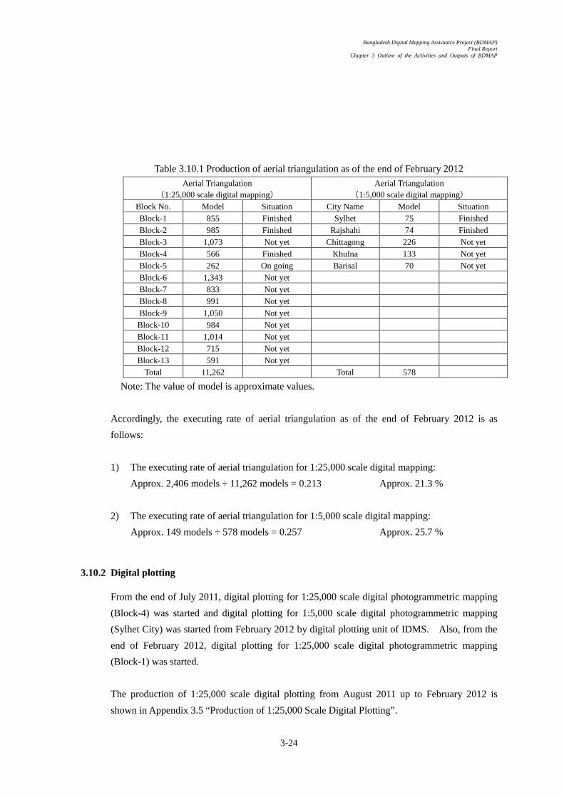
Bangladesh Digital Mapping Assistance Project (BDMAP) Final Report
Chapter 3 Outline of the Activities and Outputs of BDMAP
3-24
Table 3.10.1 Production of aerial triangulation as of the end of February 2012
Aerial Triangulation (1:25,000 scale digital mapping)
Aerial Triangulation (1:5,000 scale digital mapping)
Block No. Model Situation City Name Model Situation Block-1 855 Finished Sylhet 75 Finished Block-2 985 Finished Rajshahi 74 Finished Block-3 1,073 Not yet Chittagong 226 Not yet Block-4 566 Finished Khulna 133 Not yet Block-5 262 On going Barisal 70 Not yet Block-6 1,343 Not yet Block-7 833 Not yet Block-8 991 Not yet Block-9 1,050 Not yet Block-10 984 Not yet Block-11 1,014 Not yet Block-12 715 Not yet Block-13 591 Not yet
Total 11,262 Total 578
Note: The value of model is approximate values.
Accordingly, the executing rate of aerial triangulation as of the end of February 2012 is as
follows:
1) The executing rate of aerial triangulation for 1:25,000 scale digital mapping:
Approx. 2,406 models ÷ 11,262 models = 0.213 Approx. 21.3 %
2) The executing rate of aerial triangulation for 1:5,000 scale digital mapping:
Approx. 149 models ÷ 578 models = 0.257 Approx. 25.7 %
3.10.2 Digital plotting
From the end of July 2011, digital plotting for 1:25,000 scale digital photogrammetric mapping
(Block-4) was started and digital plotting for 1:5,000 scale digital photogrammetric mapping
(Sylhet City) was started from February 2012 by digital plotting unit of IDMS. Also, from the
end of February 2012, digital plotting for 1:25,000 scale digital photogrammetric mapping
(Block-1) was started.
The production of 1:25,000 scale digital plotting from August 2011 up to February 2012 is
shown in Appendix 3.5 “Production of 1:25,000 Scale Digital Plotting”.

Bangladesh Digital Mapping Assistance Project (BDMAP) Final Report
Chapter 3 Outline of the Activities and Outputs of BDMAP
3-25
The progress of the implementation of digital plotting as of the end of February 2012 is shown
on Table 3.5 “Production of digital plotting as of the end of February 2012”.
Table 3.10.2 Production of digital plotting as of the end of February 2012
1:25,000 Scale Digital Plotting 1:5,000 Scale Digital Plotting Block No. Area (km2) Situation City Name Area (km2) Situation Block-1 7,298 On going Sylhet 178 Just started. Block-2 10,139 Not yet Rajshahi 185 Not yet Block-3 9,907 Not yet Chittagong 575 Not yet Block-4 5,784 56% finished Khulna 329 Not yet Block-5 1,642 Not yet Barisal 148 Not yet Block-6 14,160 Not yet Block-7 8,519 Not yet Block-8 11,345 Not yet Block-9 11,804 Not yet Block-10 8,669 Not yet Block-11 5,150 Not yet Block-12 6,524 Not yet Block-13 4,352 Not yet
Border area 38,707 Not yet Total 144,000 Total 1,417
Note: 1) The area of Bangladesh territory is approx. 144,000 km2.
2) The value of area (km2) is an approximate value.
Accordingly, the executing rate of digital plotting as of the end of February 2012 is as follows:
1) The executing rate of 1:25,000 scale digital plotting:
Approx. 3,239 km2 ÷ 144,000 km2 = 0.022 Approx. 2.2 %
2) The executing rate of 1:5,000 scale digital plotting:
Approx. 0 km2 ÷ 1,417 km2 = 0.000 Just started.
3.10.3 DEM production
From the end of July 2011, DEM production was started and the progress of the implementation
of DEM production as of the end of February 2012 is shown on Table 10.3 “Production of DEM
as of the end of February 2012”.
Table 3.10.3 Production of DEM as of the end of February 2012
1:25,000 Scale DTM Production 1:5,000 Scale DTM Production Block No. Area (km2) Situation City Name Area (km2) Situation Block-1 7,298 Not yet Sylhet 178 Not yet Block-2 10,139 Not yet Rajshahi 185 Not yet

Bangladesh Digital Mapping Assistance Project (BDMAP) Final Report
Chapter 3 Outline of the Activities and Outputs of BDMAP
3-26
Block-3 9,907 Not yet Chittagong 575 Not yet Block-4 5,784 30% finished Khulna 329 Not yet Block-5 1,642 Not yet Barisal 148 Not yet Block-6 14,160 Not yet Block-7 8,519 Not yet Block-8 11,345 Not yet Block-9 11,804 Not yet Block-10 8,669 Not yet Block-11 5,150 Not yet Block-12 6,524 Not yet Block-13 4,352 Not yet
Border area 38,707 Not yet Total 144,000 Total 1,417
Note: 1) The area of Bangladesh territory is approx. 144,000 km2.
2) The value of area (km2) is an approximate value.
Accordingly, the executing rate of DEM production as of the end of February 2012 is as follows:
1) The executing rate of 1:25,000 scale DEM production:
Approx. 1,750 km2 ÷ 144,000 km2 = 0.012 Approx. 1.2 %
2) The executing rate of 1:5,000 scale DEM production:
Approx. 0 km2 ÷ 1,417 km2 = 0.000 Not yet started.
3.10.4 Orthophoto production
From the end of July 2011, orthophoto production was started and the progress of the
implementation of orthophoto production as of the end of February 2012 is shown on Table
3.10.4 “Production of orthophoto as of end of February 2012”.
Table 3.10.4 Production of orthophoto as of the end of February 2012 1:25,000 Scale Orthophoto Production 1:5,000 Scale Orthophoto Production
Block No. Area (km2) Situation City Name Area (km2) Situation Block-1 7,298 On going Sylhet 178 Not yet Block-2 10,139 Not yet Rajshahi 185 Not yet Block-3 9,907 Not yet Chittagong 575 Not yet Block-4 5,784 Finished Khulna 329 Not yet Block-5 1,642 Not yet Barisal 148 Not yet Block-6 14,160 Not yet Block-7 8,519 Not yet Block-8 11,345 Not yet Block-9 11,804 Not yet Block-10 8,669 Not yet Block-11 5,150 Not yet Block-12 6,524 Not yet Block-13 4,352 Not yet
Border area 38,707 Not yet Total 144,000 Total 1,417

Bangladesh Digital Mapping Assistance Project (BDMAP) Final Report
Chapter 3 Outline of the Activities and Outputs of BDMAP
3-27
Note: 1) The area of Bangladesh territory is approx. 144,000 km2.
2) The value of area (km2) is an approximate value.
Accordingly, the executing rate of orthophoto production is as follow:
1) The executing rate of 1:25,000 scale orthophoto production:
Approx. 5,784 km2 ÷ 144,000 km2 = 0.040 Approx. 4.0 %
2) The executing rate of 1:5,000 scale orthophoto production:
Approx. 0 km2 ÷ 1,417 km2 = 0.000 Not yet started.
3.10.5 GIS basic data production
The work of GIS section was started from January 2012. The polygon data for water area such
as river, lake, pond, vegetation and so on were created and the suitable code number according
to the specification of GIS database was applied to the digital plotting data based on the field
identification and so on.
The GIS basic data prepared by GIS section was delivered to cartographic section for the digital
compilation that is the last step of digital topographic map production.
The progress of the implementation of GIS basic data creation as of the end of February 2012 is
shown on Table 3.10.5 “Production of GIS basic data as of the end of February 2012”.
Table 3.10.5 Production of GIS basic data as of the end of February 2012 1:25,000 Scale GIS Basic Data Production 1:5,000 Scale GIS Basic Data Production
Block No. Area (km2) Situation City Name Area (km2) Situation Block-1 7,298 Not yet Sylhet 178 Not yet Block-2 10,139 Not yet Rajshahi 185 Not yet Block-3 9,907 Not yet Chittagong 575 Not Yet Block-4 5,784 6% finished Khulna 329 Not yet Block-5 1,642 Not yet Barisal 148 Not yet Block-6 14,160 Not yet Block-7 8,519 Not yet Block-8 11,345 Not yet Block-9 11,804 Not yet Block-10 8,669 Not yet Block-11 5,150 Not yet Block-12 6,524 Not yet Block-13 4,352 Not yet
Border area 38,707 Not yet Total 144,000 Total 1,417
Note: 1) The area of Bangladesh territory is approx. 144,000 km2.
2) The value of area (km2) is an approximate value.

Bangladesh Digital Mapping Assistance Project (BDMAP) Final Report
Chapter 3 Outline of the Activities and Outputs of BDMAP
3-28
Accordingly, the executing rate of GIS basic data production is as follow:
1) The executing rate of 1:25,000 scale GIS basic data production:
Approx. 375 km2 ÷ 144,000 km2 = 0.0026 Approx. 0.26 %
2) The executing rate of 1:5,000 scale GIS basic data production:
Approx. 0 km2 ÷ 1,417 km2 = 0.000 Not yet started.
3.10.6 Digital compilation (Production of digital topographic maps)
Digital topographic map is the outputs of cartography section in IDMS. The first sheet of
1:25,000 scale digital topographic maps in Block-4 was completed by the end of February 2012.
The progress of the implementation of digital compilation (Production of digital topographic
map) as of the end of February 2012 is shown on Table 3.10.6 “Production of digital compilation
as of the end of February 2012 (Production of digital topographic map)”.
Table 3.10.6 Production of digital compilation as of the end of February 2012
(Production of digital topographic map) 1:25,000 Scale Digital Topographic
Map Production 1:5,000 Scale Digital Topographic
Map Production Block No. Area (km2) Situation City Name Area (km2). Situation Block-1 7,298 Not yet Sylhet 178 Not yet Block-2 10,139 Not yet Rajshahi 185 Not yet Block-3 9,907 Not yet Chittagong 575 Not yet Block-4 5,784 3% finished Khulna 329 Not yet Block-5 1,642 Not yet Barisal 148 Not yet Block-6 14,160 Not yet Block-7 8,519 Not yet Block-8 11,345 Not yet Block-9 11,804 Not yet Block-10 8,669 Not yet Block-11 5,150 Not yet Block-12 6,524 Not yet Block-13 4,352 Not yet
Border area 38,707 Not yet Total 144,000 Total 1,417
Note: 1) The area of Bangladesh territory is approx. 144,000 km2.
2) The value of area (km2) is an approximate value.
Accordingly, the executing rate of digital compilation (Production of digital topographic maps)
is as follow:
1) Executing rate of 1:25,000 scale digital compilation (Production of digital topographic
map):
Bangladesh Digital Mapping Assistance Project (BDMAP) Final Report
Chapter 3 Outline of the Activities and Outputs of BDMAP
3-29
Approx. 175 km2 ÷ 144,000 km2 = 0.0012 Approx. 0.12 %
2) Executing rate of 1:5,000 scale digital compilation (Production of digital topographic map):
Approx. 0 km2 ÷ 1,417 km2 = 0.000 Not yet started.
The sheet index of 1:25,000 scale and 1:5,000 scale digital topographic maps are shown in
Appendix 3.6 “Index to Sheet of Bangladesh (1:25,000)”, Appendix 3.7 “Index to Sheets of
Sylhet (Scale 1:5,000), Appendix 3.8 “Index to Sheets of Rajshahi (Scale 1:5,000)”, Appendix
3.9 “Index to Sheets of Khulna (Scale 1:5,000)”, Appendix 3.10 “Index to Sheets of Barisal
(Scale 1:5,000)” and Appendix 3.11 “Index to Sheets of Chittagong (Scale 1:5,000)”.
The first 1:25,000 scale digital topographic map prepared by IDMS is shown in Appendix 3.12
“1:25,000 scale digital topographic map prepared by IDMS (Reduced version)”.
3.10.7 Procurement of satellite image data and training by the contractor
Based on the contract for the procurement of satellite image data between SOB and the
contractor, factory training for the digital plotting using satellite image data was executed from
the beginning of February 2012 in Bangkok City by the contractor.
The actual work of data acquisition for 1:25,000 scale digital topographic map using satellite
image data at the border area will be started from around April 2012 after completion of the
delivery of satellite image data to SOB from the contractor.


Bangladesh Digital Mapping Assistance Project (BDMAP) Final Report
Chapter 4 Implementation Schedule of BDMAP
4-1
Chapter 4 Implementation Schedule of BDMAP

Bangladesh Digital Mapping Assistance Project (BDMAP) Final Report
Chapter 4 Implementation Schedule of BDMAP
4-2
Chapter 4 Implementation Schedule of BDMAP
As described in Chapter 1 “Outline of the Project”, the purpose of BDMAP is to execute the technical
training to the staff of SOB, and also to support IDMS from technical, planning and management
aspects. Therefore, the activities of BDMAP depend on the capability of the staff of SOB and the
actual schedule of IDMS.
The schedule and contents of activities of BDMAP were drastically changed from the original plan of
BDMAP due to the changes of important assumptions occurred in the 1st year and 2nd year of BDMAP.
4.1 Original plan of BDMAP
The basic concept of the original plan of BDMAP before starting BDMAP (1st year) was as
follows:
1) First year of BDMAP
Outline of the activities of BDMAP
a) Preparation of the implementation plan of IDMS
b) Technical training of digital photogrammetric mapping to the staff of SOB
(Lecture and practical training)
Outline of the activities of IDMS
a) Aerial photography
b) Procurement of photogrammetric equipment and software
c) Ground control point survey (Northern part of Bangladesh)
2) Second year of BDMAP
Outline of the activities of BDMAP
a) On the Job Training
b) Trouble shooting
c) Quality control
d) Project planning and management support
Outline of the activities of IDMS
a) 1:25,000 and 1:5,000 scale digital mapping
- Aerial triangulation
- Digital plotting
- DEM and orthophoto production
- GIS basic data production

Bangladesh Digital Mapping Assistance Project (BDMAP) Final Report
Chapter 4 Implementation Schedule of BDMAP
4-3
- Digital compilation (Preparation of digital topographic map)
b) Ground control point survey (Central part of Bangladesh)
c) Field identification for digital plotting completion area
d) Aerial photography, in case not completed in the first year
3) Third year of BDMAP
Outline of the activities of BDMAP
a) On the Job Training
b) Trouble shooting
c) Quality control
d) Project planning and management support
Outline of the activities of IDMS
a) 1:25,000 and 1:5,000 scale digital mapping
- Aerial triangulation
- Digital plotting
- DEM and orthophoto production
- GIS basic data production
- Digital compilation (Preparation of digital topographic map)
b) Ground control point survey (Southern part of Bangladesh)
c) Field identification for digital plotting completion area
According to the original schedule of BDMAP, the technical training to the staff of SOB was
planned to be executed in a short period of time, approximately from the beginning of December
2009 up to the end of March 2010, and in a concentrated manner (1 computer per 1 person).
During this period, it was planned that the basic technique of digital mapping is transferred to
the staff of SOB.
From the 2nd year of BDMAP, through the implementation of the actual work of 1:25,000 and
1:5,000 scale digital photogrammetric mapping of IDMS, necessary technique and knowledge
for the implementation of IDMS, such as a capability of trouble shooting, quality control, project
planning and management and so on, was planned to be transferred to the staff of SOB to be able
to execute IDMS smoothly.
4.2 Modification of the implementation schedule and activities of BDMAP
Due to the change of the important assumptions of BDMAP at the beginning of the 1st year of
BDMAP, it was impossible to execute the activities of BDMAP according to the original plan
and schedule of BDMAP.

Bangladesh Digital Mapping Assistance Project (BDMAP) Final Report
Chapter 4 Implementation Schedule of BDMAP
4-4
Through the discussion with JICA Bangladesh Office, SOB and BDMAP, BDMAP decided to
modify the implementation schedule and contents of the activities of BDMAP to minimize the
delay of the schedule of IDMS caused by the change of the important assumptions of BDMAP.
Finally, the implementation schedule and contents of the activities of BDMAP were drastically
changed from the original plan as mentioned on Table 4.2.1 “Alteration of the implementation
schedule of the activities of BDMAP”.
4.3 Original and actual schedule of BDMAP and IDMS
The original and actual schedule of main items of BDMAP and IDMS are shown in Figure 4.3.1
“Original and actual schedule of BDMAP and IDMS.

1st Year 2nd Year 3rd Year 1st Year 2nd Year 3rd Year
A Contents of Activities
1 Preparation of Inception Report ○ ○ No change
2 Counterpart training in Japan ○ ○ ○ ○ ○ ○ No change
3 Explanation meeting of Inception Report ○ ○ No change
4 Confirmation of procurement of equipment and aerial photography ○ ○ ○ ○ Due to the delay of aerial photography and procurement of photogrammetric equipment and software
5 Preparation of the process and products of digital mapping ○ ○ ○ Due to the delay of checking of translation from English to Bengali by SOB
6-1 Preparation of operation manual of aerial triangulation ○ ○ ○ ○ Due to the delay of the procurement of software, final version of operation manual was prepared in the 3rd year of BDMAP.
6-2 Technical transfer of aerial triangulation ○ ○ ○ ○ Technical training was executed using the equipment and software prepared by BDMAP due to the delay of procurement
6-3 Quality and schedule control of aerial triangulation ○ ○ The actual work of IDMS started from the 3rd year of BDMAP
7-1 Preparation of operation manual of orthophoto production ○ ○ ○ Due to the difference of software, provisional version of operation manuals were prepared.
7-2 Technical transfer of orthophoto production ○ ○ ○ Technical training was started from the 2nd year using the equipment and software prepared by BDMAP
7-3 Quality and schedule control of orthophoto production ○ ○ Actual work of IDMS was started from the 3rd year of BDMAP
8-1 Preparation of operation manual of DEM production ○ ○ ○ Due to the delay of the procurement of software, final version of operation manual was prepared in the 3rd year of BDMAP.
8-2 Technical transfer of DEM production ○ ○ ○ Technical training was executed using the software prepared by BDMAP in the 2nd year of BDMAP.
8-3 Quality and schedule control of DEM production ○ ○ Actual work of IDMS was started from the 3rd year of BDMAP.
9-1 Preparation of operation manual of digital plotting ○ ○ ○ ○ Due to the difference of software, final version of operation manual was prepared in the 3rd year of BDMAP.
9-2 Technical transfer of digital plotting ○ ○ ○ ○ Technical training was executed in the 1st and 2nd year using the software prepared by BDMAP.
9-3 Quality and schedule control of digital plotting ○ ○ Actual work of IDMS was started from the 3rd year of BDMAP.
10-1 Preparation of operation manual of digital compilation ○ ○ ○ Provisional version was prepared in the 2nd year and final version was prepared in the 3rd year of BDMAP.
10-2 Technical transfer of digital compilation ○ ○ ○ ○ ○ Technical training was started from the 1st year of BDMAP considering the capability of the staff of SOB.
10-3 Quality and schedule control of digital compilation ○ ○ Actual work of IDMS was started from the 3rd year of BDMAP.
11-1 Preparation of operation manual of GIS basic data production ○ ○ ○ Provisional version was prepared in the 2nd year and final version was prepared in the 3rd year of BDMAP.
11-2 Technical transfer of GIS basic data production ○ ○ ○ ○ No change
11-3 Quality and schedule control of GIS basic data production ○ ○ Actual work of IDMS was started from the 3rd year of BDMAP.
12-1 Preparation of operation manual of map printing ○ Deleted Based on the recommendation by terminal evaluation, this activity was deleted from PDM.
12-2 Technical transfer of map printing ○ Deleted Based on the recommendation by terminal evaluation, this activity was deleted from PDM.
12-3 Preparation of maintenance plan of printing machine ○ Deleted Based on the recommendation by terminal evaluation, this activity was deleted from PDM.
13-1 Lecture of photogrammetry and aerial triangulation ○ ○ No change
14 Preparation of map specifications ○ ○ ○ ○ Draft was prepared in the 1st year and necessary amendment was executed in 2nd and 3rd year of BDMAP.
15 Preparation of map sheet index and map numbers ○ ○ ○ ○ Draft was prepared in the 1st year and necessary amendment was executed in 2nd and 3rd year of BDMAP.
16 Preparation of sample map ○ ○ ○ ○ Draft was prepared in the 1st year and necessary amendment was executed in 2nd and 3rd year of BDMAP.
17 Preparation and discussion of P/O ○ ○ Due to the change of the important assumption, P/O on 2nd and 3rd BDMAP were necessary.
18 Preparation of aerial photography plan ○ ○ No activity on the original plan. Executed on the 1st and 2nd year.
19 Preparation of GCP plan (Northern part) ○ No activity on the original plan. Executed on the 1st year.
20 Preparation of GCP plan (Southern part) ○ No activity on the original plan, Executed on the 2nd year.
21 Assistance for aerial triangulation implementation planning ○ ○ No activity on the original plan. Executed on the 2nd and 3rd year.
22 Assistance for orthophoto production planning ○ ○ No activity on the original plan. Executed on the 2nd and 3rd year.
23 Assistance for DEM production planning ○ ○ No activity on the original plan. Executed on the 2nd and 3rd year.
24 Assistance for digital plotting implementation planning ○ ○ No activity on the original plan. Executed on the 2nd and 3rd year.
25 Assistance for digital compilation implementation planning ○ No activity on the original plan. Executed on the 2nd and 3rd year.
26 Assistance for GIS basic data production planning ○ No activity on the original plan. Executed on the 2nd and 3rd year.
27 Training of pricking (Height point) ○ No activity on the original plan. Executed on the 1st year.
28 Training of eccentric survey (Horizontal position) ○ No activity on the original plan, Executed on the 2nd year.
29 Lecture of project management ○ No activity on the original plan, Executed on the 2nd year.
30 Alteration of PDM ○ Based on the recommendation of the terminal evaluation, PDM was modified.
31 Confirmation of equipment procured by SOB ○ Due to the delay of aerial photography and procurement of equipment and software,
32 Confirmation of the activities of IDMS ○ The activities of IDMS during the period between 2nd and 3rd year is necessary.
33 Project management of IDMS ○ For the smooth implementation of IMDS, this activity were necessary.
34 Finalization of operation manuals ○ Final version was prepared based on the provisional version prepared on 1st and 2nd year.
35 Support for mid-term evaluation team ○ ○ No change
36 Support for terminal evaluation team ○ ○ No change
37 Preparation and explanation of report ○ ○ ○ ○ ○ ○ No change
38 Publicity activities ○ ○ ○ ○ ○ ○ No change
39 Printing and binding of final report ○ ○ No change
B Common activities
Data collection of evaluation ○ ○ ○ ○ ○ ○ No change
Attendance for meeting and submission of monthly report ○ ○ ○ ○ ○ ○ No change
Execution and support for seminar ○ ○ ○ ○ ○ Due to the delay of aerial photography, seminar on the 1st year was decided not to be executed.
C Outputs of the activities
Inception Report ○ ○ No change
Project Progress Report I ○ ○ No change
Technical specification of digital mapping (Draft) ○ ○ ○ Check of the translation from English to Bengali was executed on the 2nd year.
Operation manual of aerial triangulation (Draft) ○ ○ ○ ○ Provisional version was prepared on the 1st and 2nd year and final version was prepared on the 3rd year.
Operation manual of orthophoto production (Draft) ○ ○ ○ Provisional version was prepared on the 1st and 2nd year and final version was prepared on the 3rd year.
Operation manual of DEM production (Draft) ○ ○ ○ Provisional version was prepared on the 1st and 2nd year and final version was prepared on the 3rd year.
Operation manual of digital plotting (Draft) ○ ○ ○ ○ Provisional version was prepared on the 1st and 2nd year and final version was prepared on the 3rd year.
Marginal information (Draft) ○ ○ Prepared on the 1st year and modification was executed on the 2nd and 3rd year if necessary.
Map specification (Draft) ○ ○ Prepared on the 1st year and modification was executed on the 2nd and 3rd year if necessary.
Preparation of 1:25,000 scale sample map ○ ○ ○ Prepared on the 1st and 2nd year.
Sheet index and numbering plan ○ ○ ○ ○ Prepared on the 1st year and modification was executed on the 2nd and 3rd year if necessary.
Technical training plan ○ ○ ○ ○ ○ ○ No change
Plan of operation of the 2nd year of BDMAP ○ Due to the change of the activity plan and schedule, P/O was necessary to be prepared.
Project Progress Report II ○ ○ No change
Operation manual of digital compilation ○ ○ ○ Provisional version was prepared on the 2nd year and final version was prepared on the 3rd year.
Operation manual of GIS basic data production ○ ○ ○ Provisional version was prepared on the 2nd year and final version was prepared on the 3rd year.
Technical training plan ○ ○ No change
Plan of operation of the 3rd year of BDMAP ○ Due to the change of the activity plan and schedule, P/O was necessary to be prepared.
Final report ○ ○ No change
Technical specification of digital mapping (Draft) ○ ○ No change
Operation manual (Final version) ○ ○ No change
Project management and lecture ○ ○ No change
Operation manual of map printing (Draft) ○ Deleted Based on the recommendation of the terminal evaluation, this activity was deleted.
Maintenance plan of printing machine (Draft) ○ Deleted Based on the recommendation of the terminal evaluation, this activity was deleted.
Technical training plan ○ Deleted Based on the recommendation of the terminal evaluation, this activity was deleted.
Note
1 "Red" is the activity not mentiioned on the original plan or PDM.
2 "Blue" is the activity deleted from PDM based on the recommendation of the terminal evaluation.
4-5
Table 4.2.1 Alteration of the implementations schedule of BDMAP
Original Plan Revised PlanNoteActivities


1 2 3 4 5 6 7 8 9 10 11 12 13 14 15 16 17 18 19 20 21 22 23 24 25 26 27 28 29 30 31 32 33
7 8 9 10 11 12 1 2 3 4 5 6 7 8 9 10 11 12 1 2 3 4 5 6 7 8 9 10 11 12 1 2 3Items
Plan
Actual
Plan
Actual
Plan
Actual
Plan
Actual
Plan
Actual
Plan
Actual
Plan
Actual
Plan
Actual
Plan
Actual
Plan
Actual
Plan
Actual
Plan
Actual
Plan
Actual
Plan
Actual
Plan
Actual
Plan
Actual
Plan
Actual
Plan
Actual
Plan
Actual
Plan
Actual
Plan
Actual
Plan
Actual
Plan
Actual
Accumulative month 1 2 3 4 5 6 7 8 9 10 11 12 13 14 15 16 17 18 19 20 21 22 23 24 25 26 27 28 29 30 31 32 33Year
Month 7 8 9 10 11 12 1 2 3 4 5 6 7 8 9 10 11 12 1 2 3 4 5 6 7 8 9 10 11 12 1 2 3Items Fisical Year in Japan
Bangla Japan Bangla Japan Bangla Japan Bangla Japan
Contract 5.50 0.50 4.00 0.00 7.13 0.00 16.63 0.50
Actual 5.83 0.50 7.10 0.00 8.80 0.00 21.73 0.50
Contract 0.80 0.00 0.00 0.00 0.00 0.00 0.80 0.00
Actual 0.80 0.00 0.00 0.00 0.00 0.00 0.80 0.00
Contract 4.0 4.00 0.00 4.50 0.00 1.50 0.00 10.00 0.00
Actual 4.00 0.00 4.50 0.00 1.50 0.00 10.00 0.00
Contract 1.00 0.00 3.50 0.00 0.83 0.00 5.33 0.00
Actual 1.60 0.00 3.50 0.00 0.83 0.00 5.93 0.00
Contract 3.50 0.00 6.00 0.00 7.06 0.00 16.56 0.00
Actual 4.06 0.00 6.00 0.00 7.06 0.00 17.12 0.00
Contract 3.50 0.00 6.50 0.00 3.83 0.00 13.83 0.00
Actual 3.50 0.00 6.50 0.00 3.83 0.00 13.83 0.00
Contract 0.50 0.00 1.00 0.00 1.67 0.00 3.17 0.00
Actual 0.50 0.00 1.00 0.00 1.67 0.00 3.17 0.00
Contract 0.00 0.00 0.00 0.00 0.00 0.00 0.00 0.00
Actual 0.00 0.00 0.00 0.00 0.00 0.00 0.00 0.00
Contract 2.00 0.00 2.00 0.00 2.00 0.00 6.00 0.00
Actual 2.13 0.00 2.40 0.00 2.00 0.00 6.53 0.00
Excluding Addministrative Support 18.80 0.50 25.50 0.00 22.02 0.00 66.32 0.50
Including Addministrative Support 20.29 0.50 28.60 0.00 23.69 0.00 72.58 0.50
▲ ▲ △ ▲ △ ▲IC/R Project Progress Report I P/O Project Progress Report II P/O Final Report
Mid-term Evaluation Terminal Evaluation
4-6
Evaluation Mission
Counterpart Training in Japan
Chief/Technical Specification
Digital Compilation
GIS
Aerial Triangulation/Orthophoto &DEM (1)
Aerial Triangulation/Orthophoto &DEM (2)
Addministrative Support
Report
Prining
ここでいう「IDMSプロジェクト」とは、日本国政府による債務削
減無償(DRGA)のカウンターパートファンド見返り資金を原資として、バングラデシュ国政府により実施される「バングラデシュ地図情報整備計画」プロジェクト(IDMSプロジェクト)をさしている。IDMSプロジェクトでは、バングラデシュ測量局(SOB)は、
(1) 全土(約144,000km2)の1/25,000地形図(約975面)作成を実施する。(2) 主要5都市の1/5,000地形図作成(約1,384km2、約228面)を実施する。IDMSプ
Implementation of aerial photography
3rd year
2009
Data processing and delivery ofoutputs of aerial photography
Tender for photogrammetricequipment and software
Orthophoto production
Digital plotting
Tender for satellite image data
Digital Plotting
3rd Year
Training by the contractor
Establishment of photo signals
Aerial triangulation
DEM production
Delivery of satellite image data
1st Year
2nd Year
GIS basic data production
Total1st Year
Figure 4.3.1 Original and actual work schedule of BDMAP and IDMS
2009 2010 2011Note
2012
Rainy Season
Accumulative months
Year
Weather Dry Season Rainy Season Dry SeasonRainy SeasonMonth
Dry Season
Plan and Actual of B
DM
AP
Plan and Actual of ID
MS
Seminar
Preparation of aerial photography
Planning and contract of aerialphotography
Photogrammetry/Aerial TriangulationTheory
Field identification
Ground control point survey
Pricking of ground control points
Digital compilation
Map printing
2011 2012
Data acquisition using satellite imagedata
2nd Year
Upper: Contract
2010
Lower: Actual
Upper: Contract
Lower: ActualLower: Actual Lower: Actual
Upper: Contract Upper: Contract
Fasting Month
Fasting Month
Fasting Month
Northern part
Southern part of Bangladesh
3.50
1.00
3.50
1.00 1.00
0.50
1.00 3.00
4.06
0.40
1.00
2.50
2.50
3.00
3.00
1.00
Northern part of Bangladesh
0.40
1.60
2.00
0.5
0.30
Whole Banglaesh
Activity on the initial stage
Activities on the preparatory stage
Activities on the training stage Activities on the technical training stage
Delivery and setting up of equipment, and factory training and site training by the contractor
Additional technical training
Ammendment of PDM Check of the progress of setting up of photogrammetric equipment
Support for the project planning and management of IDMS Support for quality control, schedule control and trouble shooting
Finalization of operation manuals Seminar
C/P研修の
実施
3.50 2.33 0.27 0.23
0.40 0.40
1.00 3.00
1.00
3.50
3.50
0.50
1.00 2.03 2.40 1.66
1.50 1.46
2.00
3.00
3.00
1.58
0.4
1.00
1.50
3.00
1.00
Northern part of Bangladesh
Norhtern part of Bangladesh
Northern part of Bangladesh
Northern part of Bangladesh
Whole Bangladesh
Whole Bangladesh
Whole Bangladesh
Border area
Southern part of Bangladesh
Southern part of Bangladesh
Northern part of
0.2
Southern part
Whole Bangladesh
2.00 2.00 1.00 4.13
1.50
0.83
2.50
1.67
1.67
0.80 1.46
1.00
1.00
1.50
3.00
1.00
Tender and contracting procedure
Setting up of equipment and site training by the contractor
Whole Bangladesh
Whole Bangladesh
Whole Bangladesh
1.67
2.17
Tender and contracting procedure
Border area
Whole Bangladesh
Activities on the simulation stage
対象地域:再撮影範囲
3.00 1.67 4.13
1.50
2.50 1.67
0.83
1.67 2.17
1.67
1.33
1.00
2.03
1.00
0.76
1.00
1.00
1.00
1.40
1.00
1.00
1.00
1.00 1.36
2.90
2.90


Bangladesh Digital Mapping Assistance Project (BDMAP) Final Report
Chapter 5 Inputs of BDMAP
5-1
Chapter 5 Inputs of BDMAP

Bangladesh Digital Mapping Assistance Project (BDMAP) Final Report
Chapter 5 Inputs of BDMAP
5-2
Chapter 5 Inputs of BDMAP
The inputs of BDMAP (July 2009~March 2012) are as follows:
5.1 Inputs of BDMAP (1st year)
The inputs of the 1st year of BDMAP are as follows:
1) Contract amount: Yen 83,115,900.- (Including consumption tax: Yen 3,957,900.-)
2) Contract period: From 24 July 2009 to 26 March 2010
3) Contract M/M, assignment and name of experts:
Assignment Name of Expert Contract M/M
Chief/Technical specification Mr. Toru Watanabe 5.50 M/M
Photogrammetry/Aerial
triangulation theory Dr. Mitsuru Nasu 0.80 M/M
Aerial triangulation/Orthophoto
& DEM (1) Mr. Takashi Harada 4.00 M/M
Aerial triangulation/Orthophoto
& DEM (2) Mr. Yoshiteru Matsushita 1.00 M/M
Digital plotting Mr. Tsuneo Terada 3.50 M/M
Digital compilation Mr. Yoshiteru Matsushita 3.50 M/M
GIS management Mr. Shigeru Ono 0.50 M/M
Administrative support (1) Ms. Michi Hayashi 1.00 M/M
Administrative support (2) Ms. Kazue Uchiyama 1.00 M/M
Total Including administrative support 20.80 M/M
Excluding administrative support 18.80 M/M
5.2 Inputs of BDMAP (2nd year)
The inputs of the 2nd year of BDMAP are as follows:
1) Contract amount: Yen 95,604,600.- (Including consumption tax: Yen 4,552,600.-)
2) Contract period: From 27 April 2010 to 31 March 2011

Bangladesh Digital Mapping Assistance Project (BDMAP) Final Report
Chapter 5 Inputs of BDMAP
5-3
3) Contract M/M, assignment and name of experts:
Assignment Name of Expert Contract M/M
Chief/Technical specification Mr. Toru Watanabe 4.00 M/M
Aerial triangulation/Orthophoto
& DEM (1) Mr. Takashi Harada 4.50 M/M
Aerial triangulation/Orthophoto
& DEM (2) Mr. Koji Yamazaki 3.50 M/M
Digital plotting Mr. Tsuneo Terada 6.00 M/M
Digital compilation Mr. Yoshiteru Matsushita 6.50 M/M
GIS management Mr. Shigeru Ono 1.00 M/M
Administrative support (1) Ms. Michi Hayashi 2.00 M/M
Total Including administrative support 27.50 M/M
Excluding administrative support 25.50 M/M
5.3 Inputs of BDMAP (3rd year)
The inputs of the 3rd year of BDMAP are as follows:
1) Contract amount: Yen 78,171,450.- (Including consumption tax: Yen 3,722,450.-)
2) Contract period: From 26 May 2011 to 25 March 2012
3) Contract M/M, assignment and name of experts:
Assignment Name of Expert Contract M/M
Chief/Technical specification Mr. Toru Watanabe 7.13 M/M
Aerial triangulation/Orthophoto
& DEM (1) Mr. Takashi Harada 1.50 M/M
Aerial triangulation/Orthophoto
& DEM (2) Mr. Koji Yamazaki 0.83 M/M
Digital plotting Mr. Tsuneo Terada 7.06 M/M
Digital compilation Mr. Yoshiteru Matsushita 3.83 M/M
GIS management Mr. Shigeru Ono 1.67 M/M
Administrative support (1) Ms. Michi Hayashi 2.00 M/M
Total Including administrative support 24.02 M/M
Excluding administrative support 22.02 M/M

Bangladesh Digital Mapping Assistance Project (BDMAP) Final Report
Chapter 5 Inputs of BDMAP
5-4
5.4 Inputs of whole BDMAP (1st year~3rd year)
The inputs of whole BDMAP (1st year~3rd year) are as follows:
1) Contract amount: Yen 256,891,950.-
(Including consumption tax: 12,232,950.-)
2) Contract period: From 24 July 2009 to 25 March 2012
3) Contract M/M, assignment and name of expert:
Assignment Name of Expert Contracted M/M
Chief/Technical specification Mr. Toru Watanabe 16.63 M/M
Photogrammetry/Aerial
triangulation theory Dr. Mitsuru Nasu 0.80 M/M
Aerial triangulation/Orthophoto
& DEM (1) Mr. Takashi Harada 10.00 M/M
Aerial triangulation/Orthophoto
& DEM (2) Mr. Koji Yamazaki 4.33 M/M
Digital plotting Mr. Tsuneo Terada 16.56 M/M
Digital compilation Mr. Yoshiteru Matsushita 14.83 M/M
GIS management Mr. Shigeru Ono 3.17 M/M
Administrative support (1) Ms. Michi Hayashi 5.00 M/M
Administrative support (2) Ms. Kazue Uchiyama 1.00 M/M
Total Including administrative support 72.32 M/M
Excluding administrative support 66.32 M/M
Bangladesh Digital Mapping Assistance Project (BDMAP) Final Report
Chapter 6 Actual Assignment Period of the Experts of BDMAP
6-1
Chapter 6 Actual Assignment Periods of the Experts of BDMAP

Bangladesh Digital Mapping Assistance Project (BDMAP) Final Report
Chapter 6 Actual Assignment Period of the Experts of BDMAP
6-2
Chapter 6 Actual Assignment Periods of the Experts of BDMAP
The actual assignment periods of the experts of BDMAP are as follows:
6.1 Actual assignment periods of the experts of BDMAP (1st year)
The actual assignment periods of the experts on the 1st year of BDMAP are as follows:
Assignment Name of Expert Assignment Period Days
Chief/Technical Mr. Toru Watanabe 05/09/2009 – 18/12/2009 105 days
Specification 10/01/2010 – 20/03/2010 70 days
Photogrammetry/Aerial Dr. Mitsuru Nasu 17/12/2009 – 28/12/2009 12 days
triangulation theory 23/02/2010 – 06/03/2010 12 days
Aerial triangulation/Ortho- Mr. Takashi Harada 30/08/2009 – 28/09/2009 30 days
photo & DEM (1) 21/12/2009 – 20/03/2010 90 days
Aerial triangulation/Ortho- Mr. Yoshiteru Matsushita 01/02/2010 – 20/03/2010 48 days
photo & DEM (2)
Digital plotting Mr. Tsuneo Terada 19/11/2009 – 20/03/2010 122 days
Digital compilation Mr. Yoshiteru Matsushita 05/09/2009 – 18/12/2009 105 days
GIS management Mr. Shigeru Ono 28/09/2009 – 12/10/2009 15 days
Administrative support (1) Ms. Michi Hayashi 30/08/2009 – 29/10/2009 61 days
10/12/2009 – 19/01/2010 41 days
Administrative support (2) Ms. Kazue Uchiyama 26/02/2010 – 20/03/2010 23 days
Total Including administrative support 734 days
Excluding administrative support 609 days
6.2 Actual assignment periods of the experts of BDMAP (2nd year)
The actual assignment periods of the experts on the 2nd year of BDMAP are as follows:
Assignment Name of Expert Assignment Period Days
Chief/Technical Mr. Toru Watanabe 10/05/2010 – 08/06/2010 30 days
Specification 04/07/2010 – 02/09/2010 61 days
15/09/2010 – 05/12/2010 72 days
30/01/2011 – 20/03/2011 50 days
Aerial triangulation/Ortho- Mr. Takashi Harada 20/07/2010 – 02/09/2010 45 days
photo & DEM (1) 25/11/2010 – 07/01/2011 44 days
03/02/2011 – 20/03/2011 46 days

Bangladesh Digital Mapping Assistance Project (BDMAP) Final Report
Chapter 6 Actual Assignment Period of the Experts of BDMAP
6-3
Aerial triangulation/Ortho- Mr. Koji Yamazaki 10/05/2010 – 08/07/2010 60 days
photo & DEM (2) 24/11/2010 – 07/01/2011 45 days
Digital plotting Mr. Tsuneo Terada 01/06/2010 – 29/08/2010 90 days
10/10/2010 – 29/08/2010 90 days
Digital compilation Mr. Yoshiteru Matsushita 10/05/2010 – 07/08/2010 90 days
27/09/2010 – 08/10/2010 12 days
24/10/2010 – 16/11/2010 24 days
26/11/2010 – 07/01/2011 43 days
23/02/2011 – 20/03/2011 30 days
GIS management Mr. Shigeru Ono 25/09/2010 – 24/10/2010 30 days
Administrative support (1) Ms. Michi Hayashi 10/05/2010 – 08/06/2010 30 days
07/02/2011 – 20/03/2011 42 days
Total Including administrative support 934 days
Excluding administrative support 852 days
Note: The number of trips of Mr. Matsushita increased due to the reason of passing away of his
father during the period of the 2nd year of BDMAP.
6.3 Actual assignment periods of the experts of BDMAP (3rd year)
The actual assignment periods of the experts on the 3rd year of BDMAP are as follows:
Assignment Name of Expert Assignment Period Days
Chief/Technical Mr. Toru Watanabe 30/05/2011 – 27/08/2011 90 days
Specification 09/09/2011 – 28/10/2011 50 days
18/11/2011 – 20/03/2012 124 days
Aerial triangulation/Ortho- Mr. Takashi Harada 08/07/2011 – 21/08/2011 45 days
photo & DEM (1)
Aerial triangulation/Ortho- Mr. Koji Yamazaki 06/12/2011 – 30/12/2011 25 days
photo & DEM (2)
Digital plotting Mr. Tsuneo Terada 06/06/2011 – 19/08/2011 75 days
09/09/2011 – 28/10/2011 50 days
25/12/2011 – 20/03/2012 87 days
Digital compilation Mr. Yoshiteru Matsushita 09/09/2011 – 28/10/2011 50 days
09/12/2011 – 11/04/2012 65 days
GIS management Mr. Shigeru Ono 09/09/2011 – 28/10/2011 50 days
Administrative support (1) Ms. Michi Hayashi 06/06/2011 – 05/07/2011 30 days
20/02/2012 – 20/03/2012 30 days
Total Including administrative support 771 days

Bangladesh Digital Mapping Assistance Project (BDMAP) Final Report
Chapter 6 Actual Assignment Period of the Experts of BDMAP
6-4
Excluding administrative support 711 days
6.4 Actual assignment periods of the experts of whole BDMAP (1st year~3rd year)
The actual assignment period of the experts of whole BDMAP (1st year~3rd year) are as
follows:
Assignment Name Trips Total Days
Chief/Technical specification Mr. Toru Watanabe 9 times 652 days
Photogrammetry/Aerial triangulation theory Dr. Mitsuru Nasu 2 times 24 days
Aerial triangulation/Orthophoto & DEM (1) Mr. Takashi Harada 6 times 300 days
Aerial triangulation/Orthophoto & DEM (2) Mr. Koji Yamazaki 3 times 130 days
Digital plotting Mr. Tsuneo Terada 6 times 514 days
Digital compilation Mr. Yoshiteru Matsushita 9 times 467 days
GIS management Mr. Shigeru Ono 3 times 95 days
Administrative support (1) Ms. Michi Hayashi 5 times 234 days
Administrative support (2) Ms. Kazue Uchiyama 1 times 23 days
Total Including administrative support 2439 days
Excluding administrative support 2182 days

Bangladesh Digital Mapping Assistance Project (BDMAP) Final Report
Chapter 7 Counterparts Training in Japan
7-1
Chapter 7 Counterpart Training in Japan

Bangladesh Digital Mapping Assistance Project (BDMAP) Final Report
Chapter 7 Counterparts Training in Japan
7-2
Chapter 7 Counterpart Training in Japan
The counterparts training in Japan was executed as follows:
7.1 Participants and period of counterpart training in Japan
The participants and period of counterparts training in Japan are as follows:
1) Counterparts training in Japan of BDMAP (1st year)
Participant: Col. Mahumudun Nabi, psc
Director of Defense Survey Directorate
Mr. Ganesh Chandra Roy
Assistant Superintendent of Survey, Geodetic Detachment
Period: From 24 January 2010 to 21 February 2010 (29 days)
2) Counterparts training in Japan of BDMAP (2nd year)
Participant: Lt. Col. Shameem Ahsan Jagul, psc
Director of Development Survey Directorate
Mr. Md. Ibrahim Khalil
Sub. Assistant Superintendent, No.2 Digital Cartographic Office
Period: From 6 November 2010 to 5 December 2010 (30 days)
3) Counterparts training in Japan of BDMAP (3rd year)
Participant: Mr. Md. Mustafijur Rahman
Assistant Director (Survey)
Ms. Jahanara Sultana
Sub. Assistant Superintendent
Period: From 14 January 2012 to 12 February 2012 (30 days)
7.2 Purpose and contents of counterpart training in Japan
The purpose and contents of counterpart training in Japan are as follows:
1) Purpose of counterpart training in Japan
- To understand the role and contents of work of government survey and mapping

Bangladesh Digital Mapping Assistance Project (BDMAP) Final Report
Chapter 7 Counterparts Training in Japan
7-3
organization in Japan, and also the present situation of topographic map data release
method in Japan.
Based on the above understanding, future organization and scope of work of SOB and so
on will be considered.
- To understand the planning and management method of topographic mapping by
photogrammetric method.
2) Contents of training in Japan
- Present situation of topographic maps and data in Japan and future plan
- Present situation of data release of topographic maps and digital data in Japan
- Geoid model in Japan
- Transformation from Bessel to World Geodetic System in Japan
- Role of GSI Japan and business content
- Utilization of satellite images for topographic mapping
- Modern technology of survey and mapping
- Planning and management of topographic mapping
- Countermeasures for computer virus and utilization of computer server for office work
- Explanation of server system
- Survey law in Japan
- Utilization of GIS in Japan
- Quality control method for topographic mapping in Japan
- Permanent GPS station in Japan
- Clearing house and Web system for digital topographic data in Japan
- Other topics based on the request from the participants
7.3 Visiting Places
The main visiting places during the counterpart training in Japan are as follows:
- Japan International Cooperation Agency, Head Office in Tokyo
- Geospatial Information Authority of Japan (former Geographical Survey Institute of Japan)
- Geospatial Information Authority of Japan, Kinki Regional Survey Department
- College of Land, Infrastructure, Transport and Tourism
- Japan Map Center
- Japan Association of Surveyor
- Japan Aerospace Exploration Agency (JAXA)
- Remote Sensing Technology Center of Japan (RESTEC)

Bangladesh Digital Mapping Assistance Project (BDMAP) Final Report
Chapter 7 Counterparts Training in Japan
7-4
- Tokyo SPOT Image K.K.
- Asia Air Survey Co., Ltd.
- Aero Asahi Corporation
- Book store, etc.
Bangladesh Digital Mapping Assistance Project (BDMAP) Final Report
Chapter 8 Equipment Used for BDMAP and IDMS
8-1
Chapter 8 Equipment Used for BDMAP and IDMS

Bangladesh Digital Mapping Assistance Project (BDMAP) Final Report
Chapter 8 Equipment Used for BDMAP and IDMS
8-2
Chapter 8 Equipment Used for BDMAP and IDMS
The equipment and software procured and prepared by BDMAP and SOB, and the equipment and
software donated to SOB from BDMAP are as bellows:
8.1 Equipment and software procured by BDMAP
The equipment and software procured by BDMAP at the 1st year of BDMAP are listed in Table
8.1.1 “Equipment and software procured by BDMAP”.
Table 8.1.1 Equipment and software procured by BDMAP
Name of Equipment & Software Details of Equipment & Software No. A. Equipment and software procured in Bangladesh 1)Computer DELL Precision T3500, Xeon X5550 2.66 GHz 1 DELL Precision T3500, Xeon W3520 2.66 GHz 4 2) Laser Printer (B/W with Copier) Canon image CLASS, MF6550 1 3) Laser Printer (Color, A3 size) Canon LASER SHOT LBP5970 1 4) Large Format Printer (Plotter) Canon Image PROGRAF iPF710 1 5) UPS 5 6) Back Up Power Supply 1 7) OS Micro-Office 2007 Professional 5 8) Adobe Acrobat Adobe Acrobat Standard 9 5 9) Antivirus software Symantec Norton 360 5 10) Graphic software Photo Shop CS4 Extended 5 11) Graphic software Illustrator CS4 5 12) Network 1 B. Equipment and software procured in Japan 1) Computer CF-52W1AAS 1 2) OS WIN-XP-PRO-SP3/OEM/E 1 3) OS Micro-Office 2007 PRO 1 4) Graphic software Illustrator CS4 1 5) Hard-disc 250 GB, IO-DATA, 1.5 inch 10
8.2 Equipment and software prepared by BDMAP
According to the original plan of BDMAP, technical training to the staff of SOB would be
executed using the equipment and software which would be procured by SOB. It was
estimated that the equipment and software, to be procured by SOB, could be used from the
beginning of December 2009.
However, the tender for the procurement of photogrammetric equipment and software executed
by SOB was decided as a cancel by the Government of Bangladesh in the middle of October
2009. Therefore, it was impossible to execute the technical training to the staff of SOB

Bangladesh Digital Mapping Assistance Project (BDMAP) Final Report
Chapter 8 Equipment Used for BDMAP and IDMS
8-3
according to the original plan of BDMAP.
Facing this issue, through the discussion with JICA Bangladesh Office, SOB and BDMAP,
BDMAP decided to prepare the minimum number of equipment and software, especially digital
mapping system necessary for the technical training of aerial triangulation and digital plotting,
by BDMAP by its own cost (Refer to Appendix 12.4 “Record of Discussion on 8 December
2009”).
At the beginning of the 2nd year of BDMAP, the fresh tender (2nd tender) for the procurement of
photogrammetric equipment and software by SOB was decided as a cancel again by the
Government of Bangladesh. Therefore, it was estimated that the photogrammetric equipment
and software to be procured by SOB was not able to use for the technical training to the staff of
SOB before around the end of February 2011.
Therefore, during the period of the 2nd year of BDMAP, the technical training to the staff of SOB
had to be executed using the digital plotting systems which were already prepared by BDMAP
on the 1st year of BDMAP.
Considering the efficiency of the technical training to the staff of SOB, BDMAP decided to
increase the number of digital plotting systems (Total 12 sets) by BDMAP by its own cost.
The equipment and software prepared by BDMAP for the implementation of technical training
to the staff of SOB in the 1st and 2nd year of BDMAP are listed on Table “Equipment and
software prepared by BDMAP”.
Table 8.2.1 Equipment and software prepared by BDMAP
Name of Equipment & Software Details of Equipment & Software No. 1) Computer Dell Latitude D630 7 2) UPS 7 3) 3D monitor Zalman 12 4) Digital mapping software Zukameijin (English version) 12 5) Mouse 7
8.3 Equipment and software procured by SOB
The equipment and software, necessary for the implementation of IDMS, procured by SOB are
listed on Table 8.3.1 “Equipment and software procured by SOB”. The setting up of the
equipment and software in SOB was started from around the beginning of February 2011 and
completed by the end of May 2011.

Bangladesh Digital Mapping Assistance Project (BDMAP) Final Report
Chapter 8 Equipment Used for BDMAP and IDMS
8-4
Table 8.3.1 Equipment and software procured by SOB
Item of equipment Name of equipment No. 1. Photogrammetric equipment Aerial triangulation software Inpho Match-AT 3 3D plotting software Inpho Summit Evolution with Autodesk
AutoCAD Map 3D 40
Accessory Monitor, glass, 3D mouse 53 DTM computation and orthophoto
generation software Inpho DTM Box and Inpho Ortho Box 10
Computer 53 Furniture 53 2. Digital compilation equipment Cartographic software ESRI ArcGIS, ArcEditor, PLTS 45 Computer 45 Furniture 45 3. GIS equipment GIS software ESRI ArcGIS, ArcEditor, PLTS 16 Computer 16 Furniture 16 4. Server Server 1 4. Other equipment UPS 1 AVR 1 Air conditioner As required numbers

Bangladesh Digital Mapping Assistance Project (BDMAP) Final Report
Chapter 9 Implementation Procedure of BDMAP
9-1
Chapter 9 Implementation Procedure of BDMAP

Bangladesh Digital Mapping Assistance Project (BDMAP) Final Report
Chapter 9 Implementation Procedure of BDMAP
9-2
Chapter 9 Implementation Procedure of BDMAP
The issues, implementation procedure of BDMAP and IDMS, lessons learned and recommendation are
as follows:
9.1 Issues on the implementation of BDMAP and IDMS
Many problems happened during the implementation of BDMAP and IDMS. Especially, the
personal difference of the capability among the staff of SOB, such as an experience of actual
work, technical capabilities, comprehension and so on, was one of the issues for the
implementation of BDMAP and IDMS.
The main issues encountered during the implementation of BDMAP and IDMS excluding the
technical aspects of digital mapping are as follows:
9.1.1 Lack of the experience of actual work of digital photogrammetric mapping of the staff of
SOB
Some of the staff of SOB has an experience of analogue photogrammetric mapping using aerial
photos. However, most of the staff of SOB has no experience of analogue and digital
photogrammetric mapping using aerial photos.
Meanwhile, SOB has several staff who received training in digital photogrammetric mapping
abroad. However, these persons of SOB had no experiences of actual work of digital
photogrammetric mapping after training. The knowledge and capability of these persons of
SOB is just a paper knowledge ability of digital photogrammetric mapping. Therefore, the idea
or plans made by these persons were not suitable or not realistic from the view point of the
implementation of actual works of digital photogrammetric mapping.
This is a typical pattern of the middle class staff of SOB and these persons will contribute little
to the implementation of actual work of digital photogrammetric mapping of IDMS.
Therefore, it is necessary to build up the capability of the middle class staff of SOB through the
experience of actual work of digital photogrammetric mapping.
9.1.2 Lack of the planning capability of the staff of SOB
The purpose of BDMAP is not only to execute the technical transfer of digital photogrammetric
mapping using aerial photo to the staff of SOB, but also to assist the 1:25,000 scale and 1:5,000

Bangladesh Digital Mapping Assistance Project (BDMAP) Final Report
Chapter 9 Implementation Procedure of BDMAP
9-3
scale digital mapping project smoothly by the staff of SOB based on the results of technical
training to the staff of SOB.
However, the actual digital photogrammetric mapping can not be executed only by the technical
knowledge such as aerial triangulation, digital plotting and so on. For the implementation of
the actual work such as IDMS, many works such as estimation of productivity, cost estimation,
preparation of implementation plan, preparation of work schedule, quality control planning,
schedule control planning and so on are essential.
These works have to be executed by the middle class staff of SOB such as in charge of section or
team leader of each section of IDMS. However, most of the middle class staff of SOB has no
experience and capability of the project planning of digital photogrammetric mapping.
Therefore, it was necessary to build up the capability of project planning of the middle class staff
of SOB for the implementation of IDMS.
9.1.3 Lack of the project management capability of the staff of SOB
For the implementation of huge project such as IDMS, not only proper project planning, but also
proper project management is essential for the smooth implementation of the project. In IDMS,
overall management will be executed by the top management of SOB and the management of
the work of each section will be executed by the middle class staff of SOB such as these in
charge of section and so on.
However, the capability of project management of the middle class staff of SOB, such a person
charge of section and team leader, are low due to the lack of knowledge of project management
and an experience of actual work of digital photogrammetric mapping using aerial photos.
Therefore, the middle class staff of SOB can not execute the necessary management of IDMS.
Furthermore, the middle class staff of SOB does not know the basic concept of the project
management as “Plan→Do→Check→Action”.
Generally speaking, many staff of SOB starts the work without plan and schedule, no check of
the outputs of work, no idea of the countermeasures not to repeat the same issues and troubles.
Therefore, the buildup of the capability of project management of the middle class staff of SOB
was essential for the implementation of IDMS.
9.1.4 Lack of the trouble shooting capability of the staff of SOB
The project (actual work of the project) will not be implemented according to the plan due to the

Bangladesh Digital Mapping Assistance Project (BDMAP) Final Report
Chapter 9 Implementation Procedure of BDMAP
9-4
reason of unexpected issues which will be occurred during the implementation of the project.
Therefore, it is necessary to solve the issues one by one during the implementation of the
project.
For the smooth implementation of the project, the capability of trouble shooting and the
capability to grasp the source of issues are essential. However, these capabilities can be
obtained only by the building up experience of actual works, and it is difficult to obtain this
capabilities only by the lecture and training.
Most of the staff of SOB has no experience of actual work of digital photogrammetric mapping
using aerial photos. Therefore, it was necessary to build up the capability of trouble shooting
of the staff of SOB through the engagement of the actual work of digital photogrammetric
mapping of IDMS.
9.1.5 Sense of self-independence of the staff of SOB
One of the big issues of the staff, especially low class staff of SOB is the lack of the sense of
self-independence. The typical attitudes of the low class staff of SOB are as follows.
1) Not to consider by themselves and always, ask for answer to Japanese experts.
2) Not to study by themselves
3) No action, talk only
4) No own opinion
5) Only do the work that is ordered
6) Unpunctuality
7) No check of the outputs of the work
9.2 Implementation procedure of BDMAP
To solve the above mentioned issues, BDMAP executed the activities as mentioned below:
9.2.1 Improvement of the basic capability focusing on the basics of computer operation and
photogrammetric mapping
Considering the work volume of IDMS, SOB had to assign many staff of SOB to IDMS. The
total number of staff necessary for the implementation of IDMS was estimated as approximately
200 persons for indoor works such as aerial triangulation, digital plotting, GIS basic data
production, cartography work and so on.
Bangladesh Digital Mapping Assistance Project (BDMAP) Final Report
Chapter 9 Implementation Procedure of BDMAP
9-5
However, the human resources of SOB for digital photogrammetric mapping were limited.
SOB had to assign the newly recruited staff and old generation staff to IDMS to secure the
required number of people necessary for the implementation of IDMS even though some of the
staff are lacking the experience of actual work and basic knowledge of survey and mapping and
computer operation.
Therefore, BDMAP decided to execute the following basic training of survey and mapping,
especially basic knowledge of photogrammetric mapping, and also computer operation to the
staff of SOB to establish the foundation necessary for digital photogrammetric mapping before
starting the technical training.
1) Lecture of the basics of survey and mapping, especially photogrammetric mapping
2) Lecture of the basics of computer
3) Lecture and training of basic software such as Excel, Office, AutoCAD and ArcMap and so
on
The lecture and training of survey and mapping and computer operation to the staff of SOB was
continued in the 2nd year of BDMAP by SOB.
9.2.2 Weight on the actual work and on-the-job training
It is impossible to teach all aspects of digital photogrammetric mapping, such as technique,
planning, management and trouble shooting aspects, only by the lecture and training.
As described to hereinafter, the theory of digital photogrammetric mapping can not be applied
directly and simply to the actual work of digital photogrammetric mapping without the
consideration of the conditions and circumstances of the project.
Of course, the lecture and training are important as the method to obtain new knowledge and
information. However, real technical capability will be built up only by the engagement in
actual work and accumulation of actual work experience based on the knowledge obtained by
lecture and training.
Therefore, the most important training to the staff of SOB is “On the Job Training” that is to
solve the issues which will occur during the implementation of actual works of digital
photogrammetric mapping.
According to the original plan of BDMAP, on the job training was planned to be executed in the
2nd year and 3rd year of BDMAP as shown on Table 9.2.1 “Original plan and actual
implementation of BDMAP and IDMS”.

Bangladesh Digital Mapping Assistance Project (BDMAP) Final Report
Chapter 9 Implementation Procedure of BDMAP
9-6
Table 9.2.1 Original plan and actual implementation of BDMAP and IDMS
Year Original Plan Actual Implementation
1st year September 2009~
March 2010
BDMAP - Preparation of implementation plan - Lecture and training
IDMS - Procurement of equipment - Aerial photography - Ground control point survey
BDMAP - Preparation of implementation plan - Lecture and training
IDMS - Pricking of BMs
2nd year May 2010~
March 2011
BDMAP - On the Job training - Technical transfer of project planning and management - Technical transfer of quality control - Technical transfer of schedule Control - Trouble shooting
IDMS - Ground control point survey - Field identification - Office works of digital mapping
BDMAP - Revision of implementation plan - Lecture and training
IDMS - Ground control point survey - Aerial photography - Procurement of equipment
3rd year May 2011~
March 2012
BDMAP - On the Job Training - Technical transfer of project planning and management - Technical transfer of quality control - Technical transfer of schedule control - Trouble shooting
IDMS - Field identification - Office works of digital mapping
BDMAP - On the Job Training - Technical transfer of project planning and management - Technical transfer of quality control - Technical transfer of schedule
control - Trouble shooting IDMS - Re-flight of aerial photography - Ground control point survey - Field identification - Office works of digital mapping
However, due to the delay of the procurement of photogrammetric equipment and software, on
the job training for digital plotting was executed only for the period of approximately seven (7)
months, and on the job training for GIS basic data production and digital cartography was
executed only for the period of approximately two (2) months in the 3rd yea of BDMAP.
9.2.3 Buildup of the project management capability
Even though the staff of SOB obtains the capability of digital photogrammetric mapping
technique, the staff of SOB can not execute the digital photogrammetric mapping project such as
IDMS.
For the implementation of the project, the knowledge and experience such as project planning,

Bangladesh Digital Mapping Assistance Project (BDMAP) Final Report
Chapter 9 Implementation Procedure of BDMAP
9-7
project management, quality control, schedule control, project team making, budget
management, labor management and so on are essential.
Without such knowledge and experience, it is impossible to implement the huge project such as
IDMS. Therefore, Technical transfer of the project planning and management to the staff of
SOB was decided to be executed as one of the activities of BDMAP even though not described
in PDM of BDMAP.
9.2.4 Planning and implementation of IDMS by the staff of SOB by themselves
After completion of BDMAP, SOB has to manage IDMS by the staff of SOB themselves. For
this, the middle class staff of SOB such as in charge of a section and team leaders of each section
has to execute all necessary planning, management and trouble shooting by themselves.
On the 3rd year of BDMAP, after starting the actual work of IDMS, project planning and
management such as preparation of implementation plan, work schedule, personnel distribution
for the work, quality control, schedule control and so on were executed by the staff of SOB as
much as possible under the instruction of BDMAP to build up the capability of project planning
and management of the staff of SOB.
9.2.5 To solve the issues and troubles as much as possible at the beginning stage of IDMS
Humans learn a lot of lessons from failures or mistakes, but less from success. The reason is
that the cause and effect relationship in the case of failures or mistakes is generally clear, but in
the case of success, it is difficult to define the cause and effect relationship clearly.
Generally, at the beginning stage of the project, many issues and troubles may occur during the
implementation of the actual works. As mentioned above, it is possible to learn a lot of lessons
from the issues and troubles. However, it is necessary to avoid the fatal issues or troubles that
will be a cause of the heavy damage to the work schedule of the project.
Therefore, it is necessary to set up the first working area as a pilot area to solve the issues
troubles during the implementation of the actual works as much as possible, and to establish the
suitable work procedures. Through the implementation of actual work of the first working area,
it is possible to build up the capability of project planning, management and trouble shooting of
the staff of the project. It is considered that the subsequent working area can be implemented
more smoothly than the first working area. For this purpose, in IDMS, Block-4 was decided as
the first working area (Pilot area).
Accordingly, Block-4 is the position of the integration of the training of digital photogrammetric

Bangladesh Digital Mapping Assistance Project (BDMAP) Final Report
Chapter 9 Implementation Procedure of BDMAP
9-8
mapping that was executed in the 1st year and 2nd year of BDMAP, and the real actual work of
digital photogrammetric mapping of IDMS will be started from the second working area
(Block-1).
9.2.6 Basic concept of “Plan→Do→Check→Action”
It is impossible to avoid the issues and troubles during the implementation of the project.
Therefore, the project will be implemented by solving issues and troubles one by one. For the
smooth implementation of the project, the staff of SOB has to understand clearly the basic
concept of project management that is “Plan→Do→Check→Action”.
The working procedure of the staff of SOB before starting IDMS is only “Plan→Do” in an
extreme case. Many staff of SOB has no idea that the outputs of work, including intermediate
outputs, must be checked appropriately and correctly. Furthermore, many staff of SOB has no
idea of “Check→Action” that is a countermeasure to prevent the same issues or troubles
occurring again.
IDMS is the first digital photogrammetric mapping project for SOB. Therefore, it is expected
that many issues or troubles will occur especially at the beginning stage of the actual work of
IDMS.
The important point is to develop and establish the production procedure of digital
photogrammetric mapping in SOB by solving the issues and troubles one by one not to occur the
same issues and troubles at the beginning stage of actual work of IDMS based on the project
management concept as “Plan→Do→Check→Action”.
9.2.7 Communication among the sections of IDMS
The main issue of the failure of the project is the lack of the communication among the project
team.
The digital photogrammetric mapping is the accumulation of each steps of digital
photogrammetric work such as aerial triangulation, digital plotting, field identification and so on.
Therefore, close communication among sections and teams is essential for the smooth
implementation of the project.
However, before starting the actual work of IDMS, the communication among sections and
teams are practically nonexistent.
Therefore, the suggestion and instruction for the close communication among digital plotting

Bangladesh Digital Mapping Assistance Project (BDMAP) Final Report
Chapter 9 Implementation Procedure of BDMAP
9-9
section, GIS section and cartography section for the determination of role of each section, data
delivery, data correction and so on was executed by BDMAP.
9.3 Lessons learned through the implementation of BDMAP and IDMS
The lessons learned through the implementation of BDMAP are as follows:
9.3.1 For the implementation of the project, not only the technical capability, but also planning
and management capability are essential
The digital photogrammetric mapping project can not be implemented only by the training of the
technical aspects such as aerial triangulation, digital plotting and so on.
Of course, the capability of digital photogrammetric mapping such as aerial triangulation, digital
plotting and so on is essential for the implementation of digital photogrammetric mapping
project. In addition to these capabilities, capabilities of project planning, project management,
labor management, trouble shooting and so on are also required for the implementation of the
project, especially huge project such as IDMS.
Without these capabilities, it is difficult to execute the project smoothly and also according to the
schedule.
9.3.2 Lecture and training are not enough for capacity development
The technical, planning and management capabilities will be obtained and boosted up through
the engagement in a actual work. Of course, the lecture and training are one of the methods to
obtain the new knowledge and information. However, the important factor for capacity
development is to engage in the actual works based on the knowledge obtained by the lecture
and training.
Many staff of SOB participated in the training abroad. However, the persons who engaged in
the actual works after the completion of training in abroad are limited.
Frankly speaking, the technical, planning and management capabilities of the persons who were
engaged in the actual work after the completion of the training in abroad are improved and
boosted up. However, the persons who are not engaged in the actual work are not, and the
capability of such person will drop as time advance.
Furthermore, the idea and opinion of such persons are always not a realistic and logical idea or

Bangladesh Digital Mapping Assistance Project (BDMAP) Final Report
Chapter 9 Implementation Procedure of BDMAP
9-10
an opinion based on the desk theory, not considering the real situation of the project. And such
person will often become an obstacle for the planning and implementation of the project.
9.3.3 Theory can not be automatically applied to the actual work (Project)
The theory is the basis of engineering. However, actual work often can not be executed
according to the theory. When the digital photogrammetric mapping plan is made, it is
necessary to pay attention to the fact that even though the plan is theoretically possible, it may
not be possible to be implemented.
In actual work, always, it is necessary to consider the resources necessary for the
implementation of the project. If not, the plan may be an impracticable idea.
According to the present project management theory, the project plan will be prepared based on
the condition that the resources are always limited. And also, it is necessary to consider the
restriction elements at the time of the preparation of project plan.
Therefore, the project, which can not secure the necessary resources, cannot be executed
according to the plan. Also, the project, without the consideration of the restriction elements,
cannot be executed according to the plan.
Persons, without the experience of actual works, have an inclination to make a plan or to state an
opinion based on the theory or knowledge obtained from the textbook or specifications shown
on the catalogue of products, and without the consideration of resources and restriction elements.
Therefore, often times, such a plan or opinion becomes an unrealistic plan or opinion.
This phenomenon can be found typically in the middle class staff without the experience of
actual work in SOB.
In general, the resources and restriction element in the digital photogrammetric mapping are
considered as follows;
1) Budget
In general, the total amount of project budget is decided before starting the project and it is
impossible to increase the budget of the project without limitation. In general, the budget
of the project will become short.
2) Work period
In general, the work period of the project is decided before starting the project ant the
project team is requested to complete project within the decided work period. The work

Bangladesh Digital Mapping Assistance Project (BDMAP) Final Report
Chapter 9 Implementation Procedure of BDMAP
9-11
period will be decided by the various reasons and has a tendency toward the short work
period.
3) Technology
In case no technology necessary for the implementation of the project is available, it is
necessary to take measures to meet the situation. If impossible, the project can not be
implemented.
4) Human resource
For the implementation of the project, it is necessary to secure the necessary number of
personnel who has the necessary capabilities for the implementation of the project. If not,
the project will not be implemented according to the plan. In general, human resources
are always limited and short.
5) Equipment
For the implementation of the project, it is necessary to secure the necessary number of
equipment. If not, the project will not be implemented according to the plan.
6) Natural condition such as weather, topography and so on
The digital photogrammetric mapping includes not only office works, but also field works
such as aerial photography, ground control point survey, field identification and so on.
The work schedule of field works will be affected by the natural condition such as
topography, accessibility, weather condition and so on.
7) Required accuracy
Of course, the high accuracy of the outputs of digital photogrammetric mapping is better
than low accuracy of the outputs. However, to obtain the high accuracy of the outputs of
digital photogrammetric mapping, the long work period is necessary, the high technical
skills are necessary, more budget are necessary, and more high level of equipment is
necessary.
Above-mentioned seven (7) items have a mutual relation and the balance of these seven (7)
items must be harmonious. If not, the project plan is not a realistic plan.
Therefore, the middle class staff of SOB always has a point of view as “The plan is theoretically
possible or not, and also, practically possible or not” considering the above-mentioned seven (7)
items.
Bangladesh Digital Mapping Assistance Project (BDMAP) Final Report
Chapter 9 Implementation Procedure of BDMAP
9-12
9.3.4 Engagement in the actual work is the best teacher
As already mentioned, the real capability can not be obtained only by the lecture and training.
The real capability will be built up by the engagement in actual work and solving the issues
encountered through the implementation of the project. Therefore, an engagement in actual
work of the project is the best teacher for the buildup and skill up of the capability.
Especially, trouble shooting capability can be obtained only by the experience of the actual
works. Furthermore, it is necessary to clearly understand that it is impossible to execute and
manage the project only by the book knowledge and desk theory.
However, before starting actual work of IDMS, most of the staff of SOB believed that the theory
and functions mentioned in the textbooks and product catalogues can be automatically applied to
the actual work of the project.
Unfortunately, the theory and functions mentioned in the textbooks and product catalogues can
be applied under the condition that all factors are perfect, and such case is a rare in the actual
work of the project due to the various reasons.
Therefore, it is necessary to accumulate actual work experience to build up and skill up of the
capability of the digital photogrammetric mapping.
9.3.5 Humans learn only from one’s failures
Humans learn a lot of lessons from failures or mistakes, but less from success. The reason why
is that the cause and effect relationship in the case of failures or mistakes is generally clear, but
in the case of success, it is difficult to define the cause and effect relationship clearly.
Therefore, before the implementation of the big project, it is recommended to execute the small
project using same technology as a pilot project. Through the implementation of the pilot
project, it is necessary to solve the issues and troubles which are not expected before starting the
actual work and to establish the production procedure for the smooth implementation of the big
project.
The actual work of digital photogrammetric mapping of Block-4 serves as a pilot project in
IMDS. Therefore, during the implementation of Block-4, the staff of SOB encountered many
issues and troubles which are not expected by the staff of SOB before starting the actual work of
IDMS. Therefore, it took more time to complete the work of Block-4, especially digital
plotting, comparing with the work schedule prepared before starting the actual work.

Bangladesh Digital Mapping Assistance Project (BDMAP) Final Report
Chapter 9 Implementation Procedure of BDMAP
9-13
However, the real capability of the staff of SOB will be built up and leveled up by solving the
issues and troubles during the implementation of the actual work of IDMS. However, the
important point of project management is that the same issues and mistakes will not be repeated
time and again.
9.4 Recommendations
The recommendations to SOB at the completion of the three years activities of BDMAP are as
follows:
9.4.1 Work schedule of IDMS and improvement of the productivity
Generally, the work schedule of digital photogrammetric mapping will be decided mainly by the
work schedule of digital plotting. The work schedule of IDMS also will be decided by the
work schedule of digital plotting.
The estimated work schedules of 1:25,000 and 1:5,000 scale digital mapping at the end of the 3rd
year of BDMAP are shown in Appendix 3.1 “Estimated Work Schedule of 1:25,000 Scale
Digital Mapping” and Appendix 3.2 “Estimated Work Schedule of 1:5,000 Scale Digital
Mapping”.
According to these estimated work schedules, 1:25,000 scale digital mapping is estimated to be
completed around November 2018 and 1:5,000 scale digital mapping is estimated to be
completed around October 2018.
Also, 1:25,000 scale digital plotting is estimated to be completed around August 2017 and
1:5,000 scale digital plotting is estimated to be completed around December 2017.
To shorten the whole work schedule of IDMS, it is necessary to shorten the work schedule of
digital plotting. Following measures will be useful to shorten the work schedule of digital
plotting of IDMS.
1) To improve the productivity of digital plotting
Frankly speaking, the productivity of digital plotting estimated by the digital plotting unit is
low. It is considered that the improvement of the productivity of digital plotting is
possible by proper labor management, quality control, works distribution to the staff of
digital plotting unit and so on.
2) To reduce the loss time caused by the trouble of server and UPS, and computer crash
It is estimated that an approximately 15% of total working time of digital plotting was lost
by the trouble of server and UPS, and computer crash. Therefore, it is necessary to keep a

Bangladesh Digital Mapping Assistance Project (BDMAP) Final Report
Chapter 9 Implementation Procedure of BDMAP
9-14
good condition of server, UPS and computer at all times not to lose the working time.
3) To reduce the loss time caused by the insufficient project planning and management
For the big project such as IDMS, careful project planning and management, and also labor
management are essential. Even though the loss time at one time caused by the
insufficient management is small, in case such poor management continues during the
implementation of the project, the total loss time caused by the poor management will
become huge.
4) Different production line for data acquisition using satellite images
The data acquisition using satellite images will be executed by 2D, and it is not necessary
to use the digital plotting systems. Therefore, it is recommended that the data acquisition
using satellite image using will be executed by the production line different from 3D data
acquisition using digital plotting system.
5) To increase the number of digital plotting systems
This is the most popular method to shorten the work period of digital plotting. In IDMS,
total number of the digital plotting system is already fixed. Therefore, it is difficult to
increase the number of digital plotting systems under present circumstance.
6) To increase the working hours per day or per month
It is possible to increase the volume of outputs per day or per month by this method.
However, proper labor management and work distribution to the staff of digital plotting unit
are essential, and budget for overtime may be necessary.
7) Outsourcing of the work
Some portion of the digital mapping work will be executed by outsourcing. However, this
is the final option to shorten the work schedule of digital mapping of IDMS.
9.4.2 Attention on the 90 % syndrome of the work
In general, the actual work from the start up to an approximately 90 % completion will be
executed smoothly. However, it will take a long time to complete the remaining 10 % (from an
approximately 90 % up to completion). This phenomenon is called as “90 % syndrome of the
work” in project management.
For example, in the digital photogrammetric mapping, it will take a long time for checking and
correction of the data at each step of the works. The work of checking and correction in the
digital photogrammetric mapping corresponds to this remaining 10 % of the work.

Bangladesh Digital Mapping Assistance Project (BDMAP) Final Report
Chapter 9 Implementation Procedure of BDMAP
9-15
Therefore, the establishment of the proper checking system and checking procedure of the data
produced at each section are the important key factors in the digital photogrammetric mapping
project.
9.4.3 Future main work, organization and distribution of personnel of SOB
After completion of IDMS, SOB will possess new 1:25,000 scale digital topographic maps and
data covering whole Bangladesh territory and 1:5,000 scale digital topographic maps and data
covering main cities in Bangladesh.
However, it is necessary to pay attention that 1:25,000 scale and 1:5,000 scale digital
topographic maps and data will be prepared based on the aerial photos and satellite image which
were taken in 2011 and 2012.
This means that the information shown on the 1:25,000 scale and 1:5,000 scale digital
topographic maps and data is the information as of 2011 and 2012. Therefore, approximately 5
or 6 years will be passed when the digital topographic maps and data on the last stage of IDMS
is completed.
Comparing with the satellite images on Google Earth and 1:5,000 scale digital topographic maps
covering Dhaka City area prepared in 2004 by JICA and SOB (Aerial photos were taken in
January 2002), it is found that the secular change during the past ten (10) years is big. Therefore,
it is judged that secular change correction is necessary due to the rapid change of urbanization
especially surrounding area of main part of Dhaka City.
According to the economic development in Bangladesh, the secular change in the urban area
will be more drastic comparing with the past 10 year’s change. Therefore, within the short
period of the completion of IDMS, it is expected that the secular change correction, especially
urban area, will be necessary for the updating of the digital topographic maps which will be
prepared by IDMS.
Considering this situation, the future main works, restructuring of the organization, suitable
distribution of personnel of SOB and so on have to be planned before the completion of IDMS.
9.4.4 Alteration of generations of the staff of SOB
The technology of survey and mapping was already shifted from analogue to digital, especially
in photogrammetric mapping. Therefore, the basic knowledge of computer and software are
essential for the persons who are engaging in survey and mapping.

Bangladesh Digital Mapping Assistance Project (BDMAP) Final Report
Chapter 9 Implementation Procedure of BDMAP
9-16
However, the knowledge of computer and software of the old generations of the staff of SOB is
low from the view points of the present survey and mapping technology. And it is difficult to
build up the capability of computer and software of the old generations of the staff of SOB.
Meanwhile, the young generation of the staff of SOB has the knowledge and experience of
computer and software or has a capacity to deal with the computer and software necessary for
the survey and mapping comparing with the old generation of the staff of SOB. However, the
knowledge for the theory of survey and mapping and the actual work experience are lacking or
shortage.
Considering the future vision of SOB, especially digitalization of survey and mapping works,
buildup of the capability of the young generation of SOB is necessary for the alteration of
generations of SOB. And, also, the person in charge of the sections of SOB will be sifted from
the old generations to young generations smoothly and rapidly.
At the time of alteration of generations, it is necessary to count not only the academic record, but
also the experience of the actual work of the project, planning and management capability and
labor management capability of the persons.
The high academic record does not always mean the capability for the implementation of the
actual works and also the capability necessary for the section manager of the organization.
9.4.5 Improvement of the consciousness of the staff of SOB
The capability of the staff of SOB may be able to build up by the lecture or training to a certain
degree. However, without the conscious mind of self-learning of the staff of SOB, the effect of
the lecture and training is limited. Therefore, the staff of SOB should have a mind to study by
themselves.
Lack of social imperative of the low class staff of SOB, especially being less than punctual and
no sense of responsibility, may be the typical issue of the government sector in Bangladesh
including SOB. These issues may not be solved by the lecture and training of technical aspects.
These are the issues of labor management of the government sector in Bangladesh, and it will
take a long time to solve these issues or improve the present situation.

Bangladesh Digital Mapping Assistance Project (BDMAP) Final Report
Chapter 10 Amendment of PDM
10-1
Chapter 10 Amendment of PDM

Bangladesh Digital Mapping Assistance Project (BDMAP) Final Report
Chapter 10 Amendment of PDM
10-2
Chapter 10 Amendment of PDM
The PDM of BDMAP was amended as follows:
10.1 Original PDM (PDM Version 0.1)
The original PDM of BDMAP was prepared by the Japanese Implementation Study Team for
Bangladesh Digital Mapping Assistance Project during the period from 10 November 2008 to 28
November 2008. The original PDM of BDMAP is shown in Appendix 10.1 “PDM (Version
0.1, 24 November 2008).
However, this original PDM has several matters in question as mentioned below. Through the
discussion between JICA and BDMAP, it was decided that the minimal amendment for the
original PDM was applied.
1) The activities and input of short-term expert (Geoid model) are not included in the original
PDM (Version 0.1).
2) The project purpose of BDMAP and the relation between BDMAP and IDMS is not clearly
mentioned on the original PDM (Version 0.1).
3) The activities mentioned on the PDM (Version 0.1) are only the technical transfer
concerning the digital mapping technique and does not include the support necessary for
the implementation of IDMS such as project planning, project management, quality control
and so on.
10.2 First amendment of PDM (PDM Version 2.0)
Considering the above-mentioned matters and based on the proposal which were made by
BDMAP, minimum amendment of PDM (Version 0.1) was executed and PDM (Version 2.0) was
prepared before starting the activities of the 1st year of BDMAP through the discussion between
JICA and BDMAP. This minimum amended PDM is shown in Appendix 10.2 “PDM (Version
2.0, 6 August 2008).
This minimum amended PDM (Version 2.0) was submitted and explained to the Bangladesh side
on the explanation meeting of Inception Report of BDMAP at the beginning of the 1st year of
BDMAP and agreed by both parties.

Bangladesh Digital Mapping Assistance Project (BDMAP) Final Report
Chapter 10 Amendment of PDM
10-3
The activity plan of BDMAP had to be modified due to the change of the important assumptions
of BDMAP, and also the activities which were not mentioned on PDM (Version 2.0) had to be
executed for the implementation of IDMS.
Considering these situation, it was mentioned that the PDM (Version 2.0) should be modified
according to the change of the important assumptions of BDMAP at the time of mid-term
evaluation. Finally, the PDM (Version 2.0) was amended at the time of terminate evaluation of
BDMAP which was executed at the beginning of December 2011.
10.3 Second amendment of PDM (PDM Version 3.0)
The terminate evaluation of BDMAP was executed from 22 November 2011 up to 10 December
2011 by JICA. The influence caused by the change of important assumptions of BDMAP,
countermeasures taken by BDMAP and SOB and the activities not mentioned on the PDM
(Version 2.0) which were executed by BDMAP and so on were evaluated in the terminate
evaluation of BDMAP.
Based on the results of terminal evaluation, new PDM (Version 3.0) was prepared and explained
in the terminal evaluation meeting which was held on 8 December 2011. On this terminal
evaluation meeting, the PDM (Version 3.0) was approved by JCC. The PDM (Version 3.0) is
shown in Appendix 10.3 “PDM (Version 3.0, 23 November 2011)”.
The main items of amendment of PDM are as follows:
1) The items which could not be executed due to the change of the important assumptions of
BDMAP and so on were eliminated from the activities of PDM (Version 2.0) of BDMAP.
2) The activities, not including in PDM, which were already executed during the
implementation of BDMAP were added to new PDM (Version 3.0) of BDMAP.


Bangladesh Digital Mapping Assistance Project (BDMAP) Final Report
Chapter 11 JCC and Seminar
11-1
Chapter 11 JCC and Seminar

Bangladesh Digital Mapping Assistance Project (BDMAP) Final Report
Chapter 11 JCC and Seminar
11-2
Chapter 11 JCC and Seminar
During the implementation of BDMAP, JCC and seminar were held as mentioned below:
11.1 Holding of JCC
During the implementation of BDMAP, JCC meetings were held as follows:
11.1.1 First JCC meeting
Due to the reason of a cancel of the tender for the procurement of photogrammetric equipment
and software by the Government of Bangladesh, it was estimated that the equipment and
software can not be used before around the end of February 2011.
Therefore, the plan of operation of the 2nd year of BDMAP, which were prepared in Japan, had
to be modified. Through the discussion with JICA Bangladesh Office and SOB, BDMAP
prepared the revised version of plan of operation of the 2nd year of BDMAP.
The explanation meeting for the revised plan of operation of the 2nd year of BDMAP between
SOB and BDMAP was executed on 25 May 2010. After this meeting, JCC meeting for the
explanation and discussion of the revised plan of operation of the 2nd year of BDMAP and the
issues on the implementation of BDMAP and IDMS was held on 31 May 2010.
The minutes of meeting was prepared after completion of JCC meeting and the participants of
JCC meeting are as follows:
Bangladesh side
Survey of Bangladesh
1. Brig. General Md. Mominul Haque, afwc, psc
Surveyor General
2. Colonel Mahmudun Nabi, psc
Director, Defense Survey Directorate
3. Major Md. Nurul Amin Chowdhury
Project Manager, Surveyor General Office
4. Major Md. Anisur Rahman
In charge Photogrammery Unit
5. Mr. Md. Abdur Rouf Haolader
Officer in charge, No.2 Cartographic Office
6. Major Md. Zamil Hossain Munshi

Bangladesh Digital Mapping Assistance Project (BDMAP) Final Report
Chapter 11 JCC and Seminar
11-3
Project Officer (Technical), Surveyor General Office
Ministry of Finance
1. Ms. Nasreen Akhtar Chowdhury
Deputy Secretary, Economic Relation Division
Ministry of Defense
1. Colonel Md. Ashfakul Islam
Japan side
JICA Bangladesh Office
1. Mr. Shigeki Furuta
Senior Representative, JICA Bangladesh Office
2. Mr. Tamaoki Watanabe
Project Formulation Adviser, JICA Bangladesh Office
BDMAP
1. Mr. Toru Watanabe
Chief/Technical specifications
2. Mr. Yoshiteru Matsushita
Digital compilation
3. Mr. Koji Yamazaki
Orthophoto & DEM (2)
4. Ms. Michi Hayashi
Administrative support (1)
JICA long-term expert
1. Mr. Bokuro Urabe
The minutes of meeting signed by four (4) parties is shown in Appendix 12.2 “Minute of
Meeting on Plan of Operation for Bangladesh Digital Mapping Assistance Project (2nd year)”.
11.1.2 Second JCC meeting
The joint mid-term evaluation meeting was held on 1st December 2010 by JCC. On this
meeting, the results of mid-term evaluation and the points to be considered for the activities
during the remaining period of BDMAP were discussed. The participants of the joint mid-term
evaluation meeting are as follows:

Bangladesh Digital Mapping Assistance Project (BDMAP) Final Report
Chapter 11 JCC and Seminar
11-4
Bangladesh side evaluation member
Survey of Bangladesh
1. Brig. General Md. Mominul Haque, afwc, psc
Surveyor General
2. Colonel Mahmudun Nabi, psc
Director, Defense Survey Directorate
3. Major Md. Nurul Amin Chowdhury
Project Manager, Surveyor General Office
Ministry of Finance
1. Ms. Nasreen Akhtar Chowdhury
Deputy Secretary, Economic Relation Division
Ministry of Defense
1. Colonel Md. Ashfakul Islam
Japan side evaluation member
JICA Bangladesh Office
1. Mr. Shigeki Furuta
Senior Representative, JICA Bangladesh Office
2. Mr. Tamaoki Watanabe
Project Formulation Adviser, JICA Bangladesh Office
Observer
BDMAP
1. Mr. Toru Watanabe
Chief/Technical Specifications
JICA long-term expert
1. Mr. Bokuro Urabe
11.1.3 Third JCC meeting
The joint terminal evaluation meeting was held on 8 December 2011 by JCC. On this meeting,
the results of terminal evaluation of BDMAP, and the points to be considered for the activities
during the remaining period of the 3rd year of BDMAP were discussed by JCC. The
participants of the joint terminal evaluation meeting are as follows:
Bangladesh side evaluation member
Survey of Bangladesh

Bangladesh Digital Mapping Assistance Project (BDMAP) Final Report
Chapter 11 JCC and Seminar
11-5
1.Brig. General Md. Mominul Haque, afwc, psc
Surveyor General
2. Colonel Mahmudun Nabi, psc
Director, Defense Survey Directorate
2. Major Md. Zamil Hossain Munshi
In charge GIS Section
Ministry of Finance
1. Ms. Khadiza Begum
Deputy Secretary, Economic Relation Division
Ministry of Defense
1. Mr. Shamimuzzaman
Senior Assistant Chief
Japan side evaluation member
JICA Bangladesh Office
1. Mr. Shigeki Furuta
Senior Representative, JICA Bangladesh Office
2. Mr. Hideki Katayama
Project Formation Adviser, JICA Bangladesh Office
Observer
BDMAP
1. Mr. Toru Watanabe
Chief/Technical specifications
2. Mr. Koji Yamazaki
Orthophoto & DEM (2)
JICA long-term expert
1. Mr. Bokuro Urabe
11.1.4 Fourth JCC meeting
At the end of the activities of BDMAP, fourth JCC meeting was held on 18 March 2012.
BDMAP explained the activities, present situation of IDMS, important aspects on the
implementation of IDMS and so on to the members of JCC. After the explanation by BDMAP,
JICA Bangladesh office explained the plan for BDMAP extension to the members of JCC. The
participants of the fourth JCC meeting are as follows:

Bangladesh Digital Mapping Assistance Project (BDMAP) Final Report
Chapter 11 JCC and Seminar
11-6
Bangladesh side
Survey of Bangladesh
1. Brig. General Md. Mahidul Islam Talukder, ndc, afwc, psc
Surveyor General
2. Colonel Mahmudun Nabi, psc
Director, Defense Survey Directorate
Ministry of Finance
1. Ms. Khadiza Begum
Deputy Secretary, Economic Relation Division
Ministry of Defense
1. Mr. Shamimuzzaman
Senior Assistant Chief
Japan side
JICA Bangladesh Office
1. Mr. Shigeki Furuta
Senior Representative, JICA Bangladesh Office
2. Mr. Hideki Katayama
Project Formation Adviser, JICA Bangladesh Office
3. Ms. Salma Akter
Program Officer, JICA Bangladesh Office
BDMAP
1. Mr. Toru Watanabe
Chief/Technical specifications
2. Mr. Tsuneo Terada
Digital plotting
3. Ms. Michi Hayashi
Administrative support (1)
JICA long-term expert
1. Mr. Bokuro Urabe
11.2 Seminar
During the implementation of BDMAP, seminars were held in the 2nd year and 3rd year of
BDMAP as follows:

Bangladesh Digital Mapping Assistance Project (BDMAP) Final Report
Chapter 11 JCC and Seminar
11-7
11.2.1 First Seminar
To explain the outline and outputs of BDMAP and IDMS to stakeholders and the users of digital
topographic maps and GIS basic data such as Bangladesh governmental organizations,
international organizations, private sector and so on, the first seminar organized by SOB and
JCIA Bangladesh Office was held on 3rd October 2010. The outline of the seminar is as
follows:
1) Name of seminar: Creation and Use of Digital Map & Geospatial Data for Digital
Bangladesh
2) Organizer: SOB and JICA Bangladesh Office
3) Date: 3rd October 2010, 10:00~16:30
4) Place: Grand Ball Room of Pan Pacific Sonargaon Hotel
5) Guest: Chief Guest of the Seminar
Major General (Retd) Tarique Ahmed Sddique, rcds, psc
Defence Adviser to the Honourable Prime Minister
Special Guest of the Seminar
H.E. Mr. Tamotsu Shinotsuka
Ambassador of Japan
Guest of Honour
Dr. Takao Toda
Chief Representative, JICA Bangladesh Office
6) Chairperson: Brigadier General Md Mominul Haque, afw, psc
Surveyor General of Bangladesh
7) Guest of seminar: Approximately 150 organization (Approx. 250 persons)
8) Outline of seminar:
Inaugural Session
1. Welcome address by Surveyor General of Survey of Bangladesh
2. Key Note Presentation on Digital Geospatial Data by Director,
Defence survey
3. Presentation by Representative of Geospatial Information
Authority of Japan
4. Presentation by Chief Adviser of BDMAP, JICA
5. Address by Chief Representative, JICA Bangladesh Office
6. Address by H.E. Ambassador, Embassy of Japan
7. Address by Defence Advisor to the Honourable Prime Minister,
Government of the People’s Republic of Bangladesh
8. Vote of Thanks by Director, Development Survey

Bangladesh Digital Mapping Assistance Project (BDMAP) Final Report
Chapter 11 JCC and Seminar
11-8
Technical Session
1. Presentation on Improvement of Digital Mapping System (IDMS)
Project by Major Zulfikar Hydar
2. Presentation on Improvement of Digital Mapping System (IDMS)
Project by Major Jamil Hossain Munshi
3. Open Discussion
4. Closing Remarks by Chairperson
11.2.2 Second Seminar
The second seminar was held on 15 March 2012 mainly to explain and to show the outputs and
schedule of IDMS to the stakeholders of IDMS jointly by SOB and JICA Bangladesh Office.
The outline of the second seminar is as follows:
1) Name of seminar: Digital Topographic Maps for Digital Bangladesh
2) Organizer: SOB and JICA Bangladesh Office
3) Date: 15 March 2012, 10:00~16:30
4) Place: Grand Ball Room of Ruposhi Bangla Hotel
5) Guest: Chief Guest of the Seminar
H.E. Architect Yeafesh Osman
Minister of State for Science and Technology
Special Guest of the Seminar
H.E. Mr. Shiro Sadoshima
Ambassador of Japan
Mr. Khondaker M. Asaduzzaman
Secretary, Ministry of Defence
Guest of Honour
Dr. Takao Toda
Chief Representative, JICA Bangladesh Office
6) Chairperson: Brigadier General Md. Mahidul Islam Talukder, ndc, afwc, psc
Surveyor General of Bangladesh
7) Guest of seminar: Approximately 150 organization (Approx. 250 persons)
8) Outline of seminar:
Inaugural Session
1. Welcome address by Surveyor General of Survey of Bangladesh
2. Address by Chief Representative of JICA Bangladesh Office
3. Address by Secretary, Ministry of Defence
4. Address by HE. Ambassador of Japan
5. Address by HE. State Minister, Ministry of Science and
Technology

Bangladesh Digital Mapping Assistance Project (BDMAP) Final Report
Chapter 11 JCC and Seminar
11-9
6. Address by the Secretary MOD
Technical Session
1. Key note presentation on Digital Geospatial Data by Director,
Survey of Bangladesh
2. Presentation by Representative of Trimble, Singapore
3. Presentation by Representative of Geospatial Information
Authority of Japan
4. Presentation by Chief Advisor of JICA to Survey of Bangladesh
5. Presentation on Photogrammetry by Mohammad Masudur
Rahman, Survey of Bangladesh
6. Presentation on GIS by Major Zamil Hossain Munshi, Survey of
Bangladesh
7. Presentation on Cartography by Syed Mohammad Masum, Survey
of Bangladesh


Bangladesh Digital Mapping Assistance Project (BDMAP) Final Report
Chapter 12 Minutes of Meeting
12-1
Chapter 12 Minutes of Meeting

Bangladesh Digital Mapping Assistance Project (BDMAP) Final Report
Chapter 12 Minutes of Meeting
12-2
Chapter 12 Minutes of Meeting
The minutes of meeting signed between BDMAP and SOB are as follows:
12.1 Minutes of meeting on the inception report for BDMAP (1st year)
The inception report of BDMAP was prepared in Japan before starting the activities of BDMAP
in Bangladesh. However, due to the change of the important assumptions of BDMAP which
occurred at the beginning of the 1st year of BDMAP, it was impossible to execute the activities
of BDMAP according to the inception report prepared by BDMAP beforehand. Therefore, it
was necessary to modify the inception report of BDMAP drastically and immediately.
The schedule of the fresh tender by SOB and the contents of the activities of the 1st year of
BDMAP were discussed by JICA Bangladesh Office, SOB and BDMAP. Based on the
discussion, the revised inception report was prepared by BDMAP.
The explanation meeting of the revised plan of operation was held on 22 October 2010 by JICA
Bangladesh Office, SOB and BDMAP and the minutes of meeting on the revised inception
report of BDMAP was signed by the three parties.
The minutes of meeting for the revised inception report of BDMAP is shown in Appendix 12.1
“Minutes of Meeting on Inception Report for Bangladesh Digital Mapping Assistance Project”.
12.2 Minutes of meeting on the plan of operation for BDMAP (2nd year)
The plan of operation in the 2nd year of BDMAP was prepared in Japan before starting the
activities in Bangladesh. However, just before starting the activities of the 2nd year of BDMAP,
the fresh tender (2nd tender) for the procurement of photogrammetric equipment and software by
SOB was cancelled by the Government of Bangladesh. BDMAP received this information
through JICA Bangladesh Office several days before departure from Japan to Bangladesh.
Therefore, it was estimated that the photogrammetric equipment and software procured by SOB
could not be used for the technical training according to the schedule that was planned on the
end of the 1st year of BDMAP.
Facing this issue, the BDMAP discussed with JICA Bangladesh Office and decided to take the
following actions.

Bangladesh Digital Mapping Assistance Project (BDMAP) Final Report
Chapter 12 Minutes of Meeting
12-3
1) BDMAP has already prepared the plan of operation of the 2nd year of BDMAP. This plan
of operation has to be modified according to the delay of the procurement of
photogrammetric equipment and software by SOB. However, there was not enough time
to modify the plan of operation on the 2nd year of DBMAP due to the short period before
departure of BDMAP from Japan to Bangladesh.
2) Furthermore, to modify the plan of operation of the 2nd year of BDMAP, the information of
the new schedule of re-fresh tender (3rd tender) and delivery and setting up of equipment and
software to SOB are essential. However, BDMAP could not get necessary information
from JICA Bangladesh Office and SOB.
3) BDMAP decided to depart from Japan to Bangladesh on schedule and the plan of operation
on the 2nd year of BDMAP will be modified through the discussion with JICA Bangladesh
Office and SOB and the revised plan of operation on the 2nd year of BDMAP will be made.
Immediately after arrived at Dhaka, BDMAP started to obtain the information of the present
situation of the tender for the procurement of photogrammetric equipment and software (3rd
tender), and the tender of aerial photography (2nd tender) from SOB.
Based on the obtained information, BDMAP prepared the revised plan of operation by the
middle of May 2010 and explained the contents of the revised plan of operation on the 2nd year
of BDMAP to JCIA Bangladesh Office and SOB.
Based on the revised plan of operation prepared by BDMAP, the minutes of meeting on the plan
of operation on the 2nd year of BDMAP was signed among JICA Bangladesh Office, SOB and
BDMAP on 31 May 2010.
The minutes of meeting on the plan of operation on the 2nd year of BDMAP are shown in
Appendix 12.2 “Minutes of Meeting on Plan of Operation for Bangladesh Digital Mapping
Assistance Project (2nd year)”.
12.3 Minutes of meeting on the plan of operation for BDMAP (3rd year)
The plan of operation of the 3rd year of BDMAP was prepared in Japan and explained to SOB at
the beginning of the activities of the 3rd year of BDMAP. Based on the explanation and
discussion between SOB and BDMAP, the minutes of meeting on the plan of operation of the 3rd
year of BDMAP was signed by SOB and BDMAP on 2nd June 2011.
The minutes of meeting signed by SOB and BDMAP is shown in Appendix 12.3 “Minutes of
Bangladesh Digital Mapping Assistance Project (BDMAP) Final Report
Chapter 12 Minutes of Meeting
12-4
Meeting on Plan of Operation for Bangladesh Digital Mapping Assistance Project (3rd year)”.
12.4 Record of discussion on 8 December 2009
According to the original plan of BDMAP, the technical training to the staff of SOB was planned
to use the equipment and software procured by SOB by the end of October 2009, and the
training was planned to start from the beginning of November 2009. However, due to the
reason of delay of the procurement of photogrammetric equipment and software, it became
impossible to execute the technical training to the staff of SOB according to the original plan.
Therefore, BDMAP had to modify the technical training plan to the staff of SOB in full scale.
At the time of modification of the technical training plan, it was necessary to consider the
following points.
1) How to arrange the necessary numbers of computers for the technical training.
2) How to arrange the software such as digital plotting system, Arc GIS and AutoCAD and so
on necessary for the technical training.
3) How to execute the training considering the limited number of available computers and
software.
4) When the photogrammetric equipment and software will be delivered to SOB. It is
necessary to modify the technical training plan of the 2nd year of BDMAP or not.
Through the discussion between SOB and BDMAP, both parties agreed to execute the technical
training to the staff of SOB by the following method.
1) BDMAP will bring 4 sets of digital plotting system (finally 12 sets) from Japan and basic
training of aerial triangulation and digital plotting will be executed using these digital
plotting systems.
2) Considering the available number of digital plotting systems, the technical training of
orthophoto making and DEM making will be executed in the 2nd year of BDMAP.
3) The technical training of digital compilation, which is planned in the 2nd year of BDMAP,
will be started from the 1st year of BDMAP. Considering the present capability and
knowledge of the staff of SOB, especially young generation of the staff of SOB, the lecture
of survey and mapping including photogrammetric mapping will be executed.

Bangladesh Digital Mapping Assistance Project (BDMAP) Final Report
Chapter 12 Minutes of Meeting
12-5
4) The final products of the first year of BDMAP will be modified based on the modification
of the activities of the first year of BDMAP.
The items agreed between SOB and BDMAP are shown in Appendix 12.4 “Record of
Discussion on 8 December 2009”.
12.5 Minutes of Meeting on the draft final report
At the end of the activities of BDMAP, the draft final report was prepared by BDMAP and
submitted to SOB around the beginning of March 2012. The meetings on the draft final
report were held between BDMAP and SOB. The draft final report was corrected based on
the comments from SOB and final report was prepared in Japan.
The minutes of meeting on the draft final report is shown in Appendix 12.5 “Minutes of
Meeting on Draft Final Report for Bangladesh Digital Mapping Assistance Project
(BDMAP)”.


Bangladesh Digital Mapping Assistance Project (BDMAP) Final Report
Appendix
Appendix
Appendix 3.1 Estimated Work Schedule of 1:25,000 Scale Digital Mapping
Appendix 3.2 Estimated Work Schedule of 1:5,000 Scale Digital Mapping
Appendix 3.3 Progress and SPI of 1:25,000 Scale Digital Plotting
Appendix 3.4 Aerial Triangulation Block for 1:25,000 Scale Digital Mapping
Appendix 3.5 Production of 1:25,000 Scale Digital Plotting
Appendix 3.6 Index to Sheets of Bangladesh (Scale 1:25,000)
Appendix 3.7 Index to Sheets of Sylhet (Scale 1:5,000)
Appendix 3.8 Index to Sheets of Rajshahi (Scale 1:5,000)
Appendix 3.9 Index to Sheets of Khulna (Scale 1:5,000)
Appendix 3.10 Index to Sheets of Barisal (Scale 1:5,000)
Appendix 3.11 Index to Sheets of Chittagong (Scale 1:5,000)
Appendix 3.12 1:25,000 Scale Digital Topographic Map prepared by IDMS (Reduced Version)
Appendix 10.1 PDM (Version 0.1, 24 November 2008)
Appendix 10.2 PDM (Version 2.0, 6 August 2009)
Appendix 10.3 PDM (Version 3.0, 23 November 2011)
Appendix 12.1 Minutes of Meeting on Inception Report for Bangladesh Digital Mapping
Assistance Project
Appendix 12.2 Minutes of Meeting on Plan of Operation for Bangladesh Digital Mapping
Assistance Project (2nd Year)
Appendix 12.3 Minutes of Meeting on Plan of Operation for Bangladesh Digital Mapping
Assistance Project (3rd Year)
Appendix 12.4 Record of Discussion on 8 December 2009
Appendix 12.5 Minutes of Meeting on Draft Final Report for Bangladesh Digital Mapping
Assistance Project (BDMAP)


Bangladesh Digital Mapping Assistance Project (BDMAP) Final Report
Appendix
Appendix 3.1 Estimated Work Schedule of 1:25,000 Scale Digital Mapping


Work Schedule of 1:25,000 Scale Digital Mapping 17 2012
1 2 3 4 5 6 7 8 9 10 11 12 13 14 15 16 17 18 19 20 21 22 23 24 25 26 27 28 29 30 31 32 33 34 35 36 37 38 39 40 41 42 431:25,000 digital plotting
2 3 4 5 6 7 8 9 10 11 12 1 2 3 4 5 6 7 8 9 10 11 12 1 2 3 4 5 6 7 8 9 10 11 12 1 2 3 4 5 6 7 8 9 10 11 12North
1 878 878
2 1,007 1,885 3 1,099 2,984 4 580 3,564
5 275 3,839
6 1,368 5,207
7 855 6,062
South
8 1011 7,0739 1071 8,14410 1005 9,14911 1032 10,18112 731 10,91213 607 11,519
Major 5 cities
Sylhet 80 80
Rajshahi 79 159 Barisal 77 236 Note:
Khulna 142 378 Border area is the area between border line and 15 km line.
Chitagong 238 616 Area does not include water area.
Total 12,135 Area is an approximate value.Red Completed Blue Under going Black Plan
Schedule and volume of digital plotting Scale 1:25,000 by photos Target area km2 by photos
1 2 3 4 5 6 7 8 9 10 11 12 13 14 15 16 17 18 19 20 21 22 23 24 25 26 27 28 29 30 31 32 33 34 35 36 37 38 39 40 41 42 43 44 45 46 47 48 49 50 51 52 53 54 55 56 57 58
3 4 5 6 7 8 9 10 11 12 1 2 3 4 5 6 7 8 9 10 11 12 1 2 3 4 5 6 7 8 9 10 11 12 1 2 3 4 5 6 7 8 9 10 11 12 1 2 3 4 5 6 7 8 9 10 11 12 1 2 3
Group Km2/day
Group-1 11 person 330 330 330 330 330 396 396 396 396 396 396 440 440 440 440 440 440 440 440 440 440 440 440 440 440 440 440 440 440 484 484 484 484 484 484 484 484 484 484 484 484 513 513 513 513 513 513 528 528 528 528 528 528 528 528 528
Group-2 11 person 330 330 330 330 330 396 396 396 396 396 396 440 440 440 440 440 440 440 440 440 440 440 440 440 440 440 440 440 440 484 484 484 484 484 484 484 484 484 484 484 484 513 513 513 513 513 513 528 528 528 528 528 528 528 528 528
Group-3 11 person 330 330 330 330 330 396 396 396 396 396 396 440 440 440 440 440 440 440 440 440 440 440 440 440 440 440 440 440 440 484 484 484 484 484 484 484 484 484 484 484 484 513 513 513 513 513 513 528 528 528 528 528 528 528 528 528
Plan km2 990 990 990 990 990 1,188 1,188 1,188 1,188 1,188 1,188 1,320 1,320 1,320 1,320 1,320 1,320 1,320 1,320 1,320 1,320 1,320 1,320 1,320 1,320 1,320 1,320 1,320 1,320 1,452 1,452 1,452 1,452 1,452 1,452 1,452 1,452 1,452 1,452 1,452 1,452 1,538 1,538 1,538 1,538 1,538 1,538 1,584 1,584 1,584 1,584 1,584 1,584 1,584 1,584 1,584
Plan km2 990 1,980 2,970 3,960 4,950 6,138 7,326 8,514 9,702 10,890 12,078 13,398 14,718 16,038 17,358 18,678 19,998 21,318 22,638 23,958 25,278 26,598 27,918 29,238 30,558 31,878 33,198 34,518 35,838 37,290 38,742 40,194 41,646 43,098 44,550 46,002 47,454 48,906 50,358 51,810 53,262 54,800 56,338 57,875 59,413 60,951 62,489 64,073 65,657 67,241 68,825 70,409 71,993 73,577 75,161 76,745
Plan Sheet 6 11 17 23 28 35 42 49 55 62 69 77 84 92 99 107 114 122 129 137 144 152 160 167 175 182 190 197 205 213 221 230 238 246 255 263 271 279 288 296 304 313 322 331 340 348 357 366 375 384 393 402 411 420 429 439
Actual Sheet 3.5 1.5 6.8 4.5 3.9 3.4 5.9
Actual Sheet 3.5 5.0 11.8 16.3 20.2 23.6 29.5 29.5 29.5 29.5 29.5 29.5 29.5 29.5 29.5 29.5 29.5 29.5 29.5 29.5 29.5 29.5 29.5 29.5 29.5 29.5 29.5 29.5 29.5 29.5 29.5 29.5 29.5 29.5 29.5 29.5 29.5 29.5 29.5 29.5 29.5 29.5 29.5 29.5 29.5 29.5 29.5 29.5 29.5 29.5 29.5 29.5 29.5 29.5 29.5 29.5
0.62 0.44 0.70 0.72 0.71 0.67 0.70 0.61 0.53 0.47 0.43 0.39 0.35 0.32 0.30 0.28 0.26 0.24 0.23 0.22 0.20 0.19 0.18 0.18 0.17 0.16 0.16 0.15 0.14 0.14 0.13 0.13 0.12 0.12 0.12 0.11 0.11 0.11 0.10 0.10 0.10 0.09 0.09 0.09 0.09 0.08 0.08 0.08 0.08 0.08 0.08 0.07 0.07 0.07 0.07 0.07
Block-4 Block-1 Block-2 Block-6 Block-3 Block-5 Block-7 Block-8
Working day per month 36
20 days
Overtime 0 hour 1 sheet 175.0 Km2
Schedule and volume of digital plotting Scale 1:25,000 by satellite images Target area km2 by satellite images1 2 3 4 5 6 7 8 9 10 11 12 13 14 15 16 17 18 19 20 21 22 23 24 25 26 27 28 29 30 31 32 33 34 35 36 37 38 39 40 41 42 43 44 45 46 47 48 49 50 51 52 53 54 55 56 57 58
3 4 5 6 7 8 9 10 11 12 1 2 3 4 5 6 7 8 9 10 11 12 1 2 3 4 5 6 7 8 9 10 11 12 1 2 3 4 5 6 7 8 9 10 11 12 1 2 3 4 5 6 7 8 9 10 11 12 1 2 3
Group Km2/day
Group-1 4 person 160 160 160 160 160 160 160 160 160 176 176 176 176 176 176 176 176 176 176 176 176 194 194 194 194 194 194 194 194 194 194 194 194 213 213 213 213 213 213 213 213 213 213 213 213 234 234 234
Group-2 4 person 160 160 160 160 160 160 160 160 160 176 176 176 176 176 176 176 176 176 176 176 176 194 194 194 194 194 194 194 194 194 194 194 194 213 213 213 213 213 213 213 213 213 213 213 213 234 234 234
Group-3 3 person 120 120 120 120 120 120 120 120 120 132 132 132 132 132 132 132 132 132 132 132 132 145 145 145 145 145 145 145 145 145 145 145 145 160 160 160 160 160 160 160 160 160 160 160 160 176 176 176
Plan km2 440 440 440 440 440 440 440 440 440 484 484 484 484 484 484 484 484 484 484 484 484 532 532 532 532 532 532 532 532 532 532 532 532 586 586 586 586 586 586 586 586 586 586 586 586 644 644 644
Plan km2 440 880 1,320 1,760 2,200 2,640 3,080 3,520 3,960 4,444 4,928 5,412 5,896 6,380 6,864 7,348 7,832 8,316 8,800 9,284 9,768 10,300 10,833 11,365 11,898 12,430 12,962 13,495 14,027 14,560 15,092 15,624 16,157 16,742 17,328 17,914 18,499 19,085 19,671 20,256 20,842 21,428 22,013 22,599 23,184 23,829 24,473 25,117
Plan Sheet 3 5 8 10 13 15 18 20 23 25 28 31 34 36 39 42 45 48 50 53 56 59 62 65 68 71 74 77 80 83 86 89 92 96 99 102 106 109 112 116 119 122 126 129 132 136 140 144
Actual Sheet
Actual Sheet 0.0 0.0 0.0 0.0 0.0 0.0 0.0 0.0 0.0 0.0 0.0 0.0 0.0 0.0 0.0 0.0 0.0 0.0 0.0 0.0 0.0 0.0 0.0 0.0 0.0 0.0 0.0 0.0 0.0 0.0 0.0 0.0 0.0 0.0 0.0 0.0 0.0 0.0 0.0 0.0 0.0 0.0 0.0 0.0 0.0 0.0 0.0 0.0
0.00 0.00 0.00 0.00 0.00 0.00 0.00 0.00 0.00 0.00 0.00 0.00 0.00 0.00 0.00 0.00 0.00 0.00 0.00 0.00 0.00 0.00 0.00 0.00 0.00 0.00 0.00 0.00 0.00 0.00 0.00 0.00 0.00 0.00 0.00 0.00 0.00 0.00 0.00 0.00 0.00 0.00 0.00 0.00 0.00 0.00 0.00 0.00
Block-4 Block-1 Block-2 Block-6 Block-3 Block-5 Block-7 Block-8 Block-9
Working day per month
20 days
Overtime 0 hour 1 sheet 175.0 Km2
Schedule and volume of data of correction and field identification Scale 1:25,000 Target area km21 2 3 4 5 6 7 8 9 10 11 12 13 14 15 16 17 18 19 20 21 22 23 24 25 26 27 28 29 30 31 32 33 34 35 36 37 38 39 40 41 42 43 44 45 46 47 48 49 50 51 52 53 54 55 56 57 58
2 3 4 5 6 7 8 9 10 11 12 1 2 3 4 5 6 7 8 9 10 11 12 1 2 3 4 5 6 7 8 9 10 11 12 1 2 3 4 5 6 7 8 9 10 11 12 1 2 3 4 5 6 7 8 9 10 11 12 1 2 3
Availabiliry of field work Party-1 1 1 1 1 1 0 0 0 0 1 1 1 1 1 1 1 1 0 0 0 0 1 1 1 1 1 1 1 1 0 0 0 0 1 1 1 1 1 1 1 1 0 0 0 0 1 1 1 1 1 1
Availabiliry of field work Party-2 1 1 1 1 1 0 0 0 0 1 1 1 1 1 1 1 1 0 0 0 0 1 1 1 1 1 1 1 1 0 0 0 0 1 1 1 1 1 1 1 1 0 0 0 0 1 1 1 1 1 1
Availability of field work Party-3 0 0 0 0 0 0 0 0 0 0 0 1 1 1 1 1 1 0 0 0 0 0 0 0 0 0 0 1 1 0 0 0 0 0 0 0 0 0 1 1 1 0 0 0 0 0 0 0 0 1 1
Party-1 15 person 5.0 5.0 0.0 5.0 5.0 0.0 0.0 0.0 0.0 5.0 5.0 5.0 6.0 6.0 6.0 6.0 6.0 0.0 0.0 0.0 0.0 6.0 6.0 6.0 7.5 7.5 7.5 7.5 7.5 0.0 0.0 0.0 0.0 7.5 7.5 7.5 7.5 7.5 7.5 7.5 7.5 0.0 0.0 0.0 0.0 7.5 7.5 7.5 7.5 7.5 7.5
Party-2 15 person 5.0 5.0 5.0 5.0 5.0 0.0 0.0 0.0 0.0 5.0 5.0 5.0 6.0 6.0 6.0 6.0 6.0 0.0 0.0 0.0 0.0 6.0 6.0 6.0 7.5 7.5 7.5 7.5 7.5 0.0 0.0 0.0 0.0 7.5 7.5 7.5 7.5 7.5 7.5 7.5 7.5 0.0 0.0 0.0 0.0 7.5 7.5 7.5 7.5 7.5 7.5
Party-3 15 person 0.0 0.0 0.0 0.0 0.0 0.0 0.0 0.0 0.0 0.0 0.0 5.0 6.0 6.0 6.0 6.0 6.0 0.0 0.0 0.0 0.0 0.0 0.0 0.0 0.0 0.0 0.0 7.5 7.5 0.0 0.0 0.0 0.0 0.0 0.0 0.0 0.0 0.0 7.5 7.5 7.5 0.0 0.0 0.0 0.0 0.0 0.0 0.0 0.0 7.5 7.5
Sheet 10 10 5 10 10 0 0 0 0 10 10 15 18 18 18 18 18 0 0 0 0 12 12 12 15 15 15 23 23 0 0 0 0 15 15 15 15 15 23 23 23 0 0 0 0 15 15 15 15 23 23
Sheet 10 20 25 35 45 45 45 45 45 54 64 79 97 115 133 151 169 169 169 169 169 181 193 205 220 235 250 273 295 295 295 295 295 310 325 340 355 370 393 415 438 438 438 438 438 453 468 483 498 520 543
Km2 1,733 3,465 4,331 6,064 7,796 7,796 7,796 7,796 7,796 9,529 11,261 13,860 17,010 20,160 23,310 26,460 29,610 29,610 29,610 29,610 29,610 31,710 33,810 35,910 38,535 41,160 43,785 47,723 51,660 51,660 51,660 51,660 51,660 54,285 56,910 59,535 62,160 64,785 68,723 72,660 76,598 76,598 76,598 76,598 76,598 79,223 81,848 84,473 87,098 91,035 94,973
Actual Sheet 0.0 0.0 0.0 0.0 0.0 0.0 0.0 0.0 0.0 0.0 0.0 0.0 0.0 0.0 0.0 0.0 0.0 0.0 0.0 0.0 0.0 0.0 0.0 0.0 0.0 0.0 0.0 0.0 0.0 0.0 0.0 0.0 0.0 0.0 0.0 0.0 0.0 0.0 0.0 0.0 0.0 0.0 0.0 0.0 0.0 0.0 0.0 0.0 0.0 0.0 0.0
Actual Sheet 0.0 0.0 0.0 0.0 0.0 0.0 0.0 0.0 0.0 0.0 0.0 0.0 0.0 0.0 0.0 0.0 0.0 0.0 0.0 0.0 0.0 0.0 0.0 0.0 0.0 0.0 0.0 0.0 0.0 0.0 0.0 0.0 0.0 0.0 0.0 0.0 0.0 0.0 0.0 0.0 0.0 0.0 0.0 0.0 0.0 0.0 0.0 0.0 0.0 0.0 0.0
0.00 0.00 0.00 0.00 0.00 0.00 0.00 0.00 0.00 0.00 0.00 0.00 0.00 0.00 0.00 0.00 0.00 0.00 0.00 0.00 0.00 0.00 0.00 0.00 0.00 0.00 0.00 0.00 0.00 0.00 0.00 0.00 0.00 0.00 0.00 0.00 0.00 0.00 0.00 0.00 0.00 0.00 0.00 0.00 0.00 0.00 0.00 0.00 0.00 0.00 0.00
Block-4 Block-1 Block-3 Block-6 Block-3 Block-5 Block-7 Block-8
Working day per month
20 days
Overtime 0 hour 1 sheet 175.0 Km2
Schedule and volume of data of data input, classification and structuring Scale 1:25,000 Target area km21 2 3 4 5 6 7 8 9 10 11 12 13 14 15 16 17 18 19 20 21 22 23 24 25 26 27 28 29 30 31 32 33 34 35 36 37 38 39 40 41 42 43 44 45 46 47 48 49 50 51 52 53 54 55 56 57 58
2 3 4 5 6 7 8 9 10 11 12 1 2 3 4 5 6 7 8 9 10 11 12 1 2 3 4 5 6 7 8 9 10 11 12 1 2 3 4 5 6 7 8 9 10 11 12 1 2 3 4 5 6 7 8 9 10 11 12 1 2 3
Availabiliry of work Party-1 1 1 1 1 1 1 1 1 1 1 1 1 1 1 1 1 1 1 1 1 1 1 1 1 1 1 1 1 1 1 1 1 1 1 1 1 1 1 1 1 1 1 1 1 1 1 1 1 1 1 1
Availabiliry of work Party-2 0 0 0 0 0 0 0 0 0 0 1 1 1 1 1 1 1 1 1 1 1 1 1 1 1 1 1 1 1 1 1 1 1 1 1 1 1 1 1 1 1 1 1 1 1 1 1 1 1 1 1
Availability of work Party-3 0 0 0 0 0 0 0 0 0 0 1 1 1 1 1 1 1 1 1 1 1 1 1 1 1 1 1 1 1 1 1 1 1 1 1 1 1 1 1 1 1 1 1 1 1 1 1 1 1 1 1
Party-1 5 person 3.3 3.3 3.3 3.3 3.3 3.3 3.3 3.3 3.3 3.3 3.3 3.3 3.3 3.3 3.3 3.3 3.3 3.3 3.3 3.3 3.3 3.3 3.3 3.3 3.5 3.5 3.5 3.5 3.5 3.5 3.5 3.5 3.5 3.5 3.5 3.5 4.0 4.0 4.0 4.0 4.0 4.0 4.0 4.0 4.0 4.0 4.0 4.0 4.5 4.5 4.5
Party-2 5 person 0.0 0.0 0.0 0.0 0.0 0.0 0.0 0.0 0.0 0.0 3.3 3.3 3.3 3.3 3.3 3.3 3.3 3.3 3.3 3.3 3.3 3.3 3.3 3.3 3.5 3.5 3.5 3.5 3.5 3.5 3.5 3.5 3.5 3.5 3.5 3.5 4.0 4.0 4.0 4.0 4.0 4.0 4.0 4.0 4.0 4.0 4.0 4.0 4.5 4.5 4.5
Party-3 5 person 0.0 0.0 0.0 0.0 0.0 0.0 0.0 0.0 0.0 0.0 3.3 3.3 3.3 3.3 3.3 3.3 3.3 3.3 3.3 3.3 3.3 3.3 3.3 3.3 3.5 3.5 3.5 3.5 3.5 3.5 3.5 3.5 3.5 3.5 3.5 3.5 4.0 4.0 4.0 4.0 4.0 4.0 4.0 4.0 4.0 4.0 4.0 4.0 4.5 4.5 4.5
Sheet 3 3 3 3 3 3 3 3 3 3 10 10 10 10 10 10 10 10 10 10 10 10 10 10 11 11 11 11 11 11 11 11 11 11 11 11 12 12 12 12 12 12 12 12 12 12 12 12 14 14 14
Sheet 3 7 10 13 17 20 23 26 30 33 43 53 63 73 83 92 102 112 122 132 142 152 162 172 182 193 203 214 224 235 245 256 266 277 287 298 310 322 334 346 358 370 382 394 406 418 430 442 455 469 482
Km2 578 1,155 1,733 2,310 2,888 3,465 4,043 4,620 5,198 5,775 7,508 9,240 10,973 12,705 14,438 16,170 17,903 19,635 21,368 23,100 24,833 26,565 28,298 30,030 31,868 33,705 35,543 37,380 39,218 41,055 42,893 44,730 46,568 48,405 50,243 52,080 54,180 56,280 58,380 60,480 62,580 64,680 66,780 68,880 70,980 73,080 75,180 77,280 79,643 82,005 84,368
Actual Sheet 0.0 0.0 0.0 0.0 0.0 0.0 0.0 0.0 0.0 0.0 0.0 0.0 0.0 0.0 0.0 0.0 0.0 0.0 0.0 0.0 0.0 0.0 0.0 0.0 0.0 0.0 0.0 0.0 0.0 0.0 0.0 0.0 0.0 0.0 0.0 0.0 0.0 0.0 0.0 0.0 0.0 0.0 0.0 0.0 0.0 0.0 0.0 0.0 0.0 0.0 0.0
Actual Sheet 0.0 0.0 0.0 0.0 0.0 0.0 0.0 0.0 0.0 0.0 0.0 0.0 0.0 0.0 0.0 0.0 0.0 0.0 0.0 0.0 0.0 0.0 0.0 0.0 0.0 0.0 0.0 0.0 0.0 0.0 0.0 0.0 0.0 0.0 0.0 0.0 0.0 0.0 0.0 0.0 0.0 0.0 0.0 0.0 0.0 0.0 0.0 0.0 0.0 0.0 0.0
0.00 0.00 0.00 0.00 0.00 0.00 0.00 0.00 0.00 0.00 0.00 0.00 0.00 0.00 0.00 0.00 0.00 0.00 0.00 0.00 0.00 0.00 0.00 0.00 0.00 0.00 0.00 0.00 0.00 0.00 0.00 0.00 0.00 0.00 0.00 0.00 0.00 0.00 0.00 0.00 0.00 0.00 0.00 0.00 0.00 0.00 0.00 0.00 0.00 0.00 0.00
Block-4 Block-1 Block-2 Block-6 Block-3 Block-5 Block-7
Working day per month
20 days
Overtime 0 hour 1 sheet 175.0 Km2
Schedule and volume of data of cartography Scale 1:25,000 Target area km21 2 3 4 5 6 7 8 9 10 11 12 13 14 15 16 17 18 19 20 21 22 23 24 25 26 27 28 29 30 31 32 33 34 35 36 37 38 39 40 41 42 43 44 45 46 47 48 49 50 51 52 53 54 55 56 57 58
2 3 4 5 6 7 8 9 10 11 12 1 2 3 4 5 6 7 8 9 10 11 12 1 2 3 4 5 6 7 8 9 10 11 12 1 2 3 4 5 6 7 8 9 10 11 12 1 2 3 4 5 6 7 8 9 10 11 12 1 2 3
Availabiliry of work Party-1 0 0 0 1 1 1 1 1 1 1 1 1 1 1 1 1 1 1 1 1 1 1 1 1 1 1 1 1 1 1 1 1 1 1 1 1 1 1 1 1 1 1 1 1 1 1 1 1 1 1 1
Availabiliry of work Party-2 0 0 0 0 0 0 0 0 0 0 0 0 0 0 0 0 1 1 1 1 1 1 1 1 1 1 1 1 1 1 1 1 1 1 1 1 1 1 1 1 1 1 1 1 1 1 1 1 1 1 1
Availability of work Party-3 0 0 0 0 0 0 0 0 0 0 0 0 0 0 0 0 0 0 0 1 1 1 1 1 1 1 1 0 0 0 1 1 1 1 1 1 1 1 1 1 1 1 1 1 1 1 1 1 1 1 1
Party-1 5 person 0.0 0.0 0.0 3.3 3.3 3.3 3.3 3.3 3.3 3.3 3.3 3.3 3.3 3.3 3.3 3.3 3.3 3.3 3.3 3.3 3.3 3.3 3.3 3.3 3.3 3.3 3.3 3.3 3.3 3.3 3.3 3.3 3.3 3.3 3.3 3.3 3.3 3.3 3.3 3.3 3.3 3.3 3.3 3.3 3.3 3.3 3.3 3.3 3.3 3.3 3.3
Party-2 6 person 0.0 0.0 0.0 0.0 0.0 0.0 0.0 0.0 0.0 0.0 0.0 0.0 0.0 0.0 0.0 0.0 4.0 4.0 4.0 4.0 4.0 4.0 4.0 4.0 4.0 4.0 4.0 4.0 4.0 4.0 4.0 4.0 4.0 4.0 4.0 4.0 4.0 4.0 4.0 4.0 4.0 4.0 4.0 4.0 4.0 4.0 4.0 4.0 4.0 4.0 4.0
Party-3 7 person 0.0 0.0 0.0 0.0 0.0 0.0 0.0 0.0 0.0 0.0 0.0 0.0 0.0 0.0 0.0 0.0 0.0 0.0 0.0 4.6 4.6 4.6 4.6 4.6 4.6 4.6 4.6 0.0 0.0 0.0 4.6 4.6 4.6 4.6 4.6 4.6 4.6 4.6 4.6 4.6 4.6 4.6 4.6 4.6 4.6 4.6 4.6 4.6 4.6 4.6 4.6
Sheet 0 0 0 3 3 3 3 3 3 3 3 3 3 3 3 3 7 7 7 12 12 12 12 12 12 12 12 7 7 7 12 12 12 12 12 12 12 12 12 12 12 12 12 12 12 12 12 12 12 12 12
Sheet 0 0 0 3 7 10 13 17 20 23 26 30 33 36 40 43 50 57 65 77 88 100 112 124 136 148 160 167 174 182 193 205 217 229 241 253 265 277 288 300 312 324 336 348 360 372 383 395 407 419 431
Km2 0 0 0 578 1,155 1,733 2,310 2,888 3,465 4,043 4,620 5,198 5,775 6,353 6,930 7,508 8,778 10,049 11,319 13,398 15,477 17,556 19,635 21,714 23,793 25,872 27,951 29,222 30,492 31,763 33,842 35,921 38,000 40,079 42,158 44,237 46,316 48,395 50,474 52,553 54,632 56,711 58,790 60,869 62,948 65,027 67,106 69,185 71,264 73,343 75,422
Actual Sheet 0.0 0.0 0.0 0.0 0.0 0.0 0.0 0.0 0.0 0.0 0.0 0.0 0.0 0.0 0.0 0.0 0.0 0.0 0.0 0.0 0.0 0.0 0.0 0.0 0.0 0.0 0.0 0.0 0.0 0.0 0.0 0.0 0.0 0.0 0.0 0.0 0.0 0.0 0.0 0.0 0.0 0.0 0.0 0.0 0.0 0.0 0.0 0.0 0.0 0.0 0.0
Actual Sheet 0.0 0.0 0.0 0.0 0.0 0.0 0.0 0.0 0.0 0.0 0.0 0.0 0.0 0.0 0.0 0.0 0.0 0.0 0.0 0.0 0.0 0.0 0.0 0.0 0.0 0.0 0.0 0.0 0.0 0.0 0.0 0.0 0.0 0.0 0.0 0.0 0.0 0.0 0.0 0.0 0.0 0.0 0.0 0.0 0.0 0.0 0.0 0.0 0.0 0.0 0.0
0.00 0.00 0.00 0.00 0.00 0.00 0.00 0.00 0.00 0.00 0.00 0.00 0.00 0.00 0.00 0.00 0.00 0.00 0.00 0.00 0.00 0.00 0.00 0.00 0.00 0.00 0.00 0.00 0.00 0.00 0.00 0.00 0.00 0.00 0.00 0.00 0.00 0.00 0.00 0.00 0.00 0.00 0.00 0.00 0.00 0.00 0.00 0.00
Block-4 Block-1 Block-2 Block-6 Block-3 Block-5
Working day per month
20 days
Overtime 0 hour 1 sheet 175.0 Km2
Block NoNumber of sheets
Monthly productsAccumulated sheets
Schedule performance index
Completion of Block No.
Total sheet
Accumulated sheetAccumulated area
0.660.66 0.66 0.66 0.66
Month
Sheet/Month/Person 0.66 0.66
2013 2014 2015
144,000No.
Year 2011 2012
Schedule performance index
Completion of Block No.Block No
Number of sheets
Accumulated sheetAccumulated area
Monthly productsAccumulated sheets
Total sheet
0.66 0.66 0.70Sheet/Month/Person 0.66 0.66 0.66 0.80
Month2014 2015Year 2011 2012 2013
Block NoNumber of sheets
144,000No.
Monthly productsAccumulated sheets
Schedule performance index
Completion of Block No.
Total sheet
Accumulated sheetAccumulated area
0.500.33 0.40
Month
Sheet/Month/Person 0.33 0.33 0.40 0.50
2013 2014 2015
144,000No.
Year 2011 2012
105,293 139,Total area 105,293 33,940 139,233
131,13 4,352 3,051 7,403 13 105,293 139,
12 6,524 4,329 10,853
10 89,2671,536 10,205
12 100,94111 94,417
115,120,
10 8,669
11 5,150 0 5,150
8 68,794 91,89 11,804 1,920 13,724 9 80,598 105,8 11,345 2,033 13,378
4 37,381 51,57 8,519 2,228 10,747 7 57,449 78,56 14,160 423 14,583
1 5,784 8,95 1,642 2,404 4,046 6 48,930 67,74 5,784 3,174 8,958
23,221 36,93 9,907 2,313 12,220 5 47,288 63,7
3,258
Border area
13,397 3
Block NoArea covered by
photos
2 10,139
Total area Working order
Accumulated area
2.33
Accumula(Total
1 7,298 7,271 14,569 2 13,082 23,5
2011 2012
Accumulated area(By photo)
Number of sheet
2.41.50
Month
No.
2011Year
Monthly products
2012
Accumulated sheets
Block No.Completion schedule of Block No.
Schedule performance index
1.80 2.00
2013
2.00
2013
105,293
Month
Number of Months
Year 2011 2015
2013
2.00
2014 2015
2014 2015
2.20 2.20
Completion schedule of Block No.
Total area
Accumulated areaNumber of sheet
Number of sheets
No.
MonthYear
Total area
Number of sheets
Monthly productsAccumulated sheets
Schedule performance index
Prepared on January
Block No
2012
2.00 2.00
33,940
2.20 2.20 2.42 2.42 2.66 2.66 2.9
2.40


Data acquisition Checking and correction Total number of equipment
1:25,000 scale digital plotting by aerial photos 33 sets 3 sets 36 sets
1:5,000 scale digital plotting by aerial photos 3 sets 1 sets 4 sets
Total number of equipment 36 sets 4 sets 40 sets
1:25,000 scale digital plotting by satellite images Data acquisiton will not be executed by digital plotting section due to 2D data acquisition.
Production line for 1:25,000 scale digital plotting by satellite images have to be established.1:5,000 scale digital plotting
59 60 61 62 63 64 65 66 67 68 69 70 71 72 73 74 75 76 77 78 79 80 81 82 83 84 85 86 87 88 89 90 91
4 5 6 7 8 9 10 11 12 1 2 3 4 5 6 7 8 9 10 11 12 1 2 3 4 5 6 7 8 9 10 11 12
528 528 528 550 550 550 550 550 550 550 550 550 550 550 550 550 550 550 550 550 550 550 550 550 550 550 550 550 550 550 550 550 550
528 528 528 550 550 550 550 550 550 550 550 550 550 550 550 550 550 550 550 550 550 550 550 550 550 550 550 550 550 550 550 550 550
528 528 528 550 550 550 550 550 550 550 550 550 550 550 550 550 550 550 550 550 550 550 550 550 550 550 550 550 550 550 550 550 550
1,584 1,584 1,584 1,650 1,650 1,650 1,650 1,650 1,650 1,650 1,650 1,650 1,650 1,650 1,650 1,650 1,650 1,650 1,650 1,650 1,650 1,650 1,650 1,650 1,650 1,650 1,650 1,650 1,650 1,650 1,650 1,650 1,650
78,329 79,913 81,497 83,147 84,797 86,447 88,097 89,747 91,397 93,047 94,697 96,347 97,997 99,647 101,297 102,947 104,597 106,247 107,897 109,547 111,197 112,847 114,497 116,147 117,797 119,447 121,097 122,747 124,397 126,047 127,697 129,347 130,997
448 457 466 475 485 494 503 513 522 532 541 551 560 569 579 588 598 607 617 626 635 645 654 664 673 683 692 701 711 720 730 739 749
29.5 29.5 29.5 29.5 29.5 29.5 29.5 29.5 29.5 29.5 29.5 29.5 29.5 29.5 29.5 29.5 29.5 29.5 29.5 29.5 29.5 29.5 29.5 29.5 29.5 29.5 29.5 29.5 29.5 29.5 29.5 29.5 29.5
0.07 0.06 0.06 0.06 0.06 0.06 0.06 0.06 0.06 0.06 0.05 0.05 0.05 0.05 0.05 0.05 0.05 0.05 0.05 0.05 0.05 0.05 0.05 0.04 0.04 0.04 0.04 0.04 0.04 0.04 0.04 0.04 0.04
Block-9 Block-10 Block-11 Block-12 Block-13
59 60 61 62 63 64 65 66 67 68 69 70 71 72 73 74 75 76 77 78 79 80 81 82 83 84 85 86 87 88 89 90 91
4 5 6 7 8 9 10 11 12 1 2 3 4 5 6 7 8 9 10 11 12 1 2 3 4 5 6 7 8 9 10 11 12
234 234 234 234 234 234 234 234 234 234 234 234 234 234 234 234 234 234 234 234 234 234 234 234 234 234 234 234 234 234 234 234 234
234 234 234 234 234 234 234 234 234 234 234 234 234 234 234 234 234 234 234 234 234 234 234 234 234 234 234 234 234 234 234 234 234
176 176 176 176 176 176 176 176 176 176 176 176 176 176 176 176 176 176 176 176 176 176 176 176 176 176 176 176 176 176 176 176 176
644 644 644 644 644 644 644 644 644 644 644 644 644 644 644 644 644 644 644 644 644 644 644 644 644 644 644 644 644 644 644 644 644
25,761 26,406 27,050 27,694 28,338 28,982 29,627 30,271 30,915 31,559 32,203 32,848 33,492 34,136 34,780 35,424 36,069 36,713 37,357 38,001 38,645 39,290 39,934 40,578 41,222 41,866 42,511 43,155 43,799 44,443 45,087 45,732 46,376
147 151 155 158 162 166 169 173 177 180 184 188 191 195 199 202 206 210 213 217 221 225 228 232 236 239 243 247 250 254 258 261 265
0.0 0.0 0.0 0.0 0.0 0.0 0.0 0.0 0.0 0.0 0.0 0.0 0.0 0.0 0.0 0.0 0.0 0.0 0.0 0.0 0.0 0.0 0.0 0.0 0.0 0.0 0.0 0.0 0.0 0.0 0.0 0.0 0.0
0.00 0.00 0.00 0.00 0.00 0.00 0.00 0.00 0.00 0.00 0.00 0.00 0.00 0.00 0.00 0.00 0.00 0.00 0.00 0.00 0.00 0.00 0.00 0.00 0.00 0.00 0.00 0.00 0.00 0.00 0.00 0.00 0.00
Block-10 Block-12 Block-13
Block-11
59 60 61 62 63 64 65 66 67 68 69 70 71 72 73 74 75 76 77 78 79 80 81 82 83 84 85 86 87 88 89 90 91 92 93 94 95 96 97 98 99 100 101 102 103
4 5 6 7 8 9 10 11 12 1 2 3 4 5 6 7 8 9 10 11 12 1 2 3 4 5 6 7 8 9 10 11 12 1 2 3 4 5 6 7 8 9 10 11 12
1 1 0 0 0 0 1 1 1 1 1 1 1 1 0 0 0 0 1 1 1 0 0 0 0 0 0 0 0 0 1 1 1 1 1 1 1 1 0 0 0 0 1 1 1
1 1 0 0 0 0 1 1 1 1 1 1 1 1 0 0 0 0 1 1 1 0 0 0 0 0 0 0 0 0 1 1 1 1 1 1 1 1 0 0 0 0 1 1 1
1 1 0 0 0 0 0 0 0 0 1 1 1 1 0 0 0 0 1 1 1 0 0 0 0 0 0 0 0 0 1 1 1 1 1 1 1 1 0 0 0 0 1 1 1
7.5 7.5 0.0 0.0 0.0 0.0 7.5 7.5 7.5 7.5 7.5 7.5 7.5 7.5 0.0 0.0 0.0 0.0 7.5 7.5 7.5 0.0 0.0 0.0 0.0 0.0 0.0 0.0 0.0 0.0 7.5 7.5 7.5 7.5 7.5 7.5 7.5 7.5 0.0 0.0 0.0 0.0 7.5 7.5 7.5
7.5 7.5 0.0 0.0 0.0 0.0 7.5 7.5 7.5 7.5 7.5 7.5 7.5 7.5 0.0 0.0 0.0 0.0 7.5 7.5 7.5 0.0 0.0 0.0 0.0 0.0 0.0 0.0 0.0 0.0 7.5 7.5 7.5 7.5 7.5 7.5 7.5 7.5 0.0 0.0 0.0 0.0 7.5 7.5 7.5
7.5 7.5 0.0 0.0 0.0 0.0 0.0 0.0 0.0 0.0 7.5 7.5 7.5 7.5 0.0 0.0 0.0 0.0 7.5 7.5 7.5 0.0 0.0 0.0 0.0 0.0 0.0 0.0 0.0 0.0 7.5 7.5 7.5 7.5 7.5 7.5 7.5 7.5 0.0 0.0 0.0 0.0 7.5 7.5 7.5
23 23 0 0 0 0 15 15 15 15 23 23 23 23 0 0 0 0 23 23 23 0 0 0 0 0 0 0 0 0 23 23 23 23 23 23 23 23 0 0 0 0 23 23 23
565 588 588 588 588 588 603 618 633 648 670 693 715 738 738 738 738 738 760 783 805 805 805 805 805 805 805 805 805 805 828 850 873 895 918 940 963 985 985 985 985 985 1,008 1,030 1,053
98,910 102,848 102,848 102,848 102,848 102,848 105,473 108,098 110,723 113,348 117,285 121,223 125,160 129,098 129,098 129,098 129,098 129,098 133,035 136,973 140,910 140,910 140,910 140,910 140,910 140,910 140,910 140,910 140,910 140,910 144,848 148,785 152,723 156,660 160,598 164,535 168,473 172,410 172,410 172,410 172,410 172,410 176,348 180,285 184,223
0.0 0.0 0.0 0.0 0.0 0.0 0.0 0.0 0.0 0.0 0.0 0.0 0.0 0.0 0.0 0.0 0.0 0.0 0.0 0.0 0.0 0.0 0.0 0.0 0.0 0.0 0.0 0.0 0.0 0.0 0.0 0.0 0.0 0.0 0.0 0.0 0.0 0.0 0.0 0.0 0.0 0.0 0.0 0.0 0.0
0.0 0.0 0.0 0.0 0.0 0.0 0.0 0.0 0.0 0.0 0.0 0.0 0.0 0.0 0.0 0.0 0.0 0.0 0.0 0.0 0.0 0.0 0.0 0.0 0.0 0.0 0.0 0.0 0.0 0.0 0.0 0.0 0.0 0.0 0.0 0.0 0.0 0.0 0.0 0.0 0.0 0.0 0.0 0.0 0.0
0.00 0.00 0.00 0.00 0.00 0.00 0.00 0.00 0.00 0.00 0.00 0.00 0.00 0.00 0.00 0.00 0.00 0.00 0.00 0.00 0.00 0.00 0.00 0.00 0.00 0.00 0.00 0.00 0.00 0.00 0.00 0.00 0.00 0.00 0.00 0.00 0.00 0.00 0.00 0.00 0.00 0.00 0.00 0.00 0.00
Block-9 Block-10 Block-11 Block-12 Block-13
59 60 61 62 63 64 65 66 67 68 69 70 71 72 73 74 75 76 77 78 79 80 81 82 83 84 85 86 87 88 89 90 91 92 93 94 95 96 97 98 99 100 101 102 103
4 5 6 7 8 9 10 11 12 1 2 3 4 5 6 7 8 9 10 11 12 1 2 3 4 5 6 7 8 9 10 11 12 1 2 3 4 5 6 7 8 9 10 11 12
1 1 1 1 1 1 1 1 1 1 1 1 1 1 1 1 1 1 1 1 1 1 1 1 1 1 1 1 1 1 1 1 1 1 1 1 1 1 1 1 1 1 1 1 1
1 1 1 1 1 1 1 1 1 1 1 1 1 1 1 1 1 1 1 1 1 1 1 1 1 1 1 1 1 1 1 1 1 1 1 1 1 1 1 1 1 1 1 1 1
1 1 1 1 1 1 0 0 0 0 0 0 0 1 1 1 1 1 1 1 1 1 1 1 1 1 1 1 1 1 1 1 1 1 1 1 1 1 1 1 1 1 1 1 1
4.5 4.5 4.5 4.5 4.5 4.5 4.5 4.5 4.5 4.5 4.5 4.5 4.5 4.5 4.5 4.5 4.5 4.5 4.5 4.5 4.5 4.5 4.5 4.5 4.5 4.5 4.5 4.5 4.5 4.5 4.5 4.5 4.5 5.0 5.0 5.0 5.0 5.0 5.0 5.0 5.0 5.0 5.0 5.0 5.0
4.5 4.5 4.5 4.5 4.5 4.5 4.5 4.5 4.5 4.5 4.5 4.5 4.5 4.5 4.5 4.5 4.5 4.5 4.5 4.5 4.5 4.5 4.5 4.5 4.5 4.5 4.5 4.5 4.5 4.5 4.5 4.5 4.5 5.0 5.0 5.0 5.0 5.0 5.0 5.0 5.0 5.0 5.0 5.0 5.0
4.5 4.5 4.5 4.5 4.5 4.5 0.0 0.0 0.0 0.0 0.0 0.0 0.0 4.5 4.5 4.5 4.5 4.5 4.5 4.5 4.5 4.5 4.5 4.5 4.5 4.5 4.5 4.5 4.5 4.5 4.5 4.5 4.5 5.0 5.0 5.0 5.0 5.0 5.0 5.0 5.0 5.0 5.0 5.0 5.0
14 14 14 14 14 14 9 9 9 9 9 9 9 14 14 14 14 14 14 14 14 14 14 14 14 14 14 14 14 14 14 14 14 15 15 15 15 15 15 15 15 15 15 15 15
496 509 523 536 550 563 572 581 590 599 608 617 626 640 653 667 680 694 707 721 734 748 761 775 788 802 815 829 842 856 869 883 896 911 926 941 956 971 986 1,001 1,016 1,031 1,046 1,061 1,076
86,730 89,093 91,455 93,818 96,180 98,543 100,118 101,693 103,268 104,843 106,418 107,993 109,568 111,930 114,293 116,655 119,018 121,380 123,743 126,105 128,468 130,830 133,193 135,555 137,918 140,280 142,643 145,005 147,368 149,730 152,093 154,455 156,818 159,443 162,068 164,693 167,318 169,943 172,568 175,193 177,818 180,443 183,068 185,693 188,318
0.0 0.0 0.0 0.0 0.0 0.0 0.0 0.0 0.0 0.0 0.0 0.0 0.0 0.0 0.0 0.0 0.0 0.0 0.0 0.0 0.0 0.0 0.0 0.0 0.0 0.0 0.0 0.0 0.0 0.0 0.0 0.0 0.0 0.0 0.0 0.0 0.0 0.0 0.0 0.0 0.0 0.0 0.0 0.0 0.0
0.0 0.0 0.0 0.0 0.0 0.0 0.0 0.0 0.0 0.0 0.0 0.0 0.0 0.0 0.0 0.0 0.0 0.0 0.0 0.0 0.0 0.0 0.0 0.0 0.0 0.0 0.0 0.0 0.0 0.0 0.0 0.0 0.0 0.0 0.0 0.0 0.0 0.0 0.0 0.0 0.0 0.0 0.0 0.0 0.0
0.00 0.00 0.00 0.00 0.00 0.00 0.00 0.00 0.00 0.00 0.00 0.00 0.00 0.00 0.00 0.00 0.00 0.00 0.00 0.00 0.00 0.00 0.00 0.00 0.00 0.00 0.00 0.00 0.00 0.00 0.00 0.00 0.00 0.00 0.00 0.00 0.00 0.00 0.00 0.00 0.00 0.00 0.00 0.00 0.00
Block-8 Block-9 Block-10 Block-11 Block-12 Block-13
59 60 61 62 63 64 65 66 67 68 69 70 71 72 73 74 75 76 77 78 79 80 81 82 83 84 85 86 87 88 89 90 91 92 93 94 95 96 97 98 99 100 101 102 103
4 5 6 7 8 9 10 11 12 1 2 3 4 5 6 7 8 9 10 11 12 1 2 3 4 5 6 7 8 9 10 11 12 1 2 3 4 5 6 7 8 9 10 11 12
1 1 1 1 1 1 1 1 1 1 1 1 1 1 1 1 1 1 1 1 1 1 1 1 1 1 1 1 1 1 1 1 1 1 1 1 1 1 1 1 1 1 1 1 1
1 1 1 1 1 1 1 1 1 1 1 1 1 1 1 1 1 1 1 1 1 1 1 1 1 1 1 1 1 1 1 1 1 1 1 1 1 1 1 1 1 1 1 1 1
1 1 1 1 1 1 1 1 1 1 1 1 1 1 1 1 1 1 1 1 1 1 1 1 1 1 1 1 1 1 1 1 1 1 1 1 1 1 1 1 1 1 1 1 1
3.3 3.3 3.3 3.3 3.3 3.3 3.3 3.3 3.3 3.3 3.3 3.3 3.3 3.3 3.3 3.3 3.3 3.3 3.3 3.3 3.3 3.3 3.3 3.3 3.3 3.3 3.3 3.3 3.3 3.3 3.3 3.3 3.3 3.3 3.3 3.3 3.3 3.3 3.3 3.3 3.3 3.3 3.3 3.3 3.3
4.0 4.0 4.0 4.0 4.0 4.0 4.0 4.0 4.0 4.0 4.0 4.0 4.0 4.0 4.0 4.0 4.0 4.0 4.0 4.0 4.0 4.0 4.0 4.0 4.0 4.0 4.0 4.0 4.0 4.0 4.0 4.0 4.0 4.0 4.0 4.0 4.0 4.0 4.0 4.0 4.0 4.0 4.0 4.0 4.0
4.6 4.6 4.6 4.6 4.6 4.6 4.6 4.6 4.6 4.6 4.6 4.6 4.6 4.6 4.6 4.6 4.6 4.6 4.6 4.6 4.6 4.6 4.6 4.6 4.6 4.6 4.6 4.6 4.6 4.6 4.6 4.6 4.6 4.6 4.6 4.6 4.6 4.6 4.6 4.6 4.6 4.6 4.6 4.6 4.6
12 12 12 12 12 12 12 12 12 12 12 12 12 12 12 12 12 12 12 12 12 12 12 12 12 12 12 12 12 12 12 12 12 12 12 12 12 12 12 12 12 12 12 12 12
443 455 467 479 490 502 514 526 538 550 562 574 585 597 609 621 633 645 657 669 680 692 704 716 728 740 752 764 776 787 799 811 823 835 847 859 871 882 894 906 918 930 942 954 966
77,501 79,580 81,659 83,738 85,817 87,896 89,975 92,054 94,133 96,212 98,291 100,370 102,449 104,528 106,607 108,686 110,765 112,844 114,923 117,002 119,081 121,160 123,239 125,318 127,397 129,476 131,555 133,634 135,713 137,792 139,871 141,950 144,029 146,108 148,187 150,266 152,345 154,424 156,503 158,582 160,661 162,740 164,819 166,898 168,977
0.0 0.0 0.0 0.0 0.0 0.0 0.0 0.0 0.0 0.0 0.0 0.0 0.0 0.0 0.0 0.0 0.0 0.0 0.0 0.0 0.0 0.0 0.0 0.0 0.0 0.0 0.0 0.0 0.0 0.0 0.0 0.0 0.0 0.0 0.0 0.0 0.0 0.0 0.0 0.0 0.0 0.0 0.0 0.0 0.0
0.0 0.0 0.0 0.0 0.0 0.0 0.0 0.0 0.0 0.0 0.0 0.0 0.0 0.0 0.0 0.0 0.0 0.0 0.0 0.0 0.0 0.0 0.0 0.0 0.0 0.0 0.0 0.0 0.0 0.0 0.0 0.0 0.0 0.0 0.0 0.0 0.0 0.0 0.0 0.0 0.0 0.0 0.0 0.0 0.0
0.00 0.00 0.00 0.00 0.00 0.00 0.00 0.00 0.00 0.00 0.00 0.00 0.00 0.00 0.00 0.00 0.00 0.00 0.00 0.00 0.00 0.00 0.00 0.00 0.00 0.00 0.00 0.00 0.00 0.00 0.00 0.00 0.00 0.00 0.00 0.00 0.00 0.00 0.00 0.00 0.00 0.00 0.00 0.00 0.00
Block-7 Block-8 Block-9 Block-10 Block-11 Block-12 Block-13
2017 2018 2019
0.66 0.66 0.66
2016
2018 20192017
0.90 0.90 0.90
2016
2017 2018 2019
0.50 0.50 0.50
2016
,233
,830,233
,827,977
898,622
507520
958773
924727
ated area area)
527
20182016 2017
40
Accumulated area(Border area)
10,445
13,703
26,560
26,560
2017
2.93
30,889
2016
City Name Working order
14,126
21,071
23,104
25,024
2.93
2.50
93 2.93 2.93
SylhetRajshahi
Khulna
BarisalChittagong
Total
45
2.93
16,439
3,174
18,843
2.50 2.502.50 2.50
2018
3
178185
329
Area(Km2)
0.50
1.00
Accumulated area(Km2)
178363
1,415
148
0.66
33,940
33,940
8401,415
1,415
692
575
12


Bangladesh Digital Mapping Assistance Project (BDMAP) Final Report
Appendix
Appendix 3.2 Estimated Work Schedule of 1:5,000 Scale Digital Mapping


Work Schedule of 1:5,000 Scale Digital Mapping 17 2012
1 2 3 4 5 6 7 8 9 10 11 12 13 14 15 16 17 18 19 20 21 22 23 24 25 26 27 28 29 30 31 32 33 34 35 36 37 38 39 40 41 42 431:25,000 digital plotting
2 3 4 5 6 7 8 9 10 11 12 1 2 3 4 5 6 7 8 9 10 11 12 1 2 3 4 5 6 7 8 9 10 11 12 1 2 3 4 5 6 7 8 9 10 11 12North
1 878 878
2 1,007 1,885
3 1,099 2,984
4 580 3,564
5 275 3,839
6 1,368 5,207
7 855 6,062
South
8 1011 7,0739 1071 8,14410 1005 9,14911 1032 10,18112 731 10,91213 607 11,519
Major 5 cities
Sylhet 80 80
Rajshahi 79 159
Barisal 77 236 Note:
Khulna 142 378 Border area is the area between border line and
Chitagong 238 616 Area does not include water area.
Total 12,135 Area is an approximate value.Red Completed Blue Under going Black Plan
Schedule and volume of digital plotting Scale 1:5,000 by photos Target area km2 by photos1 2 3 4 5 6 7 8 9 10 11 12 13 14 15 16 17 18 19 20 21 22 23 24 25 26 27 28 29 30 31 32 33 34 35 36 37 38 39 40 41 42 43 44 45 46 47 48 49 50
3 4 5 6 7 8 9 10 11 12 1 2 3 4 5 6 7 8 9 10 11 12 1 2 3 4 5 6 7 8 9 10 11 12 1 2 3 4 5 6 7 8 9 10 11 12 1 2 3 4 5 6 7
Group Km2/day
Group-1 1 person 6.0 6.0 6.0 6.0 6.0 6.0 6.0 6.0 6.0 6.0 6.0 6.0 6.6 6.6 6.6 6.6 6.6 6.6 6.6 6.6 6.6 6.6 6.6 6.6 7.3 7.3 7.3 7.3 7.3 7.3 7.3 7.3 7.3 7.3 7.3 7.3 7.3 7.3 7.3 7.3 7.3 7.3 7.3
Group-2 1 person 6.0 6.0 6.0 6.0 6.0 6.0 6.0 6.0 6.0 6.0 6.0 6.0 6.6 6.6 6.6 6.6 6.6 6.6 6.6 6.6 6.6 6.6 6.6 6.6 7.3 7.3 7.3 7.3 7.3 7.3 7.3 7.3 7.3 7.3 7.3 7.3 7.3 7.3 7.3 7.3 7.3 7.3 7.3
Group-3 1 person 6.0 6.0 6.0 6.0 6.0 6.0 6.0 6.0 6.0 6.0 6.0 6.0 6.6 6.6 6.6 6.6 6.6 6.6 6.6 6.6 6.6 6.6 6.6 6.6 7.3 7.3 7.3 7.3 7.3 7.3 7.3 7.3 7.3 7.3 7.3 7.3 7.3 7.3 7.3 7.3 7.3 7.3 7.3
Plan km2 18 18 18 18 18 18 18 18 18 18 18 18 20 20 20 20 20 20 20 20 20 20 20 20 22 22 22 22 22 22 22 22 22 22 22 22 22 22 22 22 22 22 22
Plan km2 18 36 54 72 90 108 126 144 162 180 198 216 236 256 275 295 315 335 355 374 394 414 434 454 475 497 519 541 563 584 606 628 650 671 693 715 737 759 780 802 824 846 867
Plan Sheet 2 5 7 10 12 14 17 19 22 24 26 29 31 34 37 39 42 45 47 50 53 55 58 60 63 66 69 72 75 78 81 84 87 90 92 95 98 101 104 107 110 113 116
Actual Sheet
Actual Sheet 0.0 0.0 0.0 0.0 0.0 0.0 0.0 0.0 0.0 0.0 0.0 0.0 0.0 0.0 0.0 0.0 0.0 0.0 0.0 0.0 0.0 0.0 0.0 0.0 0.0 0.0 0.0 0.0 0.0 0.0 0.0 0.0 0.0 0.0 0.0 0.0 0.0 0.0 0.0 0.0 0.0 0.0 0.0
0.00 0.00 0.00 0.00 0.00 0.00 0.00 0.00 0.00 0.00 0.00 0.00 0.00 0.00 0.00 0.00 0.00 0.00 0.00 0.00 0.00 0.00 0.00 0.00 0.00 0.00 0.00 0.00 0.00 0.00 0.00 0.00 0.00 0.00 0.00 0.00 0.00 0.00 0.00 0.00 0.00 0.00 0.00
Sylhet Rajshahi Khulna Barisal
Working day per month
20 days
Overtime 0 hour 1 sheet 7.5 Km2
Schedule and volume of data of correction and field identification Scale 1:5,000 Target area km2 by photos1 2 3 4 5 6 7 8 9 10 11 12 13 14 15 16 17 18 19 20 21 22 23 24 25 26 27 28 29 30 31 32 33 34 35 36 37 38 39 40 41 42 43 44 45 46 47 48 49 50
2 3 4 5 6 7 8 9 10 11 12 1 2 3 4 5 6 7 8 9 10 11 12 1 2 3 4 5 6 7 8 9 10 11 12 1 2 3 4 5 6 7 8 9 10 11 12 1 2 3 4 5 6 7
Availabiliry of field work Party-1 1 1 1 1 1 1 1 1 0 0 0 0 1 1 1 1 1 1 1 1 0 0 0 0 1 1 1 1 1 1 1 1 0 0
Availabiliry of field work Party-2 0 0 0 0 0 0 1 1 0 0 0 0 0 0 0 0 0 0 0 0 0 0 0 0 0 0 0 0 0 0 1 1 0 0
Availability of field work Party-3 0 0 0 0 0 0 0 0 0 0 0 0 0 0 0 0 0 0 0 0 0 0 0 0 0 0 0 0 0 0 0 0 0 0
Party-1 5 person 3.8 3.8 3.8 3.8 3.8 3.8 3.8 3.8 0.0 0.0 0.0 0.0 3.8 3.8 3.8 3.8 3.8 3.8 3.8 3.8 0.0 0.0 0.0 0.0 3.8 3.8 3.8 3.8 3.8 3.8 3.8 3.8 0.0 0.0
Party-2 5 person 0.0 0.0 0.0 0.0 0.0 0.0 3.8 3.8 0.0 0.0 0.0 0.0 0.0 0.0 0.0 0.0 0.0 0.0 0.0 0.0 0.0 0.0 0.0 0.0 0.0 0.0 0.0 0.0 0.0 0.0 3.8 3.8 0.0 0.0
Party-3 5 person 0.0 0.0 0.0 0.0 0.0 0.0 0.0 0.0 0.0 0.0 0.0 0.0 0.0 0.0 0.0 0.0 0.0 0.0 0.0 0.0 0.0 0.0 0.0 0.0 0.0 0.0 0.0 0.0 0.0 0.0 0.0 0.0 0.0 0.0
Sheet 4 4 4 4 4 4 8 8 0 0 0 0 4 4 4 4 4 4 4 4 0 0 0 0 4 4 4 4 4 4 8 8 0 0
Sheet 4 8 11 15 19 23 30 38 38 38 38 38 41 45 49 53 56 60 64 68 68 68 68 68 71 75 79 83 86 90 98 105 105 105
Km2 28 56 84 113 141 169 225 281 281 281 281 281 309 338 366 394 422 450 478 506 506 506 506 506 534 563 591 619 647 675 731 788 788 788
Actual Sheet 0.0 0.0 0.0 0.0 0.0 0.0 0.0 0.0 0.0 0.0 0.0 0.0 0.0 0.0 0.0 0.0 0.0 0.0 0.0 0.0 0.0 0.0 0.0 0.0 0.0 0.0 0.0 0.0 0.0 0.0 0.0 0.0 0.0 0.0
Actual Sheet 0.0 0.0 0.0 0.0 0.0 0.0 0.0 0.0 0.0 0.0 0.0 0.0 0.0 0.0 0.0 0.0 0.0 0.0 0.0 0.0 0.0 0.0 0.0 0.0 0.0 0.0 0.0 0.0 0.0 0.0 0.0 0.0 0.0 0.0
0.00 0.00 0.00 0.00 0.00 0.00 0.00 0.00 0.00 0.00 0.00 0.00 0.00 0.00 0.00 0.00 0.00 0.00 0.00 0.00 0.00 0.00 0.00 0.00 0.00 0.00 0.00 0.00 0.00 0.00 0.00 0.00 0.00 0.00
Sylhet Rajshahi Khulna
Working day per month
20 days
Overtime 0 hour 1 sheet 7.5 Km2
Schedule and volume of data of data input, classification and structuring Scale 1:5,000 Target area km2 by photos1 2 3 4 5 6 7 8 9 10 11 12 13 14 15 16 17 18 19 20 21 22 23 24 25 26 27 28 29 30 31 32 33 34 35 36 37 38 39 40 41 42 43 44 45 46 47 48 49 50
2 3 4 5 6 7 8 9 10 11 12 1 2 3 4 5 6 7 8 9 10 11 12 1 2 3 4 5 6 7 8 9 10 11 12 1 2 3 4 5 6 7 8 9 10 11 12 1 2 3 4 5 6 7
Availabiliry of work Party-1 1 1 1 1 1 1 1 1 1 1 1 1 1 1 1 1 1 1 1 1 1 1 1 1 1 1 1 1 1 1 1
Availabiliry of work Party-2 0 0 0 1 1 1 1 1 1 1 1 0 0 0 0 0 0 0 0 0 1 1 1 0 0 0 0 0 0 1 1
Availability of work Party-3 0 0 0 0 0 0 0 0 0 0 0 0 0 0 0 0 0 0 0 0 0 0 0 0 0 0 0 0 0 0 0
Party-1 2 person 2.0 2.0 2.0 2.0 2.0 2.0 2.0 2.0 2.0 2.0 2.0 2.0 2.0 2.0 2.0 2.0 2.0 2.0 2.0 2.0 2.0 2.0 2.0 2.0 2.0 2.0 2.0 2.0 2.0 2.0 2.0
Party-2 2 person 0.0 0.0 0.0 2.0 2.0 2.0 2.0 2.0 2.0 2.0 2.0 0.0 0.0 0.0 0.0 0.0 0.0 0.0 0.0 0.0 2.0 2.0 2.0 0.0 0.0 0.0 0.0 0.0 0.0 2.0 2.0
Party-3 2 person 0.0 0.0 0.0 0.0 0.0 0.0 0.0 0.0 0.0 0.0 0.0 0.0 0.0 0.0 0.0 0.0 0.0 0.0 0.0 0.0 0.0 0.0 0.0 0.0 0.0 0.0 0.0 0.0 0.0 0.0 0.0
Sheet 2 2 2 4 4 4 4 4 4 4 4 2 2 2 2 2 2 2 2 2 4 4 4 2 2 2 2 2 2 4 4
Sheet 2 4 6 10 14 18 22 26 30 34 38 40 42 44 46 48 50 52 54 56 60 64 68 70 72 74 76 78 80 84 88
Km2 15 30 45 75 105 135 165 195 225 255 285 300 315 330 345 360 375 390 405 420 450 480 510 525 540 555 570 585 600 630 660
Actual Sheet 0.0 0.0 0.0 0.0 0.0 0.0 0.0 0.0 0.0 0.0 0.0 0.0 0.0 0.0 0.0 0.0 0.0 0.0 0.0 0.0 0.0 0.0 0.0 0.0 0.0 0.0 0.0 0.0 0.0 0.0 0.0
Actual Sheet 0.0 0.0 0.0 0.0 0.0 0.0 0.0 0.0 0.0 0.0 0.0 0.0 0.0 0.0 0.0 0.0 0.0 0.0 0.0 0.0 0.0 0.0 0.0 0.0 0.0 0.0 0.0 0.0 0.0 0.0 0.0
0.00 0.00 0.00 0.00 0.00 0.00 0.00 0.00 0.00 0.00 0.00 0.00 0.00 0.00 0.00 0.00 0.00 0.00 0.00 0.00 0.00 0.00 0.00 0.00 0.00 0.00 0.00 0.00 0.00 0.00 0.00
Sylhet Rajshahi
Working day per month
20 days
Overtime 0 hour 1 sheet 7.5 Km2
Schedule and volume of data of cartography Scale 1:5,000 Target area km2 by photos1 2 3 4 5 6 7 8 9 10 11 12 13 14 15 16 17 18 19 20 21 22 23 24 25 26 27 28 29 30 31 32 33 34 35 36 37 38 39 40 41 42 43 44 45 46 47 48 49 50
2 3 4 5 6 7 8 9 10 11 12 1 2 3 4 5 6 7 8 9 10 11 12 1 2 3 4 5 6 7 8 9 10 11 12 1 2 3 4 5 6 7 8 9 10 11 12 1 2 3 4 5 6 7
Availabiliry of work Party-1 1 1 1 1 1 1 1 1 1 1 1 1 1 1 1 1 1 1 1 1 1 1 1 1 1 1
Availabiliry of work Party-2 0 1 1 1 1 1 1 1 1 1 0 0 0 0 0 0 0 0 0 1 1 1 0 0 0 0
Availability of work Party-3 0 0 0 0 0 0 0 0 0 0 0 0 0 0 0 0 0 0 0 0 0 0 0 0 0 0
Party-1 2 person 2.0 2.0 2.0 2.0 2.0 2.0 2.0 2.0 2.0 2.0 2.0 2.0 2.0 2.0 2.0 2.0 2.0 2.0 2.0 2.0 2.0 2.0 2.0 2.0 2.0 2.0
Party-2 2 person 0.0 2.0 2.0 2.0 2.0 2.0 2.0 2.0 2.0 2.0 0.0 0.0 0.0 0.0 0.0 0.0 0.0 0.0 0.0 2.0 2.0 2.0 0.0 0.0 0.0 0.0
Party-3 2 person 0.0 0.0 0.0 0.0 0.0 0.0 0.0 0.0 0.0 0.0 0.0 0.0 0.0 0.0 0.0 0.0 0.0 0.0 0.0 0.0 0.0 0.0 0.0 0.0 0.0 0.0
Sheet 2 4 4 4 4 4 4 4 4 4 2 2 2 2 2 2 2 2 2 4 4 4 2 2 2 2
Sheet 2 6 10 14 18 22 26 30 34 38 40 42 44 46 48 50 52 54 56 60 64 68 70 72 74 76
Km2 15 45 75 105 135 165 195 225 255 285 300 315 330 345 360 375 390 405 420 450 480 510 525 540 555 570
Actual Sheet 0.0 0.0 0.0 0.0 0.0 0.0 0.0 0.0 0.0 0.0 0.0 0.0 0.0 0.0 0.0 0.0 0.0 0.0 0.0 0.0 0.0 0.0 0.0 0.0 0.0 0.0
Actual Sheet 0.0 0.0 0.0 0.0 0.0 0.0 0.0 0.0 0.0 0.0 0.0 0.0 0.0 0.0 0.0 0.0 0.0 0.0 0.0 0.0 0.0 0.0 0.0 0.0 0.0 0.0
0.00 0.00 0.00 0.00 0.00 0.00 0.00 0.00 0.00 0.00 0.00 0.00 0.00 0.00 0.00 0.00 0.00 0.00 0.00 0.00 0.00 0.00 0.00 0.00 0.00 0.00
Sylhet Rajshahi
Working day per month
20 days
Overtime 0 hour 1 sheet 7.5 Km2
0.36 0.36 0.36
Prepared on January
Schedule performance index
Completion schedule of cityNumber of sheets
Accumulated sheetsMonthly products
No.
0.30 0.30
Block No
2013 2014 2015
0.33
2012
Accumulated areaNumber of sheet
Total area
0.33
YearMonth
2011
1,415
4,3
13
Number of Months
Year 2011 2012 2013 2015Month
Borde
1 7,298 7,2
Block NoArea covered by
photos
2 10,139 3,2
3 9,907 2,3
4 5,784 3,1
5 1,642 2,4
6 14,160 42
7 8,519 2,2
8 11,345 2,0
9 11,804 1,9
11 5,150 0
10 8,669 1,5
12 6,524
4,352 3,0
Total area 105,293 33,9
2015
1,415No.
Year 2011 2012
0.75 0.75
2013 2014Month
Sheet/Month/Person 0.33 1.00
Total sheet
Accumulated sheetAccumulated area
0.750.75 0.75
Monthly productsAccumulated sheets
Schedule performance index
Completion of Block No.Block No
Number of sheets
1,415No.
Month2014 2015Year 2011 2012 2013
1.00
Total sheet
1.00 1.00 1.00Sheet/Month/Person 1.00
Accumulated sheetAccumulated area
Monthly productsAccumulated sheets
Schedule performance index
Completion of Block No.Block No
Number of sheets
2015
1,415No.
Year 2011 2012
1.00 1.00
2013 2014Month
Sheet/Month/Person
Total sheet
Accumulated sheetAccumulated area
1.001.00
Block NoNumber of sheets
Monthly productsAccumulated sheets
Schedule performance index
Completion of Block No.


Data acquisition Checking and correction Total number of equipment
1:25,000 scale digital plotting by aerial photos 33 sets 3 sets 36 sets
1:5,000 scale digital plotting by aerial photos 3 sets 1 sets 4 sets
Total number of equipment 36 sets 4 sets 40 sets
1:25,000 scale digital plotting by satellite images Data acquisiton will not be executed by digital plotting section due to 2D data acquisition.
Production line for 1:25,000 scale digital plotting by satellite images have to be established.1:5,000 scale digital plotting
d 15 km line.
51 52 53 54 55 56 57 58 59 60 61 62 63 64 65 66 67 68 69 70 71 72 73 74 75 76 77 78 79 80 81 82 83 84 85 86 87 88 89 90 91
8 9 10 11 12 1 2 3 4 5 6 7 8 9 10 11 12 1 2 3 4 5 6 7 8 9 10 11 12 1 2 3 4 5 6 7 8 9 10 11 12
7.3 7.3 7.3 7.3 7.3 7.3 7.3 7.3 7.3 7.3 7.3 7.3 7.3 7.3 7.3 7.3 7.3 7.3 7.3 7.3 7.3 7.3 7.3 7.3 7.3 7.3 7.3 7.3 7.3 7.3 7.3 7.3 7.3 7.3 7.3 7.3 7.3 7.3 7.3 7.3 7.3
7.3 7.3 7.3 7.3 7.3 7.3 7.3 7.3 7.3 7.3 7.3 7.3 7.3 7.3 7.3 7.3 7.3 7.3 7.3 7.3 7.3 7.3 7.3 7.3 7.3 7.3 7.3 7.3 7.3 7.3 7.3 7.3 7.3 7.3 7.3 7.3 7.3 7.3 7.3 7.3 7.3
7.3 7.3 7.3 7.3 7.3 7.3 7.3 7.3 7.3 7.3 7.3 7.3 7.3 7.3 7.3 7.3 7.3 7.3 7.3 7.3 7.3 7.3 7.3 7.3 7.3 7.3 7.3 7.3 7.3 7.3 7.3 7.3 7.3 7.3 7.3 7.3 7.3 7.3 7.3 7.3 7.3
22 22 22 22 22 22 22 22 22 22 22 22 22 22 22 22 22 22 22 22 22 22 22 22 22 22 22 22 22 22 22 22 22 22 22 22 22 22 22 22 22
889 911 933 955 976 998 1,020 1,042 1,063 1,085 1,107 1,129 1,151 1,172 1,194 1,216 1,238 1,259 1,281 1,303 1,325 1,347 1,368 1,390 1,412 1,434 1,455 1,477 1,499 1,521 1,543 1,564 1,586 1,608 1,630 1,652 1,673 1,695 1,717 1,739 1,760
119 121 124 127 130 133 136 139 142 145 148 151 153 156 159 162 165 168 171 174 177 180 182 185 188 191 194 197 200 203 206 209 211 214 217 220 223 226 229 232 235
0.0 0.0 0.0 0.0 0.0 0.0 0.0 0.0 0.0 0.0 0.0 0.0 0.0 0.0 0.0 0.0 0.0 0.0 0.0 0.0 0.0 0.0 0.0 0.0 0.0 0.0 0.0 0.0 0.0 0.0 0.0 0.0 0.0 0.0 0.0 0.0 0.0 0.0 0.0 0.0 0.0
0.00 0.00 0.00 0.00 0.00 0.00 0.00 0.00 0.00 0.00 0.00 0.00 0.00 0.00 0.00 0.00 0.00 0.00 0.00 0.00 0.00 0.00 0.00 0.00 0.00 0.00 0.00 0.00 0.00 0.00 0.00 0.00 0.00 0.00 0.00 0.00 0.00 0.00 0.00 0.00 0.00
Chittagong
51 52 53 54 55 56 57 58 59 60 61 62 63 64 65 66 67 68 69 70 71 72 73 74 75 76 77 78 79 80 81 82 83 84 85 86 87 88 89 90 91 92 93 94 95 96 97 98 99 100 101 102 103
8 9 10 11 12 1 2 3 4 5 6 7 8 9 10 11 12 1 2 3 4 5 6 7 8 9 10 11 12 1 2 3 4 5 6 7 8 9 10 11 12 1 2 3 4 5 6 7 8 9 10 11 12
0 0 1 1 1 1 1 1 1 1 0 0 0 0 1 1 1 1 1 1 1 1 0 0 0 0 1 1 1 0 0 0 0 0 0 0 0 0 0 0 0 0 0 0 0 0 0 0 0 0 1 1 1
0 0 0 0 0 0 0 0 0 1 0 0 0 0 0 0 0 0 0 0 0 1 0 0 0 0 0 1 1 0 0 0 0 0 0 0 0 0 0 0 0 0 0 0 0 0 0 0 0 0 1 1 1
0 0 0 0 0 0 0 0 0 0 0 0 0 0 0 0 0 0 0 0 0 0 0 0 0 0 0 0 0 0 0 0 0 0 0 0 0 0 0 0 0 0 0 0 0 0 0 0 0 0 1 1 1
0.0 0.0 3.8 3.8 3.8 3.8 3.8 3.8 3.8 3.8 0.0 0.0 0.0 0.0 3.8 3.8 3.8 3.8 3.8 3.8 3.8 3.8 0.0 0.0 0.0 0.0 3.8 3.8 3.8 0.0 0.0 0.0 0.0 0.0 0.0 0.0 0.0 0.0 0.0 0.0 0.0 0.0 0.0 0.0 0.0 0.0 0.0 0.0 0.0 0.0 3.8 3.8 3.8
0.0 0.0 0.0 0.0 0.0 0.0 0.0 0.0 0.0 3.8 0.0 0.0 0.0 0.0 0.0 0.0 0.0 0.0 0.0 0.0 0.0 3.8 0.0 0.0 0.0 0.0 3.8 3.8 3.8 0.0 0.0 0.0 0.0 0.0 0.0 0.0 0.0 0.0 0.0 0.0 0.0 0.0 0.0 0.0 0.0 0.0 0.0 0.0 0.0 0.0 3.8 3.8 3.8
0.0 0.0 0.0 0.0 0.0 0.0 0.0 0.0 0.0 0.0 0.0 0.0 0.0 0.0 0.0 0.0 0.0 0.0 0.0 0.0 0.0 0.0 0.0 0.0 0.0 0.0 0.0 0.0 0.0 0.0 0.0 0.0 0.0 0.0 0.0 0.0 0.0 0.0 0.0 0.0 0.0 3.8 0.0 0.0 0.0 0.0 0.0 0.0 0.0 0.0 3.8 3.8 3.8
0 0 4 4 4 4 4 4 4 8 0 0 0 0 4 4 4 4 4 4 4 8 0 0 0 0 8 8 8 0 0 0 0 0 0 0 0 0 0 0 0 4 0 0 0 0 0 0 0 0 11 11 11
105 105 109 113 116 120 124 128 131 139 139 139 139 139 143 146 150 154 158 161 165 173 173 173 173 173 180 188 195 195 195 195 195 195 195 195 195 195 195 195 195 199 199 199 199 199 199 199 199 199 210 221 233
788 788 816 844 872 900 928 956 984 1,041 1,041 1,041 1,041 1,041 1,069 1,097 1,125 1,153 1,181 1,209 1,238 1,294 1,294 1,294 1,294 1,294 1,350 1,406 1,463 1,463 1,463 1,463 1,463 1,463 1,463 1,463 1,463 1,463 1,463 1,463 1,463 1,491 1,491 1,491 1,491 1,491 1,491 1,491 1,491 1,491 1,575 1,659 1,744
0.0 0.0 0.0 0.0 0.0 0.0 0.0 0.0 0.0 0.0 0.0 0.0 0.0 0.0 0.0 0.0 0.0 0.0 0.0 0.0 0.0 0.0 0.0 0.0 0.0 0.0 0.0 0.0 0.0 0.0 0.0 0.0 0.0 0.0 0.0 0.0 0.0 0.0 0.0 0.0 0.0 0.0 0.0 0.0 0.0 0.0 0.0 0.0 0.0 0.0 0.0 0.0 0.0
0.0 0.0 0.0 0.0 0.0 0.0 0.0 0.0 0.0 0.0 0.0 0.0 0.0 0.0 0.0 0.0 0.0 0.0 0.0 0.0 0.0 0.0 0.0 0.0 0.0 0.0 0.0 0.0 0.0 0.0 0.0 0.0 0.0 0.0 0.0 0.0 0.0 0.0 0.0 0.0 0.0 0.0 0.0 0.0 0.0 0.0 0.0 0.0 0.0 0.0 0.0 0.0 0.0
0.00 0.00 0.00 0.00 0.00 0.00 0.00 0.00 0.00 0.00 0.00 0.00 0.00 0.00 0.00 0.00 0.00 0.00 0.00 0.00 0.00 0.00 0.00 0.00 0.00 0.00 0.00 0.00 0.00 0.00 0.00 0.00 0.00 0.00 0.00 0.00 0.00 0.00 0.00 0.00 0.00 0.00 0.00 0.00 0.00 0.00 0.00 0.00 0.00 0.00 0.00 0.00 0.00
Barisal Chitagong
51 52 53 54 55 56 57 58 59 60 61 62 63 64 65 66 67 68 69 70 71 72 73 74 75 76 77 78 79 80 81 82 83 84 85 86 87 88 89 90 91 92 93 94 95 96 97 98 99 100 101 102 103
8 9 10 11 12 1 2 3 4 5 6 7 8 9 10 11 12 1 2 3 4 5 6 7 8 9 10 11 12 1 2 3 4 5 6 7 8 9 10 11 12 1 2 3 4 5 6 7 8 9 10 11 12
1 1 1 1 1 1 1 1 1 1 1 1 1 1 1 1 1 1 1 1 1 1 1 1 1 1 1 1 1 1 1 1 1 1 0 0 0 0 0 0 0 0 0 0 0 0 0 0 0 0 0 0 0
1 1 1 1 0 0 0 0 0 0 0 1 1 1 1 1 0 0 0 0 0 0 0 1 1 1 1 1 1 1 1 1 1 1 0 0 0 0 0 0 0 0 0 0 0 0 0 0 0 0 0 0 0
0 0 0 0 0 0 0 0 0 0 0 0 0 0 0 0 0 0 0 0 0 0 0 0 0 0 0 0 0 0 0 0 0 0 0 0 0 0 0 0 0 0 0 0 0 0 0 0 0 0 0 0 0
2.0 2.0 2.0 2.0 2.0 2.0 2.0 2.0 2.0 2.0 2.0 2.0 2.0 2.0 2.0 2.0 2.0 2.0 2.0 2.0 2.0 2.0 2.0 2.0 2.0 2.0 2.0 2.0 2.0 2.0 2.0 2.0 2.0 2.0 0.0 0.0 0.0 0.0 0.0 0.0 0.0 0.0 0.0 0.0 0.0 0.0 0.0 0.0 0.0 0.0 0.0 0.0 0.0
2.0 2.0 2.0 2.0 0.0 0.0 0.0 0.0 0.0 0.0 0.0 2.0 2.0 2.0 2.0 2.0 0.0 0.0 0.0 0.0 0.0 0.0 0.0 2.0 2.0 2.0 2.0 2.0 2.0 2.0 2.0 2.0 2.0 2.0 0.0 0.0 0.0 0.0 0.0 0.0 0.0 0.0 0.0 0.0 0.0 0.0 0.0 0.0 0.0 0.0 0.0 0.0 0.0
0.0 0.0 0.0 0.0 0.0 0.0 0.0 0.0 0.0 0.0 0.0 0.0 0.0 0.0 0.0 0.0 0.0 0.0 0.0 0.0 0.0 0.0 0.0 0.0 0.0 0.0 0.0 0.0 0.0 0.0 0.0 0.0 0.0 0.0 0.0 0.0 0.0 0.0 0.0 0.0 0.0 0.0 0.0 0.0 0.0 0.0 0.0 0.0 0.0 0.0 0.0 0.0 0.0
4 4 4 4 2 2 2 2 2 2 2 4 4 4 4 4 2 2 2 2 2 2 2 4 4 4 4 4 4 4 4 4 4 4 0 0 0 0 0 0 0 0 0 0 0 0 0 0 0 0 0 0 0
92 96 100 104 106 108 110 112 114 116 118 122 126 130 134 138 140 142 144 146 148 150 152 156 160 164 168 172 176 180 184 188 192 196 196 196 196 196 196 196 196 196 196 196 196 196 196 196 196 196 196 196 196
690 720 750 780 795 810 825 840 855 870 885 915 945 975 1,005 1,035 1,050 1,065 1,080 1,095 1,110 1,125 1,140 1,170 1,200 1,230 1,260 1,290 1,320 1,350 1,380 1,410 1,440 1,470 1,470 1,470 1,470 1,470 1,470 1,470 1,470 1,470 1,470 1,470 1,470 1,470 1,470 1,470 1,470 1,470 1,470 1,470 1,470
0.0 0.0 0.0 0.0 0.0 0.0 0.0 0.0 0.0 0.0 0.0 0.0 0.0 0.0 0.0 0.0 0.0 0.0 0.0 0.0 0.0 0.0 0.0 0.0 0.0 0.0 0.0 0.0 0.0 0.0 0.0 0.0 0.0 0.0 0.0 0.0 0.0 0.0 0.0 0.0 0.0 0.0 0.0 0.0 0.0 0.0 0.0 0.0 0.0 0.0 0.0 0.0 0.0
0.0 0.0 0.0 0.0 0.0 0.0 0.0 0.0 0.0 0.0 0.0 0.0 0.0 0.0 0.0 0.0 0.0 0.0 0.0 0.0 0.0 0.0 0.0 0.0 0.0 0.0 0.0 0.0 0.0 0.0 0.0 0.0 0.0 0.0 0.0 0.0 0.0 0.0 0.0 0.0 0.0 0.0 0.0 0.0 0.0 0.0 0.0 0.0 0.0 0.0 0.0 0.0 0.0
0.00 0.00 0.00 0.00 0.00 0.00 0.00 0.00 0.00 0.00 0.00 0.00 0.00 0.00 0.00 0.00 0.00 0.00 0.00 0.00 0.00 0.00 0.00 0.00 0.00 0.00 0.00 0.00 0.00 0.00 0.00 0.00 0.00 0.00 0.00 0.00 0.00 0.00 0.00 0.00 0.00 0.00 0.00 0.00 0.00 0.00 0.00 0.00 0.00 0.00 0.00 0.00 0.00
Khulna Barisal Chitagong
51 52 53 54 55 56 57 58 59 60 61 62 63 64 65 66 67 68 69 70 71 72 73 74 75 76 77 78 79 80 81 82 83 84 85 86 87 88 89 90 91 92 93 94 95 96 97 98 99 100 101 102 103
8 9 10 11 12 1 2 3 4 5 6 7 8 9 10 11 12 1 2 3 4 5 6 7 8 9 10 11 12 1 2 3 4 5 6 7 8 9 10 11 12 1 2 3 4 5 6 7 8 9 10 11 12
1 1 1 1 1 1 1 1 1 1 1 1 1 1 1 1 1 1 1 1 1 1 1 1 1 1 1 1 1 1 1 1 1 1 1 1 1 1 1 1 1 1 1 1 1 1 1 1 1 1 1 1 1
0 0 1 1 1 1 1 1 0 0 0 0 0 0 0 1 1 1 1 1 0 0 0 0 0 0 0 1 1 1 1 1 0 0 0 1 1 1 1 1 1 1 1 1 1 1 1 1 1 1 1 1 1
0 0 0 0 0 0 0 0 0 0 0 0 0 0 0 0 0 0 0 0 0 0 0 0 0 0 0 0 0 0 0 0 0 0 0 0 0 0 0 0 0 0 0 0 0 0 0 0 0 0 0 0 0
2.0 2.0 2.0 2.0 2.0 2.0 2.0 2.0 2.0 2.0 2.0 2.0 2.0 2.0 2.0 2.0 2.0 2.0 2.0 2.0 2.0 2.0 2.0 2.0 2.0 2.0 2.0 2.0 2.0 2.0 2.0 2.0 2.0 2.0 2.0 2.0 2.0 2.0 2.0 2.0 2.0 2.0 2.0 2.0 2.0 2.0 2.0 2.0 2.0 2.0 2.0 2.0 2.0
0.0 0.0 2.0 2.0 2.0 2.0 2.0 2.0 0.0 0.0 0.0 0.0 0.0 0.0 0.0 2.0 2.0 2.0 2.0 2.0 0.0 0.0 0.0 0.0 0.0 0.0 2.0 2.0 2.0 2.0 2.0 2.0 0.0 0.0 0.0 2.0 2.0 2.0 2.0 2.0 2.0 2.0 2.0 2.0 2.0 2.0 2.0 2.0 2.0 2.0 2.0 2.0 2.0
0.0 0.0 0.0 0.0 0.0 0.0 0.0 0.0 0.0 0.0 0.0 0.0 0.0 0.0 0.0 0.0 0.0 0.0 0.0 0.0 0.0 0.0 0.0 0.0 0.0 0.0 0.0 0.0 0.0 0.0 0.0 0.0 0.0 0.0 0.0 0.0 0.0 0.0 0.0 0.0 0.0 0.0 0.0 0.0 0.0 0.0 0.0 0.0 0.0 0.0 0.0 0.0 0.0
2 2 4 4 4 4 4 4 2 2 2 2 2 2 2 4 4 4 4 4 2 2 2 2 2 2 4 4 4 4 4 4 2 2 2 4 4 4 4 4 4 4 4 4 4 4 4 4 4 4 4 4 4
78 80 84 88 92 96 100 104 106 108 110 112 114 116 118 122 126 130 134 138 140 142 144 146 148 150 154 158 162 166 170 174 176 178 180 184 188 192 196 200 204 208 212 216 220 224 228 232 236 240 244 248 252
585 600 630 660 690 720 750 780 795 810 825 840 855 870 885 915 945 975 1,005 1,035 1,050 1,065 1,080 1,095 1,110 1,125 1,155 1,185 1,215 1,245 1,275 1,305 1,320 1,335 1,350 1,380 1,410 1,440 1,470 1,500 1,530 1,560 1,590 1,620 1,650 1,680 1,710 1,740 1,770 1,800 1,830 1,860 1,890
0.0 0.0 0.0 0.0 0.0 0.0 0.0 0.0 0.0 0.0 0.0 0.0 0.0 0.0 0.0 0.0 0.0 0.0 0.0 0.0 0.0 0.0 0.0 0.0 0.0 0.0 0.0 0.0 0.0 0.0 0.0 0.0 0.0 0.0 0.0 0.0 0.0 0.0 0.0 0.0 0.0 0.0 0.0 0.0 0.0 0.0 0.0 0.0 0.0 0.0 0.0 0.0 0.0
0.0 0.0 0.0 0.0 0.0 0.0 0.0 0.0 0.0 0.0 0.0 0.0 0.0 0.0 0.0 0.0 0.0 0.0 0.0 0.0 0.0 0.0 0.0 0.0 0.0 0.0 0.0 0.0 0.0 0.0 0.0 0.0 0.0 0.0 0.0 0.0 0.0 0.0 0.0 0.0 0.0 0.0 0.0 0.0 0.0 0.0 0.0 0.0 0.0 0.0 0.0 0.0 0.0
0.00 0.00 0.00 0.00 0.00 0.00 0.00 0.00 0.00 0.00 0.00 0.00 0.00 0.00 0.00 0.00 0.00 0.00 0.00 0.00 0.00 0.00 0.00 0.00 0.00 0.00 0.00 0.00 0.00 0.00 0.00 0.00 0.00 0.00 0.00 0.00 0.00 0.00 0.00 0.00 0.00 0.00 0.00 0.00 0.00 0.00 0.00 0.00 0.00 0.00 0.00 0.00 0.00
Khulna Barisal Chitagong
1.00
33,940
33,940
8401,415
1,415
692
575
SylhetRajshahi
Working orderArea(Km2)
0.75
Accumulated area(Km2)
178363
0.36
4
13,703
1,415
12
3
178185
329
148
City Name
Khulna
BarisalChittagong
Total
5
0.36 0.36 0.36 0.360.36
2017 20182016
0.36
26,56030,889329 10,853 12 100,941 131,830
21,071
23,104
25,02426,560
14,126
16,439
3,174
18,843
Accumulated area(Border area)
10,445
er area Total area Working orderAccumulated area
(By photo)Accumulated area
(Total area)
271 14,569 2 13,082 23,527258 13,397 3 23,221 36,924313 12,220 5 47,288 63,72774 8,958 1 5,784 8,958
404 4,046 6 48,930 67,77323 14,583 4 37,381 51,507228 10,747 7 57,449 78,520033 13,378 8 68,794 91,898920 13,724 9 80,598 105,622
115,8270 5,150 11 94,417 120,977
10 89,267536 10,205
105,293 139,233051 7,403 13
105,293 139,233940 139,233
2016 2017 2018 2019
0.75 0.75 0.75
2016
1.00 1.00 1.00
2018 20192017
1.00
2016 2017 2018 2019
1.00 1.00 1.00


Bangladesh Digital Mapping Assistance Project (BDMAP) Final Report
Appendix
Appendix 3.3 Progress and SPI of 1:25,000 Scale Digital Plotting


Digital Plotting
BAC 91 Months(Month) (Year)
SPI at 2 2012 0.70
Estimated months for completion 129 Months
Progress of 1:25,000 digital plotting by photos
0
100
200
300
400
500
600
700
6 8 10 12 2 4 6 8 10 12 2 4 6 8 10 12 2 4 6 8 10 12 2 4 6 8 10 12 2 4 6 8 10 12 2 4 6 8Month
Sheets
Plan
Actual
SPI of 1:25,000 Digital Plotting by photos
0
0.1
0.2
0.3
0.4
0.5
0.6
0.7
0.8
0.9
1
1.1
6 8 10 12 2 4 6 8 10 12 2 4 6 8 10 12 2 4 6 8 10 12 2 4 6 8 10 12 2 4 6 8 10 12 2 4 6 8Month
SP
I
Blank data
SPI
2011 20162015201420132012 201720122011 20172016201520142013


Bangladesh Digital Mapping Assistance Project (BDMAP) Final Report
Appendix
Appendix 3.4 Aerial Triangulation Block for 1:25,000 Scale Digital Mapping


Bangladesh Digital Mapping Assistance Project (BDMAP) Final Report
Appendix
Appendix 3.5 Production of 1:25,000 Scale Digital Plotting


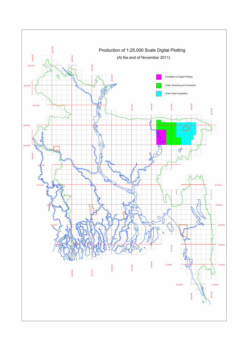


![Digital Bangladesh [ IT PRESENTATION-2012 ]](https://static.fdocuments.in/doc/165x107/577d1df21a28ab4e1e8d58db/digital-bangladesh-it-presentation-2012-.jpg)