BANGLADESH - geospatialworldforum.org 1977 1:5,000 Bangladesh Air Force Dhaka City 3 1981-82...
41
-
Upload
nguyennguyet -
Category
Documents
-
view
222 -
download
0
Transcript of BANGLADESH - geospatialworldforum.org 1977 1:5,000 Bangladesh Air Force Dhaka City 3 1981-82...
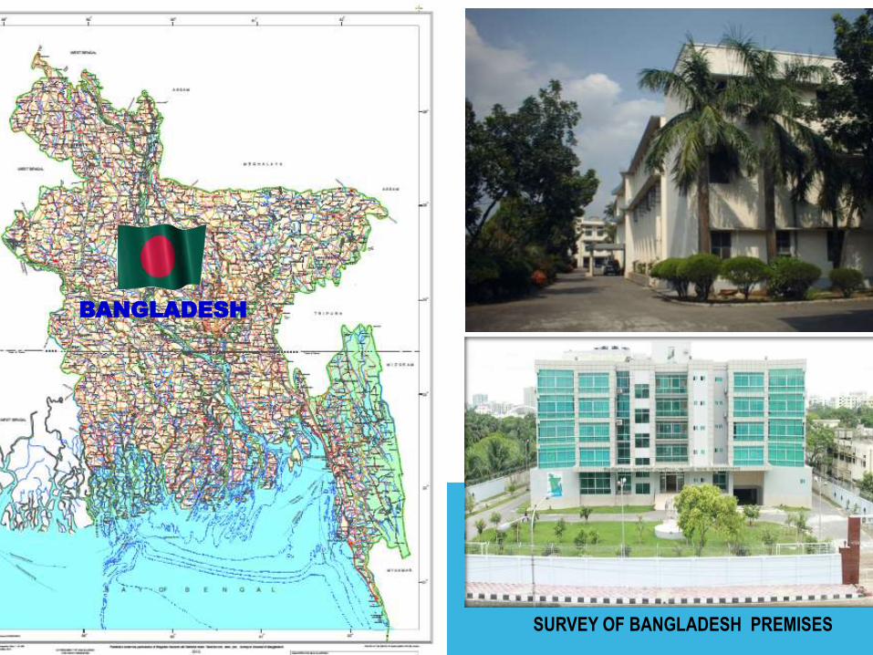
BANGLADESH
SURVEY OF BANGLADESH PREMISES
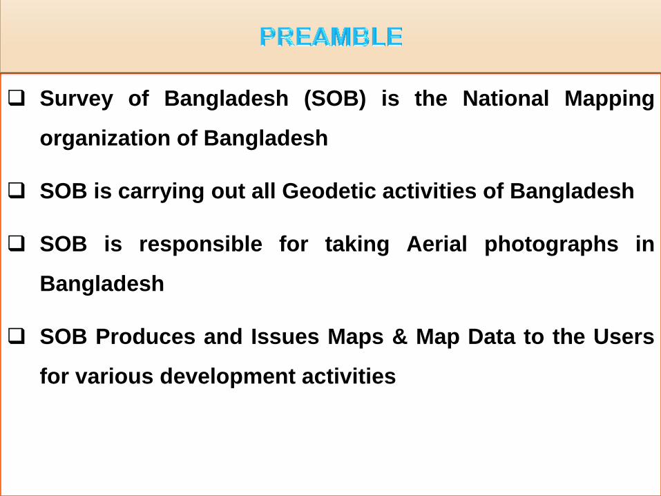
Survey of Bangladesh (SOB) is the National Mapping
organization of Bangladesh
SOB is carrying out all Geodetic activities of Bangladesh
SOB is responsible for taking Aerial photographs in
Bangladesh
SOB Produces and Issues Maps & Map Data to the Users
for various development activities
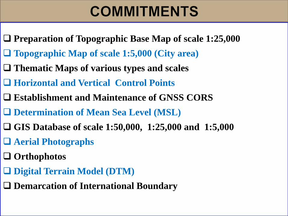
Preparation of Topographic Base Map of scale 1:25,000
Topographic Map of scale 1:5,000 (City area)
Thematic Maps of various types and scales
Horizontal and Vertical Control Points
Establishment and Maintenance of GNSS CORS
Determination of Mean Sea Level (MSL)
GIS Database of scale 1:50,000, 1:25,000 and 1:5,000
Aerial Photographs
Orthophotos
Digital Terrain Model (DTM)
Demarcation of International Boundary
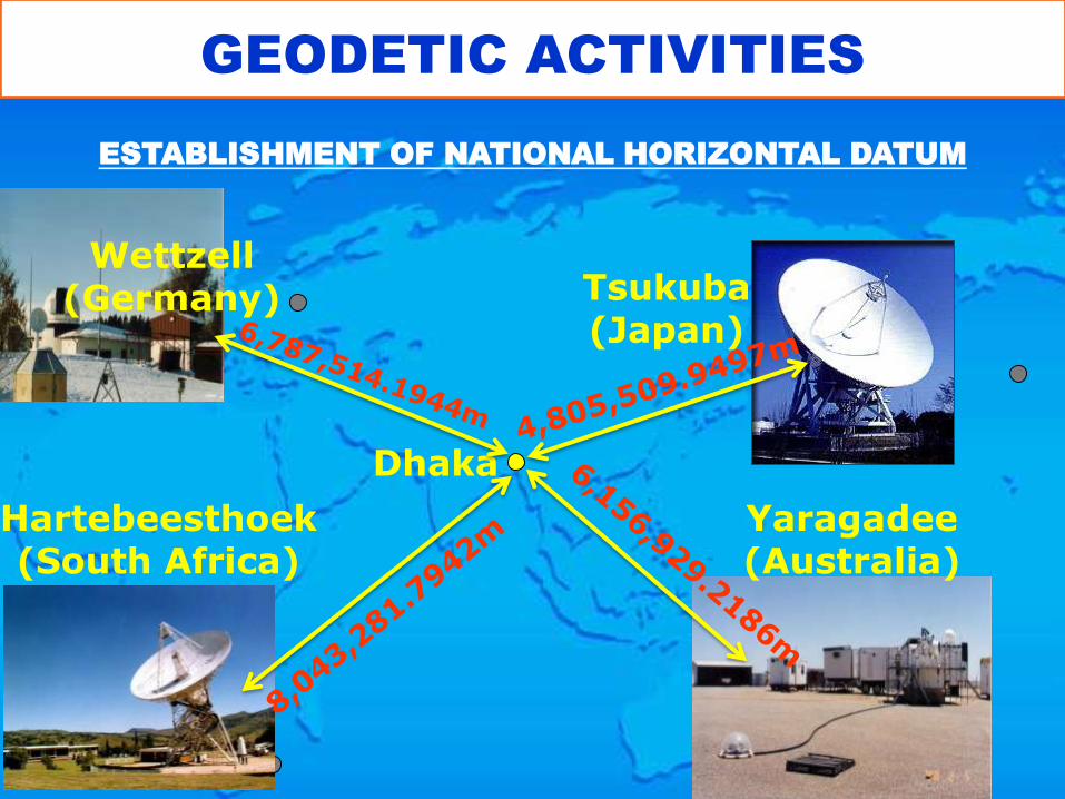
Dhaka
Tsukuba (Japan)
Wettzell (Germany)
Hartebeesthoek (South Africa)
Yaragadee (Australia)
GEODETIC ACTIVITIES
ESTABLISHMENT OF NATIONAL HORIZONTAL DATUM
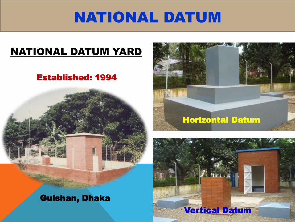
Gulshan, Dhaka
Horizontal Datum
Vertical Datum
Established: 1994
NATIONAL DATUM YARD
NATIONAL DATUM
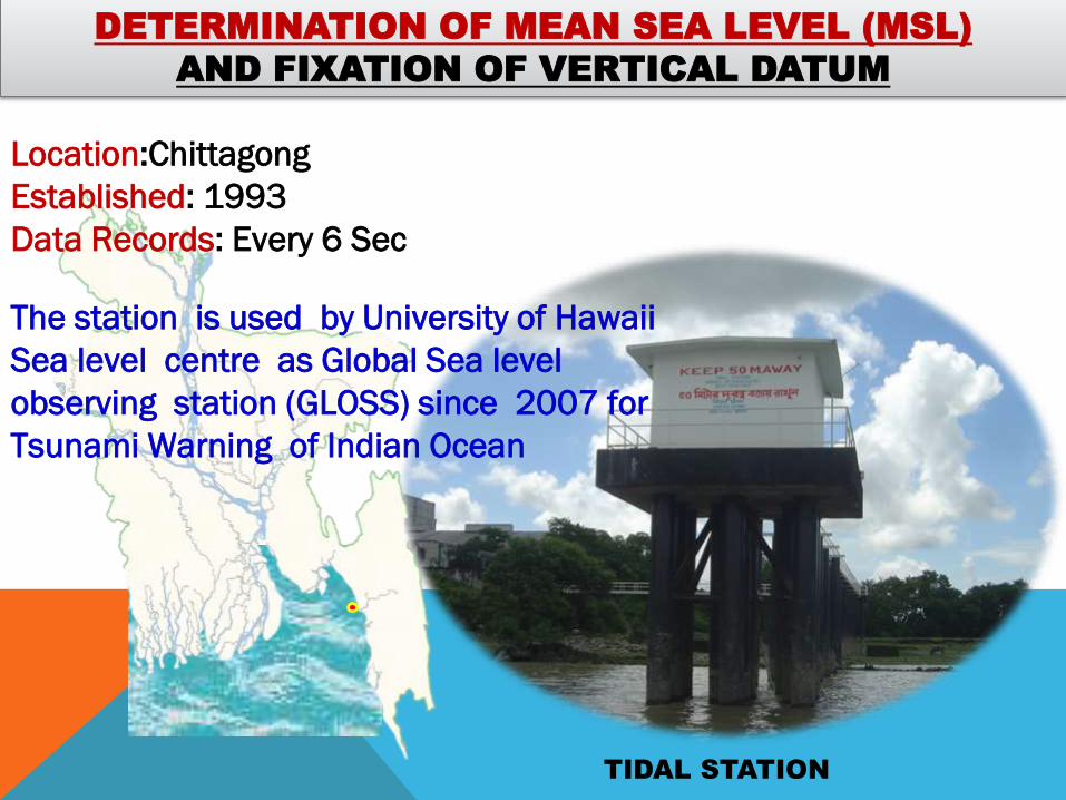
DETERMINATION OF MEAN SEA LEVEL (MSL)
AND FIXATION OF VERTICAL DATUM
TIDAL STATION
Location:Chittagong
Established: 1993
Data Records: Every 6 Sec
The station is used by University of Hawaii
Sea level centre as Global Sea level
observing station (GLOSS) since 2007 for
Tsunami Warning of Indian Ocean

Horizontal Control Points
• 1st Order Horizontal GCP - 260
• 2nd Order Horizontal GCP - 817
Vertical Control Points
• 1st Order Vertical GCP - 662
• 2nd Order Vertical GCP - 1485
3D Control Points(X,Y,Z) - 765
GEODETIC CONTROL Netwark
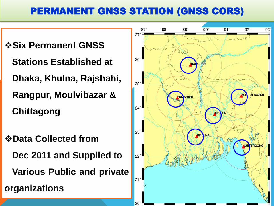
PERMANENT GNSS STATION (GNSS CORS)
Six Permanent GNSS
Stations Established at
Dhaka, Khulna, Rajshahi,
Rangpur, Moulvibazar &
Chittagong
Data Collected from
Dec 2011 and Supplied to
Various Public and private
organizations
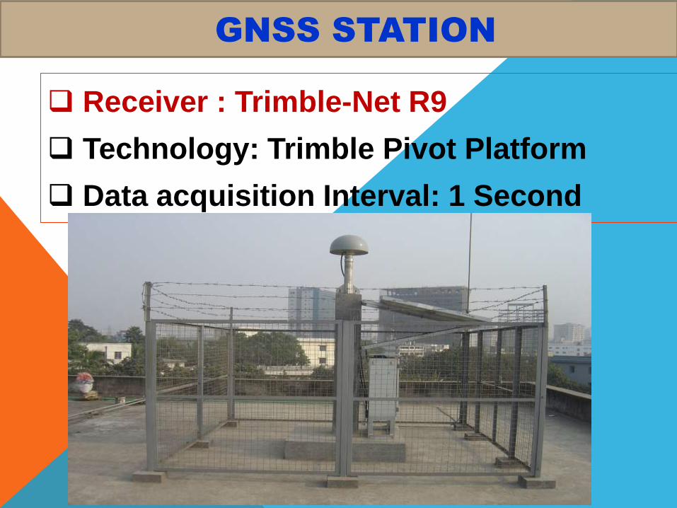
GNSS STATION
Receiver : Trimble-Net R9
Technology: Trimble Pivot Platform
Data acquisition Interval: 1 Second
Total
Station
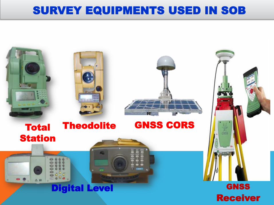
SURVEY EQUIPMENTS USED IN SOB
Digital Level
Theodolite GNSS CORS
GNSS Receiver

CHRONOLOGICAL HISTORY OF
AERIAL PHOTOGRAPHY AND SATELLITE
IMAGERY IN BANGLADESH
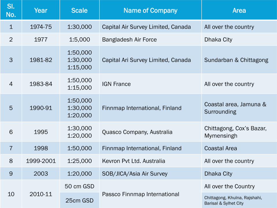
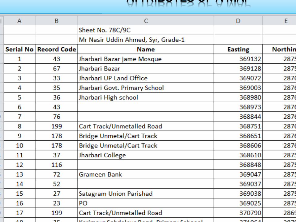
Sl.
No. Year Scale Name of Company Area
1 1974-75 1:30,000 Capital Air Survey Limited, Canada All over the country
2 1977 1:5,000 Bangladesh Air Force Dhaka City
3 1981-82
1:50,000
1:30,000
1:15,000
Capital Ari Survey Limited, Canada Sundarban & Chittagong
4 1983-84 1:50,000
1:15,000 IGN France All over the country
5 1990-91
1:50,000
1:30,000
1:20,000
Finnmap International, Finland Coastal area, Jamuna &
Surrounding
6 1995 1:30,000
1:20,000 Quasco Company, Australia
Chittagong, Cox’s Bazar,
Mymensingh
7 1998 1:50,000 Finnmap International, Finland Coastal Area
8 1999-2001 1:25,000 Kevron Pvt Ltd. Australia All over the country
9 2003 1:20,000 SOB/JICA/Asia Air Survey Dhaka City
10 2010-11
50 cm GSD
Passco Finnmap International
All over the Country
25cm GSD Chittagong, Khulna, Rajshahi,
Barisal & Sylhet City
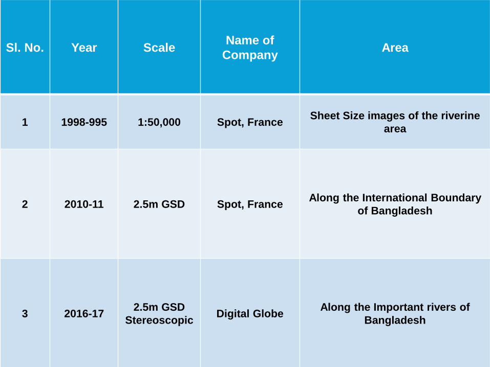
Sl. No. Year Scale Name of
Company Area
1 1998-995 1:50,000 Spot, France Sheet Size images of the riverine
area
2 2010-11 2.5m GSD Spot, France Along the International Boundary
of Bangladesh
3 2016-17 2.5m GSD
Stereoscopic Digital Globe
Along the Important rivers of
Bangladesh
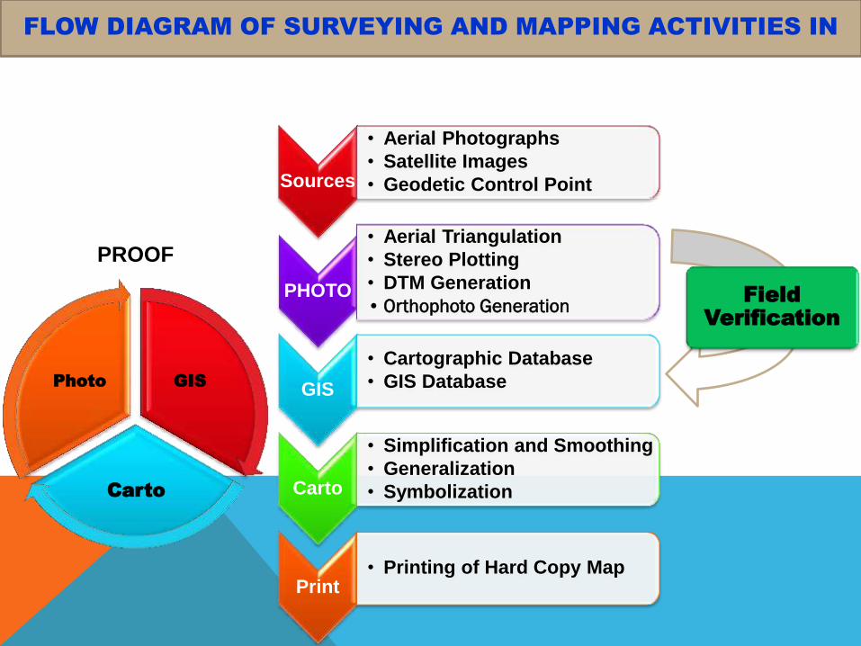
Sources
• Aerial Photographs
• Satellite Images
• Geodetic Control Point
PHOTO
• Aerial Triangulation
• Stereo Plotting
• DTM Generation
• Orthophoto Generation
GIS
• Cartographic Database
• GIS Database
Carto
• Simplification and Smoothing
• Generalization
• Symbolization
Print • Printing of Hard Copy Map
PROOF
Field Verification
GIS
Carto
Photo
FLOW DIAGRAM OF SURVEYING AND MAPPING ACTIVITIES IN
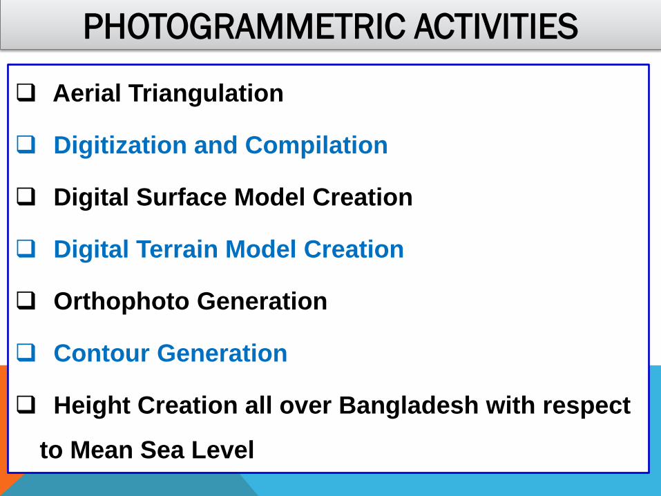
PHOTOGRAMMETRIC ACTIVITIES
Aerial Triangulation
Digitization and Compilation
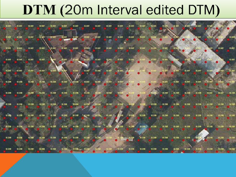
Digital Surface Model Creation
Digital Terrain Model Creation
Orthophoto Generation
Contour Generation
Height Creation all over Bangladesh with respect
to Mean Sea Level
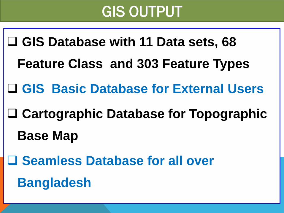
GIS OUTPUT
GIS Database with 11 Data sets, 68
Feature Class and 303 Feature Types
GIS Basic Database for External Users
Cartographic Database for Topographic
Base Map
Seamless Database for all over
Bangladesh
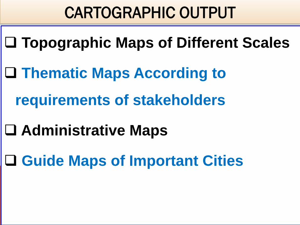
CARTOGRAPHIC OUTPUT
Topographic Maps of Different Scales
Thematic Maps According to
requirements of stakeholders
Administrative Maps
Guide Maps of Important Cities
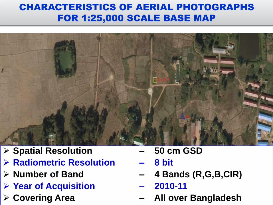
Spatial Resolution – 50 cm GSD
Radiometric Resolution – 8 bit
Number of Band – 4 Bands (R,G,B,CIR)
Year of Acquisition – 2010-11
Covering Area – All over Bangladesh
CHARACTERISTICS OF AERIAL PHOTOGRAPHS
FOR 1:25,000 SCALE BASE MAP
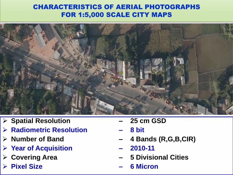
CHARACTERISTICS OF AERIAL PHOTOGRAPHS
FOR 1:5,000 SCALE CITY MAPS
Spatial Resolution – 25 cm GSD
Radiometric Resolution – 8 bit
Number of Band – 4 Bands (R,G,B,CIR)
Year of Acquisition – 2010-11
Covering Area – 5 Divisional Cities
Pixel Size – 6 Micron
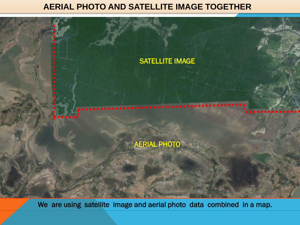
AERIAL PHOTO AND SATELLITE IMAGE TOGETHER
SATELLITE IMAGE
AERIAL PHOTO
We are using satellite image and aerial photo data combined in a map.
IMAGE PROCESSING SOFTWARE
Recently we purchased two image processing
software to update our Base maps in reverine areas
using satellite image.
ERDAS Imagine Professional 2016
ENVI version 5.3
Apparently we are using monochromic/Stereoscopic
satellite data which were acquisitioned in different
years.
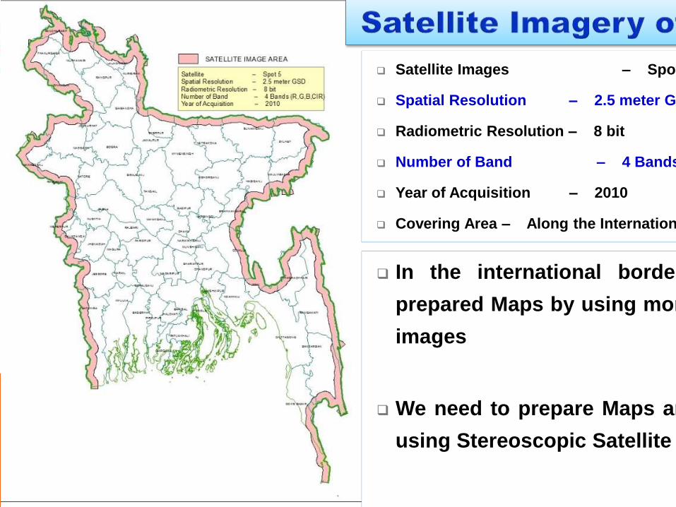
In the international border area we
prepared Maps by using monchrometic
images
We need to prepare Maps and DEM by
using Stereoscopic Satellite Images
Satellite Images – Spot 5
Spatial Resolution – 2.5 meter GSD
Radiometric Resolution – 8 bit
Number of Band – 4 Bands (R,G,B; CIR)
Year of Acquisition – 2010
Covering Area – Along the International Boundary
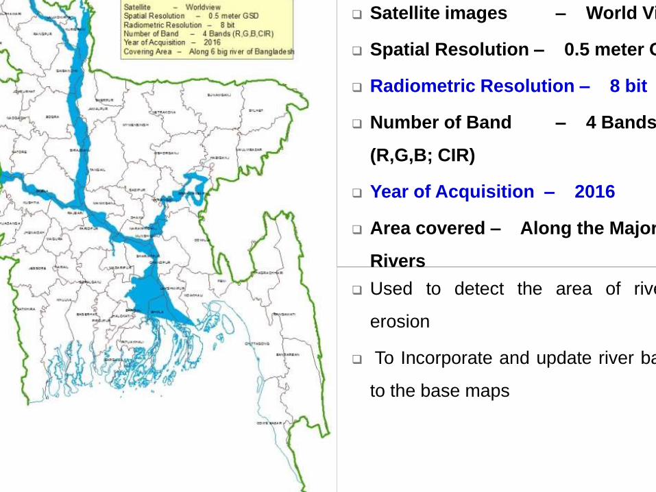
Used to detect the area of river bank
erosion
To Incorporate and update river bank data
to the base maps
Satellite images – World View
Spatial Resolution – 0.5 meter GSD
Radiometric Resolution – 8 bit
Number of Band – 4 Bands
(R,G,B; CIR)
Year of Acquisition – 2016
Area covered – Along the Major
Rivers
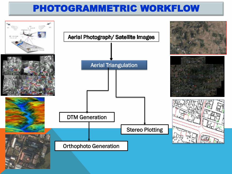
PHOTOGRAMMETRIC WORKFLOW
Orthophoto Generation
Stereo Plotting
Aerial Triangulation
DTM Generation
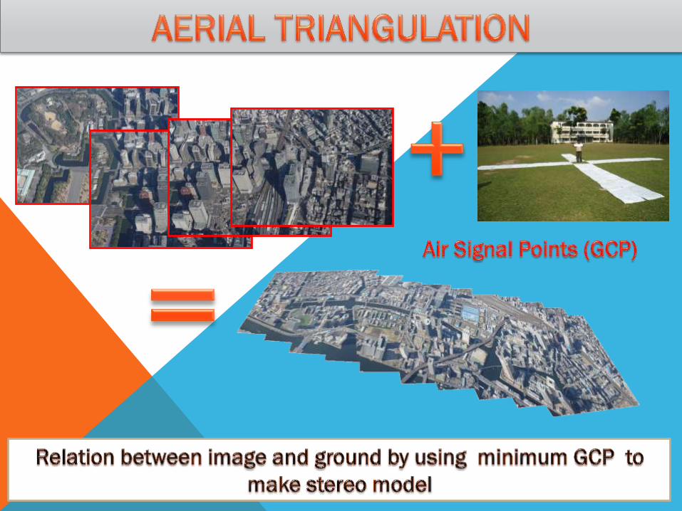
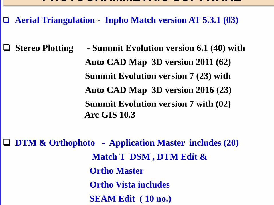
Aerial Triangulation - Inpho Match version AT 5.3.1 (03)
Stereo Plotting - Summit Evolution version 6.1 (40) with
Auto CAD Map 3D version 2011 (62)
Summit Evolution version 7 (23) with
Auto CAD Map 3D version 2016 (23)
Summit Evolution version 7 with (02)
Arc GIS 10.3
DTM & Orthophoto - Application Master includes (20)
Match T DSM , DTM Edit &
Ortho Master
Ortho Vista includes
SEAM Edit ( 10 no.)
PHOTOGRAMMETRIC SOFTWARE
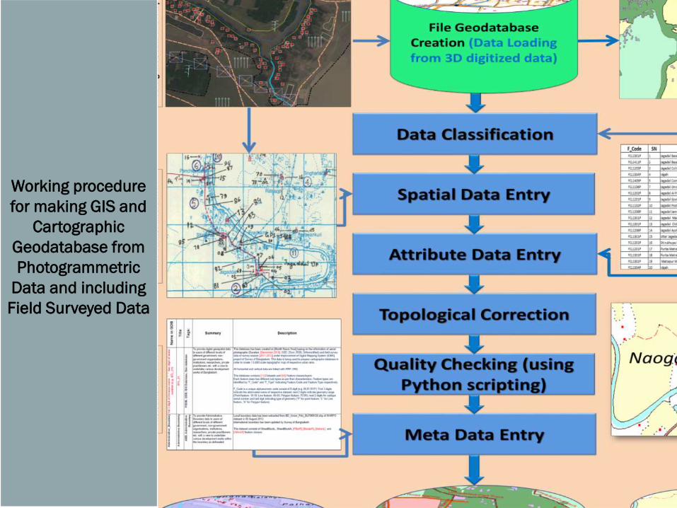
Working procedure
for making GIS and
Cartographic
Geodatabase from
Photogrammetric
Data and including
Field Surveyed Data
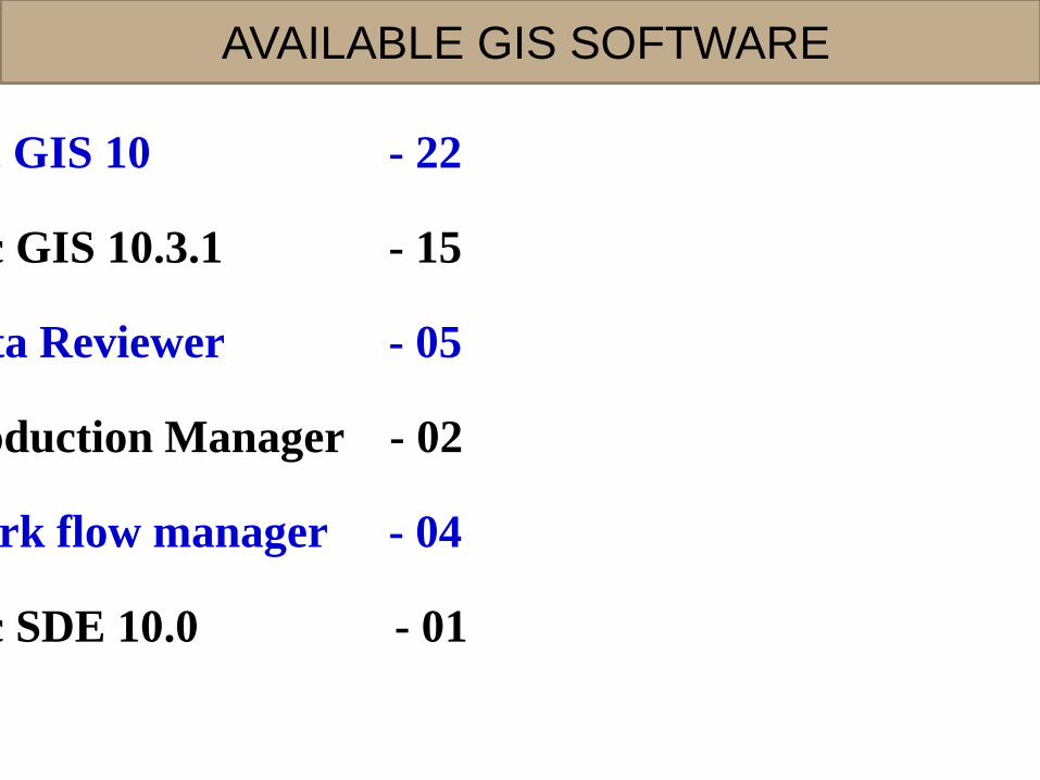
Arc GIS 10 - 22
Arc GIS 10.3.1 - 15
Data Reviewer - 05
Production Manager - 02
Work flow manager - 04
Arc SDE 10.0 - 01
AVAILABLE GIS SOFTWARE
ATTRIBUTES OF A MAP
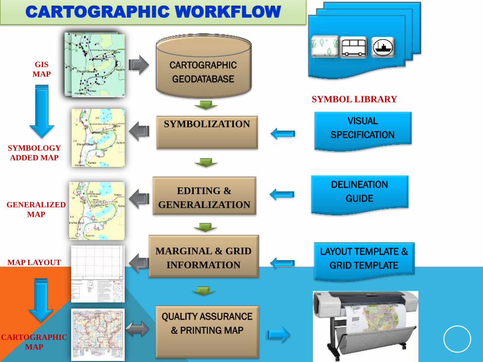
CARTOGRAPHIC
GEODATABASE
SYMBOL LIBRARY
SYMBOLIZATION
VISUAL
SPECIFICATION
EDITING &
GENERALIZATION
DELINEATION
GUIDE
MARGINAL & GRID
INFORMATION
LAYOUT TEMPLATE &
GRID TEMPLATE
QUALITY ASSURANCE
& PRINTING MAP
LAYOT
&
GIS
MAP
SYMBOLOGY
ADDED MAP
GENERALIZED
MAP
MAP LAYOUT
CARTOGRAPHIC
MAP
CARTOGRAPHIC WORKFLOW
CARTOGRAPHIC
GEODATABASE
CARTOGRAPHIC
GEODATABASE
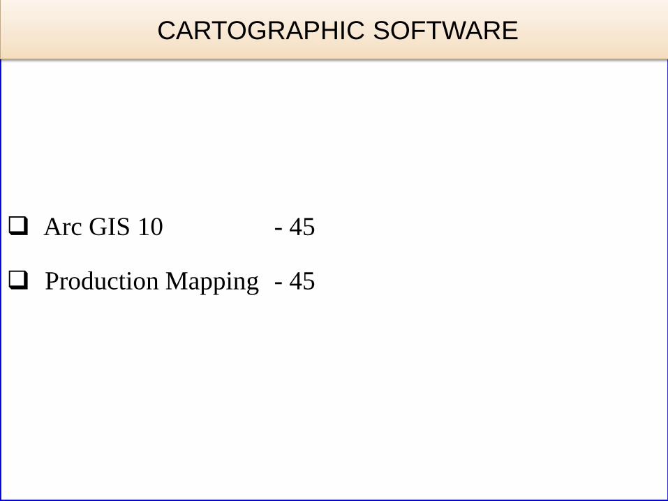
Arc GIS 10 - 45
Production Mapping - 45
CARTOGRAPHIC SOFTWARE
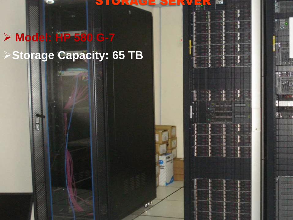
STORAGE SERVER
Model: HP 580 G-7
Storage Capacity: 65 TB

PRINTING PRESS
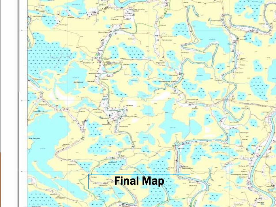
Final Map
37
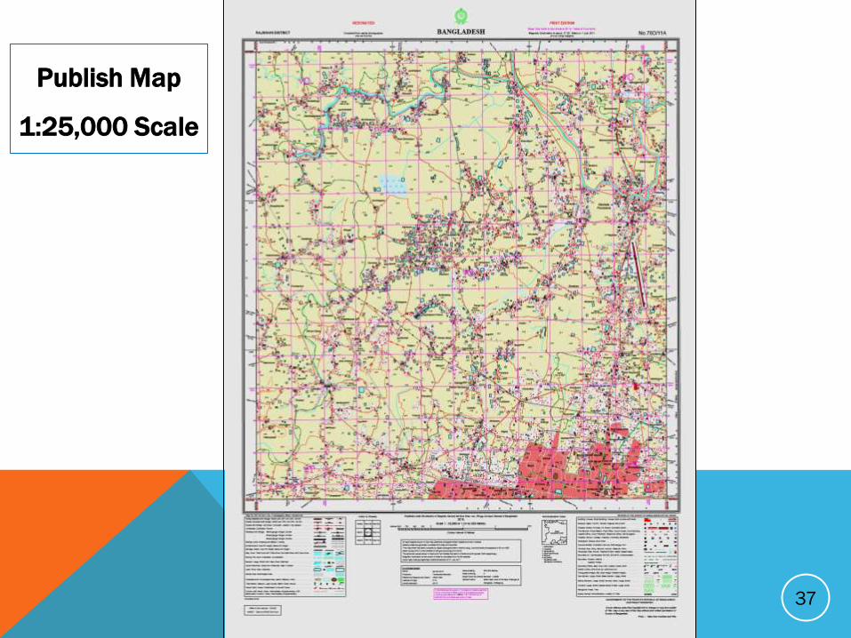
Publish Map
1:25,000 Scale
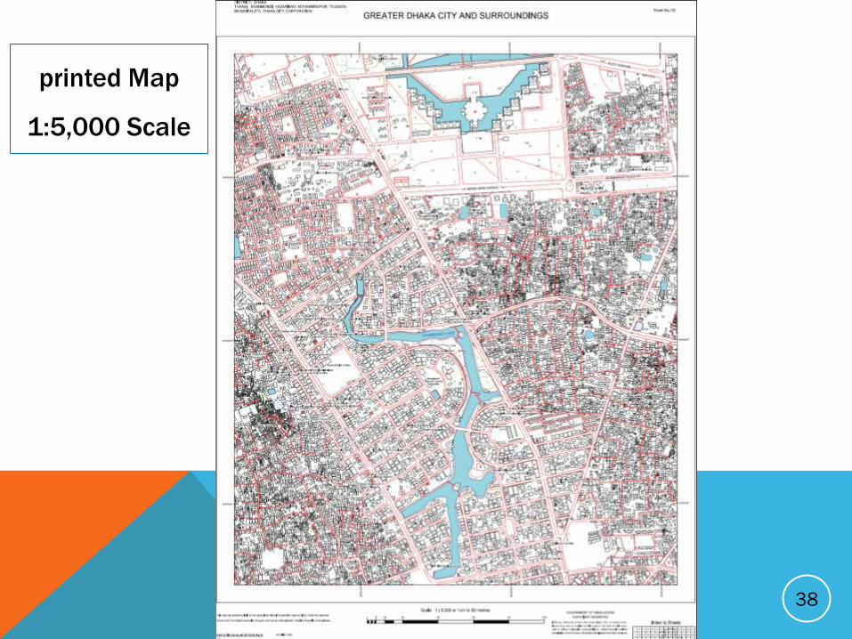
38
printed Map
1:5,000 Scale
F
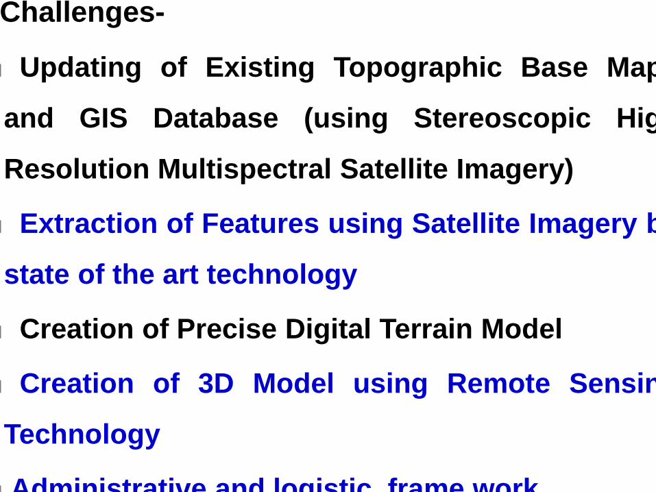
Challenges-
Updating of Existing Topographic Base Maps
and GIS Database (using Stereoscopic High
Resolution Multispectral Satellite Imagery)
Extraction of Features using Satellite Imagery by
state of the art technology
Creation of Precise Digital Terrain Model
Creation of 3D Model using Remote Sensing
Technology
Administrative and logistic frame work
Densification of GNSS CORS Network
Establish National Spatial Data Infrastructure (NSDI)
Aerial Survey using Unmanned Aerial Vehicle (UAV)
Light Detection and Ranging (LiDAR) Survey
Establishment of more tidal stations
To carry out Gravity survey all over the country for
determination of an accurate Geoid Model
FUTURE PLAN