
BAN: South Asia Subregional Economic Cooperation … · Initial Environmental Examination May 2017...
357
Initial Environmental Examination May 2017 BAN: South Asia Subregional Economic Cooperation Dhaka – Northwest Corridor Road Project, Phase 2 Hatikamrul - Rangpur Road Prepared by Roads and Highways Department, Government of Bangladesh for the Asian Development Bank. South Asia Subregional Economic Cooperation Dhaka–Northwest Corridor Road Project, Phase 2 (RRP BAN 40540)
Transcript of BAN: South Asia Subregional Economic Cooperation … · Initial Environmental Examination May 2017...

Initial Environmental Examination
May 2017
BAN: South Asia Subregional Economic Cooperation Dhaka – Northwest Corridor Road Project, Phase 2
Hatikamrul - Rangpur Road
Prepared by Roads and Highways Department, Government of Bangladesh for the Asian Development Bank.
South Asia Subregional Economic Cooperation Dhaka–Northwest Corridor Road Project, Phase 2 (RRP BAN 40540)

CURRENCY EQUIVALENTS (As of 07 April 2017)
Currency unit – Bangladeshi Taka (Tk) Tk 1.00 = $ 0.012539 $ 1.00 = Tk 79.75
ABBREVIATION
AADT Annual Average Daily Traffic AAQ Ambient air quality AAQM Ambient air quality monitoring ADB Asian Development Bank AH
BCCSAP BUET
Asian Highway Bangladesh Climate Change Strategy and Action Plan Bangladesh University of Engineering and Technology
BOD Biochemical oxygen demand BOQ
CITES Bill of quantity
Convention on International Trade of Endangered Species COD Chemical oxygen demand CSC Construction Supervision Consultant DO Dissolved oxygen DPR
ECC ECR
Detailed project report Environmental Clearance Certificate Environmental Conservation Rules
EA Executing agency EHS Environment Health and Safety EIA Environmental impact assessment EMOP Environmental monitoring plan EMP
GOB Environmental management plan
Government of Bangladesh GHG Greenhouse gas GIS Geographical information system GOB Government of Bangladesh GRC Grievance redress committee GRM Grievance redress mechanism HFL Highest flood level IA
MOEF Implementing Agency
Ministry of Environment and Forests NOx Oxides of nitrogen PAP Project Affected Persons PCU Passenger Car Units PD Project Director PM Particulate Matter PIU Project Implementation Unit PPE Personal protective equipment PPTA
RHD Project Preparedness Technical Assistance
Roads and Highways Department ROW Right of way RRTC
SASEC Road Research and Training Centre
South Asia Subregional Economic Corridor SO2 Sulphur Dioxide

SPM Suspended Particulate Matter SPS ADB Safeguard Policy Statement, 2009 TA Technical assistance TDS Total dissolved solids TSS Total Suspended Solids
WEIGHTS AND MEASURES
dB(A) – A-weighted decibel ha – hectare km – kilometre
km2 – square kilometre KWA – kilowatt ampere Leq – equivalent continuous noise level µg – microgram m – meter MW (megawatt) – megawatt PM 2.5 or 10 – Particulate Matter of 2.5 micron or 10 micron size
NOTE
In this report, "$" refers to US dollars. This initial environmental examination is a document of the borrower. The views expressed herein do not necessarily represent those of ADB's Board of Directors, Management, or staff and may be preliminary in nature. Your attention is directed to the “terms of use” section of this website. In preparing any country program or strategy, financing any project, or by making any designation of or reference to a particular territory or geographic area in this document, the Asian Development Bank does not intend to make any judgments as to the legal or other status of any territory or area.

TABLE OF CONTENTS
EXECUTIVE SUMMARY ............................................................................................................. i A. Introduction ...................................................................................................................... i B. Environmental Policy, Legal and Administrative Framework ............................................ ii C. Description of the Project................................................................................................. ii D. Description of the Environment ....................................................................................... iii E. Anticipated Environmental Impacts and Mitigation Measures ....................................... viii F. Greenhouse Gases Emission and Climate Change Assessment .................................... ix G. Environmental Management Plan ................................................................................... ix H. Institutional Arrangement, Capacity Building and Grievance Redress Mechanism .......... x I. Information Disclosure, Consultation and Participation ................................................... xi J. Conclusions and Recommendations ............................................................................. xii
I. INTRODUCTION...................................................................................................................... 1 A. Physical Environment ...................................................................................................... 2 B. Biological Environment .................................................................................................... 4 C. Socio-Cultural Environment ............................................................................................. 4 D. The Environmental Impact Assessment (EIA) Team ........................................................ 5
II. PROJECT DESCRIPTION ................................................................................................... 6 A. Background ..................................................................................................................... 6 B. Purpose of the Report ..................................................................................................... 6 C. Extent of the Study .......................................................................................................... 7 D. Approach and Methodology ............................................................................................. 7 E. Physical Environment. ..................................................................................................... 8 F. Biological Environment .................................................................................................. 12 G. Socio-Cultural Environment ........................................................................................... 12 H. The Environmental Impact Assessment (EIA) Team ...................................................... 13
III. ENVIRONMENTAL POLICY, LEGAL AND ADMINISTRATIVE FRAMEWORK .............. 14 A. Regulatory Requirements for the Project ....................................................................... 14 B. GOB Environmental Policy, Regulations, and Guidelines .............................................. 14 C. Relevant other Regulatory Requirements for the Project ............................................... 18 D. Relevant other Regulatory Requirements for the Project ............................................... 20 E. International Treaties ..................................................................................................... 24 F. Administrative Framework ............................................................................................. 25 G. Asian Development Bank Safeguard Policies, 2009 ...................................................... 25
IV. DESCRIPTION OF THE PROJECT ............................................................................... 29 A. Background ................................................................................................................... 29 B. Project Location ............................................................................................................. 29 C. Project Components ...................................................................................................... 31 D. Alignment and ROW ...................................................................................................... 31 E. Existing and Proposed Cross Drainage Structures ........................................................ 32 F. Major Bridge with Design Features ................................................................................ 39 G. Rail over Bridges (ROBs)/Flyovers and Overpasses ..................................................... 42 H. Construction Material and Sources ................................................................................ 42 I. Establishment of Road Research and Training Centre (RRTC) ..................................... 43 J. Establishment of Road Operations Unit (ROU) .............................................................. 43 K. Existing Traffic and Forecast ......................................................................................... 43 L. Project Schedule ........................................................................................................... 44

M. ADB’s Environmental Categorisation ............................................................................. 44 V. DESCRIPTION OF THE ENVIRONMENT ......................................................................... 45
A. General ......................................................................................................................... 45 B. Physical Environment .................................................................................................... 45 C. Biological Environment .................................................................................................. 75 D. Socio-Economic Environment ........................................................................................ 85
VI. ANTICIPATED ENVIRONMENTAL IMPACTS AND MITIGATION MEASURES ............. 96 A. General ......................................................................................................................... 96 B. Project Corridor ............................................................................................................ 96 C. Project Right of Way (RoW) .......................................................................................... 96 D. Corridor of Impact (CoI) ................................................................................................. 97 E. Evaluation of Significant Impacts .................................................................................. 97 F. Pre -construction Phase ............................................................................................. 101 G. Construction Phase ..................................................................................................... 103 H. Operation Phase ......................................................................................................... 120
VII. CLIMATE CHANGE ASSESSMENT ............................................................................ 127 A. Greenhouse Gas Emission .......................................................................................... 127 B. Climate Change Risks and Vulnerabilities .................................................................. 130 C. Climate Change Adaptation Measures ....................................................................... 132
VIII. ENVIRONMENTAL MANAGEMENT PLAN .................................................................. 134 A. General ....................................................................................................................... 134 B. Objective of EMP ........................................................................................................ 134 C. Environmental Management Plan (EMP) .................................................................... 134 D. EMP Implementation Schedule.................................................................................... 165 E. Environmental Monitoring Plan ................................................................................... 165 F. Components to be monitored ..................................................................................... 168 G. Monitoring Program ..................................................................................................... 169 H. Environmental Budget ................................................................................................. 176
IX. INSTITUTIONAL ARRANGEMENT, CAPACITY BUILDING AND GRIEVANCE REDRESS MECHANISM ....................................................................................................................... 179 A. Institutional Arrangement ............................................................................................. 179 B. Institutional Roles and Responsibilities ....................................................................... 182 C. Capacity Building ........................................................................................................ 186 D. Grievance Redress Mechanism ................................................................................... 187
X. INFORMATION DISCLOSURE, CONSULTATION AND PARTICIPATION ...................... 190 A. Background ................................................................................................................. 190 B. Identification of Stakeholder ....................................................................................... 190 C. Information Disclosed ................................................................................................. 190 D. Compliance with Relevant Regulatory Requirements .................................................. 191 E. Major Comments Received ........................................................................................ 191 F. Government Officers’ Comment ................................................................................. 191 G. Focus Group Discussions ............................................................................................ 194 H. Suggestions:................................................................................................................ 195 I. Local People’s Comments ........................................................................................... 196 J. Integration of Comments ............................................................................................. 197
XI. CONCLUSIONS AND RECOMMENDATIONS ............................................................. 198 A. Conclusions ................................................................................................................. 198
B. Environmental Gains Due to Proposed Work Justifying Implementation ...................... 198 C. Potential Impacts, Mitigation, Management and Monitoring ........................................ 198 D. Post EIA Surveillance and Monitoring .......................................................................... 199 E. Recommendations....................................................................................................... 200
REFERENCES ....................................................................................................................... 201 APPENDICES
Appendix A: Terms of Reference for Environmental Impact Assessment of Road Development Projects under Subregional Transport Project (SRTP) ............................................................ 202 Appendix B: DOE Approval of the TOR ................................................................................... 210 Appendix C: Rapid Environmental Assessment (REA) Checklist ............................................ 212 Appendix D: Surface Water Quality Test Results .................................................................... 217 Appendix E: Groundwater Quality Test Results ....................................................................... 235 Appendix F: Air Quality Impacts Assessment of Proposed Highway Corridor of Hatikamrul-Rangpur .................................................................................................................................. 246 Appendix G: Noise Modeling for the Project Corridor .............................................................. 257 Appendix H: Land Use of the Project Road Area ..................................................................... 282 Appendix I: List of IESFS Along the ROW ............................................................................... 308 Appendix J: List of Trees Affected in the ROW........................................................................ 317 Appendix K: Tree Plantation Plan............................................................................................ 319 Appendix L: List of Participants for FGDs ................................................................................ 322 Appendix M: List of Individual Interviewee ............................................................................... 337
List of Figures Figure 1: Location of Sample Collection along the Project Road ...............................................10 Figure 2: Government of Bangladesh Environmental Assessment Process ..............................24 Figure 3: Locality Plan of the Project .........................................................................................30 Figure 4: Typical Cross Section ................................................................................................33 Figure 5: Layout Plan of Bus Bay at Urban and Rural Area .......................................................34 Figure 6: Embankment Drain on Curve .....................................................................................35 Figure 7: Cross Section of the Proposed Karatoya Bridge ........................................................40 Figure 8: Cross Section of the Proposed Karatoya Bridge ........................................................40 Figure 9: Abutment Design of the Proposed Karatoya Bridge ...................................................41 Figure 10: Average Monthly Maximum and Minimum Temperature at Rangpur and Bogra Station (1991-2012) ..............................................................................................................................46 Figure 11: Climatic Zones .........................................................................................................47 Figure 12: Average Monthly Total Rainfall at Rangpur and Bogra Station, 1991-2012 ..............48 Figure 13: Average Monthly Humidity at Rangpur and Bogra Station, 1991-2012 .....................48 Figure 14: Average Monthly Maximum Wind Speed at Rangpur and Bogra Station, 1991-2012 .................................................................................................................................................49 Figure 15: Physiographic Sub-regions of Bangladesh ...............................................................51 Figure 16: Topography ..............................................................................................................52 Figure 17: Geology ...................................................................................................................54 Figure 18: Seismic Zones within Bangladesh ............................................................................56 Figure 19: General Soil Classification of the Project Area .........................................................58 Figure 20: Agroecological Zones of the Project Area.................................................................60 Figure 21: River Network ..........................................................................................................63

Figure 22: Arsenic Concentrations in Groundwater ...................................................................68 Figure 23: Bio-ecological Zones ................................................................................................78 Figure 24: Environmental Protected Areas ................................................................................84 Figure 25: Organisation Structure of RHD ............................................................................... 180 Figure 26: Proposed Organisation Structure of RHD for Hatikamrul-Rangpur Road Project .... 181 List of Tables Table 1: Road Components and Design Standards for Hatikamrul-Rangpur Road .................... iii Table 2: The EIA Team .............................................................................................................. 5 Table 3: The EIA Team .............................................................................................................13 Table 4: Applicability of Key Environmental Legislation .............................................................18 Table 5: Applicability of Key Environmental Legislation .............................................................20 Table 6: Relevant International Treaties, Conventions and Protocols signed by Bangladesh ....24 Table 7: Environmental Regulatory Compliance ........................................................................28 Table 8: Relevant Occupational Health and Safety Laws and Rules .........................................28 Table 9: Road Components and Design Standards for Hatikamrul-Rangpur Road ...................31 Table 10: List of New Major Bridges (> 100 m length) in Hatikamrul-Rangpur Road .................32 Table 11: Drainage Structures on the Hatikamrul-Rangpur Road ..............................................36 Table 12: Details of Proposed Flyovers and Pedestrian Overpasses in Hatikamrul-Rangpur Road .................................................................................................................................................42 Table 13: Existing and Traffic Forecast for Hatikamrul-Rangpur Road ......................................44 Table 14: Seismic Zonation of Bangladesh ...............................................................................55 Table 15: Test Results of Soil Quality .......................................................................................61 Table 16: Water Bodies and Fish Resources within the Rows of the Alignment ........................63 Table 17: Test Results for Surface Water Field Samples ..........................................................65 Table 18: Source of Drinking Water in the Project Area ............................................................66 Table 20: Results for Groundwater Field Samples ....................................................................67 Table 20: Ambient Air Quality in Different Locations along the Project Road .............................70 Table 21: Predicted vs. Monitored Air Quality Parameters ........................................................71 Table 22: Predicted noise for the year 2040 where there is exceedance vs. baseline data .......73 Table 23: Bangladesh Standard for Noise Level at Different Types of Areas ............................74 Table 24: Noise Level at Different Locations of the Project Alignment .......................................74 Table 25: List of Plants along the Project Road .........................................................................78 Table 26: List of Fauna Identified in and around the Project Area .............................................80 Table 27: Demographic Status in the Project Area ....................................................................85 Table 28: Quantity of Affected Structure along the Project Road ...............................................86 Table 29: Land Use Category of Hatikamrul-Rangpur Road Project Area .................................86 Table 30: Sanitary Facilities in the Project Area ........................................................................87 Table 31: List of Crossings along the Alignment ........................................................................88 Table 32: List of Affected Cultural and Sensitive Structures within the RoW .............................90 Table 33: Evaluation of Significant Impact Using Leopold Matrix ............................................ 100 Table 34: Checklist of Important Environmental Components (IECs) ...................................... 125 Table 35: Fuel efficiency in km/l .............................................................................................. 127 Table 36: Emission Standards of Fleet (%) ............................................................................. 127 Table 37. Annual Average Daily Traffic (AADT) for Hatikamrul-Rangpur Road ....................... 128 Table 38: Normal Traffic Growth Rates for Different Category of Vehicles .............................. 128 Table 39: Input Parameters for TEEMP .................................................................................. 129

Table 40: CO2 Emission Factors for different vehicle types .................................................... 129 Table 41: Output and Output Intensity of CO2, PM and NOx .................................................. 130 Table 42: Environmental Management Plan for Hatikamrul-Rangpur Road ............................. 135 Table 43: EMP Implementation Schedule ............................................................................... 166 Table 44: Environmental Monitoring Plan ................................................................................ 171 Table 45: Environmental Budget for Hatikamrul-Rangpur Road .............................................. 176 Table 46: Training Plan ........................................................................................................... 186 Table 47: Details of Consultation with Government Authorities for Hatikamrul-Rangpur Road Project .................................................................................................................................... 192 Table 48: Details of Consultation with Public in Hatikamrul-Rangpur Road Sections .............. 196
List of Photographs Photograph 1: Physiography of the Project Area. ......................................................................50 Photograph 2: Riverbed Materials Collection at Karatoya River, Gaibandha and Fuljor River, Sirajganj ....................................................................................................................................61 Photograph 3: Water Bodies along the Hatikamrul-Rangpur Road. ...........................................62 Photograph 4: Surface Water Collection from along the Project Road ......................................64 Photograph 5: Air quality measurement at the Project Road .....................................................69 Photograph 6: Sources of Air Pollution along the Hatikamrul-Rangpur Road ............................71 Photograph 7: Monitoring of Ambient Noise Level .....................................................................72 Photograph 8: View of Terrestrial Flora along the Hatikamrul-Rangpur Road. ..........................77 Photograph 9: Fishing Practices in Water Bodies along Hatikamrul-Rangpur Road. .................82 Photograph 10: Dangerous Road Crossing at Hatikamrul-Rangpur Road .................................88 Photograph 11: Consultation with Government Officials .......................................................... 194 Photograph 12: Photos of Focus Group Discussion at Various Locations ............................... 196 Photograph 13: Individual Interviews at Different Locations along the Road ........................... 197

i
EXECUTIVE SUMMARY
A. Introduction
1. Background: The Government of Bangladesh is emphasizing on improved connectivity in the country. In line with this objective the GOB announced its National Land Transport Policy in 2004 defining long term (20 years) Road Master Plan (RMP). The RMP has identified many feasible and priority projects. One of priority roads identified is the Hatikamrul – Rangpur Road. This road is a vital link in the national highway network and forms a part of the Asian Highway Network complementing the government plans to increase trade with India.
2. The upgrading of the road will have its associated environmental impacts that require due consideration in project design for its mitigation and management based on detailed environmental assessment. This report presents the Environmental Impact Assessment (EIA) carried out to determine the likely significant environmental changes due to the project and crafts mitigation measures to avoid, minimize, or compensate these impacts. 3. The existing road suffers from inadequate capacities and lack of safety. The road is two lanes with no shoulders and no provision for slow moving vehicular traffic (SMVT) or non-motorized traffic (NMT). There are capacity constraints caused by congested junctions, markets, and community areas. The project will upgrade the road to a four lane road with safety features, dedicated SMVT lane, flyovers at business junctions, and overpasses at intersections.
4. Purpose of the Report: This environmental impact assessment (EIA) is part of the process of compliance with the Government of Bangladesh and ADB guidelines in relation to Road Improvement Project under Subregional Transport Project Preparatory Facility (Road Component: Package-1) and as part of the Second Phase of SASEC Dhaka – Northwest Corridor Road Project.
5. The EIA provides a road map to the environmental measures needed to prevent and/or mitigate negative environmental effects associated with the development project. The EIA also provides a detailed description of the direct and indirect environmental effects associated with the proposed project during key periods of work.
6. Extent of the Study: This EIA is carried out based on most up-to-date project details and detailed designs provided by the design team during the preparation of this report. The corridor of impact has been defined as 500 m on either side from the edge of the road alignment. However, the study area has been extended to 5 Km wide area on both side of the alignment to analyse the land use, identify potential borrow areas and environmental sensitive areas. Geographical Information System (GIS) techniques have also been used based on recent satellite imageries of the project areas for above purposes. The impacts on ecologically sensitive areas (e.g. national parks, wildlife sanctuaries, biosphere reserve, and protected places) within 5 Km radius of the project areas have also been assessed.
7. Approach and Methodology: The study has been conducted in accordance with Environment Conservation Rules, 1997, Government of Bangladesh (GOB) EIA Guidelines, 1997, and ADB Safeguard Policy Statement (2009). The study is based on both primary and secondary data and information. The primary data includes data collected from field observations and secondary data includes review of the Bangladesh statistical and relevant information from Government Departments. Discussions were held with stakeholders including government officials, community representatives and a wide range of road users and roadside dwellers. The

ii
main purpose of this approach was to obtain a fair impression on the people’s perceptions of the project and its environmental impacts.
B. Environmental Policy, Legal and Administrative Framework
8. Regulatory Requirements for the Project: Regulatory requirements toward protection and conservation of environment and various environmental resources and also toward protection of social environment from adverse impact of projects and activities associated with them have been enunciated by the GOB as well as the ADB pertinent among these requirements are summarized below.
GOB Environmental Policy, Regulations, and Guidelines National Environmental Policy, 1992 National Environmental Management Action Plan, 1995 Environmental Conservation Act (ECA), 1995
- Environmental Conservation Act (Amendment 2000) - Environmental Conservation Act (Amendment 2002) - Environmental Conservation Act (Amendment 2010)
Environmental Conservation Rules (ECR), 1997 and Amendments Bangladesh Climate Change Strategy and Action Plan Relevant other regulatory requirements for the project
9. Asian Development Bank Safeguard Policies, 2009: Asian Development Bank (ADB) has three safeguard policies that seek to avoid, minimize or mitigate adverse environmental impacts and social costs to third parties, or vulnerable groups as a result of development projects. Since the ADB Safeguard Policy Statement had been approved it supersedes the Involuntary Resettlement Policy (1995), the Policy on Indigenous Peoples (1998), the Environment Policy (2002), and the second sentence of para. 73 and paras. 77–85, and 92 of the Public Communications Policy (2005).
10. Project Category: The ADB SPS addresses environmental concerns, if any, of a proposed activity in the initial stages of project preparation. For this, the ADB SPS categorizes the proposed components into A, B, or C to determine the level of environmental assessment required to address the potential impacts. The project has been categorized as B. Stakeholder consultation was an integral part of the EIA, and an environmental management plan (EMP) specifying mitigation measures to be adhered to during implementation of the project has been prepared.
11. According to ECR Schedule 1, the project is ―red category because it involves construction, reconstruction, and extension of roads and bridges. In due course an environmental assessment must be prepared in the prescribed format and be submitted to the Department of Environment (DOE) for approval.
C. Description of the Project
61. Project Location: The Hatikamrul-Rangpur Road, located north of Dhaka city will start at Hatikamrul roundabout (24°25'8.89"N and 89°33'6.31"E) at an intersection where the three major national highways (N5, N405 and N507) meet. The project road ends at Rangpur (25°42'59.88"N and 89°15'45.80"E). The total length is 156.9 km.

iii
12. The road is a standard two-lane highway (two 3.65m lanes, paved shoulders each 1.5m and verges each 1.0m). The road condition is varying in different section. Pavement crack is one the main problems for this road. There are several sub-standard horizontal curves. There are areas of distressed pavement. Road passes through various heavily congested areas at Chandikona, Sherpur, Bogra Sadar, Shibganj, Gabindaganj, Palashbari, Shathibari, Mithapukur, Pirganj and Rangpur Sadar.
13. Project Components: The project components and design standards are defined in the following table.
Table 1: Road Components and Design Standards for Hatikamrul-Rangpur Road Road Components
Length 156.9 Km
Alignment Follow the existing road alignment including the bypass area for road widening and improvement. No new road alignment or bypass is proposed.
Flyovers 1 Flyover (at Bogra)
Major Bridges 155 bridges /culverts of which 21 bridges (2 Major Bridges (>100m in length) and 134 culverts
Embankment Design
Embankment height established for 1m free board on 20 years frequency HFL Dredged river sand based, side slope 3 hor: 1 ver, 600mm compacted cladding layer and turf for slope stabilization.
Design Standard
Speed Design : 80 Km/h Posted : 70 km/h
Horizontal Controls
Controlling Curve: Super Elevation: 3% normal, 6% desirable maximum, 7% absolute maximum Minimum Curve Radius: 500 m desirable; 252 m
Cross-Section Elements
Travelled each lane: 3.65 m Cross Fall: 3 %
Structural Design Standards
Roads and Highways Department (RHD) Bridge Design Standard 2004 American Association of State Highway and Transportation Officials (AASHTO) Standards Specification
Pavement Type Bituminous Flexible Pavement as per AASHTO Design Method
D. Description of the Environment
14. The baseline condition in the locality of the project site serves as the basis for identification, prediction and evaluation of impacts. The baseline environmental quality is assessed through field studies within the impact zone for various components of the environment, viz. air, noise, water, land and socio-economic, etc.
1. Physical Environment
15. Climate: Like other parts of the country, the project area is heavily influenced by the Asiatic monsoon, and it has these three distinct seasons:
Pre-monsoon hot season (from March to May),
iv
Rainy monsoon season (from June to October), and Cool dry winter season (from November to February).
16. Temperature: The highest temperature recorded in the two weather stations Rangpur and Bogra have been 37.8 °C and 38.2 °C in May accordingly. The lowest temperature recorded at the two weather stations Rangpur and Bogra were found in the same month January which were 7.2°C and 7.9 °C respectively. Both of the average monthly temperature graphs show that these two areas face high temperature from March to May and lowest temperature during winter remains from December to February in the year.
17. Rainfall: Maximum rainfall occurs during May to September and the lowest rainfall occurs in November to February during winter season. Statistical data of 1991 to 2012 shows that both stations experience more than 300 mm rainfall in June and September months during monsoon. In the month of November, December and January of winter season around 10 mm rainfall occurred in the region of Rangpur and Bogra stations.
18. Humidity: Humidity remains high in summer and comparatively low in winter season. The statistical data of humidity from 1991 to 2012 indicates that humidity in the above two stated areas are more than 70% through the year. However, humidity falls 70% in March during the winter season in the considered areas.
19. Wind Speed: The statistical wind speed data shows that wind speed at Rangpur was comparatively higher than the area of Bogra. Wind speed remained maximum with 4.1 knots in April and 2.9 knots in April and May for Rangpur and Bogra stations respectively. The minimum wind speed was 2.9 knots and 0.7 knots for Rangpur and Bogra stations accordingly in the month of January and November.
20. Physiographic Features: The Hatikamrul-Rangpur road alignment area lies mostly in the north-western part of the country and depends on the Teesta River for freshwater supply. The entire road alignment runs through the following two physiographic units:
Teesta Floodplain (2) Barind Tract (16a)
21. Topography: The general topography of the project area comprises floodplains in the majority of the road and terraces. The topography of the project area slopes from north to south with elevation ranged from 32 m a.m.s.l to 15 m a.m.s.l.
22. Geology: Bangladesh is situated to the east of the Indian sub-continental plate. Nearly 85% of Bangladesh is underlain by deltaic and alluvial deposits of the Ganges, Brahmaputra, and Meghna river systems. The project area consists of Holocene alluvial deposits flood plain and predominantly consisting of fine sand, silts and clay. The site is on deep Cenozoic deposits that overlie Precambrian basement rock. The Precambrian rocks form the basement of all geological formations of Bengal Basin and shield areas. The materials deposited are a mixture of sediments transported by the old Brahmaputra and by the Jamuna (Brahmaputra) River.
23. Seismicity: As per the seismic zone map project road falls in zone II means medium seismic intensity. There is no evidence of major earthquakes in the project areas in the past.
v
24. Soil: The project road passes through three different soil formation zones. The general soil types of the project road area predominantly include the following: Grey floodplain soil (5); Red-brown terrace soil (18); and Grey terrace soil (19).
25. Agroecological Zones within the Project Area: The project area contains 3 agroecological Zones, namely: Teesta Meander Floodplain (3), Karatoya-Bangali Floodplain (4) and North Eastern Barind Tract (27).
26. The nature and soil characteristics of these zones influence the crops and cropping patterns within the region. Human interventions and modifications in the drainage patterns have already affected the cropping calendar, crop diversity and introduction of new varieties and agricultural products.
27. Soil Quality: The soil in the project area is highly productive and suitable to support different ecosystems in balance. The land in this area is mostly used for agricultural cultivation and there are a lot discrete water bodies for fish cultivation. During the construction phase of the project, road embankment will be built by carried earth. Hence, there is the chance of the native soil to be disturbed by the external carried earth. There has the priority of using the dredged earth from the rivers along the road alignment instead of using the local soil from the local land. River bed material (sand) of the Fuljor and Karatoya Rivers contains acceptable amount of Arsenic (As), Lead (Pb), Zinc (Zn) and Mercury (Hg) comparing with the standard of EU Directive 86/278/EEC for land application. That is why; sand from the two rivers can be used for developing project Road Embankment.
28. Surface Water: There are two major surface water bodies surrounding the project area which are Fuljor River and Karatoya River. The project road alignment crosses all the rivers at several locations. There are also significant numbers of beel and khal in and around the project locations. Besides, there are remarkable numbers of ponds and ditches available in the project area. Most of the water bodies become waterless or contain minimum amount of water during the dry season and gets water in rainy season. People use the water from the river, khal, canal and ponds for washing, bathing and irrigation purposes. In the wet season, substantial amount of the land in the area is inundated due to flood. In the dry season local canals and channels provide water for irrigation for boro cultivation and for growing winter crops.
29. Surface Water Quality: The overall quality of surface water around the project site and its surroundings varies throughout the year. Typically water quality improves during the monsoon due to the influx of fresh rainwater, and worsens during the dry season as water evaporates and the concentration of contaminants increases.
30. Groundwater: The groundwater resources in the project area are found in three separate aquifers. An upper aquifer: a surface layer consisting mainly of clay and silt, characterized by high porosity but low permeability; composite aquifer: an intermediate layer of mainly fine sand and clay characterized by high porosity and moderate permeability (possibility of providing water with hand pumps); and main aquifer: a deeper layer, containing mainly fine to coarse sand. The main aquifer is characterized by high porosity and moderate to high permeability and is separated from the composite aquifer by a clay layer. Fresh groundwater is relatively carbonate-rich with low total dissolved solid contents of less than 500 milligrams/litre (mg/l).
31. Groundwater Quality: The concentration levels of pH, Mn, As, Fe, Cl-, Total Hardness, TC and FC for shallow tube well of the project road varied and several parameters were found above the acceptable limit set by the DOE, GoB for drinking water. The coliforms were present in

vi
the water from Bogra Rail Gate and Mithapukur tubewell. The arsenic concentration was within the standard value of drinking water.
32. Ambient Air Quality: The ambient air quality was measured at several locations along the project corridor. The particulate matter and gaseous pollutants both were above the standard at some locations of the project road. Human activities, such as the burning of fossil fuels in vehicles, power plants and various industrial processes also generate significant amounts of particulates. In the project area human activities are mainly responsible for the high concentration of particulate matters.
33. Noise Level: Analysis of the noise data shows that the baseline noise around the project area varies from location to location. The equivalent noise levels recorded at different locations for 24 hours show that the baseline noise level are higher than the standard set Bangladesh Noise Pollution (Control) Rules, 2006 in both day and night time. The noise modeling result also present the higher noise level during the operation period according to the projected traffic volume.
2. Biological Environment
34. Bio-ecological Zones: The project road alignment falls below the two bio-ecological zones; Barind Tract (2) and Teesta floodplain (4a).
35. Terrestrial Flora: The project influence area (PIA) is highland with mixed vegetation. Crops, vegetables are cultivated at the surrounding mainly include rice, wheat, robi crops and variety of homestead vegetables. A sizeable number of fruit trees with economic value have been observed in the PIA. The fruit trees include jackfruit, mangoes, litchi, banana, coconut, blackberry and timber trees that include mehegoni, neem, epil-epil, koroi etc. Considerable number of trees and bushes in the PIA site provide habitat for birds and other animals. The composition of plant community includes low growing grasses, trees, herbs and shrubs. According to the Inventory of Losses (IOL) survey, total 105,339 trees of different types (35,334 fruit trees, 67,170 timber trees, 2,835 medicinal trees) and sizes (large= 10,644 trees, medium= 25,019 trees, small= 48,493 trees, saplings= 21183 trees) will be affected being located within the ROW of the subproject road’s alignment. Excluding the affected 105,339 trees, 37,785 banana trees and 39,731 bamboo trees will be affected being located within the ROW.
36. Terrestrial Fauna: The diversified habitat and ecosystem in the project area support various types of animals. Most of the birds are identified through direct observation rather than from people. Most of the Amphibians, Reptiles and Mammals were identified by using books and description of the local people during the field survey. A total of 81 species are identified during field survey among them 2 are Amphibian, 12 Reptilian, 61 Avian faunas and 6 Mammalian faunas. Out of the species identified, 1 is endangered and 7 are vulnerable. No endemic species are found in the project area.
37. Aquatic Flora: Different types of aquatic floral species were recorded in the project areas. The most abundant hydrophytes in the project area are Kochuripana (Eichhornia crassipes), Topapana (Pistia stratiotes), Khudipana (Lemna minor) Pata Jhajii (Vallisneria spiralis), Shapla (Nymphaea sp.), Kolmi (Ipomoea aquatica), Helenchaa (Enhydra fluctuant), and Duckweed (Spiredella sp.). Numerous algae (e.g. Spirogyra and Scytonema) and amphibian plant, Dhol kolmi (Ipomoea fistulosa) are also found in the road side water bodies.
38. Aquatic Fauna: Fish is the most important aquatic fauna of the project areas, along with other groups. The aquatic fauna includes Prawns (Macrobrachium spp.), crabs, snails (Pila,

vii
Vivipara, Lymna etc.), freshwater mussels (Lamellidens sp.) etc. invertebrates and fish. Kolabang (Rana tigrina); Guishap (Varanus bengalensis) and Matia sap (Enhydris enhydris) are common. The aquatic birds are – Pancowri (Phalacrocoraxcarto), Kanibok (Ardeolagrayii), Sadabok (Egrettagarzetta), Borobok (Egrettaalba), Machranga (Halcyon pileata), Dahuk (Gallicrexcinerea), and winter migratory birds – Balihash (Dendrocygnajavanica) and Chakha (Tadornaferruginea).
39. The wetlands of this region also support large populations of the commercially important prawn such as Macrobrachium rosenbergii (Golda Chingri), M. malcomsoni (Chatka chingri) and Leander sp. (Gura chingri). Fresh water Crab is a common aquatic arthropod observed in most of wetlands. Fresh water Crab is a common aquatic arthropod observed in most of wetlands. No aquatic mammal like Dolphin was observed in the Rivers (Fuljor and Karatoya) along the project road.
40. Biodiversity/Environmentally Sensitive Areas: In and around the project area some wildlife species were identified as locally vulnerable. The name of these vulnerable species are Bengal monitor, Rat snake, Common vine snake, Crested Serpent-eagle, Yellow-footed green pigeon, Common mongoose, Bengal fox, Small Indian Civet. Some species were also identified as locally endangered and these are Ring lizard, Monocellate cobra, and Jungle cat. Any construction must consider impacts on the rate of deforestation, loss of habitat, habitat fragmentation, and interruption of wildlife migration patterns. There is no protected area located within the 5 km buffer zone of this project.
3. Socio-Economic Environment
41. Settlement and Housing Pattern: The project is located in densely settlements area. There are many large and small industries and factories situated in the both sides of the RoW. Housing condition of the eleven upazilas (Ullapara, Raiganj, Sherpur, Shajahanpur, Bogra Sadar, Shibganj, Gabindaganj, Palashbari, Pirganj, Mithapukur and Rangpur Sadar) of the project is predominantly kutcha, semi pucca and pucca structures. The average data about the main house of the dwelling households by type of structure shows that pucca and semi-pucca household structures remain higher in urban area comparing to the rural area and upazila.
42. Water Supply and Sanitation: Tube wells are the most common source of drinking water in both the urban and rural areas. Tap water is accessible only in urban areas. Most households do not treat water prior to drinking. Sewage facilities are available in most of the urban areas. The sanitary facilities are better in the urban areas than the rural areas.
43. Transport and Communication: The project areas are connected with national highways, village roads, waterways, and railways in certain locations. The common types of transports are bus, truck, microbus, car, CNG, motorcycle, van and rickshaw. Mobile and wire telephone services are available in most of the areas. During the field survey, it is found that there are many roads crossing present in the Hatikamrul-Rangpur road alignment which connect the adjacent villages to the highway.
44. Environmental Hotspots: The socio-cultural aspects include the educational institutions, hospitals/health centres, religious structures, cultural structures, burial grounds, cremation yards, market places, industrial structure, water bodies, etc., few of which would be affected directly and indirectly through implementation of the both routes. Such sites could be termed as Environmental Hotspots in relation to project activities and, hence, need to be dealt carefully during the construction phase.

viii
45. There are no archaeological and historic sites in the RoW of the Hatikamrul-Rangpur Road project. Among the cultural sites, fifty six mosques, ten madrasah, twenty three eidgah, fourteen graveyards, seven mazar, twenty three school, eight college and five health complex/hospital fall within the RoW of the road alignment.
E. Anticipated Environmental Impacts and Mitigation Measures
46. This section identifies the overall impacts on the physical, biological and socio-economic environment of the project area. An environmental impact is defined as any change to an existing condition of the environment. Identification of potential impacts has been done on the basis of baseline data collected from secondary and primary sources. Qualitative and quantitative techniques have been applied for direct and indirect impact identification. Impacts are classified as being insignificant, minor, moderate and major. Impacts are described in the sections below.
47. Some of the important impacts associated with the proposed project will be associated with land use (land acquisition), land stability (soil erosion), soil compaction and contamination, water availability, water quality of river/stream/canal, ground water contamination, waste and wastewater disposal, ambient air quality, ambient noise levels, vegetation, tree cutting (including social forestry tree), fauna ( terrestrial and aquatic), drainage pattern, hydrology, climate change, socio economic, places of social/cultural importance (religious structures, community structure), construction material sourcing and occupational health and safety. Adequate mitigation measures are devised to mitigate/minimise all likely environmental impacts and the same have been presented along with the impacts.
48. To assess the likely impacts on the ambient air quality due to the proposed road project, CALINE-4, a line source model developed by the California Transport Department, was used to predict carbon monoxide (CO) and particulate matter (PM) concentrations on the road. The model was run to predict hourly average CO, PM2.5 and PM10 concentrations generated from traffic movement on proposed highway.
49. Kerb side locations were selected to compare the model prediction with monitored locations. Compared with the actual measurements of PM2.5, PM10 and CO concentrations, the predicted concentrations of each pollutant is lower.
50. In addition, the spatial distribution of hourly average predicted CO, PM2.5 and PM10, concentrations have been plotted for peak traffic hour which shows that pollutant concentrations is decreasing the farther away from the highway corridor. Therefore, the impacts of traffic movement at proposed highway project will not impact the surrounding atmosphere.
51. Noise pollution propagation generated from traffic was predicted using Canarina CUSTIC 3.2 software, where noise emission from vehicles along the proposed Hatikamrul - Rangpur Road is modelled as steady state line source. Sensitive noise receptors along the corridor were identified such as educational institutions, health complexes and religious centres. Based on the model prediction, the predicted noise for the following sensitive receptors will be exceeded by 2040, compared to the current scenario: (1) N5-28 Hatikamrul-Bhuyangati (Dadupur Sahebgonj Govt. High School, National Skill Development Institute, Royhati Madrasa Mor; (2) N5-31, Sherpur Int. with Z-5049)-Sherpur (Int. with Z-5401) (Krishnapur Govt. Primart School and Jameya Hafizia Madrasha); (3) N5-45, between Kashipur (Mokamtola)-Gabindaganj, Pakurtala, km 243.512 (Makamtola Mohila Degree College, Rahbol Girls High School and TMSS Health Complex); (4) N5-48, between Palashbari-Pirganj, Ekberpur, km 275.511 (R. V. Cold Storage Mosque, Dhaperhat Bazar and Lillah Boarding Madrasha); (5) N5-50, between Pirganj-Mithapukur, km

ix
292.502 (unnamed Mosque); (6) N5-51, between Mithapukur-Rangpur Modern More, Pairabond, km 316.022 (N5-51, between Mithapukur-Rangpur Modern More, Pairabond, km 316.022, Islampur Mondon Para Mosque, Payrabondo Salehkiya Madrasa, and Drishtiprotibondhi School). Predicted noise levels ranged from 65 -73.7 Leq.
F. Greenhouse Gases Emission and Climate Change Assessment
52. GHG emissions likely to be generated from the project roads have been computed using the Transport Emissions Evaluation Model for Projects (TEEMP)1 developed by Clean Air Asia2 was utilized to assess the CO2 gross emissions with and without the project improvements. In terms of intensity, total CO2 emissions at business-as-usual, with-project (without induced traffic) and with project (with induced traffic) scenarios were estimated at 1,350,548.73 tons/year, 740,172.06 tons/year and 959,115.5 tons/year, respectively. These values are significantly above the 100,000 tons CO2e/year threshold3 set in ADB SPS 2009. ADB requires the borrower (the Government of Bangladesh through the Roads and Highways Department) to evaluate feasible and cost effective options to reduce or offset project related greenhouse gas emissions.
53. Climate change in Bangladesh indicate risks and vulnerabilities due to changes of temperature, rainfall, temperature and rainfall related extreme events, cyclones, floods, and sea level rise that will likely result to (1) higher annual precipitation and daily temperature; (2) greater temperature and rainfall extremes; (3) increased flooding, both in terms of extent and frequency; (4) increased cyclone and storm surges both in terms of extent and frequency; (5) low river flow during dry periods; and (6) sea level rise and increased salinity intrusion. Climate change adaptation measures include (1) Adaptation allowance of 0.37 m above flood level; (2) Additional 102.4 cm for road embankment; (3) Additional 37 cm in bridge above HFL; (4) Incorporation of longitudinal drains along total highway length and increasing the number of cross drainage per unit distance; (5) Construction materials policy adaptation through the use of river sand rather than clayey agricultural soil for roadway embankment; (6) and using high quality asphalt pavement to adapt to increase in temperature.
G. Environmental Management Plan
54. Environmental Management Plan (EMP): On the basis of identification of the environmental impacts and recommended mitigation measures linked with the Hatikamrul-Rangpur project activities, an EMP has been prepared which will be followed at the pre-construction, construction and operation stages. While preparing the EMP, medium and significant impacts are taken into consideration to recommend possible mitigation measures. A mitigation measure will be considered as successful when it complies with the Environmental Quality Standards (EQS), policies, legal requirements set by ADB SPS, 2009 and DoE environmental guidelines and other relevant GoB legal requirements. In absence of DoE’s own EQS, other relevant international or other recognized organization’s quality standard will be applied.
55. EMP Implementation Schedule: An implementation schedule has been sketched based on the environmental components that may be affected during the construction and operation of the project. Since project is likely to have impact on various components of environment, a 1 TEEMP is an excel-based, free-of-charge spreadsheet models to evaluate emissions impacts of transport projects. 2A network of 250 organizations in 31 countries established by the Asian Development Bank, World Bank, and USAID to promote better air quality and livable cities by translating knowledge to policies and actions that reduce air pollution and greenhouse gas emissions from transport, energy and other sectors. 3Page 38, Appendix I, footnote 10 of SPS 2009

x
comprehensive EMP implementation schedule covering terrestrial and aquatic ecology, soil erosion, drainage congestion, tree plantation, air quality, noise, and vibration are provided. Monitoring Plan has been separately suggested for pre-construction, construction and operation phase.
56. Environmental Monitoring Plan: Environmental monitoring is an essential tool for environmental management as it provides the basic information for rational management decisions. The purpose of the monitoring program is to ensure that the envisaged purposes of the project are achieved and result in desired benefits to the target population. To ensure the effective implementation of the mitigation measures, it is essential that an effective monitoring program be designed and carried out. Compliance monitoring will be conducted in accordance with the environmental mitigation measures and monitoring plan provided with this report.
57. Environmental Budget: The overall costs of the EMP will comprise:
Environmental monitoring through sample collection and analysis; Any remedial measures necessary to reduce or avoid environmental damage; Designing and implementing all mitigating and enhancement measures; Supervision staff from RHD and consultants including direct costs and travel
subsistence.
58. The total budget is estimated as US$ 1.42 million.
H. Institutional Arrangement, Capacity Building and Grievance Redress Mechanism
59. Institutional Arrangement: The Environmental Management Plan (EMP) implementation requires an organization support structure in the form of organizational requirements, training needs and plan, and information management system.
60. The Roads and Highways Department (RHD) is the Executing Agency (EA) and will be responsible for ensuring that all the provisions of the EMP are complied with. The RHD has the responsibility to ensure that the investment follows the legal requirements for environmental assessment. The Environmental and Social Circle (ESC) headed by the Superintending Engineer, will be responsible for managing environment and social safeguards including safeguards related capacity building for all RHD projects, although they will not be involved in the day to day implementation of safeguards for specific projects.
61. The Project Implementation Unit (PIU) will be responsible for ensuring proper implementation of environment safeguards in their respective projects including implementation of the EMP and Environmental Monitoring Plan (EMoP), timely reporting and timely resolution of complaints and grievances.
62. The Additional Project Director under the PIU will serve as the Environmental Focal Person at the Project Headquarter level. At the site level an Assistant Engineer supporting the Project Manager will serve as the environmental focal person.
63. The Project Implementation Consultant (PIC) will provide support to the PIU for day to day monitoring and reporting on environmental safeguards. The PIC will be responsible for supervising the civil works contractor and to ensure the conformity of contractors with the relevant clauses in construction contracts and national regulations. The Contractor will implement the
xi
EMP and EMoP and obtain all environment related permits and clearances required for construction
64. Capacity Building: The project implementation unit (PIU) of RHD had some officers in the environmental and social circle department (ESC) that are delegated environmental duties. The delegated officers have responsibility to bring environmental issues to the notice of senior management. Typically, the delegated officers have been moved to different departments due to promotions and operational needs after about every 3 years, and they move on to other engineering departments in RHD. The status quo is that ESC engineering officers are delegated to check environmental assessments prepared by consultants. The EIA and EMP are referred to the DOE in the Ministry of Environment and Forests (MOEF) for approval. The ESC in RHD is not directly involved with project implementation, but has more administrative responsibility to ensure environmental compliance and a general role to increase environmental awareness for RHD. It is therefore not clear if RHD/ESC has the capacity to check the adequacy of the developed EMP for this project.
65. Grievance Redress Mechanism: To facilitate the resolution of affected people’s concerns, complaints, and grievances about the social and environmental performance of the project, a Grievance Redress Mechanism (GRM) is established which aims to provide a time bound and transparent mechanism to voice and resolve social and environmental concerns.
66. The Environmental and Social Circle (SEC) of RHD shall make the public aware of the GRM through public awareness campaigns. The contact phone number of the respective SEC will serve as a hotline for complaints, and shall be publicized through the media and placed on notice boards outside their offices and at construction sites. The project information brochure will include information on the GRM and shall be widely disseminated throughout the project area by the Environmental Specialist/Engineer in the SEC, with support from the NGOs and communications firm. Grievances can be filed in writing or by phone with any member of the SEC.
I. Information Disclosure, Consultation and Participation
67. The discussions were primarily focused on receiving maximum inputs from the participants regarding their acceptability and environmental concerns arising out of the project. The purpose of this stakeholder consultation is to identify the views of major institutional and project affected persons (PAPs) stakeholders to the project area being examined, and to identify issues of relevance to the study, as well as any impacts which the project may have on project planned by the stakeholders, and to assess any mitigation measures which may be undertaken to minimize any adverse impacts of the proposals under consideration. This project will indeed be helpful for socio-economic development for central region of the country by timely transporting of essential goods and products required for agricultural and industrial development. Subsequently, stakeholder consultation is one of the important parts of the EIA to address the environmental aspects as well as socio-economic issues from stakeholders’ point of view.
68. Public Consultations, Focus Group Discussions (FGDs), Government Officials, Individual Local People have been conducted continuously during the EIA study in conformity with the ADB and DoE guidelines. Project staffs were carried out a series of stakeholder consultations at different locations of the project.

xii
J. Conclusions and Recommendations
69. Conclusions: This EIA concludes that the adverse environmental impacts will be manageable if the mitigation measures are implemented thoroughly. The EMP is based on the type, extent, and duration of the identified environmental impacts. The EMP has been prepared with close reference to best practices and in line with the ADB’s Safeguards Policy Statement (SPS) and DoE environmental guidelines.
70. The project is classified ‘B’ in accordance with ADB’s Safeguard Policy Statement 2009 requiring preparation of an Initial Environmental Examination Report. As per the Environmental Conservation Act, 1995 of Bangladesh, the project falls under Red category and requiring preparation of an EIA. This report is prepared keeping the ADB and GOB environmental requirements in consideration.
71. Recommendations: The EMP, its mitigation and monitoring programs, contained herewith should be included within the Bidding documents for project works. The Bid documents state that the contractor shall be responsible for the implementation of the requirements of the EMP through his own Site Specific Environmental Management Plan which will adopt all of the conditions of the EMP and add site specific elements that are not currently known, such as the Contractors borrow pit locations. This ensures that all potential bidders are aware of the environmental requirements of the project and its associated environmental costs.
72. The EMP and all its requirements shall then be added to the contractor’s contract, thereby making implementation of the EMP a legal requirement according to the contract. He shall then prepare his CEMP which will be approved and monitored by the Engineer/Environmental Specialist. To ensure compliance with the CEMP the contractors should employ a national environmental specialist to monitor and report project activities throughout the project construction phase.
73. RHD has social and environmental circle but they need capacity building and practical exposure. Adequate training shall be imparted as proposed under environmental management plan to enhance the capability of concerned EA officials. It is recommended to update environmental guidelines focused on effective implementation of mitigation measures. Performance indicators may also be developed as part of these guidelines to monitor and assess the effectiveness of the mitigation measures.
74. The Initial Environmental Examinations and Environmental Management Plans for the establishment of Research and Training Centre (RRTC) and Road Operations Unit (ROU) will be prepared by the Project Implementation Consultant (Supervision Consultant) after the detailed designs are prepared.

1
I. INTRODUCTION
1. Background: The Government of Bangladesh is emphasizing on improved connectivity between each part of the country. In line with this objective the GOB announced its National Land Transport Policy in 2004 defining long term (20 years) Road Master Plan (RMP). The RMP has identified many feasible and priority projects. One of priority roads identified is the Hatikamrul – Rangpur Road. This road is a vital link in the national highway network and forms a part of the Asian Highway Network complementing the government plans to increase trade with India.
2. The upgrading of the road will have its associated environmental impacts that require due consideration in project design for its mitigation and management based on detailed environmental assessment. This report presents the Environmental Impact Assessment (EIA) carried out to determine the likely significant environmental changes due to the project and crafts mitigation measures to avoid, minimize, or compensate these impacts.
3. The existing road suffers from inadequate capacities and lack of safety. The road is two lanes with no shoulders and no provision for slow moving vehicular traffic (SMVT) or non-motorized traffic (NMT). There are capacity constraints caused by congested junctions, markets, and community areas. The project will upgrade the road to a four lane road with safety features, dedicated SMVT lane, flyovers at business junctions, and overpasses at intersections.
4. Purpose of the Report: This environmental impact assessment (EIA) is part of the process of compliance with the Government of Bangladesh and ADB guidelines in relation to Road Improvement Project under Subregional Transport Project Preparatory Facility (Road Component: Package-1). The EIA provides a road map to the environmental measures needed to prevent and/or mitigate negative environmental effects associated with the development project. The EIA also provides a detailed description of the direct and indirect environmental effects associated with the proposed project during key periods of work.
5. Extent of the Study: This EIA is carried out based on most up-to-date project details and detailed designs provided by the design team during the preparation of this report. The corridor of impact has been defined as 500 m on either side from the edge of the road alignment. However, the study area has been extended to 5 Km wide area on both side of the alignment to analyse the land use, identify potential borrow areas and environmental sensitive areas. Geographical Information System (GIS) techniques have also been used based on recent satellite imageries of the project areas for above purposes. The impacts on ecologically sensitive areas (e.g. national parks, wildlife sanctuaries, biosphere reserve, and protected places) within 5 Km radius of the project areas have also been assessed.
6. Approach and Methodology: The study has been conducted in accordance with Environment Conservation Rules, 1997, Government of Bangladesh (GOB) EIA Guidelines, 1997, and ADB Safeguard Policy Statement (2009). The study is based on both primary and secondary data and information. The primary data includes data collected from field observations and secondary data includes review of the Bangladesh statistical and relevant information from Government Departments. Discussions were held with stakeholders including government officials, community representatives and a wide range of road users and roadside dwellers. The main purpose of this approach was to obtain a fair impression on the people’s perceptions of the project and its environmental impacts.
7. The following methodology was adopted for carrying out the EIA study of the proposed project:

2
(i) Orientation
8. Meetings and discussions were held among the members of the EIA Consulting Team. This activity was aimed at achieving a common ground of understanding of various issues of the study.
(ii) Data Collection Planning
9. Subsequent to the concept clarification and understanding obtained in the preceding step, a detailed data acquisition plan was developed for the internal use of the EIA Consulting Team. The plan included identification of specific data requirements and their sources; determined time schedules and responsibilities for their collection; and indicated the logistics and other supporting needs for the execution of the data acquisition plan.
(iii) Data Collection
10. In this step, primary and secondary data were collected through field observations, environmental monitoring in the field, concerned departments and published materials to establish baseline profile for physical, biological and socioeconomic environmental conditions. Following activities were performed for data collection:
Site Reconnaissance Analysis of Maps and Plans Literature Review Desk Research Public Consultations Field Observations, Data Collection & Studies Laboratory Analysis
A. Physical Environment
11. Information was collected on the existing physical environment, particularly as related to geology, topography, soils, hydrology and drainage, water quality, air quality and noise, etc.
1. Geology, Topography, Soils
12. Data related to geology, topography and soil was collected to establish the baseline of the project area and further to find out the impacts of the project during the construction and operational phases.
2. Hydrology and Drainage
13. Data related to hydrology and drainage was collected to identify the elements of the hydrological cycle that are likely to have impacts on the project and the possible impacts that the project could have on the hydrological regime. Field assessments included a determination and verification of all the existing inflows into the drain, assessment of drainage issues, interviews with local community members, and roundtable discussions with stakeholders.

3
3. Air Quality
14. Ambient air quality measurements are essential to provide a description of the existing conditions, to provide a baseline against which changes can be measured and to assist in the determination of potential impacts of the proposed construction on air quality conditions. Ambient air quality was continuously monitored for Carbon Monoxide (CO), Sulphur Dioxide (SO2), Oxides of Nitrogen (NOx), Particulate Matter (PM10 & PM2.5), and other regular weather conditions for 24 hours. In order to monitor air quality at the different locations, the field investigation was undertaken on 22-30 March, 2017. The high volume sampler, Ecotech Model AAS 271 MINI has been used to collect particulate matters and Ecotech Model AAS 118 Gaseous Pollutions Sampler for gaseous measurement.
4. Noise
15. The noise monitoring was performed by a trained specialist, using a calibrated Digital Sound Level Meter (Model No SL-4033SD) set to A-weighting, fast response and statistical analysis settings. The Sound Level Meter (SLM) was mounted on a tripod at a height of approximately 1.5m, facing in the direction of the apparent predominant noise source. The SLM was programmed to record statistical noise levels for 24 hours at each location and was calibrated before and after the survey; no significant drift was detected.
5. Ground /Drinking Water Quality
16. Sampling and analysis of ground/drinking water has been carried for the following parameters: pH, Manganese (Mn), Arsenic (As), Iron (Fe), Chloride (Cl), Total Hardness, Total Coliform (TC) and Faecal Coliform (FC).
6. Surface Water Quality
17. Sampling and analysis of surface water quality has been carried out for the following parameters: pH, Total Organic Carbon (TOC), Total Phosphate (PO4), Total Suspended Solids (TSS), Oil and Grease, and Dissolved Oxygen (DO).
7. Noise
18. The noise monitoring was performed by a trained specialist, using a calibrated SVAN 949 Sound Level Meter set to A-weighting, fast response and statistical analysis settings. The Sound Level Meter (SLM) was mounted on a tripod at a height of approximately 1.5m, facing in the direction of the apparent predominant noise source. The SLM was programmed to record statistical noise levels for 15 minutes at each location and was calibrated before and after the survey; no significant drift was detected.
8. Ground /Drinking Water Quality
19. Sampling and analysis of ground/drinking water has been carried for the following parameters: pH, Manganese (Mn), Arsenic (As), Iron (Fe), Chloride as Residual Chlorine (Cl¯), Total Hardness, Fecal Coliform (FC) and Total Coliform (TC).

4
9. Surface Water Quality
20. Sampling and analysis of surface water quality has been carried out for the following parameters: pH, Dissolved Oxygen (DO), Electrical Conductivity (EC), Biochemical Oxygen Demand (BOD5), Chemical Oxygen Demand (COD), Total Suspended Solids (TSS), Free Chlorine (Cl2), Iron (Fe), and Ammonia-Nitrogen (NH3-N).
10. Soil Quality
21. Soil quality has been carried out to identify presence of heavy metals for the parameters: Mercury (Hg), Zinc (Zn); Arsenic (As), Cadmium, Copper and Lead (Pb).
B. Biological Environment
22. The status of the flora and fauna of the project area were determined by an ecological survey, review of literature relevant to the area, and an assessment of terrestrial environment.
1. Flora
23. The vegetative communities were identified and classified into community types. Identification was carried out of dominant tree species, assessment of stage of growth (mature or sapling) and assessment of canopy cover.
2. Fauna
24. Information on fauna was gathered from existing literature on reported species as well as observations in the field.
C. Socio-Cultural Environment
25. In order to assess the socio-cultural environment the Consultants utilized a combination of desk research, field investigations, census data, structured interviews, maps, reports to generate the data required for description of the existing social environment and assessment of the potential impacts due to the construction of the project. The important data collected and analysed to assess the parameter are given below:
Land use Traffic, transportation and access Roads Demographics Livelihoods Poverty Education Health Social setup Community facilities Recreational activities Archaeological and cultural heritage, etc.
26. Public Consultation. Public consultation is one of the important components of the EIA preparation activities. Local knowledge about the ecosystem and problems associated with the existing roads were carefully recorded and used in impact assessment and developing mitigation

5
plan. Formal institutional level public consultation, in tandem with opportunistic informal ones involving local dwellers, road users and people whose livelihood depends on these roads, were executed. Detailed description of public consultation has been presented at Chapter 8.
D. The Environmental Impact Assessment (EIA) Team
27. SMEC International Pty Ltd is a specialist consultancy firm which has been contracted by RHD to prepare and deliver the EIA for the project. The SMEC team members have many years of professional experience working in environmental impact assessments both within Bangladesh and internationally. The composition of the EIA team is provided below in Table 2.
TABLE 2: THE EIA TEAM
Name Position Md. Shafiqur Rahman Environmental Specialist Raisin Akhter Feroz Environmental Specialist

6
II. PROJECT DESCRIPTION
A. Background
28. The Government of Bangladesh is emphasizing on improved connectivity between each part of the country. In line with this objective the GOB announced its National Land Transport Policy in 2004 defining long term (20 years) Road Master Plan (RMP).The RMP has identified many feasible and priority projects. One of priority roads identified is the Hatikamrul–Rangpur road. This road is a vital link in the national highway network and forms a part of the Asian Highway Network complementing the government plans to increase trade with India.
29. The existing road suffers from inadequate capacity and has safety problem. The road is two lanes with no shoulders and no provision for slow moving vehicular traffic (SMVT) or non-motorized traffic (NMT). There are capacity constraints caused by congested junctions, markets, and community areas. The project will upgrade the road to a four lane road with safety features, dedicated SMVT lane, flyovers at business junctions, and overpasses at some intersections.
30. The upgrading of the road will have its associated environmental impacts that require due consideration in project design for its mitigation and management based on detailed environmental assessment. This report presents the Environmental Impact Assessment (EIA) carried out to determine the likely significant environmental changes due to the project and crafts mitigation measures to avoid, minimize, or compensate these impacts.
31. This EIA was prepared under the Technical Assistance for Subregional Road Transport Project Preparatory Facility (ADB Loan 2688-BAN) with the guidance of the Roads and Highways Department (RHD) which is the project’s executing agency (EA). Considering ADB’s Screening Checklist for Environmental Classification the proposed roads have been categorized under Category B of ADB’s environmental classification system. The required level of environmental assessment for Hatikamrul-Rangpur (HR) with respect to Government of Bangladesh (GoB) requirements was established prior to commencing the assessments. Accordingly, as the road is proposed for developments are either national or regional roads which are in the Red List of GoB Environment Conservation Rules, 1997, the requirement is for preparation of EIA.
B. Purpose of the Report
32. This environmental impact assessment (EIA) is part of the process of compliance with the Government of Bangladesh and ADB guidelines in relation to Road Improvement Project under Subregional Transport Project Preparatory Facility (Road Component: Package-1).
33. In this report, the different activities that are likely to take place to achieve the project objectives in Hatikamrul – Rangpur road were analysed and the potential impacts that may accompany them have been assessed.
34. The EIA provides a road map to the environmental measures needed to prevent and/or mitigate negative environmental effects associated with the development project. The EIA also provides a detailed description of the direct and indirect environmental effects associated with the proposed project during key periods of work.
35. The Hatikamrul–Rangpur road largely passes through inhabited and commercial areas. This road crosses various water bodies, which are important from aquatic ecology prospective. Assessment has been carried out to identify the impacts of the proposed road improvement works
7
on terrestrial and aquatic ecology, land use, air, and water and noise quality. In order to mitigate the potential impacts, appropriate measures have also been proposed in the Environmental Management Plan (EMP). Extensive public consultations undertaken as part of the EIA work have been considered for identifying the mitigation measures.
C. Extent of the Study
36. This EIA is carried out based on most up-to-date project details and detailed designs provided by the design team during the preparation of this report. The corridor of impact has been defined as 500 m on either side from the edge of the road alignment. However, the study area has been extended to 5km wide area on both side of the alignment to analyse the land use, identify potential borrow areas and environmental sensitive areas. Geographical Information System (GIS) techniques have also been used based on recent satellite imageries of the project areas for above purposes. The impacts on ecologically sensitive areas (e.g. national parks, wildlife sanctuaries, biosphere reserve, and protected places) within 5km of the project areas have also been assessed.
37. The scope of the EIA study has been confined to project related activities associated with design, construction (e.g. site clearing, earth borrowing, quarrying, material transportation, paving, camping) and operation stages. As per information available from design team, no additional facilities like toll plazas, truck plaza are proposed. Hence, no impacts assessment for such facilities was carried out. The TOR of the EIA is provided in the Appendix A and DoE approval of the TOR is provided in the Appendix B.
38. This EIA report comprises nine chapters, in consistent with the Government of Bangladesh guidelines and ADB’s Safeguard Policy Statement, 2009. These chapters are:
1. Introduction 2. Policy, Legal and Administrative Framework 3. Description of the Project 4. Description of Existing Environment 5. Anticipated Environmental Impacts and Mitigation Measures 6. Environmental Management Plan 7. Institutional Arrangement, Capacity Building and Grievance Redress Mechanism 8. Information Discloser, Consultation and Participation and 9. Conclusion and Recommendations.
D. Approach and Methodology
1. Approach
39. The study has been conducted in accordance with Environment Conservation Rules, 1997, Government of Bangladesh (GOB) EIA Guidelines, 1997, and ADB Safeguard Policy Statement (2009). The study is based on both primary and secondary data and information. The primary data includes data collected from field observations and secondary data includes review of the Bangladesh statistical and relevant information from Government Departments. Discussions were held with stakeholders including government officials, community representatives and a wide range of road users and roadside dwellers. The main purpose of this approach was to obtain a fair impression on the people’s perceptions of the project and its environmental impacts.

8
2. Methodology
40. The following methodology was adopted for carrying out the EIA study of the proposed project:
41. Orientation. Meetings and discussions were held among the members of the EIA Consulting Team. This activity was aimed at achieving a common ground of understanding of various issues of the study.
42. Data Collection and Planning. Subsequent to the concept clarification and understanding obtained in the preceding step, a detailed data acquisition plan was developed for the internal use of the EIA Consulting Team. The plan included identification of specific data requirements and their sources; determined time schedules and responsibilities for their collection; and indicated the logistics and other supporting needs for the execution of the data acquisition plan.
43. Data Collection. In this step, primary and secondary data were collected through field observations, environmental monitoring in the field, concerned departments and published materials to establish baseline profile for physical, biological and socioeconomic environmental conditions. Following activities were performed for data collection:
Site Reconnaissance Analysis of Maps and Plans Literature Review Desk Research Public Consultations Field Observations and Studies Laboratory Analysis \
E. Physical Environment.
44. Information was collected on the existing physical environment, particularly as related to geology, topography, soils, hydrology and drainage, water quality, air quality and noise.
1. Geology, Topography, Soils
45. Data related to geology, topography and soil was collected to establish the baseline of the project area and further to find out the impacts of the Project during the construction and operational phases.
2. Hydrology and Drainage
46. Data related to hydrology and drainage was collected to identify the elements of the hydrological cycle that are likely to have impacts on the project and the possible impacts that the project could have on the hydrological regime. Field assessments included a determination and verification of all the existing inflows into the drain, assessment of drainage issues, interviews with local community members, and roundtable discussions with stakeholders.

9
3. Air Quality
47. Ambient air quality measurements are essential to provide a description of the existing conditions, to provide a baseline against which changes can be measured and to assist in the determination of potential impacts of the proposed construction on air quality conditions. Ambient air quality was continuously monitored for carbon monoxide (CO), sulphur dioxide (SO2), Oxides of nitrogen oxide (NOx), particulate matter (PM10 & PM2.5), and other regular weather conditions for 24 hours. In order to monitor air quality at the different locations, the field investigation was undertaken on 22-30 March, 2017. The high volume sampler, Ecotech Model AAS 271 MINI has been used to collect particulate matters and Ecotech Model AAS 118 Gaseous Pollutions Sampler for gaseous measurement.

10
Figure 1: Location of Sample Collection along the Project Road

11
4. Noise
48. The noise monitoring was performed by a trained specialist, using a calibrated Digital Sound Level Meter (Model No SL-4033SD) set to A-weighting, fast response and statistical analysis settings. The Sound Level Meter (SLM) was mounted on a tripod at a height of approximately 1.5m, facing in the direction of the apparent predominant noise source. The SLM was programmed to record statistical noise levels for 24 hours at each location and was calibrated before and after the survey; no significant drift was detected.
5. Ground /Drinking Water Quality
49. Sampling and analysis of ground/drinking water has been carried for the following parameters: pH, Manganese (Mn), Arsenic (As), Iron (Fe), Chloride (Cl), Total Hardness, Total Coliform (TC) and Faecal Coliform (FC).
6. Surface Water Quality
50. Sampling and analysis of surface water quality has been carried out for the following parameters: pH, Total Organic Carbon (TOC), Total Phosphate (PO4), Total Suspended Solids (TSS), Oil and Grease, and Dissolved Oxygen (DO).
7. Soil Quality
51. Soil quality has been carried out to identify presence of heavy metals for the parameters: Mercury (Hg), Zinc (Zn); Arsenic (As), Cadmium (Cd), Copper (Cu), Chromium (Cr) and Lead (Pb).
8. Air Quality
52. Ambient air quality measurements are essential to provide a description of the existing conditions, to provide a baseline against which changes can be measured and to assist in the determination of potential impacts of the proposed construction on air quality conditions. Ambient air quality was continuously monitored for carbon monoxide (CO), carbon dioxide (CO2), sulphur dioxide (SO2), hydrogen sulphide (H2S), nitrogen oxide (NO), nitrogen dioxide (NO2), particulate matter (PM10), suspendate particulate matters (SPM) for 24 hours.
9. Noise
53. The noise monitoring was performed by a trained specialist, using a calibrated SVAN 949 Sound Level Meter set to A-weighting, fast response and statistical analysis settings. The Sound Level Meter (SLM) was mounted on a tripod at a height of approximately 1.5m, facing in the direction of the apparent predominant noise source. The SLM was programmed to record statistical noise levels for 15 minutes at each location and was calibrated before and after the survey; no significant drift was detected.
10. Ground /Drinking Water Quality
54. Sampling and analysis of ground/drinking water has been carried for the following parameters: pH, Colour, Turbidity, Manganese (Mn), Arsenic (As), Iron (Fe), Chloride as Residual Chlorine (Cl¯), Total Hardness as CaCO3, Total Dissolved Solids (TDS), Fecal Coliform (FC) and Total Coliform (TC).

12
11. Surface Water Quality
55. Sampling and analysis of surface water quality has been carried out for the following parameters: pH, Dissolved Oxygen (DO), Electrical Conductivity (EC), Biochemical Oxygen Demand (BOD5), Chemical Oxygen Demand (COD), Total Dissolved Solids (TDS), Total Suspended Solids (TSS), Free Chlorine (Cl2), Iron (Fe), and Ammonia-Nitrogen (NH3-N).
12. Soil Quality
56. Soil quality has been carried out to identify presence of heavy metals for the parameters: Mercury (Hg), Zinc (Zn); Arsenic (As), Cadmium (Cd), Copper (Cu), Chromium (Cr) and Lead (Pb).
F. Biological Environment
57. The status of the flora and fauna of the project area were determined by an ecological survey, review of literature relevant to the area, and an assessment of terrestrial environment.
1. Flora
58. The vegetative communities were identified and classified into community types. Identification was carried out of dominant tree species, assessment of stage of growth (mature or sapling) and assessment of canopy cover.
2. Fauna
59. Information on fauna was gathered from existing literature on reported species as well as observations in the field.
G. Socio-Cultural Environment
60. The Consultants utilized a combination of desk research, field investigations, census data, structured interviews, maps, reports to generate the data required for description of the existing social environment and assessment of the potential impacts due to the construction of the project. Data was collected on the following aspects given below:
Land use Traffic, transportation and access Roads Demographics Livelihoods Poverty Education Health Social setup Community facilities Recreational activities Archaeological and cultural heritage
61. Public Consultation. Public consultation is an important component of the EIA preparation activities. Local anecdotal knowledge about the ecosystem and problems associated

13
with the existing roads were carefully recorded and used in impact assessment and developing mitigation plan. Formal institutional level public consultation, in tandem with opportunistic informal ones involving local villagers, road users and people whose livelihood depends on these roads, were executed. Detailed description of public consultation has been presented at Chapter 8.
H. The Environmental Impact Assessment (EIA) Team
62. SMEC International Pty Ltd is a specialist consultancy firm which has been contracted by RHD to prepare and deliver the EIA for the project. The SMEC team members have many years of professional experience working in environmental impact assessments both within Bangladesh and internationally. The composition of the EIA team is provided below in Table 3.
Table 3: The EIA Team Name Position Md. Shafiqur Rahman Environmental Specialist Raisin Akhter Feroz Environmental Specialist

14
IV. ENVIRONMENTAL POLICY, LEGAL AND ADMINISTRATIVE FRAMEWORK
A. Regulatory Requirements for the Project
63. Regulatory requirements toward protection and conservation of environment and various environmental resources and also toward protection of social environment from adverse impact of projects and activities associated with them have been enunciated by the GOB as well as the ADB Pertinent requirements are summarized below.
B. GOB Environmental Policy, Regulations, and Guidelines
1. National Environmental Policy, 1992
64. Bangladesh has adopted a National Environmental Policy (NEP) in 1992 aimed at sustainable development. The NEP sets out the basic framework for environmental action together with a set of broad sectoral guidelines for action. Major elements of the policy are as follows:
a) maintaining the ecological balance for ensuring sustainable development; b) protection of the country against natural disasters; c) identifying and controlling activities which are polluting and destroying the
environment; d) ensuring environment-friendly development in all sectors; e) promoting sustainable and sound management of natural resources; and f) active collaboration with international initiatives related to the environment.
65. With regard to the transport sector, the environmental policy aims at prevention of pollution and degradation of resources caused by roads and inland waterways transport. The policy mentions that Environmental Impact Assessments (EIA) should be conducted before projects are undertaken.
2. National Environmental Management Action Plan, 1995
66. The National Environmental Management Action Plan (NEMAP) builds on the NEP and was developed to address specific issues and management requirements during the period 1995-2005. The plan includes a framework within which the recommendations of a National Conservation Strategy (NCS) are to be implemented. The NEMAP was developed with the following objectives:
a. to identify key environmental issues affecting Bangladesh; b. to identify actions to halt or reduce the rate of environmental degradation; c. to improve management of the natural environment; d. to conserve and protect habitats and bio-diversity; e. to promote sustainable development; and f. to improve the quality of life.
3. Environmental Conservation Act (ECA), 1995
67. The ECA is currently the main legislation relating to environment protection in Bangladesh. This Act is promulgated for environment conservation, environmental standards development and environment pollution control and abatement.

15
68. The main objectives of ECA are:
Conservation and improvement of the environment; and Control and mitigation of pollution of the environment.
69. The main focuses of the Act can be summarized as:
Declaration of ecologically critical areas and restriction on the operations and processes, which can or cannot be carried out/ initiated in the ecologically critical areas (ECA);
Regulations in respect of vehicles emitting smoke harmful for the environment; Environmental clearance; Regulation of industries and other development activities’ discharge permits; Promulgation of standards for quality of air, water, noise and soil for different areas
for different purposes; Promulgation of a standard limit for discharging and emitting waste; and Formulation and declaration of environmental guidelines.
70. The main focuses of the Act can be summarized as:
The ECA is currently the main legislation relating to environment protection in Bangladesh. This Act is promulgated for environment conservation, environmental standards development and environment pollution control and abatement.
Before any new project can go ahead, as stipulated under the ECA, the project promoter must obtain Environmental Clearance from the Director General (DG), DOE. An appeal procedure does exist for those promoters who fail to obtain clearance. Failure to comply with any part of this Act may result in punishment to a maximum of 5 years imprisonment or a maximum fine of Tk.100, 000 or both. The DOE executes the Act under the leadership of the DG.
The Project will be undertaken in line with the aims and objectives of the Act by conserving the environment and controlling and mitigating potential impacts throughout the drilling program.
4. Environmental Conservation Act (Amendment 2000)
71. The Bangladesh Environment Conservation Act Amendment 2000 focuses on ascertaining responsibility for compensation in cases of damage to ecosystems, increased provision of punitive measures both for fines and imprisonment and the authority to take cognizance of offences.
5. Environmental Conservation Act (Amendment 2002)
72. The 2002 Amendment of the ECA elaborates on the following parts of the Act:
Restrictions on polluting automobiles; Restrictions on the sale, production of environmentally harmful items like polythene
bags; Assistance from law enforcement agencies for environmental actions; Break up of punitive measures; and Authority to try environmental cases.

16
6. Environmental Conservation Act (Amendment 2010)
73. This amendment of the act introduces new rules and restriction on:
No individual or institution (Gov. or Semi Gov, / Non Gov. / Self Governing) can cut any Hill and Hillock. In case of national interest; it can be done after getting clearance from respective the department
Owner of the ship breaking yard will be bound to ensure proper management of their hazardous wastes to prevent environmental pollution and Health Risk
No remarked water body cannot be filled up/changed; in case of national interest; it can be done after getting clearance from the respective department; and
Emitter of any activities/incident will be bound to control emission of environmental pollutants that exceeds the existing emission standards.
7. Environmental Conservation Rules (ECR), 1997 and Amendments
74. These are a set of rules, promulgated under the ECA, 1995 and its amendments. The Environment Conservation Rules provide categorization of industries and projects and identify types of environmental assessment required against respective categories of industries or projects. The Rules set:
The National Environmental Quality Standards (NEQS) for ambient air, various types of water, industrial effluent, emission, noise, vehicular exhaust etc.;
The requirement for and procedures to obtain environmental clearance; and The requirement for IEE and EIA according to categories of industrial and other
development interventions.
75. The Environment Conservation Rules, 1997 were issued by the GOB in exercise of the power conferred under the Environment Conservation Act (Section 20), 1995. Under these Rules, the following aspects, among others, are covered:
Declaration of ecologically critical areas; Classification of industries and projects into four categories; Procedures for issuing the Environmental Clearance Certificate (ECC); and Determination of environmental standards.
76. Rule 3 defines the factors to be considered in declaring an 'ecologically critical area’ as per Section 5 of the ECA (1995). It empowers the Government to declare the area as the Ecologically Critical Areas (ECA), if it is satisfied that the ecosystem of the area has reached or is threatened to reach a critical state or condition due to environmental degradation. The Government is also empowered to specify which of operations or processes may be carried out or may not be initiated in the ecologically critical area. Under this mandate, the Ministry of Environment and Forest (MOEF) has declared Sunderban, Cox's Bazar-Tekhnaf Sea Shore, Saint Martin Island, Sonadia Island, Hakaluki Haor, Tanguar Haor, Marzat Baor and Gulshan-Baridhara Lake as ecologically critical areas and prohibited certain activities in those areas.
77. Rule 7 of the 1997 ECR provides a classification of industrial units and projects into four categories, depending on environmental impact and location. These categories are:
Green;
17
Orange A; Orange B; and Red.
78. The categorization of a project determines the procedure for issuance of an Environmental Clearance Certificate (ECC). All proposed industrial units and projects that are considered to be low polluting are categorized under "Green" and shall be granted Environmental Clearance. For proposed industrial units and projects falling in the Orange-A, Orange-B and Red Categories, firstly a site clearance certificate and thereafter an environmental clearance certificate will be required. A detailed description of those four categories of industry/project is in Schedule-1 of ECR (1997). The Rules were essentially developed for industrial developments, but under Schedule 1 of the Guidelines (Clauses 63 and 64) the following falls into the Orange B Category.
79. All existing industrial units and projects and proposed industrial units and projects, that are considered to be low polluting are categorized under "Green" and shall be granted Environmental Clearance. For proposed industrial units and projects falling in the Orange- A, Orange- B and Red Categories, firstly a site clearance certificate and thereafter an environmental clearance certificate will be issued. A detailed description of those four categories of industries has been given in Schedule-1 of ECR'97. Apart from general requirement, for every Red category proposed industrial unit or project, the application must be accompanied with feasibility report on Initial Environmental Examination, Environmental Impact Assessment based on approved TOR by DOE, Environmental Management Plan EMP etc.
80. Depending upon location, size and severity of pollution loads, projects/activities have been classified in ECR, 1997 into four categories: Green, Orange A, Orange B and Red respectively, to nil, minor, medium and severe impacts on important environmental components (IECs). Corresponding categories of road projects are based on:
Red Category: Item 67: include construction / reconstruction / expansion of roads (regional, national and international). So, EIA study and ECC are required from the DOE.
8. Bangladesh Climate Change Strategy and Action Plan
81. The GOB also prepared the Bangladesh Climate Change Strategy and Action Plan (BCCSAP) in 2008 and revised in 2009. This is a comprehensive strategy to address climate change challenges in Bangladesh. Bangladesh Climate Change Strategy and Action Plan built on and expanded the NAPA. It is built around the following six themes:
Food security, social protection and health to ensure that the poorest and most vulnerable in society, including women and children, are protected from climate change and that all programs focus on the needs of this group for food security, safe housing, employment and access to basic services, including health.
Comprehensive disaster management to further strengthen the country’s already proven disaster management systems to deal with increasingly frequent and severe natural calamities.
Infrastructure to ensure that existing assets (e.g., coastal and river embankments) are well maintained and fit for purpose and that urgently needed infrastructure (cyclone shelters and urban drainage) is put in place to deal with the likely impacts of climate change.

18
Research and Knowledge management to predict that the likely scale and timing of climate change impacts on different sectors of economy and socioeconomic groups; to underpin future investment strategies; and to ensure that Bangladesh is networked into the latest global thinking on climate change.
Mitigation and low carbon development to evolve low carbon development options and implement these as the country’s economy grows over the coming decades.
Capacity building and Institutional strengthening to enhance the capacity government ministries, civil society and private sector to meet the challenge of climate change.
82. There are 44 specific programs proposed in the BCCSAP under the above six themes.
9. National Land Use Policy, 2001
83. The National Land Use Policy was adopted by Bangladesh government in 2001, setting out guidelines for improved land-use and zoning regulations. The main objectives of this policy is to ensure criteria based uses of land and to provide guidelines for usage of land for the purpose of agriculture, housing, afforestation, commercial and industrial establishments, rail and highway and for tea and rubber gardens. Overall, this policy promotes a sustainable and planned utilization of land.
84. The main contents of this policy are
Stopping the high conversion rate of agricultural land to non-agricultural purposes; Utilizing agro-ecological zones to determine maximum land use efficiency; Adopting measures to discourage the conversion of agricultural land for urban or
development purposes; Improving the environmental sustainability of land-use practices.
C. Relevant other Regulatory Requirements for the Project
85. The Government of Bangladesh has framed various laws and regulation for protection and conservation of natural environment. The legislation with applicability to this project is summarized below in Table 4.
Table 4: Applicability of Key Environmental Legislation
No. Act/Rule/Law/Ordinance Responsible
Agency-Ministry/Authority
Key Features-Potential Applicability
1 Water Pollution Control Ordinance 1970
Ministry of Water Resources
The Ordinance adopt measures for the prevention, control and abatement of existing or potential pollution of any waters, including construction, modification, extension or alteration of disposal systems; provide information to the Board regarding wastes, sewerage or treatment works; and permit any officer to inspect and search land and buildings.
19
No. Act/Rule/Law/Ordinance Responsible
Agency-Ministry/Authority
Key Features-Potential Applicability
2 Bangladesh Labour Law, 2006
Ministry of Labor
This Act pertains to the occupational rights and safety of factory workers and the provision of a comfortable working environment and reasonable working conditions.
3 National Land use Policy, 2001
Ministry of Land
The plan deals with land uses for several purposes including agriculture (crop production, fishery and livestock), housing, forestry, industrialization, railways and roads, tea and rubber. The plan basically identifies land use constraints in all these sectors.
4 National Forest Policy and Forest Sector Review (1994, 2005)
Forest Department, MOEF
Afforestation of 20% land. Bio-diversity of the existing degraded
forests Strengthening of agricultural sector Control of global warming,
desertification, control of trade in wild birds and animals
Prevention illegal occupation of the forestlands, tree felling and hunting of wild animals.
5 National Biodiversity Strategy and Action Plan (2004)
Ministry of Environment and Forest
Conserve, and restore the biodiversity of the country;
Maintain and improve environmental stability of ecosystems;
Ensure preservation of the unique biological heritage of the nation for the benefit of the present and future generations;
Guarantee safe passage and conservation of globally endangered migratory species, especially birds and mammals in the country;
Stop introduction of invasive alien species, genetically modified organisms and living modified organisms.
6 Bangladesh Climate Change Strategy and Action Plan (2008)
Ministry of Environment and Forest
Establishment of six strategic pillars for action, including: 1. food security, social protection and
health 2. disaster management 3. protective infrastructure 4. research and knowledge
management, 5. decreased carbon development, and

20
No. Act/Rule/Law/Ordinance Responsible
Agency-Ministry/Authority
Key Features-Potential Applicability
6. capacity building and institutional strengthening.
7 National Fisheries Policy, 1998
Ministry of Fisheries and Livestock (MOFL)
Preservation & management of inland open water fisheries.
8 The Protection and Conservation of Fish Act, 1950 and The Protection and Conservation of Fish Rules, 1985
Ministry of Fisheries and Livestock
Prohibits and regulates the construction of temporary or permanent of weirs, dams, bunds, embankment and other structures
9 Wetland Protection Act 2000
Ministry of Water Resources (MOWR)
Advocates protection against degradation and resuscitation of natural water-bodies such as lakes, ponds, beels, khals, tanks, etc. affected by man-made interventions or other causes. Prevents the filling of publicly-owned water bodies and depressions in urban areas for preservation of the natural aquifers and environment. Prevents unplanned construction on riverbanks and indiscriminate clearance of vegetation on newly accreted land.
10 Embankment & drainage Act,
Ministry of Water Resources
An Act to consolidate the law relating to embankment & drainage.
11 The ground Water Management Ordinance 1985
Ministry of Water Resources
Focuses on management of Ground Water Resources. Disallows digging of tube wells without permission from the Upazilla Parishad
12 Vehicle Act 1927 & Motor vehicle ordinance 1983
Bangladesh Road Transport Authority (BRTA)
Road/traffic safety Vehicular air & noise pollutions Fitness of vehicles & registration
D. Relevant other Regulatory Requirements for the Project
86. The Government of Bangladesh has framed various laws and regulation for protection and conservation of natural environment. The legislation with applicability to this project is summarized below in Table 5.
Table 5: Applicability of Key Environmental Legislation
No. Act/Rule/Law/Ordinance Responsible
Agency-Ministry/ Authority
Key Features-Potential Applicability
1 Bangladesh Environmental Conservation Act, 1995 (ECA, 1995) and
Ministry of Environment and Forest (MOEF)
Includes categorization of development projects into green, amber A, Amber B and red. Details procedures for securing environmental clearances for projects that

21
No. Act/Rule/Law/Ordinance Responsible
Agency-Ministry/ Authority
Key Features-Potential Applicability
Environment Conservation Rules 1997 (ECR, 1997)
are under red category. Also details procedures for obtaining site clearance for projects.
2 Environment Court Act, 2000 and subsequent amendments in 2002
MOEF GOB has given highest priority to environment pollution and passed Environment Court Act, 2000 for completing environment related legal proceedings effectively
3 Bangladesh Wildlife Preservation Order 1973 and Revision 2008 (Draft)
MOEF Restricts people from damaging or destroying vegetation in wildlife sanctuaries and hunting and capturing of wild animals
4 The National Water Policy, 1999
Ministry of Water Resources (MOWR)
Protection, restoration and enhancement of water resources; Protection of water quality, including strengthening regulations concerning agro-chemicals and industrial effluent; Sanitation and potable water; Fish and fisheries; and Participation of local communities in all water sector development.
5 The Brick Burning (Control) Act, 1989 The Brick Burning (Control) Amendment Act, 1992 and 2001
MOEF Control of brick burning Requires a license from the MoEF for operation; Restricts brick burning with fuel wood
6 Water Pollution Control Ordinance 1970
MOWR Prevents water pollution
7 Bangladesh Labour Law, 2006
Ministry of Labor
This Act pertains to the occupational rights and safety of factory workers and the provision of a comfortable working environment and reasonable working conditions.
8 National Land use Policy, 2001
Ministry of Land
The plan deals with land uses for several purposes including agriculture (crop production, fishery and livestock), housing, forestry, industrialization, railways and roads, tea and rubber. The plan basically identifies land use constraints in all these sectors.
9 National Forest Policy and Forest Sector Review (1994, 2005)
Forest Department, MOEF
Afforestation of 20% land. Bio-diversity of the existing degraded
forests Strengthening of agricultural sector Control of global warming, desertification,
control of trade in wild birds and animals Prevention illegal occupation of the
forestlands, tree felling and hunting of wild animals.

22
No. Act/Rule/Law/Ordinance Responsible
Agency-Ministry/ Authority
Key Features-Potential Applicability
10 The Forest Act 1927,Amendment 2000 (Protected, village Forests and Social Forestry)
Forest Department, MOEF
Declare any forests land or wasteland as protected forests. May stop public or private way or watercourse in the interest of preservation of the forest Declare a reserved forest area as Village Forests Declare an area as Social forests or launch a social forestry programme in Govt. land or private land with permission
11 National Biodiversity Strategy and Action Plan (2004)
MOEF
Conserve, and restore the biodiversity of the country;
Maintain and improve environmental stability of ecosystems;
Ensure preservation of the unique biological heritage of the nation for the benefit of the present and future generations;
Guarantee safe passage and conservation of globally endangered migratory species, especially birds and mammals in the country;
Stop introduction of invasive alien species, genetically modified organisms and living modified organisms.
12 Bangladesh Climate Change Strategy and Action Plan (2008)
MOEF
Establishment of six strategic pillars for action, including: food security, social protection and health disaster management protective infrastructure research and knowledge management, decreased carbon development, and capacity building and institutional
strengthening. 13 National Fisheries Policy,
1998 Ministry of Fisheries and Livestock (MOFL)
Preservation and management of inland open water fisheries.
14 The Protection and Conservation of Fish Act, 1950 and The Protection and Conservation of Fish Rules, 1985
MOFL
Prohibits and regulates the construction of temporary or permanent of weirs, dams, bunds, embankment and other structures
15 Wetland Protection Act 2000
MOWR Advocates protection against degradation and resuscitation of natural water-bodies such as lakes, ponds, beels, khals, tanks,
23
No. Act/Rule/Law/Ordinance Responsible
Agency-Ministry/ Authority
Key Features-Potential Applicability
etc. affected by man-made interventions or other causes. Prevents the filling of publicly-owned water bodies and depressions in urban areas for preservation of the natural aquifers and environment. Prevents unplanned construction on riverbanks and indiscriminate clearance of vegetation on newly accreted land.
16 Embankment and drainage Act
MOWR
An Act to consolidate the law relating to embankment and drainage.
17 The ground Water Management Ordinance 1985
MOWR Focuses on management of Ground Water Resources. Disallows digging of tube wells without permission from the Upazilla Parishad
18 Vehicle Act 1927 and Motor vehicle ordinance 1983
BRTA
Road/traffic safety Vehicular air and noise pollutions Fitness of vehicles and registration
87. Under the Environmental Conservation Act (1995) and Rules (1997), the project will be required to obtain a site clearance as well as an environmental clearance. The procedure for obtaining environmental clearance is given in the Figure 2.

24
Figure 2: Government of Bangladesh Environmental Assessment Process
E. International Treaties
88. Bangladesh has signed most international treaties, conventions and protocols on environment, pollution control, bio-diversity conservation and climate change, including the Ramsar Convention, the Bonn Convention on migratory birds, the Rio de Janeiro Convention on biodiversity conservation and the Kyoto protocol on climate change. An overview of the relevant international treaties and conventions signed by GOB is shown in Table 6.
Table 6: Relevant International Treaties, Conventions and Protocols signed by Bangladesh
Treaty or Convention Year Brief description Responsible Agency
On protection of birds (Paris) 1950 Protection of birds in wild state DOE/DOF Occupational hazards due to air pollution, noise and vibration (Geneva)
1977 Protect workers against occupational hazards in the working environment
MOHFW
Occupational safety and health in working environment (Geneva)
1981 Prevent accidents and injury to health by minimizing hazards in the working environment
MOHFW
C3. EIA review by DoE, sometimes conditions; & Env Clearance Certificate
A1. Project Authorization letter A2. Schedule 1 Classification A3. If Orange B or Red Category, presentation to DoE needed
B1.Prepare GoB IEE & if Red, include ToC for EIA C1. DoE review of Red
Cat. IEE and issues letter to proceed with EIA
C2. Prepare & submit EIA as per approved ToC, plus Treasury Chalan, NOCs from local authorities and Eng. Feas. Study
Return to applicant for modification
Decision within 60 working
days from the date of
application / IEE
submission
Within 30 working
days from the date of submission
B2. Orange B IEE review by DoE, approved, with Fee Payment include NOC and Treasury Chalan
A2a. If Orange B or Red category proceed with GoB IEE
A2b. If Orange prepares EMP: if green no environmental action needed. No further consultation with DoE
IEE complete & implemented
EIA & EMP complete and implemented: Construction can begin

25
Treaty or Convention Year Brief description Responsible Agency
Occupational health services (Geneva)
1985 To promote a safe and healthy working environment
MOHFW
International convention on climate changes (Kyoto Protocol)
1997 International treaty on climate change and emission of greenhouse gases
DOE/MOEF
F. Administrative Framework
89. Bangladesh has a very clear administrative framework regarding environmental aspect. It has strong interface between local government and federal Government. Department of Environment is responsible for grant of environmental clearance to a project. In addition there are other ministries to deal with specific area of importance to the country like Forests, Water and others. The administrative stages for grant of clearance of a project are also shown in Figure 2.
G. Asian Development Bank Safeguard Policies, 2009
90. Asian Development Bank (ADB) has three safeguard policies that seek to avoid, minimize or mitigate adverse environmental impacts and social costs to third parties, or vulnerable groups as a result of development projects4.The current generation of safeguard policies was designed when direct project lending was the dominant modality for development assistance. New lending modalities and financing instruments, such as the multitranche financing facility (MFF), have increased the complexity of applying safeguard policies and ensuring compliance. The new modalities and the likelihood of continued innovation, as well as changing client circumstances, suggest a need to enhance the relevance and effectiveness of ADB‘s safeguards, which has been reflected in an update of the Safeguard Policy by 2009, announced through the Safeguard Policy Statement 2009.
91. According to the Safeguard Policies 2009 (SPS 2009) of ADB, ADB‘s overarching statement on its commitment and policy principles are:
92. ADB affirms that environmental and social sustainability is a cornerstone of economic growth and poverty reduction in Asia and the Pacific. ADB‘s Strategy 2020 therefore emphasizes assisting Developing Member Countries (DMCs) to pursue environmentally sustainable and inclusive economic growth. In addition, ADB is committed to ensuring the social and environmental sustainability of the projects it supports. In this context, the goal of the SPS is to promote the sustainability of project outcomes by protecting the environment and people from projects’ potential adverse impacts.
93. The objectives of ADB‘s safeguards are to:
avoid adverse impacts of projects on the environment and affected people, where possible;
minimize, mitigate, and/or compensate for adverse project impacts on the environment and affected people when avoidance is not possible; and
help borrowers/clients to strengthen their safeguard systems and develop the capacity to manage environmental and social risks.
4 ADB.2009. Safeguard Policy Statement, Manila

26
94. Since the ADB Safeguard Policy Statement had been approved it supersedes the Involuntary Resettlement Policy (1995), the Policy on Indigenous Peoples (1998), the Environment Policy (2002), and the second sentence of para. 73, and paras. 77–85, and 92 of the Public Communications Policy (2005).
1. Safeguard Requirements 1: Environment
95. The objectives are to ensure the environmental soundness and sustainability of projects, and to support the integration of environmental considerations into the project decision-making process.
96. The requirements apply to all ADB-financed and/or ADB-administered sovereign and non-sovereign projects, and their components regardless of the source of financing, including investment projects funded by a loan; and/or a grant; and/or other means, such as equity and/or guarantees. Mechanisms such as Public Consultation, Identification of potential impacts, elaboration of adequate mitigation measures and impact monitoring as well as implementation of an appropriate environmental management plan remained mainly unchanged referring to the former Environmental Safeguard Policy.
97. Special attention has been put on the Grievance Redress Mechanism, securing that the borrower/client will establish a mechanism to receive and facilitate resolution of affected peoples‘ concerns, complaints, and grievances about the project‘s environmental performance. The grievance mechanism should be scaled to the risks and adverse impacts of the project. It should address affected people's concerns and complaints promptly, using an understandable and transparent process that is gender responsive, culturally appropriate, and readily accessible to all segments of the affected people at no costs and without retribution. The mechanism should not impede access to the country‘s judicial or administrative remedies. The affected people will be appropriately informed about the mechanism.
98. Guidelines provide a rational approach for determining environmental category of the Project, the need for public consultation and disclosure, environmental management planning, and resolving involuntary resettlement, indigenous people and gender issues.
2. Safeguard Requirements 2: Involuntary Resettlement
99. The objectives are to avoid involuntary resettlement wherever possible; to minimize involuntary resettlement by exploring project and design alternatives; to enhance, or at least restore, the livelihoods of all displaced persons in real terms relative to pre-project levels; and to improve the standards of living of the displaced poor and other vulnerable groups. The safeguard requirements underscores the requirements for undertaking the social impact assessment and resettlement planning process, preparing social impact assessment reports and resettlement planning documents, exploring negotiated land acquisition, disclosing information and engaging in consultations, establishing a grievance mechanism, and resettlement monitoring and reporting.
100. The involuntary resettlement requirements apply to full or partial, permanent or temporary physical displacement (relocation, loss of residential land, or loss of shelter) and economic displacement (loss of land, assets, access to assets, income sources, or means of livelihoods) resulting from (i) involuntary acquisition of land, or (ii) involuntary restrictions on land use or on access to legally designated parks and protected areas. Resettlement is considered involuntary when displaced individuals or communities do not have the right to refuse land acquisition that result in displacement.

27
3. Safeguard Requirements 3: Indigenous Peoples
101. The objective is to design and implement projects in a way that fosters full respect for Indigenous Peoples’ identity, dignity, human rights, livelihood systems, and cultural uniqueness as defined by the Indigenous Peoples themselves so that they (i) receive culturally appropriate social and economic benefits, (ii) do not suffer adverse impacts as a result of projects, and (iii) can participate actively in projects that affect them.
102. For operational purposes, the term Indigenous Peoples is used in a generic sense to refer to a distinct, vulnerable, social and cultural group possessing the following characteristics in varying degrees:
(i) self-identification as members of a distinct indigenous cultural group and recognition of this identity by others;
(ii) collective attachment to geographically distinct habitats or ancestral territories in the project area and to the natural resources in these habitats and territories;
(iii) customary cultural, economic, social, or political institutions that are separate from those of the dominant society and culture; and
(iv) a distinct language, often different from the official language of the country or region.
103. In considering these characteristics, national legislation, customary law, and any international conventions to which the country is a party will be taken into account.
104. Guidelines provide a rational approach for determining environmental category of the Project, the need for public consultation and disclosure, environmental management planning, and resolving involuntary resettlement, indigenous people and gender issues.
105. Activities carried out under the project needs to conform to current laws in Bangladesh and sound social and environmental principles. In general, the project activities will not trigger serious impacts on physical and human environment.
4. Project Category
106. The ADB SPS addresses environmental concerns, if any, of a proposed activity in the initial stages of project preparation. For this, the ADB SPS categorizes the proposed components into A, B, or C to determine the level of environmental assessment required to address the potential impacts. The project has been categorized as B. Stakeholder consultation was an integral part of the IEE, and an environmental management plan (EMP) specifying mitigation measures to be adhered to during implementation of the project has been prepared.
107. According to ECR Schedule 1, the project is red category because it involves construction, reconstruction, and extension of roads and bridges5. In due course an environmental assessment must be prepared in the prescribed format and be submitted to the Department of Environment (DOE) for approval. Table 7 shows the summary of environmental regulatory compliance required for the project.
5 Consultation with the DoE during the course of this environmental assessment confirmed that the project is category red and requires EIA under the ECA and ECR.

28
Table 7: Environmental Regulatory Compliance
Component Description
Government of Bangladesh ADB Category in
Accordance with ECR
Environmental Assessment
Category in Accordance
with SPS
Environmental Assessment
Hatikamrul-Rangpur Road Project
Red Category: Construction / reconstruction / expansion of roads and bridge (regional, national and international)
IEE, EIA, and EMP
Category B
IEE
5. Occupational Health and Safety
108. During construction, the project will conform to the labour laws and occupational and health related rules as outlined in Table 8.
Table 8: Relevant Occupational Health and Safety Laws and Rules Title Overview
Bangladesh Labor Act, 2006
Provides for safety of work force during construction period. The act provides guidance of employer’s extent of responsibility and the workmsn’s right to compensation in case of injury caused by accident while working.
Labor Relations under Labor Laws, 1996
General concerns during the project implementation state that the project manager must recognize labor unions.
Public Health (Emergency Provisions) Ordinance, 1994
Calls for special provisions with regard to public health. In case of emergency, it is necessary to make special provisions for preventing the spread of disease, safeguarding the public health, and providing adequate medical service, and other services essential to the health of respective communities and workers during construction-related work.
The Employees State Insurance Act, 1948
Health, injury and sickness benefit should be paid.
The Employer's Liability Act, 1938
Covers accidents, risks, and damages with respect to employment injuries
Maternity Benefit Act, 1950
Framed rules for female employees, who are entitled to various benefits for maternity
Bangladesh Factory Act, 1979
Workplaces provisions: these Act and Labor Laws require medical facilities, first aid, accident and emergency arrangements, and childcare services to be provided to the workers at workplace.

29
V. DESCRIPTION OF THE PROJECT
A. Background
109. Bangladesh, due to its location, can serve as vital link between neighbouring countries Nepal, Bhutan, Myanmar, and India. The Transport Working Group (TWG) of the South Asia Sub-regional Economic Cooperation (SASEC) has also identified four of the six corridors passing through Bangladesh. With the opening of Bangabandhu Bridge and the proposed development of Padma Bridge, the Dhaka–Chittagong transport corridor and other transport corridors can serve to facilitate trade between Bangladesh and the north-eastern states of India, the Indian state of West Bengal, and neighbouring country Bhutan and Nepal. This central location of Bangladesh generates immense potential to benefit from better trade facilitation efforts. However, this potential has not been fully realized because of deficiencies in key infrastructure and the trade-related constraints.
110. The Hatikamrul-Rangpur road is a vital link in the national highway network. This road is part of Asian Highway Network route AH2.
111. The upgrading of these roads is consistent with the Road Master Plan 2008 of Bangladesh. The existing roads are two lane roads with shoulders. There is no separate provision for slow moving vehicular traffic (SMVT) or non-motorised traffic (NMT). There are capacities constraints caused by congested junctions, markets and built up areas.
112. The completion of the proposed upgrading will substantially improve transport efficiency on the road linking the Bangabandhu Bridge to Dhaka and the Southeast Road Corridor (to Chittagong). This will also contribute in integrating the southwest region into the national economy, a key issue identified in the Asian Development Bank country strategy and programme for Bangladesh (2006-2010) as a requirement to support the country’s National Poverty Reduction Strategy.
B. Project Location
113. The Hatikamrul-Rangpur road located north of Dhaka city will start at Hatikamrul roundabout (24°25'8.89"N and 89°33'6.31"E) at an intersection where the three major national highways (N5, N405 and N507) meet. The project road ends at Rangpur (25°42'59.88"N and 89°15'45.80"E). The total length is 156.9 km. Figure 3 shows the project location.
114. The road is a standard two-lane highway (two 3.65m lanes, paved shoulders each 1.5m and verges each 1.0m). The road condition is varying in different section. Pavement crack is one the main problem for this road. There are several sub-standard horizontal curves. There are areas of distressed pavement. Road passes through various heavily congested areas at Chandikona, Sherpur, Bogra Sadar, Shibganj, Gabindaganj, Palashbari, Shathibari, Mithapukur, Pirganj and Rangpur Sadar.

30
Figure 3: Locality Plan of the Project

31
C. Project Components
115. The project components and design standards are defined in the following sections:
Table 9: Road Components and Design Standards for Hatikamrul-Rangpur Road ROAD COMPONENTS
Length 156.9 Km
Alignment Follow the existing road alignment including the bypass area for road widening and improvement. No new road alignment or bypass is proposed.
Flyovers 1 Flyover (at Bogra)
Major Bridges 155 bridges /culverts of which 21 bridges (2 Major Bridges (>100m in length) and 134 culverts
Embankment Design
Embankment height established for 1m free board on 20 years frequency HFL Dredged river sand based, side slope 3 hor: 1 ver, 600mm compacted cladding layer and turf for slope stabilization.
Design Standard
Speed Design : 80 Km/h Posted : 70 km/h
Horizontal Controls
Controlling Curve: Super Elevation: 3% normal, 6% desirable maximum, 7% absolute maximum Minimum Curve Radius: 500 m desirable; 252 m
Cross-Section Elements
Travelled each lane: 3.65 m Cross Fall: 3 %
Structural design standards
Roads and Highways Department (RHD) Bridge Design Standard 2004 American Association of State Highway and Transportation Officials (AASHTO) Standards Specification
Pavement Type Bituminous Flexible Pavement as per AASHTO Design Method
D. Alignment and ROW
116. The project road is two lanes at most of the places, and will be upgraded to four-lane highway. The carriage way at each side typically will have of 7.3 m width with median of 1.2 m and either side shoulder of 1.0 m wide. The side slope of road embankment will be of 1:2. Widening will be either right aligned or left aligned. Largely it will be left aligned. The RoW required is 40m, and is available throughout the road. The ROW may not be available in areas where new parallel bridges and its approach roads are to be constructed. The road is also passing through rural, urban, and densely populated areas. In many areas, ROW is encroached by the people. At some of the places, either ROW may not be available for the desired embankment height or is un-utilisable due to encroachment. At such places, RC retaining wall option will be exercised to reduce the ROW requirement. Widening will be either right aligned or left aligned.
117. Typical cross sections of road alignment for normal road, constricted road and highly constricted road are given at Figure 3.2. The pavement works comprise construction of sub-grade, sub-base, base binder course and wearing course. All roads has been designed following road safety requirements as per RHD published guidelines and standards. This includes separation of motorised and non-motorised traffic, planning of cross section, bus stop, and service road to

32
ensure accident flow of traffic. The cross section bus stand layout and embankment drain on curve is shown at Figure 3.3 and Figure 3.4.
118. The river protection works will be decided based on the depth and flow pattern of the river, the scouring regime and the type of structure. Geotextiles, Brick Block, Concrete Blocks, Sand Cement Blocks and sand geo-bags may be used for construction of protective works.
E. Existing and Proposed Cross Drainage Structures
119. Two major bridges of more than 100m length are proposed to be constructed over defined perennial waterways. These bridges are listed in Table 10, which will be constructed mostly downstream at all the bridge location where river training structures are used in the upstream.
Table 10: List of New Major Bridges (> 100 m length) in Hatikamrul-Rangpur Road Bridge Name Location chainage Length (m)
Jora 7+984 122.33 Karatoya River Bridge 93+851 158.10
120. The Hatikamrul-Rangpur project EIA TOR has been approved from the concerned authorities and that will cover the possible impact and mitigation measures for the entire project. These major two bridges are within the Hatikamrul-Rangpur Road project and work activities are within the same project. Therefore, this EIA has been fulfilled details environmental impacts and mitigation measure for these bridges. In addition to above major bridges, there are many other lesser bridges and culverts on the project roads. These structures mostly cross-undefined channels and carry only seasonal flow. Some of these bridges are located over depressions and low-lying ditches. Culverts are located in depressions and at low lying agricultural land and are used merely as balancing structures and equalizing water levels either side of the road embankment. The list of all the structures with length and structural condition is given in Table 11.

33
Figure 4: Typical Cross Section

34
Figure 5: Layout Plan of Bus Bay at Urban and Rural Area

35
Figure 6: Embankment Drain on Curve

36
Table 11: Drainage Structures on the Hatikamrul-Rangpur Road Sl. No. Chainage Type of
Structure Bridge Name Span Arrangement
Total Length (m)
Width (m)
Nature of Treatment
1 0+373 Box Culvert 4 x 6.0m 24.00 35.42 Widening 2 0+777 Box Culvert 2 x 2.5m 5.00 35.49 Widening 3 1+823 Box Culvert 6 x 6.0m 36.00 35.75 Widening 4 2+365 Box Culvert 4 x 2.5m 10.00 35.15 Widening 5 2+670 Box Culvert 4 x 2.5m 10.00 35.80 Widening 6 3+024 Box Culvert 4 x 2.5m 10.00 36.19 Widening 7 3+225 Box Culvert 10 x 6.0m 60.00 35.60 Widening 8 4+171 Box Culvert 3 x 3.5m 10.50 42.98 Widening 9 5+026 Box Culvert 4 x 3.5m 14.00 35.80 Widening
10 5+396 RCC Girder Bridge Gurka Beltala
12.200m + 18.290m + 12.200m
46.10 14.715 New Bridge (2Lane + SMVT)
11 6+035 Box Culvert 6 x 3.0m 18.00 35.88 Widening 12 6+928 Box Culvert 4 x 6.0m 24.00 35.72 Widening 13 7+363 Box Culvert 2 x 2.5m 5.00 35.86 Widening
14 7+984 PC Girder Bridge Jora 3 x 39.640m 122.33 14.715 New Bridge
(2Lane + SMVT) 15 8+594 Box Culvert 2 x 2.5m 5.00 37.85 Widening
16 9+625 PC Girder Bridge
21.340m + 30.490m + 21.340m
76.58 14.715 New Bridge (2Lane + SMVT)
17 10+586 Box Culvert 1 x 6.5m 6.50 37.54 New culvert
18 11+066 RCC Girder Bridge 18.290m 19.46 14.715 New Bridge
(2Lane + SMVT)
19 12+537 RCC Girder Bridge Dhatia 3x18.290m 58.28 14.715 New Bridge
(2Lane + SMVT) 20 13+560 Box Culvert 4 x 3.0m 12.00 35.50 Widening 21 14+170 Box Culvert 4 x 3.5m 14.00 35.66 Widening 22 14+648 Box Culvert 2 x 3.0m 6.00 35.29 Widening 23 15+087 Box Culvert 3 x 3.0m 9.00 36.55 Widening 24 15+510 Box Culvert 4 x 2.5m 10.00 36.14 Widening 25 15+920 Box Culvert 4 x 2.5m 10.00 35.92 Widening
26 16+641 PC Girder Bridge
Chandaikana-1 33.540m 34.71 14.715 New Bridge
(2Lane + SMVT)
27 16+641 PC Girder Bridge
Chandaikana-2 33.540m 34.71 14.715 New Bridge
(2Lane + SMVT) 28 17+602 Box Culvert 1 x 6.5m 6.50 35.79 Widening 29 17+983 Box Culvert 3 x 4.0m 12.00 36.69 New culvert 30 18+740 Box Culvert 2 x 2.5m 5.00 37.26 Widening 31 19+151 Box Culvert 8 x 3.0m 24.00 36.58 Widening 32 19+329 Box Culvert 4 x 2.5m 10.00 37.94 Widening 33 20+017 Box Culvert 4 x 1.5m 6.00 38.35 Widening 34 20+656 Box Culvert 4 x 3.0m 12.00 35.97 New culvert 35 21+040 Box Culvert 2 x 3.0m 6.00 36.57 Widening
36 21+515 RCC Girder Bridge Ghorer-1
15.240m + 18.290m + 15.240m
52.18 14.715 New Bridge (2Lane + SMVT)
37 21+515 RCC Girder Bridge Ghorer-2
15.240m + 18.290m + 15.240m
52.18 14.715 New Bridge (2Lane + SMVT)
38 22+667 Box Culvert 4 x 3.5m 14.00 37.32 Widening

37
Sl. No. Chainage Type of
Structure Bridge Name Span Arrangement
Total Length (m)
Width (m)
Nature of Treatment
39 23+509 Box Culvert 1 x 1.5m 1.50 36.57 New culvert 40 26+780 Box Culvert 1 x 1.5m 1.50 37.41 New culvert 41 27+357 Box Culvert 1 x 1.5m 1.50 35.41 Widening 42 29+168 Box Culvert 1 x 1.5m 1.50 29.20 New culvert 43 29+781 Box Culvert 1 x 1.5m 1.50 30.60 New culvert 44 30+218 Box Culvert 1 x 1.5m 1.50 30.10 New culvert 45 35+186 Box Culvert 3 x 2.5m 7.50 31.15 Widening 46 35+512 Box Culvert 1 x 5.0m 5.00 32.31 Widening 47 41+583 Box Culvert 1 x 2.0m 2.00 31.37 Widening 48 43+600 Box Culvert 1 x 3.0m 3.00 31.67 Widening 49 44+394 Box Culvert 1 x 1.5m 1.50 35.93 New culvert
50 48+323 PC Girder Bridge 30.490m 31.66 14.715 New Bridge
(2Lane + SMVT)
51 48+323 PC Girder Bridge 30.490m 31.66 14.715 New Bridge
(2Lane + SMVT) 52 51+100 Box Culvert 1 x 6.5m 6.50 30.20 New culvert 53 52+964 Box Culvert 1 x 6.5m 6.50 30.19 New culvert 54 56+526 Box Culvert 1 x 2.0m 2.00 30.21 New culvert 55 57+880 Box Culvert 1 x 2.5m 2.50 30.73 New culvert 56 58+560 Box Culvert 1 x 6.0m 6.00 30.59 Widening 57 60+285 Box Culvert 2 x 4.5m 9.00 30.47 Widening 58 60+460 Box Culvert 1 x 2.0m 2.00 30.44 New culvert 59 64+710 Box Culvert 1 x 1.5m 1.50 30.02 Widening 60 65+029 Box Culvert 2 x 2.0m 4.00 32.53 Widening 61 66+267 Box Culvert 1 x 2.0m 2.00 30.46 Widening 62 66+699 Box Culvert 1 x 1.5m 1.50 30.43 Widening 63 67+127 Box Culvert 1 x 1.5m 1.50 32.08 New culvert 64 67+224 Box Culvert 1 x 1.5m 1.50 31.77 New culvert 65 67+401 Box Culvert 1 x 1.5m 1.50 30.39 New culvert 66 67+762 Box Culvert 2 x 2.0m 4.00 32.15 Widening
67 68+561 PC Girder Bridge Mohastan 3 x 24.390m 76.58 14.715 New Bridge
(2Lane + SMVT) 68 69+426 Box Culvert 6 x 2.0m 12.00 35.80 Widening 69 70+114 Box Culvert 2 x 2.0m 4.00 36.80 Widening 70 72+060 Box Culvert 4 x 2.0m 8.00 35.17 Widening 71 73+241 Box Culvert 4 x 2.0m 8.00 35.66 Widening
72 73+813 RCC Girder Bridge 12.200m 13.37 14.715 New Bridge
(2Lane + SMVT) 73 74+722 Box Culvert 1 x 1.5m 1.50 31.56 Widening 74 76+948 Box Culvert 1 x 2.5m 2.50 30.06 Widening 75 77+532 Box Culvert 1 x 6.0m 6.00 35.77 New culvert 76 78+349 Box Culvert 1 x 2.5m 2.50 35.80 Widening 77 79+223 Box Culvert 1 x 2.0m 2.00 35.40 Widening 78 80+255 Box Culvert 1 x 1.5m 1.50 35.79 New culvert 79 80+750 Box Culvert 1 x 1.5m 1.50 37.00 New culvert 80 81+717 Box Culvert 2 x 1.5m 3.00 36.53 Widening 81 82+528 Box Culvert 5 x 3.0m 15.00 35.70 Widening 82 85+730 Box Culvert 1 x 1.5m 1.50 35.80 Widening 83 91+097 Box Culvert 5 x 2.0m 10.00 35.70 Widening 84 91+566 Box Culvert 1 x 6.0m 6.00 37.26 Widening 85 91+876 Box Culvert 3 x 2.0m 6.00 35.80 Widening

38
Sl. No. Chainage Type of
Structure Bridge Name Span Arrangement
Total Length (m)
Width (m)
Nature of Treatment
86 92+677 Box Culvert 1 x 2.0m 2.00 35.80 Widening 87 92+877 Box Culvert 4 x 2.0m 8.00 35.80 Widening 88 93+082 Box Culvert 5 x 2.0m 10.00 35.82 Widening
89 93+851 PC Girder Bridge
Karatoya River Bridge 5 x 30.490m 158.10 14.715 New Bridge
(2Lane + SMVT) 90 94+377 Box Culvert 4 x 2.0m 8.00 35.40 Widening
91 95+177 PC Girder Bridge Chantipur 2 x 21.340m 44.97 14.715 New Bridge
(2Lane + SMVT) 92 95+746 Box Culvert 3 x 2.0m 6.00 36.54 Widening
93 95+972 PC Girder Bridge Shomaspara 2 x 21.340m 44.97 14.715 New Bridge
(2Lane + SMVT) 94 96+960 Box Culvert 5 x 2.0m 10.00 35.08 Widening 95 97+400 Box Culvert 4 x 2.0m 8.00 37.15 Widening
96 98+276 PC Girder Bridge Kalithola 2 x 21.340m 44.97 14.715 New Bridge
(2Lane + SMVT) 97 98+717 Box Culvert 4 x 2.5m 10.00 35.79 Widening 98 100+020 Box Culvert 6 x 2.0m 12.00 35.59 Widening 99 100+440 Box Culvert 2 x 2.0m 4.00 37.00 Widening 100 102+101 Box Culvert 3 x 1.5m 4.50 36.04 Widening
101 102+834 RCC Girder Bridge Ovirampur-1 18.290m +
18.290m 38.87 14.715 New Bridge (2Lane + SMVT)
102 102+834 RCC Girder Bridge Ovirampur-2 18.290m +
18.290m 38.87 14.715 New Bridge (2Lane + SMVT)
103 103+794 Box Culvert 10 x 3.0m 30.00 35.36 Widening 104 104+621 Box Culvert 2 x 2.0m 4.00 35.56 Widening 105 104+964 Box Culvert 2 x 2.0m 4.00 35.80 Widening 106 105+490 Box Culvert 2 x 2.0m 4.00 35.78 Widening 107 108+438 Box Culvert 3 x 1.5m 4.50 36.38 Widening 108 110+340 Box Culvert 2 x 2.0m 4.00 35.80 Widening 109 110+974 Box Culvert 2 x 2.0m 4.00 35.80 Widening 110 111+564 Box Culvert 2 x 2.0m 4.00 35.81 Widening 111 112+292 Box Culvert 5 x 3.0m 15.00 36.29 Widening 112 112+664 Box Culvert 6 x 2.0m 12.00 36.27 Widening 113 113+346 Box Culvert 2 x 2.0m 4.00 34.36 Widening 114 113+597 Box Culvert 1 x 1.5m 1.50 29.85 Widening 115 113+752 Box Culvert 1 x 1.5m 1.50 31.33 Widening 116 114+239 Box Culvert 1 x 3.0m 3.00 31.14 Widening 117 115+251 Box Culvert 5 x 3.0m 15.00 35.47 Widening 118 116+392 Box Culvert 1 x 1.5m 1.50 37.00 New culvert 119 117+412 Box Culvert 1 x 1.5m 1.50 35.44 Widening 120 117+637 Box Culvert 1 x 1.5m 1.50 35.19 New culvert 121 117+912 Box Culvert 1 x 1.5m 1.50 30.45 Widening 122 119+060 Box Culvert 3 x 1.5m 4.50 35.80 Widening 123 119+710 Box Culvert 3 x 1.5m 4.50 35.81 Widening 124 120+160 Box Culvert 3 x 1.5m 4.50 35.80 Widening 125 121+111 Box Culvert 3 x 1.5m 4.50 35.20 Widening 126 121+880 Box Culvert 3 x 5.0m 15.00 36.68 Widening 127 122+192 Box Culvert 2 x 2.0m 4.00 37.84 Widening 128 123+471 Box Culvert 1 x 1.5m 1.50 30.21 New culvert 129 124+286 Box Culvert 1 x 1.5m 1.50 35.80 Widening 130 124+360 Box Culvert 1 x 1.5m 1.50 35.80 New culvert 131 126+797 Box Culvert 1 x 1.5m 1.50 35.80 New culvert

39
Sl. No. Chainage Type of
Structure Bridge Name Span Arrangement
Total Length (m)
Width (m)
Nature of Treatment
132 127+870 Box Culvert 1 x 1.5m 1.50 35.79 New culvert 133 129+117 Box Culvert 1 x 1.5m 1.50 35.79 New culvert 134 130+178 Box Culvert 1 x 2.5m 2.50 36.25 Widening 135 131+578 Box Culvert 1 x 2.5m 2.50 35.69 Widening 136 132+703 Box Culvert 1 x 2.5m 2.50 35.79 Widening 137 133+640 Box Culvert 1 x 1.5m 1.50 35.31 New culvert 138 135+142 Box Culvert 1 x 2.5m 2.50 35.51 Widening 139 137+770 Box Culvert 2 x 2.5m 5.00 35.81 Widening 140 139+307 Box Culvert 2 x 2.0m 4.00 35.74 Widening 141 141+809 Box Culvert 2 x 2.5m 5.00 35.40 Widening 142 143+095 Box Culvert 2 x 2.5m 5.00 35.77 Widening 143 144+291 Box Culvert 2 x 2.5m 5.00 36.97 Widening 144 144+683 Box Culvert 1 x 1.5m 1.50 35.81 New culvert 145 145+952 Box Culvert 2 x 2.5m 5.00 35.52 Widening 146 146+568 Box Culvert 1 x 2.5m 2.50 35.80 Widening 147 147+462 Box Culvert 2 x 3.0m 6.00 35.49 Widening 148 148+407 Box Culvert 1 x 3.5m 3.50 35.58 Widening 149 149+094 Box Culvert 2 x 2.5m 5.00 37.80 Widening 150 150+393 Box Culvert 1 x 1.5m 1.50 35.79 New culvert 151 150+993 Box Culvert 5 x 6.0m 30.00 36.78 Widening 152 151+751 Box Culvert 1 x 1.5m 1.50 35.81 New culvert
153 152+683 PC Girder Bridge Domdoma 3 x 21.340m 67.43 14.715 New Bridge
(2Lane + SMVT) 154 154+711 Box Culvert 1 x 3.0m 3.00 35.81 Widening
155 156+003 PC Girder Bridge Modern More 24.390m 25.56 14.715 New Bridge
(2Lane + SMVT)
F. Major Bridge with Design Features
121. The Jora Bridge at Km 7+984 is 122.33 m long bridge and it is in good condition. This bridge is on a large water body which contains significant amount of water almost through the year. However, during the summer season it becomes dry. One new additional bridge is proposed to be built at this location catering for the two traffic lanes plus a SMVT lane required for the upgrading to four-lane standard.
122. The Karatoya Bridge at 93+851 chainage is 158.10 m long bridge. A new two traffic lanes plus a SMVT lane required for the upgrading to four-lane standard, is proposed at this location.

40
Figure 7: Cross Section of the Proposed Karatoya Bridge
Figure 8: Cross Section of the Proposed Karatoya Bridge
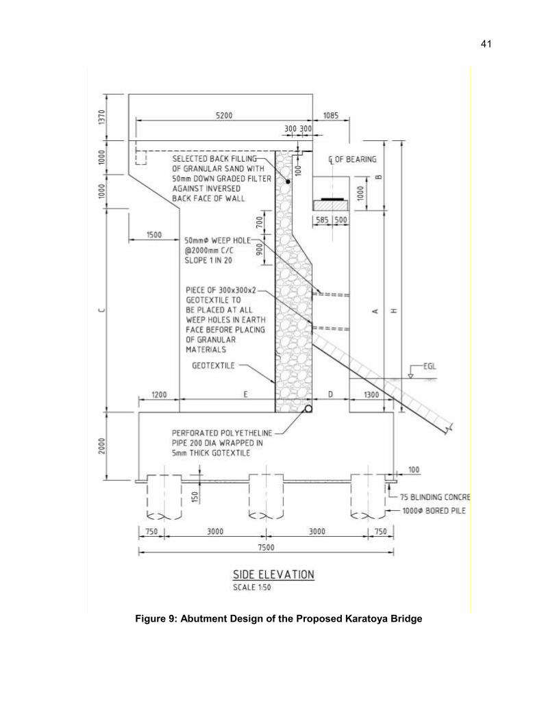
41
Figure 9: Abutment Design of the Proposed Karatoya Bridge

42
G. Rail over Bridges (ROBs)/Flyovers and Overpasses
123. To improve road efficiency and safety, one flyover and several pedestrian overpasses are proposed in Hatikamrul-Rangpur road. The list of these structures is given at Table 12.
Table 12: Details of Proposed Flyovers and Pedestrian Overpasses in Hatikamrul-Rangpur Road
Sl. No. Location Chainage Length (m) Width (m) Type of Structure 1 Bogra Railway 55+473 411.25 19.120 New Flyover 2 Chandaikona 16+836 38.2 3 New Overpass 3 Shrepur 33+527 38.2 3 New Overpass 4 Banani Bazar 50+340 35.2 3 New Overpass 5 Bogra Bus Stand 57+250 35.2 3 New Overpass 6 Mohasthan 68+127 35.2 3 New Overpass 7 Mokamtola 75+728 35.2 3 New Overpass 8 Gobindaganj 89+683 38.2 3 New Overpass 9 Palashbari 106+539 35.2 3 New Overpass 10 Pirganj 122+695 35.2 3 New Overpass 11 Mithapukur 141+478 35.2 3 New Overpass
H. Construction Material and Sources
1. Embankment Fills
124. The GOB has adopted a policy to encourage construction of roadway embankments with river sand rather than clayey agricultural soil. Accordingly, the embankments for new carriageways on this project have been designed based on the use of river sand with a CBR value estimated as 10% or greater. River sand is a good fill material with higher CBR value. It is quite abundant in the various riverbeds in the project area. Sand is easily compactable to a high degree of compaction but will require protection against erosion by cladding with a layer of cohesive soil.
2. Concrete Aggregate
125. Stone aggregates from Sylhet quarries are commonly used for the manufacture of normal and high strength concrete and it is proposed to be used for these roads as well. The major concreting operation for Jamuna Bridge was undertaken using stone aggregate from Sylhet sources. Aggregate of high strength concrete is likely to be imported from India also.
3. Cement and Steel Reinforcement
126. Bangladesh produces different classes of EN and ASTM standard cement and high strength deformed bar of 40, 60 and 75 grades. These materials are readily available in the project area.
4. Bitumen
127. Bitumen will be imported. Commonly used bitumen in the road construction industry in Bangladesh is 60-70 and 80-100 penetration grade bitumen. For Bangladesh temperatures 60-70 grade is better suited but the supply of this grade is limited.

43
5. Recycled Pavement Materials
128. The preliminary design envisages recycling pavement materials by milling the existing asphalt concrete and re-using the product. This recycled asphalt concrete mixed with unbound base and sub-base materials shall be used in the sub-base or lower base of the new carriageways.
I. Establishment of Road Research and Training Centre (RRTC)
129. The Technical Assistance for Subregional Road Transport Project Preparatory Facility recommended to combine Bangladesh Road Research Laboratory (BRRL) and Roads and Highways Department Training Centre (RHDTC) and establish a new Centre of Excellence for quality control, research and training for human resource development. This new institution, to be named Road Research and Training Centre (RRTC) will support RHD’s road sector development strategy and road operation, and aims to an enhanced holistic approach to quality management, applied sector-specific research and development of skills needed to manage and achieve improvements in road network service quality levels.
130. The Road Research and Training Centre will establish a) RHD Training Centre and ICT; and b) Road Research and Laboratory. The Training Centre and ICT will comprise training / class rooms, conference room, network and computer training room, office, and living accommodation. The Road Research and Laboratory will include research centre, laboratory, equipment hall, office, computer laboratory, auditorium, and internal mosque.
131. The proposed 10-storey RRTC building will cover gross area of about 185,000 sq. ft. and will include parking facility with 100 slots. The building will be established inside the RHD Headquarter in Mirpur, Dhaka.
J. Establishment of Road Operations Unit (ROU)
132. The Road Operations Unit (ROU) will be established and implemented initially along the Dhaka-Elenga-Hatikamrul-Rangpur (Dhaka-Northwest international trade corridor). The ROU will focus on pilot good practices on overloading control, road asset management and road safety. The ROU will establish axle load control stations, required facilities and equipment, business models (operation plan and staffing plan), enforcement mechanism engaging other agencies, and safety provisions to reduce the safety vulnerability.
133. There will be 3 ROU located 01 at Chandra (Chainage 17+000 km from Joydevpur on SASEC-I Project area), 01 at Hatikamrul (Chainage 107+00 km from Joydevpur on SASEC-II Project area and 01 at Polashbari (Chainage 207+00 km from Joydevpur on SASEC-II Project area.
K. Existing Traffic and Forecast
134. The type of traffic considered for traffic assessment and forecast includes (i) normal traffic which is using the existing corridor, and (ii) generated traffic likely to arise from reduced transport costs. The existing weighted average Annual Average Daily Traffic (AADT) as per the traffic studies carried out for 2011 including two and three wheelers and forecast traffic are given at Table 13.
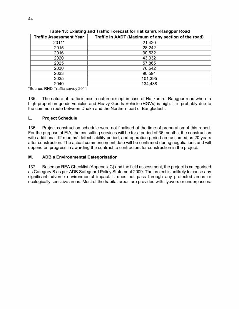
44
Table 13: Existing and Traffic Forecast for Hatikamrul-Rangpur Road Traffic Assessment Year Traffic in AADT (Maximum of any section of the road)
2011* 21,420 2015 28,242 2016 30,632 2020 43,332 2025 57,865 2030 76,542 2033 90,594 2035 101,395 2040 134,488
*Source: RHD Traffic survey 2011
135. The nature of traffic is mix in nature except in case of Hatikamrul-Rangpur road where a high proportion goods vehicles and Heavy Goods Vehicle (HGVs) is high. It is probably due to the common route between Dhaka and the Northern part of Bangladesh.
L. Project Schedule
136. Project construction schedule were not finalised at the time of preparation of this report. For the purpose of EIA, the consulting services will be for a period of 36 months, the construction with additional 12 months’ defect liability period, and operation period are assumed as 20 years after construction. The actual commencement date will be confirmed during negotiations and will depend on progress in awarding the contract to contractors for construction in the project.
M. ADB’s Environmental Categorisation
137. Based on REA Checklist (Appendix C) and the field assessment, the project is categorised as Category B as per ADB Safeguard Policy Statement 2009. The project is unlikely to cause any significant adverse environmental impact. It does not pass through any protected areas or ecologically sensitive areas. Most of the habitat areas are provided with flyovers or underpasses.

45
VI. DESCRIPTION OF THE ENVIRONMENT
A. General
138. The baseline condition of environmental quality in the locality of project site serves as the basis for identification, prediction and evaluation of impacts. The baseline environmental quality is assessed through field studies within the impact zone for various components of the environment, viz. air, noise, water, land and socio-economic, etc.
139. Information of baseline environmental status of the project area is useful for impact assessment process of assessing and predicting the environmental consequences of the significant actions. Based on the existing environmental scenario potential impacts of road improvement will be identified and accordingly management plan will be proposed in forthcoming sections. The baseline environmental conditions will help in comparing and to monitor the predicted negative and positive impacts resulting from the project during pre-construction, construction and operation phases. Significant action depicts direct adverse changes caused by the action and its effect on the health of the biota including flora, fauna and human being, socio-economic conditions, current use of land and resources, climate change aspects, physical and cultural heritage properties and biophysical surroundings. Baseline data generation of the following environmental attributes is essential in EIA studies.
140. Data was collected from secondary sources for the macro-environmental setting like climate (temperature, rainfall, humidity, and wind speed), physiography, geology etc. Firsthand information have been collected to record the micro-environmental features within and adjacent to the project corridor. Collection of primary information includes extrapolating environmental features on proposed road design, tree inventories, location and measurement of socio-cultural features adjoining proposed road. Ambient air, noise, soil and water quality samples were collected at important locations in terms of environment quality to prepare a baseline database. Consultation was another source of information and to explain local environmental conditions, impacts, and suggestions, etc.
141. The following section describes the baseline environment in three broad categories:
Physical Environment- factors such geology, climate and hydrology; Biological Environment- factors related to life such as flora, fauna and ecosystem; Socio-economic Environment- anthropological factors like demography, income,
land use and infrastructure.
B. Physical Environment
1. Climate
142. Although less than half of Bangladesh lies within the tropics, the presence of the Himalaya mountain range has created a tropical macroclimate across most of the east Bengal land mass. Bangladesh can be divided into seven climatic zones (Rashid 1991). According to the classification, the project area is located in the North-western climatic zone (Figure 4.2). Except that the extremes are less and the rainfall is lower. In summer the mean maximum temperature is well above 32°C whereas in winter the mean minimum is below 10°C. The summer is dry, with a scorching westerly wind, but the rainy season is very wet, with 2,000 to 3,000 mm of rainfall. The lower rainfall makes this area both atmospherically and pedologically drier (Banglapedia, 2012).

46
143. Like other parts of the country, the project area is heavily influenced by the Asiatic monsoon, and it has these three distinct seasons:
Pre-monsoon hot season (from March to May), Rainy monsoon season (from June to October), and Cool dry winter season (from November to February).
144. The pre-monsoon hot season is characterized by high temperatures and thunderstorms. April is the hottest month in the country with mean temperatures ranging from 27°C in the east and south, to 31°C in the west-central part of the country. After April, increasing cloud-cover reduces the temperature. Wind direction is variable during this season, especially during the early part. Rainfall, mostly caused by thunderstorms, at this time can account for 10 to 25 percent of the annual total.
145. The rainy monsoon season is characterized by southerly or south-westerly winds, very high humidity, heavy rainfall and long periods of consecutive days of rainfall. The monsoon rain is caused by a tropical depression that enters the country from the Bay of Bengal. About 80% of the annual precipitation occurs during the five-month monsoon season from May to September.
146. The cool dry season is characterized by low temperatures, cool air blowing from the west or northwest, clear skies and meagre rainfall. The average temperature in January varies from 17°C in the northwest and north-eastern parts of the country to 20°C to 21°C in the coastal areas. Minimum temperatures in the extreme northwest in late December and early January reach between 3°C to 4°C.
2. Temperature
147. Long-term average monthly temperature data (1991-2012) collected at Rangpur and Bogra weather station of Bangladesh Meteorological Department. The highest temperature recorded in the two weather stations Rangpur and Bogra have been 37.8 °C and 38.2 °C in May accordingly. The lowest temperature recorded at the two weather stations Rangpur and Bogra were found in the same month January which were 7.2°C and 7.9 °C respectively (Figure 10). Both of the average monthly temperature graphs show that these two areas face high temperature from March to May and lowest temperature during winter remains from December to February in the year.
Figure 10: Average Monthly Maximum and Minimum Temperature at Rangpur and Bogra Station (1991-2012)
0
10
20
30
40
50
Tem
per
atu
re (
°C)
Average Monthly Maximum and Minimum Temperature (°C)Maximum MinimumRangpur Station Bogra Station

47
(Source: Rashid, 1991) Figure 11: Climatic Zones
3. Rainfall
148. The rainfall data collected from the two above stated stations represents that maximum rainfall occurs during May to September and the lowest rainfall occurs in November to February during winter season. Statistical data of 1991 to 2012 shows that both stations experience more than 300 mm rainfall in June and September months during monsoon. In the month of November, December and January of winter season around 10 mm rainfall occurred in the region of Rangpur and Bogra stations (Figure 12).

48
Figure 12: Average Monthly Total Rainfall at Rangpur and Bogra Station, 1991-2012
Humidity
149. Humidity is the amount of water vapour in the air. There are three main measurements of humidity: absolute, relative and specific. Relative humidity is an important metric used in weather forecasts and reports, as it is an indicator of the likelihood of precipitation, dew, or fog. While humidity itself is a climate variable, it also interacts strongly with other climate variables.
Figure 13: Average Monthly Humidity at Rangpur and Bogra Station, 1991-2012
150. Humidity remains high in summer and comparatively low in winter season. The statistical data of humidity from 1991 to 2012 indicates that humidity in the above two stated areas are more than 70% through the year. However, humidity falls 70% in March during the winter season in the considered areas (Figure 4.4).
4. Wind Speed
151. Prior to the onset of the monsoon in March and April, hot conditions and thunderstorms prevail while winds gradually start blowing from the south or southwest - a pattern that continues throughout the monsoon period. Winds are generally stronger in the summer than they are in winter. The direction of prevailing winds is generally consistent during the winter and monsoon
0
100
200
300
400
500
Jan Feb Mar Apr May Jun Jul Aug Sep Oct Nov Dec
Rai
nfal
l in
mm
Average Monthly Rainfall in mm (1991-2012)
Rangpur Bogra
0.0
20.0
40.0
60.0
80.0
100.0
Jan Feb Mar Apr May Jun Jul Aug Sep Oct Nov Dec
Re
lati
ve H
um
idit
y in
%
Average Monthly Relative Humidity in % (1991-2012) Rangpur Bogra

49
seasons and more variable during the transition periods. The Himalayan mountains are influence wind patterns. Recirculation of winds during the monsoon season under the influence of the Himalayas can result in winds circling to the east–southeast in the northern parts of the country.
152. The statistical wind speed data (Figure 14) shows that wind speed at Rangpur was comparatively higher than the area of Bogra. Wind speed remained maximum with 4.1 knots in April and 2.9 knots in April and May for Rangpur and Bogra stations respectively. The minimum wind speed was 2.9 knots and 0.7 knots for Rangpur and Bogra stations accordingly in the month of January and November.
Figure 14: Average Monthly Maximum Wind Speed at Rangpur and Bogra Station, 1991-
2012
5. Physiographic Features
153. Physiography is the description of the physical nature (form, substance, arrangement, changes) of objects, especially of natural features. Physiographic region/unit refers to a region of which all parts are similar in terms of physical characteristics and which have consequently had a uniform geomorphic history, and whose pattern of topographical features or landforms differs significantly from that of adjacent regions.
154. In the context of physiography, Bangladesh can be divided into three broad categories based on topography, physical features, and geological history (Brammer 1996):
Floodplains Terraces Hills
155. Within these 3 broad categories, a number of authors have further divided the land surface into a series of Physiographic Units based on a combination of topographical/landscape features, underlying geology and surface soils (Bramer, 1996, Rashid, 1991, Morgan and McIntyre, 1959). The most recent study was undertaken by the Soil Resource Development Institute (SRDI) who further refined the previous classifications into 26 Physiographic Units (20 primary units and 6 sub-units) based on an assessment of more recent and detailed data (SRDI, 1997).
0.0
1.0
2.0
3.0
4.0
5.0
Jan Feb Mar Apr May Jun Jul Aug Sep Oct Nov Dec
Win
d S
pee
d in
kn
ots
Average Monthly Maximum Wind Speed in knots (1991-2012)
Rangpur Bogra

50
156. The Hatikamrul-Rangpur road alignment area lies mostly in the north-western part of the country and depends on the Teesta River for freshwater supply. The entire road alignment runs through the following two physiographic units 2 and 16a (Figure 15).
Photograph 1: Physiography of the Project Area.
Tista floodplain (2) - A big sub-region stretches between the Old Himalayan
Piedmont Plain in the west and the right bank of the N-S flowing Brahmaputra in the east. An elongated outlier representing the floodplain of the ancient Tista extends up to Sherpur (Bogra district) in the south. Most of the land is shallowly flooded during monsoons. There is a shallow depression along the Ghaghat river, where flooding is of medium depth. The big river courses of Tista, Dharla and Dudhkumar cut through the plain. The active floodplain of these rivers, with their sandbanks and diyaras, is usually less than six kilometres wide (Banglapedia, 2012).
Barind Tract (16a): It comprises mid and lower western part of Rajshahi division, between the Ganges and Brahmaputra. The largest one of the three Pleistocene upland blocks, the Barind Tract spreads over an area of about 7,770 sq km. In the south, the Barind Tract is an older pleistocene terrace forming a small plateau with a flat or in some sectors a slightly undulating surface. This terrace consists of reddish and yellowish and partially mottled clays and is characterised morphologically by a dendritic drainage pattern, which is typical of all older Pleistocene terraces in Bangladesh. The Barind unit is comparatively at higher elevation than the adjoining floodplains. The contours of the tract suggest that there are two terrace levels one at 40m and the other between 19.8 and 22.9m. Therefore, when the floodplains go under water during monsoon the Barind Tract stands free from flooding and is drained by a few small streams. About 47% of the Barind region is classified as highland, about 41% as medium-high land, and the rest are lowland. The depression at the southeast of the Barind Tract is called the Bhar Basin. It includes parts of Rajshahi and Pabna districts, with its centre in the vast marshy area called the Chalan Beel (Banglapedia, 2012).
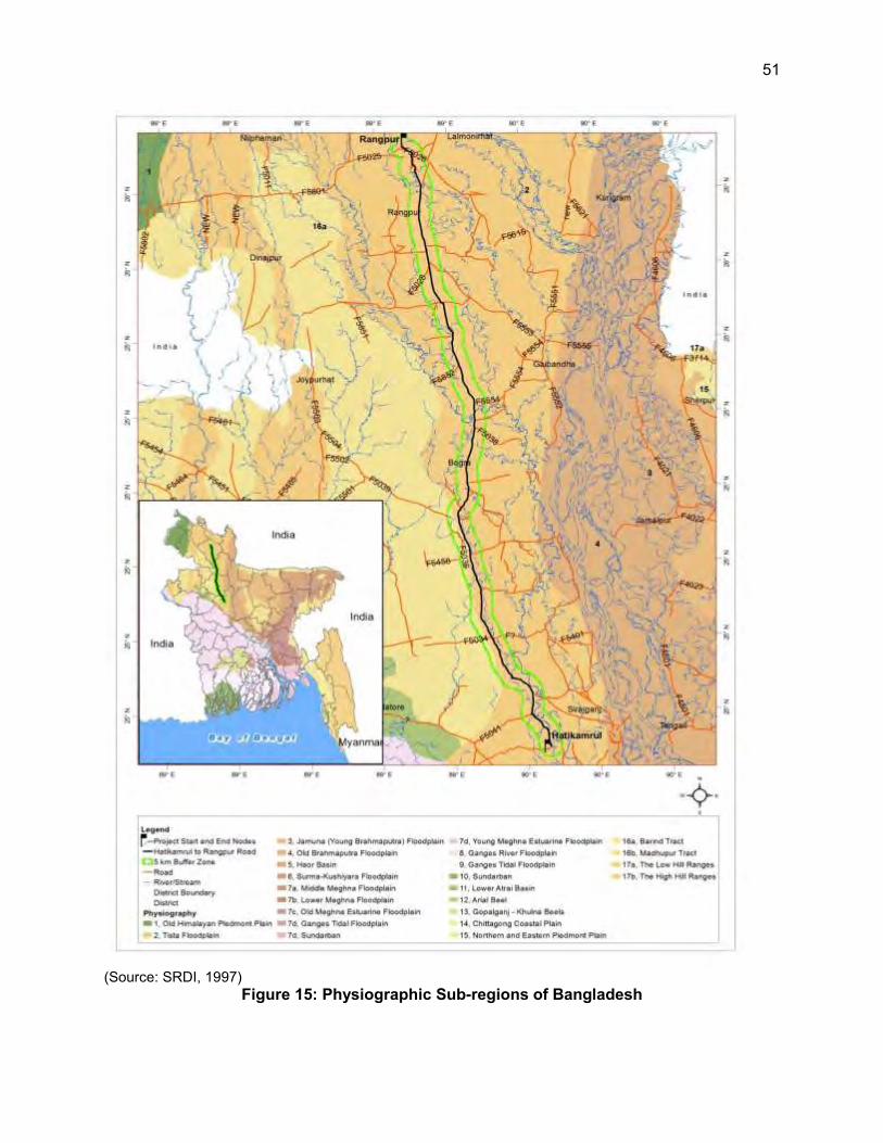
51
(Source: SRDI, 1997) Figure 15: Physiographic Sub-regions of Bangladesh

52
6. Topography
157. Topography is the configuration of a land surface including its relief and contours, the distribution of mountains and valleys, the patterns of rivers, and all other features, natural and artificial, that produce the landscape. Although Bangladesh is a small country, it has considerable topographic diversity. It has three distinctive features: (i) a broad alluvial plain subject to frequent flooding, (ii) a slightly elevated relatively older plain, and (iii) a small hill region drained by flashy rivers.
158. The general topography of the project area comprises floodplains in the majority of the road and terraces. The topography of the project area slopes from north to south with elevation ranged from 32 m a.m.s.l to 15 m a.m.s.l (Figure 16).
Figure 16: Topography

53
7. Geology
159. Bangladesh is situated to the east of the Indian sub-continental plate. Nearly 85% of Bangladesh is underlain by deltaic and alluvial deposits of the Ganges, Brahmaputra, and Meghna river systems. The project area consists of Holocene alluvial deposits flood plain and predominantly consisting of fine sand, silts and clay. The site is on deep Cenozoic deposits that overlie Precambrian basement rock. The Precambrian rocks form the basement of all geological formations of Bengal Basin and shield areas. The materials deposited are a mixture of sediments transported by the old Brahmaputra and by the Jamuna (Brahmaputra) River. The generalized geological features of the project area are shown in the geological map of Bangladesh (Figures 17).
Rangpur Saddle represents Indian Platform and connects the Indian Shield with the shillong massif and the Mikir Hills. Shillong Massif is a large thrust block of the Indian Shield. In Rangpur Saddle the basement is the most uplifted and is covered with thin sedimentary deposits. In Madhyapara area of Dinajpur the basement is only 130m deep from the ground surface and is overlain by Dupi Tila Sandstone and Madhupur Clay of Plio-Pliestocene age. Rangpur Saddle can be divided into 3 parts- Rangpur Saddle, Northern Slope of Rangpur Saddle and Southern Slope of Rangpur Saddle. The basement plunges gently from Madhyapara towards the southeast upto the Hinge Zone, which is known as the Southern Slope of Rangpur Saddle. The tentative boundary of the Rangpur Saddle with the northern and the southern slopes has been marked at approximately 700m contour line on the basement. It separates the Bengal Foredeep and the Himalayan Foredeep. The Northern Slope of Rangpur Saddle also known as Dinajpur Slope, occupies the north western part of Rangpur-Dinajpur districts and gently slopes towards the Sub-Himalayan Foredeep with dips 3-4° which sharply increases in Tetulia area (Banglapedia, 2012).
Bogra Shelf represents the southern slope of Rangpur Saddle which is a regional monocline plunging towards southeast gently to Hinge Zone. This zone marks the transition between the Rangpur Saddle and the Bengal Foredeep from depositional as well as structural point of view. The width of Bogra Shelf varies from 60-125 km up to the Hinge Zone and the thickness of the sedimentary sequence increases towards the southeast (Banglapedia, 2012).
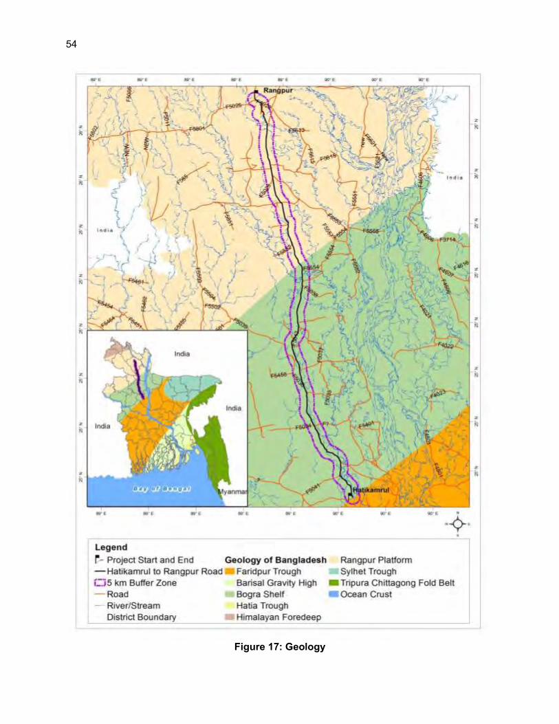
54
Figure 17: Geology

55
8. Seismicity
160. Seismic Zone expression of the proneness of a region to earthquake occurrence in the historical past including the expectations in future. A region experiencing more frequent and large earthquakes has a higher seismicity compared to one with less frequent and small earthquakes. Both the temporal and spatial distributions of all earthquakes, small and big, have to be systematically accounted for by determining their past behaviour to determine the future trend.
161. Bangladesh is situated in one of the most tectonically active regions in the world. Here is where three major plates meet (the Indian Plate, the Tibet Sub-Plate, and the Burmese Sub-Plate). The project area is located over the Indian Plate, which is moving north. However due to the location of relevant plates, fault lines and hinge zones, Bangladesh itself is divided into three seismic zones (Table 14), based on the ranges of the seismic coefficient (note: the seismic coefficient is a measure of how strong an earthquake has the potential to be based on a combination of the mass of the plate and the seismic forces acting on it, as well as how frequently these quakes are likely to occur). As per the seismic zone map (Figure 17), project road falls in zone II means medium seismic intensity. There is no evidence of major earthquakes in the project areas in the past.
Table 14: Seismic Zonation of Bangladesh
Zoning Area Mercalli Scale Bask Seismic Coefficient
I North and eastern regions of Bangladesh (Seismically most active)
0.08
II Lalmai, Barind, Madhupur Tracts, Dhaka, Comilla, Noakhali and western part of Chittagong Folded belt.
0.05
III Khulna division S-E Bangladesh (Seismically relatively quiet)
0.04
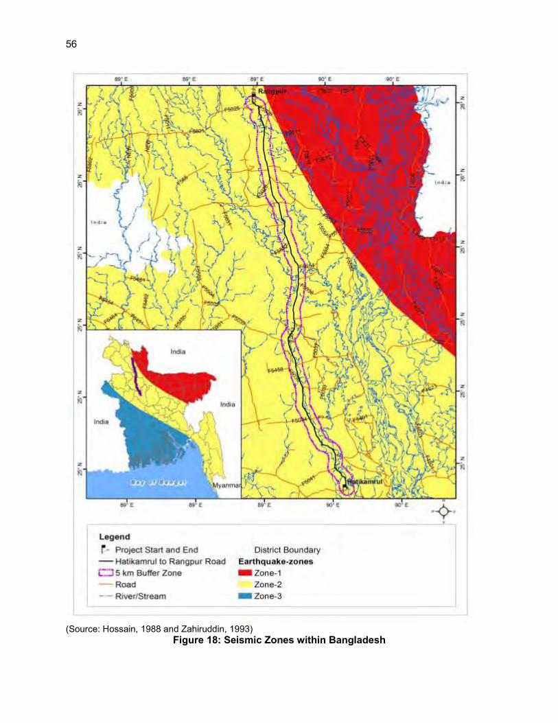
56
(Source: Hossain, 1988 and Zahiruddin, 1993) Figure 18: Seismic Zones within Bangladesh

57
9. Soil
162. The project road passes through three different soil formation zones (Figure 19). The general soil types of the project road area predominantly include the following:
Grey floodplain soil (5): Generally comprise grey topsoil and a cambic B-horizon in the subsoil with a grey matrix or grey gleans. They extensively occupy Teesta, Karatoya-Bangali, Jamuna, middle Meghna and eastern Surma-Kushiyara floodplains. However, there are considerable regional differences in the proportions occupied by individual soil textures. Silt loam texture is dominant in the Teesta meander floodplain whereas silty clays are predominant in the Ganges tidal floodplain and in the Surma-Kushiyara floodplain. But the Jamuna floodplain has a more even distribution of silt loam, silty clay loam and silty clays. Most of these soils have been included in Eutric Gleysols (Banglapedia, 2012).
Red-brown terrace soil (18): This type of soil can be divided into two classes; one is shallow red-brown terrace soil and deep red-brown terrace soil. Shallow red-brown terrace soil occurs extensively on gently undulating to rolling relief on the Madhupur Tract and locally in the Barind tract. They are pale olive-brown to reddish-brown soils overlying grey, little altered, Madhupur Clay at less than 90 cm depth. The subsoil ranges from a porous yellow brown loam to olive brown, strong or reddish brown structured clay in different soils. Generally these soils are strongly to extremely acidic. The majority of them have been classified as Haplic and Gleyic Alisols. Deep Red Brown Terrace soils Occur extensively in the north-eastern Barind Tract, on the Madhupur Tract and on the Akhaura Terrace. These soils are well to moderately well drained, reddish brown to yellow-brown, strongly to extremely acidic, friable clay soils over deeply weathered, red-mottled, Madhupur Clay. They are mainly Ferric Alisols (Banglapedia, 2012).
Grey terrace soil (19): This type of soil can be divided into three classes. These are shallow grey terrace soils, deep grey terrace soils and grey valley soils. Shallow Grey Terrace soils occur extensively on the level Barind Tract and the high Barind Tract. The soils are grey, silty and poorly drained, which overlie heavy, grey, little-altered Madhupur Clay at a shallow depth. Below the cultivated layer, there is an E-horizon. They have been classified as Eutric Planosols. Deep Grey Terrace soils Occupy extensive parts of the north-eastern Barind Tract and the Madhupur Tract. They also occur in the northwest of the Northern and Eastern Piedmont Plains. The soils are poorly drained, grey and silty and overlie pervious, deeply weathered Madhupur or Piedmont clay. The major part of the subsoil is an E-horizon. The majority of these soils are Albic Gleysols, Gleyic Luvisols and Gleyic Alisols. Grey Valley soils are broadly similar to deep grey terrace soils but differ from them in being developed in valleys and in generally not overlying a strongly red-mottled clay substratum. They are Albic and Eutric Gleysols (Banglapedia, 2012).

58
Figure 19: General Soil Classification of the Project Area

59
10. Agroecological Zones within the Project Area
163. A 1988 study carried out by the United Nations Development Program (UNDP) classified Bangladesh into a series of Agroecological Zones (AEZs) based on an assessment of commonalities in characteristics such as physiography, soil types, climate and drainage. In total, 34 regions were identified and characterized, however this information has been updated and further refined on numerous occasions since the original study was undertaken.
164. The purpose of assessing the AEZs within the project area is to establish a broad overview of expected soil conditions which can be compared against more detailed, Upazila-level data sources.
165. The most recent assessment was completed by the Soil Resource Development Institute (SRDI, 1998) which classified Bangladesh into 30 AEZs. The project area contains 3 AEZs (refer Figure 20), namely:
Teesta Meander Floodplain (3): This region occupies the major part of the Teesta floodplain as well as the floodplain of the Atrai, little Jamuna, Karatoya, Dharla and Dudhkumar rivers. Most areas have broad floodplain ridges and almost level basins. There is an overall pattern of olive brown, rapidly permeable, loamy soils on the floodplain ridges, and grey or dark grey, slowly permeable, heavy silt loam or silty clay loam soils on the lower land and parent materials medium in weatherable K minerals. Eight general soil types occur in the region, moderately acidic throughout, low in organic matter content on the higher land, but moderate in the lower parts. Fertility level is low to medium. Soils, in general, have good moisture holding capacity (Banglapedia, 2012).
Karatoya-Bangali Floodplain (4): This region is very similar to the Teesta Meander Floodplain in physiography and soil, and comprises a mixture of Teesta and Brahmaputra sediments. Most areas have smooth, broad, floodplain ridges and almost level basins. The soils are grey silt loams and silty clay loams on ridges and grey or dark grey clays in basins. Five general soil types occur in the region, of which non-calcareous grey floodplain and non-calcareous dark grey floodplain soils predominate. The soil is moderately acidic throughout. Organic matter contents are generally low in the cultivated layer of ridge soils and moderate in basins. General fertility is medium. The eastern half of Bogra and most of Sirajganj districts are included in this zone (Banglapedia, 2012).
North Eastern Barind Tract (27): This region occupies several discontinuous areas on the north-eastern margins of the Barind Tract. It has silty or loamy topsoil and clay loams to clay subsoil. The soils are strongly acidic in reaction. Organic matter in the soils is low. General fertility is poor (Banglapedia, 2012).
166. The nature and soil characteristics of these zones influence the crops and cropping patterns within the region. Human interventions and modifications in the drainage patterns have already affected the cropping calendar, crop diversity and introduction of new varieties and agricultural products.

60
Figure 20: Agroecological Zones of the Project Area

61
11. Soil Quality
167. According to the United States Department of Agriculture (USDA) Natural Resources Conservation Service, soil quality is the capacity of a specific kind of soil to function, within natural or managed ecosystem boundaries, to sustain plant and animal productivity, maintain or enhance water and air quality, and support human health and habitation. The soil in the project area is highly productive and suitable to support different ecosystems in balance. The land in this area is mostly used for agricultural cultivation and there are a lot discrete water bodies for fish cultivation. During the construction phase of the project, road embankment will be built by carried earth. Hence, there is the chance of the native soil to be disturbed by the external carried earth. There has the priority of using the dredged earth from the rivers along the road alignment instead of using the local soil from the local land. This is why; soil sample in 1 m depth from the bed of the Fuljor River and Karatoya River will be analysed in the environmental laboratory of BUET to assess the current soil quality of the dredged material. Table 15 reflects the test results of the soil sample collected from the bed of the two rivers. Test report (see Appendix D) of soil analysis proofs that river bed material (sand) of the Fuljor and Karatoya Rivers contains acceptable amount of Arsenic (As), Lead (Pb), Zinc (Zn) and Mercury (Hg) comparing with the standard of EU Directive 86/278/EEC for land application. That is why; sand from the two rivers can be used for developing project Road Embankment.
Photograph 2: Riverbed Materials Collection at Karatoya River, Gaibandha and Fuljor
River, Sirajganj
Table 15: Test Results of Soil Quality
Parameter
Concentration Present (ppm) EU Directive 86/278/EEC
for Land Application
Method of Analysis
Fuljor River Location: 24° 26' 54.2" N 89° 32' 50.3" E
Karatoya River Location: 25° 10' 26.0" N 89° 23' 18.1" E
Arsenic (As) 10.59 1.178 - USEPA 206.2; SM 3113 B Lead (Pb) 5 8 1200 USEPA 200.9 Rev 2.2;SM 3111 B Zinc (Zn) 21.8 40.7 4000 USEPA 200.9; SM 3111 B Mercury (Hg) <MDL 103 25 ----------- Cadmium (Cd) <MDL <MDL 40 USEPA 213.2; SM 3113 B Copper (Cu) 6.7 11.8 1750 ----------- Chromium (Cr) 11.3 23.6 - USEPA 200.9 Rev 2.2;SM 3111 B
Source: Lab Analysis, February 2014, BUET

62
12. Water Resources and Hydrology
168. Bangladesh is located over a subsiding basin of tectonic origin overlain with a great thickness of sedimentary strata. This sedimentary stratum is an unconsolidated alluvial deposit of recent age overlaying marine sediments. The recent delta and alluvial plains of the Ganges, Brahmaputra and the Meghna Rivers constitute the upper formation. The near surface Quaternary alluvium contains good aquifer characteristics (transmission and storage coefficients). The groundwater (GW) storage reservoir has three divisions: upper clay and silt layer, a middle composite aquifer (fine to very fine sand) and a main aquifer consisting of medium to coarse sand. Drinking water is generally taken from deep tube wells with strainers set between depths of 200 metres to around 400 metres (DPHE, 2011). The Ground water level is at or very close to the surface during the monsoon; whereas, it is at maximum depth during the months of April and May (Banglapedia, 2012).
169. Surfarce Water. There are two major surface water bodies surrounding the project area which are Fuljor River and Karatoya River. The project road alignment crosses all the rivers at several locations (Figure 21). There are also significant numbers of beel and khal in and around the project locations. Besides, there are remarkable numbers of ponds and ditches available in the project area. Most of the water bodies become waterless or contain minimum amount of water during the dry season and gets water in rainy season. People use the water from the river, khal, canal and ponds for washing, bathing and irrigation purposes. In the wet season, substantial amount of the land in the area is inundated due to flood. In the dry season local canals and channels provide water for irrigation for boro cultivation and for growing winter crops. Table 16 represents the affected water bodies and fish resources in the RoW of the project road alignment.
Photograph 3: Water Bodies along the Hatikamrul-Rangpur Road.

63
Figure 21: River Network Table 16: Water Bodies and Fish Resources within the Rows of
the Alignment

64
Type of Water Bodies
Total No. of Water Bodies
Area (ha) Affected Total Fish Production
Total Area Affected Area MT/ha/Year6 Total
Production (MT) River - - - - Canal 4 2.14 1.63 - - Pond 87 25.19 7.60 1.25 9.5 Khal - - - - Ditch 285 30.13 16.67 0.60 10.00
Borrowpit 3 3.20 0.81 0.60 0.47 Hatchery 7 3.74 0.51 - -
170. Surface Water Quality. To assess the current quality of ground and surface water, water samples were collected from two locations along the whole alignment.
171. The overall quality of surface water around the project site and its surroundings varies throughout the year. Typically water quality improves during the monsoon due to the influx of fresh rainwater, and worsens during the dry season as water evaporates and the concentration of contaminants increases.
172. In March 2017, surface water samples were collected by environmental team from several water bodies (at major bridge site two samples were collected from 50 m upstream and 50 m downstream of bridge location) along the project corridor. The Bangladesh Council of Scientific and Industrial Research (BCSIR) analysed the samples (See Appendix E). The result of the surface water samples are shown in Table 17.
Photograph 4: Surface Water Collection from along the Project Road
6 Production in MT/ha/Year has been given based on the information collected from the owners of the water bodies

65
Table 17: Test Results for Surface Water Field Samples
SL No. Sample ID Sampling Location
Results
pH Total Organic Carbon (TOC) Total phosphate (PO₄)
Total Suspended Solids (TSS)
Dissolved Oxygen (DO)
Oil and Grease
Method of Analysis pH Meter
Wet Oxidation Method Followed by Potentiometric
Titration
Vanadomolybdophosphoric Yellow Color Method
Gravimetric Method DO Meter APHA
5520.B
Unit - ppm ppm mg/L mg/L mg/L 01 SW 01 Terminal Road, Bogra 7.22 3.16 4.95 58.21 6.24 18.2 02 SW 02 Mithapukur Post Office Road, Bogra 6.88 6.42 7.35 141.53 6.05 5.20 03 SW 03 BoroBila, Pirganj Bus Stand, Bogra 6.93 6.35 4.58 148.50 7.46 5.40 04 SW 04 Korotoya River, Nauda Para 6.86 3.16 4.52 50.21 7.70 7.60 05 SW 05 Korotoya River, TMSS, Gokul 7.45 6.29 3.48 62.34 7.72 4.00
06 SW 06 Akhira River, Dhaperhat Bazar, Pirganj 7.30 6.39 4.22 195.21 6.86 3.40
07 SW 7.1 (50m US) Bangali River, Gobindoganj 7.64 6.41 4.65 102.35 7.73 9.60
08 SW 7.2 (50m DS) Bangali River, Gobindoganj 6.92 6.28 6.06 130.63 5.23 15.4
09 SW 08 Shathibari High School Pond, Rangpur 7.21 12.63 5.81 183.02 5.26 16.0
10 SW 09 PairabandMozaPukur, Rangpur 6.84 6.37 7.83 198.51 5.31 16.0
11 SW 10.1 (50m US) Ghaghat River 7.28 9.52 3.67 135.21 7.64 6.00
12 SW 10.2 (50m DS) Ghaghat River 7.72 9.48 4.03 112.41 7.02 10.0
13 SW 11 Majhira, Cantonment Pond, Bogra 7.22 15.84 6.79 212.59 5.10 9.60 14 SW 12 Mirapur, Shollaghati Pond, Bogra 7.32 32.12 63.50 316.35 1.01 6.80
15 SW 13.1 (50m US) Chandiakona, Bogra Bazar, Bogra 7.37 18.94 4.22 253.81 1.47 7.40
16 SW 13.2 (50m DS) Bhuiyagati, Bogra 7.22 12.61 5.26 222.79 2.96 11.4
17 SW 15 Hatikumrul, Shahebganj 7.33 2.42 < 0.2 < 5 4.88 < 5
Standards for Inland Surface Water (water usable for recreational activity)
6.5-8.5 No standard No standard No standard 5 or more No
standard Source: Lab Analysis, April 2017, BCSIR

66
173. Groundwater. The groundwater resources in the project area are found in three separate aquifers. An upper aquifer: a surface layer consisting mainly of clay and silt, characterized by high porosity but low permeability; composite aquifer: an intermediate layer of mainly fine sand and clay characterized by high porosity and moderate permeability (possibility of providing water with hand pumps); and main aquifer: a deeper layer, containing mainly fine to coarse sand. The main aquifer is characterized by high porosity and moderate to high permeability and is separated from the composite aquifer by a clay layer. Fresh groundwater is relatively carbonate-rich with low total dissolved solid contents of less than 500 milligrams/litre (mg/l). Arsenic is a problem in large part of Bangladesh ground water. The project area also has Arsenic levels in ground water varying from <1 microgram to 50 microgram per litre of water. The acceptable quantity of arsenic in potable water is 0.05 mg per litre under the Department of Environment standard and 0.01 mg per litre under the WHO standards (Figure 22).
174. Based on field observations and interviews with local residents it was found that groundwater in the area is used as a drinking water source in many instances, as well as for irrigation purposes. Water is generally extracted via hand pump (tube wells) from the shallow regions of the composite aquifer, and via machine-driven pumps (deep tube wells) which draw from the deeper main aquifers (Table 18). The groundwater reservoir usually recharges from rainfall, floods and river. In summer season, the water table slightly goes down and goes up in rainy season.
Table 18: Source of Drinking Water in the Project Area
District Upazila (sub-district) No. of Households Source of Drinking Water (%)
Tap Tube-well Others
Sirajganj Ullapara 123630 0.9 94.7 4.4 Raiganj 77104 0.7 95.4 3.9
Bogra
Sherpur 81639 3.8 93.7 2.5 Shajahanpur 72323 7.9 90.6 1.5 Bogra Sadar 129597 16.7 82.1 1.2
Shibganj 99124 1.1 95.8 3.0
Gaibandha Gabindaganj 132402 0.9 95.4 3.7 Palashbari 63178 0.6 96.2 3.2
Rangpur Pirganj 101485 0.4 97.9 1.7
Mithapukur 134898 0.3 97.4 2.3 Rangpur Sadar 163052 7.1 91.3 1.6
Source: Population Census, 2011
175. Groundwater Quality. In March 2017, groundwater samples were collected by environmental team from shallow tube wells in the project area. The Bangladesh Council of Scientific and Industrial Research (BCSIR) analysed the samples (See Appendix E). The result of the groundwater samples and the GoB standards for potable water (ECR, 1997) are shown in Table 19. The concentration of Mn is higher than the standard value of most the measured water sources and only Fe is higher at Hatikamrul. The microbial contamination was identified at Bogra Rail Gate and Mithapukur water sources.

67
Table 19: Results for Groundwater Field Samples
Parameters Unit Hatikamrul (GW-
02)
Sherpur
Bazar (GW-03)
Aria Bazar (GW-04)
Bogra Rail Gate
(GW-05)
Matidali, Biman More
(GW-6)
Polashbari
Chowmatha
(GW-07)
Mithipur Paurashava
(GW-08)
Mithapukur (GW-09)
Asshotpur, Parker Mor,
Rangpur (GW-10)
Drinking Water
Quality Standard,
DOE (ECR,97)
Method of Analysis
pH --- 7.20 6.02 6.84 6.95 6.66 6.56 5.99 6.47 6.76 6.5-8.5 pH Meter Total Hardness (as CaCO3)
ppm 172 40.05 27.41 26.79 81.19 73.43 50.38 47.43 10.73 200-500 Potentiometric Titration
Chloride (Cl-) ppm 2.66 40.05 27.41 26.79 81.19 73.43 50.38 47.43 10.73 150-600 Ion Chromatography
Manganese (Mn) ppm 0.67 0.144 0.017 0.363 0.584 0.522 0.031 0.191 0.026 0.1 AAS
Arsenic (As) ppm 0.022 0.00464 0.0062 0.0066 0.0029 0.003 0.0048 0.005 0.0041 0.05 AAS with HVG Unit
Iron (Fe) ppm 12.7 0.025 0.026 0.059 0.021 0.022 0.020 0.022 0.040 0.3-1.0 AAS Total Coliform (TC) CFU/100ml 0 0 0 24 0 0 0 15 0 0 Membrane
Filtration Fecal Coliform (FC) CFU/100ml 0 0 0 16 0 0 0 5 0 0 Membrane
Filtration Source: Lab Analysis, April 2017, BCSIR and icddr,b

68
Figure 22: Arsenic Concentrations in Groundwater

69
13. Ambient Air Quality
176. Existing ambient air quality data on various sections of the project corridors was collected to establish a baseline database. The aim was to identify areas that already have high pollution levels or are expected to experience so, on account of the road project, and to design adequate mitigation measures, as applicable.
177. The activities, which generate modify atmospheric air quality, are transportation (i.e., motor vehicle emissions, which are addressed in this report); industry; domestic and construction. The principal sources of air pollution due to road projects are hot mix plants and machinery used during construction phase and the vehicles that ply over it during the operation phase. The major pollutants of significance to roadside air quality, on account of vehicular emissions, are suspended particulate matter (SPM), sulphur dioxide (SO2), nitrogen oxides (NOx), hydrocarbons (HC), carbon-monoxide (CO), total volatile organic carbon (TVOC).
178. Dispersal of pollutants depends upon factors like prevailing wind direction and other weather conditions, atmospheric stability, height of the source, NOx, SOx or relevant to photochemical smog rather than roadside.
179. There are significant numbers of small and big factories/industries are located in the project areas; therefore, air pollution is comparatively higher than in other areas of Bangladesh. In addition, air pollution in the project area is from road dust, black smoke from diesel engines, construction dust, windblown dust from agricultural lands, domestic heating and cooking, industries, transportations and brick kilns. Photograph 5 shows the several sources of air pollution within the project area.
180. In order to monitor air quality at the different locations, the field investigation was undertaken during March, 2017. The parameters were obtained by monitoring over a period of 24 hours. Measured ambient air quality (data are recorded in Table 20. Photograph 6 shows a few snapshots of air quality monitoring processes and Photograph 7 shows the several sources of air pollution within the project area.
Photograph 5: Air quality measurement at the Project Road

70
Table 20: Ambient Air Quality in Different Locations along the Project Road
Air Quality Parameters Unit
Concentration Present Bangladesh
Standard (ECR, 2005) Hatikamrul Chandaikona
Bazar Nandigram -
Sherpur Noymail Bus
Stand Bir Shrestho
Square
Elenga – Gaibandha Rangpur
Intersection
Pirganj Bus Stand
Rangpur Parker Mor
GPS Location 24°27'12.21"N 89°42'9.94"E
24°34'8.17"N 89°29'2.64"E
24°40'11.15"N 89°24'58.66"E
24°43'29.99"N 89°23'47.65"E
24°50'50.90"N 89°22'21.78"E
25°17'4.21"N 89°21'4.25"E
25°25'5.41"N 89°18'54.77"E
25°42'57.32"N 89°15'44.66"E
Temperature C 26.15 23.55 25.95 28.39 25.83 25.47 22.76 23.82 Relative Humidity % 79.84 81.87 82.64 76.10 85.43 86.72 92.01 88.36
Wind Speed Km/h 0.14 0.09 0.34 0.62 0.11 0.09 0.20 0.17 Wind Direction Degree 194.570
South-West 148.580
South-East 95.980
South-East 183.610
South-West 237.530
South-West 229.230
South-West 280.400
North-West 165.060
South-East
O3 μg/m3 3.09 3.40 6.53 4.65 7.16 3.45 4.03 3.15
157 (8-hr Average) 235 (1-hr Average)
NOx μg/m3 92.42 34.82 99.86 120.70 99.37 66.60 55.17 53.39 100 (annual)
SO2 μg/m3 9.85 7.46 10.40 12.60 6.50 10.64 14.82 4.68 80 (Annual) 365 (24-hr Average)
CO μg/m3 0.0 0.0 0.0 0.0 0.0 0.0 0.0 0.0
10 (8-hr Average) 40 (1-hr
Average) VOC ppm 0.0 0.0 0.0 0.0 0.0 0.0 0.0 0.0 NYS
PM10 μg/m3 65.78 86.95 159.72 145.17 133.92 70.07 93.75 66.66
50 (annual average)
150 (24-hr average)
PM2.5 μg/m3 27.77 42.62 63.13 88.56 71.68 30.88 40.32 37.63
15 (annual average) 65 (24-hr average)

71
181. The particulate matters, and oxides of nitrogen concentrations exceeded the DoE allowable limit at several measured locations along the project road. Human activities, such as the burning of fossil fuels in vehicles, construction activities and various industrial processes also generate significant amounts of particulates. In the project area human activities are mainly responsible for the high concentration of particulate matters.
182. To assess the likely impacts on the ambient air quality due to the proposed road project, CALINE-4, a line source model developed by the California Transport Department, was used to predict carbon monoxide (CO) and particulate matter (PM) concentrations on the road. The model was run to predict hourly average CO, PM2.5 and PM10 concentrations generated from traffic movement on proposed highway. Details are in Appendix F.
183. Kerb side locations were selected to compare the model prediction with monitored locations. Compared with the actual measurements of PM2.5, PM10 and CO concentrations, the predicted concentrations of each pollutant is lower, as shown in Table 21.
Table 21: Predicted vs. Monitored Air Quality Parameters Parameter
Concentrations Monitored Predicted
PM2.5 (µg/m3)
PM10 (µg/m3)
CO (ppm)
PM2.5 (µg/m3)
PM10 (µg/m3)
CO (ppm)
Hatikamrul 27.77 65.78 0 18 29 0.1 Elenga – Gaibandha Rangpur Intersection
30.88 70.07 0 13 26 0
Pirganj Bus Stand 40.32 93.75 0 18 29 0 Rangpur Parker Mor 37.63 66.66 0 15 28.6 0
184. In addition, the spatial distribution of hourly average predicted CO, PM2.5 and PM10, concentrations have been plotted for peak traffic hour which shows that pollutant concentrations is decreasing the farther away from the highway corridor. Therefore, the impacts of traffic movement at proposed highway project will not impact the surrounding atmosphere.
Photograph 6: Sources of Air Pollution along the Hatikamrul-Rangpur Road

72
14. Noise Level
185. Excessive noise is a potential issue for both human and biological receivers and can cause a range of negative issues, from mild annoyance and moderately elevated levels of aggression to significant disturbance of behavioural patterns and in severe cases temporary or permanent hearing loss. According to World Health Organization’s Guidelines for Community Noise (1999), daily sound pressure levels of 50 decibels (dB) or above can create discomfort amongst humans, while ongoing exposure to sound pressure levels over 85 dB is usually considered the critical level for temporary hearing damage.
186. Two primary sources of noise have been identified in the project area:
Road Traffic: Road traffic is one of the major noise sources in the project area. The project road is common route of transportation for several districts. This highway carries a relatively high volume of both motorized and non-motorized vehicles, resulting in road traffic noise impacts along the road corridors.
Commercial Areas: There are some commercial or refreshment areas where always significant number of people gather and makes chaos continuously. This is another source of noise pollution along the road.
187. Monitoring of ambient noise levels was undertaken by the environment team at 07 locations for twenty four hours in March 2017 within the project area. The outcomes of this monitoring are presented in Table 22. Photograph 7 shows some of the snapshots during the monitoring phases.
188. Analysis of the noise data shows that the baseline noise around the project area varies from location to location. However, the noise levels at measured locations are higher than the standard set by the Bangladesh Noise Pollution Control rules.
189. Additionally, a noise analysis for different sections of the project road is carried out by noise modeling software. The predicted noise during operation period also indicates a high level noise at different places of the road. The noise analysis result using noise modeling software is given in Appendix F of this EIA report.
Photograph 7: Monitoring of Ambient Noise Level

73
190. Noise pollution propagation generated from traffic was predicted using Canarina CUSTIC 3.2 software, where noise emission from vehicles along the proposed Hatikamrul - Rangpur Road is modelled as steady state line source. Sensitive noise receptors along the corridor were identified such as educational institutions, health complexes and religious centres. Based on the model prediction, the predicted noise for the sensitive receptors is indicated in Table 22.
191. Based on the model prediction, the predicted noise for the following sensitive receptors will be exceeded by 2040, compared to the current scenario: (1) N5-28 Hatikamrul-Bhuyangati (Dadupur Sahebgonj Govt. High School, National Skill Development Institute, Royhati Madrasa Mor; (2) N5-31, Sherpur Int. with Z-5049)-Sherpur (Int. with Z-5401) (Krishnapur Govt. Primart School and Jameya Hafizia Madrasha); (3) N5-45, between Kashipur (Mokamtola)-Gabindaganj, Pakurtala, km 243.512 (Makamtola Mohila Degree College, Rahbol Girls High School and TMSS Health Complex); (4) N5-48, between Palashbari-Pirganj, Ekberpur, km 275.511 (R. V. Cold Storage Mosque, Dhaperhat Bazar and Lillah Boarding Madrasha); (5) N5-50, between Pirganj-Mithapukur, km 292.502 (unnamed Mosque); (6) N5-51, between Mithapukur-Rangpur Modern More, Pairabond, km 316.022 (N5-51, between Mithapukur-Rangpur Modern More, Pairabond, km 316.022, Islampur Mondon Para Mosque, Payrabondo Salehkiya Madrasa, and Drishtiprotibondhi School). Predicted noise levels ranged from 65 -73.7 Leq.
Table 22: Predicted noise for the year 2040 where there is exceedance vs. baseline data Segment
name Name of sensitive receptor
Type of establishment
Latitude Longitude Baseline noise (Leq) under
current traffic conditions
Predicted noise (Leq) for the year
2040
Comments (No change/
net increase in noise)
N5-28 Hatikamrul-Bhuyangati
Dadupur Sahebgonj Govt. High School
Educational 24.45099 89.5454 68.6 69.9 Marginal increase
National Skill Development Institute
Educational 24.46188 89.5375 71.0 73.7 Net increase
Royhati Madrasa Mor
Educational 24.47895 89.52355 70.1 73.4 Net increase
N5-31, Sherpur Int. with Z-5049)-Sherpur (Int. with Z-5401)
Krishnapur Govt. Primart School
Educational 24.63901 89.43226 57.6 70.6 Net increase
Jameya Hafizia Madrasha
Educational 24.66334 89.42091 61.8 70.4 Net increase
N5-45, between Kashipur (Mokamtola)-Gabindaganj, Pakurtala, km 243.512
Makamtola Mohila Degree College
Educational 25.01357 89.36747 63.8 65.0 Marginal increase
Rahbol Girls High School
Educational 25.05966 89.36947 63.4 68.3 Increase
TMSS Health Complex
Health 25.08785 89.3807 61.8 73.3 Increase
N5-48, between Palashbari-Pirganj,
R. V. Cold Storage Mosque
Religious 25.33883 89.34263 66.8 69.3 Increase
Dhaperhat Bazar
Bazar 25.3441 89.3419 70.6 72.9 Increase

74
Segment name
Name of sensitive receptor
Type of establishment
Latitude Longitude Baseline noise (Leq) under
current traffic conditions
Predicted noise (Leq) for the year
2040
Comments (No change/
net increase in noise)
Ekberpur, km 275.511
Lillah Boarding Madrasha
Educational 25.39123 89.32641 61.5 64.4 Increase
N5-50, between Pirganj-Mithapukur, km 292.502
Mosque Religious 25.45452 89.29762 65.4 69.9 Increase
N5-51, between Mithapukur-Rangpur Modern More, Pairabond, km 316.022
Mithapukur Autistic School
Educational 25.57818 89.27351 67.2 70.1 Increase
Islampur Mondon Para Mosque
Religious 25.6672 89.27393 67.5 68.9 Increase
Payrabondo Salehkiya Madrasa
Educational 25.6738 89.27351 61.6 69.1 Increase
Drishtiprotibondhi School
Educational 25.68816 89.27077 61.2 67.0 Increase
192. Permitted noise level in different area according to Bangladesh Noise Pollution (Control) Rules, 2006 is listed below in Table 23. Comparing the monitored noise level with the values of Table 24, it can be concluded that, the noise level at the five locations are above the standard set in both day and night time. The corresponding World Bank EHS guidelines as shown in Table 25, showed that except for the industrial area where World Bank’s EHS guideline standard is 70 dBA during day time, most of the national standards are more stringent compared to World Bank’s EHS guidelines.
Table 23: Bangladesh Standard for Noise Level at Different Types of Areas Area Type Noise Level (dBA)
Day Night Silent Zone 50 40 Residential Area 55 45 Mixed Area 60 50 Commercial Area 70 60 Industrial Area 75 70
Source: Noise Pollution (Control) Rules, 2006
Table 24: Noise Level at Different Locations of the Project Alignment Location Noise Level Description (dBA)
LAeq Sirajganj Road Chowrasta 64.93 Chandaikona Bazar 76.59 Nandigram – Sherpur 92.06 Noymail Bus Stand 92.41 Bir Shrestho Square 87.05 Elenga – Gaibandha Rangpur Intersection 87.09 Pirganj Bus Stand 69.41 Rangpur Parker Mor 70.42

75
Table 25: Noise Level at Different Locations of the Project Alignment
C. Biological Environment
1. General
193. The countries of South and Southeast Asia are recognized by International Union for Conservation of Nature (IUCN) to be regions of high species diversity. A large number of native plants, including 3,000-4,000 species of woody flora, have been recorded from Bangladesh. The country lies at the meeting point (ecotonal region) of several floristic provinces, including the Manipur-Khasia, Bengal and North Burman provinces within the Indo-Malayan realm (IUCN, 2002).
194. Bangladesh was once well forested, but most of the native forests have disappeared in recent decades due to mounting pressure from human populations. Only scattered patches of native trees, wetlands and associated fauna habitat remain in isolated locations within the terrestrial environment (IUCN, 2002). In many parts of the country, the abundance of plantations and groves of trees around villages creates an aspect of discontinuous forest (Wahab, 2008).
195. The floodplains of Bangladesh have long been subject to cultivation, the most dominant land use within the project area, with only scattered patches of native trees, wetlands and associated fauna habitat remaining in isolated locations within the terrestrial environment (IUCN, 2002).
2. Bio-ecological Zones
196. Within a relatively small geographic boundary, Bangladesh enjoys a diverse array of ecosystems. Being a low-lying deltaic country, seasonal variation in water availability is the major factor, which generates different ecological scenarios of Bangladesh. Temperature, rainfall, physiographic variations in soil and different hydrological conditions play vital roles in the country's diverse ecosystems. The ecosystems of Bangladesh could be categorised into two major groups, i.e. (i) land based and (ii) aquatic. The land-based ecosystems include forest and hill ecosystems, agro-ecosystems and homestead ecosystems; while seasonal and perennial wetlands, rivers, lakes, coastal mangroves, coastal mudflats and chars, and marine ecosystems fall into the aquatic category.
197. Each of the ecosystems has many sub-units with distinct characteristics as well. IUCN Bangladesh in 2002 classified the country into twenty five bio-ecological zones (Figure 4.14). The project road alignment falls below the two bio-ecological zones.
Area Type
Bangladesh Standard Noise Level (dBA)
World Bank EHS Guidelines
1-hour Leq (dBA)
Day (06:00-21:00)
Night (21:00-6:00)
Day (07:00-22:00)
Night (22:00-7:00)
Silent Zone 50 40 55 45 Residential Area 55 45 55 45
Mixed Area 60 50 Commercial Area 70 60 70 70
Industrial Area 75 70 70 70

76
Barind Tract (2): Barind Tract is located in the centre and western part of Rajshahi division. The greater part of the tract is almost plain and is crisscrossed by only a few minor rivers. This tract is considered an ecologically fragile ecosystem with extremely low vegetation cover. Though this zone was rich with faunal diversity in the past, it has now noticeably reduced mostly due to various pressures like expansion of human habitat, agricultural extension, unwise use of agrochemicals and illegal hunting. (IUCN, 2002f).
Teesta Floodplain (4a): Teesta floodplain spreads over several different landscapes in greater Rangpur and the adjoining regions. The diversity results from the fact that the Teesta river had occupied and later abandoned several different channel during the last few thousand years including the valleys now are occupied by the Mahananda, Punarnava, Atrai, Choto Jamuna, Karatoya and Ghaghat rivers. There were large patches of forests in this zone, but they have in most cases been ruthlessly cut down. However, this zone is still fairly wooded with many valuable indigenous timber species. Although most of the large mammals have been disappeared- form this area but most of common bird species are still found in this location. (IUCN, 2002f).
3. Diversity of Terrestrial Floral and Faunal Species
198. The status of terrestrial floras and faunas at the project site were assessed from visual observations, review of literature, and information documented by other agencies. The project area consists of several ecological subsystems e.g. open agricultural land, homesteads, and roadside vegetation. The open agriculture land ecosystem dominates the area providing widespread habitat types for various species of flora and fauna under flooded and non-flooded conditions. The vegetation covers of agricultural lands are different crop species, weeds and other herbaceous plants species. The faunal species in the agriculture land and roadside bush ecosystems include birds, amphibians, fish, snakes rodents and a few mammals. The homestead ecosystem provides the main tree covered areas within rural Bangladesh including the project site. The homesteads are covered by fruit, timber, fuel wood, medicinal plants and various multipurpose tree species. The wildlife species in homestead ecosystem include the birds, amphibians, reptiles, rodents and mammals like mongoose, jackal, cats, monkey, etc. Many of the species including mammals are vulnerable or/and endangered in Bangladesh due to habitat loss, over exploitation, natural calamities and lacking of management. The project area, including rivers where proposed bridges will be constructed, is not the specific habitat for any particular species of flora and fauna hence none such species will be specifically affected due to project implementation.
199. Terrestrial Flora. The project influence area (PIA) is highland with mixed vegetation. Crops, vegetables are cultivated at the surrounding mainly include rice, wheat, robi crops and variety of homestead vegetables. A sizeable number of fruit trees with economic value have been observed in the PIA. The fruit trees include jackfruit, mangoes, litchi, banana, coconut, blackberry etc. and timber trees include mehegoni, neem, epil-epil, koroi etc. Considerable number of trees and bushes in the PIA site provide habitat for birds and other animals. The composition of plant community includes low growing grasses, trees, herbs and shrubs. The data collected from the field survey and suggests that the predominant species are those of cultivated vegetables and trees. A detailed list of terrestrial floral species found in the project area is shown in Table 25.
200. According to the Inventroy of Losses (IOL) survey done in March 2015, total 105339 trees of different types (35334 fruit trees, 67170 timber trees, 2835 medicinal trees) and sizes (large= 10644 trees, medium= 25019 trees, small= 48493 trees, saplings= 21183 trees) will be affected

77
being located within the ROW of the subproject road’s alignment (Details in Appendix E). Excluding the affected 105339 trees, 37785 banana trees and 39731 bamoo trees will be affected being located within the ROW.
Photograph 8: View of Terrestrial Flora along the Hatikamrul-Rangpur Road.

78
Figure 23: Bio-ecological Zones
Table 26: List of Plants along the Project Road
Common Name Scientific Name English Name Family Ata Annona squamosa Bullock’s heart Annonaceae Akashmoni Acacia aurculiformios Akanda Calotropis procera Swallow wort Asclepiadaceae Ishw Armol Hemidesmus indicus Indian sarasaparilla Asclepiadaceae Ashok Saraca indica Ashoka Caesalpinioideae Aurjun Terminalia arjuna Aurjun Combretaceae Amra Spondias pinnata Wild mango Anacardiceae Am Mangifera indica Mango Anacardiceae Babla Acacia nilotica Bashak Adhatoda vasica Malabar Nut Tree Acanthaceae Bamboo Bambosa spp. Banana Musa sapientum Bel Aegle marmelos Wood apple Rutaceae Bet Calamus rotung

79
Common Name Scientific Name English Name Family Ban Chandal/Ban charal Cadariocalyx motorius - Leguminosae Banar Lathi Cassia fistula Indian laburnum Caesalpinioideae Bichuti Girardinia heterophylla - Urticaceae Bokna Neem Melia azadirach Boroi Zizyphusm auritiana Bot Ficus benghala nsis Banyan tree Moraceae Bishkatali Polygonum orientale - Polygonaceae Chatim Alstonia scholaris Chatian Apocynaceae Chalta Dellenia indica Coconut Cocos nucifera Durba Ghas Cynodon dactylon Barmuda grass Gramineae Debdaru Polyalthia longifolia - Annonaceae Dhundul Luffa 79eregrine79l Sponge gourd Cucurbitaceae Dalim Panica granatum Pomegranate Puniacacaea Dhotura, Kalo Datura metel Downy thornapple Solanaceae Epil Epil Leucaena leucocephala Gheta Kumari Aloe indica Indian aloe Liliaceae Gab Diospytos 79eregrine River ebony Ebeanaceae Guava Psidium guajava Gandhoraj Gardenia coronaria Olive/Jolpai Elaeocarpus robustus Kalpanath/Kalo megh Andrographis paniculata Creat Acanthaceae Kamranga Averrhoa carambola Carambola apple Averhhoaceae Kathal Artocarpus heterophyllus Jackfruit Koroi Albizzia procera Kodbel Feronia limonia Lajjabati Mimosa pudica Sensitive plant Mimosoideae Lebu Citrus aurantifolia Lemon Rutaceae Litchi Litchi chinenss Mesta Hibiscus cannabinus Malvaceae Mesta Man Kachu Alocasia indica Gaint taro Araceae Mehedi/Mendi Lawsonia inermis - Lythraceae Mehogoni Swietenia mahagoni Mochi Ganda/ Mochkanda
Pterospermum acerifolium Hatipaila Sterculiaceae
Nayantara Vinca rosea Pri winkle Apocynaceae Nishinda Vitex negundo Five leaved caste tree Verbenaceae Papaya Carica papaya Papaw tree Caricaceae Racta Jaba Hibiscus rosa-sinensis Rose of china Malvaceae Raktadrun Leucas sibiricus Labiatae Racta Chandal Pterocarpus santalinus Red sanders Papilionaceae Shimul Bombax ceiba
Shishu Dalbergia sisoo
Sofeda Manilkara zapota Sapota Sspotaceae Thankoni Centella asiatica Indian pennywort Umblelliferae Telakucha Coccinea cordifolia - Cucurbitaceae Torup Chandal Desmodium gyrans - Papilionaceae Tit Begun Smilax macrophylla - Liliaceae Tentul Tamarindus indica Tamarind Caesalpinioideae Tulsi Ocimum canum U-caliptas Eucalyptus citriodora Ulat chandal Gloriosa superba Glory Lilly Liliaceae

80
Common Name Scientific Name English Name Family Venna Ricinus communes Zamrul Syzygium samarangense Ziga Lannea coromandelica
4. Terrestrial Fauna
201. The diversified habitat and ecosystem in the project area support various types of animals as given in Table 26. Primary and secondary mode was adopted for identification of fauna. Most of the birds are identified through direct observation rather than from people. Most of the Amphibians, Reptiles and Mammals were identified by using books and description of the local people during the field survey. A total of 81 species are identified during field survey among them 2 are Amphibian, 12 Reptilian, 61 Avian faunas and 6 Mammalian faunas. The list of these species with their vulnerability status is given at Table 26. Out of the species identified, 1 is endangered and 7 are vulnerable. No endemic species are found in the project area.
Table 27: List of Fauna Identified in and around the Project Area Scientific Name English Name Local Name Local
Status Class: Amphibia Bufo melanostictus Common Toad Kuno bang NO Rana temporalis Bull Frog Kola bang NO Class: Reptilia Hemidactylus flaviviridis Common House Lizard Tiktiki NO Calotes versicolor Common Garden Lizard Rokto-chosha NO Mabuya carinata Common skink Anjon NO Varanus bengalensis Bengal monitor Gui shap VU Varanus salvator Ring lizard Kalo gui EN Xenochrophis piscator Checkered keelback Dhora shap NO Amphiesma stolata Stripped keelback Dora shap NO Enhydris enhydris Common smooth water snake Paina shap NO Coluber mucosus Rat snake Daraj shap VU Ahaetulla nasutus Common vine snake Laodoga shap VU Atretium schistosum Olive keelback Maitta shap NO Kachuga tecta Indian roofed turtle Kori kaitta NO Class: Aves Phalacrocorax niger Little cormorant Paan-kowri NO Dendrocygna javanica Lesser Whistling-duck Shorali NO Ardeola grayii Indian pond heron Kani bok NO Casmerodius albus Great egret Sada bok NO Egretta intermedia Intermediate egret Mazla bok NO Egretta garzetta Little egret Choto bok NO Bubulcus ibis Cattle egret Go-bok NO Nycticorax nycticorax Black-crowned night heron Nishi bok NO Ixobrychus cinnamomeus Cinnamon Bittern Lal bok NO Ixobrychus sinensis Yellow Bittern Holud bok NO Anastomus oscitans Asian Openbill Shamuk-khol NO Haliastur indus Brahminy kite Shankho chil NO Milvus migrans Black kite Bhubon chil NO Spilornis cheela Crested Serpent-eagle Khopa Baz VU Ichthyophaga ichthyaetus Grey-headed fish eegol Metematha kura eagle LC Metopidius indicus Bronze-winged Jacana Jolpipi NO Columba livia Rock pigeon Jalali Kobutar NO

81
Scientific Name English Name Local Name Local Status
Streptopelia chinensis Spotted dove Tila Ghughu NO Streptopelia decaocto Eurasian collared dove Raj Ghughu NO S. tranquebarica Red-collared Dove Lal Ghughu NO Treron phoenicopterus Yellow-footed Green Pigeon Horial VU Psittacula krameri Rose-ringed parakeet Tia NO Amaurornis phoenicurus White-breasted waterhen Dahuk NO Eudynamys scolopacea Asian cuckoo Kokil NO Centropus sinensis Greater coucal Kanakua NO Cuculus micropterus Indian cuckoo Bou-kotha-kao Pakhi NO Hierococcyx varies Common hawk cuckoo Chokhgelo Pakhi NO Athene brama Spotted owlet Khuruley Pencha NO Tyto alba Barn owl Laxmi Pencha NO Apus affinis House swift Ababil NO Cypsiurus balasiensis Asian palm swift Nakkati NO Alcedo atthis Common kingfisher Choto Maachranga NO Halcyon smyrnensis White-throated kingfisher Sada buk Maachranga NO Merops orientalis Little Green bee-eater Suichora NO Megalaima haemacephala Coppersmith barbet Choto Basanta Bauri NO M. asiatica Blue-throated barbet Basanta Bauri NO M. lineate Lineated barbet Gurkhod NO Dendrocopos macei Fulvous-breasted woodpecker Pakra Kaththokra NO Dinopium benghalense Black-rumped flameback Kaththokra NO L. schach Long-tailed shrike Bagha tiki NO Oriolus xanthornus Black-headed oriole Holdey Pakhi NO Corvus splendens House crow Pati Kak NO C. marorhynchos Jungle crow Darn Kak NO Dendrocitta vagabunda Rufous treepie Hanrichacha NO Dicrurus macrocercus Black drongo Fingey NO Artamus fuscus Ashy woodswallow Latora NO Copsychus saularis Oriental magpie robin Doel NO Acridotheres fuscus Jungle myna Jhuti Shalik NO A. tristis Common myna Bath Shalik NO A. ginginianus Bank myna Gang Shalik NO Sturnus contra Asian pied starling Gobrey Shalik NO S. malabaricus Chestnut-tailed starling Kath Shalik NO Pycnonotus cafer Red-vented bulbul Bulbuli NO P. jocosus Red-whiskered Bulbul Shepahi Bulbul NO Turdoides striatus Jungle babbler Satbhai NO Orthotomus sutorius Common tailorbird Tuntuni NO Nectarinia asiatica Purple sunbird Niltuni NO N. zeylonica Purple-rumped sunbird Moutusi NO D. agile Thick-billed Flowerpecker Fuljuri NO Passer domesticus House sparrow Charui NO Ploceus philippinus Baya weaver Babui NO Class: Mammalia Pteropus giganteus Flying Fox Badur NO H. auropunctatus Small Indian Mongoose Benji NO Vulpes bengalensis Bengal Fox Khek shial VU Viverricula indica Small Indian Civet Khatash VU Rattus rattus Common House Rat Indur NO Suncus murinus House Shrew Chicka NO
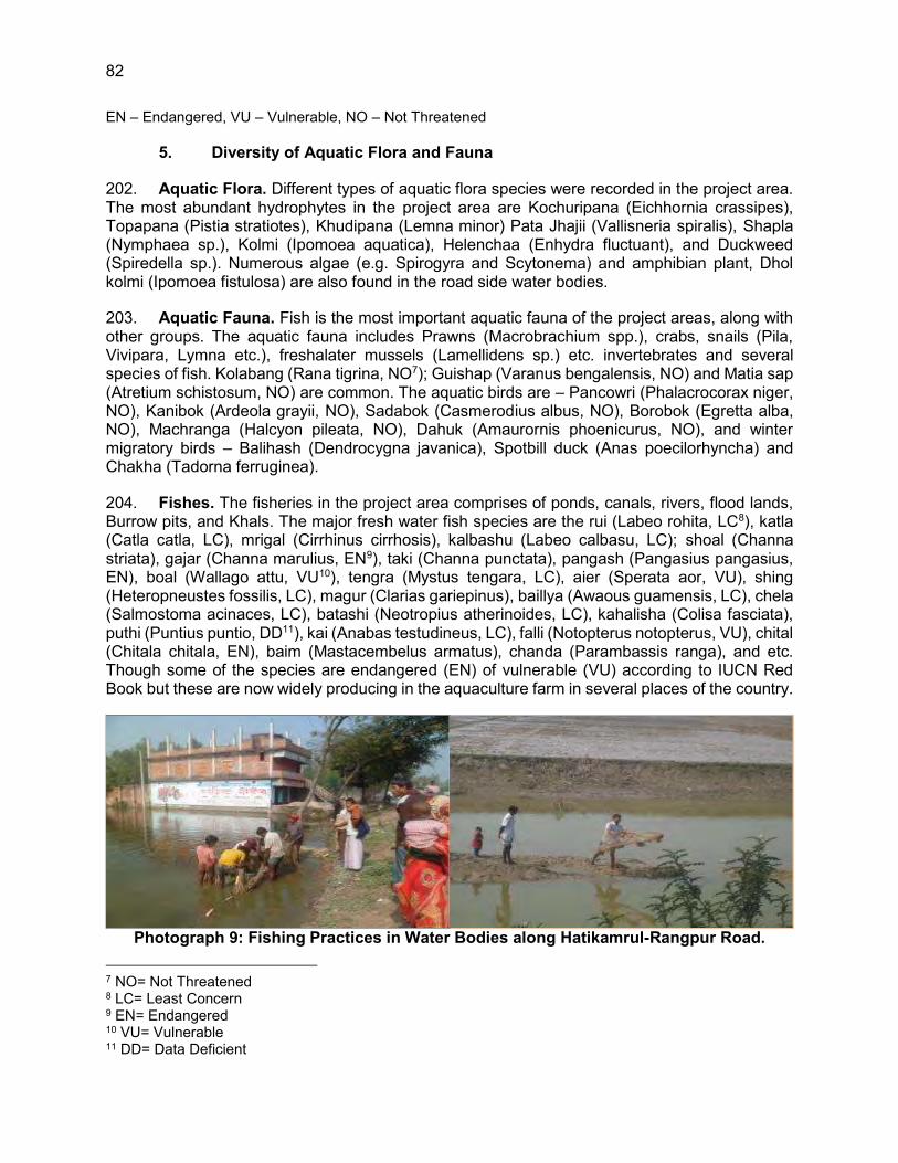
82
EN – Endangered, VU – Vulnerable, NO – Not Threatened
5. Diversity of Aquatic Flora and Fauna
202. Aquatic Flora. Different types of aquatic flora species were recorded in the project area. The most abundant hydrophytes in the project area are Kochuripana (Eichhornia crassipes), Topapana (Pistia stratiotes), Khudipana (Lemna minor) Pata Jhajii (Vallisneria spiralis), Shapla (Nymphaea sp.), Kolmi (Ipomoea aquatica), Helenchaa (Enhydra fluctuant), and Duckweed (Spiredella sp.). Numerous algae (e.g. Spirogyra and Scytonema) and amphibian plant, Dhol kolmi (Ipomoea fistulosa) are also found in the road side water bodies.
203. Aquatic Fauna. Fish is the most important aquatic fauna of the project areas, along with other groups. The aquatic fauna includes Prawns (Macrobrachium spp.), crabs, snails (Pila, Vivipara, Lymna etc.), freshalater mussels (Lamellidens sp.) etc. invertebrates and several species of fish. Kolabang (Rana tigrina, NO7); Guishap (Varanus bengalensis, NO) and Matia sap (Atretium schistosum, NO) are common. The aquatic birds are – Pancowri (Phalacrocorax niger, NO), Kanibok (Ardeola grayii, NO), Sadabok (Casmerodius albus, NO), Borobok (Egretta alba, NO), Machranga (Halcyon pileata, NO), Dahuk (Amaurornis phoenicurus, NO), and winter migratory birds – Balihash (Dendrocygna javanica), Spotbill duck (Anas poecilorhyncha) and Chakha (Tadorna ferruginea).
204. Fishes. The fisheries in the project area comprises of ponds, canals, rivers, flood lands, Burrow pits, and Khals. The major fresh water fish species are the rui (Labeo rohita, LC8), katla (Catla catla, LC), mrigal (Cirrhinus cirrhosis), kalbashu (Labeo calbasu, LC); shoal (Channa striata), gajar (Channa marulius, EN9), taki (Channa punctata), pangash (Pangasius pangasius, EN), boal (Wallago attu, VU10), tengra (Mystus tengara, LC), aier (Sperata aor, VU), shing (Heteropneustes fossilis, LC), magur (Clarias gariepinus), baillya (Awaous guamensis, LC), chela (Salmostoma acinaces, LC), batashi (Neotropius atherinoides, LC), kahalisha (Colisa fasciata), puthi (Puntius puntio, DD11), kai (Anabas testudineus, LC), falli (Notopterus notopterus, VU), chital (Chitala chitala, EN), baim (Mastacembelus armatus), chanda (Parambassis ranga), and etc. Though some of the species are endangered (EN) of vulnerable (VU) according to IUCN Red Book but these are now widely producing in the aquaculture farm in several places of the country.
Photograph 9: Fishing Practices in Water Bodies along Hatikamrul-Rangpur Road.
7 NO= Not Threatened 8 LC= Least Concern 9 EN= Endangered 10 VU= Vulnerable 11 DD= Data Deficient

83
205. The wetlands of this region also support large populations of the commercially important prawn such as Macrobrachium rosenbergii (Golda Chingri), M. malcomsoni (Chatka chingri) and Leander sp. (Gura chingri). Fresh water Crab is a common aquatic arthropod observed in most of wetlands. Fresh water Crab is a common aquatic arthropod observed in most of wetlands. No aquatic mammal like Dolphin was observed in the Rivers (Fuljor and Karatoya) along the project road.
6. Biodiversity/Environmentally Sensitive Areas
206. Many wildlife species are in stress in Bangladesh, many more are endangered/ threatened and a large number already faced extinction. The status of faunal species in Bangladesh has been published by IUCN (2000). According to the IUCN findings this country has lost 10% of its mammalian fauna, 3% avifauna and 4% reptiles over the last 100 years. More than 50 species are presently critically endangered in Bangladesh of which 23 species are already declared as endangered in the Red Data Book of IUCN. In addition, 83 species are commercially threatened and are included in the appendices of Convention on International Trade in Endangered Species (CITES). Among the most endangered species are: elephant, tiger, wild Cat, Leopard or wild goat, serao, dolphin; birds: white-winged duck, comb duck, stork, carne, pheasant, partridge, and crocodile, python, monitor, lizard, tiger terrapin, roofed turtle, soft turtle, and marine turtles.
207. In and around the project area some wildlife species were identified as locally vulnerable. The name of these vulnerable species are Bengal monitor, Rat snake, Common vine snake, Crested Serpent-eagle, Yellow-footed green pigeon, Common mongoose, Bengal fox, Small Indian Civet. Some species were also identified as locally endangered and these are Ring lizard, Monocellate cobra, and Jungle cat. Any construction must consider impacts on the rate of deforestation, loss of habitat, habitat fragmentation, and interruption of wildlife migration patterns. There is no protected area located within the 5 km buffer zone of this project (Figure 24).

84
Figure 24: Environmental Protected Areas
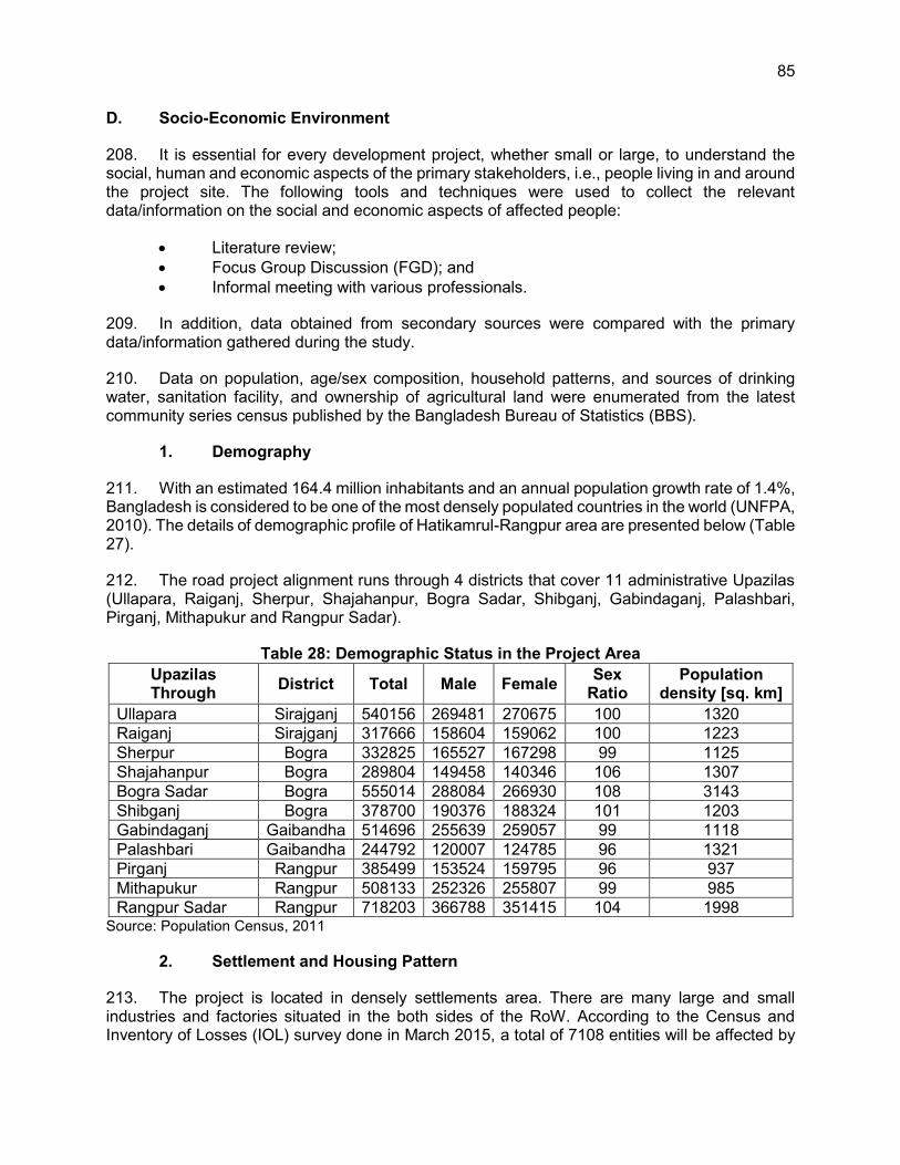
85
D. Socio-Economic Environment
208. It is essential for every development project, whether small or large, to understand the social, human and economic aspects of the primary stakeholders, i.e., people living in and around the project site. The following tools and techniques were used to collect the relevant data/information on the social and economic aspects of affected people:
Literature review; Focus Group Discussion (FGD); and Informal meeting with various professionals.
209. In addition, data obtained from secondary sources were compared with the primary data/information gathered during the study.
210. Data on population, age/sex composition, household patterns, and sources of drinking water, sanitation facility, and ownership of agricultural land were enumerated from the latest community series census published by the Bangladesh Bureau of Statistics (BBS).
1. Demography
211. With an estimated 164.4 million inhabitants and an annual population growth rate of 1.4%, Bangladesh is considered to be one of the most densely populated countries in the world (UNFPA, 2010). The details of demographic profile of Hatikamrul-Rangpur area are presented below (Table 27).
212. The road project alignment runs through 4 districts that cover 11 administrative Upazilas (Ullapara, Raiganj, Sherpur, Shajahanpur, Bogra Sadar, Shibganj, Gabindaganj, Palashbari, Pirganj, Mithapukur and Rangpur Sadar).
Table 28: Demographic Status in the Project Area Upazilas Through District Total Male Female Sex
Ratio Population
density [sq. km] Ullapara Sirajganj 540156 269481 270675 100 1320 Raiganj Sirajganj 317666 158604 159062 100 1223 Sherpur Bogra 332825 165527 167298 99 1125 Shajahanpur Bogra 289804 149458 140346 106 1307 Bogra Sadar Bogra 555014 288084 266930 108 3143 Shibganj Bogra 378700 190376 188324 101 1203 Gabindaganj Gaibandha 514696 255639 259057 99 1118 Palashbari Gaibandha 244792 120007 124785 96 1321 Pirganj Rangpur 385499 153524 159795 96 937 Mithapukur Rangpur 508133 252326 255807 99 985 Rangpur Sadar Rangpur 718203 366788 351415 104 1998
Source: Population Census, 2011
2. Settlement and Housing Pattern
213. The project is located in densely settlements area. There are many large and small industries and factories situated in the both sides of the RoW. According to the Census and Inventory of Losses (IOL) survey done in March 2015, a total of 7108 entities will be affected by

86
the project including landowners, structure owners, roadside shops and business owners. Out of these, 1140 households will lose residential structures.
214. Housing condition of the eleven upazilas (Ullapara, Raiganj, Sherpur, Shajahanpur, Bogra Sadar, Shibganj, Gabindaganj, Palashbari, Pirganj, Mithapukur and Rangpur Sadar) of the project is predominantly kutcha, semi pucca and pucca structures. The average data about the main house of the dwelling households by type of structure shows that pucca and semi-pucca household structures remain higher in urban area comparing to the rural area and upazila. According to the resettlement survey, total 700352 m2 housing/settlement structures of different types will be affected. Details of the affected structures by types along the project road have been given in Table 28.
Table 29: Quantity of Affected Structure along the Project Road Sl. No. Category of loss m2
1 Pucca (concrete) 276,071 2 Semi Pucca 326,541 3 Tin Made 71,139 4 Katcha (earthen) 20,805 5 Thatched 5,796
Total 700,352 Source: Census and IOL Survey, March 2015
3. Land Use Patterns
164. Lands at the project area are used for agriculture, fisheries, agro-forestry, homestead, homestead forestry and vegetation, animal husbandry, etc. The areas through which the existing alignment passes is characterized by an agricultural ecosystem with very little of the natural ecosystem remaining. The most heavily vegetated areas along the alignment are the homestead areas where several species of trees of economic value are present.
165. The land use pattern along the alignment like other areas has traditionally been devised based on soil condition, relief, climate, hydrology and flood conditions, availability of resources, etc. The road alignment would impact the local land uses positively due to establishment of fast, safe and convenient road linkages between the project command areas and small markets of rural areas.
166. Land use analysis is carried out along five-kilometre buffer zone from centreline of the Hatikamrul-Rangpur road using optical satellite imageries. Several land use classes were found along Hatikamrul-Rangpur section (Appendix G).
167. The below Table 29 shows the land use category and their area in 200 m buffer zone from the centreline of Hatikamrul-Rangpur road. Agriculture area is in the dominant position along the project road which is 37.73%. A significant portion covers the commercial area which is 8.84%. The residential area covers 34.42% and water bodies covers 4.61% respectively.
Table 30: Land Use Category of Hatikamrul-Rangpur Road Project Area Category Area (ha) Area in %
Agricultural 1188.444 37.73 Residential 1084.286 34.42 Educational 13.470 0.42 Commercial 278.428 8.84

87
Category Area (ha) Area in % Cantonment 3.617 0.11 Industry 107.081 3.39 Brick Field 45.209 1.43 Playground 10.132 0.32 Road 132.306 4.20 Road Island 1.087 0.03 River 26.612 0.84 Vacant Land 24.793 0.78 Vegetation 88.653 2.81 Water body 145.507 4.61
4. Water Supply and Sanitation
215. Tube well is the most common source of drinking water in both the urban and rural areas. Tap water is accessible only in urban areas. Most households do not treat water prior to drinking. Sewage facilities are available in most of the urban areas. The below Table 30 shows the sanitary facilities in the project area.
Table 31: Sanitary Facilities in the Project Area
Upazila Through District Number of
Households
Toilet Facility (%) Sanitary (water-sealed)
Sanitary (non- water-sealed)
Non-sanitary
None
Ullapara Sirajganj 123630 17.1 50.7 29.2 3.0 Raiganj 77104 15.3 46.5 28.8 9.3 Sherpur
Bogra
81639 35.2 36.1 21.8 6.8 Shajahanpur 72323 38.6 33.2 22.6 5.6 Bogra Sadar 129597 45.9 32.0 18.5 3.6 Shibganj 99124 24.1 21.9 30.4 23.6 Gabindaganj Gaiband
ha 132402 12.6 17.1 38.3 32.0
Palashbari 63178 12.1 15.9 43.2 28.8 Pirganj
Rangpur 101485 19.0 21.1 33.2 26.7
Mithapukur 134898 8.9 18.4 47.1 25.5 Rangpur Sadar 163052 28.1 31.0 25.3 15.6
Source: Population Census, 2011
216. According to the statistical data mentioned above it can be said that the sanitary facilities are better in the urban areas than the rural areas.
5. Transport and Communication
217. The project areas are connected with national highways, village roads, waterways, and railways in certain locations. The common types of transport are bus, truck, microbus, car, CNG, motorcycle, van and rickshaw. Mobile and wire telephone services are available in most of the areas. During the field survey, it is found that there are many roads crossing present in the Hatikamrul-Rangpur road alignment which connect the adjacent villages to the highway. A list of the crossings are presented in the below Table 31 and Photograph 9 shows a dangerous road crossing.

88
Photograph 10: Dangerous Road Crossing at Hatikamrul-Rangpur Road
Table 32: List of Crossings along the Alignment
Sl. No. Chainage Name of Road Type of Road 1 1+200 Pacla to Sawlonga Thana Pucca Road 2 2+560 Kalipur to Kumaspur/Nalka Katcha Road 3 5+680 Natunpara to Uttar Para Katcha Road 4 7+640 Doctor para to Madrasha Katcha Road 5 10+820 Shaidoho to Bhuyiangati Katcha Road 6 12+020 Lokikhola to Thana Road Katcha Road 7 14+390 Ganrhat to Dhangora Pucca Road 8 17+550 Ranirhat to Modrapur Pucca Road 9 21+150 Garoi to Hasra Katcha Road 10 28+220 Jolsora to Mirjapur School Pucca Road 11 33+000 Bazar to Hospital Pucca Road 12 33+295 Bazar Road to Para Road Semi Pucca 13 33+460 Bikel Bazar to Nondi Gram Pucca Road 14 33+660 Bazar to Koli Road Pucca Road 15 34+300 Khas Para to College Pucca Road 16 34+485 Thana Road to College Semi Pucca 17 34+720 Thana Road to Olipur Road Pucca Road 18 34+860 Thana Road to Hajipur Road Pucca Road 19 37+305 Pagra to Nondigram Road Pucca Road 20 40+270 Sonahat Road to Thengamara Road Pucca Road 21 43+580 Birkustiya Road to Office Road Pucca Road 22 50+380 Ranirhat to Banani Bazar Pucca Road 23 54+900 Balail to Malgram Pucca Road 24 55+410 Village to Town Pucca Road 25 55+450 Bogra to Shantahar Rail Crossing 26 55+945 Railgate to College Pucca Road 27 57+300 Bogra to Joypurhat Pucca Road 28 58+255 Komira to Upashohor Pucca Road 29 58+515 Goderpara to Upashohor Semi Pucca 30 59+390 Bian Bazar to Darom Pucca Road 31 59+780 Bogra Sadar to Joypurhat Pucca Road 32 68+260 Village to Shibganj Pucca Road 33 68+940 Village to Village Kutcha Road 34 65+810 Village to Village Katcha Road
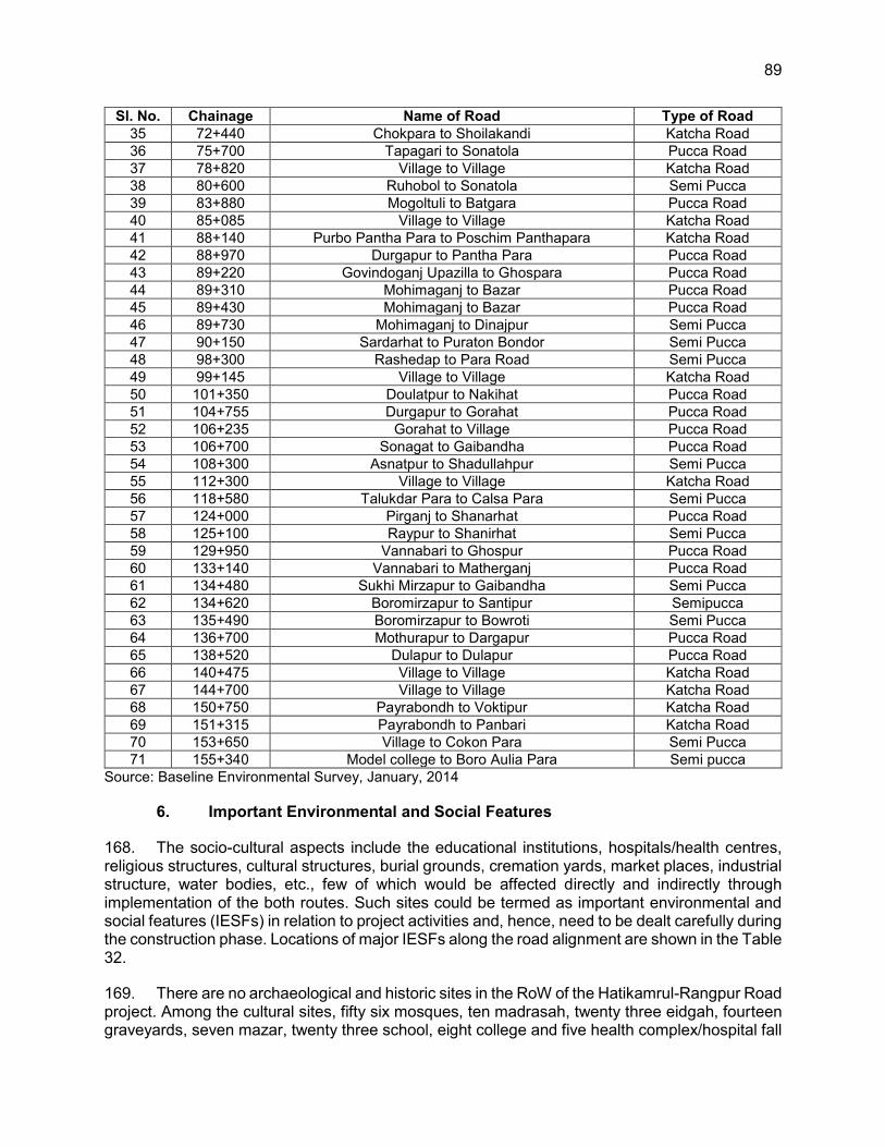
89
Sl. No. Chainage Name of Road Type of Road 35 72+440 Chokpara to Shoilakandi Katcha Road 36 75+700 Tapagari to Sonatola Pucca Road 37 78+820 Village to Village Katcha Road 38 80+600 Ruhobol to Sonatola Semi Pucca 39 83+880 Mogoltuli to Batgara Pucca Road 40 85+085 Village to Village Katcha Road 41 88+140 Purbo Pantha Para to Poschim Panthapara Katcha Road 42 88+970 Durgapur to Pantha Para Pucca Road 43 89+220 Govindoganj Upazilla to Ghospara Pucca Road 44 89+310 Mohimaganj to Bazar Pucca Road 45 89+430 Mohimaganj to Bazar Pucca Road 46 89+730 Mohimaganj to Dinajpur Semi Pucca 47 90+150 Sardarhat to Puraton Bondor Semi Pucca 48 98+300 Rashedap to Para Road Semi Pucca 49 99+145 Village to Village Katcha Road 50 101+350 Doulatpur to Nakihat Pucca Road 51 104+755 Durgapur to Gorahat Pucca Road 52 106+235 Gorahat to Village Pucca Road 53 106+700 Sonagat to Gaibandha Pucca Road 54 108+300 Asnatpur to Shadullahpur Semi Pucca 55 112+300 Village to Village Katcha Road 56 118+580 Talukdar Para to Calsa Para Semi Pucca 57 124+000 Pirganj to Shanarhat Pucca Road 58 125+100 Raypur to Shanirhat Semi Pucca 59 129+950 Vannabari to Ghospur Pucca Road 60 133+140 Vannabari to Matherganj Pucca Road 61 134+480 Sukhi Mirzapur to Gaibandha Semi Pucca 62 134+620 Boromirzapur to Santipur Semipucca 63 135+490 Boromirzapur to Bowroti Semi Pucca 64 136+700 Mothurapur to Dargapur Pucca Road 65 138+520 Dulapur to Dulapur Pucca Road 66 140+475 Village to Village Katcha Road 67 144+700 Village to Village Katcha Road 68 150+750 Payrabondh to Voktipur Katcha Road 69 151+315 Payrabondh to Panbari Katcha Road 70 153+650 Village to Cokon Para Semi Pucca 71 155+340 Model college to Boro Aulia Para Semi pucca
Source: Baseline Environmental Survey, January, 2014
6. Important Environmental and Social Features
168. The socio-cultural aspects include the educational institutions, hospitals/health centres, religious structures, cultural structures, burial grounds, cremation yards, market places, industrial structure, water bodies, etc., few of which would be affected directly and indirectly through implementation of the both routes. Such sites could be termed as important environmental and social features (IESFs) in relation to project activities and, hence, need to be dealt carefully during the construction phase. Locations of major IESFs along the road alignment are shown in the Table 32.
169. There are no archaeological and historic sites in the RoW of the Hatikamrul-Rangpur Road project. Among the cultural sites, fifty six mosques, ten madrasah, twenty three eidgah, fourteen graveyards, seven mazar, twenty three school, eight college and five health complex/hospital fall

90
within the RoW of the road alignment (Table 32). A detail list of the cultural and sensitive areas located within 500 m from the RoW boundary is presented in Appendix E.
Table 33: List of Affected Cultural and Sensitive Structures within the RoW Name Chainage LS/RS Description
Eidgah 0+880 RS Boundary wall and some land area will be affected. Graveyard 1+490 RS Half of the total area (5 decimal) will be affected. Mosque 1+510 RS Half of the tin shed mosque will be affected. Mosque 3+050 RS Full building on 6 decimal land will be affected. Dadpur Girls High School 4+000 RS The tin shed building of this school will be full affected. Nurul Ulum Kowme Madrasah 5+880 LS Tin shed and Semi pucca building. Total land area 25
decimal and 5 decimal will be affected.
Eidgah 8+200 LS Boundary wall and significant land area will be affected.
Mosque 12+820 LS 1 storied building. Total land area 13 decimal. Half of the total area will be affected.
Chandikona Shahi Jami Mosque 16+300 RS This is a big one storied building and some part will be
affected. Rabeya Hafezia Madrasah and Mosque 18+140 RS Tin shed building will be affected.
College Mosque 19+190 LS Semi pucca mosque. Land area 8 decimal. Affected land area 2 decimal.
Food Village Jami Mosque and Eidgah 19+580 RS This is big mosque with two storied building which will
be full affected due to road widening.
Dankuti Jami Mosque 20+370 LS Tin Shed Building. Total land area 10 decimal. Total infrastructure is within the RoW.
Dandunti Eidga 20+430 LS Road side boundary wall and half of the total land will be affected.
Gario Bus Stand Jami Mosque 21+140 LS One storied Building on 8 decimal land areas which will
be full affected. Gora Govt. Primary School
22+250 LS Half of one storied building and 10-15% of another
building will be affected. Khadizatul Kobra Mohila Hafizia Kowmi Abashik Madrasah
24+980 LS 10-15% of the tin shed building is within the RoW.
Sonka High School Jami Mosque 25+490 LS 2 Storied Building. Some portion of the building will be
affected. Kazpur Jami Mosque 25+910 LS Half of the total one storied building will be affected.
Biroil Eidgah 26+420 LS Roadside boundary wall with 6 decimal land will be affected.
Mirzapur Amraban Madrasah 28+020 RS Tin shed building will be affected.
Holy Child School 28+770 RS Half of the tin Shed building will be affected. Mirzapur Bazar Kendrio Graveyard 29+160 RS Only boundary wall will be affected.
Eidgah 29+700 LS Roadside boundary wall with 20 decimal land will be affected.
Graveyard 30+025 LS One third of the total graveyard (15 decimal) will be affected.
Krishnopur Jami Mosque 30+090 RS Some portion of the one storied building mosque will be affected.
Krisnopur Jamuna Para Jami Mosque 30+375 LS Minor portion the tin shed building with some land area
will be affected.

91
Name Chainage LS/RS Description Sherua Bottola Jami Mosque 31+560 RS Some portion of the tin shed mosque will be affected.
Baytun Nur Jami Mosque 32+665 LS Minor portion of the two storied building with some land area will be affected.
Ahale Hadis Sherpur Jami Mosque 33+765 LS Minor portion of the two storied building with some land
area will be affected.
Majibar Rahman Girls Degree College 33+880 RS
There are two building; one tin shed and another one storied pucca building. More than 50% of the total area will be affected of this educational institution due to road widening.
Sherpur Girls Degree College 33+900 RS
There are two building; one tin shed and another one storied pucca building. Only boundary wall will be affected.
Sherpur Technical and B.M. College 33+950 RS Only boundary wall will be affected.
Upozilla Jami Mosque 33+950 LS Small portion of the one storied building with some land area will be affected.
Graveyard 34+580 RS More than 30% of the total area (33 decimal) will be affected due to road widening.
Summit School and College 35+670 RS This is three storied school building. Only boundary
wall will be affected.
Garidaho Jami Mosque 37+290 LS Minor portion of the semi pucca building with some land area will be affected.
Garidaho Government Primary School 37+460 RS
This is one storied school building and total area is 33 decimal approximately. Full building will be affected because of road widening.
Accademi Bazar Jami Mosque 38+240 LS Very small portion of the one storied building with
some land area will be affected. Accademi Bazar Jami Eidgha 38+285 LS 30% of the total land area is within the RoW.
Anoroya School 38+560 LS A significant portion of the tin shed mosque will be affected.
Jamalpur Mazar and Eidgah 39+620 RS Only eidgah boundary wall will be affected.
Naymail hat Jami Mosque 40+220 LS
This mosque is three storied building on 10 decimal land area. A minor portion of this building will be affected.
Bamoria Jami Mosque 40+450 RS One storied building will be full affected Ariya Bazar Primary School 41+980 LS It is one storied building and some portion will be
affected due to road widening. Aria Rahimabad Government Primary School
42+120 RS There are two building; one tin shed and another two storied pucca building. Only tin shed building will be affected.
Health Complex 42+190 RS Half of the total one storied building on 45 decimal land will be affected.
Rahimabad Government Primary School 42+920 RS Boundary wall and a small portion of one storied
building of this school will be affected. Bogra Ahsania Jami Mosque 43+040 RS Three storied building on 15 decimal land and will be
full affected. Mohious sunna Ouluin Jami Mosque 45+860 LS Two storied building mosque will not be affected but
some land will be affected. Mohious sunna Ouluin Jami Madrasah 45+870 LS The two storied educational structure will be affected
due to road widening.

92
Name Chainage LS/RS Description Sajapur Nura Alahi Jami Mosque 47+690 LS One storied building on 20 decimal land will be full
affected because of road widening. Sajapur fooltola Govt. Primary School 49+150 LS Two storied school building and half of the total
building will be affected. Batgari Government Primary School 49+325 RS Boundary wall and a significant portion of one storied
building of this school will be affected. Batgari Puraton Jami Mosque 49+360 LS A small portion of this one storied building will be
affected.
Jamia An-Nur Kowmi Cadet Madrasah 49+650 LS
This is four storied educational building on approximately 33 decimal land. A significant portion of this building will be affected due to road widening.
Krishi Somprosaron Jami Mosque 50+430 RS Almost 50% of the total land 25 decimal) and a portion
of the one storied building will be affected. Open University Bangladesh 51+270 RS Only boundary wall will be affected.
Fullkoli Kinder Garden School 51+400 RS Some land is within the RoW but main structure will not
be affected. Fulltola Jami Mosque 52+460 RS One storied building on 15 decimal will be full affected. North School and College 52+790 RS Boundary wall will be affected only.
Graveyard 52+840 RS This graveyard is on around 33 decimal and half of it will be affected.
Dighipur Eidgah Field 52+990 RS 5 decimal from 20 decimal is within the RoW. Buytul Mamur Jami Mosque 54+760 LS This is one storied mosque and will be affected totally.
Soto Balail Paribarik Graveyard 54+800 LS A family graveyard on 16 decimal land area. Full
Affected due to road widening. Nowda Para Jami Mosque 61+275 RS Half of the total one storied building on 10 decimal land
will be affected. Thangamara Dokhin Para Jami Mosque 62+620 RS Half of the total two storied building on 8 decimal land
will be affected. Khatenon Adarsha Junior High School 62+880 RS This is a two storied school building. Half of the total
building is within the RoW due to road extension.
Thangamara Ansar Night College 62+890 RS
Total area of this college is approximately 33 decimal. There is a one storied building and half of it will be affected due to road widening.
Graveyard 63+070 RS Approximately 4 decimal from 10 decimal land will be affected.
Thangamara Kendrio Jami Mosque 63+150 LS Half of the total one storied building on 10 decimal land
will be affected. Rafatulla community Hospital 63+160 RS This is a big hospital. Only boundary wall will be
affected. Hajarot Dewan (R) Mazar 63+200 RS This is a mausoleum of Muslim spiritual person and will
be affected due to road widening.
T.M.S.S Medical College 63+260 RS This is seven storied building and total area is approximately 66 decimal. Only boundary wall will be affected.
B.C.L Paper Mills 63+300 RS
This is five storied building and total area is approximately 66 decimal. Only boundary wall will be affected.
Graveyard 63+400 RS This is on 5 decimal land and will be full affected.

93
Name Chainage LS/RS Description Bagho Para Danes Uddin School and College
63+650 RS Only boundary wall will be affected.
Allahma Abu Nashair (Ro) Mazar 64+005 LS This is a mausoleum of Muslim spiritual person and will
be fully affected due to road widening.
Graveyard and Eidgha 64+040 RS The graveyard and eidgah cover a very big area. However, only boundary wall will be affected.
Bago Para Jami Mosque 65+395 RS This is one storied building and only front side of it will be affected.
Shah Sufi (R) Mazar 64+400 RS This is a mausoleum of Muslim spiritual person and will be full affected due to road widening.
Bagho Para Uttar Para Eidgah 64+930 RS Some land area will be affected.
Graveyard 65+510 RS Approximately 30% of the total area will be affected. Graveyard 65+990 RS Approximately 50% of the total area will be affected. Gokul Mosque 66+105 RS The one storied building mosque will be full affected. Gokul Upo Health Complex 66+205 RS Only some land area will be affected.
Hajarat Shah Sufi (R) Mazar 66+210 RS This is a mausoleum of Muslim spiritual person and will
be full affected due to road widening. Gokul Eidgah 66+415 RS A small portion of the total land area is within the RoW. Graveyard 69+070 RS Some land area will be affected. Dokkhin Chandu Jami Mosque 70+065 RS A minor portion of this one storied building will be
affected. Eidgah 70+200 RS A small portion with boundary wall will be affected.
Chondihara Girls School 71+030 RS A significant land area with boundary wall will be affected of this educational institute.
Eidgah 71+425 RS Full affected due to road extension. Chakpara Darul Ulam Madrasha and Primary School
72+405 RS Only boundary wall of this educational institute will be affected.
Chokir ghat Bazar Mosque 72+615 RS Full affected due to road extension.
Graveyard 75+540 RS Full affected due to road extension. Mokamtala Kendrio Jami Mosque 75+810 RS 10%-15% of this two storied building will be affected.
Mokamtola Joypur Hat Road Jami Mosque 76+200 RS This tin shed mosque on 10 decimal land will be full
affected due to road widening. Munshi Para Jami Mosque 77+390 RS This is a tin shed mosque on 5 decimal land. Half of
the total area will be affected. Varia Matree Maya Kinder Garden School 78+060 RS Tin shed school on 10 decimal land. Only boundary
wall will be affected.
64 No. Varia Govt. Primary and High School 78+870 RS
This school has one tin shed and another one storied pucca building. Half of the tin shed building will be affected.
Rohobal Kendrio Bazar Jami Mosque 20+505 RS Half of the total area (20 decimal) with two storied
building will be affected. Rohubul Eidgah 80+560 RS Half of the total area (10 decimal) will be affected. Rahobul Community Clinic 80+865 RS The one storied building medical centre will be full
affected. Fashitola Jami Mosque 84+595 RS Two storied building mosque will be full affected. Nuramodina Hafijia Madrasha and Mosque 85+020 RS Only boundary wall will be affected.

94
Name Chainage LS/RS Description Bokchor Para Jami Mosque 86+700 RS Small portion of this one storied building is within the
RoW. Bokchor Poschim Para Eidgah 87+835 RS A significant land area with boundary wall will be
affected.
Eden K.G School 88+670 RS This educational institution will be full affected because of road widening.
Dhokhin Bus Stand Jami Mosque 88+820 RS The two storied building mosque on 15 decimal area
will be full affected. Knowledge of Holi Child School 90+200 RS Tin shed school building on 10 decimal which will be
full affected.
Gobindo Pouro Model School 90+450 RS
This is a tin shed school on 28 decimal which will be affected with minor portion. However, a significant land is within the RoW due to road widening.
Graveyard 90+840 RS Full affected due to road extension. Pekosh Chokkhu Hospital 91+110 RS This eye hospital is one storied building and will be
affected. Katakhali Baluahat Jami Mosque 94+620 RS This is two storied building on 8 decimal land. Half of
the total area with infrastructure will be affected. Coksingho Dangga Jami Mosque 97+240 RS Tin shed mosque on 6 decimal area is within the RoW.
Chatel Jami Mosque 104+850 RS Tin shed building on 5 decimal which will be full affected.
Mohamadia Jami Mosque and Madrasah 107+600 RS
There are one storied pucca and tin shed infrastructure in 20 decimal land. Approximately half of the total area is within the RoW because of road widening. Only tin shed will be affected.
Matherpur Eidgah 115+445 RS Half of the total land will be affected.
Matherpur Jami Mosque 115+450 RS Half of the total tin shed infrastructure on 7decimal land will be affected.
Naibia Kendrio Mosque 116+200 RS Tin shed building on 6 decimal which will be full affected.
Graveyard 117+025 RS A family graveyard will be full affected due to road extension.
Khedmodpur Jami Mosque 118+270 RS Two storied building on 8 decimal which will be full
affected.
Gaga Shimultala Mosque 118+508 RS Approximately 80% of the total tin shed building will be affected.
Lal Dighi Bazar Jami Mosque 126+010 RS Only a minor portion of the total land is within the RoW.
Sukenchoki Jami Mosque and Madrasah and Eidgah
127+450 RS Only a minor portion of the total land is within the RoW.
Bro drowga Mazar Jami Mosque 133+160 RS Some portion of the one storied building will be
affected Boro Dorgha Govt. Primary School 133+240 RS Some portion of the one storied building will be
affected. Eidgah 134+380 RS A significant portion of the total land is within the RoW. Mithapukur Kendrio Eidgah 139+960 RS Only front side boundary wall will be affected.
Adarshapara Jami Mosque 141+210 RS This tin shed mosque will be affected due to road
widening. Fatapur Kendrio Eidgah 144+630 RS Only front side boundary wall will be affected. Jaigirhat Kendrio Eidgah 145+520 RS Boundary wall with some land will be affected.

95
Name Chainage LS/RS Description
Jami Mosque 147+900 RS One storied building on 5 decimal land will be full affected.
Taragonj Mazar 151+915 RS This is a mausoleum of Muslim spiritual person and only minor land will be affected.
Sorderpara Eidgah 153+640 RS Some portion of the total land will be affected.
Boro Auliar Mazar 155+300 RS This is a mausoleum of Muslim spiritual person and will be fully affected due to road widening.
Source: Baseline Environmental Survey, January, 2014

96
VII. ANTICIPATED ENVIRONMENTAL IMPACTS AND MITIGATION MEASURES
A. General
218. This section identifies the overall impacts on the physical, biological and socio-economic environment of the project area. An environmental impact is defined as any change to an existing condition of the environment. Identification of potential impacts has been done on the basis of baseline data collected from secondary and primary sources. Environmental impact assessment was carried out considering present environmental setting of the project area, and nature and extent of the proposed activities. Potential environmental impacts associated with the proposed project activities of both the project are classified as:
(i) impacts during pre-construction/design phase (ii) impacts during construction phase and (iii) impacts during operation phase.
219. Qualitative and quantitative techniques have been applied for direct and indirect impact identification. Impacts are classified as being insignificant, minor, moderate and major. Impacts are described in the sections below.
220. Some of the important impacts associated with the proposed project will be associated with land use (land acquisition), land stability (soil erosion), soil compaction and contamination, water availability, water quality of river/stream/canal, ground water contamination, waste and wastewater disposal, ambient air quality, ambient noise levels, vegetation, tree cutting (including social forestry tree), fauna ( terrestrial and aquatic), drainage pattern, hydrology, climate change, socio economic, places of social/cultural importance (religious structures, community structure), construction material sourcing and occupational health and safety. Adequate mitigation measures are devised to mitigate/minimise all likely environmental impacts and the same have been presented along with the impacts.
221. During the field observation and data collection, consultations were also held with people in the locality including those presently living in the project areas, NGOs and Government authorities. Outcome of these consultations were used in impact assessment and devising mitigation measures.
B. Project Corridor
222. The Project corridor is delineated according to two criteria: right of way (RoW); which the RHD is legally entitled to, and Corridor of Impact (CoI), i.e. the width of the corridor that will be impacted, directly or indirectly, by the proposed project during the construction and operational phases.
C. Project Right of Way (RoW)
223. The proposed project corridor will have a well-defined RoW that will be approximately 50 meters for the entire length of the highway. Major construction works will generally remain confined within the RoW. All the infrastructure and commercial activities within the existing or proposed RoW need to be relocated as they will have direct impact of the project.

97
D. Corridor of Impact (CoI)
224. The corridor of the proposed Impact (CoI) was delineated as the extent, which has direct or indirect impact of project. Direct impacts of the project are relocation of houses, utilities and air and noise pollution impact on workers during construction. All direct impacts are constrained within the RoW. Indirect impacts, caused by noise, dust emissions, camp sites and borrow sites could be beyond the RoW. The direct CoI of the surface water bodies will be confined within the RoW of the proposed project and will be temporary only for the construction period.
225. According to the Department of Environment (DoE) guideline the project impact area is divided into two sections. One, those related to the project which is 50m for the project. Another section is those related to the background environmental features of the project site. This should cover not only the project site in proper, but generally an area of 5km radius around the site. In this project 500m from the RoWs have been considered as core impact zone and 5 km as buffer zone for better understanding.
E. Evaluation of Significant Impacts
226. As is the case for most development projects, potential negative impacts sometimes could be far more numerous than beneficial impacts. Whereas the anticipated negative impacts could be dealt with through carefully selected and undertaken efficient mitigation measures and good management practices, beneficial impacts could still be augmented through mobilizing and strengthening the realization about the positive outcomes of the project among all the stakeholders and project officials as well as contractors performing works related to various stages of implementation. It is generally expected that the long-term benefits of any development intervention will ultimately trickle down for the benefit of the local population and make contributions toward improvement of life quality.
i. Intensity of the effect: The intensity of the effect refers to the level of disruption to the component. Three levels have been defined:
1) Low: Little change in the characteristics of the component. Difficult to quantify;
2) Average: Change in certain characteristics of the component. The change may be quantifiable;
3) High: Change in all or in the main characteristics of the component. The change is quantifiable
ii. Duration of the effect: Duration means the time dimension of the effect. The terms permanent, temporary and short are used to describe the period of time:
1) Short-lived: the effect disappears promptly; 2) Temporary: the effect is felt during one project activity or, at most,
throughout implementation of the project; 3) Permanent: the effect has repercussions for the life of the
infrastructure. iii. Scope of the effect: The scope describes the spatial dimension of the effect
caused by an action in the environment. It refers to the distance or area covered by the disruption. The terms regional, local and limited are used to describe the scope:
1) Limited: the scope is limited when the action affects only one environmental element located near the project;
2) Local: the scope is local when the action affects the study area;

98
3) Regional: the scope is regional when the action affects areas beyond the study area
iv. Assessment of the potential effect: These three parameters are incorporated into a multi-criteria matrix, making it possible to place the potential effect into one of three categories:
1) Major (MAJ): signifies an effect that is permanent and that affects the integrity, diversity and sustainability of the element. Such an effect substantially or irremediably alters the quality of the environment.
2) Medium (MED): signifies a perceptible, temporary and/or low-return effect that has little impact on the environmental component and is not irreversible. Such an effect is short-lived and/or limited in scope.
3) Minor (MIN): signifies that the effect is non-existent or virtually non-existent, that it does not affect the environmental component in any observable or quantifiable way and that it is related to a randomly occurring natural effect. As a rule, this would be a short-lived effect, limited in scope.
Intensity Duration Scope Short-lived Temporary Permanent
Low Limited MIN MIN MED Local MIN MIN MED Regional MIN MED MAJ
Average Limited MIN MED MED Local MED MED MAJ Regional MED MAJ MAJ
High Limited MED MAJ MAJ Local MED MAJ MAJ Regional MAJ MAJ MAJ
227. The potential impacts due to implementation of the Hatikamrul-Rangpur road project are identified by using the above Leopold Matrix for environmental assessment by project implementation stages. In this developed checklist, actions, which may affect the various Important Environmental Components (IECs) pertaining to the areas adjacent to the alignment during the various stages of the project activities, are listed and the degrees of Significant Environmental Impacts (SEIs) are shown. The terms Major, Medium and Minimum are used in the checklists to evaluate the magnitude of SEIs. In the checklist, each of the pre-construction, construction and operational phases of the Hatikamrul-Rangpur road are considered separately in order to distinguish the short term and long term impacts as well as reversibility and irreversibility of impacts in terms of their duration.
228. Identification and evaluation of potential/significant impacts due to project location, site preparation, construction and operation at the project has been done using the ‘Impact Matrix’ by identifying all stages of activities (pre-construction to operation and maintenance) and assessing the potential impact of each operation upon individual environmental components.
229. As can be observed from the checklist in Table 33, major environmental components, which will be adversely affected by activities related to the project, are: air quality, noise hazard, loss of trees, accidental risk, hydrology/drainage and occupational health and safety and socio-economic environment. It should be noted that the environmental factors indicated in the table

99
relate to the changeability or un-changeability of the existing situations due to interventions of the project and significant level of impact without mitigation of negative impacts.

100
Table 34: Evaluation of Significant Impact Using Leopold Matrix
Environment En
visa
ged
Impa
ct F
acto
rs Project Activities
Pre-Construction Construction Post-Construction Operation
Site
Mob
iliza
tion
Con
stru
ctio
n of
Te
mpo
rary
Fac
ilitie
s
Mai
nten
ance
of
Traf
fic
Util
ity S
hifti
ng
Exis
ting
Pave
men
t St
rippi
ng
Soil
Strip
ping
Exca
vatio
n/Ea
rthw
orks
Pave
men
t C
onst
ruct
ion
Brid
ge C
onst
ruct
ion
Man
agem
ent o
f W
aste
s
Tran
spor
tatio
n
Equi
pmen
t and
M
achi
nerie
s
Dec
onst
ruct
ion
of
Stru
ctur
es
Dem
obili
zatio
n of
W
orks
ite
Dem
obili
zatio
n of
B
ridge
Site
Man
agem
ent o
f W
aste
s
Tran
spor
tatio
n
Equi
pmen
t and
M
achi
nerie
s
Pres
ence
of R
oad
Mai
nten
ance
&
Rep
air
Physical
Climate Physiography MIN Topography MIN MIN MIN MIN MIN MIN MIN MIN MIN Geology Seismicity Soil MIN MIN MIN MIN MED MIN MIN MIN MIN MIN MIN MIN Surface Water MIN MIN MIN MED MIN MIN MED MIN MIN MIN MIN MIN MIN Groundwater MIN Air Quality MIN MIN MED MED MAJ MED MIN MIN MED MIN MIN MIN MIN MIN MIN MIN Noise MIN MIN MED MED MED MED MED MED MIN MIN MIN MIN MIN MIN MIN
Biological
Bio-ecological Zones
Terrestrial Flora MIN MIN MIN MED Terrestrial Fauna MIN MIN MIN MED MED
Aquatic Flora MIN MIN MIN MIN MED MIN MIN Aquatic Fauna MIN MIN MIN MIN MED MIN MIN Fishes MIN MIN MIN MIN MED MIN Biodiversity/ Environmentally Sensitive Area
Socio-economic
Demography MIN MED Settlement & Housing Pattern MIN MIN MED
Land Use Patterns MIN MIN MED
Water Supply and Sanitation MED MIN MIN MED MIN
Transport and Communication MED MED MED MED MED MED MIN MIN MED

101
F. Pre -construction Phase
230. Following is a brief description of impacts envisaged during the Pre-construction/Design Phase:
1. Topography
231. Impact. With the proposed planning for the project, the topography of the project area is not expected to be affected significantly other than from excavations for borrow pits. If not selected carefully, the borrow pits can lead to spoilage of agricultural land. The topography in the project area will change to some extent because of construction of the proposed project related structures such as embankments, bridges, flyovers, interchanges etc. Visual changes to the topography would be permanent and minor negative in nature.
232. Mitigation. It is recommended that all requisite borrow pits shall be located outside the RoW or in uncultivated areas or private land with concurrence and agreed borrow bit rehabilitation plan with landowners. Visual changes to the topography will be of permanent but slightly adverse in nature and need no mitigation measures except that the project design should consider aesthetic concerns.
2. Removal of Trees
233. Impact. The project implementation activities, at different locations, will invariably involve trees and vegetation to be removed for the upgrade, widening and geometric improvement of the project road. Implementation of the project particularly during the construction stage will require removal of trees numbering 105339 of different species, types (fruit, timber, medicinal) and sizes (large, medium, small, saplings) along the project alignment. In most of the affected trees occur on homesteads, private waste/marginal lands; agricultural lands as well as on road sides. Of the affected trees 10644 are large, 25019 are medium size, and 48493 are small size, while some 21183 are saplings. Excluding the above stated number (105339) of affected trees 37785 banana trees and 39731 bamboos will be affected being located within ROW. Appendix F shows the different types of trees and their respective number within the ROW. In addition, many social forestry trees are likely to be cut. Trees are of timber value, fruit bearing and medicinal in nature.
234. Mitigation. All efforts will be made to minimize the tree cutting by selecting road-widening option based on technical consideration. Public and NGOs will be consulted before cutting of the old trees if its felling is absolutely unavoidable due to technical consideration. Option may also be explored at detailed design stage to widen the road on other side of trees leaving them in the middle of the road as divider.
235. RHD will be responsible for the compensatory tree planting program by forming an ‘Environmental and Social Team’ in coordination with the Forest Department (FD). The tree cutting programme will not start until RHD will get permission from Forest Department. RHD will inform the Upazilla Forest Officer regarding tree cutting and the compensatory tree plantation programme. The respective Forest Officers will encourage the local community (especially women) to participate in this programme. RHD’s compensatory planting will be in rows as per the prescription of FD e.g. two tree seedlings to be planted for each tree felled, after the project construction activities are completed. This ratio may be more in the case of social forestry trees as per any mutual understanding arrived at with tree owners before cutting the social trees. These trees will be planted primarily along the road within the RoW. The social forestry can be planted

102
on the area allocated by local authorities. A total of 215000 saplings will be planted. Permission from the Forest Department will be sought for cutting trees from the roadside or along the water courses if these fall within the RoW. Planting will be done as soon as the construction of the road is completed. Maintenance is the key to the establishment of the plantation and therefore regular monitoring of plantation will be carried out by the executing agency.
236. The suitable trees for planting on homestead platforms are am (Mangifera indica), jam (Syzigium cumini), kul (ziziphus spp.), litchi (Litchi chinensis), jambura (Citrus grandis) amra (Spondias pinnata), narikel (Cocos nicifera), kathal, (Artocarpus heterophyllus), jalpai (Elaeocarpus floribundus), guava (Psidium guajava), and other species. Many of these species are multipurpose tree species (MPTS) with timber fruit and fuel wood potentials.
237. The compact plantation shall be effective live screens against night glare, dust, noise and pollutant emissions. These vegetated strips shall develop into a complete ecosystem. Flowering and fruiting shrubs can be planted along the road to beautify the landscape. Planting should however be done keeping in view the principles of landscape designing.
3. Land Acquisition
238. Impact. One of the major project related impact will be the land acquisition for the Project RoW that will result in causing disturbance to the effected residents of the project area. The project activity involves widening of road. The required RoW of 50m is available with RHD almost along the entire road length and proposed bridges and flyover locations. The total land to be acquired is total 184.43 ha (68.65 ha in Sirajganj, 41.89 ha in Bogra, 54.33 ha in Gaibandha, 19.56 ha in Rangpur) of which 39% are crop lands, 26% are commercial lands, 17% are homestead lands, 11% are vita/highlands, 2.63 % are ponds, 1.11% are wetlands and 1.11% fallow lands.
239. This impact would be permanent and major negative in nature and the mitigation measures will involve careful alignment and route selection by the designer to minimize the impact.
240. The construction activity for road widening and bridge/flyovers construction will temporarily change the land use for use of construction site, access road, and construction camp. Due to these interventions, agricultural, seasonal wet land area and social forestry tree around these areas may be affected adversely.
241. Mitigation. The mitigation measures include:
Careful alignment and route selection by the designer to minimize the impacts by avoiding the important environmental components, settlements etc.
As far as possible the proposed alignment follows the existing alignment, with concentric widening.
The land acquisition will be restricted to bare minimum required. Provision of protection works like retaining/toe wall is kept to confine the
embankment with in RoW /minimizing the width to be acquires. Developing proper judicious compensation package for affecters and giving
compensation amount before the affecters shifting.

103
4. Loss of Structures (Dwellings, Commercial Buildings and Industrial Structures)
242. Impact. To implement the Hatikamrul-Rangpur road way, 700352 m2 dwelling structures will have to be acquired and resettled from the project alignment. There are some other rural and urban markets and shops along the alignment which will also be relocated for the implementation of the project (details in Resettlement Plan).
243. Mitigation. The mitigation measures include:
Resettlement Specialists have calculated that the amount needed to compensate for the loss of land, house, trees, structures, crops, wage income etc.
To ensure similar or better living conditions for project affected persons (PAPs) for the limited period of time their livelihood may be interrupted.
5. Educational Institution, Religious Structure, Culturally Sensitive Structures
244. Impact. According to the DOE guideline, the Project Influence Area (PIA) has to be 5 km radius of the development of the project activities. The PIA for the project alignment of road project was confined within a radius of 0.5 km from the alignment of the development since the nature of the project is such that most of the potential impacts are likely to occur within this area. However, there are some educational, religious, and cultural aspects were investigated in the PIA that directly and indirectly affected from the project activities (Refer to Appendix E).
245. Mitigation. The project implementation should take in to consideration construction of the alignment or making provision of allocating alternative land and financial resources (for rehabilitation of the Madrasah, Mosque and the educational institution falling within the alignment). As alignment is chosen, provision should be made of, at least, two rows of trees along the ROWs of the alignment and suitable noise barriers to absorb the noise and vibration to be caused by vehicle movement.
6. Public Utility
246. Impact. Due to the proposed project, public utilities will be affected creating disruption of public services and inconvenience to the local residents. This impact is temporary and may be considered as moderately negative in nature.
247. Mitigation. Mitigation measures will include:
Provision in the design and budget for the relocation of the existing utility infrastructures wherever required; and
All public utilities (e.g. water pipes, gas pipes, power/ telephone lines likely to be affected by the proposed highway will be relocated well ahead of time before the actual commencement of the construction work.
G. Construction Phase
248. Environmental effects of the construction phase are expected to be temporary. Construction impacts are considered to be minimal as all the construction works will be carried out within the site boundary of the acquired land and will be controlled via the mitigation measures
104
defined in the EMP section. Following is the brief description of impacts envisaged during the construction phase:
1. Change in Hydrologic Regime
249. Impact. No major impacts are expected on hydrological aspects of the river due to bridge constructions. However, river hydrological, morphological, and ecological aspects have direct bearing on bridge location selection. On all the rivers, bridge already exists and new bridge shall be constructed at the same locations.
250. The dredging and use of dredged material if involved may have its impact in terms of localised sedimentation level increase and dispersion of pollutants present in the dredged material in the river water.
251. The proposed project area is in flood prone areas at some places but the project activities are to development of existing road alignment therefore, no major changes in hydrological regime will occur. As noted above, bridges currently cross the Karatoya and Ghaghat Rivers and therefore no change in water flow pattern will be caused. The major bridges (>100) will be constructed beside the existing bridges. Moreover, water flow of these rivers is not vigorous but most of them are remain dry during dry season. Thus the hydrologist does not suggest a separate morphological study for these rivers due to bridge construction. From the environmental perspective, it is also realised that the morphological study is not essential as there will be no changes in river hydrology due to bridge construction. For the crossing of canals and drains small bridges will be constructed. For the crossing of water courses, culverts and other possible arrangement will be done. Runoff from storage of construction material near water bodies, or uncontrolled disposal may cause temporary drainage congestion, especially near the locations of small bridges, culverts, service areas, and construction sites. The direct CoI of the surface water bodies will be confined within the RoW of the project, and it will be minor and temporary in nature.
252. Mitigation. Possible impacts are temporary and minor negative, however following mitigation measures will be incorporated:
Proper design of bridges on the rivers and canals to accommodate design flows; Small bridges will be constructed on canals and drains coming in the RoW; Provision of box culverts to control flood damages and provision of safety of
embankments; Provision of sufficient sizes of drains to take design flows; Wastes should not be disposed near any water body. All waste depending on its
characteristics, should be disposed off in a controlled manner. The dredged material from the riverbank shall be tested for presence for heavy
metals and other pollutants before its reuse.
2. Drainage Congestion
253. Impact. Run off from storage of construction material near water bodies, or uncontrolled disposal may cause temporary drainage congestion, especially near the locations of small bridges, culverts, service areas, and construction sites. Project design has made provisions of about many lesser bridges and culverts. Hence, no significant impact is anticipated on these water bodies during this phase. Stockpiling of fill materials dredged from the riverbeds for construction of the embankment may result erosion and subsequent deposition in the adjacent crop fields. The
105
hydrological impacts of the project are primarily limited due to faster post monsoon drainage caused due to faster fall of water level in the drainage channels following the monsoon season.
254. Mitigation. Construction shall be so planned that there is no drainage congestion. Wastes should not be disposed near any water body. All waste depending on its characteristics, should be disposed off in a controlled manner. Adequate cross drainage structure shall be provided to easily drain off water to canals and other lowland areas. Drainage works can also be designed with the provision of lower volume of water to drain in other low-lying areas, but the regulators are to be provided in such cases to permit controlled drainage rates and the consequent water levels.
3. Soil Erosion and Siltation
255. Impact. Soil erosion is observed at various locations of the road. Soil erosion levels depend on various factors like slope of an area, geological structure, soil type, and climatic variation. Slope though is predominant factor amongst these. The existing roads have an average slope of about 1% with alluvial loam soils, which is not prone to soil erosion with reasonable vegetation cover. During construction phase, some trees, shrubs, grasses and will need to be cleared and existing road pavement will need to be removed. This may create localised soil erosion problems during the rains.
256. The slope of 1:2 is proposed for the project road, which is the desired slope internationally. The proposed RoW is sufficient to construct road with this slope level and as such, soil erosion potential is minimal at large. The potential risk of river erosion will increase after implementation of the project road if the bridge crossings are provided with waterway width less than the regime width of the river. The portion of the road that is in contact with river will be provided with slope protection measures. The bank erosion in certain sections of the project in contact with the rivers is mild to minimal. The project is not expected to worsen the erosion risk particularly in areas where soil and topography are less vulnerable to erosion.
257. Mitigation. The following mitigation measures are proposed to alleviate or avoid the impacts:
Adopt good engineering and construction practices particularly at above identified locations.
The road embankments and road cuttings shall be vegetated with a fast growing crop and a native seed mix immediately after fill placement to prevent scour and to encourage stabilization. Use of stone pitching or riprap shall be made at appropriate places especially around overpasses, bridges, culverts.
Based on morphological consideration provide adequate bank protection and structures.
The erosion tendency increases at water logged areas as well. Adequate drain and slope protection measures shall be applied at such locations specially as identified above.
Spraying of water over the road bed from time to time and use of geo-grids on a layer by layer basis for better bonding in the pavement structure must be carried out to resist erosion.
Particular attention needs to be taken while designing the bridge, which will be provided for the regime waterway width without narrowing the natural channel width. The portion of the highway that is in contact with river, channel and canal will be provided with slope protection measures.

106
4. Soil compaction and Contamination
258. Impact. Due to construction of the proposed project, soil contamination may take place around borrow pits, road cuttings, embankments, construction camps, workshop areas, equipment washing yards, asphalt plants, batching plants, fuel and chemical storage areas, etc. Soil contamination may affect the road stability in worst cases may reduce the economic productivity of land and biodiversity in the project area.
259. During transportation of machine and materials, the cultivable lands beyond the proposed ROW may get compacted due to movement of vehicle and construction equipment, setting up construction camps, resulting in reduction in agriculture yield. Dumping of construction debris on fields adjoining the acquired areas, may lead to impairment of soil for agriculture, especially when the nearby areas to the alignment is largely agriculture. Parking of vehicles by the side of roads also leads to soil compaction and may spoil the soil characteristics necessary for cultivation. Soil in the project area may also get contaminated particularly from the bituminous wastes, spillage of oil and grease, mixing with construction materials, at the construction sites. The impacts of soil contamination would be temporary and moderate negative.
260. Mitigation. The movement of construction vehicles, machinery and equipment will be restricted to the corridor or identified route. The unusable, non-saleable, non-hazardous construction waste shall be dispose of in the properly delineated places. The compacted land is restored for agricultural use.
261. All efforts shall be made to prevent soil contaminations. Following measures shall be taken to prevent the same:
The construction vehicle shall be fuelled or repaired/serviced at the designated place with proper arrangement of waste collection and disposal. The arrangement shall include, cemented floor with dyke around for fuel storage and filling as well repairing of construction equipment.
Soil contamination by bitumen, fuel and chemical storages shall be minimized by siting them on an impervious base within an embanked area and secured by fencing. The base and walls of the embankment shall be impermeable and of sufficient capacity to contain of the total volume of stored fuels and chemicals.
The disposal of waste asphalt shall be made in approved locations such as borrow pits or natural depressions and shall not be within the RoW. Unless located in areas with impervious soils, encapsulation with pre-laid impervious liners including walls and capping is required with the objective to prevent water percolating through the waste materials and leaching toxic chemicals into the surrounding soils. On completion of disposal at the site, the area shall be capped with a compacted thickness of impermeable soil covered and with the top soil and shall be finally landscaped.
5. Top Soil
262. Impact. The potential impacts on top soil are:
Removal of top soil for construction from outside the RoW. Compaction of top soil. Loss of top soil by wind and water erosion. Covering of top soil by project works.

107
263. Mitigation. Mitigation measures will include:
The stockpiles will be done in slopes of 2:1 to reduce surface runoff and enhance percolation through the mass of stored soil.
Locate topsoil stockpiles in areas outside drainage lines and protect from erosion. Construct diversion channels and silt fences around the topsoil stockpiles to
prevent erosion and loss of topsoil. Spread the topsoil to maintain the physico-chemical and biological activity of the
soil. The stored top soil will be utilized for covering all disturbed area and along the proposed plantation sites.
Prior to the re-spreading of topsoil, the ground surface will be ripped to assist the bonding of the soil layers, water penetration and revegetation.
Limit equipment and vehicular movements to within the approved construction zone.
Remove unwanted materials from top soil like grass, roots of trees and similar others.
6. Air Quality
264. Impact. During construction phase, there are two main sources of air emissions i.e. mobile sources and fixed sources. Mobile sources are mostly vehicles involved in construction activities while emissions are from fixed sources that include diesel generator sets, construction equipment (e.g. compressors) and excavation/ grading activities. Certain amount of dust and gaseous emissions will be generated during the construction phase from road construction machineries. Pollutants of primary concern include Suspended Particulate Matter (SPM) and Respirable Suspended Particulate Matter (RSPM). However, suspended dust particles are coarse and settle within a short distance of construction area. Therefore, impact in nearby inhabited area will be direct but temporary and restricted within the closed vicinity of the construction activities only.
265. Localised emissions are also anticipated from hot mix plants and batching plants. These emissions would be in the form of coarse particulate matter and will settle down in close vicinity of construction site. Further, this will be a temporary phase. Hence, no significant impact is expected during the construction phase. Emissions may be carried over longer distances depending upon the wind speed, direction, temperature of surrounding air and atmospheric stability. Construction work involves breaking up, digging, crushing, transporting, and dumping large quantities of dry material. During construction, the continuous operation of machinery and movement of heavy trucks and vehicles may generate gaseous emissions. It will inevitably lead to an increase in suspended particulate matter (SPM) in and around the construction zones. Emissions from crushers and quarry sites can cause health impacts, i.e. coughing, flue, difficulty in inhaling, irritation in eyes and reduction in visibility. This impact is temporary and major negative in nature.
266. Mitigation. Mitigation measures will include:
The stockpiles of construction material shall be sprinkled with water. Water should be sprayed at asphalt mixing site and temporary service and access roads. After compacting, water should be sprayed on the earthwork regularly to prevent dust. Construction equipment will be maintained to a good standard and idling of

108
engines discouraged. Machinery causing excessive pollution (e.g. visible clouds of smoke) will be banned from construction sites;
The Contractor(s) will submit a dust suppression program to RHD prior to construction. The plan will detail action to be taken to minimize dust generation (e.g. spraying of roads with water), and will identify equipment to be used.
Road pavement design should be such that tyre friction due to vehicle movement will be reduced. Vehicles delivering loose and fine materials like sand and fine aggregates shall be covered to reduce dust pollution on existing road.
Dust control by equipping asphalt hot mix and batching plants with fabric filters or wet scrubbers to reduce the level of dust emissions;
Hot mix plants should be located at least 500 m away from the populated areas and be fitted with high stack (30m) to allow adequate dispersion of emissions. Further, the hot mix plants must be sited at least 1 km in the downwind direction from the nearest human settlement. Regular maintenance of machinery and equipment shall be carried out. Diesel Generating (DG) sets shall be fitted with stacks of adequate height. Low sulphur diesel will be used in DG sets as well as machineries. Dust mask will be provided to the workers. Proper dust collection system should be ensured at crushers and continuous sprinkling of water;
Air pollution monitoring shall be carried out as per monitoring plan and corrective action shall be taken in case of deviation.
7. Noise and Vibration
267. Impact. During construction, noise is likely to be generated form site clearing, excavation, concrete mixing, crushers, piling in bridge construction. The general noise levels during construction phase such as due to working of heavy earth moving equipment and machineries installation may sometimes go up to 100 dB(A) or more at the work sites12. Under the worst case scenario, it is assumed that all these equipment generate noise from a common point. The increase in noise levels due to operation of various construction equipment is expected to increase the noise level from 100 dB (A) at a distance of 1 m to 52.1 dB (A) at a distance of 250 m from the sources. The vehicular increase during construction is likely to be limited and may not have any significant contributions to increase in ambient noise level.
268. Vibrations caused by movements of heavy construction equipment, pile driving operations, operation of crushing, ballasting and aggregating plants will disturb the local residents unless operation times are fixed by discussing with local representatives. The vibration caused by some of the construction activities such as the roller compaction of the embankment, movement of heavy material transport vehicles, driving of piles and erection of bridges may be detrimental to the neighbouring structures.
269. Mitigation. All mitigation measures mentioned below should be taken in order to minimize the impacts of noise in the project area. These measures include, but are not limited to the following:
12 The noise level from various construction equipment /machinery is (all levels are in dB(A)): Dozers ( 95-100), front Loaders (72-84), Backhoes (72-93), Tractors (76-96), Toppers/Truckes (82-94), Concrete mixers (75-83), Concrete pumps (75-83), Concrete pumps (81-83), Cranes (movable) (75-86), Vehicular Traffic (contruction material & plant & Machinery) (85-98), Dg Set ( 90-95), Pumps (69-71), Compressors (74-86), Pneumatic Wrenches (83-88), Jack Hammer and rock drills (81-98), Pile Drievrs (peak) (95-105).

109
Selection of latest equipment and plant with reduced noise level ensured by suitable in-built damping techniques and appropriate muffling devices.
All powered mechanical equipment and machinery shall be fitted with noise abating gear such as mufflers for effective sound reducing, in full compliance with the DoE regulations.
Vehicles and equipment should be fitted with silencer and maintained well. Mufflers should be used during pile driving hydraulic mechanism to ensure noise level is below 85 dB(A).
The noisiest operations should be performed during daytime. Proper equipment maintenance and restricted operation between 0700 to 1800 hours will reduce noise.
The construction equipment/machinery (stationary) shall be placed away from inhabited areas. Provision of temporary noise barrier shall be made near sensitive locations like schools, religious places and hospitals. If temporary noise barriers are not feasible then regulate construction activity and timing so as the impact intensity is minimized.
The workers should be provided with personal protection devices as earplugs and earmuffs.
In areas, where there are structures likely to be affected by vibrations because of the construction activities, precaution will be taken to minimize the vibration and the resulting impact.
Noise and vibration monitoring shall be carried out as per the suggested monitoring plan.
8. Siting of Construction Camps
270. Impact. The precise locations for construction camps and other facilities such as workshops, equipment washing yards, borrow pits, quarries, crushing plants, asphalt plants, batching plants, construction material storage areas, haul routes and disposal sites for construction waste will be finally decided by RHD in consultation with Contractors. However, the siting of these facilities may cause a number of issues such as loss of plantation and vegetation, permanent physical and visual impact on the area, siltation and pollution risks if construction materials are extracted from the river bed.
271. The construction process will take several years, with the result that the camps will take on a semi-permanent appearance. The people and the changes they bring can have significant impacts on the local communities and social structures. Substantial numbers of workers will inhabit the area in temporary camps loading local infrastructure and causing ambient social influence. Most important aspects are: contamination risk of soil and surface water due to sanitation of the camps; waste and garbage from the camp.
272. Mitigation. The mitigation measures include:
The construction camps and workshops shall not be located in sensitive areas and shall not be within 500 meters distance from the existing settlements or might be selected after consultation with local people.
Conducting special briefing and/or on-site training for the contractors and workers on the environmental requirement of the project to understand the environmental requirements of the project and implementation of mitigation measures.

110
Efforts will be made to minimize vegetation loss while making site arrangements for construction camps and other facilities;
The crushing plants, sites for borrow pits, asphalt hot mix and batching plants will not be located in environmentally sensitive areas, productive land or existing settlements;
The construction material storage areas shall not be located in sensitive areas and shall be sheltered or sited within hoardings;
Water and good sanitation facilities should be provided for the camps. Solid waste and sewage shall be managed according to the national regulations.
As a rule solid waste must not be dumped, buried or burned at or near the project site, but shall be disposed of at the nearest sanitary landfill or site having and complying with the necessary permits.
The sites for camps and associated facilities shall be reinstated by the Contractor(s) after decommissioning of the project.
9. Quarry
273. Impact. The precise locations for quarries will be finally decided by RHD in consultation with contractors. Quarries (together with borrow sites) are important construction material sources. Impacts from quarry operation ranged from loss of vegetation, erosion, siltation, pollution risks, noise and air quality deterioration, as well as aesthetic impact in the area.
274. Mitigation. The contractor has to ensure that the construction materials to be used for road construction will only be sourced from quarry with government clearance. Transportation of materials from quarry areas should be done by using special vehicles to avoid spillage along the road and they should be covered. During closure and reclamation of quarry sites, the contractor has to ensure that stripped materials will be levelled to facilitate water percolation and make natural grass planting possible. The contractor also has to ensure the restoration of river’s natural flow to its previous state. Closure will be in accordance with the set guidelines in the EMP and in accordance with the country’s environmental regulations.
10. Surface Water
275. Impact. There are large number of ponds and borrow pits currently being used for fishing, are likely to be affected. Most of these ponds are seasonal in nature and go dry during dry season. Most of these ponds are used for unorganised fishing. Project design has made provisions of about many lesser bridges and culverts. Hence, no significant impact is anticipated on these water bodies during this phase.
276. The project road crosses several important water bodies/river. Most of the water bodies are seasonal in nature. Major bridges are proposed on river and large water reservoirs. Dredging and piling activities may have localised impact in terms increase TSS level in river water. Since this will be a temporary phenomenon, no significant adverse impact is anticipated during this phase.
277. Surface water might get contaminated due to the disposal of construction waste generated due to the project activity. Uncontrolled dumping of wastes, sewage, dredge materials, and accidental spillage of fuels and chemicals into the water bodies may greatly pollute them. Disposal of sewage and wastes from the construction camps to surface water bodies without treatment will deteriorate the water quality. The seasonal beels and ponds are unlikely to be affected from construction activities. This contamination will not only endanger the aquatic life but will also result

111
in jeopardizing the health of natives that use this water for meeting domestic requirement. The impact on these water bodies will be only for the period of construction and will vanish as the construction work is over.
278. Mitigation. Proper care will be taken during construction of project road above or near the water channels so that no damage could be made during construction activities. To maintain the surface water flow/drainage, proper mitigation measures will be taken along the road, like drainage structures in urban areas.
279. Proper construction management including, training of operators and other workers should be ensured to avoid pollution of water bodies by the operation of construction machinery and equipment. Temporary construction facilities including structures and material stockpiles shall be located at least 50 m away from water bodies. Avoid disposal of wash water, solid waste as discarded packing etc., waste from concrete agitator cleaning operations and excavated material on water bodies adjacent to or in the vicinity of the sites.
280. Construction of bridges and culverts should be done during dry season as much as possible. Cast-in-place concrete pile should be used in bridge and culvert construction. During the boring in the river cofferdams will be installed to prevent silt from mixing with river water. When large amounts of boring slag are produced, this slag will be hauled to spoiled disposal areas.
11. Groundwater
281. Impact. Increased demand of groundwater is anticipated during the construction phase for construction activities and domestic purposes. Since ground water is likely to be contaminated with arsenic at large places, consumption of arsenic contaminated groundwater may have adverse health effect on workers. Uncontrolled extraction of water may also affect availability of waters to locals. In addition to that, construction waste, if left unattended will result in forming leachate which will percolate through the soil strata and will reach underground water table and hence, will end up contaminating it.
282. Mitigation. It is necessary that arrangement for safe drinking water is made prior to start of work. Water shall be supplied for consumption only after adequate analysis and requisite treatment. The workers may also be trained on the need for judicious use of freshwater resources. The contractors must be advised to use water judiciously. The water reserves will be adequately protected from any source of contamination such as the construction and oily waste that will degrade its potable quality.
12. Waste Pollution
283. Impact. Due to construction activities waste will be generated at construction and contractors camp site. The construction waste will include wastewater, oil spillage from machinery and solid waste etc. This will result in unhygienic conditions, health risk to work force and general public at the camp site.
284. Following are the types and sources of construction waste:
Oil, grease etc. from construction machinery; Solid waste from waste construction material and food; Wastewater from washing and sprinkling; and Sanitary waste from staff toilets.

112
285. Mitigation. This impact is temporary and moderate negative in nature. Mitigation measures will include:
Wastewater effluent from contractor’s workshop and equipment washing yards would be passed through gravel/ sand beds to remove oil/ grease contaminants before discharging it into natural streams;
Waste will be disposed at designated sites and no waste will be disposed in the productive agricultural field;
The hazardous waste will be transported to nearby incineration facility; Solid waste generated during construction will be safely disposed in approved and
demarcated waste disposal sites and the contractor will not dispose waste into productive agricultural lands and will also provide a proper waste management plan;
Sanitary wastes generating from staff and labour camps must be disposed of in environment friendly manner, i.e. provision of septic tank etc. for toilet wastes; and
Aggregate waste material of existing road will be reused in up-gradation of road.
13. Dredging and Dredged Materials
286. Impact. Development of road embankment will require filling material to provide prescribed height of the embankment thinking the regional land elevation. Huge amount of filling materials will be collected from the nearby rivers bed. Dredging in the river has some physical and ecological impacts. The dredging activities have the chance of increasing river bank erosion and higher flood risk downstream. During dredging the existing aquatic habitats will be dislocated. The surface water quality will be affected and there is chance of spilling/seepage of oil in the river. While collecting filling materials from the nearby ponds and lands, it may affect the surrounding agricultural land and local people will be temporarily disturbed due to noise and dust creation.
287. Mitigation. All reasonable steps must be taken to prevent the transport of sediments beyond the worked stretch. All reasonable steps must be taken to avoid increased erosion of the banks and bed work must not be carried out when fish are likely to be spawning in the affected surface water, or in the period between spawning and the subsequent emergence of juvenile fish. While dredging, special care must be given to prevent any spillage/seepage of oil from the dredging machines and wastes from the workers on the river water. If some of the owners of the ponds and lands nearby to the road alignment want to use their area for fisheries project, the contractor may collect filling materials from that area through proper contract and dredging guidelines.
14. Flora
288. Impact. There would be no major impact on flora except cutting of trees during project intervention in both the project area. There is no protected forest, reserved forest or sanctuary etc. present in these areas. About 105339 different species trees in Hatikamrul-Rangpur road section are located along the road alignment and may be affected due to the project. Of the affected trees 10644 are large, 25019 are medium size, and 48493 are small size, while some 21183 are sapling plants. In addition, 37785 banana, 39731 bamboos and many social forestry trees are likely to be cut. Trees are of timber value, fruit bearing and medicinal in nature.
289. Establishment of contractor’s camps and warehouses for storage of equipment, material etc. shall involve clearing of vegetation from the area causing a negative impact. During the entire construction period, dust laden polluted air will form a dust film on the leaves, thus blocking

113
sunshine and stomata, thereby hindering photosynthesis process and cause quaintly causing detrimental effect on the plant health. Also during the construction activities, the contractor’s workers may damage the vegetation including trees (for use as firewood to fulfil the camp’s requirements). This may affect the ecological habitat of the area. This impact will be permanent and moderate negative in nature.
290. Mitigation. Mitigation measures will include:
All efforts shall be made to minimize the tree cutting by selecting road-widening option based on technical consideration. Public and NGOs shall be taken into confidence before cutting of the old trees if its felling is absolutely unavoidable due to technical consideration. Option may also be explored at detailed design stage to widen the road on other side of trees leaving them in the middle of the road as divider.
According to Forest Department’s recommendation, the tree shall be planted at the ratio of 1:2. This ratio may be more in case of social forestry tree as per mutual understanding arrived with tree owner before cutting the social tree. These trees shall be planted primarily along the road within ROW. The social forestry can be planted on the area allocated by local authorities.
Flowering and fruiting shrubs will be planted along the RoWs to beautify the landscape. Planting would however be done keeping in view the principles of landscape designing;
An awareness campaign targeted on the neighbourhood farmers shall be run to popularize the planting of trees;
The contractor’s staff and labour will be strictly directed not to damage any vegetation such as trees or bushes. They will use the paths and tracks for movement and will not be allowed to trespass through farmlands.
Construction vehicles, equipment’s and machinery will remain confined within their designated areas of movement.
Contractor will supply gas cylinders at the camps for cooking purposes and cutting of trees/bushes for fuel will not be allowed.
Camp sites and asphalt plants will be established on waste/barren land rather than on forested or agriculturally productive land. However if such type of land is not available, it will be ensured that minimum clearing of the vegetation is carried out and minimum damage is caused to the trees, under growth and crops.
Compensation for trees required to be cut on account of their coming in the RoW of road must be paid to farmers/owners in accordance with market rates.
15. Wildlife
291. Impact. There are no endemic wild animal within the project area. The project will pose minor negative impact on the fauna present in the project area. There is no presence of any game reserve or wild life sanctuary along the project alignment, therefore no negative impact will happen. There is no direct disturbance is expected to wild animals.
292. Mitigation. The following mitigation measures will be taken:
Illegal animal hunting will not be allowed and punishment will be enforced in case of violation;

114
All efforts shall be made to prevent cutting of large tree. All efforts shall be made to ensure that these trees are cut only on one side of the road by making suitable adjustment in the road design.
New and good condition machinery with minimum noise will be used in construction;
Noisy work will not be carried out in night time so that there should be no disturbance to local birds and animals;
Contractor will ensure that the no hunting, trapping of animal will be carried out during construction; and
Borrow pits will be fenced so that no animal can fell into these.
16. Fisheries
293. Impact. There would be loss of fish productivity in the pond fishery, borrow pit fishery due to filling of the ponds along the road areas. Fish species such as Sheat Fish, Carp, Pale Carplet, Salmon, Prawn, Kakila, Aire, Tengra, Bele, Mrigal and Olive Barb migration takes place in Hatikamrul-Rangpur road Section (in Karatoya and Fuljor). Migration is more prominent between June to August. Construction of bridges might have negative impact during the rainy season and without due consideration of maintaining the deep-water channel of migration of these fishes.
294. Mitigation. Adequate cross drainage structure shall be provided in all water logged or pond extending both sides of the road areas. No construction shall be undertaken in during the high flood when water depth is usually maximum 6m. Further, it is recommended that construction along the riverbanks must be avoided during the fish breeding season (July to September).
17. Land Use
295. Impact. Land use changes along the road corridors are anticipated. These shall bring about a change in the characteristics of the adjacent lands. The construction activity for road widening and Bridge/flyovers construction will temporarily change the land use for use of construction site, access road, and construction camp. Due to these interventions, agricultural, seasonal wet land area and social forestry tree around these areas may get affected adversely.
296. A substantial earth is required for widening and elevating the road with existing levels. The RHD borrowed earth from the roadside during the previous construction activities. Earth has been borrowed mostly within RoW. The borrowed areas are seen left without rehabilitation or interconnectivity to maintain the natural drainage at various locations. These borrow pits are being used as fishpond. However, these are also causing water logging since no drainage is planned in these areas. Additionally, RHD has the practice of issuing of contract for sourcing borrow earth without specified controls for borrowing the earth or preservation of top soil or borrow areas rehabilitation. Similar practice for proposed road widening activity will have direct impact on land use, top soil preservation and drainage pattern around the road.
297. Mitigation. GOB has adopted the practice of encouraging construction of roadway embankment with river sand rather than clayey agricultural soil. The same option is proposed for the project road. Wherever earth to be borrowed for cladding with cohesive soil, following mitigation measures should be taken to minimise the impact on land use:
298. Preference shall be given to borrow earth from RoW itself wherever feasible. However, due care shall be given for protecting the road embankment with slope protection measures. Each borrow pit shall have a side opening for flow of accumulated water. It shall be put to community

115
preferred used for fishing or other activity. Alternatively, it shall be rehabilitated and used for tree plantation using the preserved top soil.
299. Wherever borrow earth not available from the RoW, preference shall be given to land, which farmers want to convert either into a fishpond or lowering the agriculture field level to increase its water retention capacity. No land acquisition shall be made for borrow areas.
While borrowing the earth top soil shall be preserved. The borrow pits shall be rehabilitated after borrowing the earth;
Borrow areas should not be located on cultivable lands. However, if it becomes necessary to borrow earth from temporarily acquired cultivated lands, their depth should not exceed 45 cm. The topsoil to a depth of 15cm shall be stripped and set aside. Thereafter, soil may be dug out to a further depth not exceeding 30 cm and used in forming the embankment.
Borrow pit shall be selected from wasteland at least 500m away from the road; Priority should be given to the borrowing from humps (including from digging of
wells) above the general ground level within the road land; Priority should be given to the borrowing by excavating/enlarging existing borrow
areas; Borrowing should be from land acquired temporarily and located at least 500 m
away from the road; In case of settlements, borrow pits shall not be selected within a distance 800 m
from towns or villages. If unavoidable, earth excavation shall not exceed 30 cm in depth
The haulage distance from site should not be too far. Good engineering and construction practices should be followed. While issuing the contract, all above conditions shall be included in the contract
and monitored as well.
18. Traffic Congestion
300. Impact. Due to construction activities traffic management may be a problem in the project area. This may result in traffic jams and cause inconvenience to the people passing through the road crossings at interchanges due to movement of vehicles carrying construction materials.
301. Mitigation. This impact is temporary and minor negative in nature and can be mitigated by providing proper alternative traffic management plan during construction of the road. Interchanges will be constructed in a way that traffic flow is not disturbed; alternative routes will be clearly defined. Proper traffic management with marking should be done on the road crossings near interchanges.
19. Cultural Sites
302. Impact. There are no physical cultural resources as listed in UNESCO World Heritage list of archaeological sites exist along the entire alignment. There will be some impact like noise and dust pollution on the nearby socio-cultural structures from the road alignment such as the schools, colleges, mosques, and graveyards etc. (as stated according to Appendix E) due to construction activities.

116
303. Mitigation. This impact is temporary and minor negative in nature. Mitigation measures will include:
Timely completion of the construction work and provision of alternative routes during the construction;
Establishment of construction site camp and labour camp must maintain proper distance from the cultural sites.
20. Income and Employment
304. Impact. Normal living of the local people will be affected for a certain period. Income loss in a lower scale will be happened due to the loss of agricultural lands and rehabilitation of the households. Some local roads will be disturbed being located on the road alignment during developing the road embankment. Unplanned occupation of roadside land for habitation and commercial purpose may alter the land use of the project area beyond the project-acquired area.
305. During construction activities, local unemployed people will get employment and increased income. The immediate benefits to the poorest residents in the project impact areas include employment in construction activities; and subsistence allowances and other benefits under resettlement, and increased income from petty business during construction. It is also expected that during the construction phase several other employment opportunities with contractor’s office would be available for local people.
306. Mitigation. In order to minimize the income loss, contractors as far as practicable will recruit construction workers from amongst the locals where possible, and shall maintain gender equity while employing the locals. Priority shall always be given to people from amongst the PAPs and from those unemployed and belong to the lower income group. Additional benefits will be derived by setting aside-areas within contractor camps/labour shed for local people to sell their products or to provide additional services to the workers. Replacement on a suitable location in a better form will be done with the help and consent of the affected local community.
307. Project authorities shall take necessary actions as per the recommendation of Resettlement Plan (RP) and Social Impact Assessment.
21. Occupational Health and Safety
a) Occupational Health and Safety of Workers
308. Impact. Health risks and workers safety problems may result at the workplace if the working conditions provide unsafe and/or unfavourable working environment due to storage, handling and transport of hazardous construction material. Construction workers are at risk of accident due to moving vehicle, and other construction related activities. Workers are also exposed to high dust, exhaust from vehicles and noise levels. Workers are often required to work irregular working hours resulting in fatigue and increased risk of accidents. Workers will be provided with safe and healthy working environment taking into account risks inherent to the particular sector and specific classes of hazards in project area.
309. Mitigation. Mitigation measures will include:
Obligatory insurance against accidents for labourers/workers;
117
Providing basic medical training to specified work staff and basic medical service and supplies to workers;
Layout plan for camp site, indicating safety measures taken by the contractor, e.g. firefighting equipment, safe storage of hazardous material, first aid, security, fencing, and contingency measures in case of accidents;
Protection devices (ear muffs) will be provided to the workers doing job in the vicinity of high noise generating machines;
Provision of adequate sanitation, washing, cooking and dormitory facilities including light up to satisfaction;
Provision of protective clothing for labourers handling hazardous materials, e.g. helmet, adequate footwear for bituminous pavement works, protective goggles, gloves etc.;
Adequate signage, lightning devices, barriers, yellow tape and persons with flags during construction to manage traffic at construction sites, haulage and access roads;
Occupational Health and Safety of Community
310. Impact. The construction activities and vehicular movement at construction sites and access service roads may result in road side accidents particularly inflicting local communities who are not familiar with presence of heavy equipment. This is a temporary and minor negative impact. Quality of groundwater and surface water resources available in the nearby local communities may be affected due to the construction activities, oil spillage and leakage, roadside accidents etc. The labour works with different transmittable diseases may cause spread out of those diseases in the local residents. The borrow pit areas located near the residential, settlements, may cause accident for the people moving near to those areas.
311. Mitigation. Mitigation measures will include:
There should be proper control on construction activities and oil spillage leakage of vehicles.
The labour works with different transmittable diseases should be restricted within the construction site.
Efforts will be made to create awareness about road safety among the drivers operating construction vehicles;
Close consultation with local communities to identify optimal solutions for diversions to maintain community integrity and social links;
Provision of proper safety and diversion signage, particularly at urban areas and at sensitive/accident-prone spots.
Reducing the impacts of vector borne diseases on long-term health effect of workers should be accomplished through implementation of diverse interventions aimed at eliminating the factors that lead to disease;
During construction work, pedestrian and vehicular passages should be provided for crossing near settlement
Bridges and other structures have to be structurally stable enough to bear maximum ground acceleration recorded for the area in past.
Use of water should not disturb public water availability. Source of water should be selected carefully.

118
22. Impacts due to Bridge Construction
312. The Hatikamrul-Rangpur road alignment will necessitate construction of two major bridges longer than 100 m at different locations along the road. These are at chainage 7+984 over a large water bodies at Sirajganj and 93+851 over the Karatoya River at Gaibandha. However, these bridges are within the same activities of Hatikamrul-Rangpur road construction thus there is no separate environmental impact assessment for these bridges. But detailed impacts and mitigation measures for major bridges has been covered in this EIA and additionally this section will discuss some major impacts and mitigation measures due to these bridges constructions. Since construction of such bridges will involve earthwork, piling, concrete structures across rivers and over both the river-banks, river-training, restriction to plying of country boats, blockage of aquatic biodiversity movement, etc., (for river bridges), environmental impacts due to such activities will be different from those due to the construction of the project road and, hence, different will be the environmental components and parameters to be addressed during the impact assessment and management processes.
23. Navigation Channel Obstruction
313. A small quantity of construction materials and equipment are to be transported using water transports that might create disruption in movements of mechanized and non-mechanized water-transports unless dealt with carefully and properly. The piling, dredging and other construction related operations might also disrupt movement of navigational transports in the main river channels. These disruptions however will be local and will last during construction only. The Rivers along the road alignment are unchartered navigation channel which must be kept clear for the movement of country cargo vessels, passenger steamers, barges, engine boats, small fishing vessels.
314. Therefore, RHD will instruct the contractor to implement the following mitigative measures during the major bridges constructions:
Ensure that channel width at the crossing point will not be narrowed and corrective actions to mitigate the existing erosion problems will be addressed, through careful design of shore erosion prevention structures and the sizing of all structures to pass the 100-year ‘design storm’.
Provide slope protection measures to the portion of the road alignment that will be in contact with the river channel.
Design proper river bank protection measures at the upstream and downstream sides of the bridge crossings such that they do not narrow the channel.
Monitor and manage river traffic to ensure that there is no obstruction of local country vessel traffic.
24. Erosion and Drainage
315. With the project area, being low elevation flood plain, erosion is not the major concern but drainage is. Nevertheless, at some locations near the bridge crossings, the banks of the major Rivers are steep and minor erosion prone. Proper river training measures will be adopted upstream and downstream of the bridge crossings for an appropriate reach length.

119
25. Soil and Water Quality Degradation
316. Spillage of fuel, solvents, lubricants and paint by leakage of tanks or careless handling of disposal of chemical waste can cause severe pollution of soil, groundwater and surface water. Soil pollution and groundwater pollution by liquid wastes can have serious effects on the quality of drinking water in the project area for several years. Use of drilling mud other than that derived from the river itself, e.g., bentonite leasing to water quality degradation. If bentonite is used, a recover protocol must be in place and the contractor must demonstrate this by showing the balance between bentonite used and recovered in a daily ledger that can be checked by the Engineer at any time. Handling and storage of potential contaminants will be organized under strict conditions and preventive measures to avoid contamination during construction of the bridge. Additionally, the bridge construction activity will increase the Total Suspended Solids (TSS) level at the downstream of the construction site which will temporarily and locally. To avoid the impact; the contractor should carry out the activities during dry season when water level is lower and have to avoid the breeding and spawning period.
26. Vibration and Pile Driving Noise
317. The piles for the bridge foundations will be cast in place reinforced concrete piles. Therefore, the vibration will not be significant and noise level will also remain at low level. However, noise level will rise due to other construction activities, transportation and loading, unloading of construction materials, dredging and electricity generation. It is expected that the noise caused by these activities will still be below the 70 dBA level and at the river crossing will not be relevant since the site will be in less inhabited areas. Construction work such as pile driving and operation of batch plants near the river will have a marginal impact and will contribute to the increases in noise levels within 50 m of the construction site, which will be in rural, less inhabited area.
27. Fisheries
318. The main project-related potential causes of adverse impacts on fisheries are:
hydrocarbon spills and leaks from river transport disposal of construction and construction camp wastes into rivers and streams sediment-laden runoff from construction sites and camps Construction within waterways.
319. The construct contract specifications and EMP place high emphasis on the proper environmental management and a full-time supervision consultant will be engaged to ensure compliance with these requirements for both disposals of wastes as well as the control of sediment laden-runoff for the project site. There will be rigorous control of hazardous materials, although for a road design project these are not expected to be present in large quantities.
320. With the exception of Bridge over the Karatoya River, all the bridges and culverts are to be constructed across low-lying areas and non-perennial streams thereby limiting the potential for disruption of waterways and fisheries. The bridgeworks will be of a conventional nature and the bored pile foundations which will generate some sediment, but the levels are not expected to be high compared with the natural sediment load in that river.

120
28. River Transport
321. The use of construction and dredging barges has the potential to cause some disruption to river traffic on the rivers. Construction barges may be employed for bridge construction and conventional management practices will be able to mitigate any adverse effects on river navigation by identifying the navigation channel through use of aids such as buoys, beacons and lighting. The following specific measures should be taken to avoid impact on river traffic due to bridge construction:
Keep adequate space for passing the country vessels with marking the route Provide navigational lighting for the barges and associated vessels Provide appropriate lighting to all floating pipelines and buoys Check all navigational lights routinely to ensure that they are working properly.
H. Operation Phase
322. Due to increased activities and efficient operational systems, there will be some impacts on the environmental set-up in the project area, which are discussed hereunder. In order to achieve sustainability of the development works, it is necessary to ensure the effectiveness of mitigation measures even after construction, as some adverse environmental impacts may result from the operation of the project facilities. Therefore, in order to reap the full environmental benefits of the activities and ensure environmental enhancement it would be necessary to implement the following which are beyond the purview of this project and may require national level involvement.
1. Soil Erosion and Quality
323. Impact. No soil erosion is anticipated during the operation phase except in the situation where shoulders are not well maintained and its damage trigger the erosion of road embankment. However, soil erosion may take place at different road structures (bridges, embankments, culverts etc.), which may increase the flood risk by rapid flash of storm-water runoff and also undermine these structures. Contamination of soil is not likely to happen other than due to accidental spillage from vehicle movement. Soil contamination can take place on border areas by road runoff containing heavy metals (e.g. lead). If these areas are used for growing vegetables for human consumption, it can have adverse impacts on human health. The research has shown that the increase in heavy metals is generally limited to a narrow border along the edge of the road and concentrations rapidly fall away with distance from the hard shoulder.
324. Mitigation. The following mitigation measures are proposed to reduce the impacts on soil:
In case soil erosion takes place, proper remedial measures will be undertaken to stop future impacts of loss of soils and the associated impacts caused by soil erosion;
Slope protection measures by grass turfing and vegetation must be ensured. Proper measures must be ensured to prevent any oil spillage and leakage from
the locomotives. Depending on the nature and magnitude of spill, appropriate land remediation
measures shall be employed by the concerned authorities.

121
2. Noise and Vibration
325. Impact. During the operational phase, the noise levels are anticipated to increase due to traffic related noise pollution; vibrations from engines and tires and mainly use of pressure horns. The main source of noise during the operation phase is the traffic. It can be estimated that ambient noise level will increase due to the increased traffic. However, the better road condition and less congestion on roads will reduce the net noise levels at market and other crowded places. The Noise levels are likely to reach the acceptable levels at a distance of 500 m from the road. Some sensitive locations within 600 m of the road may be affected due to higher noise levels than the stipulated 45 dB(A). Overall, impact on noise environment is considered moderate during the operation phase.
326. Mitigation. This impact is permanent and moderate negative in nature. Mitigation measures will include:
It is suggested that suitable engineering measures such as noise barriers, road pavement design, underpasses/foot over bridges at market areas as feasible should be adopted to minimize the noise generation.
According to monitoring results, additional sound barriers in form of trees and hedges will be discussed with the affected people and planted if agreed;
It is also suggested that surface roughness of the roads are maintained as per the design characteristics and honking should be discouraged through signboard displays.
Signs for sensitive zones (health centres / educational institutions etc.) to disallow the use of pressure horns;
Enforcement and penalties against traffic rules violators; and Noise monitoring shall be carried out as per the suggested monitoring plan.
3. Air Quality
327. Impact. The bad road conditions, the idling of vehicles and congestions are the main causes of the air and noise pollution at present. The improved road conditions will change this scenario, which will result in the improved ambient air quality. However, in the longer run, increased traffic levels and congestion will lead to PM10 pollution levels above the national/international standards, which may result in causing public health risks, nuisance and other impacts on bio-physical environment.
328. These conditions will result in the rise of vehicular emissions (CO, NOx, SOx, PM10) associated with the adverse effects on the environment and human. This impact is permanent and positive, in case of improvement of road conditions and minor negative, when traffic volume is increased.
329. Mitigation. Mitigation measures will include:
It is proposed to maintain the road conditions especially the shoulders and embankment turfing.
Setting up of a system to monitor air quality along project area in accordance with the applicable standards/limits;

122
Roadside tree plantations as applicable and feasible under harsh climatic conditions; plants should be selected in accordance to their ability to absorb emissions;
Densely populated trees shall be planted close to school, and religious places. Provision of slip road shall be made in urban and congested areas as feasible to
separate slow moving and localised traffic. Regular road maintenance to ensure good surface condition; Regular vehicle check to control/ensure compliance with air quality standards; Best traffic management practices shall also be adopted to regulate the traffic.
Enforcement and penalties against traffic rules violators.
4. Water Quality
330. Impact. The surface water bodies may get flooded and polluted due to uncontrolled release of contaminated storm-water/road runoff from road surfaces. The pollutants associated with the road-runoff include, hydrocarbons, heavy, corrosive products and suspended solids including insoluble heavy metals as colloidal materials from traffic. The worst contamination generally takes place during the first flush of runoff from roads after a spell of dry weather. The level of pollution is directly related to the traffic volume. The pollution risk from accidental spillage may increase moderately. In the long run, the increased traffic volume and faster traffic speeds would increase the risk of accidental spillage, which could have medium adverse impact on surface water quality. The natural drainage of road runoff across embankments or discharge of runoff into water bodies from large area of carriageway may have medium adverse impacts on ponding and the flood risk to downstream locations.
331. Groundwater may get polluted due to contaminated road runoff on earthen shoulders and embankments planted with grasses. Additionally, the project may lead to faster urbanization near the project area especially along proposed new bypasses. This will exert stress on the availability of groundwater in the project area.
332. Mitigation. The following mitigation measures are proposed to attenuate water quality related impacts:
In order to discharge rapid removal of storm-water/road runoff, cross slopes and longitudinal drainage will be provided in the design. Well-designed cross drainage structures limit ponding across embankments;
Proper drainage system with sedimentation ponds and oil separators will be provided to avoid contamination by run-off and oil spills, especially drainage will be provided for oil spills near water channels to prevent any contamination;
Retention basins with reedbeds provided in the design will improve the quality of polluted storm-water/road runoff;
Drainage and collection structures on the road project, particularly in areas near the river and irrigation canals, shall be designed such that spills of hazardous materials shall not result to contamination of these watercourses
Prior to operation, an emergency response plan for spills of hazardous materials and oil will be prepared.
The surface water quality monitoring will also be carried out at defined intervals and for environmental quality monitoring parameters suggested in the Environmental Monitoring Plan. If these parameters are above the prescribed limits, suitable control measures will be taken;

123
Groundwater quality monitoring will be carried out as per schedule suggested in the Environmental Monitoring Plan.
5. Land Use
333. Impact. The project road will induce land use changes in the form of development of commercial establishments (restaurants, petrol and gas filling stations), educational institutes etc. The existing settlements will be shifted due to resettlement and the agricultural land will be changed into road, with heavy traffic passing on it. The changes in land use may affect the land value, which will vary depending upon the location. The impacts on land use would be permanent and both moderate negative especially for those whose land values have not increased and medium beneficial for businessmen and those having escalated land values (especially near interchanges). Unplanned occupation of roadside land for habitation and commercial purpose may alter the land use of the project area beyond the project-acquired area.
334. Mitigation. The mitigation measures include:
All the facilities with the exception of restaurants and petrol/gas filling stations likely to pop up in the future will be prohibited within the RoW.
The permission will be sought from the concerned authority for the development of any establishment along the project corridor.
Project authorities shall take necessary actions as per the recommendation of Resettlement Plan (RP) and Social Impact Assessment.
6. Wildlife
335. Impact. The project activities will bring some negative impacts on the fauna of the project area such as the uneasiness of movement and increased probability of accidents, if the animals/livestock approach the road. This impact is permanent and minor negative in nature. Noise and air pollution caused due to heavy and fast traffic on highway, shall be a source of disturbance to the fauna of the area and especially to the avifauna of the area, which is an another minor negative impact.
336. Mitigation. Rising of dense plantation of shady trees on both sides of the RoW shall provide resting, nestling and roosting habitat to the fauna and especially to the avifauna which is a major positive impact. Provision of small net on the both side of the road shall be made where the animal movement is frequent.
7. Fisheries
337. Impact. Fisheries resources will be affected due to the damage of 87 ponds, 285 ditches and disturbance to fisheries species during construction of bridge and culvert over rivers and canals to build the Hatikamrul-Rangpur road embankment. After completion of building the road embankment, proper steps must be taken to regain the fisheries resources in the project area. When the water level recedes in the post rainy season, the big fishes may get fragmented due to reduced water or unavailability of deep water channel especially the places where sedimentation is high.
338. Mitigation. During the operation phase, RHD needs to take initiatives to enrich fisheries resources. In this case, RHD can provide logistic support to the PAPs of the water bodies to culture fish in other places in the PIA. Moreover, RHD can consult with the local fisheries

124
department to enrich the fisheries resources in the PIA. Efforts shall be made as an enhancement measure to maintain deep-water stream up to certain distance on both end of the bridge.
8. Cultural Sites
339. Impact. Loss of ancestral property, graveyards and mosques may cause some lasting stress on the affected people. Cultural and sensitive areas adjacent to 50 m away from the RoW boundary may be affected due to the noise originating from the moving traffics.
340. Mitigation. Proper rehabilitation of the affected people and the religious and cultural monuments and structures will eventually ease out the stresses and this will not remain a significant issue over the time. Noise barrier through plantation on the boundary of the affected cultural sites may reduce the magnitude of noise level.
9. Road Safety
341. Impact. The increased vehicular movement and speed may result in road safety issues like traffic accidents. The accidents may also be due to tiredness. This impact is permanent but moderately adverse in nature, since the frequency of accidents may be lowered, but their intensity may be quite severe due to enhanced speeds at which vehicles will move.
342. Mitigation. Mitigation measure will include strict enforcement of speed limits, installation of speed guns and channelization of traffic with respect to categories (heavy vehicle traffic and light vehicle traffic) and enforcement of penalties for the violators. Traffic signs will be provided to facilitate road users about rest areas, eating establishments etc. All the lanes, median, sharp bends will be reflectorized to facilitate travellers in the night time. Proper lighting arrangement on the RoW will be done at required places.
10. Evaluation of Significant Impacts
343. The potential impacts due to implementation of the Hatikamrul-Rangpur road project are identified by using DOE formatted matrix for environmental assessment by project implementation stages. In this developed checklist, actions, which may affect the various Important Environmental Components (IECs) pertaining to the areas adjacent to the alignment during the various stages of the project activities, are listed and the degrees of Significant Environmental Impacts (SEIs) are shown. The terms none, minor, moderate and major are used in the checklists to evaluate the magnitude of SEIs. In the checklist, each of the pre-construction, construction and operational phases of the Hatikamrul-Rangpur road are considered separately in order to distinguish the short term and long term impacts as well as reversibility and irreversibility of impacts in terms of their duration.
344. Identification and evaluation of potential/significant impacts due to project location, site preparation, construction and operation at the project has been done using an ‘Impact Matrix’ by identifying all stages of activities (pre-construction to operation and maintenance) and assessing the potential impact of each operation upon individual environmental components. Within the matrix, each potential interaction is represented by an impact category, as defined below:
Type - beneficial or adverse Effect - direct or indirect Duration - short term or long term Change - reversible or irreversible

125
Extent - local or wide Significance - low or high
345. The ‘Matrix Rating’ figures assume no mitigation measures were implemented.
346. As can be observed from the checklist in Table 34, major environmental components, which will be adversely affected by activities related to the project, are: air quality, noise hazard, loss of trees, accidental risk, hydrology/drainage and occupational health and safety and socio-economic environment. It should be noted that IECs indicated in the checklist relate to the changeability or un-changeability of the existing situations due to interventions of the project and significant level of impact without mitigation of negative impacts.
Table 35: Checklist of Important Environmental Components (IECs) Project Phases
Activity Important Environmental Components
Types of Impact Significance of Impact
Duration of Impact
Pre-Construction Phase
Climate Change Adverse, Direct Low Long term Loss of Trees Adverse, Direct Medium Medium term Land Acquisition Adverse, Direct Localized, Low Short term Loss of Structure Adverse, Direct Medium Short term Educational, Cultural, Religious/Historical sites Adverse, Direct Localized, Low Short term
Public Utility Adverse, Direct Localized, Low Short term Construction Phase
Hydrology Adverse, Direct Minor, Reversible Short term Drainage and Flood Adverse, Direct Minor, Reversible Short term Soil Erosion and Siltation Adverse, Direct Localized, Reversible Short term Soil Contamination Adverse, Direct Minor, Reversible Short term Noise Adverse, Direct Localized, Reversible Short term Air Adverse, Direct Localized, Reversible Short term Groundwater Minor Low Short term Surface Water Adverse, Direct Localized, Reversible Medium term Waste Pollution Adverse, Direct Localized, Reversible Short term Dredging Adverse, Indirect Localized, Low Short term Flora Adverse, Indirect Moderate, Reversible Medium term Wild Life Adverse, Direct Localized, Reversible Short term Fisheries Adverse, Direct Localized, Low Short term Traffic Congestion Adverse, Direct Moderate, Reversible Short term Income and Employment Beneficial, Direct Localized, Moderate Short term Cultural and Religious Sites Adverse, Direct Localized, Reversible Short term Educational Institutions, Health Facilities Adverse, Direct Localized, Reversible Short term
Occupational Health and Safety Adverse, Direct Minor, Reversible Short term
Operation Phase
Soil Erosion and Quality Adverse, Direct Localized, Low Short term Flora Positive, Direct Localized Long term
Noise Adverse/Positive, Direct Localized Persistent
Air Adverse/Positive, Direct Localized Persistent
Water Quality Adverse/Positive, Direct Minor, Reversible Persistent
Landuse Positive, Direct Moderate Long term Wild Life Positive, Direct Moderate Long term

126
Project Phases
Activity Important Environmental Components
Types of Impact Significance of Impact
Duration of Impact
Fisheries Adverse/Positive, Indirect Moderate, Reversible Medium term
Cultural Sites Adverse/Positive, Indirect Localized Persistent
Road Safety Adverse/Positive, Indirect Localized, Reversible Long term

127
VIII. CLIMATE CHANGE ASSESSMENT
A. Greenhouse Gas Emission
347. GHG emission likely to be generated from the project roads have been computed using the Transport Emissions Evaluation Model for Projects (TEEMP)13 developed by Clean Air Asia14, the Institute for Transportation and Development Policy and with funding from ADB. TEEMP is an excel based tool to assess the equivalent CO2 gross emissions without (business as usual or BAU) and with the project improvements (with project scenario or WPS). The main improvement from the project that was considered for the model are better surface roughness with less than 2.5m/km, and widening of project road from 2 lanes to 4 lanes. These were translated into increase in traffic speed and hence fuel consumption. The model has also been used for CO2 emission assessment during construction stage. The model also allows for the inclusion of impacts related to traffic congestion with and without project through provisions for inserting data on the traffic numbers, lane width, number of lanes and volume/capacity saturation limit. The model also computes for emission and emission intensity of PM and NOx.
348. Few assumptions were made in this software:
i. Fuel efficiency as reckoned in business as usual (BAU) and with project scenario (WPS) is given in Table 35. It is assumed that the fuel efficiency of the vehicles would increase due to improvement of the roads.
ii. It is assumed that there would be no or minimum number of vehicles with vintage year before 2000 using Euro–I fuel type after 20 years (Table 36). Pre Euro vehicles are assumed to be completely discarded for vehicle categories except for 3 wheelers.
Table 36: Fuel efficiency in km/l
Scenario 2017 2036 Petrol Diesel LPG Petrol Diesel LPG
2-Wheeler 50.00 50.00 3-Wheeler 30.00 20.00 30.00 30.00 20.00 30.00 Car 15.00 18.00 11.00 18.00 Multi-axle 8.00 8.00 Bus 6.00 6.00 2-axle 8.00 8.00
Table 37: Emission Standards of Fleet (%)
Vehicle Type Current Scenario Post 20 Years Pre-Euro Euro I Euro II Euro III Euro I Euro II Euro III
2 Wheeler 20% 80% 20 60% 20% 3 Wheeler 100% 50% 50% Car 20% 80% 20% 80% Multi-axle 10% 20% 70% 10% 20% 70%
13 TEEMP is an excel-based, free-of-charge spreadsheet models to evaluate emissions impacts of transport projects. 14A network of 250 organizations in 31 countries established by the Asian Development Bank, World Bank, and USAID to promote better air quality and livable cities by translating knowledge to policies and actions that reduce air pollution and greenhouse gas emissions from transport, energy and other sectors.

128
Vehicle Type Current Scenario Post 20 Years Pre-Euro Euro I Euro II Euro III Euro I Euro II Euro III
Bus 10% 20% 70% 10% 20% 70% 2-axle 10% 20% 70% 10% 20% 70%
349. The model requires basic information and parameters from the project such as the type of road (expressway, rural or urban road), number of sections to be assessed, project’s useful life, induced traffic elasticity, and maximum passenger car units (PCUs). TEEMP also requires physical details (lane width, lane length, number of lanes and roughness coefficient); traffic and trip details per section (average traffic volume per day, average trip distance, % share of local traffic, and trip distance for local trips); and fleet details (% breakdown of vehicles per fuel type, fuel efficiency at 50 kph, % breakdown of different vehicle fuel types by Euro standards, PCU equivalent of different vehicles, occupancy and loading factors).
350. Traffic forecasts were taken from Detailed Project Report and is shown in Table 37. The corresponding growth rates for different vehicle types are indicated in Table 38.
Table 38. Annual Average Daily Traffic (AADT) for Hatikamrul-Rangpur Road Section15 Vehicle Type 2017 2020 2025 2030 2036
1
2-Wheelers 867 1,055 1,464 2,032 3,010 3-Wheelers 415 506 701 973 1,442 Car 445 542 752 1,043 1,546 Multi-axle 638 777 1,078 1,496 2,217 Bus 4,782 5,821 8,077 11,207 16,602 2-axle 7,929 9,651 13,391 18,580 27,526
2
2-Wheelers 3,337 4,061 5,635 7,819 11,583 3-Wheelers 1,232 1,500 2,081 2,887 4,278 Car 442 538 747 1,036 1,535 Multi-axle 630 767 1,064 1,476 2,187 Bus 3,557 4,329 6,006 8,334 12,347 2-axle 6,054 7,369 10,224 14,186 21,017
3
2-Wheelers 5,081 6,185 8,581 11,907 17,640 3-Wheelers 867 1,055 1,464 2,032 3,010 Car 553 673 934 1,296 1,920 Multi-axle 649 790 1,096 1,521 2,254 Bus 2,929 3,565 4,946 6,863 10,167 2-axle 4,348 5,292 7,343 10,188 15,094
Table 39: Normal Traffic Growth Rates for Different Category of Vehicles
Period 2-Wheelers 3-Wheelers Car Multi-Axle Bus 2-Axle 2017~ 2019 4.70% 7.48% 7.48% 7.48% 7.48% 7.48% 2020 ~ 2024 4.82% 7.74% 7.74% 7.74% 7.74% 7.74% 2025 ~ 2029 4.82% 7.74% 7.74% 7.74% 7.74% 7.74% 2030 ~ 2034 4.82% 7.74% 7.74% 7.74% 7.74% 7.74% 2035 ~ 2036 4.82% 7.74% 7.74% 7.74% 7.74% 7.74%
15 Section 1 – Hatikamrul – Bhuyangati; Section 2 – Between Kashipur (Mokamtola) – Gabindaganj, Pakurtala (km 243.512); Section 3 – N5-51, Between Mithapukur – Rangpur Modern More, Pairabond (km 316.022)

129
351. Input parameters as considered for all the project roads are as given in Table 39. Design period is considered to be 20 years and volume capacity saturation limit is considered based on the current traffic velocity and is considered as 2.0 for the entire project road.
Table 40: Input Parameters for TEEMP No. Particular BAU WPS 1 Lane width (m) 3.5 3.65 2 Lane length (km) Section 1 66.6 66.6 Section 2 70.5 70.5 Section 3 19.8 19.8 3 Number of lanes 2 4 4 Roughness (m/km) 6 2.5 5 Induced Traffic 0.2 6 Start of Assessment Year 3 3
352. Maximum PCU for 2 and 4 lanes were considered as 36,000 and 80,000, respectively. In the absence of emission factors data for vehicles in Bangladesh, emission factors were mostly taken from the CPCB/ MoEF&CC, India (2007) Draft Report on Emission Factor Development for Indian Vehicles, The Automotive Research Association of India, and C. Reynolds et. al (2011) Climate and Health Relevant Emissions from in-use Indian three-wheelers rickshaw as presented in Table 40.
Table 41: CO2 Emission Factors for different vehicle types Vehicle Type CO2 Emission Factor (kg/L)
Gasoline Diesel 2-Wheel 1.37 3-Wheel 2.12 2.63 Cars 2.24 2.59 Multi-axle 3.21 Bus 3.61 2-axle 3.50
353. It was assumed that 2-wheelers average 5 km and 3-wheelers average 10 km for Sections 1 and 2, and 3 km for both 2 and 3-wheelers for Section 3. All other types of vehicles were assumed to cover the whole road segment. Furthermore, 2-wheelers and 3-wheelers constitute 90% each of the total local traffic, whereas car, multi-axles, bus and 2-axles constitute 40% respectively of the total local traffic.
354. Emissions from road construction were estimated by using the emission factor for rural/urban roads, by using ADB - Carbon footprint 1(http://www.adb.org/documents/reports/estimating-carbon-footprints-road-projects/default.asp), which is equivalent to 48,400 kg CO2/km of road construction.
355. The proposed road widening and upgrading resulting to surface roughness and road capacity improvements have implications in CO2 emissions. Improved roughness results to higher speed and lesser emissions while increase in vehicles in the new road increases emissions. These factors are further affected by traffic congestion once the volume/capacity saturation limit was reached.

130
356. The project road section-wise CO2 emission intensity is provided in Table 41. The design life of the road is 20 years. Total CO2 emission at business-as-usual, project without induced traffic, and project with induced traffic were estimated as 22,862,356 tons, 10,627,776 tons, and 13,559,956 tons, respectively. CO2 emission from construction phase was estimated at 1,726 tons.
357. Emissions from PM and NOx were likewise shown in Table 41. PM and NOx emissions are higher during with project scenario, as a result of more vehicles using the road compared to the BAU scenario.
Table 42: Output and Output Intensity of CO2, PM and NOx Parameters GHG /
Pollutants Project Scenario
BAU WPS (without induced traffic)
WPS (with induced traffic)
Output (tons) CO2 22,862,356 10,627,776 13,559,956 PM 2,205 2,396 2,851 NOx 76,812 83,504 99,342
Output Intensity (tons/year)
CO2 1,143,117.78 531,475.11 678,084.07 PM 110.25 119.81 142.53 NOx 3,840.62 4,175.22 4,967.08
358. In terms of intensity, total CO2 emissions at business-as-usual, with-project (without induced traffic) and with project (with induced traffic) scenarios were estimated at 1,143,117.78 tons/year, 531,475.11 tons/year and 678,084.07 tons/year, respectively. These values are significantly above the 100,000 tons CO2e/year threshold16 set in ADB SPS 2009. ADB requires the borrower (the Government of Bangladesh through the Roads and Highways Department) to evaluate feasible and cost effective options to reduce or offset project related greenhouse gas emissions.
B. Climate Change Risks and Vulnerabilities
359. The Bangladesh Climate Change Strategy Action Plan17 (BCCSAP 2009) recognizes that climate change will exacerbate many of the current problems and natural hazards the country faces. It is apprehended that climate change will lead to: increasingly frequent and severe tropical cyclones, with higher wind speeds and storm surges leading to more damage in the coastal region; heavier and more erratic rainfall during the monsoon season resulting in: higher river flows, causing over-topping and breaching of embankments and widespread flooding, severe river bank erosion and increased sedimentation.
360. Review of findings from other published and online available literature on climate change in Bangladesh indicate risks and vulnerabilities due to changes of temperature, rainfall, temperature and rainfall related extreme events, cyclones, floods, and sea level rise. Climate change in Bangladesh is likely to result in: (1) higher annual precipitation and daily temperature; (2) greater temperature and rainfall extremes; (3) increased flooding, both in terms of extent and frequency; (4) increased cyclone and storm surges both in terms of extent and frequency; (5) low
16Page 38, Appendix I, footnote 10 of SPS 2009 17 A publication by Ministry of Environment and Forests, Government of the People’s Republic of Bangladesh, Sep. 2009; http://www.climatechangecell.org.bd/Documents/climate_change_strategy 2009.pdf

131
river flow during dry periods; and (6) sea level rise and increased salinity intrusion.18 Similarly a working paper19 by World Bank cites Bangladesh as one of more “potential impact hotspots” threatened by, “extreme floods, more intense tropical cyclones, rising sea levels and very high temperatures”.
361. Precipitation. Although various literature sources have differing projections on precipitation, yet all agree to an increased intensity and frequency. Spatial pattern of average annual rainfall shows that rainfall is significantly increasing in all regions of Bangladesh. Trend analysis of wet and dry months in Bangladesh show that the number of wet months is increasing and the number of dry months is decreasing in most parts of the country. Heavy rainfall days (>200mm/day) in Bangladesh have increased significantly by an amount of 1.2 days/decade. This leads to say that the increased severe monsoon wet months can trigger more rain related flooding throughout Bangladesh.
362. River Water Level and Flooding. The frequency of abnormal floods in Bangladesh has increased substantially in the past decade. By the trend in flood events in last fifty-five years in Bangladesh, it has been indicated that flood severity and frequency has increased in the spatial as well as depth of inundation in Bangladesh.
363. Temperature. An increase of mean temperature of Bangladesh by 0.097°C/decade has also been observed at 95% level of confidence in the last fifty years. Climate models estimate a steady increase in temperature for Bangladesh and predict an average increase of temperature of 1.4°C in 2050 and 2.4°C in 2100. The trends in number of hot days (maximum temperature > 30°C) and heat wave frequency (consecutive three days with maximum temperature greater than the 90th percentile) for the time period 1958-2007 increased by 1.16 days/year at 99% level of confidence (Shahid 2010d).
364. Tropical Cyclones. In the past century (1901–2000), the rate of tropical storms striking the Bangladesh coast was one storm per year. Since 1950, the rate of land falling tropical storms has increased by 1.18 per year. A hydrodynamic model predicts more intensified surge heights at the coasts of Bangladesh due to climate change. They also predicted that flooded area, flooding depth and surge intrusion length will be substantially larger under intensified surge conditions.
365. Sea Level Rise. It has been reported that the sea level in the coastal region of Bangladesh will increase by about a meter by 2100 (World Bank 2000). The 2007 Fourth Assessment Report of the Intergovernmental Panel on Climate Change (IPCC) projected that global mean sea levels would rise by 18 – 59 cm above 1990 levels by the 2090s (where the lower bound corresponds to the lower estimate for the lowest emissions scenario, and the higher bound corresponds to the upper estimate for the highest scenario).
366. Salinity in River Water. A study on changes in salinity of coastal rivers between 1967 and 1997 by the Soil Resources Development Institute (SRDI, 1998) shows that salinity in some parts of the coastal region of Bangladesh has increased by 124% in the last 30 years. One of the major impacts of sea level rise on water resources will be the reduction of fresh water availability by salinity intrusion. It is reported that the reduction in rainfall and low river flow during the dry season may aggravate the salinity levels in the coastal rivers of Bangladesh.
18 Vulnerability of the power sector of Bangladesh to climate change and extreme weather events; Regional Environmental Change, 12(3): 595-606, Shahid, S. (2012) 19 http://climatechange.worldbank.org

132
C. Climate Change Adaptation Measures
367. Design Flood Level. As a structural measures, to counter the increase in flood levels due to the effects of climate change, the design flood level incorporates an adaptation allowance of 0.37 m above limits generated by general engineering considerations.
368. Road Embankment. The design of the road embankment of the Hatikamrul – Rangpur road project has taken into consideration an additional 102.4 cm increase from the existing road surface. This corresponds to a freeboard of 0.9 to 1.0 m (depending on the road stretches) above the existing road surface and is consistent with the 2011 hydrological study, where an extreme value analysis HFL plot for a 50-year flood frequency was estimated to be about 0.85 m above the 20-year HFL.
369. Bridge Design. As an adaptation measure recommended by the EIA reports, the design of bridges in the project area advocates a 37 cm increase from existing HFL in line with the envisaged increase in flood level under a changed future climate. The climate change adaptation concept for bridges in the project area thus takes the bridge design to protect against a 1 in 50 year flood (i.e. 2% chance of occurrence of a 50-year flood magnitude in any given year).
370. Drainage Capacity Design. As an adaptation measure, the proposed road will incorporate longitudinal drains along the total highway length, increase the number of cross drainages per unit distance and replace existing pipe culverts with box culverts that provide larger discharge openings.
371. Construction Materials Policy Adaptation. The Government of Bangladesh has recently adopted a policy to encourage construction of roadway embankments with river sand rather than clayey agricultural soil. River sand is a good fill material with higher California Bearing Ratio (CBR) value. The EIA reports point that river sand is quite abundant in the various riverbeds in the project area. Sand is easily compactable to a high degree of compaction but will require protection against erosion by cladding with a layer of cohesive soil. The design of embankments for new carriageways on these sub-projects have based on the use of river sand with a CBR value estimated as 10% or greater than clayey agricultural soil.
372. Adaptation to High Temperature. It is well known that rutting is one of the main distresses in the asphalt pavements under the action of heavy traffic and high road surface temperatures, followed by cracking under the action of UV radiation. Climate models estimate a steady increase in temperature for Bangladesh and predict an average increase of temperature of 1.4°C in 2050 and 2.4°C in 2100. The trends in number of hot days (maximum temperature > 30°C) and heat wave frequency (consecutive three days with maximum temperature greater than the 90th percentile) for the time period 1958-2007 increased by 1.16 days/year at 99% level of confidence.
D. Climate Change Adaptation Costs for Hatikamrul – Rangpur Road
373. Since there are enough evidences that climate change will modify actual risk levels and therefore challenge design guidelines and procedures for the operation and maintenance of the road infrastructure, a budget of $45.9 million was allocated for engineering measures as climate change adaptation costs. These cover increase in road embankment height by 37 cm for 157 km length of the Elenga-Hatikamrul road; increase in bridge height by 37 cm for 17 bridges with a total length 1,113 meters; addition of new box culverts and replacing pipe culverts with box culverts; installation of longitudinal drainage system to quickly drain out the water for heavy

133
rainfall; and improvement of subgrade as drainage layer to lessen the deterioration of the road base.

134
IX. ENVIRONMENTAL MANAGEMENT PLAN
A. General
374. This section describes an Environmental Management Plan (EMP) for the Hatikamrul-Rangpur road project. It aims to provide environmental management guidance by delineating compliance requirements, accountabilities and performance objectives, and contains practical recommendations to reduce the potential environmental impacts which may occur as a result of the project activities. Since, HR road project is comprised of development of existing 156+900 km road which has both positive and negative environmental impacts at the pre-construction, construction and operational period. Potential negative impacts of the project as per the Environmental Impact Assessment (EIA) ratings are classified as insignificant, moderate and significant; localized or widespread and temporary or persistent. It is, therefore, necessary to manage the environmental issues timely with proper manner with the help of Environmental Management Plan (EMP) in compliance with the ADB safeguard policy statement 2009 and Department of Environment (DoE) environmental guidelines. The purpose of this EMP is to protect the environmental values of the project areas by facilitating mitigation measures and management plan of potential adverse impacts arising from the project implementation.
B. Objective of EMP
375. The EMP is necessary on the grounds that it will manage the environment by off-setting the negative impacts with possible mitigation measures and enhancing the positive impacts within the allocated fund from the project. Thus, the main objectives of the EMP for the construction of the Hatikamrul-Rangpur road project are:
(i) Define the responsibilities of the project proponents in accordance with the three project phases (design, construction and operation);
(ii) Facilitate the implementation of the mitigation measures by providing the technical details of each project impact, and proposing an implementation schedule of the proposed mitigation measures;
(iii) Define a monitoring mechanism and identify monitoring parameters to ensure that all proposed mitigation measures are completely and effectively implemented;
(iv) Identify training requirements at various levels and provide a plan for the implementation of training sessions;
(v) Identify the resources required to implement the EMP and outline corresponding financing arrangements; and
(vi) Providing a cost estimate for all proposed EMP actions.
C. Environmental Management Plan (EMP)
376. On the basis of identification of the environmental impacts and recommended mitigation measures linked with the Hatikamrul-Rangpur project activities, an EMP has been prepared which will be followed at the pre-construction, construction and operation stages. While preparing the EMP, medium and significant impacts are taken into consideration to recommend possible mitigation measures. A mitigation measure will be considered as successful when it complies with the Environmental Quality Standards (EQS), policies, legal requirements set by ADB SPS, 2009 and DoE environmental guidelines and other relevant GoB legal requirements. In absence of DoE’s own EQS, other relevant international or other recognized organization’s quality standard will be applied.

135
Table 43: Environmental Management Plan for Hatikamrul-Rangpur Road EMP
Code20 Environmental
Activity Potential Impacts Mitigation Measures Monitoring
Indicator Performance
Target Approximate
Location
Institutional Responsibility
Implementation Monitoring/ Supervision
DESIGN/PRE-CONSTRUCTION STAGE P01EMP Topography Change in
topography due to construction-related structures such as bridges, embankments, etc.; and
Visual changes to topography.
Provision for tree plantation in the design (see Appendix G for tree plantation plan).
Transport route and worksite cleared of any dust/mud
Compliance with National guideline for land use policy.
Throughout the project areas
Design Consultants
(DC)
RHD
P02EMP Removal of Trees
Cutting of 105339 trees of different species.
Minimize the tree cutting by selecting road widening option based on technical and tree laws consideration.
Trees should not be cut prior the permission from Forest Department.
Afforestation shall be done at the ratio of 1:2
A total of 215000 sapling trees will be planted (see Appendix G for tree plantation plan).
For social forestry afforestation ratio shall
No of tree felled;
No. of afforested seedlings;
No. of indigenous tree species planted;
Compensatory plantation site identified
Compliance with guidelines on tree cutting and afforestation from the Forest Department
Throughout the project areas
DC RHD
20 P- Pre-construction; C – Construction; O - Operation

136
EMP Code20 Environmenta
l Activity
Potential Impacts Mitigation Measures Monitoring
Indicator Performance
Target Approximate
Location
Institutional Responsibility
Implementation Monitoring/ Supervision
be as per the consultation with tree owner.
Raised Median will be planted with grasses and shrubs which may not attain height more than two meters. This planting could provide an effective protection against night glare besides beautifying the area;
The compact plantation will be done on both sides;
The indigenous trees most suited to the tract will be planted;
If a tree of rare species is growing within the ROW and is required to be removed, it will not be felled but uprooted and transplanted in close consultation with the Forest Department;
An awareness campaign targeted on the neighbourhood farmers will be carried to popularize the planting of trees, and saplings should be

137
EMP Code20 Environmenta
l Activity
Potential Impacts Mitigation Measures Monitoring
Indicator Performance
Target Approximate
Location
Institutional Responsibility
Implementation Monitoring/ Supervision
provided on subsidized costs
P03EMP Land Acquisition
Loss of 184.43 hectares of land of different types;
Resettlement of Affected Persons (APs).
All efforts shall be made in finalization of alignment to reduce productive land requirement
Careful alignment and route selection by the designer to minimize resettlement;
Developing proper judicious compensation package for affected persons;
Prior to site works, payment of fair compensation to affected people based on the Land Acquisition and Resettlement Plan shall be made.
Land substitution
Cash compensation of properties acquired.
Compliance with Resettlement Plan
Throughout the project areas
RHD/DC RHD
P04EMP Loss of Structures (Dwellings, Commercial Buildings and Industrial Structures)
A few numbers of homesteads have to be acquired throughout the road alignment.
Some markets and shops will
Need to compensate for the loss of land, house, trees, structures, crops, wage income etc.
To ensure similar or better living conditions for project affected persons (PAPs).
Number of public grievances re-resettlement and compensation;
Number of complaints from sensitive receptors
Compliance with Resettlement Plan
Throughout the project areas (Refer to Table 4.15 and Appendix E)
RHD/DC RHD

138
EMP Code20 Environmenta
l Activity
Potential Impacts Mitigation Measures Monitoring
Indicator Performance
Target Approximate
Location
Institutional Responsibility
Implementation Monitoring/ Supervision
also be relocated.
P05EMP Educational Institution, Religious Structure, Culturally Sensitive Structures
Educational, religious, and cultural institutions in the PIA will be directly and indirectly affected from the project activities.
The project implementation should take in to consideration construction of the alignment or making provision of allocating alternative land and financial resources (for rehabilitation of the Madrasah, Mosque and the educational institution falling within the alignment).
Provision should be made of, at least, two rows of trees along the RoWs of the alignment and suitable noise barriers to absorb the noise and vibration to be caused by vehicle movement.
Records of chance finds
Temporary access provision;
Permanent access restored
Compliance with Resettlement Plan
Throughout the project areas. (Refer to Table 4.15 and Appendix E)
RHD/DC RHD
P06EMP Public Utility Inconvenience caused by disruption of public utilities
Provision in the design and budget for the relocation of the existing utility infrastructures wherever required; and
All public utilities (e.g. water pipes, power/ telephone lines likely to be affected by the
Number of complaints from sensitive receptors
Nos of electric poles relocated;
Temporary power supply
Compliance with Resettlement Plan and Emergency Response plan
Throughout the project areas
RHD/DC RHD

139
EMP Code20 Environmenta
l Activity
Potential Impacts Mitigation Measures Monitoring
Indicator Performance
Target Approximate
Location
Institutional Responsibility
Implementation Monitoring/ Supervision
proposed project road expansion will be relocated well ahead of time before the actual commencement of the construction work.
CONSTRUCTION STAGE C01EMP Hydrologic
Regime Temporary
drainage blockage, especially at small bridges, culverts, service areas, and construction sites.
Increased flood risk from more rapid and higher levels of runoff
Provision of drains to take design flows;
Wastes should not be disposed near any water body. All waste depending on its characteristics, should be disposed of in a controlled manner.
Designs of both Cross and side drains;
No of culverts; Number and
size of pipes
Compliance with Design report
Bridge and culvert sites
Contractor RHD / Supervision Consultants
(SC)
C02EMP Drainage Drainage congestion due to waste/sediment disposal and construction of road embankment;
Regular cleaning of channels to avoid choking.
Designs of both Cross and side drains;
Number of culverts;
Number and size of pipes
Compliance with Design report
Drainage structure sites
Contractor RHD / SC
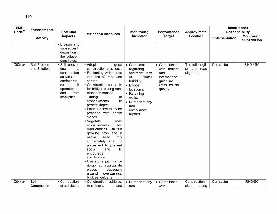
140
EMP Code20 Environmenta
l Activity
Potential Impacts Mitigation Measures Monitoring
Indicator Performance
Target Approximate
Location
Institutional Responsibility
Implementation Monitoring/ Supervision
Erosion and subsequent deposition in the adjacent crop fields.
C03EMP Soil Erosion and Siltation
Soil erosion due to construction activities, earthworks, cut and fill operations and from stockpiles
Adopt good construction practices.
Replanting with native varieties of trees and shrubs
Construction schedule for bridges during non-monsoon season.
Turfing of embankments to protect slopes.
Earth stockpiles to be provided with gentle slopes
Vegetate road embankments and road cuttings with fast growing crop and a native seed mix immediately after fill placement to prevent scour and to encourage stabilization.
Use stone pitching or riprap at appropriate places especially around overpasses, bridges, culverts.
Complaint regarding sediment loss or water turbidity.
Bridge locations;
Retaining walls;
Number of any non- compliance reports
Compliance with national and international guideline limits for soil quality
The full length of the road alignment
Contractor RHD / SC
C04EMP Soil Compaction
Compaction of soil due to
Construction vehicles, machinery, and
Number of any non-
Compliance with
Construction sites along
Contractor RHD/SC

141
EMP Code20 Environmenta
l Activity
Potential Impacts Mitigation Measures Monitoring
Indicator Performance
Target Approximate
Location
Institutional Responsibility
Implementation Monitoring/ Supervision
and Contamination
movement of vehicles and equipment’s
Contamination of soil due to leakage/spillage of oil, bituminous and non-bituminous debris
equipment to be stationed in the designated ROW to avoid compaction.
Haul roads to be designated along the fallow and consolidated soil areas to reduce compaction of arable land.
Fuel storage and filling to be undertaken in areas with concrete surfacing, bunds and interceptor traps
Oil interceptors to be provided at wash down and refuelling sites
Oil and grease spill and oil-soaked materials shall be sold off to authorized recyclers.
compliance reports
Maintenance of temporary passages;
National/International guideline limits for soil quality
the full length of the project
1. C05EMP 2. Topsoil Removal of top soil for construction from outside the RoW.
Compaction of topsoil.
Loss of top soil by wind and water erosion.
Covering of top soil by
The stockpile top surface slope to be no steeper than 2 (H):1 (V) to reduce surface runoff and enhance percolation through the mass of stored soil.
Locate topsoil stockpiles outside drainage lines and protect stockpiles from erosion.
Number of non - compliances observed/ reported
Compliance with National/International guideline limits for soil quality
Various construction sites throughout the road alignment
Contractor RHD/SC

142
EMP Code20 Environmenta
l Activity
Potential Impacts Mitigation Measures Monitoring
Indicator Performance
Target Approximate
Location
Institutional Responsibility
Implementation Monitoring/ Supervision
project works.
3.
Construct diversion channels and silt fences around the topsoil stockpiles to prevent erosion and loss of topsoil.
Use stripped topsoil only to cover all disturbed areas and along the proposed tree plantation sites.
Rip ground surface prior to the spreading of topsoil,
Limit equipment and vehicular movements to within the approved construction zone.
Remove unwanted materials from topsoil such as roots of trees, rubble and waste etc.
C06EMP Air Quality Dust Generation due to construction activities and transport of construction materials.
Emissions from vehicles, equipment
Vehicles transporting construction material to be covered ;
Construction equipment to be maintained to a good standard and idling of engines discouraged.
Machinery emitting visible smoke to be banned from construction sites;
Contractor to prepare a dust suppression
Location of stockpiles;
Number of complaints from sensitive receptors;
Heavy equipment and machinery with air pollution control devices;
Compliance with DoE and National guideline limits for Air at sensitive receptors. Certification that vehicles are compliant with air
Construction sites along the full length of the project
Contractor RHD/SC/DOE

143
EMP Code20 Environmenta
l Activity
Potential Impacts Mitigation Measures Monitoring
Indicator Performance
Target Approximate
Location
Institutional Responsibility
Implementation Monitoring/ Supervision
and machinery.
program detailing action to be taken to minimize dust generation (e.g. spraying of roads with water), and the equipment to be used.
Equipping asphalt hot mix and batching plants with fabric filters or wet scrubbers to reduce dust emissions;
Locate asphalt and crushing plants away from residential areas and social infrastructure such as mosques, schools and madrasas. (Refer to Appendix E for locations of these). Clearance should be at least 500 m and take into account the prevailing wind direction
Dust masks to be provided to workers where dust hazards exist.
Proper dust collection and control systems to be installed at crushers
Ambient air quality found beyond the national standards;
Levels of SOx, NOx, CO, PM10, PM2.5,
quality standards.

144
EMP Code20 Environmenta
l Activity
Potential Impacts Mitigation Measures Monitoring
Indicator Performance
Target Approximate
Location
Institutional Responsibility
Implementation Monitoring/ Supervision
Air quality monitoring to be carried out as per the schedule in the environmental monitoring plan.
C07EMP Noise and Vibration
Noise from construction vehicles, equipment and machinery.
Vibration caused by construction activities.
Use of modern plant and equipment with appropriate muffling devices.
All powered mechanical equipment and machinery to be fitted with noise abating gear such as mufflers for effective noise control, in compliance with DoE regulations.
Construction operations to be restricted to 0700 to 1800 hours.
Locate rock crushing, concrete mixing and material shipment yards away from residential areas, schools, colleges and hospitals.
Install temporary noise barriers near sensitive locations such as schools, religious places and hospitals (Refer to Appendix E for locations)
Number of complaints from sensitive receptors;
Noise measurement data
Use of silencers in noise-producing equipment and sound barriers;
Equivalent day and night time noise levels
Compliance with DoE and National guideline limits for Noise at sensitive receptors.
Construction sites along the full length of the project
Contractor RHD/SC/DOE

145
EMP Code20 Environmenta
l Activity
Potential Impacts Mitigation Measures Monitoring
Indicator Performance
Target Approximate
Location
Institutional Responsibility
Implementation Monitoring/ Supervision
Providing the construction workers with suitable hearing protection like ear cap, or earmuffs etc.
In areas, where structures may to be affected by vibrations from construction activities, take precautions to minimize the vibration and the resulting impact.
Noise quality monitoring to be carried out as per the schedule in the environmental monitoring plan.
C08EMP Topography and Landscape
Land degradation due to careless excavation from borrow area
Borrow pits to be opened within the road right of way and not on agricultural land
Top soil to be preserved. Borrow pits to be rehabilitated.
Borrow pits opened on private land, to be either closed or converted to ponds at the completion of work as per the written direction of the landowner.
Worksite clear of hazardous wastes such as oil/fuel
Worksite clear of any wastes, collected materials from drainages, unutilized materials and debris
Transport route and worksite
Compliance with National guideline for land use policy.
Compliance with
Waste management plan
Borrow areas Contractor RHD/SC

146
EMP Code20 Environmenta
l Activity
Potential Impacts Mitigation Measures Monitoring
Indicator Performance
Target Approximate
Location
Institutional Responsibility
Implementation Monitoring/ Supervision
Construction wastes to be used in construction activities.
cleared of any dust/mud
C09EMP Construction Camps, Workshops and Processing Facilities
Loss of plantation and vegetation.
Permanent physical and visual impact on the area.
Social disturbance for nearby community
Construction camps and workshops to be located away from sensitive areas and not within 500 metres of existing settlements (Refer to Appendix E) unless agreed to after consultation with local people.
Briefing and/or on-site training for the contractor’s workers on the environmental requirement of the project and the implementation of mitigation measures.
Minimise vegetation loss while making site arrangements for construction camps and other facilities;
Crushing plants, sites for borrow pits, asphalt hot mix and batching plants to be located clear of environmentally sensitive areas, productive land or existing settlements
Worksite clear of hazardous wastes such as oil/fuel
Worksite clear of any wastes, collected materials from drainages, unutilized materials and debris
Transport route and worksite cleared of any dust/mud
Compliance with Waste management plan
Construction sites along the full length of the project
Contractor RHD/SC

147
EMP Code20 Environmenta
l Activity
Potential Impacts Mitigation Measures Monitoring
Indicator Performance
Target Approximate
Location
Institutional Responsibility
Implementation Monitoring/ Supervision
(Refer to Appendix E for locations);
Construction material storage areas not to be located in sensitive areas and to be sheltered or sited within hoardings;
Water and good sanitation facilities to be provided for the camps.
Solid waste must not be dumped, buried or burned at or near the project site, but shall be disposed of at the nearest sanitary landfill or site having and complying with the necessary permits.
The sites for camps and associated facilities shall be rehabilitated after completion of the project.
C10EMP Surface Water Bodies
Loss of surface water bodies and impact on fish
No bituminous or hazardous materials to be used for filling of water bodies.
No visible degradation to nearby drainages, khals or water bodies due to construction activities
Effectiveness of water management measures
All water bodies likely to be affected along the project road (Refer to Appendix E)
Contractor RHD/SC

148
EMP Code20 Environmenta
l Activity
Potential Impacts Mitigation Measures Monitoring
Indicator Performance
Target Approximate
Location
Institutional Responsibility
Implementation Monitoring/ Supervision
C11EMP Surface Water Quality
Contamination of surface water by disposal of construction waste.
Pollution of domestic water supplies
The workforce to be trained in proper means for storage and handling of materials and chemicals;
Work camps and work sites to be provided with toilets and septic tanks;
Proper drainage system with sedimentation ponds and oil separators to be provided to cope with the rain water and oil spills.
Measures to be implemented to control oil spills near water channels
Washing of machinery and vehicles in surface waters to be prohibited. Sealed washing areas shall be provided and wastewater shall be collected in a sedimentation/retention pond for treatment prior to release.
Avoid or minimize damage to water channels;
Conduct regular water quality monitoring
Areas for stockpiles, storage of fuels and lubricants and waste materials;
Number of silt traps installed along trenches leading to water bodies
Records of surface water quality inspection;
Levels of pH, TOC, PO4, TSS, DO, oil and grease
Compliance with National guideline limits for Surface water.
Construction sites along the full length of the project particularly beel / lowland / pond / ditch areas (Refer to Appendix E)
Contractor RHD/SC/DOE

149
EMP Code20 Environmenta
l Activity
Potential Impacts Mitigation Measures Monitoring
Indicator Performance
Target Approximate
Location
Institutional Responsibility
Implementation Monitoring/ Supervision
according to the determined sampling schedule;
Prevent construction debris from entering drainage or irrigation canals;
Construction work close to ponds or other water bodies to be minimised especially during monsoon season;
Wastes to be collected, stored and taken to approve disposal sites.
C12EMP Groundwater Quality
Contamination of underground water table from leachate of construction waste.
Arrangements for safe drinking water to be made prior to start of work. Water for consumption to be supplied only after adequate analysis and requisite treatment.
Train workers on the need for judicious use of freshwater resources.
Water reserves to be protected from contamination such as construction and oily waste.
Monitoring in accordance with monitoring program.
No breaches of Material Safety Data Sheet (MSDS) for hazardous substances.
Levels of pH, CaCO3, Cl-, Mn, As, Fe, total coliform, fecal coliform
Compliance with National guideline limits for Ground water.
Construction sites along the full length of the project
Contractor RHD/SC/DOE

150
EMP Code20 Environmenta
l Activity
Potential Impacts Mitigation Measures Monitoring
Indicator Performance
Target Approximate
Location
Institutional Responsibility
Implementation Monitoring/ Supervision
C13EMP Waste Pollution
Unhygienic conditions, health risk to workforce and general public at the camp site.
Solid and liquid wastes to be disposed at designated sites and no waste to be disposed in productive agricultural land;
Hazardous waste to be transported to nearby incineration facility;
Sanitary wastes generating from staff and labour camps to be disposed of in an environmentally friendly manner, i.e. provision of septic tank etc. for toilet wastes;
Pavement materials from the existing road to be incorporated in the upgrading works.
Air (PM10) and noise level measurements ;
Dust pollution; Number of
non-compliances observed/
reported
Compliance with Waste management plan
Construction sites along the full length of the project
Contractor RHD/SC/DOE
C14EMP Dredging and Dredged Materials
River bank erosion and higher flood risk and pollution due to spilling/seepage of oil in the river.
Increase in sedimentation and dispersion of pollutants
Permits/NOC to be obtained, from relevant authority such as BIWTA prior to extraction
Work not to be carried out when fish are likely to be spawning or in the period between spawning and the subsequent emergence of juvenile fish. (July to September
Air (PM10) and noise level measurements ;
Dust pollution and complaint of local residents
Number of non-compliances observed/ reported
Compliance with Waste management plan
Dredging sites
Contractor RHD/SC

151
EMP Code20 Environmenta
l Activity
Potential Impacts Mitigation Measures Monitoring
Indicator Performance
Target Approximate
Location
Institutional Responsibility
Implementation Monitoring/ Supervision
in dredged material
While dredging, special care to be given to prevent any spillage/seepage of oil from the dredging machines;
If owners of the ponds and lands near the road alignment want to use their area for fisheries project, the contractor may collect filling materials from that area through proper contract and dredging guidelines.
Dredged material from the river bank to be tested for presence of heavy metals and other pollutants before its use.
Note – some areas were tested during the preparation of EIA (refer to Table 4.2).
C15EMP Flora Loss of habitat due to tree cutting
Vegetation loss due to site preparation and
Trees suited to the tract to be planted (see Appendix G for tree plantation plan);
Flowering and fruiting shrubs to be planted along the RoWs to beautify the landscape;
Number of complaints from sensitive receptors on disturbance of vegetation.
Illegal felling of trees
PMO and PIU to report in
Compliance with
Tree management plan
Construction sites along the full length of the project
Contractor RHD/SC/FD

152
EMP Code20 Environmenta
l Activity
Potential Impacts Mitigation Measures Monitoring
Indicator Performance
Target Approximate
Location
Institutional Responsibility
Implementation Monitoring/ Supervision
construction activities
Contractor’s personnel to be directed not to damage any vegetation such as trees or bushes.
Construction vehicles, equipment and machinery to be limited to their designated areas of movement.
Gas cylinders to be used for fuel at the camps for cooking purposes. Cutting of trees/bushes for fuel not to be allowed.
Camp sites and asphalt plants to be established on waste/barren land rather than on forested or agriculturally productive land. However if such type of land is not available, it must be ensured that vegetation clearing is minimised and minimum damage is caused to the trees, undergrowth and crops.
writing the number of trees cut and planted if tree-cutting will be required (to be determined during detailed design stage)
C16EMP Wildlife Hunting of wildlife and
Wildlife Department to check and confirm that no hunting occurs;
Number of complaints from sensitive
Compliance with National/Intern
Along the road alignment
Contractor RHD/SC/DOE

153
EMP Code20 Environmenta
l Activity
Potential Impacts Mitigation Measures Monitoring
Indicator Performance
Target Approximate
Location
Institutional Responsibility
Implementation Monitoring/ Supervision
birds during construction.
New and good condition machinery with low noise generation characteristics to be used in construction;
Construction work not to be carried out at night.
Borrow pits to be fenced to protect animals.
receptors on disturbance of poaching.
Illegal hunting
ational guideline for wildlife
C17EMP Fisheries Impact on fishing activity (production, spawning and breeding grounds)
Disturbance to aquatic life including migration of fish due to bridge construction
Construction not to be undertaken during high flood.
Construction along the riverbanks must be avoided during the fish breeding season (July to September).
Deep water channel to be maintained during bridge construction.
Number of complaints from sensitive receptors on disturbance of fishing;
Any evidence of fish mortality.
Compliance with National/International guideline
Throughout the road alignment particularly in beel/lowland/pond/ditch/river areas (Refer to Appendix E)
Contractor RHD/SC
C18EMP Land use Land disputes, soil erosion, loss of potential cropland and vegetation, landscape
Agricultural areas not to be used as borrow areas.
Land acquisition for borrow areas to be minimized. River sand to be used for embankment. Preference shall be
Number of complaints from sensitive receptors;
Records of sources of materials
Compliance with National/International guideline
Borrow areas, access roads, bypasses
DC, Contractor RHD/SC

154
EMP Code20 Environmenta
l Activity
Potential Impacts Mitigation Measures Monitoring
Indicator Performance
Target Approximate
Location
Institutional Responsibility
Implementation Monitoring/ Supervision
degradation, and damage to road embankments.
Land use change due to borrowing of earth.
Land use change and loss of productive top soil.
given to borrow earth from right of way wherever feasible;
Necessary permits to be obtained for any borrow pits from the competent authorities and all environmental considerations to be ensured;
Topsoil from borrow areas to be preserved and borrow pits to be rehabilitated after completion of borrow operations ;
Borrow pits to be sited on waste land and at least 500 m away from the road;
Priority to be given to borrowing from humps (including from digging of wells) above the general ground level;
Priority should be given to the borrowing by excavating/enlarging existing borrow areas;
C19EMP Traffic Traffic jams causing inconvenience to the people
Provision to be made for passing traffic during construction
Traffic management shall be undertaken in coordination with the
Traffic route during construction works including number of
Compliance with Traffic management plan
Construction sites along the full length of the project
Contractor RHD/SC

155
EMP Code20 Environmenta
l Activity
Potential Impacts Mitigation Measures Monitoring
Indicator Performance
Target Approximate
Location
Institutional Responsibility
Implementation Monitoring/ Supervision
local traffic police department.
permanent signage, barricades and flagmen on worksite;
Number of complaints from sensitive receptors;
Number of signages placed at project location;
Number of walkways, signage, and metal sheets placed at project location
C20EMP Cultural Sites Noise and dust pollution and movement of the people to the nearby schools, colleges, mosques, and graveyards etc.
Timely completion of the construction work and provision for movement through or around the construction site;
Workshops and storage / processing facilities and labour camp to be sited so as to maintain proper clearances from the cultural sites.
No complaints from sensitive receptors
Compliance with National guideline limits for Noise and dust.
Along the road alignment (Refer to Table 4.15 and Appendix E)
Contractor RHD/SC
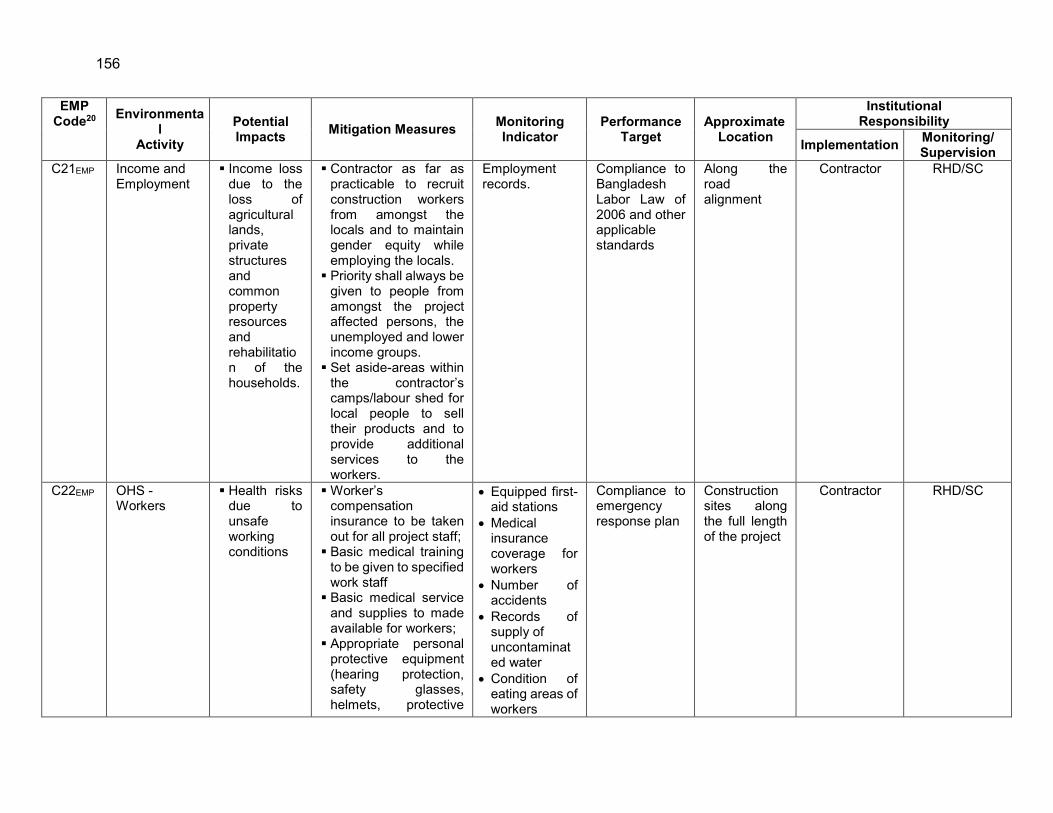
156
EMP Code20 Environmenta
l Activity
Potential Impacts Mitigation Measures Monitoring
Indicator Performance
Target Approximate
Location
Institutional Responsibility
Implementation Monitoring/ Supervision
C21EMP Income and Employment
Income loss due to the loss of agricultural lands, private structures and common property resources and rehabilitation of the households.
Contractor as far as practicable to recruit construction workers from amongst the locals and to maintain gender equity while employing the locals.
Priority shall always be given to people from amongst the project affected persons, the unemployed and lower income groups.
Set aside-areas within the contractor’s camps/labour shed for local people to sell their products and to provide additional services to the workers.
Employment records.
Compliance to Bangladesh Labor Law of 2006 and other applicable standards
Along the road alignment
Contractor RHD/SC
C22EMP OHS - Workers
Health risks due to unsafe working conditions
Worker’s compensation insurance to be taken out for all project staff;
Basic medical training to be given to specified work staff
Basic medical service and supplies to made available for workers;
Appropriate personal protective equipment (hearing protection, safety glasses, helmets, protective
Equipped first-aid stations
Medical insurance coverage for workers
Number of accidents
Records of supply of uncontaminated water
Condition of eating areas of workers
Compliance to emergency response plan
Construction sites along the full length of the project
Contractor RHD/SC

157
EMP Code20 Environmenta
l Activity
Potential Impacts Mitigation Measures Monitoring
Indicator Performance
Target Approximate
Location
Institutional Responsibility
Implementation Monitoring/ Supervision
footwear and gloves, high visibility vests and other protective clothing) to be provided to all workers;
Provision of adequate sanitation, washing, cooking and dormitory facilities including lighting;
Adequate signage, lighting, barriers, yellow tape and persons with flags during construction to manage traffic at construction sites, haulage and access roads.
Application of preventive and protective measures consistent with international good practices such as the World Bank Group’s Environment, Health and Safety Guidelines.
Use of personal protective equipment
% of moving equipment outfitted with audible back-up alarms
Permanent sign boards for hazardous areas
Signage for storage and disposal areas
Condition of sanitation facilities for workers.
Record of H&S orientation trainings
C23EMP OHS - Community
Safety risks due to construction works
The labour works with different transmittable diseases should be restricted within the construction site.
Drivers operating construction vehicles
Number of accidents;
Number of permanent signage, barricades and flagmen
Compliance to emergency response plan
Construction sites along the full length of the project
Contractor RHD/SC

158
EMP Code20 Environmenta
l Activity
Potential Impacts Mitigation Measures Monitoring
Indicator Performance
Target Approximate
Location
Institutional Responsibility
Implementation Monitoring/ Supervision
to be trained in road safety awareness;
Close consultation with local communities to identify optimal solutions for diversions to maintain community integrity and social links;
Provision of proper safety and diversion signage,
Crossing provision to be made for pedestrians and vehicles near settlements
Use of water not to disturb water availability for the public.
on worksite as per Traffic Management Plan;
Number of complaints from sensitive receptors;
Number of walkways, signage, and metal sheets placed at project location
Permanent sign boards for hazardous areas
Agreement between landowner and contractors in case of using private lands as work camps, storage areas, etc.
OPERATION STAGE O01EMP Soil Erosion due
to damage of embankment and during transportatio
Turfing of embankment shall be maintained.
Surveillance to protect the embankment from
No complaints from sensitive receptors
Compliance with National/ International guideline limits for soil
Along the road alignment particularly at erosion prone area
RHD RHD

159
EMP Code20 Environmenta
l Activity
Potential Impacts Mitigation Measures Monitoring
Indicator Performance
Target Approximate
Location
Institutional Responsibility
Implementation Monitoring/ Supervision
n of sand by sand miners along river
Soil contamination due to accidental spillage from vehicular movement.
unauthorized accesses.
In case soil erosion takes place, proper remedial measures will be undertaken to stop future impacts of loss of soils and the associated impacts caused by soil erosion;
Proper measures must be ensured to prevent any oil spillage and leakage from the locomotives.
Efforts will be made to clean the spills of oil, toxic chemicals etc. as early as possible.
O02EMP Noise and Vibration
The noise levels are anticipated to increase due to traffic related noise pollution; vibrations from engines and tires and mainly use of pressure horns.
According to monitoring results, additional sound barriers in form of trees and hedges will be discussed with the affected people and planted if agreed;
Signs for sensitive zones (health centres / educational institutions etc.) to disallow the use of pressure horns;
Enforcement and penalties against traffic rules violators;
No complaints from sensitive receptors
Compliance with National guideline limits for Noise level.
Along the road alignment particularly in the major road intersections and densely settlement areas
RHD RHD/DOE

160
EMP Code20 Environmenta
l Activity
Potential Impacts Mitigation Measures Monitoring
Indicator Performance
Target Approximate
Location
Institutional Responsibility
Implementation Monitoring/ Supervision
Monitoring to protect the trees.
O03EMP Air Quality Increased traffic levels and congestion will lead to air pollution levels.
Ambient air quality monitoring should be carried out during operation phase;
Roadside tree plantations as applicable and feasible under harsh climatic conditions;
Regular road maintenance to ensure good surface condition;
Regular vehicle check to control/ensure compliance with air quality standards;
Enforcement and penalties against traffic rules violators.
No complaints from sensitive receptors;
Levels of SOx, NOx, CO, PM2.5, PM10
Compliance with National guideline limits for Air quality.
Along the road alignment particularly in the major road intersections and densely settlement areas
RHD RHD/DOE
O04EMP Water Quality Contamination of water bodies from runoff from the roads containing oils and grease;
Groundwater may get polluted due to contaminated road runoff
In order to discharge rapid removal of storm-water/road runoff, cross slopes and longitudinal drainage will be provided in the design;
Proper drainage system with sedimentation ponds and oil separators will be provided to avoid contamination by run-off and oil spills;
No visible degradation to nearby drainages, khals or water bodies due to construction activities;
Levels of pH, TOC, PO4, TSS, DO, oil and grease (surface water)
Compliance with National guideline limits for Surface and Ground water.
Throughout the road alignment particularly in khal/lowland/rivers/pond/ditch areas (Refer to Appendix E)
RHD RHD/DOE

161
EMP Code20 Environmenta
l Activity
Potential Impacts Mitigation Measures Monitoring
Indicator Performance
Target Approximate
Location
Institutional Responsibility
Implementation Monitoring/ Supervision
on earthen shoulders and embankments planted with grasses.
Retention basins with reedbeds provided in the design will improve the quality of polluted storm-water/road runoff;
Prior to operation, an emergency response plan for spills of hazardous materials and oil will be prepared.
Groundwater quality monitoring will be carried out as per schedule suggested in the Environmental Monitoring Plan.
Levels of pH, CaCO3, Cl-, Mn, As, Fe, total coliform, fecal coliform (groundwater)
O05EMP Land Use Development of commercial establishments, educational institutes etc., which may affect the land value
All the facilities with the exception of restaurants and petrol/gas filling stations likely to pop up in the future will be prohibited within the RoW.
The permission will be sought from the concerned authority for the development of any establishment along the project;
The bridge site may also be developed as tourist spot with further beautification;
Number of complaints from sensitive receptors
Compliance with National/International guideline
Along the road alignment particularly in the urban and densely settlement areas
RHD RHD

162
EMP Code20 Environmenta
l Activity
Potential Impacts Mitigation Measures Monitoring
Indicator Performance
Target Approximate
Location
Institutional Responsibility
Implementation Monitoring/ Supervision
The designated RoW shall be maintained free of any encroachment.
O06EMP Wildlife Killing of animals in road accidents
Raising of dense plantation of shady trees on both sides of the RoW shall provide resting, nestling and roosting habitat to the fauna and especially to the avifauna which is a major positive impact;
Low width under passes with the provision of small net on the both side of the road shall be made where the animal movement is frequent.
Number of complaints from sensitive receptors on disturbance of poaching.
Illegal hunting
Compliance with National/International guideline for wildlife
Along the road alignment
RHD RHD/DOE
O07EMP Fisheries The damage of 44 ponds, 189 ditches and disturbance to fisheries species during construction of bridge and culvert over rivers and canals to build the road embankment.
Provide logistic support to the PAPs of the water bodies to culture fish in other places in the PIA.
Consult with the local fisheries department to enrich the fisheries resources;
Efforts shall be made to maintain deep water stream for certain length on both end of the bridge.
Number of complaints from sensitive receptors on disturbance of fishing;
Any evidence of fish mortality.
Compliance with National/International guideline
Throughout the road alignment particularly in khal/lowland and/rivers/pond/ditch areas
RHD RHD/DOE

163
EMP Code20 Environmenta
l Activity
Potential Impacts Mitigation Measures Monitoring
Indicator Performance
Target Approximate
Location
Institutional Responsibility
Implementation Monitoring/ Supervision
O08EMP Cultural Sites Noise, vibration and whistling near to cultural sites like school, college, madrasa, health complex, temple, etc.
Proper rehabilitation of the affected people and the religious and cultural monuments and structures;
Noise problem can be mitigated through plantation of trees along the boundary of the cultural sites;
Avoid unnecessary whistling at sensitive cultural sites.
No complaints from sensitive receptors
Compliance with National guideline limits for Noise and dust.
Along the road alignment
RHD RHD
O09EMP Road Safety Increase in the number of road accidents and animals kills
Speed limits shall be imposed.
Safety signal shall be displayed along the road and speed limits be displayed as well as monitored especially along settlements;
Traffic signs shall be provided to warn road users about speed limits, rest areas, eating establishments etc.
Lanes, median, and sharp bends shall be reflectorized to improve road visibility at night time.
Foot over bridge shall be provided near schools, markets,
Number of accidents;
Number of complaints from sensitive receptors;
Number of speed limit violations
Installation of road safety signages
Compliance with road safety regulations
Along the road alignment particularly at road intersections
RHD RHD

164
EMP Code20 Environmenta
l Activity
Potential Impacts Mitigation Measures Monitoring
Indicator Performance
Target Approximate
Location
Institutional Responsibility
Implementation Monitoring/ Supervision
habitat areas for safe crossing of the roads
Proper lighting shall be provided along the project road.

165
D. EMP Implementation Schedule
377. An implementation schedule has been sketched based on the environmental components that may be affected during the construction and operation of the project. Since project is likely to have impact on various components of environment, a comprehensive EMP implementation schedule covering terrestrial and aquatic ecology, soil erosion, drainage congestion, tree plantation, air quality, noise, and vibration are provided in table 42. Monitoring Plan has been separately suggested for pre-construction, construction and operation phase.
E. Environmental Monitoring Plan
1. General
378. Environmental monitoring is an essential tool for environmental management as it provides the basic information for rational management decisions. The purpose of the monitoring program is to ensure that the envisaged purposes of the project are achieved and result in desired benefits to the target population. To ensure the effective implementation of the mitigation measures, it is essential that an effective monitoring program be designed and carried out. Compliance monitoring will be conducted in accordance with the environmental mitigation measures and monitoring plan provided with this report (Table 43).
2. Objectives
379. The objective of environmental monitoring during the construction and operation phases is to compare the monitored data against the baseline condition collected during the study period to assess the effectiveness of the mitigation measures and the protection of the ambient environment based on national standards. The main objectives of the pre-construction, construction and operation phase monitoring plans will be to:
Monitor the actual impact of the works on physical, biological and socioeconomic receptors within the project corridor for indicating the adequacy of the EIA;
Recommend mitigation measures for any unexpected impact or where the impact level exceeds that anticipated in the EIA;
Ensure compliance with legal and community obligations including safety on construction sites;
Monitor the rehabilitation of borrow areas and the restoration of construction campsites as described in the EMP;
Ensure the safe disposal of excess construction materials. Appraise the adequacy of the EIA with respect to the project’s predicted long-term
impacts on the corridor’s physical, biological and socio-economic environment; Evaluate the effectiveness of the mitigation measures proposed in the EMP and
recommend improvements, if and when necessary; Compile periodic accident data to support analyses that will help minimize future
risks; and Monitor the survival rate of avenue plantations.

166
Table 44: EMP Implementation Schedule Environmental
Issue EMP Time Line
Pre-Const'n (6 months)
Construction Phase (36 months)
Operation Phase (36 months)
Technical Support
Updation of environmental guidelines and performance indicators
Flora Tree cutting along the RoW Compensatory afforestation (Minimum 1:2)
Drainage Congestion
Provision of adequate opening Monitoring analysis of drainage congestion
Erosion, Sedimentation and Soil
River bank protection measures Soil conservation Monitoring of soil erosion
Land Compensation against land acquisition Landscaping on approach road and service areas
Slope/ Embankment protection at approach Road
Turfing of embankment with grasses and herbs Embankment protection of the approach road
Water and Drinking Water Supply
Monitoring of Surface Water Quality Monitoring of Ground Water Quality and Levels Installation of oil and grease traps at construction sites Construction of soak pits at construction and rehabilitation sites Ensuring arsenic free drinking water for construction camps
Air Quality and Dust Management
Monitoring of Ambient Air Quality Water Spraying/ Watering
Construction Safety Provision of PPEs Health Issues Health Check-up Camps
Monitoring of Noise and Vibration

167
Environmental Issue EMP
Time Line Pre-Const'n (6 months)
Construction Phase (36 months)
Operation Phase (36 months)
Noise Quality and Barriers
Monitoring of Tree Felling and Plantation Maintenance of tree Provision of Noise Barriers
Establishments Construction Stage Training Environmental training and Awareness Management Information System
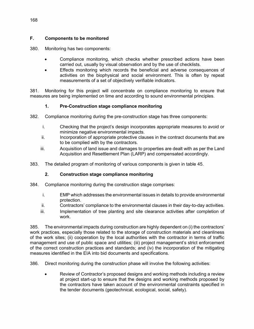
168
F. Components to be monitored
380. Monitoring has two components:
Compliance monitoring, which checks whether prescribed actions have been carried out, usually by visual observation and by the use of checklists.
Effects monitoring which records the beneficial and adverse consequences of activities on the biophysical and social environment. This is often by repeat measurements of a set of objectively verifiable indicators.
381. Monitoring for this project will concentrate on compliance monitoring to ensure that measures are being implemented on time and according to sound environmental principles.
1. Pre-Construction stage compliance monitoring
382. Compliance monitoring during the pre-construction stage has three components:
i. Checking that the project’s design incorporates appropriate measures to avoid or minimize negative environmental impacts.
ii. Incorporation of appropriate protective clauses in the contract documents that are to be complied with by the contractors.
iii. Acquisition of land issue and damages to properties are dealt with as per the Land Acquisition and Resettlement Plan (LARP) and compensated accordingly.
383. The detailed program of monitoring of various components is given in table 45.
2. Construction stage compliance monitoring
384. Compliance monitoring during the construction stage comprises:
i. EMP which addresses the environmental issues in details to provide environmental protection.
ii. Contractors’ compliance to the environmental clauses in their day-to-day activities. iii. Implementation of tree planting and site clearance activities after completion of
work.
385. The environmental impacts during construction are highly dependent on (i) the contractors’ work practices, especially those related to the storage of construction materials and cleanliness of the work sites; (ii) cooperation by the local authorities with the contractor in terms of traffic management and use of public space and utilities; (iii) project management’s strict enforcement of the correct construction practices and standards; and (iv) the incorporation of the mitigating measures identified in the EIA into bid documents and specifications.
386. Direct monitoring during the construction phase will involve the following activities:
Review of Contractor’s proposed designs and working methods including a review at project start-up to ensure that the designs and working methods proposed by the contractors have taken account of the environmental constraints specified in the tender documents (geotechnical, ecological, social, safety).
169
Site- specific review of contractors’ temporary facilities; involving the inspection of contractor’s worksites and work camps to ensure that the contractor’s arrangements regarding temporary facilities are satisfactory.
Regular site inspection during the construction period, involving scheduled and unannounced inspections to ensure that the stipulated procedures as defined in the EMP are being followed by the contractor(s). This monitoring will require the completion of systematic observations of site activities using checklists to be developed by RHD or its supervising consultants.
Inspection of the certification of site clearance and restoration, to ensure that actual restoration has taken place, e.g., the temporary sewage works have been adequately disposed of.
3. Operation stage monitoring
387. The contractor will compile and maintain the environmental data and records gathered during the construction phase for reference during the operation phase. The contractor will coordinate with government departments and agencies, RHD in particular, for monitoring with respect to air quality, water, noise and traffic.
The contractor in collaboration with the concerned department will organize monitoring of air quality and effects of the exhausts along the road project. Sensitive parameters including NO2, SO2 and particulate matters will be monitored and necessary measures will be taken to keep them within the limits set by government.
The noise levels will be monitored to see whether they are within the limits. When they are found to exceed these limits and disturb the nearby settlements, noise abatement measures, like plantation of trees and construction of sound barriers will be taken.
Monitoring will be done to ensure that both surface and groundwater quality will up to the standards. Mitigation measures will be taken in the design of new facilities and also from the point sources related to new developments and industry. Pollution control equipment’s including wastewater treatment plants will be recommended for the local industry and accordingly monitored.
The contractor will monitor that flora and fauna of the area is not disturbed by the increase of population and other activities in the area of influence. Tree plantation will be done. Any activity of the nearby residents (such as disposal of waste, land use change, etc.), which affects the environment, will be brought to the knowledge of the competent authority for necessary action.
388. The above monitoring system will be fully controlled by the project proponent i.e. RHD. A monitoring schedule has been included as guideline for the stakeholders (Table 44).
G. Monitoring Program
389. Monitoring points have been selected based on the sensitivity of the location with respect to sensitive receptors.
390. The schedule has been developed based on the possible occurrence of adverse impacts and required mitigation actions. However, this schedule is subject to change depending on the analysis results obtained. The protocol for changing the monitoring schedule is given below.

170
1. Tree Plantation
391. The 75% survival rate of re-plantation shall be monitored on the first year of the operation phase. If the survival rate is found below 75%, survival rate monitoring shall be again taken up after 3 years. This cycle should continue until the 75% survival rate is achieved.
2. Terrestrial and Aquatic Fauna including Fisheries
392. The fish productivity monitoring are important and sensitive issues. In case, any significant decline in terms of fish productivity in the khals/canals or ponds is noticed, the monitoring frequency shall be increased until the effectiveness of mitigation measures are established.
3. Soil Erosion and Drainage Congestion
393. No significant soil erosion problem is anticipated due to the project either in the construction phase or in the operation phase. However, in the construction phase, some localized soil erosion may be noticed owing to construction activities. However, if soil erosion is noticed during construction and operation phase, the corrective action shall be initiated and frequency of check be increased to assess the tendency of occurrence.
4. Air and Noise Quality
394. Due to the variability of the construction activities, namely changes in batch composition, type of construction activity and other anthropogenic influences, the ambient air quality of the project area may change. If the air quality with respect to any parameter exceeds by more than 25% of its last monitored value, the monitoring frequency shall be doubled and cause of the increase investigated. If the construction activities are found to be the reason for this increase, suitable measures should be adopted.
395. Similarly, due to the variability in traffic movement, namely changes in traffic volume, traffic compositions and other anthropogenic influences, the noise quality in the project area is likely to change. If the noise quality exceeds by 20% of the applicable ambient noise quality standard or 5% of its last monitored value, the monitoring frequency shall be increased and the cause of the increase investigated. If the construction activities are found to be the reason for this increase, suitable measures should be adopted.
5. Water Quality
396. No significant change in water quality is perceived due to the project in the operation phase. However, in the construction phase, the monitored values for pH, BOD, COD, TDS, DO and Oil and Grease might change owing to construction activities. Hence, it is suggested that if the monitored value for any water quality parameter exceeds by more than 20% of its last monitored status the monitoring frequency shall be increased. If the construction activities are found to be the reason for this increase, suitable measures should be adopted.

171
Table 45: Environmental Monitoring Plan EMoP Code
Environmental Components
Parameters/ Units
Standards/ Guidelines
Location Monitoring Period/
Frequency/ Sampling, No/year
Responsibility Implementation Supervision
Pre-Construction Stage
P01EMoP Dredged materials
Lead (Pb), Cadmium (Cd), Cromium (Cr), Copper (Cu), Zinc (Zn), Manganese (Mn), Arsenic (As), Selenium (Se), and Mercury (Hg)
Government of Bangladesh (GoB) and international standard
Proposed dredging sites
Once prior to start dredging
Contractor RHD/Construction Supervision Consultant (CSC)
P02EMoP Air Quality PM2.5, PM10, CO, SO2, NO, NO2, O3, VOC, Temperature, Humidity, Wind Speed and Wind Direction
Air quality standard by DOE, Bangladesh
Major road intersections
Once Contractor RHD/CSC
P03EMoP Noise Level dB(A) Noise Pollution Control Rules (2006)
Major Road Intersections and inhabited locations and sensitive areas
Once Contractor RHD/CSC
P04EMoP Water Quality Surface water: pH, TOC, Total Phosphate, TSS, Oil and Grease, and DO
Surface water quality standard by DOE, Bangladesh
Surface water near project site
Once Contractor RHD/CSC
P05EMoP Groundwater: pH, Mn, As, Fe, Cl-, Total hardness, TC, FC
Groundwater quality standard by DOE, Bangladesh
Groundwater near project site
Once Contractor RHD/CSC
P06EMoP Wildlife Wildlife habitat and movement
None Specific Areas alongside the road alignment
Once Contractor RHD/CSC
P07EMoP Tree felling Monitoring activities outlined in RP;
Check whether proper compensation as mentioned in RP is
Inspection ROW along the alignment
During tree felling and site clearing operations
Contractor/ NGOs/RHD
RHD/CSC

172
EMoP Code
Environmental Components
Parameters/ Units
Standards/ Guidelines
Location Monitoring Period/
Frequency/ Sampling, No/year
Responsibility Implementation Supervision
received by PAPs. Construction Stage
C01EMoP Air Quality PM2.5, PM10, CO, SO2, NO, NO2, O3, VOC, Temperature, Humidity, Wind Speed and Wind Direction
Air quality standard by DOE, Bangladesh
Hot mix plant, concrete mixing plant/stone crushers at construction sites
2/year per site for 3 years
Contractor RHD\CSC
C02EMoP Dust Dust control Air quality standard by DOE, Bangladesh
Construction site and ROW along the alignment
Regularly Contractor RHD\CSC
C03EMoP Noise Level dB(A) Noise Pollution Control Rules (2006)
Construction sites and inhabited locations and sensitive areas
2/year per site for 3 years
Contractor RHD\CSC
C04EMoP Water Quality Surface water: pH, TOC, Total Phosphate, TSS, Oil and Grease, and DO
Water quality standard by MoEF, Bangladesh
Surface water near project site
2/year per site for 3 years
Contractor RHD\CSC
C05EMoP Groundwater: pH, Mn, As, Fe, Cl-, Total hardness, TC, FC
Water quality standard by MoEF, Bangladesh
Drinking water to made available to construction camps and ground water near project site
2/year per site for 3 years
Contractor RHD\CSC
C06EMoP Soil Erosion Visual check for Soil erosion and siltation
All major water bodies
Once during rainy seasons of the construction period.
Contractor RHD\CSC
C07EMoP Drainage congestion
Check drainage plan implemented correctly
Conduct regular inspection
Monitoring Construction site Weekly during monsoon
Contractor RHD\CSC

173
EMoP Code
Environmental Components
Parameters/ Units
Standards/ Guidelines
Location Monitoring Period/
Frequency/ Sampling, No/year
Responsibility Implementation Supervision
C08EMoP Soil Pollution Check liquid waste is carried out by experienced personnel and in proper way
Careful and proper handling of oil and other hazardous liquids
Monitoring Construction Yard, dumping site
Regularly Contractor RHD\CSC
C09EMoP Wildlife Wildlife habitat and movement
None Specific Areas alongside the road alignment
Quarterly Contractor RHD\CSC
C10EMoP Fisheries Impact on fish productivity , breeding and spawning
All major water bodies
Once in a year Contractor RHD\CSC
C11EMoP Waste
Check storage, transportation, disposal, handling of hazarders waste
Waste and effluents to be collected and disposed safely from all camps.
Wastes and garbage from bridges construction sites to be disposed safely
Monitoring Construction Yard, dumping site
Weekly Contractor RHD\CSC
C12EMoP Health and Safety
Check quality of food and accommodation at construction camp;
Check safe water supply, hygienic toilet at camps, construction of drain at camp sites;
Check toilets are close to construction site and separate toilet for female workers;
Monitoring Construction site and labor camp
Regularly Contractor RHD\CSC

174
EMoP Code
Environmental Components
Parameters/ Units
Standards/ Guidelines
Location Monitoring Period/
Frequency/ Sampling, No/year
Responsibility Implementation Supervision
First Aid Box with required tools and medicines;
The heavy construction material to handled and stored safely putting due care on public safety;
Heavy construction materials at bridges construction sites to be stored and handled safely; and
Check of personal protective equipment (PPE) for worker at the sites
Operation Stage
O01EMoP Tree Plantation
Check that the planted trees are maintained as mentioned in tree plantation plan
Inspection to ensure proper plantation with proper species
Along the road Regular during June/July
RHD RHD\DOE
O02EMoP Air Quality PM2.5, PM10, CO, SO2, NO, NO2, O3, VOC, Temperature, Humidity, Wind Speed and Wind Direction
Air quality standard by DOE, Bangladesh
Major Road Intersections
1site/year for 3 years
RHD RHD\DOE
O03EMoP Noise Level dB(A) Noise Pollution Control Rules (2006)
Major Road Intersections and inhabited locations and sensitive areas
1site/year for 3 years
RHD RHD\DOE
O04EMoP Water Quality Surface water: pH, TOC, Total Phosphate, TSS, Oil and Grease, and DO
Water quality standard by DOE, Bangladesh
Surface water near project site
1site/year for 3 years
RHD RHD\DOE

175
EMoP Code
Environmental Components
Parameters/ Units
Standards/ Guidelines
Location Monitoring Period/
Frequency/ Sampling, No/year
Responsibility Implementation Supervision
O05EMoP Groundwater: pH, Mn, As, Fe, Cl-, Total hardness, TC, FC
Groundwater near project site
1site/year for 3 years
RHD RHD\DOE
O06EMoP Accident and Public Safety
Record of accidents, different level of disabilities/fatalities.
None Specific Thought out the project section
---------- RHD RHD
O07EMoP Soil Erosion Visual check for soil erosion and siltation
All major water bodies
After first precipitation
RHD RHD
O08EMoP Soil Quality Heavy metals At each construction camp post restoration of construction camp site
Once at each construction site
RHD RHD\DOE
O09EMoP Wildlife Wildlife habitat and movement
None Specific Areas alongside the road alignment
Quarterly RHD RHD\DOE
O10EMoP Fisheries Impact on fish productivity , breeding and spawning
All major water bodies
End of First year of Operation
RHD RHD\DOE

176
H. Environmental Budget
397. The estimated budget for implementation of the mitigation and monitoring measures proposed in the EMP is presented in Table 45.The overall costs of the EMP will comprise:
Environmental monitoring through sample collection and analysis; Any remedial measures necessary to reduce or avoid environmental damage; Designing and implementing all mitigating and enhancement measures; Supervision staff from RHD and consultants including direct costs and travel
subsistence.
398. The total budget is estimated as US$ 1.42 million.
Table 46: Environmental Budget for Hatikamrul-Rangpur Road Component Item Unit Quantity Rate
(in BDT) Amount
(million BDT) PRE-CONSTRUCTION STAGE Technical Support Updating of Environmental
guidelines and performance indicators
Lump sum
- 5,00,000 0.50
Dredged Material Measuring dredged material quality
No. 2 20,000 0.04
Air Quality Measuring air quality No. 2 60,000 0.12 Noise Measuring ambient noise
level No. 6 15,000 0.09
Flora Clearing of Roadside plantation
No. of tree
215000 Covered in Eng. Cost
--
Water Quality Surface water quality measurement
No. 2 20,000 0.040
Groundwater quality measurement
No. 2 20,000 0.040
Land acquisition and resettlement
Compensation against land acquisition
Covered in R and R Budget --
SUB TOTAL (PRE-CONSTRUCTION STAGE) 0.83 CONSTRUCTION STAGE Air Quality Measuring air quality No. 12 60,000 0.72 Noise Measuring ambient noise
level No. 36 15,000 0.54
Provision for additional tree plantation / Noise Barriers
No. Covered in Engineering Cost
--
Flora / tree plantation
Clearing of roadside plantation
No. Covered in Engineering Cost
--
Compensatory afforestation (Minimum 1:2) (Plantation and maintenance for three years)
No. 215000 300/tree 64.5
Water Quality Surface water quality measurement
No. 36 20,000 0.72
Groundwater quality measurement
No. 36 20,000 0.72

177
Component Item Unit Quantity Rate (in BDT)
Amount (million BDT)
Installation of oil and grease traps at construction sites @ 1 per site and 1 site per construction package ( 6 )
No. 25 60,000 1.50
Construction of soak pits at construction sites @ 2 per construction camp and 1 camp per package
No. 20 30,000 0.60
Agriculture Institutional support for enhancing agricultural productivity (Development of demonstration plots for change in cropping pattern for cash crop or high yield variety)
Plots 20 1,00,000 2.00
Technical Support to farmers Lump sum
- 20,00,000 2.00
Fisheries Conversion of derelict pond into culture ponds and other support (fisheries seed distribution, demonstration ponds, technical support)
Lump sum
- 20,00,000 2.00
Drainage Congestion
Provision of adequate opening
Covered in Engineering Cost
Erosion and Sedimentation
River bank protection measures
Covered in Engineering Cost
Soil Maintenance cost in soil conservation
Covered in Engineering Cost
Slope /Embankment protection at approach Road
Turfing of embankment with grasses and herbs
Covered in Engineering Cost
Dust Management
Water sprayer / watering Covered in Engineering Cost
Waste disposal and management
Disposal and management of construction waste
Lump sum
- 80,00,000 8.00
Traffic management
Road signages and traffic directional signs
Covered in Engineering Cost --
Construction Safety
Accident risks in construction activity
Covered in Engineering Cost/Insurance
General Safety (provision of PPE like ear muffs, gloves etc.)
Lump sum
- 8,00,000 0.80
Health Health check-up camps for construction workers
Camps Camps/year
5,00,000 1.50
Environmental Monitoring in construction phase
Monitoring Tree Felling and Plantation
Lump sum
- 20,00,000 2.00
Fisheries Lump sum
- 8,00,000 0.80
SUB TOTAL (CONSTRUCTION STAGE) 88.4 OPERATION STAGE Air Quality Monitoring air quality No. 3 (1/year) 60,000 0.18

178
Component Item Unit Quantity Rate (in BDT)
Amount (million BDT)
Noise Monitoring ambient noise level
No. 6 (1/year) 15,000 0.09
Water Monitoring surface water quality
No. 6 (1/year) 20,000 0.12
Monitoring ground water quality and levels
No. 6 (1/year) 20,000 0.12
Fisheries Maintenance of Derelict Ponds or rehabilitation of Borrow Areas
Lump Sum
- 20,00,000 2.00
Tree survival Provision of additional tree plantation ( Plantation and maintenance for two year)
No. of trees
21500 100/tree 2.15
Monitoring of performance indicators
Monitoring tree felling and plantation
Lump sum
- 8,00,000 0.80
Fisheries Lump sum
- 8,00,000 0.80
Monitoring of waste disposal and management
Lump Sum
- 8,00,000 0.80
SUB TOTAL ( OPERATION STAGE) 7.06 ESTABLISHMENT and TRAINING Establishment Construction stage Per
month 36 1,00,000 3.60
Operation stage Per month
60 25,000 for first three years of operation and 15000 after three years additional two years
1.26
Training Environmental training and awareness
Lump sum
As per training details
30,00,000 3.0
Management Information System Lump sum
- 8,00,000 0.80
SUB TOTAL (ESTABLISHMENT and TRAINING) 8.66 SUB TOTAL (Pre-construction, Construction, Operation, establishment and training)
104.95
CONTINGENCIES @ 10 % on total Environmental Costs 10.49 GRAND TOTAL (in BDT) 115.44 GRAND TOTAL IN MILLION US$ (@ 1 US $ = 81.5 BDT) 1.42

179
X. INSTITUTIONAL ARRANGEMENT, CAPACITY BUILDING AND GRIEVANCE REDRESS MECHANISM
A. Institutional Arrangement
399. The Environmental Management Plan (EMP) implementation requires an organization support structure in the form of organizational requirements, training needs and plan, and information management system. The following section captures these institutional arrangements for EMP implementation by concerned officials of RHD, their consultants and working contractors.
400. The organizational structure of RHD is given in Figure 7.1. However, an organizational structure shall be developed at the corporate, regional and site level to aid effective implementation of the EMP document. Various departments will be involved during implementation of the project as shown in Figure 7.2. Contractor is responsible for implementation of EMP during works and Construction Supervision Consultant (CSC) is primarily responsible for supervision of monitoring of the implementation of the EMP. RHD will be supported by a Management Consultant (MC) to advise and assist RHD in quality and capacity enhancement and independent quality monitoring. Contractor will be responsible for implementation of EMP during work activities stage. Relevant departments responsible for implementation and supervision of proposed mitigation and monitoring measures are given in the EMP.
401. CSC will be responsible to monitor all activities of all contractors procured under the project. As several contractors will be working simultaneously for timely and speedy implementation of the project, it is important that CSC has an environmental unit to effectively supervise and monitor the environmental activities being implemented in the field. The CSC is also responsible to update or make necessary changes to the EMP if required based on the revised designs and locations.
402. A combined grievance redress committee is proposed to address grievances in both social and environmental issues. In addition, there will be NGOs working for plantation program and environmental awareness.
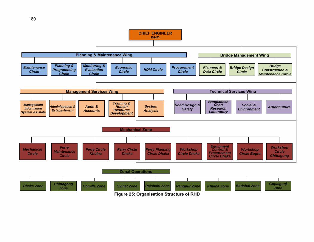
180
Figure 25: Organisation Structure of RHD
CHIEF ENGINEER RHD
Planning & Maintenance Wing
Maintenance
Circle
Planning & Programming
Circle
Monitoring & Evaluation
Circle
Economic
Circle HDM Circle
Procurement
Circle
Bridge Management Wing
Planning &
Data Circle Bridge Design
Circle
Bridge Construction &
Maintenance Circle
Management Services Wing
System Analysis
Training & Human
Resource Development
Audit & Accounts
Administration &
Establishment
Management Information
System & Estate
Technical Services Wing
Arboriculture Social &
Environment
Bangladesh Road
Research Laboratory
Road Design & Safety
Workshop Circle
Chittagong
Workshop Circle Bogra
Equipment Control &
Procurement Circle Dhaka
Workshop Circle Dhaka
Ferry Planning Circle Dhaka
Ferry Circle Dhaka
Ferry Circle Khulna
Ferry Maintenance
Circle
Mechanical Circle
Mechanical Zone
Zonal Operations
Dhaka Zone Rangpur Zone Khulna Zone Barishal Zone Gopalgonj
Zone Sylhet Zone Rajshahi Zone Comilla Zone
Chittagong Zone

181
Figure 26: Proposed Organisation Structure of RHD for Hatikamrul-Rangpur Road
Project21
21 - Roads and Highways Department (RHD); - Project Implementation Unit;
- Project Implementation Consultant; - Contractor
RHD, Government of Bangladesh
Social and Environment Circle (RHD Headquarter)
Project Director
Asst. Project Director (Environmental Focal
Person)
Project Manager
Resident Engineer Assistant Engineer Environment,
Health and Safety Officer
Contractor Project
Implementation Consultant

182
B. Institutional Roles and Responsibilities
403. The Roads and Highways Department (RHD) is the Executing Agency (EA) for the MFF and will be responsible for ensuring that all the components of the EARF are complied with. The RHD has the responsibility to ensure that the investment follows the legal requirements for environmental assessment. The RHD has an Environmental and Social Circle (ESC) headed by the Superintending Engineer who is supported by the Executive Engineer, Subdivision Engineer, Assistant Engineer and Sub-assistant Engineer.
404. Two Project Implementation Units (PIU) will be responsible for implementing phase 1 (Joydepur–Chandra–Tangail–Elenga)22 and phase 2 (Elenga–Hatikamural–Rangpur)23 of the MFF. Each PIU is headed by a Project Director (PD) who is supported by Additional Project Directors (APD). The PD for phase 1 is supported by 1 APD while the PD for phase 2 is supported by 3 APDs. At the site level there are 3 Project Managers (PMs) for the 4 contract packages under the phase 1 and 8 PMs for the 9 contract packages under the phase 2. Each PM is further supported by Deputy PM, Assistant Engineers and Sub Assistant Engineers.
405. The APDs serve as the environmental focal persons under each PIU. One of Assistant Engineers serve as the environmental focal person at the site level and support the respective APD on environment safeguard matters. Further the Project Implementation Consultant (PIC) responsible for supervising the civil works contractor will provide support to the respective PIU for day to day monitoring and reporting on environment safeguards.
406. The following elaborates the detailed responsibilities on environment safeguards:
1. RHD
407. As the EA for the investment program, RHD will be responsible for ensuring that all the environment safeguard requirements as provided in the Framework Financing Agreement (FFA), this EARF and the respective IEE and EMP are complied with.
2. RHD (Environment and Social Cell)
408. The RHD Environment and Social Cell (ESC) is responsible for managing environment and social safeguards including safeguards related capacity building for all RHD projects. They will not be involved in the day to day implementation of safeguards for specific projects such as this investment program. The respective PIU will seek their support and advise on an as needed basis. Their overall responsibilities are:
Ensure that all RHD works and projects are executed in accordance with appropriate environmental and social standards and practices.
Liaise with GOB organisations and other line agencies to ensure effective inter-agency cooperation on relevant projects.
Ensure the provision or procurement of the necessary services for carrying out Environmental Assessment, Land acquisition and Resettlement studies.
22 Phase 1 is already under implementation under Loan 2949-BAN: South Asia Subregional Economic Cooperation Road Connectivity Project 23 A new PIU for phase 2 has just been established

183
Disseminate the need for high social and environmental standards throughout RHD and to the concerned public through research, publicity, seminars and training.
Coordination the preparation and implementation of environmental and resettlement management plans for RHD projects as needed.
Monitor long-term, cumulative environmental impacts and ensure mitigation measures for project sustainability.
Conduct site inspections on selected RHD projects as needed Provide feedback on all environmental issues of existing and ongoing RHD
projects and works. Review and preparation of Request for Proposal (RFP) and tender documents for
procurement of Environmental Services (IEE, EIA and EMP) for RHD projects. Assist the Director of RHD Training Centre in providing training to RHD officers in
Environmental and Resettlement issues. Review and approve the Environmental Assessment reports and Environmental
Monitoring reports produced by consultants/experts under RHD projects as needed.
Establish and maintain environmental standards, guidelines and manuals in RHD. Identify environmental issues and constraints at project planning stage, suggest
alternatives, options. Establish a reference library, containing relevant environmental documents (hard
and soft copies) of domestic and overseas sources. Monitor long term environmental impacts on relevant RHD Projects Liaise with Road Safety Circle, Arboriculture Head and maintain intra-departmental
co-ordination.
3. PIU (Environmental Focal Persons at Project Head Quarter and Site level)
409. The Additional Project Directors under the respective PIU will serve as the Environmental Focal Person at the Project Head Quarter level. At the site level an Assistant Engineer supporting the Project Manager will serve as the environmental focal person. The PIU will be responsible for ensuring proper implementation of environment safeguards in their respective projects including implementation of the EMP and EMoP, timely reporting and timely resolution of complaints and grievances. Their detailed responsibilities are:
Prepare or engage consultants to prepare environmental assessment reports (IEE, EIA, EMP) for project components as necessary
Review and comment on the environmental assessment reports and environmental monitoring reports prepared by consultants and ensure they are prepared in accordance with requirements of RHD, DOE and ADB
Ensure that the consultants while carrying out work at site follow the environmental standards, guidelines and manual of RHD.
Take necessary steps to ensure timely receipt of DoE Environmental Clearance Ensure that the EMP and relevant environmental clauses are included in the
contractors bidding documents Conduct spot checks on-site to monitor contractor’s compliance with the EMP Review and endorse quarterly monitoring reports prepared by the PIC Review and endorse annual environmental monitoring reports prepared by the PIC
for further submission to ADB for disclosure on the ADB website

184
If there are any non-compliance issues or unanticipated environmental impacts ensure that necessary corrective actions are taken and IEE and/or EMP is updated as necessary
Ensure that all grievances and complaints received are addressed in a timely manner and properly documented
Carry out all other activities on environment safeguards on behalf of the PIU as needed
4. Project Implementation Consultant (Environment Safeguards Team)
410. The proposed framework for implementation of the project shall utilize consultancy services from both international and national companies for the overall management and supervision of construction work on behalf of the EA. In addition to supervising the construction work of the contractor their role will be to check on conformity with the relevant clauses in construction contracts and national legislation and regulations. The following are the detailed responsibilities of the PIC.
Review the IEE and EMPs of respective subprojects to understand the context and environmental issues of the project
Establish monitoring and reporting protocols within the environment safeguards team at the site level and project headquarter level
Require the civil works contractor to prepare sub-plans on environment safeguards such as camp layout plan, borrow area management plan, construction debris management plan, traffic management plan etc. as needed
Review and approve all sub-plans on environment safeguards submitted by the civil works contractor
Conduct regular (minimum of weekly) onsite inspections on implementation of the EMP by the contractor
Ensure the contractor obtains all clearances, permits etc. related to environment safeguards on a timely basis
Ensure the contract collects required environmental monitoring data (air, water, noise) as stipulated in the respective IEE report
Provide on-site technical advice and training to the contractor as needed Organize training workshops on implementation of environment safeguards for the
project team including PIU, RHD site offices, members of the PIC and civil works contractor
Facilitate proper functioning of the grievance redress mechanism and maintain records of all complaints received and actions taken for inclusion in the environmental monitoring reports
If there are any non-compliance issues or unanticipated environmental impacts ensure that necessary corrective actions are taken and update the IEE and/or EMP as necessary
Review and approve the monthly progress reports submitted by the contractor Based on monthly progress reports submitted by the contractor and site
inspections prepare quarterly environmental monitoring reports for review and approval by the PIU
Based on the quarterly monitoring reports prepare annual environmental monitoring reports for review and approval by the PIU and further submission to ADB for disclosure on the ADB website

185
Provide necessary technical support to the PIU on implementation of environment safeguards
5. Contractor (Environment Safeguards Team)
411. The tender for the construction of the project would be national/international competitive bidding contractors. The Contractor is legally mandated to implement the EMP and EMoP and obtain all environment related permits and clearances required for construction. The detailed responsibilities of the contractor on environment safeguards are the following:
Recruit and appoint environmental focal persons and/or environmental health and safety officers on the construction site
The contractor shall comply with all statutes and regulations concerning the execution of works as mentioned in DoE and RHD environmental guidelines.
The contractor shall be responsible for familiarizing himself with all legislation elating to environmental protection that is relevant to his activities. Reference to rational environmental quality guidelines should be made.
Implement the EMP approved by the PIC Prepare all sub-plans related environment safeguards such as camp layout plan,
borrow area management plan, construction debris management plan, traffic management plan etc. as needed and submit for approval by the PIC
Obtain all statutory clearances and permits on environment safeguards in a timely manner
Conduct environmental quality monitoring (air, noise, water) as stipulated in the Environmental Monitoring Plan of the respective IEE report
Take necessary measures to immediately address any complaints or grievances raised by local community or other stakeholders
Prepare monthly progress reports on implementation of the EMP for approval by the PIC
The contractor shall be responsible for the costs of cleaning up any environmental pollution resulting from his activities if methods for doing so are available and effective.
6. ADB
412. As a funding agency ADB is responsible for monitoring implementation of environment safeguards, providing technical guidance to the EA as necessary. Specific responsibilities entail the following:
Review IEE reports including EMP provide feedback and disclose the reports on the ADB website as required by the ADB SPS;
Provide assistance to RHD, if required, in carrying out its responsibilities and for building capacity for safeguard compliance;
Monitor overall compliance of the MFF tranches and components to respective IEE and EMP through review missions;
Review all environmental monitoring reports submitted by RHD, provide feedback and disclose the reports on the ADB website as required by the ADB SPS
Provide guidance to the RHD and the PIU on issues related to inclusion of new component components, changes in component design, occurrence of

186
unanticipated environmental impacts during component implementation, emergency situations and others as necessary.
C. Capacity Building
413. In Bangladesh, the environmental assessment process is established, but environmental awareness and capability for implementation of EMP in infrastructure projects are still developing. The project implementation unit (PIU) of RHD had some officers in the environmental and social circle department (ESC) that are delegated environmental duties. The delegated officers have responsibility to bring environmental issues to the notice of senior management. Typically, the delegated officers have been moved to different departments due to promotions and operational needs after about every 3 years, and they move on to other engineering departments in RHD. The status quo is that ESC engineering officers are delegated to check environmental assessments prepared by consultants. The EIA and EMP are referred to the DOE in the Ministry of Environment and Forests (MOEF) for approval. The ESC in RHD is not directly involved with project implementation, but has more administrative responsibility to ensure environmental compliance and a general role to increase environmental awareness for RHD. It is therefore not clear if RHD/ESC has the capacity to check the adequacy of the developed EMP for this project.
414. The most significant challenge for environmental management on this project is the lack of human and financial resources and necessary infrastructure in PIU. To enhance the capacity of the RHD Environmental and Social Circle and PIU for effective implementation of proposed mitigation measures and monitoring the resultant effect, some training programs and awareness workshop are proposed. The detailed training plan is provided at Table 46.
Table 47: Training Plan Target Group Subject(s) Method Time Frame
Planning and Construction Stage All concerned PIU/RHD project staff
Environmental Overview: Environmental regulations, and national standards, process of impact assessment and identification of mitigation measures, importance of EMP and monitoring, and monitoring methodology
Lectures Before beginning of the implementation of the project
Environmental engineers, field officers, contractors, supervision consultants
Implementation of EMPs: Basic features of an EMP, Planning, designing and execution of environmental mitigation and enhancement measures, monitoring and evaluation of environmental conditions during construction and operation
Workshops and Seminars
Before the construction begins
Environmental Engineers, field officers, contractors, supervision consultants
Environmentally Sound Construction Practices: Waste management and minimization in construction, pollution control devices and methods for construction sites and equipment, Environmental clauses in contract documents and their implications, Environmental monitoring during construction
Seminars, Lectures and Site visits
Before the construction
Project staff dealing in social/lands matters
Social awareness: Monitoring consultants/organizations specializing in social management and monitoring can provide training on social
Lectures, Workshops and Seminars
Before the construction begins

187
Target Group Subject(s) Method Time Frame awareness and land acquisition and resettlement issues
Environmental engineers, field officers, contractors, supervision consultants
Monitoring Environmental Performance during Construction: Monitoring, Air, Water, Soil Erosion, Noise, and effect on wild life and fisheries, Evaluation and Review of results, Performance indicators and their applicability, possible corrective actions, reporting requirements and mechanisms
Lectures, Workshop and site visits
During initial phases of construction
Contractor’s staff, construction labourers
Occupational Safety and Health: Monitoring consultants/ organizations specializing in occupational, health and safety issues can provide training on this issue
Workshops and seminars
During initial phases of construction
Construction labourers
Waste handling and sanitation at construction sites/construction camps
Workshops and signage
During initial phases of construction
During Operation Phase Environmental engineers, field officers, contractors,
Long-term Environmental Issues in Project Management: Designing and implementing environmental surveys for ambient air, noise, biological and water quality , data storage, retrieval and analysis, contract documents and environmental clauses, risk assessment and management, contingency planning and management and value addition
Workshops and seminars
During implementation of the project
General public and bridge users
Wild life protection and environmental protection awareness programme
Signage, workshops,
Construction and operation stage
415. It would be essential to understand the legislative framework and enhance capacity of Environmental and Social Unit of RHD and Field Officer (Environment) for analysing the applicability of various environmental legislations and clearances, approvals and compliance monitoring requirements. An environmental legislation applicability matrix framework has already been given in Chapter 2 above for ready reference.
D. Grievance Redress Mechanism
416. To facilitate the resolution of affected people’s concerns, complaints, and grievances about the social and environmental performance of the project, a Grievance Redress Mechanism (GRM) is established which aims to provide a time bound and transparent mechanism to voice and resolve social and environmental concerns.
417. Grievances related to the implementation of the project, particularly regarding the environmental management plan will be acknowledged, evaluated, and responded to the complainant with corrective actions proposed using understandable and transparent processes that are gender responsive, culturally appropriate, and readily accessible to all segments of the affected people. The responsibility for addressing the grievances along with proper timelines will be clearly indicated. Records of grievances received, corrective actions taken and their outcomes will be properly maintained and form part of the environmental monitoring report for submission to ADB.

188
418. The Project Implementation Unit (PIU) of RHD shall make the public aware of the GRM with the support of PIC through methods such as public awareness campaigns. Grievances can be filed in writing or by phone with any member of the PIU or PIC. The following steps procedures will be followed under the GRM.
419. First tier of GRM: The Site Project Manager (PM) under the PIU shall be the designated officer for grievance redress at the first tier. Resolution of complaints will be done within 7 working days. Investigation of grievances will involve site visits and consultations with relevant parties (e.g., affected persons, contractors, traffic police, etc.) Grievances will be documented and personal details (name, address, date of complaint, etc.) will be included, unless anonymity is requested. A tracking number shall be assigned for each grievance, including the following elements:
initial grievance sheet (including the description of the grievance), with an acknowledgement of receipt handed back to the complainant when the complaint is registered;
grievance monitoring sheet, mentioning actions taken (investigation, corrective measures); and
closure sheet, one copy of which will be handed to the complainant after he/she has agreed to the resolution and signed off.
420. The updated register of grievances and complaints will be available to the public at the PM office, construction site, and other key public offices along the project area. Should the grievance remain unresolved within 7 working days, it will be elevated to the second tier.
421. Second tier of GRM: The respective site level PM will activate the second tier of GRM by referring the unresolved issue (with written documentation). The GRC shall be established by the PIU before commencement of site works. The GRC will consist of the following persons: (i) project director; (ii) representative of city ward; (iii) representative of the affected persons; (iv) representative of the local deputy commissioner’s office (land); and (v) representative of the Department of Environment (DOE) for environmental related grievances. A hearing will be called with the GRC, if necessary, where the affected person can present his or her concerns and issues. The process will facilitate resolution through mediation. The local GRC will meet as necessary when there are grievances to be addressed. The local GRC will suggest corrective measures at the field level and assign clear responsibilities for implementing its decision within 15 working days.
422. The contractor will have observer status on the committee. If unsatisfied with the decision, the existence of the GRC shall not impede the complainant’s access to the government’s judicial or administrative remedies.
423. The functions of the local GRC are as follows: (i) resolve problems and provide support to affected persons arising from various environmental issues, including dust, noise, utilities, power and water supply, waste disposal, traffic interference, and public safety, as well as social issues such as land acquisition, asset acquisition, and eligibility for entitlements, compensation, and assistance; (ii) reconfirm grievances of displaced persons, categorize and prioritize them, and aim to provide solutions within a month; and (iii) report to the aggrieved parties about developments regarding their grievances and decisions of the GRC.

189
424. The respective APD and PM will be responsible for processing and placing all papers before the GRC, maintaining database of complaints, recording decisions, issuing minutes of the meetings, and monitoring to see that formal orders are issued and the decisions carried out.
425. Third tier of GRM: In the event that a grievance cannot be resolved directly by the Project Implementation Unit (PIU) (first tier) or GRC (second tier), the affected person can seek alternative redress through the city ward committees or in appropriate courts. The PIU or GRC will be kept informed by the city mayor authority.
426. The monitoring reports of the EMP and the resettlement plan implementation shall include the following aspects pertaining to progress on grievances: (i) number of cases registered with the GRC, level of jurisdiction (first, second, and third tiers), number of hearings held, decisions made, and the status of pending cases; and (ii) lists of cases in process and already decided upon, which may be prepared with details such as name, identification (I.D.) with unique serial number, date of notice, date of application, date of hearing, decisions, remarks, actions taken to resolve issues, and status of grievance (i.e., open, closed, or pending).

190
XI. INFORMATION DISCLOSURE, CONSULTATION AND PARTICIPATION
A. Background
427. This section deals with the information disclosure to the public and consultation sessions held with the different stakeholder groups that are likely to be affected by the implementation of the proposed project. The consultation process was carried out as per the guidelines of ADB’s SPS 2009 and DoE environmental guidelines.
428. This consultation process had the following objectives:
Share information with stakeholders on proposed improvement works and expected impacts on the physical, biological and socio-economic environment of the project corridor;
Understand stakeholders’ concerns regarding various aspects of the project, including the existing condition of the road, upgrading requirements, and the likely impact of construction related activities and operation of the improved road;
Provide an opportunity to the public to influence project design in a positive manner;
Obtain local and traditional knowledge, before decision making; Increase public confidence about the proponent, reviewers and decision makers; Reduce conflict through the early identification of controversial issues, and work
through them to find acceptable solutions; Create a sense of ownership of the proposal in the mind of the stakeholders; and Develop the proposal which is truly sustainable.
B. Identification of Stakeholder
429. During the field survey, significant efforts were made to identify the possible categories of stakeholders and their stakes. During the field survey different stakeholders identified were the villagers, local residents, government officials, shop owners, public representative, NGO’s and general public. All those stakeholders had different types of stakes according to their professions.
C. Information Disclosed
430. The discussions were primarily focused on receiving maximum inputs from the participants regarding their acceptability and environmental concerns arising out of the project. The purpose of this stakeholder consultation is to identify the views of major institutional and project affected persons (PAPs) stakeholders to the project area being examined, and to identify issues of relevance to the study, as well as any impacts which the project may have on project planned by the stakeholders, and to assess any mitigation measures which may be undertaken to minimize any adverse impacts of the proposals under consideration. This project will indeed be helpful for socio-economic development for central region of the country by timely transporting of essential goods and products required for agricultural and industrial development. Subsequently, stakeholder consultation is one of the important parts of the EIA to address the environmental aspects as well as socio-economic issues from stakeholders’ point of view.
431. Stakeholder consultations were held during the different site visits in January 2014 for the EIA report preparation. Public Consultations, Focus Group Discussions (FGDs), Government Officials, Non-government Organizations, Individual Local People have been conducted

191
continuously during the EIA study in conformity with the ADB and DoE guidelines. Project staffs were carried out a series of stakeholder consultations at different locations of the project.
432. Issues were discussed in depth with the government officials and while in case of the people those issues were touched upon which are relevant to them. To begin with, they were given a brief outline of the project’s objectives, type and components of the project in a simplified manner and in their native language. A set of pre-determined common questions were provided to the stakeholders to seek their perception of the project. The discussions with the stakeholders were focused mainly on the following points:
Whether the project will help in providing safety to the people, their property and environment of the area,
Any significant negative impact of the project on the overall environment of the area,
Possible effects of the project on fisheries, trees, other habitats, agriculture, wetlands, drinking water availability and local economy
The consultation process was undertaken after studying the project design and identifying the possible impacts due to the project execution and commissioning.
Impact on the flora and fauna was mainly discussed with the officers of the forest department. The effect of air and noise pollution due to the project (during the design and construction stage) and effect on river water quality were focus of discussion with Department of Environment. Biological environment, disturbance on fishing activities and fish productivity, productivity of beels in the study areas of the projects and proposed mitigation measures were discussed at length with fisheries and wildlife Department.
433. Roads and Highways Department will continue to carry out consultations with affected people and communities in all phases of the project, to identify and help address safeguard issues that may arise.
D. Compliance with Relevant Regulatory Requirements
434. Public consultation was undertaken as per the ADB and DoE requirements. All the five principles of information dissemination, information solicitation, integration, coordination and engagement into dialogue were incorporated during the task. A framework of different environmental impacts likely from the project was strengthened and modified based on opinions of all those consulted, especially in the micro level by setting up dialogues with the village people from whom information on site facts and prevailing conditions were collected. The requirement of public consultation during the implementation of the project is proposed as part of the mitigation plan.
E. Major Comments Received
435. While a wide range of people from different administrative, social and economic backgrounds were consulted, their concerns and outcome of the consultation along with suggestions made by them are following section.
F. Government Officers’ Comment
436. Stakeholders from different departments and institutes were consulted. Their concerns are summarized in the following Table 47.

192
Table 48: Details of Consultation with Government Authorities for Hatikamrul-Rangpur Road Project
Department Name and
Designation of the Government Official
Comments Suggestions
Roads and Highways
Department (RHD)
Rowshan Ara Khanam Superintending Engineer
Priority Roads are priority.
Department will be open to incorporate feasible environmental protection measures in road design.
Mitigative measures shall be simple and implementable.
RHD is open for the implementable ideas for institutional capacity building
A. K. M. Mozammel Haque Executive Engineer
Department of Environment
(DOE)
Md. Shahjahan Additional Director General
Sourcing of borrow area earth is a concern in Bangladesh
Needs adequate Baseline Environment Quality Determination for construction and borrow areas.
Effective Measures must be developed for construction and operation stage both.
Sourcing borrow earth from agriculture area is acceptable provided top soil is preserved.
Obtain prior environmental clearance being it a red category Project.
Collect Soil from Multiple sources such as Char area or from riverbed, which will increase water depth in river and improve navigability of the river.
Sayed Nazmul Ahsan Deputy Director (Environmental Clearance) Md. Monirul Islam Assistant Director Md. Samsuzzaman Sarker Assistant Director
Department of Agriculture Extension (DAE)
Kalyan Kumar Sarker Upazilla Agriculture Officer Shajahanpur, Bogra
Agricultural land will be affected due to the project implementation
Livelihoods of the families will be affected severely due to acquiring agricultural land.
Noise pollution and Air pollution will be increased during bringing heavy machinery at the stage of construction.
Avoid agricultural land as much as possible.
Tree plantation programme should be according to the government rule and must be in 1:2 ratio.
Ensure the proper sprinkling of water during construction stage to control dust pollution.
Ummey Habiba Upazilla Agriculture Extension Officer Shajahanpur, Bogra Md. Shahidul Islam Upazilla Agriculture Extension Officer Royganj, Sirajganj Md. Sowkat Usman Upazilla Agriculture Officer Polashbari, Gaibandha Md. Khorshed Alam Upazilla Agriculture Officer Govindoganj, Gaibandha Dr. Md. Sorwarul Haque Upazilla Agriculture Officer Mithapukur, Rangpur Md. Ferdous Ali

193
Department Name and
Designation of the Government Official
Comments Suggestions
Department of Fisheries (DoF)
Upazilla Fisheries Officer Shajahanpur, Bogra
Small water channels/ watercourses may be abandoned due to non-availability of passages across the road.
Adopt measures to minimise dust, smoke, and noise pollution, and to control spillages from construction machinery
Drainage system will be provided to control surface runoff
Do not wash the construction materials in ponds and ditches. Try to use a fixed place.
Ensure the proper sprinkling of water during construction stage to control dust pollution.
Md. Zillur Rahman Upazilla Fisheries Officer Sherpur, Bogra Md. Khalekuzzaman Sarker Upazilla Fisheries Officer Royganj, Sirajganj Dr. Md. Aftab Hossain Senior Upazilla Fisheries Officer Polashbari, Gaibandha Md. Harun-ar-Rashid Assistant Fisheries Officer Pirganj, Rangpur Depok Kumar Paul Senior Fisheries Officer Mithapukur, Rangpur
Local Government Engineering Department (LGED)
Md. Ahsan Kabir Upazilla Engineer Govindoganj, Gaibandha
This project will reduce some agricultural land because of land acquisition.
Construction activities will cause noise and air pollution.
Tree cutting will create imbalance to local environment.
Improve general standards of construction
Plant trees along the highway that could reduce air and noise pollution.
To prevent impacts due to noise all the noisy construction activities will be carried out in day time.
Drainage system will be provided to control surface runoff.
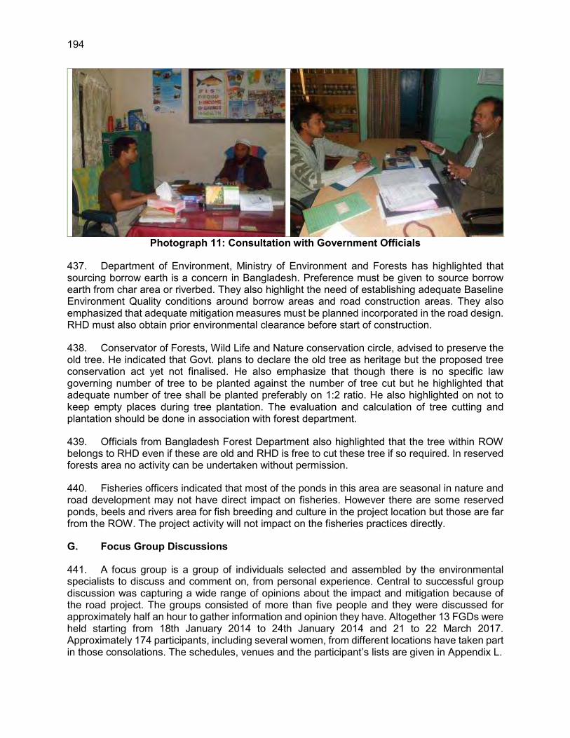
194
Photograph 11: Consultation with Government Officials
437. Department of Environment, Ministry of Environment and Forests has highlighted that sourcing borrow earth is a concern in Bangladesh. Preference must be given to source borrow earth from char area or riverbed. They also highlight the need of establishing adequate Baseline Environment Quality conditions around borrow areas and road construction areas. They also emphasized that adequate mitigation measures must be planned incorporated in the road design. RHD must also obtain prior environmental clearance before start of construction.
438. Conservator of Forests, Wild Life and Nature conservation circle, advised to preserve the old tree. He indicated that Govt. plans to declare the old tree as heritage but the proposed tree conservation act yet not finalised. He also emphasize that though there is no specific law governing number of tree to be planted against the number of tree cut but he highlighted that adequate number of tree shall be planted preferably on 1:2 ratio. He also highlighted on not to keep empty places during tree plantation. The evaluation and calculation of tree cutting and plantation should be done in association with forest department.
439. Officials from Bangladesh Forest Department also highlighted that the tree within ROW belongs to RHD even if these are old and RHD is free to cut these tree if so required. In reserved forests area no activity can be undertaken without permission.
440. Fisheries officers indicated that most of the ponds in this area are seasonal in nature and road development may not have direct impact on fisheries. However there are some reserved ponds, beels and rivers area for fish breeding and culture in the project location but those are far from the ROW. The project activity will not impact on the fisheries practices directly.
G. Focus Group Discussions
441. A focus group is a group of individuals selected and assembled by the environmental specialists to discuss and comment on, from personal experience. Central to successful group discussion was capturing a wide range of opinions about the impact and mitigation because of the road project. The groups consisted of more than five people and they were discussed for approximately half an hour to gather information and opinion they have. Altogether 13 FGDs were held starting from 18th January 2014 to 24th January 2014 and 21 to 22 March 2017. Approximately 174 participants, including several women, from different locations have taken part in those consolations. The schedules, venues and the participant’s lists are given in Appendix L.

195
442. During the consultation, the participants spontaneously expressed their feelings about the importance of developing the road. They told that the project will remove current stress on road traffic and will ease their turmoil and reduce their commuting time. Moreover, business sectors will be greatly benefitted due to the improvement of communication system.
443. Most of the people told that the local air quality has been degraded from the emission of brickfields, industries and other man made sources. The participants expressed that the dredging materials should not be collected from the agricultural land since people are cultivating there. They told that there will be no major environmental impacts due to the project except a temporary impact of noise and dust from the engine of the construction transport and materials. Most of the people argued that they are willing to endure the temporary negative impact for the sake of the improvement of communication system which will improve their livelihood.
444. During the focus group discussion, people said that there will be no impacts on ground water and surface water. In accordance with people’s information there are some wild life found in the area and rarely cross the road or die because of run over by the transport. People also told that there is no Environmental Protected Area in the project area. Finally, they answered that all of them are in favour of the project.
445. Suggestions: The following suggestions received from the consultation:
The dredging materials should be properly managed as though local inhabitants face no troubles.
Dredging materials should be deposited in a proper place that does not harm the local people and agricultural land.
There should be effective mitigation measures in order to reduce noise pollution and emission from construction vehicles engine and materials.
Initiatives need to be taken to stop surface water pollution. Water should be sprayed 2-3 times in a day to reduce the dust pollution. Tree should be planted in 1:2 ratio.

196
Photograph 12: Photos of Focus Group Discussion at Various Locations
H. Local People’s Comments
446. A number of informal public consultations were held along the priority roads. In all the places, respondents mostly welcomed the project. However, they did point out few issues of concern noise and air pollution, accident hazard along with loss of land and compensation issues. In the time of field survey 33 local people were interviewed (See Appendix I).
Table 49: Details of Consultation with Public in Hatikamrul-Rangpur Road Sections Comments Suggestions
Good news Very welcome step from Govt. Improved road is essential and we
welcome the road. Commuting will be fast which will help
improve business environment. Difficult to cross the road due to heavy
traffic, accident prone Construction stage will create some
inconvenience to people but that is tolerable.
Accident prone area due high traffic and substantial movement of people in the business areas.
Increased traffic may cause air and noise pollution.
Local people will be benefited economically due to more employment opportunities.
Road should be straight as it is sharply turning at this place or road ROW should be reduced.
Footpath and over-bridge should be constructed in appropriate and convenient (heavily used) locations so that common people may use it to avoid accident during road crossing.
Provide underpass at this location to facilitate easy movement of people who are moving in large number currently.
Require safe passage being a growth centre. Make appropriate measures in road design
for safe passage. Speed-breakers should be constructed near
schools, hospitals and religious places. Tree shall be planted wherever there is
space available. Tree should be planted in 1:2 ratio. Water should be sprayed 2-3 times in a day
to reduce the dust pollution.
447. A brief summary of comments of local people is presented in the following sections:

197
Most of the people who were interviewed in the project area welcome the road expansion project as this is expected to improve the connectivity. Farmers have positively reacted to the development considering that better communication facility will fetch them better farm price. However, roadside shopkeepers and farmers have concern of loss of business due to widening of road and loss of livelihood.
The people in the project areas were less concerned about the environmental problems, such as, air and noise pollution, top soil removal problem that may arise due to pre and post operation of road construction. However, they have raised concern regarding dust pollution and noise pollution near religious places and schools and suggested for adoption of appropriate mitigation measures for the control of it.
The local people also mentioned that the environmental impact due to the proposed project is minor and short term. However, some mitigation measures should be taken during construction of the road, such as water spray to reduce dust pollution, tree plantation, and working hour should be only in day time and particularly if it will near the residential area.
People have raised concern of accident during road crossing near village crossing due to increasing traffic. They have strongly demanded provision of foot over bridge and speed breaker. They also demanded for traffic management near big towns.
Local people are of strong opinion for the early implementation of the project.
Photograph 13: Individual Interviews at Different Locations along the Road
I. Integration of Comments
448. As observed from their responses, almost everyone interviewed was supportive of the project and believes that it will help to provide the much-needed connectivity and development to the region.
449. During discussions, notes were taken for any issue raised and suggestions made. These were collated for a comprehensive analysis of the concerns raised. References have been taken from public opinion where no official data were available, while the officially available data have been extensively used for understanding of the study area characteristics. Each of the issues was then analysed on practical and scientific basis and accorded a likewise importance in terms of their magnitude in impacts and mitigation. For any significant concern, preventive or mitigation measures have been suggested drawing points from all the suggested measures.

198
XII. CONCLUSIONS AND RECOMMENDATIONS
A. Conclusions
450. This environmental impact assessment (EIA) concludes that the environmental impacts will be manageable if the mitigation measures are implemented thoroughly. The EMP is based on the type, extent, and duration of the identified environmental impacts. The EMP has been prepared with close reference to best practices and in line with the ADB’s Safeguards Policy Statement (SPS) and DoE environmental guidelines
451. The project is classified ‘B’ in accordance with ADB’s Safeguard Policy Statement 2009 requiring preparation of an Initial Environmental Examination Report. As per the Environmental Conservation Act, 1995 of Bangladesh, the project falls under Red category and requiring preparation of an EIA. This report is prepared keeping the ADB and GOB environmental requirements in consideration.
452. This EIA study was carried out when the Hatikamrul-Rangpur Road Subproject was at the detailed design stage of ADB Loan 2688-BAN. Essentially primary data was used to assess the environmental impacts in a comprehensive manner. Site survey for environmental data collection, public consultation and specific studies (flora, fauna, land use, hydrology) were carried out in order to complete the environmental impact assessments and recommend suitable mitigation measures.
453. The potential environmental impacts were assessed in a comprehensive manner. The EIA report assesses the potential environmental impacts associated with the Hatikamrul-Rangpur Road Subproject, and suitable mitigation measures have been recommended. In the event that any design details of the Hatikamrul-Rangpur Road Subproject are changed, the EIA and EMP shall be reviewed and revised accordingly and submitted to DOE and ADB for acceptance.
B. Environmental Gains Due to Proposed Work Justifying Implementation
454. The project entails various impacts on the project setting. There are many impacts bearing benefits to the area against the limited number and magnitude of negative impacts. These include the following: (i) the project will substantially improve the transport efficiency on the road linking the Bangabandhu Bridge to Dhaka and the southeast road corridor (to Chittagong). (ii) This will contribute in integrating the southwest region into the national economy. (iii) The project once implemented will improve the overall environmental conditions with better roads and environmental protection measures (iv) will reduce traffic congestion at related air pollution due to idling of the vehicles due to widening as well as provision of flyovers and underpasses.
C. Potential Impacts, Mitigation, Management and Monitoring
455. The Hatikamrul-Rangpur Road Subproject offers a robust option for the enhancement of the existing road-based transportation network. Several actions are required during the detailed design stage to minimize impacts to acceptable levels. The negative environmental impacts from the Hatikamrul-Rangpur Road Subproject will mostly take place during the construction stage there are no significant cumulative adverse impacts during operation that are identifiable at this stage. The construction impacts should be very predictable and manageable, and with appropriate mitigation few residual impacts are likely. Additional human and financial resources will be required to improve environmental capability, and to progress and achieve necessary statutory compliance and environmental clearance certification for the Hatikamrul-Rangpur Road

199
Subproject or associated activities that also require environmental assessment and environmental permits under the environmental laws of Bangladesh.
456. The finding of EIA indicates that the project is unlikely to cause any significant adverse environmental impacts. The project proposed road expansion does not pass through or located nearby any national park, wildlife sanctuary, reserved forests, or any other ecologically sensitive or areas. No archaeological/protected monument is located in the project vicinity. The land use pattern around the alignment is predominantly agricultural.
457. While some of the impacts are negative, there are many bearing benefits to the area. Most of the impacts are likely to occur during construction stage and are temporary in nature. Some impacts require design consideration and are suitably addressed. The road alignment does not pass through or near to any ecologically sensitive/protected area. No archeologically protected monument either located in any of the project vicinity. The land use pattern around the road alignment primarily includes fallow land, agriculture land, rural settlement, and perennial or non-perennial water bodies. Urban settlement is also there but most of the populated locations either provision of flyover has been made or best engineering measures like RCC wall are taken to minimize the social impact. The impact is primarily caused due to land clearing for widening the carriageway, cutting of roadside full grown trees, borrowing of earth, transportation of construction material, loss of water bodies/fish ponds, and construction of bridge. The impacts are with regard to loss of terrestrial flora, impact on aquatic fauna, soil compaction, water contamination, and change in ambient air quality, water quality, and increase in ambient noise levels. During the operation, direct local impacts are mostly related to noise levels, air quality and road accidents. Some sections of the entire road are threatened by floods of average flood return period of 2.33 years. Provisions have been recommended for the road elevation keeping the HFL level keeping this threat in view. Implementation of the prescribed mitigation measures will minimize the adverse impacts. Moreover, the impacts shall be monitored continually by implementing and updating the Environmental Management Plan and Environmental Monitoring Plan.
458. During the construction stage, some trees along the road are likely to be cut but if the proposed compensatory afforestation plans are effectively implemented and survival rate is monitored and sustained, the positive benefits are likely to be accrued. Many old trees are located along the project road. These trees play vital role for the environmental conditions of the area. Efforts are proposed to minimize cutting of these trees with suitable modifications in the road alignment/widening options. However, there are no legislative restrictions in cutting these trees. There are no other environmental sensitive resources found in the project area, which is likely to be affected due to the project.
459. The project is welcomed by all the stakeholders and received immense support from local people. The local people appreciated that besides providing an all-weather efficient connectivity to large rural populations and improving the traffic scenario in the region, it will bear out several other socio-economic positive benefits. The suggestions received from the public/stakeholders have been integrated while developing the mitigation measures and Environmental Management and Monitoring Plan.
D. Post EIA Surveillance and Monitoring
460. While an EIA is meant to provide a comprehensive understanding of the environment status of the area under the study, post EIA surveillance is the means to ensure that the significant impacts identified are adequately mitigated as per the proposed mitigation plan. A detailed monitoring plan has been provided as part of the Environmental Management Plan.

200
461. Environmental impact and compliance monitoring activities will focus on compliance with conditions of licenses from DOE and EMP provisions, recording implementation of mitigation measures, recording environmental parameters, reviewing contractor environmental performance, and proposing remedial actions to address unexpected impacts and complaints.
462. The EMP prepared for the project (Chapter 6) will be used as basis for an environmental compliance program in a regular program of environmental monitoring and auditing. In addition, any conditions included as part of the environmental compliance certificate from the government (MOEF/DOE) will also be included as a basis for environmental monitoring and compliance. Therefore, monitoring of (i) the implementation of mitigation measures and (ii) the implementation of the conditions of environmental compliance will be carried out regularly as scheduled in the EMP, and results will be reported semi-annually to ADB and DOE.
E. Recommendations
463. The EMP, its mitigation and monitoring programs, contained herewith shall be included within the Bidding documents for project works. The Bid documents state that the contractor shall be responsible for the implementation of the requirements of the EMP through his own Site Specific Environmental Management Plan which will adopt all of the conditions of the EMP and add site specific elements that are not currently known, such as the Contractors borrow pit locations. This ensures that all potential bidders are aware of the environmental requirements of the project and its associated environmental costs.
464. The EMP and all its requirements shall then be added to the contractor’s contract, thereby making implementation of the EMP a legal requirement according to the contract. He shall then prepare his CEMP which will be approved and monitored by the Engineer/Environmental Specialist. To ensure compliance with the CEMP the contractor should employ a national environmental specialist to monitor and report project activities throughout the project construction phase.
465. RHD has social and environmental circle but they need capacity building and practical exposure. Adequate training shall be imparted as proposed under environmental management plan to enhance the capability of concerned EA officials. It is recommended to update environmental guidelines focused on effective implementation of mitigation measures. Performance indicators may also be developed as part of these guidelines to monitor and assess the effectiveness of the mitigation measures.
466. The Initial Environmental Examinations and Environmental Management Plans for the establishment of Research and Training Centre (RRTC) and Road Operations Unit (ROU) will be prepared by the Project Implementation Consultant (Supervision Consultant) after the detailed designs are prepared.

201
REFERENCES
Banglapedia, 2012. National Encyclopedia of Bangladesh Online [Online]. Available at http://www.banglapedia.org (accessed on 15-04-2013)
Bangladesh Bureau of Statistics, 2006. Population Census 2011. [Online], Available at: http://www.bbs.gov.bd/home.aspx# (accessed on 15-04-2013)
Brammer, H., 1996. The Geography of the Soils of Bangladesh. Dhaka: University Press Limited. IPCC (Intergovernmental Panel on Climate Change), 2007. Climate change 2007: Synthesis Report. Contribution of Working Groups I, II, III to the Fourth Assessment Report of the Intergovernmental Panel on Climate Change. Geneva, Switzerland.
International Union for Conservation of Nature (IUCN), 2002. Bio-ecological zones of Bangladesh. Dhaka: IUCN Bangladesh.
IUCN Bangladesh. ed. 2002f. Bio-ecological Zones of Bangladesh. Dhaka: IUCN-TheWorld Conservation Union.
MoEF, 2009. Bangladesh Climate Change Strategy and Action Plan 2009, Ministry of Environment and Forest, Bangladesh.
MoEF/UNDP, 2005. National Adaptation Programme on Action (NAPA). Final Report. Ministry of Environment and Forests, GOB, Bangladesh.
Morgan, J.P. and McIntyre, W.G., 1959.Quaternary Geology of the Bengal Basin, East Pakistan and India. Bulletin of the Geological Society of America, Vol 70, pp 319-342.
Rashid, H., 1977. Geography of Bangladesh. Dhaka: University Press Limited.
Soil Resource Development Institute (SRDI), 1997. Physiography of Bangladesh. Dhaka: SRDI, Ministry of Agriculture.
Soil Resource Development Institute (SRDI), 1998. Agro-ecological regions of Bangladesh. Dhaka: SRDI, Ministry of Agriculture.
United Nations Population Fund (UNFPA), 2010. State of World Population 2010- From Conflict and Crisis to Renewal: generations of change [Online]. Available at: http://www.unfpa.org/webdav/site/global/shared/swp/2010/swop_2010_eng.pdf (accessed on 15-04-2013)
Wahab, A., (2008), Bangladesh Introduction (Ramsar Wetland Information). [Online] Available at: http://ramsar.wetlands.org/Portals/15/Bangladesh.pdf (accessed on 15-04-2013)
Zahiruddin, S.A., 1993. Bangladesh National Building Code. Dhaka: Housing and Building Research Institute, Ministry of Housing and Public Works, Government of the People’s Republic of Bangladesh.

202 Appendix A
APPENDIX A: TERMS OF REFERENCE FOR ENVIRONMENTAL IMPACT ASSESSMENT OF ROAD DEVELOPMENT PROJECTS UNDER SUBREGIONAL TRANSPORT PROJECT
(SRTP)
A. Background
1. The Government of Bangladesh (GoB) has received a loan from Asian Development Bank (ADB) for the Subregional Transport Project Preparatory Facility under Technical Assistance for Subregional Road Transport Project Preparatory Facility (ADB Loan 2688-BAN). GoB has resolved to apply a portion of the loan to meet the expenditure for consultancy services to be rendered by international consultants to prepare (a) feasibility studies and (b) detailed engineering designs for upgrading selected national highways and zilla roads from 2-lanes to 4-lanes to promote subregional development. The Ministry of Communications (MOC) is the Executing Agency and Roads and Highways Department (RHD) is the Implementation Agency. 2. The environmental impact assessment (EIA) process will be based on current information, including an accurate project description, and appropriate environmental and social baseline data. In the environmental assessment, Roads and Highways Department (RHD) as the project proponent will consider all potential impacts and risks of the road development works on physical, biological, socioeconomic (occupational health and safety, community health and safety, vulnerable groups and gender issues, and impacts on livelihoods and physical cultural resources) in an integrated way. This TOR is prepared to carryout detailed EIA study for the ‘Subregional Transport Project Preparatory Facility’ in accordance with the relevant laws and regulations in Bangladesh and the Asian Development Bank’s Safeguard Policy Statement, 2009. The study will be carried out by the design consultant during 2012-2014 and the EIA report will be submitted along with the EMP to DOE and ADB for approval. 3. As part of the EIA the project proponent will prepare an environmental management plan (EMP) that addresses the potential impacts and risks identified by the environmental assessment. The EMP will include the proposed mitigation measures, environmental monitoring and reporting requirements, emergency response procedures, related institutional or organizational arrangements, capacity development and training measures, implementation schedule, cost estimates, and performance indicators. Where impacts and risks cannot be avoided or prevented, mitigation measures and actions will be identified so that the project is designed, constructed, and operated in compliance with applicable laws and regulations and meets the requirements specified in this document.
B. Project Location
4. The road development project under SRTP covers a vast area of Bangladesh. The length of the roads of this project is 961km and located in South-central to Southern, South-Western, North-Western, and Northern parts of Bangladesh. The road alignment crosses a total of 21 districts and 2 major rivers, Jamuna and Padma. The districts it will cross are Khulna, Bagerhat, Borguna, Patuakhali, Jhalokathi, Barisal, Madaripur, Gopalganj, Faridpur, Munshiganj, Dhaka, Gazipur, Tangail, Sirajganj, Natore, Rajshahi, Nawabganj, Bogra, Gaibandha, Rangpur and Lalmonirhat. The project location Map with priority details is shown in Figure 1.

Appendix A 203
Figure A-1: Location Map of Road with Priority Details

204 Appendix A
C. Project Components
5. The SRTP consists of the following roads are being considered for upgrading:
(i) Design Package No. 1 – Joydevpur-Chandra-Tangail road section in N4 and N405 (70km)
(ii) Design Package No. 2 – Tangail-Hatikamrul (40km) (iii) Design Package No. 3 – Dhaka-Mawa-Bhanga road section in N8 (70km) (iv) Design Package No. 4 – Upgrading of Rangpur-Teesta-Burimari Road into 4-lane
highway (138km) (v) Design Package No. 5 – Construction of a bridge over the river Mongla at Mongla
on Khulna-Mongla Road (vi) Design Package No. 6 – Upgrading of Khulna-Mongla Road into 4-lane highway
with link to Dhigraj to Mongla Ferry Ghat (46km) (vii) Design Package No. 7 – Upgrading of Hatikamrul-Rangpur National Highway into
4-lane highway (160km) (viii) Design Package No. 8 – Faridpur-Barisal-Kuakata road section in N8 (236km) (ix) Design Package No. 9 – Upgrading of Sonamasjid-Rajshahi Road into 4 lane
highway (Asian Highway, SAARC Corridor: Regional Corridors identified in SAARC Regional Multimodal Transport Study) (85km)
(x) Design Package No. 10 – Rajshahi-Hatikamrul Road into 4 lane highway (Asian Highway, SAARC Corridor: Regional Corridors identified in SAARC Regional Multimodal Transport Study) (111km)
6. As some of the packages consist of upgrading different sections of the same road, these sections would be considered together in a single EIA but with separate Environmental Management Plans for each package.
D. Objectives
7. The main objective of the EIA study is to assess both positive and negative environmental impacts due to each project activities. Assess the impacts and recommend appropriate mitigation measures during preconstruction, construction, and operation phases to minimize negative impacts of the project to acceptable levels. Prepare ten (10) EIA including EMP for SRTP in compliance with the Government and ADB requirements and obtain Environmental Clearance Certificate (ECC) from the Department of Environment, Bangladesh.
E. Scope of Work
1. Baseline Studies
a. Legal and Administrative Procedure
Collection and review of relevant information regarding environmental legislation, statutory orders, by-laws, etc. connected to preparation and approval of the EIA report by the Department of Environment, and draft the memo. The memo will also consider the requirements of ADB Guidelines.
Conduction of meetings with the Department of Environment, the Ministry of Environment and Forest (MoEF), and the Roads and Highways Department (RHD). During these meetings appropriate legal and administrative procedures

Appendix A 205
has been discussed. Review of other relevant environmental laws, regulations, Norms, and Standards on Air, Noise, Vibration, Water, Waste, and Wildlife.
Conduction of discussion meeting with the Department of Environment particularly for “Environmental Clearance Certificate” in accordance with the Environment Conservation Act, 1995 and Bangladesh Environment Conservation Rules, 1997.
b. Stakeholder Consultation
8. Conduction of Stakeholder Group meetings to ensure relevance of the project to the interests of the people of the project area and hence sustainability of the project; and to seek views and suggestions toward identifying important environmental components (IECs) for environmental assessment and ascertain their degree and ranking. The proposed Stakeholder Group meeting will also help determine potential social, economic and cultural impacts due to the project. Targeted Stakeholder Group is to comprise members of the civil society, professional groups, etc. To provide local communities and socio-economic interest groups with the foundation for their role in detailed design project interventions and, hence, participation in project planning, implementation, operation and maintenance.
c. Preparation of Baseline Assessment
9. Review of reports and secondary data collected from the project’s feasibility study. Feasibility study and the study conducted by the RHD as well as the studies on similar projects carried out under ADB funding. 10. Collection of general baseline information on existing environmental condition in the project influence area and environmental quality baseline monitoring along the project corridor and identification of the environmental components that need detailed study. Baseline assessment will be done based on the available secondary information, field visits, sampling and environmental monitoring including but not limited to the following:
(i) Physical Resources: Topography, climate, soils, geology, land use, aquatic resources, and surface and
groundwater resources. (ii) Environmental Risks: Cyclones, tornadoes, droughts, floods, earthquakes, road accidents, etc. (iii) Ecological Resources: Landscape and natural ecosystem, flora and fauna, wildlife and wetland habitats,
and protected areas. (iv) Environmental Quality: Air (SPM, PM10, CO, CO2, NOx, SOx, O3 etc.): Air samples should be collected
from the existing road alignment to identify the baseline and air quality in the project area.
Noise quality: Noise level should be measured along the highway roads during day and night times to identify the baseline and present noise level in the project area.
Groundwater quality (pH, Mn, Fe, As, Total hardness as CaCO3, Coliforms, Chlorine as Cl-): Samples should be tested for baseline setup and identifying the present status of groundwater for drinking purpose.
Surface Water Quality (pH, BOD, Chlorine as Cl-, COD, TDS, TSS, DO, EC, Fe): Samples should be tested for baseline setup and identifying the quality of the surface water.

206 Appendix A
River-bed dredged materials: (Zn, Cu, Hg, Pb, Cd, and As): Samples should be collected from the dredged sites at a reasonable depth. Samples should be tested for identifying the baseline chemical properties of the dredged materials and the suitability of the material to be used for road embankment, and service area, etc.
(v) Cultural Resources Sites: Structures or sites those are of historical, religious, or architectural significance.
2. Detailed Field Investigation to Screen Environmental Impacts
a. Field Investigation and Analysis of Results
11. Collection of cadastral maps showing the project locations and descriptions of the surrounding activities. This is to ensure that the project is compatible with the national regulation specified for construction sites. 12. Initiation of necessary investigations and fieldwork for gathering of additional information on ecological and environmental baseline parameters of the Important Environmental Components (IECs) selected during the previous studies in the project area.
(i) Physical Environment Regional Hydrology and Flood Pattern, Drainage Congestion, River Erosion and Siltation, and Landuse (ii) Ecological Environment Agriculture, Tree Plantation/Felling, Water bodies and Fisheries, and Wildlife (iii) Environmental Pollution Surface and Ground Water Quality, Air Pollution, Noise and Vibration, Soil Contamination including dredged spoil, and Pollution due to Waste (iv) Social Environment Land Acquisition, Homestead, Irrigation and Agricultural Production, Cultural Resources Loss, Navigation/Water Transport, Health and Safety, Employment Opportunities, Women Empowerment, Infrastructure and Industry, Split of Communities, Road Transport, Road Accident, and Tourism.

Appendix A 207
3. Anticipated Environmental Impacts and Mitigation Measures
13. This section will predict and assess the project's likely positive and negative direct and indirect impacts on physical, biological, socioeconomic (including occupational health and safety, community health and safety, vulnerable groups and gender issues, and impacts on livelihoods, and physical cultural resources) environment in the project's area of influence, in quantitative terms as far as possible; identify mitigation measures and any residual negative impacts that cannot be mitigated; explore opportunities for enhancement; identify and estimate the extent and quality of available data, key data gaps, and uncertainties associated with predictions and specifies topics; and examine transboundary, and cumulative impacts as appropriate.
4. Environmental Management Plan
14. In this section RHD will incorporate the set of mitigation and management measures to be adopted during project implementation to avoid, reduce, mitigate, or compensate for adverse environmental impacts (in that order of priority). It may include multiple management plans, sub plans and actions. It will include the following key components:
(i) Mitigation: Under mitigation the EMP will: (a) identify and summarize anticipated significant adverse environmental
impacts and risks; (b) describe each mitigation measure with technical details, including the type
of impact to which it relates and the conditions under which it is required (for instance, continuously or in the event of contingencies), together with designs, equipment descriptions, and operating procedures, as appropriate; and
(c) provide links to any other mitigation plans (for example, for involuntary resettlement) required for the project.
(ii) Monitoring: Under monitoring the EMP will:
(a) describe monitoring measures with technical details, including parameters to be measured, methods to be used, sampling locations frequency of measurements, detection limits and definition of thresholds that will signal the need for corrective actions; and
(b) describe monitoring and reporting procedures to ensure early detection of conditions that necessitate particular mitigation measures and document the progress and results of mitigation.
(iii) Implementation arrangements: Under the implementation arrangements the EMP
will: (a) specify the implementation schedule showing phasing and coordination
with overall project implementation; (b) describe institutional or organizational arrangements, namely, who is
responsible for carrying out the mitigation and monitoring measures, which may include one or more of the following additional topics to strengthen environmental management capability: technical assistance programs, training programs, procurement of equipment and supplies related to environmental management and monitoring, and organizational changes; and
(c) estimate capital and recurrent costs and describe sources of funds for implementing the environmental management plan.

208 Appendix A
(iv) Performance indicators: Here the desired outcomes as measurable events will be
described to the extent possible, such as performance indicators, targets, or acceptance criteria that can be tracked over defined time periods.
5. Institutional Arrangement, Capacity building and Grievance Redress Mechanism
15. Assessment of institutional capacity of the implementing agencies for effective implementation of environmental management and monitoring plan. Identification of responsible institutes for implementation and supervision of the Environmental management and monitoring plan (EMMP). Assess training needs of these agencies and propose capacity building measures and institutional arrangements to strengthen these agencies along with the cost estimates. 16. In this section RHD will describe the grievance redress framework (both informal and formal channels), prepared for the road development projects, setting out the time frame and mechanisms for resolving complaints about environmental performance.
6. Information Disclosure, Consultation, and Participation
17. This section will:
(i) describe the process undertaken during project design and preparation for engaging stakeholders, including information disclosure and consultation with affected people and other stakeholders;
(ii) summarize comments and concerns received from affected people and other stakeholders and how these comments have been addressed in project design and mitigation measures, with special attention paid to the needs and concerns of vulnerable groups, including women, the poor, and Indigenous Peoples; and
(iii) describe the planned information disclosure measures (including the type of information to be disseminated and the method of dissemination) and the process for carrying out consultation with affected people and facilitating their participation during project implementation.
7. Conclusion and Recommendation
18. This section will provide the conclusions drawn from the assessment and present the recommendations.
F. EIA Study Team
19. The EIA team has been included in the following team:
1. National Environmental Specailist-1 08 months 2. National Environmental Specailist-2 12 months 3. Junior Environmental Specialist-1 17 months 4. Junior Environmental Specialist-2 07 months
20. RHD will be responsible to coordinate with the Consultant to carry out the EIA study along with EMP in accordance with environmental guidelines of ADB and GOB within the project stipulated time schedule. The Environment and Social Circle of RHD will monitor the EIA and

Appendix A 209
EMP activities on a regular basis and review all environmental reports prepared by the Environmental Team of the Consultant.
G. Work Program and Personal Schedule
21. The duration of the preparation of the 10 EIA including EMP will be about 18 months. The work program and personnel schedule is provided in Annex-1.
H. EIA Report Structure
22. The EIA report will be prepared following the DOE guidelines and ADB safeguard policy statement 2009. The EIA reports prepared by RHD will contain the following Chapters:
Executive Summary 1. Introduction 2. Policy, Legal and Administrative Framework 3. Description of the Project 4. Description of the Environment (Baseline Data) 5. Anticipated Environmental Impacts and Mitigation Measures 6. Environmental Management Plan 7. Institutional Arrangement, Capacity Building and Grievance Redress Mechanism 8. Information Disclosure, Consultation and Participation 9. Conclusions and Recommendations

210 Appendix B
APPENDIX B: DOE APPROVAL OF THE TOR

Appendix B 211

212 Appendix C
APPENDIX C: RAPID ENVIRONMENTAL ASSESSMENT (REA) CHECKLIST
Instructions: (i) The project team completes this checklist to support the environmental classification of a project. It
is to be attached to the environmental categorization form and submitted to the Environment and Safeguards Division (RSES), for endorsement by Director, RSES and for approval by the Chief Compliance Officer.
(ii) This checklist focuses on environmental issues and concerns. To ensure that social dimensions are
adequately considered, refer also to ADB's (a) checklists on involuntary resettlement and Indigenous Peoples; (b) poverty reduction handbook; (c) staff guide to consultation and participation; and (d) gender checklists.
(iii) Answer the questions assuming the “without mitigation” case. The purpose is to identify potential
impacts. Use the “remarks” section to discuss any anticipated mitigation measures.
Country/Project Title: Sector Division:
Screening Questions Yes No Remarks A. Project Siting Is the project area adjacent to or within any of the following environmentally sensitive areas?
Cultural heritage site
The road passes through many villages and towns and few community resources like temple, mosque and graveyards are located near the roads. Some of these cultural sites will be directly affected because of the widening of the existing road.
Protected Area There are no protected areas in or within 10km of the project area that might me directly affected because of the project.
Wetland There are small ponds, beels and Khals link to certain rivers. However none of them are protected or rich in biodiversity.
Mangrove
None
Estuarine
None
Buffer zone of protected area
None
Special area for protecting biodiversity
None
B. Potential Environmental Impacts Will the Project cause…
Bangladesh: SASEC-Dhaka Northwest Corridor Road Project, Phase 2
South Asia Transport and Communication Division

Appendix C 213
Screening Questions Yes No Remarks Encroachment on historical/cultural areas;
disfiguration of landscape by road embankments, cuts, fills, and quarries?
No encroachment on historical but some cultural areas are envisaged. The topography of project road is mainly flat. However, minor impacts on landscape are unavoidable due to increase in elevation and widening of road embankment and side roads for slow moving vehicles.
Encroachment on precious ecology (e.g. sensitive or protected areas)?
The project road does not pass through any National Park/Wildlife Sanctuary.
Alteration of surface water hydrology of waterways crossed by roads, resulting in increased sediment in streams affected by increased soil erosion at construction site?
There are significant numbers of bridges with the existing road and those bridges will be reconstructed. The bridge construction may temporally increase the sedimentation level in the river around bridge construction site. However this would be temporary and short term in nature. All measures shall be taken during construction stage so that watercourses are not affected and temporary soil and rock stockpiles will be designed so that runoff will not induce sedimentation of waterways.
Deterioration of surface water quality due to silt runoff and sanitary wastes from worker-based camps and chemicals used in construction?
Suitable siltation prevention measures such as silt fencing is included in the EMP. Adequate measures for sanitary and construction related waste such as chemicals shall be taken to prevent contaminating local water resources.
Increased local air pollution due to rock crushing, cutting and filling works, and chemicals from asphalt processing?
Local air pollution level is likely to be increased for short duration during construction period particularly due to earth work. Appropriate distance from settlement area and wind direction will be taken into account to locate air polluting facility like stone crushing unit etc. if required.
Risks and vulnerabilities related to occupational health and safety due to physical, chemical, biological, and radiological hazards during project construction and operation during project construction and operation?
Construction activities could cause accidents and health risks to workers. Occupational health and safety measures will be mandatory for the contractor.
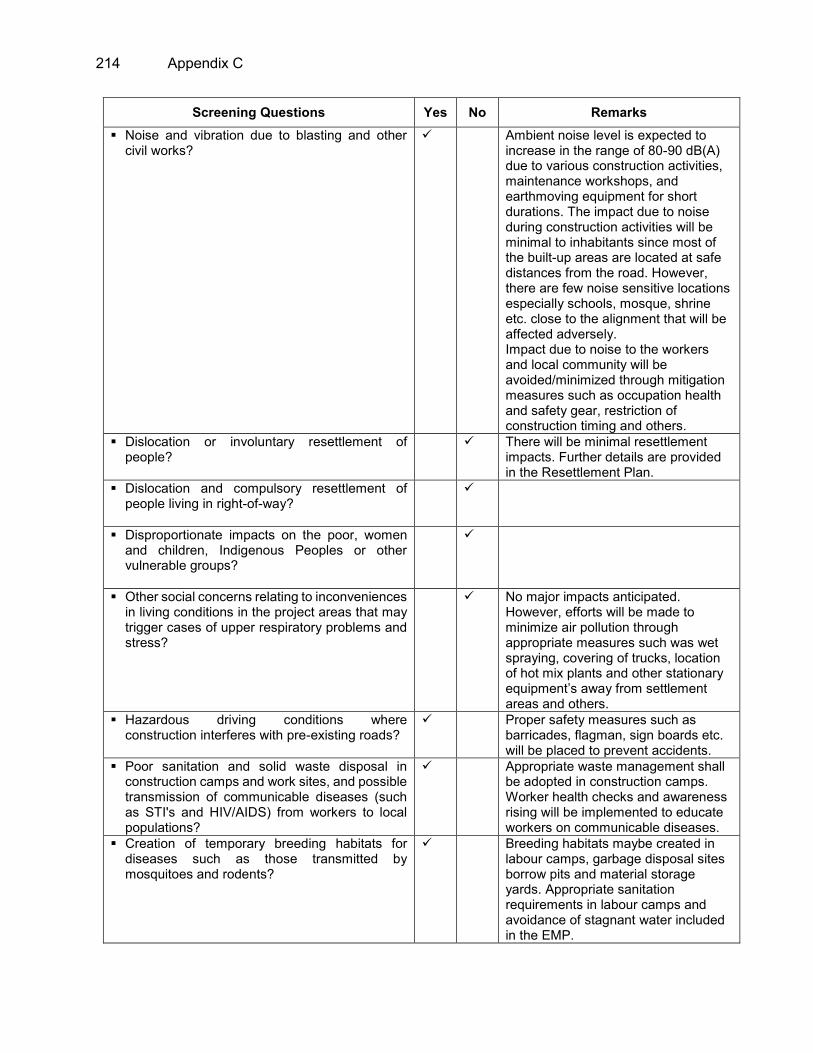
214 Appendix C
Screening Questions Yes No Remarks Noise and vibration due to blasting and other
civil works?
Ambient noise level is expected to increase in the range of 80-90 dB(A) due to various construction activities, maintenance workshops, and earthmoving equipment for short durations. The impact due to noise during construction activities will be minimal to inhabitants since most of the built-up areas are located at safe distances from the road. However, there are few noise sensitive locations especially schools, mosque, shrine etc. close to the alignment that will be affected adversely. Impact due to noise to the workers and local community will be avoided/minimized through mitigation measures such as occupation health and safety gear, restriction of construction timing and others.
Dislocation or involuntary resettlement of people?
There will be minimal resettlement impacts. Further details are provided in the Resettlement Plan.
Dislocation and compulsory resettlement of people living in right-of-way?
Disproportionate impacts on the poor, women and children, Indigenous Peoples or other vulnerable groups?
Other social concerns relating to inconveniences in living conditions in the project areas that may trigger cases of upper respiratory problems and stress?
No major impacts anticipated. However, efforts will be made to minimize air pollution through appropriate measures such was wet spraying, covering of trucks, location of hot mix plants and other stationary equipment’s away from settlement areas and others.
Hazardous driving conditions where construction interferes with pre-existing roads?
Proper safety measures such as barricades, flagman, sign boards etc. will be placed to prevent accidents.
Poor sanitation and solid waste disposal in construction camps and work sites, and possible transmission of communicable diseases (such as STI's and HIV/AIDS) from workers to local populations?
Appropriate waste management shall be adopted in construction camps. Worker health checks and awareness rising will be implemented to educate workers on communicable diseases.
Creation of temporary breeding habitats for diseases such as those transmitted by mosquitoes and rodents?
Breeding habitats maybe created in labour camps, garbage disposal sites borrow pits and material storage yards. Appropriate sanitation requirements in labour camps and avoidance of stagnant water included in the EMP.

Appendix C 215
Screening Questions Yes No Remarks Accident risks associated with increased
vehicular traffic, leading to accidental spills of toxic materials?
Temporarily during construction Stage. Adequate measures will be provided to prevent them such as speed reduction, provision of crash barrier and proper traffic signage system at sensitive places will ensure smooth traffic flow which will reduce accidental risk
Increased noise and air pollution resulting from traffic volume?
Due to improvement in road riding conditions the net effect on noise and air pollution will be negligible. However, the number of traffic will increase and the pollution will also increase consistently.
Increased risk of water pollution from oil, grease and fuel spills, and other materials from vehicles using the road?
EMP recommendations are designed to mitigate water pollution due to construction related activities.
Social conflicts if workers from other regions or countries are hired?
EMP suggests to hire most workers from the local area and to ensure gender equality.
Large population influx during project construction and operation that causes increased burden on social infrastructure and services (such as water supply and sanitation systems)?
Most workers will be hired locally, hence this is not anticipated.
Risks to community health and safety due to the transport, storage, and use and/or disposal of materials such as explosives, fuel and other chemicals during construction and operation?
Transport, storage, use and disposal of fuel and chemicals will be required. Appropriate safety, storage and disposal measures recommended in the EMP.
Community safety risks due to both accidental and natural causes, especially where the structural elements or components of the project are accessible to members of the affected community or where their failure could result in injury to the community throughout project construction, operation and decommissioning.
Safety and injury related risks will arise from the presence of equipment’s and construction activities. Clear demarcation of restricted areas and prevention of open access to construction areas is included in the EMP.
Climate Change and Disaster Risk Questions The following questions are not for environmental categorization. They are included in this checklist to help identify potential climate and disaster risks.
Yes No REMARKS
Is the Project area subject to hazards such as earthquakes, floods, landslides, tropical cyclone winds, storm surges, tsunami or volcanic eruptions and climate changes
As in most parts of Bangladesh, parts of the project road face problems of flooding. Required design measures for adapting to future flooding events the result of climate change have been recommended to this EIA as well.

216 Appendix C
Note: Hazards are potentially damaging physical events.
Could changes in temperature, precipitation, or extreme events patterns over the Project lifespan affect technical or financial sustainability (eg., increased erosion or landslides could increase maintenance costs, permafrost melting or increased soil moisture content could affect sub-grade).
With the incorporation of recommendations from the climate change it is expected that the road will be able to withstand with future changes of various climatic parameters.
Are there any demographic or socio-economic aspects of the Project area that are already vulnerable (eg., high incidence of marginalized populations, rural-urban migrants, illegal settlements, ethnic minorities, women or children)?
There is no potential impact identified in the project area yet.
Could the Project potentially increase the climate or disaster vulnerability of the surrounding area (e.g., by encouraging settlement in areas that will be more affected by floods in the future, or encouraging settlement in earthquake zones)?
The project will significantly reduce the GHG emissions due to better road condition.

Appendix D 217
APPENDIX D: SURFACE WATER QUALITY TEST RESULTS

218 Appendix D

Appendix D 219

220 Appendix D

Appendix D 221

222 Appendix D

Appendix D 223

224 Appendix D

Appendix D 225

226 Appendix D

Appendix D 227
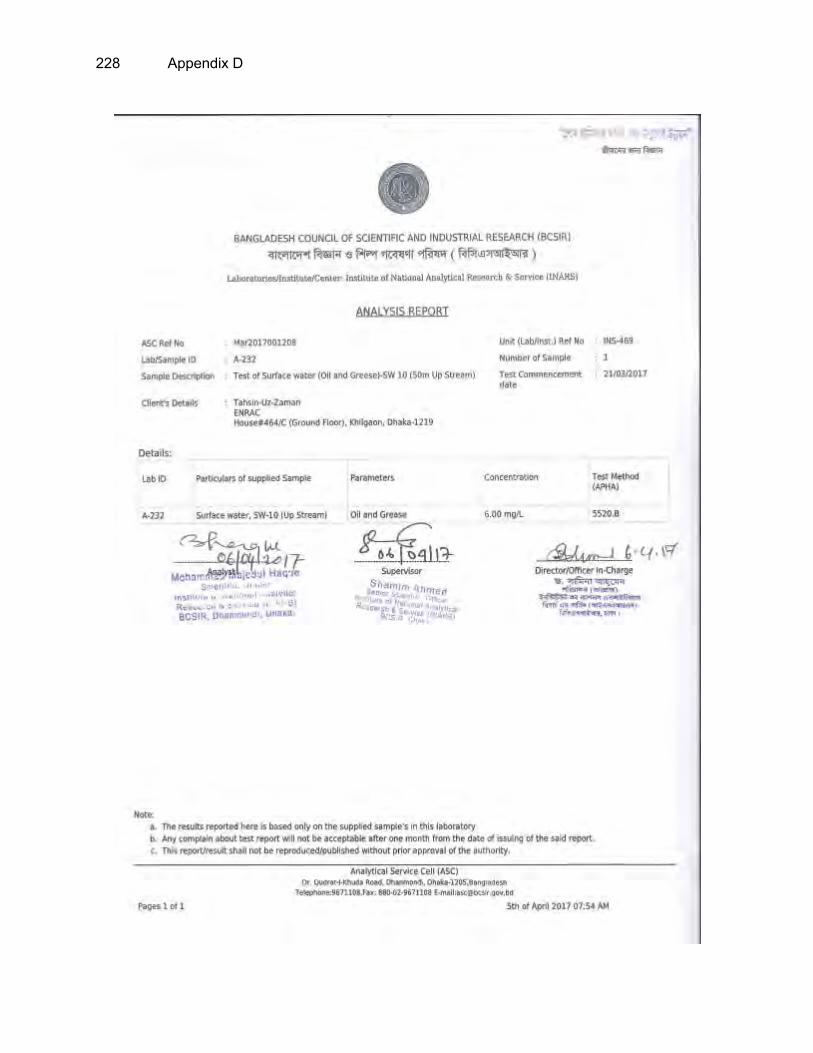
228 Appendix D

Appendix D 229

230 Appendix D

Appendix D 231

232 Appendix D

Appendix D 233

234 Appendix D

Appendix E 235
APPENDIX E: GROUNDWATER QUALITY TEST RESULTS

236 Appendix E

Appendix E 237

238 Appendix E

Appendix E 239

240 Appendix E

Appendix E 241

242 Appendix E

Appendix E 243

244 Appendix E

Appendix E 245

246 Appendix F
APPENDIX F: AIR QUALITY IMPACTS ASSESSMENT OF PROPOSED HIGHWAY CORRIDOR OF HATIKAMRUL-RANGPUR
A. Introduction
1. The major impact on the air quality during the operation stage will be due to plying of vehicles on the proposed Highway corridor. The impact on air quality depends upon traffic volume, traffic fleet including fuel type and prevailing atmospheric conditions. An unstable atmospheric condition disperses pollutants more and results in to low pollutant concentrations while stable atmospheric conditions buildup the pollution level. To assess the likely impacts on the ambient air quality due to the proposed highway corridor project, the prediction of the carbon monoxide (CO) and particulate matter (PM) concentrations have been carried out using line source dispersion modelling approach, based on Gaussian equation. CO is an indicator pollutant for vehicular exhaust pollution. So, prediction of CO concentration is representative of the impacts of air pollution due to traffic movement on the road. Both PM2.5 and PM10 concentration emitted from vehicles exhaust and re-suspension of road dust are predicted along the high corridor. The modeling for this project has been carried out using CALINE-4, line source model developed by the California Transport Department. The model has been setup and run by using CO emission factors (Department of Environment, Bangladesh Govt., 2012), for PM2.5 (ARAI, 2007, Indian standards) and for PM10 due to re-suspension of road dust ( AP-42, USEPA) and hourly traffic volumes as predicted for the project. Only CO emission factor are available in full-fledged for all vehicles categories in Bangladesh. The study is conducted to predict hourly increment in CO, PM2.5 and PM10.
B. Model descriptions
2. CALINE-4 is the fourth generation simple line source Gaussian plume dispersion model (Benson, 1984). It employs a mixing zone concept to characterize pollutant dispersion over the roadway. The main purpose of the model is to assess air quality impacts near transportation facilities. The input parameters are emission source strength, meteorology and road geometry. It can predict the pollutant concentrations at selected receptors locations for 1 hour and 8-hour average up to 500 meters of the roadway. For most applications, optional inputs can be bypassed and many other inputs can be assigned assuming worst-case values. More complex approaches to dispersion modeling are unnecessary for most of the applications because of the uncertainties in the estimation of emission factors and traffic volumes for the future years. CALINE- 4’s accuracy is well balanced with the accuracy of state-of-art predictive models for vehicular pollution.
C. Source information
1. Traffic data
3. The fleet wise traffic volumes for the present study have been taken from the detailed project report of the project. The annual average daily traffic (AADT) data is available for the proposed highway corridor through traffic survey for year 2016 (Base year) and future years (2020, 2025, 2030, 2035 and 2040). CALINE 4 model needs hourly average traffic volume. However, model has been setup for peak traffic hours assuming 2 times of average hourly traffic volume. The total hourly traffic volume is further categorized in to two wheeler, three wheeler, four wheeler, light commercial vehicles (LCVs), high commercial vehicles (HCVs) and Bus based on the traffic survey at existing highway corridor (Figure 1). It is found that heavy duty vehicles is the dominating vehicles category (33%) along the road corridors.
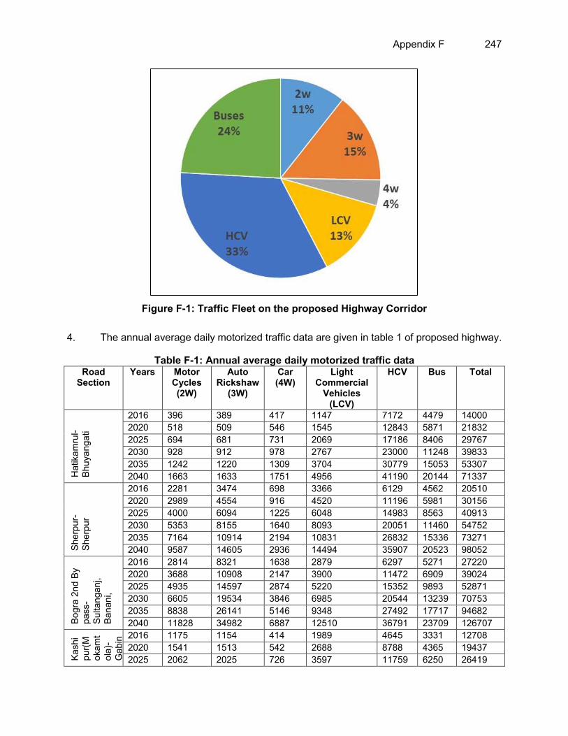
Appendix F 247
Figure F-1: Traffic Fleet on the proposed Highway Corridor
4. The annual average daily motorized traffic data are given in table 1 of proposed highway.
Table F-1: Annual average daily motorized traffic data Road
Section Years Motor
Cycles (2W)
Auto Rickshaw
(3W)
Car (4W)
Light Commercial
Vehicles (LCV)
HCV Bus Total
Hat
ikam
rul-
Bhuy
anga
ti
2016 396 389 417 1147 7172 4479 14000 2020 518 509 546 1545 12843 5871 21832 2025 694 681 731 2069 17186 8406 29767 2030 928 912 978 2767 23000 11248 39833 2035 1242 1220 1309 3704 30779 15053 53307 2040 1663 1633 1751 4956 41190 20144 71337
Sher
pur-
Sher
pur
2016 2281 3474 698 3366 6129 4562 20510 2020 2989 4554 916 4520 11196 5981 30156 2025 4000 6094 1225 6048 14983 8563 40913 2030 5353 8155 1640 8093 20051 11460 54752 2035 7164 10914 2194 10831 26832 15336 73271 2040 9587 14605 2936 14494 35907 20523 98052
Bogr
a 2n
d By
pa
ss-
Sulta
ngan
j, Ba
nani
,
2016 2814 8321 1638 2879 6297 5271 27220 2020 3688 10908 2147 3900 11472 6909 39024 2025 4935 14597 2874 5220 15352 9893 52871 2030 6605 19534 3846 6985 20544 13239 70753 2035 8838 26141 5146 9348 27492 17717 94682 2040 11828 34982 6887 12510 36791 23709 126707
Kash
ipu
r(M
okam
tol
a)-
Gab
inda
ganj
, Pa
kur
tala
,
2016 1175 1154 414 1989 4645 3331 12708 2020 1541 1513 542 2688 8788 4365 19437 2025 2062 2025 726 3597 11759 6250 26419

248 Appendix F
Road Section
Years Motor Cycles (2W)
Auto Rickshaw
(3W)
Car (4W)
Light Commercial
Vehicles (LCV)
HCV Bus Total
2030 2759 2710 971 4813 15737 8363 35353 2035 3692 3626 1300 6441 21059 11191 47309 2040 4941 4853 1739 8620 28182 14977 63312
Pala
shba
ri-Pi
rgan
j, Ek
berp
ur
2016 626 216 223 987 2679 1719 6450 2020 820 283 292 1325 5183 2254 10157 2025 1097 379 391 1774 6935 3227 13803 2030 1468 507 523 2373 9280 4319 18470 2035 1965 679 701 3176 12419 5780 24720 2040 2630 908 937 4250 16621 7735 33081
Pirg
anj-
Mith
apuk
ur
2016 583 73 227 741 2753 1668 6045 2020 765 96 298 1002 5301 2186 9648 2025 1023 128 399 1341 7094 3130 13115 2030 1370 171 533 1794 9493 4188 17549 2035 1833 229 714 2401 12703 5605 23485 2040 2453 307 955 3213 16999 7501 31428
Mith
apuk
ur-
Ran
gpur
M
oder
n M
ore,
Pa
irabo
nd
2016 2607 812 518 1591 3409 2743 11680 2020 3418 1064 678 2148 6325 3597 17230 2025 4574 1424 908 2875 8464 5149 23394 2030 6121 1906 1215 3848 11327 6891 31308 2035 8191 2551 1626 5149 15158 9222 41897 2040 10961 3414 2176 6890 20285 12340 56066
2. Road geometry
5. In the CALINE-4 model the entire length of the selected road section is divided into various road links. The division of sections into links has been done in such way, so that the link can be fairly considered as straight stretch of road having homogenous geometry with uniform road width, height and alignment. The coordinates of end points of links specify the location of the links in the model. The maximum numbers of link in each road section can be 20. The mixing zone width calculated for selected highway corridor is 14.2 m (1.2 m+ 3 m + 3 m + 7 m) as per guideline provided in CALINE4 model.
3. Emission factors
6. Emission factor is one of the important input parameter in Caline-4 model. In the present study, the emission factors specified by Department of Environment, Bangladesh Govt., 2012 ( for CO), ARAI, 2007, Indian standards ( for PM2.5) and AP-42 for PM10 due to re-suspension of road dust are used. Only CO emission factor are available in full-fledged for all vehicles categories in Bangladesh. The weighted emission factors (WEF in g/mile) have been calculated using these emission factors (g/km) for CO, PM2.5 and PM10 for corresponding year. The emission factor for CO and PM2.5 used in the present study for different vehicles type are given in table 2. These emission factors have been expressed in terms of type of vehicles and type of fuel used (for petrol and diesel driven passenger cars). Since, there is only one input requirement for total no. of vehicles in the CALINE 4 model, whereas, there are different categories of vehicles (viz., Two wheelers, Cars, Bus and trucks) with different fuel used, it is essential that a single value representing the equivalent or weighted emission factors for all the vehicles is input into the model.

Appendix F 249
The emission factor used to estimate WEF are given below in table 3. The traffic data are not available for fuel types, therefore average emission factor for different fuels vehicle are used in this study. Thus, WEF expressed in g/mile (converted from gm/km) has been calculated for the present study using methodology given by Sharma et al., 2013. For PM10, emission from re-suspension of road dust of paved road have been estimated using following empirical equation (USEPA 2011).
E = k (sL) 0.91 × (W)1.02 Where: E= particulate emission factor (g/VKT) K =particle size multiplier (g/VKT), default value of “k” for PM10 is 0.3 g/VKT sL = road surface silt loading (g/m2) = 0.531 g/m2 (Sahu et al., 2011) W = Average weight of vehicles (in tons) on road = 1.41 Ton (Sahu et al., 2011)
7. The calculated WEF for CO, PM2.5 and PM10 for peak traffic hours is given in table 3. It is estimated that WEF is almost same for all future years for all three pollutants. This is because of similar traffic fleet characteristics in all years. The WEF is representative of dominated vehicles types.
Table F-2: Emission factors for different types of Vehicle Vehicle type CO Emission factor
(gm/km)* PM2.5 Emission factor (gm/km)#
Two wheeler 5.5 0.20 Three Wheeler 4.5 0.24 Cars/Jeep 2.68 0.06 LCV 6.5 0.49 BUS$ 4.5 1.08 HCV 4.5 1.60
*Department of Environment, Bangladesh Govt., 2012 (CASE Project); #ARAI, 2007; $ Emission factor for bus is not available, so HCV is used.
Table F-3: Weighted Emission Factor for proposed traffic
Year Weighted Emission factor for CO (g/mile)
Weighted Emission factor for PM2.5 (g/mile)
Weighted Emission factor for PM10 (g/mile)
2016 7.72 1.48 3.21 2020 7.68 1.61 3.34 2025 7.67 1.61 3.35 2030 7.67 1.61 3.35 2035 7.67 1.61 3.35 2040 7.67 1.61 3.35
4. Meteorological data
8. The study was conducted to predict pollutant concentration for given meteorological conditions. The meteorological parameters such as wind speed, wind direction, temperature, mixing height and stability condition are used in model as given in table 4. It is found that dominated wind direction is South East in the study area with average wind speed of 0.24 km/hr. The minimum threshold wind speed essential for the model run is 0.5 m/s. The same has been used in the present study. The model has been run with standard case, in which models predicted maximum pollutant concentration w.r.t down wind direction.
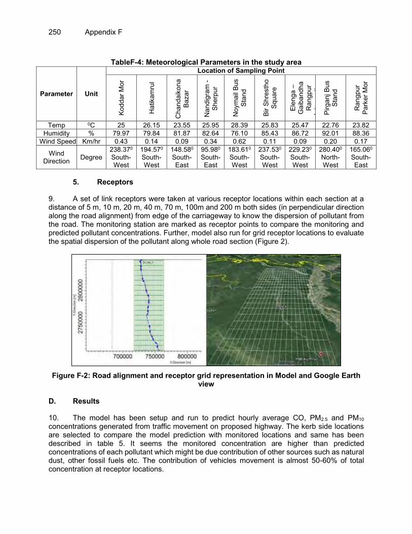
250 Appendix F
TableF-4: Meteorological Parameters in the study area
Parameter Unit
Location of Sampling Point
Kodd
ar M
or
Hat
ikam
rul
Cha
ndai
kona
Ba
zar
Nan
digr
am -
Sher
pur
Noy
mai
l Bus
St
and
Bir S
hres
tho
Squa
re
Elen
ga –
G
aiba
ndha
R
angp
ur
Inte
rsec
tion
Pirg
anj B
us
Stan
d
Ran
gpur
Pa
rker
Mor
Temp 0C 25 26.15 23.55 25.95 28.39 25.83 25.47 22.76 23.82 Humidity % 79.97 79.84 81.87 82.64 76.10 85.43 86.72 92.01 88.36
Wind Speed Km/hr 0.43 0.14 0.09 0.34 0.62 0.11 0.09 0.20 0.17
Wind Direction Degree
238.370 South-West
194.570 South-West
148.580 South-East
95.980 South-East
183.610 South-West
237.530
South-West
229.230
South-West
280.400 North-West
165.060 South-East
5. Receptors
9. A set of link receptors were taken at various receptor locations within each section at a distance of 5 m, 10 m, 20 m, 40 m, 70 m, 100m and 200 m both sides (in perpendicular direction along the road alignment) from edge of the carriageway to know the dispersion of pollutant from the road. The monitoring station are marked as receptor points to compare the monitoring and predicted pollutant concentrations. Further, model also run for grid receptor locations to evaluate the spatial dispersion of the pollutant along whole road section (Figure 2).
Figure F-2: Road alignment and receptor grid representation in Model and Google Earth
view D. Results
10. The model has been setup and run to predict hourly average CO, PM2.5 and PM10 concentrations generated from traffic movement on proposed highway. The kerb side locations are selected to compare the model prediction with monitored locations and same has been described in table 5. It seems the monitored concentration are higher than predicted concentrations of each pollutant which might be due contribution of other sources such as natural dust, other fossil fuels etc. The contribution of vehicles movement is almost 50-60% of total concentration at receptor locations.

Appendix F 251
Table F-5: Monitored and Predicted Concentration at selected location (kerb) along the road
Parameter
Concentrations Monitored Predicted
PM2.5 (µg/m3)
PM10 (µg/m3)
CO (ppm)
PM2.5 (µg/m3)
PM10 (µg/m3)
CO (ppm)
Hatikamrul 27.77 65.78 0 18 29 0.1 Elenga – Gaibandha Rangpur Intersection
30.88 70.07 0 13 26 0
Pirganj Bus Stand 40.32 93.75 0 18 29 0 Rangpur Parker Mor 37.63 66.66 0 15 28.6 0
11. The predicted hourly average concentration of CO, PM2.5 and PM10 during peak traffic hour are shown in table 6. The graphical representation of hourly average pollutant concentrations on both side of the road sections shown in figures 3 – 5 at different locations.
Table F-6: Pollutant predicted concentrations along the proposed highway corridor for peak traffic hour
Pollutant Distance from the edge of the road, m. (Left side)
Distance from the edge of the road, m. (Right side)
-200 -100 -70 -40 -20 -10 -5 5 10 20 40 70 100 200 CO
(ppm) 0 0 0 0 0.1 0.1 0.1 0.1 0 0 0 0 0 0
PM2.5
(µg/m3) 0.00 1.80 3.60 7.20 12.60 16.56 18.00 13.00 9.10 7.80 3.90 2.60 0.00 0.00
PM10 (µg/m3) 1.11 2.90 5.80 11.60 20.30 26.68 29.00 22.00 15.40 14.30 6.60 6.60 2.20 1.12
Figure F-3: CO predicted concentrations (ppm) along the proposed highway corridor
(Left Side is of graph represent downwind side)

252 Appendix F
Figure F-4: PM2.5 predicted concentrations (µg/m3) along the proposed highway corridor
(Left Side is of graph represent downwind side)
Figure F-5: PM10 predicted concentrations (µg/m3) along the proposed highway corridor
(Left Side is of graph represent downwind side)
12. In addition, the spatial distribution of hourly average predicted CO, PM2.5 and PM10, concentrations have been plotted in figures 6-9, respectively for peak traffic hour which shows that pollutant concentrations is decreasing when goes away from the highway corridor. Therefore, the impacts of traffic movement at proposed highway project will not impact the surrounding atmosphere.

Appendix F 253
Figure F-6: Spatial distribution of CO concentrations
Year 2016 Year 2020
Year 2025 Year 2030
Year 2035 Year 2040

254 Appendix F
Figure F-7: Spatial distribution of PM2.5 concentrations
Year 2016 Year 2020
Year 2025 Year 2030
Year 2035 Year 2040

Appendix F 255
Figure F-8: Spatial distribution of PM10 concentrations
Year 2016 Year 2020
Year 2025 Year 2030
Year 2035 Year 2040
13. The summary of maximum GLC of CO, PM2.5 and PM10 at kerb side of road in downwind side are described in Table 7.

256 Appendix F
Table F-7: Maximum GLC of CO, PM2.5 and PM10 at kerb side of road in downwind side Year CO PM2.5 PM10
2016 0.1 18 29 2020 0.1 25 54 2025 0.2 32 72 2030 0.2 40 94 2035 0.2 52 123 2040 0.3 75 164
Reference:
Department of Environment ( 2012). Revisions of Vehicular Emission Standards For Bangladesh (Bdesh-2 And Bdesh-3) Draft Final Report - Part 1, Clean Air and Sustainable Environment (CASE) Project, Department of Environment, Government of The People’s Republic of Bangladesh.
ARAI (Automotive Research Association of India), 2007. Emission factor development for Indian vehicles. Project report no. AEF/2006-07/IOCL/Emission Factor Project. Automotive Research Association of India, Pune, India, 94 pages.
USEPA (U.S. Environment Protection Agency), 2011d. Compilation of air pollutant EFs: miscellaneous sources: paved roads final section. AP 42, Fifth Ed. 1.

Appendix G 257
APPENDIX G: NOISE MODELING FOR THE PROJECT CORRIDOR Noise Emission Modeling of the proposed Elenga-Hatikamrul-Rangpur Roadway traffic
1. Under the proposed project the existing 2-lane roadways will be upgraded to a four lane road with safety features that include the addition of a separate SMVT lane, flyovers at the busiest junctions, overpasses, Bus stops, pedestrian bridges and additional lanes at intersections. This will generate additional traffic and consequently alter the noise environment along the route of the roadway. We used Canarina CUSTIC 3.2 software for noise pollution modeling for the assessment of the noise pollution propagation generated from traffic. The CUSTIC Software allows us to create robust and useful numeric simulations that fully makes use of the graphical user interface. The methodology and governing equations for noise modelling under the graphic user interface of CUSTIC 3.2 is described in Annex A.
A. Basic Data and Assumptions for Noise Impact Modeling
2. Noise emission from vehicles along the route is modelled as steady-state line source. We use the traffic projections (primarily motorized traffic) from the “STPPF (Road Component - Package 1) –Traffic Forecast Report – Feb 2014” to estimate the source emissions according to different scenarios. In the report, traffic projections are made considering 2011 RHD traffic data as the baseline traffic and increasing it by the annual growth rates. For the Rangpur-Hatikamrul route, there is no diverted traffic from any internal road but affected by SAARC traffic. More specifically, for 2011-16, traffic on all seven sections is increased annually by the normal traffic growth rates. In 2016 the additional traffic on all seven sections generated from the SAARC traffic (367 veh./day from Nepal and Bhutan) is added. In 2018 additional SAARC traffic of 1259 veh./day is added up to Gobindaganj and 856 veh./day from Gobindaganj to end point which will be diverted from India. During the period 2018-2040, traffic on all seven sections is increased annually by the normal traffic growth rates.
Figure G-1: Traffic Forecast of Rangpur-Hatikamrul Road
(Source: STPPF (Road Component - Package 1) –Traffic Forecast Report – Feb 2014)
0
5000
10000
15000
20000
25000
30000
2011
2013
2015
2017
2019
2021
2023
2025
2027
2029
2031
2033
2035
Ave
rage
AA
DT
(EXC
. Aut
oric
ksha
w &
Mot
or
Cyc
le)
Year
Average AADT with normal trafficgrowthAverage AADT with normal trafficgrowth+Generated TrafficAverage AADT with normal trafficgrowth+SAARC +Generated Traffic

258 Appendix G
3. For noise emission modeling, we considered three scenarios: (i) baseline emission for the current year (i.e. projected estimate of 2016); (ii) projected noise emission for the design year 2033 and (ii) projected noise emission for the year 2040. Estimations of Motorized traffic of different sections of the road for these scenarios (as stated in the STPPF report) are used as input which is summarized in Table 1. Figure 2 shows the different road sections in which noise emission modeling has been performed. The design speed has been assumed to be 80 km/hr for noise emission modeling. The posted speed is 70 km/hr, therefore 80 km/hr will give a conservative estimate of noise emissions.
Table G-1: Baseline traffic data of different sections which were used for noise modeling
Segment name Box
Designation in Figure 2
Baseline traffic for year 2016
(veh/hr)
Projected traffic for 2033
(veh/hr)
Projected traffic for 2040
(veh/hr) N5-51, between Mithapukur-Rangpur Modern More, Pairabond, km 316.022
1 486 1553 2336
N5-50, between Pirganj-Mithapukur, km 292.502 2 252 871 1309
N5-48, between Palashbari-Pirganj, Ekberpur, km 275.511
3 269 917 1378
N5-45, between Kashipur (Mokamtola)-Gabindaganj, Pakurtala, km 243.512
4 530 1754 2638
N5-33, between Int. with Bogra2nd By pass-Sultanganj, Banani, km 203.568
5 1134 3511 5279
N5-31, Sherpur(Int. withZ-5049)-Sherpur(Int. with Z-5401)
6 854 2717 4085
N5-28,Hatikamrul-Bhuyangati 7 583 1977 2972
N405-1, between Elenga-Jamuna Bridge,11km west of Elenga
8,9,10 775 2123 3802

Appendix G 259
Figure G-2: The different road sections in which noise emission modeling has been
performed. Boxes 1 – 10 are delineated in the figure to highlight the road sections (see Table 1 for details) in which noise simulations were made.

260 Appendix G
Figure G-3: Location of sensitive noise receptors where baseline noise measurements
were carried out along the Elenga- Hatikamrul-Rangpur route
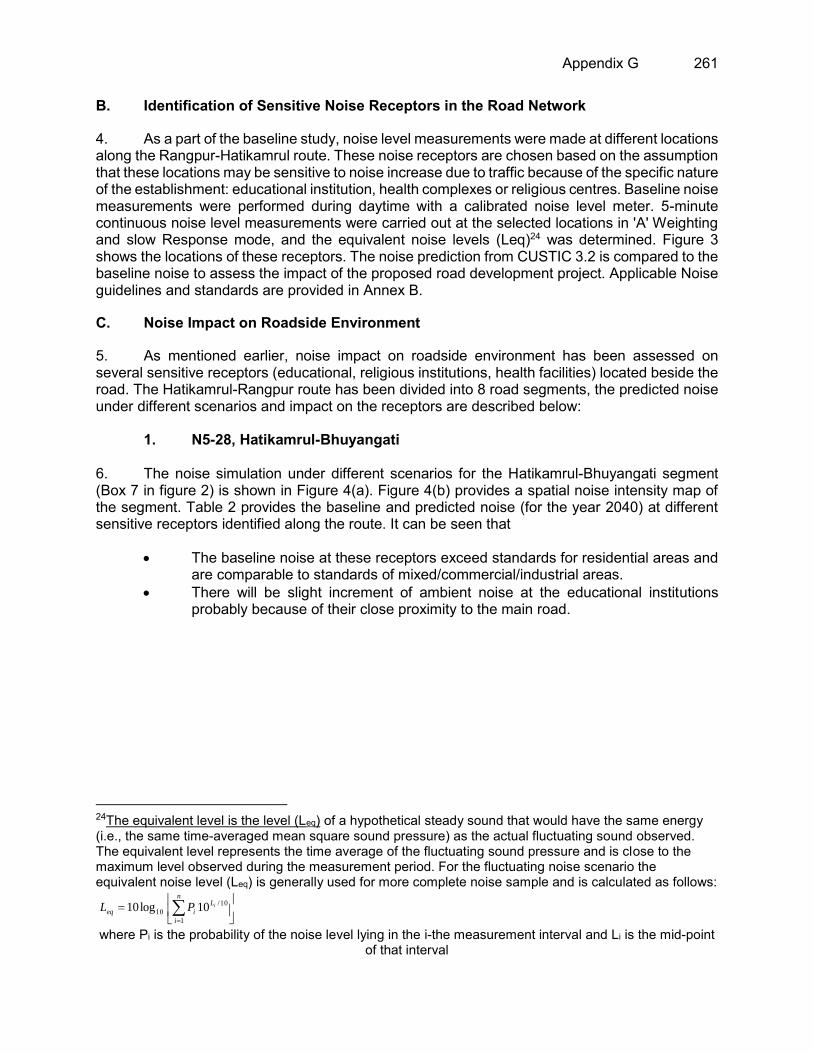
Appendix G 261
B. Identification of Sensitive Noise Receptors in the Road Network
4. As a part of the baseline study, noise level measurements were made at different locations along the Rangpur-Hatikamrul route. These noise receptors are chosen based on the assumption that these locations may be sensitive to noise increase due to traffic because of the specific nature of the establishment: educational institution, health complexes or religious centres. Baseline noise measurements were performed during daytime with a calibrated noise level meter. 5-minute continuous noise level measurements were carried out at the selected locations in 'A' Weighting and slow Response mode, and the equivalent noise levels (Leq)24 was determined. Figure 3 shows the locations of these receptors. The noise prediction from CUSTIC 3.2 is compared to the baseline noise to assess the impact of the proposed road development project. Applicable Noise guidelines and standards are provided in Annex B.
C. Noise Impact on Roadside Environment
5. As mentioned earlier, noise impact on roadside environment has been assessed on several sensitive receptors (educational, religious institutions, health facilities) located beside the road. The Hatikamrul-Rangpur route has been divided into 8 road segments, the predicted noise under different scenarios and impact on the receptors are described below:
1. N5-28, Hatikamrul-Bhuyangati
6. The noise simulation under different scenarios for the Hatikamrul-Bhuyangati segment (Box 7 in figure 2) is shown in Figure 4(a). Figure 4(b) provides a spatial noise intensity map of the segment. Table 2 provides the baseline and predicted noise (for the year 2040) at different sensitive receptors identified along the route. It can be seen that
The baseline noise at these receptors exceed standards for residential areas and are comparable to standards of mixed/commercial/industrial areas.
There will be slight increment of ambient noise at the educational institutions probably because of their close proximity to the main road.
24The equivalent level is the level (Leq) of a hypothetical steady sound that would have the same energy (i.e., the same time-averaged mean square sound pressure) as the actual fluctuating sound observed. The equivalent level represents the time average of the fluctuating sound pressure and is close to the maximum level observed during the measurement period. For the fluctuating noise scenario the equivalent noise level (Leq) is generally used for more complete noise sample and is calculated as follows:
where Pi is the probability of the noise level lying in the i-the measurement interval and Li is the mid-point of that interval
n
i
L
ieqiPL
1
10/
10 10log10
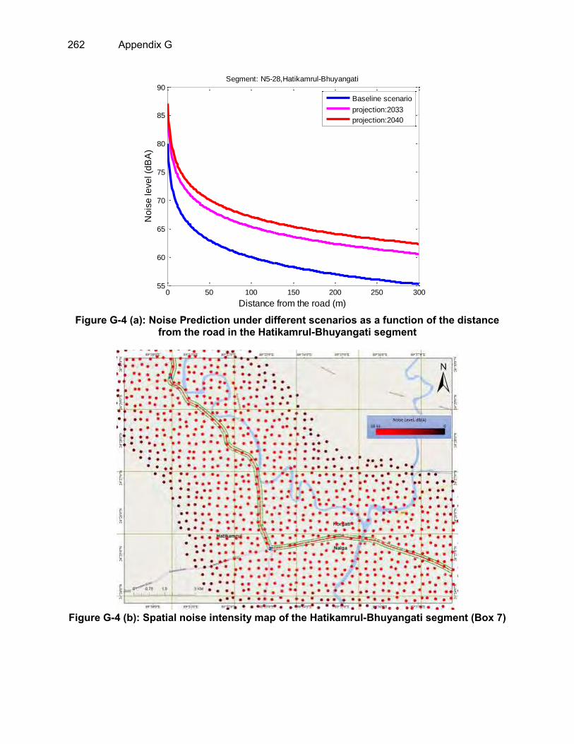
262 Appendix G
Figure G-4 (a): Noise Prediction under different scenarios as a function of the distance
from the road in the Hatikamrul-Bhuyangati segment
Figure G-4 (b): Spatial noise intensity map of the Hatikamrul-Bhuyangati segment (Box 7)
0 50 100 150 200 250 30055
60
65
70
75
80
85
90
Distance from the road (m)
No
ise
le
ve
l (d
BA
)
Segment: N5-28,Hatikamrul-Bhuyangati
Baseline scenario
projection:2033
projection:2040

Appendix G 263
Table G-2: Baseline and predicted noise (for the year 2040) at different sensitive
receptors identified along the Hatikamrul-Bhuyangati route segment Segment
name Name of sensitive receptor
Type of establishm
ent
Latitude Longitude Baseline noise (Leq)
under current traffic
conditions
Predicted noise
(Leq) for the year
2040
Comments (No
change/ net
increase in noise)
N5-28, Hatikamrul-Bhuyangati
Hatikamrul Puraton Mosque
Religious 24.42852 89.54746 82.5 74.2 No change
Dadupur Sahebgonj Govt. High School
Educational 24.45099 89.5454 68.6 69.9 Marginal increase
Daudpur Raypara Mosque
Religious 24.45828 89.54364 74.2 72.5 No change
National Skill Development Institute
Educational 24.46188 89.5375 71.0 73.7 Net increase
Royhati Madrasa Mor Educational 24.47895 89.52355 70.1 73.4 Net
increase
2. N5-31, Sherpur Int. with Z-5049)-Sherpur (Int. with Z-5401)
7. The noise simulation under different scenarios for the N5-31, Sherpur (Int. with Z-5049)-Sherpur (Int. with Z-5401) segment (Box 6 in figure 2) is shown in Figure 5(a). Figure 5(b) provides a spatial noise intensity map of the segment. Table 3 provides the baseline and predicted noise (for the year 2040) at different sensitive receptors identified along the route. It can be seen that
The baseline noise at some of these receptors (except the educational institutions) exceed standards for residential areas
There will be an increase in ambient noise at the educational institutions probably because of their close proximity to the main road. It may be suggested in the mitigation plan that regular noise monitoring should be conducted in these locations in future and proper mitigation measures should be devised (green-belt development) if required.

264 Appendix G
Figure G-5 (a): Noise Prediction under different scenarios as a function of the distance
from the road in the N5-31, Sherpur Int. with Z-5049)-Sherpur (Int. with Z-5401)
Figure G-5 (b): Spatial noise intensity map of the N5-31, Sherpur Int. with Z-5049)-Sherpur
(Int. with Z-5401) (Box 6)
0 50 100 150 200 250 30055
60
65
70
75
80
85
90
Distance from the road (m)
No
ise
le
ve
l (d
BA
)
Segment: N5-31, Sherpur Int. with Z-5049-Sherpur Int. with Z-5401)
Baseline scenario
projection:2033
projection:2040

Appendix G 265
Table G-3: Baseline and predicted noise (for the year 2040) at different sensitive receptors identified along the N5-31 route segment
Segment name
Name of sensitive receptor
Type of establishm
ent
Latitude Longitude Baseline noise (Leq)
under current traffic
conditions
Predicted noise
(Leq) for the year
2040
Comments (No
change/ net increase in
noise)
N5-31, Sherpur Int. with Z-5049)-Sherpur (Int. with Z-5401)
Holi Child School Educational 24.63166 89.43683 73.2 72.4 No change
Krishnapur Govt. Primart School
Educational 24.63901 89.43226 57.6 70.6 Net increase
Sherua Bottola Bazar
Bazar 24.65272 89.42429 80.6 75.5 No change
Jameya Hafizia Madrasha
Educational 24.66334 89.42091 61.8 70.4 Net increase
3. N5-33, between Int. with Bogra 2nd By pass-Sultanganj, Banani
8. The noise simulation under different scenarios for the N5-31, Sherpur (Int. with Z-5049)-Sherpur (Int. with Z-5401) segment (Box 5 in figure 2) is shown in Figure 6(a). Figure 6(b) provides a spatial noise intensity map of the segment. Table 4 provides the baseline and predicted noise (for the year 2040) the sensitive receptor identified along the route. It can be seen that the baseline noise at some of the receptors exceed standards for residential areas and there will be no net change of noise due to added traffic in the route.
Table G-4: Baseline and predicted noise (for the year 2040) at different sensitive receptors identified along the N5-33 route segment
Segment name
Name of sensitive receptor
Type of establishment
Latitude Longitude Baseline noise (Leq)
under current traffic
conditions
Predicted noise
(Leq) for the year
2040
Comments (No
change/ net increase in
noise) N5-33,
between Int. with Bogra
2nd By pass-Sultanganj, Banani, km
203.568
Banani Bazar Bazar 24.81253 89.3807 82.5 74.2 No change
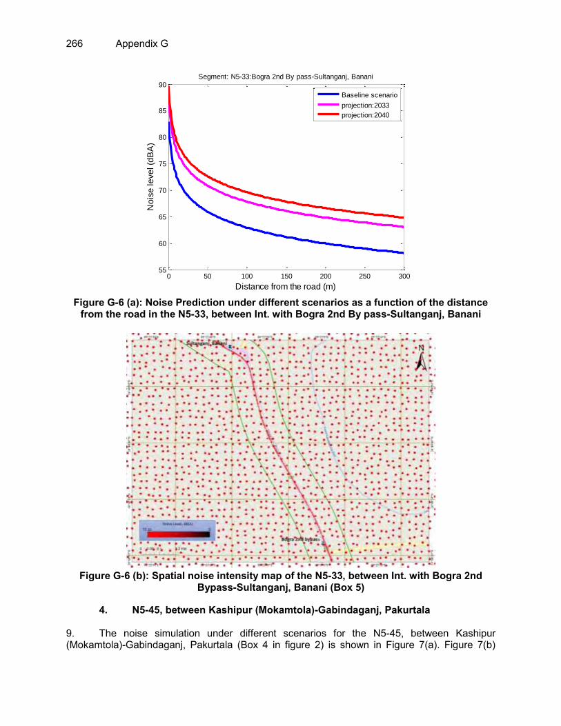
266 Appendix G
Figure G-6 (a): Noise Prediction under different scenarios as a function of the distance
from the road in the N5-33, between Int. with Bogra 2nd By pass-Sultanganj, Banani
Figure G-6 (b): Spatial noise intensity map of the N5-33, between Int. with Bogra 2nd
Bypass-Sultanganj, Banani (Box 5)
4. N5-45, between Kashipur (Mokamtola)-Gabindaganj, Pakurtala
9. The noise simulation under different scenarios for the N5-45, between Kashipur (Mokamtola)-Gabindaganj, Pakurtala (Box 4 in figure 2) is shown in Figure 7(a). Figure 7(b)
0 50 100 150 200 250 30055
60
65
70
75
80
85
90
Distance from the road (m)
No
ise
le
ve
l (d
BA
)
Segment: N5-33:Bogra 2nd By pass-Sultanganj, Banani
Baseline scenario
projection:2033
projection:2040

Appendix G 267
provides a spatial noise intensity map of the segment. Table 5 provides the baseline and predicted noise (for the year 2040) at different sensitive receptors identified along the route. It can be seen that
The baseline noise at some of these receptors exceed standards for residential areas
There will be an increase in ambient noise at the educational institution and health facility probably because of their close proximity to the main road. It may be suggested in the mitigation plan that regular noise monitoring should be conducted in these locations in future and proper mitigation measures should be devised (green-belt development) if required.
Figure G-7(a): Noise Prediction under different scenarios as a function of the distance
from the road in the N5-45, between Kashipur (Mokamtola)-Gabindaganj, Pakurtala
0 50 100 150 200 250 30050
55
60
65
70
75
80
85
90
Distance from the road (m)
No
ise
le
ve
l (d
BA
)
Segment: N5-45:Kashipur(Mokamtola)-Gabindaganj,Pakurtala
Baseline scenario
projection:2033
projection:2040

268 Appendix G
Figure G-7(b): Spatial noise intensity map of the N5-45, between Kashipur (Mokamtola)-
Gabindaganj, Pakurtala (Box 4)
Table G-5: baseline and predicted noise (for the year 2040) at different sensitive receptors identified along the N5-45 route segment
Segment name
Name of sensitive receptor
Type of establishm
ent
Latitude Longitude Baseline noise (Leq) under
current traffic conditions
Predicted noise (Leq) for the year
2040
Comments (No
change/ net
increase in noise)
N5-45, between Kashipur
(Mokamtola)-Gabindaganj,
Pakurtala, km 243.512
Makamtola Mohila Degree College
Educational 25.01357 89.36747 63.8 65.0 Marginal increase
Pakurtola Bazar Bazar 25.04359 89.36677 75.1 72.1 No change
Rahbol Girls High School Educational 25.05966 89.36947 63.4 68.3 Increase
TMSS Health Complex Health 25.08785 89.3807 61.8 73.3 Increase
Boxer Mondolpara Jame Mosque
Religious 25.10972 89.38301 73.8 71.6 No change
5. N5-48, between Palashbari-Pirganj, Ekberpur
10. The noise simulation under different scenarios for the N5-48, between Palashbari-Pirganj, Ekberpur (Box 3 in figure 2) is shown in Figure 8(a). Figure 8(b) provides a spatial noise intensity map of the segment. Table 6 provides the baseline and predicted noise (for the year 2040) at different sensitive receptors identified along the route. It can be seen that

Appendix G 269
The baseline noise at most of these receptors exceed standards for residential areas mainly due to high level of human activities during daytime
There will be a marginal increase in ambient noise at few of these receptors and overall the generated noise will not alter the existing noise environment significantly.
Figure G-8 (a): Noise Prediction under different scenarios as a function of the distance
from the road in the N5-48, between Palashbari-Pirganj, Ekberpur
Figure G-8 (b): Spatial noise intensity map of the N5-48, between Palashbari-Pirganj,
Ekberpur (Box 3)
0 50 100 150 200 250 30050
55
60
65
70
75
80
85
Distance from the road (m)
No
ise
le
ve
l (d
BA
)Segment: N5-48,Palashbari-Pirganj, Ekberpur
Baseline scenario
projection:2033
projection:2040

270 Appendix G
Table G-6: baseline and predicted noise (for the year 2040) at different sensitive receptors identified along the N5-48 route segment
Segment name
Name of sensitive receptor
Type of establishm
ent
Latitude Longitude Baseline noise (Leq) under
current traffic conditions
Predicted noise (Leq) for the year
2040
Comments (No
change/ net
increase in noise)
N5-48, between
Palashbari-Pirganj,
Ekberpur, km
275.511
Mosque Religious 25.28686 89.35039 74.7 66.7 No change Mosheshpur Govt. Primary School
Educational 25.30028 89.34622 73.7 66.3 No change
Akbarpur Govt. Primary School
Educational 25.32521 89.33933 65.3 65.2 No change
R. V. Cold Storage Mosque
Religious 25.33883 89.34263 66.8 69.3 Increase
Dhaperhat Bazar Bazar 25.3441 89.3419 70.6 72.9 Increase
Mosque Religious 25.35539 89.33632 71.3 66.9 No change Madarpur Govt. Primary School
Educational 25.36537 89.33066 73.9 70.8 No change
Lillah Boarding Madrasha
Educational 25.39123 89.32641 61.5 64.4 Increase
PirganjMohila Technical and BM College
Educational 25.40738 89.32244 69.3 65.3 No change
6. N5-48, between Pirganj, Ekberpur -Mithapukur
11. The noise simulation under different scenarios for the N5-50, between Pirganj-Mithapukur (Box 2 in figure 2) is shown in Figure 9(a). Figure 9(b) provides a spatial noise intensity map of the segment. Table 7 provides the baseline and predicted noise (for the year 2040) at different sensitive receptors identified along the route. It can be seen that
The baseline noise at most of these receptors exceed standards for residential areas mainly due to high level of human activities during daytime.
There will be a marginal increase in ambient noise at only one of the receptors (a mosque) and overall the generated noise will not alter the existing noise environment significantly

Appendix G 271
Figure G-9 (a): Noise Prediction under different scenarios as a function of the distance
from the road in the N5-50, between Pirganj-Mithapukur
Figure G-9 (b): Spatial noise intensity map of the N5-50, between Pirganj-Mithapukur
(Box 2)
0 50 100 150 200 250 30050
55
60
65
70
75
80
85
Distance from the road (m)
No
ise
le
ve
l (d
BA
)
Segment: N5-50, Pirganj-Mithapukur
Baseline scenario
projection:2033
projection:2040

272 Appendix G
Table G-7: baseline and predicted noise (for the year 2040) at different sensitive receptors identified along the N5-50 route segment
Segment name
Name of sensitive receptor
Type of establish
ment Latitude Longitude
Baseline noise (Leq) under
current traffic conditions
Predicted noise (Leq) for the year
2040
Comments (No change/ net increase
in noise)
N5-50, between Pirganj-Mithapukur, km 292.502
Pirganj Community
Eye Hospital Health 25.42076 89.31395 69.3 70.5 No change
Mosque Religious 25.45452 89.29762 65.4 69.9 Increase Bishmail
Jame Mosque Religious 25.47706 89.29352 69.5 69.7 No change
Borodorga Bazar Bazar 25.50597 89.2894 71.9 69.4 No change
ShotibariJame Mosque Religious 25.52649 89.28544 74.2 70.9 No change
Sathibari Bazar Bazar 25.53495 89.28418 79.7 72.0 No change
Al Farukh High School
Educational 25.5536 89.27981 75.2 65.2 No change
Hera Memorial
Mohila Mohabiddaloy
Educational 25.56396 89.27596 72.6 68.0 No change
7. N5-51, between Mithapukur-Rangpur Modern More, Pairabond
12. The noise simulation under different scenarios for the N5-51, between Mithapukur-Rangpur Modern More, Pairabond (Box 1 in figure 2) is shown in Figure 10(a). Figure 10(b) provides a spatial noise intensity map of the segment. Table 8 provides the baseline and predicted noise (for the year 2040) at different sensitive receptors identified along the route. It can be seen that
The baseline noise at most of these receptors exceeds standards for residential areas mainly due to high level of human activities during daytime.
There will be an increase in ambient noise at the educational institutions probably because of their close proximity to the main road. It may be suggested in the mitigation plan that regular noise monitoring should be conducted in these locations in future and proper mitigation measures should be devised (green-belt development) if required.

Appendix G 273
Figure G-10(a): Noise Prediction under different scenarios as a function of the distance
from the road in the N5-51, between Mithapukur-Rangpur Modern More, Pairabond
Figure G-10(b): Spatial noise intensity map of the N5-51, between Mithapukur-Rangpur
Modern More, Pairabond (Box 1)
0 50 100 150 200 250 30050
55
60
65
70
75
80
85
90
Distance from the road (m)
No
ise
le
ve
l (d
BA
)
Segment: N5-51: Mithapukur-Rangpur Modern More,Pairabond
Baseline scenario
projection:2033
projection:2040

274 Appendix G
Table G-8: baseline and predicted noise (for the year 2040) at different sensitive receptors identified along the N5-50 route segment
Segment name
Name of sensitive receptor
Type of establishm
ent Latitude Longitude
Baseline noise (Leq) under
current traffic conditions
Predicted noise
(Leq) for the year
2040
Comments (No change/ net increase
in noise)
N5-51, between
Mithapukur-Rangpur Modern More,
Pairabond, km
316.022
Mithapukur Autistic School Educational 25.57818 89.27351 67.2 70.1 Increase
Batason Fathehfur Jame Mosque
Religious 25.60268 89.26888 74.4 72.6 No change
Genbikash Sishukanon Educational 25.61124 89.26881 73.4 71.7 No change
Adorsho High School Educational 25.61546 89.26982 70.8 67.8 No change
Mosque Religious 25.63672 89.2699 74.3 71.9 No change Boiriganj Bazar Bazar 25.66192 89.27274 80.6 68.8 No change Islampur Mondon Para Mosque Religious 25.6672 89.27393 67.5 68.9 Increase
Payrabondo Salehkiya Madrasa
Educational 25.6738 89.27351 61.6 69.1 Increase
Hazipara Jame Mosque Religious 25.68171 89.27203 69.0 68.6 No change
Drishtiprotibondhi School Educational 25.68816 89.27077 61.2 67.0 Increase
Popular Model School Educational 25.69598 89.26561 77.3 66.1 No change
Muslim Aid Institute of Technology
Educational 25.71022 89.25935 72.5 64.8 No change
North Bengal University Educational 25.71091 89.26022 69.7 72.3 Increase
8. Tangail (Elenga)-Hatikamrul Road
13. The noise simulation under different scenarios for the Tangail (Elenga)-Hatikamrul Road (Box 8-10 in figure 2) is shown in Figure 11(a). Figure 11(b) provides a spatial noise intensity map of the segment. Table 9 provides the baseline and predicted noise (for the year 2040) at different sensitive receptors identified along the route. It can be seen that
The baseline noise at most of these receptors exceeds standards for residential areas mainly due to high level of human activities during daytime.
There will be an increase in ambient noise at most of the receptors identified along the route. It may be suggested in the mitigation plan that regular noise monitoring should be conducted in these locations in future and proper mitigation measures should be devised (green-belt development) if required.

Appendix G 275
Figure G-11(a): Noise Prediction under different scenarios as a function of the distance
from the road in Tangail (Elenga)-Hatikamrul Road segment
0 50 100 150 200 250 30055
60
65
70
75
80
85
90
Distance from the road (m)
No
ise
le
ve
l (d
BA
)
Segment: N405-1, between Elenga-Jamuna Bridge
Baseline scenario
projection:2033
projection:2040

276 Appendix G
Figure G-11(b): Spatial noise intensity map of the Tangail (Elenga)-Hatikamrul Road (Box
8, 9 and 10)
Box 8
Box 9
Box 10

Appendix G 277
Table G-9: baseline and predicted noise (for the year 2040) at different sensitive receptors identified along the Tangail (Elenga)-Hatikamrul Road segment
Segment name
Name of sensitive receptor
Type of establishm
ent
Latitude Longitude Baseline noise (Leq) under
current traffic conditions
Predicted noise (Leq) for the year
2040
Comments (No change/
net increase in noise)
Tangail (Elenga)-
Hatikamrul Road
Bytunnur Jame Mosque Religious 24.34407 89.91985 62.0 67.4 Increase
An-Noor Mosque Religious 24.38649 89.8258 62.0 68.5 Increase
Mosque Religious 24.39461 89.73837 48.9 65.6 Increase Sayadabad Mosque Religious 24.39177 89.71413 61.0 69.9 Increase
Dhopakanti Mosque Religious 24.42 89.5575 72.3 74.8 Increase
Fuljor Degree College Mosque
Religious 24.42454 89.58956 65.7 68.0 Increase
Bangabandhu Setu Purbo Station
Others 24.38945 89.81992 66.3 72.4 Increase
Bangabandhu Setu Poschim Station
Others 24.39579 89.73359 59.7 71.8 Increase
Hatikomrul Highway Thana
Others 24.41885 89.55367 76.0 70.7 No change
Gas Transmission Company Ltd
Industry 24.3384 89.92561 73.5 68.9 No change
Poschimanchol Gas Company Limited
Industry 24.42158 89.59808 74.6 68.6 No change
Shakhawat Memorial Hospital
Health 24.41961 89.55268 80.0 72.3 No change
Analiabari High School Educational 24.37013 89.88501 60.3 66.1 Increase
Talimul Islam Madrasha Educational 24.39169 89.7142 66.0 69.3 Increase
Jamuna Polytechnic Institute
Educational 24.39612 89.69189 64.6 67.6 Increase
Shohidul Bulbul Karigori College
Educational 24.39864 89.65486 63.4 66.9 Increase
Simanto Bazar Bazar 24.41015 89.63028 67.0 73.6 Increase

278 Appendix G
Annex A: Methodology for Noise Modeling
A. Noise Model
1. Noise emission from the proposed road network will be modeled using CUSTIC 3.2 (Canarina Environmental Software, Spain). CUSTIC 3.2 noise modeling is based on estimates for dispersion of noise in free field by means of numerical simulations which provides approximate values for the noise levels, regardless of source type (point, line or area). The program calculates the noise level discrete points in space considering different kind of sources and the conditions of the atmosphere. Figure 1 presents the input and output data of the CUSTIC 3.2 software. As shown on the Figure 1, input data include: type of source (point, line ore area), ambient (climate) data, grid size and scale. Based on data entered the software calculates noise levels and presents those levels in form of iso-lines, numerical grid or color gradient.
Figure 1: Input and output data arrangements in CUSTIC 3.2
Figure 2: A typical noise intensity output in CUSTIC 3.2 for a typical road using line noise
source.

Appendix G 279
Mathematical Construct of Noise Dispersion Model
2. The mathematical model that the software uses provides options to model noise emissions from a wide range of sources that might be present at industrial areas and urban areas. The basis of the model is the linear sound propagation equation, which is used to model simple point source emissions from vehicles, industries, aircrafts etc. Emission sources are categorized into two basic types of sources: point sources and line sources. The algorithms used to model each of these source types are described in the following: 3. The CUSTIC software accepts meteorological data records to define the conditions for sound propagation. The model estimates the noise level for each source and receptor combination and calculates user-selected averages. For an external source, the noise level equation is
𝑳𝒆𝒒 = 𝑳𝑾 − 𝟐𝟎× 𝐥𝐨𝐠(𝒓) − 𝟏𝟏×𝒅𝑩(𝑨) Where r is the distance and LW the source power.
4. However, for an industrial complex, the following equation will be used:
𝑳𝒆𝒒 = 𝑳𝒊 + 𝟏𝟎× 𝐥𝐨𝐠(𝑺) − 𝟐𝟎× 𝐥𝐨𝐠(𝒓) − 𝟏𝟒×𝒅𝑩(𝑨) Where 𝑺 is the external surface and 𝑳𝒊 is the internal noise power.
5. In a road case, we shall consider several points. We shall consider a minimum number of 1000 vehicles per hour N with a 50km/h minimum velocity (100km/h is the maximum velocity). Then we have a 68 dB(A) noise level at 10m from a lineal road (infinity length). The noise level in the linear (infinite) road case will be,
𝑳𝒆𝒒 = 𝟔𝟖×𝒅𝑩(𝑨) + 𝟑𝟎 𝐥𝐨𝐠(𝒗/𝟓𝟎) + 𝟏𝟎× 𝐥𝐨𝐠(𝑵/𝟏𝟎𝟎𝟎) − 𝟏𝟎× 𝐥𝐨𝐠(𝒓/𝟏𝟎)
6. In the curved road case, the program considers a finite element method of calculation. Each small size of road contributes to the total noise level. Each contribution will be given by
𝑳𝒊 = 𝟏𝟎× 𝐥𝐨𝐠(𝒂/𝟏𝟖𝟎) Where a is the angle of the small road size (degrees).
7. To obtain the total noise level, we add the different 𝐋𝐢 values following the equation
𝑳𝒆𝒒 = 𝟏𝟎× 𝐥𝐨𝐠[∑ 𝟏𝟎(𝑳𝒊/𝟏𝟎)
𝒊
]
This model performs satisfactorily for simple sound propagations with no ground interaction or attachment. The application will not consider sound reflections in the ground surface.

280 Appendix G
Data and Assumptions in the Noise model
8. The noise model will consider the following:
Current noise emissions will be predicted based on current vehicle density in the proposed road sections. The estimated projected traffic will be used to predict the noise in future times.
Flat topographic features (no undulations) will be assumed in the noise model. Meteorological information of the respective area will be used as input parameters.
Contour diagrams of noise isolines will be generated along the proposed road route
Several potential sensitive receptors will be located along the route of the road network (educational institutions, hospitals, religious institutions) and the incremental increase in noise will be calculated based on measured baseline noise in those locations and predicted noise from CUSTIC 3.2
Reference: CUSTIC 3.2 Noise Pollution Modeling Software, Manuel, 2004.CanarinaAlgorithosNumericos, S.L.

Appendix G 281
Annex B: Ambient Noise Standards and Guidelines
Table B-1: Bangladesh standards for sound level (GoB, 2006) Locations Noise level (dBA) at day Noise level (dBA) at night Silent zone 50 40
Residential area 55 45 Mixed area 60 50
Commercial area 70 60 Industrial area 75 70
(Ref: Noise Pollution Control Rules, 2006)
Table B-2: Noise Level Guidelines Measure Out of Doors. (Guidelines for Community Noise, WHO, 1999)
Receptor One Hour LAeq (dBA)
Daytime 07:00 – 22:00
Night-time 22:00 – 7:00
Residential, institutional, educational 55 45 Industrial, commercial 70 70 Note: For acceptable indoor noise levels for residential, institutional, and education settings refer to WHO (1999).
Table B-3: Noise Limits for Various Working Environments.
Location/ activity Equivalent Level LAeq, 8h
Maximum LAmax, fast
Heavy Industry (no demand for oral communication) 85 dB(A) 110 dB(A) Light Industry (decreasing demand for oral communication) 50 – 65 dB(A) 110 dB(A) Open offices, control rooms, service counters or similar 45 – 50 dB(A) -- Individual offices (no disturbing noises) 40 – 45 dB(A) -- Classrooms, lecture halls 35 – 40 dB(A) -- Hospitals 30 – 35 dB(A) 40 dB(A) Note: For acceptable indoor noise levels for residential, institutional, and education settings refer to WHO (1999).

282 Appendix H
APPENDIX H: LAND USE OF THE PROJECT ROAD AREA

Appendix H 283

284 Appendix H

Appendix H 285

286 Appendix H

Appendix H 287

288 Appendix H

Appendix H 289

290 Appendix H

Appendix H 291

292 Appendix H

Appendix H 293

294 Appendix H

Appendix H 295

296 Appendix H

Appendix H 297

298 Appendix H

Appendix H 299

300 Appendix H
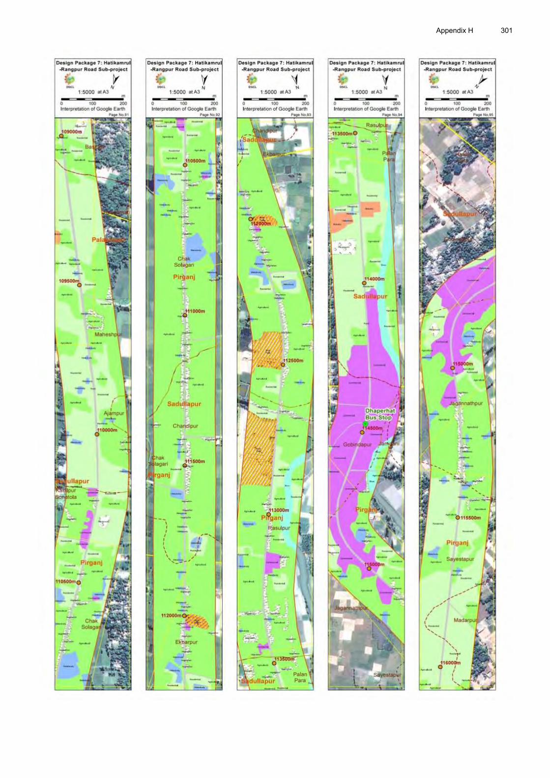
Appendix H 301

302 Appendix H

Appendix H 303

304 Appendix H

Appendix H 305

306 Appendix H
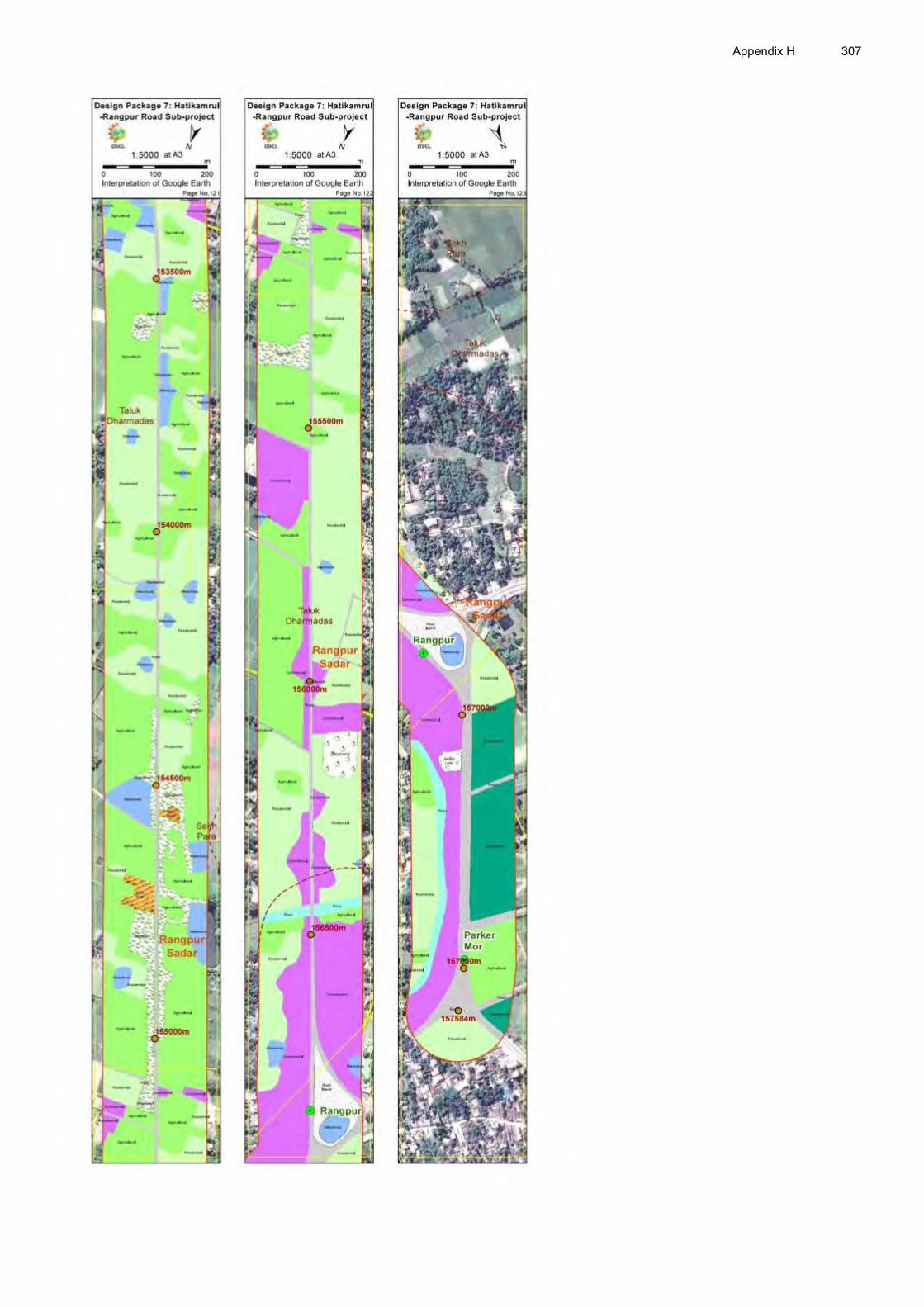
Appendix H 307

308 Appendix I
APPENDIX I: LIST OF IESFS ALONG THE ROW
IECs Within the RoW From Boundary of the RoW to 500meter
Chainages (km) Right
Chainages (km) Left
Chainages (km) Right
Distance from Alignment (m)
Chainages (km) Left
Distance from Alignment (m)
Mosque
1+510, 3+050, 16+300, 18+140, 19+580, 30+090, 31+560, 40+450, 43+040, 50+430, 52+460, 61+275, 62+620 72+615, 77+390, 104+850, 116+200, 118+270, 126+010, 127+450, 133+160, 141+210
12+820, 17+190, 20+370, 21+140, 25+490, 25+910, 30+375, 32+665, 33+765, 33+950, 37+290, 38+240, 40+220, 45+860, 47+690, 49+360, 54+760, 63+150, 65+395, 66+150, 70+065, 75+810, 76+200, 80+505, 84+545, 86+700, 88+820, 94+620, 97+240, 107+600, 115+450, 118+508, 147+900
1+100, 4+430, 38+240, 44+070, 45+480, 55+530, 57+230, 59+030, 59+420, 71+120, 103+965, 106+680, 115+020, 119+580, 129+440, 140+820, 141+640, 143+800, 147+780, 150+800, 154+680, 155+170, 156+180
40, 30, 40, 30, 40, 30, 100, 40, 30, 20, 80, 40, 02, 60, 400, 30, 40, 02, 05, 70, 10, 10, 05
10+130, 16+450, 22+760, 23+335, 32+440, 33+450, 35+120, 35+740, 35+960, 39+020, 43+630, 46+690, 49+510, 51+280, 51+490, 53+350, 55+090, 55+900, 56+440, 57+320, 58+250, 62+100, 65+090, 66+915, 78+160, 88+130, 93+960, 95+295, 98+825, 99+395, 101+250, 102+380, 113+930, 116+720, 122+840, 123+460, 124+035, 129+995, 135+500, 137+190, 138+520, 144+150, 148+890, 150+550, 152+610, 152+790, 152+950, 155+335
070, 050, 030, 100, 050, 050,050, 050, 300, 150, 010, 020, 020, 030, 025, 030, 100, 030,150, 010, 080, 045, 020, 200, 080, 025, 010, 050, 006, 003, 003, 007, 030, 030, 003, 002, 004, 002, 002, 005, 002, 003, 020, 020, 060, 005, 050, 050
School 4+000, 28+770, 33+880, 35+670, 37+460, 42+120, 42+920, 49+325, 51+400, 52+790, 62+880, 78+060, 78+870, 88+670, 90+200, 133+240
22+250, 38+560, 41+980, 48+150, 71+030, 72+405, 90+450
36+210, 41+920, 57+700, 74+480, 74+800, 77+680, 84+170, 85+350, 88+880, 90+460, 91+500, 94+935, 94+980, 95+100, 95+280, 95+300, 94+780, 103+940, 119+630, 134+400, 144+930, 145+560,
70, 50, 150, 20, 20, 30, 100, 100, 150, 70, 70, 20, 50, 30, 20, 20, 250, 100, 150, 400, 70, 15, 20, 30,
0+050, 3+600, 3+600, 5+600, 7+650, 8+580, 9+230, 16+400, 19+420, 23+410, 25+400, 25+500, 26+100, 26+650, 34+360, 35+780, 35+960, 37+480, 40+370, 42+295, 44+170, 45+830, 52+670, 66+025,
100, 030, 90, 080, 150, 80, 145, 100, 030, 040, 150, 100, 045, 400, 500, 055, 300, 150, 070, 015, 025, 015, 200, 015, 100, 015, 015, 100, 450, 015, 003, 100, 003, 100, 010, 100,

Appendix I 309
IECs Within the RoW From Boundary of the RoW to 500meter
Chainages (km) Right
Chainages (km) Left
Chainages (km) Right
Distance from Alignment (m)
Chainages (km) Left
Distance from Alignment (m)
150+770, 152+000, 156+760
20 71+365, 71+570, 71+580, 75+810, 80+600, 82+580, 83+400, 84+680, 86+820, 89+610, 90+300, 95+395, 101+480, 101+540, 102+670, 106+115, 107+415, 108+685, 109+015, 109+005, 111+810, 113+920, 115+470, 116+520, 116+765, 118+370, 121+075, 133+260, 134+605, 137+800, 140+185, 145+040
015, 010, 050, 018, 050, 003, 008, 005, 035, 035, 070, 030, 007, 075, 150, 200, 500, 200, 005, 025
College
33+900, 33+950, 51+270, 62+890, 63+260, 63+950
17+400, 84+860 40, 100 17+120, 34+300, 34+360, 38+140, 44+170, 53+200, 53+700, 62+710, 62+780, 63+135, 64+740, 65+085, 68+130, 80+850, 84+385, 90+495, 116+890, 138+800, 140+540
080, 500, 500, 030, 025, 200, 030, 015, 010, 020, 020, 012, 200, 050, 450, 100, 300, 003, 050
Madrasah
28+020, 85+020 5+880, 24+980, 45+870, 49+650, 72+405, 107+600
25+070, 26+380, 40+080, 68+900, 75+010, 78+750, 88+490, 95+440, 18+820, 124+030, 127+440, 133+440, 140+250
60, 500, 500, 150, 25, 10, 15, 30, 70, 250, 150, 400, 50
19+250, 23+330, 35+960, 48+130, 61+350, 63+425, 63+700, 108+615
015, 070, 300, 050, 050, 400, 450, 005
Training Institute
46+950, 55+520, 60+380, 61+800, 62+625, 107+385
400, 050, 450, 055, 500, 450

310 Appendix I
IECs Within the RoW From Boundary of the RoW to 500meter
Chainages (km) Right
Chainages (km) Left
Chainages (km) Right
Distance from Alignment (m)
Chainages (km) Left
Distance from Alignment (m)
Graveyard
1+490, 29+160, 34+580, 52+840, 63+070, 63+400, 64+040, 65+700, 69+070, 75+540, 90+840, 117+025
30+025, 54+800, 65+510, 65+990
4+330, 18+270, 28+400, 39+420, 41+780, 46+500, 63+440, 94+140, 98+450, 99+750 104+160, 108+750, 110+200, 115+580, 117+100, 117+570, 117+960, 138+690, 144+920, 145+190, 153+580, 153+680
30, 70, 40, 20, 50, 50, 20, 70, 60, 20, 100, 100, 10, 20, 20, 150, 100, 100, 50, 10, 70, 50,
19+350, 20+380, 32+440, 37+290, 51+160, 53+360, 62+990, 63+015, 63+360, 65+100, 65+180, 65+750, 66+085, 67+015, 71+720, 78+890, 80+445, 82+725, 86+800, 101+495, 102+590, 103+115, 115+300, 117+900, 121+130, 125+300, 125+430, 150+020, 152+830, 152+845, 153+010, 153+590, 153+630, 153+920
020, 005, 050, 020, 050, 030, 003, 050, 010, 010, 020, 005, 015, 005, 007, 006, 003, 005, 003, 004, 020, 018, 012, 013, 020, 012, 015, 040, 020, 040, 003, 050, 020, 070
Mazar 63+200, 64+400, 66+210,
64+005, 151+915, 155+300, 151+015
103+570, 133+180 50, 05, 67+650, 71+650, 85+515, 148+890
200, 005, 050, 020
Temple
17+440, 102+020, 113+730, 136+940,
70, 20, 40, 20
6+550 150
Eidgah
0+880, 39+620, 52+990, 64+930, 71+425, 80+560, 134+380, 153+640
8+200, 20+430, 26+420, 29+700, 38+285, 66+415, 70+200, 87+835, 115+445, 139+960, 144+630, 145+520
77+660, 97+260, 105+100, 121+540, 132+380, 148+840, 155+320
30, 350, 150, 06, 20, 05, 150,
22+420, 28+080, 85+515, 108+190, 126+970
150, 040, 050, 003, 016
Boddhobhumi 152+850 350 UP Office 85+070 200 Asrom 6+190, 28+980 100, 010 Filling Station
8+660, 30+840, 34+080, 48+530, 49+040, 54+840, 55+200, 58+670, 58+850, 59+085, 61+300, 62+315, 62+360, 67+580,
1+390, 5+710, 28+490, 32+060, 39+140, 39+190, 50+470, 53+150, 56+600, 59+100, 74+970, 88+410, 107+070, 145+740,
24+880, 46+700, 46+780, 47+780, 48+970, 48+990, 49+160, 60+100, 61+100, 61+440, 61+580, 71+570,
30, 30, 20, 50, 50, 50, 50, 15, 20, 30, 30, 10, 10, 20, 07,
0+150, 37+500, 43+770, 46+620, 49+690, 57+350, 60+700, 64+020, 66+980, 90+170, 105+815, 123+605
030, 010, 050, 020, 020, 030, 010, 015, 007, 006, 003, 003
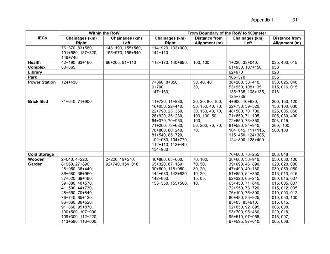
Appendix I 311
IECs Within the RoW From Boundary of the RoW to 500meter
Chainages (km) Right
Chainages (km) Left
Chainages (km) Right
Distance from Alignment (m)
Chainages (km) Left
Distance from Alignment (m)
76+370, 83+580, 101+580, 137+320, 149+740
148+190, 155+560, 155+970, 156+540
114+920, 132+000, 141+110
Health Complex
42+190, 63+160, 80+865,
66+205, 91+110 118+170, 140+690, 100, 100, 1+220, 33+040, 61+930, 107+150,
035, 400, 015, 050
Library 62+970 020 Park 105+370 035 Power Station 124+430 7+360, 8+850,
9+700 147+180,
30, 40, 40 30,
36+260, 53+410, 53+950, 108+135, 135+735, 108+135, 135+735
030, 025, 040, 015, 016, 015, 016
Brick filed 71+640, 71+900 11+730, 11+830, 16+050, 22+440, 22+790, 23+360, 26+920, 35+280, 64+370, 70+950, 71+260, 73+680, 78+860, 80+240, 81+540, 85+720, 102+060, 104+770, 112+110, 112+440, 134+980
30, 30, 80, 100, 30, 150, 40, 70, 30, 150, 40, 70, 100, 100, 50, 100, 50, 200, 70, 70, 70,
4+900, 10+630, 22+730, 39+520, 48+500, 70+700, 71+850, 71+195, 72+650, 73+350, 81+580, 84+940, 104+045, 111+115, 115+450, 124+385, 124+800, 128+400
200, 150, 120, 150, 100, 030, 025, 005, 050, 005, 080, 400, 003, 015, 200, 100, 500, 100
Cold Storage 76+600, 78+255 008, 048 Wooden Garden
2+040, 4+220, 8+960, 27+890, 28+050, 36+440, 36+680, 36+950, 37+520, 39+480, 39+880, 40+570, 41+500, 44+730, 48+650, 70+840, 76+740, 85+120, 86+060, 86+520, 91+860, 95+870, 100+500, 107+900, 109+300, 112+220, 113+580, 116+000,
2+220, 19+570, 92+740, 154+010
46+880, 63+660, 65+320, 67+160 90+600, 118+050, 142+680, 142+830, 142+860, 153+550, 155+500,
70, 100, 70, 50, 30, 20, 10, 20, 15, 05, 10,
38+680, 38+940, 39+690, 46+890, 47+490, 49+180, 51+850, 54+350, 62+320, 65+245, 65+450, 71+640, 72+950, 73+720, 76+100, 76+800, 80+480, 83+925, 85+05, 85+910, 92+650, 92+895, 93+700, 95+460, 95+510, 97+055, 97+595, 97+610,
030, 030, 100, 020, 020, 030, 030, 050, 060, 015, 013, 015, 080, 015, 007, 015, 005, 007, 015, 012, 005, 010, 003, 012, 010, 050, 100, 015, 015, 003, 008, 020, 018, 015, 007, 005, 006,

312 Appendix I
IECs Within the RoW From Boundary of the RoW to 500meter
Chainages (km) Right
Chainages (km) Left
Chainages (km) Right
Distance from Alignment (m)
Chainages (km) Left
Distance from Alignment (m)
116+680, 123+640, 135+400, 139+030, 153+280,
98+510, 100+820, 101+605, 107+995, 108+550, 115+300, 115+750, 115+950, 116+200, 116+480, 117+150, 120+100, 120+750, 124+500, 125+435, 127+165, 127+440, 133+685, 139+450
004, 015, 100, 070, 002, 010, 005, 013, 200, 005
Nursery 36+540, 64+100, 66+430, 66+575, 67+020, 67+500, 70+410, 71+840, 101+660, 102+350, 155+020
36+140, 36+470, 37+390, 41+420, 67+000, 122+705, 152+080, 115+040, 155+100, 155+170, 115+170, 155+200
74+880, 154+960, 155+280,
15, 05, 05,
15+850, 41+320, 61+130, 64+110, 64+590, 66+250, 66+700, 66+820, 67+080, 67+110, 67+390, 76+290, 77+450, 87+230, 133+520
100, 030, 015, 010, 050, 015, 005, 010, 007, 005, 010, 010, 005, 008
Hatchery 146+140, 146+200, 146+260, 146+320, 146+360, 146+430, 146+510,
Industries
113+380 57+750 86+460, 113+380, 117+160, 117+420, 120+520, 120+860, 137+200, 143+760, 145+600, 145+700, 147+820, 148+160, 149+160, 149+460, 154+640, 155+100
15, 05, 200, 200, 150, 100, 100, 05, 15, 20, 40, 30, 20, 10, 150, 20,
Hut / Bazar
6+100-6+300, 9+850-1+000, 16+300-16+800, 25+300-25+600, 28+800-29+050, 31+500-31+680, 32+800-33+100, 33+600-33+1800, 33+900-34+200, 35+700-35+880, 37+200-37+400, 39+000-40+400, 63+900-64+050, 67+200-67+600, 68+260-68+600, 71+080-71+200, 72+800-72+900, 75+700-76+200,

Appendix I 313
IECs Within the RoW From Boundary of the RoW to 500meter
Chainages (km) Right
Chainages (km) Left
Chainages (km) Right
Distance from Alignment (m)
Chainages (km) Left
Distance from Alignment (m)
80+500-80+700, 84+100-84+500, 88+700-90+00, 94+400-95+000, 98+700-98+880, 101+100-101+800, 106+300-107+400, 113+800-114+600, 122+700-123+020, 115+800-116+100, 133+100-133+400, 136+400-137+700, 152+300-152+600,
Road Crossing
1+200, 2+590, 1+200, 2+560, 5+680, 7+640, 10+820, 12+020, 14+390, 17+550, 21+150, 28+220, 33+000, 33+295, 33+460, 33+660, 34+300, 34+485, 34+720, 34+860, 37+305, 40+270, 43+580, 50+380, 54+900, 55+410, 55+450, 55+945, 57+300, 58+255, 58+515, 59+390, 59+780, 60+920, 65+810, 68+260, 68+940, 72+440, 75+700, 78+820, 80+600, 83+880, 85+085, 88+140, 88+970, 89+220, 89+310, 89+430, 89+730, 90+150, 98+300, 99+145, 105+350, 100+755, 106+235, 106+700, 108+300, 112+300, 118+580, 124+000, 125+100, 129+950, 133+140, 134+480, 134+620, 135+490, 136+700, 138+520, 140+475, 144+700, 150+750, 151+315, 153+650, 155+340
Sculpture/ Monuments
1+680, 8+900 500, 100
Pond
17+480, 28+100, 31+150, 35+540, 40+910, 43+000, 47+600, 47+880, 65+100, 69+300, 72+950, 82+540, 90+340, 91+650, 99+160, 111+820, 128+500, 140+520, 141+240, 141+860, 141+900, 142+010, 142+120, 143+090, 144+160, 144+200,
0+300, 0+650, 1+750-1+900, 2+450, 4+150, 5+100, 5+590, 9+990, 17+880, 20+250, 22+500, 23+120, 24+390, 30+100, 51+950, 71+665, 71+905, 72+310, 72+790, 77+850, 78+110, 81+105, 85+700, 86+750, 90+620, 92+245, 92+280,
18+240, 71+570, 75+170, 82+770, 97+930, 126+020, 127+480, 127+600, 128+770, 133+170, 142+100, 142+930,
40, 70, 20, 30, 10, 20, 05, 80, 60, 70, 30, 100
24+810, 27+300, 35+920, 47+260, 51+310, 52+250, 55+190, 56+410, 71+770, 71+895, 76+700, 84+450, 87+000, 92+500, 100+985, 103+820, 104+925, 110+900, 111+865, 123+000, 125+330, 139+405, 143+100, 144+600,
035, 030, 050, 020, 010, 030, 020, 080, 035, 015, 020, 018, 010, 200, 025, 035, 100, 015, 018, 015, 015, 050, 200, 025, 070, 035, 020, 030, 100, 150

314 Appendix I
IECs Within the RoW From Boundary of the RoW to 500meter
Chainages (km) Right
Chainages (km) Left
Chainages (km) Right
Distance from Alignment (m)
Chainages (km) Left
Distance from Alignment (m)
153+670, 153+820, 154+100
92+340, 97+800, 97+840, 97+885, 97+910, 7+960, 98+025, 98+920, 99+220, 107+415, 108+010, 18+030, 126+205, 127+030, 127+085, 127+800, 135+315, 135+385, 136+350, 138+115, 138+160, 139+210, 139+350, 142+390, 143+050, 144+345, 144+500, 146+600, 149+190, 150+525
146+100, 146+510, 149+700, 149+960, 150+170, 154+310
Ditches
0+360, 0+640, 1+580, 1+980, 2+450, 2+500, 4+850, 5+420, 6+660, 6+860, 7+420, 9+440, 9+470, 9+660, 10+280, 12+020, 12+565, 12+590, 12+780, 12+800, 13+500, 13+720, 13+950, 17+620, 18+850, 19+240, 19+830, 20+120, 21+200, 23+510, 26+590, 31+270, 39+090, 39+680, 51+360, 53+180-53+260, 53+280-53+360, 53+380-53+420, 56+100, 58+950-59+025,
1+000, 1+050, 1+100, 1+190, 2+090, 3+000, 3+350, 3+850, 4+750, 5+350, 5+880, 6+000, 6+450, 6+680, 7+180, 7+200, 7+310, 7+450, 7+500, 7+550, 7+950, 8+150, 8+450, 8+610, 8+700, 8+980, 9+200, 9+650, 9+800, 10+200, 10+520, 15+050, 15+200, 15+500, 15+600, 15+780, 16+050, 16+200, 16+250, 16+270, 16+310, 16+370, 17+010, 17+120, 17+190, 17+220, 17+390, 17+420, 17+460, 17+470, 17+620, 17+700, 17+780,
1+640, 4+400, 5+450, 6+050, 14+840, 30+760, 47+310, 65+500, 90+490, 91+260, 91+900, 92+170, 92+560, 92+650, 94+060, 96+050, 96+740, 96+960, 97+440, 97+580, 99+220, 104+460, 106+060, 112+570, 115+280, 126+160, 137+520, 141+050, 146+550, 148+900,
30, 60, 20, 20, 20, 80, 70, 40, 70, 40, 30, 50, 50, 50, 20, 20, 10, 10, 70, 10, 40, 100, 40, 100, 05, 15, 20, 40, 05, 05,
24+430, 29+420, 31+290, 31+300, 31+665, 72+710, 72+720, 77+960, 80+905, 82+100, 85+480, 94+300, 94+380, 95+120, 95+550, 97+130, 97+495, 98+390, 100+770, 101+850, 101+885, 102+045, 104+425, 128+800, 131+200, 131+350, 131+450, 134+010, 134+080, 137+190, 138+685, 149+280
040, 030, 050, 020, 040, 015, 010, 020, 018, 025, 020, 008, 008, 020, 025, 010, 008, 015, 008, 015, 050, 005, 012, 007, 005, 008, 005, 005, 006, 015, 010, 015

Appendix I 315
IECs Within the RoW From Boundary of the RoW to 500meter
Chainages (km) Right
Chainages (km) Left
Chainages (km) Right
Distance from Alignment (m)
Chainages (km) Left
Distance from Alignment (m)
60+760, 62+720, 67+730, 72+370, 77+460, 77+480, 77+530, 78+090, 86+180, 91+570, 92+350, 92+390, 92+400, 92+440, 92+470, 92+970, 94+200, 94+260, 94+380, 95+180, 95+630, 95+970, 97+400, 97+980, 98+280, 98+700, 99+720, 100+050, 100+800, 100+880, 100+930, 101+000, 102+100, 102+470, 102+840, 103+900, 104+830, 105+750, 105+940, 108+720, 109+450, 115+100, 115+550, 116+550, 117+050, 125+070, 125+430, 125+450, 125+470, 125+540, 127+760, 127+970, 128+360, 129+270, 129+680, 129+760, 130+670, 132+280, 133+580, 135+230, 135+340, 135+370, 135+420, 135+490, 136+100, 137+400, 137+950, 138+070, 139+240, 139+590, 140+000, 140+070, 140+780, 140+900,
18+000-18+100, 18+240, 18+250, 18+350, 18+450, 18+530, 18+570, 18+640, 18+850, 18+900, 20+310, 20+400, 22+390, 29+980, 30+875, 31+065, 31+200, 31+250, 33+850, 33+920, 34+075, 34+960, 35+740, 39+050, 41+540, 42+120, 51+950, 54+905, 77+050, 78+020, 79+450, 79+470, 79+495, 79+510, 82+110, 86+685, 94+050, 97+750, 98+270, 99+490, 100+015, 100+110, 101+950, 102+590, 102+650, 102+230, 103+750, 104+310, 110+400, 115+150, 117+520, 117+800, 117+880, 121+300, 121+510, 121+850, 124+300, 125+110, 125+475, 127+285, 127+600, 127+700, 133+100, 134+680, 135+410, 135+850, 135+910, 136+010, 136+025, 137+510, 137+850, 137+900, 138+000,

316 Appendix I
IECs Within the RoW From Boundary of the RoW to 500meter
Chainages (km) Right
Chainages (km) Left
Chainages (km) Right
Distance from Alignment (m)
Chainages (km) Left
Distance from Alignment (m)
141+290, 141+350, 141+670, 141+960, 142+200, 148+550, 148+600, 150+070, 150+540, 152+940, 155+080,
138+210, 138+250, 138+300, 138+800, 138+325-138+615, 139+040, 141+000, 141+370, 141+400, 141+730, 141+750, 141+880, 141+990, 142+280, 142+730, 143+100, 143+400, 144+005, 144+080, 144+230, 145+020, 146+00, 146+000-146+150, 146+155, 146+520-146+560, 148+450, 148+500, 148+590, 148+800, 149+050, 149+515, 153+640, 153+720, 153+980, 154+830, 154+830, 154+890, 154+910, 155+020
Canal 11+400-11+560, 19+050-19+220, 19+850-20+090, 129+100-129+200
42+630, 44+350, 44+420 - 44+980, 45+020 – 45+340,
112+500, 128+700-129+485
012, 003
River 93+245 Borrow Pit 7+800-8+100,
103+775, 147+500, 84+300 – 84+500, 87+750 – 87+850, 113+000, 126+240 – 126+475
138+800 136+000, 122+000, 146+850, 150+940-151+700
05, 100, 03, 03,

Appendix J 317
APPENDIX J: LIST OF TREES AFFECTED IN THE ROW
1. The survey on affected trees has been conducted in March 2015. The Forest Department of Bangladesh does not have any guideline of separating trees according to sizes. Therefore, the following standards of tree sizes have been followed to count the affected trees:
Large Tree: A commonly found tree (except some particular species such as palm, dates, coconut, betel nut, guava, lemon, sharifa/sofeda, etc) with more than 4 feet of girth at the chest position has been classified as big tree. In case of fruit bearing trees (Mango, Jackfruit, Litchi, Black Berry, etc.) the girth size 3.5 feet and above are also considered as big category. In case of Palm, dates, coconut, betel nut, etc. 20 feet or above height is considered big. In case of guava, lemon, sharifa/sofeda, etc the age of the trees and judgment of the surveyor and trees owners has been imposed to classify the size. More than 10 years of age of such species of trees has been categorized as large.
Medium Tree: Trees having 2-4 feet girth is classified as medium. In case of palm, dates, coconut, betel nut species, the height between 10-20 feet is medium and for guava, lemon, sharifa/sofeda, etc the age of the trees between 5-10 years are classified as medium.
Small Tree: Three having less than 2 feet girth is classified as small, In case of palm, dates, coconut, betel nut species, the height between 5-10 feet is small and for guava, lemon, sharifa/sofeda, etc the age of the trees between 2-5 years are classified as small
Sapling/plant: Tree planted for gardening or growing up is classified as sapling. The plant still in nursery or eligible for shifting is classified as seedling.
2. According to the Inventory of Losses (IOL) survey conducted in March 2015, a total of 105339 trees of different types (fruit, timber and medicinal) and sizes (large, medium, small and saplings) will be needed to remove being located within the ROW of the Hatikamrul-Rangpur road subproject’s alignment.
Table J-1: Number of trees affected in the ROW District Type of Tree Large Medium Small Saplings Total Sirajganj Fruit 168 294 216 58 736
Timber 51 103 88 13 255 Medicinal Plant 7 8 10 25
Bogra Fruit 549 874 1350 182 2955 Timber 181 546 1236 592 2555 Medicinal Plant 21 20 6 1 48
Gaibandha Fruit 381 520 756 72 1729 Timber 469 974 1268 120 2831 Medicinal Plant 0 0 0 0 0
Rangpur Fruit 1077 1318 6531 4477 13403 Timber 818 1097 2555 438 4908 Medicinal Plant 2 20 18 5 45
Total Fruit 2175 3006 8853 4789 18823 Timber 1519 2720 5147 1163 10549 Medicinal Plant 30 48 34 6 118
Source: Census and IOL Survey, March 2015.

318 Appendix J
Table J-2: Number of affected trees remained in the Government land
District Type of Tree Large Medium Small Saplings Total Sirajganj Fruit 10 28 10 0 48
Timber 7 14 23 4 48 Medicinal Plant 1 2 1 0 4
Bogra Fruit 131 238 397 35 801 Timber 108 475 689 500 1772 Medicinal Plant 0 0 0 0 0
Gaibandha Fruit 852 3387 4905 6322 15466 Timber 5507 14723 26101 8330 54661 Medicinal Plant 92 353 2238 29 2712
Rangpur Fruit 130 7 56 3 196 Timber 81 18 39 0 138 Medicinal Plant 1 0 0 0 1
Total Fruit 1123 3660 5368 6360 16511 Timber 5703 15230 26852 8834 56619 Medicinal Plant 94 355 2239 29 2717
Source: Census and IOL Survey, March 2015.
Table J-3: Summary of affected trees located in the private and Government land Types Large Medium Small Saplings Total
Fruit 3298 6666 14221 11149 35334 Timber 7222 17950 31999 9999 67170 Medicinal 124 403 2273 35 2835 Grand Total of Affected Trees Remained on Private and Government Land 1,05,339
Source: Census and IOL Survey, March 2015.
Table J-4: Summary of affected banana and bamboo trees
Types Private Land Gov Land Total Banana 6,436 31,349 37785 Bamboo 25,936 13,795 39731 Grand Total of Affected Banana and Bamboo Trees 77516
Source: Census and IOL Survey, March 2015.

Appendix K 319
APPENDIX K: TREE PLANTATION PLAN A. Objectives
1. The objective of the tree plantation program is to compensate for the loss of trees due to the implementation of the Hatikamrul-Rangpur road project. Other major objectives of the program are to protect the affected cultural/sensitive areas and to enhance the health of the existing ecosystem. 2. Approximately 105339 nos. of various trees of different sizes will be cut down due to preparing of project sites. The proposed Tree Plantation Plan (TPP) will plant a total number of 215000 trees.
3. The following areas have been identified for development of plantation sites in the project areas. The required space for tree plantation will not cover areas required to plant 215000 saplings on the slopes and therefore it is suggested to use the open space of private land under social forestry category for tree plantation. The tree plantation programme will be carried out along the road embankment but there are many urban areas and market places. In that case the private land near these places will be considered for tree plantation.
Both side slopes of the developed Hatikamrul-Rangpur road embankment; Open places of private land along the Hatikamrul-Rangpur road under social
forestry; and Along the affected cultural/sensitive areas.
B. Selection of Tree Species
4. The species for the proposed tree plantation have been selected based on the statistics of the lost vegetation and suitability for the intended purpose. The main consideration for selection of species for the Hatikamrul-Rangpur road has been on protection of the road embankment from erosion and habitat for biotic species, improved aesthetics and ecological conservation as well as commercial benefits. Accordingly, the list of tree species proposed to be planted on the slope of road embankment but not limited to be as follows:
Timber Trees: Garjan (Dipterocarpus turbinatus), Shal (Shorea robusta), Shilkoroi (Albzia procera), Akasmoni (Acacia auricoliformis), Kat badam (Terminalia calappa), mehogani (Swietenia mahagoni), Raintree (Samania saman) etc.
Fruit Trees: Date Tree (Phoenix sylvestris), Black berry (Syzygium cumini), Olive (Elaeocarpus floribundus), Palm tree (Borossus flabelliformis), Mango (Mangifera indica), Jackfruit (Artocarpus heterophyllus) etc.
Fuel Trees: Epil –epil (Leucaena leucocephala), Raintree (Samania saman), Krishnochura (Delonix regia) etc.
Medicinal Trees: Neem (Azarlirachla indica), Arjun (Terminaliaarjuna), Bohera (Terminalia belliricha), Bel (Aegle marmelos) etc.
5. The species of tree under the social forestry will be selected after the consultation with the land owner.
C. Tree Plantation Regime

320 Appendix K
6. According to the prevailing practice in Bangladesh, the FD has recommended to plant minimum 2 trees for each tree felled for the implementation of the project. Total available space for the tree plantation on the slopes of the road embankment is approximately 500000 m2 taking on an average road height 0.92 m on the left side and 1.10 m on the right side of the road. In this case, on the available areas approximate 125000 saplings are possible to plant and therefore it is suggested to plant rest of the required saplings (90,000 Nos.) under social forestry. 7. Under the proposed tree plantation plan:
fruit tree species will cover 40% of the total area; timber tree species will cover 30% of the total area; medicine tree species will cover 20% of the total area and fuel tree species will cover the rest 10% of the total area.
8. The estimated land area under each category of trees and the number of trees are given in Table 1.
Tree species Spacing of Tree Species (m) No. of Trees Fruit (40%) 2.0 86,000 Timber (30%) 2.0 64,500 Medicine (20%) 2.0 43,000 Fuel (10%) 2.0 21,500
Total 215,000 D. Institutional Arrangements
9. The Forest Department (FD) is generally responsible for plantation of all government owned sites. It is a common practice in Bangladesh that the Forest Department performs the task by themselves. However, the FD will be encouraged to involve the PAPs, especially vulnerable poor and women, in the plantation program. The Forest Department will provide all technical and other supports in planning and developing the plantations. 10. Nurseries of the FD in along the Hatikamrul-Rangpur road districts can be used for raising the suitable saplings of the tree species for the project areas as mentioned above. There are a number of private sector nurseries in the project districts which may be also contacted for raising saplings as well. The Forest Department will also assist the PAP in developing the tree plantation surrounding their housing space in all possible ways. The Environmental Officer of Project Implementation Unit (PIU), RHD will be responsible for overall coordination (with the FD, PAPs, and destitute women), implementation and supervision of the program. It is recommended that RHD should start dialogue with the Forest Department for the tree plantation development program in the construction stage, so that setting up of nurseries for about trees can be done in the operation stage of the project.
11. The tasks of the FD are as follows:
Training of the local people particularly the PAPs on tree plantation and maintenance;
Preparation of the tree plantation programs in accordance with this plan and get them approved by the Forest Department and PIU under RHD;

Appendix K 321
Development of nurseries for raising seedlings; Procurement of seedlings of approved species and / or FD nurseries; Plantation of seedlings after preparation of the land with fertilizers and installing
fences for the protection of saplings; Maintenance of the saplings by employing adequate number of the trained PAPs; Distribution of saplings among the PAPs settled in and outside of the RA; Assist Forest Department and PIU-EMU in procurement and distribution of
saplings and other inputs to the PAPs and conduct sample trace studies on the effectiveness of the program in plantation.
E. Budget
12. The budget for the proposed tree plantation development plan is given in Table 2. The budget also includes maintenance for first five years of plantation to ensure that all planted saplings will survive and provision for an additional plantation. The plantation on the slopes of road embankment, and along the affected cultural/sensitive areas will be taken up after completion of construction work. The budget also includes procurement and development of all facilities required to establish a nursery such as, collection of suitable soils, decomposing cow dung, procurement of fertilizers etc. The budget also includes measures required for maintenance of plantation, such as watering, weeding, fertilizer application, replacing of dead saplings (if any) etc. for first tree years. Total approximate budget for tree plantation is BDT 66.65 Million.
Table K-2: Cost estimates for the tree plantation plan
Item Rate (BDT) Quantity
Amount (Million BDT)
Plantation of saplings 100 215000 21.5 Maintenance of replanted trees (three years) 200 215000 43 Provision of additional 10% tree plantation (in case of dead) 100 21500 2.15 Total 66.65

322 Appendix L
APPENDIX L: LIST OF PARTICIPANTS FOR FGDS

Appendix L 323

324 Appendix L

Appendix L 325

326 Appendix L

Appendix L 327
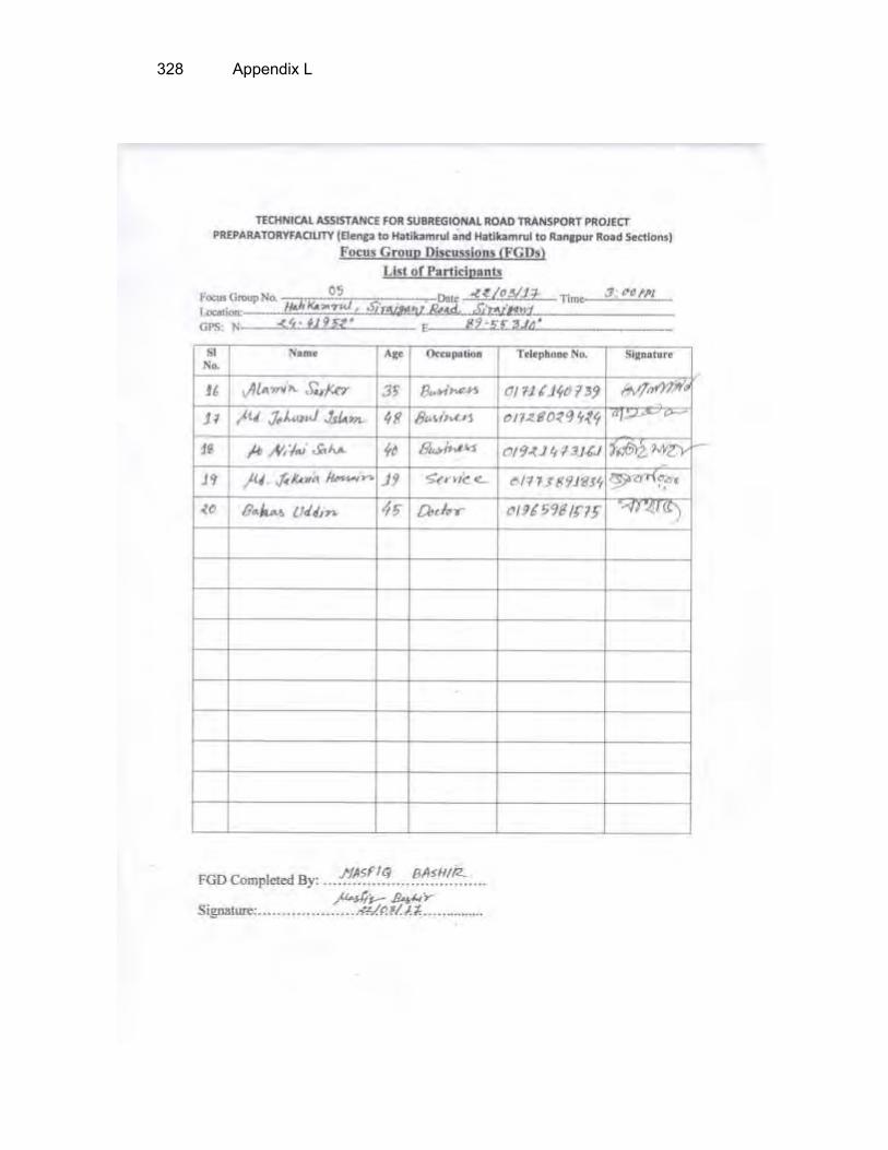
328 Appendix L

Appendix L 329

330 Appendix L

Appendix L 331

332 Appendix L

Appendix L 333

334 Appendix L

Appendix L 335

336 Appendix L

Appendix M 337
APPENDIX M: LIST OF INDIVIDUAL INTERVIEWEE Location Name Occupation Contact Number
Royganj, Sirajganj
Md. Monirul Islam Business 01729727160 Palash Chandra Business 01752445194 Md. Shafiqur Rahman Business 01735433150 Md. Sohel Business 01736267821 Somir Business 01721718440
Bogra Sadar, Bogra Md. Rezaul Karim Electrician 01729614812
Shibganj, Bogra
Md. Badsha Mia Farmer 01835330923 Md. Mamtaj Uddin Business 01823609694 Md. Rezaul Karim Doctor 01716126866 Md. Abu-Bakar Siddik UP Memebr 01718969524 Md. Badsha Mia Business 01943622851 Md. Abdul Motalib Business 01917211674 Md. Nurul Islam Teacher 01713716695
Palashbari, Gaibandha Md. Jahangir Alam Labour Md. Saju Miah Business 01934984629 Md. Emdadul Business 01745215730
Sadullahpur, Gaibandha
Subol Kumar Employee 01786831322 Md. Sharif Uddin Business 01729163630 Md. Bodrul Alam Teacher 01716336544
Govindoganj, Gaibandha
Md. Monsur Rahman Teacher 01717975124 Md. Nazrul Islam Driver 01743941454 Md. Aytal Haque Business 01740801256 Md. Mehdi Hasan Business 01725674533 Md. Anamul Business 01735115972 Md. Hasan Miah Business 01734101837 Md. Zahid Hossain Business 01767453688 Md. Ripon Business 01711411692 Md. Sohel Rana Business 01757963346
Pirganj, Rangpur
Md. Nazrul Islam Employee 01714169731 Md. Russel Business 01722722192 Md. Abul Kalam Farmer 01722905195 Md. Golap Farmer 01738534740 Krisno Business 01724020441