Balcatta Stirling Local Area Plan Area Planning... · The Local Area The Balcatta-Stirling Local...
81
Transcript of Balcatta Stirling Local Area Plan Area Planning... · The Local Area The Balcatta-Stirling Local...
CITY OF STIRLING BALCATTA-STIRLING LOCAL AREA PLAN 1
Hi Brooke

CITY OF STIRLING BALCATTA-STIRLING LOCAL AREA PLAN 2
Foreword
Annual Implementation Plans will be carried out over the next ten to fifteen years to work towards realising the outcomes written in this Plan while building upon the existing strengths of the Local Area as we work towards the below vision:
In the year 2020 the Balcatta-Stirling Local Area is a friendly, distinct and attractive place that provides opportunities for community needs and desires in a sustainable way. People of any age or culture will be encouraged to interact, make friends and enjoy their local area because they can travel around easily and access a great range of amenities in cluding social hubs, community facilities, workplaces and quality parks. Balcatta-Stirling Local Area provides a healthy, happy lifestyle. Realising the vision of the Balcatta-Stirling Local Area Plan is a joint effort. Council has committed to doing what it can, and requests the full support of the community in playing its part. We welcome your ideas, comments and questions. More information about the Balcatta-Stirling Local Area Plan and how you can be involved is available on the City’s website at http://www.stirling.wa.gov.au/Local+Area+Planning/ via email at [email protected], or by contacting the City on 9205 8555.
Councillor David Boothman Mayor City of Stirling
It is my pleasure to present the inaugural plan for the Balcatta-Stirling Local Area. This Plan presents a community vision for the next ten to fifteen years of the Local Area’s future, and outlines the priorities and outcomes required to realise this vision. Over 700 people were involved in the creation of this Plan, including residents, business owners, community groups, and State government agencies. Being a shared plan it reflects the priorities of these participants as well as those of Council, from which we propose to work together.
CITY OF STIRLING BALCATTA-STIRLING LOCAL AREA PLAN 3
Contents
FOREWORD............................................................................................................................................................................................................1 CONTENTS .............................................................................................................................................................................................................3 EXECUTIVE SUMMARY .........................................................................................................................................................................................5 BALCATTA – STIRLING LOCAL AREA PLAN OUTCOMES TABLE.................................................................................................................10 1. INTRODUCTION ............................................................................................................................................................................................14 2. PLANNING CONTEXT...................................................................................................................................................................................19 3. COMMUNITY VISION AND VALUES ............................................................................................................................................................37 4. BALCATTA-STIRLING COMMUNITY ...........................................................................................................................................................48 5. BALCATTA-STIRLING NATURAL ENVIRONMENT ....................................................................................................................................54 6. BALCATTA-STIRLING HOUSING & BUILT ENVIRONMENT......................................................................................................................58 7. BALCATTA-STIRLING BUSINESS ENVIRONMENT ...................................................................................................................................65 8. BALCATTA-STIRLING MOVEMENT NETWORK.........................................................................................................................................74 9. BALCATTA-STIRLING LOCAL AREA KEY OPPORTUNITIES ...................................................................................................................80
CITY OF STIRLING BALCATTA-STIRLING LOCAL AREA PLAN 4
PART1:
SUMMARY & OUTCOMES
CITY OF STIRLING BALCATTA-STIRLING LOCAL AREA PLAN 5
Executive Summary The Balcatta-Stirling Local Area Plan is the first comprehensive, community based plan the City of Stirling has produced for this locality. The plan has been produced as part of the City’s Local Area Planning programme, which provides a local focus by focusing on a defined locality. This allows for holistic consideration of social, economic and environmental issues and unique opportunities in a local area and integrates the outcomes of community engagement with the City’s broader strategic objectives. Local Area Planning also acknowledges that the City is not uniform in character and function and that community values and issues of concern vary from place to place. The plan presents a detailed profile of the local area and how it relates to the wider metropolitan area. This provides the context for analyzing potential future direction for the area. The profile combines empirical planning research with the outcomes of the community engagement process and what the visions for the local area are within the community. The plan then instigates achievable actions to work towards the realization of the community’s vision. The plan also serves as a reference guide and decision making tool for the City’s business units, Council, landowners and the community; more generally. The Local Area The Balcatta-Stirling Local Area is a central precinct in the City of Stirling, encompassing the suburbs of Balcatta and Stirling but excluding those parts of Stirling that are covered by the Stirling City Centre project. The Balcatta-Stirling Local Area has a fairly diverse land use character due to its industrial and residential roles, as well as different periods of development. While the northern portion of the area consists of the Balcatta Industrial Area, the eastern portion consists of infill development and the southern area contains
Roselea and Princeton Estates, which are both contemporary residential estates, built on former agricultural land. The remainder of the area consists mostly of low-density 1970’s development. There are various community facilities and commercial facilities including Northlands Shopping Centre and two other commercial centres, five schools, numerous reserves and clubs and sporting facilities/associations. The local area is located 10km from the Perth City Centre and is increasingly being seen as an inner suburb of the wider metropolitan region. Located adjacent to the local area is the Stirling Regional Centre, which is a major commercial area within the City of Stirling. Balcatta-Stirling Local Area is in itself a major employment area, given the presence of the Balcatta Industrial Area within it. Community Consultation The local community’s input has been central to the development of the plan. This follows the intentions of the state government’s Network City and recognizes that many residents and business operators have a keen interest in planning for the future of their neighbourhoods. Community input not only allows planning for the local area to be more responsive to local needs and opportunities, but also aims to build capacity in the local area and the sharing of ideas and experiences. Community surveys, community forums, youth engagement and business engagement were used in the development of the plan, as to represent a diverse range of community interests in the process. People were also able to submit comments or petitions. The surveys sought to reliably measure the values, attitudes and priorities of community members and to initiate more in-depth deliberation at the community forums. 4,000 resident surveys were distributed, with some 586 being returned, thus providing a
CITY OF STIRLING BALCATTA-STIRLING LOCAL AREA PLAN 6
statistically valid representation of views. Specially designed surveys were given to youth and businesses and while the response rates for these did not yield statistically valid results they provide anecdotal insight into various local interests. Two community forums were then held to bring representatives of the community together to discuss their ideas, concerns and aspirations for the area. Discussion then led to the identification of priorities and preferences and development of the following vision statement: - In the year 2020 the Balcatta-Stirling Local Area is a friendly, distinct and attractive place that provides opportunities for community needs and desires in a sustainable way. People of any age or culture will be encouraged to interact, make friends and enjoy their local area because they can travel around easily and access a great range of amenities including social hubs, community facilities, workplaces and quality parks. Balcatta-Stirling Local Area provides a healthy, happy lifestyle. The Community The Balcatta-Stirling Local Area community is a growing population (at 2% per annum), with growth largely attributed to the development of new residential estates and infill development and population growth is expected to continue. It is also an aging population and relatively culturally diverse population with a distinct European representation. The area is largely family orientated though there is growing trend towards non-nuclear families, with an increasing number of first homebuyers and single elderly residents in the area. The community has been established for many decades and some strong social networks exist in the area. The community members are particularly happy with the culture and community of the area and opportunities that the area presents. The continued development of a community, which builds on its strengths and
diversity is recognised as being of importance and could be an area where Council provides guidance and assistance to the Balcatta-Stirling community in further strengthening. The cultural heritage of the area’s past, as a market gardening area and the character that the European residents have given the area is similarly of value and it is important that the cultural associations are valued and celebrated in the community. It follows that the Balcatta-Stirling community generally wished to see only moderate levels of change over the next 20 years. There was however a need expressed for there to be community hubs, which would provide amenities for diverse communities needs and spaces for social interaction. Such an area could possibly be developed at Stirling Village, Northlands or in the Stirling Civic Precinct. The development of recreation and leisure facilities, that allows for the enhancement of social connections and provides for diverse recreational needs in the community, was also identified as being of high priority in the local community. There is high demand for facilities in parks such as barbeques, as well as recreation facilities such as gymnasiums and aquatic centres, the latter of which was identified as the one thing most missing from the local area. The City can plan to ensure recreational opportunities are provided for a changing and growing population. Natural Environment The natural environment was also seen to be of value in the community and contribute to the local sense of place. The Stirling Civic Gardens and various other community parks were identified as favourite places, for their environmental value and provision for social interaction. The development of parks and reserves, which provide high-quality public open space and are ecologically sound, was established as the highest priority in the local area.
CITY OF STIRLING BALCATTA-STIRLING LOCAL AREA PLAN 7
Yet the ecological integrity of the Balcatta-Stirling local area is under threat. Cedric Grebe and Spoonbill-Shearwater Wetlands, as well as various other wetlands in the local area, are subject to growing attention for their declining quality caused by acid sulfate soils. Bioremediation projects and further study are underway to protect these areas and the City will be setting targets for improvements in water management. Housing and Built Environment The development of further dwellings and greater housing diversity is another important consideration for the community and presents much opportunity for the future development of the local area. While the area does have a range of housing types, there is still a need to increase housing diversity with two-thirds of housing consisting of single detached dwellings located on green-title lots. All the while, there are many residents living in one-two occupant households, suggesting that older children or existing residents and elderly residents could face difficulty in finding suitable housing in the local area. There is also a need to provide more housing, particularly affordable housing. The community recognises the need for smaller and appropriately designed housing to meet such needs. Meanwhile, many landowners are seeking opportunities to capitalise on the development potential of large lots or R40 zoned properties or are interested in seeing some lower density areas rezoned to accommodate greater housing density. However, support for higher density varies across the local area, with greater support for increased density around Stirling Train Station/Civic Precinct, north of Amelia Street and directly adjacent to Stirling Village. The City has an opportunity to rezone some R20 areas and provide more housing around the Stirling Train Station. There has been increased interest in developing underdeveloped sites over the local area into residential areas, with calls to develop East Roselea and the City initiating discussion with landowners
over the area’s future and with the Department of Environment regarding the environmental issues and constraints relating to the site. Meanwhile, the Education Department has successfully applied to have part of the Balcatta Senior High School site rezoned under the Metropolitan Region Scheme to ‘urban’, to allow for residential development. As there is more development, there is a need to provide infrastructure and the City is currently investigating the feasibility and support for undergrounding power in the northern part of Balcatta and is working with the community to provide comment on whether a substation should be developed at Orr Place. There is also value attached to the design of the built form, with the need to ensure high-quality built forms to distinguish the area and sustainable building design. Business Environment The Balcatta-Stirling Local Area contains the Balcatta Industrial area and many small commercial centres, which provide local retail functions. Over 730 establishments provide approximately 6800 jobs in the Balcatta Industrial Area, whilst several commercial centres throughout the local area provide a further 204 employment opportunities. Meanwhile, only 10% of the local resident 5400 strong workforce, in fact work in the local area. The business community is however largely dissatisfied with the business opportunities provided in the local area. There is much transition however occurring in the economic profile of the Balcatta-Stirling area. An increasing number of showrooms and mixed business is being developed in the industrial area. In recognition of this new trend, the City has prepared and adopted the Industrial Areas in Transition Strategy to guide the future development of this area. Amendment 492 to District Planning Scheme No.2 and two new policies are being proposed to accommodate the emergence of showroom development and retain a sufficient amount of industrial land, whilst maintaining the
CITY OF STIRLING BALCATTA-STIRLING LOCAL AREA PLAN 8
aesthetic character of the industrial area’s built form, the latter of which is also seen to be of value in the community. The Stirling Centre Structure Plan Review also has bearing on the development and opportunities in the Balcatta-Stirling local area, despite its location outside of the local area. This plan is being developed to see the Stirling Regional Centre reach its full potential, with issues such as appropriate activity mix, transport and intensity of development being addressed. There are also opportunities to develop the Northlands area as a connected community hub, which delivers a variety of district level commercial functions, a mix of land uses and diverse local employment opportunities. The community’s demands for more cafes/restaurants could also be met by such re-development. The survival of smaller commercial centres is also important and there are opportunities for the City to investigate urban upgrades of centres, in recognition of the value of the built form of such centres. Movement Network In relation to movement networks, there are high levels of car dependency in the Balcatta-Stirling Local area. While public transport is provided, it is limited and infrequent. The community has called for the development of a connective, integrated and sustainable transport network and the train services and bus integration could serve a major role in this area. The City would be required to collaborate with the Public Transport Authority to provide public transport and could also work with developers to provide pedestrian and cyclist facilities, which link with major destinations. Local traffic issues particularly along Karrinyup Road, parking shortages at Stirling Train Station, inadequate pedestrian and traffic safety and poorly maintained streetscapes were also identified as points of contention in the local community and is something the City would need to investigate further. The introduction of the ‘Travelsmart’ project to the City of Stirling offers a
great opportunity to work with the State government and local communities to promote and increase walking, cycling and public transport use also. Key Opportunities The key opportunities, which have been identified from the process, include: - Further establishing Stirling Village precinct as a Community
hub which provides a range of commercial, recreational and social facilities;
Developing Northlands into a true activity centre; Developing Wanneroo Road into an Activity Corridor with
mixed use and higher density housing; Developing well-designed mixed use corridors along
Erindale and Balcatta Roads; Increasing residential density in locations near the Stirling
Train Station and major activity centres; Protecting wetlands across the local area.
CITY OF STIRLING BALCATTA-STIRLING LOCAL AREA PLAN 9
BBaallccaattttaa--SSttiirrlliinngg CCoommmmuunniittyy VViissiioonn
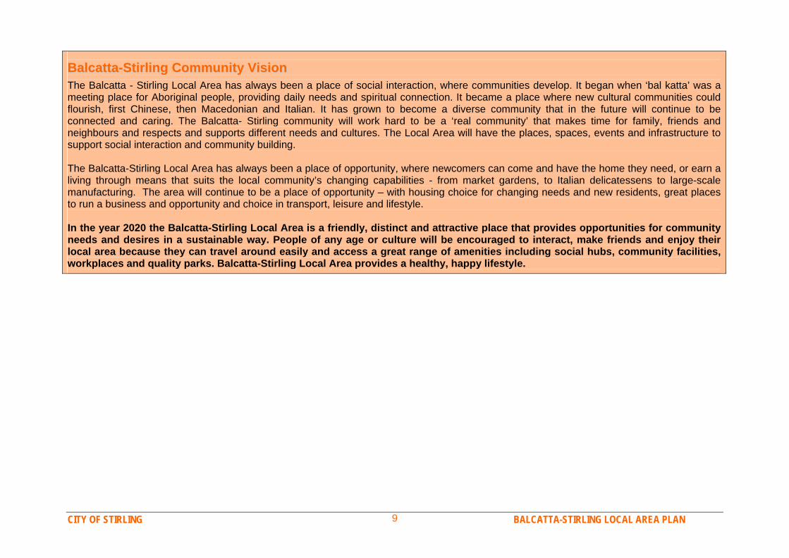
The Balcatta - Stirling Local Area has always been a place of social interaction, where communities develop. It began when ‘bal katta’ was a meeting place for Aboriginal people, providing daily needs and spiritual connection. It became a place where new cultural communities could flourish, first Chinese, then Macedonian and Italian. It has grown to become a diverse community that in the future will continue to be connected and caring. The Balcatta- Stirling community will work hard to be a ‘real community’ that makes time for family, friends and neighbours and respects and supports different needs and cultures. The Local Area will have the places, spaces, events and infrastructure to support social interaction and community building. The Balcatta-Stirling Local Area has always been a place of opportunity, where newcomers can come and have the home they need, or earn a living through means that suits the local community’s changing capabilities - from market gardens, to Italian delicatessens to large-scale manufacturing. The area will continue to be a place of opportunity – with housing choice for changing needs and new residents, great places to run a business and opportunity and choice in transport, leisure and lifestyle. In the year 2020 the Balcatta-Stirling Local Area is a friendly, distinct and attractive place that provides opportunities for community needs and desires in a sustainable way. People of any age or culture will be encouraged to interact, make friends and enjoy their local area because they can travel around easily and access a great range of amenities including social hubs, community facilities, workplaces and quality parks. Balcatta-Stirling Local Area provides a healthy, happy lifestyle.
CITY OF STIRLING BALCATTA-STIRLING LOCAL AREA PLAN 10
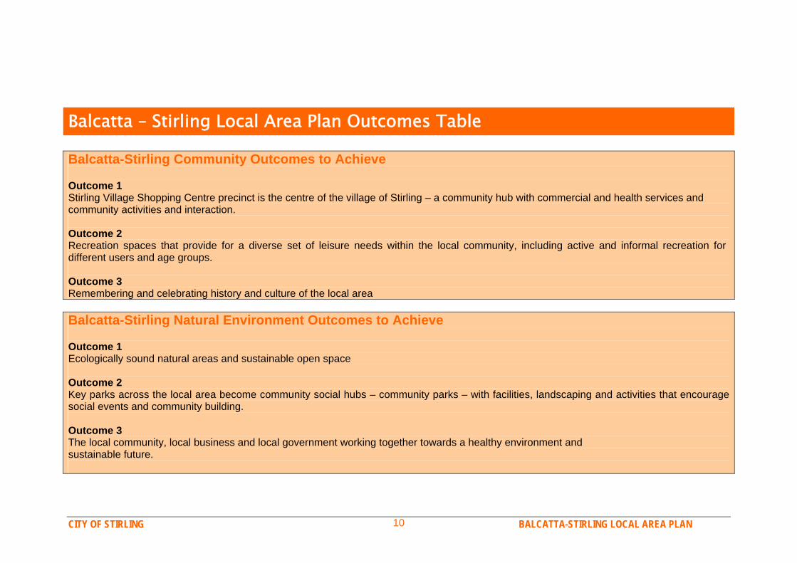
Balcatta – Stirling Local Area Plan Outcomes Table Balcatta-Stirling Community Outcomes to Achieve Outcome 1 Stirling Village Shopping Centre precinct is the centre of the village of Stirling – a community hub with commercial and health services and community activities and interaction. Outcome 2 Recreation spaces that provide for a diverse set of leisure needs within the local community, including active and informal recreation for different users and age groups. Outcome 3 Remembering and celebrating history and culture of the local area Balcatta-Stirling Natural Environment Outcomes to Achieve Outcome 1 Ecologically sound natural areas and sustainable open space Outcome 2 Key parks across the local area become community social hubs – community parks – with facilities, landscaping and activities that encourage social events and community building. Outcome 3 The local community, local business and local government working together towards a healthy environment and sustainable future.
CITY OF STIRLING BALCATTA-STIRLING LOCAL AREA PLAN 11
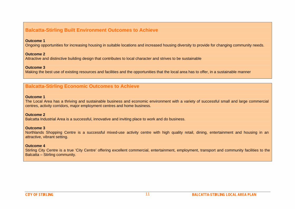
Balcatta-Stirling Built Environment Outcomes to Achieve Outcome 1 Ongoing opportunities for increasing housing in suitable locations and increased housing diversity to provide for changing community needs. Outcome 2 Attractive and distinctive building design that contributes to local character and strives to be sustainable Outcome 3 Making the best use of existing resources and facilities and the opportunities that the local area has to offer, in a sustainable manner Balcatta-Stirling Economic Outcomes to Achieve Outcome 1 The Local Area has a thriving and sustainable business and economic environment with a variety of successful small and large commercial centres, activity corridors, major employment centres and home business. Outcome 2 Balcatta Industrial Area is a successful, innovative and inviting place to work and do business. Outcome 3 Northlands Shopping Centre is a successful mixed-use activity centre with high quality retail, dining, entertainment and housing in an attractive, vibrant setting. Outcome 4 Stirling City Centre is a true ‘City Centre’ offering excellent commercial, entertainment, employment, transport and community facilities to the Balcatta – Stirling community.
CITY OF STIRLING BALCATTA-STIRLING LOCAL AREA PLAN 12
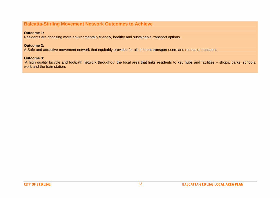
Balcatta-Stirling Movement Network Outcomes to Achieve Outcome 1: Residents are choosing more environmentally friendly, healthy and sustainable transport options. Outcome 2: A Safe and attractive movement network that equitably provides for all different transport users and modes of transport. Outcome 3: A high quality bicycle and footpath network throughout the local area that links residents to key hubs and facilities – shops, parks, schools, work and the train station.

CITY OF STIRLING BALCATTA-STIRLING LOCAL AREA PLAN 13
Part 2:
Background Study
CITY OF STIRLING BALCATTA-STIRLING LOCAL AREA PLAN 14
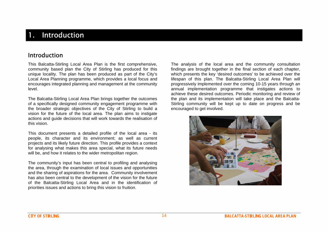
1. Introduction Introduction This Balcatta-Stirling Local Area Plan is the first comprehensive, community based plan the City of Stirling has produced for this unique locality. The plan has been produced as part of the City’s Local Area Planning programme, which provides a local focus and encourages integrated planning and management at the community level. The Balcatta-Stirling Local Area Plan brings together the outcomes of a specifically designed community engagement programme with the broader strategic objectives of the City of Stirling to build a vision for the future of the local area. The plan aims to instigate actions and guide decisions that will work towards the realisation of this vision. This document presents a detailed profile of the local area - its people, its character and its environment; as well as current projects and its likely future direction. This profile provides a context for analysing what makes this area special, what its future needs will be, and how it relates to the wider metropolitan region. The community’s input has been central to profiling and analysing the area, through the examination of local issues and opportunities and the sharing of aspirations for the area. Community involvement has also been central to the development of the vision for the future of the Balcatta-Stirling Local Area and in the identification of priorities issues and actions to bring this vision to fruition.
The analysis of the local area and the community consultation findings are brought together in the final section of each chapter, which presents the key ‘desired outcomes’ to be achieved over the lifespan of this plan. The Balcatta-Stirling Local Area Plan will progressively implemented over the coming 10-15 years through an annual implementation programme that instigates actions to achieve these desired outcomes. Periodic monitoring and review of the plan and its implementation will take place and the Balcatta-Stirling community will be kept up to date on progress and be encouraged to get involved.
CITY OF STIRLING BALCATTA-STIRLING LOCAL AREA PLAN 15
Background The notion of introducing Local Area Planning into the planning system of the City of Stirling was first raised in discussion during 2004, as an example of a process for reviewing residential density. The concept of using the system for more holistic local planning, rather than purely for density review, was then explored, and it was subsequently included on the list of key strategic planning initiatives to be considered as part of a review of the City’s Strategic Plan during 2005. Considerable research and analysis on the concepts and practice of local-area style planning was subsequently undertaken by Council planning staff, to identify options for the City of Stirling. Discussions and briefing sessions with Council, executive staff and affected business units were also undertaken to examine how such a system would operate within the City. In October 2005 a Local Area Planning project proposal was presented to Council and Council subsequently resolved that the objectives of the project and the proposed local area planning boundaries be endorsed, and that a Pilot Local Area Planning Study be initiated. A pilot project was proposed so that the principles and methodology of the process could be tested, before application City wide. The Dianella Local Area was chosen as the pilot area, with the project conducted in 2006. The pilot project in Dianella proved successful, with an effective community engagement programme taking place and the City’s first local area plan being adopted. This led to Council adopting a roll out of the Local Area Planning programme across the City, in October 2006, with 2-3 projects to be commenced each year. The Balcatta-Stirling Local Area was subsequently chosen as the first project of 2007.
The community consultation phase with the Balcatta–Stirling community was conducted between February and April 2007 and used a number of techniques to inform, motivate and engage the community in the project. The major components of the consultation phase included: Community Surveys – a postal survey was sent to a random
selection of 4,000 residents and 200 businesses in the local area.
Community Forums – two large forums were held to bring together discussion among residents, business & property owners, community groups and other stakeholders.
Youth Engagement – local youth were consulted through surveys and discussions via the Youth Advisory Committee. Balcatta Senior High School declined invitations to be involved.
The information gathered from these events was then collated and analysed for incorporation into this plan (the key results are presented in Chapter 3). In addition to the information gathered from community input, considerable research on the local area was also conducted to provide information both to the community and to this plan. The preparation of this local area plan has also involved analysis of a wide variety of documents, plans and policies that affect the area, the City of Stirling and the Perth region. The resulting plan thus provides a synthesis of strategic planning documents and community aspirations. Another integral aspect of preparing this plan was working with the City’s business units and other relevant stakeholders to discuss local issues, opportunities and community priorities to develop widely supported and achievable outcomes for the Balcatta-Stirling Local Area.
CITY OF STIRLING BALCATTA-STIRLING LOCAL AREA PLAN 16
What is Local Area Planning? Local area planning is a contemporary approach to planning that concentrates on planning for a defined area, rather than broad plans that cover the entire City, or strategies based on individual issues. This approach allows a comprehensive range of issues to be considered at both the local and regional level and addresses these issues through integrated planning strategies. It requires a holistic approach to planning which seeks to incorporate stakeholders and community members into the planning process in a collaborative approach to community building. Local area planning is a proactive, rather than reactive, process that enables the integration of social, environmental and economic initiatives into one plan that guides both the short and longer term direction of a local area. This method of planning is used extensively in Australia and internationally and is increasing in prominence in Western Australia, both within local governments and State planning agencies. Local area planning is similar to ‘precinct planning’ or ‘place planning’ in that it involves preparing a plan for an identified geographical area in order to facilitate development, change or better management within that area. The size of the subject area can vary – boundaries can be defined by a number of criteria, such as land use, character, population and identified boundaries. However the size of the area selected is based more so on management systems and the objectives of the project. The local area planning system acknowledges that the City is not uniform in character and function and that community values and issues of concern can vary from place to place. A focus on smaller areas allows local issues and the uniqueness of the area to be explored in greater depth, whilst still considering the impact of the
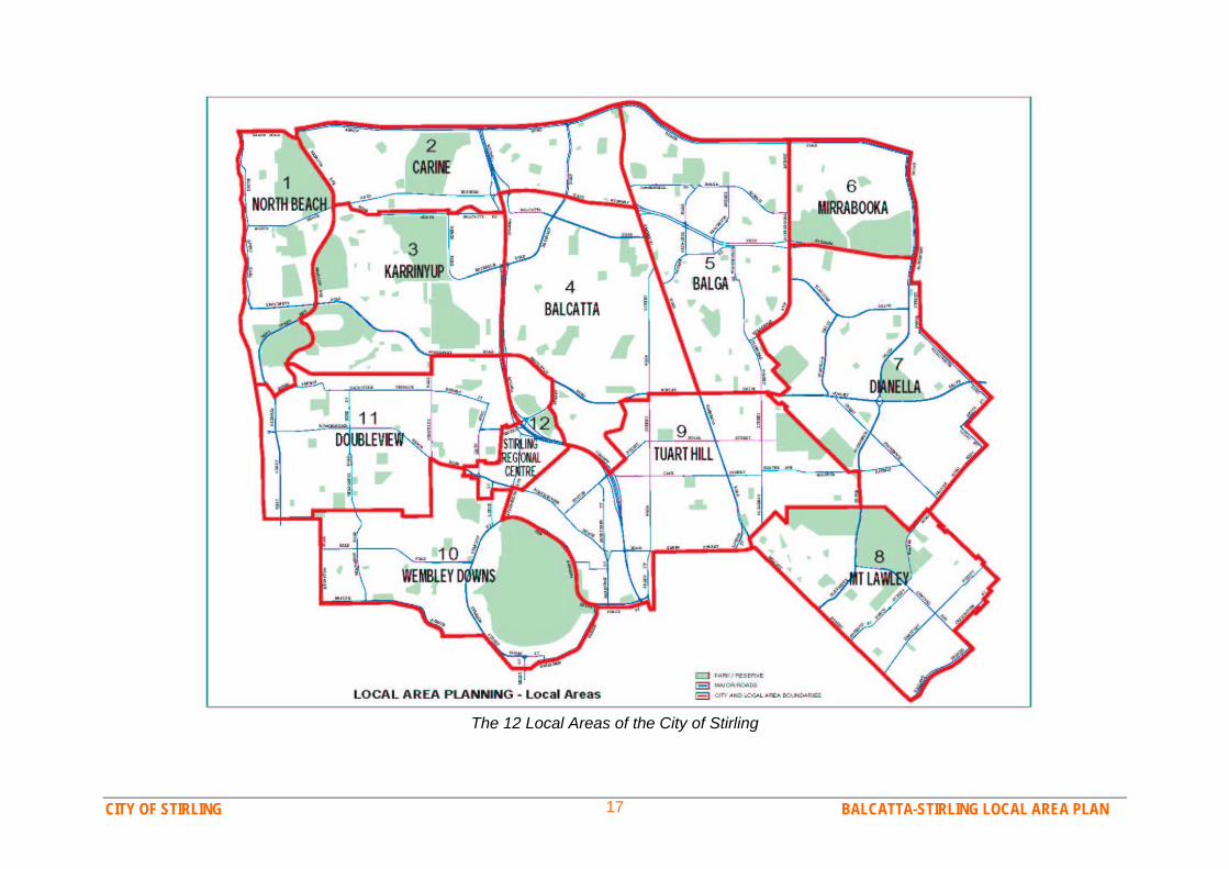
area’s regional context. The process also enables closer, more comprehensive consultation with the local community at the start of the planning process, rather than just presenting plans to the community and asking them to accept them. More community involvement also creates a better exchange of knowledge and experiences between the City and its residents and among the community itself, thus building better understanding and stronger ties. Another major objective of local area planning is that it facilitates integrated planning - different disciplines and stakeholders working together on one plan that addresses many issues or topics. This requires stakeholders to share information and their objectives or aspirations for the area and enables them to work together to develop common goals for the future direction of the area. Integrated planning can avoid the conflicts and contradictions which can often arise when issues are addressed in isolation to one another. The City’s local area plans are not just planning department documents, they are strategies, reference documents and decision making guides for all the City’s business units, for Council, developers, land owners and the community. Local area planning in the City of Stirling divides the large municipality into smaller localities to enable more fine-grained planning, community consultation and management. Twelve individual local areas have been identified within the City (shown overleaf). Each local area is an area of a manageable size with a somewhat similar character that is generally defined by physical and identifiable boundaries, such as suburb boundaries, major roads, and where appropriate, changes in land use character or density.
CITY OF STIRLING BALCATTA-STIRLING LOCAL AREA PLAN 17
The 12 Local Areas of the City of Stirling
CITY OF STIRLING BALCATTA-STIRLING LOCAL AREA PLAN 18
Local Area Planning Principles Objectives A set of guiding principles have been established to guide the operation of the local area planning project and the preparation of each local area plan. These principles are:
Sustainability Sustainability requires balancing the current and future needs of the community, the environment and the economy to provide quality of life for today and tomorrow’s communities.
Integration Local area planning requires an integrated approach to planning and management. The process of planning must bring together many stakeholders and the product must bring together a comprehensive range of issues. Integrated planning enables better coordination and more efficient management.
Communication Local area planning is an effective tool for improving the City’s communication with the public. Integration and implementation of plans will also require strong communication with stakeholders.
Public Participation Public involvement in local area planning is crucial to its success. All those with a stake in a local area’s future must be actively encouraged to be involved, through collaborative planning.
Prioritisation Local area planning acknowledges that different communities have different priorities. Local area plans will recognise, emphasise and respond to the key issues identified as community priorities.
The objectives of the Local Area Planning programme for the City of Stirling are: To review key planning issues, policies and forces acting on
local areas within the City and develop a coordinated response to these;
To identify specific ‘opportunities’ and 'constraints' within
each local area and develop strategies to address these; To develop a commonly embraced 'vision' for each local
area which recognises areas of local significance and key attributes contributing to each area's sense of place;
To identify issues of priority to the local community and work
with them to developing practical solutions to these, within the context of a regional framework;
To foster open lines of communication between the City and
the community; To create a sound and comprehensible statutory and
strategic planning framework for each local area to allow delivery of the vision and plan; and
To help ensure that each local area operates in a
sustainable way and in balance with surrounding precincts and other areas of influence.
CITY OF STIRLING BALCATTA-STIRLING LOCAL AREA PLAN 19
2. Planning Context
Study AreaThe Balcatta-Stirling Local Area is a central precinct in the City of Stirling, encompassing the suburb of Balcatta and most of the suburb of Stirling. The precinct is bound by Mitchell Freeway, Reid Highway, Wanneroo Road, Morley Drive and Hamilton Street. A small south-west portion of Stirling, between Karrinyup Road and Stirling Train Station has been excluded from the study area, as this area is part of the designated Stirling City Centre – which is subject to a separate study. The local area covers approximately 1,080 hectares and is 10km from Perth city centre. The Balcatta-Stirling Local Area has a fairly diverse land use character due to its industry and residential roles, as well as different periods of residential development. The northern portion of the area is covered by a large industrial precinct, the eastern side is an infill development area with many medium density units, the southern area contains two new waterfront residential estates, whilst the core of the area maintains its original 1970s low density suburban character. The area also includes a variety of commercial and community amenities, including three shopping centres, five schools, numerous reserves and a number of recreation and cultural facilities. Remnants of the areas agricultural past also remain in the area. Significant local landmarks include the limestone pinnacles on the grounds of Balcatta Senior High School and the redeveloped wetland system between Roselea and Princeton estates.
Key amenities in the Balcatta-Stirling Local Area include: Shopping Centres Northlands Plaza Stirling Village Centre Amelia Heights Centre Major Parks and Reserves Richard Guelfi Reserve Rickman Delawney Reserve Jones Paskin Reserve Grindleford Reserve Sanderling/Spoonbill Reserve Schools Balcatta Senior High School Balcatta Primary School St Lawrence Primary School Takari Primary School West Balcatta Primary School Community Facilities / Clubs Community Recreation Centre at Balcatta High School Stirling Adriatic Centre Chung-Wah Association Siciliani Club Macedonian Cultural Centre

CITY OF STIRLING BALCATTA-STIRLING LOCAL AREA PLAN 20
CITY OF STIRLING BALCATTA-STIRLING LOCAL AREA PLAN 21
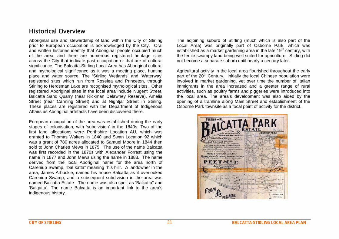
Historical Overview Aboriginal use and stewardship of land within the City of Stirling prior to European occupation is acknowledged by the City. Oral and written histories identify that Aboriginal people occupied much of the area, and there are numerous registered heritage sites across the City that indicate past occupation or that are of cultural significance. The Balcatta-Stirling Local Area has Aboriginal cultural and mythological significance as it was a meeting place, hunting place and water source. The ‘Stirling Wetlands’ and ‘Waterway’ registered sites which run from Roselea and Princeton, through Stirling to Herdsman Lake are recognised mythological sites. Other registered Aboriginal sites in the local area include Nugent Street, Balcatta Sand Quarry (near Rickman Delawney Reserve), Amelia Street (near Canning Street) and at Nightjar Street in Stirling. These places are registered with the Department of Indigenous Affairs as Aboriginal artefacts have been discovered there. European occupation of the area was established during the early stages of colonisation, with ‘subdivision’ in the 1840s. Two of the first land allocations were Perthshire Location AU, which was granted to Thomas Walters in 1840 and Swan Location 92 which was a grant of 780 acres allocated to Samuel Moore in 1844 then sold to John Charles Mews in 1875. The use of the name Balcatta was first recorded in the 1870s with Alexander Forrest using the name in 1877 and John Mews using the name in 1888. The name derived from the local Aboriginal name for the area north of Careniup Swamp, “bal katta” meaning ”his hill”. A landowner in the area, James Arbuckle, named his house Balcatta as it overlooked Careniup Swamp, and a subsequent subdivision in the area was named Balcatta Estate. The name was also spelt as ‘Balkatta” and ‘Balgatta’. The name Balcatta is an important link to the area’s indigenous history.
The adjoining suburb of Stirling (much which is also part of the Local Area) was originally part of Osborne Park, which was established as a market gardening area in the late 19th century, with the fertile swampy land being well suited for agriculture. Stirling did not become a separate suburb until nearly a century later. Agricultural activity in the local area flourished throughout the early part of the 20th Century. Initially the local Chinese population were involved in market gardening, yet over time the number of Italian immigrants in the area increased and a greater range of rural activities, such as poultry farms and piggeries were introduced into the local area. The area’s development was also aided by the opening of a tramline along Main Street and establishment of the Osborne Park townsite as a focal point of activity for the district.

CITY OF STIRLING BALCATTA-STIRLING LOCAL AREA PLAN 22
As Perth’s northern suburbs grew after World War II, agricultural activity began to relocate further north as residential development progressed rapidly. In the mid 1960s much of Balcatta was rezoned from rural to residential and blue-collar workers began to establish homes in the area. The establishment of Town Planning Scheme No.31 in 1972 facilitated conversion of much of the lower lying rural lands into a residential estate of over 1,000 lots. The 1970s also saw the establishment of the Balcatta industrial area, following it’s rezoning in the Metropolitan Region Scheme. The area is now a significant regional industry and employment hub. Balcatta’s growing residential population created the need for supporting amenities. A number of schools were established in the 1960s and 70s, including Balcatta High School in 1967. Balcatta High School is today recognised on the City of Stirling’s Municipal Inventory of Heritage Places. A large community and recreation centre (Moir Community Hall) opened at Balcatta High School in 1980 as the result of a joint project of State and local government. Several other sporting and cultural facilities have also been established in the area by community organisations. Redevelopment in the region also led to the establishment of the new suburb of Stirling which was officially gazetted as a suburb in 1976 to be the home for the City of Stirling’s new administrative headquarters and to provide new residential land. Stirling was named after Admiral Sir James Stirling, who colonised the Swan River and was the first Governor of Western Australia. Subdivision of the suburb commenced in the late 1970s and continued throughout the 1980s and 90s with small pockets of land still being developed today, including Princeton and Roselea Estates. Roselea estate was named after the landmark Roselea Nursery which was a local landmark for much of the 20th century.

CITY OF STIRLING BALCATTA-STIRLING LOCAL AREA PLAN 23
Regional ContextThe Balcatta-Stirling Local Area is in a fortunate position within the Perth metropolitan region, being located approximately 10km from Perth city centre and 5km from the coast. The majority of the City of Stirling has traditionally been considered to be part of Perth’s middle suburbs, however given the vast outward growth of Perth and the location and accessibility of Balcatta and Stirling, they are now beginning to be viewed more as ‘inner suburbs’. The local area also benefits from its close proximity to the ‘Stirling City Centre’, which is directly south of the precinct. Land within approximately 1km of the Stirling Train Station is designated as a Strategic Regional Centre by the Western Australian Planning Commission’s Metropolitan Centres Policy. These are significant centres across Perth which should provide for a large range of retail, office, entertainment, recreation and community facilities and associated employment. Stirling City Centre contains key regional facilities such as Osborne Park Hospital, the City of Stirling Administration Centre, Stirling Civic Gardens, the train/bus interchange, Innaloo Shopping Centre, cinemas and other commercial, industrial and employment activity. The Balcatta-Stirling Local Area itself is also a significant regional employment hub due to the industrial precinct, which employs approximately 5,000 people and includes regional facilities such as the City of Stirling works depot and Western Power and Water Corporation offices. The large Osborne Park industrial area is also in close proximity, abutting the southern end of the local area. Osborne Park is a major business, industrial, commercial and employment hub for the north metropolitan region. Osborne Park also contains a ‘community hub’, along Main Street, containing shopping, dining, entertainment and office development and a
nearby community centre. This hub also services residents of the Balcatta-Stirling Local Area. The eastern edge of the local area is bounded by Wanneroo Road which, under the State’s Network City planning strategy, has potential to develop into an ‘activity corridor’ - which is a major road with good public transport where activity clusters. The diversity and intensity of development along Wanneroo Road is therefore likely to increase in the future, possibly with higher density development and a greater mix of commercial activities such as offices, dining and retail. The Karrinyup regional centre is also in proximity to the Balcatta-Stirling Local Area. This regional centre is based around Karrinyup Shopping Centre, which provides commercial and employment opportunities to surrounding suburbs. The centre also provides community facilities such as Karrinyup Library and a community recreation centre. The suburb of Karrinyup also contains a large sports centre, which is accessible to residents of the Balcatta-Stirling Local Area. Other major recreation facilities within close proximity include Lake Gwelup Reserve and Karrinyup Country Club. The other areas surrounding the local area are a variety of residential suburbs. To the north is the suburb of Hamersley, a 1980s low-density residential suburb. To the east are Westminster and Nollamara, two suburbs previously often considered “Homeswest suburbs”, that are now being redeveloped into contemporary medium density suburbs. Tuart Hill, to the south is also experiencing some redevelopment with infill housing.

CITY OF STIRLING BALCATTA-STIRLING LOCAL AREA PLAN 24
Balcatta-Stirling Local Area’s Regional Context
CITY OF STIRLING BALCATTA-STIRLING LOCAL AREA PLAN 25
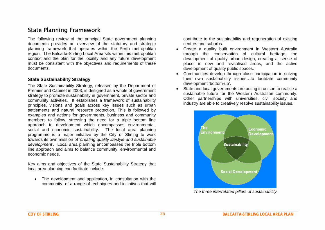
State Planning FrameworkThe following review of the principal State government planning documents provides an overview of the statutory and strategic planning framework that operates within the Perth metropolitan region. The Balcatta-Stirling Local Area sits within this metropolitan context and the plan for the locality and any future development must be consistent with the objectives and requirements of these documents. State Sustainability Strategy The State Sustainability Strategy, released by the Department of Premier and Cabinet in 2003, is designed as a whole of government strategy to promote sustainability in government, private sector and community activities. It establishes a framework of sustainability principles, visions and goals across key issues such as urban settlements and natural resource protection. This is followed by examples and actions for governments, business and community members to follow, stressing the need for a triple bottom line approach to development which encompasses environmental, social and economic sustainability. The local area planning programme is a major initiative by the City of Stirling to work towards its own mission of ‘creating quality lifestyle and sustainable development’. Local area planning encompasses the triple bottom line approach and aims to balance community, environmental and economic needs. Key aims and objectives of the State Sustainability Strategy that local area planning can facilitate include:
The development and application, in consultation with the community, of a range of techniques and initiatives that will
contribute to the sustainability and regeneration of existing centres and suburbs.
Create a quality built environment in Western Australia through the conservation of cultural heritage, the development of quality urban design, creating a ‘sense of place’ in new and revitalised areas, and the active development of quality public spaces.
Communities develop through close participation in solving their own sustainability issues…to facilitate community development ‘bottom-up’.
State and local governments are acting in unison to realise a sustainable future for the Western Australian community. Other partnerships with universities, civil society and industry are able to creatively resolve sustainability issues.
The three interrelated pillars of sustainability

CITY OF STIRLING BALCATTA-STIRLING LOCAL AREA PLAN 26
State Planning Strategy The State Planning Strategy (1997) is prepared and administered by the Western Australian Planning Commission and the Department for Planning and Infrastructure to guide planning, development, resource protection and conservation across the State. The strategy examines major issues and trends influencing the state and sets out a vision for future development. The strategy contains five guiding principles – environmental, community, economic, infrastructure and regional principles, and details strategies and actions under each principle for the State government, local government and other agencies to follow. The strategy includes numerous criteria that plans should include to address these principles and strategies. Some of the criteria that are relevant to local area planning include:
Encourage mixed use development. Encourage a range of housing densities. Maximise the potential for development near public transport
routes. Provide a central community focus. Ensure that consultation occurs at appropriate stages in the
planning process. Ensure environmental issues are considered in the
preparation of plans.
Metropolitan Region Scheme The Metropolitan Region Scheme (1963) is the overarching statutory planning scheme for the Perth metropolitan region. It classifies all land in the region into general zones, such as Urban, Industrial or Rural, or into reserves, such as for Parks and Recreation or High Schools. The scheme text that accompanies the map establishes provisions for development control across the region, such as requiring local government schemes to be consistent with the broad zonings of the MRS map.
The Metropolitan Region Scheme map delineates land in the Balcatta-Stirling
Local Area with zonings including ‘Urban’ (brown) and ‘Industrial’ (purple) and reserves land for Balcatta High School (HS). The Stirling City Centre is
zoned as a ‘Central City Area’ (blue).
CITY OF STIRLING BALCATTA-STIRLING LOCAL AREA PLAN 27
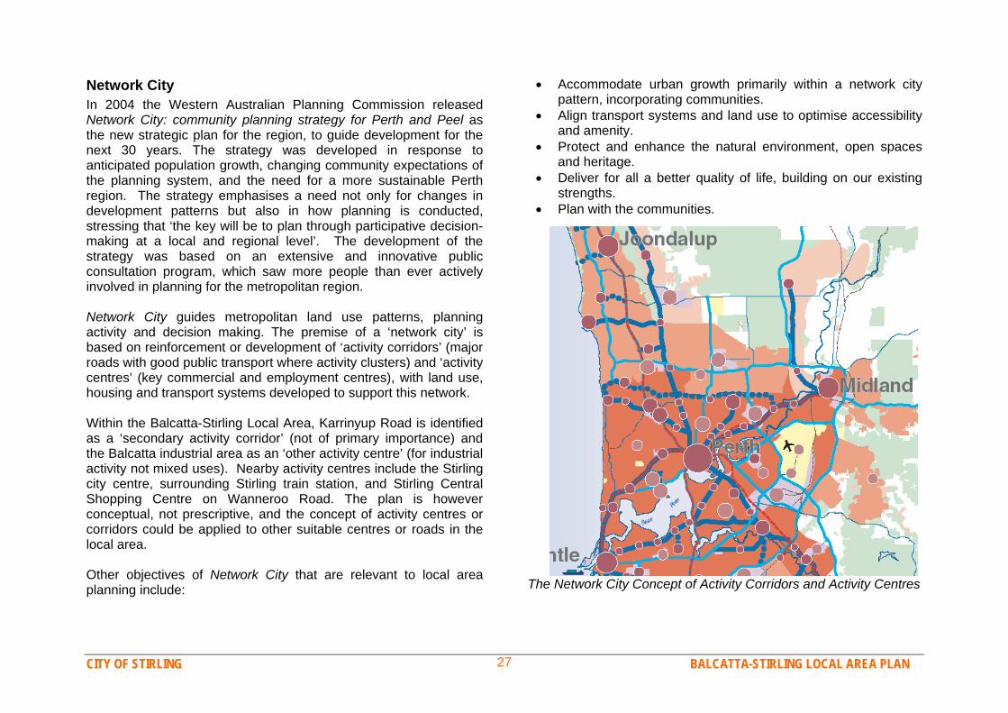
Network City In 2004 the Western Australian Planning Commission released Network City: community planning strategy for Perth and Peel as the new strategic plan for the region, to guide development for the next 30 years. The strategy was developed in response to anticipated population growth, changing community expectations of the planning system, and the need for a more sustainable Perth region. The strategy emphasises a need not only for changes in development patterns but also in how planning is conducted, stressing that ‘the key will be to plan through participative decision-making at a local and regional level’. The development of the strategy was based on an extensive and innovative public consultation program, which saw more people than ever actively involved in planning for the metropolitan region. Network City guides metropolitan land use patterns, planning activity and decision making. The premise of a ‘network city’ is based on reinforcement or development of ‘activity corridors’ (major roads with good public transport where activity clusters) and ‘activity centres’ (key commercial and employment centres), with land use, housing and transport systems developed to support this network. Within the Balcatta-Stirling Local Area, Karrinyup Road is identified as a ‘secondary activity corridor’ (not of primary importance) and the Balcatta industrial area as an ‘other activity centre’ (for industrial activity not mixed uses). Nearby activity centres include the Stirling city centre, surrounding Stirling train station, and Stirling Central Shopping Centre on Wanneroo Road. The plan is however conceptual, not prescriptive, and the concept of activity centres or corridors could be applied to other suitable centres or roads in the local area. Other objectives of Network City that are relevant to local area planning include:
Accommodate urban growth primarily within a network city pattern, incorporating communities.
Align transport systems and land use to optimise accessibility and amenity.
Protect and enhance the natural environment, open spaces and heritage.
Deliver for all a better quality of life, building on our existing strengths.
Plan with the communities. The Network City Concept of Activity Corridors and Activity Centres

CITY OF STIRLING BALCATTA-STIRLING LOCAL AREA PLAN 28
Metropolitan Centres Policy This Metropolitan Centres Policy is a statutory State Planning Policy and provides the regional planning framework to co-ordinate the location and development of retail and commercial activities across Perth. The policy establishes a hierarchy of different size centres across the region and controls the number, location and floor size of major retail and commercial centres, including city centre, regional and district centres. The policy aims to define and reinforce the roles of different types of centres, whether it be major employment provision, recreation, entertainment, or daily convenience shopping. The policy also guides the development of local commercial strategies by local governments. The most recent version of the Centres policy was gazetted in 2000, however it is likely that the provisions of the policy will be reviewed and modified so that it is a more effective tool for implementing the more recent Network City strategy. State Planning Policy 3.5 Historic Heritage Conservations State Planning Policy 3.5 Historic Heritage Conservations sets out the principles of planning for the conservation and protection of Western Australia’s historic heritage. It ensures that places and areas of heritage significance are conserved; that development does not adversely impact places with significant heritage value and that landowners and developers are aware of heritage processes. The policy applies in most part to heritage areas, buildings, structures and other man made and natural landscapes, which are of heritage significance at a State and local level. Heritage protection is important for Western Australia’s social, environmental and economic prosperity and enhances connection to place and the quality of the built environment.
Metropolitan Transport Strategy The State’s Transport Strategy was released in 1995 and aims to facilitate an efficient and accessible transport system for the Perth region through better co-ordination, integration and efficiency in transport and land use planning and management. The strategy acknowledges that the dominance of private vehicles in Perth’s transport system is likely to continue over coming decades yet identifies that changes need to be made to address the high levels of pollution, congestion, accidents and costs associated with the system. Goals to address these issues include improving and promoting walking, cycling and public transport; better land use mix and higher densities at strategic locations; and development of accessible commercial and employment centres. Since the release of the Transport Strategy several more specific plans and policies have been developed to implement its goals, such as Bike Ahead, Travelsmart 2010 and the Freight Transport Strategy. Bush Forever 2000 Bush Forever is a State Government strategy for the conservation of bushland and natural environments across Perth. The strategy aims to protect ten percent of each of the 26 different types of vegetation complexes originally found on the Swan Coastal Plain, and to conserve threatened ecological communities. The strategy identifies valued sites across the region that should be reserved, maintained or rehabilitated for conservation and/or recreation purposes. These sites may be in public or private ownership. The Western Australian Planning Commission has also prepared a draft State Planning Policy to provide statutory support to Bush Forever. There are nine Bush Forever sites within the City of Stirling, however none are located in the Balcatta-Stirling Local Area.
CITY OF STIRLING BALCATTA-STIRLING LOCAL AREA PLAN 29
Residential Design Codes The State’s Residential Design Codes (R-Codes) is a statutory State Planning Policy that provides the base standards for local governments to control residential development. The Codes prescribe measures for requirements such as lot size, parking, setbacks, open space and building heights, to guide housing developers and local governments on what can be approved as acceptable development. Some degree of flexibility on these measures is however provided through the ‘performance criteria’ assessment method, which allows developments to be assessed against performance or objectives based statements. State legislation requires all local governments to adopt the Residential Design Codes and they are adopted through Stirling’s District Planning Scheme. The City has also adopted a number of residential development policies to strengthen or clarify the requirements of the codes, including policies on streetscapes, building height and parking.

CITY OF STIRLING BALCATTA-STIRLING LOCAL AREA PLAN 30
City of Stirling Planning FrameworkThe Balcatta-Stirling Local Area Plan sits within a broader planning framework that operates within the City of Stirling. A range of plans, strategies and policies are developed by the City to guide the management and development of the City and its inhabitants. Key documents include: The City of Stirling’s Strategic Plan 2004/-2008 The Strategic Plan 2004/2008 is the blueprint for what Council hopes to achieve and how this will be done over a five-year period. The plan incorporates Council’s vision, mission and values and guides operational activities through the Key Result Areas of:
‘Our Community’ – to provide services that meet changing community needs. ‘Our Built and Natural Environment’ – to encourage sustainability and enhance choice in the built environment, while preserving and enhancing the natural environment. ‘Our Economic Opportunity’ – to enhance opportunity, choice, and prosperity for the community by encouraging sustainable economic development of the City.
Through its Strategic Plan 2004/2008, the City of Stirling also ensures that resources are managed effectively and good governance is provided for the benefit of the community. Local Planning Strategy The City’s draft Local Planning Strategy was prepared in 2004 to facilitate the review of the current District Planning Scheme and to articulate the future direction of development across the City over the coming 20–30 years. The strategy covers a comprehensive range of topics, such as Population & Housing, Commercial
Centres, and Community & Recreation Facilities, identifying the current situation, key issues, and future trends in each topic. This information provides the basis from which to build the Planning Scheme and to develop more specific planning strategies. District Planning Scheme No. 2 The District Planning Scheme, which was gazetted in 1985, is the current planning scheme controlling development across the City. The scheme and the scheme map establish zoning of land, uses and development permitted on that land, and development standards such as parking and setback requirements for industrial or commercial development, and also includes provisions for heritage protection and detailed requirements for special precincts, including Roselea and Princeton estates. A wide range of policies to control development has also been adopted under the scheme. The City is undertaking a review of Scheme No.2 and is anticipating advertising a new draft Local Planning Scheme No. 3 in late 2007. Commercial Strategy The draft Local Commercial Strategy covers all commercial centres in the City from the large regional centres, to the district, local and neighbourhood centres. The strategy identifies objectives for each type of commercial centre and guides the planning of these activity nodes, including the limitations on expansion, centres that require specific action or improvement, and supporting services and facilities. The strategy relates to the provisions of the State Government’s Metropolitan Centres Policy and also provides Council with a basis for decision making for each centre.
CITY OF STIRLING BALCATTA-STIRLING LOCAL AREA PLAN 31
Industrial Areas in Transition Management Strategy In response to emerging trends affecting the City's industrial areas including increase in retailing from established industrial premises, large showrooms seeking to locate in industrial areas, and associated traffic and amenity issues, the City has recently adopted a strategy to manage and control development within its industrial areas. The strategy, covering the City’s industrial areas in Balcatta, Osborne Park and Dianella, proposes a containment of showroom activity to major roads, an amendment to the City’s Planning Scheme to better control development, and design guidelines. Housing Strategy The City is currently preparing a Local Housing Strategy to guide the future development of housing and residential lots across the City. The strategy will provide a general overview of housing-related issues and the housing profile of the City and establish what changes or improvements are needed in planning schemes and policies to provide more housing choice and a more sustainable built environment. The housing strategy will also inform any plans or decisions for changing residential densities within the City, and it will guide consultation and decision making in the Local Area Planning project. Public Open Space Strategy A strategy is currently being prepared to guide the provision and management of parks and reserves across the City. The development of this strategy involves establishing objectives for the amount and location of public open space across the City, an inventory and assessment of existing spaces, and guidelines for
future provision and maintenance. Standards will be established for the facilities required, the target size, and catchment areas of different categories of open spaces, such as local, district and regional reserves. The strategy will seek to balance the objectives of efficient management, conservation and quality recreation in a sustainable manner. Integrated Transport Strategy An Integrated Transport Strategy is currently being developed to facilitate increased accessibility for all members of the community, through resource efficient and sustainable approaches to transport planning. Key principles underlying the strategy are reducing car dependency, increasing public transport use and increasing pedestrian and cyclist amenity. The strategy examines the relationship between land use and travel and establishes ways to improve access and transport options between homes, workplaces, commercial centres and other activity nodes. Seniors and Youth Strategies The City recognises that different sectors of the community have different needs and that specific strategies are needed to adequately plan for different groups. The City has adopted a Children’s and Youth Strategy and is anticipating finalising its Seniors Strategy in late 2007. These strategies will direct the provision of specific services and facilities for different age groups, as well as look at measures for enhancing quality of life and community interaction for these groups.

CITY OF STIRLING BALCATTA-STIRLING LOCAL AREA PLAN 32
Plans and Projects for the Balcatta-Stirling Locality Stirling City Centre Structure Plan Review The Western Australian Planning Commission’s Metropolitan Centres Policy designates a number of key centres across the Perth metropolitan region as ‘Strategic Regional Centres’. These centres, such as Stirling, Joondalup, Morley and Fremantle, are intended to provide for a large mix of retail, office, entertainment, recreation and community facilities. The Stirling city centre has also been identified in the Commission’s Network City planning strategy as a ‘major Activity Centre’ on an ‘Activity Corridor’, which reinforces its role as an important centre in the metropolitan region. The Stirling City Centre includes the Stirling Civic Centre precinct, Osborne Park Hospital, the Innaloo Shopping Centre, the Greater Union Theatre complex, part of the Osborne Park industrial area and some residences. Although adjacent to the Balcatta Local Area, the centre will be addressed through a separate project, The Stirling City Centre Structure Plan Review. A Structure Plan is an integrated land use plan for large urban areas that set out the broad environmental, land use, infrastructure and development concepts to guide detailed site planning. The City of Stirling has formed a partnership agreement with the Planning Commission to conduct a detailed review of the last structure plan that was adopted for city centre. The review provides an opportunity to establish a current, comprehensive and robust guiding document to ensure that the Centre achieves its full potential, by addressing issues such as appropriate mix and intensity of development around the train station, the Stephenson Highway road reserve, improving the pedestrian and cyclist environment and creating a strong heart and
identity for the regional centre. Design options for the area will be discussed with landowners and the local community in late 2007.
Stirling City Centre area
CITY OF STIRLING BALCATTA-STIRLING LOCAL AREA PLAN 33
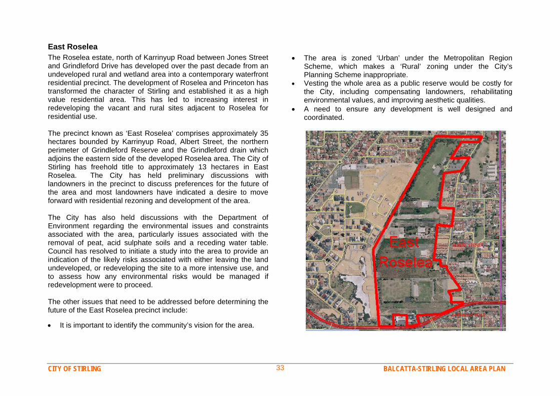
East Roselea The Roselea estate, north of Karrinyup Road between Jones Street and Grindleford Drive has developed over the past decade from an undeveloped rural and wetland area into a contemporary waterfront residential precinct. The development of Roselea and Princeton has transformed the character of Stirling and established it as a high value residential area. This has led to increasing interest in redeveloping the vacant and rural sites adjacent to Roselea for residential use. The precinct known as ‘East Roselea’ comprises approximately 35 hectares bounded by Karrinyup Road, Albert Street, the northern perimeter of Grindleford Reserve and the Grindleford drain which adjoins the eastern side of the developed Roselea area. The City of Stirling has freehold title to approximately 13 hectares in East Roselea. The City has held preliminary discussions with landowners in the precinct to discuss preferences for the future of the area and most landowners have indicated a desire to move forward with residential rezoning and development of the area. The City has also held discussions with the Department of Environment regarding the environmental issues and constraints associated with the area, particularly issues associated with the removal of peat, acid sulphate soils and a receding water table. Council has resolved to initiate a study into the area to provide an indication of the likely risks associated with either leaving the land undeveloped, or redeveloping the site to a more intensive use, and to assess how any environmental risks would be managed if redevelopment were to proceed. The other issues that need to be addressed before determining the future of the East Roselea precinct include: It is important to identify the community’s vision for the area.
The area is zoned ‘Urban’ under the Metropolitan Region Scheme, which makes a ‘Rural’ zoning under the City’s Planning Scheme inappropriate.
Vesting the whole area as a public reserve would be costly for the City, including compensating landowners, rehabilitating environmental values, and improving aesthetic qualities.
A need to ensure any development is well designed and coordinated.

CITY OF STIRLING BALCATTA-STIRLING LOCAL AREA PLAN 34
Industrial Strategy & Amendment 492 Part Rezoning of Balcatta High SchoolThe industrial areas of the City of Stirling have for several years been the subject of increasing commercial interest, resulting in the emergence of new large business enterprises of a showroom / retail nature and stand-alone offices, as opposed to the more traditional manufacturing, processing and warehousing type of industrial development. In recognition of this trend the City has prepared and adopted the Industrial Areas in Transition Strategy to guide the future direction of the City’s industrial areas, principally Balcatta, Osborne Park and Dianella. To implement this strategy the City is proposing an Amendment to District Planning Scheme No. 2 and two new policies for industrial areas. Should the proposal be approved by the Minster for Planning and Infrastructure, Amendment 492 will introduce a new ‘Mixed Business’ zone into the industrial areas of Osborne Park and Balcatta. This zone is intended to accommodate the emergence of higher intensity showroom type activities seeking to establish on major traffic routes. In the Balcatta area, properties along Erindale Road and most of Balcatta Road will be rezoned to ‘Mixed Business’. New provisions in the Planning Scheme and the Mixed Business Design Guidelines will control the type of businesses in these areas as well as the aesthetic character of new development. It is not however intended that these streets will become shopping areas – as retail activity is more appropriate in commercial areas. The other parts of the Balcatta industrial area will change in zoning from ‘Special Garden Industrial’ to ‘General Industrial’ and development will be restricted to industrial type activities. New industrial development will be required to follow the General Industrial Design Guidelines, which seek to improve the aesthetic quality of industrial development. The ‘Mixed Business’ and ‘General Industrial’ zonings will thus provide for different types of businesses, and more effectively separate incompatible land uses.
The Education Department has successfully applied to the Western Australian Planning Commission to rezone a portion of Balcatta Senior High School from ‘Reserve: Public Purpose’ to ‘Urban’, under the Metropolitan Region Scheme. This rezoning will facilitate the rationalisation (disposal) of land considered to be surplus to the school’s needs and the redevelopment of the southwest corner of the school site for residential use. The total size of the school site is 11.2 hectares, the rezoning covers approximately 7,000m2, bringing the site down to 10.5 hectares (the standard public high school site size is 10 hectares). The Minister for Planning and Infrastructure approved the amendment, subject to requirements regarding a certain number of trees being retained or transplanted. The City’s District Planning Scheme Map must now be amended to apply a residential zoning and R-Coding (e.g. R20, R30) to this portion of the site, then subdivision may take place.
Approximate rezoning area of Balcatta Senior High School grounds

CITY OF STIRLING BALCATTA-STIRLING LOCAL AREA PLAN 35
Balcatta Underground Power Project Western Power SubstationThe Underground Power Programme is a State Government initiative to convert existing residential areas in Perth to underground power. Under the programme 50% of project costs are subsidised by the State Government with the remaining 50% to be provided by the relevant local government. In keeping with the user pays principle, Council has resolved that the City’s 50% contribution will be fully recovered from the owners of properties that benefit from the underground power works. The City has put forward proposals in each round of projects undertaken by the State and has recently received preliminary approval by the Office of Energy for the proposed Balcatta project area as a round four project. The project area encompasses the majority of the northern portion of Balcatta between Amelia Street and Delawney Street and is scheduled to commence in late 2008. Prior to formal adoption of the project the owners of all affected properties will be surveyed to determine the level of community support and the willingness of owners to contribute the required 50% funding payment.
Proposed Balcatta project area for the State underground power project
Western Power has purchased lot 51 (HN 7) Orr Place, Stirling for the future development of a substation to service the electricity needs of the immediate locality. The City has been advised that because of increasing electricity demand and population increases, Western Power anticipates that a number of additional substations will be required across the Perth Metropolitan Region in the coming years. Western Power states that due to increasing residential power use, for things such as air conditioning, heating and home entertainment the service area of a substation has dropped to around 4km, thus creating a need for more substations within developed areas. Western Power stated “to ensure a reliable power supply in the local area, the substation must be located in the Odin Drive vicinity”. Western Power’s alternative to additional substations is increasing the voltage capacity of transmission lines to existing substations or turning power off to an area for a period. A large number of residents in the locality are strongly opposed to the substation development and a Special Electors Meeting of Council was held in December 2006 for residents, Council and Western Power to discuss the proposal. Residents made it clear to Council that they are very concerned about the amenity of the area in terms of the potential health hazards and the appearance of the proposed substation and they asked for Councils assistance in dealing with Western Power and investigating alternatives. Council and City staff have advised Western Power they would like to further discuss the proposal and look at more suitable sites in the locality for the substation. It is anticipated that the substation will be required by 2015, and communication will continue in the meantime. However the City is not the approving authority for such development, it can only make a recommendation to the Western Australian Planning Commission, if/when a development application is made.
CITY OF STIRLING BALCATTA-STIRLING LOCAL AREA PLAN 36
Spoonbill Lakes Bio-remediation Model A large portion of the chain of wetlands that cover the metropolitan region is located within the City of Stirling, particularly in the suburbs of Gwelup, Stirling and Herdsman. Over the last decade there have been increasing concerns over the impact acid sulphate soils have had on wetlands and water quality and the City has undertaken significant research into comprehending the nature of acid sulphate soils, the extent of their occurrence, their impact on waterways, and methods for remediating acidified or contaminated soils and water. Wetlands in the Balcatta-Stirling Local Area have been affected by such problems and the City is developing a bio-remediation model in collaboration with Edith Cowan and Curtin Universities for Spoonbill Lake. The bio-remediation model will seek to establish an effective method for rehabilitating the lake, which may then be used for other wetlands experiencing similar problems. Local Area Public Open Space Plan Development of parks and reserves in the locality will be guided in the future by the City’s forthcoming Public Open Space Strategy. This strategy will be used to guide an inventory, assessment, and classification of all reserves in each local area, with a subsequent plan for the future management and development of the reserves being prepared. A review of public open space in the Balcatta Local Area will commence following the adoption of the City-wide strategy. This review will facilitate the development of a public open space plan to guide the development of facilities in parks and reserves in the Balcatta-Stirling Local Area. The plan will also identify specific parks which are considered appropriate locations for developing ‘Community Parks’ – these are medium sized parks in accessible locations which will be developed with facilities and landscaping to encourage social activities and community interaction – such as BBQ’s, toilets and shade shelters. The proposed plan will be advertised for community input.
TravelSmart An innovative travel behaviour programme has recently been introduced to the City of Stirling. TravelSmart is a WA community-based program that helps individuals, schools and workplaces make smarter choices about the way they travel. The programme uses a range of different projects to promote alternatives to car use and encourages people to swap one or two of their weekly car journeys to a smarter, more sustainable form of transport, such as walking, cycling, public transport or car-pooling. Being TravelSmart has a number of benefits, including increased physical activity and fitness, more activity in local communities, less traffic, saving petrol, decreased pollution and less greenhouse gas emissions. A range of different TravelSmart programmes, with residents, workplaces and schools are currently being initiated across the City. Schools in the Balcatta-Stirling Local Area can be assisted by the City’s TravelSmart officer to set up a ‘Walking School Bus’ or develop their own school-specific plan, whilst companies and other workplaces can also be assisted to develop a Green Transport Plan for their workplace. Follow My Lead The City of Stirling launched the ‘Follow My Lead’ walking group project in 2006. This community-based programme is designed to increase the physical activity levels of residents whilst also encouraging responsible dog ownership in the local community. ‘Follow My Lead’ aims to get City of Stirling residents of all ages walking both for exercise and social interaction, where local residents meet up for regular walks at a nearby reserve. The programme also encourages people to bring their dogs along as well, although dog ownership is not necessary to join a group. ‘Follow my lead’ walking groups are set up at various parks and reserves around the City and there are currently two walking groups operating in the Balcatta-Stirling locality.
CITY OF STIRLING BALCATTA-STIRLING LOCAL AREA PLAN 37
3. Community Vision and Values
Community Engagement Process One of the key objectives of the state government’s Network City planning strategy is to ‘Plan with communities’. Network City recognises the importance of involving local communities in planning for the future of their locality. This is emphasised in Priority Strategy No.8, which aims to:
Plan for local places to develop identity and pride, and to increase social and cultural capital, by engaging the community in decision making.
The City of Stirling also values the importance of ‘planning with communities’. The City recognises that many residents and business operators have a keen interest in planning for the future of their neighbourhoods, and that fair and balanced planning is best delivered through the active involvement of those it affects. The local area planning programme was therefore introduced to provide the City with an effective method for working together with local communities to create clear and achievable visions for each locality. The programme also aims to improve communication and information sharing between the City and the public, thus producing plans that will be widely supported by the public and also improving community bonds. The community engagement phase is a major element of each Local Area Planning project. It is conducted at the start of the project for each local area, prior to the local area plan being prepared, so that community priorities and values will form an integral part of the plan. In this way the City seeks to move away
from the traditional model of community consultation, which involves merely advising people of planning proposals, to encouraging participatory and collaborative planning. The community engagement process for the Balcatta-Stirling Local Area Planning project was carefully designed to encourage the community to take part in planning for the future of their area. A variety of methods were used to design, promote and conduct consultation which provides a number of opportunities for a broad range of community members and stakeholders to take part. This included surveys specifically for residents, business owners and youth, and two community forums. People were also able to submit written or email comments, suggestions or petitions. Community Surveys The community engagement programme for the Balcatta-Stirling Local Area commenced with surveys of different elements of the local community, including residents, businesses and youth. The surveys sought to reliably measure the values, attitudes and priorities of community members across a range of topics and issues relevant to the development of a local area plan. As the surveys are the first stage in the consultation process, they were also used to raise awareness of the Local Area Planning Project across the community and engage people in the project. The results of the surveys are also used as a starting point for more in-depth deliberation, through community forums.
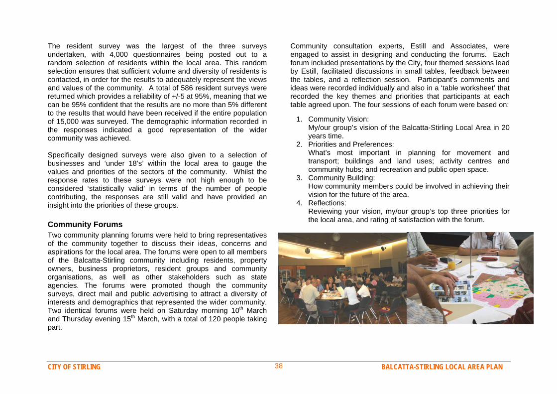
CITY OF STIRLING BALCATTA-STIRLING LOCAL AREA PLAN 38
The resident survey was the largest of the three surveys undertaken, with 4,000 questionnaires being posted out to a random selection of residents within the local area. This random selection ensures that sufficient volume and diversity of residents is contacted, in order for the results to adequately represent the views and values of the community. A total of 586 resident surveys were returned which provides a reliability of +/-5 at 95%, meaning that we can be 95% confident that the results are no more than 5% different to the results that would have been received if the entire population of 15,000 was surveyed. The demographic information recorded in the responses indicated a good representation of the wider community was achieved. Specifically designed surveys were also given to a selection of businesses and ‘under 18’s’ within the local area to gauge the values and priorities of the sectors of the community. Whilst the response rates to these surveys were not high enough to be considered ‘statistically valid’ in terms of the number of people contributing, the responses are still valid and have provided an insight into the priorities of these groups. Community Forums Two community planning forums were held to bring representatives of the community together to discuss their ideas, concerns and aspirations for the local area. The forums were open to all members of the Balcatta-Stirling community including residents, property owners, business proprietors, resident groups and community organisations, as well as other stakeholders such as state agencies. The forums were promoted though the community surveys, direct mail and public advertising to attract a diversity of interests and demographics that represented the wider community. Two identical forums were held on Saturday morning 10th March and Thursday evening 15th March, with a total of 120 people taking part.
Community consultation experts, Estill and Associates, were engaged to assist in designing and conducting the forums. Each forum included presentations by the City, four themed sessions lead by Estill, facilitated discussions in small tables, feedback between the tables, and a reflection session. Participant’s comments and ideas were recorded individually and also in a ‘table worksheet’ that recorded the key themes and priorities that participants at each table agreed upon. The four sessions of each forum were based on:
1. Community Vision: My/our group’s vision of the Balcatta-Stirling Local Area in 20 years time.
2. Priorities and Preferences: What’s most important in planning for movement and
transport; buildings and land uses; activity centres and community hubs; and recreation and public open space.
3. Community Building: How community members could be involved in achieving their vision for the future of the area.
4. Reflections: Reviewing your vision, my/our group’s top three priorities for the local area, and rating of satisfaction with the forum.

CITY OF STIRLING BALCATTA-STIRLING LOCAL AREA PLAN 39
Community Engagement FindingsAnalysis of each public submission and each consultation process was undertaken to identify the key themes, issues and values of the local area community overall, including majority held opinions, issues or concerns for a particular group or area, and individual ideas and aspirations. A comprehensive summary of the community consultation findings are presented under the following five headings, with emphasis placed on themes or issues that were most commonly supported. Community Values Community engagement was used to identify the core values of local residents and stakeholders - how they feel about the area, what’s important to them for the future and are there commonly shared values that can be considered ‘community values’? The survey demonstrated that residents of the Balcatta-Stirling Local Area are quite happy with the area overall. When asked to rank their satisfaction with the area as a place to live on a scale of 1 to 9, 79% of respondents gave a score of 6 or more, with only 6% giving a ‘dissatisfied’ rating (3 or less). Analysis of all consultation indicates that the most pleasing aspects of the Balcatta-Stirling Local Area were its community and culture and the lifestyle and opportunities that the place offers. Satisfaction also comes from education facilities, transport facilities and safety and security of the locality, although various comments were received for improvement in these areas. The area’s great location, with close proximity to workplaces, a train station, shopping facilities and the coast, also contribute strongly to people’s satisfaction with living in the area. However business operators only reported reasonable levels of satisfaction with the
local area as a place to run a business. Youth however were generally satisfied and think they would probably like to stay living in the area in the future. Overall, how satisfied are you with the Local Area as a place to live?
1% 1%3%
7%
13%
20%
27%
14% 13%
1 2 3 4 5 6 7 8 9
Very dissatisfied Reasonably satisfied Very satisfied
How distinctive do you think the character of the area is at the moment?
2% 3%6%
16%
20%17%
21%
5%
9%
1 2 3 4 5 6 7 8 9
No discernable character Moderately strong character Very distinctive character
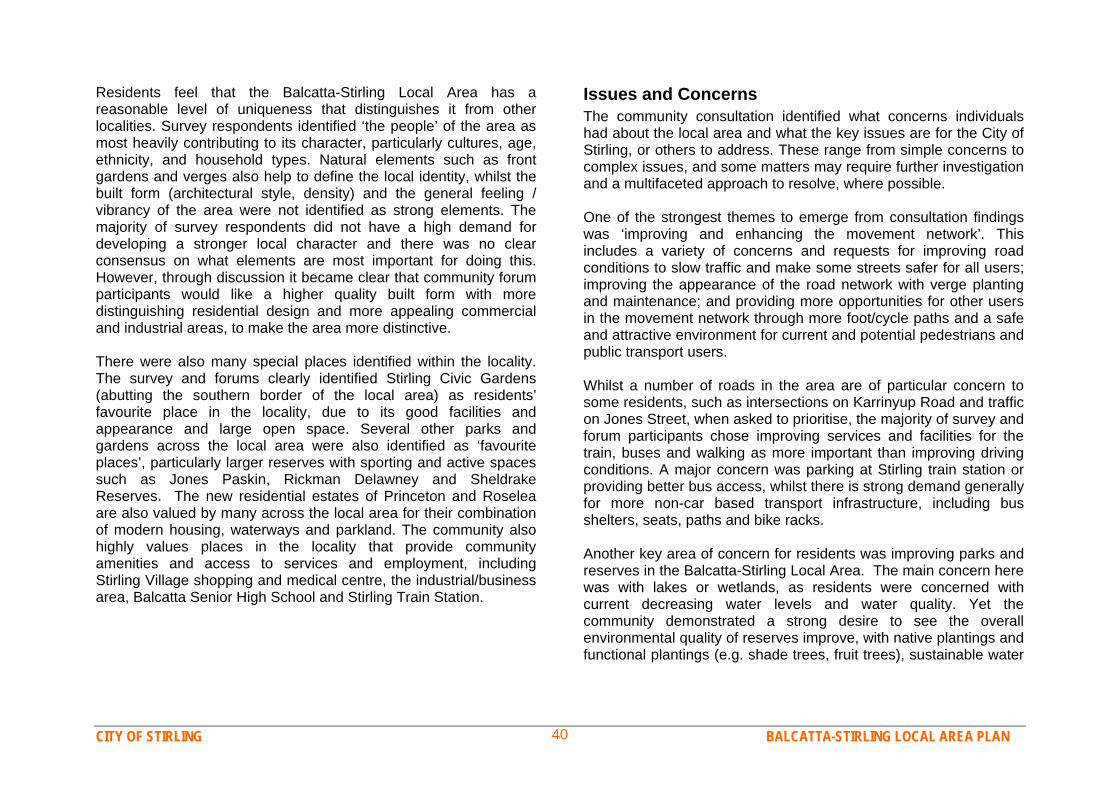
CITY OF STIRLING BALCATTA-STIRLING LOCAL AREA PLAN 40
Residents feel that the Balcatta-Stirling Local Area has a reasonable level of uniqueness that distinguishes it from other localities. Survey respondents identified ‘the people’ of the area as most heavily contributing to its character, particularly cultures, age, ethnicity, and household types. Natural elements such as front gardens and verges also help to define the local identity, whilst the built form (architectural style, density) and the general feeling / vibrancy of the area were not identified as strong elements. The majority of survey respondents did not have a high demand for developing a stronger local character and there was no clear consensus on what elements are most important for doing this. However, through discussion it became clear that community forum participants would like a higher quality built form with more distinguishing residential design and more appealing commercial and industrial areas, to make the area more distinctive. There were also many special places identified within the locality. The survey and forums clearly identified Stirling Civic Gardens (abutting the southern border of the local area) as residents’ favourite place in the locality, due to its good facilities and appearance and large open space. Several other parks and gardens across the local area were also identified as ‘favourite places’, particularly larger reserves with sporting and active spaces such as Jones Paskin, Rickman Delawney and Sheldrake Reserves. The new residential estates of Princeton and Roselea are also valued by many across the local area for their combination of modern housing, waterways and parkland. The community also highly values places in the locality that provide community amenities and access to services and employment, including Stirling Village shopping and medical centre, the industrial/business area, Balcatta Senior High School and Stirling Train Station.
Issues and Concerns The community consultation identified what concerns individuals had about the local area and what the key issues are for the City of Stirling, or others to address. These range from simple concerns to complex issues, and some matters may require further investigation and a multifaceted approach to resolve, where possible. One of the strongest themes to emerge from consultation findings was ‘improving and enhancing the movement network’. This includes a variety of concerns and requests for improving road conditions to slow traffic and make some streets safer for all users; improving the appearance of the road network with verge planting and maintenance; and providing more opportunities for other users in the movement network through more foot/cycle paths and a safe and attractive environment for current and potential pedestrians and public transport users. Whilst a number of roads in the area are of particular concern to some residents, such as intersections on Karrinyup Road and traffic on Jones Street, when asked to prioritise, the majority of survey and forum participants chose improving services and facilities for the train, buses and walking as more important than improving driving conditions. A major concern was parking at Stirling train station or providing better bus access, whilst there is strong demand generally for more non-car based transport infrastructure, including bus shelters, seats, paths and bike racks. Another key area of concern for residents was improving parks and reserves in the Balcatta-Stirling Local Area. The main concern here was with lakes or wetlands, as residents were concerned with current decreasing water levels and water quality. Yet the community demonstrated a strong desire to see the overall environmental quality of reserves improve, with native plantings and functional plantings (e.g. shade trees, fruit trees), sustainable water
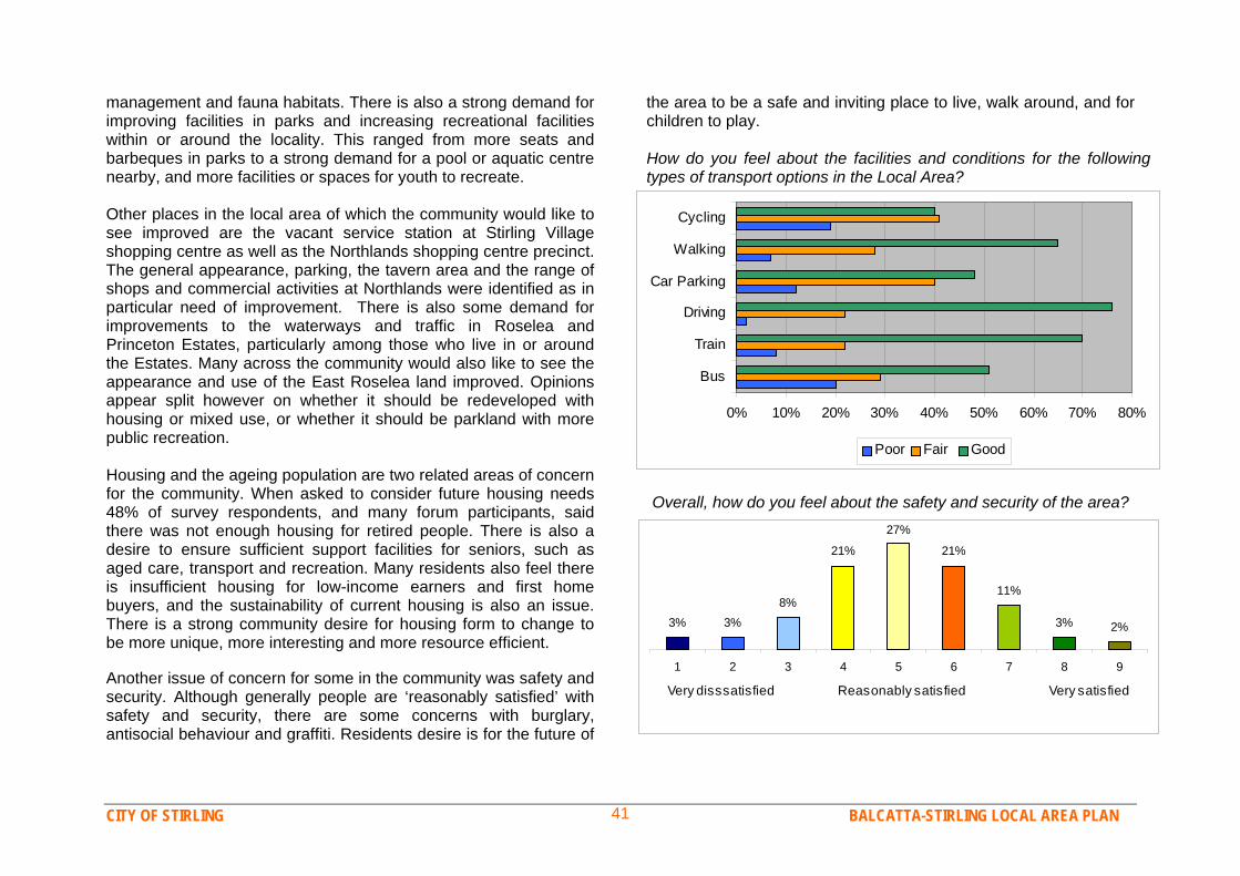
CITY OF STIRLING BALCATTA-STIRLING LOCAL AREA PLAN 41
management and fauna habitats. There is also a strong demand for improving facilities in parks and increasing recreational facilities within or around the locality. This ranged from more seats and barbeques in parks to a strong demand for a pool or aquatic centre nearby, and more facilities or spaces for youth to recreate. Other places in the local area of which the community would like to see improved are the vacant service station at Stirling Village shopping centre as well as the Northlands shopping centre precinct. The general appearance, parking, the tavern area and the range of shops and commercial activities at Northlands were identified as in particular need of improvement. There is also some demand for improvements to the waterways and traffic in Roselea and Princeton Estates, particularly among those who live in or around the Estates. Many across the community would also like to see the appearance and use of the East Roselea land improved. Opinions appear split however on whether it should be redeveloped with housing or mixed use, or whether it should be parkland with more public recreation. Housing and the ageing population are two related areas of concern for the community. When asked to consider future housing needs 48% of survey respondents, and many forum participants, said there was not enough housing for retired people. There is also a desire to ensure sufficient support facilities for seniors, such as aged care, transport and recreation. Many residents also feel there is insufficient housing for low-income earners and first home buyers, and the sustainability of current housing is also an issue. There is a strong community desire for housing form to change to be more unique, more interesting and more resource efficient. Another issue of concern for some in the community was safety and security. Although generally people are ‘reasonably satisfied’ with safety and security, there are some concerns with burglary, antisocial behaviour and graffiti. Residents desire is for the future of
the area to be a safe and inviting place to live, walk around, and for children to play. How do you feel about the facilities and conditions for the following types of transport options in the Local Area?
0% 10% 20% 30% 40% 50% 60% 70% 80%
Bus
Train
Driving
Car Parking
Walking
Cycling
Poor Fair Good
Overall, how do you feel about the safety and security of the area?
3% 3%8%
21%
27%
21%
11%
3% 2%
1 2 3 4 5 6 7 8 9
Very disssatisfied Reasonably satisfied Very satisfied

CITY OF STIRLING BALCATTA-STIRLING LOCAL AREA PLAN 42
Opportunities and Ideas
The community consultation and public suggestions have gathered a wealth of information on opportunities and ideas for the future of the Balcatta-Stirling Local Area. These findings can be grouped into a number of themes which illustrate the key opportunities for achieving the community vision for the future. Some of the most common or innovative suggestions are listed below each theme. Developing community hubs with social places and
recreation spaces A key theme for the vision of the future of the Balcatta-Stirling Local Area is for there to be a strong community which has the facilities, spaces and events that support interaction and social development. There is strong demand for more social spaces and events in the area, such as cafes, barbeques, parties and fairs, both to socialise with friends and family and to meet neighbours and make new ties. Many people see that the Stirling Village area - with shops, a medical centre and adjoining parkland, has the potential to become a ‘community hub’, a busy yet friendly place with shops, services and social spaces that is the heart of the community. People would also be encouraged to walk and cycle to these hubs creating more opportunities for interaction and increasing safety and enjoyment. There are also many opportunities for parks and recreation spaces to further develop as community hubs where people can exercise, recreate and socialise. There is some demand for an aquatic centre to be located near the local area, yet this recreation demand could also be met by other suggestions such as community parks, places for children to play and learn, and youth meeting places and active facilities such as courts or skate ramps.
Developing stronger and more dynamic activity centres It was recognised that the major ‘centres’ in the local area, particularly Northlands shopping centre and Balcatta industrial area, have not reached their full potential and more businesses, business diversity, improvement strategies, beautification and changes in planning controls were all suggested to help make these centres more successful and appealing places. Key suggestions were: Can the Balcatta industrial area become a showcase business
and employment centre that generates innovation and business growth?
Can Northlands shopping centre area become an attractive activity precinct with a variety of shops, cafes, al fresco dining, markets and a modern pub?
Can we have a major centre that is attractive and vibrant, with a variety of facilities and activity during the day, evening and weekends and that is inviting to all cultures and age groups?
Becoming a more sustainable community that makes the
best use of facilities and resources There are many opportunities for community members and the City of Stirling to contribute to the sustainable future of the local area. Many in the community want to see things like less car use and water recycling, yet also recognise the importance of making better use of the great facilities already in the area, such as parks and schools. Popular ideas from the forums included: Can we make better use of parks and, with more facilities or
some social events to encourage us to go there more often? Can we have a shuttle bus linking to the train station and
shopping centres?
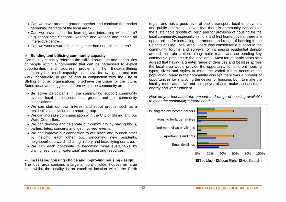
CITY OF STIRLING BALCATTA-STIRLING LOCAL AREA PLAN 43
Can we have areas to garden together and continue the market gardening heritage of the local area?
Can we have places for learning and interacting with nature? e.g. rehabilitate Spoonbill Reserve and wetland and include an interactive centre.
Can we work towards becoming a carbon neutral local area? Building and utilising community capacity Community capacity refers to the skills, knowledge and capabilities of people within a community that can be harnessed to exploit opportunities and address problems. The Balcatta-Stirling community has much capacity to achieve its own goals and can work individually, in groups and in conjunction with the City of Stirling or other organisations to achieve the vision for the future. Some ideas and suggestions from within the community are: Be active participants in the community; support community
events, local businesses, local groups and join community associations.
We can start our own interest and social groups, such as a resident’s association or a nature group.
We can increase communication with the City of Stirling and our Ward Councillors.
We can develop and celebrate our community by having bbq’s, parties, fetes, concerts and ‘get involved’ events.
We can improve our connection to our place and to each other by helping each other out, welcoming new residents, neighbourhood watch, sharing history and beautifying our area.
We can each contribute to becoming more sustainable by driving less, being ‘waterwise’ and conserving resources.
Increasing housing choice and improving housing design The local area contains a large amount of older houses on large lots, whilst the locality is an excellent location within the Perth
region and has a good level of public transport, local employment and public amenities. Given that there is community concern for the sustainable growth of Perth and for provision of housing for the local community, especially seniors and first home buyers, there are opportunities for increasing the amount and range of housing in the Balcatta-Stirling Local Area. There was considerable support in the community forums and surveys for increasing residential density around the train station, along major roads and surrounding key commercial precincts in the local area. Most forum participants also agreed that having a greater range of densities and lot sizes across the local area would provide the opportunity for different housing types, sizes and styles to meet the varied future needs of the population. Many in the community also felt there was a number of opportunities for improving the design of housing, both to make the locality more attractive and unique yet also to make houses more energy and water efficient. How do you feel about the amount and range of housing available to meet the community’s future needs?
0% 20% 40% 60% 80% 100%
Small dwellings
Apartments and flats
Retirment villas or villages
Housing for large families
Housing for low income earners
Too Much About Right Not Enough
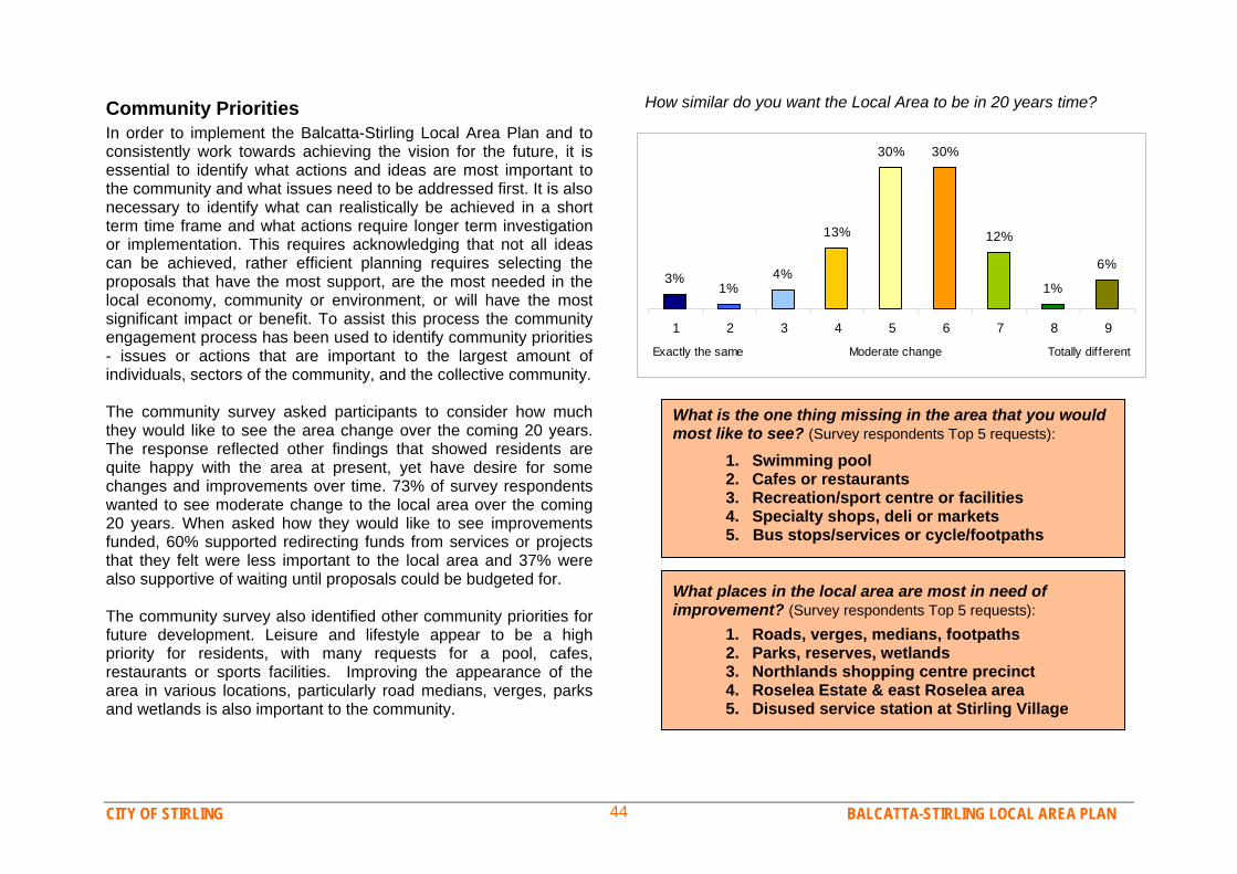
CITY OF STIRLING BALCATTA-STIRLING LOCAL AREA PLAN 44
Community Priorities How similar do you want the Local Area to be in 20 years time?
In order to implement the Balcatta-Stirling Local Area Plan and to consistently work towards achieving the vision for the future, it is essential to identify what actions and ideas are most important to the community and what issues need to be addressed first. It is also necessary to identify what can realistically be achieved in a short term time frame and what actions require longer term investigation or implementation. This requires acknowledging that not all ideas can be achieved, rather efficient planning requires selecting the proposals that have the most support, are the most needed in the local economy, community or environment, or will have the most significant impact or benefit. To assist this process the community engagement process has been used to identify community priorities - issues or actions that are important to the largest amount of individuals, sectors of the community, and the collective community. The community survey asked participants to consider how much they would like to see the area change over the coming 20 years. The response reflected other findings that showed residents are quite happy with the area at present, yet have desire for some changes and improvements over time. 73% of survey respondents wanted to see moderate change to the local area over the coming 20 years. When asked how they would like to see improvements funded, 60% supported redirecting funds from services or projects that they felt were less important to the local area and 37% were also supportive of waiting until proposals could be budgeted for. The community survey also identified other community priorities for future development. Leisure and lifestyle appear to be a high priority for residents, with many requests for a pool, cafes, restaurants or sports facilities. Improving the appearance of the area in various locations, particularly road medians, verges, parks and wetlands is also important to the community.
3%1%
4%
13%
30% 30%
12%
1%
6%
1 2 3 4 5 6 7 8 9
Exactly the same Moderate change Totally different
What is the one thing missing in the area that you would most like to see? (Survey respondents Top 5 requests):
1. Swimming pool 2. Cafes or restaurants 3. Recreation/sport centre or facilities 4. Specialty shops, deli or markets 5. Bus stops/services or cycle/footpaths
What places in the local area are most in need of improvement? (Survey respondents Top 5 requests):
1. Roads, verges, medians, footpaths 2. Parks, reserves, wetlands 3. Northlands shopping centre precinct 4. Roselea Estate & east Roselea area 5. Disused service station at Stirling Village
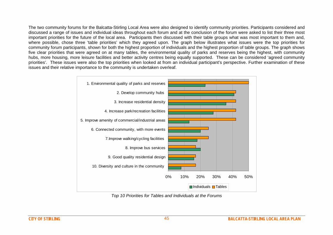
CITY OF STIRLING BALCATTA-STIRLING LOCAL AREA PLAN 45
The two community forums for the Balcatta-Stirling Local Area were also designed to identify community priorities. Participants considered and discussed a range of issues and individual ideas throughout each forum and at the conclusion of the forum were asked to list their three most important priorities for the future of the local area. Participants then discussed with their table groups what was most important to them and, where possible, chose three ‘table priorities’ which they agreed upon. The graph below illustrates what issues were the top priorities for community forum participants, shown for both the highest proportion of individuals and the highest proportion of table groups. The graph shows five clear priorities that were agreed on at many tables, the environmental quality of parks and reserves being the highest, with community hubs, more housing, more leisure facilities and better activity centres being equally supported. These can be considered ‘agreed community priorities’. These issues were also the top priorities when looked at from an individual participant’s perspective. Further examination of these issues and their relative importance to the community is undertaken overleaf.
0% 10% 20% 30% 40% 50%
10. Diversity and culture in the community
9. Good quality residential design
8. Improve bus services
7.Improve walking/cycling facilities
6. Connected community, with more events
5. Improve amenity of commercial/industrial areas
4. Increase park/recreation facilities
3. Increase residential density
2. Develop community hubs
1. Environmental quality of parks and reserves
Individuals Tables
Top 10 Priorities for Tables and Individuals at the Forums

CITY OF STIRLING BALCATTA-STIRLING LOCAL AREA PLAN 46
Analysis of all community input has identified a list of issues that are the most important to the most people. Given that the consultation findings can be considered an accurate representation of the wider community’s opinion, the follow list can be considered the top community priorities for the future of the Balcatta-Stirling Local Area.
1. Environmental Quality of Parks and Reserves Having attractive, high quality public open space is the highest priority for the Balcatta-Stirling community. This includes rehabilitating the wetland system and developing ecologically sensitive reserves that are water-wise and have native plantings. These reserves will be a source of Balcatta-Stirling community pride and reconnect people with nature and history. 2. Recreation and Leisure The high value placed on open space is linked to the importance of leisure in the community’s lifestyle and the desire to use recreation activities to bring different members of the community closer together. There is a high demand for increasing facilities such as barbeques, seats and lights in parks so that more social activity will occur, yet high demand also for recreation facilities such as gyms, sports and aquatic centres and a strong desire to ensure youth and seniors have adequate recreation facilities. 3. Community Hubs The third highest priority for the Balcatta-Stirling community is the development of one or a number of ‘community hubs’. The precincts surrounding Stirling Village and Northlands Shopping Centre and the Civic Precinct based around the City of Stirling complex have the potential to become community hubs with a range of amenities for community needs and social interaction. (See Opportunities and Ideas page. 40 for more details).
4. Housing The fourth community priority is increasing quality and diversity in residential density, housing types and styles to cater for the needs of the population, especially retirees. The majority of the community support some higher density around activity hubs and transit areas, with the remaining residential areas ranging between R20 to R30. However ensuring new development is of a high standard in terms of attractive appearance, local character and environmental efficiency is also a high priority. (See Opportunities and Ideas p. 41) 5. Connectivity and Sustainable Transport The community would like a movement network that better connects all types of transport users to local community amenities and that encourages transport that is physically active, socially interactive and environmentally sustainable. This includes increasing the coverage and frequency of bus services, supporting the use of the train station such as more parking or a shuttle bus and improving the bicycle and footpath network. 6. An Holistic Community People knowing and supporting each other and becoming like an extended family with community groups and events. The community will respect its culture and diversity and its children and seniors. 7. Sustainability and Conservation Be a leading ‘green area’ with conservation of nature, water and energy, sustainable building design and reducing car use, that also makes best use of residential land and existing facilities. 8. The Function and Amenity of Key Centres Redevelop Northlands to a modern area with more diversity of shops and amenities and retain and strengthen the industrial area which is very important for employment and business. (See Opportunities and Ideas p. 40).
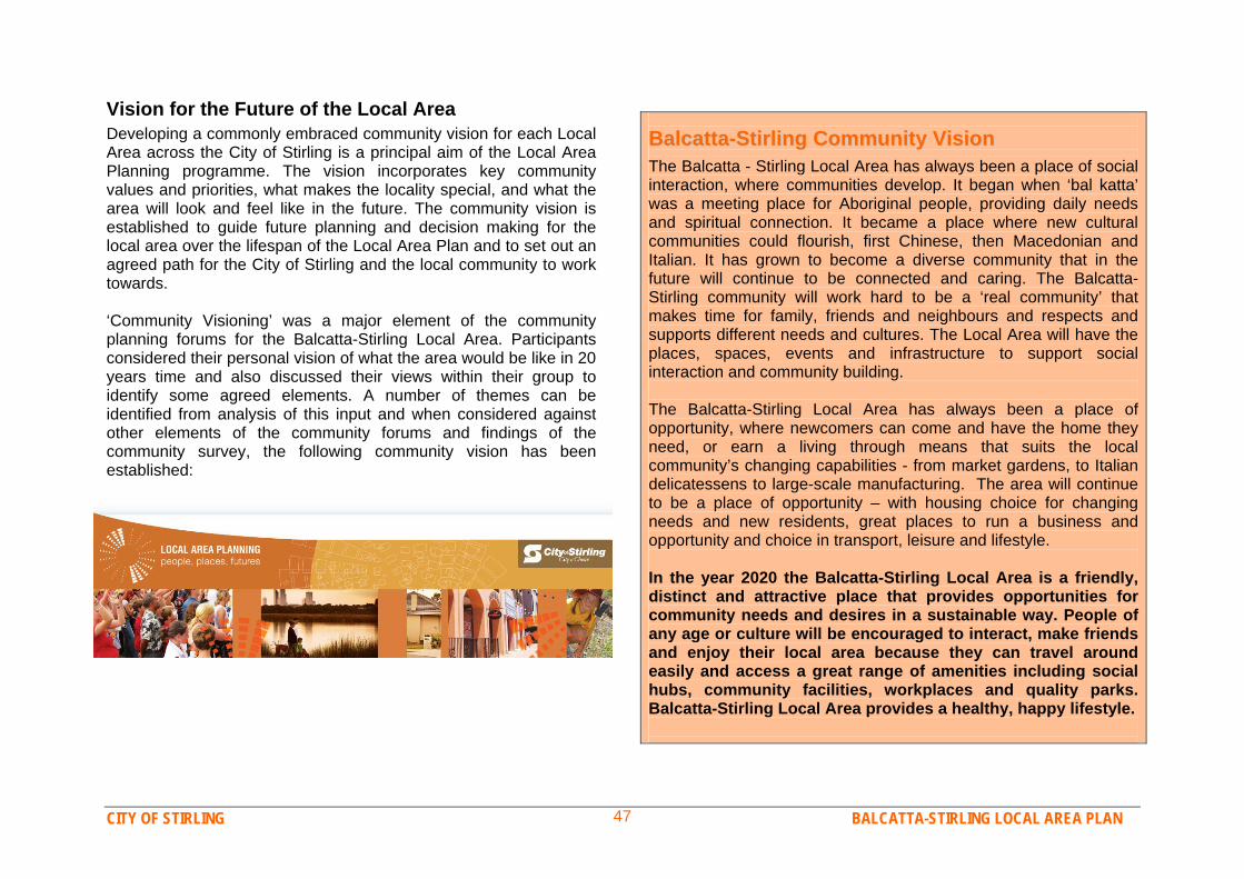
CITY OF STIRLING BALCATTA-STIRLING LOCAL AREA PLAN 47
Vision for the Future of the Local Area Developing a commonly embraced community vision for each Local Area across the City of Stirling is a principal aim of the Local Area Planning programme. The vision incorporates key community values and priorities, what makes the locality special, and what the area will look and feel like in the future. The community vision is established to guide future planning and decision making for the local area over the lifespan of the Local Area Plan and to set out an agreed path for the City of Stirling and the local community to work towards. ‘Community Visioning’ was a major element of the community planning forums for the Balcatta-Stirling Local Area. Participants considered their personal vision of what the area would be like in 20 years time and also discussed their views within their group to identify some agreed elements. A number of themes can be identified from analysis of this input and when considered against other elements of the community forums and findings of the community survey, the following community vision has been established:
BBaallccaattttaa--SSttiirrlliinngg CCoommmmuunniittyy VViissiioonn
The Balcatta - Stirling Local Area has always been a place of social interaction, where communities develop. It began when ‘bal katta’ was a meeting place for Aboriginal people, providing daily needs and spiritual connection. It became a place where new cultural communities could flourish, first Chinese, then Macedonian and Italian. It has grown to become a diverse community that in the future will continue to be connected and caring. The Balcatta- Stirling community will work hard to be a ‘real community’ that makes time for family, friends and neighbours and respects and supports different needs and cultures. The Local Area will have the places, spaces, events and infrastructure to support social interaction and community building. The Balcatta-Stirling Local Area has always been a place of opportunity, where newcomers can come and have the home they need, or earn a living through means that suits the local community’s changing capabilities - from market gardens, to Italian delicatessens to large-scale manufacturing. The area will continue to be a place of opportunity – with housing choice for changing needs and new residents, great places to run a business and opportunity and choice in transport, leisure and lifestyle. In the year 2020 the Balcatta-Stirling Local Area is a friendly, distinct and attractive place that provides opportunities for community needs and desires in a sustainable way. People of any age or culture will be encouraged to interact, make friends and enjoy their local area because they can travel around easily and access a great range of amenities including social hubs, community facilities, workplaces and quality parks. Balcatta-Stirling Local Area provides a healthy, happy lifestyle.
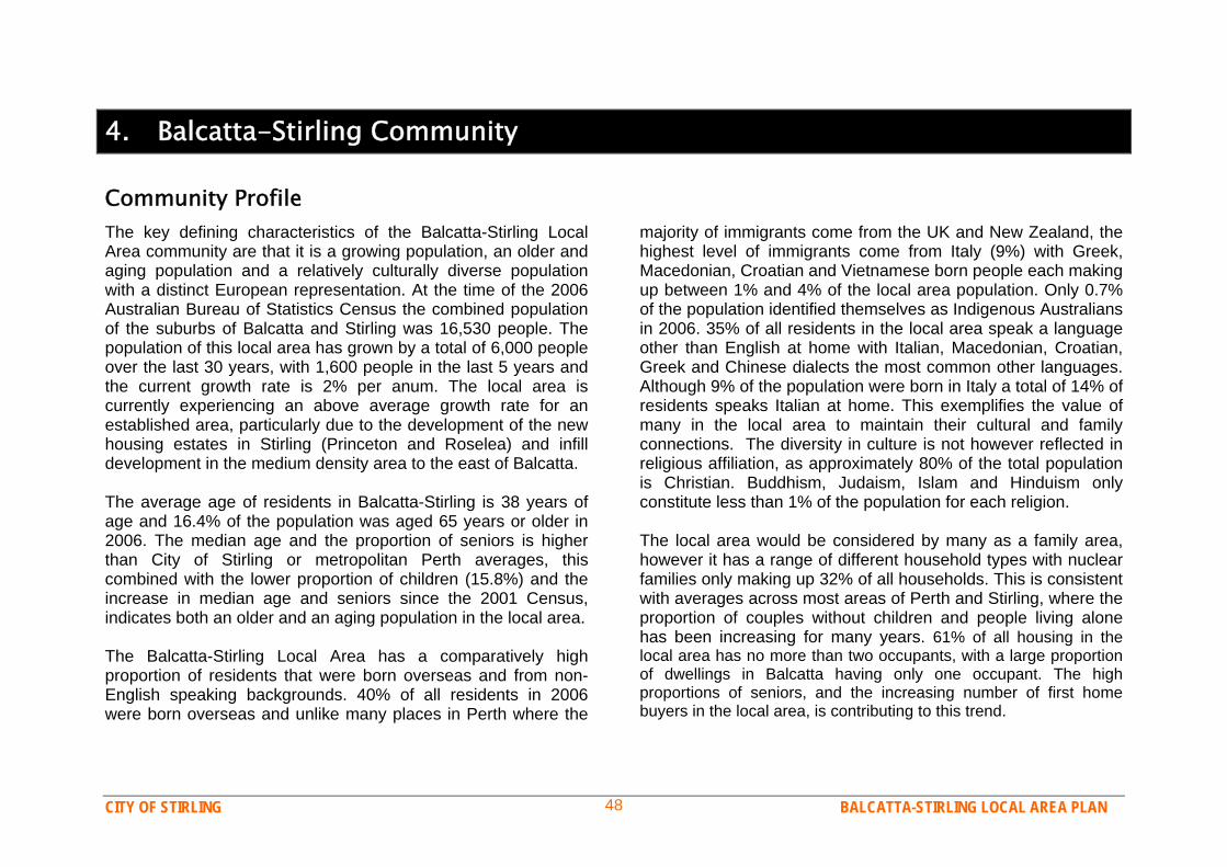
CITY OF STIRLING BALCATTA-STIRLING LOCAL AREA PLAN 48
4. Balcatta-Stirling Community
Community Profile The key defining characteristics of the Balcatta-Stirling Local Area community are that it is a growing population, an older and aging population and a relatively culturally diverse population with a distinct European representation. At the time of the 2006 Australian Bureau of Statistics Census the combined population of the suburbs of Balcatta and Stirling was 16,530 people. The population of this local area has grown by a total of 6,000 people over the last 30 years, with 1,600 people in the last 5 years and the current growth rate is 2% per anum. The local area is currently experiencing an above average growth rate for an established area, particularly due to the development of the new housing estates in Stirling (Princeton and Roselea) and infill development in the medium density area to the east of Balcatta. The average age of residents in Balcatta-Stirling is 38 years of age and 16.4% of the population was aged 65 years or older in 2006. The median age and the proportion of seniors is higher than City of Stirling or metropolitan Perth averages, this combined with the lower proportion of children (15.8%) and the increase in median age and seniors since the 2001 Census, indicates both an older and an aging population in the local area. The Balcatta-Stirling Local Area has a comparatively high proportion of residents that were born overseas and from non-English speaking backgrounds. 40% of all residents in 2006 were born overseas and unlike many places in Perth where the
majority of immigrants come from the UK and New Zealand, the highest level of immigrants come from Italy (9%) with Greek, Macedonian, Croatian and Vietnamese born people each making up between 1% and 4% of the local area population. Only 0.7% of the population identified themselves as Indigenous Australians in 2006. 35% of all residents in the local area speak a language other than English at home with Italian, Macedonian, Croatian, Greek and Chinese dialects the most common other languages. Although 9% of the population were born in Italy a total of 14% of residents speaks Italian at home. This exemplifies the value of many in the local area to maintain their cultural and family connections. The diversity in culture is not however reflected in religious affiliation, as approximately 80% of the total population is Christian. Buddhism, Judaism, Islam and Hinduism only constitute less than 1% of the population for each religion. The local area would be considered by many as a family area, however it has a range of different household types with nuclear families only making up 32% of all households. This is consistent with averages across most areas of Perth and Stirling, where the proportion of couples without children and people living alone has been increasing for many years. 61% of all housing in the local area has no more than two occupants, with a large proportion of dwellings in Balcatta having only one occupant. The high proportions of seniors, and the increasing number of first home buyers in the local area, is contributing to this trend.
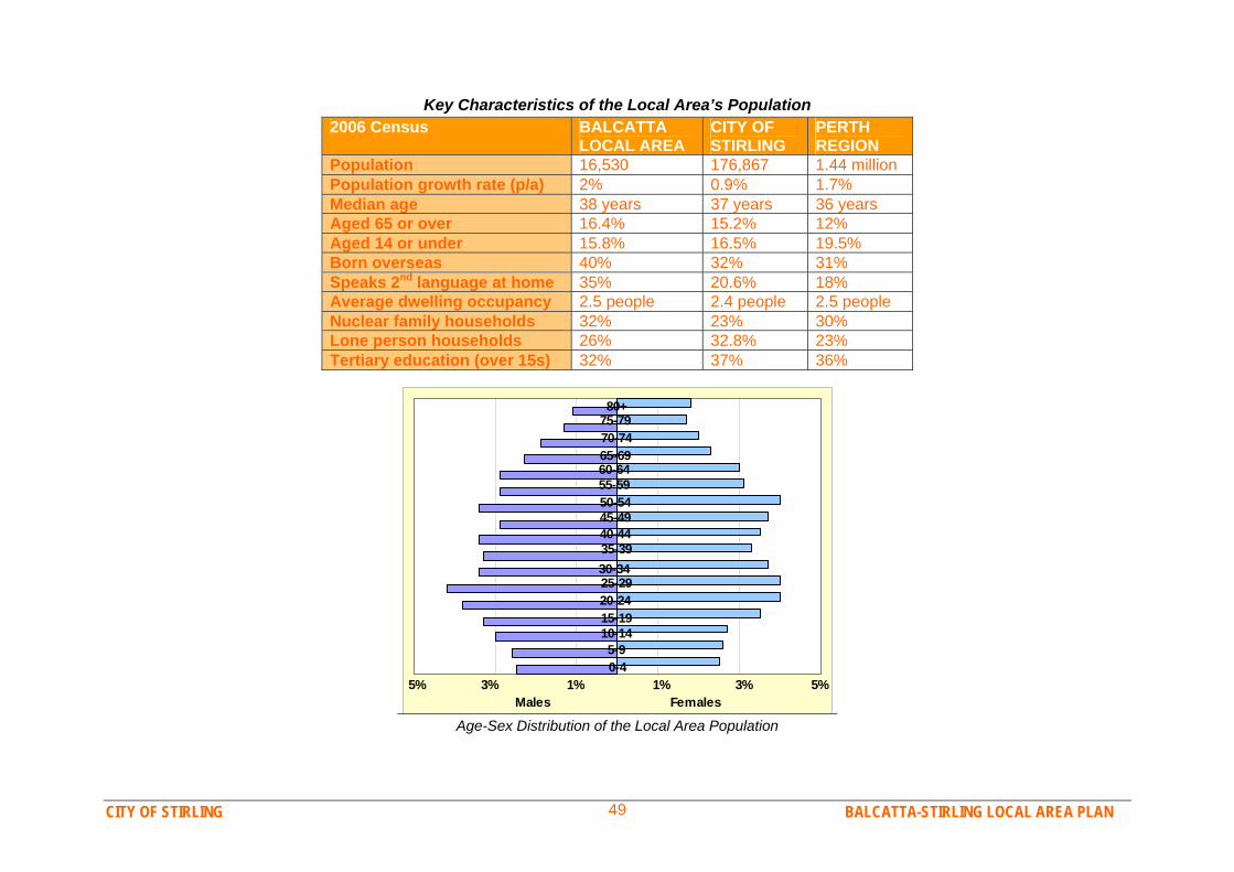
CITY OF STIRLING BALCATTA-STIRLING LOCAL AREA PLAN 49
Key Characteristics of the Local Area’s Population 2006 Census BALCATTA
LOCAL AREA CITY OF STIRLING
PERTH REGION
Population 16,530 176,867 1.44 million Population growth rate (p/a) 2% 0.9% 1.7% Median age 38 years 37 years 36 years Aged 65 or over 16.4% 15.2% 12% Aged 14 or under 15.8% 16.5% 19.5% Born overseas 40% 32% 31% Speaks 2nd language at home 35% 20.6% 18% Average dwelling occupancy 2.5 people 2.4 people 2.5 people Nuclear family households 32% 23% 30% Lone person households 26% 32.8% 23% Tertiary education (over 15s) 32% 37% 36%
0-45-9
10-1415-19
20-2425-29 30-3435-3940-4445-4950-54
55-5960-6465-6970-7475-7980+
5% 3% 1% 1% 3% 5%Males Females
Age-Sex Distribution of the Local Area Population
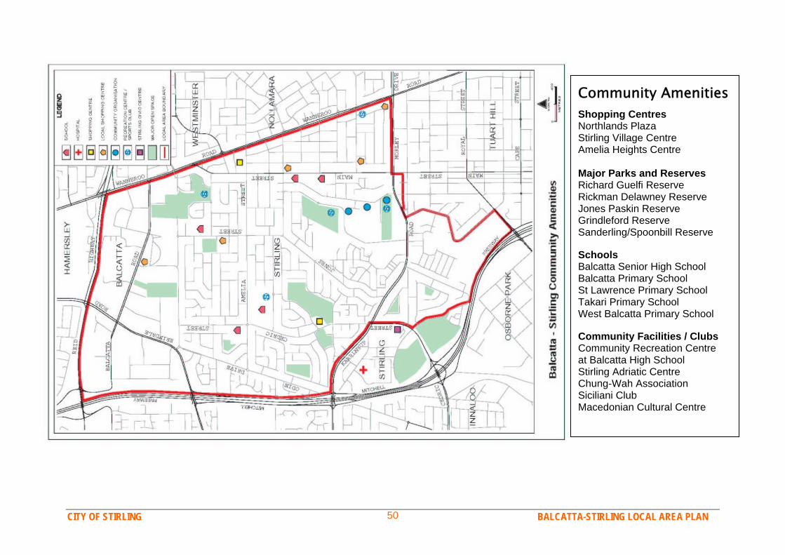
CITY OF STIRLING BALCATTA-STIRLING LOCAL AREA PLAN 50
Community Amenities Shopping Centres Northlands Plaza Stirling Village Centre Amelia Heights Centre Major Parks and Reserves Richard Guelfi Reserve Rickman Delawney Reserve Jones Paskin Reserve Grindleford Reserve Sanderling/Spoonbill Reserve Schools Balcatta Senior High School Balcatta Primary School St Lawrence Primary School Takari Primary School West Balcatta Primary School Community Facilities / Clubs Community Recreation Centre at Balcatta High School Stirling Adriatic Centre Chung-Wah Association Siciliani Club Macedonian Cultural Centre
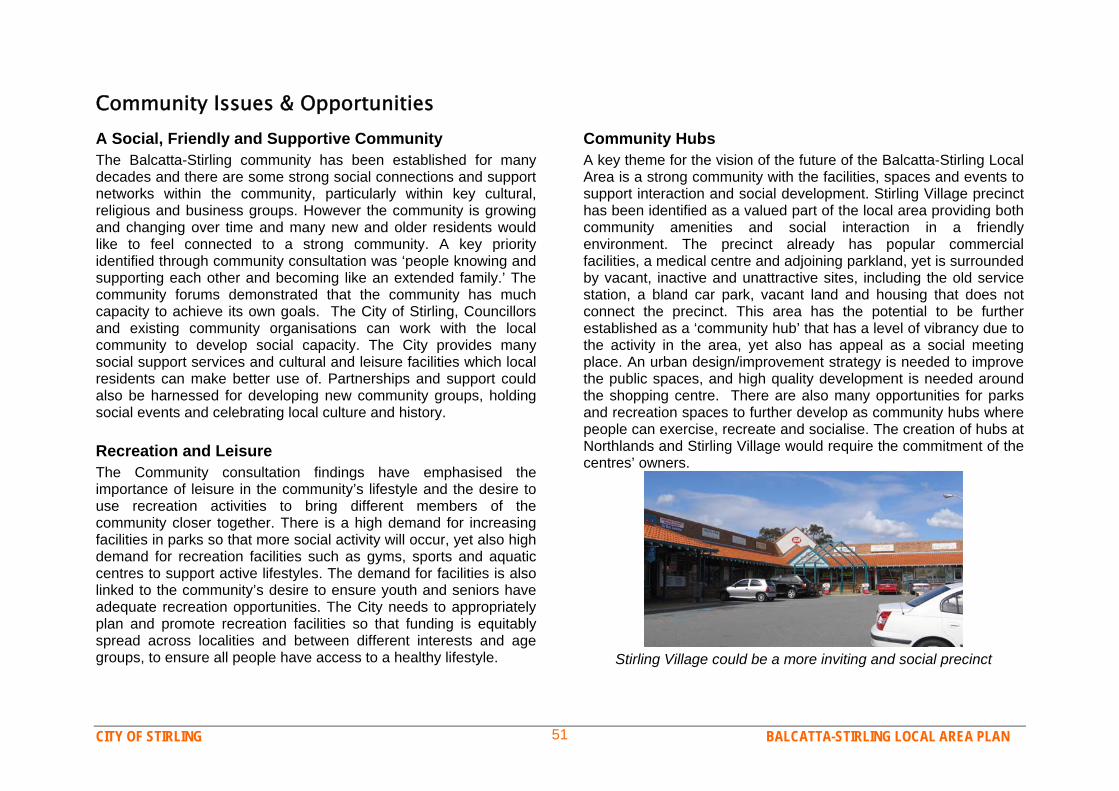
CITY OF STIRLING BALCATTA-STIRLING LOCAL AREA PLAN 51
Community Issues & Opportunities A Social, Friendly and Supportive Community The Balcatta-Stirling community has been established for many decades and there are some strong social connections and support networks within the community, particularly within key cultural, religious and business groups. However the community is growing and changing over time and many new and older residents would like to feel connected to a strong community. A key priority identified through community consultation was ‘people knowing and supporting each other and becoming like an extended family.’ The community forums demonstrated that the community has much capacity to achieve its own goals. The City of Stirling, Councillors and existing community organisations can work with the local community to develop social capacity. The City provides many social support services and cultural and leisure facilities which local residents can make better use of. Partnerships and support could also be harnessed for developing new community groups, holding social events and celebrating local culture and history. Recreation and Leisure The Community consultation findings have emphasised the importance of leisure in the community’s lifestyle and the desire to use recreation activities to bring different members of the community closer together. There is a high demand for increasing facilities in parks so that more social activity will occur, yet also high demand for recreation facilities such as gyms, sports and aquatic centres to support active lifestyles. The demand for facilities is also linked to the community’s desire to ensure youth and seniors have adequate recreation opportunities. The City needs to appropriately plan and promote recreation facilities so that funding is equitably spread across localities and between different interests and age groups, to ensure all people have access to a healthy lifestyle.
Community Hubs A key theme for the vision of the future of the Balcatta-Stirling Local Area is a strong community with the facilities, spaces and events to support interaction and social development. Stirling Village precinct has been identified as a valued part of the local area providing both community amenities and social interaction in a friendly environment. The precinct already has popular commercial facilities, a medical centre and adjoining parkland, yet is surrounded by vacant, inactive and unattractive sites, including the old service station, a bland car park, vacant land and housing that does not connect the precinct. This area has the potential to be further established as a ‘community hub’ that has a level of vibrancy due to the activity in the area, yet also has appeal as a social meeting place. An urban design/improvement strategy is needed to improve the public spaces, and high quality development is needed around the shopping centre. There are also many opportunities for parks and recreation spaces to further develop as community hubs where people can exercise, recreate and socialise. The creation of hubs at Northlands and Stirling Village would require the commitment of the centres’ owners.
Stirling Village could be a more inviting and social precinct

CITY OF STIRLING BALCATTA-STIRLING LOCAL AREA PLAN 52
Arts and Culture and Heritage The culture and heritage of the local area and its residents are highly valued by the community. The locality has important heritage in its Indigenous past and its role in the early development of Perth. Cultural and heritage aspects also include its rural and market gardening past, and the character and contribution the Italian, Macedonian, Croatian and Greek residents have given the area. The wetlands of the locality are one unifying theme in the area’s heritage as they were important for Aboriginal people as well as Chinese, then Italian, market gardeners. The local area also contains many important cultural associations and facilities which have been operating in the area for many decades, such as the Chung Wah Association, the Stirling Adriatic Centre, the Siciliani Club and the Macedonian Cultural Centre. These facilities are of regional importance to ethnic communities dispersed across the inner and northern suburbs. It is important to these groups and the wider community that the Balcatta-Stirling Local Area’s history and culture is recognised, valued and celebrated. Cultural, art and heritage projects and events are something the City of Stirling and community can work together on. Safety & Security Safety and security is an issue of concern for some in the community, whilst others value the level of security they feel in the local area. Although community consultation found that generally people are ‘reasonably satisfied’ with safety and security, there are some concerns with burglary, antisocial behaviour and graffiti. Recent statistics show the local area as having comparable crime rates to surrounding areas, yet burglary rates would be a concern to some and can cause a feeling of insecurity for some residents and business owners. Whilst crime or safety were not identified as major problems or top priorities for improvements, residents desire is for the future of the area to be a safe and inviting place to live, to walk around, and for children to play.
The community plays an important role in local safety and security and must continue to report suspicious activities, crimes and problems to the City’s security service or police. The City must also promote the services it offers to residents and businesses and ensure its security patrols have a visible presence in the area. Ensuring the local area is a safe place to live into the future also includes designing parks and public places to be safe, inviting and well lit, and also managing traffic and transport so that streets are safe for all users and people feel comfortable to walk and cycle in the area.
0 5 10 15 20
Osborne Park
Nollamara
Hamersley
Balcatta
StirlingVehicle Theft
Graffiti
Burglary
Assault
Average Monthly Reported Crimes 2006
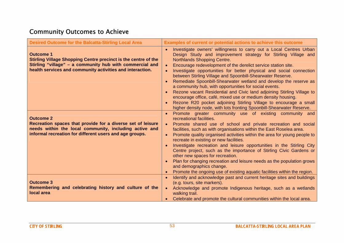
CITY OF STIRLING BALCATTA-STIRLING LOCAL AREA PLAN 53
Community Outcomes to Achieve Desired Outcome for the Balcatta-Stirling Local Area Examples of current or potential actions to achieve this outcome Outcome 1 Stirling Village Shopping Centre precinct is the centre of the Stirling “village” – a community hub with commercial and health services and community activities and interaction.
Investigate owners’ willingness to carry out a Local Centres Urban Design Study and improvement strategy for Stirling Village and Northlands Shopping Centre.
Encourage redevelopment of the derelict service station site. Investigate opportunities for better physical and social connection
between Stirling Village and Spoonbill-Shearwater Reserve. Remediate Spoonbill-Shearwater wetland and develop the reserve as
a community hub, with opportunities for social events. Rezone vacant Residential and Civic land adjoining Stirling Village to
encourage office, café, mixed use or medium density housing. Rezone R20 pocket adjoining Stirling Village to encourage a small
higher density node, with lots fronting Spoonbill-Shearwater Reserve. Outcome 2 Recreation spaces that provide for a diverse set of leisure needs within the local community, including active and informal recreation for different users and age groups.
Promote greater community use of existing community and recreational facilities.
Promote shared use of school and private recreation and social facilities, such as with organisations within the East Roselea area.
Promote quality organised activities within the area for young people to recreate in existing or new facilities.
Investigate recreation and leisure opportunities in the Stirling City Centre project, such as the importance of Stirling Civic Gardens or other new spaces for recreation.
Plan for changing recreation and leisure needs as the population grows and demographics change.
Promote the ongoing use of existing aquatic facilities within the region. Outcome 3 Remembering and celebrating history and culture of the local area
Identify and acknowledge past and current heritage sites and buildings (e.g. tours, site markers).
Acknowledge and promote Indigenous heritage, such as a wetlands walking trail.
Celebrate and promote the cultural communities within the local area.
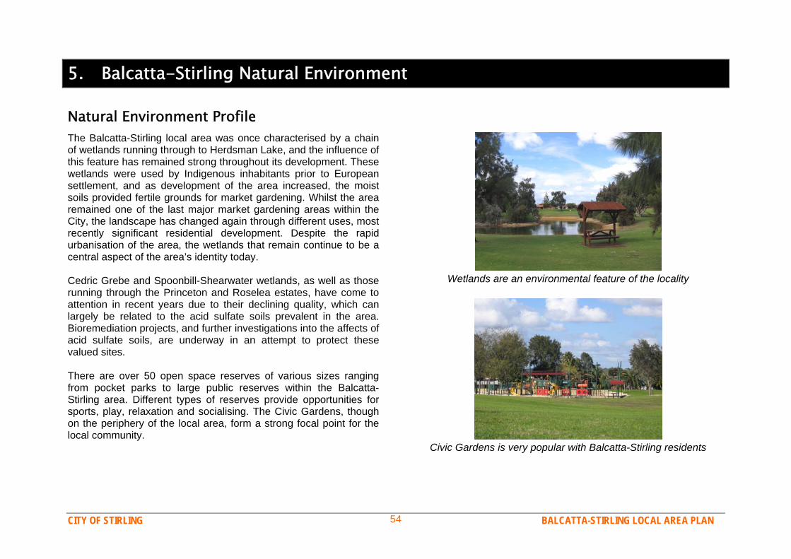
CITY OF STIRLING BALCATTA-STIRLING LOCAL AREA PLAN 54
5. Balcatta-Stirling Natural Environment
Natural Environment Profile The Balcatta-Stirling local area was once characterised by a chain of wetlands running through to Herdsman Lake, and the influence of this feature has remained strong throughout its development. These wetlands were used by Indigenous inhabitants prior to European settlement, and as development of the area increased, the moist soils provided fertile grounds for market gardening. Whilst the area remained one of the last major market gardening areas within the City, the landscape has changed again through different uses, most recently significant residential development. Despite the rapid urbanisation of the area, the wetlands that remain continue to be a central aspect of the area’s identity today. Cedric Grebe and Spoonbill-Shearwater wetlands, as well as those running through the Princeton and Roselea estates, have come to attention in recent years due to their declining quality, which can largely be related to the acid sulfate soils prevalent in the area. Bioremediation projects, and further investigations into the affects of acid sulfate soils, are underway in an attempt to protect these valued sites. There are over 50 open space reserves of various sizes ranging from pocket parks to large public reserves within the Balcatta-Stirling area. Different types of reserves provide opportunities for sports, play, relaxation and socialising. The Civic Gardens, though on the periphery of the local area, form a strong focal point for the local community.
Wetlands are an environmental feature of the locality
Civic Gardens is very popular with Balcatta-Stirling residents
CITY OF STIRLING BALCATTA-STIRLING LOCAL AREA PLAN 55
Natural Environment Issues & Opportunities Environmental Sustainability The Balcatta-Stirling community expressed a keen concern for the sustainability of their local area, particularly in terms of its environmental wellbeing. Many of the factors which must be addressed to improve the sustainability of the area, such as water management, climate change and biodiversity, are discussed below.
Ecologically Sound Parks and Reserves Community consultation revealed a strong desire to develop ecologically sensitive reserves that are water-wise and have native plantings. These reserves will be a source of Balcatta-Stirling community pride and reconnect people with nature and history. Balcatta-Stirling community members suggested that ecologically sustainable open spaces could be achieved through native plantings and functional plantings (e.g. shade trees and fruit trees), sustainable water management and fauna habitats. Community Parks Community parks, civic gardens and shared open space are highly valued by the Balcatta-Stirling community. They are valued as places for leisure and education, and strengthen the community by providing a shared space for working together and socialising. The possibility of areas for gardening together and continuing the market garden heritage of the local area was raised during consultation as a possible future use of some community parks. Another priority was providing places for learning and interacting
with nature. Spoonbill Reserve, for example, was suggested as a site for wetland rehabilitation, complemented by educational features such as interpretive signage. Water Quality and Conservation Residents of the Balcatta-Stirling local area expressed their concern with the decreasing water levels in local wetlands. Spoonbill-Shearwater and Cedric Grebe wetlands to the east of the local area, and the wetlands running through Roselea and Princeton estates, which once formed part of a wetland chain through to Herdsman Lake, have all been effected by lack of rainfall as well as quality concerns. The City joined the International Council for Local Environmental Initiatives (ICLEI) Water Campaign in July 2007, and through this initiative is undertaking a full investigation into its water conservation and quality requirements. The City will be setting targets for improvements within both community and corporate sectors, and will be producing and implementing an action plan to address many of the water issues facing the Balcatta-Stirling community and the City as a whole. Acid Sulfate Soils Acid sulfate soils affect the entire area of the City of Stirling, but the Balcatta-Stirling local area has come under particular focus, primarily in terms of water quality in wetlands and around the Princeton and Roselea estate areas. Acid sulfate soils are created when iron sulfides in waterlogged soil sediments are exposed to air, which causes these sulfides to
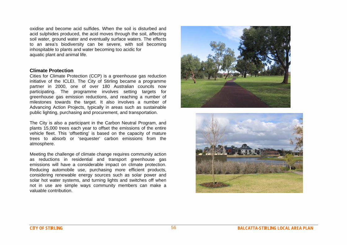
CITY OF STIRLING BALCATTA-STIRLING LOCAL AREA PLAN 56
oxidise and become acid sulfides. When the soil is disturbed and acid sulphides produced, the acid moves through the soil, affecting soil water, ground water and eventually surface waters. The effects to an area’s biodiversity can be severe, with soil becoming inhospitable to plants and water becoming too acidic for aquatic plant and animal life. Climate Protection Cities for Climate Protection (CCP) is a greenhouse gas reduction initiative of the ICLEI. The City of Stirling became a programme partner in 2000, one of over 180 Australian councils now participating. The programme involves setting targets for greenhouse gas emission reductions, and reaching a number of milestones towards the target. It also involves a number of Advancing Action Projects, typically in areas such as sustainable public lighting, purchasing and procurement, and transportation. The City is also a participant in the Carbon Neutral Program, and plants 15,000 trees each year to offset the emissions of the entire vehicle fleet. This ‘offsetting’ is based on the capacity of mature trees to absorb or ‘sequester’ carbon emissions from the atmosphere. Meeting the challenge of climate change requires community action as reductions in residential and transport greenhouse gas emissions will have a considerable impact on climate protection. Reducing automobile use, purchasing more efficient products, considering renewable energy sources such as solar power and solar hot water systems, and turning lights and switches off when not in use are simple ways community members can make a valuable contribution.
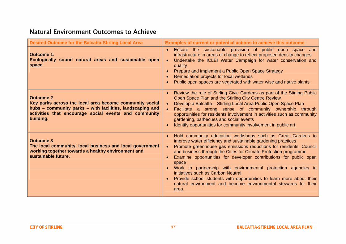
CITY OF STIRLING BALCATTA-STIRLING LOCAL AREA PLAN 57
Natural Environment Outcomes to Achieve Desired Outcome for the Balcatta-Stirling Local Area Examples of current or potential actions to achieve this outcome Outcome 1: Ecologically sound natural areas and sustainable open space
Ensure the sustainable provision of public open space and infrastructure in areas of change to reflect proposed density changes
Undertake the ICLEI Water Campaign for water conservation and quality
Prepare and implement a Public Open Space Strategy Remediation projects for local wetlands Public open spaces are vegetated with water wise and native plants
Outcome 2 Key parks across the local area become community social hubs – community parks – with facilities, landscaping and activities that encourage social events and community building.
Review the role of Stirling Civic Gardens as part of the Stirling Public Open Space Plan and the Stirling City Centre Review
Develop a Balcatta – Stirling Local Area Public Open Space Plan Facilitate a strong sense of community ownership through
opportunities for residents involvement in activities such as community gardening, barbecues and social events
Identify opportunities for community involvement in public art
Outcome 3 The local community, local business and local government working together towards a healthy environment and sustainable future.
Hold community education workshops such as Great Gardens to improve water efficiency and sustainable gardening practices
Promote greenhouse gas emissions reductions for residents, Council and business through the Cities for Climate Protection programme
Examine opportunities for developer contributions for public open space
Work in partnership with environmental protection agencies in initiatives such as Carbon Neutral
Provide school students with opportunities to learn more about their natural environment and become environmental stewards for their area.
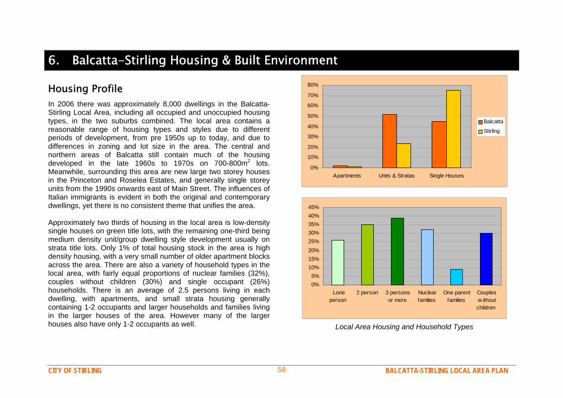
CITY OF STIRLING BALCATTA-STIRLING LOCAL AREA PLAN 58
6. Balcatta-Stirling Housing & Built Environment
Housing Profile In 2006 there was approximately 8,000 dwellings in the Balcatta-Stirling Local Area, including all occupied and unoccupied housing types, in the two suburbs combined. The local area contains a reasonable range of housing types and styles due to different periods of development, from pre 1950s up to today, and due to differences in zoning and lot size in the area. The central and northern areas of Balcatta still contain much of the housing developed in the late 1960s to 1970s on 700-800m2 lots. Meanwhile, surrounding this area are new large two storey houses in the Princeton and Roselea Estates, and generally single storey units from the 1990s onwards east of Main Street. The influences of Italian immigrants is evident in both the original and contemporary dwellings, yet there is no consistent theme that unifies the area. Approximately two thirds of housing in the local area is low-density single houses on green title lots, with the remaining one-third being medium density unit/group dwelling style development usually on strata title lots. Only 1% of total housing stock in the area is high density housing, with a very small number of older apartment blocks across the area. There are also a variety of household types in the local area, with fairly equal proportions of nuclear families (32%), couples without children (30%) and single occupant (26%) households. There is an average of 2.5 persons living in each dwelling, with apartments, and small strata housing generally containing 1-2 occupants and larger households and families living in the larger houses of the area. However many of the larger houses also have only 1-2 occupants as well.
0%
10%
20%
30%
40%
50%
60%
70%
80%
Apartments Units & Stratas Single Houses
Balcatta
Stirling
0%5%
10%15%20%25%30%35%40%45%
Loneperson
2 person 3 personsor more
Nuclearfamilies
One parentfamilies
Couplesw ithoutchildren
Local Area Housing and Household Types
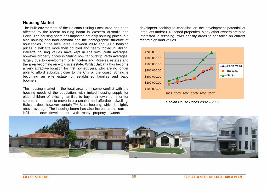
CITY OF STIRLING BALCATTA-STIRLING LOCAL AREA PLAN 59
Housing Market The built environment of the Balcatta-Stirling Local Area has been affected by the recent housing boom in Western Australia and Perth. The housing boom has impacted not only housing prices, but also housing and land demand and the demographic structure of households in the local area. Between 2002 and 2007 housing prices in Balcatta more than doubled and nearly tripled in Stirling. Balcatta housing values have kept in line with Perth averages, however property prices in Stirling now far outstrip Perth averages, largely due to development of Princeton and Roselea estates and the area becoming an exclusive estate. Whilst Balcatta has become a very attractive location for first homebuyers, who are no longer able to afford suburbs closer to the City or the coast, Stirling is becoming an elite estate for established families and baby boomers. The housing market in the local area is in some conflict with the housing needs of the population, with limited housing supply for older children of existing families to buy their own home or for seniors in the area to move into a smaller and affordable dwelling. Balcatta does however contain 7% State housing, which is slightly above average. The housing boom has also increased the rate of infill and new development, with many property owners and
developers seeking to capitalise on the development potential of large lots and/or R40 zoned properties. Many other owners are also interested in rezoning lower density areas to capitalise on current record high land values.
$100,000.00
$200,000.00
$300,000.00
$400,000.00
$500,000.00
$600,000.00
$700,000.00
2002 2003 2004 2005 2006 2007
Perth Metro
Balcatta
Stirling
Median House Prices 2002 – 2007
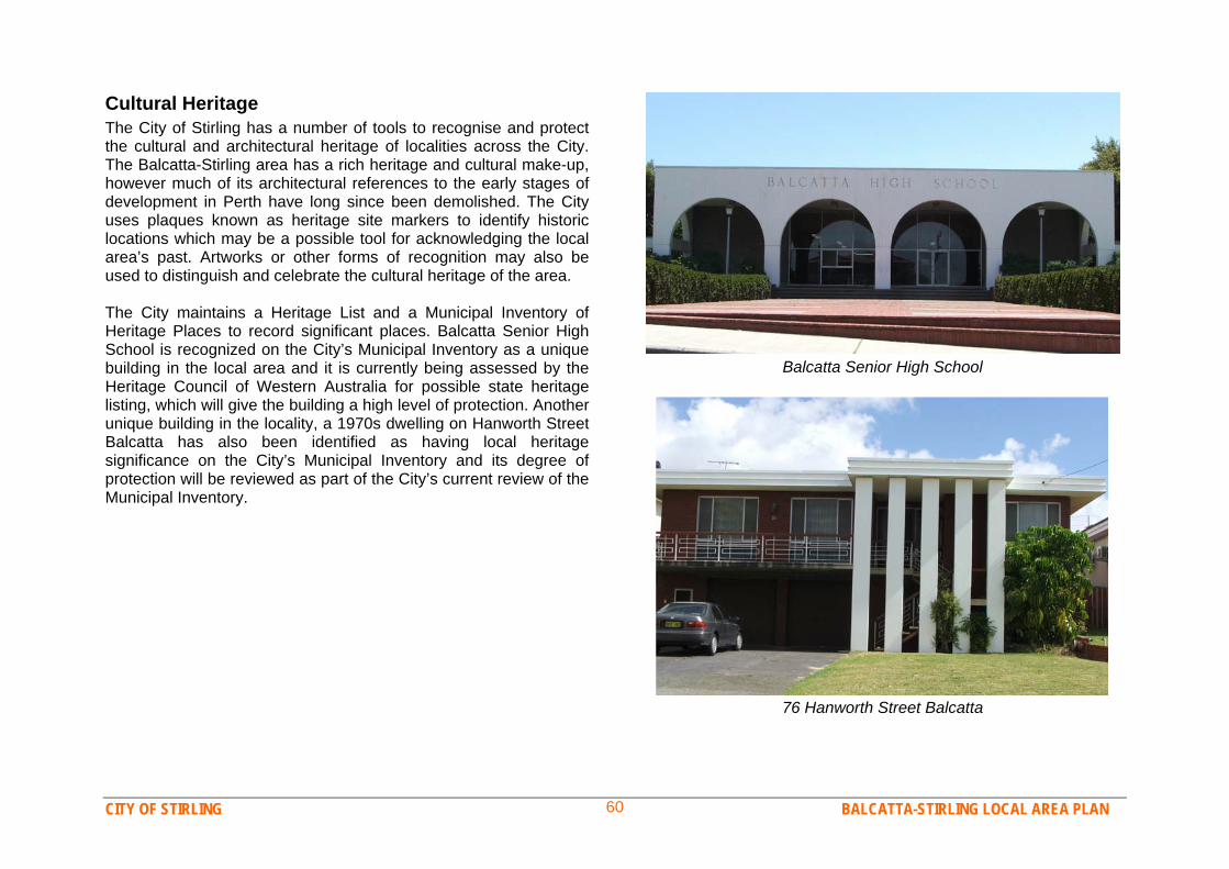
CITY OF STIRLING BALCATTA-STIRLING LOCAL AREA PLAN 60
Cultural Heritage The City of Stirling has a number of tools to recognise and protect the cultural and architectural heritage of localities across the City. The Balcatta-Stirling area has a rich heritage and cultural make-up, however much of its architectural references to the early stages of development in Perth have long since been demolished. The City uses plaques known as heritage site markers to identify historic locations which may be a possible tool for acknowledging the local area’s past. Artworks or other forms of recognition may also be used to distinguish and celebrate the cultural heritage of the area. The City maintains a Heritage List and a Municipal Inventory of Heritage Places to record significant places. Balcatta Senior High School is recognized on the City’s Municipal Inventory as a unique building in the local area and it is currently being assessed by the Heritage Council of Western Australia for possible state heritage listing, which will give the building a high level of protection. Another unique building in the locality, a 1970s dwelling on Hanworth Street Balcatta has also been identified as having local heritage significance on the City’s Municipal Inventory and its degree of protection will be reviewed as part of the City’s current review of the Municipal Inventory.
Balcatta Senior High School
76 Hanworth Street Balcatta

CITY OF STIRLING BALCATTA-STIRLING LOCAL AREA PLAN 61
Built Environment Issues & Opportunities Infill Development and Housing Diversity The Balcatta-Stirling Local Area has both the need and opportunity to increase housing supply and diversity. Environmental, resource and infrastructure issues, combined with the current housing boom are creating increasing demand for infill housing across Perth, where larger lots are subdivided and additional housing is built. Whilst there is capacity for approximately 2,000 additional dwellings if all R40 zoned lots in Balcatta are redeveloped, there are also opportunities and demand elsewhere in the locality for additional housing. Some larger and older properties could be rezoned to bring more people closer to important facilities, such as the train station, Northlands District Centre and employment at Balcatta Industrial Area. Redevelopment of parts of the area also provides the opportunity for increasing housing diversity to meet the changing demographics of the area. The community recognises the need for smaller and appropriately designed housing for the aging population and first homebuyers, particularly where residents would like their children to be able to stay living in the area. Sustainable Building Design The sustainability of the current built form in much of Perth is a significant issue and many in the local community are concerned with the direction of the local area. The increasing size of houses, and the lack of consideration for energy (heating, cooling and lighting) and water use in building design, is producing unsustainable buildings. There is strong demand, and a clear need for the City of Stirling to work with the development industry to address these issues. Recent changes to building legislation in Western Australia is requiring more energy and water efficient buildings, however some members of the local community would like to see the City of Stirling taking more of a lead. In supporting
rezoning of parts of the local area, many residents would like to see this tied to a requirement for ecologically sensitive, resource efficient, design.
Current Housing Capacity in Balcatta-Stirling

CITY OF STIRLING BALCATTA-STIRLING LOCAL AREA PLAN 62
Local Identity Network City strategy 3.3 stresses the importance of ‘providing places with distinctive qualities, and with a role and a purpose, that differentiates them within the city.’ This relates to the concept of “Local Identity”, where it is recognised that sustainable and satisfied community’s have a pride of place and a unique identity, based on the appearance, feel or other characteristics of a location. The Community Survey identified that the people themselves provide the most unique character to the Balcatta-Stirling Local Area, yet many in the forums would like architecture to be bolder or more distinctive to other areas, to give the locality more identity. The high value of the natural character of the area is also evident in community findings. Protecting, promoting and encouraging local character, through celebration of culture and history, and through building on the quality and uniqueness of the natural and built environment is an important part of a successful future of the Balcatta-Stirling Local Area. Better Use of Vacant Land The Balcatta-Stirling Local Area has been progressively transformed over the last 40 years from a rural area to a suburban area. Parcels of vacant land still exist. Sustainability and efficiency principles encourage making better use of underitilised resources or land. This does not mean using up all resources or overdeveloping, rather minimising waste and maximising the use of existing infrastructure or amenities. As the local area has a high standard or existing infrastructure (transport, water supply etc) and community amenities (parks, schools, shops) it is important to make efficient use of land. There are opportunities to rezone some lots to develop housing, such as the earmarked portion of Balcatta High School, the vacant site next to Stirling Medical Centre and the substation site lot on Orr Place. The future of the East Roselea precinct also needs to be determined, as there is much under-utilised land. The environmental issues and community desires need to be carefully
considered and plans made for better use of the land, whether that is public recreation, housing, or a mix of uses. The community is interested in all these options to improve the precinct, however environmental issues must be resolved.
East Roselea is under-utilised
Increasing Land-Use Mix and Activity Network City also encourages increasing land-use mix and activity within local areas. This means having shops, recreation facilities and employment close to housing (land use mix) so that people will be encouraged to walk more and drive less. It also means that there are more people outside shopping, dining or recreating (increased activity). Local residents are in close proximity to employment in the industrial area and in Innaloo/Osborne Park. However some increased diversity and levels of activity within the locality would support community priorities of less car-use, a friendly environment and an ‘alfresco lifestyle’. The City should continue to support low impact home business, and encourage more diversity and activity within and around Northlands and Stirling Village shopping centers.

CITY OF STIRLING BALCATTA-STIRLING LOCAL AREA PLAN 63
Built Environment Outcomes to Achieve Desired Outcome for the Balcatta-Stirling Local Area Examples of current or potential actions to achieve this outcome Outcome 1 Ongoing opportunities for increasing housing in suitable locations and increased housing diversity to provide for changing community needs.
Rezoning of some R20 zoned residential areas to provide for additional housing and a greater range of housing styles and sizes (see map).
Allow and promote a balanced mix of smaller dwellings including one and two bedroom dwellings.
Investigate measures to encourage a proportion of affordable housing development within all medium and large-scale developments.
Outcome 2 Attractive and distinctive building design that contributes to local character and strives to be sustainable.
Encourage attractive and active streetscapes, through high quality housing and other buildings fronting streets, attractive fencing, street trees, footpaths, awnings and some areas of mixed-use (commercial and residential) for instance.
Investigate incentives or policies to improve energy and water efficiency of new and established housing and other buildings.
Start an awards or promotion programme to encourage a high standard of contemporary housing design and sustainable building design.
Implement measures of the City’s Housing Strategy (when adopted) to promote the development of universal design housing and other measures to accommodate aging in place and disability access.
Outcome 3 Making the best use of existing resources and facilities and the opportunities that the local area has to offer, in a sustainable manner.
Encourage additional housing in walking distance of Stirling train station, Northlands and (to a lesser extent) Stirling Village shopping centres.
Provide opportunities for redevelopment of some large lots and older dwellings through rezoning strategically appropriate locations.
Investigate opportunities to make better use of vacant land in the East Roselea area, including its suitability for housing development.
Encourage the redevelopment of vacant sites and buildings, such as the vacant service station at Stirling Village and the proposed substation site on Odin Drive.
Continue to work with schools, sporting groups and other associations to encourage public use of recreation and community facilities.

CITY OF STIRLING BALCATTA-STIRLING LOCAL AREA PLAN 64
Potential Rezoning Locations: R40 & R30 near Stirling train station - between Cedric Street & Princeton Estate. Restricted Business, R80 & R40 immediately around Stirling Village centre (appropriate lot layout to be determined). R30 near Northlands shopping centre between Wanneroo Rd, Delawney, Jones & Amelia Streets; and Between Amelia, Canning & Ida Streets. R25 North of Amelia Street between Cedric & Jones Street. R25 ‘Urban’ zoned area of Balcatta High School. Vacant Rural site corner on Orr Pl rezone to R25 to encourage housing. R30 to provide uniform zoning in southern corner of Odin Dr (below Stirling Grove Reserve).
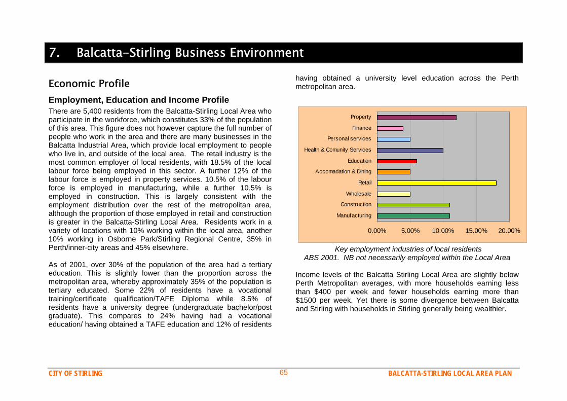
CITY OF STIRLING BALCATTA-STIRLING LOCAL AREA PLAN 65
7. Balcatta-Stirling Business Environment
Economic Profile Employment, Education and Income Profile There are 5,400 residents from the Balcatta-Stirling Local Area who participate in the workforce, which constitutes 33% of the population of this area. This figure does not however capture the full number of people who work in the area and there are many businesses in the Balcatta Industrial Area, which provide local employment to people who live in, and outside of the local area. The retail industry is the most common employer of local residents, with 18.5% of the local labour force being employed in this sector. A further 12% of the labour force is employed in property services. 10.5% of the labour force is employed in manufacturing, while a further 10.5% is employed in construction. This is largely consistent with the employment distribution over the rest of the metropolitan area, although the proportion of those employed in retail and construction is greater in the Balcatta-Stirling Local Area. Residents work in a variety of locations with 10% working within the local area, another 10% working in Osborne Park/Stirling Regional Centre, 35% in Perth/inner-city areas and 45% elsewhere. As of 2001, over 30% of the population of the area had a tertiary education. This is slightly lower than the proportion across the metropolitan area, whereby approximately 35% of the population is tertiary educated. Some 22% of residents have a vocational training/certificate qualification/TAFE Diploma while 8.5% of residents have a university degree (undergraduate bachelor/post graduate). This compares to 24% having had a vocational education/ having obtained a TAFE education and 12% of residents
having obtained a university level education across the Perth metropolitan area.
0.00% 5.00% 10.00% 15.00% 20.00%
Manufacturing
Construction
Wholesale
Retail
Accomadation & Dining
Education
Health & Comunity Services
Personal services
Finance
Property
Key employment industries of local residents ABS 2001. NB not necessarily employed within the Local Area
Income levels of the Balcatta Stirling Local Area are slightly below Perth Metropolitan averages, with more households earning less than $400 per week and fewer households earning more than $1500 per week. Yet there is some divergence between Balcatta and Stirling with households in Stirling generally being wealthier.
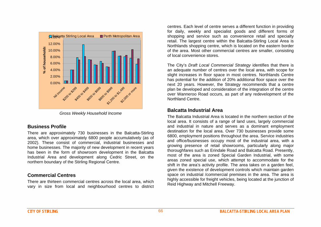
CITY OF STIRLING BALCATTA-STIRLING LOCAL AREA PLAN 66
0.00%
2.00%
4.00%
6.00%
8.00%
10.00%
12.00%
14.00%
Nil inc
ome
$200
to $2
99$4
00 to
$499
$600
to $6
99$8
00 to
$999
$1,20
0 to $
1,499
$2,00
0 or m
ore
% o
f hou
seho
lds
Balcatta Stirling Local Area Perth Metropolitan Area
Gross Weekly Household Income
Business Profile There are approximately 730 businesses in the Balcatta-Stirling area, which over approximately 6800 people accumulatively (as of 2002). These consist of commercial, industrial businesses and home businesses. The majority of new development in recent years has been in the form of showroom development in the Balcatta Industrial Area and development along Cedric Street, on the northern boundary of the Stirling Regional Centre. Commercial Centres There are thirteen commercial centres across the local area, which vary in size from local and neighbourhood centres to district
centres. Each level of centre serves a different function in providing for daily, weekly and specialist goods and different forms of shopping and service such as convenience retail and specialty retail. The largest centre within the Balcatta-Stirling Local Area is Northlands shopping centre, which is located on the eastern border of the area. Most other commercial centres are smaller, consisting of local convenience stores. The City’s Draft Local Commercial Strategy identifies that there is an adequate number of centres over the local area, with scope for slight increases in floor space in most centres. Northlands Centre has potential for the addition of 20% additional floor space over the next 20 years. However, the Strategy recommends that a centre plan be developed and consideration of the integration of the centre over Wanneroo Road occurs, as part of any redevelopment of the Northland Centre. Balcatta Industrial Area The Balcatta Industrial Area is located in the northern section of the local area. It consists of a range of land uses, largely commercial and industrial in nature and serves as a dominant employment destination for the local area. Over 730 businesses provide some 6800, employment positions throughout the area. Service industries and office/businesses occupy most of the industrial area, with a growing presence of retail showrooms, particularly along major thoroughfares such as Erindale Road and Balcatta Road. Presently, most of the area is zoned Special Garden Industrial, with some areas zoned special use, which attempt to accommodate for the shift in the area’s activity profile. The area takes on a garden feel, given the existence of development controls which maintain garden space on industrial /commercial premises in the area. The area is highly accessible for freight vehicles, being located at the junction of Reid Highway and Mitchell Freeway.
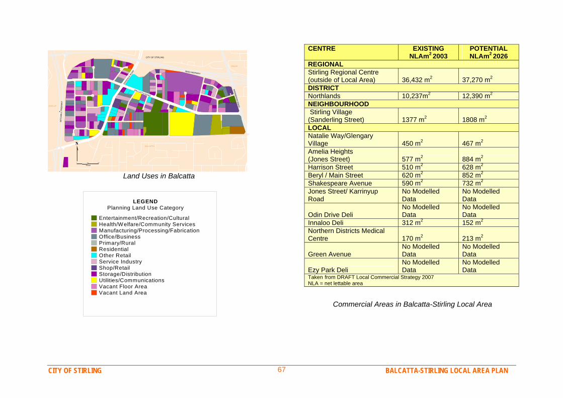
CITY OF STIRLING BALCATTA-STIRLING LOCAL AREA PLAN 67
0 150 300
metres
CITY OF STIRLING
BALCATTA ROAD
ERIN
DALE
ROAD
MIT
CH
ELL
FR
EEW
AY
WAN
NER
OO
RO
AD
REID HIGHWAY
GWELUP
BALCATTA
BALGA
Land Uses in Balcatta
CENTRE EXISTING NLAm2 2003
POTENTIAL NLAm2 2026
REGIONAL Stirling Regional Centre (outside of Local Area) 36,432 m2
37,270 m2
DISTRICT Northlands 10,237m2 12,390 m2 NEIGHBOURHOOD Stirling Village (Sanderling Street) 1377 m2 1808 m2 LOCAL Natalie Way/Glengary Village 450 m2 467 m2 Amelia Heights (Jones Street) 577 m2 884 m2 Harrison Street 510 m2 628 m2 Beryl / Main Street 620 m2 852 m2 Shakespeare Avenue 590 m2 732 m2 Jones Street/ Karrinyup Road
No Modelled Data
No Modelled Data
Odin Drive Deli No Modelled Data
No Modelled Data
Innaloo Deli 312 m2 152 m2 Northern Districts Medical Centre 170 m2 213 m2
Green Avenue No Modelled Data
No Modelled Data
Ezy Park Deli No Modelled Data
No Modelled Data
Taken from DRAFT Local Commercial Strategy 2007 NLA = net lettable area
LEGENDPlanning Land Use Category
Entertainment/Recreation/CulturalHealth/Welfare/Community ServicesManufacturing/Processing/FabricationOffice/BusinessPrimary/RuralResidentialOther RetailService IndustryShop/RetailStorage/DistributionUtilities/CommunicationsVacant Floor AreaVacant Land Area
Commercial Areas in Balcatta-Stirling Local Area
CITY OF STIRLING BALCATTA-STIRLING LOCAL AREA PLAN 68
Stirling City Centre Project The Stirling Regional Centre is the major strategic Regional Centre within the City of Stirling and consists of the Stirling Train Station, Westfield Innaloo Shopping Centre, City of Stirling Administration Centre, Cinema Complex, Osborne Park Hospital, various other businesses and some residential areas. The centre employs some 21,000 people and provides many commercial services for residents of the Balcatta/Stirling Local Area.
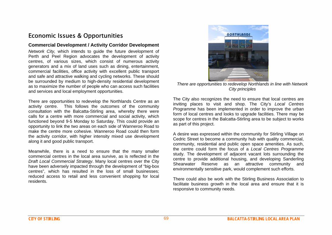
CITY OF STIRLING BALCATTA-STIRLING LOCAL AREA PLAN 69
Economic Issues & Opportunities Commercial Development / Activity Corridor Development Network City, which intends to guide the future development of Perth and Peel Region advocates the development of activity centres, of various sizes, which consist of numerous activity generators and a mix of land uses such as dining, entertainment, commercial facilities, office activity with excellent public transport and safe and attractive walking and cycling networks. These should be surrounded by medium to high-density residential development as to maximize the number of people who can access such facilities and services and local employment opportunities. There are opportunities to redevelop the Northlands Centre as an activity centre. This follows the outcomes of the community consultation with the Balcatta-Stirling area, whereby there were calls for a centre with more commercial and social activity, which functioned beyond 9-5 Monday to Saturday. This could provide an opportunity to link the two areas on each side of Wanneroo Road to make the centre more cohesive. Wanneroo Road could then form the activity corridor, with higher intensity mixed use development along it and good public transport. Meanwhile, there is a need to ensure that the many smaller commercial centres in the local area survive, as is reflected in the Draft Local Commercial Strategy. Many local centres over the City have been adversely impacted through the development of “big-box centres”, which has resulted in the loss of small businesses; reduced access to retail and less convenient shopping for local residents.
There are opportunities to redevelop Northlands in line with Network
City principles The City also recognizes the need to ensure that local centres are inviting places to visit and shop. The City’s Local Centres Programme has been implemented in order to improve the urban form of local centres and looks to upgrade facilities. There may be scope for centres in the Balcatta-Stirling area to be subject to works as part of this project. A desire was expressed within the community for Stirling Village on Cedric Street to become a community hub with quality commercial, community, residential and public open space amenities. As such, the centre could form the focus of a Local Centres Programme study. The development of adjacent vacant lots surrounding the centre to provide additional housing, and developing Sanderling Shearwater Reserve as an attractive community and environmentally sensitive park, would complement such efforts. There could also be work with the Stirling Business Association to facilitate business growth in the local area and ensure that it is responsive to community needs.
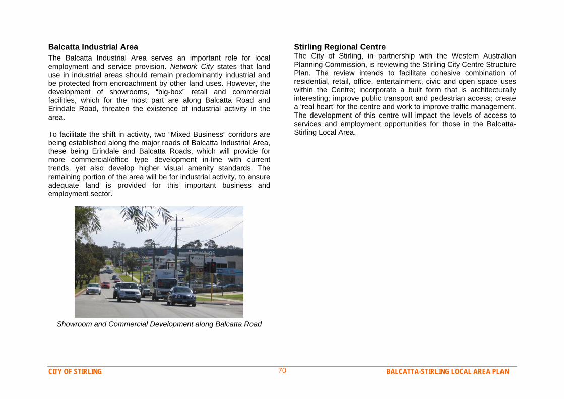
CITY OF STIRLING BALCATTA-STIRLING LOCAL AREA PLAN 70
Balcatta Industrial Area The Balcatta Industrial Area serves an important role for local employment and service provision. Network City states that land use in industrial areas should remain predominantly industrial and be protected from encroachment by other land uses. However, the development of showrooms, “big-box” retail and commercial facilities, which for the most part are along Balcatta Road and Erindale Road, threaten the existence of industrial activity in the area. To facilitate the shift in activity, two “Mixed Business” corridors are being established along the major roads of Balcatta Industrial Area, these being Erindale and Balcatta Roads, which will provide for more commercial/office type development in-line with current trends, yet also develop higher visual amenity standards. The remaining portion of the area will be for industrial activity, to ensure adequate land is provided for this important business and employment sector.
Showroom and Commercial Development along Balcatta Road
Stirling Regional Centre The City of Stirling, in partnership with the Western Australian Planning Commission, is reviewing the Stirling City Centre Structure Plan. The review intends to facilitate cohesive combination of residential, retail, office, entertainment, civic and open space uses within the Centre; incorporate a built form that is architecturally interesting; improve public transport and pedestrian access; create a ‘real heart’ for the centre and work to improve traffic management. The development of this centre will impact the levels of access to services and employment opportunities for those in the Balcatta-Stirling Local Area.
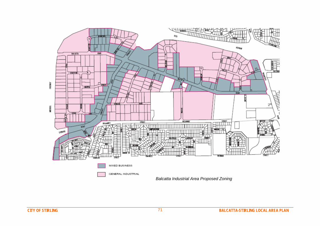
CITY OF STIRLING BALCATTA-STIRLING LOCAL AREA PLAN 71
Balcatta Industrial Area Proposed Zoning

CITY OF STIRLING BALCATTA-STIRLING LOCAL AREA PLAN 72
Economic Outcomes to Achieve Desired Outcome for the Balcatta-Stirling Local Area Examples of current or potential actions to achieve this outcome Outcome 1 The Local Area has a thriving and sustainable business and economic environment with a variety of successful small and large commercial centres, activity corridors, major employment centres and home business.
Adopt the Network City principles of Activity Corridors and Activity Centres in locations such as Wanneroo Road, Main St, Karrinyup Road.
Continue the debate with DPI and others in the development of Activity Corridors and centres.
Increasing residential component of mixed use and Activity Centres from R40 to R80
Investigate measures to encourage commercial and business owners to develop and operate in an environmentally responsible and sustainable way.
The City continues to support appropriate applications for new and expanding businesses, in a timely manner and provides information and assistance to people wishing to develop a new business.
The City continues to make the best use of technology to provide information and support to local business and to simplify the development approval process.
Outcome 2 Balcatta Industrial Area is a successful, innovative and inviting place to work and do business.
A new ‘Mixed Business’ zone is established along the key road axis of the industrial area to provide opportunities for new business.
Land in the majority of the industrial area is zoned for traditional industrial type business to provide land for and protect such business activity.
New design guidelines are introduced for Mixed Business and Industrial development in the area to improve the visual amenity of the area.
The “garden industrial” character of the area is maintained, with landscaping and maintenance of private businesses, verges, medians and reserves.
The City to continue working with the Stirling Business Association and the Small Business Centre in Balcatta to address the needs of local
CITY OF STIRLING BALCATTA-STIRLING LOCAL AREA PLAN 73
business and to consolidate the business precinct as a leading support centre for business development.
Outcome 3 Northlands Shopping Centre is a successful mixed-use activity centre with high quality retail, dining, entertainment and housing in an attractive, vibrant setting.
Consider providing incentives to encourage the creation of more mixed use centres capped to an appropriate scale.
Seek to implement parking options that reflect local land uses to minimise conflict between commercial and residential areas.
Ensure land use changes enhance the amenity of the local area. Prepare Revitalisation Plans for major commercial centres in the area. Seek to better integrate community facilities in public places – shops,
parks, other.
Outcome 4 Stirling City Centre is a true ‘City Centre’ offering excellent commercial, entertainment, employment, transport and community facilities to the Balcatta – Stirling community.
Ensure the sustainable provision of public open space and infrastructure in areas of change to reflect proposed density changes.
To continue work on Stirling City Centre Structure Plan Review and to consider the impact this development has on the Balcatta-Stirling Local Area
Establish a commercial hub or civic centre on Council owned land along Cedric Street.
CITY OF STIRLING BALCATTA-STIRLING LOCAL AREA PLAN 74
8. Balcatta-Stirling Movement Network Transport Profile The movement network of the Balcatta-Stirling Local Area constitutes its roads, footpaths, cycle routes, public transport and any other means of moving around, through and to and from the local area. Much of the road network has been established for many decades, however there is no consistent street pattern and many cul-de-sacs, which reduces the permeability (ability to move through) of the area. The northern suburbs rail line runs along the western boundary of the local area, with Stirling train station at the southwest edge. Residents south of Karrinyup Road are within 1km/15 minutes walk of the station, however at its furthermost boundary residents are up to 3km away. A good level of bus services also surrounds the local area with frequent buses along Wanneroo Road, the Circle Route running along Karrinyup Road and numerous services from Stirling train station. However bus services coming through the local area are limited and infrequent. The majority of precincts, except for the industrial area, are fairly well serviced by footpaths, although the amount of cul-de-sacs reduces the walkability of the area. The Balcatta-Stirling Local Area community can currently be considered highly car reliant. Although residents and workers in the area have many transport choices and are fairly well served in terms of alternative transport choices, car use is by far the preferred means of transport. Approximately 60% of households in the local area have two or more cars and only 5% do not have a car at all. Approximately 70% of people in the area drive alone in a car to work, whilst only 4% of workers take public transport and less than
2% walk or drive. A small proportion of residents work from home, reducing the need for home/work trips. The local area also contains a number of workplaces, which provide good opportunities for people to work close to home, reducing the length of car trips and allowing for walking and cycling. However many workers in the Balcatta Industrial Area and the Stirling City Centre travel from outside of the local area, and most are driving. Research has shown that approximately 85% of workers in the Balcatta Industrial Area drive to work, and although Stirling City Centre is close to the train station, only about 5% of workers take public transport to workplaces in that area. Anecdotal evidence also shows that most school children in the local area are driven to school, a TravelSmart programme with West Balcatta Primary in 2006 showed that between 70-80% of students were driven to school, however there is potential for this to change through the TravelSmart programme.
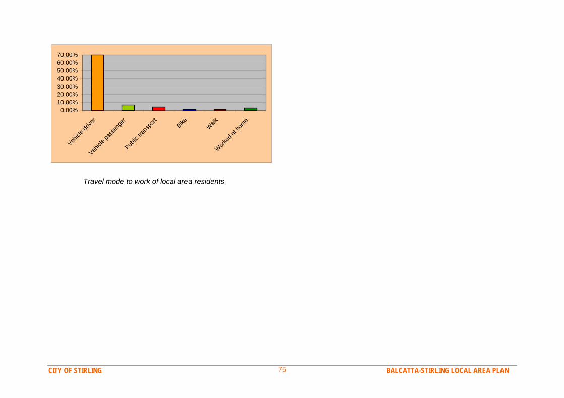
CITY OF STIRLING BALCATTA-STIRLING LOCAL AREA PLAN 75
0.00%10.00%20.00%30.00%40.00%50.00%60.00%70.00%
Vehicle
drive
r Veh
icle pa
ssen
ger
Public
trans
port
Bike
Walk
W
orked
at ho
me
Travel mode to work of local area residents
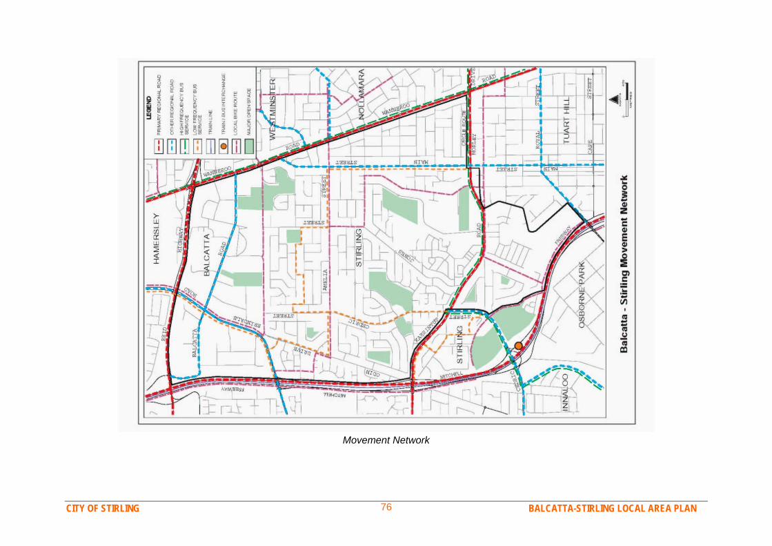
CITY OF STIRLING BALCATTA-STIRLING LOCAL AREA PLAN 76
Movement Network
CITY OF STIRLING BALCATTA-STIRLING LOCAL AREA PLAN 77
Issues & Opportunities Sustainable Transport It is becoming increasingly evident that Perth’s current heavy reliance on single-occupant car use is unsustainable, due to issues such as a looming oil crisis, air pollution, global warming and traffic congestion. The Balcatta-Stirling community is aware of these issues and would like to move towards more sustainable transport options. Whilst many residents and workers are heavily reliant on their cars, there is a strong desire for services, opportunities and encouragement to drive less. The major opportunity and priority is train services yet there is also strong community demand for increased bus services. Stirling Train Station is already a very busy station, thereby limiting opportunities for more bus services to connect with the station. Yet the Stirling City Centre project, TravelSmart projects and the City’s relationship with the Perth Transport Authority could be used to maximise access to the train station, and to initiate a multi-faceted approach to station access consisting of parking, bus, cycling and walking access. The City can also encourage non-vehicle transport by planning for enhanced bus shelter provision and shared paths in the local area. A Connected Movement Network The Balcatta-Stirling community would like a movement network that better connects all types of transport users to local community amenities, such as workplaces, shops, schools and parks. A well planned footpath and cycle network is the best system for providing local people with easy access to local facilities, however there is also strong interest in a shuttle bus, taking residents to places such as Stirling train station, Northlands shopping centre and Innaloo regional centre. The City of Stirling could investigate the feasibility
of this idea and investigate opportunities for shopping centres or other agencies to provide or partner in the service. Healthy and Social Transport Options The added benefit of more sustainable transport options is a more physically active and socially interactive community. Increasing walking and cycling in the Balcatta-Stirling Local Area will help to achieve the Local Area Plan’s community vision of a more socially interactive, healthy, safe and vibrant place. Driving and Parking The main community priority for roads and driving in the area is safety, principally through reducing vehicle speeding on local streets, and efficient traffic movement on Karrinyup Road. The City can utilise a number of community safety and traffic engineering initiatives to manage traffic, yet also relies on community input to identify problem areas. With regard to parking, the two areas of concern are Stirling Train Station (adjacent to the Local Area) and the Balcatta Industrial Area. Parking shortages are experienced in both locations. TravelSmart The City of Stirling runs a range of “TravelSmart” programmes to encourage smarter travel choice. Projects, events and information are provided to encourage people to walk, cycle, car pool and take public transport. In 2006 West Balcatta Primary School set up a Walking School Bus with parents walking groups of students to school. During their TravelSmart Week, students were able to dramatically cut car travel, with one class reducing car trips from 84% to 44%. Balcatta-Stirling youth, residents and businesses have the opportunity to get involved in a number of TravelSmart
CITY OF STIRLING BALCATTA-STIRLING LOCAL AREA PLAN 78
projects and the City can work with individuals and organisations to address transport issues.
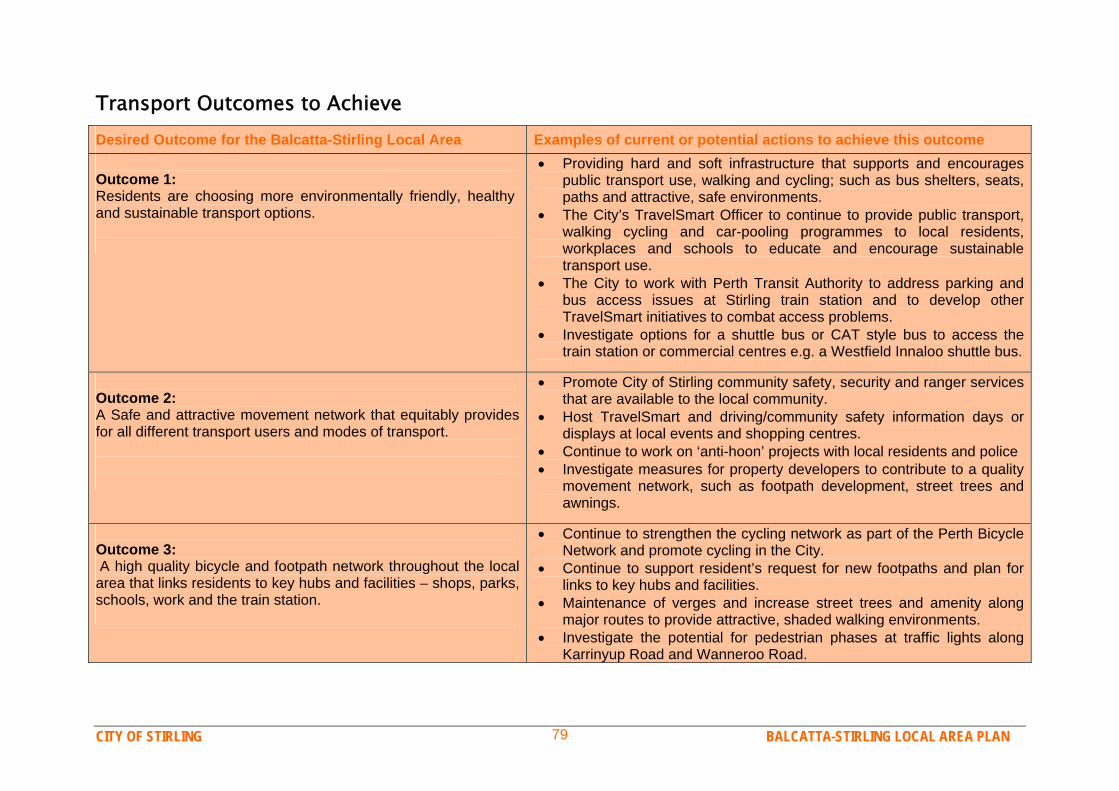
CITY OF STIRLING BALCATTA-STIRLING LOCAL AREA PLAN 79
Transport Outcomes to Achieve Desired Outcome for the Balcatta-Stirling Local Area Examples of current or potential actions to achieve this outcome Outcome 1: Residents are choosing more environmentally friendly, healthy and sustainable transport options.
Providing hard and soft infrastructure that supports and encourages public transport use, walking and cycling; such as bus shelters, seats, paths and attractive, safe environments.
The City’s TravelSmart Officer to continue to provide public transport, walking cycling and car-pooling programmes to local residents, workplaces and schools to educate and encourage sustainable transport use.
The City to work with Perth Transit Authority to address parking and bus access issues at Stirling train station and to develop other TravelSmart initiatives to combat access problems.
Investigate options for a shuttle bus or CAT style bus to access the train station or commercial centres e.g. a Westfield Innaloo shuttle bus.
Outcome 2: A Safe and attractive movement network that equitably provides for all different transport users and modes of transport.
Promote City of Stirling community safety, security and ranger services that are available to the local community.
Host TravelSmart and driving/community safety information days or displays at local events and shopping centres.
Continue to work on ‘anti-hoon’ projects with local residents and police Investigate measures for property developers to contribute to a quality
movement network, such as footpath development, street trees and awnings.
Outcome 3: A high quality bicycle and footpath network throughout the local area that links residents to key hubs and facilities – shops, parks, schools, work and the train station.
Continue to strengthen the cycling network as part of the Perth Bicycle Network and promote cycling in the City.
Continue to support resident’s request for new footpaths and plan for links to key hubs and facilities.
Maintenance of verges and increase street trees and amenity along major routes to provide attractive, shaded walking environments.
Investigate the potential for pedestrian phases at traffic lights along Karrinyup Road and Wanneroo Road.

CITY OF STIRLING BALCATTA-STIRLING LOCAL AREA PLAN 80
9. Balcatta-Stirling Local Area Key Opportunities Key Opportunities Map The following “Balcatta-Stirling Key Opportunities Map” illustrates some of the major opportunities for the local area over the implementation phase of this document, the Balcatta Stirling Local Area Plan. The Local Area Plan will be implemented over the coming 10-15 year period, through actions devised to accomplish the “Outcomes to Achieve” listed throughout the plan. Throughout the plan many actions, activities, programmes, ideas and events have been discussed. The City of Stirling, with the help of community members and other agencies, will seek to implement these initiatives by examining the opportunities, costs and support for different actions and how they can be integrated into all the other important work the City does for its residents and businesses across the City. The following plan shows the major opportunities to achieve the desired outcomes and community vision for the future of the Balcatta Stirling Local Area: Further establishing the Stirling Village precinct as a Community
Hub with shops, medical services and spaces for offices and cafes, within an attractive setting. This will be a key location for people to access amenities and to meet and socialise. The attraction and success of this hub can be strengthened by developing adjacent vacant lots, some additional housing and developing Sanderling Shearwater Reserve as an attractive community and environmentally sensitive park.
Northlands Shopping Centre precinct developing as a true
“Activity Centre” in-line with Network City principles, with more diversity of land use and activity that extends beyond 9-5
Monday to Saturday. A more attractive/exciting environment and more people living nearby would help this Activity Centre to be more successful.
Wanneroo Road developing as an “Activity Corridor” in-line with
Network City principles of medium to high density housing, mixed use, dining and entertainment, commercial and office activity with excellent public transport and safe and attractive walking and cycling networks.
Two “Mixed Business” corridors being established along the
major roads of Balcatta Industrial Area which will provide for more commercial/office type development in-line with current trends, yet also develop with higher visual amenity. The remaining portion of the area will be for industrial activity, to ensure adequate land is provided for industrial activity
Providing opportunities for additional housing in locations that
provide access to the train station, Northlands and Stirling Village Shopping Centres and bus services on Wanneroo Road. Increased population in these areas will also provide support for these important amenities.
Protecting wetlands such as Cedric Grebe and Spoonbill-
Shearwater across the local area, managing changing environmental circumstances and recognising their historical, community and environmental value.
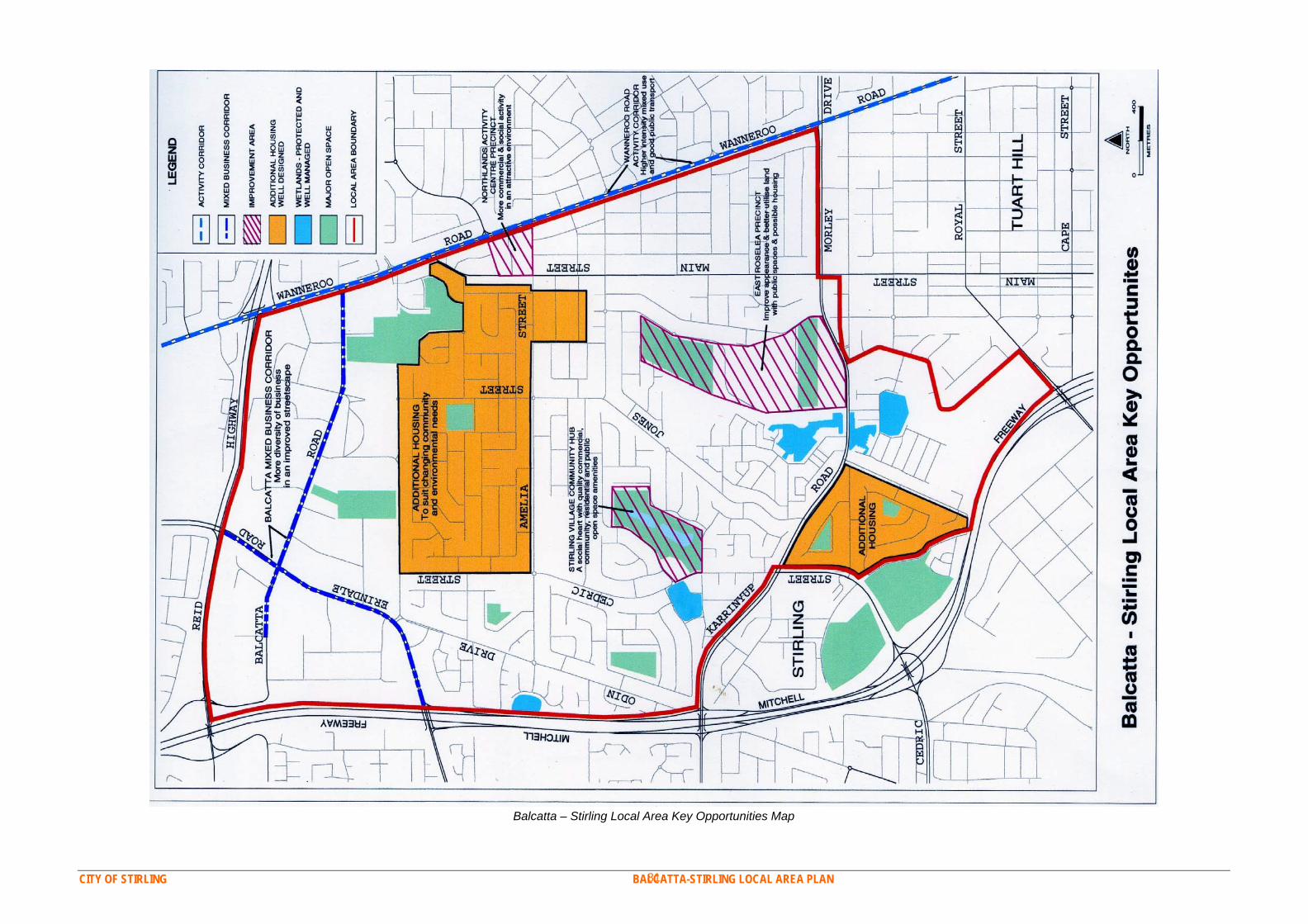
CITY OF STIRLING BALCATTA-STIRLING LOCAL AREA PLAN 81
Balcatta – Stirling Local Area Key Opportunities Map