Badgerys Creek Biodiversity Report - Western...
165
www.smec.com Biodiversity Report Commonwealth land at Badgerys Creek Prepared for Western Sydney Unit Department of Infrastructure and Regional Development October 2014
Transcript of Badgerys Creek Biodiversity Report - Western...

www.smec.com
Biodiversity Report
Commonwealth land at Badgerys Creek
Prepared for Western Sydney Unit Department of Infrastructure and Regional Development
October 2014


Commonwealth-owned Land at Badgerys Creek – Biodiversity Report Page | i
EXECUTIVE SUMMARY
This biodiversity report of Commonwealth-owned land at Badgerys Creek has been prepared
by SMEC Australia Pty Ltd (SMEC) on behalf of the Western Sydney Unit (WSU) of the
Department of Infrastructure and Regional Development. The survey builds upon a
substantial body of existing information about the site to provide an updated baseline of the
status and condition of biodiversity.
In particular, this report focuses on describing the flora and fauna of the Badgerys Creek site,
including nationally and state-listed threatened species and ecological communities and
listed migratory species potentially on or utilising the site.
The methods included a detailed review of relevant literature, ecological databases, reports
and vegetation mapping. Ecological surveys were undertaken on the 22, 23 and 25
September 2014 to provide a ‘snapshot’ of biodiversity values, ground-truth vegetation and
describe broad habitat types. Ecological surveys of the site focused on identifying threatened
flora and fauna habitat and the validation of previous vegetation mapping within the study
area.
It is estimated that approximately 437 hectares of native vegetation occurs in the study area.
The majority of mapped vegetation in the study area is Shale Plains Woodland and Shale
Hills Woodland, both components of Cumberland Plain Woodland and included in the EPBC
listing for Cumberland Plain Shale Woodlands and Shale-Gravel Transition Forest and the
TSC Act listing for Cumberland Plain Woodlands. Only the larger, higher condition remnants
of Cumberland Plain Woodlands are likely to meet the condition thresholds of the EPBC Act
determination.
A small amount of Shale Gravel Transition Forest has been identified from recent field
survey. Shale Gravel Transition Forest is listed separately under the TSC Act but is included
in the EPBC listing for Cumberland Plain Shale Woodlands and Shale-Gravel Transition
Forest. A small area of Moist Shale Woodland has also been identified in the study area
during field survey. This vegetation community is listed separately under the TSC Act and is
part of the EPBC listing for Western Sydney Dry Rainforest and Moist Woodland on Shale.
The condition of vegetation remnants in the supplement to the Draft EIS was largely
described as poor to very poor, however, using current condition assessment methods, field
survey undertaken in preparation of this report found that the vast majority of sites visited
would be classified as moderate to good condition.
The presence of four individuals of Pultenaea parviflora was confirmed in the study area
where sixty-eight (68) individuals had been previously recorded in the same location. A
significant reduction in the size of this population has occurred since the 1999 EIS. This
reduction appears most likely due to observed road widening and possibly fencing works
between the road reserve and adjoining paddock.
Marsdenia viridiflora subsp. viridiflora was also previously recorded in the study area. Field
surveys undertaken by SMEC, confirmed the presence of one individual where it had been
previously located and new records were also found in a second location.
There is potential habitat in the study area for a further seven threatened flora species and
one endangered population, including five species listed under the EPBC Act.

Commonwealth-owned Land at Badgerys Creek – Biodiversity Report Page | ii
The study area contains low to moderate quality fauna habitat, including riparian vegetation,
open woodland and grassland vegetation. Badgerys Creek has been identified as a potential
wildlife corridor in a number of local and regional planning documents.
Potential habitat is available within the study area for 26 threatened fauna species including
the Cumberland Plain Land Snail, woodland birds, microchiropteran bats and the Grey-
headed Flying-fox. Six of the threatened fauna species with potential habitat in the study
area are listed under the EPBC Act. There is also potential habitat for seven migratory
species in the study area.
Biodiversity values within the study area are of national, state, regional and local
significance. A diverse range of vegetation communities (all threatened) occur across both
low-lying plains and hilly terrain in the south-west. The majority of EPBC listed vegetation in
the study area likely to meet condition thresholds occurs as larger remnants with >76% of the
total area in patches of >5 ha and around 40% in patches of >25 ha. There is relatively good
connectivity between remnants along drainage-lines and roadsides, particularly in the
northern and western parts. Patch size and connectivity within the study area is generally
higher than evident on adjoining lands to the north and north-west, comparable to lands to
the south and lower than to the west and east.
Management measures have been recommended to help protect EECs, threatened flora
and fauna habitat. Recommended management measures include weed control, fencing of
good condition remnants, reduction in grazing pressure, protection of hollow bearing and
habitat trees and stormwater management.
This report provides a baseline for any future environmental assessment, however a number
of information gaps have been identified resulting from changes to legislative status of biota
present in the study area, changes in standards required for environmental survey and
assessment, and improved species knowledge.
The information gaps identified include vegetation communities and condition that have not
been accurately described for the study area at the level of detail required for any future
environmental assessment. There is a lack of recent survey effort for threatened flora and
fauna with survey results from the late 1990’s too old for use in future environmental
assessment and unlikely to be accepted by regulatory authorities except as background
information.
To address these information gaps it is recommended that any future environmental
assessment includes detailed vegetation survey, vegetation community and condition
mapping and targeted threatened flora and fauna survey for species likely to occur in the
study area. Future environmental assessment should be guided by current Commonwealth
and State standards and guidelines for vegetation and species survey and assessment.

Commonwealth-owned Land at Badgerys Creek – Biodiversity Report Page | iii
TABLE OF CONTENTS
EXECUTIVE SUMMARY ...................................................................................................... I
TABLE OF CONTENTS ..................................................................................................... III
TABLES ............................................................................................................................ III
FIGURES .......................................................................................................................... IV
ACRONYMS ...................................................................................................................... V
1 INTRODUCTION .......................................................................................................... 7
2 PREVIOUS INVESTIGATIONS .................................................................................. 11
3 RELEVANT LEGISLATION AND GUIDELINES .......................................................... 15
4 METHODOLOGY ....................................................................................................... 27
5 EXISTING ENVIRONMENT ........................................................................................ 33
6 KEY FINDINGS AND INFORMATION GAPS.............................................................. 81
7 RECOMMENDATIONS ............................................................................................... 85
8 REFERENCES AND BIBLIOGRAPHY ....................................................................... 91
APPENDIX 1: VEGETATION COMMUNITY DESCRIPTIONS .......................................... 97
APPENDIX 2: FIELD SURVEY RESULTS ...................................................................... 101
APPENDIX 3: THREATENED FLORA AND FAUNA SPECIES WITH THE POTENTIAL TO
OCCUR IN THE STUDY AREA. ............................................................................... 110
APPENDIX 4: SURVEY GUIDELINES FOR SPECIES WITH A MODERATE TO HIGH
LIKELIHOOD OF OCCURENCE IN THE STUDY AREA .......................................... 151
APPENDIX 5: RISK MATRIX – SPECIES LIKELIHOOD OF OCCURRENCE ................. 163
TABLES
TABLE 1: SPECIES THAT ARE KNOWN OR ARE LIKELY TO HAVE HABITAT WITHIN
THE STUDY AREA AND SURROUNDS ........................................................................ 16
TABLE 2: NSW (DRAFT) BIODIVERSITY STRATEGY (2010 – 2015) KEY THEMES AND
TARGETS ...................................................................................................................... 25
TABLE 3: DESCRIPTION OF VEGETATION WITHIN EACH ZONE .................................... 36
TABLE 4: WEEDS OF NATIONAL SIGNIFICANCE ............................................................. 48
TABLE 5: FRAGMENTATION ANALYSIS OF CANDIDATE EPBC LISTED VEGETATION . 53
TABLE 6: VEGETATION COMMUNITIES IN THE STUDY AREA ........................................ 55
TABLE 7: THREATENED ECOLOGICAL COMMUNITIES IN THE STUDY AREA ............... 55

Commonwealth-owned Land at Badgerys Creek – Biodiversity Report Page | iv
TABLE 8: COMPARISON OF CONDITION ASSESSMENT RESULTS DRAFT EIS 1999
AND SMEC FIELD SURVEY 2014 ................................................................................. 57
TABLE 9: RECENT SURVEY DETAILS FOR PULTENAEA PARVIFLORA AND
MARSDENIA VIRIDIFLORA SUBSP. VIRIDIFLORA ..................................................... 66
TABLE 10: EPBC KOALA GUIDELINES HABITAT ASSESSMENT TOOL ........................... 78
TABLE 11: RECOMMENDED MANAGEMENT MEASURES FOR THE BADGERYS CREEK
SITE ............................................................................................................................... 87
TABLE 12: VEGETATION COMMUNITY EQUIVALENCES ............................................... 100
TABLE 13: DATA COLLECTED DURING VEGETATION PLOT ASSESSMENTS ............. 101
TABLE 14: SITE ATTRIBUTES .......................................................................................... 104
TABLE 15: FAUNA SPECIES RECORDED DURING SEPTEMBER 2014 FIELD SURVEY
.................................................................................................................................... 107
TABLE 16 THREATENED FAUNA AND FLORA SPECIES WITH THE POTENTIAL TO
OCCUR IN THE STUDY AREA ................................................................................... 111
FIGURES
FIGURE 1: LOCATION OF THE STUDY AREA .....................................................................9
FIGURE 2: EXISTING VEGETATION MAPPING (NPWS 2002F) ........................................ 31
FIGURE 3: SURVEY SITES AND CANDIDATE EPBC LISTED CPW .................................. 32
FIGURE 4: VEGETATION COMMUNITIES AND CONDITION ............................................. 50
FIGURE 5: EECS WITHIN THE STUDY AREA. ................................................................... 64
FIGURE 6: THREATENED SPECIES RECORDS IN AND SURROUNDING THE STUDY
AREA. ............................................................................................................................ 69
FIGURE 7: PULTENAEA PARVIFLORA AND MARSDENIA VIRIDIFLORA SUBSP.
VIRIDIFLORA RECORDS IN AND SURROUNDING THE STUDY AREA. ..................... 70
FIGURE 8: KEY FISH HABITAT ........................................................................................... 74
FIGURE 9: DRAFT EPBC ACT REFERRAL GUIDELINES FOR KOALA (DOE 2013A) ....... 76

Commonwealth-owned Land at Badgerys Creek – Biodiversity Report Page | v
ACRONYMS
Acronyms Definition
CAMBA China-Australia Migratory Birds Agreement
cm Centimetres
CPW Cumberland Plain Woodland
DoE Department of the Environment
DIRD Department of Infrastructure and Regional Development
EEC Endangered Ecological Community
EP&A Act Environmental Planning and Assessment Act 1979
EPBC Act Environmental Protection and Biodiversity Conservation Act 1999
FM Act Fisheries Management Act 1994
ha hectare
JAMBA Japan-Australia Migratory Birds Agreement
km Kilometres
KTP Key Threatening Process
LEP Local Environmental Plan
LGA Local Government Area
m Meters
MNES Matters of National Environmental Significance
MSW Moist Shale Woodland
MU Mapping Unit
NPWS National Parks and Wildlife Service, NSW
NSW New South Wales
OEH Office of Environment and Heritage, NSW.
PCT Plant Community Type
ROTAP Rare or Threatened Australian Plants
SEPP State Environmental Planning Policy
SGTF Shale Gravel Transition Forest

Commonwealth-owned Land at Badgerys Creek – Biodiversity Report Page | vi
Acronyms Definition
Site or study area Commonwealth-owned land at Badgerys Creek
SMEC Snowy Mountains Engineering Corporation
TEC Threatened Ecological Community
TSC Act Threatened Species Conservation Act 1995 (NSW)
WoNS Weeds of National Significance
WSU Western Sydney Unit

Commonwealth-owned Land at Badgerys Creek – Biodiversity Report Page | 7
1 INTRODUCTION
1.1 Background
This biodiversity report of Commonwealth-owned land at Badgerys Creek has been
prepared by SMEC Australia Pty Ltd (SMEC) on behalf of the Western Sydney Unit (WSU)
of the Department of Infrastructure and Regional Development. The survey builds upon a
substantial body of existing information about the site to provide an updated baseline of the
status and condition of biodiversity.
In particular, this report focuses on describing the flora and fauna of the Badgerys Creek
site, including nationally and state-listed threatened species and ecological communities and
listed migratory species potentially on or utilising the site.
The biodiversity values of the Badgerys Creek site have been the subject of a number of
past investigations. This includes environmental investigations undertaken for the Draft
Environmental Impact Statement (EIS) that was completed in 1997 and the Supplement to
the Draft EIS completed in 1999, both under the Environment Protection (Impact of
Proposals) Act 1974. The purpose of this report is to build upon the previous work relating to
the biodiversity values of the site and to bring the knowledge up to date. This current work
interprets the findings of the survey in the context of current Commonwealth and NSW
legislation and guidance materials.
1.2 Objectives of the investigation
The objectives of this biodiversity investigation are to:
Update existing baseline environmental information for the Commonwealth-owned land
at Badgerys Creek and specifically the status and condition of the site’s flora, fauna,
cultural heritage and hydrological features.
Undertake a review of published documentation and a desktop study of flora and fauna
relevant to the biodiversity study area, identifying species and communities that may be
present.
Conduct a field survey (flora survey and fauna habitat assessment) of the study area,
with particular attention to species, populations and ecological communities listed under
the Environment Protection and Biodiversity Conservation (EPBC) Act 1999, Threatened
Species Conservation (TSC) Act 1995 and Fisheries Management (FM) Act 1994.
Identify the national, state and regional significance of these biodiversity values in the
broader environmental context of the area surrounding the site.
Analyse any changes in status and condition since the last field surveys undertaken in
the late 1990s and particularly in the context of the requirements of the Environment
Protection and Biodiversity Conservation Act 1999.
Provide baseline data to inform any future environmental assessment(s).
Provide a benchmark against which past and future surveys can be compared.
Identify measures for managing threatened biota at the site.
Make recommendations for possible future site survey program(s) for vegetation
communities, flora and fauna.

Commonwealth-owned Land at Badgerys Creek – Biodiversity Report Page | 8
The biodiversity report will be used to assist the Commonwealth to identify, analyse and
consider options available for the existing and future management of the site.
1.3 Study area
The study area for this biodiversity investigation consists of Commonwealth-owned land at
Badgerys Creek as shown in Figure 1. The study area includes the creeks bordering the site
and the land immediately adjacent to The Northern Road. It also takes in the area
surrounding the land in order to provide a broader context for the survey, particularly with
regard to biodiversity.
The study area is located within the Liverpool LGA and is about 50 kilometres west of the
Sydney CBD, 15 kilometres west of the Liverpool town centre, and about 12 kilometres
south of Penrith. To the west of the site lies the Nepean River and the Blue Mountains,
including the Greater Blue Mountains World Heritage Area. The site is adjacent to the north-
western boundary of the South West Growth Centre and at the far western edge of the
Western Sydney Employment Area.
The land is about 1,700 hectares in size and is currently tenanted. There are about 250 short
term residential rural and commercial leases. Commercial leases include grazing, horse
agistment, a winery, shop, piggery, duck farm and market gardens. The majority of the
properties are rural residential of about two hectares or greater.
The general area is undulating, with rolling hills and valleys, large areas of grassland, and
some areas of flat land. The main land uses are various agricultural purposes and low
density rural residential development. The study area is within the catchment of South Creek
which flows generally northward into the Hawkesbury River.

Commonwealth-owned Land at Badgerys Creek – Biodiversity Report Page | 9
Figure 1: Location of the Study Area


Commonwealth-owned Land at Badgerys Creek – Biodiversity Report Page | 11
2 PREVIOUS INVESTIGATIONS
2.1 Second Sydney Airport Draft EIS & Supplements
The Second Sydney Airport Draft EIS and Supplementary reports identified biodiversity
values of national, state and regional significance at the Badgerys Creek site. Biodiversity
values identified in these investigations and their status at that time (1999) are summarised
below.
2.1.1 National
Cumberland Plain Woodland
The Draft EIS and Supplement identified 315 hectares of Cumberland Plain Woodland
(CPW) within 46 separate remnants in the study area. About 73 hectares of CPW was
assessed as being in moderate condition with the remainder being in poor to very poor
condition (48 out of 53 remnants visited). None of the CPW in the study area was assessed
as being in good condition. The Draft EIS describes remnants within the study area as of
‘regional significance’. Cumberland Plain Woodland was listed as an Endangered Ecological
Community under Schedule 1 of the Commonwealth Endangered Species Protection Act
1992 and Schedule 1 of the NSW Threatened Species Conservation Act 1995 (TSC Act).
Cumberland Plain Woodland has since been listed (in 2009) as a Critically Endangered
Ecological Community under the Environment Protection and Biodiversity Conservation Act
1999 (EPBC Act). It is now referred to under the EPBC Act as Cumberland Plain Shale
Woodlands and Shale-Gravel Transition Forest.
Pultenaea parviflora
The Draft EIS and Supplement identified one plant species of national significance in the
study area. Pultenaea parviflora was at the time listed on Schedule 2 (Vulnerable) of the
Commonwealth Endangered Species Protection Act 1992. The population was recorded as
consisting of approximately 68 individuals occurring on both sides of Longleys Road
between Ferndale and Taylors Road.
The population was assessed as being small in size, in good condition and at the southern
limit of the species’ distribution which is predominantly the northern Cumberland Plain.
2.1.2 State
Sydney Coastal River-flat Forest
The Draft EIS and Supplement identified about 19 hectares of River-flat Forest within 17
separate remnants in the study area. All of the River-flat Forest vegetation in the study area
was assessed as being in poor to very poor condition. River-flat Forest was listed as the
Endangered Ecological Community Sydney Coastal River Flat Forest under Schedule 1 of
the TSC Act. It has since (in 2004) been incorporated into the River-flat Eucalypt Forest on
Coastal Floodplains EEC.
Although this vegetation in the study area was in poor condition, it is present along Badgerys
Creek and was assessed as having regional significance as a riparian wildlife corridor.
Commonwealth-owned Land at Badgerys Creek – Biodiversity Report Page | 12
Cumberland Plain Land Snail
The Cumberland Plain Land Snail was, and still is, listed as endangered under Schedule 1 of
the TSC Act. Over 90 individual Cumberland Plain Land Snails were observed within 14
Cumberland Plain Woodland remnants within the Badgerys Creek site during surveys
undertaken for the supplementary report. The populations of Cumberland Plain Land Snail
present in the study area though fragmented were considered to represent a ‘cluster’ of state
significance. These populations are thought to be at the western edge of the known
distribution of the species.
Green and Golden Bell Frog
The Green and Golden Bell Frog was, and still is, listed as Endangered under the TSC Act.
The Supplement to the Draft EIS included targeted surveys and assessment of potential
Green and Golden Bell Frog habitat. These investigations concluded that the survey results,
previous surveys, and National Parks and Wildlife Service (1998) records for the local area
indicated that the Green and Golden Bell Frog is not likely to be present within the sites of
the airport options. Based on available information, the Supplementary report concluded that
the airport sites are not considered to be significant habitat for the Green and Golden Bell
Frog or critical for the survival of the species. Since the 1999 EIS, the Green and Golden
Bell Frog has also been listed as vulnerable under the EPBC Act.
Eastern Bentwing-bat and Eastern False Pipistrelle
The Eastern Bentwing-bat and Eastern False Pipistrelle were recorded at the Badgerys
Creek site during surveys for the Supplement. They were both listed as Vulnerable under
Schedule 2 of the TSC Act. There was little discussion of the value of the habitat in the study
area for these species in a regional or state context with the report stating that they are
mobile species whose regional distribution is poorly known but they are likely to be
uncommon. The impact assessment provided did not conclude whether the airport options
as proposed in the Supplement to the EIS, would affect the regional distribution of these
species.
2.1.3 Regional
The Draft EIS and Supplement identified a number of species as being of ‘regional
significance’. There is no statutory basis for this status, however, a number of these species
have since been listed under the EPBC Act and/or TSC Act.
The Supplementary report lists 48 flora species and 38 fauna species recorded in the study
area as being ‘regionally significant’ meaning the Badgerys Creek site is considered to make
a substantial contribution to conservation at the Regional level (rather than at the State
level).
Benson and McDougall (1991), Benson (1992), Keith (1994) and Bofeldt (1996) are used in
the supplement as authorities on species and vegetation of regional significance. Regional
significance for fauna is assessed by referring to relevant government reports, consulting
experts familiar with the area, referring to the literature and by drawing upon previous field
experience of the consultants. Species of regional significance identified in the Western
Sydney Urban Bushland Biodiversity Survey reports (NPWS 1997) have also been included.

Commonwealth-owned Land at Badgerys Creek – Biodiversity Report Page | 13
Marsdenia viridiflora subsp. viridiflora
Marsdenia viridiflora subsp. viridiflora was identified in the Draft EIS as a flora species of
regional significance. This species is now listed as an endangered population under the TSC
Act, ‘Marsdenia viridiflora R. Br. subsp. viridiflora population in the Bankstown, Blacktown,
Camden, Campbelltown, Fairfield, Holroyd, Liverpool and Penrith local government areas’.
Migratory species
Species listed under International Treaties are those listed under the Japan-Australia
Migratory Birds Agreement (JAMBA) and the China-Australia Migratory Birds Agreement
(CAMBA).
The Draft EIS and Supplementary report found that the study has potential habitat for five
species listed under international agreements. These are the Great Egret, Cattle Egret,
Latham’s Snipe, Fork-tailed Swift and White-throated Needletail. These species are now
considered MNES under the EPBC Act.
Aquatic habitat
The Draft EIS and Supplementary report found that the aquatic value of the Badgerys Creek
site was low overall although the streams are of ‘local’ significance. Major habitat
degradation was apparent in all streams examined. High flows had facilitated bank erosion
and carried high loads of suspended solids which rendered the stream turbid.
Water quality throughout the site was found to be generally poor. This included low levels of
dissolved oxygen which were often found to be below the level recommended for support of
aquatic fauna, presumably from processes of organic decay and algal respiration. Despite
this introduced fish species Gambusia and Carp were found to be common.
High levels of total nitrogen and phosphorous were found at a majority of sample locations,
exceeding ANZECC guidelines. High numbers of algal cells were found at selected sites.
This was broadly attributed to influences such as agricultural runoff and discharge from
intensive farming.
Assessment of aquatic macro invertebrates found an average of 32 percent of animals from
the most sensitive category and only 22 percent of animals from the pollutant tolerant group.
This suggests that the ecosystem was slightly impoverished but still allows development of
sensitive fauna.
2.2 Western Sydney Urban Bushland Biodiversity Survey
The Western Sydney Urban Bushland Biodiversity Survey (WSUBBS), published in 1997,
outlines the type and status of urban bushland in Western Sydney. The study discusses
general trends and changes associated with flora and fauna in the area, with specific
reference to historic and ongoing threats and conservation and management measures.
While the WSUBBS does not focus on specific areas it does provide an overview of the
status of flora, fauna and ecological communities found within and around the
Commonwealth-owned land at Badgerys Creek. In particular, the survey notes that
Cumberland Plain Woodland (listed as endangered in 1997, rather than the current critically
endangered) was under particular threat from clearing for agricultural and residential
purposes, alongside several other threats (e.g. invasive species, declining water quality etc.)

Commonwealth-owned Land at Badgerys Creek – Biodiversity Report Page | 14
The WSUBBS briefly discusses the Badgerys Creek Corridor between The Northern Road
and Elizabeth Drive. The report notes the presence of Swamp Oak Forest dominated by
Casuarina glauca intergrading with Red Gum-Cabbage Gum Forest and indicates three
species considered to be vulnerable in western Sydney that have been recorded in the area:
Angophora subvelutina, Eriochloa pseudoacrotricha and Eucalyptus amplifolia.
Recommendations arising from the WSUBBS report include the protection of vulnerable
plant species and protection of the riparian corridor generally.

Commonwealth-owned Land at Badgerys Creek – Biodiversity Report Page | 15
3 RELEVANT LEGISLATION AND GUIDELINES
3.1 Commonwealth
3.1.1 Environment Protection and Biodiversity Conservation Act 1999
The Environment Protection and Biodiversity Conservation Act 1999 (EPBC Act) is the
Australian Government’s central piece of environmental legislation and commenced
operation on 16 July 2000. It provides the legal framework to protect and manage nationally
and internationally important flora, fauna, ecological communities and heritage places
defined in the Act as matters of national environmental significance. In addition, the EPBC
Act confers jurisdiction over actions that have a significant impact on the environment where
the actions affect, or are taken on, Commonwealth land or are undertaken by the
Commonwealth or a Commonwealth agency (even if that significant impact is not on one of
the nine matters of ‘national environmental significance’).
The nine matters of national environmental significance (MNES) to which the EPBC Act
applies are:
world heritage properties
national heritage places
wetlands of international importance (often called 'Ramsar' wetlands after the
international treaty under which such wetlands are listed)
nationally threatened species and ecological communities
migratory species
Commonwealth marine areas
the Great Barrier Reef Marine Park
nuclear actions (including uranium mining)
a water resource, in relation to coal seam gas development and large coal mining
development.
MNES considered in this biodiversity report include listed threatened species, populations
and ecological communities as well as migratory species protected under international
agreements. Particular consideration has been given to threatened biota that occur or could
occur in the study area.
Cumberland Plain Recovery Plan
The Cumberland Plain Recovery Plan has been prepared under the Commonwealth
Environment Protection and Biodiversity Conservation Act 1999 (EPBC Act) and the NSW
Threatened Species Conservation Act 1995 (TSC Act) to promote the recovery of threatened
species, populations and ecological communities on the Cumberland Plain. The recovery
plan aims to guide investment in the recovery of the threatened biodiversity of Western
Sydney, and to inform future urban planning decisions.
The Cumberland Plain Recovery Plan addresses the following species that are known or are
likely to have habitat within the study area and surrounds:

Commonwealth-owned Land at Badgerys Creek – Biodiversity Report Page | 16
Table 1: Species that are known or are likely to have habitat within the study area and
surrounds
Species/population/community EPBC Act status TSC Act status
Flora species
Allocasuarina glareicola Endangered Endangered
Dillwynia tenuifolia Vulnerable Vulnerable
Juniper-leaved Grevillea (Grevillea juniperina subsp.
juniperina)
- Vulnerable
Micromyrtus minutiflora Vulnerable Endangered
Sydney Plains Greenhood (Pterostylis saxicola) Endangered Endangered
Pultenaea parviflora Vulnerable Endangered
Fauna species
Cumberland Plain Land Snail (Meridolum
corneovirens)
- Endangered
Populations
Marsdenia viridiflora R. Br subsp. viridiflora
population in the Bankstown, Blacktown, Camden,
Fairfield, Holroyd, Liverpool and Penrith LGAs.
- Endangered
Ecological communities
Cumberland Plain Woodland (listed under the EPBC
Act as Cumberland Plain Shale Woodlands and
Shale-Gravel Transition Forest)
Critically Endangered Critically Endangered
Shale Gravel Transition Forest (listed under the
EPBC Act as Cumberland Plain Shale Woodlands
and Shale-Gravel Transition Forest)
Critically Endangered Endangered
Moist Shale Woodland (listed under the EPBC Act as
Western Sydney Dry Rainforest and Moist Woodland
on Shale).
Critically Endangered Endangered
River-flat Eucalypt Forest (previously Sydney
Coastal River Flat Forest) Endangered
- Endangered
Species Recovery Plans
There are species specific national recovery plans in place for the following EPBC listed
threatened species that have potential habitat in the study area:

Commonwealth-owned Land at Badgerys Creek – Biodiversity Report Page | 17
Large-eared Pied Bat
Swift Parrot
Glossy Black Cockatoo
Regent Honeyeater
Persoonia nutans
Pimelea spicata
Acacia pubescens
Key Threatening Processes
The EPBC Act provides for the identification and listing of key threatening processes. A
threatening process is defined as a key threatening process if it threatens or may threaten
the survival, abundance or evolutionary development of a native species or ecological
community
The following Key Threatening Processes listed under the EPBC Act are likely to be
operating within the study area:
Aggressive exclusion of birds from potential woodland and forest habitat by over-
abundant noisy miners (Manorina melanocephala)
Competition and land degradation by rabbits.
Dieback caused by the root-rot fungus (Phytophthora cinnamomi).
Infection of amphibians with chytrid fungus resulting in chytridiomycosis.
Land clearance.
Loss and degradation of native plant and animal habitat by invasion of escaped garden
plants, including aquatic plants.
Predation by European red fox.
Threat Abatement Plans
Threat abatement plans provide for the research, management, and any other actions
necessary to reduce the impact of a listed key threatening process on native species and
ecological communities. Threat abatement plans potentially relevant to the study area
include:
Threat abatement plan for competition and land degradation by rabbits.
Threat abatement plan for disease in natural ecosystems caused by Phytophthora
cinnamomi.
Threat abatement plan for infection of amphibians with chytrid fungus resulting in
chytridiomycosis.
Threat abatement plan for predation by European red fox.
3.1.2 National Biodiversity Conservation Strategy
Australia‘s Biodiversity Conservation Strategy (2010-2030) identifies three priorities for
action to help stop, and then reverse, the current decline in Australia‘s biodiversity.
Engaging all Australians in biodiversity conservation.
Building Ecosystem Resilience in a changing climate.
Getting measurable results.

Commonwealth-owned Land at Badgerys Creek – Biodiversity Report Page | 18
The Strategy describes ‘ecosystem resilience’ as the capacity of an ecosystem to respond to
changes and disturbances, yet retain its basic functions and structures. It lists a number of
threats to ecosystem resilience that are relevant to the study area, including:
Habitat loss, degradation and fragmentation.
Invasive species.
Unsustainable use and management of natural resources.
Changes to the aquatic environment and water flows.
Changing fire regimes.
Climate change.
A priority action identified in the strategy is building ecosystem resilience in a changing
climate by:
Protecting diversity.
Maintaining and re-establishing ecosystem functions.
Reducing threats to biodiversity.
3.1.3 National Weeds Strategy
Under the National Weeds Strategy, 32 Weeds of National Significance (WoNS) have been
identified by Australian governments based on their invasiveness, potential for spread and
environmental, social and economic impacts. Individual landowners and managers are
ultimately responsible for managing WoNS. Presence of WoNS in the study area is
discussed in Section 5.3.2.
3.1.4 EPBC Significant Impact Guidelines 1.1 (Matters of National
Environmental Significance)
The significant impact guidelines provide overarching guidance on determining whether an
action is likely to have a significant impact on a matter protected under national environment
law, the EPBC Act.
The purpose of these guidelines is to assist any person who proposes to take an action to
decide whether or not they should submit a referral to the Australian Government
Department of the Environment (DoE) for a decision by the Australian Government
Environment Minister on whether assessment and approval is required under the EPBC Act.
Under the EPBC Act an action will require approval from the minister if the action has, will
have, or is likely to have, a significant impact on a matter of national environmental
significance. These guidelines outline a ‘self-assessment’ process, including detailed criteria,
to assist persons in deciding whether or not referral may be required.
These guidelines would be applied during any future environmental assessment.
3.1.5 EPBC Significant Impact Guidelines 1.2: Actions on, or impacting
upon, Commonwealth land, and actions by Commonwealth agencies.
These guidelines assist in deciding whether or not to submit a referral to the DoE for a
decision by the Australian Government Environment Minister on whether assessment and
approval is required under the EPBC Act.
Commonwealth-owned Land at Badgerys Creek – Biodiversity Report Page | 19
The guidelines apply to:
any person who proposes to take an action which is either situated on Commonwealth
land or which may impact on Commonwealth land, and/or
representatives of Commonwealth agencies who propose to take an action that may
impact on the environment anywhere in the world.
The guidelines outline a ‘self-assessment’ process to assist in determining whether an action
is likely to have a significant impact on the environment and are to be considered in
conjunction with the EPBC Significant Impact Guidelines 1.1, which deal with matters of
national environmental significance.
3.1.6 Draft EPBC Act Referral Guidelines for the Vulnerable Koala
These guidelines aim to provide guidance to proponents regarding whether an action is likely
to require referral to the Commonwealth Department of the Environment due to impacts on
the koala. In doing so the guidelines seek to:
Promote avoidance and mitigation of significant impacts on the koala.
Promote and ensure the recovery of the koala through the regulatory requirements of the
EPBC Act.
Promote a clear, consistent and transparent approach for proponents deciding whether
to refer an action to the Department for approval and assessment of significant impacts
on the koala.
Promote streamlined decision-making and approval processes.
As the study area is identified as known or likely/potential habitat for the koala these
guidelines may be important in any future environmental assessment. Should the koala be
identified as likely to be present on the site, the potential impact of proposed activities on the
species would need to be considered as part of the assessment.
An initial application of the guidelines has been undertaken based upon feed tree species
identified during initial site inspections (Section 5.12.1 ). In this instance the process
identified that a referral to the DoE would not be required. It is however advised that this
process is repeated for any future environmental assessment in order to confirm these
findings. It is also recommended that koala feed trees are specifically searched for and
noted when undertaking surveys on behalf of the EIS in order to better inform this process.
3.1.7 Significant Impact Guidelines for the Green and Golden Bell Frog
This policy statement is designed to assist in determining whether a proposed action is likely
to have a significant impact on the green and golden bell frog. This policy statement provides
guidance to project proponents on how they can meet applicable legal obligations of the
EPBC Act. It guides the user through several phases broadly based around the following
questions:
Does the site support the green and golden bell frog?
What impacts (direct and indirect) could result from the action?
Could any of these impacts exceed the impact thresholds?
What measures could be taken to reduce the level of impact?

Commonwealth-owned Land at Badgerys Creek – Biodiversity Report Page | 20
These guidelines also include best practice survey methodology. It is recommended that any
amphibian surveys undertaken at the site take account of these during design and
implementation.
Advice on avoidance or mitigation of significant impacts upon green and golden bell frog
populations and individuals are also provided. It is recommended that these potential actions
are recognised early for the existing and future management of the site and in any future
environmental assessment.
3.1.8 EPBC Act Administrative Guidelines on Significance - Supplement
for the Grey-headed Flying-fox
The purpose of this document is to provide general guidance to assist in determining
whether a proposed activity is likely to have a significant impact on the grey-headed flying
fox and whether a referral to DoE is required. These guidelines provide guidance to project
proponents on how they can meet applicable legal obligations of the EPBC Act.
Whilst the guidelines are aimed primarily at the 2003-2004 fruiting season it also provides
pertinent information on the ecology of the grey-headed flying fox and the legislative
implications of disturbance and certain types of management actions. This is relevant to the
Badgerys Creek site as desktop surveys found this species has been identified within 10 km
of the site.
3.1.9 EPBC Species Survey Guidelines
The Commonwealth Department of the Environment have prepared a range of survey
guidelines that provide advice on survey techniques for specific threatened species and give
guidance on the Department's expectations with regard to surveys. The following survey
guidelines are available:
Survey Guidelines for Australia's threatened Bats.
Survey Guidelines for Australia's threatened Birds.
Survey Guidelines for Australia's threatened Frogs.
Survey guidelines for Australia's threatened fish.
Survey guidelines for Australia's threatened mammals.
Survey guidelines for Australia's threatened reptiles.
Draft survey guidelines for Australia's threatened orchids.
It is recommended that these guidelines are consulted as part of any future environmental
assessment. It is recommended that all field surveys are undertaken to these standards,
where relevant.
3.1.10 EPBC Environmental Offsets Policy and Offsets Assessment Guide
The EPBC Environmental Offsets Policy provides guidance on the role of offsets in
environmental impact assessments, and how the DoE considers the suitability of a proposed
offset. It aims to improve environmental outcomes through the consistent application of best
practice offset principles, provide more certainty and transparency, and encourage advanced
planning of offsets.

Commonwealth-owned Land at Badgerys Creek – Biodiversity Report Page | 21
Offsets are measures that compensate for the residual impacts of an action on the
environment, after avoidance and mitigation measures are taken. Where appropriate, offsets
are considered during the assessment phase of an environmental impact assessment under
the EPBC Act. The suitability of a proposed offset is considered as part of the decision to
approve or not approve a proposed action under the EPBC Act.
The Offsets assessment guide, which accompanies the policy, utilises a balance sheet
approach to measure impacts and offsets. It applies where the impacted protected matter is
a threatened species or ecological community. The Offsets assessment guide is a tool that
has been developed for DoE staff to assess the suitability of offset proposals. The guide is
also available to proponents to assist with planning for future development proposals and
estimating future offset requirements.
3.2 New South Wales
3.2.1 Threatened Species Conservation Act 1995
The NSW Threatened Species Conservation Act 1995 (TSC Act) protects threatened flora
and fauna species, endangered populations and ecological communities and their habitats
within NSW. This report describes threatened species, populations or ecological
communities that occur or could occur in the study area. They are discussed in Section 5.5,
5.6, and Appendix 3 of this report.
Recovery Plans
In addition to the national recovery plans identified in Section 3.1.1 under the EPBC Act, a
NSW Recovery Plan is in place for the Large Forest Owls Powerful Owl (Ninox strenua),
Sooty Owl (Tyto tenebricosa) and Masked Owl (Tyto novaehollandiae) (DEC, 2006a).
Threatened Species Priority Action Statement (PAS)
The NSW Threatened Species Priorities Action Statement (PAS) identifies strategies to help
recover threatened plants and animals and establishes priorities to implement these
strategies. The PAS identifies actions for all listed species, populations and ecological
communities. It also identifies actions to manage listed key threatening processes.
Key Threatening Processes
A threat can be listed under the Threatened Species Conservation Act 1995 (TSC Act) as a
'key threatening process' if it adversely affects threatened species, populations or ecological
communities or if it could cause species, populations or ecological communities that are not
threatened to become threatened. Key threatening processes are considered in an
assessment of significance where a proponent considers whether a development constitutes
or exacerbates a key threatening process. Key threatening processes relevant to the study
are considered in Section 5.13.
Threat Abatement Plans
A threat abatement plan (TAP) is a statutory document prepared and approved in
accordance with the TSC Act. Ministers and public authorities are required to take any
appropriate action available to them to implement the measures in the plan. The terms of
threat abatement plans are to be taken into account by consent and determining authorities

Commonwealth-owned Land at Badgerys Creek – Biodiversity Report Page | 22
when they are considering development applications under the planning legislation. TAPs
relevant to the study area are considered in Section 5.13.
Threatened Species Survey and Assessment Guidelines
The NSW OEH has prepared the Threatened Species Survey and Assessment Guidelines to
inform the process of survey and assessment of threatened biodiversity by describing and
discussing:
the chronological steps within the threatened biodiversity assessment process;
the strategies, policies and legislation relevant to threatened biodiversity;
appropriate survey techniques for detecting threatened biodiversity;
the information required for an Assessment of Significance; and
reporting requirements and standards.
The Guidelines aim to provide a consistent and systematic approach to survey and
assessment of threatened biodiversity. In particular, the guidance provided will assist in:
setting appropriate aims for survey and assessment of threatened biodiversity;
the planning of suitable survey techniques and the appropriate level of effort;
the provision of adequate reporting;
a justifiable interpretation of results; and
making an informed and justifiable decision.
It is intended that they are adapted to fit the requirements of individual animal and plant
surveys by outlining field techniques and considerations, relevant legislation, and the
relevant method of impact assessment for threatened biodiversity. The Guidelines will assist
applicants, proponents, investigators and decision-makers by identifying their
responsibilities, outlining relevant procedures and providing considerations for the
interpretation of results.
Species specific impact assessment guidelines
The NSW Office of Environment and Heritage has prepared Environmental Impact
Assessment (EIA) Guidelines for the following species, populations and ecological
communities that are known or have potential habitat in the study area. The guidelines
include species specific survey requirements.
Cynanchum elegans
Dillwynia tenuifolia
Pultenaea parviflora
Acacia pubescens
Grevillea juniperina
Grevillea parviflora
Pimelea spicata
Green and Golden Bell Frog
Cumberland Plain Land Snail
The following best practice guidelines are also available for management:
Recovering Bushland on the Cumberland Plain Best Practice Guidelines.
Best Practice Guidelines for the Grey-headed Flying-fox.
Commonwealth-owned Land at Badgerys Creek – Biodiversity Report Page | 23
3.2.2 Fisheries Management Act 1994
The Fisheries Management Act 1994 protects fishery resources within the State. The
objectives of the Act include the conservation of fish stocks and key fish habitats, threatened
species, populations and ecological communities of fish and marine vegetation.
Section 5.10 of this report considers potential habitat of threatened fish species that may
occur in the study area.
Policy and guidelines for fish habitat conservation and management
This NSW Department of Primary Industries (DPI) developed the Policy and guidelines for
fish habitat conservation and management to promote compliance with legislation relating to
fish habitat conservation and management. It aims to assist local and state government
authorities, proponents of developments and their advisers, and individuals or non-
government organisations concerned with the planning and management of aquatic
resources.
NSW DPI takes these policies and guidelines into account when assessing and either
approving or refusing proposals for developments or other activities affecting fish habitats,
with a particular focus on ‘key fish habitats’.
3.2.3 Noxious Weeds Act 1993
Under the NSW Noxious Weeds Act 1993, public authorities are required to control noxious
weeds which are likely to spread to adjoining land. Section 5.3.2 of this report considers
weeds declared as noxious in the Liverpool LGA that occur within the study area.
3.2.4 Environmental Planning and Assessment Act
The Environmental Planning and Assessment Act 1979 (EP&A Act) is the primary law
regulating land use in NSW. The EP&A Act provides for environmental planning instruments
(EPI) to be made to guide the process of development and to regulate competing land uses.
Currently, there are two types of EPIs under the Act:
Local environmental plans (LEP) that guide planning decisions for a local government
area (LGA).
State environmental planning policies (SEPP) that address planning issues of State or
regional within NSW.
The EPIs specify what types of development are allowed in an area, whether development
consent is required and what type of assessment must be undertaken before consent is
granted.
The EP&A Act makes a distinction between development undertaken by public authorities
and that by other developers. Generally, public authorities are exempted from the need to
obtain development consent. However, for proposals where a significant environmental
impact is likely approval from the Minster for Planning is required. The application for
approval must be supported by an EIS prepared under either Part 5 (for an activity that is not
State Significant Infrastructure, SSI) or Part 5.1 (for an activity that is SSI).

Commonwealth-owned Land at Badgerys Creek – Biodiversity Report Page | 24
SEPP 44 Koala Habitat Protection
The application of SEPP 44 to State major projects is not a legislative requirement, however
consistent with good environmental assessment practice the provisions of SEPP 44 are
often considered.
The objective of SEPP 44 is to encourage the proper conservation and management of
areas of natural vegetation that provide habitat for koalas to ensure a permanent free-living
population over their present range and reverse the current trend of koala population
decline. The SEPP requires the preparation of plans of management before development
consent can be granted in relation to areas of core koala habitat. The State Environmental
Planning Policy (SEPP) 44 (Koala Habitat Protection) is considered in this report as areas
identified under this SEPP may be impacted by the project. Section 5.12 of this biodiversity
report includes an assessment of whether the study area contains koala habitat as defined
by the policy.
SEPP 19 Bushland in Urban Areas
SEPP 19 protects and preserves bushland within certain urban areas (including Liverpool
LGA) as part of the natural heritage or for recreational, educational and scientific purposes.
The policy is designed to protect bushland in public open space zones and reservations, and
to ensure that bush preservation is given a high priority when local environmental plans for
urban development are prepared.
3.2.5 NSW Biodiversity Strategy
The NSW (Draft) Biodiversity Strategy (2010 – 2015) identifies the following key themes and
measurable targets that will contribute to building ecosystems that are healthy and resilient.

Commonwealth-owned Land at Badgerys Creek – Biodiversity Report Page | 25
Table 2: NSW (Draft) Biodiversity Strategy (2010 – 2015) key themes and targets
Key Theme Targets
Smarter Biodiversity
Investment
By 2015, state-scale priorities are incorporated into biodiversity and
related planning processes including Catchment Action Plan updates
and plans of management for reserves and other public lands.
By 2015, standard site-assessment tools have been taken up by public
and private conservation organisations in New South Wales.
By 2015, recovery and threat abatement efforts will reflect the priorities
set out in the Priorities Action Statements under the TSC Act and FM
Act.
Whole of Landscape
Planning
By 2015, regional land-use planning processes are informed by
landscape scale biodiversity assessment and contain provisions that
contribute to the protection of biodiversity.
Improved Partnerships By 2015, there is a 25% increase in employment and participation of
Aboriginal people in natural resource management, including biodiversity
conservation.
Effectively Managing
Threats
Selected Statewide NRM targets will inform the evaluation of the
effectiveness of actions for this theme (Appendix 5 of Draft Strategy).
Sustainable Production
Environments
Selected Statewide NRM targets will inform the evaluation of the
effectiveness of actions for this theme (Appendix 5 of the Draft Strategy)
The strategy broadly maps priority areas for investment in native vegetation management
across NSW. Grassy woodlands are mapped as a priority for investment in some locations,
including the Cumberland Plain, but are limited to the larger, better condition remnants with
good landscape connectivity.
3.2.6 NSW Biodiversity Offset Policy
The NSW Biodiversity Offset Policy for Major Projects (2014) clarifies, standardises and
improves biodiversity offsetting for major project approvals. The policy applies to state
significant development and state significant infrastructure under the EP&A Act.
The policy aims to strike an effective balance between the needs of proponents,
communities and the environment by:
providing clear, efficient and certain guidance for stakeholders
improving outcomes for the environment and communities
providing a practical and achievable offset scheme for proponents.
The policy is underpinned by the Framework for Biodiversity Assessment (FBA). The FBA
sets out the process for:
assessing biodiversity impacts on a proposed development site
determining the biodiversity offset requirements for those impacts.
The Framework for Biodiversity Assessment Credit Calculator is a decision support tool that
should be used in conjunction with the FBA. It is largely based on the biobanking credit

Commonwealth-owned Land at Badgerys Creek – Biodiversity Report Page | 26
calculator. It will assist proponents and ecological consultants to calculate the number and
type of credits required to offset the impacts of a major project on biodiversity and estimate
the approximate area of land required for an offset.
3.3 Regional
3.3.1 Liverpool Biodiversity Management Plan 2012
The purpose of the Liverpool Biodiversity Management Plan (Liverpool Council 2012) is to
provide an implementation framework for the protection and management of biodiversity at
the local, and where relevant, regional scale. This Plan is concerned with the conservation
and management of native plants and animals, genetic variations, ecosystems and
ecological processes which occur within, or are dependent upon, the Liverpool LGA.
The BMP discusses the distribution of endangered ecological communities across the LGA
and sets targets for their protection. It also maps regional connectivity (or corridors) across
the LGA.
3.3.2 Greater Sydney Local Land Service Transition Catchment Action
Plan 2013-2023
The Greater Sydney Local Land Service Transition Catchment Action Plan (CAP) (Greater
Sydney Local Land Service 2013) is a ten year plan to guide the management of water, land
and vegetation by the community and government. The CAP identifies a number of priorities
that are relevant to the study area. These include:
Identification of the Cumberland Plain as a priority area for investment in native
vegetation management. High priority sites for management of Cumberland Plain
Woodland are identified in the study area.
Research into Grey Box dieback on the Cumberland Plain and trialling of management
options.
Key weed projects including African Olive on Cumberland Plain.
Improving aquatic and terrestrial habitat condition, connectivity and recreational value.

Commonwealth-owned Land at Badgerys Creek – Biodiversity Report Page | 27
4 METHODOLOGY
4.1 Database searches and literature reviews
Desktop research was undertaken prior to the commencement of field surveys and included
database searches and a review of relevant literature to help identify threatened biota known
or likely to occur in the study area.
The following databases and resources were investigated:
NSW Office of Environment and Heritage (OEH) Atlas of NSW Wildlife Database within a
10 kilometre buffer of the site (OEH 2014a).
Commonwealth Protected Matters Search to identify all Matters of National
Environmental Significance (MNES) within 10 km of the site. MNES include threatened
species, communities and migratory species which are listed under the EPBC Act
(Department of Environment 2014b).
NSW Flora Online Search – Rare or Threatened Australian Plants (ROTAP) species (The
Royal Botanic Gardens and Domain Trust 2014).
NSW OEH (2012) NSW Native Vegetation Types Database, Vegetation Benchmarks
Database, Threatened Species Profile Database.
NSW NPWS (2002f) Native Vegetation of the Cumberland Plain, Western Sydney.
NSW NPWS (1997) Western Sydney Urban Bushland Biodiversity Survey.
Department of Primary Industry – Fishing and Aquaculture: Threatened and Protected
Species, Wyong Shire Council LGA (DPI, 2014).
NSW Department of Primary Industries records viewer (DPI, 2014a),
http://www.dpi.nsw.gov.au/fisheries/species-protection/records/viewer.
NSW Department of Primary Industries Noxious Weeds List (DPI, 2014b).
Previous ecological reports prepared as part of the Second Sydney Airport Draft
Environmental Impact Statement in 1999 and associated supplementary reports.
BoM (2014) Groundwater Dependent Ecosystems Atlas.
Survey methods were developed following a review of the relevant DoE Survey Guidelines
for Nationally Threatened Species, Threatened Species Survey and Assessment: Guidelines
for developments and activities (working draft) (DEC 2004) and the Native Vegetation Interim
Type Standard (DECCW 2010a).
4.2 Field survey
A terrestrial flora survey and fauna habitat assessment of the study area was conducted on
22, 23 and 25 September 2014. Field survey aimed to ground truth existing vegetation
mapping, describe vegetation and habitat type and condition in more detail and identify any
areas of higher quality vegetation habitat that could support threatened species potentially
occurring in the study area.

Commonwealth-owned Land at Badgerys Creek – Biodiversity Report Page | 28
The field surveys undertaken by SMEC in September 2014 added to, and updated, previous
flora and fauna surveys undertaken by Biosis in the study area in preparation of the Second
Sydney Airport Draft Environmental Impact Statement (1999).
4.2.1 Flora surveys
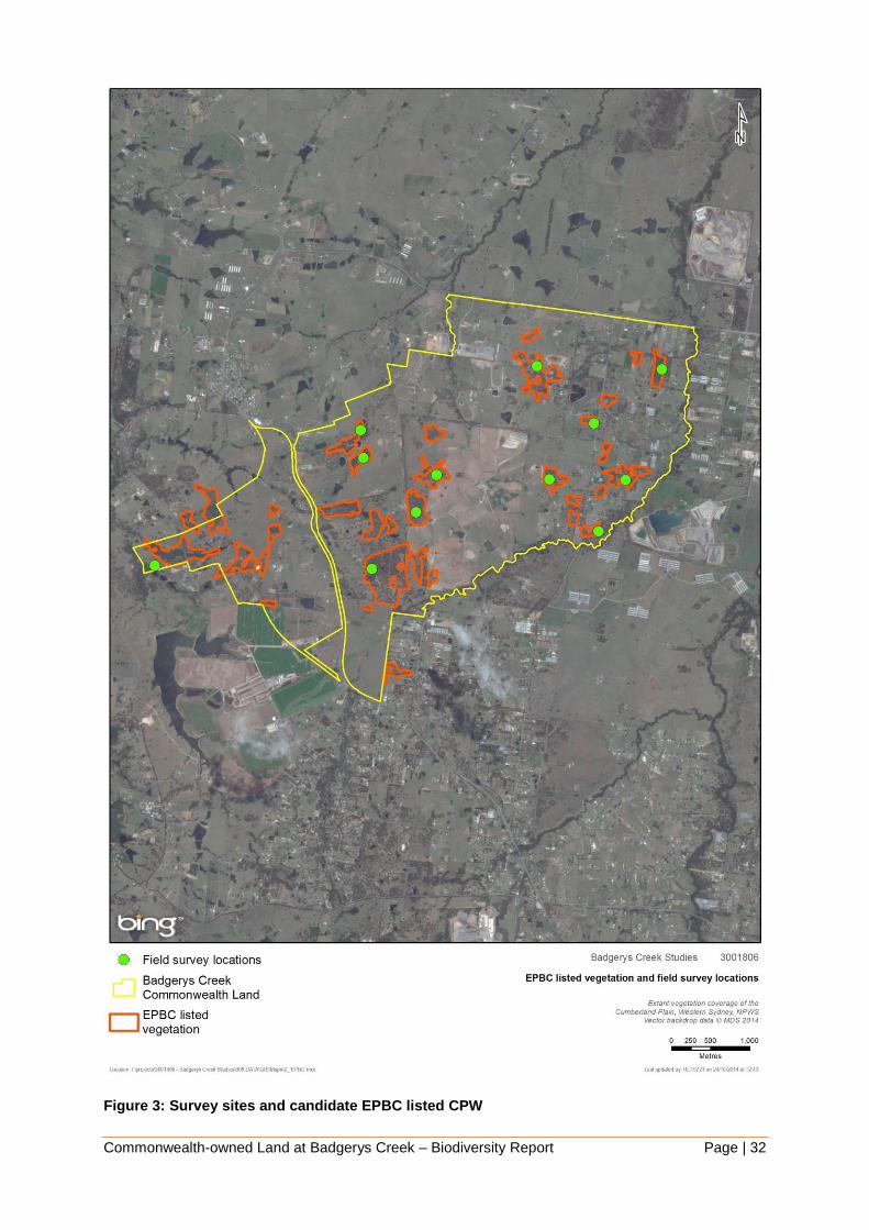
Figure 2 shows the existing vegetation community mapping undertaken by NPWS (2002f).
The majority of the biodiversity study area has been mapped as Shale Hills Woodland
(MU9), Shale Plains Woodland (MU10) and Alluvial Woodland (MU11). The remainder of the
study area appears to be cleared of vegetation and has not been mapped.
Survey sites were selected via desktop analysis of aerial photography. Sites were selected
within patches of vegetation most likely to meet the definition of EPBC listed Cumberland
Plain Shale Woodlands and Shale-Gravel Transition Forest (CPW). This process involved
using the NPWS (2002f) vegetation mapping to select polygons of Shale Plains Woodland
and Shale Hills Woodland with greater than ten per cent canopy cover and within a patch of
at least five hectares in size. Desktop mapping of EPBC listed CPW and selected field
survey sites are shown in Figure 3.
Specific plot locations were selected within each of these sites while in the field. Plots were
selected so as to provide a representative account of vegetation and communities present.
A total of 12 sites (with one plot each) were surveyed throughout the study area. Vegetation
plot assessments were undertaken within each site, with data collected in a 20 metre x 20
metre quadrat. Information recorded included dominant native species in each strata, per
cent cover and abundance, native species richness and exotic species cover. Results of
these assessments are presented in Section 5.3.1 and Appendix 2.
Two of the sites assessed were additional to those initially proposed. The two additional sites
were located along Badgerys Creek and were selected in order to provide a sample of
riparian vegetation present in the area.
In addition to plot assessments additional observations of vegetation type and condition were
made throughout the study area. These included opportunistic observation of the condition of
‘cleared’ land to assess whether the remaining grassland contained native vegetation. These
observations were used in conjunction with plot data and aerial photography to confirm
(ground-truth) existing vegetation mapping and assist in calculating approximate patch sizes
of vegetation communities.
Outside of plots the random meander technique (Cropper 1993) was used to target areas in
the vicinity of previously identified locations of threatened flora species. These searches
focused specifically on Pultenaea parviflora along Longleys Road and Anton Road as well as
Marsdenia viridiflora subsp. viridiflora along Badgerys Creek Road in the north of the study
area. Searches were also undertaken in suitable habitat near to an old record of Acacia
pubescens referred to in the recovery plan for this species, on a property on Longleys Road.
Further searches were undertaken for an old herbarium record of A. pubescens on Elizabeth
Drive at Badgerys Creek referred to in the WSUBBS report (NPWS 1997).
4.2.2 Fauna habitat assessment
Fauna habitat assessment was conducted to assist in determining the likelihood of presence
of threatened fauna species. Habitat assessments were focused at sites where vegetation
assessment plots were undertaken, though opportunistic observations throughout the study
area were also recorded.

Commonwealth-owned Land at Badgerys Creek – Biodiversity Report Page | 29
Habitat characteristics considered include the presence of nectar-producing plants, hollow
bearing trees, fallen logs, leaf litter and other ground debris, drainage lines, ponds, the
structure of vegetation communities and the presence of fruiting/flowering plant species to
assess the habitat suitability for a range of fauna species.
Using the random meander technique (Cropper 1993), searches were carried out for signs of
fauna activity such as tracks, scats, scratches and notches on trees, as well as any
opportunistic sightings, to identify the presence of common and threatened fauna species.
4.3 Limitations
Limitations to the flora and fauna surveys, which may affect biodiversity survey results,
include:
This report provides a broad appraisal of the biodiversity values of the study area,
however it is not a detailed investigation of all relevant ecological characteristics.
Access to parts of the study area for field survey was limited due to time constraints and
landholder notification requirements.
Vegetation survey was limited to 12 vegetation plot assessments at selected locations,
mainly targeting better condition EPBC listed CPW. Detailed floristic surveys and
vegetation community diagnostic analyses were not undertaken in relation to plot data.
The flora surveys conducted in September 2014 allowed some validation of the existing
Cumberland Plain vegetation mapping (NPWS 2002f). This provided a high level of
confidence in the plant communities identified broadly across the study area and
associated threatened species that may occur.
Threatened flora surveys were limited to known locations of Pultenaea parviflora,
Marsdenia viridiflora subsp. viridiflora and Acacia pubescens. No seasonal surveys were
undertaken for threatened flora across the whole study area.
While fauna habitat assessments were undertaken, this technique is not a complete
substitute for fauna surveys. Fauna are capable of inhabiting sub-optimal habitat. In
addition fragmentation, isolation or species density can all influence the presence and
distribution of a particular species. Species likelihood of occurrence was informed by
habitat characteristics and opportunistic sightings. For the purposes of this biodiversity
report, threatened fauna species known to occur in the locality are assumed to use the
site if suitable habitat is present. No seasonal fauna survey or trapping was undertaken.
No aquatic survey was undertaken of Badgerys Creek or other drainage lines in the study
area. Species likelihood of occurrence was informed by previous ecological reports,
habitat characteristics and opportunistic sightings.
Based on these limitations all survey results arising from this study should be viewed as a
‘snapshot’ of the biodiversity assets and values at a point in time. These results are unlikely
to be able to be used as the ‘before’ element in any BACI (before, after, control, impact)
assessment undertaken at the site.
The compressed timeframe in which the field assessment was undertaken has meant that a
sampling and ground-truthing approach has been taken. As such surveys may not have
included all individuals, populations or communities that may be present within the site. It is

Commonwealth-owned Land at Badgerys Creek – Biodiversity Report Page | 30
recommended that any assessment of the site in support of future development employ a an
approach that adequately captures all ecological assets in at an appropriate level of detail.

Commonwealth-owned Land at Badgerys Creek – Biodiversity Report Page | 31
Figure 2: Existing vegetation mapping (NPWS 2002f)
Commonwealth-owned Land at Badgerys Creek – Biodiversity Report Page | 32
Figure 3: Survey sites and candidate EPBC listed CPW

Commonwealth-owned Land at Badgerys Creek – Biodiversity Report Page | 33
5 EXISTING ENVIRONMENT
5.1 Landscape context
The study area is located in the Hawkesbury-Nepean catchment and the Cumberland
subregion of the Sydney Basin bioregion. The study area is within the Liverpool City Council
local government area (LGA).
The topography of the study area is generally level with undulating areas associated with
drainage lines. There are two main watercourses on the site: Badgerys Creek and Oaky
Creek. Badgerys Creek itself runs broadly along the eastern margin of the study area, from
the south-west to the north, and is moderately vegetated. Several large farm dams are
present throughout the study area.
The western side of the site is transected by the Luddenham Dyke, a natural subsurface wall
two to three metres wide and approximately eight kilometres long, forming an elevated ridge
(DTRD 1997).
Elevation across the site varies between approximately 49 m and 97 m.
The underlying geology of the study area is Wianamatta Shale, which is overlain by
Quaternary alluvial gravel, sand, silt and clay. Large-scale mapping of Soil Landscape Series
Sheet 9030 (Bannerman & Hazelton 1990) indicate the influence of three Soil Landscape
Groups in the study area: the Luddenham, Blacktown and South Creek Soil Landscape
Units. The likelihood of the presence of Acid Sulphate Soils is considered to be low (DTRD
1997).
The Commonwealth-owned land at Badgerys Creek is located in the south-west portion of
the Cumberland Plain, on the eastern side of the elevated ridge system dividing the
catchments of the Nepean River and South Creek. The Cumberland Plain has an average
elevation of about 20 metres above sea level in the north, rising to about 150 metres in the
south around Bringelly, Camden and Campbelltown, a distance of about 50 kilometres. The
elevated ridge system on which the site is located begins to rise at Orchard Hills in the north
and extends to Bringelly and Cobbitty, where it broadens into an elevated plain.
5.2 Land use
The study area is largely comprised of small to medium sized rural holdings, with the majority
of these dedicated to grazing of livestock. Part of the south eastern portion of the site is
industrial-agricultural with the presence of a poultry hatchery facility. The area includes some
residential areas, as well as community facilities such as Badgerys Creek Public School,
Badgerys Creek Park and Hubertus Country Club.
The Boral Badgerys Creek Brickworks is located outside the Commonwealth land, within the
south-east portion of the study area. The brickworks includes several disused quarry areas, a
large tailings dam, the kiln building and a large brick storage area. The site was closed for
production purposes in 2012, though still operates as a brick selection centre.
Areas of remnant vegetation are present generally as fragments amongst otherwise cleared
agricultural areas. Large portions of the study area’s remnant vegetation are composed of
native overstorey with cleared/grassland understorey.
The study area is zoned Commonwealth Land and nearby land is zoned R1.

Commonwealth-owned Land at Badgerys Creek – Biodiversity Report Page | 34
5.3 Vegetation communities
Native vegetation in the study area comprises mostly Shale Plains Woodland in varying
condition with Alluvial Woodland present along Badgerys Creek and other drainage lines in
the study area. There are also small areas of Shale Gravel Transition Forest and Moist Shale
Woodland. The extent of particularly these latter two communities would need to be verified
with more detailed survey of remnant vegetation.
The Native Vegetation of the Cumberland Plain undertaken by NPWS (2002f) identifies three
native plant communities within the study area (Figure 2):
Shale Plains Woodland (MU10)
Shale Hills Woodland (MU9)
Alluvial Woodland (MU11)
Field surveys undertaken by SMEC in 2014 also identified the presence of:
Shale Gravel Transition Forest (MU103), and
Moist Shale Woodland (MU14).
Equivalent EPBC Act, NSW TSC Act and NSW Plant Community Type names are provided
in Appendix 1.
The Shale Plains Woodland and Shale Hills Woodland vegetation communities mapped in
the study area meet the definition of Cumberland Plain Shale Woodlands and Shale-Gravel
Transition Forest, a Critically Endangered Ecological Community under the Commonwealth
EPBC Act. This vegetation is also listed as a Critically Endangered Ecological Community
under the NSW TSC Act and its listed name is Cumberland Plain Woodland in the Sydney
Basin Bioregion. Shale Plains Woodland is also equivalent to the NSW Plant Community
Type 849 Grey Box - Forest Red Gum grassy woodland on flats of the Cumberland Plain,
Sydney Basin in the NSW Vegetation Types Database (OEH 2012). Shale Hills Woodland is
equivalent to NSW PCT 850 Grey Box - Forest Red Gum grassy woodland on shale of the
southern Cumberland Plain, Sydney Basin. This vegetation type occurs across most of the
study area.
The Shale Gravel Transition Forest observed in the study area during field survey also meets
the definition of Cumberland Plain Shale Woodlands and Shale-Gravel Transition Forest
under the EPBC Act. It is listed under the TSC Act as Shale Gravel Transition Forest and is
equivalent to NSW PCT 724 Broad-leaved Ironbark - Grey Box - Melaleuca decora grassy
open forest on clay/gravel soils of the Cumberland Plain, Sydney Basin.
The Moist Shale Woodland observed in the study area during field survey also meets the
definition of Western Sydney Dry Rainforest and Moist Woodland on Shale listed under the
EPBC Act. It is listed under the TSC Act as Moist Shale Woodland and is equivalent to NSW
PCT 830 Forest Red Gum - Grey Box shrubby woodland on shale of the Cumberland Plain,
Sydney Basin.
The Alluvial Woodland vegetation mapped in the study area is not listed under the EPBC Act,
however it is listed at the state level under the NSW TSC Act as River Flat Eucalypt Forest
on Coastal Floodplains of the NSW North Coast, Sydney Basin and South East Corner
Bioregions.
Further detail on vegetation of the study area is provided below in Section 5.3.1 and 5.5.

Commonwealth-owned Land at Badgerys Creek – Biodiversity Report Page | 35
5.3.1 Field Survey Results
Field survey broadly confirmed the accuracy of the NPWS (2002f) mapping, with most sites
being confirmed as Shale Plains Woodland (MU10) or Alluvial Woodland (MU11) along
drainage lines. However there did seem to be some departure from the mapped vegetation
community and what was observed on the ground for some of the sites.
One of the sites surveyed (Plot 3) appeared to be a better match with Moist Shale Woodland
(MU14).
Shale Gravel Transition Forest (MU103) was also observed at Plot 5. This community was
not mapped in the study area by NPWS (2002f). Further delineation of vegetation at the site
was undertaken based on observed condition.
The vegetation type and condition shown in Figure 4 is largely based upon existing
vegetation mapping but also incorporates results of the twelve vegetation plot assessments
undertaken during field survey in September 2014.

Commonwealth-owned Land at Badgerys Creek – Biodiversity Report Page | 36
Table 3: Description of vegetation within each zone
Plot 1
Location 55 Longleys Road. Rural property cattle grazing.
Blacktown soil landscape.
Condition Moderate.
Description Moderate condition patch of advanced regeneration Shale Plains Woodland
canopy 12 m to 15 m high comprised Cabbage Gum (Eucalyptus amplifolia) and
Broad-leaved Ironbark (Eucalyptus fibrosa). No hollow-bearing trees observed.
Open mid-storey comprised of Blackthorn (Bursaria spinosa) and Dillwynia
sieberi. Mixed native and exotic groundcover with dominant grasses being
Weeping Meadow Grass (Microlaena stipoides), Kangaroo Grass (Themeda
australis) and Barbed Wire Grass (Cymbopogon refractus). Wattle Mat-rush
(Lomandra filiformis) and Blue Trumpet (Brunoniella australis) are also common.
Total native species richness in a 20m x 20m plot = 30.
Main weeds present in the groundcover include Fireweed (Senecio
madagascariensis), Paddys Lucerne (Sida rhombifolia) and Scotch Thistle
(Onopordum acanthium).
Resilience moderate, likely to have viable soil seed bank, regeneration would
require ongoing management including fencing, weed control and appropriate
fire management. No dead trees observed in the canopy.
NPWS (2002)
veg community
Shale Plains Woodland (MU10).
EPBC name Cumberland Plain Shale Woodlands and Shale-Gravel Transition Forest.
TSC name Cumberland Plain Woodland.
NSW PCT Grey Box - Forest Red Gum grassy woodland on flats of the Cumberland Plain,
Sydney Basin (BioMetric code: HN528, NSW plant community type: 849).
Photo
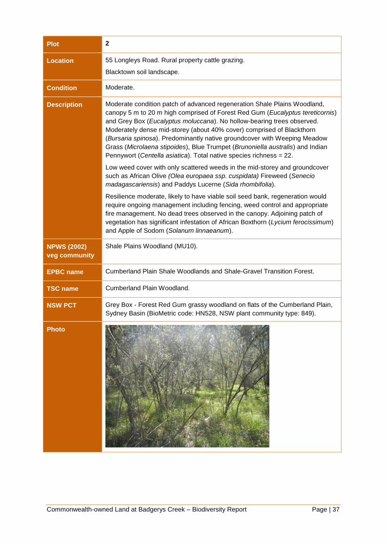
Commonwealth-owned Land at Badgerys Creek – Biodiversity Report Page | 37
Plot 2
Location 55 Longleys Road. Rural property cattle grazing.
Blacktown soil landscape.
Condition Moderate.
Description Moderate condition patch of advanced regeneration Shale Plains Woodland,
canopy 5 m to 20 m high comprised of Forest Red Gum (Eucalyptus tereticornis)
and Grey Box (Eucalyptus moluccana). No hollow-bearing trees observed.
Moderately dense mid-storey (about 40% cover) comprised of Blackthorn
(Bursaria spinosa). Predominantly native groundcover with Weeping Meadow
Grass (Microlaena stipoides), Blue Trumpet (Brunoniella australis) and Indian
Pennywort (Centella asiatica). Total native species richness = 22.
Low weed cover with only scattered weeds in the mid-storey and groundcover
such as African Olive (Olea europaea ssp. cuspidata) Fireweed (Senecio
madagascariensis) and Paddys Lucerne (Sida rhombifolia).
Resilience moderate, likely to have viable soil seed bank, regeneration would
require ongoing management including fencing, weed control and appropriate
fire management. No dead trees observed in the canopy. Adjoining patch of
vegetation has significant infestation of African Boxthorn (Lycium ferocissimum)
and Apple of Sodom (Solanum linnaeanum).
NPWS (2002)
veg community
Shale Plains Woodland (MU10).
EPBC name Cumberland Plain Shale Woodlands and Shale-Gravel Transition Forest.
TSC name Cumberland Plain Woodland.
NSW PCT Grey Box - Forest Red Gum grassy woodland on flats of the Cumberland Plain,
Sydney Basin (BioMetric code: HN528, NSW plant community type: 849).
Photo

Commonwealth-owned Land at Badgerys Creek – Biodiversity Report Page | 38
Plot 3
Location 1850 The Northern Road. Rural property, horse agistment.
Blacktown soil landscape.
Condition Moderate.
Description Moderate condition patch of advanced regeneration Moist Shale Woodland,
canopy 15 m to 20 m high comprised of Grey Box (Eucalyptus moluccana). No
hollow-bearing trees observed. Moderately dense mid-storey comprised of
Blackthorn (Bursaria spinosa) of about 50% cover. Mixed native and exotic
groundcover with Weeping Meadow Grass (Microlaena stipoides), Plump
Windmill Grass (Chloris ventricosa) and Winter Apple (Eremophila debilis). Total
native species richness = 29.
There is some African Olive (Olea europaea ssp. cuspidata) present in the mid-
storey (about 10% cover). Main weeds present in the groundcover include
Paddys Lucerne (Sida rhombifolia) and Bridal Creeper (Asparagus
asparagoides).
Resilience moderate, likely to have viable soil seed bank, regeneration would
require ongoing management including fencing, weed control and appropriate
fire management. No dead trees observed in the canopy.
NPWS (2002)
veg community
Moist Shale Woodland (MU14).
EPBC name Western Sydney Dry Rainforest and Moist Woodland on Shale.
TSC name Moist Shale Woodland
NSW PCT Forest Red Gum - Grey Box shrubby woodland on shale of the Cumberland
Plain, Sydney Basin (BioMetric code: HN524, NSW plant community type: 830).
Photo

Commonwealth-owned Land at Badgerys Creek – Biodiversity Report Page | 39
Plot 4
Location 365 Willowdene Ave. Low intensity horse grazing. Property largely natural.
Luddenham soil landscape.
Condition Moderate to Good.
Description Moderate to good condition patch of advanced regeneration Cumberland Plain
Woodland, canopy 6 m to 25 m high comprised of Grey Box (Eucalyptus
moluccana) and Forest Red Gum (E. tereticornis). One hollow-bearing tree
observed. Open mid-storey comprised of Blackthorn (Bursaria spinosa). Mostly
native grassy understorey dominated by Weeping Meadow Grass (Microlaena
stipoides), Plump Windmill Grass (Chloris ventricosa) and Kangaroo Grass
(Themeda australis). Slender Tick-trefoil (Desmodium varians), Berry Saltbush
(Einadia hastata) and Forest Nightshade (Solanum prinophyllum) are also
present. Total native species richness = 23.
Some patches of the property mainly near the creekline have African Olive (Olea
europaea ssp. Cuspidata) infestation.
Resilience good, likely to have viable soil seed bank, regeneration would require
ongoing management including fencing, weed control and appropriate fire
management. No dead trees observed in the canopy. Adjoining areas cleared of
canopy are high probability derived native grasslands.
NPWS (2002)
veg community
Shale Plains Woodland (MU10).
EPBC name Cumberland Plain Shale Woodlands and Shale-Gravel Transition Forest.
TSC name Cumberland Plain Woodland.
NSW PCT Grey Box - Forest Red Gum grassy woodland on flats of the Cumberland Plain,
Sydney Basin (BioMetric code: HN528, NSW plant community type: 849).
Photo

Commonwealth-owned Land at Badgerys Creek – Biodiversity Report Page | 40
Plot 5
Location 60 Gardiner Street. Vacant property formerly grazed. High level of recreational
use – quad/trail bikes.
Blacktown soil landscape.
Condition Moderate.
Description Uneven aged patch of Shale Gravel Transition Forest, canopy 8m to 18m high
comprised of Broad-leaved Ironbark (Eucalyptus fibrosa), Stringybark (E.
eugenioides) and Melaleuca decora. No hollow-bearing trees observed. Open
mid-storey comprised of Blackthorn (Bursaria spinosa) and Prickly-leaved
Paperbark (Melaleuca nodosa). Mostly native understorey dominated by
Weeping Meadow Grass (Microlaena stipoides), Cryptandra spinescens and
Blackthorn seedlings, with Wiry Panic (Entolasia stricta) and Threeawn
Speargrass (Aristida vagans) also present. Total native species richness = 33.
Very low weed cover (about 2%) scattered in the groundcover.
Resilience moderate, likely to have viable soil seed bank, regeneration would
require ongoing management including fencing, weed control and appropriate
fire management. No dead trees observed in the canopy, but no juvenile
eucalypt regeneration observed. Disturbed area of former grazing and quad/trail
bike tracks.
NPWS (2002)
veg community
Shale Gravel Transition Forest (MU103).
EPBC name Cumberland Plain Shale Woodlands and Shale-Gravel Transition Forest.
TSC name Shale Gravel Transition Forest.
NSW PCT Broad-leaved Ironbark - Grey Box - Melaleuca decora grassy open forest on
clay/gravel soils of the Cumberland Plain, Sydney Basin (BioMetric code:
HN512, NSW plant community type: 724).
Photo

Commonwealth-owned Land at Badgerys Creek – Biodiversity Report Page | 41
Plot 6
Location 65 Leggo Street. Vacant property, occasional horse grazing.
South Creek soil landscape.
Condition Moderate to Good.
Description Alluvial Woodland, canopy 5 m to 20 m high comprised of Cabbage Gum
(Eucalyptus amplifolia) and Melaleuca decora. No hollow-bearing trees
observed. Open mid-storey comprised of Prickly-leaved Paperbark (Melaleuca
nodosa) and scattered Rice Flower (Ozothamnus diosmifolius). Mostly native
understorey dominated by Kangaroo Grass (Themeda australis), Threeawn
Speargrass (Aristida vagans), Weeping Meadow Grass (Microlaena stipoides)
and wattle Mat-rush (Lomandra filiformis). Total native species richness = 25.
Exotic species are scattered at low abundance in the mid-storey and
groundcover with the main weeds present consisting of African Love Grass
(Eragrostis curvula), Fireweed (Senecio madagascariensis) and Paddys Lucerne
(Sida rhombifolia).
Resilience good, likely to have viable soil seed bank, regeneration would require
ongoing management including fencing, weed control and appropriate fire
management. No dead trees observed in the canopy. Adjoining areas cleared of
canopy are high probability derived native grasslands.
NPWS (2002)
veg community
Alluvial Woodland (MU11)
EPBC name n/a
TSC name River Flat Eucalypt Forest on Coastal Floodplains
NSW PCT Forest Red Gum - Rough-barked Apple grassy woodland on alluvial flats of the
Cumberland Plain, Sydney Basin (BioMetric code: HN526, NSW plant
community type: 835).
Photo

Commonwealth-owned Land at Badgerys Creek – Biodiversity Report Page | 42
Plot 7
Location 595 Badgerys Creek Road. Rural property, horse agistment.
South Creek soil landscape.
Condition Moderate to Good.
Description Advanced regeneration Alluvial Woodland, canopy 10 m to 20 m high comprised
of Forest Red Gum (Eucalyptus tereticornis), Grey Box (E. moluccana) and
Swamp Oak (Casuarina glauca). No hollow-bearing trees observed. Open mid-
storey comprised of Blackthorn (Bursaria spinosa), Swamp Oak and Forest Red
Gum saplings. Mostly native grassy understorey dominated by Weeping
Meadow Grass (Microlaena stipoides) and Kangaroo Grass (Themeda australis),
with Indian Pennywort (Centella asiatica), Oxalis perennans and Slender Tick-
trefoil (Desmodium varians) also present. Total native species richness = 23.
Exotic species present were mainly in the groundcover (about 15% cover)
consisting of Panic Veldt Grass (Ehrharta erecta), Slender Pigeon Grass
(Setaria parviflora), Fireweed (Senecio madagascariensis) and Paddys Lucerne
(Sida rhombifolia).
Resilience good, likely to have viable soil seed bank, regeneration would require
ongoing management including fencing, weed control and appropriate fire
management. No dead trees observed in the canopy.
NPWS (2002)
veg community
Alluvial Woodland (MU11)
EPBC name n/a
TSC name River Flat Eucalypt Forest on Coastal Floodplains
NSW PCT Forest Red Gum - Rough-barked Apple grassy woodland on alluvial flats of the
Cumberland Plain, Sydney Basin (BioMetric code: HN526, NSW plant
community type: 835).
Photo

Commonwealth-owned Land at Badgerys Creek – Biodiversity Report Page | 43
Plot 8
Location 75 Jagelman Road. Rural property, horse agistment.
Blacktown soil landscape.
Condition Moderate.
Description Moderate condition patch of advanced regeneration Cumberland Plain
Woodland, canopy 6 m to 28 m high comprised of Grey Box (Eucalyptus
moluccana), Forest Red Gum (E. tereticornis) and Cherry Ballart (Exocarpos
cupressiformis). No hollow-bearing trees observed. Moderately dense mid-storey
comprised of Blackthorn (Bursaria spinosa). Mostly native grassy understorey
dominated by Weeping Meadow Grass (Microlaena stipoides), Plump Windmill
Grass (Chloris ventricosa) and Carex inversa with Forest Nightshade (Solanum
prinophyllum), Bear’s Ear (Cymbonotus lawsonianus) and Einadia spp also
present. Total native species richness = 27.
African Olive (Olea europaea ssp. Cuspidata) occurs in the mid-storey at about
3% cover within the plot but is dense in parts of the property. Other weeds
scattered in the groundcover include Fireweed (Senecio madagascariensis) and
Paddys Lucerne (Sida rhombifolia).
Resilience moderate, likely to have viable soil seed bank, regeneration would
require ongoing management including fencing, weed control and appropriate
fire management. No dead trees observed in the canopy. A fenced area of
native vegetation adjoining the site where the plot was located was in good
condition.
NPWS (2002)
veg community
Shale Plains Woodland (MU10)
EPBC name Cumberland Plain Shale Woodlands and Shale-Gravel Transition Forest
TSC name Cumberland Plain Woodland
NSW PCT Grey Box - Forest Red Gum grassy woodland on flats of the Cumberland Plain,
Sydney Basin (BioMetric code: HN528, NSW plant community type: 849).
Photo
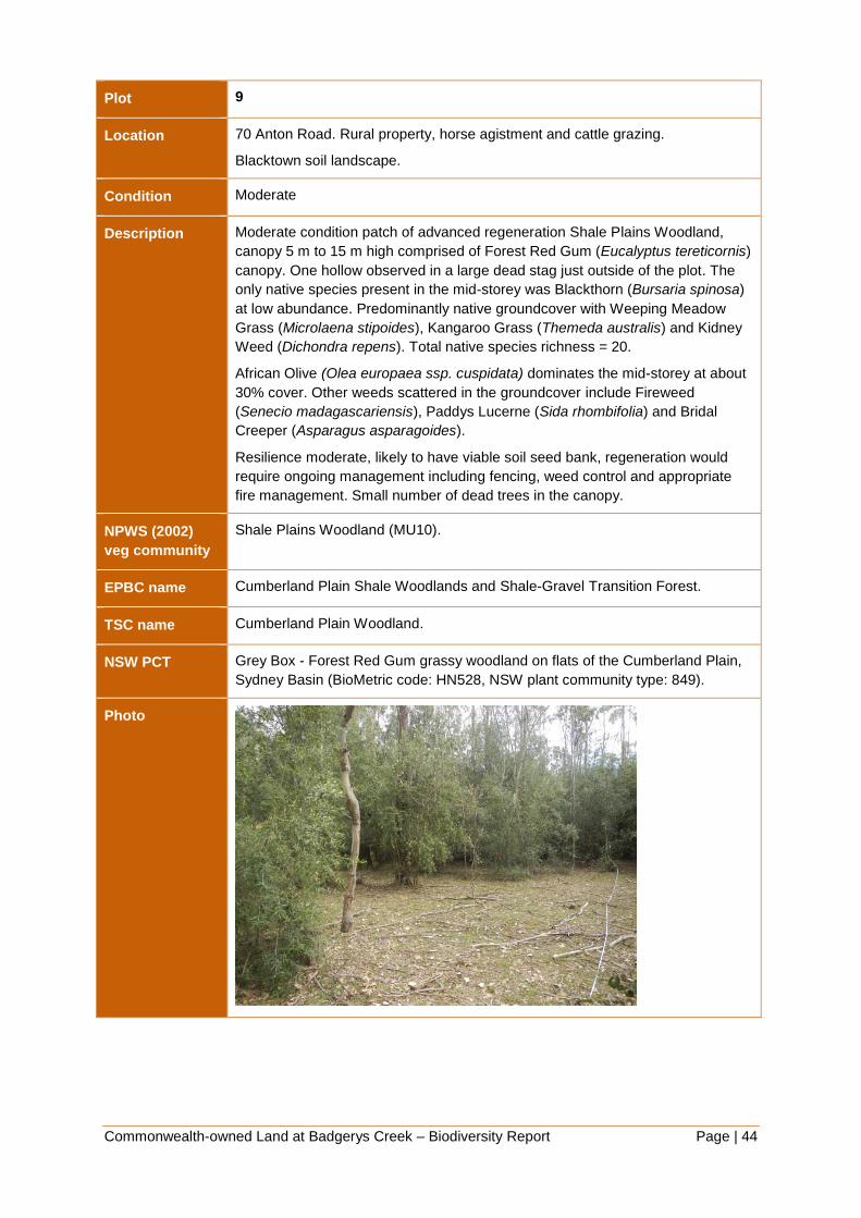
Commonwealth-owned Land at Badgerys Creek – Biodiversity Report Page | 44
Plot 9
Location 70 Anton Road. Rural property, horse agistment and cattle grazing.
Blacktown soil landscape.
Condition Moderate
Description Moderate condition patch of advanced regeneration Shale Plains Woodland,
canopy 5 m to 15 m high comprised of Forest Red Gum (Eucalyptus tereticornis)
canopy. One hollow observed in a large dead stag just outside of the plot. The
only native species present in the mid-storey was Blackthorn (Bursaria spinosa)
at low abundance. Predominantly native groundcover with Weeping Meadow
Grass (Microlaena stipoides), Kangaroo Grass (Themeda australis) and Kidney
Weed (Dichondra repens). Total native species richness = 20.
African Olive (Olea europaea ssp. cuspidata) dominates the mid-storey at about
30% cover. Other weeds scattered in the groundcover include Fireweed
(Senecio madagascariensis), Paddys Lucerne (Sida rhombifolia) and Bridal
Creeper (Asparagus asparagoides).
Resilience moderate, likely to have viable soil seed bank, regeneration would
require ongoing management including fencing, weed control and appropriate
fire management. Small number of dead trees in the canopy.
NPWS (2002)
veg community
Shale Plains Woodland (MU10).
EPBC name Cumberland Plain Shale Woodlands and Shale-Gravel Transition Forest.
TSC name Cumberland Plain Woodland.
NSW PCT Grey Box - Forest Red Gum grassy woodland on flats of the Cumberland Plain,
Sydney Basin (BioMetric code: HN528, NSW plant community type: 849).
Photo
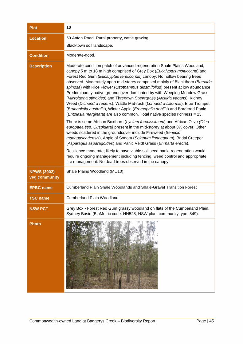
Commonwealth-owned Land at Badgerys Creek – Biodiversity Report Page | 45
Plot 10
Location 50 Anton Road. Rural property, cattle grazing.
Blacktown soil landscape.
Condition Moderate-good.
Description Moderate condition patch of advanced regeneration Shale Plains Woodland,
canopy 5 m to 18 m high comprised of Grey Box (Eucalyptus moluccana) and
Forest Red Gum (Eucalyptus tereticornis) canopy. No hollow bearing trees
observed. Moderately open mid-storey comprised mainly of Blackthorn (Bursaria
spinosa) with Rice Flower (Ozothamnus diosmifolius) present at low abundance.
Predominantly native groundcover dominated by with Weeping Meadow Grass
(Microlaena stipoides) and Threeawn Speargrass (Aristida vagans). Kidney
Weed (Dichondra repens), Wattle Mat-rush (Lomandra filiformis), Blue Trumpet
(Brunoniella australis), Winter Apple (Eremophila debilis) and Bordered Panic
(Entolasia marginata) are also common. Total native species richness = 23.
There is some African Boxthorn (Lycium ferocissimum) and African Olive (Olea
europaea ssp. Cuspidata) present in the mid-storey at about 3% cover. Other
weeds scattered in the groundcover include Fireweed (Senecio
madagascariensis), Apple of Sodom (Solanum linnaeanum), Bridal Creeper
(Asparagus asparagoides) and Panic Veldt Grass (Ehrharta erecta).
Resilience moderate, likely to have viable soil seed bank, regeneration would
require ongoing management including fencing, weed control and appropriate
fire management. No dead trees observed in the canopy.
NPWS (2002)
veg community
Shale Plains Woodland (MU10).
EPBC name Cumberland Plain Shale Woodlands and Shale-Gravel Transition Forest
TSC name Cumberland Plain Woodland
NSW PCT Grey Box - Forest Red Gum grassy woodland on flats of the Cumberland Plain,
Sydney Basin (BioMetric code: HN528, NSW plant community type: 849).
Photo

Commonwealth-owned Land at Badgerys Creek – Biodiversity Report Page | 46
Plot 11
Location 540 Badgerys Creek Road. Rural property, cattle grazing.
Blacktown soil landscape.
Condition Moderate-poor
Description Poor to moderate condition patch of advanced regeneration Shale Plains
Woodland, canopy 6 m to 20 m high comprised of Grey Box (Eucalyptus
moluccana) and Forest Red Gum (Eucalyptus tereticornis) canopy. No hollow
bearing trees observed. Moderately open mid-storey comprised mainly of
Blackthorn (Bursaria spinosa) with Australian Indigo (Indigofera australis) also
present. About 50/50 mixed native and exotic groundcover with main native
species including Weeping Meadow Grass (Microlaena stipoides), Plump
Windmill Grass (Chloris ventricosa), Kangaroo Grass (Themeda australis) and
Berry Saltbush (Einadia hastata). Total native species richness = 17.
There is some African Olive (Olea europaea ssp. cuspidata) and Lantana
(Lantana camara) present in the mid-storey at about 10% cover. Main weeds
present in the groundcover include Panic Veldt Grass (Ehrharta erecta), Paddys
Lucerne (Sida rhombifolia) and Bridal Creeper (Asparagus asparagoides).
Small, disturbed patch of vegetation. Resilience low to moderate, likely to have
some viable soil seed bank, regeneration would require significant investment in
ongoing management including fencing, weed control and appropriate fire
management. No dead trees observed in the canopy.
NPWS (2002)
veg community
Shale Plains Woodland (MU10).
EPBC name Cumberland Plain Shale Woodlands and Shale-Gravel Transition Forest
TSC name Cumberland Plain Woodland
NSW PCT Grey Box - Forest Red Gum grassy woodland on flats of the Cumberland Plain,
Sydney Basin (BioMetric code: HN528, NSW plant community type: 849).
Photo

Commonwealth-owned Land at Badgerys Creek – Biodiversity Report Page | 47
Plot 12
Location 2300 Elizabeth Drive. Rural property, cattle grazing.
Blacktown soil landscape.
Condition Poor.
Description Poor condition patch of advanced regeneration Shale Plains Woodland, canopy
10 m to 15 m high comprised of Forest Red Gum (Eucalyptus tereticornis)
canopy. No hollow bearing trees observed. Weedy mid-storey with no native
species present. Mostly exotic groundcover with only scattered native species
present, the main ones being Weeping Meadow Grass (Microlaena stipoides),
Berry Saltbush (Einadia hastata) and Carex inversa. Total native species
richness = 11.
The main exotic species present in the mid-storey at about 20% cover are
African Boxthorn (Lycium ferocissimum) and Apple of Sodom (Solanum
linnaeanum). The main weeds dominating the groundcover include Panic Veldt
Grass (Ehrharta erecta), Fireweed (Senecio madagascariensis), Paddys
Lucerne (Sida rhombifolia) and Flatweed (Hypochaeris radicata).
Disturbed patch of vegetation, historically heavily grazed. Resilience low, likely
to limited capacity for regeneration. Would require significant investment in
ongoing management including fencing, weed control and planting. Significant
tree death observed in the canopy. Vegetation on properties over the southern
fence looks to be in better condition.
NPWS (2002)
veg community
Shale Plains Woodland (MU10).
EPBC name Cumberland Plain Shale Woodlands and Shale-Gravel Transition Forest.
TSC name Cumberland Plain Woodland.
NSW PCT Grey Box - Forest Red Gum grassy woodland on flats of the Cumberland Plain,
Sydney Basin (BioMetric code: HN528, NSW plant community type: 849).
Photo

Commonwealth-owned Land at Badgerys Creek – Biodiversity Report Page | 48
Resilience of vegetation in the study area
Ground-truthing during field surveys confirmed that the study area contains a mix of
disturbed former grazing land, varying condition shale woodland and poor condition riparian
vegetation. African Olive is particularly prevalent in gullies and agricultural and
environmental weeds are present in the groundcover and mid-storey to varying degrees
throughout much of the study area. However, there is still good native species diversity in
the remnants visited in September 2014, with the majority of sites visited meeting the
condition thresholds of EECs listed under the EPBC Act.
5.3.2 Weeds
A number of Weeds of National Significance (WoNS) were observed during field survey of
the site. National Management Guides are available for these species. Table 4 lists weeds
identified in the field in September 2014, whether they are WoNS, whether they are declared
as noxious in the Liverpool LGA under the Noxious Weeds Act (1993), class and control
requirements.
Table 4: Weeds of National Significance
Species name Common name Class Legal requirements
Asparagus
asparagoides
Bridal Creeper WoNS,
4
The plant must not be sold, propagated or
knowingly distributed.
Bryophyllum species Mother of Millions 4 The growth of the plant must be managed
in a manner that continuously inhibits the
ability of the plant to spread and the plant
must not be sold, propagated or
knowingly distributed.
Cestrum parqui Green Cestrum 3 The plant must be fully and continuously
suppressed and destroyed.
Lantana camara Lantana WoNS,
4
The growth of the plant must be managed
in a manner that continuously inhibits the
ability of the plant to spread.
Lycium ferocissimum African Boxthorn WoNS
Olea europaea
subspecies cuspidata
African Olive 4 The growth of the plant must be managed
in a manner that continuously inhibits the
ability of the plant to spread and the plant
must not be sold, propagated or
knowingly distributed.
Opuntia sp. Prickly Pear WoNS,
4
The growth of the plant must be managed
in a manner that continuously inhibits the
ability of the plant to spread and the plant
must not be sold, propagated or
knowingly distributed

Commonwealth-owned Land at Badgerys Creek – Biodiversity Report Page | 49
Species name Common name Class Legal requirements
Rubus fruticosus agg Blackberry WoNS,
4
The growth of the plant must be managed
in a manner that continuously inhibits the
ability of the plant to spread and the plant
must not be sold, propagated or
knowingly distributed.
Senecio
madagascariensis
Fireweed WoNS The plant must not be sold, propagated or
knowingly distributed.

Commonwealth-owned Land at Badgerys Creek – Biodiversity Report Page | 50
Figure 4: Vegetation communities and condition

Commonwealth-owned Land at Badgerys Creek – Biodiversity Report Page | 51
5.4 Fauna habitat
5.4.1 Field Survey Results
Fauna habitat present within the study area is moderately to highly modified. Much of this
disturbance is due to the presence of grazing of livestock, which has been occurring within
the study area for several decades. It is likely that much of the original vegetation within the
area was directly cleared to facilitate grazing and other agricultural infrastructure, with
remaining vegetation clearing and suppression of regeneration accounted for by grazing
itself.
Despite this, several native fauna habitats persist within the study area. Such habitats can
be classified into the three broad categories, open woodland, grassland and aquatic habitat.
Each category exhibits is a high degree of variation in its vegetation composition across the
study area, however, the structural elements relevant to native fauna are generally
consistent.
Open woodland
Pockets of open woodland habitat are scattered across the study area, separated by large
expanses of grassland. Such pockets are of varying age, with some likely to be remnant,
while others have regenerated since clearing. The presence of large tree stumps within
remnant patches indicates that within these areas many of the large trees have been
selectively removed. The overall result of such clearing is the general scarcity of trees old or
large enough to produce usable hollows for arboreal mammals, reptiles and diurnal and
nocturnal birds and other native fauna. As such habitat value of this layer is considered to be
low.
Within remnant/regenerating patches mid-storey vegetation varies from non-existent to
native shrubs of varying density to dense African Olive infestations. It should be noted that
mid-storey vegetation within the native plant communities types present within the study
area is typically sparse and usually dominated by Bursaria spinosa.
Whilst the abundant African Olive provides a certain degree of habitat structure within the
mid-storey (e.g. shelter and foraging opportunities for reptiles and small birds) this generally
comes at the expense of native mid-storey vegetation which is likely to provide better
structure, as well as increased opportunity for hosting food resources for native wildlife. Of
the open woodland sites surveyed it was noted that a couple of sites contained mid-storeys
dominated by African Olive and African Boxthorn. As such the overall habitat value of this
layer within remnant/regenerating patches is generally considered to be moderate to low.
Vegetative ground covers within some remnant/regenerating patches of open woodland are
often sparse or less than five centimetres in height as a result of ongoing grazing pressure.
Leaf litter is thin, although many sites are littered with debris and fallen/cut logs. Parts of the
study area are also infested with non-native groundcovers such as African lovegrass.
However there are some remnants where there is good native species diversity and there
were some fenced areas with reduced grazing pressure where the native grass cover was
intact. It is likely that populations of the threatened Cumberland Plain Land Snail persist in
these areas; however, no targeted searches were undertaken. The habitat value within this
layer across the broader study area is considered to be moderate to low.

Commonwealth-owned Land at Badgerys Creek – Biodiversity Report Page | 52
Grassland
The grassland habitat present exhibits a mixture of native and exotic grasses. Occasional
emerging eucalypts are present where there is reduced grazing pressure. Isolated mature
canopy trees and logs occur sporadically amongst pastures. The overall habitat value of
grasslands throughout the site is considered to be low to moderate.
Aquatic habitat
There are numerous farm dams within the study area. These are generally vegetated around
the edge except where the banks have been degraded by livestock access.
Badgerys Creek flows through the eastern portion of the study area in a northerly direction
and has a relatively well vegetated riparian corridor. Large portions of the waterway are
infested with weeds and natural water flow is significantly altered in certain locations,
particularly through the actions of livestock and other agricultural activities. Despite this
highly degraded state the creek is likely to provide suitable habitat for a variety of native
fauna species.
5.4.2 Threatened fauna habitat
No threatened fauna species were directly or indirectly observed during the field surveys,
though surveys were not undertaken in sufficient detail to normally detect such species.
Habitat assessment undertaken as part of the field surveys indicates that likely habitat for
threatened species is present in certain locations. This includes potential habitat for the
Cumberland Plain Land Snail, woodland and migratory birds, microbats, the Grey-headed
Flying-fox and amphibians such as the Green and Golden Bell Frog, among others.
The 1999 Supplement to the Draft EIS makes reference to the Badgerys Creek Community
Hall as important roosting habitat for two species of microbats: Chalinolobus gouldi (Goulds
Wattled Bat) and Mormopterus sp. This site was not specifically targeted during these
surveys as it is understood that the building has since been removed.
While the quality and quantity of habitat features for threatened fauna varies throughout the
site, specific species requirements indicate it is likely that the site supports at least a subset
of the threatened species with potential to occur in the area (see Appendix 3). Important
features present within the site likely to support such populations include waterways,
wetlands, riparian corridors, hollow bearing trees, native and exotic grasslands, vegetative
litter and native vegetation generally. Ongoing management of the site should take account
and provide for threatened species habitat wherever possible. This should include
management of Key Threatening Processes such as clearing of native vegetation, grazing of
livestock and the presence of weeds (see section 5.13 for further detail).
Further targeted surveys for threatened species are recommended in support of any future
environmental assessment.
5.5 Threatened ecological communities
5.5.1 Fragmentation analysis
An analysis of the spatial configuration of remnant vegetation within the study area was
undertaken to provide a better understanding of remnant size and distribution.

Commonwealth-owned Land at Badgerys Creek – Biodiversity Report Page | 53
The fragmentation analysis was undertaken within the boundaries of the Commonwealth
land at Badgerys Creek. Only vegetation mapped in the good condition classes (“A”, “B” and
“C”) of NPWS (2002f) was used in the fragmentation analysis, excluding scattered tree
condition classes (“TX”, “TXR”, “TXU” and “X”). The fragmentation just applies to vegetation
identified via desktop as most likely to meet the definition of EPBC listed Cumberland Plain
Shale Woodlands and Shale-Gravel Transition Forest (CPW) or Western Sydney Dry
Rainforest and Moist Woodland on Shale.
The results of the fragmentation analysis reveal a high degree of fragmentation in the study
area (Table 5). Some 33 individual remnants of candidate EPBC listed vegetation are
present, ranging in size from <1 ha to 35 ha. Vegetation remnants in the 1-2 and 5-10
hectares class ranges are the most common with 33% of remnants being 1-2 ha in size and
27% of remnants being between 5 and 10 hectares.
The majority of candidate EPBC listed vegetation in the study area is contained with larger
patches of vegetation with over 76% of the total area of candidate EPBC listed vegetation in
patches of greater than five hectares.
Table 5: Fragmentation analysis of candidate EPBC listed vegetation
Size class range
(ha)
No. of remnants % of total no. of
remnants
Area of
vegetation
% of total area of
vegetation
<1 2 6 1.3 0.7
>1 <2 11 33 17.7 9.9
>2 <3 3 9 7.4 4.2
>3 <4 3 9 10.5 5.9
>4 <5 1 3 4.7 2.6
>5 <10 9 27 62.3 35.0
>10 <25 3 9 39.3 22.1
>25 <50 1 3 34.7 19.5
Total 33 177.9
5.5.2 Commonwealth and NSW listed EECs
Desktop searches identified 22 Threatened Ecological Communities as occurring or
potentially occurring within a ten kilometre radius of the study area (Appendix 3). Ecological
Communities identified as having a medium to high likelihood of occurrence in the study
area include:
Cooks River/Castlereagh Ironbark Forest in the Sydney Basin Bioregion.
Cumberland Plain Woodland in the Sydney Basin Bioregion.
Freshwater Wetlands on Coastal Floodplains of the New South Wales North Coast,
Sydney Basin and South East Corner Bioregions.
Moist Shale Woodland in the Sydney Basin Bioregion.

Commonwealth-owned Land at Badgerys Creek – Biodiversity Report Page | 54
River-Flat Eucalypt Forest on Coastal Floodplains of the New South Wales North Coast,
Sydney Basin and South East Corner Bioregions.
Shale Gravel Transition Forest in the Sydney Basin Bioregion.
Western Sydney Dry Rainforest in the Sydney Basin Bioregion.
All of the remnant vegetation present in the study area is listed as threatened ecological
communities (TECs) under either the EPBC Act or TSC Act (Figure 4).
Two EPBC-listed critically endangered communities were found to be present within the
study area:
Cumberland Plain Shale Woodlands and Shale-Gravel Transition Forest.
Western Sydney Dry Rainforest and Moist Woodland on Shale.
Four TSC-listed TECs were found to be present in the study area:
Cumberland Plain Woodland in the Sydney Basin Bioregion
Shale Gravel Transition Forest in the Sydney Basin Bioregion
River-Flat Eucalypt Forest on Coastal Floodplains of the New South Wales North Coast,
Sydney Basin and South East Corner Bioregions
Moist Shale Woodland in the Sydney Basin Bioregion
There is some overlap with these listings and further detail is provided in Appendix 1 Table
12.
It is estimated that approximately 437 hectares of native vegetation occurs in the study area.
Estimates of the area of the different vegetation communities present are provided in Table
6. These estimates are derived from the Native Vegetation of the Cumberland Plain map
(NPWS 2002f) (including vegetation mapped as having both greater than and less than ten
per cent canopy cover) and limited field survey undertaken by SMEC in September 2014.
The majority of mapped vegetation in the study area is Shale Plains Woodland and Shale
Hills Woodland (124.5 and 208 hectares respectively), both components of Cumberland
Plain Woodland and included in the EPBC listing for Cumberland Plain Shale Woodlands
and Shale-Gravel Transition Forest and the TSC Act listing for Cumberland Plain
Woodlands. Based on the limited field work undertaken by SMEC in September 2014 it is
evident that some of the mapped Shale Hills Woodland is Shale Plains Woodland in lower
parts of the study area. This does not affect estimates for area of TECs as both communities
are included in the Commonwealth and State EEC determinations.
Only the larger, higher condition remnants of Cumberland Plain Woodlands are likely to
meet the condition thresholds of the EPBC Act determination.
A small amount of Shale Gravel Transition Forest (9.1 ha) was identified in the current
SMEC field survey of the study area, associated with small patches of Tertiary alluvium
and/or high concentrations of iron-hardened gravels. This community has not previously
been mapped in the study area and it is likely that additional patches could occur. Further
field survey and verification is recommended to identify and map any additional remnants.
Shale Gravel Transition Forest is listed separately under the TSC Act but is included in the
EPBC listing for Cumberland Plain Shale Woodlands and Shale-Gravel Transition Forest.
A small area of Moist Shale Woodland (13.5 ha) was identified in the study area during the
current SMEC field survey at higher elevations on rolling topography south-east of

Commonwealth-owned Land at Badgerys Creek – Biodiversity Report Page | 55
Luddenham. Moist Shale Woodland has not been previously mapped in the study area. It is
possible that additional areas could occur on the Commonwealth-owned land and further
field survey and verification is required. This vegetation community is listed separately under
the TSC Act and is part of the EPBC listing for Western Sydney Dry Rainforest and Moist
Woodland on Shale.
Table 6: Vegetation communities in the study area
Vegetation community
(NPWS 2002f) EPBC Act TSC Act
Area in the study
area (ha)
Locality
(10km)2
Shale Plains Woodland Y (part) Y 124.5 4556.7
Shale Hills Woodland Y (part) Y 208.0 3515.7
Shale Gravel Transition
Forest Y (part) Y 9.1 191.2
Moist Shale Woodland Y (part) Y 13.5 75.0
Alluvial Woodland - Y 81.7 2322.5
Total 436.9
Table 7: Threatened Ecological Communities in the study area
EEC name Area within the study
area (ha)
EPBC Act
Cumberland Plain Shale Woodlands and Shale-Gravel Transition Forest 147.9
Western Sydney Dry Rainforest and Moist Woodland on Shale 13.5
Total 161.4
TSC Act
Cumberland Plain Woodland 332.5
Shale Gravel Transition Forest 9.1
Moist Shale Woodland 13.5
River Flat Eucalypt Forest on Coastal Floodplains 81.7
Total 436.9

Commonwealth-owned Land at Badgerys Creek – Biodiversity Report Page | 56
Cumberland Plain Shale Woodlands and Shale-Gravel Transition Forest
(EPBC Act)
General
Cumberland Plain Shale Woodlands and Shale-Gravel Transition Forest is listed as a
critically endangered ecological community under the EPBC Act. The community represents
occurrences of the coastal plain grassy eucalypt woodlands that are endemic to the shale
hills and plains of the Cumberland sub-region within the Sydney Basin Bioregion. It also
includes smaller areas of a more shrubby forest known as Shale Gravel Transition Forest
occurring in areas where Tertiary alluvium and/or iron-indurated gravels overlies the shale
substrate.
Distribution
Cumberland Plain Shale Woodlands and Shale-Gravel Transition Forest occurs on flat to
undulating or hilly terrain, at elevations up to around 350 metres above sea level. The
community lies in a coastal valley rain shadow that occupies the driest part of the
Cumberland Plain with a mean annual rainfall of between 700 and 900 mm.
Vegetation structure and floristics
The community structure is variable ranging from open grassy woodland to forest with the
understorey predominantly grassy to predominantly shrubby. This structure may include an
upper tree layer, lower tree layer, shrub layer and a ground layer, although one or more of
these layers may be absent or degraded depending on disturbance history. Disturbances
resulting from clearing, fire, slashing/mowing and grazing regimes directly influence the
structure and diversity of the community.
Grey Box Eucalyptus moluccana and Forest Red Gum Eucalyptus tereticornis and Narrow-
leaved Ironbark Eucalyptus crebra are the dominant canopy trees, with Spotted Gum
Corymbia maculata, Thin-leaved Stringybark Eucalyptus eugenioides and Broad-leaved
Ironbark Eucalyptus fibrosa occurring less frequently. A lower tree layer consisting of young
eucalypts of upper tree canopy species and species of Acacia, Exocarpos cupressiformis
and Melaleuca decora may be present. The understorey layer is generally dominated by
Blackthorn Bursaria spinosa with Prickly Parrot Pea Dillwynia sieberi, Sickle Wattle Acacia
falcata, Berry Saltbush Einadia hastata and Wedge-leaf Hopbush Dodonaea viscosa subsp.
cuneata occurring less frequently. The highest diversity is found in the ground layer where it
is common to find abundant grasses and herbs such as Kangaroo Grass Themeda australis,
Weeping Meadow Grass Microlaena stipoides var stipoides, Three-awn Grass Aristida
species, Kidney Weed Dichondra repens, Glycine species and Blue Trumpet Brunoniella
australis.
Threats
Less than 10% of this community remain. The key threats are vegetation clearing,
fragmentation of remnants, weed invasion, increased nutrient loads due to fertiliser run-off
from nearby developed lands, rubbish dumping, inappropriate management regimes and
climate change.
Area and condition of remnants within study area
To meet the definition of Cumberland Plain Shale Woodlands and Shale-Gravel Transition
Forest under the EPBC Act, an upper tree layer must be present (with projected foliage
cover of canopy trees being 10% or more), patch size of at least 0.5 ha as well as either a
shrub or ground layer with predominantly native species (at least 50%) or 30% if the patch is

Commonwealth-owned Land at Badgerys Creek – Biodiversity Report Page | 57
>5ha, contiguous with other native vegetation of 5 ha or more or contains at least one
mature tree per hectare.
It is estimated for this report that approximately 148 ha of this critically endangered
community occurs within the study area that could meet the definition under the EPBC Act.
The degree of fragmentation is high with 33% of remnants being 1-2 ha in size and 27% of
remnants being between 5 and 10 hectares. No Conservation Priority Lands as identified in
the Cumberland Plain Recovery Plan (2011) occur within the study area.
In the draft EIS (Chapter 14) the Cumberland Plain Woodlands were assessed as being
mostly of local conservation significance in consideration of their small size and degraded
condition as a result of grazing and weed invasion. Individual sites were predominantly
assessed as being in poor to very poor condition except survey sites 17, 19 and 20 that were
considered to be in moderate condition. From the limited field survey undertaken by SMEC
in September 2014 it was found that remnants were generally in higher condition than
reported in the draft EIS with all but two sites assessed as moderate, moderate to good or
good condition based on cover/abundance values for upper, mid and ground layers and
native species richness in accordance with OEH survey guidelines. A comparison of
condition assessment results between sites surveyed in the draft EIS and sites surveyed by
SMEC in 2014 is provided in Table 8. Native species richness within 0.04 ha plots was close
to or below benchmark. These remnants meet the criteria for listing under the EPBC Act
although other small more degraded remnants are unlikely to.
Conservation significance
In view of the above results together with consideration of the revised critically endangered
status of the community since the draft EIS, it is concluded that approximately 148 ha of
Cumberland Plain Shale Woodlands and Shale-Gravel Transition Forest provisionally
identified within the study area is likely to be consistent with the EPBC Act listing and of
national significance.
*Information specific to the Shale Gravel Transition Forest component of the community can
be found under the Shale Gravel Transition Forest TSC Act listed community.
Table 8: Comparison of condition assessment results draft EIS 1999 and SMEC field survey
2014
Plot number
(SMEC 2014) Condition (SMEC 2014)
Remnant number
Draft EIS (1999) Condition (1999 EIS)
1 Moderate 18 Poor
2 Moderate 17 Moderate
3 Moderate 20 Poor to Moderate
4 Moderate to Good 22 Poor
5 Moderate 2 Poor
6 Moderate to Good 53 (closest site) Poor
7 Moderate to Good 3 Poor
8 Moderate 16 Poor

Commonwealth-owned Land at Badgerys Creek – Biodiversity Report Page | 58
Plot number
(SMEC 2014) Condition (SMEC 2014)
Remnant number
Draft EIS (1999) Condition (1999 EIS)
9 Moderate 46 Poor
10 Moderate to Good 46 Poor
11 Poor to Moderate 9 Poor
12 Poor 12 (closest site) Poor
Cumberland Plain Woodland (TSC Act)
General
Cumberland Plain Woodland is listed as a critically endangered ecological community under
the TSC Act. The community represents occurrences of the coastal plain grassy eucalypt
woodlands that are endemic to the shale hills and plains of the Cumberland sub-region
within the Sydney Basin Bioregion. Both Shale Plains Woodland (on flat, lower rainfall areas)
and Shale Hills Woodland (at higher elevations mostly in southern districts) are included in
the listed community.
Distribution
Cumberland Plain Woodland occurs on flat to undulating or hilly terrain, at elevations up to
around 350 metres above sea level across the Cumberland Plain. The community lies in a
coastal valley rain shadow that occupies the driest part of the Cumberland Plain with a mean
annual rainfall of between 700 and 900 mm.
Vegetation structure and floristics
The vegetation structure and floristics of the TSC Act-listed community is generally the same
as for the EPBC Act listed community except for the more shrubby forest occurring on
Tertiary alluvium and iron-indurated gravels that is listed separately as Shale Gravel
Transition Forest.
Threats
Same as for the EPBC Act listed community.
Area and condition of remnants within study area
It is estimated for this report that approximately 332 ha of the TSC Act listed community
occurs within the study area. This does not include areas of derived grasslands that may
also meet the EEC definition. The degree of fragmentation is high with 33% of remnants
being 1-2 ha in size and 27% of remnants being between 5 and 10 hectares. No
Conservation Priority Lands as identified in the Cumberland Plain Recovery Plan (2011)
occur within the study area.
Under the TSCA a wider range of condition states are included in the definition of the listed
community including tree dominated stands, scattered trees with <10% cover, shrub
dominated vegetation and derived grassland. There are no patch size restrictions. Smaller
remnants are considered important in a local and regional context (Cumberland Plain
Recovery Plan 2011 and NSW Scientific Committee 2009).
Commonwealth-owned Land at Badgerys Creek – Biodiversity Report Page | 59
In the draft EIS (Chapter 14) Cumberland Plain Woodland was assessed as being mostly of
local conservation significance in consideration of their small size and degraded condition as
a result of grazing and weed invasion. Individual sites were predominantly assessed as
being in poor to very poor condition. From the field survey undertaken by SMEC in
September 2014 it was found that remnants were generally in higher condition than reported
in the draft EIS with all but two sites assessed as moderate, moderate to good or good
condition based on cover/abundance values for upper, mid and ground layers and native
species richness in accordance with OEH survey guidelines. Native species richness within
0.04 ha plots was close to or below benchmark. However, the survey focussed on larger
remnants and smaller more degraded remnants also occur within the study area. There are
no condition thresholds for this community under the TSC Act.
Conservation significance
Cumberland Plain Woodland within the study area is relatively diverse with both Shale Plains
Woodland and Shale Hills Woodland, as well as vegetation transitional with Castlereagh
Woodlands (Shale Gravel Transition Forest) and representative of a wetter form of shale
woodland (Moist Shale Woodland). This diversity reflects variability in topography, geologies
and to a lesser extent rainfall from north to south. It also provides habitat for an endangered
population of Marsdenia viridiflora subsp. viridiflora.
Based on these considerations, SMEC survey results and analysis together with
consideration of the revised critically endangered status of the community since the draft
EIS, it is concluded that Cumberland Plain Woodland present within the study area includes
remnants of state, regional and/or local significance. Larger remnants in moderate to good
condition are considered to be of state significance.
Shale Gravel Transition Forest (TSC Act)
Distribution
Shale Gravel Transition Forest is listed separately as an endangered ecological community
under the TSC Act. It is restricted to areas of tertiary alluvium overlying shale where soils are
more sandy and infertile, often with iron-indurated gravels exposed at the surface. It occurs
in low-lying areas of the Cumberland Plain with low rainfall (800-900 mm) in association with
Cumberland Plain Woodland and Castlereagh Woodlands. It is found predominantly
between Blacktown, Richmond and Windsor with outliers in Liverpool and Bankstown.
Vegetation structure and floristics
Shale Gravel Transition Forest is an open eucalypt forest with a shrubby to grassy
understorey transitional between Cumberland Plain Woodland and Castlereagh Ironbark
Forest. Typically the canopy is dominated by Broad-leaved Ironbark Eucalyptus fibrosa and
Grey Box Eucalyptus moluccana with the Paperbark Melaleuca decora a common smaller
tree. The shrub layer is dominated by Native Blackthorn Bursaria spinosa, Gorse Bitter Pea
Daviesia ulicifolia and Peach Heath Lissanthe strigosa. The ground layer contains many
grasses and herbs typical of Cumberland Plain Woodland as well as those preferring sandier
soils such as Entolasia stricta, Lepidosperma laterale, Lomandra multiflora and Dianella
revoluta.
Threats
Same as for Cumberland Plain Woodlands and Shale Gravel Transition Forest under EPBC
Act.
Commonwealth-owned Land at Badgerys Creek – Biodiversity Report Page | 60
Area and condition of remnants within study area
Approximately 9.1 ha of Shale Gravel Transition Forest along Longley’s Road and Gardiner
Street was identified in the survey undertaken by SMEC (September 2014). It occurs in
association with Cumberland Plain Woodland (Shale Plains Woodland) rather than
Castlereagh Woodlands within the study area. Shale Gravel Transition Forest has not been
recorded previously from the study area although a small patch is known to occur in
association with Castlereagh Woodland communities at nearby Kemps Creek. The
occurrence along Longley’s Road was identified coincidentally as a result of targeted survey
for the endangered shrub Pultenaea parviflora. It is possible that additional patches could
occur within the study area particularly in the low-lying northern and central parts.
The Longley’s Road remnant comprises narrow zones on either side of the road with a
variable tree canopy and scattered to locally dense shrub regrowth. The ground layer
contains a mixture of native and exotic plant species interspersed by open areas of exotic
dominated grassland. There has been considerable disturbance along the road embankment
as a result of clearing and soil works. A larger remnant at 60 Gardiner Street (extending on
to adjoining properties) was assessed as moderate condition with good native species
richness (33) close to the biometric benchmark value (34) for this community. The area is
currently grazed and frequently used by quad and trail bikes but retains good resilience with
minimal weed cover observed.
Conservation significance
The small disturbed remnants of Shale Gravel Transition Forest within the study area are
typical of this community. The final determination includes disturbed vegetation including
remnants that retain resilience and the ability to regenerate (NSW Scientific Committee
2002a: paragraph 8). Approximately 1600 ha of the community remains across its known
range in reasonable condition (Cumberland Plain Recovery Plan 2011) with only 191 ha
mapped within the locality (Table 6).
Both the Gardiner Street and Longleys Road remnants are considered to be of state,
regional and local significance. The remnant of Shale Gravel Transition Forest and
Cumberland Plain Woodland along Longley’s Road although small and narrow, provides an
important corridor function within a mostly cleared landscape and provides habitat for one
endangered plant species Pultenaea parviflora (national and state) and an endangered
population of Marsdenia viridiflora subsp. viridiflora (state).
Western Sydney Dry Rainforest and Moist Woodland on Shale (EPBC Act)
Distribution
Western Sydney Dry Rainforest and Moist Woodland on Shale is listed as critically
endangered under the EPBC Act. It is generally limited to elevations below 300 metres
above sea level in sheltered sites and rugged terrain on clay soils. The moist woodland
generally occurs on upper slopes with the dry rainforest on lower slopes and in gullies. It is
restricted to small areas in southern parts of the Cumberland Plain. Within the study area the
moist woodland form of the community was found at higher elevations on rolling topography
south-east of Luddenham (SMEC survey site 3). Additional remnants could be found in this
part of the study area. It is possible that small patches of dry rainforest could occur in
protected gullies within this area.

Commonwealth-owned Land at Badgerys Creek – Biodiversity Report Page | 61
Vegetation structure and floristics
Vegetation structure varies from low closed rainforest to open moist woodland. Canopy trees
in the woodland (also emergents in the rainforest) include Grey Box Eucalyptus moluccana,
Forest Red Gum Eucalyptus tereticornis and Narrow-leaved Ironbark Eucalyptus crebra.
Diagnostic smaller trees include Hickory Wattle Acacia implexa, Spotted Gum Corymbia
maculata and Prickly-leaved Paperbark Melaleuca styphelioides. A diverse range of both
soft-leaved and sclerophyllous species occur in the shrub layer above a fern and herb
dominated ground layer although grasses and sedges can also be common in more open
and disturbed remnants. Vines and climbers are a characteristic component of the
community.
Threats
Clearing and fragmentation are ongoing key threats as well as weed invasion, grazing,
increased fire frequency and climate change. African Olive and Lantana are serious weeds
commonly found in this community.
Area and condition of remnants within study area
A small area of Moist Woodland on Shale (13.5 ha) has been identified in the study area
during field survey. This form of the community has not been recorded previously within or
adjoining the study area. It is possible but less likely that dry rainforest occurs within the
study area.
The condition of the remnant at SMEC survey site 3 was assessed as moderate with all
strata present, good cover values and native species richness just above biometric
benchmark value. The mid-storey was species poor and dominated in parts by African Olive
as is typical of the community. This remnant meets the condition thresholds for the
community under the EPBC Act with patch size more than 0.1 ha, >20 native species in a
0.04 ha plot and non-native perennial plants not making up more than 50% of the total
vegetation in the patch.
Conservation significance
Western Sydney Dry Rainforest and Moist Woodland on Shale is critically endangered under
the EPBC Act with less than 1000 ha remaining (Approved Conservation Advice, 2012). The
identified remnant east of The Northern Road and south of Luddenham (1850 The Northern
Road) forms part of the largest remnant (34.7 ha) within the study area and is larger than
most known examples of the community with 60% of remnants under one ha (Approved
Conservation Advice, 2012). The condition is assessed as moderate and easily meets the
condition thresholds. It is considered to be of national and state significance.
Moist Shale Woodland (TSC Act)
Distribution
Moist Shale Woodland is listed as endangered under the TSC Act. Although it often occurs
with Western Sydney Dry Rainforest it is listed separately. Moist Shale Woodland is
generally limited to elevations below 300 metres above sea level in sheltered sites and
rugged terrain on clay soils, generally on upper slopes. It is restricted to small areas in
southern parts of the Cumberland Plain. Within the study area one larger remnant was found
at higher elevations on rolling topography south-east of Luddenham (SMEC survey site 3).
Additional remnants could be found in this part of the study area. It is possible that small
patches of dry rainforest could occur in protected gullies within this area.

Commonwealth-owned Land at Badgerys Creek – Biodiversity Report Page | 62
Vegetation structure and floristics
Canopy trees in the woodland include Grey Box Eucalyptus moluccana, Forest Red Gum
Eucalyptus tereticornis and Narrow-leaved Ironbark Eucalyptus crebra. Smaller diagnostic
smaller trees include Hickory Wattle Acacia implexa, Spotted Gum Corymbia maculata and
Hairy Clerodendrum Clerodendrum tomentosum. A diverse range of both soft-leaved and
sclerophyllous species occur in the shrub layer above a ground layer dominated by herbs,
grasses and ferns. Vines and climbers are a characteristic component of the community.
Threats
Clearing and fragmentation are ongoing key threats as well as weed invasion, grazing,
increased fire frequency and climate change. African Olive and Lantana are serious weeds
commonly found in this community.
Area and condition of remnants within study area
A small area of Moist Shale Woodland (13.5 ha) has been identified in the study area during
field survey. This community has not been recorded previously within or adjoining the study
area. It is possible but less likely that dry rainforest occurs within the study area.
The condition of the remnant at SMEC survey site 3 was assessed as moderate with all
strata present, good cover values and native species richness just above biometric
benchmark value. The mid-storey was species poor and dominated in parts by African Olive
as is typical of the community. Disturbed remnants are considered to be part of the
community (NSW Scientific Committee 2002b: paragraph 8).
Conservation significance
Moist Shale Woodland is endangered under the TSC Act with about 600 ha remaining in
reasonable condition across the Cumberland Plain (Cumberland Plain Recovery Plan 2011)
and only 75 ha within the locality (Table 6). The identified remnant east of the Northern Road
and south of Luddenham forms part of the largest remnant within the study area and is large
in comparison with many known remnants of the community. It is considered to be of state
significance.
River-flat Eucalypt Forest (TSC Act)
Distribution
River-flat Eucalypt Forest is listed as endangered under the TSC Act. It is a variable
community occurring on soils of recent alluvial origin (mostly on the South Creek soil
landscape) and is confined to stream lines and adjacent swampy areas that are periodically
inundated. Along the smaller creek-lines of the Cumberland Plain the EEC is represented by
Riparian Woodland in the wettest zone and Alluvial Woodland in adjoining areas (Tozer
2003). The community occurs extensively across the Cumberland Plain but remnants are
generally narrow due to clearing.
Vegetation structure and floristics
Dominant canopy species are Swamp Oak Casuarina glauca, Cabbage Gum Eucalyptus
amplifolia and Forest Red Gum E. tereticornis with Grey Box Eucalyptus moluccana and
Apples Angophora species occurring less commonly. Common smaller trees include Wattles
Acacia species and Paperbarks Melaleuca species. The shrub layer is typically sparse but
the ground layer may be dense and include riparian and moisture-loving herbs, sedges and
grasses. Common native groundcovers include Weeping Grass Microlaena stipoides, Basket

Commonwealth-owned Land at Badgerys Creek – Biodiversity Report Page | 63
Grass Oplismenus species, Common Rush Juncus usitatus, Knotweed Persicaria species,
Native Wandering Jew Commelina cyanea and Whiteroot Pratia purpurascens.
Threats
Clearing often up close to the creek-line, weed invasion, flood mitigation/loss of natural flow
and flooding regimes, nutrient enrichment and grazing are key threats to the community and
water quality.
Area and condition of remnants within study area
Approximately 82 ha of River-flat Eucalypt Forest has been identified in the study area. Most
remnants occur in the north-eastern part of the study area along Badgerys Creek and its
tributaries. Remnants typically comprise narrow corridors often adjoining cleared agricultural
land although wider remnants occur in the vicinity of the southern end of Badgerys Creek
Road. Sites with Alluvial Woodland were surveyed along Leggo Street (site 6) and Badgerys
Creek Road (site 7); both were away from the actual creek-line but in periodically wet or
damp areas. The condition of these remnants was assessed as moderate to good with good
native cover values and native species richness close to the biometric benchmark value
(24). The mid-storey was poorly developed due to grazing with most diversity in the ground
layer. Disturbed remnants are considered to be part of the community.
Conservation significance
River-flat Eucalypt Forest is endangered under the TSC Act with about 5000 ha remaining in
reasonable condition on the Cumberland Plain (Cumberland Plain Recovery Plan 2011) and
over 2000 ha within the locality. Most remnants are narrow, function poorly and are
degraded. Larger, intact remnants with an active floodplain (natural flooding regimes) are
less common and considered to be of state significance. Smaller remnants with important
corridor values are considered to be of regional and local significance.
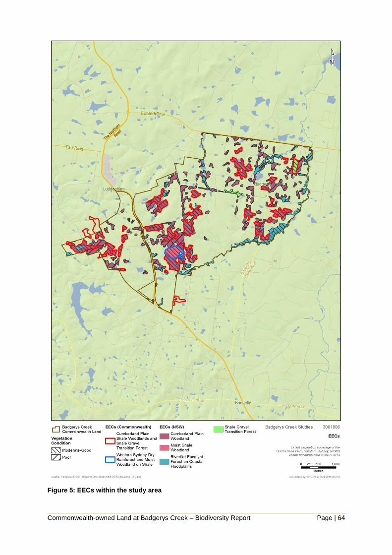
Commonwealth-owned Land at Badgerys Creek – Biodiversity Report Page | 64
Figure 5: EECs within the study area

Commonwealth-owned Land at Badgerys Creek – Biodiversity Report Page | 65
5.6 Threatened species and endangered populations
5.6.1 Flora
Ten flora species and two endangered populations listed under the TSC Act and/or EPBC
Act have been recorded within 10 kilometres of the study area (OEH 2014a) (Appendix 3). A
further twelve threatened flora species are identified as potentially occurring in the study
area (OEH 2014a). Using a matrix based approach of the likelihood of occurrence
(Appendix 3), the study area is considered to provide suitable habitat for eight of these
species as well as the two endangered populations. Those with a medium to high chance of
occurring within the study area include:
Acacia pubescens (EPBC)
Cynanchum elegans (EPBC)
Dillwynia tenuifolia
Dillwynia tenuifolia (population)
Grevillea juniperina subsp. juniperina
Grevillea parviflora subsp. parviflora
(EPBC)
Isotoma sessiliflora (Hypsela
sessiliflora)
Marsdenia viridiflora subsp. viridiflora
(population)
Pimelea spicata (EPBC)
Pultenaea parviflora (EPBC)
Two of the threatened flora species identified in the desktop assessment as having a
medium to high likelihood of occurring were specifically targeted and observed at the site
during the March 2014 field survey, Pultenaea parviflora (EPBC – V, TSC – E1) and
Marsdenia viridiflora subsp. viridiflora (TSC – E2).
Threatened flora recorded within and surrounding the study area are shown in Figure 6.
Pultenaea parviflora and Marsdenia viridiflora subsp. viridiflora records within and
surrounding the study area are shown in Figure 7. The historical record of Acacia pubescens
along Longley’s Road within the study area could not be located on the ground and it is
assumed that it is no longer present. The record was not included in the NPWS Wildlife Atlas
and was identified in the National Recovery Plan for Acacia pubescens as an ‘excluded
record - old and/or inadequate location’. There is an additional 1992 NSW Herbarium record
from Elizabeth Drive (NPWS 1997 WSUBBS Flora Appendices 3) that is not included in the
NPWS Wildlife Atlas or in the National Recovery Plan for Acacia pubescens but due to lack
of location details no targeted search was undertaken.
Pultenaea parviflora has been previously recorded in the study area. Field surveys
undertaken by SMEC, confirmed the presence of four (4) individuals of Pultenaea parviflora
on the southern side of Longley’s Road between Ferndale and Taylors Road. Sixty-eight
(68) individuals had been previously recorded along both sides of Longley’s Road in this
location. A significant reduction in the size of this population has occurred since the 1999
survey. This reduction appears most likely due to observed road widening and possibly
fencing works between the road reserve and adjoining paddock. It is noted that a good
proportion of plants recorded in 1999 were young plants 50 cm or less high indicating that
regeneration was occurring (Supplement to Draft EIS, Appendix F3). The life span of
Pultenaea parviflora is estimated to be around twenty years (OEH profile) consequently
these plants are expected to still be alive under natural conditions. At least 10 of the
68 plants were located on the roadside embankment, the habitat of which has since been
lost. A single record located to the northwest of the Longleys Road population was targeted
though no individual was found and habitat at the site was deemed to be unsuitable. An

Commonwealth-owned Land at Badgerys Creek – Biodiversity Report Page | 66
additional record to the south of the site was not specifically targeted as it could be seen that
habitat at the site was not suitable and as such the individual was assumed to be absent.
Table 9: Recent survey details for Pultenaea parviflora and Marsdenia viridiflora subsp.
viridiflora
Species &
clump no. Location Coordinates Details Vegetation community
Pultenaea
parviflora
Clump 1
Longleys Road
(top of road verge
c. 5 m from road
edge & 1 m from
fence within road
reserve on
southern side)
289829 N
6248250 E
1 plant 1 m high
x 1.5 m wide.
Flowers present.
Shale Gravel Transition
Forest regrowth.
Associated species:
Bursaria spinosa,
Dillwynia sieberi,
Lissanthe sieberi,
Astroloma humifusum,
Cheilanthes sieberi,
Dianella longifolia
Themeda australis,
Aristida vagans,
Microlaena stipoides
Pultenaea
parviflora
Clump 2
Longleys Road (on
adjoining leased
property, southern
side of road)
289849 N
6248244 E
One plant 1.5 m
high x 80cm wide
just on other side
of fence.
Shale Gravel Transition
Forest regrowth.
Associated species as
above.
Pultenaea
parviflora
Clump 3
Longleys Road
(top of road verge
c. 5 m from road
edge & 1 m from
fence
within road reserve
on southern side)
289862 N
6248241 E
One plant 0.5 m
high x 0.5 m
wide.
Shale Gravel Transition
Forest regrowth.
Associated species as
above.
Pultenaea
parviflora
Clump 4
Longleys Road (on
roadside
embankment at
edge of zone
impacted from
road widening,
within road reserve
on southern side)
289837 N
6248249 E
One damaged
plant 0.3 m high
x 0.2 m wide
Several larger
dead plants
observed in
close vicinity.
Flowers present.
Shale Gravel Transition
Forest regrowth.
Associated species as
above.
Marsdenia
viridiflora
subsp.
viridiflora
Clump 1
Longleys Road
(road reserve on
southern side). On
upper
embankment and
above disturbed
road edge.
290039 N
6248218 E
Five plants
growing up
through Native
Blackthorn
Bursaria
regrowth,
climbing to 1-3 m
high.
Shale Plains
Woodland/Shale Gravel
Transition Forest
regrowth. Associated
species: Bursaria spinosa,
Exocarpos cupressiformis,
Eucalyptus moluccana,
Glycine tabacina,
Microlaena stipoides,

Commonwealth-owned Land at Badgerys Creek – Biodiversity Report Page | 67
Species &
clump no. Location Coordinates Details Vegetation community
Exotic species: African
Olive, Rhodes Grass &
Mother of Millions.
Marsdenia
viridiflora
subsp.
viridiflora
Clump 2
Longleys Road
(road reserve on
southern side). On
upper
embankment and
above disturbed
road edge.
290076 N
6248211 E
Three plants
growing up
through Native
Blackthorn
Bursaria
regrowth,
climbing to 1-3 m
high.
Shale Plains
Woodland/Shale Gravel
Transition Forest
regrowth. Associated
species as above.
Marsdenia
viridiflora
subsp.
viridiflora
Clump 3
Longleys Road
(road reserve on
southern side). On
upper
embankment and
above disturbed
road edge.
290123 N
6248201 E
1 small plant
growing among
Native
Blackthorn
Bursaria
regrowth.
Shale Plains
Woodland/Shale Gravel
Transition Forest
regrowth. Associated
species as above.
Marsdenia
viridiflora
subsp.
viridiflora
Clump 4
Longleys Road
(road reserve on
southern side). On
upper
embankment and
above disturbed
road edge.
290082 N
6248210 E
1 large and 2
small plants
growing amongst
Bursaria
regrowth
Shale Plains
Woodland/Shale Gravel
Transition Forest
regrowth. Associated
species as above.
Marsdenia
viridiflora
subsp.
viridiflora
Badgerys Creek
Road, fence-line of
road reserve on
eastern side of
road c. 20 m north
of Gardiner Rd.
291217 N
6249048 E
One plant (two
stems) growing
up fence. Road
reserve generally
weedy with
Rhodes Grass
and Verbena.
Disturbed Shale Plains
Woodland, more intact on
adjoining property.
Eucalyptus regeneration
and occasional plants of
Pultenaea microphylla,
Einadia hastata,
Dichondra repens,
Themeda australis,
Aristida vagans & Dianella
longifolia.
Marsdenia viridiflora subsp. viridiflora was also previously recorded in the study area. Field
surveys undertaken by SMEC, confirmed the presence of one individual of Marsdenia
viridiflora subsp. viridiflora along the eastern side of Badgerys Creek, just north of Gardiner
Road. New records (12 individuals) were also found during the field survey on the southern
side of Longley’s Road between Ferndale and Taylors Road. Details of survey records are
summarised in Table 9.
The Pultenaea parviflora population along Longley’s Road is considered to be of low to
medium conservation significance at state and national levels. Pultenaea parviflora is
Commonwealth-owned Land at Badgerys Creek – Biodiversity Report Page | 68
restricted to threatened Castlereagh woodlands, Shale Gravel Transition Forest and more
rarely shale woodland in mostly central parts of the Cumberland Plain with population size
from 1 to several thousand. The population along Longley’s Road is very small with four
plants recorded in this survey although a much larger population (68 plants) was previously
recorded. Despite the observed damage to habitat through road widening, it is possible that
seed is present in areas of undisturbed soil and the population potentially larger than is
immediately apparent. Recruitment occurs from seed and is largely dependent on fire. The
Longley’s Road site is an outlier population occurring in atypical habitat (marginal
occurrence of Tertiary alluvium within dominant shale environment) and could potentially
represent a genetic variant important to the survival of the species. The location is close to
the species southern geographical limit. Pultenaea parviflora is not well protected across its
range outside of Windsor Downs, Castlereagh and Wianamatta Nature Reserves.
It is possible that Pultenaea parviflora occurs elsewhere within the study area in patches of
Shale Gravel Transition Forest, an ecological community that was not previously identified in
the 1999 EIS. Further targeted survey during spring is recommended.
The Marsdenia viridiflora subsp. viridiflora sub-population along Longley’s Road and
Badgerys Creek Road is considered to be of medium conservation significance within the
Sydney region and NSW. The TSC listed endangered population is generally restricted to
small, fragmented remnants of Cumberland Plain Woodland and Shale Gravel Transition
Forest in central to southern parts of the Cumberland Plain, population size is generally
small and it is poorly protected in conservation reserves (Scientific Committee 2002, NPWS
1997 WSUBBS, OEH threatened species profile).
The sub-population within the study area is of relatively moderate size and close to the
western limit of the endangered population. There is a reasonable probability that this
species occurs elsewhere within the study area in view of the extent of potential habitat and
the cryptic nature of the plant when growing in stands of Native Blackthorn Bursaria spinosa.
Further targeted survey is recommended.
Other species identified as having a medium to high chance of occurring within the study
area should also be subject to targeted survey, particularly the more cryptic Pimelea spicata.

Commonwealth-owned Land at Badgerys Creek – Biodiversity Report Page | 69
Figure 6: Threatened species records in and surrounding the study area

Commonwealth-owned Land at Badgerys Creek – Biodiversity Report Page | 70
Figure 7: Pultenaea parviflora and Marsdenia viridiflora subsp. viridiflora records in and
surrounding the study area

Commonwealth-owned Land at Badgerys Creek – Biodiversity Report Page | 71
5.6.2 Fauna
Thirty-four threatened fauna species listed under the TSC Act and/or EPBC Act have been
recorded within 10 kilometres of the study area (OEH 2014a) (Appendix 3). Of these, 33 are
listed as threatened under the TSC Act and nine are listed as threatened under the EPBC
Act (Appendix 3). A further eight threatened fauna species listed under the EPBC Act are
identified as potentially occurring in the study area (DoE 2014b). Using a matrix based
approach of the likelihood of occurrence (Appendix 3), the study area is considered to
provide suitable habitat and resources for 26 of these species. Species that have a medium
to high chance of occurring within the study area include:
Giant Burrowing Frog (EPBC)
Green and Golden Bell Frog (EPBC)
Barking Owl
Black-chinned Honeyeater
Diamond Firetail
Flame Robin
Gang-gang Cockatoo
Glossy Black-cockatoo
Hooded Robin
Little Eagle
Little Lorikeet
Powerful Owl
Masked Owl
Regent Honeyeater (EPBC)
Scarlet Robin
Speckled Warbler
Square-tailed Kite
Swift Parrot (EPBC)
Varied Sittella
Cumberland Plain Land Snail
Eastern Bentwing Bat
Eastern Freetail Bat
Greater Broad-nosed Bat
Grey-headed Flying-fox (EPBC)
Large-eared Pied Bat (EPBC)
Southern Myotis
No threatened fauna species were observed during the surveys undertaken by SMEC in
September 2014, however no targeted threatened fauna surveys were undertaken.
Threatened fauna records in the vicinity of the study area are shown in Figure 6.
There are no records of threatened or protected fish species listed under the FM Act
occurring in the Liverpool LGA and no suitable habitat for any listed species occurs within
the study area.
Although suitable feed trees for the Koala occur within the study area, it is unlikely suitable
habitat is present for this species. Despite this a SEPP 44 and EPBC assessment for Koala
habitat has been undertaken for completeness (see Section 5.12).
5.7 Migratory species
The results of the 10 kilometre database searches included numerous migratory species.
Many of these species have not been considered in this biodiversity report due to the
unsuitable nature of this terrestrial environment to provide any necessary habitat
requirements. Species that may occasionally visit the study area have been included in this
report (Appendix 3). Species not considered in this report include pelagic seabirds (i.e.
albatross and petrel species) and marine species. This approach deemed the study area

Commonwealth-owned Land at Badgerys Creek – Biodiversity Report Page | 72
likely to provide suitable habitat and resources for seven migratory species listed under the
EPBC Act:
Cattle Egret
Fork-tailed Swift
Great Egret
Latham’s Snipe
Rainbow Bee-eater
Rufous Fantail
White-throated Needletail
No migratory species were observed during the surveys undertaken by SMEC in September
2014, however no targeted fauna surveys were undertaken.
5.8 Critical habitat
The subject site is not registered as critical habitat under NSW or Commonwealth legislation.
5.9 Groundwater dependent ecosystems
Badgerys Creek is identified as a groundwater dependent ecosystem (GDE) according to the
Groundwater Dependent Ecosystems Atlas (BOM 2014).
The presence of potential GDEs was considered in this biodiversity report in relation to the
NSW State Groundwater Dependent Ecosystems Policy (DLWC 2002). Several types of
GDEs are recognised in NSW (Office of Water 2012) however the GDE with the most
relevance to the study area is ‘terrestrial vegetation’ where forest or woodland may be
sustained, either permanently or periodically by shallow groundwater that discharges to local
creeks or rivers.
The NSW Office of Water Risk assessment guidelines for groundwater dependent
ecosystems indicate that several vegetation communities that occur within the study area
are likely to be ‘high probability groundwater dependent ecosystems’. These include:
Cumberland Moist Shale Woodland
Cumberland Shale Hills Woodland
Cumberland Shale Plains Woodland
Cumberland River Flat Forest
These GDEs are equivalent to vegetation communities described in the study area. As such
it is likely that vegetation within these vegetation communities will have a moderate to high
dependence upon groundwater at various times, including during low rainfall or drought
periods. This will need to be further confirmed during any future environmental assessment
for the site, and will need to take into account further site-specific hydrological assessment.
5.10 Aquatic habitat
Although there are no records of threatened or protected fish species listed under the FM
Act occurring in the Liverpool LGA, the study area does contain key fish habitat according to
the draft Policy and Guidelines for Fish Habitat Conservation and Management – Update
2013 (DPI 2013). Key fish habitat is shown in Figure 8.
Key fish habitat under this policy is classified by its ‘sensitivity’ and ‘waterway classification’.

Commonwealth-owned Land at Badgerys Creek – Biodiversity Report Page | 73
‘Sensitivity’ is defined by the importance of the habitat to the survival of fish (noting that ‘fish’
under the FM Act includes all aquatic invertebrates) and its robustness (ability to withstand
disturbance). Key fish habitat in the study area is classified as Type 3 - Minimally sensitive
key fish habitat.
The waterway classification scheme is adapted from Fairfull and Witheridge (2003) and
factors in the functionality of the waterway as fish habitat. Key fish habitat in the study area
is classified as Class 3 Minimal Key Fish Habitat: Named or unnamed waterway with
intermittent flow and sporadic refuge, breeding or feeding areas for aquatic fauna (e.g. fish,
yabbies). Semi-permanent pools form within the waterway or adjacent wetlands after a rain
event. Otherwise, any minor waterway that interconnects with wetlands or other CLASS 1-3
fish habitats.
Aquatic habitats within the site have the potential to be adversely affected by future
development in the area. Additional and ongoing water quality testing would be
recommended in order to provide an adequate baseline against which impacts may be
measured. It should be noted in this context that no aquatic ecological assessment was
undertaken during field investigations for this report.

Commonwealth-owned Land at Badgerys Creek – Biodiversity Report Page | 74
Figure 8: Key fish habitat

Commonwealth-owned Land at Badgerys Creek – Biodiversity Report Page | 75
5.11 Wildlife connectivity corridors
Parts of the study area have been identified within the Liverpool City Council Biodiversity
Management Plan as ‘regionally connected vegetation’, and ‘riparian corridor’ (Liverpool City
Council 2012).
The Draft EIS for the Second Sydney Airport Proposal also identifies Badgerys Creek (the
waterway) as a corridor of high local significance. From desktop assessment it is clear that
this waterway remains largely vegetated throughout the study area. It is likely that the creek
forms an important (broadly) north-south corridor for wildlife movement within the site.
South Creek is located to the east of the study area. As with Badgerys Creek, this waterway
was not specifically surveyed during field studies though is likely to provide an important
north-south corridor for wildlife movement through western Sydney.
There is a high probability that the vegetation surrounding most waterways within the study
area would be of a somewhat degraded condition based upon the prevalence of exotic
vegetation generally in the area. Limited results from two sites sampled in the SMEC flora
survey (away from the riparian zone but still within River-flat Forest) indicates that vegetation
was in moderate condition. A detailed assessment of the condition and corridor value of
these and other waterways present within the study area would be recommended to be
undertaken as part of any future environmental assessment.
The WSUBBS identifies Badgerys Creek as riparian corridor between The Northern Road
and Elizabeth Drive (WSUBBS 1997). The corridor was found to support Swamp Oak Forest
dominated by Casuarina glauca intergrading with Red Gum-Cabbage Gum Forest. The
report notes that the area has been affected by clearing for agriculture as well as water
quality issues associated with chicken farming. It recommends the protection of vulnerable
plant species and protection of the riparian corridor.
OEH are undertaking corridor mapping as part of linking landscapes in the locality. They are
currently seeking feedback from local Councils (including Liverpool Council) on the draft map
layers. The purpose of this mapping is to identifying areas for investment in conservation
activities, including offsetting. The mapping is likely to be available in 2015.
5.12 Koala Habitat
5.12.1 Draft EPBC Act referral guidelines for the vulnerable koala
Consideration of these guidelines in this report is limited to identifying whether there is koala
habitat in the study area and assessing the potential need for a referral which would need to
be confirmed in any future environmental assessment.
In December 2013 the Commonwealth Department of the Environment replaced the Interim
koala referral advice for proponents (DoE 2012) with the Draft EPBC Act referral guidelines
for the vulnerable koala (DoE 2013a). These guidelines provide specific advice to
proponents on how to avoid and mitigate development impacts on the koala. These
guidelines set out a process in which the need for referral of the project to the
Commonwealth is specified according to the location and habitat attributes of the proposed
development site and having regard to the significance of impacts associated with the taking
of the proposed action. This process is illustrated in Figure 9.

Commonwealth-owned Land at Badgerys Creek – Biodiversity Report Page | 76
Figure 9: Draft EPBC Act referral guidelines for koala (DoE 2013a)

Commonwealth-owned Land at Badgerys Creek – Biodiversity Report Page | 77
The process identified in the flowchart was undertaken in order to assess the potential for a
significant impact of an action upon the koala or its habitat. The process undertaken is
outlined below, with numbers correlating to those on the left of Figure.
1. Could the impact(s) of your action occur within the modelled distribution of the koala?
The study area is within an area mapped as ‘Known/Likely to occur’.
2. Determine the geographic context of your action
The study area is within the ‘coastal area’, as defined by the guidelines.
3. Does your impact area contain koala habitat?
The draft EPBC Act referral guidelines for the vulnerable koala (DoE 2013a) state
that: “For the purposes of these guidelines, koala habitat is defined as any forest or
woodland containing species that are known koala food trees or shrubland with
emergent food trees. This can include remnant or non-remnant vegetation in natural,
agricultural and urban environments. Koala habitat is defined based on the plant
community present and the vegetation structure; the koala does not necessarily have
to be present.”
Based on the above definition and the plant species detected during initial site
inspections (Eucalyptus tereticornis), listed as primary and secondary food trees
respectively in the Hawkesbury Nepean CMA, the study area may be considered to
contain koala habitat.
4. Does your impact area contain habitat critical to the survival of the koala (score ≥ 5 in
the habitat assessment tool)?
The draft EPBC Act referral guidelines provide a tool whereby a site may be
assessed for its potential to be considered critical koala habitat. This tool is provided
in Table 10, with the answers relevant to this site highlighted in blue.

Commonwealth-owned Land at Badgerys Creek – Biodiversity Report Page | 78
Table 10: EPBC koala guidelines habitat assessment tool
Attribute Score Inland Coastal
Koala
occurrence +2 (high)
Evidence of one or more
koalas within the last 5 years.
Evidence of one or more koalas
within the last 2 years.
+1
(medium)
Evidence of one or more
koalas within 5 km of the edge
of the impact area within the
last 10 years.
Evidence of one or more koalas
within 5 km of the edge of the impact
area within the last 5 years.
0 (low) None of the above. None of the above.
Vegetation
composition
+2
(high)
Has forest, woodland or
shrubland with emerging trees
with 2 or more known koala
food tree species in the
canopy.
Has forest or woodland with 2 or
more known koala food tree species
in the canopy.
+1
(medium)
Has forest, woodland or
shrubland with emerging trees
with only 1 species of known
koala food tree present in the
canopy.
Has forest or woodland with only 1
species of known koala food tree
present in the canopy.
0 (low) None of the above. None of the above.
Habitat
connectivity
+2
(high)
Area is part of a contiguous
landscape ≥ 1000 ha.
Area is part of a contiguous
landscape ≥ 500 ha.
+1
(medium)
Area is part of a contiguous
landscape < 1000 ha, but ≥
500 ha.
Area is part of a contiguous
landscape < 500 ha, but ≥ 300 ha.
0
(low)
None of the above None of the above.
Key existing
threats
+2
(low)
Little or no evidence of koala
mortality from vehicle strike or
dog attack at present in areas
that score 1 or 2 for koala
occurrence.
Little or no evidence of koala
mortality from vehicle strike or dog
attack at present in areas that score
1 or 2 for koala occurrence.
+1
(medium)
Evidence of infrequent or
irregular koala mortality from
vehicle strike or dog attack at
present in areas that score 1
or 2 for koala occurrence.
Evidence of infrequent or irregular
koala mortality from vehicle strike or
dog attack at present in areas that
score 1 or 2 for koala occurrence.
0
(high)
Evidence of frequent or regular
koala mortality from vehicle
strike or dog attack in the
study area at present, or
Areas which score 0 for koala
occurrence and have a significant
dog or vehicle threat present.

Commonwealth-owned Land at Badgerys Creek – Biodiversity Report Page | 79
Attribute Score Inland Coastal
Recovery
value +2 (high)
Habitat is likely to be important
for achieving the interim
recovery objectives for the
relevant context.
Habitat is likely to be important for
achieving the interim recovery
objectives for the relevant context.
+1
(medium)
Uncertainty exists as to
whether the habitat is
important for achieving the
interim recovery objectives for
the relevant context.
Uncertainty exists as to whether the
habitat is important for achieving the
interim recovery objectives for the
relevant context.
0 (low)
Habitat is unlikely to be
important for achieving the
interim recovery objectives for
the relevant context.
Habitat is unlikely to be important for
achieving the interim recovery
objectives for the relevant context.
The koala habitat assessment tool provided an overall score of two for the Badgerys Creek
site. Based upon this and the results of the previous flowchart steps it is deemed that a
referral to the DoE specifically for potential impacts upon the koala would not be required.
While the result of the above process is likely to be very similar to that undertaken on behalf
of future development on the site it is recommended that it is repeated at that stage in order
to confirm these findings.
5.12.2 SEPP 44
This Policy concerns the protection of core koala habitat, habitat with evidence of koala
usage, or areas of native potential habitat. Potential koala habitat within the Liverpool LGA is
defined as any area that has at least 15 per cent of trees in the upper and lower strata
comprised of Schedule 2 feed tree species: forest red gum (Eucalyptus tereticornis),
tallowwood (Eucalyptus microcorys), grey gum (Eucalyptus punctata), manna gum
(Eucalyptus viminalis), river red gum (Eucalyptus camaldulensis), broad leaved scribbly gum
(Eucalyptus haemastoma), scribbly gum (Eucalyptus signata), white box (Eucalyptus
albens), poplar box (Eucalyptus populnea) and swamp mahogany (Eucalyptus robusta).
No individuals, or characteristic scratching or scats, were identified during the initial flora and
fauna survey, with no evidence to suggest a resident koala population exists within the study
area. Therefore it is unlikely that the study area would be classified as core koala habitat.
One of the feed tree species was recorded within the study area (Eucalyptus tereticornis),
and it comprised up to 15 per cent of the upper and lower strata of three of the sites visited,
suggesting there is potential koala habitat as defined in SEPP 44 in the study area. Other
parts of the study area not visited by SMEC in 2014 may also meet the definition of potential
koala habitat under SEPP 44.
5.13 Key Threatening Processes
The following Key Threatening Processes listed under the TSC Act are likely to be operating
within the study area:
Alteration to the natural flow regimes of rivers and streams and their floodplains and
wetlands.

Commonwealth-owned Land at Badgerys Creek – Biodiversity Report Page | 80
Clearing of native vegetation.
Competition and grazing by the feral European rabbit (Oryctolagus cuniculus)
Infection of frogs by amphibian chytrid causing the disease chytridiomycosis.
Infection of native plants by Phytophthora cinnamomi.
Introduction and Establishment of Exotic Rust Fungi of the order Pucciniales pathogenic
on plants of the family Myrtaceae.
Invasion of native plant communities by African Olive (Olea europaea L. subsp.
cuspidata).
Invasion and establishment of exotic vines and scramblers.
Invasion by native plant communities by exotic perennial grasses.
Invasion, establishment and spread of lantana (Lantana camara).
Loss of hollow-bearing trees.
Loss and degradation of native plant and animal habitat by invasion of escaped garden
plants, including aquatic plants.
Predation by the European Red Fox (Vulpes vulpes).
Predation by the feral cat (Felis catus).
Predation by Gambusia holbrooki Girard, 1859 (plague minnow or mosquito fish).
Removal of dead wood and dead trees.
Management of land within the study area should seek to reduce the impact of these KTPs
or at least reduce the likelihood of exacerbating the effect of the KTPs. Other KTPs may be
introduced to the study area if there is a land use change.
The following TAPs are likely to be relevant to the study area:
Predation by the red fox (Vulpes vulpes).
Predation by Gambusia holbrooki (plague minnow).
Management guidance provided in these documents should be considered in relation to
management of land in the study area.

Commonwealth-owned Land at Badgerys Creek – Biodiversity Report Page | 81
6 KEY FINDINGS AND INFORMATION GAPS
6.1 Overview of key findings
The key findings of this report are as follows:
Flora
Biodiversity values within the study area are of national, state, regional and local
significance. A diverse range of threatened vegetation communities occur across low-
lying plains and more hilly terrain in the south-west. Most of EPBC listed vegetation in
the study area likely to meet condition thresholds occurs as larger remnants with over
76% of the total area in patches of over 5 ha and approximately 40% in patches of over
25 ha. There are no priority conservation lands greater than 50 ha in size, however, as
identified in the Cumberland Plain Recovery Plan (DECCW 2011). There is moderate to
good connectivity between remnants along both drainage-lines and roadsides,
particularly in the northern and western parts. Patch size and connectivity within the
study area is generally higher than on adjoining lands to the north and north-west,
comparable to lands to the south and lower than to the west and east.
The majority of mapped vegetation in the study area is Shale Plains Woodland and
Shale Hills Woodland (124.5 and 208 hectares respectively), both components of
Cumberland Plain Woodland and included in the EPBC listing for Cumberland Plain
Shale Woodlands and Shale-Gravel Transition Forest and the TSC Act listing for
Cumberland Plain Woodlands. Only the larger, higher condition remnants of Cumberland
Plain Woodlands are likely to meet the condition thresholds of the EPBC Act
determination.
A small amount of Shale Gravel Transition Forest (9.1 ha) has been identified from
recent field survey in the study area associated with small patches of Tertiary alluvium
and/or high concentrations of iron-hardened gravels. This community has not previously
been mapped in the study area and it is likely that additional patches could occur. Shale
Gravel Transition Forest is listed separately under the TSC Act but is included in the
EPBC listing for Cumberland Plain Shale Woodlands and Shale-Gravel Transition
Forest.
A small area of Moist Shale Woodland (13.5 ha) has been identified in the study area
during field survey at higher elevations on rolling topography south-east of Luddenham.
Moist Shale Woodland has not been previously mapped in the study area. This
vegetation community is listed separately under the TSC Act and is part of the EPBC
listing for Western Sydney Dry Rainforest and Moist Woodland on Shale.
The condition of vegetation remnants in the supplement to the Draft EIS was largely
described as poor to very poor (48 out of 53 remnants visited). Using current condition
assessment methods, including an estimate of native species richness, field survey
undertaken in September 2014 found that ten out of the twelve sites visited would be
classified as moderate to good condition.
Field surveys undertaken by SMEC, confirmed the presence of four individuals of
Pultenaea parviflora on the southern side of Longley’s Road between Ferndale and
Taylors Road. Sixty-eight individuals had been previously recorded along both sides of
Longley’s Road in this location. A significant reduction in the size of this population has
Commonwealth-owned Land at Badgerys Creek – Biodiversity Report Page | 82
occurred since the Draft EIS. This reduction appears most likely due to observed road
widening and possibly fencing works between the road reserve and adjoining paddock.
Marsdenia viridiflora subsp. viridiflora was also previously recorded in the study area.
Field surveys undertaken by SMEC, confirmed the presence of one individual along the
eastern side of Badgerys Creek, just north of Gardiner Road. New records (12
individuals) were also found during the field survey on the southern side both sides of
Longleys Road between Ferndale and Taylors Road.
No other threatened flora species have been found in the study area, however, there is
potential habitat for a further seven threatened flora species and one endangered
population.
Six of the threatened flora species with potential habitat in the study area are listed under
the EPBC Act. These are Acacia pubescens, Cynanchum elegans, Grevillea parviflora
subsp. parviflora, Pultenaea parviflora, Isotoma sessiliflora and Pimelea spicata.
Nine noxious weeds declared in the Liverpool LGA (Noxious Weeds Act 1993) were
observed in the study area, six of these are Weeds of National Significance.
The NSW Office of Water Risk assessment guidelines for groundwater dependent
ecosystems indicate that several vegetation communities that occur within the study area
are likely to be ‘high probability groundwater dependent ecosystems’.
Management strategies have been provided in order to minimise impact on native flora
(Section 7.2 ).
Fauna
The study area contains low to moderate quality habitat, including riparian vegetation
open woodland and grassland vegetation.
Badgerys Creek has been identified as a potential wildlife corridor in a number of local
and regional planning documents.
Potential habitat is available within the study area for 26 threatened fauna species
including the Cumberland Plain Land Snail, woodland birds, microchiropteran bats and
the Grey-headed Flying-fox. No targeted surveys for threatened fauna species were
undertaken during the September 2014 surveys.
Six of the threatened fauna species with potential habitat in the study area are listed
under the EPBC Act. These are the Giant Burrowing Frog, Green and Golden Bell Frog,
Regent Honeyeater, Swift Parrot, Large-eared Pied Bat and Grey-headed Flying-fox.
Seven migratory species, Cattle Egret, Fork-tailed Swift, Great Egret, Latham’s Snipe,
Rainbow Bee-eater, Rufous Fantail and White-throated Needletail have also been
identified as having potential habitat in the study area.
Management strategies have been recommended in order to minimise impact on native
fauna (Section 7.2 ).
6.2 Information gaps
There are a number of information gaps that exist due to:

Commonwealth-owned Land at Badgerys Creek – Biodiversity Report Page | 83
New and improved standards for flora and fauna survey since the Draft EIS and
Supplement were prepared.
Improvement in knowledge of species distribution and significance.
Changes in legislative status of biodiversity.
The following gaps have been identified that would need to be addressed in any future
environmental assessment:
Vegetation communities have not been accurately described for the study area at the
level of detail required for any future environmental assessment. The study area is
included in the Native Vegetation of the Cumberland Plain mapping (NPWS 2002f),
however, there are some communities that were identified in the study area during
SMEC field surveys that have not been previously mapped in the study area. Further
vegetation survey is required to determine the extent of these vegetation communities.
Areas of potential derived native grassland observed during fieldwork were also mapped
as ‘cleared’. Further assessment of the extent of derived native grasslands would also be
required.
Vegetation condition has not been accurately assessed in the study area. There is a
large discrepancy between vegetation condition descriptions for vegetation remnants in
the 1999 EIS and the vegetation condition observed at a selection of the same remnants
by SMEC during field surveys, using current accepted condition assessment methods.
Further vegetation survey is required to determine the condition of remnant vegetation in
the study area. EPBC Act listing information for EECs specifies patch size and condition
thresholds for identification. Detailed vegetation condition information would allow a
subset of vegetation that would meet the EPBC definition to be accurately quantified.
There is a lack of recent survey effort for threatened flora. Suitable habitat exists for eight
flora species and two endangered populations (Acacia pubescens, Cynanchum elegans,
Dillwynia tenuifolia, Grevillea juniperina subsp. juniperina, Grevillea parviflora subsp.
parviflora, Isotoma sessiliflora (Hypsela sessiliflora), Marsdenia viridiflora subsp.
viridiflora, Pimelea spicata and Pultenaea parviflora) within the study area. Targeted
surveys for these species in areas of suitable habitat would be required for any future
environmental assessment.
There is also a lack of recent survey effort for threatened fauna. A range of fauna survey
guidelines have been developed by Commonwealth and State regulatory agencies in
recent years to increase the likelihood of detecting a species if present in the study area.
Suitable habitat exists for 33 threatened or migratory fauna species within the study
area. Targeted surveys for these species in areas of suitable habitat would be required
for any future environmental assessment.
Surveys of the site undertaken in the late 1990s would not be suitable for use as part of
future environmental assessment of the site as they are now outdated. This is due to
several changes in the site and legislative context in the intervening period including:
updates to Commonwealth environmental legislation and supporting regulation (such as
threatened flora and fauna survey and assessment guidelines), changes to the suite of
listed threatened species (both NSW and Commonwealth), changes in the ecological
and physical condition of the site, as well as the nature of land use. Previous surveys
may however provide a useful general background of the site and the nature of change
over time. Any future surveys would need to adhere to the guidelines outlined in Chapter
3.
Commonwealth-owned Land at Badgerys Creek – Biodiversity Report Page | 84
The existing biodiversity information available for the study area would also be
inadequate to allow quantification of impacts and possible offsets required as a result of
any future development of the site in accordance with either the EPBC Act
Environmental Offset Policy and associated Offset Assessment Guide or the NSW
Biodiversity Offsets Policy for Major Projects.
Detail on aquatic flora and fauna is patchy and inconsistently reported in previous
studies. Aquatic surveys previously undertaken at the site will require updating prior to
any future development. This will include resurveying all relevant waterways including
streams, creeks, dam and wetlands within the site.
To fill these gaps the following would be required:
Further assessment of remnant vegetation is required to accurately determine the extent
of vegetation communities present, particularly the extent of Moist Shale Woodland and
Shale Gravel Transition Forest components of EPBC listed EECs.
Further field assessment is required to better detail the extent and condition of EPBC Act
listed vegetation as a subset of TSC Act listed vegetation in line with patch size and
condition thresholds in the EPBC conservation advice for EECs. Survey methods will
need to be consistent with current accepted standards and guidelines.
Targeted threatened flora and fauna survey for all species listed in Appendix 4 as having
a medium to high risk of occurrence would be required to bring the level of information
into line with current accepted standards and guidelines. Requirements for survey for
each of the 12 flora and 33 fauna species requiring survey including duration, timing and
techniques are detailed in Appendix 4.
Recommendations for future survey are provided in Section 7.1 and Appendix 4.

Commonwealth-owned Land at Badgerys Creek – Biodiversity Report Page | 85
7 RECOMMENDATIONS
7.1 Survey recommendations
To adequately describe the biodiversity values of the study area for any future environmental
assessment of the study area, information gaps identified in Section 6.2 would need to be
addressed. This would require detailed vegetation survey and mapping, targeted threatened
flora searches and seasonal fauna surveys. The following survey activities are
recommended:
Detailed vegetation community and condition mapping of the study area. This would
involve additional site stratification and vegetation sampling using plot surveys, including
full floristics, to supplement the vegetation plot assessment already undertaken by
SMEC in 2014. This additional plot survey would be used to inform preparation of
detailed vegetation community and condition mapping.
Targeted threatened flora survey for ten threatened flora species in areas of potential
habitat in the study area during the appropriate flowering season. Species to be
surveyed for include, Acacia pubescens (EPBC), Cynanchum elegans (EPBC), Dillwynia
tenuifolia, Grevillea juniperina subsp. juniperina, Grevillea parviflora subsp. parviflora
(EPBC), Isotoma sessiliflora (Hypsela sessiliflora), Marsdenia viridiflora subsp. viridiflora,
Pimelea spicata (EPBC) and Pultenaea parviflora (EPBC).
Targeted survey for 26 threatened fauna species with potential habitat in the study area.
All potential threatened species are listed under the TSC Act, with five of these also
listed under the EPBC Act. These are:
Giant Burrowing Frog
(EPBC)
Green and Golden Bell
Frog (EPBC)
Barking Owl
Black-chinned
Honeyeater
Diamond Firetail
Flame Robin
Gang-gang Cockatoo
Glossy Black-cockatoo
Hooded Robin
Little Eagle
Little Lorikeet
Powerful Owl
Masked Owl
Regent Honeyeater
(EPBC)
Scarlet Robin
Speckled Warbler
Square-tailed Kite
Swift Parrot (EPBC)
Varied Sittella
Cumberland Plain Land
Snail
Eastern Bentwing Bat
Eastern Freetail Bat
Greater Broad-nosed Bat
Grey-headed Flying-fox
(EPBC)
Large-eared Pied Bat
(EPBC)
Southern Myotis
Targeted survey for seven migratory species with potential habitat in the study area.
Species to be surveyed for include Cattle Egret, Fork-tailed Swift, Great Egret, Latham’s
Snipe, Rainbow Bee-eater, Rufous Fantail and White-throated Needletail.
Further survey of representative aquatic environments throughout the study area, with
targeted surveys undertaken for known threatened aquatic flora and fauna.
Specific techniques and timing of surveys for all threatened species described above is
provided in Appendix 4.

Commonwealth-owned Land at Badgerys Creek – Biodiversity Report Page | 86
7.2 Management recommendations
Within the context of future development plans for the site and to the extent that is
practicable and reasonable, consideration should be given to implementing the management
measures described in Table 11 to protect and enhance existing ecological assets and
values.
Should a formal development proposal for the site come forward, appropriate management
measures should be prepared as part of that proposal’s environmental assessment. Any
such future recommendations for environmental management should be consistent with best
practice guidance and subject to further detailed field investigations. Future management of
the Commonwealth land should consider the “avoid/mitigate/offset” hierarchy of impact
management.
Where impacts arising from future development are deemed unavoidable or cannot
otherwise be mitigated through management actions, consideration should be given to
potential offsetting arrangements consistent with relevant legislative and policy
requirements.
It should be noted that the management measures below have been prepared on the basis
of protecting and enhancing existing ecological assets and values within the study area,
including threatened flora and ecological communities, as well as habitat for threatened
fauna. As the land within the study area is nearly all Commonwealth owned the measures
provided have been primarily prepared for the protection of matters of national
environmental significance. In doing so however many NSW state objectives for threatened
species management will also be met.
The management measures provided are broadly listed in order of priority for managing
ecological values.
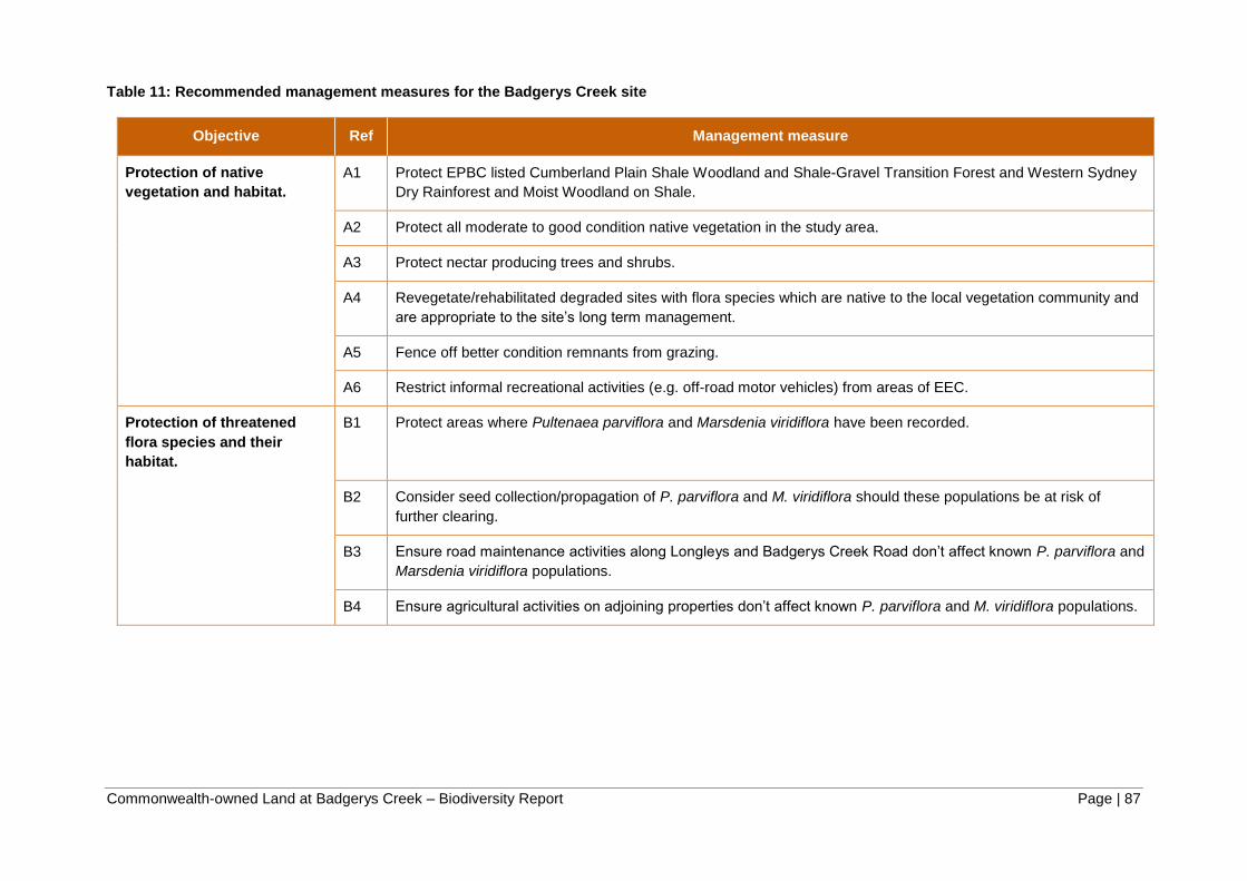
Commonwealth-owned Land at Badgerys Creek – Biodiversity Report Page | 87
Table 11: Recommended management measures for the Badgerys Creek site
Objective Ref Management measure
Protection of native
vegetation and habitat.
A1 Protect EPBC listed Cumberland Plain Shale Woodland and Shale-Gravel Transition Forest and Western Sydney
Dry Rainforest and Moist Woodland on Shale.
A2 Protect all moderate to good condition native vegetation in the study area.
A3 Protect nectar producing trees and shrubs.
A4 Revegetate/rehabilitated degraded sites with flora species which are native to the local vegetation community and
are appropriate to the site’s long term management.
A5 Fence off better condition remnants from grazing.
A6 Restrict informal recreational activities (e.g. off-road motor vehicles) from areas of EEC.
Protection of threatened
flora species and their
habitat.
B1 Protect areas where Pultenaea parviflora and Marsdenia viridiflora have been recorded.
B2 Consider seed collection/propagation of P. parviflora and M. viridiflora should these populations be at risk of
further clearing.
B3 Ensure road maintenance activities along Longleys and Badgerys Creek Road don’t affect known P. parviflora and
Marsdenia viridiflora populations.
B4 Ensure agricultural activities on adjoining properties don’t affect known P. parviflora and M. viridiflora populations.

Commonwealth-owned Land at Badgerys Creek – Biodiversity Report Page | 88
Objective Ref Management measure
Protection of threatened
fauna and their habitat.
C1 Retain mature and hollow bearing trees and supplement with nest boxes.
C2 Restrict use of pesticides to control weeds particularly near watercourses and immediately before or during wet
weather.
C3 Retain habitat features including dead wood and trees.
C4 Regeneration works in riparian areas should include placement of rocks and logs to enhance existing aquatic
habitat.
C5 Undertake regeneration activities in strategic locations to improve habitat connectivity.
C6 Maintain native grasses in pasture.
Weeds D1 Undertake noxious weed control in accordance with the Noxious Weeds Act 1993.
D2 Undertake weed control in accordance with best practice, including control of environmental weeds.
Pests and Pathogens E1 Implement measures to prevent the spread of chytrid fungus. Adopt hygiene protocol standards for the control of
disease in frogs.
E2 Follow protocol to prevent introduction or spread of Phytophthora cinnamomi. The protocols used should be either
the Sydney Region Pest Management Strategy or Best Practice Guidelines for Phytophthora cinnamomi (DECC
2008f).
E3 Myrtle Rust is to be managed in accordance with the DPI handout prepared for Myrtle rust response 2010–11:
Preventing spread of Myrtle Rust in bushland or the OEH Interim management plan for Myrtle rust in bushland
(2011).
E4 Implement pest management control for vertebrate pests.

Commonwealth-owned Land at Badgerys Creek – Biodiversity Report Page | 89
Objective Ref Management measure
Hydrology and Drainage F1 Implement controls to prevent pollution of local waterways.
F2 Manage riparian and in-stream fish habitat
F3 Restrict access of livestock to riparian areas.
F4 Reduce the potential for diffuse pollution from overland runoff or stock access.
F5 Control sediment at the catchment and local site scale.
F6 Identify and manage point sources of pollution
F7 Undertake further macroinvertebrate survey for the purposes of assessing ongoing water quality
General G1 Land management standards, including management measures to support biodiversity as outlined above, to be
included as part of new tenancy agreements.

Commonwealth-owned Land at Badgerys Creek – Biodiversity Report Page | 90

Commonwealth-owned Land at Badgerys Creek – Biodiversity Report Page | 91
8 REFERENCES AND BIBLIOGRAPHY
Bannerman S.M. and Hazelton P.A. (1990) Soil Landscapes of the Penrith 1:100,000 Sheet
map and report, Soil Conservation Service of NSW, Sydney
BoM (2014) Groundwater Dependent Ecosystems Atlas, Bureau of Meteorology, Melbourne.
Cropper, S.C. (1993) Management of Endangered Plants, CSIRO East Melbourne, Victoria.
DEC (2004) Threatened Biodiversity Survey and Assessment: Guidelines for Developments
and Activities, NSW Department of Environment and Conservation NSW, Hurstville.
DEC (2005a) Draft Recovery Plan for the Green and Golden Bell Frog (Litoria aurea). NSW
Department of Environment and Conservation, Hurstville.
DEC (2005b) Recovering Bushland on the Cumberland Plain: Best practice guidelines for
the management and restoration of bushland, NSW Department of Environment and
Conservation, Hurstville.
DEC (2006a) NSW Recovery Plan for the Large Forest Owls: Powerful Owl (Ninox strenua),
Sooty Owl (Tyto tenebricosa) and Masked Owl (Tyto novaehollandiae). Department of
Environment and Conservation, Sydney.
DEC (2006b) Persoonia nutans R. Br. (Nodding Geebung) Recovery Plan, NSW Department
of Environment and Conservation, Sydney.
DEC (2006c) Pimelea spicata R. Br. Recovery Plan, NSW Department of Environment and
Conservation, Sydney.
DECC (2008a) About the Priorities Action Statement, Department of Environment and
Climate Change NSW, Sydney.
DECC (2008b) Best practice guidelines Cooks River Castlereagh Ironbark Forest,
Department of Environment and Climate Change NSW, Sydney.
DECC (2008c) Best practice guidelines for the grey-headed flying fox, Department of
Environment and Climate Change NSW, Sydney.
DECC (2008d) Rapid Fauna Habitat Assessment of the Sydney Metropolitan Catchment
Management Authority Area, Department of Environment and Climate Change, Hurstville.
DECC (2008e) Recovery Plan for the Koala (Phascolarctos cinereus), Department of
Environment and Climate Change NSW, Sydney.
DECC (2008f) Statement of Intent 1: Infection of native plants by Phytophthora cinnamomi.
NSW Department of Environment and Climate Change (Sydney NSW. Available from:
http://www.environment.nsw.gov.au/resources/threatenedspecies/08119soipc.pdf
DECCW (2010) Draft New South Wales Biodiversity Strategy 2010–2015, Department of
Environment, Climate Change and Water NSW, Sydney.
DECCW (2010) Native Vegetation Interim Type Standard, Department of Environment,
Climate Change and Water NSW, Sydney.
DECCW (2010) Report on the methodology for identifying priority conservation lands on the
Cumberland Plain, Department of Environment, Climate Change and Water NSW, Sydney.
DECCW (2011) Cumberland Plain Recovery Plan, Department of Environment, Climate
Change and Water NSW, Sydney.

Commonwealth-owned Land at Badgerys Creek – Biodiversity Report Page | 92
Department of Environment and Heritage (2003) EPBC Act Administrative Guidelines on
Significance - Supplement for the Grey-headed Flying-fox, Department of Environment and
Heritage, Canberra.
Department of Environment and Heritage (2006) Threat Abatement Plan: Infection of
amphibians with chytrid fungus resulting in chytridiomycosis, Department of Environment
and Heritage, Canberra.
Department of Environment and Resource Management (2011) National recovery plan for
the large-eared pied bat Chalinolobus dwyeri, State of Queensland, Brisbane.
Department of Sustainability, Environment, Water, Population and Communities (2011a)
Survey guidelines for Australia’s threatened fish, Department of Sustainability, Environment,
Water, Population and Communities, Canberra.
Department of Sustainability, Environment, Water, Population and Communities (2011b)
Survey guidelines for Australia’s threatened mammals, Department of Sustainability,
Environment, Water, Population and Communities, Canberra.
Department of Sustainability, Environment, Water, Population and Communities (2011c)
Survey guidelines for Australia’s threatened reptiles, Department of Sustainability,
Environment, Water, Population and Communities, Canberra.
Department of Transport and Regional Development (DTRD) (1997) Draft Environmental
Impact Statement Second Sydney Airport Proposal, (Vols 1, 2) prepared by PPK
Environment & Infrastructure, Sydney.
Department of Transport and Regional Services (1999) Supplement to the Draft
Environmental Impact Statement Second Sydney Airport Proposal, (Vols 3,4,5 )prepared by
PPK Environment & Infrastructure, Sydney.
DEWHA (2008) Threat abatement plan for competition and land degradation by rabbits,
Department of the Environment, Water, Heritage and the Arts, Canberra.
DEWHA (2008) Threat abatement plan for predation by the European red fox, Department of
the Environment, Water, Heritage and the Arts, Canberra.
DEWHA (2009a) Significant impact guidelines for 36 migratory shorebird species: migratory
species. Department of the Environment, Water, Heritage and the Arts, Parkes, ACT.
DEWHA (2009b) Significant Impact Guidelines for the vulnerable Green and Golden Bell
Frog, Policy Statement 3.19, Department of Environment, Water, Heritage and the Arts,
Canberra.
DEWHA (2010a) Cumberland Plain Shale Woodlands and Shale-Gravel Transition Forest: A
guide to identifying and protecting the nationally threatened ecological community, Policy
Statement 3.31, Department of Environment, Water, Heritage and the Arts, Canberra.
DEWHA (2010b) Survey Guidelines for Australia’s Threatened Bats, Department of
Environment, Water, Heritage and the Arts, Canberra.
DEWHA (2010c) Survey Guidelines for Australia’s Threatened Birds, Department of
Environment, Water, Heritage and the Arts, Canberra.
DEWHA (2010d) Survey Guidelines for Australia’s Threatened Frogs, Department of
Environment, Water, Heritage and the Arts, Canberra.
DLWC (2002) The NSW State Groundwater Dependent Ecosystems Policy. Department of
Land and Water Conservation.

Commonwealth-owned Land at Badgerys Creek – Biodiversity Report Page | 93
DoE (2013a) Draft EPBC Act referral guidelines for the vulnerable koala (combined
populations of Queensland, New South Wales and the Australian Capital Territory),
Department of Environment, Canberra.
DoE (2013b) Draft survey guidelines for Australia's threatened orchids, Department of
Environment, Canberra.
DoE (2013c) Environment Protection and Biodiversity Conservation Act 1999 Environmental
Offsets Policy, Department of Environment, Canberra.
DoE (2013d) Significant impact guidelines 1.1: Matters of National Environmental
Significance, Department of Environment, Canberra.
DoE (2014a) Cooks River/Castlereagh Ironbark Forest in the Sydney Basin bioregion: draft
description, Department of Environment, Canberra.
DoE (2014b) Protected Matters Database - Search Tool Department of Environment,
Canberra. Available from: http://www.environment.gov.au/epbc/pmst
DoE (2014c) Threat abatement plan for disease in natural ecosystems caused by
Phytophthora cinnamomi, Department of Environment, Canberra.DPI (2013) Draft Policy and
Guidelines for Fish Habitat Conservation and Management – Update 2013, Department of
Primary Industries, Nelson Bay.
DPI (2013) Draft Policy and Guidelines for Fish Habitat Conservation and Management –
Update 2013, Department of Primary Industries, Nelson Bay.
DPI (2014a). Fishing and Aquaculture: Threatened and Protected Species,
Hawkesbury/Nepean CMA, NSW Department of Primary Industry. Available from:
http://www.dpi.nsw.gov.au/fisheries.
DPI (2014b). Agriculture. Noxious weeds declaration. NSW Department of Primary Industry
Available from: http://www.dpi.nsw.gov.au/agriculture/pests-weeds/weeds/noxweed
Fairfull, S. and Witheridge, G. (2003) Why do Fish Need to Cross the Road? Fish Passage
Requirements for Waterway Crossings, NSW Fisheries, Cronulla.
Hawkesbury-Nepean Catchment Management Authority (2013) Greater Sydney Local Land
Service Transition Catchment Action Plan 2013-2023, Hawkesbury-Nepean Catchment
Management Authority, Sydney.
James, T. (1997) Urban bushland biodiversity survey: native flora of western Sydney, flora
appendices 2, National Parks & Wildlife Service, NSW, Hurstville.
Liverpool City Council (2012) Liverpool Biodiversity Management Plan, Liverpool City
Council, Liverpool.
McDougall, K.L. and Summerell, B.A. (2002). Nomination to list ‘infection of native plants by
Phytophthora cinnamomi as a key threatening process. Unpublished nomination to the NSW
Scientific Committee prepared by the NSW National Parks and Wildlife Service and the
Royal Botanic Gardens, Sydney.
Menkhorst, P., Schedvin, N., Geering, D. (1999) Regent Honeyeater Recovery Plan 1999 -
2003, Department of Natural Resources and Environment Victoria, Melbourne.
Mooney, P.A. and Pedler, L.P. (2005) Recovery Plan for the South Australian subspecies of
the Glossy Black (Calyptorhynchus lathami halmaturinus): 2005-2010, Department for
Environment and Heritage South Australia, Kingscote.

Commonwealth-owned Land at Badgerys Creek – Biodiversity Report Page | 94
Natural Resource Management Ministerial Council (2006) Australian Weeds Strategy – A
national strategy for weed management in Australia, Department of the Environment and
Water Resources, Canberra.
Natural Resource Management Ministerial Council (2010) Australia’s Biodiversity
Conservation Strategy 2010 - 2030, Department of Sustainability, Environment, Water,
Population and Communities, Canberra.
NPWS (1997) Western Sydney Urban Bushland Biodiversity Survey, NSW National Parks
and Wildlife Service, Hurstville.
NPWS (2000) Environmental Impact Assessment Guidelines for the Cumberland Plain Large
Land Snail, NSW National Parks and Wildlife Service, Hurstville.
NPWS (2002a) Environmental Impact Assessment Guidelines for Cynanchum elegans,
NSW National Parks and Wildlife Service, Hurstville.
NPWS (2002b) Environmental Impact Assessment Guidelines for Dillwynia tenuifolia, NSW
National Parks and Wildlife Service, Hurstville.
NPWS (2002c) Environmental Impact Assessment Guidelines for Grevillea juniperina subsp.
juniperina, NSW National Parks and Wildlife Service, Hurstville.
NPWS (2002d) Environmental Impact Assessment Guidelines for Grevillea parviflora subsp.
parviflora, NSW National Parks and Wildlife Service, Hurstville.
NPWS (2002e) Environmental Impact Assessment Guidelines for Pultenaea parviflora, NSW
National Parks and Wildlife Service, Hurstville.
NPWS (2002f) Interpretation Guidelines for the Native Vegetation Maps of the Cumberland
Plain, Western Sydney, Final Edition NSW National Parks and Wildlife Service, Hurstville.
NPWS (2003a) Downy Wattle (Acacia pubescens) Recovery Plan, NSW National Parks and
Wildlife Service, Hurstville.
NPWS (2003b) Environmental Impact Assessment Guidelines for Acacia pubescens, NSW
National Parks and Wildlife Service, Hurstville.
NPWS (2003c) Environmental Impact Assessment Guidelines for the Green and Golden Bell
Frog, NSW National Parks and Wildlife Service, Hurstville.
NPWS (2004d) Environmental Impact Assessment Guidelines for Pimelea spicata R. Br.,
NSW National Parks and Wildlife Service, Hurstville.
NSW Scientific Committee (2002a) Shale gravel transition forest in the Sydney Basin
Bioregion - endangered ecological community listing – final determination.
NSW Scientific Committee (2002b) Moist shale woodland in the Sydney Basin Bioregion -
endangered ecological community listing – final determination.
NSW Scientific Committee (2009) Cumberland Plain woodland - Critically endangered
ecological community determination – final determination.
OEH (2014a) Atlas of NSW Wildlife. Office of Environment and Heritage, Sydney. Available
from: http://www.bionet.nsw.gov.au.
OEH (2014b) NSW Biodiversity Offset Policy for Major Projects, Office of Environment and
Heritage, Sydney.

Commonwealth-owned Land at Badgerys Creek – Biodiversity Report Page | 95
OEH (2014c) Sydney Growth Centres Strategic Assessment Commitment 7 Cumberland
Plain Woodland HMV and PCLs review: Outcomes Report, Office of Environment and
Heritage, Hurstville.
OEH (2014d) The Native Vegetation of the Sydney Metropolitan Area. Version 2. NSW
Office of Environment and Heritage, Hurstville.
OEH (2014e) Threatened species advanced search, Office of Environment and Heritage,
Sydney. Available from: http://www.environment.nsw.gov.au/threatenedSpeciesAppRoyal
Botanic Gardens and Domain Trust (2014) NSW Flora Online Search. PlantNET. Available
from: http://plantnet.rbgsyd.nsw.gov.au/floraonline.htm
Royal Botanic Gardens and Domain Trust (2014) NSW Flora Online Search. PlantNET.
Available from: http://plantnet.rbgsyd.nsw.gov.au/floraonline.htm
Saunders, D.L. and Tzaros, C.L. (2011) National Recovery Plan for the Swift Parrot
Lathamus discolour. Birds Australia, Melbourne.
Serov, P., Kuginis, L., Williams, J.P. (2012) Risk assessment guidelines for groundwater
dependent ecosystems, Volume 1 – The conceptual framework, NSW Department of
Primary Industries, Office of Water, Sydney.
Tozer, M. (2003) ‘The native vegetation of the Cumberland Plain, western Sydney:
systematic classification and field identification of communities’, Cunninghamia 8(1): 1–75.
Walker, P.H. (1960) A soil survey of the county of Cumberland, Sydney region, New South
Wales Government Printer, Sydney.


Commonwealth-owned Land at Badgerys Creek – Biodiversity Report Page | 97
APPENDIX 1: VEGETATION COMMUNITY DESCRIPTIONS
The following vegetation descriptions come from ‘The native vegetation of the
Cumberland Plain, western Sydney: systematic classification and field identification
of communities’ (Tozer 2003).
Shale Plains Woodland (MU10)
Shale Plains Woodland is dominated by Eucalyptus moluccana and E. tereticornis with E.
crebra, E. eugenioides and Corymbia maculata occurring less frequently. These species
often form a separate small tree stratum, occasionally including other species such as
Exocarpos cupressiformis, Acacia parramattensis subsp. parramattensis and Acacia
decurrens. A shrub stratum is usually present and dominated by Bursaria spinosa. Common
ground stratum species include Dichondra repens, Aristida vagans, Microlaena stipoides var
stipoides, Themeda australis, Brunoniella australis, Desmodium varians, Opercularia
diphylla, Wahlenbergia gracilis and Dichelachne micrantha. Shale Plains Woodland is the
most widely distributed community on the Cumberland Plain. It predominantly occurs on
soils derived from Wianamatta Shale, but also occurs on Holocene alluvium in well drained
areas. Isolated patches of Shale Plains Woodland may be found on soils derived from the
Mittagong Formation, but only in the vicinity of outcrops of almost pure shale. Very rarely, it
may occur on soils derived from Tertiary alluvium, but it is more usual for Shale Plains
Woodland to grade into Shale Gravel Transition Forest near the boundary of Shale and
Tertiary alluvium. Towards the edge of the Cumberland Plain Shale Plains Woodland grades
into Shale Sandstone Transition Forest (Low sandstone influence) as the depth of the shale
soil decreases and the influence of the underlying sandstone increases. In the southern half
of the study area Shale Plains Woodland grades into Shale Hills Woodland with increasing
elevation and ruggedness. This gradation commences on the gentle rises running south
from Prospect Reservoir in the centre of the plain, and south of Mulgoa Nature Reserve on
the western boundary of the plain.
Shale Hills Woodland (MU9)
Shale Hills Woodland is dominated by Eucalyptus moluccana and E. tereticornis with E.
crebra occurring less frequently. A small tree stratum is often present and frequently
includes Acacia implexa together with a variety of the commonly occurring Eucalyptus
species. Shale Hills Woodland typically has a shrub stratum dominated by Bursaria spinosa,
and more rarely includes other species such as A. falcata, Breynia oblongifolia, Indigofera
australis and Dodonaea viscosa subsp. cuneata. The ground stratum is variable in cover. A
dense cover of grass and herb species is typical, but this may become quite sparse under a
dense shrub canopy of B. spinosa or the exotic species Olea europaea subsp. africana.
Species include Dichondra repens, Brunoniella australis, Aristida ramosa, Desmodium
varians, Microlaena stipoides var. stipoides, Themeda australis and Cheilanthes sieberi
subsp. sieberi.
Shale Hills Woodland occurs almost exclusively on soils derived from Wianamatta Shale
though may occur occasionally on soils that are alluvial in nature. Shale Hills Woodland is
closely related to Shale Plains Woodland but there is a reasonably clear differentiation
between the habitats of the two communities. Shale Hills Woodland is largely confined to the
southern half of the Cumberland Plain and occurs at higher elevations and on steeper slopes
than Shale Plains Woodland. It is most often found on undulating country with a relatively

Commonwealth-owned Land at Badgerys Creek – Biodiversity Report Page | 98
high degree of ruggedness and rarely north of Mulgoa Nature Reserve and Prospect
Reservoir. Stand of this vegetation are sometimes difficult to distinguish from Shale Plains
Woodland. On very steep, sheltered hillsides Shale Hills Woodland grades into Moist Shale
Woodland.
Alluvial Woodland (MU11)
Alluvial Woodland is most often dominated by Eucalyptus amplifolia and E. tereticornis with
Angophora floribunda occurring less frequently. Alluvial Woodland often includes a stratum
of small trees, frequently including Acacia parramattensis subsp. parramattensis, and less
frequently Casuarina glauca, Angophora floribunda and Melaleuca linariifolia. A shrub
stratum is usually evident, but is often sparse and invariably dominated by Bursaria spinosa.
Alluvial Woodland often has a dense ground cover dominated by grasses such as
Oplismenus aemulus, Microlaena stipoides var. stipoides, Entolasia marginata and
Echinopogon ovatus. Herb species are also common, including Solanum prinophyllum,
Pratia purpurascens and Commelina cyanea.
Shale Gravel Transition Forest (MU103)
Shale Gravel Transition Forest is usually dominated by Eucalyptus fibrosa with E.
moluccana and E. tereticornis occurring less frequently, but sometimes dominating in the
absence of E. fibrosa. Melaleuca decora is frequently present in a small tree stratum. A
sparse shrub stratum is usually present and typically includes species such as Bursaria
spinosa, Daviesia ulicifolia and Lissanthe strigosa. A variety of forb species were recorded
with high frequency, including Microlaena stipoides subsp. stipoides, Cheilanthes sieberi
subsp. sieberi, Themeda australis, Opercularia diphylla, Lomandra multiflora subsp.
multiflora, Aristida vagans, Pratia purpurascens and Wahlenbergia gracilis. Shale Gravel
Transition Forest occurs primarily in areas where shallow deposits of Tertiary alluvium
overlie shale soils, but also in association with localised concentrations of iron-indurated
gravel. Ironstone accretions are more resistant to weathering than shale and may become
concentrated on ridgelines through the long-term erosion of shale. This community is likely
to have been found in the Auburn-Bankstown area in association with the gravels of the
Villawood soil series (Walker 1960), although native vegetation in this area has been
extensively cleared. Shale Gravel Transition Forest grades into Shale Plains Woodland as
alluvial and ironstone influences decline. On thicker deposits of Tertiary alluvium it grades
into Castlereagh Ironbark Forest or Castlereagh Scribbly Gum Woodland. South of the
Tertiary alluvial deposits at Holsworthy, this community apparently occurs on soils of the
Mittagong Formation, and forms complex mosaics with shale/sandstone transitional
communities.
Moist Shale Woodland (MU14)
Moist Shale Woodland is dominated by Eucalyptus tereticornis and E. moluccana, with E.
crebra and Corymbia maculata occurring more occasionally. A small tree stratum consisting
of the same species is often evident, and this may occasionally include species such as
Acacia implexa or Acacia parramattensis subsp. parramattensis. A relatively sparse shrub
stratum is usually present and dominated by mesophyllic species. Breynia oblongifolia,
Clerodendrum tomentosum, Sigesbeckia orientalis subsp. orientalis, Bursaria spinosa and
Olearia viscidula are commonly occurring shrub species. The ground stratum is variable in
cover and contains species such as Desmodium varians, Cyperus gracilis, Galium
propinquum, Cayratia clematidea, Glycine clandestina, Brunoniella australis, Desmodium

Commonwealth-owned Land at Badgerys Creek – Biodiversity Report Page | 99
brachypodum, Dichondra repens, Microlaena stipoides var. stipoides and Solanum
prinophyllum.
Moist Shale Woodland occurs exclusively on soils derived from Wianamatta shale and is
restricted to rugged areas at higher elevations in the southern half of the Cumberland Plain.
This community appears to represent the endpoint of the gradient in increasing elevation,
rainfall and ruggedness from the central Cumberland Plain to the Razorback range at Picton.
This gradient is paralleled by a transition from Shale Plains Woodland through Shale Hills
Woodland with Moist Shale Woodland occurring on the upper portion of very steep sheltered
slopes. Moist Shale Woodland is found in very similar environments to Dry Rainforest. Moist
Shale Woodland tends to occupy upper slopes while Dry Rainforest is often found on lower
slopes and in gullies, which presumably provides a more reliably moist environment for the
constituent rainforest species.

Commonwealth-owned Land at Badgerys Creek – Biodiversity Report Page | 100
Table 12: Vegetation community equivalences
EPBC Name EPBC Status TSC Name TSC
status
NPWS (2002)/ Tozer Map
Unit NSW PCT (OEH 2012)
Cumberland Plain Shale
Woodlands and Shale-
Gravel Transition Forest
CE
Cumberland Plain
Woodland
CE Shale Plains Woodland
(MU10)
849 Grey Box – Forest Red Gum
grassy woodland on flats of the
Cumberland Plain, Sydney Basin.
Shale Hills Woodland
(MU9)
850 Grey Box – Forest Red Gum
grassy woodland on shale of the
southern Cumberland Plain, Sydney
Basin.
Shale Gravel
Transition Forest
E Shale Gravel Transition
Forest (MU103).
724 Broad-leaved Ironbark – Grey Box
– Melaleuca decora grassy open forest
on clay/gravel soils of the Cumberland
Plain, Sydney Basin.
Western Sydney Dry
Rainforest and Moist
Woodland on Shale
CE Moist Shale
Woodland
E Moist Shale Woodland
(MU14)
830 Forest Red Gum – Grey Box
shrubby woodland on shale of the
Cumberland Plain, Sydney Basin.
n/a Not listed River Flat Eucalypt
Forest on Coastal
Floodplains
E Alluvial Woodland (MU11) 835 Forest Red Gum – Rough-barked
Apple grassy woodland on alluvial flats
of the Cumberland Plain, Sydney
Basin.

Commonwealth-owned Land at Badgerys Creek – Biodiversity Report Page | 101
APPENDIX 2: FIELD SURVEY RESULTS
Table 13: Data collected during vegetation plot assessments
Plot
No. Location Date Easting Northing
Vegetation Community
(NPWS 2002f)
Dominant Species (
within 0.04 ha
quadrat)
Native species richness (within 0.04 ha quadrat)
Stratum
Growth
form Species name
Cover
% Abund Height to crown (m)
1 55 Longleys Rd 22.9.2014 289029 6247658 Shale Plains Woodland Upper T Eucalyptus amplifolia 25 11 min 12-max 15 30
Upper T E. fibrosa 8 5
Mid S Bursaria spinosa 20 100 min 1- max 3
Mid S Dillwynia sieberi 4 5
Ground S Dillwynia sieberi 4 30 min 0- max 1
Ground G Microlaena stipoides 20 500
Ground G Themeda australis 10 100
2 55 Longleys Rd 22.9.2014 288764 6247182 Shale Plains Woodland Upper T E. tereticornis 40 15 min 5-max 20
22
Upper T E. moluccana 2 1
Mid S Bursaria spinosa 40 50 min 1- max 5
Ground G Microlaena stipoides 65 1000 min 0- max 0.2
Ground O Brunoniella australis 5 100
Ground O Centella asiatica 4 50
3 1850 The Northern
Rd
22.9.2014 288202 6246458 Moist Shale Woodland Upper T E. moluccana 18 6 min 15 - max 20 29
Mid S Bursaria spinosa 50 100 min 1- max 2.5
Ground G Chloris ventricosa 15 50 min 0- max 30
Ground G Microlaena stipoides 20 100
Ground O Eremophila debilis 10 50
4 365 Willowdene Rd 23.9.2014 285418 6246499 Shale Plains Woodland Upper T E. moluccana 5 3 min 6-max 25 23
Upper T E. tereticornis 20 18
Mid S Bursaria spinosa 8 10 min 1- max 3
Ground G Chloris ventricosa 20 500 min 0- max 1
Ground G Themeda australis 10 200
Ground G Microlaena stipoides 60 100
5 60 Gardiner Rd 23.9.2014 291913 6249006 Shale Plains Woodland Upper T E. fibrosa 5 3 min 8 - max 18 33
Upper T E. eugenioides 4 2
Upper T Melaleuca decora 40 20
Mid S Bursaria spinosa 5 50 min 1-max 3
Mid S Melaleuca nodosa 5 10

Commonwealth-owned Land at Badgerys Creek – Biodiversity Report Page | 102
Plot
No. Location Date Easting Northing
Vegetation Community
(NPWS 2002f)
Dominant Species (
within 0.04 ha
quadrat)
Native species richness (within 0.04 ha quadrat)
Stratum
Growth
form Species name
Cover
% Abund Height to crown (m)
Ground G Microlaena stipoides 20 200 min 0- max 1
Ground S Cryptandra spinescens 3 10
Ground S Bursaria spinosa 4 20
6 65 Leggo Rd 23.9.2014 291446 6247593 Alluvial Woodland Upper T E. amplifolia 15 10 min 5-max 20 25
Upper T Melaleuca decora 25 14
Mid S Melaleuca decora 3 3 min 2- max 2
Ground G Themeda australis 20 50 min 0- max 0.5
Ground G Aristida vagans 20 100
Ground G Microlaena stipoides 15 50
7 595 Badgerys Creek
Road
23.9.2014 291101 6246935 Alluvial Woodland Upper T E. tereticornis 10 20
min 10 - max 20 23
Upper T E. moluccana 5 8
Upper T Casuarina glauca 5 7
Mid S Bursaria spinosa 5 10 min 1- max 3
Mid T Casuarina glauca 2 3
Mid T E. tereticornis 3 8
Ground G Microlaena stipoides 50 >1000 min 0- max 0.7
Ground G Themeda australis 5 50
Ground O Centella asiatica
8 75 Jagelman Rd 23.9.2014 290474 6247598 Shale Plains Woodland Upper T E. moluccana 30 10 min 6-max 28 27
Upper T E. tereticornis 2 1
Upper T
Exocarpos
cupressiformis 3 1
Mid S Bursaria spinosa 40 50 min 1- max 3
Ground G Microlaena stipoides 35 1000 -
Ground G Chloris ventricosa 10 50
Ground G Carex inversa 4 50
9 70 Anton Rd 25.9.2014 288091 6247875 Shale Plains Woodland Upper T E. tereticornis 20 20 min 5 - max 15 20
Mid S Bursaria spinosa 3 2 min 0 - max 2
Ground G Microlaena stipoides 35 500 min 0- max 0.5
Ground G Themeda australis 10 100
Ground O Dichondra repens 2 100
10 50 Anton Rd 25.9.2014 288055 6248229 Shale Plains Woodland Upper T E. moluccana 15 20 min 5 - max 18 23
Upper T E. tereticornis 10 10
Mid S Bursaria spinosa 15 50 -

Commonwealth-owned Land at Badgerys Creek – Biodiversity Report Page | 103
Plot
No. Location Date Easting Northing
Vegetation Community
(NPWS 2002f)
Dominant Species (
within 0.04 ha
quadrat)
Native species richness (within 0.04 ha quadrat)
Stratum
Growth
form Species name
Cover
% Abund Height to crown (m)
Mid S Ozothamnus
diosmifolius 1 1
Ground G Micro strip 10 500 min 0- max 0.5
Ground O Aristida vagans 5 50
Ground O Lomandra filiformis 3 100
11 540 Badgerys Creek Rd
25.9.2014 291042 6248316 Shale Plains Woodland Upper T E. moluccana 12 11 min 6 - max 20 17
Upper T E. tereticornis 5 6
Mid S Bursaria spinosa 10 10 min 1 - max 2
Mid S Indigofera australis 5 2
Ground G Microlaena stipoides 500 30 min 0- max 1
Ground G Chloris ventricosa 50 5
Ground G Themeda australis 50 5
12 2300 Elizabeth Dv 25.9.2014 290314 6249049 Shale Plains Woodland Upper T E. tereticornis 15 8 min 10 - max 15 11
Mid - No natives - - - Ground G Microlaena stipoides 10 500 min 0- max 0.7
Ground O Einadia hastata 3 50 Ground O Carex inversa 5 500

Commonwealth-owned Land at Badgerys Creek – Biodiversity Report Page | 104
Table 14: Site attributes
Plot No. Cover % (within 0.04 ha
quadrat)
Trees with hollows
Woody debris
Woody regeneratio
n Tree Health Age Structure Landuse
Other common native species
Main exotic species present
Stratum Native cover
Exotic cover
Litter Bare
Ground Cryptogam
1 Upper 33 0 10 15 - No No No Main Branches
Dead
Advanced regeneration
Grazing Cymbopogon refractus, Lomandra filiformis, Brunoniella
australis
Fireweed, Paddys Lucerne,
Scotch Thistle
Mid 24 5
Ground (Grasses) 40 15
Ground (Shrubs) 5 5
Ground (Other) 10 10
2 Upper 42 0 4 4 0 No Yes Yes Main Branches
Dead
Advanced regeneration
Grazing African Olive, Fireweed,
Paddys Lucerne
Mid 40 0
Ground (Grasses) 75 2
Ground (Shrubs) 1 2
Ground (Other) 10 2
3 Upper 18 0 10 10 0 No Yes Yes Small Branches
Dead
Advanced regeneration
Grazing African Olive, Paddys Lucerne, Bridal Creeper
Mid 50 10
Ground (Grasses) 40 10
Ground (Shrubs) 0 5
Ground (Other) 10 15
4 Upper 25 - 3 2 - Yes Yes Yes Branchlets Dead
Advanced regeneration
Nature Conservation and Grazing
Desmodium varians, Einadia hastata,
Solanum prinophyllum
African Olive
Mid 8 5
Ground (Grasses) 80 4
Ground (Shrubs) 3 -
Ground (Other) 4 4

Commonwealth-owned Land at Badgerys Creek – Biodiversity Report Page | 105
Plot No. Cover % (within 0.04 ha
quadrat)
Trees with hollows
Woody debris
Woody regeneratio
n Tree Health Age Structure Landuse
Other common native species
Main exotic species present
Stratum Native cover
Exotic cover
Litter Bare
Ground Cryptogam
5
Upper 5 - 50 10 2 - Yes No no evidence uneven age Grazing
recreation Entolasia stricta, Aristida vagans
Mid 10 - Ground (Grasses) 25 - Ground (Shrubs) 8 - Ground (Other) 5 2
6 Upper 40 - 28 4 - No Yes Yes Branchlets Dead
Advanced regeneration
Grazing vacant Lomandra filiformis African Olive, Fireweed,
Paddys Lucerne
Mid 3 2
Ground (Grasses) 60 2
Ground (Shrubs) 1 -
Ground (Other) 4 1
7 Upper 20 - 7 2 - No Yes Yes Branchlets Dead
Advanced regeneration
Grazing horses
Oxalis perennans, Desmodium varians
Panic Veldt Grass, Slender Pigeon Grass,
Fireweed, Paddys Lucerne
Mid 10 1
Ground (Grasses) 65 15
Ground (Shrubs) 2 3
Ground (Other) 4 2
8 Upper 35 - 16 6 2 No Yes Yes Branchlets Dead
uneven age Grazing Solanum prinophyllum, Cymbonotus
lawsonianus, Einadia spp.
African Olive, Fireweed,
Paddys Lucerne
Mid 42 2
Ground (Grasses) 60 0
Ground (Shrubs) 4 4
Ground (Other) 4 4
9 Upper 20 - 17 13 4 No Yes Yes Branchlets Dead, Trees
Dead
Advanced regeneration
Grazing horses
African Olive, Fireweed,
Paddys Lucerne, Bridal Creeper
Mid 3 35
Ground (Grasses) 50 2
Ground (Shrubs) 5 1
Ground (Other) 5 3
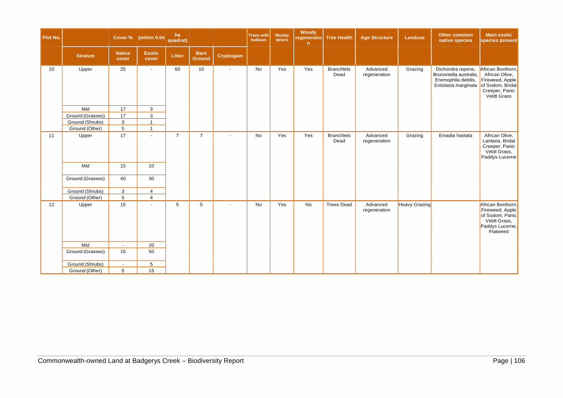
Commonwealth-owned Land at Badgerys Creek – Biodiversity Report Page | 106
Plot No. Cover % (within 0.04 ha
quadrat)
Trees with hollows
Woody debris
Woody regeneratio
n Tree Health Age Structure Landuse
Other common native species
Main exotic species present
Stratum Native cover
Exotic cover
Litter Bare
Ground Cryptogam
10 Upper 25 - 60 10 - No Yes Yes Branchlets Dead
Advanced regeneration
Grazing Dichondra repens, Brunoniella australis, Eremophila debilis, Entolasia marginata
African Boxthorn, African Olive,
Fireweed, Apple of Sodom, Bridal Creeper, Panic
Veldt Grass
Mid 17 3
Ground (Grasses) 17 3
Ground (Shrubs) 3 1
Ground (Other) 5 1
11 Upper 17 - 7 7 - No Yes Yes Branchlets Dead
Advanced regeneration
Grazing Einadia hastata African Olive, Lantana, Bridal Creeper, Panic
Veldt Grass, Paddys Lucerne
Mid 15 10
Ground (Grasses) 40 30
Ground (Shrubs) 3 4 Ground (Other) 5 4
12 Upper 15 - 5 5 - No Yes No Trees Dead Advanced regeneration
Heavy Grazing African Boxthorn, Fireweed, Apple of Sodom, Panic
Veldt Grass, Paddys Lucerne,
Flatweed
Mid - 20 Ground (Grasses) 15 50
Ground (Shrubs) - 5 Ground (Other) 5 15
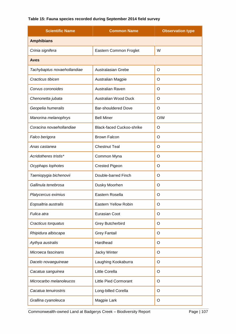
Commonwealth-owned Land at Badgerys Creek – Biodiversity Report Page | 107
Table 15: Fauna species recorded during September 2014 field survey
Scientific Name Common Name Observation type
Amphibians
Crinia signifera Eastern Common Froglet W
Aves
Tachybaptus novaehollandiae Australasian Grebe O
Cracticus tibicen Australian Magpie O
Corvus coronoides Australian Raven O
Chenonetta jubata Australian Wood Duck O
Geopelia humeralis Bar-shouldered Dove O
Manorina melanophrys Bell Miner O/W
Coracina novaehollandiae Black-faced Cuckoo-shrike O
Falco berigora Brown Falcon O
Anas castanea Chestnut Teal O
Acridotheres tristis* Common Myna O
Ocyphaps lophotes Crested Pigeon O
Taeniopygia bichenovii Double-barred Finch O
Gallinula tenebrosa Dusky Moorhen O
Platycercus eximius Eastern Rosella O
Eopsaltria australis Eastern Yellow Robin O
Fulica atra Eurasian Coot O
Cracticus torquatus Grey Butcherbird O
Rhipidura albiscapa Grey Fantail O
Aythya australis Hardhead O
Microeca fascinans Jacky Winter O
Dacelo novaeguineae Laughing Kookaburra O
Cacatua sanguinea Little Corella O
Microcarbo melanoleucos Little Pied Cormorant O
Cacatua tenuirostris Long-billed Corella O
Grallina cyanoleuca Magpie Lark O

Commonwealth-owned Land at Badgerys Creek – Biodiversity Report Page | 108
Scientific Name Common Name Observation type
Vanellus miles Masked Lapwing O
Manorina melanocephala Noisy Miner O
Oriolus sagittatus Olive-backed Oriole O/W
Anas superciliosa Pacific Black Duck O
Phalacrocorax varius Pied Cormorant O
Strepera graculina Pied Currawong O
Porphyrio porphyrio Purple Swamphen O
Anthochaera carunculata Red Wattlebird O
Pycnonotus jocosus* Red-whiskered Bulbul O
Pachycephala rufiventris Rufous Whistler O
Acanthiza lineata Striated Thornbill O
Cacatua galerita Sulphur-crested Cockatoo O
Malurus cyaneus Superb Fairy-wren O/W
Sericornis frontalis White-browed Scrubwren O
Egretta novaehollandiae White-faced Heron O
Ardea pacifica White-necked Heron O
Lichenostomus penicillatus White-plumed Honeyeater O
Gerygone albogularis White-throated Gerygone O/W
Corcorax melanorhamphos White-winged Chough O
Rhipidura leucophrys Willie Wagtail O
Acanthiza nana Yellow Thornbill O
Platalea flavipes Yellow-billed Spoonbill O
Acanthiza chrysorrhoa Yellow-rumped Thornbill O
Reptiles
Lampropholis delicata Dark-flecked Garden Sunskink O
Varanus varius Lace Monitor O
Mammals
Oryctolagus cuniculus* Rabbit F/P
Wallabia bicolor Swamp Wallaby O

Commonwealth-owned Land at Badgerys Creek – Biodiversity Report Page | 109
* introduced species
Observation Type:
A Stranding/beached I Subfossil/Fossil Remains R Road kill
AR Acoustic recording J Floristics Record from Systematic Flora Survey
S Shot
B Burnt K Dead T Trapped or netted
C Cat kill L Flora Record U Ultrasonic recording
D Dog kill M Miscellaneous V Fox kill
E Nest/roost N Not located W Heard call
F Tracks, scratchings O Observed X In scat
FB Burrow OW Observed and Heard call Y Bone, teeth or shell
G Crushed Cones P Scat Z In raptor/owl pellet
H Hair, feathers or skin Q Camera
Commonwealth-owned Land at Badgerys Creek – Biodiversity Report Page | 110
APPENDIX 3: THREATENED FLORA AND FAUNA SPECIES WITH THE POTENTIAL TO OCCUR
IN THE STUDY AREA.
Note: List of threatened species, populations, or ecological communities which may be affected directly or indirectly by the Project is derived from searches of the following databases
as well as on ground survey conducted December 2013: Likelihood of occurrence is based on the risk matrix in Appendix 4.
1. NSW Office of Environment and Heritage (OEH) Atlas of NSW Wildlife Database
2. Protected Matters Report that documents all Matters of National Environmental Significance (MNES) within 10 km of site (Department of Sustainability, Environment, Water,
Population and Communities)
3. Department of Environment and Conservation (now OEH) Endangered Ecological Community and Threatened Species Profiles (OEH, 2013)
4. NSW Flora Online Search – Rare or Threatened Australian Plants (ROTAP) species (The Royal Botanic Gardens and Domain Trust 2013)
5. Department of Primary Industries: Fishing and Aquaculture – Profiles for species, populations and ecological communities (NSW Government, 2005)
Likelihood of occurrence is based on the risk matrix in Appendix 4.
V = Vulnerable species or ecological community.
E = Endangered species or ecological community
EP = Endangered population
X = Extinct
CE = Critically endangered species or ecological community

Commonwealth-owned Land at Badgerys Creek – Biodiversity Report Page | 111
Table 16 Threatened fauna and flora species with the potential to occur in the study area
Scientific Name Common
Name
TSC
Act/
FM Act
EPBC
Act
No
.
Atla
s
Reco
rds
Habitat requirements Likelihood –
desktop
Likelihood
– field
survey
Likelihood
of
occurrence
FLORA
Flora (24)
Acacia pubescens Downy Wattle V V 12 Occurs on alluviums, shales and at the
intergrade between shales and sandstones.
Soils are characteristically gravely soils,
often with ironstone. Occurs in open
woodland and forest, in a variety of plant
communities, including Cooks
River/Castlereagh Ironbark Forest,
Shale/Gravel Transition Forest and
Cumberland Plain Woodland. Concentrated
around the Bankstown-Fairfield-Rookwood
area, also Holroyd-Liverpool and the Pitt
Town area.
B C High
Allocasuarina glareicola E E Occurs in Castlereagh woodland on lateritic
soil. Primarily restricted to the Richmond
(NW Cumberland Plain) district, but with an
outlier population found at Voyager Point,
Liverpool.
D F Low
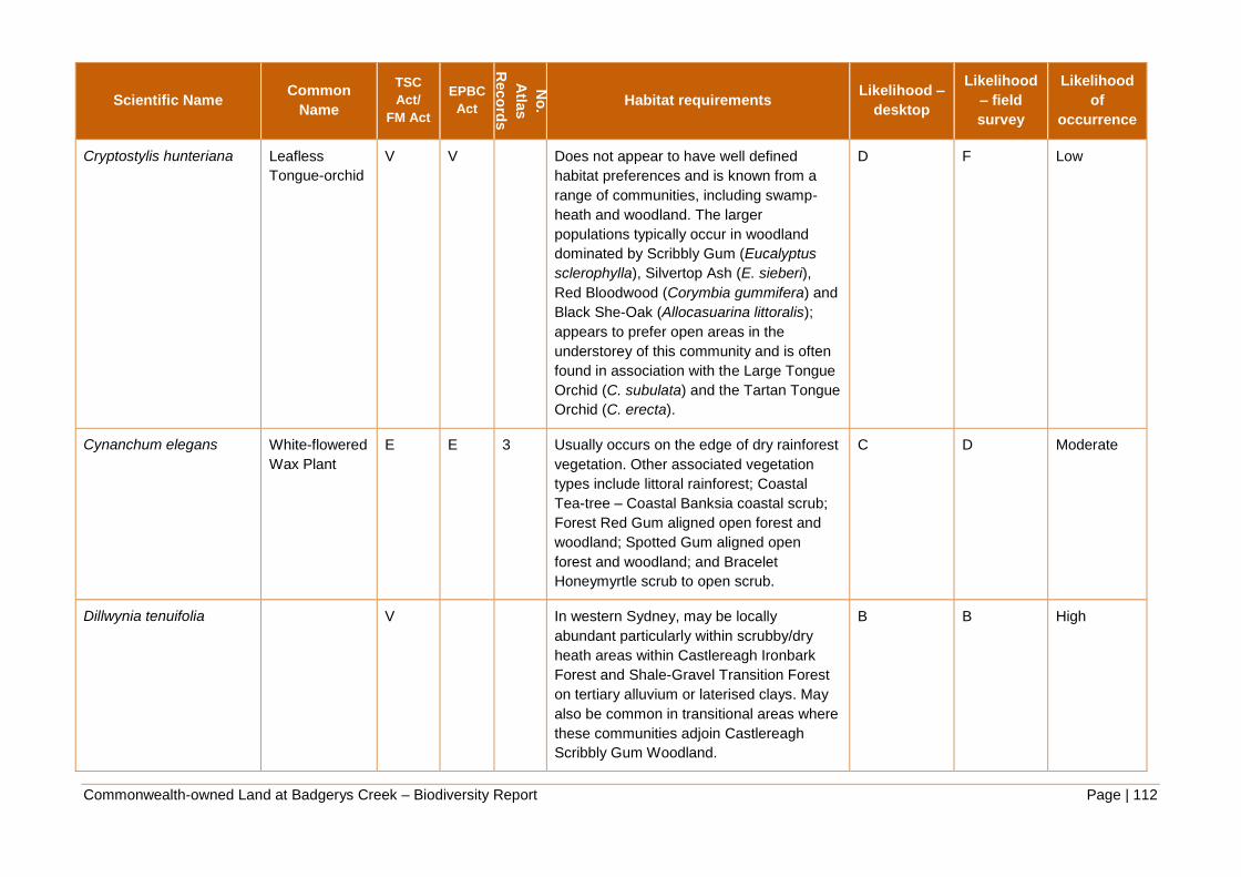
Commonwealth-owned Land at Badgerys Creek – Biodiversity Report Page | 112
Scientific Name Common
Name
TSC
Act/
FM Act
EPBC
Act
No
.
Atla
s
Reco
rds
Habitat requirements Likelihood –
desktop
Likelihood
– field
survey
Likelihood
of
occurrence
Cryptostylis hunteriana Leafless
Tongue-orchid
V V Does not appear to have well defined
habitat preferences and is known from a
range of communities, including swamp-
heath and woodland. The larger
populations typically occur in woodland
dominated by Scribbly Gum (Eucalyptus
sclerophylla), Silvertop Ash (E. sieberi),
Red Bloodwood (Corymbia gummifera) and
Black She-Oak (Allocasuarina littoralis);
appears to prefer open areas in the
understorey of this community and is often
found in association with the Large Tongue
Orchid (C. subulata) and the Tartan Tongue
Orchid (C. erecta).
D F Low
Cynanchum elegans White-flowered
Wax Plant
E E 3 Usually occurs on the edge of dry rainforest
vegetation. Other associated vegetation
types include littoral rainforest; Coastal
Tea-tree – Coastal Banksia coastal scrub;
Forest Red Gum aligned open forest and
woodland; Spotted Gum aligned open
forest and woodland; and Bracelet
Honeymyrtle scrub to open scrub.
C D Moderate
Dillwynia tenuifolia V In western Sydney, may be locally
abundant particularly within scrubby/dry
heath areas within Castlereagh Ironbark
Forest and Shale-Gravel Transition Forest
on tertiary alluvium or laterised clays. May
also be common in transitional areas where
these communities adjoin Castlereagh
Scribbly Gum Woodland.
B B High

Commonwealth-owned Land at Badgerys Creek – Biodiversity Report Page | 113
Scientific Name Common
Name
TSC
Act/
FM Act
EPBC
Act
No
.
Atla
s
Reco
rds
Habitat requirements Likelihood –
desktop
Likelihood
– field
survey
Likelihood
of
occurrence
Dillwynia tenuifolia Dillwynia
tenuifolia
endangered
population of
Kemps Creek
EP,V 69 In western Sydney, may be locally
abundant particularly within scrubby/dry
heath areas within Castlereagh Ironbark
Forest and Shale-Gravel Transition Forest
on tertiary alluvium or laterised clays. May
also be common in transitional areas where
these communities adjoin Castlereagh
Scribbly Gum Woodland.
A B High
Eucalyptus benthamii Camden White
Gum
V V 21 Occurs on the alluvial flats of the Nepean
River and its tributaries. Requires a
combination of deep alluvial sands and a
flooding regime that permits seedling
establishment.
C E Low
Genoplesium baueri Yellow Gnat-
orchid
E E Occurs in coastal areas. Habitats include
heathland, open forest, shrubby forest,
heathy forest and woodland with
sandy/sandy loam and well-draining soils.
D F Low
Grevillea juniperina
subsp. juniperina
Juniper-leaved
Grevillea
V 90 Grows on reddish clay to sandy soils
derived from Wianamatta Shale and
Tertiary alluvium (often with shale
influence), typically containing lateritic
gravels.
B C High

Commonwealth-owned Land at Badgerys Creek – Biodiversity Report Page | 114
Scientific Name Common
Name
TSC
Act/
FM Act
EPBC
Act
No
.
Atla
s
Reco
rds
Habitat requirements Likelihood –
desktop
Likelihood
– field
survey
Likelihood
of
occurrence
Grevillea parviflora
subsp. parviflora
Small-flower
Grevillea
V V 12 Occurs in a range of vegetation types from
heath and shrubby woodland to open
forest. Found over a range of altitudes from
flat, low-lying areas to upper slopes and
ridge crests. Hunter occurrences are
usually 30-70m ASL, while the southern
Sydney occurrences are typically at 200-
300m ASL. Recorded from transitional
communities associated with sandstone
and Tertiary alluvium. Often occurs in open,
slightly disturbed sites such as along tracks.
B E Moderate
Haloragis exalata subsp.
exalata
Wingless
Raspwort
V V Square Raspwort occurs in four widely
scattered localities in eastern NSW. It is
disjunctly distributed in the Central Coast,
South Coast and North Western Slopes
botanical subdivisions of NSW. Square
Raspwort appears to require protected and
shaded damp situations in riparian habitats.
E E Low
Isotoma sessiliflora
(Hypsela sessiliflora)
E X 7 Known to grow in damp places, on the
Cumberland Plain, including freshwater
wetland, grassland/alluvial woodland and
alluvial woodland/shale plains woodland
(Cumberland Plain Woodland) ecotone.
Known in recent years from only two
adjacent sites on a single private property
at Erskine Park in the Penrith LGA. There is
some doubt about the taxonomy of this
species and may be part of an Isotoma
fluviatilis species complex (D. Albrecht
pers. comm.).
B D-C Moderate to
High

Commonwealth-owned Land at Badgerys Creek – Biodiversity Report Page | 115
Scientific Name Common
Name
TSC
Act/
FM Act
EPBC
Act
No
.
Atla
s
Reco
rds
Habitat requirements Likelihood –
desktop
Likelihood
– field
survey
Likelihood
of
occurrence
Marsdenia viridiflora
subsp. viridiflora
Marsdenia
viridiflora R.
Br. Subsp.
viridiflora
population in
the
Bankstown,
Blacktown,
Camden,
Campbelltown,
Fairfield,
Holroyd,
Liverpool and
Penrith local
government
areas
EP 22 Grows in vine thickets and open shale
woodland.
A A High:
Known to
occur
Micromyrtus minutiflora E V Grows in Castlereagh Scribbly Gum
Woodland, Ironbark Forest, Shale/Gravel
Transition Forest, open forest on tertiary
alluvium and consolidated river sediments.
E C Low
Pelargonium striatellum Omeo Stork’s-
bill
E E Known from only 3 locations in NSW, with
two on lake-beds on the basalt plains of the
Monaro and one at Lake Bathurst. Has a
narrow habitat that is usually just above the
high-water level of irregularly inundated or
ephemeral lakes, in the transition zone
between surrounding grasslands or pasture
and the wetland or aquatic communities.
E F Extremely
low

Commonwealth-owned Land at Badgerys Creek – Biodiversity Report Page | 116
Scientific Name Common
Name
TSC
Act/
FM Act
EPBC
Act
No
.
Atla
s
Reco
rds
Habitat requirements Likelihood –
desktop
Likelihood
– field
survey
Likelihood
of
occurrence
Persoonia nutans Nodding
Geebung
E E 10 Restricted to the Cumberland Plain in
western Sydney, between Richmond in the
north and Macquarie Fields in the south.
The species has a disjunct distribution, with
the majority of populations (and 99% of
individuals) occurring in the north of the
species range in the Agnes Banks,
Londonderry, Castlereagh, Berkshire Park
and Windsor Downs areas. Northern
populations are confined to aeolian and
alluvial sediments and occur in a range of
sclerophyll forest and woodland vegetation
communities. The southern and northern
populations have distinct habitat
differences.
C E Low
Pimelea curviflora var.
curviflora
V V Confined to the coastal area of the Sydney
and Illawarra regions. Occurs on
shaley/lateritic soils over sandstone and
shale/sandstone transition soils on
ridgetops and upper slopes amongst
woodlands. Also recorded in Illawarra
Lowland Grassy Woodland habitat at Albion
Park on the Illawarra coastal plain. There is
a recent record from Tertiary alluvium at
Castlereagh.
C E Low
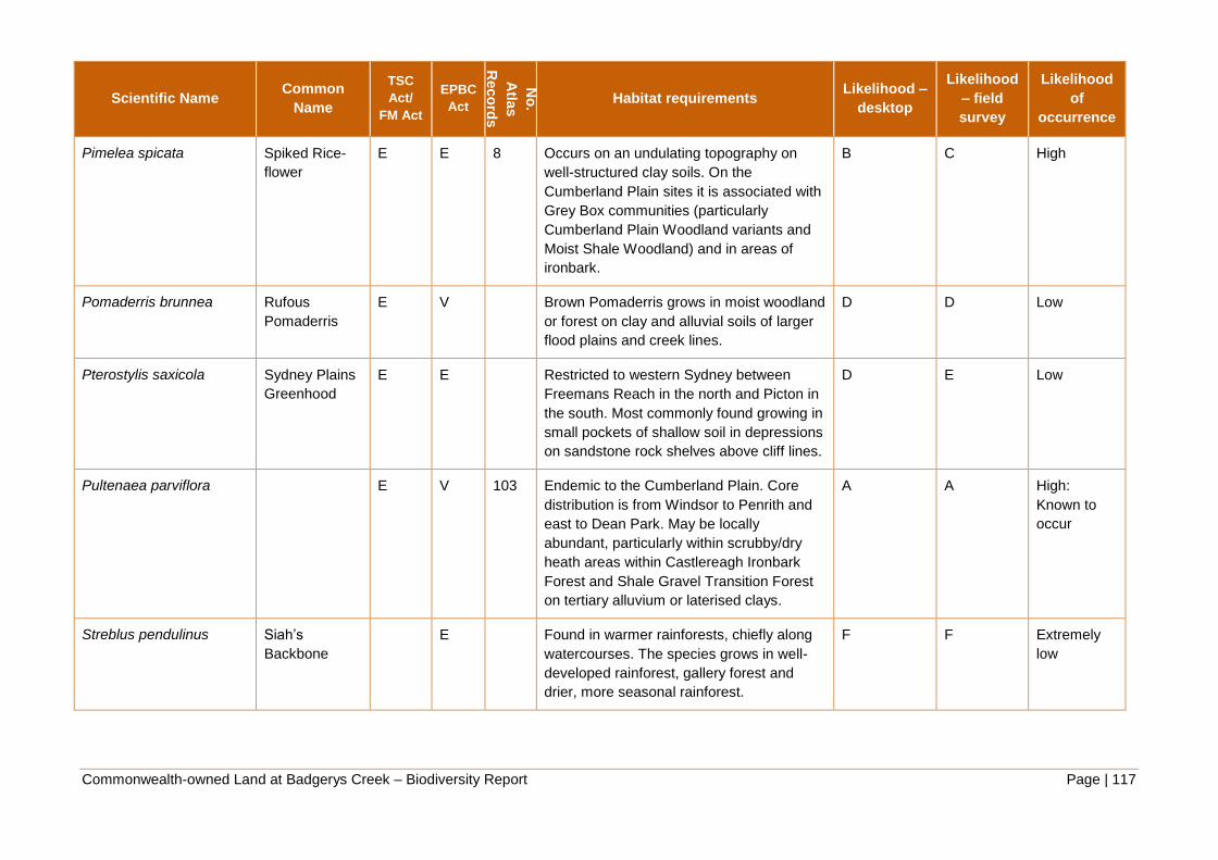
Commonwealth-owned Land at Badgerys Creek – Biodiversity Report Page | 117
Scientific Name Common
Name
TSC
Act/
FM Act
EPBC
Act
No
.
Atla
s
Reco
rds
Habitat requirements Likelihood –
desktop
Likelihood
– field
survey
Likelihood
of
occurrence
Pimelea spicata Spiked Rice-
flower
E E 8 Occurs on an undulating topography on
well-structured clay soils. On the
Cumberland Plain sites it is associated with
Grey Box communities (particularly
Cumberland Plain Woodland variants and
Moist Shale Woodland) and in areas of
ironbark.
B C High
Pomaderris brunnea Rufous
Pomaderris
E V Brown Pomaderris grows in moist woodland
or forest on clay and alluvial soils of larger
flood plains and creek lines.
D D Low
Pterostylis saxicola Sydney Plains
Greenhood
E E Restricted to western Sydney between
Freemans Reach in the north and Picton in
the south. Most commonly found growing in
small pockets of shallow soil in depressions
on sandstone rock shelves above cliff lines.
D E Low
Pultenaea parviflora E V 103 Endemic to the Cumberland Plain. Core
distribution is from Windsor to Penrith and
east to Dean Park. May be locally
abundant, particularly within scrubby/dry
heath areas within Castlereagh Ironbark
Forest and Shale Gravel Transition Forest
on tertiary alluvium or laterised clays.
A A High:
Known to
occur
Streblus pendulinus Siah’s
Backbone
E Found in warmer rainforests, chiefly along
watercourses. The species grows in well-
developed rainforest, gallery forest and
drier, more seasonal rainforest.
F F Extremely
low
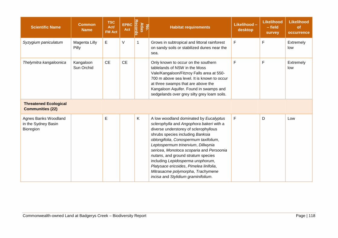
Commonwealth-owned Land at Badgerys Creek – Biodiversity Report Page | 118
Scientific Name Common
Name
TSC
Act/
FM Act
EPBC
Act
No
.
Atla
s
Reco
rds
Habitat requirements Likelihood –
desktop
Likelihood
– field
survey
Likelihood
of
occurrence
Syzygium paniculatum Magenta Lilly
Pilly
E V 1 Grows in subtropical and littoral rainforest
on sandy soils or stabilized dunes near the
sea.
F F Extremely
low
Thelymitra kangaloonica Kangaloon
Sun Orchid
CE CE Only known to occur on the southern
tablelands of NSW in the Moss
Vale/Kangaloon/Fitzroy Falls area at 550-
700 m above sea level. It is known to occur
at three swamps that are above the
Kangaloon Aquifer. Found in swamps and
sedgelands over grey silty grey loam soils.
F F Extremely
low
Threatened Ecological
Communities (22)
Agnes Banks Woodland
in the Sydney Basin
Bioregion
E K A low woodland dominated by Eucalyptus
sclerophylla and Angophora bakeri with a
diverse understorey of sclerophyllous
shrubs species including Banksia
oblongifolia, Conospermum taxifolium,
Leptospermum trinervium, Dillwynia
sericea, Monotoca scoparia and Persoonia
nutans, and ground stratum species
including Lepidosperma urophorum,
Platysace ericoides, Pimelea linifolia,
Mitrasacme polymorpha, Trachymene
incisa and Stylidium graminifolium.
F D Low

Commonwealth-owned Land at Badgerys Creek – Biodiversity Report Page | 119
Scientific Name Common
Name
TSC
Act/
FM Act
EPBC
Act
No
.
Atla
s
Reco
rds
Habitat requirements Likelihood –
desktop
Likelihood
– field
survey
Likelihood
of
occurrence
Blue Gum High Forest in
the Sydney Basin
Bioregion
CE CE K Tall forest typically grows in high rainfall
areas, receiving more than 1,100 mm per
year and on deep clay soils derived from
Wianamatta Shale. It occurs at elevations
of 50–178 m above sea level with gentle
slopes.
F F Extremely
low
Blue Mountains Shale
Cap Forest in the Sydney
Basin Bioregion
E CE K Characteristic tree species of this ecological
community are Mountain Blue Gum
(Eucalyptus deanei), Monkey Gum (E.
cypellocarpa) and Turpentine (Syncarpia
glomulifera). Other tree species include
Sydney Red Gum (Angophora costata),
Rough-barked Apple (A. floribunda),
Mountain Mahogany (E. notabilis), Sydney
Peppermint (E. piperita) and Grey Gum (E.
punctata). Tree species composition varies
between sites depending on geographical
location and local conditions (e.g.
topography, rainfall exposure).
F F Extremely
low

Commonwealth-owned Land at Badgerys Creek – Biodiversity Report Page | 120
Scientific Name Common
Name
TSC
Act/
FM Act
EPBC
Act
No
.
Atla
s
Reco
rds
Habitat requirements Likelihood –
desktop
Likelihood
– field
survey
Likelihood
of
occurrence
Blue Mountains Swamps
in the Sydney Basin
Bioregion
V E K Characterised by a dense mixture of shrubs
and sedges, most of which have
sclerophyllous foliage. The shrub stratum
typically varies from 0.5 m to over 2.0 m tall
and is highly variable in cover. The ground
stratum may be up to about 1 m tall and is
dominated by a dense sward of
sclerophyllous sedges and grasses except
in patches where these are displaced by a
dense cover of taller shrubs. Ferns, forbs
and small shrubs are scattered amongst the
sedges and grasses. There is considerable
local variation within the swamps in species
composition and vegetation structure, which
is apparently related to local soil properties
and fire history.
F F Extremely
low
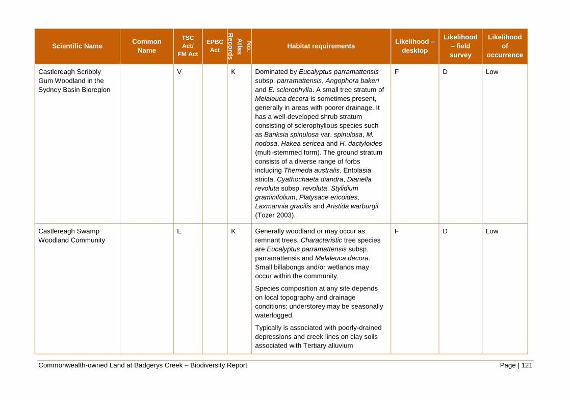
Commonwealth-owned Land at Badgerys Creek – Biodiversity Report Page | 121
Scientific Name Common
Name
TSC
Act/
FM Act
EPBC
Act
No
.
Atla
s
Reco
rds
Habitat requirements Likelihood –
desktop
Likelihood
– field
survey
Likelihood
of
occurrence
Castlereagh Scribbly
Gum Woodland in the
Sydney Basin Bioregion
V K Dominated by Eucalyptus parramattensis
subsp. parramattensis, Angophora bakeri
and E. sclerophylla. A small tree stratum of
Melaleuca decora is sometimes present,
generally in areas with poorer drainage. It
has a well-developed shrub stratum
consisting of sclerophyllous species such
as Banksia spinulosa var. spinulosa, M.
nodosa, Hakea sericea and H. dactyloides
(multi-stemmed form). The ground stratum
consists of a diverse range of forbs
including Themeda australis, Entolasia
stricta, Cyathochaeta diandra, Dianella
revoluta subsp. revoluta, Stylidium
graminifolium, Platysace ericoides,
Laxmannia gracilis and Aristida warburgii
(Tozer 2003).
F D Low
Castlereagh Swamp
Woodland Community
E K Generally woodland or may occur as
remnant trees. Characteristic tree species
are Eucalyptus parramattensis subsp.
parramattensis and Melaleuca decora.
Small billabongs and/or wetlands may
occur within the community.
Species composition at any site depends
on local topography and drainage
conditions; understorey may be seasonally
waterlogged.
Typically is associated with poorly-drained
depressions and creek lines on clay soils
associated with Tertiary alluvium
F D Low

Commonwealth-owned Land at Badgerys Creek – Biodiversity Report Page | 122
Scientific Name Common
Name
TSC
Act/
FM Act
EPBC
Act
No
.
Atla
s
Reco
rds
Habitat requirements Likelihood –
desktop
Likelihood
– field
survey
Likelihood
of
occurrence
Cooks River/Castlereagh
Ironbark Forest in the
Sydney Basin Bioregion
E K Predominantly of open-forest to low
woodland structure usually with trees of
Eucalyptus fibrosa and Melaleuca decora,
sometimes with Eucalyptus longifolia. A
relatively dense shrub stratum is typical,
commonly with Melaleuca nodosa and
Lissanthe strigosa, and to a lesser extent
Melaleuca decora. A variety of shrub
species may occur, including Acacia
pubescens, Dillwynia tenuifolia, Daviesia
ulicifolia, Pultenaea villosa and Grevillea
juniperina. Commonly occurring species in
the ground stratum include Entolasia stricta,
Lepidosperma laterale, Opercularia
diphylla, Dianella revoluta, Themeda
australis, Microlaena stipoides and Pratia
purpurascens.
Usually occurs on clay soils on Tertiary
alluvium, or on shale soils on Wianamatta
Shale including the Birrong Soil Landscape
and associated shale lowlands.
C C Moderate

Commonwealth-owned Land at Badgerys Creek – Biodiversity Report Page | 123
Scientific Name Common
Name
TSC
Act/
FM Act
EPBC
Act
No
.
Atla
s
Reco
rds
Habitat requirements Likelihood –
desktop
Likelihood
– field
survey
Likelihood
of
occurrence
Cumberland Plain
Woodland in the Sydney
Basin Bioregion
CE CE K Dominant canopy trees are Grey Box
(Eucalyptus moluccana) and Forest Red
Gum (E. tereticornis), with Narrow-leaved
Ironbark (E. crebra), Spotted Gum
(Corymbia maculata) and Thin-leaved
Stringybark (E. eugenioides) occurring less
frequently. The shrub layer is dominated by
Blackthorn (Bursaria spinosa), and it is
common to find abundant grasses such as
Kangaroo Grass (Themeda australis) and
Weeping Meadow Grass (Microlaena
stipoides var. stipoides). Contains many
more species and other references should
be consulted to identify these.
A A High: Know
to occur
Elderslie Banksia Scrub
Forest
E K A scrub community dominated by Coastal
Banksia (Banksia integrifolia subsp.
Integrifolia). Other canopy species include
Broad-leaved Apple Angophora
subvelutina. The shrubby understorey is
diverse and includes species that usually
occur in sandstone areas, such as Wedding
Bush Ricinocarpus pinifolius, Riceflower
(Pimelea linifolia subsp. linifolia) and
Daphne Heath Brachyloma daphnoides.
Contains many more species and other
references should be consulted to identify
these.
F F Extremely
low

Commonwealth-owned Land at Badgerys Creek – Biodiversity Report Page | 124
Scientific Name Common
Name
TSC
Act/
FM Act
EPBC
Act
No
.
Atla
s
Reco
rds
Habitat requirements Likelihood –
desktop
Likelihood
– field
survey
Likelihood
of
occurrence
Freshwater Wetlands on
Coastal Floodplains of
the New South Wales
North Coast, Sydney
Basin and South East
Corner Bioregions
E K Associated with coastal areas subject to
periodic flooding and in which standing
fresh water persists for at least part of the
year in most years. Typically occurs on
silts, muds or humic loams in low-lying
parts of floodplains, alluvial flats,
depressions, drainage lines, backswamps,
lagoons and lakes but may also occur in
backbarrier landforms where floodplains
adjoin coastal sandplains. Generally occurs
below 20 m elevation on level areas.
Dominated by herbaceous plants with very
few woody species. Structure and
composition varies both spatially and
temporally depending on the water regime.
The threatened aquatic plants, Aldrovanda
vesiculosa and Najas marina, also occur
within this community.
B D Moderate

Commonwealth-owned Land at Badgerys Creek – Biodiversity Report Page | 125
Scientific Name Common
Name
TSC
Act/
FM Act
EPBC
Act
No
.
Atla
s
Reco
rds
Habitat requirements Likelihood –
desktop
Likelihood
– field
survey
Likelihood
of
occurrence
Moist Shale Woodland in
the Sydney Basin
Bioregion
E CE K It differs from Cumberland Plain Woodland
in having a shrub understorey that contains
plants from moist habitats. Dominant
canopy trees include Forest Red Gum
Eucalyptus tereticornis, Grey Box E.
moluccana, Narrow-leaved Ironbark E.
crebra and Spotted Gum Corymbia
maculata. Small trees, such as Hickory
Wattle Acacia implexa and Sydney Green
Wattle A. parramattensis subsp.
parramattensis are also common. The
shrub layer includes Breynia oblongifolia,
Hairy Clerodendrum Clerodendrum
tomentosum and Indian Weed Sigesbeckia
orientalis subsp. orientalis.
A A High:
Known to
occur

Commonwealth-owned Land at Badgerys Creek – Biodiversity Report Page | 126
Scientific Name Common
Name
TSC
Act/
FM Act
EPBC
Act
No
.
Atla
s
Reco
rds
Habitat requirements Likelihood –
desktop
Likelihood
– field
survey
Likelihood
of
occurrence
Montane Peatlands and
Swamps of the New
England Tableland, NSW
North Coast, Sydney
Basin, South East
Corner, South Eastern
Highlands and Australian
Alps bioregions
E E K Dense, open or sparse layer of shrubs with
soft-leaved sedges, grasses and forbs. The
only type of wetland that may contain more
than trace amounts of Sphagnum spp., the
hummock peat-forming mosses. Small
trees may be present as scattered
emergents or absent.
Typically has an open to very sparse layer
of shrubs, 1-5 m tall, (e.g. Baeckea
gunniana, B. utilis, Callistemon pityoides,
Leptospermum juniperinum, L. lanigerum,
L. myrtifolium, L. obovatum, L.
polygalifolium). Species of Epacris (e.g. E.
breviflora, E. microphylla, E. paludosa) and
Hakea microcarpa are also common
shrubs. In some peatlands and swamps,
particularly those with a history of
disturbance to vegetation, soils or
hydrology, the shrub layer comprises dense
thickets of Leptospermum species. In other
peatlands and swamps with a history of
grazing by domestic livestock, the shrub
layer may be very sparse or absent.
F F Extremely
low

Commonwealth-owned Land at Badgerys Creek – Biodiversity Report Page | 127
Scientific Name Common
Name
TSC
Act/
FM Act
EPBC
Act
No
.
Atla
s
Reco
rds
Habitat requirements Likelihood –
desktop
Likelihood
– field
survey
Likelihood
of
occurrence
Newnes Plateau Shrub
Swamp in the Sydney
Basin Bioregion
E E K Characteristically dominated by shrubs,
with a variable cover of sedges. Shrubs
have a dense to open cover, and include
Baeckea linifolia, Grevillea acanthifolia
subsp. acanthifolia, Epacris paludosa and
Leptospermum species. The cover of
sedges varies inversely with shrub cover.
Common sedges include Baloskion
australe, Empodisma minus, Lepyrodia
scariosa and Lepidosperma limicola, while
herbs include Patersonia fragilis and
Xanthosia dissecta. Gleichenia dicarpa and
Gymnoschoenus sphaerocephalus may
occur around drainage lines, while
Lomandra longifolia may be prominent
around the swamp margins. Floristic
composition varies locally in relation to soil
moisture gradients within the swamps
(Keith and Benson 1988; Benson and Keith
1990).
F F Extremely
low

Commonwealth-owned Land at Badgerys Creek – Biodiversity Report Page | 128
Scientific Name Common
Name
TSC
Act/
FM Act
EPBC
Act
No
.
Atla
s
Reco
rds
Habitat requirements Likelihood –
desktop
Likelihood
– field
survey
Likelihood
of
occurrence
River-Flat Eucalypt
Forest on Coastal
Floodplains of the New
South Wales North
Coast, Sydney Basin and
South East Corner
Bioregions
E K Found on the river flats of the coastal
floodplains. It has a tall open tree layer of
eucalypts, which may exceed 40 m in
height, but can be considerably shorter in
regrowth stands or under conditions of
lower site quality. While the composition of
the tree stratum varies considerably, the
most widespread and abundant dominant
trees include Eucalyptus tereticornis (forest
red gum), E. amplifolia (cabbage gum),
Angophora floribunda (rough-barked apple)
and A. subvelutina (broad-leaved apple). E.
benthamii occurs on the Hawkesbury
floodplain.
A A High:
Known to
occur
Shale-Gravel Transition
Forest in the Sydney
Basin Bioregion
E CE K Has an open forest structure with a canopy
dominated by Broad-leaved Ironbark
Eucalyptus fibrosa, with Grey Box E.
moluccana and Forest Red Gum E.
tereticornis occurring less frequently.
Paperbark Melaleuca decora is common in
the small tree layer. A sparse shrub layer is
usually present which includes Blackthorn
Bursaria spinosa, Daviesia ulicifolia and
Peach Heath Lissanthe strigosa.
A A High:
Known to
occur

Commonwealth-owned Land at Badgerys Creek – Biodiversity Report Page | 129
Scientific Name Common
Name
TSC
Act/
FM Act
EPBC
Act
No
.
Atla
s
Reco
rds
Habitat requirements Likelihood –
desktop
Likelihood
– field
survey
Likelihood
of
occurrence
Shale/Sandstone
Transition Forest
E E K Occurs at the edges of the Cumberland
Plain, where clay soils from the shale rock
intergrade with earthy and sandy soils from
sandstone, or where shale caps overlay
sandstone. The boundaries are indistinct,
and the species composition varies
depending on the soil influences. The main
tree species include Forest Red Gum
(Eucalyptus tereticornis), Grey Gum (E.
punctata), stringybarks (E. globoidea, E.
eugenioides) and ironbarks (E. fibrosa and
E. crebra). Areas of low sandstone
influence (more clay-loam soil texture) have
an understorey that is closer to Cumberland
Plain Woodland
D F Low

Commonwealth-owned Land at Badgerys Creek – Biodiversity Report Page | 130
Scientific Name Common
Name
TSC
Act/
FM Act
EPBC
Act
No
.
Atla
s
Reco
rds
Habitat requirements Likelihood –
desktop
Likelihood
– field
survey
Likelihood
of
occurrence
Southern Sydney
sheltered forest on
transitional sandstone
soils in the Sydney Basin
Bioregion
E K An open forest dominated by eucalypts with
scattered subcanopy trees, a diverse shrub
layer and a well-developed groundcover of
ferns, forbs, grasses and graminoids. The
dominant trees include Angophora costata,
Eucalyptus piperita and occasionally E.
pilularis, particularly around Helensburgh.
Corymbia gummifera occurs frequently
within the community, although generally at
lower abundance than the other eucalypts.
Features that distinguish Southern Sydney
sheltered forest on transitional sandstone
soils from vegetation more typical of
sandstone gullies in the eastern Sydney
basin include the occurrences of E.
pilularis, Acacia binervata, Elaeocarpus
reticulatus, Pittosporum undulatum and its
relatively dense groundcover of ferns,
grasses, rushes, lilies and forbs. There is
considerable variation in species
composition, richness and structure within
the community in response to local soil
variation and geographic gradients across
the range. The community typically has an
open forest structure, although disturbance
may result in local manifestations as
woodland or scrub.
F F Extremely
low

Commonwealth-owned Land at Badgerys Creek – Biodiversity Report Page | 131
Scientific Name Common
Name
TSC
Act/
FM Act
EPBC
Act
No
.
Atla
s
Reco
rds
Habitat requirements Likelihood –
desktop
Likelihood
– field
survey
Likelihood
of
occurrence
Sun Valley Cabbage
Gum Forest in the
Sydney Basin Bioregion
CE K Sun Valley Cabbage Gum Forest is
dominated by Eucalyptus amplifolia
(Cabbage Gum) with E. eugenioides (Thin-
leaved Stringybark) as an associated tree.
Native understorey species include Acacia
parramattensis, Imperata cylindrica,
Lomandra longifolia and Pteridium
esculentum.
Occurs in the Sun Valley in the Blue
Mountains City Council local government
area. About 15 hectares of the community
remains, mostly in poor condition.
F F Extremely
low

Commonwealth-owned Land at Badgerys Creek – Biodiversity Report Page | 132
Scientific Name Common
Name
TSC
Act/
FM Act
EPBC
Act
No
.
Atla
s
Reco
rds
Habitat requirements Likelihood –
desktop
Likelihood
– field
survey
Likelihood
of
occurrence
Swamp Oak Floodplain
Forest of the New South
Wales North Coast,
Sydney Basin and South
East Corner Bioregions
E K Found on the coastal floodplains of NSW. Dense
to sparse tree layer. Species include Acmena
smithii (Lilly pili), Glochidion spp. (cheese trees)
and Melaleuca spp. (paperbarks) may be
present as subordinate species, and are found
most frequently in stands of the community
northwards from Gosford. Tree diversity
decreases with latitude. The understorey is
characterised by frequent occurrences of vines,
Parsonsia straminea, Geitonoplesium cymosum
and Stephania japonica var. discolor, a sparse
cover of shrubs, and a continuous groundcover
of forbs, sedges, grasses and leaf litter.
The composition of the ground stratum varies
depending on levels of salinity in the
groundwater. Under less saline conditions
prominent ground layer plants include forbs such
Centella asiatica, Commelina cyanea, Persicaria
decipiens and Viola banksii; graminoids such as
Carex appressa, Gahnia clarkei, Lomandra
longifolia, Oplismenus imbecillis; and the fern
Hypolepis muelleri.
On the fringes of coastal estuaries, where soils
are more saline, the ground layer may include
the threatened grass species, Alexfloydia
repens, as well as Baumea juncea, Juncus
kraussii, Phragmites australis, Selliera radicans
and other saltmarsh species.
F F Extremely
low

Commonwealth-owned Land at Badgerys Creek – Biodiversity Report Page | 133
Scientific Name Common
Name
TSC
Act/
FM Act
EPBC
Act
No
.
Atla
s
Reco
rds
Habitat requirements Likelihood –
desktop
Likelihood
– field
survey
Likelihood
of
occurrence
Swamp Sclerophyll
Forest on Coastal
Floodplains of the New
South Wales North
Coast, Sydney Basin and
South East Corner
Bioregions
E K Has an open to dense tree layer of
eucalypts and paperbarks although some
remnants now only have scattered trees as
a result of partial clearing. The trees may
exceed 25 m in height, but can be
considerably shorter in regrowth stands or
under conditions of lower site quality where
the tree stratum is low and dense. For
example, stands dominated by Melaleuca
ericifolia typically do not exceed 8 m in
height. The community also includes some
areas of fernland and tall reedland or
sedgeland, where trees are very sparse or
absent.
F F Extremely
low
Western Sydney Dry
Rainforest in the Sydney
Basin Bioregion
E CE K This is a dry vine scrub community of the
Cumberland Plain with a restricted
distribution. It occurs in areas of higher
elevation, high rainfall and hilly country in
the sheltered lower slopes and gullies.
C C Moderate

Commonwealth-owned Land at Badgerys Creek – Biodiversity Report Page | 134
Scientific Name Common
Name
TSC
Act/
FM Act
EPBC
Act
No
.
Atla
s
Reco
rds
Habitat requirements Likelihood –
desktop
Likelihood
– field
survey
Likelihood
of
occurrence
White Box Yellow Box
Blakely’s Red Gum
Woodland
E CE P An open woodland community in which the
most obvious species are one or more of
the following: White Box Eucalyptus albens,
Yellow Box E. melliodora and Blakely's Red
Gum E. blakelyi. Intact sites contain a high
diversity of plant species, including the
main tree species, additional tree species,
some shrub species, several climbing plant
species, many grasses and a very high
diversity of herbs. The community also
includes a range of mammal, bird, reptile,
frog and invertebrate fauna species. Intact
stands that contain diverse upper and mid-
storeys and ground layers are rare.
F F Extremely
low
Fauna (60)
Amphibians (3)
Heleioporus australiacus Giant
Burrowing
Frog
V V 4 Distributed through the Sydney Basin
sandstone country in woodland, open
woodland and heath vegetation, breeding
habitat is generally soaks or pools within
first or second order streams, but also
'hanging swamp' seepage lines and where
small pools form from the collected water.
Spend the majority of time in non-breeding
habitat up to 300 m away and burrows in
soil surface or leaf litter.
C C Moderate

Commonwealth-owned Land at Badgerys Creek – Biodiversity Report Page | 135
Scientific Name Common
Name
TSC
Act/
FM Act
EPBC
Act
No
.
Atla
s
Reco
rds
Habitat requirements Likelihood –
desktop
Likelihood
– field
survey
Likelihood
of
occurrence
Litoria aurea Green and
Golden Bell
Frog
E V 1 Inhabits marshes, dams and stream-sides,
particularly those containing bullrushes
(Typha spp.) or spikerushes (Eleocharis
spp.)
C C Moderate
Pseudophryne australis Red-crowned
Toadlet
V Occurs in open forests, mostly on
Hawkesbury and Narrabeen Sandstones.
Inhabits periodically wet drainage lines
below sandstone ridges that often have
shale lenses or cappings. Shelters under
rocks and amongst masses of dense
vegetation or thick piles of leaf litter.
Breeding congregations occur in dense
vegetation and debris beside ephemeral
creeks and gutters. Have not been
recorded breeding in waters that are even
mildly polluted or with a pH outside 5.5 to
6.5. Disperses outside the breeding period,
when they are found under rocks and logs
on sandstone ridges and forage amongst
leaf-litter.
D F Low

Commonwealth-owned Land at Badgerys Creek – Biodiversity Report Page | 136
Scientific Name Common
Name
TSC
Act/
FM Act
EPBC
Act
No
.
Atla
s
Reco
rds
Habitat requirements Likelihood –
desktop
Likelihood
– field
survey
Likelihood
of
occurrence
Birds (35)
Anthochaera phrygia Regent
Honeyeater
CE E 3 Inhabits temperate woodlands and open
forests of the inland slopes of south-east
Australia. Also found in drier coastal
woodlands and forests. Inhabits dry open
forest and woodland, particularly Box-
Ironbark woodland, and riparian forests of
River She-oak with large numbers of
mature trees, high canopy cover and
abundance of mistletoes. Key eucalypt
species include Mugga Ironbark, Yellow
Box, Blakely's Red Gum, White Box and
Swamp Mahogany.
D C Moderate
Apus pacificus Fork-tailed
Swift
M 3 Aerial space over a variety of habitat types;
feeds on insects; breeds in Asia.
D C Moderate
Ardea alba Great Egret M Has been reported in a wide range of
wetland habitats (for example inland and
coastal, freshwater and saline, permanent
and ephemeral, open and vegetated, large
and small, natural and artificial). Usually
frequents shallow waters.
D C Moderate

Commonwealth-owned Land at Badgerys Creek – Biodiversity Report Page | 137
Scientific Name Common
Name
TSC
Act/
FM Act
EPBC
Act
No
.
Atla
s
Reco
rds
Habitat requirements Likelihood –
desktop
Likelihood
– field
survey
Likelihood
of
occurrence
Ardea ibis Cattle Egret M 20 Occurs in tropical and temperate
grasslands, wooded lands and terrestrial
wetlands. High numbers have been
observed in moist, low-lying poorly drained
pastures with an abundance of high grass.
Uses predominately shallow, open and
fresh wetlands including meadows and
swamps with low emergent vegetation and
abundant aquatic flora. Often forages away
from water on low lying grasslands,
improved pastures and croplands. It is
commonly found in cattle fields and other
farm areas that contain livestock. It is
becoming more frequent in drier regions;
consuming the ticks of livestock in the
absence of other food sources. The species
roosts in trees, or amongst ground
vegetation in or near lakes and swamps.
D C Moderate
Botaurus poiciloptilus Australasian
Bittern
E E 1 Inhabits temperate freshwater wetlands and
occasionally estuarine reed beds, with a
preference for permanent water bodies with
tall dense vegetation. The species prefers
wetlands with dense vegetation, including
sedges, rushes and reeds. Freshwater is
generally preferred, although dense
saltmarsh vegetation in estuaries and
flooded grasslands are also used by the
species.
D D Low
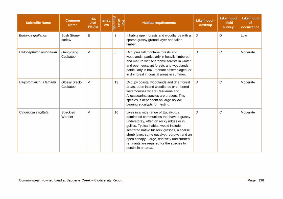
Commonwealth-owned Land at Badgerys Creek – Biodiversity Report Page | 138
Scientific Name Common
Name
TSC
Act/
FM Act
EPBC
Act
No
.
Atla
s
Reco
rds
Habitat requirements Likelihood –
desktop
Likelihood
– field
survey
Likelihood
of
occurrence
Burhinus grallarius Bush Stone-
curlew
E 2 Inhabits open forests and woodlands with a
sparse grassy ground layer and fallen
timber.
D D Low
Callocephalon fimbriatum Gang-gang
Cockatoo
V 5 Occupies tall montane forests and
woodlands, particularly in heavily timbered
and mature wet sclerophyll forests in winter
and open eucalypt forests and woodlands,
particularly in box-ironbark assemblages, or
in dry forest in coastal areas in summer.
D C Moderate
Calyptorhynchus lathami Glossy Black-
Cockatoo
V 13 Occupy coastal woodlands and drier forest
areas, open inland woodlands or timbered
watercourses where Casuarina and
Allocasuarina species are present. This
species is dependent on large hollow-
bearing eucalypts for nesting.
D C Moderate
Cthonicola sagittata Speckled
Warbler
V 16 Lives in a wide range of Eucalyptus
dominated communities that have a grassy
understorey, often on rocky ridges or in
gullies. Typical habitat would include
scattered native tussock grasses, a sparse
shrub layer, some eucalypt regrowth and an
open canopy. Large, relatively undisturbed
remnants are required for the species to
persist in an area.
D C Moderate

Commonwealth-owned Land at Badgerys Creek – Biodiversity Report Page | 139
Scientific Name Common
Name
TSC
Act/
FM Act
EPBC
Act
No
.
Atla
s
Reco
rds
Habitat requirements Likelihood –
desktop
Likelihood
– field
survey
Likelihood
of
occurrence
Daphoenositta
chrysoptera
Varied Sittella V 28 Inhabits most of mainland Australia except
the treeless deserts and open grasslands. It
inhabits eucalypt forests and woodlands,
especially rough-barked species and
mature smooth-barked gums with dead
branches, mallee and Acacia woodland.
D C Moderate
Ephippiorhynchus
asiaticus
Black-necked
Stork
E 2 Restricted to coastal and near-coastal
habitat. Inhabits wetlands, floodplains and
deeper permanent water bodies. Occurs in
shallow, permanent freshwater terrestrial
wetlands and surrounding marginal
vegetation. Nest in tall, live isolated
paddock trees near freshwater swamps and
construct large nesting platform.
D D Low
Gallinago hardwickii Latham's
Snipe
M 3 Soft wet ground, shallow water with
tussocks, inundated parts of paddocks,
seepage below dams, saltmarsh and
mangrove fringes
D C Moderate
Glossopsitta pusilla Little Lorikeet V 1 Mostly occur in dry, open eucalypt forests
and woodlands. They have been recorded
from both old-growth and logged forests in
the eastern part of their range, and in
remnant woodland patches and roadside
vegetation on the western slopes. Nest in
small hollows (entrance approx. 3 cm) of
Eucalyptus spp. between 2 - 15 m above
the ground.
D C Moderate

Commonwealth-owned Land at Badgerys Creek – Biodiversity Report Page | 140
Scientific Name Common
Name
TSC
Act/
FM Act
EPBC
Act
No
.
Atla
s
Reco
rds
Habitat requirements Likelihood –
desktop
Likelihood
– field
survey
Likelihood
of
occurrence
Haliaeetus leucogaster White-bellied
Sea-Eagle
M Coastlines, estuaries, large rivers and
lakes; occasionally over adjacent habitats;
builds a large stick nest in a tall tree, rarely
on artificial structures
D D Low
Hieraaetus morphnoides Little Eagle V 2 Occupies habitats rich in prey (birds,
reptiles and mammals) within open eucalypt
forest, woodland or open woodland.
Requires tall living trees for building a large
stick nest and preys on birds, reptiles and
mammals and occasionally carrion.
D C Moderate
Hirundapus caudacutus White-throated
Needletail
M 1 Aerial space over a variety of habitat types,
but prefers to forage over treed habitats as
these would provide a greater abundance
of insect prey; often forage on the edge of
low pressure systems and may follow these
systems ; breeds in Asia.
D C Moderate
Lathamus discolor Swift Parrot E 6 In NSW mostly occurs on the coast and
south west slopes, occurring in areas where
eucalypts are flowering profusely or where
there are abundant lerp (from sap-sucking
bugs) infestations. Favoured feed trees
include winter flowering species such as
Swamp Mahogany, Spotted Gum, Red
Bloodwood, Mugga Ironbark, and White
Box.
B E Moderate
Limosa limosa Black-tailed
Godwit
V M 1 Estuaries and lagoons with large intertidal
sand flats or mudflats
D F Low

Commonwealth-owned Land at Badgerys Creek – Biodiversity Report Page | 141
Scientific Name Common
Name
TSC
Act/
FM Act
EPBC
Act
No
.
Atla
s
Reco
rds
Habitat requirements Likelihood –
desktop
Likelihood
– field
survey
Likelihood
of
occurrence
Lophoictinia isura Square-tailed
Kite
V 1 Found in a variety of timbered habitats
including dry woodlands and open forests.
Shows a particular preference for timbered
watercourses.
B E Moderate
Melanodryas cucullata
cucullata
Hooded Robin
(south-eastern
form)
V 3 Prefers lightly wooded country, usually
open eucalypt woodland, acacia scrub and
mallee, often in or near clearings or open
areas. Requires structurally diverse habitats
featuring mature eucalypts, saplings, some
small shrubs and a ground layer of
moderately tall native grasses.
B E Moderate
Melithreptus gularis
gularis
Black-chinned
Honeyeater
(eastern
subspecies)
V 1 Occupies mostly upper levels of drier open
forests or woodlands dominated by box and
ironbark eucalypts, especially Mugga
Ironbark, White Box, Inland Grey Box,
Yellow Box, Blakely's Red Gum and Forest
Red Gum. Also inhabits open forests of
smooth-barked gums, stringybarks,
ironbarks, river she-oaks (nesting habitat)
and tea-trees.
C F Moderate
Merops ornatus Rainbow Bee-
eater
M 9 Occurs mainly in open forests and
woodlands, shrub lands, and in various
cleared or semi-cleared habitats, including
farmland and areas of human habitation.
C F Moderate

Commonwealth-owned Land at Badgerys Creek – Biodiversity Report Page | 142
Scientific Name Common
Name
TSC
Act/
FM Act
EPBC
Act
No
.
Atla
s
Reco
rds
Habitat requirements Likelihood –
desktop
Likelihood
– field
survey
Likelihood
of
occurrence
Monarcha melanopsis Black-faced
Monarch
M Mainly occurs in rainforest ecosystems,
including semi-deciduous vine-thickets,
complex notophyll vine-forest, tropical
(mesophyll) rainforest, subtropical
(notophyll) rainforest, mesophyll (broadleaf)
thicket/shrubland, warm temperate
rainforest, dry (monsoon) rainforest and
(occasionally) cool temperate rainforest.
D E Low
Myiagra cyanoleuca Satin
Flycatcher
M Inhabit heavily vegetated gullies in
eucalypt-dominated forests and taller
woodlands, and on migration, occur in
coastal forests, woodlands, mangroves and
drier woodlands and open forests.
D E Low
Ninox connivens Barking Owl V 1 Occurs throughout NSW, where it inhabits
dry open sclerophyll forests and woodlands,
favouring dense riparian stands of
eucalypts or casuarinas along watercourses
or around wetlands, where there are many
large trees suitable for roosting or breeding.
B D Moderate
Ninox strenua Powerful Owl V 16 Inhabits a range of vegetation types, from
woodland and open sclerophyll forest to tall
open wet forest and rainforest. Require
large tracts of forest or woodland habitat
but can occur in fragmented landscapes as
well. Nest in large tree hollows (at least
0.5m deep), in large eucalypts (diameter at
breast height of 80-240 cm) that are at least
150 years old.
A E Moderate

Commonwealth-owned Land at Badgerys Creek – Biodiversity Report Page | 143
Scientific Name Common
Name
TSC
Act/
FM Act
EPBC
Act
No
.
Atla
s
Reco
rds
Habitat requirements Likelihood –
desktop
Likelihood
– field
survey
Likelihood
of
occurrence
Pandion
haliaetus/Pandion
cristatus
Eastern
Osprey
V Requires clear estuarine and inshore
marine waters and coastal rivers for
foraging, and nests in tall (usually dead or
dead-topped) trees in coastal habitats from
open woodland to open forest, within 1-2
km of water.
D E Low
Petroica boodang Scarlet Robin V 3 In NSW it occupies open forests and
woodlands from the coast to the inland
slopes. Breeds in drier eucalypt forests and
temperate woodlands, often on ridges and
slopes, within an open understorey of
shrubs and grasses and sometimes in open
areas. Abundant logs and coarse woody
debris are important structural components
of its habitat.
B D Moderate
Petroica phoenicea Flame Robin V 5 Breeds in upland tall moist eucalypt forests
and woodlands, often on ridges and slopes.
Prefers clearings or areas with open
understoreys. In winter, birds migrate to
drier more open habitats in the lowlands
(i.e. valleys below the ranges, and to the
western slopes and plains).
B D Moderate

Commonwealth-owned Land at Badgerys Creek – Biodiversity Report Page | 144
Scientific Name Common
Name
TSC
Act/
FM Act
EPBC
Act
No
.
Atla
s
Reco
rds
Habitat requirements Likelihood –
desktop
Likelihood
– field
survey
Likelihood
of
occurrence
Rhipidura rufifrons Rufous Fantail M In east and south-east Australia, the Rufous
Fantail mainly inhabits wet sclerophyll
forests, often in gullies dominated by
eucalypts such as Tallow-wood, Mountain
Grey Gum, Narrow-leaved Peppermint,
Mountain Ash, Alpine Ash, Blackbutt or Red
Mahogany; usually with a dense shrubby
understorey often including ferns.
C D Moderate
Rostratula
australis/Rostratula
benghalensis (sensu lato)
Australian
Painted Snipe
E E, M Inhabits shallow inland wetlands, either
freshwater or brackish water bodies. Nests
on the ground amongst tall reed-like
vegetation near water, and feeds near the
water’s edge and on mudflats.
C E Low
Stagonopleura guttata Diamond
Firetail
V 4 Found in grassy eucalypt woodlands, open
forest, mallee, grassland and riparian
areas.
A E Moderate
Stictonetta naevosa Freckled Duck V Prefers heavily vegetated wetlands; uses
more open wetlands during drought in non-
breeding period.
D D Low
Tringa nebularia Common
Greenshank
M 1 Mudflats, estuaries, saltmarsh, margins of
wetlands.
D D Low
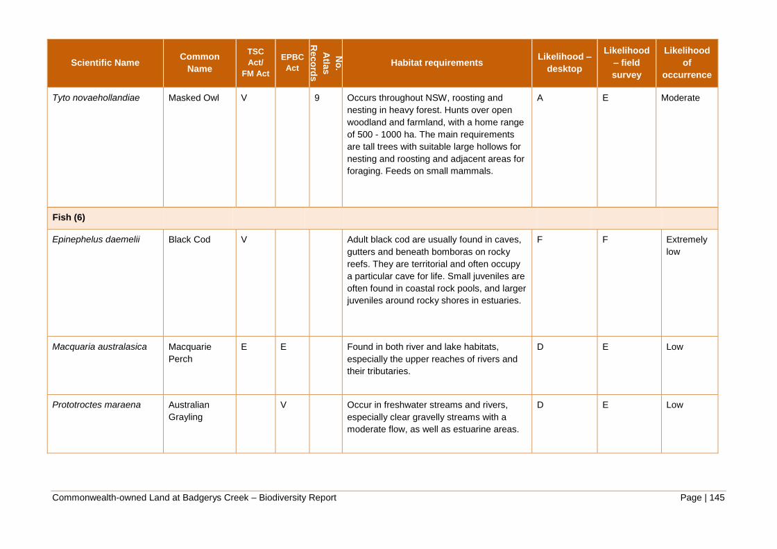
Commonwealth-owned Land at Badgerys Creek – Biodiversity Report Page | 145
Scientific Name Common
Name
TSC
Act/
FM Act
EPBC
Act
No
.
Atla
s
Reco
rds
Habitat requirements Likelihood –
desktop
Likelihood
– field
survey
Likelihood
of
occurrence
Tyto novaehollandiae Masked Owl V 9 Occurs throughout NSW, roosting and
nesting in heavy forest. Hunts over open
woodland and farmland, with a home range
of 500 - 1000 ha. The main requirements
are tall trees with suitable large hollows for
nesting and roosting and adjacent areas for
foraging. Feeds on small mammals.
A E Moderate
Fish (6)
Epinephelus daemelii Black Cod V Adult black cod are usually found in caves,
gutters and beneath bomboras on rocky
reefs. They are territorial and often occupy
a particular cave for life. Small juveniles are
often found in coastal rock pools, and larger
juveniles around rocky shores in estuaries.
F F Extremely
low
Macquaria australasica Macquarie
Perch
E E Found in both river and lake habitats,
especially the upper reaches of rivers and
their tributaries.
D E Low
Prototroctes maraena Australian
Grayling
V Occur in freshwater streams and rivers,
especially clear gravelly streams with a
moderate flow, as well as estuarine areas.
D E Low

Commonwealth-owned Land at Badgerys Creek – Biodiversity Report Page | 146
Scientific Name Common
Name
TSC
Act/
FM Act
EPBC
Act
No
.
Atla
s
Reco
rds
Habitat requirements Likelihood –
desktop
Likelihood
– field
survey
Likelihood
of
occurrence
Gastropods (1)
Meridolum corneovirens Cumberland
Plain Land
Snail
E 144 Primarily inhabits Cumberland Plain
Woodland. Lives under litter of bark, leaves
and logs, or shelters in loose soil around
grass clumps. Occasionally shelters under
rubbish. Can dig several centimetres into
soil to escape drought.
A A High
Insects (2)
Archaeophya adamsi Adam's
Emerald
Dragonfly
E Larvae have been found in small creeks
with gravel or sandy bottoms, in narrow,
shaded riffle zones with moss and rich
riparian vegetation.
D E Low
Austrocordulia leonardi Sydney Hawk
Dragonfly
E The Sydney hawk dragonfly has specific
habitat requirements, and has only ever
been collected from deep and shady
riverine pools with cooler water. Larvae are
found under rocks where they co-exist with
Austrocordulia refracta.
D E Low

Commonwealth-owned Land at Badgerys Creek – Biodiversity Report Page | 147
Scientific Name Common
Name
TSC
Act/
FM Act
EPBC
Act
No
.
Atla
s
Reco
rds
Habitat requirements Likelihood –
desktop
Likelihood
– field
survey
Likelihood
of
occurrence
Mammals (12)
Chalinolobus dwyeri Large-eared
Pied Bat
V V 8 Roosts in disused mine shafts, caves,
overhangs and disused Fairy Martin nests
for shelter and to raise young. Also
potentially roost in tree hollows. Occurs in
low to mid-elevation dry open forest and
woodlands, preferably with extensive cliffs,
caves or gullies. Pied Bat is largely
restricted to the interface of sandstone
escarpment (for roost habitat) and relatively
fertile valleys (for foraging habitat).
A E Moderate
Dasyurus maculatus
maculatus
Spotted-tail
Quoll (south-
eastern
mainland
population)
V E Utilises a range of habitat types, including
rainforest, open forest, woodland, coastal
heath and inland riparian forest, from the
sub-alpine zone to the coastline. Individual
animals use hollow-bearing trees, fallen
logs, small caves, rock crevices, boulder
fields and rocky-cliff faces as den sites.
D E Low
Falsistrellus tasmaniensis Eastern False
Pipistrelle
V 2 This species occupies tall, mature, wet
forest and the species have been recorded
roosting in stem holes in Eucalyptus and in
buildings. Prefers moist habitats, with trees
taller than 20 m. Generally roosts in
eucalypt hollows, but has also been found
under loose bark on trees or in buildings.
C E Low

Commonwealth-owned Land at Badgerys Creek – Biodiversity Report Page | 148
Scientific Name Common
Name
TSC
Act/
FM Act
EPBC
Act
No
.
Atla
s
Reco
rds
Habitat requirements Likelihood –
desktop
Likelihood
– field
survey
Likelihood
of
occurrence
Miniopterus australis Little Bentwing
Bat
V 1 This species occurs in moist eucalypt forest,
rainforest or dense coastal banksia scrub.
Little Bent-wing Bats roost in caves, tunnels
and sometimes tree hollows during the day,
and at night forage for small insects
beneath the canopy of densely vegetated
habitats.
C E Low
Miniopterus schreibersii
oceanensis
Eastern
Bentwing Bat
V 25 Caves are the primary roosting habitat, but
also use derelict mines, storm-water
tunnels, buildings and other man-made
structures. They form discrete populations
centred on a maternity cave that is used
annually in spring and summer for the birth
and rearing of young. This species tends to
hunt in forested areas.
A C High
Mormopterus norfolkensis Eastern
Freetail Bat
V 26 Habitats preference includes dry eucalypt
forest and coastal woodlands but also
include riparian zones in rainforest and wet
sclerophyll forest. Forages above forest
canopy or forest edge and requires roosts
including tree hollows.
A C High
Myotis macropus Southern
Myotis
V 16 This species generally roost in groups of 10
- 15 close to water in caves, mine shafts,
hollow-bearing trees, storm water channels,
buildings, under bridges and in dense
foliage. They forage over streams and pools
catching insects and small fish by raking
their feet across the water surface.
B D Moderate

Commonwealth-owned Land at Badgerys Creek – Biodiversity Report Page | 149
Scientific Name Common
Name
TSC
Act/
FM Act
EPBC
Act
No
.
Atla
s
Reco
rds
Habitat requirements Likelihood –
desktop
Likelihood
– field
survey
Likelihood
of
occurrence
Petrogale penicillata Brush-tailed
Rock-wallaby
E V 1 This species prefers rocky habitats,
including loose boulder-piles, rocky
outcrops, steep rocky slopes, cliffs, gorges,
isolated rock stacks and tree limbs.
Preference for north-facing slopes and cliff
lines. A range of vegetation types are
associated with Brush-tailed Rock-wallaby
habitat, including dense rainforest, wet
sclerophyll forest, vine thicket, dry
sclerophyll forest, and open forest.
D D Low
Phascolarctos cinereus Koala V V 2 Inhabits a range of eucalypt forest and
woodland communities. Adequate floristic
diversity, availability of feed trees (primarily
Eucalyptus tereticornis and E. viminalis) and
presence of mature trees very important.
Preferred food tree species vary with locality
and there are quite distinct regional
preferences. They are able to persist in
fragmented habitats, and even survive in
isolated trees across a predominantly
agricultural landscape.
C E Low
Pseudomys
novaehollandiae
New Holland
Mouse
V Inhabit open heathlands, open woodlands
with a heathland understorey, and
vegetated sand dunes. Nest in burrows and
have a preference for deeper top soils and
softer substrates to aid digging. Spends
considerable time foraging above-ground for
food in areas of high floristic diversity.
D E Low

Commonwealth-owned Land at Badgerys Creek – Biodiversity Report Page | 150
Scientific Name Common
Name
TSC
Act/
FM Act
EPBC
Act
No
.
Atla
s
Reco
rds
Habitat requirements Likelihood –
desktop
Likelihood
– field
survey
Likelihood
of
occurrence
Pteropus poliocephalus Grey-headed
Flying-fox
V V 16 Occur in subtropical and temperate
rainforests, tall sclerophyll forests and
woodlands, heaths and swamps as well as
urban gardens and cultivated fruit crops.
Roosting camps are commonly found in
gullies, close to water, in vegetation with a
dense canopy. They travel up to 50 km to
forage, on the nectar and pollen of native
trees, in particular Eucalyptus, Melaleuca
and Banksia, and fruits of rainforest trees
and vines.
B D Moderate
Scoteanax rueppellii Greater Broad-
nosed Bat
V 10 Occurs in a variety of habitats including
rainforest, dry and wet sclerophyll forest and
eucalypt woodland. Large hollow bearing
trees required for roosting.
B D Moderate
Reptiles (1)
Hoplocephalus
bungaroides
Broad-headed
Snake
E V Confined to the Sydney basin within a
radius of approximately 200 km of Sydney.
Preferred habitat of sandstone outcrops
with woodland, open woodland and/or
heath vegetation. Shelters in rock crevices
and under flat sandstone rocks on exposed
cliff edges and tree hollows.
D F Low

Commonwealth-owned Land at Badgerys Creek – Biodiversity Report Page | 151
APPENDIX 4: SURVEY GUIDELINES FOR SPECIES WITH A MODERATE TO HIGH LIKELIHOOD
OF OCCURENCE IN THE STUDY AREA
V = Vulnerable species or ecological community.
E = Endangered species or ecological community
EP = Endangered population
X = Extinct
CE = Critically endangered species or ecological
community
Scientific Name Common Name
TSC
Act/
FM Act
EPBC
Act
No
. Atla
s
Reco
rds
Likelihood
of
occurrence
Survey methods Survey timing Source
Flora
Acacia pubescens Downy Wattle V V 12 Moderate 30 minute random meander search
in suitable habitat.
Flowers from
August to
October.
2
Cynanchum elegans White-flowered Wax
Plant
E E 3 Moderate 30 minute random meander search
in suitable habitat. Low stem
numbers and/or highly localised
distributions are characteristic of C.
elegans sites and consequently, the
search effort required to confirm
presence or absence of the species
is high.
Flowering occurs
between August
and May, with a
peak in
November.
2

Commonwealth-owned Land at Badgerys Creek – Biodiversity Report Page | 152
Scientific Name Common Name
TSC
Act/
FM Act
EPBC
Act
No
. Atla
s
Reco
rds
Likelihood
of
occurrence
Survey methods Survey timing Source
Dillwynia tenuifolia Dillwynia tenuifolia,
Kemps Creek
EP,V 69 High 30 minute random meander search
in suitable habitat. Surveys should
initially concentrate in open areas
within woodland/open forest,
particularly targeting areas
possessing laterised gravels, or low
rises which have a well-developed
or regenerating low shrub layer.
Roadsides with suitable habitat
should also be surveyed.
Flowering occurs
August to March,
peaking in
September.
2
Grevillea juniperina
subsp. juniperina
Juniper-leaved
Grevillea
V 90 High 30 minute random meander search
in suitable habitat. Potential habitat
comprises woodland areas on
Wianamatta Shale and Tertiary
alluvium (often close to the
boundary between the two
geologies), and is usually
associated with lateritic gravels.
Populations are often found in
relatively open and/or disturbed
sites, including roadsides and
wetter areas.
All year.
Flowering may
occur sporadically
throughout the
year, but
particularly
between July and
October.
2

Commonwealth-owned Land at Badgerys Creek – Biodiversity Report Page | 153
Scientific Name Common Name
TSC
Act/
FM Act
EPBC
Act
No
. Atla
s
Reco
rds
Likelihood
of
occurrence
Survey methods Survey timing Source
Grevillea parviflora subsp.
parviflora
Small-flower Grevillea V V 12 Moderate 30 minute random meander search
in suitable habitat. Surveys should
target flat to gently sloping land
within areas of geology with both a
shale and sandstone or tertiary
alluvium influence as at Kemps
Creek. Soils often contain ironstone
gravels and are highly infertile
andoften poorly drained.
Populations are more commonly
found in relatively open, disturbed
sites along roads and tracks in
areas of open-forest or woodland.
Flowering occurs
July to December.
2
Isotoma sessiliflora E X 7 Moderate 30 minute random meander search
in suitable habitat. Surveys should
target periodically inundated areas
close to creek lines or dams on
recent alluvium or shale.
Spring to
summer, after
good rains.
2
Marsdenia viridiflora
subsp. viridiflora
Marsdenia viridiflora R.
Br. subsp. viridiflora
population in the
Bankstown,
Blacktown, Camden,
Campbelltown,
Fairfield, Holroyd,
Liverpool and Penrith
local government
areas
EP 22 High 30 minute random meander search
in suitable habitat. Surveys should
target woodland or adjoining open
areas (including Bursaria regrowth)
on Wianamatta Shale or in ecotone
between shale and recent alluvium
of creek-lines. Roadsides with
suitable habitat should also be
surveyed.
All year. 2

Commonwealth-owned Land at Badgerys Creek – Biodiversity Report Page | 154
Scientific Name Common Name
TSC
Act/
FM Act
EPBC
Act
No
. Atla
s
Reco
rds
Likelihood
of
occurrence
Survey methods Survey timing Source
Pultenaea parviflora E V 103 High 30 minute random meander search
in suitable habitat. Surveys should
initially concentrate in open areas
within woodland/open forest,
particularly targeting areas
possessing laterised gravels, or low
rises which have a well-developed
or regenerating low shrub layer.
Roadsides with suitable habitat
should also be surveyed.
Flowering may
occur between
August and
November
depending on
environmental
conditions. Best
to survey in
September.
2
Pimelea spicata Spiked Rice-flower E E 8 High A targeted survey should be
undertaken using the random
meander method, favouring
suitable habitat areas (i.e open
areas and woodland particularly on
lower slopes). Survey effort should
be at least one hour per hectare of
suitable habitat.
Can appear any
time of year but
mostly in summer.
Difficult to detect
when not in flower
(typically flowers
following periods
of rainfall).
2

Commonwealth-owned Land at Badgerys Creek – Biodiversity Report Page | 155
Scientific Name Common Name
TSC
Act/
FM Act
EPBC
Act
No
. Atla
s
Reco
rds
Likelihood
of
occurrence
Survey methods Survey timing Source
FAUNA
Amphibians
Heleioporus australiacus Giant Burrowing Frog V V 4 Moderate Methods: Using spotlight surveys
on foot and by road. Best results
during and immediately after
rainfall. Accompanied by habitat
assessment by appropriately
experienced personnel. Larvae are
distinctive and can be collected by
dip netting. Multiple sweeps in
pools.
Effort: A minimum of four nights
under ideal conditions.
Area to be covered: In the study
site, spotlight surveys on foot
should cover several square
kilometres of track in suitable
habitat. In the local area, spotlight
road transects should traverse up
to 30 km in suitable habitat,
repeated sections after a period of
about one hour is suitable.
Under optimum
weather
conditions; that is,
wet conditions. At
time of peak
activity for the
species; that is,
rainfall in spring
and autumn.
Seasonal:
September–
March
Weather
conditions: Within
one week of
heavy rainfall
(September–
March) (heavy
rainfall is >50 mm
in seven days)
1

Commonwealth-owned Land at Badgerys Creek – Biodiversity Report Page | 156
Scientific Name Common Name
TSC
Act/
FM Act
EPBC
Act
No
. Atla
s
Reco
rds
Likelihood
of
occurrence
Survey methods Survey timing Source
Litoria aurea Green and Golden Bell
Frog
E V 1 Moderate Methods: Using a combination of
call detection, call playback and
spotlight surveys. Accompanied by
habitat assessment by
appropriately experienced
personnel. Larvae are distinctive
but tend to be cryptic in behaviour.
Can be collected by dip netting or
trapping. Multiple sweeps in pools.
Effort: A minimum of four nights
under ideal conditions.
Area to be covered: Small wetlands
(<50 metres at greatest length) at
the study site should be covered in
a period of about one hour. Search
banks and emergent vegetation.
Larger wetlands (>50 metres)
should be searched by sampling
multiple units in a systematic
manner. Local area study should
include reference sites where
feasible.
Under optimum
weather
conditions; that is,
warm and
windless,
following rainfall.
At time of peak
activity for the
species.
Seasonal:
September–
March
Weather
conditions: Within
one week of
heavy rainfall
(October–
February)(heavy
rainfall is >50 mm
in seven days)
1
Birds
Ninox connivens Barking Owl V 1 Moderate Methods: Call playback (>5 visits
per site, on different nights); Habitat
search for suitable nesting sites
Calls at all times
of year, but
strongest
response in
March-June.
Avoid early
nesting period
(July-Sept).
2,6

Commonwealth-owned Land at Badgerys Creek – Biodiversity Report Page | 157
Scientific Name Common Name
TSC
Act/
FM Act
EPBC
Act
No
. Atla
s
Reco
rds
Likelihood
of
occurrence
Survey methods Survey timing Source
Melithreptus gularis
gularis
Black-chinned
Honeyeater (eastern
subspecies)
V 1 Moderate No specific survey methods.
Suggested methods include: Area
search (minimum 20
minute/hectare) or point count
survey (10 minutes at 5 points on a
500m transect) or random meander
until no new species are recorded
for 20 minutes
All year 2,6
Ardea ibis Cattle Egret M 20 High 20 minute survey at dawn or dusk,
for each identified water source.
Partial migrant,
more likely to be
present in winter.
3
Stagonopleura guttata Diamond Firetail V 4 Moderate As per Black-chinned Honeyeater All year 2,6
Petroica phoenicea Flame Robin V 5 Moderate As per Black-chinned Honeyeater All year 2,6
Apus pacificus Fork-tailed Swift M 3 Moderate As per Black-chinned Honeyeater October to April 2,3
Callocephalon fimbriatum Gang-gang Cockatoo V 5 Moderate As per Black-chinned Honeyeater More likely to
occur in the study
area during
winter.
2,6
Calyptorhynchus lathami Glossy Black-
Cockatoo
V 13 Moderate As per Black-chinned Honeyeater All year 2,6
Ardea alba Great Egret M Moderate 20 minute survey at dawn or dusk,
for each identified water source.
Partial migrant,
more likely to be
present in winter.
2,3
Melanodryas cucullata
cucullata
Hooded Robin (south-
eastern form)
V 3 Moderate As per Black-chinned Honeyeater All year 2,6

Commonwealth-owned Land at Badgerys Creek – Biodiversity Report Page | 158
Scientific Name Common Name
TSC
Act/
FM Act
EPBC
Act
No
. Atla
s
Reco
rds
Likelihood
of
occurrence
Survey methods Survey timing Source
Gallinago hardwickii Latham's Snipe M 3 Moderate Methods: Area searches or line
transects in suitable habitat
Effort: Minimum of four surveys for
roosting shorebirds during the
period when the majority of
shorebirds are present in the area.
Replicate surveys over this period
are important in obtaining adequate
data.
Coverage: At a minimum survey
coverage should include:
1) all of the habitat thought to be
used by the same population of
shorebirds, and 2) the entire area of
contiguous habitat where
shorebirds may occur.
This will require consideration of
the regional context of the wetland
and may include multiple discrete
roosts and feeding areas.
Surveys should
be conducted
between October
and February
4
Hieraaetus morphnoides Little Eagle V 2 Moderate As per Black-chinned Honeyeater All year 2,6
Glossopsitta pusilla Little Lorikeet V 1 Moderate Area search (minimum 20
minute/hectare) or point count
survey (10 minutes at 5 points on a
500m transect)
All year 2,6
Tyto novaehollandiae Masked Owl V 9 Moderate Methods: Call playback (>8 visits
per site, on different nights); Habitat
search for suitable nesting sites.
Most easily
detected in
winter/early spring
2,6

Commonwealth-owned Land at Badgerys Creek – Biodiversity Report Page | 159
Scientific Name Common Name
TSC
Act/
FM Act
EPBC
Act
No
. Atla
s
Reco
rds
Likelihood
of
occurrence
Survey methods Survey timing Source
Ninox strenua Powerful Owl V 16 Moderate Methods: Call playback (>5 visits
per site, on different nights); Habitat
search for suitable nesting sites
Probably calls all
year but most
frequently in
winter/early spring
2,6
Merops ornatus Rainbow Bee-eater M 9 Moderate As per Black-chinned Honeyeater All year, more
likely to be
present in
summer.
2,3
Anthochaera phrygia Regent Honeyeater CE E 3 Moderate Area searches*: 20 hours over 10
days
Targeted searches**: 20 hours over
5 days
* In areas of less than 50 ha
** Targeting areas of heavily
flowering trees and flocks of other
blossom feeders
All year 5
Rhipidura rufifrons Rufous Fantail M Moderate As per Black-chinned Honeyeater December to
March
2,3
Petroica boodang Scarlet Robin V 3 Moderate As per Black-chinned Honeyeater All year 2,6
Chthonicola sagittata Speckled Warbler V 16 Moderate As per Black-chinned Honeyeater All year 2,6
Lophoictinia isura Square-tailed Kite V 1 Moderate As per Black-chinned Honeyeater All year 2,6

Commonwealth-owned Land at Badgerys Creek – Biodiversity Report Page | 160
Scientific Name Common Name
TSC
Act/
FM Act
EPBC
Act
No
. Atla
s
Reco
rds
Likelihood
of
occurrence
Survey methods Survey timing Source
Lathamus discolor Swift Parrot E E 6 Moderate Area searches or transect surveys*
20 hours over 8 days
Targeted surveys** 20 hours over 8
days
(* In areas of less than 50 ha **
Targeting areas of heavily flowering
eucalypts)
Surveys on the
mainland should
be conducted
between March
and July
5
Daphoenositta
chrysoptera
Varied Sittella V 28 Moderate As per Black-chinned Honeyeater All year 2,6
Hirundapus caudacutus White-throated
Needletail
M 1 Moderate As per Black-chinned Honeyeater October to
February
2,3
Gastropods
Meridolum corneovirens Cumberland Plain
Land Snail
E 144 High Active searches for live individuals
and shells around the base of
trees/grass clumps and under
logs/debris.
All year 6
Mammals
Miniopterus schreibersii
oceanensis
Eastern Bentwing Bat V 25 High Methods: Roost searches and
trapping
Effort (per 100 ha of preferred
habitat): Harp traps - 4 trap nights
over 2 consecutive nights;
Ultrasonic call recording - 2 devices
for the entire night over 2 nights
Spring, summer,
autumn
2,6
Mormopterus norfolkensis Eastern Freetail Bat V 26 High Methods: Roost searches, trapping
and call survey
Effort (per 100 ha of preferred
habitat): as above
Spring, summer,
autumn
2,6

Commonwealth-owned Land at Badgerys Creek – Biodiversity Report Page | 161
Scientific Name Common Name
TSC
Act/
FM Act
EPBC
Act
No
. Atla
s
Reco
rds
Likelihood
of
occurrence
Survey methods Survey timing Source
Scoteanax rueppellii Greater Broad-nosed
Bat
V 10 Moderate Methods: Roost searches and call
survey
Effort (per 100 ha of preferred
habitat): as above
Spring, summer,
autumn
2,6
Pteropus poliocephalus Grey-headed Flying-
fox
V V 16 Moderate Consultants should demonstrate
that they have sought information
about the location of historic camps
from the appropriate authoritative
sources as outlined above. It
should also be demonstrated that a
comprehensive vegetation survey
has been completed for the survey
area, and a clear assessment of the
contribution of the project area in
terms of food plants, especially in
relation to the broader region, is
provided.
Presence will be
dependent on
food resources.
The time and
location of
flowering and
fruiting of diet
plants varies
among seasons
and years.
8
Chalinolobus dwyeri Large-eared Pied Bat V V 8 Moderate Unattended bat detectors 16
detector nights (minimum 4 nights)
Attended bat detectors 6 detector
hours (minimum 3 nights)
Harp traps and/or mistnets 16 trap
or net nights (minimum 4 nights)
Surveys are best
conducted from
October through
to March.
7
Myotis macropus Southern Myotis V 16 Moderate Methods: Roost searches and
trapping
Effort (per 100 ha of preferred
habitat): as per Eastern Bentwing
Bat
October to March 2,6
Sources:

Commonwealth-owned Land at Badgerys Creek – Biodiversity Report Page | 162
1. DEWHA (2010d) Survey guidelines for Australia’s threatened frogs. Department of the Environment, Water, Heritage and the Arts, Parkes, ACT.
2. DEC (2004) Threatened Biodiversity and Assessment: Guidelines for Development and Activities (Working draft). New South Wales Department of
Environment and Conservation, Hurstville, NSW.
3. DOE (2012) Species Profile and Threats Database. Department of the Environment, Parkes, ACT.
4. DEWHA (2009a) Significant impact guidelines for 36 migratory shorebird species: migratory species. Department of the Environment, Water, Heritage and
the Arts, Parkes, ACT.
5. DEWHA (2010c) Survey guidelines for Australia’s threatened birds. Department of the Environment, Water, Heritage and the Arts, Parkes, ACT.
6. OEH (variable dates) Threatened species profile search. Office of Environment and Heritage, Sydney, NSW.
7. DEWHA (2010b) Survey guidelines for Australia’s threatened bats. Department of the Environment, Water, Heritage and the Arts, Parkes, ACT.
8. DEH (2003) EPBC Act Administrative Guidelines on Significance - Supplement for the Grey-headed Flying-fox. Department of the Environment and
Heritage, Parkes, ACT.

Commonwealth-owned Land at Badgerys Creek – Biodiversity Report Page | 163
APPENDIX 5: RISK MATRIX – SPECIES LIKELIHOOD OF OCCURRENCE