B1: Geology of the Bald Mountain-Saddleback Wind Range ...
17
Bates College SCAB New England Intercollegiate Geological Conference 2017 NEIGC 2017 Day Two: September 30 Sep 30th, 2017 B1: Geology of the Bald Mountain-Saddleback Wind Range, West-Central Maine Douglas N. Reusch University of Maine at Farmington, [email protected] Jake Hansen Follow this and additional works at: hp://scarab.bates.edu/neigc2017 Part of the Geology Commons is Event is brought to you for free and open access by the Conferences and Events at SCAB. It has been accepted for inclusion in New England Intercollegiate Geological Conference 2017 by an authorized administrator of SCAB. For more information, please contact [email protected]. Recommended Citation Reusch, D.N., and Hansen, J., 2017, Geology of the Bald Mountain-Saddleback Wind Range, West-Central Maine in Johnson, B. and Eusden, J.D., ed., Guidebook for Field Trips in Western Maine and Northern New Hampshire: New England Intercollegiate Geological Conference, Bates College, p. 119-134. hps://doi.org/10.26780/2017.001.0008
Transcript of B1: Geology of the Bald Mountain-Saddleback Wind Range ...

Bates CollegeSCARABNew England Intercollegiate Geological Conference2017 NEIGC 2017 Day Two: September 30
Sep 30th, 2017
B1: Geology of the Bald Mountain-SaddlebackWind Range, West-Central MaineDouglas N. ReuschUniversity of Maine at Farmington, [email protected]
Jake Hansen
Follow this and additional works at: http://scarab.bates.edu/neigc2017
Part of the Geology Commons
This Event is brought to you for free and open access by the Conferences and Events at SCARAB. It has been accepted for inclusion in New EnglandIntercollegiate Geological Conference 2017 by an authorized administrator of SCARAB. For more information, please contact [email protected].
Recommended CitationReusch, D.N., and Hansen, J., 2017, Geology of the Bald Mountain-Saddleback Wind Range, West-Central Maine in Johnson, B. andEusden, J.D., ed., Guidebook for Field Trips in Western Maine and Northern New Hampshire: New England Intercollegiate GeologicalConference, Bates College, p. 119-134. https://doi.org/10.26780/2017.001.0008

B1-1
GEOLOGY OF THE BALD MOUNTAIN-SADDLEBACK WIND RANGE, WEST-CENTRAL MAINE
By
Douglas N. Reusch, Division of Natural Sciences,
University of Maine at Farmington, Farmington, Maine 04938 Jake Hansen, 437 Harris Street, Hendersonville, NC 28792
e-mail: [email protected]
INTRODUCTION
Bald Mountain, between Wilton and Weld in west-central Maine (Fig. 1), hosts one of the largest continuous exposures of bedrock in this part of the state. It is a popular hiking destination and field site for undergraduate students. Bald has been a stop on an International Geological Congress (IGC) field trip (Moench, 1989) and two previous New England Intercollegiate Geological Conference (NEIGC) field trips (Reusch and Powers, 2006; Reusch et al., 2010).
Breakthroughs in understanding the geology of the Bald Mountain field site occurred during the fall of 2009,
when digital photography was first employed to identify several marker beds with certainty, and during the fall of 2010, when repetitions of marker beds demanding cryptic thrust faults were first recognized (Hansen and Reusch, 2011).
Here, we describe the details of the microstratigraphy and structures within a field site located on the northeast
ridge of the mountain, extending several hundred meters along the ridge. This site, which can be framed pedagogically as a microcosm of William Smith’s study area, has a great potential for introducing geology students to the principles of stratigraphy, structural geology, and geologic mapping. The bulk of this paper is based on a field guide for the Geological Society of Maine summer 2012 field trip (Reusch et al., 2012). Detailed (1cm = 10 m [1:1000 scale]) mapping is presented for the northeastern side of Bald. Mapping of the far side of Bald and Saddleback Wind is in progress.
Figure 1. Saddleback Wind (center), Bald Mountain (right), and wind towers (left) viewed from Farmington.
GEOLOGIC SETTING The Central Maine Trough comprises marine strata of Silurian and Devonian age (Fig. 2, units 27 and 32a)
deposited on fragments of Ganderia (unit 18, e.g., Dead River Formation, Grand Pitch Formation, and Miramichi Group), which share a common Gondwanan provenance and Early Ordovician “Penobscot” deformation (Reusch and van Staal, 2012). Post-Penobscot dispersal of Ganderian fragments occurred behind the Popologan-Ammonoosuc arc (unit 13b), which resulted in a wide back arc basin blanketed by Middle-Upper Ordovician pelagic sediments (too thin to separate but included within units 13b and 27). Following collision of the post-Penobscot arc (unit 13b) with Laurentia, subduction flipped and Central Maine (unit 27) occupied a southeast-facing forearc setting during the Silurian. Closure of the Ordovician back arc basin during the Salinic orogeny (Dokken et al., 2014) set the stage for Acadian orogeny as the next peri-Gondwanan element—Avalonia—accreted.
The Bald Mountain-Saddleback Wind range lies within the Rumford outlier (Fig. 3; Reusch et al., 2010),
largely composed of marine strata assigned to the Seboomook Group (unit 32a) of presumed Early Devonian age (Osberg et al., 1985; Moench and Pankiwskyj, 1988). These strata are dominantly thinly bedded and fine-grained, suggesting a distal site of deposition on a submarine fan. They contrast with generally lighter-colored, thicker-

REUSCH AND HANSEN B1-2
bedded and somewhat coarser sedimentary rocks of the surrounding unit 27. All strata of the Central Maine Trough have been deformed into upright folds, and variably metamorphosed up to sillimanite grade near Devonian plutons.
Figure 2. Regional setting of Bald Mountain-Saddleback Wind (Hibbard et al., 2006). The range is centrally located within the Rumford outlier (Unit 32a, mostly west of Farmington). In turn, the Rumford outlier, ~70 km × 35 km (more than 2/3 the area of Rhode Island), lies within the northwestern part of the Central Maine Trough (unit 27). The embryo-shaped pluton is the Phillips Granite. In clear weather, Mt. Washington, 54 miles to the WSW, is easily visible. Rectangular boxes indicate the locations of Figs. 3 and 4.
GENERAL GEOLOGY In brief, a distal turbidite sequence includes several sets of marker beds that display remarkable lateral
continuity. These beds are considered Devonian based on correlation with the Littleton Formation and Seboomook Group. They are repeated along cryptic thrusts in a structurally complex zone interpreted as a thrust duplex formed at the Acadian deformation front. Fold geometry of early isoclinal folds and the cryptic nature of the thrusts indicate wet sediment deformation, and mullions imply rotation of the maximum compressive stress from vertical to subhorizontal. Upright folding overlapped with late-stage intrusion of granite and sillimanite-grade metamorphism. Stratigraphy
The Day Mountain Formation of the Seboomook Group (Moench and Pankiwskyj, 1988) crops out extensively in the eastern part of the Rumford outlier (Fig. 3). We have identified several sets of marker beds consisting of distinctive “bar codes” of gray pelite and quartzite. We have adopted informal names (Fig. 5), intended to be useful locally. Details are presented in inferred ascending stratigraphic order. Nearby, the Temple Stream Formation, a rusty-weathering graphitic schist, supposedly underlies the Day Mountain Formation, followed farther below by the Mount Blue Formation, with lithology resembling that of the Day Mountain Formation.
Southeastern member. The Southeastern member is well exposed on the cliffs, a dip slope, southeast of the
main ridge (Fig. 15). Sandstone beds are upright and dip 35° to the southeast. Several meters of section are exposed between the Southside fault and trees at the bottom of the ridge. Relative age is poorly constrained but this member may be oldest according to its position in the hanging wall of a suspected thrust duplex.

REUSCH AND HANSEN B1-3
Figure 3. Elements of the Rumford outlier (brick pattern, ribbon limestone; dots, granule conglomerate; gray, Temple Stream Formation; vertical lines widely spaced, Mount Blue Formation; vertical lines narrowly spaced, Day Mountain Formation) and surrounding region (a, Anasagunticook Formation; c, Carrabassett Formation; m, Madrid Formation; s, Sangerville Formation; sf, Smalls Falls Formation; x, plutons). F, Farmingon. Bald Mountain is Stop 8 on NEIGC Trip C3 (Reusch et al., 2010). Gray lines north and south of Stop 8 are, respectively, Routes 156 and 2.

REUSCH AND HANSEN B1-4
Stripes beds. The type locality of the Stripes beds is near the base of the Northeast Ledges (Fig. 15). A triplet of medium thick quartzite beds overlies a single thin bed (Fig. 5C). Also note the very thin beds between the thick beds of the triplet. Around 6 meters of section is present between these marker beds and The Meeting Place beds. The Stripes beds have also been recognized at the Triangle, where they are twice repeated by the 3 a.m. thrust and an unnamed thrust to the northwest.
Meeting Place beds. The Meeting Place beds are defined at the Meeting Place, where they can be followed to
the southwest across a branch of the OMG thrust and also to the northeast into the Northeast Ledges. They consist of
Figure 5A. 2xl marker beds exposed on lower Northeast Ledges (left) and near the Triangle (right). See text for description. Brunton compass for scale. Figure 5B. The Meeting Place marker beds exposed on the Northeast Ledges (left) and at the Meeting Place (right). Natasha Manuel’s knee for scale. Figure 5C. The Stripes marker beds exposed at bottom of Northeast Ledges (left), southeast side of the Triangle (center) and middle of the Triangle (right). Scale varies.

REUSCH AND HANSEN B1-5
Figure 4. Stop locations and reconnaissance geology. Stop 10 is off map near base of access road. Caution: for inclined beds, tops are mostly unknown. Stop 9 is the entire access road (~2 miles, elevations 1700’ to 2100’).
REUSCH AND HANSEN B1-6
four prominent thin beds spaced several tens of centimeters apart underlain by a thickening-upward triplet of very thin beds (Fig. 5B). Approximately 2-3 meters of mainly pelite is present between these beds and the overlying 2xl beds.
2xl beds. The 2xl beds (Fig. 5A) are defined in the ledge just above the Meeting Place. They consist of two
thick, cross-laminated (Bouma C) sandstone beds underlain by 5 thin laminations, which are in turn underlain by 4 laminations. This member can be traced southwest into the Triangle area. At the Meeting Place, it is repeated across the OMG thrust, and both occurrences can be followed northeastward into the Northeast Ledges. Cross laminations here suggest flow from northeast to southwest (Reusch and Powers, 2006).
Northwestern member. The Northwestern member is exposed along the trail below the Meeting Place and to
the northwest of the Meeting Place fault. It consists of thinly bedded graded quartzite-pelite couplets, all topping to the southeast. Again, relative age is poorly constrained but this unit may be the youngest according to its position in the footwall of a suspected thrust duplex.
Age relationships. The 2xl member overlies, presumably on a conformable contact, the Meeting Place member,
which in turn overlies the Stripes member. All of these units may be older than the Northwestern member, interpreted to occupy the footwall of a thrust duplex, and younger than the Southeastern member, interpreted to occupy the hanging wall of the same duplex.
Other units. The Dark Ledges unit comprises rusty-weathering, very thinly laminated sulfidic, graphitic schist.
It crops out to the southeast on the upper half of the near face of Bald Mountain, and is interpreted to be in fault contact with typical gray schist-quartzite to the northwest (Fig. 15). It may correlate with the Temple Stream Formation. The gray rocks that extend from above the Triangle to the summit have not been subdivided, although some quartzite beds are traceable over tens of meters.
Structural geology
The lower field site is centered on a structurally complex belt sandwiched between uniformly southeast-dipping, southeast-topping sections. We interpret the complex zone as a duplex. Early cryptic thrusts and rare isoclinal folds formed as wet sediment entered the deformation front, and were later steepened in conjunction with upright F2 folds. Minor granite intrusions (G1 and G2) are both folded by F2 folds (G1) and also truncate the folds (G2).
OMG thrust. The OMG thrust was first recognized at the Meeting Place based on repetition of two southeast-
topping sections of the 2xl member. Quartz veins may mark its precise location here but to the northeast, the thrust is entirely cryptic within the Northeast Ledges. It truncates the southeasterly belt of 2xl on the lower Northeast Ledges, and truncates the northwesterly belt of 2xl at the Meeting Place, where it offsets the Meeting Place member a few meters in a left-lateral sense.
3 a.m. thrust. The 3 a.m. thrust was recognized at 3 a.m. by comparing digital photographs taken from the
Triangle area. The Stripes member crops out along the southeastern margin of the Triangle and also in the middle of this ledge. The thrust is entirely cryptic, as with the OMG thrust, which suggests that either the repeated sedimentary sections were still wet or that metamorphic recrystallization has obliterated the fault surface. A third exposure of the Stripes member occurs still farther northwest, hence an additional (unnamed) cryptic thrust is required at the Triangle location.
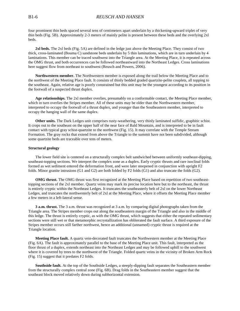
Meeting Place fault. A quartz vein-decorated fault truncates the Northwestern member at the Meeting Place
(Fig. 6A). The fault is approximately parallel to the base of the Meeting Place unit. This fault, interpreted as the floor thrust of a duplex, extends northeast into the Northeast Ledges and may be followed uphill to the southwest where it is covered by trees to the northwest of the Triangle. Folded quartz veins in the vicinity of Broken Arm Rock (Fig. 15) suggest that it predates F2 folds.
Southside fault. At the top of the Southside Ledges, a steeply-dipping fault separates the Southeastern member
from the structurally complex central zone (Fig. 6B). Drag folds in the Southeastern member suggest that the southeast block moved relatively down during subhorizontal extension.
REUSCH AND HANSEN B1-7
Figure 6. A) Meeting Place fault, pack for scale. Note truncated beds on right (northwest) and quartz veins decorating the fault. B) Southside fault, looking southwest. Black line highlights fault, and red lines show bedding.
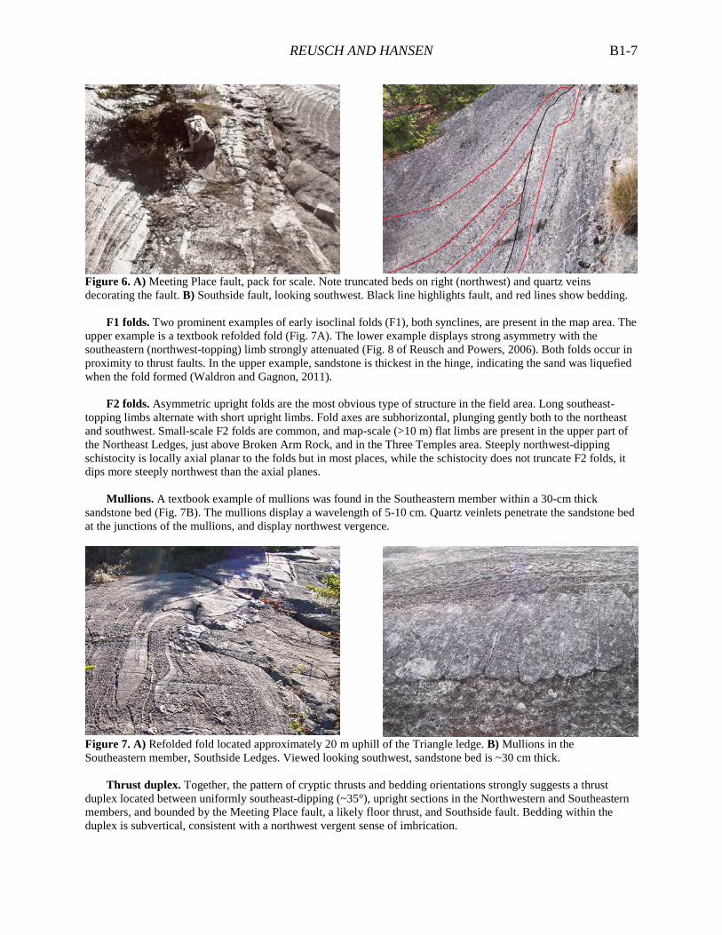
F1 folds. Two prominent examples of early isoclinal folds (F1), both synclines, are present in the map area. The
upper example is a textbook refolded fold (Fig. 7A). The lower example displays strong asymmetry with the southeastern (northwest-topping) limb strongly attenuated (Fig. 8 of Reusch and Powers, 2006). Both folds occur in proximity to thrust faults. In the upper example, sandstone is thickest in the hinge, indicating the sand was liquefied when the fold formed (Waldron and Gagnon, 2011).
F2 folds. Asymmetric upright folds are the most obvious type of structure in the field area. Long southeast-
topping limbs alternate with short upright limbs. Fold axes are subhorizontal, plunging gently both to the northeast and southwest. Small-scale F2 folds are common, and map-scale (>10 m) flat limbs are present in the upper part of the Northeast Ledges, just above Broken Arm Rock, and in the Three Temples area. Steeply northwest-dipping schistocity is locally axial planar to the folds but in most places, while the schistocity does not truncate F2 folds, it dips more steeply northwest than the axial planes.
Mullions. A textbook example of mullions was found in the Southeastern member within a 30-cm thick
sandstone bed (Fig. 7B). The mullions display a wavelength of 5-10 cm. Quartz veinlets penetrate the sandstone bed at the junctions of the mullions, and display northwest vergence.
Figure 7. A) Refolded fold located approximately 20 m uphill of the Triangle ledge. B) Mullions in the Southeastern member, Southside Ledges. Viewed looking southwest, sandstone bed is ~30 cm thick.
Thrust duplex. Together, the pattern of cryptic thrusts and bedding orientations strongly suggests a thrust
duplex located between uniformly southeast-dipping (~35°), upright sections in the Northwestern and Southeastern members, and bounded by the Meeting Place fault, a likely floor thrust, and Southside fault. Bedding within the duplex is subvertical, consistent with a northwest vergent sense of imbrication.

REUSCH AND HANSEN B1-8
Metamorphism and granites
Metamorphism. Pelitic strata are metamorphosed to muscovite-biotite-garnet-sillimanite-staurolite schist (Fig. 8). Moench and Pankiwskyj (1988) show the sillimanite isograd located just southeast of the Bald summit. Calc-silicate pods are present along the trail between The Wall and summit.
Granites. Medium-grained leucogranites are present in the upper half of the mountain between the lower field
site (Triangle) and summit. Twin Dikes (Fig. 15) refers to a pair of parallel meter-wide dikes that extends from southeast to northwest across the ridge. These G2 dikes cut F2 folds. Other smaller granite pods are clearly folded (G1).
Figure 8. Staurolite-garnet schist from northeast side of Bald (left, PPT; right, XPT). Central garnet ~1 mm across.
GEOLOGIC HISTORY Turbidite deposition
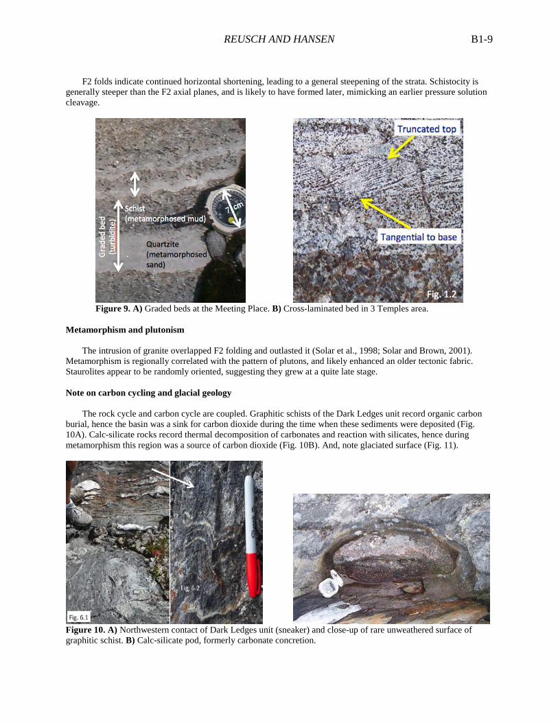
The environment of deposition was clearly marine, bedding and grain size characteristics suggesting a distal location on a submarine fan (Fig. 9A). Sandstones are quartzose, but otherwise little is known about the provenance. While paleocurrents were dominantly from northeast to southwest (Reusch and Powers, 2006), and locally to the southeast (Reusch et al., 2010), other interpretations of the Seboomook Group strongly suggest a southeastern source (e.g., Bradley et al., 2000; Bradley and Hanson, 2002). An explanation for the single example of southerly flow (Fig. 9B) invokes a meandering channel on a very gentle slope. The extraordinary continuity of bedding with no changes over hundreds of meters is quite remarkable and consistent with a distal setting. Cross laminations are interpreted as Bouma C flow regime and a turbidity current mechanism of deposition. It is possible that some very thin, ungraded laminations are contourites. Cryptic thrusts and isoclinal folds
Cryptic thrusts and the geometry of isoclinal F1 folds (Waldron and Gagnon, 2011) strongly suggest deformation of wet sediment as it was transported through a convergent deformation front. Flow of sand into fold hinges indicates that it was liquefied at this time. The surface slope, initially flat, may have increased as the sediments approached the deformation wedge. While difficult to distinguish between pure gravity and tectonic mechanisms, we prefer rooted deformation, as opposed to slumping, based on the presence of quartz veins along the Meeting Place fault.
Subsequent deformation
The mullions record a two-step history (Kenis et al. 2005) beginning with hydrofracturing of the sandstone bed, resulting in the quartz veinlets, under a vertical maximum compressive stress due to either sedimentary or tectonic loading. Subsequently, the maximum stress rotated to cause bedding-parallel shortening (mullions). Microstructural observations suggest a dislocation mechanism of deformation in the quartz veinlets, and pressure solution mechanisms in very weak sediment (Kenis et al. 2005).
REUSCH AND HANSEN B1-9
F2 folds indicate continued horizontal shortening, leading to a general steepening of the strata. Schistocity is
generally steeper than the F2 axial planes, and is likely to have formed later, mimicking an earlier pressure solution cleavage.
Figure 9. A) Graded beds at the Meeting Place. B) Cross-laminated bed in 3 Temples area.
Metamorphism and plutonism
The intrusion of granite overlapped F2 folding and outlasted it (Solar et al., 1998; Solar and Brown, 2001). Metamorphism is regionally correlated with the pattern of plutons, and likely enhanced an older tectonic fabric. Staurolites appear to be randomly oriented, suggesting they grew at a quite late stage.
Note on carbon cycling and glacial geology
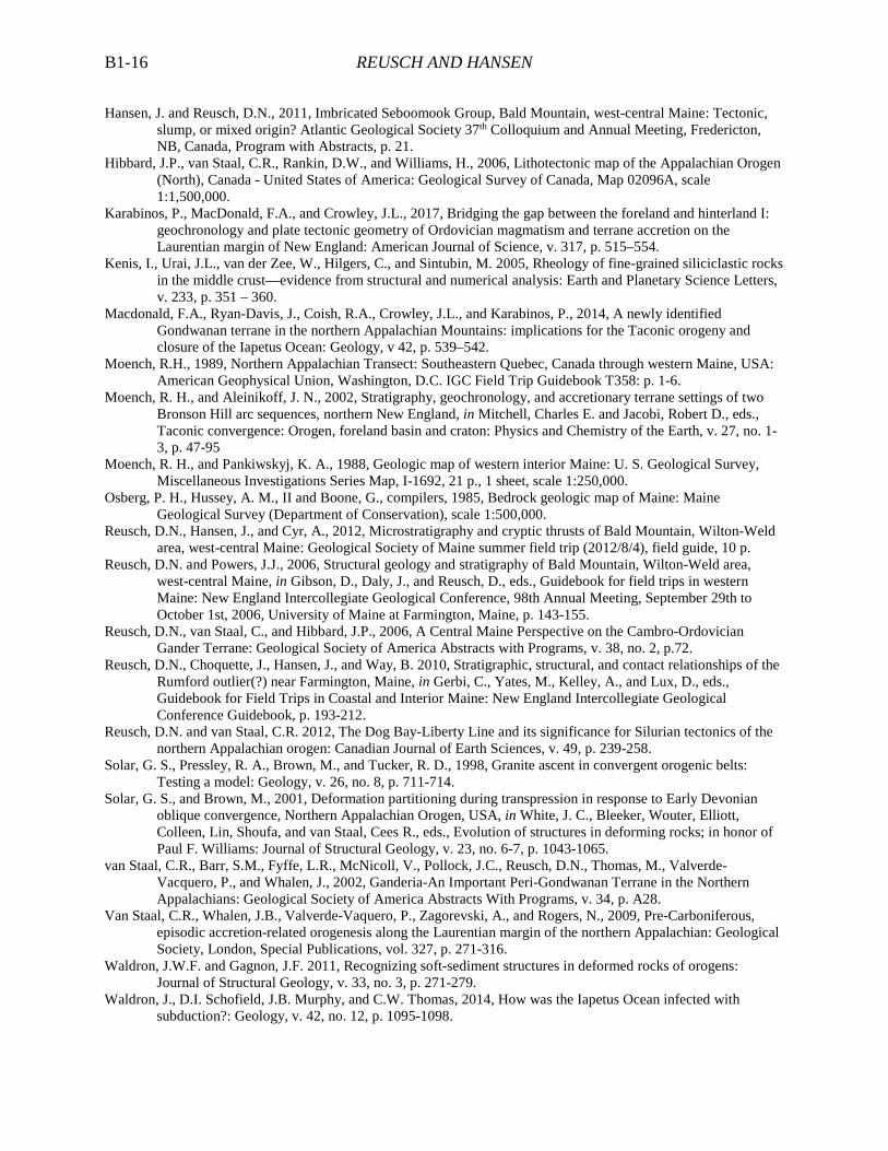
The rock cycle and carbon cycle are coupled. Graphitic schists of the Dark Ledges unit record organic carbon burial, hence the basin was a sink for carbon dioxide during the time when these sediments were deposited (Fig. 10A). Calc-silicate rocks record thermal decomposition of carbonates and reaction with silicates, hence during metamorphism this region was a source of carbon dioxide (Fig. 10B). And, note glaciated surface (Fig. 11).
Figure 10. A) Northwestern contact of Dark Ledges unit (sneaker) and close-up of rare unweathered surface of graphitic schist. B) Calc-silicate pod, formerly carbonate concretion.

REUSCH AND HANSEN B1-10
Figure 11. A) Glacial grooves oriented east-southeast. Ice flow was roughly perpendicular to the ridge. B) Crag-and-tail feature in same orientation doubles as trail marker for entrance to “Secret Path” to the Northeast Ledges.
REGIONAL SIGNIFICANCE
Ganderia, a key peri-Gondwanan element of New England, and the Salinic forearc
The Central Maine Trough comprises marine sedimentary rocks deposited on various fragments of Ganderia, the first of several peri-Gondwanan elements to be accreted to Laurentia (van Staal et al., 2002; Hibbard et al., 2006; Reusch et al., 2006). Ganderia is defined on the basis of Cambro-Ordovician quartz-rich strata (e.g., Miramichi Group, Grand Pitch Formation, Dead River Formation, and evidently the Moretown Formation [MacDonald et al., 2014]) that display Gondwanan provenance (arguably the Amazon craton) and Early Ordovician “Penobscot” deformation (in Newfoundland clearly related to ophiolite obduction). Based on relationships best preserved in the Bathurst area of New Brunswick, subsequent to the Penobscot collision, Ganderia was dispersed in a back arc setting (Tetagouche-Exploits basin of van Staal et al., 2009). After a subduction flip (Karabinos et al., 2017) and Late Ordovician accretion of the Popologan-Ammonoosuc arc to Laurentia, a new southeast-facing continental arc (“Salinic arc,” e.g., Quimby Formation [Bronson Hill] and Attean pluton [Boundary Mountains]) grew on the post-Taconic Laurentian margin (Moench and Aleinikoff, 2002). In this context, the Central Maine region then occupied a forearc setting (Reusch and van Staal, 2012; Dokken et al., 2014).
Figure 12. Location of Ganderia within the Appalachian-Caledonide orogen (Waldron et al., 2014).
Acadian foreland basin
The Seboomook Group is widely interpreted as a clastic wedge deposited in a foreland basin sourced from erosion of a growing Acadian orogen during the Early Devonian (Bradley, 1983; Bradley et al., 2000; Bradley and Tucker, 2002). The basin migrated northwestward in front of the growing orogen, eventually emerging above sea level and culminating with deposition of the Catskill delta. Note that Hibbard et al. (2006) interpret this foreland

REUSCH AND HANSEN B1-11
basin to be in a retroarc position with respect to the Silurian Coastal arc of coastal Maine, New Brunswick, and southern Newfoundland. In other words, in their scenario, northwest vergence is opposite that related to presumed northwest-dipping subduction of the Avalonian plate beneath Laurentia.
Acadian orogenesis
The geology of the Bald Mountain field site is entirely consistent with the tectonic model of Bradley et al. (2000; Fig. 13). It is a snapshot of the processes that characterize Acadian orogenesis at a high structural level. A northwest vergence is consistent with this model of a northwest-migrating orogenic front, but may be at odds with the well-documented southeast-vergent nappes of the Presidential Range in New Hampshire (Eusden and Lyons 1993). Reconciling the structural geology of these classic sites constitutes a first-order problem in northern New England geology.
Figure 13. Tectonic model (Bradley et al. 2000) showing formation of F1 folds and cryptic thrusts as foreland basin sediments cross the deformation front.
ACKNOWLEDGMENTS
The first author appreciates the patience of students in structural geology over the years. He also thanks Scott
Johnson, Dyk Eusden, Robert Marvinney, Dwight Bradley, and Lauren Bradley for site visits as well as the participants of NEIGC trips during 2006 and 2010. Thanks to Carrier Timberlands and Rebecca Howard of Saddleback Ridge Wind for allowing access to Bald and Saddleback, respectively. Mike Pakulski contributed to mapping in 2014, and Wyatt McCurdy is thanked for help with Fig. 4.
ROAD LOG
This trip is a point-to-point hike from the Bald Mountain trailhead on Rte. 156 to the Saddleback Ridge wind farm in Carthage. MEETING POINT. Saturday September 30th, 8:00 AM in the gravel parking area behind the Saddleback Ridge Wind office building (390373.00 m E, 4938625.00 m N). Driving east on Route 2, around 50 minutes from Bethel and near the crest of a long hill, turn left on Winter Hill Road (easily missed, look for signs “Winter Hill Antiques” and “Rocky Mountain Terrain Park”). Proceed 0.9 miles west to the office site. Bathroom facilities will be available. Following introductory remarks, two UMF vans will deliver 20 participants to the Bald Mountain trailhead on Route 156 (http://www.mainetrailfinder.com/trails/trail/bald-mountain-and-saddleback-wind-trail 393477 m E, 4945902 m N), a 20-minute drive. (Vans will return to the starting point, continue to the end of the wind farm access road, and drivers then hike northeast to re-join the group.) Note that while the UMF vans can accommodate 20, others are welcome to participate should they be willing to make similar travel arrangements (preferably in advance). Bring lunch, lots of water, and appropriate clothing for a long, all-day hike with significant portions exposed to the elements. Trail conditions vary considerably. The initial steep ascent has suffered from erosion. The top half of Bald is ledge that under some conditions can be dangerously slippery. If weather is atrocious, the contingency plan is to repeat our 2010 NEIGC trip. Mileage. 0.0 Turn L out of parking lot and proceed E on Winter Hill Road. 0.9 Turn L onto Rte. 2 and drive east for 6.2 miles.

REUSCH AND HANSEN B1-12
7.1 Watch closely for Pond Road, and turn left. Proceed north, then east around the north end of Wilson Lake. 9.0 Turn L and drive north on Rte. 156 for 5.5 miles. 14.5 Very carefully, watching ahead and behind, make a U-turn and park at the Bald Mountain trail head.
The lower part of the Bald Mountain trail is moderately steep and badly gullied in places. At a fast clip, it takes around 20-30 minutes to reach the first ledges.
STOP 1. MEETING PLACE, NORTHEAST LEDGES, AND SOUTHSIDE. (393446.00 m E, 4945002.00 m N, 1 HOUR).
We will examine the type localities of the Meeting Place beds, the 2xl beds, and Meeting Place fault. Participants will be set loose to find the “Rosetta Stone” repetition of the 2xl beds. We will then proceed to the Northeast Ledges to inspect extensions of the geology displayed at the Meeting Place, the type locality of the Stripes, and a spectacular F1 isocline. At Southside, we will point out the Southside fault and discuss remotely the mullions that are present in a dangerous location half way down the cliff.
Figure 14. Google Earth image of Meeting Place ledges taken on mid-afternoon of 2013/9/17. Red line is 10 m and oriented north-south. At north end (right) of red line, UMF students and first author (circle of white spots) are examining the type locality of the 2xl beds. The chances of being captured on Google Earth were high because we visit this site frequently. The “Rosetta Stone” stone, where repeated 2xl beds were first recognized, is located approximately just right of center. STOP 2. THE TRIANGLE. (393303.00 m E, 4944893.00 m N, 15 MINUTES)
The Stripes beds are repeated here. Both sets of beds top to the southeast. This is the type location for the 3 a.m. thrust. A third repetition was subsequently recognized, hence there must be at least two cryptic thrusts here. A short distance to the southeast of the Triangle ledge may be found an excellent example of the 2xl beds. Fine details of the bar code are the same as in outcrops hundreds of meters to the northeast. Presumably, the Meeting Place beds are present beneath the intervening vegetated area.
STOP 3. TWIN DIKES AND DARK LEDGES. (393175.00 m E, 4944782.00 m N, 15 MINUTES)
Two parallel granite dikes strike northwest and cross cut the F2 folds. Elsewhere, identical granite bodies are significantly deformed, which suggests that emplacement of magma was contemporaneous with F2 deformation. The Dark Ledges unit crops out to the southeast, where good examples of rusty weathering, thinly laminated graphitic schist may be observed. The northwestern contact of the Dark Ledges unit cuts bedding and F2 folds, hence is interpreted to be a fault (Dark Ledges fault on Fig. 15).
STOP 4. THREE TEMPLES. (393115.00 m E, 4944736.00 m N, 15 MINUTES)
The site name refers to a triplet of roche moutonées. This area coincides with a large flat limb of an F2 fold. Look for a small parasitic fold with uncommon S-asymmetry to confirm this. On the face of a small cliff (middle roche moutonée), cross laminated quartzite indicates transport from north to south. This current direction is anomalous, in that at face value it suggests a northern provenance. However, it might be reconciled with the prevailing view of a southeastern provenance for Devonian sediments if viewed as a meandering channel on a very low-gradient part of a submarine fan). Alternatively, these strata potentially might correlate with the Perry Mountain

REUSCH AND HANSEN B1-13
Figure 15. Precisely located geologic data, northeastern side of Bald Mountain (see text for explanation).

REUSCH AND HANSEN B1-14
Formation that has a well-established northwestern provenance. Moench (written communication, 2006) was able to distinguish Perry Mountain and Seboomook strata on the basis of “fast” versus “slow” grades. Perry Mountain sediment was mature, and the transition from sand to clay is relatively sharp (“fast grade”). Seboomook sediment was mud-rich, sedimentation rate high, and the transition from sand to clay less sharp (“slow grade”). STOP 5. BALD MOUNTAIN SUMMIT. (392948.00 m E, 4944662.00 m N, 30 MINUTES)
On the approach to the summit, the path traverses a small body of granite and the northwestern contact of the Dark Ledges unit. On a clear day, one can see Saddleback (east of Rangeley, 340°, 22 miles distant), the Presidential Range (Mt. Washington, 242°, 54 miles distant), and the Camden Hills (Mt. Megunticook, 124°, 69 miles distant). The view spans most of Ganderia (Fig. 12), and this is a great location to discuss the regional tectonics. On a more local scale, in the foreground to the northwest, the Phillips Granite is centered on the valley of Webb Lake; rocks nearly identical to Bald form the Tumbledown massif on the far side of the lake. Prevailing geomorphic wisdom attributes differential erosion to the contrast between the granite and resistant metamorphic country rock around it. On a very local scale, why is the ridge where it is? Is it a geomorphological accident, or is there something about the bedrock that makes it preferentially resistant to erosion? STOP 6. STAUROLITE CITY. (392632.00 m E, 4944078.00 m N, 30 MINUTES)
A spectacular set of ledges is bounded to the northeast by a sheer cliff (Fig. 16A). The northwest-southeast cross section nicely captures the geometry of F2 folds (long southeast-topping limbs and short upright limbs). Staurolites abound in the predominantly pelitic schists, which commonly are very thinly laminated (Fig. 16B).
Figure 16. A) Cliff face at Stop 6 displays representative F2 folds. B) Very thinly laminated pelitic schist. STOP 7. SADDLEBACK WIND SUMMIT AREA. (392280.00 m E, 4942495.00 m N, 1 HOUR)
Uncommon horizons of medium-bedded quartzites display asymmetric fold geometries (Fig. 17A). As on Bald, most beds top to the southeast in this area. The thinned northwest-topping beds are consistent with an overall top-to-northwest vergence (e.g., Fig. 13). Likely, we will have much more to communicate about these outcrops pending the results of an undergraduate mapping project in September.
STOP 8. EASTERN SPUR. (392982.00 m E, 4943062.00 m N, 1 HOUR includes round trip hike on ancient trail)
A set of quartz veins decorates a fault duplex here (Fig. 17B). Note truncation of beds on the right, and right-lateral sense of quartz veins in the duplex. STOP 9. WIND FARM ACCESS ROAD. (Tower 12: 391918.00 m E, 4942035.00 m N, Tower 3: 391161.00 m E, 4940244.00 m N, 90 MINUTES)
Moench and Pankiwskyj (1988) show the Bald Mountain detachment fault passing through this ridge, but reconnaissance mapping has not found evidence for a major discontinuity. Some beds top to the northwest (Fig. 18A). Rusty-weathering, very thinly bedded to laminated pelitic schist is common (Fig. 18B).
STOP 10. PEGMATITE. (390155.00 m E, 4939314.00 m N, 10 MINUTES)
No field trip in west-central Maine would be complete without a pegmatite. Near the base of the access road, new road cuts expose a granitic pegmatite, presumably an offshoot of the nearby Phillips Granite with an age of ca. 403 Ma (Solar et al., 1998).

REUSCH AND HANSEN B1-15
Figure 17. A) Thinned NW-topping limbs, Jesse Powers ~2 m tall. B) 1 m-wide right-lateral duplex, looking NE.
Figure 18. A) Northwest (left)-topping quartzite bed in road cut on main access road below Tower 8. B) Thinly laminated schist near Tower 4.
REFERENCES CITED
Bradley, D.C. 1983, Tectonics of the Acadian Orogeny in New England and adjacent Canada: Journal of Geology,
v. 91, p. 381–400. Bradley, D. C., and Hanson, L. S., 2002, Paleocurrent analysis of a deformed Devonian foreland basin in the
Northern Appalachians, Maine, USA: Sedimentary Geology, v. 148, no. 3-4, p. 425-447. Bradley, D. and Tucker, R., 2002, Emsian Synorogenic Paleogeography of the Maine Appalachians: Journal of
Geology, v. 110, p. 483-492. Bradley, D. C., Tucker, R. D., Lux, D. R., Harris, A. G. and McGregor, D. C., 2000, Migration of the Acadian
Orogen and foreland basin across the Northern Appalachians of Maine and adjacent areas: U. S. Geological Survey Professional Paper, Report: P 1624, 55 p.
Dokken, R.J., Waldron, J.W.F., and DuFrane, S.A., 2014, Detrital zircon geochronology of the Fredericton Trough, New Brunswick: Constraints on the Silurian closure of a remnant of the Iapetus Ocean: Geological Association of Canada Abstracts with Programs, v. 37, p. 78.
Eusden, J.D., Jr., and Lyons, J.B. 1993, The Sequence of Acadian Deformations in Central New Hampshire, in Roy, D.C. and Skehan, J.W., eds., The Acadian Orogeny: Recent Studies in New England, Maritime Canada, and the Autochthonous foreland: Geological Society of America, Special Paper 275, p. 51-66.
REUSCH AND HANSEN B1-16
Hansen, J. and Reusch, D.N., 2011, Imbricated Seboomook Group, Bald Mountain, west-central Maine: Tectonic, slump, or mixed origin? Atlantic Geological Society 37th Colloquium and Annual Meeting, Fredericton, NB, Canada, Program with Abstracts, p. 21.
Hibbard, J.P., van Staal, C.R., Rankin, D.W., and Williams, H., 2006, Lithotectonic map of the Appalachian Orogen (North), Canada - United States of America: Geological Survey of Canada, Map 02096A, scale 1:1,500,000.
Karabinos, P., MacDonald, F.A., and Crowley, J.L., 2017, Bridging the gap between the foreland and hinterland I: geochronology and plate tectonic geometry of Ordovician magmatism and terrane accretion on the Laurentian margin of New England: American Journal of Science, v. 317, p. 515–554.
Kenis, I., Urai, J.L., van der Zee, W., Hilgers, C., and Sintubin, M. 2005, Rheology of fine-grained siliciclastic rocks in the middle crust—evidence from structural and numerical analysis: Earth and Planetary Science Letters, v. 233, p. 351 – 360.
Macdonald, F.A., Ryan-Davis, J., Coish, R.A., Crowley, J.L., and Karabinos, P., 2014, A newly identified Gondwanan terrane in the northern Appalachian Mountains: implications for the Taconic orogeny and closure of the Iapetus Ocean: Geology, v 42, p. 539–542.
Moench, R.H., 1989, Northern Appalachian Transect: Southeastern Quebec, Canada through western Maine, USA: American Geophysical Union, Washington, D.C. IGC Field Trip Guidebook T358: p. 1-6.
Moench, R. H., and Aleinikoff, J. N., 2002, Stratigraphy, geochronology, and accretionary terrane settings of two Bronson Hill arc sequences, northern New England, in Mitchell, Charles E. and Jacobi, Robert D., eds., Taconic convergence: Orogen, foreland basin and craton: Physics and Chemistry of the Earth, v. 27, no. 1-3, p. 47-95
Moench, R. H., and Pankiwskyj, K. A., 1988, Geologic map of western interior Maine: U. S. Geological Survey, Miscellaneous Investigations Series Map, I-1692, 21 p., 1 sheet, scale 1:250,000.
Osberg, P. H., Hussey, A. M., II and Boone, G., compilers, 1985, Bedrock geologic map of Maine: Maine Geological Survey (Department of Conservation), scale 1:500,000.
Reusch, D.N., Hansen, J., and Cyr, A., 2012, Microstratigraphy and cryptic thrusts of Bald Mountain, Wilton-Weld area, west-central Maine: Geological Society of Maine summer field trip (2012/8/4), field guide, 10 p.
Reusch, D.N. and Powers, J.J., 2006, Structural geology and stratigraphy of Bald Mountain, Wilton-Weld area, west-central Maine, in Gibson, D., Daly, J., and Reusch, D., eds., Guidebook for field trips in western Maine: New England Intercollegiate Geological Conference, 98th Annual Meeting, September 29th to October 1st, 2006, University of Maine at Farmington, Maine, p. 143-155.
Reusch, D.N., van Staal, C., and Hibbard, J.P., 2006, A Central Maine Perspective on the Cambro-Ordovician Gander Terrane: Geological Society of America Abstracts with Programs, v. 38, no. 2, p.72.
Reusch, D.N., Choquette, J., Hansen, J., and Way, B. 2010, Stratigraphic, structural, and contact relationships of the Rumford outlier(?) near Farmington, Maine, in Gerbi, C., Yates, M., Kelley, A., and Lux, D., eds., Guidebook for Field Trips in Coastal and Interior Maine: New England Intercollegiate Geological Conference Guidebook, p. 193-212.
Reusch, D.N. and van Staal, C.R. 2012, The Dog Bay-Liberty Line and its significance for Silurian tectonics of the northern Appalachian orogen: Canadian Journal of Earth Sciences, v. 49, p. 239-258.
Solar, G. S., Pressley, R. A., Brown, M., and Tucker, R. D., 1998, Granite ascent in convergent orogenic belts: Testing a model: Geology, v. 26, no. 8, p. 711-714.
Solar, G. S., and Brown, M., 2001, Deformation partitioning during transpression in response to Early Devonian oblique convergence, Northern Appalachian Orogen, USA, in White, J. C., Bleeker, Wouter, Elliott, Colleen, Lin, Shoufa, and van Staal, Cees R., eds., Evolution of structures in deforming rocks; in honor of Paul F. Williams: Journal of Structural Geology, v. 23, no. 6-7, p. 1043-1065.
van Staal, C.R., Barr, S.M., Fyffe, L.R., McNicoll, V., Pollock, J.C., Reusch, D.N., Thomas, M., Valverde-Vacquero, P., and Whalen, J., 2002, Ganderia-An Important Peri-Gondwanan Terrane in the Northern Appalachians: Geological Society of America Abstracts With Programs, v. 34, p. A28.
Van Staal, C.R., Whalen, J.B., Valverde-Vaquero, P., Zagorevski, A., and Rogers, N., 2009, Pre-Carboniferous, episodic accretion-related orogenesis along the Laurentian margin of the northern Appalachian: Geological Society, London, Special Publications, vol. 327, p. 271-316.
Waldron, J.W.F. and Gagnon, J.F. 2011, Recognizing soft-sediment structures in deformed rocks of orogens: Journal of Structural Geology, v. 33, no. 3, p. 271-279.
Waldron, J., D.I. Schofield, J.B. Murphy, and C.W. Thomas, 2014, How was the Iapetus Ocean infected with subduction?: Geology, v. 42, no. 12, p. 1095-1098.