AVIATION WEATHER - Baron · Weather data API is available for developers to power your favorite app...
5
AVIATION WEATHER DATA • HARDWARE • SOFTWARE
Transcript of AVIATION WEATHER - Baron · Weather data API is available for developers to power your favorite app...

AVIATION WEATHERDATA • HARDWARE • SOFTWARE
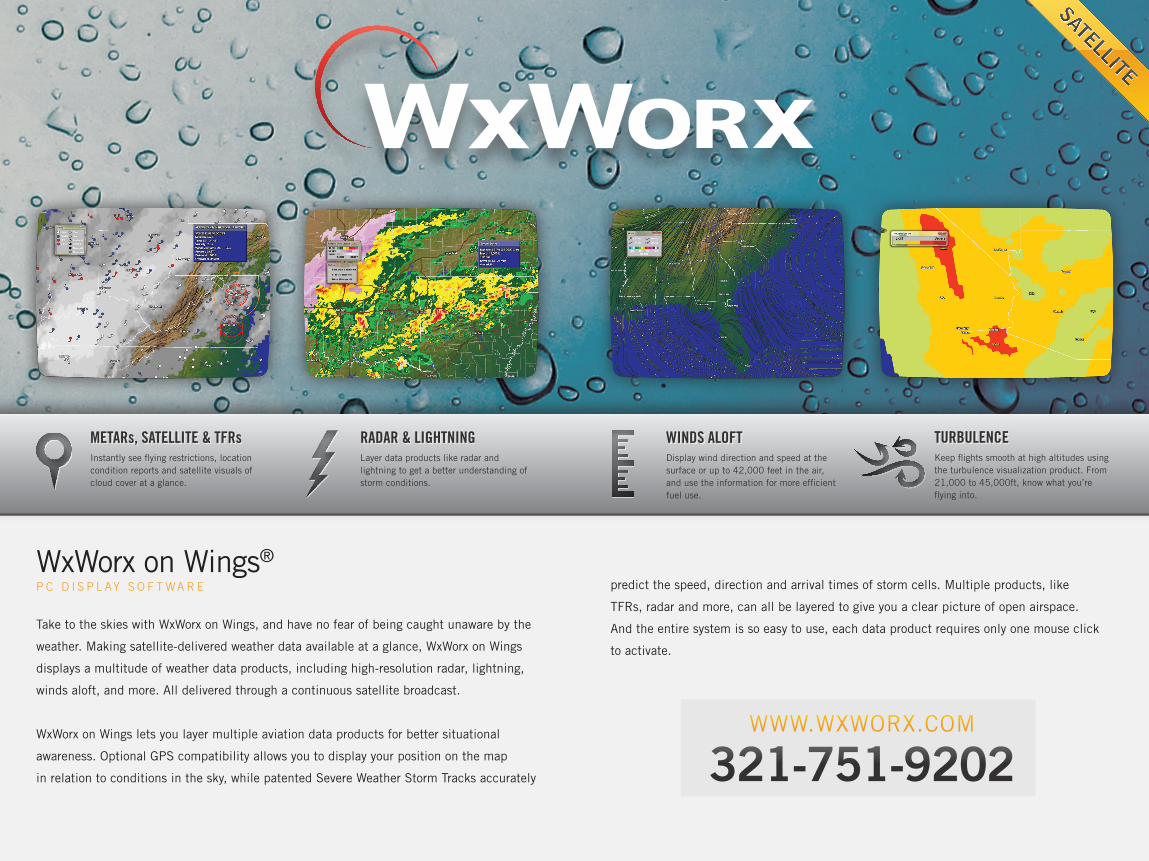
predict the speed, direction and arrival times of storm cells. Multiple products, like
TFRs, radar and more, can all be layered to give you a clear picture of open airspace.
And the entire system is so easy to use, each data product requires only one mouse click
to activate.
WxWorx on Wings®
P C D I S P L AY S O F T WA R E
Take to the skies with WxWorx on Wings, and have no fear of being caught unaware by the
weather. Making satellite-delivered weather data available at a glance, WxWorx on Wings
displays a multitude of weather data products, including high-resolution radar, lightning,
winds aloft, and more. All delivered through a continuous satellite broadcast.
WxWorx on Wings lets you layer multiple aviation data products for better situational
awareness. Optional GPS compatibility allows you to display your position on the map
in relation to conditions in the sky, while patented Severe Weather Storm Tracks accurately
WWW.WXWORX.COM
321-751-9202
Instantly see flying restrictions, location condition reports and satellite visuals of cloud cover at a glance.
Layer data products like radar and lightning to get a better understanding of storm conditions.
Display wind direction and speed at the surface or up to 42,000 feet in the air, and use the information for more efficient fuel use.
METARs, SATELLITE & TFRs RADAR & LIGHTNING WINDS ALOFTKeep flights smooth at high altitudes using the turbulence visualization product. From 21,000 to 45,000ft, know what you’re flying into.
TURBULENCE

Baron Mobile LinkV I E W X M W X D ATA O N M O B I L E D E V I C E S
The Mobile Link device allows you to get XMWX
Satellite Weather on your iPad.
The Mobile Link connects to the WxWorx Data Receiver.
• Built-in WiFi allows the Mobile Link to wirelessly
connect to your mobile device.
• The compatible app of your choice can then display
XMWX weather data. Apps are available on software
providers’ websites, and through app markets.
Broadcasts XMWX Satellite Weather data to your mobile device over WiFi so that you keep your wireless device free and accessible.
Mobile Link-compatible apps are available for the latest mobile devices, including the iPad. Visit baronservices.com for a current list.
STAY WIRELESS VIEWABLE ON MOBILE DEVICES
1
2
3
1
3
USB
WxWorx Data Receiver
Compatible App
2
WiFi
Baron Mobile Link
XMWX ON YOUR MOBILE DEVICE
B A R O N M O B I L E L I N K S P E C I F I C AT I O N SOperating Voltage Range: 12-18 volt DCDimensions: Approx. 4.4”h x 6.4”w x 1.2”dWeight: .85 lbs.
W X W O R X D ATA R E C E I V E R S P E C I F I C AT I O N SOperating Voltage Range: 9-32 VDCDimensions: Approx. 2.25”h x 5.25”w x 5.25”dMaterial: Black Polycarbonate/ABS enclosureWeight: 1.3 lbs.Mounting: Optional (Vertical/wall mount with mounting bracket and screws, included)
PARTNERS
Garmin PIlot ForeFlight Mobile GlobalNavSource EFB
The apps above provide Mobile Link compatibility for iOS devices. Visit baronservices.com for an updated list of Mobile Link developers.

WxWorx Data ReceiverF O R X M W X S AT E L L I T E W E AT H E R
Available with USB, Ethernet, Serial or Bluetooth connectivity options, the 3rd generation
WxWorx receiver provides reception of XMWX Satellite
Weather, as well as XM Satellite Radio music. With its
waterproof shell, portability and small footprint, it fits
unobtrusively into any cabin.
The WxWorx receiver can be used in tandem
with the Baron Mobile Link to supply XMWX
to mobile devices like the iPad.
AviatorWxP R E F L I G H T W E AT H E R S O F T WA R E
Designed for use in Fixed-Base Operator facilities, Baron’s AviatorWx software allows pilots
to view weather data like radar, lightning, and METAR reports from anywhere in the country.
Know what to expect before every flight, with accurate data and intuitive controls.
High Resolution NEXRAD Radar,Satellite Mosaic
NOTAMs – TextFile Detailed Flight Plan
SALES CONTACT FOR FBOs
256-881-8811
Multiple options enable a wired or wireless connection to your display device—it’s your choice.
Displaying multiple weather overlays at a time provides a complete view of conditions aloft.
FLEXIBLE CONNECTIVITY DATA LAYERINGIntegrated GPS functionality lets you depict your location on the map (compatible software required).
Point. Click. And you’re done. AviatorWx’s streamlined interface makes data access instant and easy.
WAAS-ENABLED GPS RECEIVER EASY TO USE

Based in Huntsville, Alabama, Baron Services was founded in 1988 by a meteorologist, and has since grown to be a major competitor in the weather industry at home and internationally. Baron has applied its commitment to meteorological precision and timeliness to the aviation community, resulting in innovative data and products, as well as a reputation for accuracy.
PROVEN METEOROLOGICAL EXPERTISE
From rugged and reliable hardware to easy-to-use software, Baron offers solutions for every pilot.
We are renowned for our expertise in delivering accurate, high-value weather data. A portable
WxWorx satellite data receiver and the WxWorx on Wings software for PCs allow you to view
in-flight graphical weather data.
The AviatorWx software lets you view this same datastream in your local FBO, while our Velocity
Weather data API is available for developers to power your favorite app with the best in aviation
weather data.
A DECADE OF AVIATION WEATHER EXCELLENCEDATA • HARDWARE • SOFTWARE
WWW.BARONWEATHER.COM 4930 Research Drive • Huntsville, AL 35805
AviatorWx, Baron, the Baron logo, Velocity Weather, WxWorx and WxWorx on Wings are registered trademarks of Baron Services, Inc. Mobile Link is a trademark of Baron Services, Inc. XMWX is a trademark of XM Satellite Radio, Inc. Other brands and product names are trademarks of their respective owners. The information in this publication is accurate as of its publication date; such information is subject to change without notice. ©2014 Baron Services, Inc. All rights reserved. 02/15