
AVIAN FATAL FLAW ANALYSIS FOR MEAD WESTVACO WIND …...Curry & Kerlinger, LLC 1 September 2004 F...
15
AVIAN FATAL FLAW ANALYSIS FOR MEAD WESTVACO WIND FARM AREA, GREENBRIER COUNTY, WEST VIRGINIA September 2004 Report Prepared for: Eric Miller Invenergy Wind, LLC Report Prepared by: Curry & Kerlinger, L.L.C. 1734 Susquehannock Drive McLean, Virginia 22101 Office: (703) 821-1404 Fax: (703) 821-1366
Transcript of AVIAN FATAL FLAW ANALYSIS FOR MEAD WESTVACO WIND …...Curry & Kerlinger, LLC 1 September 2004 F...

AVIAN FATAL FLAW ANALYSIS
FOR
MEAD WESTVACO WIND FARM AREA,
GREENBRIER COUNTY, WEST VIRGINIA
September 2004
Report Prepared for:
Eric Miller Invenergy Wind, LLC
Report Prepared by:
Curry & Kerlinger, L.L.C. 1734 Susquehannock Drive McLean, Virginia 22101 Office: (703) 821-1404 Fax: (703) 821-1366

FATAL FLAW ANALYSIS GREENBRIER COUNTY, WEST VIRGINIA
Introduction A desktop analysis was conducted to determine if there were potential fatal flaws associated with avian risk at a proposed wind power project located in northwestern Greenbrier County, West Virginia. The following analyses are based on examination of topographic maps, a brief review of the literature, prior knowledge of the avifauna of the region, and extensive experience with wind power development in West Virginia and elsewhere. A brief literature and database search was conducted to determine if there are potential fatal flaws to the project. Most importantly, the search focused on identifying federal and state endangered, threatened and species of special concern that may be found on and around the project site. The Mead Westvaco wind power site is located about 4 miles north of Rupert in Greenbrier County, West Virginia (Figure 1). The project site includes the area from about 2 miles east of Quinwood eastward to Old Field Mountain and southward to within 2 miles of Anjean. The site encompasses over 30 linear miles of mountaintop area. Elevations range between approximately 3,200 feet and 4,200 feet ASL. Figure 1 – Map of Mead Westvaco Wind Power Site in Greenbrier County, West Virginia, showing the site and surrounding area.
Curry & Kerlinger, LLC September 2004 1

FATAL FLAW ANALYSIS GREENBRIER COUNTY, WEST VIRGINIA
Land ownership is mainly private and the land on and near the site is largely undeveloped, with many mining activities and some timbering. There are small villages and residential areas near the site. The general area surrounding the site is comprised of mountains, valleys, and large elevation changes. There are some deep valleys, streams, lakes and high mountains on and adjacent to the site (T ). able 2 Figure 2 – Detailed map of Mead Westvaco Wind Power Site showing actual boundaries and topography within and surrounding the site.
Nearby Parks, Forests, Nature Preserves and Wildlife Refuges The southern boundary of Monongahela National Forest is located adjacent to the to the project site. There appear to a number of State Parks around the project area; however, none are within 10 miles of the site. No National Parks, Nature Preserves or National Wildlife Refuges are located near the project area. National forests are multiple use areas, although some do have habitat for sensitive wildlife. It did not appear that the Monongahela National Forest adjacent to the project site was such habitat. For permitting in West Virginia, the proximity of a National Forest is not relevant, unless that Forest is critical habitat for endangered or threatened species and those species are likely to be present.
Curry & Kerlinger, LLC September 2004 2

FATAL FLAW ANALYSIS GREENBRIER COUNTY, WEST VIRGINIA
Habitat The habitat on site consists primarily of uplands forests and cleared areas. The forests are primarily deciduous hardwoods (maple-beech) and there may be some conifers nearby. There may be isolated wetlands in the lower lying areas and near the tops of ridges, mostly well away from turbine locations. Some small streams run through the valleys near the site. If roads must be built across streams or small wetlands, federal permits may be required. Such permits would entail securing U. S. Army Corps of Engineer permits, thereby triggering scrutiny by the U. S. Fish and Wildlife Service and, potentially, the NEPA process. Habitats are combinations of uninterrupted forest, forest patches, and clearings. Habitats have been impacted by timbering, mining, and other land-use practices on and near the site during the past two centuries. There is little or no habitat for endangered or threatened species on or adjacent to the project site. Rivers, Lakes, Ponds and Wetlands No major rivers or lakes are located near the project area. There are numerous smaller rivers, many creeks on and nearby the project area. Summersville Lake is about 17 miles to the northwest of the project area. The Greenbrier River lies about 20 miles to the south of the site. The Gauley, Laurel and the Cherry Rivers are located within about 12 miles to the north of the site. Numerous burrow pits and settling pods are located nearby the many coal mines on and around the site. It is unlikely that these smaller bodies of water would provide habitat for endangered or threatened species. U.S. Fish & Wildlife Service – Listed Species According to the U.S. FWS only a single listed bird species is known to occur in the State of West Virginia. Table 1 provides the status and distribution of the species in West Virginia. Table 1 – U.S. Fish and Wildlife Federally listed avian species for West Virginia.
Species Federal Status Distribution Bald Eagle Threatened Entire state Of the West Virginia federally listed species only Bald Eagles may potentially occur on or near the Mead Westvaco project area. These birds are known to travel over wide areas and visit lakes, rivers, and large waterways throughout the eastern United States. During migration, Bald Eagles visit almost all lakes the size of Summerville Lake and other water bodies. Eagles basically look for any lake that could potentially provide sustenance in the form of fish or waterfowl, so it is likely that small numbers of eagles will visit water bodies near the project site. The U.S. Fish and Wildlife Service has made this point in writing or verbally with respect to at least 6 other proposed wind power projects in the eastern United States, including sites in West Virginia and nearby Pennsylvania
Curry & Kerlinger, LLC September 2004 3
FATAL FLAW ANALYSIS GREENBRIER COUNTY, WEST VIRGINIA
and Maryland. Further investigation is advised to determine whether this species inhabits the general area. It is unlikely to nest on the site, but it could migrate or fly over the site during the year. West Virginia Department of Natural Resources and Natural Heritage Program The West Virginia Department of Natural Resources (DNR) maintains a list of species that are considered to be threatened, endangered, and of special concern by the State of West Virginia. Because West Virginia does not have state threatened and endangered species legislation, the species listed as either threatened or endangered in the State are the same as those found on the U.S. Fish and Wildlife Service’s list of federally threatened and endangered species. In addition to federal status under the Endangered Species Act, rare species are assigned State Ranks by the West Virginia Natural Heritage Program through the West Virginia Wildlife Diversity Program (WDP). These ranks are based on the species’ documented occurrences and distributions. Other factors, such as habitat and threats to existing populations, may affect these rankings. Species with State Ranks of S1, S2, or S3 are tracked by the WDP. State ranks are defined in the following.
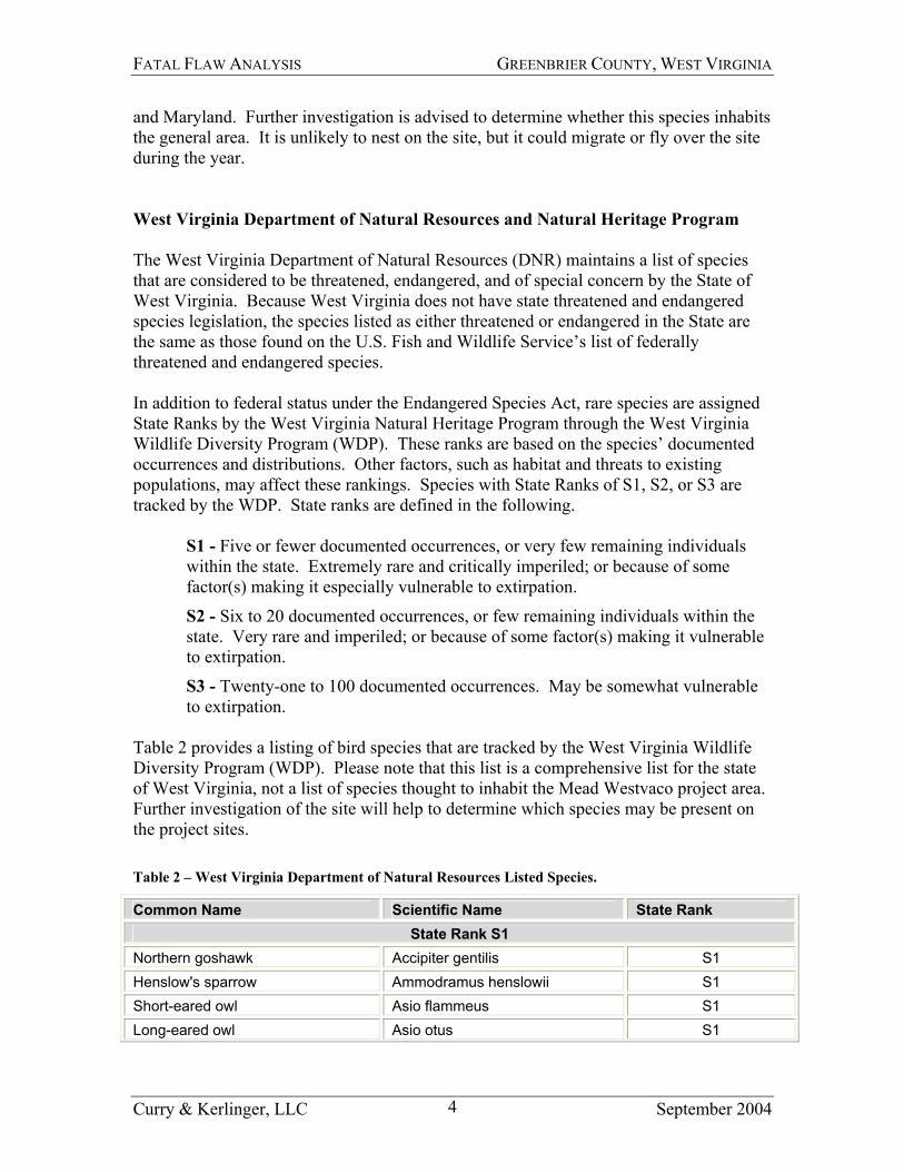
S1 - Five or fewer documented occurrences, or very few remaining individuals within the state. Extremely rare and critically imperiled; or because of some factor(s) making it especially vulnerable to extirpation.
S2 - Six to 20 documented occurrences, or few remaining individuals within the state. Very rare and imperiled; or because of some factor(s) making it vulnerable to extirpation.
S3 - Twenty-one to 100 documented occurrences. May be somewhat vulnerable to extirpation.
Table 2 provides a listing of bird species that are tracked by the West Virginia Wildlife Diversity Program (WDP). Please note that this list is a comprehensive list for the state of West Virginia, not a list of species thought to inhabit the Mead Westvaco project area. Further investigation of the site will help to determine which species may be present on the project sites. Table 2 – West Virginia Department of Natural Resources Listed Species.
Common Name Scientific Name State Rank State Rank S1
Northern goshawk Accipiter gentilis S1 Henslow's sparrow Ammodramus henslowii S1 Short-eared owl Asio flammeus S1 Long-eared owl Asio otus S1
Curry & Kerlinger, LLC September 2004 4

FATAL FLAW ANALYSIS GREENBRIER COUNTY, WEST VIRGINIA
Common Name Scientific Name State Rank American bittern Botaurus lentiginosus S1 Chuck-will's-widow Caprimulgus carolinensis S1 Pine siskin Carduelis pinus S1 Swainson's thrush Catharus ustulatus S1 Lark sparrow Chondestes grammacus S1 Northern harrier Circus cyaneus S1 Marsh wren Cistothorus palustris S1 Sedge wren Cistothorus platensis S1 Olive-sided flycatcher Contopus cooperi S1 Yellow-bellied flycatcher Empidonax flaviventris S1 Peregrine falcon Falco peregrinus S1 American coot Fulica americana S1 Wilson's snipe Gallinago delicata S1 Common moorhen Gallinula chloropus S1 Least bittern Ixobrychus exilis S1 Migrant loggerhead shrike Lanius ludovicianus migrans S1 Hooded merganser Lophodytes cucullatus S1 Sora Porzana carolina S1 King rail Rallus elegans S1 Virginia rail Rallus limicola S1 Yellow-bellied sapsucker Sphyrapicus varius S1 Appalachian Bewick's wren Thryomanes bewickii altus S1 Barn owl Tyto alba S1 Nashville warbler Vermivora ruficapilla S1
State Rank S2 Northern saw-whet owl Aegolius acadicus S2 American black duck Anas rubripes S2 Great blue heron Ardea herodias S2 Bobolink Dolichonyx oryzivorus S2 Horned lark Eremophila alpestris S2 Bald eagle Haliaeetus leucocephalus S2 Swainson's warbler Limnothlypis swainsonii S2 Red-headed woodpecker Melanerpes erythrocephalus S2 Osprey Pandion haliaetus S2 Pied-billed grebe Podilymbus podiceps S2 Prothonotary warbler Protonotaria citrea S2 Bank swallow Riparia riparia S2 Northern waterthrush Seiurus noveboracensis S2
Curry & Kerlinger, LLC September 2004 5

FATAL FLAW ANALYSIS GREENBRIER COUNTY, WEST VIRGINIA
Common Name Scientific Name State Rank Dickcissel Spiza americana S2 Golden-winged warbler Vermivora chrysoptera S2
State Rank S3 Cooper's hawk Accipiter cooperii S3 Sharp-shinned hawk Accipiter striatus S3 Spotted sandpiper Actitis macularia S3 Grasshopper sparrow Ammodramus savannarum S3 Whip-poor-will Caprimulgus vociferus S3 Brown creeper Certhia americana S3 Common nighthawk Chordeiles minor S3 Black-billed cuckoo Coccyzus erythropthalmus S3 Northern bobwhite Colinus virginianus S3 Black vulture Coragyps atratus S3 Yellow-rumped warbler Dendroica coronata S3 Blackburnian warbler Dendroica fusca S3 Alder flycatcher Empidonax alnorum S3 Cliff swallow Petrochelidon pyrrhonota S3 Vesper sparrow Pooecetes gramineus S3
Other Endangered or Threatened Animal Species Virginia Northern Flying Squirrel – a federally listed endangered species – and Eastern Woodrat – proposed for listing – are known to be in the area but unlikely to be on the site. These prey species if found on or around the site may attract raptors to the site. However, some preliminary studies conducted for a prior developer in the mid 1990s did not identify either of these species or supportive habitats present on this specific site. Indiana Bat, Virginia big-eared Bat, and Gray Bats are federally listed endangered species that are known to be present in some parts of West Virginia. Significant numbers of Indiana bats hibernate in certain West Virginia caves. This species is known to have hibernacula in Greenbrier and some other counties in West Virginia. Bats may occupy summer habitat throughout the entire state. More Virginia big-eared bats occur in West Virginia than in any other state. Caves are critical to the survival of this bat, and most of the significant caves are protected in some way. As a result, populations in the state are increasing. The known distribution of Virginia big eared bats is primarily northeastern counties, especially Pendleton, Tucker and Grant Counties. Critical habitat: Hellhole Cave, Cave Mountain Cave, Hoffman School Cave, and Sinnit/Thorn Mountain Cave in Pendleton Co.; Cave Hollow/Arbogast Cave in Tucker. None are known from Greenbrier County. Gray bats are extremely rare in the West Virginia, with only one record of two individuals known from Pendleton County, West Virginia. Its occurrence is considered
Curry & Kerlinger, LLC September 2004 6

FATAL FLAW ANALYSIS GREENBRIER COUNTY, WEST VIRGINIA
accidental. Of the three listed bats, only Indiana’s are likely to be found in Greenbrier County, the same county as the proposed project. The issue of bat interactions with wind turbines is facing increased scrutiny, although Indiana bats have not been reported to collide with wind turbines or other tall structures. Further investigation is recommended for Indiana bats to determine if the species occurs at or near the project area. If a hibernaculum of this species occurs within 5-10 miles of the site, the project may have difficulties with respect to permitting and development, and further research is certain to be requested by the agencies. Whether or not hibernacula for this species are near the project site is not known at this time. The State of West Virginia will have information about the whereabouts of hibernacula, although a formal request including a map of the site would be required by the state prior to providing such information. USGS Breeding Birds Surveys - West Virginia A search of the USGS North American Breeding Bird Survey (BBS) database was conducted to identify federal and state listed species in close proximity to the project area. Two BBS survey routes, closest to the project area, were examined (#90002 – Smoot, Greenbrier County, WV and #90029 – Richwood, Nicholas/Greenbrier Counties, WV). The Smoot survey route passes within 6 miles southwest of the project area, with Richwood within 6 miles to the northeast. For each of these routes, the most recent 10 years of surveys were reviewed. (Note: No data was available for 2002 for Smoot and data was not available for 1998 for Richwood) The results of the BBS data search identified no federally listed species and few state listed species, as presented in the following tables (Table 3and Table 4). There were some West Virginia rare species found on the Breeding Bird Surveys in the general area of the project site, so site specific habitat information is needed to determine if those species are present on site. Their presence is not likely to be a fatal flaw, but if large numbers are present, there could be closer scrutiny of the project by the state agencies. Table 3 – Breeding Bird Survey Route 90002 – Smoot, WV (within 6 miles SW of project area).
Species Status Quantity Year(s) Cooper’s Hawk S3 1
1 2003 1995
Sharp-shinned Hawk S3 1 2003 Grasshopper Sparrow S3 1 1998 Common Nighthawk S3 1 2000 Northern Bobwhite S3 1
3 2 1
2000 1999 1997 1995
Black Vulture S3 2 1999
Curry & Kerlinger, LLC September 2004 7
FATAL FLAW ANALYSIS GREENBRIER COUNTY, WEST VIRGINIA
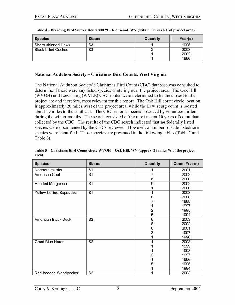
Table 4 – Breeding Bird Survey Route 90029 – Richwood, WV (within 6 miles NE of project area).
Species Status Quantity Year(s) Sharp-shinned Hawk S3 1 1995 Black-billed Cuckoo S3 2
1 1
2003 2002 1996
National Audubon Society – Christmas Bird Counts, West Virginia The National Audubon Society’s Christmas Bird Count (CBC) database was consulted to determine if there were any listed species wintering near the project area. The Oak Hill (WVOH) and Lewisburg (WVLE) CBC routes were determined to be the closest to the project are and therefore, most relevant for this report. The Oak Hill count circle location is approximately 26 miles west of the project area, while the Lewisburg count is located about 19 miles to the southeast. The CBC reports species observed by volunteer birders during the winter months. The search consisted of the most recent 10 years of count data collected by the CBC. The results of the CBC search indicated that no federally listed species were documented by the CBCs reviewed. However, a number of state listed/rare species were identified. Those species are presented in the following tables (Table 5 and Table 6). Table 5 – Christmas Bird Count circle WVOH – Oak Hill, WV (approx. 26 miles W of the project area).
Species Status Quantity Count Year(s) Northern Harrier S1 1 2001 American Coot S1 7
6 2002 2000
Hooded Merganser S1 9 1
2002 2000
Yellow-bellied Sapsucker S1 1 8 7 1 2 5
2003 2000 1999 1997 1995 1994
American Black Duck S2 6 8 6 3 1
2003 2002 2001 1997 1996
Great Blue Heron S2 1 1 1 2 1 5 1
2003 1999 1998 1997 1996 1995 1994
Red-headed Woodpecker S2 1 2003
Curry & Kerlinger, LLC September 2004 8

FATAL FLAW ANALYSIS GREENBRIER COUNTY, WEST VIRGINIA
Species Status Quantity Count Year(s) 1 1999
Pied-billed Grebe S2 8 7 6 5 2 3 2
2002 2000 1999 1997 1996 1995 1994
Cooper’s Hawk S3 1 1 2 1 2 2 4 2
2003 2002 2001 2000 1998 1997 1996 1994
Sharp-shinned Hawk S3 2 5 1 2 1 5 2 2 1
2003 2002 2001 2000 1999 1998 1997 1996 1994
Brown Creeper S3 4 2 5 5 10 3 4 1 2
2003 2001 2000 1999 1998 1997 1996 1995 1994
Black Vulture S3 11 2 3
2001 2000 1996
Yellow-rumped Warbler S3 3 13 3 10 3 34 31 34 6
2002 2001 2000 1999 1998 1997 1996 1995 1994
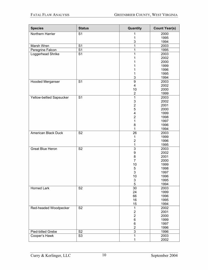
Table 6 – Christmas Bird Count circle WVLE – Lewisburg, WV (approx. 19 miles SE of the project area).
Species Status Quantity Count Year(s) Pine Siskin S1 3 1996
Curry & Kerlinger, LLC September 2004 9
FATAL FLAW ANALYSIS GREENBRIER COUNTY, WEST VIRGINIA
Species Status Quantity Count Year(s) Northern Harrier S1 1
1 3
2000 1995 1994
Marsh Wren S1 1 2003 Peregrine Falcon S1 1 1995 Loggerhead Shrike S1 1
1 1 1 1 1 3
2003 2002 2000 1999 1996 1995 1994
Hooded Merganser S1 9 4 10 2
2003 2002 2000 1999
Yellow-bellied Sapsucker S1 1 3 2 5 4 2 1 8 1
2003 2002 2001 2000 1999 1998 1997 1996 1994
American Black Duck S2 26 1 2 1
2003 1999 1996 1995
Great Blue Heron S2 3 9 8 7 10 5 3 10 3 5
2003 2002 2001 2000 1999 1998 1997 1996 1995 1994
Horned Lark S2 30 24 66 16 15
2003 1999 1996 1995 1994
Red-headed Woodpecker S2 1 2 2 6 6 2
2002 2001 2000 1999 1997 1996
Pied-billed Grebe S2 3 1996 Cooper’s Hawk S3 1
1 2003 2002
Curry & Kerlinger, LLC September 2004 10

FATAL FLAW ANALYSIS GREENBRIER COUNTY, WEST VIRGINIA
Species Status Quantity Count Year(s) 1 7 1 2 3 1
2001 2000 1999 1998 1996 1994
Sharp-shinned Hawk S3 3 2 2 1 3 4 3 1
2003 2001 2000 1999 1998 1996 1995 1994
Brown Creeper S3 5 5 4 5 6 1 10 3 6
2003 2002 2000 1999 1998 1997 1996 1995 1994
Northern Bobwhite S3 1 1994 Black Vulture S3 64
166 41
146 166 56 15
306 82
182
2003 2002 2001 2000 1999 1998 1997 1996 1995 1994
Yellow-rumped Warbler S3 16 4 43 5
2001 2000 1999 1998
Flyways – Migration Corridors There are few scientifically documented migration concentration sites in West Virginia. The project site does not appear to be situated on a major or well-used migration pathway for any of the major types of birds, including hawks, waterfowl, shorebirds, and other birds. These statements are based on the literature, as well as the topography, habitat, and geographic location of the Mead Westvaco project site and what is known about the migration behavior of birds. The habitat within the project boundary is not suggestive of important stopover sites or sites used by large concentrations of shorebirds, waterfowl, songbirds, or other types of avian migrants, although there is certainly some migration of many types of birds over the site, because migrants are known to distribute themselves
Curry & Kerlinger, LLC September 2004 11

FATAL FLAW ANALYSIS GREENBRIER COUNTY, WEST VIRGINIA
over wide geographic areas in topographic and habitat situations like those at the Mead Westvaco site. Recent Developments Regarding Wind Power Development in West Virginia The Fish and Wildlife Service is using the following statement to request extensive studies of proposed wind project sites in the Eastern United States. Size of the project does not appear to be a factor. “The potential for collision with resident or migratory species of birds and bats is affected by many factors but location of the wind turbines appears to be one of the most important. In order to determine what the potential collision hazard is for a particular site, the spatial and temporal uses of the airspace by birds, bats and insects need to be defined (insects are included because they are prey for birds and bats). These studies can best be accomplished by using remote sensing technology (radar, acoustic and infrared) to collect data in various spatial scales (ridge tops, side slopes and valley sections) and temporal scales (day and night, season to season, and year to year). Traditional sampling protocols (transect sampling, visual observation, mist netting, anabat detectors, etc.) should be used to supplement the remote sensing work and would likely be necessary to ground truth the data for individual species. We recommend a multi-season period of data collection for the Mead Westvaco Wind Project using remote sensing and traditional on-the-ground study protocols to define the temporal and spatial uses of the airspace by birds, bats and insects. In particular, the preconstruction studies should consist of, but not necessarily be limited to, the following: a raptor migration study to determine flight characteristics for this avian group; a study of nocturnal migrants using radar and acoustic recorders to determine spatial and temporal use by birds, bats, and insects; and ground truthing studies such as a migration stopover study for birds using mist nests and observation techniques and a study of bats using mist nets, anabat detectors, radio microphones, or other appropriate technology such as thermal imaging cameras. A multi-season time frame should provide an adequate sampling period to gather data on the year-to-year and seasonal variability of bird, bat insect, and other wildlife activity at the proposed site. This would provide a reasonable opportunity to determine the response of these species groups to the broad array of weather-related phenomena that could be expected and to determine the predator-prey interactions that occur in the airspace above the project area between birds/bats and their insect prey. Special emphasis would be placed on spring and fall migration periods and the breeding brood rearing and juvenile development periods. We would expect the data from this effort to be adequate for macro scale siting analysis to determine site acceptability. The Service further advises that, “In the absence of adequate preconstruction data on spatial and temporal uses by avian species, you proceed with the project at your own risk.
Curry & Kerlinger, LLC September 2004 12

FATAL FLAW ANALYSIS GREENBRIER COUNTY, WEST VIRGINIA
Any subsequent take of federally-protected species may be evaluated in light of this administrative record.” Taken from 7-7-04 Letter, over the signature of Michael J. Bartlett, Supervisor, New England Field Office. Conclusions and Recommendations Fatal Flaw conclusions and recommendations are based on the results of a desktop study of literature and other databases, including maps. We review the information in the context of our experience in assessing a broad range of sites upon which wind farms have been developed, including 5 years of experience in West Virginia and 10 years of experience in the northeastern United States. A fatal flaw is often obvious to the eye of an expert on avian/bat interactions with wind turbines without having to visit the site. However, in this instance we did have a trained biologist conduct a reconnaissance at this site. We have not found any records documenting the listing of a federally threatened or endangered species located or suspected to be located on the project site. Such a finding would not automatically preclude development of a site at least on a biologically defensible basis. A fatal flaw in this instance would mean the established presence of a T&E species on the proposed site and specifically, risk to that species from wind power development. In addition, it would have to be obvious that there is little or no likelihood of developing a plan for development that would be acceptable by the state or federal agency with jurisdiction over the issue. It is our considered opinion that the Mead Westvaco site is not encumbered with one or more fatal flaws. For example, the likelihood that there would be endangered or threatened species at or immediately adjacent to the project site is relatively low and risk to such species is, similarly, unlikely. The available literature regarding the habitat and geographic location of the proposed project do not suggest the evidence of major bird migration and/or potential stopover sites within the project boundary. The Virginia Northern Flying Squirrel – a federally listed endangered species – and Eastern Woodrat – proposed for listing – are known to be in the area but unlikely to be on the site. However, some preliminary studies conducted for a prior developer in the mid 1990s did not identify either of these species or supportive habitats present on this specific site. As stated earlier, in this part of the country there is a concerted effort being made by the U.S. Fish and Wildlife Service to secure multiple year studies of avian and bat spatial and temporal use of proposed sites as well as night migration over every project site, regardless of the size of the installation. On non-federal lands (or when no federal permits, such as for wetland impacts), the Service must defer to the state permitting authorities to make this a requirement. With small projects such as one in Vermont consisting of four turbines (for which the Service and the state agency requested
Curry & Kerlinger, LLC September 2004 13

FATAL FLAW ANALYSIS GREENBRIER COUNTY, WEST VIRGINIA
Curry & Kerlinger, LLC September 2004 14
$800,000 of studies), this would constitute a fatal flaw in the absence of relief due to the cost to conduct these studies. A Phase I Risk Assessment, or a variation thereof, may be necessary to establish a site specific scientific basis for reducing the request for additional studies. In any event, additional on site data collection and agency consultation will likely be required by the West Virginia Department of Natural Resources to proceed with the permitting of this project. The U. S. Fish and Wildlife Service will also likely request further study, although they are unlikely to have a legal nexus for their request.


![Paul Kerlinger Joelle Gehring Richard Curry - sfbayjv.org et al, January 2011 Birding[1].pdf · Paul Kerlinger Cape May Point, New Jersey pkerlinger@comcast.net Joelle Gehring Lansing,](https://static.fdocuments.in/doc/165x107/5c164e4609d3f269238c868f/paul-kerlinger-joelle-gehring-richard-curry-et-al-january-2011-birding1pdf.jpg)


