AUTOMATIC RECOGNITION OF INDOOR …AUTOMATIC RECOGNITION OF INDOOR NAVIGATION ELEMENTS FROM KINECT...
7
AUTOMATIC RECOGNITION OF INDOOR NAVIGATION ELEMENTS FROM KINECT POINT CLOUDS Liping Zeng a , Zhizhong Kang b a School of Land Science and Technology, China University of Geoscience (Beijing), Beijing China, [email protected] b School of Land Science and Technology, China University of Geoscience (Beijing), Beijing China, [email protected] Commission IV, WG IV/5 KEY WORDS: Indoor Navigation, Navigation Elements, Auto-recognition, Kinect, IndoorGML ABSTRACT: This paper realizes automatically the navigating elements defined by indoorGML data standard——door, stairway and wall. The data used is indoor 3D point cloud collected by Kinect v2 launched in 2011 through the means of ORB-SLAM. By contrast, it is cheaper and more convenient than lidar, but the point clouds also have the problem of noise, registration error and large data volume. Hence, we adopt a shape descriptor——histogram of distances between two randomly chosen points, proposed by Osada and merges with other descriptor – in conjunction with random forest classifier to recognize the navigation elements (door, stairway and wall) from Kinect point clouds. This research acquires navigation elements and their 3-d location information from each single data frame through segmentation of point clouds, boundary extraction, feature calculation and classification. Finally, this paper utilizes the acquired navigation elements and their information to generate the state data of the indoor navigation module automatically. The experimental results demonstrate a high recognition accuracy of the proposed method. 1. INTRODUCTION In the past ten years, personal navigation systems have become an indispensable tool in human life, including vehicle-mounted navigation system and the location-based services of mobile phone terminals. The fast development of outdoor navigation provides a more suitable and convenient life for people. According to statistics, people spend averagely 87% of their time engaging in indoor activities, and per most aspects of our socio- economic life, the requirements for safety and/or emergency response management of complex indoor space and underground space including shopping mall, hospital, airport, mine etc. is becoming increasingly urgent. Indoor navigation includes two basic components——location and navigation. Indoor navigation data is the platform on which the practice of indoor navigation is based. There are many composing elements of indoor data and they are complex. The manual preparation of the entire work is a waste of time and energy, and one mistake will cause heavy workload for modification at later period. Because there is some correlation among each element, a slight move in one part may affect the end result as a whole. So, it seems much better to extract indoor elements automatically. There are many means of collecting indoor 3D point cloud data. 3D information can be acquired through 2D images (HARTLEY RI,1992). Whiles mobile 3D laser scanner acquires 3D point cloud and color images (Enrique Valero, Antonio Adan, Carlos Cerrada,2012). M3 Trolley (produced by a German company) acquires indoor panorama images and 3D point cloud, Kinect, (Izadi S, Newcombe R A, Kim D, et al.2011) which is the latest in recent years can acquire 3D point cloud with color information, color images and depth images simultaneously. The 3D information acquired by 2D images is of low precision and complex calculation. 3D laser scanner can acquire high-precision Corresponding author and high-density point cloud. But there are problems of expensive cost, and matching between point cloud and images. By contrast, Kinect is portable as well as cheap, and it can acquire color point cloud data in real time. In recent years, the understanding of indoor 3D scene and the recognition of objects have always been a hot research field. Many scholars proposed some methods for the features used in recognizing and extracting objects. Some universities provided a set of marked indoor scene datasets (COIL , Columbia University; Make3d, Stanford University, NYU) to more scholars conducting research. Saurabh Gupta et al proposed algorithms for object boundary detection and hierarchical segmentation in RGB-D images. Walter Wohlkinger and Markus Vincze utilized shape descriptors to conduct research of pattern recognition for small objects of bananas, cups etc. This paper uses merging features and random forest classifier to study the pattern recognition of indoor elements——door, stairway and wall, and then improves the reliability of the recognition results by combining it with prior knowledge. As people’s subjective cognizance, doors and walls are perpendicular to the ground, and the side elevation of staircases are perpendicular to the ground too, which are also parallel and the same size. Our method is to take color point cloud adopted by Kinect as input data. That is because the quality of the color point cloud adopted by Kinect is relatively worse, with low precision and high noise. So, it needs a de-noise process before it is used. Plane segmentation is then conducted for the processed point cloud, each segmentation is taken as an object which needs to be recognized. After that, this paper utilizes random forest to classify all the objects to acquire the semantic and 3D information (location and size) of each object. Finally, the state information of indoor navigation model is acquired. In consideration of the precision of point cloud data and the The International Archives of the Photogrammetry, Remote Sensing and Spatial Information Sciences, Volume XLII-2/W7, 2017 ISPRS Geospatial Week 2017, 18–22 September 2017, Wuhan, China This contribution has been peer-reviewed. https://doi.org/10.5194/isprs-archives-XLII-2-W7-431-2017 | © Authors 2017. CC BY 4.0 License. 431
Transcript of AUTOMATIC RECOGNITION OF INDOOR …AUTOMATIC RECOGNITION OF INDOOR NAVIGATION ELEMENTS FROM KINECT...
AUTOMATIC RECOGNITION OF INDOOR NAVIGATION ELEMENTS FROM KINECT
POINT CLOUDS
Liping Zeng a, Zhizhong Kang b
a School of Land Science and Technology, China University of Geoscience (Beijing), Beijing China, [email protected] b School of Land Science and Technology, China University of Geoscience (Beijing), Beijing China, [email protected]
Commission IV, WG IV/5
KEY WORDS: Indoor Navigation, Navigation Elements, Auto-recognition, Kinect, IndoorGML
ABSTRACT:
This paper realizes automatically the navigating elements defined by indoorGML data standard——door, stairway and wall. The data
used is indoor 3D point cloud collected by Kinect v2 launched in 2011 through the means of ORB-SLAM. By contrast, it is cheaper
and more convenient than lidar, but the point clouds also have the problem of noise, registration error and large data volume. Hence,
we adopt a shape descriptor——histogram of distances between two randomly chosen points, proposed by Osada and merges with
other descriptor – in conjunction with random forest classifier to recognize the navigation elements (door, stairway and wall) from
Kinect point clouds. This research acquires navigation elements and their 3-d location information from each single data frame through
segmentation of point clouds, boundary extraction, feature calculation and classification. Finally, this paper utilizes the acquired
navigation elements and their information to generate the state data of the indoor navigation module automatically. The experimental
results demonstrate a high recognition accuracy of the proposed method.
1. INTRODUCTION
In the past ten years, personal navigation systems have become
an indispensable tool in human life, including vehicle-mounted
navigation system and the location-based services of mobile
phone terminals. The fast development of outdoor navigation
provides a more suitable and convenient life for people.
According to statistics, people spend averagely 87% of their time
engaging in indoor activities, and per most aspects of our socio-
economic life, the requirements for safety and/or emergency
response management of complex indoor space and underground
space including shopping mall, hospital, airport, mine etc. is
becoming increasingly urgent. Indoor navigation includes two
basic components——location and navigation.
Indoor navigation data is the platform on which the practice of
indoor navigation is based. There are many composing elements
of indoor data and they are complex. The manual preparation of
the entire work is a waste of time and energy, and one mistake
will cause heavy workload for modification at later period.
Because there is some correlation among each element, a slight
move in one part may affect the end result as a whole. So, it
seems much better to extract indoor elements automatically.
There are many means of collecting indoor 3D point cloud data.
3D information can be acquired through 2D images(HARTLEY
RI,1992). Whiles mobile 3D laser scanner acquires 3D point
cloud and color images (Enrique Valero, Antonio Adan, Carlos
Cerrada,2012). M3 Trolley (produced by a German company)
acquires indoor panorama images and 3D point cloud, Kinect,
(Izadi S, Newcombe R A, Kim D, et al.2011)which is the latest
in recent years can acquire 3D point cloud with color information,
color images and depth images simultaneously. The 3D
information acquired by 2D images is of low precision and
complex calculation. 3D laser scanner can acquire high-precision
Corresponding author
and high-density point cloud. But there are problems of
expensive cost, and matching between point cloud and images.
By contrast, Kinect is portable as well as cheap, and it can
acquire color point cloud data in real time.
In recent years, the understanding of indoor 3D scene and the
recognition of objects have always been a hot research field.
Many scholars proposed some methods for the features used in
recognizing and extracting objects. Some universities provided a
set of marked indoor scene datasets (COIL , Columbia
University; Make3d, Stanford University, NYU) to more
scholars conducting research. Saurabh Gupta et al proposed
algorithms for object boundary detection and hierarchical
segmentation in RGB-D images. Walter Wohlkinger and Markus
Vincze utilized shape descriptors to conduct research of pattern
recognition for small objects of bananas, cups etc.
This paper uses merging features and random forest classifier to
study the pattern recognition of indoor elements——door,
stairway and wall, and then improves the reliability of the
recognition results by combining it with prior knowledge. As
people’s subjective cognizance, doors and walls are
perpendicular to the ground, and the side elevation of staircases
are perpendicular to the ground too, which are also parallel and
the same size. Our method is to take color point cloud adopted
by Kinect as input data. That is because the quality of the color
point cloud adopted by Kinect is relatively worse, with low
precision and high noise. So, it needs a de-noise process before
it is used. Plane segmentation is then conducted for the processed
point cloud, each segmentation is taken as an object which needs
to be recognized. After that, this paper utilizes random forest to
classify all the objects to acquire the semantic and 3D
information (location and size) of each object. Finally, the state
information of indoor navigation model is acquired. In
consideration of the precision of point cloud data and the
The International Archives of the Photogrammetry, Remote Sensing and Spatial Information Sciences, Volume XLII-2/W7, 2017 ISPRS Geospatial Week 2017, 18–22 September 2017, Wuhan, China
This contribution has been peer-reviewed. https://doi.org/10.5194/isprs-archives-XLII-2-W7-431-2017 | © Authors 2017. CC BY 4.0 License.
431
registering accuracy having influences on the result, this paper
only conducts the recognition research on single frame data,
however, it means the objects are not complete.
1.1 Previous Work
The recognition of 3D objects based on point cloud is an
important research orientation in current days. Some scholars
proposed some ways of extracting 3D point cloud structure
elements (door, wall, roof etc.) of outdoor structures acquired by
3D laser scanner, to realize the automatic 3D reconstruction of
city buildings (Shi Pu; Zhuqiang Li et al.). Some other scholars
paid attention to the recognition research of indoor small objects
such as cups, mouses or furniture etc. (Saurabh Gupta,Walter
Wohlkinger and Markus Vincze et al.)However, different from
outdoor architectures, indoor scene is more complex with
narrower field angle, which makes the research of recognition of
indoor objects’ content based on point cloud richer. We will
introduce two recognition methods of outdoor objects in a simple
way below.
Shi Pu et al. in 2009 proposed an auto 3D modelling approach
for city buildings based on prior knowledge, in which the point
cloud acquired by a 3D laser scanner was used. At first, the
scholars conducted plane segmentation for point cloud data to
acquire each segmentation as plane objects. Then, they utilized
all kinds of semantic relation to classify and recognize. For
example, wall is a large area and intersects with the ground.
Finally, the semantic object acquired by recognition was used to
rebuild geometric model of structures. This method is applicable
to outdoor large-scale and simple-structured buildings, and the a
priori semantic adopted in this method is not completely suitable
for the recognition of indoor doors and walls.
Walter Wohlkinger and Markus Vincze utilized Kinect to collect
the 3D point cloud of small objects (bananas, car models, cups
etc.) in different angles as experimental data. They proposed an
Ensemble of Shape Functions to classify 3D objects. This
method applied ESF descriptor to describe the attribute of a
group of 3D point cloud, after that weight learning was used to
improve the classification accuracy. The descriptive power will
be weakened when this method is used in the situation of
increasing categories of classification or the objects with only a
part of angles to be described.
1.2 Presented Approach
IndoorGML is an indoor spatial data standard published by
International open geospatial consortium. Different from several
3D building modelling standards such as CityGML, KML, and
IFC, which deals with interior space of buildings from geometric,
cartographic, and semantic viewpoints. IndoorGML aims at
modelling indoor spaces for navigation purposes. It contains two
modules: indoor core module to describe topological
connectivity and different contexts of indoor space, and indoor
navigation module for indoor location-based services.
IndoorGML is a topological expression of the indoor
environment, because of its lack of indoor location information
definition and detailed description makes its data structure
relatively simple, but it covers geometric and semantic properties
relevant for indoor navigation in an indoor space to support
location based services for indoor navigation.
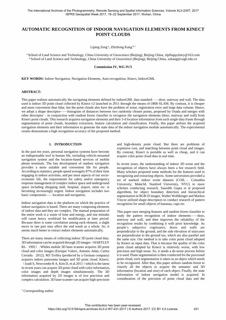
The navigation module regulated by IndoorGML includes the
state information of indoor navigation elements and the topology
connected (transition) among them. State information includes
the elements’ information of location, semantic, centroid
position etc. IndoorGML focus on setting up a common schema
for the application of indoor navigation. It models topology and
semantics of indoor spaces, which are needed for the components
of navigation networks. And it divides indoor environment into
several space layers, such as WIFI sensor space layer, RFID
sensor space layer and topological space layer. The elements of
different space layers is described by ‘states’ with relevant
geometric and semantic properties. The edge connecting both
nodes represents the event of this ‘state’ transition which
represent the topological relationships in IndoorGML such as
adjacency and connectivity between each of the ‘states’. (Figure
1)The aim of our method is to recognize doors, stairways and
walls from the single frame collected by Kinect, and acquire their
3D location and size to realize automatic generation of the partial
indoor navigation documents (states).
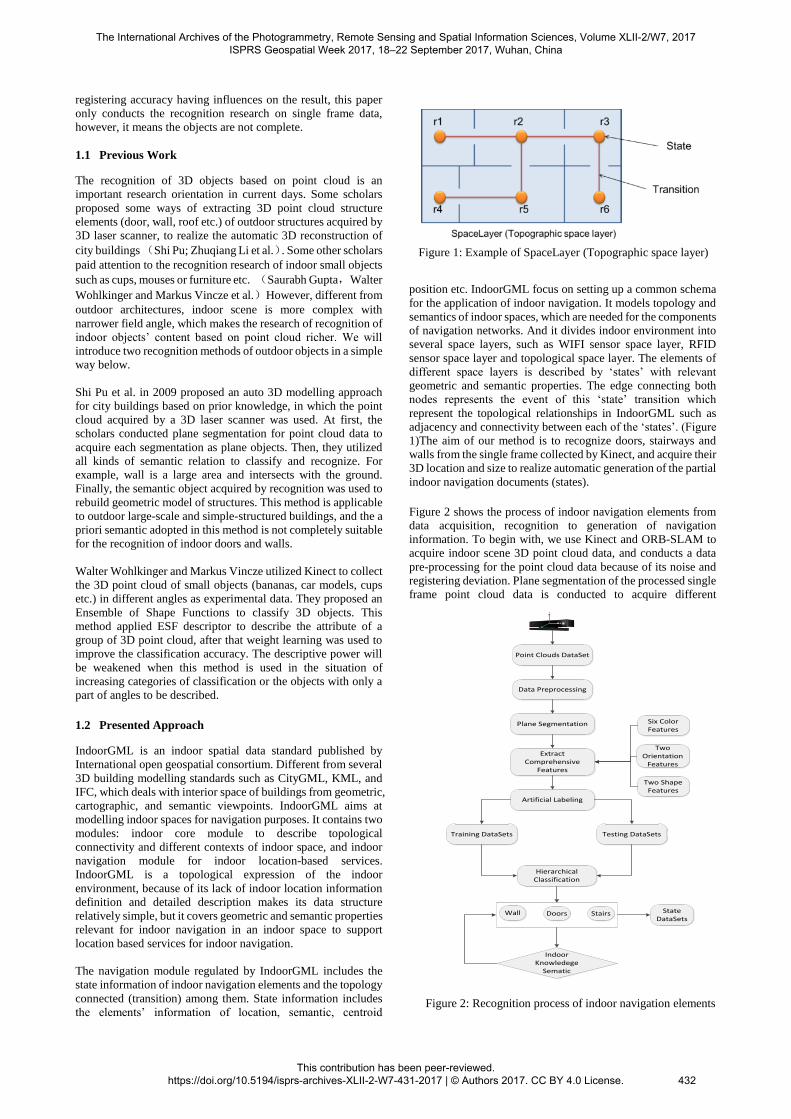
Figure 2 shows the process of indoor navigation elements from
data acquisition, recognition to generation of navigation
information. To begin with, we use Kinect and ORB-SLAM to
acquire indoor scene 3D point cloud data, and conducts a data
pre-processing for the point cloud data because of its noise and
registering deviation. Plane segmentation of the processed single
frame point cloud data is conducted to acquire different
Figure 1: Example of SpaceLayer (Topographic space layer)
Point Clouds DataSet
Data Preprocessing
Plane Segmentation
Extract Comprehensive
Features
Artificial Labeling
Training DataSets Testing DataSets
Hierarchical Classification
Wall Doors Stairs
Indoor Knowledege
Sematic
State DataSets
Six Color Features
Two Orientation
Features
Two Shape Features
Figure 2: Recognition process of indoor navigation elements
The International Archives of the Photogrammetry, Remote Sensing and Spatial Information Sciences, Volume XLII-2/W7, 2017 ISPRS Geospatial Week 2017, 18–22 September 2017, Wuhan, China
This contribution has been peer-reviewed. https://doi.org/10.5194/isprs-archives-XLII-2-W7-431-2017 | © Authors 2017. CC BY 4.0 License.
432
segmental objects. We then calculate the feature vectors of
different segmental objects and make use of random forest to
conduct the classification and recognition of objects. Finally, the
information of navigation elements is acquired.
2. DATA PREPARATION
2.1 Data Acquisition
Kinect v2 is a kind of RGB-D sensor launched by Microsoft in
2010. In the beginning, it was only connected with Xbox to apply
to motion sensing game. Then Microsoft publicized its powerful
SDK, and then more researchers were attracted to apply it to
more interesting practice such as body recognition, indoor 3D
reconstruction etc. There are three data flows namely; RGB color
data flow, depth data flow, and audio data flow which combining
with API provided by SDK can generate color point cloud data.
ORB-SLAM is an algorithm of 3D location and map building
based on ORB feature. The data acquisition system we used is
based on open-source ORB-SALM frame system. First of all, the
method of ORB feature extraction tracks sequence images, and
realize the coarse registration of Kinect data. Then, the use of
multi-features extend information filter to correct the deviation
of registration. The correction can be a good solution to normal
drift with the process of sharp turn in occlusion and messy
environment, and the problem of reduced registration accuracy
due to mismatched ORB features.
2.2 Data Preprocessing
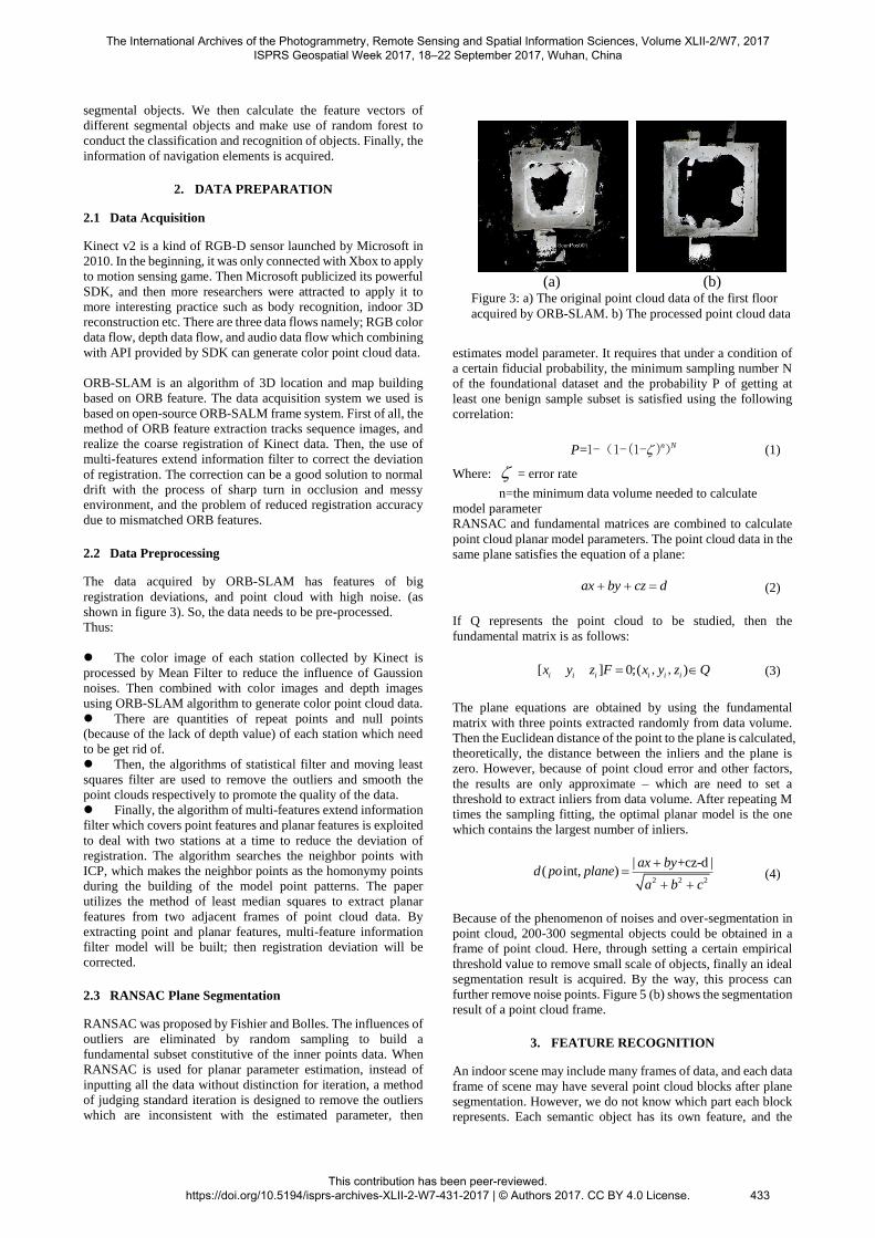
The data acquired by ORB-SLAM has features of big
registration deviations, and point cloud with high noise. (as
shown in figure 3). So, the data needs to be pre-processed.
Thus:
The color image of each station collected by Kinect is
processed by Mean Filter to reduce the influence of Gaussion
noises. Then combined with color images and depth images
using ORB-SLAM algorithm to generate color point cloud data.
There are quantities of repeat points and null points
(because of the lack of depth value) of each station which need
to be get rid of.
Then, the algorithms of statistical filter and moving least
squares filter are used to remove the outliers and smooth the
point clouds respectively to promote the quality of the data.
Finally, the algorithm of multi-features extend information
filter which covers point features and planar features is exploited
to deal with two stations at a time to reduce the deviation of
registration. The algorithm searches the neighbor points with
ICP, which makes the neighbor points as the homonymy points
during the building of the model point patterns. The paper
utilizes the method of least median squares to extract planar
features from two adjacent frames of point cloud data. By
extracting point and planar features, multi-feature information
filter model will be built; then registration deviation will be
corrected.
2.3 RANSAC Plane Segmentation
RANSAC was proposed by Fishier and Bolles. The influences of
outliers are eliminated by random sampling to build a
fundamental subset constitutive of the inner points data. When
RANSAC is used for planar parameter estimation, instead of
inputting all the data without distinction for iteration, a method
of judging standard iteration is designed to remove the outliers
which are inconsistent with the estimated parameter, then
estimates model parameter. It requires that under a condition of
a certain fiducial probability, the minimum sampling number N
of the foundational dataset and the probability P of getting at
least one benign sample subset is satisfied using the following
correlation:
= n NP 1-(1-(1- )) (1)
Where: = error rate
n=the minimum data volume needed to calculate
model parameter
RANSAC and fundamental matrices are combined to calculate
point cloud planar model parameters. The point cloud data in the
same plane satisfies the equation of a plane:
ax by cz d (2)
If Q represents the point cloud to be studied, then the
fundamental matrix is as follows:
[ ] 0;( )i i i i i ix y z F x y z Q , , (3)
The plane equations are obtained by using the fundamental
matrix with three points extracted randomly from data volume.
Then the Euclidean distance of the point to the plane is calculated, theoretically, the distance between the inliers and the plane is
zero. However, because of point cloud error and other factors,
the results are only approximate – which are need to set a
threshold to extract inliers from data volume. After repeating M
times the sampling fitting, the optimal planar model is the one
which contains the largest number of inliers.
2 2 2
| +cz-d |( int, )
ax byd po plane
a b c
(4)
Because of the phenomenon of noises and over-segmentation in
point cloud, 200-300 segmental objects could be obtained in a
frame of point cloud. Here, through setting a certain empirical
threshold value to remove small scale of objects, finally an ideal
segmentation result is acquired. By the way, this process can
further remove noise points. Figure 5 (b) shows the segmentation
result of a point cloud frame.
3. FEATURE RECOGNITION
An indoor scene may include many frames of data, and each data
frame of scene may have several point cloud blocks after plane
segmentation. However, we do not know which part each block
represents. Each semantic object has its own feature, and the
(a) (b)
Figure 3: a) The original point cloud data of the first floor
acquired by ORB-SLAM. b) The processed point cloud data
The International Archives of the Photogrammetry, Remote Sensing and Spatial Information Sciences, Volume XLII-2/W7, 2017 ISPRS Geospatial Week 2017, 18–22 September 2017, Wuhan, China
This contribution has been peer-reviewed. https://doi.org/10.5194/isprs-archives-XLII-2-W7-431-2017 | © Authors 2017. CC BY 4.0 License.
433
semantic features in the scene can be extracted through
calculating the feature of each segmental object and then
processing it further with machine learning. In consideration of
the objects, similar shape may disturb the extracting result of
registration elements. Finally we use prior knowledge to evaluate
the recognition result to increase reliability.
3.1 Characteristic Vector Calculation
Usually, the shape, texture and functions are the three most
important parts which are used to judge what an object is. So,
this paper calculates ten features totally 95-d feature vectors,
including six color features, two orientation features and two
shape features. The following are a detailed introduction to these
ten features:
Six color features: Different from the color diversity
outdoor, usually the color indoor is more balance and single. For
example, the colors of all the walls, doors and floors of a building
may belong to a color system respectively and they are balance.
So, we calculate the mean value and variance of H, S and V of
each segmentation block, after that, the objects with mussy
colors will be filtered out. For example: advertising boards on
the walls which is no doubt a disturbance term for doors objects
recognition.
At first, the RGB of each point is converted to HSV:
min min( , , );max max( , , )i i i i i iR G B R G B (5)
0 , max min
60 0 , maxmax min
60 360 , maxmax min
60 120 , i maxmax min
60 240 , i maxmax min
o
o oi ii i i
o oi ii i i
i
o oi ii
o oi ii
if
G Bif R and G B
G Bif R and G B
H
B Rf G
R Gf B
(6)
0, max 0
max min min1 ,
2 (max min) max
i
if
Sotherwise
(7)
maxiV (8)
Then, the mean value and variance of H, S, and V of each
segmentation object are calculated:
21 1
; ( )j c c c jc c
n n
i j i
i i
u P P un n
(9)
Where: jc
u = the mean value of H, S and V of j segmentation
objects
iP = the point cloud of different blocks after
segmentation
n = the number of each segmental object’s points
Planar normal: All the doors on the same wall are with no
doubt parallel to each other as well as perpendicular to the ceiling.
The elevations of each staircase are parallel to each other.
The intersection angle of plane and axis y:The axis y of
Kinect instrument is perpendicular to the ground. So, the
elevations of walls, doors, and staircases is parallel to axis y; the
ceiling and ground is perpendicular to axis y. All the
disturbances of the segmental objects which are parallel to the
ground can be removed through this feature.
Height : According to literature on indoor scene, the
height of a wall is no less than 2.5m, the height of a door is no
less than 1.8m, the elevation of a staircase is no more than 0.2m.
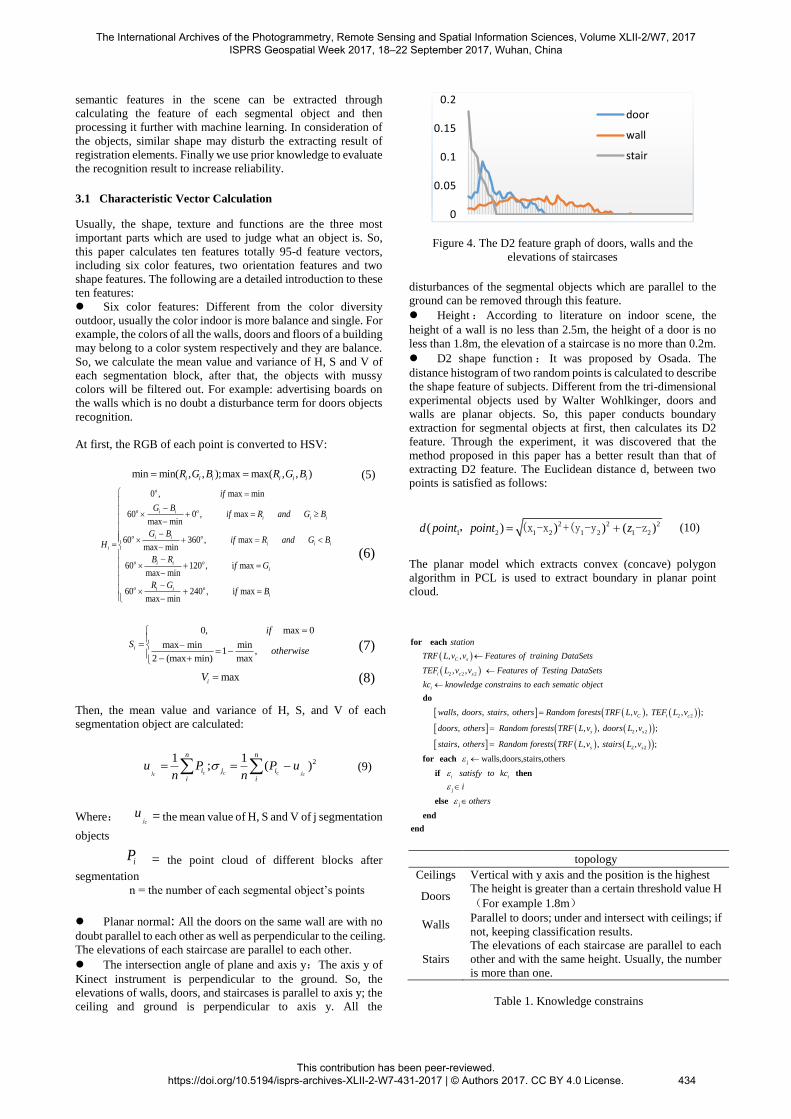
D2 shape function : It was proposed by Osada. The
distance histogram of two random points is calculated to describe
the shape feature of subjects. Different from the tri-dimensional
experimental objects used by Walter Wohlkinger, doors and
walls are planar objects. So, this paper conducts boundary
extraction for segmental objects at first, then calculates its D2
feature. Through the experiment, it was discovered that the
method proposed in this paper has a better result than that of
extracting D2 feature. The Euclidean distance d, between two
points is satisfied as follows:
2 2 2
1 2 1 2 1 2 1 2( ) ) ) ( )d point point z , (x -x +(y -y -z (10)
The planar model which extracts convex (concave) polygon
algorithm in PCL is used to extract boundary in planar point
cloud.
2 2 2
, ,
, ,
, , , , ,
C s
i c s
i
C
station
TRF L v v Features of training DataSets
TEF L v v Features of Testing DataSets
kc knowledge constrains to each sematic object
walls doors stairs others Random forests TRF L v
for each
do
j
2 2
j
2
j
2
2 2
walls,doo
, ;
rs,stairs,o
, , ,
thers
, ;
, , , , ;
i c
s s
s s
i i
TEF L v
doors others Random forests TRF L v doors L v
stairs others Random forests TRF L v stairs L v
sat
i
o
is
the
fy t
rs
o kc
for each
if then
else
end
end
topology
Ceilings Vertical with y axis and the position is the highest
Doors The height is greater than a certain threshold value H
(For example 1.8m)
Walls Parallel to doors; under and intersect with ceilings; if
not, keeping classification results.
Stairs
The elevations of each staircase are parallel to each
other and with the same height. Usually, the number
is more than one.
Table 1. Knowledge constrains
Figure 4. The D2 feature graph of doors, walls and the
elevations of staircases
0
0.05
0.1
0.15
0.2
door
wall
stair
The International Archives of the Photogrammetry, Remote Sensing and Spatial Information Sciences, Volume XLII-2/W7, 2017 ISPRS Geospatial Week 2017, 18–22 September 2017, Wuhan, China
This contribution has been peer-reviewed. https://doi.org/10.5194/isprs-archives-XLII-2-W7-431-2017 | © Authors 2017. CC BY 4.0 License.
434
3.2 Machine Learning
This paper chooses random forest classifier which is an original
classifier. In the comprehensive features, the size of D2 feature
vector is 83, and the size of the remaining features is 11. Each
element of feature vector in the classifier is equally-weighted,
which makes feature vector become the dominant factor in the
process of classification, thereby ignoring the other 11-d features
and decreasing the classification accuracy. So, this paper adopts
hierarchical classification, and at first classifies features through
11-d features. Then shape feature classification is conducted
based on the first level classification result. Finally, a-priori
semantic is used to improve the reliability of the classification
result. Table 1 is knowledge constrains. The recognition
accuracy in experimental result is improved. The following is the
pseudocode of classification.
3.3 Results
The experimental subject is an indoor scene in a teaching
building and totally acquires over one thousand frames of point
cloud. In consideration of the great degree of overlap of point
cloud acquired by ORB-SLAM, key frames of point cloud data
to be recognized in practice were choosen, thus, over two
hundreds frames of point cloud, and about 2000 segmental
objects. The experiment classifies indoor scenes into 4
categories : walls, doors, staircases and others (including floors,
ceilings, cumulate barriers, advertising boards etc.) Figure 6 and
Table 2 are the experimental results of this paper. Table 3
outlines the results of recognition by using ESF descriptor
proposed by Walter Wohlkinger and Markus Vincze. By contrast,
the method put forward by this paper have a better result than the
algorithm of ESF to recognize the navigable elements from
indoor scene. The reason may be that the ESF requires that the
objects have multi-angle point clouds and the point clouds
density be uniform. However, the data volume acquired by
Kinect are with noises, uneven density and lack diversity of
perspective making the classification results of ESF lower. This
paper extracts the boundary of each object and the semantic
information of the interior elements which could overcome these
problems to improve accuracy.
4. CONCLUSION
This paper extracts indoor navigation elements, walls and
staircases automatically by using machine learning through the
calculation of comprehensive features of point cloud. The node
data (including the semantic, location and size of objects) in the
IndoorGML navigation data files is calculated using the final
extraction results. The method adopted in this paper can acquire
the information of navigation elements, reduce manual
intervention, and save labor force —which has research
significance. As for another significant element in IndoorGML
navigation document—transition — which connects different
nodes will be the next research content.
ACKNOWLEDGMENTS
This research was supported by the National Natural Science
Foundation of China (grant number 41471360) and the
Fundamental Research Funds for the Central Universities (grant
number 2652015176).
REFERENCES
Hartley R.I. J., 1992. Estimation of relative camera positions for
uncalibrated cameras. In: Sandini G. (eds) Computer Vision —
ECCV'92. ECCV 1992. Lecture Notes in Computer Science.
Springer, Berlin, Heidelberg, vol 588.pp. 579-587.
Enrique Valero, Antonio Adan, Carlos Cerrada. J.,2012. Automatic Method for Building Indoor Boundary Models from
Dense Point Clouds Collected by Laser Scanners. Sensors. pp.
16099-16114.
Na Li, Yiwei Ma , Yang Yang. J., 2011.Segmentation of building
facade point clouds using RANSAC. Science of Surveying and
Mapping. Vol 36,No.5, pp.144-146.
Raul Mur-Arta , Juan A. Al-Nuaimi,,M. Piccolrovazzi, S.
Gedikli2, E. Steinbach, J.,2015. Indoor Location Retrieval using
Shape Matching of Kinect Fusion Scans to Large-Scale Indoor
Point Clouds. Eurographics Workshop on 3D Object Retrieval
(2015).
Shahram Izadi, Richard A. Newcombe, David Kim, Andrew
Fitzgibbon. J, Kinect Fusion: Real-time dynamic 3D surface
reconstruction and interaction. International Conference on
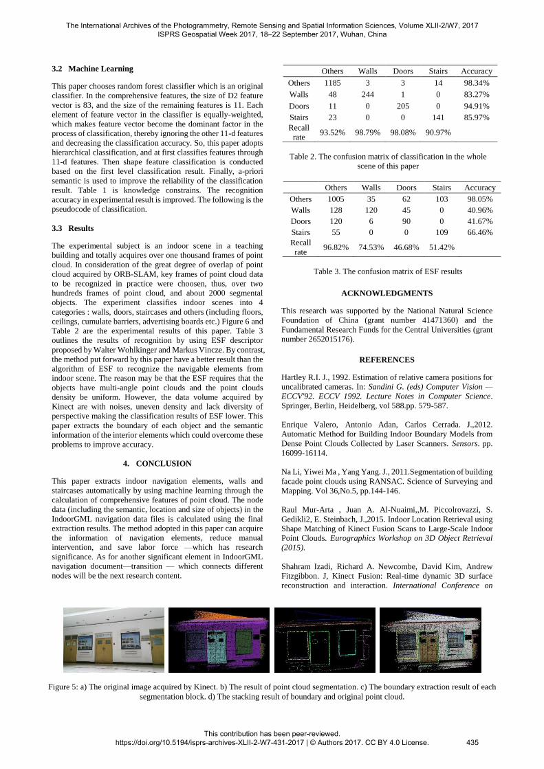
Figure 5: a) The original image acquired by Kinect. b) The result of point cloud segmentation. c) The boundary extraction result of each
segmentation block. d) The stacking result of boundary and original point cloud.
Others Walls Doors Stairs Accuracy
Others 1185 3 3 14 98.34%
Walls 48 244 1 0 83.27%
Doors 11 0 205 0 94.91%
Stairs 23 0 0 141 85.97%
Recall
rate 93.52% 98.79% 98.08% 90.97%
Table 2. The confusion matrix of classification in the whole
scene of this paper
Others Walls Doors Stairs Accuracy
Others 1005 35 62 103 98.05%
Walls 128 120 45 0 40.96%
Doors 120 6 90 0 41.67%
Stairs 55 0 0 109 66.46%
Recall
rate 96.82% 74.53% 46.68% 51.42%
Table 3. The confusion matrix of ESF results
The International Archives of the Photogrammetry, Remote Sensing and Spatial Information Sciences, Volume XLII-2/W7, 2017 ISPRS Geospatial Week 2017, 18–22 September 2017, Wuhan, China
This contribution has been peer-reviewed. https://doi.org/10.5194/isprs-archives-XLII-2-W7-431-2017 | © Authors 2017. CC BY 4.0 License.
435
Computer Graphics and Interactive Techniques, Vancouver, BC,
Canada. pp. 559-568.
Bo Xu , Wanshou Jiang 1, Jie Shan , Jing Zhang , Lelin Li. J.,
2015. Investigation on the Weighted RANSAC Approaches for
Building Roof Plane Segmentation from LiDAR Point Clouds. Remote Sensing. pp. 1-23.
G. Schroth, D. Tard os, J.,2014 . ORB-SLAM: Tracking and
Mapping Recognizable Features. Workshop on Multi View
Geometry in Robotics (MVIGRO) - RSS 2014.
Walter Wohlkinger, Markus Vincze, J., 2011. Ensemble of
Shape Functions for 3D Object Classification. IEEE
International Conference on Robotics and Biomimetics, Phuket,
Thailand, pp. 2987-2992.
Walter Wohlkinger, Markus Vincze, J., 2011. Shape
Distributions on Voxel Surfaces for 3D Object Classification
from Depth Images. 2011 IEEE International Conference on
Signal and Image Processing Applications, pp. 115-120.
Dahua Lin, Sanja Fidler, Raquel Urtasun. J., 2013. Holistic
Scene Understanding for 3D Object Detection with RGBD
Cameras. International Conference on Computer Vision. pp.
179-287.
Houwen Peng, Bing Li, Weihua Xiong, Rongrong Ji. J.,2014.
RGBD Salient Object Detection: A Benchmark and Algorithms.
Computer Vision – ECCV 2014, pp.92-109
B. Guo, X. Huang, F. Zhang, G. Sohn, J., 2015.Classification of
airborne laser scanning data using JointBoost. ISPRS Journal of
Photogrammetry and Remote Sensing, pp.71-83.
Z. Li, L. Zhang, X. Tong, B. Du, Y. Wang, L. Zhang, Z. Zhang,
H. Liu, J. Mei, X. Xing, and P. Mathiopoulos. J., 2016.A three-
step approach for TLS point cloud classification. IEEE
Transaction on Geoscience and Remote Sensing, Vol 54(9),
pp.5412-5424.
R. Osada, T. Funkhouser, B. Chazelle, and D. Dobkin, J., 2001.
Matching 3d models with shape distributions. In: Shape
Modeling and Applications. SMI 2001 International Conference,
pp. 154 –166.
Shi Pu, George Vosselman, J., 2009. Knowledge based
reconstruction of building models from terrestrial laser scanning
data. ISPRS Journal of Photogrammetry and Remote Sensing 64
(2009). pp. 575–584.
Pu, S., Vosselman, G., 2006. Automatic extraction of building
features from terrestrial laser scanning. In: International
Archives of Photogrammetry,Remote Sensing and Spatial
Information Sciences, vol. 36 (Part 5).
Zhuqiang Li, Liqiang Zhang, P. Takis Mathiopoulos , J,. 2017. A hierarchical methodology for urban facade parsing from TLS
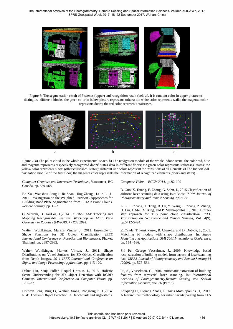
Figure 6: The segmentation result of 3 scenes (upper) and recognition result (below). It is random color in upper picture to
distinguish different blocks; the green color in below picture represents others; the white color represents walls; the magenta color
represents doors; the red color represents staircases.
a b c
Figure 7. a) The point cloud in the whole experimental space. b) The navigation module of the whole indoor scene; the color red, blue
and magenta represents respectively recognized doors’ states data in different floors; the green color represents staircases’ states; the
yellow color represents others (other cellspaces’ states); different line colors represent the transitions of all elements c) The IndoorGML
navigation module of the first floor; the magenta color represents the information of recognized elements (doors and stairs).
The International Archives of the Photogrammetry, Remote Sensing and Spatial Information Sciences, Volume XLII-2/W7, 2017 ISPRS Geospatial Week 2017, 18–22 September 2017, Wuhan, China
This contribution has been peer-reviewed. https://doi.org/10.5194/isprs-archives-XLII-2-W7-431-2017 | © Authors 2017. CC BY 4.0 License.
436

point Clouds. ISPRS Journal of Photogrammetry and Remote
Sensing 123 (2017). pp. 75-93.
Huan Ni, Xiangguo Lin , Jixian Zhang , J.,2017. Classification
of ALS Point Cloud with Improved Point Cloud Segmentation
and Random Forests. Remote Sensing. Vol (288). pp.1-34.
Qing Zhu , Yun Li 1, Qing Xiong. J., 2016. Indoor Multi-
Dimensional Location GML and Its Application for Ubiquitous
Indoor Location Services. ISPRS Int. J. Geo-Inf. pp.1-22.
Lee, J.; Li, K.; Zlatanova, S.; Kolbe, T.H.; Nagel, C.; Becher, T.
report on the Open Geospatial Consortium “OGC IndoorGML,
Version 1.0. OGC Doc. No.14-005r3”.USA. http://do-
cs.opengeospatial.org/is/14-005r3/14-005r3.html. (2 Dec 2014).
The International Archives of the Photogrammetry, Remote Sensing and Spatial Information Sciences, Volume XLII-2/W7, 2017 ISPRS Geospatial Week 2017, 18–22 September 2017, Wuhan, China
This contribution has been peer-reviewed. https://doi.org/10.5194/isprs-archives-XLII-2-W7-431-2017 | © Authors 2017. CC BY 4.0 License.
437


![AUTOMATIC LICENSE PLATE RECOGNITION [ALPR]-A … · sent to the System. ... Automatic License Plate Recognition (ALPR) can be useful ... Automatic License Plate Recognition (ALPR)](https://static.fdocuments.in/doc/165x107/5b3d8ea67f8b9a0e628e414f/automatic-license-plate-recognition-alpr-a-sent-to-the-system-automatic.jpg)