AUSTIN LAND DEVELOPMENT CODE - austintexas.gov · Our existing land development code was written 30...
20
AUSTIN LAND DEVELOPMENT CODE Code Draft 3 Guide 2018
Transcript of AUSTIN LAND DEVELOPMENT CODE - austintexas.gov · Our existing land development code was written 30...
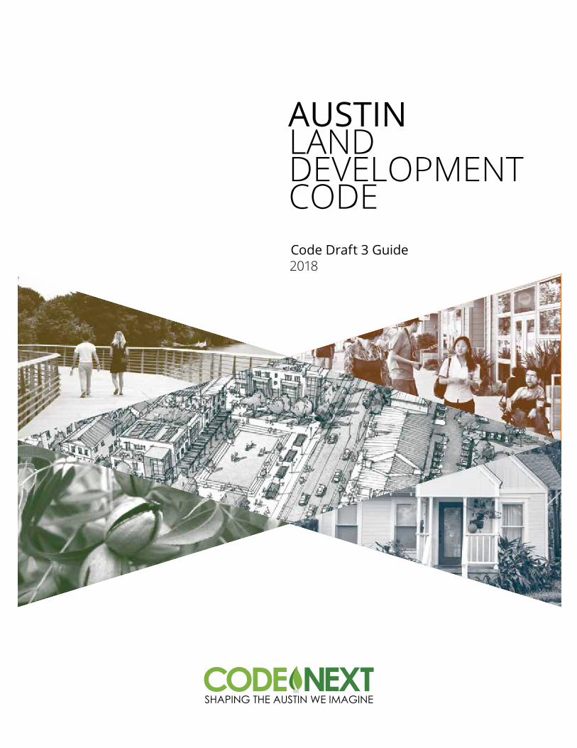
AUSTIN LAND DEVELOPMENT CODECode Draft 3 Guide 2018
2 | S H A P I N G T H E A U S T I N W E I M A G I N E
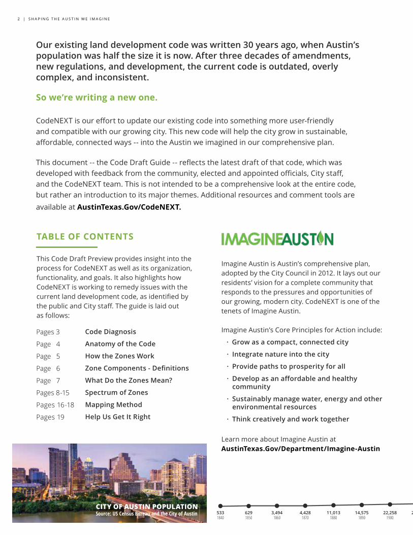
Our existing land development code was written 30 years ago, when Austin’s population was half the size it is now. After three decades of amendments, new regulations, and development, the current code is outdated, overly complex, and inconsistent.
So we’re writing a new one.
CodeNEXT is our effort to update our existing code into something more user-friendly and compatible with our growing city. This new code will help the city grow in sustainable, affordable, connected ways -- into the Austin we imagined in our comprehensive plan.
This document -- the Code Draft Guide -- reflects the latest draft of that code, which was developed with feedback from the community, elected and appointed officials, City staff, and the CodeNEXT team. This is not intended to be a comprehensive look at the entire code, but rather an introduction to its major themes. Additional resources and comment tools are available at AustinTexas.Gov/CodeNEXT.
TABLE OF CONTENTS
This Code Draft Preview provides insight into the process for CodeNEXT as well as its organization, functionality, and goals. It also highlights how CodeNEXT is working to remedy issues with the current land development code, as identified by the public and City staff. The guide is laid out as follows:
Code Diagnosis
Anatomy of the Code
How the Zones Work
ZoneComponents-Definitions
What Do the Zones Mean?
Spectrum of Zones
Mapping Method
Help Us Get It Right
Imagine Austin is Austin’s comprehensive plan, adopted by the City Council in 2012. It lays out our residents’ vision for a complete community that responds to the pressures and opportunities of our growing, modern city. CodeNEXT is one of the tenets of Imagine Austin.
Imagine Austin’s Core Principles for Action include:
· Grow as a compact, connected city
· Integrate nature into the city
· Provide paths to prosperity for all
· Developasanaffordableandhealthy community
· Sustainablymanagewater,energyandother environmental resources
· Think creatively and work together
Learn more about Imagine Austin at AustinTexas.Gov/Department/Imagine-Austin
Pages 3
Page 4
Page 5
Page 6
Page 7
Pages 8-15
Pages 16-18
Pages 19
5331840
6291850
3,4941860
4,4281870
11,0131880
14,5751890
22,2581900
29,8601910
34,8761920
53,1201930
87,9301940
132,4591950
186,5451960
253,5391970
349,8901980
456,6221990
656,5622000
790,3902010
900,7012015
Est.1,000,000
2020
Est.1,153,977
2030
CITY OF AUSTIN POPULATIONSource: US Census Bureau and the City of Austin
C O D E D R A F T G U I D E | 3
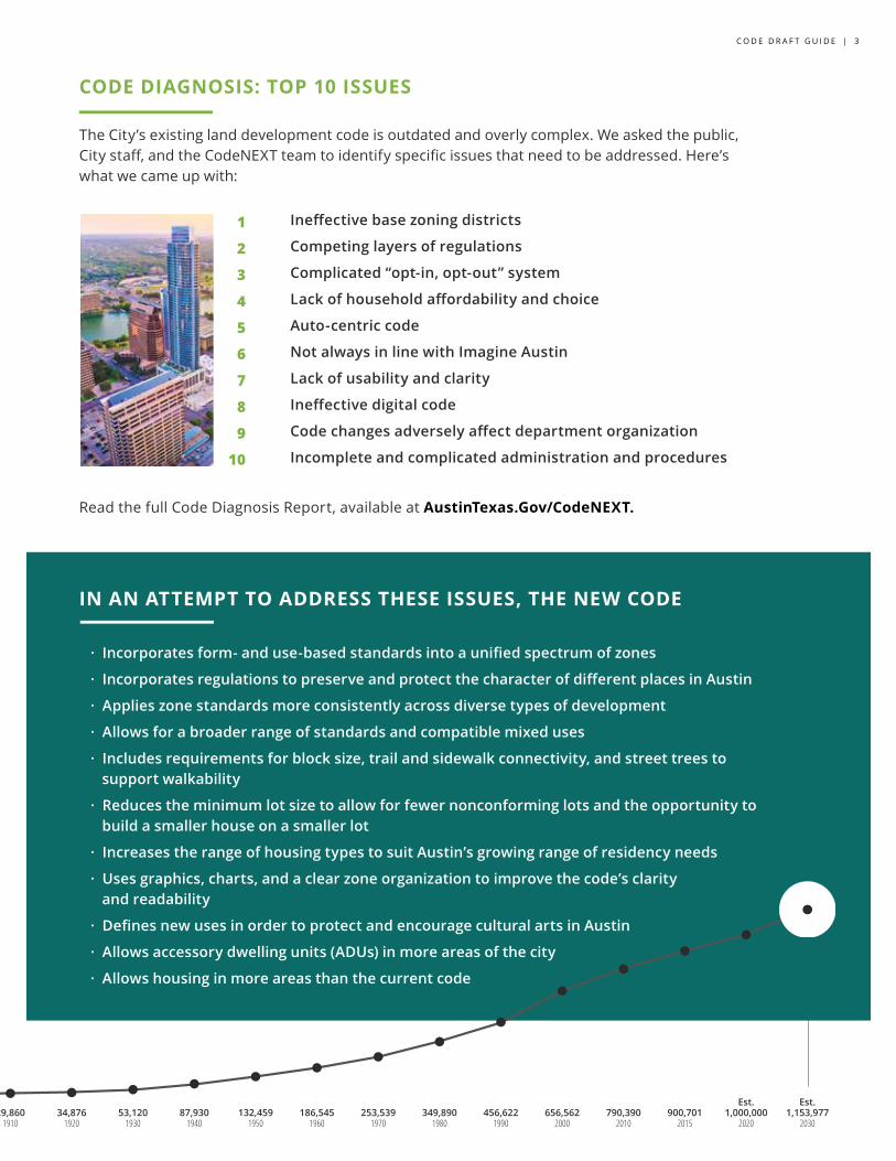
CODE DIAGNOSIS: TOP 10 ISSUES
The City’s existing land development code is outdated and overly complex. We asked the public, City staff, and the CodeNEXT team to identify specific issues that need to be addressed. Here’s what we came up with:
Ineffectivebasezoningdistricts
Competing layers of regulations
Complicated “opt-in, opt-out” system
Lackofhouseholdaffordabilityandchoice
Auto-centric code
Not always in line with Imagine Austin
Lackofusabilityandclarity
Ineffectivedigitalcode
Codechangesadverselyaffectdepartmentorganization
Incomplete and complicated administration and procedures
Read the full Code Diagnosis Report, available at AustinTexas.Gov/CodeNEXT.
1
2
3
4
5
6
7
8
9
10
5331840
6291850
3,4941860
4,4281870
11,0131880
14,5751890
22,2581900
29,8601910
34,8761920
53,1201930
87,9301940
132,4591950
186,5451960
253,5391970
349,8901980
456,6221990
656,5622000
790,3902010
900,7012015
Est.1,000,000
2020
Est.1,153,977
2030
IN AN ATTEMPT TO ADDRESS THESE ISSUES, THE NEW CODE
· Incorporatesform-anduse-basedstandardsintoaunifiedspectrumofzones
· IncorporatesregulationstopreserveandprotectthecharacterofdifferentplacesinAustin
· Applies zone standards more consistently across diverse types of development
· Allowsforabroaderrangeofstandardsandcompatiblemixeduses
· Includesrequirementsforblocksize,trailandsidewalkconnectivity,andstreettreesto supportwalkability
· Reduces the minimum lot size to allow for fewer nonconforming lots and the opportunity to buildasmallerhouseonasmallerlot
· Increases the range of housing types to suit Austin’s growing range of residency needs
· Uses graphics, charts, and a clear zone organization to improve the code’s clarity andreadability
· DefinesnewusesinordertoprotectandencourageculturalartsinAustin
· Allows accessory dwelling units (ADUs) in more areas of the city
· Allows housing in more areas than the current code
4 | S H A P I N G T H E A U S T I N W E I M A G I N E
anatomy of THE CODE
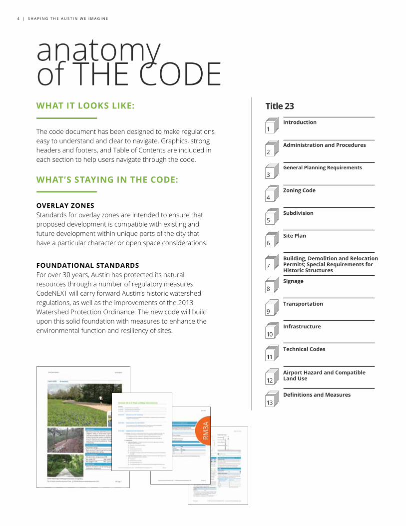
Title 23
1
2
3
4
5
6
7
8
9
10
11
Introduction
Administration and Procedures
General Planning Requirements
Zoning Code
Subdivision
Site Plan
Building, Demolition and Relocation Permits; Special Requirements for Historic Structures
Signage
Transportation
Infrastructure
Technical Codes
12Airport Hazard and Compatible Land Use
WHAT IT LOOKS LIKE: The code document has been designed to make regulations easy to understand and clear to navigate. Graphics, strong headers and footers, and Table of Contents are included in each section to help users navigate through the code.
WHAT’S STAYING IN THE CODE: OVERLAY ZONES Standards for overlay zones are intended to ensure that proposed development is compatible with existing and future development within unique parts of the city that have a particular character or open space considerations.
FOUNDATIONAL STANDARDS For over 30 years, Austin has protected its natural resources through a number of regulatory measures. CodeNEXT will carry forward Austin’s historic watershed regulations, as well as the improvements of the 2013 Watershed Protection Ordinance. The new code will build upon this solid foundation with measures to enhance the environmental function and resiliency of sites.
13Definitions and Measures
C O D E D R A F T G U I D E | 5
how the ZONES WORK
REFINED USES Permitted uses have been refined to improve neighborhood compatibility. For example, new Mixed-Use zones include uses that are more tightly calibrated for compatibility with surrounding neighborhoods than zones available in the current code.
FLEXIBLE STANDARDS Building form standards are regulated using an approach that is similar to the Subchapter F, or “McMansion”, standards and have been simplified for clarity.
INCREASED HOUSING OPPORTUNITY Most zones now allow some residential uses. Mixed-use development can provide more opportunities for residents to access jobs, shopping, education, and entertainment nearby.
Austin’s Land Development Code guides current and future development to help ensure the safety and well-being of Austinites. One way the code does this is by using zones to regulate what can be built where. The spectrum of zones provides many tools to help protect the physical character of Austin places while implementing the vision established in Imagine Austin, including:
CATEGORY
GROUPLESS INTENSE
VARIATIONS VARIATIONS
THEME
VARIATIONS
ZONE
R1
RESIDENTIAL HOUSE-SCALE (R)
R1A R1B R1C R2A R2B R2C R3A R3B R3C
R2 R3
MORE INTENSE
CATEGORY
GROUPLEAST TO MOST
INTENSE
VARIATIONS
THEME
ZONE
R1
RESIDENTIAL HOUSE-SCALE (R)
R1A R1B R1C R2A R2B R2C R3A R3B R3C
R2 R3
IMPROVED ZONES The zones are arranged into categories and groups. Categories are overall themes, like house-scaled residential or mixed-use. Groups are zones that share common intensities of development and often range from most to least restrictive.
6 | S H A P I N G T H E A U S T I N W E I M A G I N E
BUILDING COVER / IMPERVIOUS COVER Building cover is the percent of a lot that is covered by a building, and impervious cover is the percent of a lot that is covered by a surface that doesn’t absorb water. Building cover and impervious cover maximums protect watersheds and can reduce flooding throughout the city by limiting the development footprint on a lot.
FORM CONTROLS Basic form controls refer to lot size and width, setbacks, impervious cover, building coverage, and building height. Additional form controls add a floor to area ratio (FAR) limitation and compatibility standards. Some form controls have been carried forward from the current code, such as Subchapter F, or “McMansion”, regulations.
FARFloor to area ratio (FAR) is the ratio of gross floor area to gross site area. A one-story building that covers the entire lot on which it’s located has an FAR of 1.0, as does a building that covers half of the same lot but is two stories tall. AFFORDABLE HOUSING BONUS PROGRAM The affordable housing bonus program is a way to incentivize the production of long-term affordable residential units by allowing a development to have additional units, height, or FAR in exchange for providing affordable housing.
COMPATIBILITY Compatibility is a condition in which two different land uses can coexist in close proximity without negatively impacting each other. Compatibility is triggered by House-Scale Residential zones. Properties in proximity to those zones may be required to limit the building height, create screening buffers, or increase their rear setback.
PARKINGParking minimums exist for all zones except Regional Centers. These standards differ by use and can be further reduced if the project further enhances the utilization of a multi-modal network. Generally, one parking space is required per residential unit built on a lot. ACCESSORY DWELLING UNITS (ADUS) Accessory dwelling units (ADUs), also known as granny flats or garage apartments, are smaller secondary units that can be built on most residential properties as long as site development standards are still met.
zone componentsDEFINITIONS
C O D E D R A F T G U I D E | 7
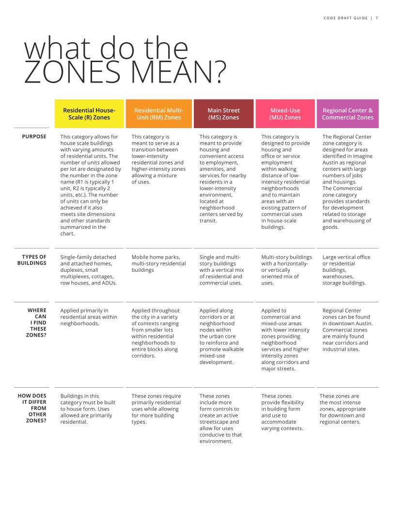
what do the ZONES MEAN?
Residential House-
Scale (R) ZonesResidential Multi- Unit (RM) Zones
Main Street (MS) Zones
Mixed-Use (MU) Zones
Regional Center & Commercial Zones
PURPOSE This category allows for house scale buildings with varying amounts of residential units. The number of units allowed per lot are designated by the number in the zone name (R1 is typically 1 unit, R2 is typically 2 units, etc.). The number of units can only be achieved if it also meets site dimensions and other standards summarized in the chart.
This category is meant to serve as a transition between lower-intensity residential zones and higher-intensity zones allowing a mixture of uses.
This category is meant to provide housing and convenient access to employment, amenities, and services for nearby residents in a lower-intensity environment, located at neighborhood centers served by transit.
This category is designed to provide housing and office or service employment within walking distance of low-intensity residential neighborhoods and to maintain areas with an existing pattern of commercial uses in house-scale buildings.
The Regional Center zone category is designed for areas identified in Imagine Austin as regional centers with large numbers of jobs and housings. The Commercial zone category provides standards for development related to storage and warehousing of goods.
TYPES OF BUILDINGS
Single-family detached and attached homes, duplexes, small multiplexes, cottages, row houses, and ADUs.
Mobile home parks, multi-story residential buildings
Single and multi-story buildings with a vertical mix of residential and commercial uses.
Multi-story buildings with a horizontally- or vertically oriented mix of uses.
Large vertical office or residential buildings, warehouses, storage buildings.
WHERE CAN
I FIND THESE
ZONES?
Applied primarily in residential areas within neighborhoods.
Applied throughout the city in a variety of contexts ranging from smaller lots within residential neighborhoods to entire blocks along corridors.
Applied along corridors or atneighborhood nodes within the urban core to reinforce and promote walkable mixed-use development.
Applied to commercial and mixed-use areas with lower intensity zones providing neighborhood services and higher intensity zones along corridors and major streets.
Regional Center zones can be found in downtown Austin. Commercial zones are mainly found near corridors and industrial sites.
HOW DOES IT DIFFER
FROM OTHER
ZONES?
Buildings in this category must be built to house form. Uses allowed are primarily residential.
These zones require primarily residential uses while allowing for more building types.
These zones include more form controls to create an active streetscape and allow for uses conducive to that environment.
These zones provide flexibility in building form and use to accommodate varying contexts.
These zones are the most intense zones, appropriate for downtown and regional centers.
8 | S H A P I N G T H E A U S T I N W E I M A G I N E
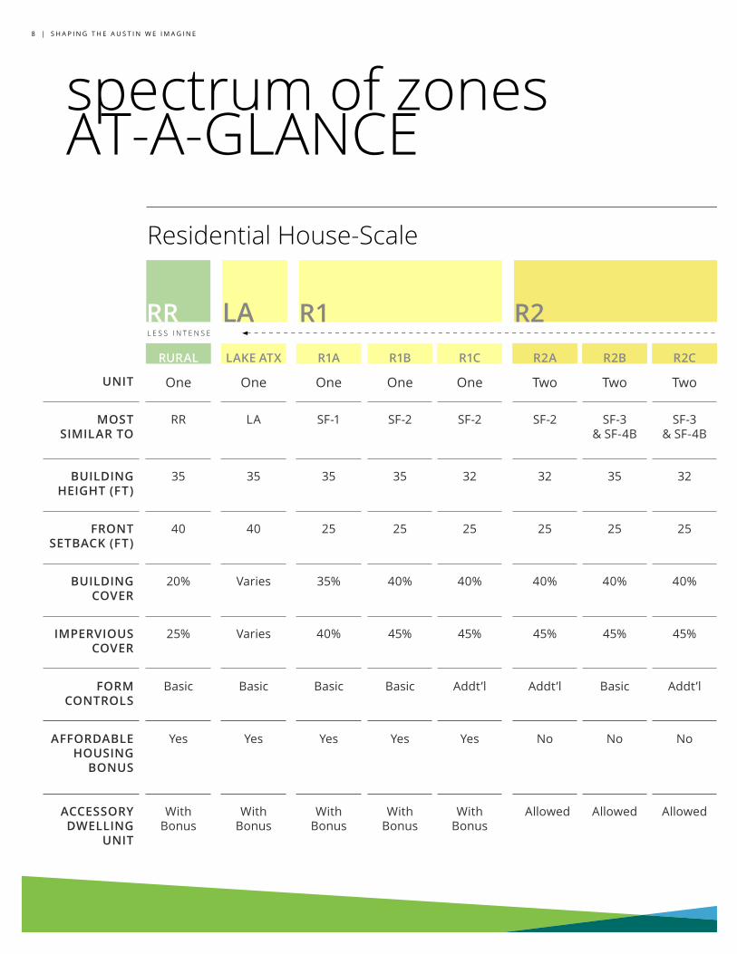
RR R1RURAL LAKE ATX R1A R1B R1C R2A R2B R2C R2D R2E R3A R3B R3C R3D R4A R4B R4C
UNIT One One One One One Two Two Two Two Two Three Three Three Three Four Four Four
MOST SIMILAR TO
RR LA SF-1 SF-2 SF-2 SF-2 SF-3 & SF-4B
SF-3 & SF-4B
SF-4A SF-4A SF-3 & SF-4B
SF-3 & SF-4B
SF-3 & SF-4B
SF-3 & SF-4B
SF-5 SF-5 SF-5
BUILDING HEIGHT (FT)
35 35 35 35 32 32 35 32 35 32 32 35 32 32 32 32 32
FRONT SETBACK (FT)
40 40 25 25 25 25 25 25 15 15 25 25 25 15 25 15 15
BUILDING COVER
20% Varies 35% 40% 40% 40% 40% 40% 55% 55% 40% 40% 40% 40% 40% 40% 40%
IMPERVIOUS COVER
25% Varies 40% 45% 45% 45% 45% 45% 65% 65% 45% 45% 45% 45% 45% 45% 45%
FORM CONTROLS
Basic Basic Basic Basic Addt’l Addt’l Basic Addt’l Basic Addt’l Addt’l Basic Addt’l Addt’l Addt’l Addt’l Addt’l
AFFORDABLE HOUSING
BONUS
Yes Yes Yes Yes Yes No No No No No No No No No Yes Yes Yes
ACCESSORY DWELLING
UNIT
With Bonus
With Bonus
With Bonus
With Bonus
With Bonus
Allowed Allowed Allowed Allowed Allowed Allowed Allowed Allowed Allowed Allowed Allowed Allowed
L E S S I N T E N S E
R2LA
Residential House-Scale
spectrum of zones AT-A-GLANCE
C O D E D R A F T P R E V I E W | 9
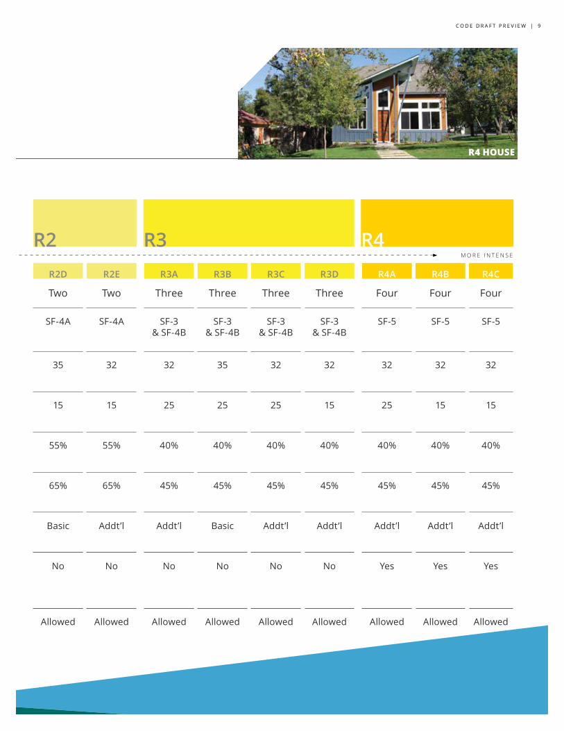
R3 R4RURAL LAKE ATX R1A R1B R1C R2A R2B R2C R2D R2E R3A R3B R3C R3D R4A R4B R4C
UNIT One One One One One Two Two Two Two Two Three Three Three Three Four Four Four
MOST SIMILAR TO
RR LA SF-1 SF-2 SF-2 SF-2 SF-3 & SF-4B
SF-3 & SF-4B
SF-4A SF-4A SF-3 & SF-4B
SF-3 & SF-4B
SF-3 & SF-4B
SF-3 & SF-4B
SF-5 SF-5 SF-5
BUILDING HEIGHT (FT)
35 35 35 35 32 32 35 32 35 32 32 35 32 32 32 32 32
FRONT SETBACK (FT)
40 40 25 25 25 25 25 25 15 15 25 25 25 15 25 15 15
BUILDING COVER
20% Varies 35% 40% 40% 40% 40% 40% 55% 55% 40% 40% 40% 40% 40% 40% 40%
IMPERVIOUS COVER
25% Varies 40% 45% 45% 45% 45% 45% 65% 65% 45% 45% 45% 45% 45% 45% 45%
FORM CONTROLS
Basic Basic Basic Basic Addt’l Addt’l Basic Addt’l Basic Addt’l Addt’l Basic Addt’l Addt’l Addt’l Addt’l Addt’l
AFFORDABLE HOUSING
BONUS
Yes Yes Yes Yes Yes No No No No No No No No No Yes Yes Yes
ACCESSORY DWELLING
UNIT
With Bonus
With Bonus
With Bonus
With Bonus
With Bonus
Allowed Allowed Allowed Allowed Allowed Allowed Allowed Allowed Allowed Allowed Allowed Allowed
M O R E I N T E N S E
Residential House-ScaleR4 HOUSE
R2
1 0 | S H A P I N G T H E A U S T I N W E I M A G I N E
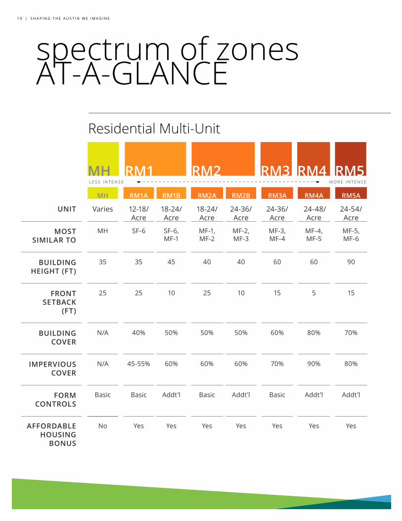
MH RM1A RM1B RM2A RM2B RM3A RM4A RM5A
UNIT Varies 12-18/Acre
18-24/Acre
18-24/ Acre
24-36/Acre
24-36/Acre
24-48/Acre
24-54/Acre
MOST SIMILAR TO
MH SF-6 SF-6, MF-1
MF-1, MF-2
MF-2, MF-3
MF-3, MF-4
MF-4, MF-5
MF-5, MF-6
BUILDING HEIGHT (FT)
35 35 45 40 40 60 60 90
FRONT SETBACK
(FT)
25 25 10 25 10 15 5 15
BUILDING COVER
N/A 40% 50% 50% 50% 60% 80% 70%
IMPERVIOUS COVER
N/A 45-55% 60% 60% 60% 70% 90% 80%
FORM CONTROLS
Basic Basic Addt’l Basic Addt’l Basic Addt’l Addt’l
AFFORDABLE HOUSING
BONUS
No Yes Yes Yes Yes Yes Yes Yes
RM1 RM2 RM3 RM4 RM5
spectrum of zones AT-A-GLANCE
Residential Multi-Unit
L E S S I N T E N S E M O R E I N T E N S E
MH
C O D E D R A F T P R E V I E W | 1 1
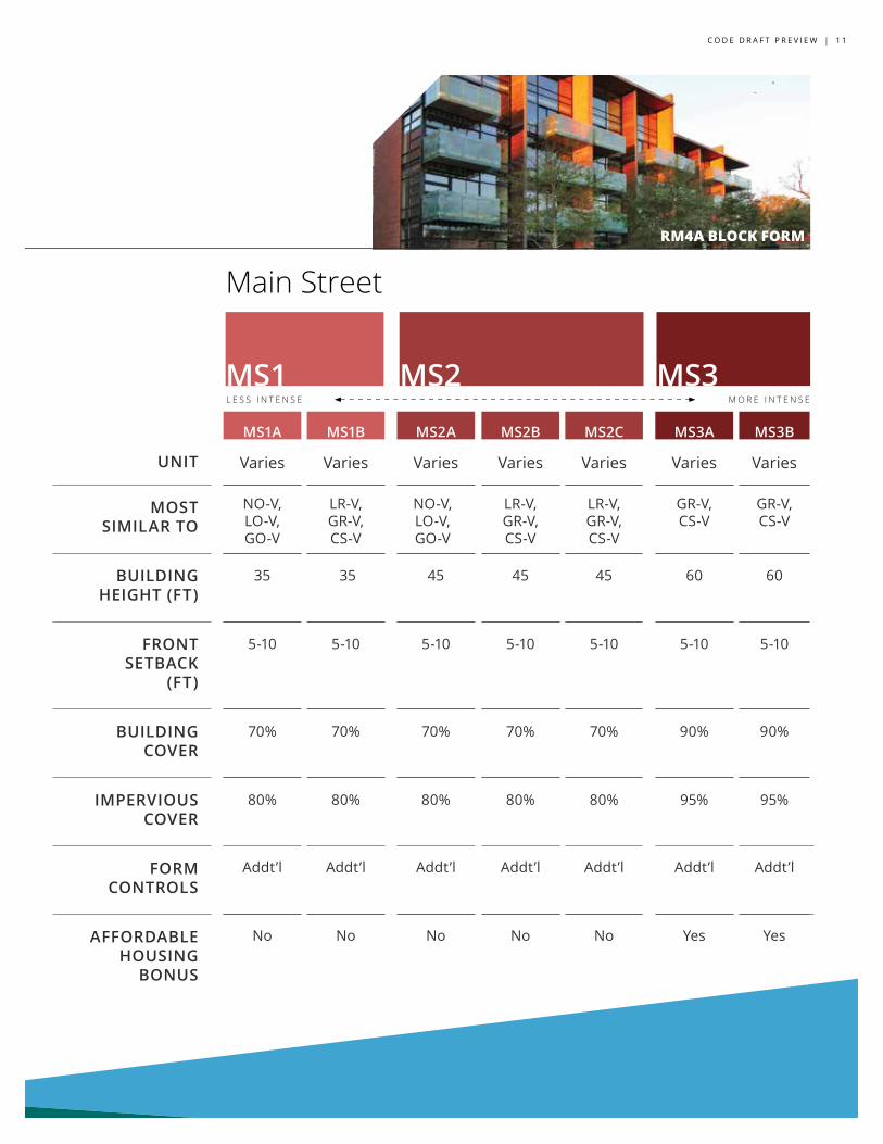
MS1
MS1A MS1B MS2A MS2B MS2C MS3A MS3B
UNIT Varies Varies Varies Varies Varies Varies Varies
MOST SIMILAR TO
NO-V, LO-V, GO-V
LR-V, GR-V, CS-V
NO-V, LO-V, GO-V
LR-V, GR-V, CS-V
LR-V, GR-V, CS-V
GR-V, CS-V
GR-V, CS-V
BUILDING HEIGHT (FT)
35 35 45 45 45 60 60
FRONT SETBACK
(FT)
5-10 5-10 5-10 5-10 5-10 5-10 5-10
BUILDING COVER
70% 70% 70% 70% 70% 90% 90%
IMPERVIOUS COVER
80% 80% 80% 80% 80% 95% 95%
FORM CONTROLS
Addt’l Addt’l Addt’l Addt’l Addt’l Addt’l Addt’l
AFFORDABLE HOUSING
BONUS
No No No No No Yes Yes
MS2 MS3
Main Street
L E S S I N T E N S E M O R E I N T E N S E
RM4A BLOCK FORM
1 2 | S H A P I N G T H E A U S T I N W E I M A G I N E
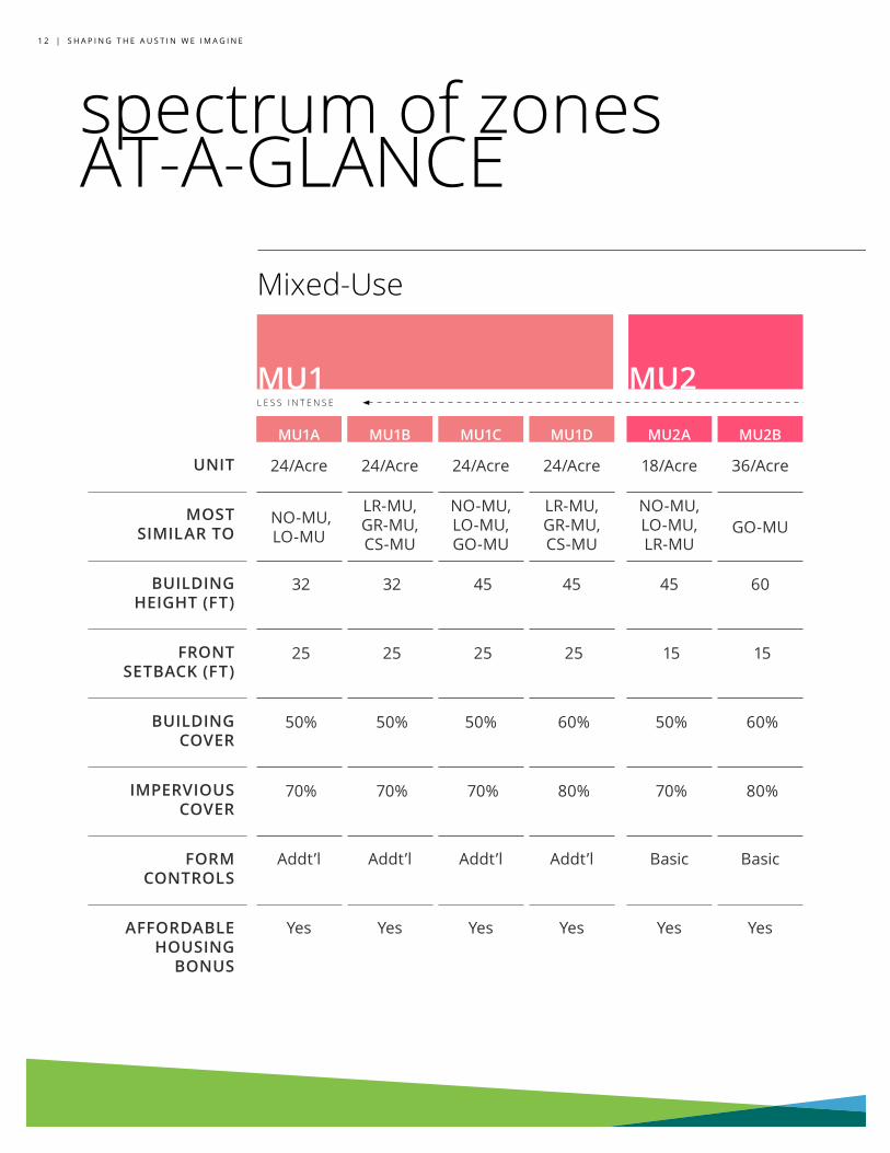
MU1 MU2MU1A MU1B MU1C MU1D MU2A MU2B MU3A MU3B MU4A MU4B MU5A
UNIT 24/Acre 24/Acre 24/Acre 24/Acre 18/Acre 36/Acre 36/Acre 36/Acre 36/Acre 36/Acre 54/Acre
MOST SIMILAR TO
NO-MU, LO-MU
LR-MU, GR-MU, CS-MU
NO-MU, LO-MU, GO-MU
LR-MU, GR-MU, CS-MU
NO-MU, LO-MU, LR-MU
GO-MU GR-MU GR-MU CS-CO-MU
CS-MU, CS-1-MU CH
BUILDING HEIGHT (FT)
32 32 45 45 45 60 60 60 60 60 80
FRONT SETBACK (FT)
25 25 25 25 15 15 10 10 10 10 30
BUILDING COVER
50% 50% 50% 60% 50% 60% 75% 75% 90% 95% 70%
IMPERVIOUS COVER
70% 70% 70% 80% 70% 80% 90% 90% 95% 95% 75%
FORM CONTROLS
Addt’l Addt’l Addt’l Addt’l Basic Basic Basic Basic Basic Basic Basic
AFFORDABLE HOUSING
BONUS
Yes Yes Yes Yes Yes Yes Yes Yes Yes Yes Yes
spectrum of zones AT-A-GLANCE
Mixed-Use
L E S S I N T E N S E
C O D E D R A F T P R E V I E W | 1 3
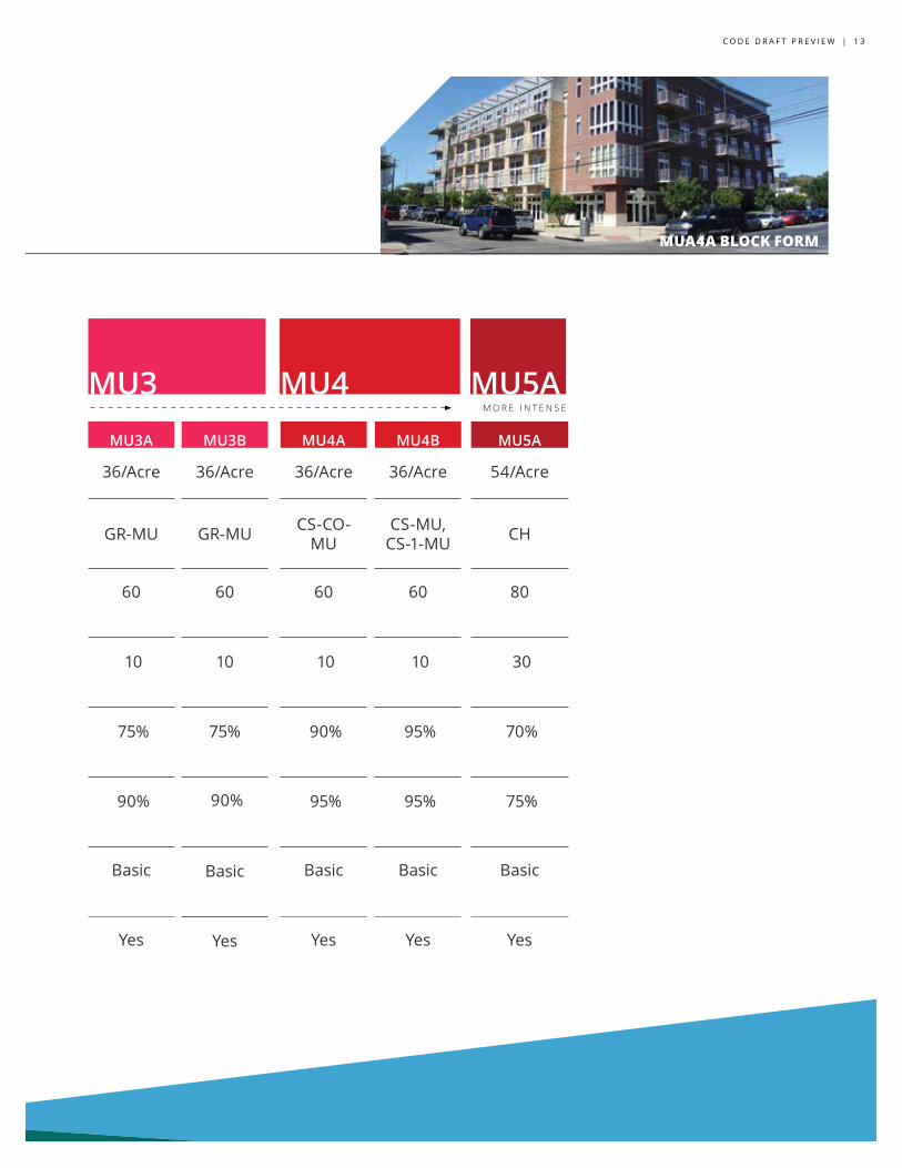
MU1A MU1B MU1C MU1D MU2A MU2B MU3A MU3B MU4A MU4B MU5A
UNIT 24/Acre 24/Acre 24/Acre 24/Acre 18/Acre 36/Acre 36/Acre 36/Acre 36/Acre 36/Acre 54/Acre
MOST SIMILAR TO
NO-MU, LO-MU
LR-MU, GR-MU, CS-MU
NO-MU, LO-MU, GO-MU
LR-MU, GR-MU, CS-MU
NO-MU, LO-MU, LR-MU
GO-MU GR-MU GR-MU CS-CO-MU
CS-MU, CS-1-MU CH
BUILDING HEIGHT (FT)
32 32 45 45 45 60 60 60 60 60 80
FRONT SETBACK (FT)
25 25 25 25 15 15 10 10 10 10 30
BUILDING COVER
50% 50% 50% 60% 50% 60% 75% 75% 90% 95% 70%
IMPERVIOUS COVER
70% 70% 70% 80% 70% 80% 90% 90% 95% 95% 75%
FORM CONTROLS
Addt’l Addt’l Addt’l Addt’l Basic Basic Basic Basic Basic Basic Basic
AFFORDABLE HOUSING
BONUS
Yes Yes Yes Yes Yes Yes Yes Yes Yes Yes Yes
MU3 MU5AMU4M O R E I N T E N S E
MUA4A BLOCK FORM
1 4 | S H A P I N G T H E A U S T I N W E I M A G I N E
spectrum of zones AT-A-GLANCE
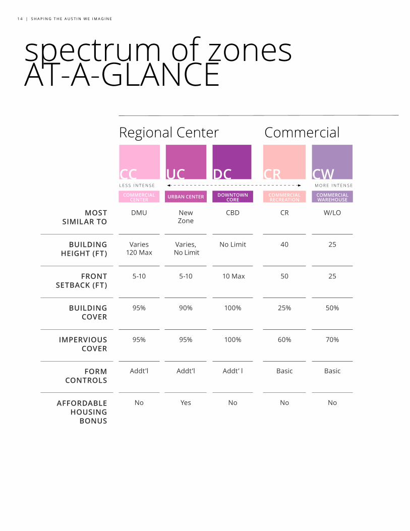
COMMERCIAL CENTER URBAN CENTER DOWNTOWN
CORECOMMERCIAL RECREATION
COMMERCIAL WAREHOUSE
MOST SIMILAR TO
DMU New Zone
CBD CR W/LO
BUILDING HEIGHT (FT)
Varies 120 Max
Varies, No Limit
No Limit 40 25
FRONT SETBACK (FT)
5-10 5-10 10 Max 50 25
BUILDING COVER
95% 90% 100% 25% 50%
IMPERVIOUS COVER
95% 95% 100% 60% 70%
FORM CONTROLS
Addt’l Addt’l Addt’ l Basic Basic
AFFORDABLE HOUSING
BONUS
No Yes No No No
CC UC DC CR CW
Regional Center Commercial
L E S S I N T E N S E M O R E I N T E N S E
C O D E D R A F T G U I D E | 1 5
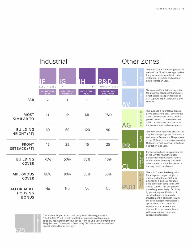
INDUSTRIAL FLEX
INDUSTRIAL GENERAL
INDUSTRIAL HEAVY
RESEARCH & DEVELOPMENT
FAR
2 1 1 1
MOST SIMILAR TO
LI IP MI R&D
BUILDING HEIGHT (FT)
60 60 120 90
FRONT SETBACK (FT)
15 25 15 25
BUILDING COVER
75% 50% 75% 40%
IMPERVIOUS COVER
80% 80% 80% 50%
AFFORDABLE HOUSING
BONUS
No No No No
IF IG IH R&D P
The Public Zone is the designation for areas of the City that are appropriate for government-owned civic, public institution, or indoor and outdoor active recreation uses.
The Aviation Zone is the designation for airport-related uses that require direct access to airport facilities or that support airport operations and services.
The purpose is to preserve areas of prime agricultural soils, concentrate urban development in and around growth centers, promote compact urban development, and preserve the environment and open spaces.
The Park Zone applies to areas of the City that are appropriate for Outdoor and Natural Recreation. The purpose of the PR Zone is to preserve areas for Outdoor Formal, Informal, or Natural Recreation land uses.
Conservation Land designates areas of the City for which the public purpose is conservation of natural land in a form generally free from development. Natural Recreation is the only Land Use allowed.
The PUD Zone is the designation for a large or complex single or multi-use development that is planned as a single contiguous development in compliance with unified control. This designation provides greater design flexibility by permitting modifications of site development standards. Development in compliance with the site development standards applicable to a PUD must be superior to the development that would occur in compliance with conventional zoning and subdivision standards.This zone is for parcels that will carry forward the regulations in
Title 25. Title 25 will remain in effect for properties within unique, specially-negotiated districts, such as Planned Unit Developments and Neighborhood Conservation Combining Districts, as well as a defined subset of Conditional Overlays.
Industrial
L E S S I N T E N S E
AV
AG
PR
CL
PUD
F25 FORM
ER T
ITLE
25
Other Zones
PUB
LIC
AVIA
TIO
N
AG
RIC
ULT
UR
E PA
RK
CO
NSE
RVAT
ION
LA
ND
PL
AN
NED
UN
IT
DEV
ELO
PMEN
T
M O R E I N T E N S E
1 6 | S H A P I N G T H E A U S T I N W E I M A G I N E
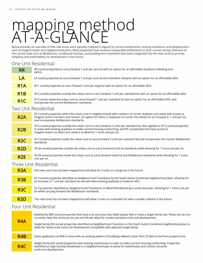
RR zoned properties to carry forward 1 unit per acre lot with an option for an affordable Accessory Dwelling Unit (ADU).
mapping methodAT-A-GLANCEOne Unit Residential
RR
LA LA zoned properties to carry forward 1 unit per acre lot and shoreline setbacks with an option for an affordable ADU.
R1A
R1BR1C
R2A
R2B
R2C
R2D
R2E
R3A
R3B
R3C
R4A
R4B
R3D
R4C
SF-1 zoned properties to carry forward 1unit per large lot with an option for an affordable ADU.
SF-2 zoned properties outside the urban core to carry forward 1 unit per standard lot with an option for an affordable ADU.
SF-2 zoned inside the urban core to carry forward 1 unit per standard lot with an option for an affordable ADU, and incorporate the current McMansion standards.
SF-3 zoned properties inside the urban core to carry forward 2 units per standard lot and incorporates the current McMansion standards.
SF-4A zoned properties outside the urban core to carry forward small lot standards while allowing for 1 more unit per lot.
SF-4A zoned properties inside the urban core to carry forward small lot and McMansion standards while allowing for 1 more unit per lot.
This new zone has not been mapped but will allow for 3 units on a large lot in the future.
SF-3 properties identified as Neighborhood Transitions or Mixed Residential by a small area plan, allowing for 1 more unit per lot while carrying forward the McMansion standards.
Multifamily (MF) zoned properties that have a lot area less than 8000 square feet or have a single family use. These lots do not currently meet the minimum lot size and R4 will allow for context sensitive multi-unit development.
Single family (SF) zoned properties identified as Neighborhood Transition in the South Austin Combined neighborhood plan to allow for house scale multi-unit development compatible with adjacent single family.
Same application as R4A in areas with an existing pattern of buildings setback closer than 25 feet to the front property line.
Single family (SF) zoned properties with existing townhouses in order to make current housing conforming. Properties identified as High Density Residential in a neighborhood plan to allow for townhouses and context sensitive multi-unit development.
Two Unit Residential
Three Unit Residential
Four Unit Residential
SF-3 zoned properties identified as Neighborhood Transitions by the South Austin Combined neighborhood plan, allowing for an increase of 1 unit per standard lot and will allow existing duplexes to build an ADU.
SF-3 zoned properties outside the urban core to carry forward 2 units per standard lot. Also applied to SF-2 zoned properties in areas with existing duplexes to make current housing conforming, and SF-2 properties that have access to Imagine Austin corridors and centers to allow for 1 more unit per lot.
SF-2 zoned properties within the urban core in neighborhoods with a pattern of corner duplexes and areas with access to Imagine Austin corridors and centers. An option for ADUs or duplexes on corner lots allows for an increase in 1 unit per lot, and incorporates McMansion standards.
Below provides an overview of how new zones were typically mapped in regards to current entitlements, existing conditions, and adopted plans such as Imagine Austin and neighborhood plans. Most properties have received comparable entitlements to their current zoning. Elements of the current code such as McMansion, conditional overlays, and building form standards have been integrated into the new zones to provide simplicity and predictablilty for development in the future.
This new zone has not been mapped but will allow 3 units on a standard lot with a smaller setback in the future.
C O D E D R A F T G U I D E | 1 7
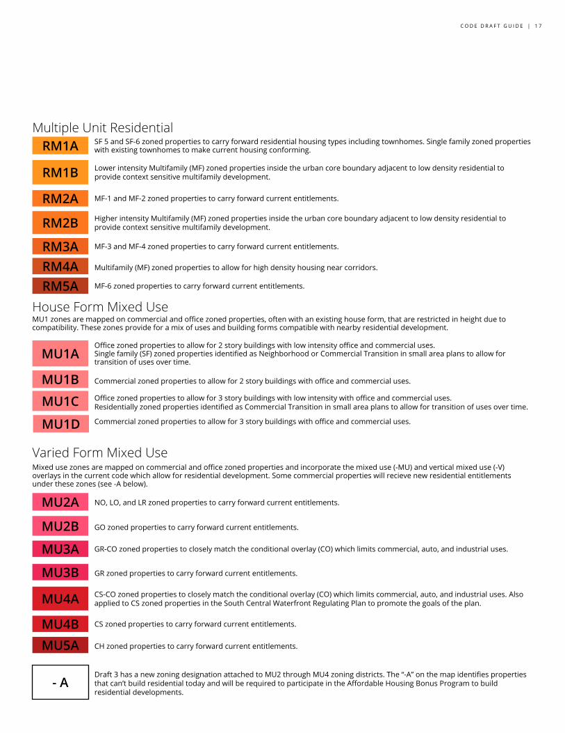
SF 5 and SF-6 zoned properties to carry forward residential housing types including townhomes. Single family zoned properties with existing townhomes to make current housing conforming.
Multiple Unit Residential
MF-1 and MF-2 zoned properties to carry forward current entitlements.
Higher intensity Multifamily (MF) zoned properties inside the urban core boundary adjacent to low density residential to provide context sensitive multifamily development.
MF-3 and MF-4 zoned properties to carry forward current entitlements.
RM1A
RM1B
RM2A
RM2B
RM3ARM4ARM5A
Multifamily (MF) zoned properties to allow for high density housing near corridors.
MF-6 zoned properties to carry forward current entitlements.
House Form Mixed Use
Office zoned properties to allow for 2 story buildings with low intensity office and commercial uses. Single family (SF) zoned properties identified as Neighborhood or Commercial Transition in small area plans to allow for transition of uses over time.
Commercial zoned properties to allow for 2 story buildings with office and commercial uses.
Office zoned properties to allow for 3 story buildings with low intensity with office and commercial uses. Residentially zoned properties identified as Commercial Transition in small area plans to allow for transition of uses over time.
Commercial zoned properties to allow for 3 story buildings with office and commercial uses.
MU1A
MU1B
MU1C
MU1D
Varied Form Mixed Use
NO, LO, and LR zoned properties to carry forward current entitlements.
GO zoned properties to carry forward current entitlements.
GR-CO zoned properties to closely match the conditional overlay (CO) which limits commercial, auto, and industrial uses.
GR zoned properties to carry forward current entitlements.
MU2A
MU2B
MU3A
MU3B
MU4A
MU4BMU5A
CS zoned properties to carry forward current entitlements.
CH zoned properties to carry forward current entitlements.
- ADraft 3 has a new zoning designation attached to MU2 through MU4 zoning districts. The “-A” on the map identifies properties that can’t build residential today and will be required to participate in the Affordable Housing Bonus Program to build residential developments.
CS-CO zoned properties to closely match the conditional overlay (CO) which limits commercial, auto, and industrial uses. Also applied to CS zoned properties in the South Central Waterfront Regulating Plan to promote the goals of the plan.
MU1 zones are mapped on commercial and office zoned properties, often with an existing house form, that are restricted in height due to compatibility. These zones provide for a mix of uses and building forms compatible with nearby residential development.
Mixed use zones are mapped on commercial and office zoned properties and incorporate the mixed use (-MU) and vertical mixed use (-V) overlays in the current code which allow for residential development. Some commercial properties will recieve new residential entitlements under these zones (see -A below).
Lower intensity Multifamily (MF) zoned properties inside the urban core boundary adjacent to low density residential to provide context sensitive multifamily development.
1 8 | S H A P I N G T H E A U S T I N W E I M A G I N E
mapping methodAT-A-GLANCE
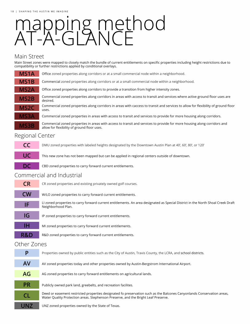
Office zoned properties along corridors or at a small commercial node within a neighborhood.
Main Street
Commercial zoned properties along corridors or at a small commercial node within a neighborhood.
Office zoned properties along corridors to provide a transition from higher intensity zones.
MS1AMS1BMS2AMS2BMS2CMS3AMS3B
Commercial zoned properties in areas with access to transit and services to provide for more housing along corridors.
Commercial zoned properties in areas with access to transit and services to provide for more housing along corridors and allow for flexibility of ground floor uses.
Regional CenterDMU zoned properties with labeled heights designated by the Downtown Austin Plan at 40’, 60’, 80’, or 120’
This new zone has not been mapped but can be applied in regional centers outside of downtown.
CBD zoned properties to carry forward current entitlements.
CC
UC
DCCommercial and Industrial
CR zoned properties and existing privately owned golf courses.
W/LO zoned properties to carry forward current entitlements.
LI zoned properties to carry forward current entitlements. An area designated as Special District in the North Shoal Creek Draft Neighborhood Plan.
IP zoned properties to carry forward current entitlements.
MI zoned properties to carry forward current entitlements.
CR
CW
IF
IG
IHR&D R&D zoned properties to carry forward current entitlements.
Other ZonesProperties owned by public entities such as the City of Austin, Travis County, the LCRA, and school districts.
AV zoned properties today and other properties owned by Austin-Bergstrom International Airport.
AG zoned properties to carry forward entitlements on agricultural lands.
Publicly owned park land, greebelts, and recreation facilites.
P
AV
AG
PR
CL
UNZ UNZ zoned properties owned by the State of Texas.
Main Street zones were mapped to closely match the bundle of current entitlements on specific properties including height restrictions due to compatibility or further restrictions applied by conditional overlays.
Commercial zoned properties along corridors in areas with access to transit and services where active ground floor uses are desired.
Deed or easement restricted properties designated fo preservation such as the Balcones Canyonlands Conservation areas, Water Quality Protection areas. Stephenson Preserve, and the Bright Leaf Preserve.
Commercial zoned properties along corridors in areas with caccess to transit and services to allow for flexibility of ground floor uses.
C O D E D R A F T G U I D E | 1 9
ONLINE COMMENTING View the code and map, and share your comments using our online tools. CodeNEXT resources are also available at every public library in the city. Note: City of Austin staff will compile and share all feedback with the Zoning & Platting Commission, the Planning Commission and the City Council.
Review and comment on the draft code codenext.civicomment.org Review and comment on the map codenext.engagingplans.org Email us general comments [email protected] PUBLIC HEARINGS Members of the public are invited to participate in CodeNEXT public hearings. This includes meetings of the Planning Commission and Zoning & Platting Commission, as well as special called work sessions and regular City Council meetings.
For an up-to-date schedule of these meetings, visit austintexas.gov/CodeNEXT OFFICE HOURS Staff will be hosting office hours to answer any questions and provide assistance in understanding the code. Visit austintexas.gov/CodeNEXT to sign up for office hours.
LEARN MORE Want to learn more about the land development code, including our 5 priorities? The CodeNEXT website and social media pages are great resources to stay informed and learn about the project.
Facebook.com/AustinCodeNEXT
Twitter.com/AustinCodeNEXT
HELP US GET IT RIGHT Rewriting Austin’s Land Development Code opens the doorway to becoming the Austin we’ve imagined. Whether you have been involved in CodeNEXT from the very beginning or you are just learning about the project, your feedback is important. Your participation will continue to help improve the code.
The best place to start is austintexas.gov/CodeNEXT
C O D E D R A F T G U I D E | 1 9