AURANGABAD A HISTORICAL CITY OF DECCAN INDIAksijmr.com/1.1.10.pdfArabs placed the Raja under...
21
“Knowledge Scholar” An International Peer Reviewed Journal Of Multidisciplinary Research Volume: 01, Issue: 01, Nov. – Dec. 2014 eISSN NO. 2394-5362 http://www.ksijmr.com Page | 115 AURANGABAD A HISTORICAL CITY OF DECCAN INDIA Syeda Amreen Sultana Dr. Abdullah Chaus M. A. 1 st Year History Lecturer Maulana Azad National Open University Dept. of History Maulana Azad Sub Centre Dr. Rafiq Zakaria College for Women Aurangabad, Maharashtra, India. Aurangabad, Maharashtra, India. Introduction The history of Aurangabad, a city in Maharashtra, India, dates to 1610, when it was founded by Malik Ambar, the Prime Minister of Murtaza Nizam Shah ofAhmadnagar, on the site of a village called Kharki. In 1653 when Prince Aurangzeb was appointed the viceroy of the Deccan for the second time, he made Fatehnagar his capital and called it Aurangabad. Aurangabad is sometimes referred to as Khujista Bunyad by the Chroniclers of Aurangzeb's reign. History of the City Malik Ambar made it his capital and the men of his army raised their dwellings around it. Within a decade, Kharki g a populous and imposing city. Malik Ambar cherished strong love and ability for architecture. Aurangabad was Ambar's architectural achievement and creation. However, in 1621, it was ravaged and burnt down by the imperial troops under Jahangir. Ambar the founder of the city was always referred to by harsh names by Emperor Jahangir. In his memoirs, he never mentions his name without prefixing epithets
Transcript of AURANGABAD A HISTORICAL CITY OF DECCAN INDIAksijmr.com/1.1.10.pdfArabs placed the Raja under...

“Knowledge Scholar”
An International Peer Reviewed Journal Of Multidisciplinary Research
Volume: 01, Issue: 01, Nov. – Dec. 2014 eISSN NO. 2394-5362
http://www.ksijmr.com Page | 115
AURANGABAD A HISTORICAL CITY OF DECCAN INDIA
Syeda Amreen Sultana Dr. Abdullah Chaus M. A. 1st Year History Lecturer Maulana Azad National Open University Dept. of History Maulana Azad Sub Centre Dr. Rafiq Zakaria College for Women Aurangabad, Maharashtra, India. Aurangabad, Maharashtra, India.
Introduction
The history of Aurangabad, a city in Maharashtra, India, dates to 1610, when it was
founded by Malik Ambar, the Prime Minister of Murtaza Nizam Shah ofAhmadnagar, on the
site of a village called Kharki. In 1653 when Prince Aurangzeb was appointed the viceroy of
the Deccan for the second time, he made Fatehnagar his capital and called it Aurangabad.
Aurangabad is sometimes referred to as Khujista Bunyad by the Chroniclers of Aurangzeb's
reign.
History of the City
Malik Ambar made it his capital and the men of his army raised their dwellings around
it. Within a decade, Kharki g a populous and imposing city. Malik Ambar cherished strong
love and ability for architecture. Aurangabad was Ambar's architectural achievement and
creation. However, in 1621, it was ravaged and burnt down by the imperial troops
under Jahangir. Ambar the founder of the city was always referred to by harsh names by
Emperor Jahangir. In his memoirs, he never mentions his name without prefixing epithets

“Knowledge Scholar”
An International Peer Reviewed Journal Of Multidisciplinary Research
Volume: 01, Issue: 01, Nov. – Dec. 2014 eISSN NO. 2394-5362
http://www.ksijmr.com Page | 116
like wretch, cursed fellow, Habshi, Ambar Siyari, black Ambar, and Ambar Badakhtur.
Malik Ambar died in 1626. He was succeeded by his son Fateh Khan, who changed the
name of Kharki to Fatehnagar. In the same year, the Moghal viceroy Khan Jahan Lodi,
advanced on the city, but retired to Burhanpur on being bribed by the Nizam
Shahi Commander, Hamid Khan. With the capture of Daulatabad by the imperial troops in
1633, the Nizam Shahi dominions, including Fatehnagar, came under the possession of the
Moghals. In 1653 when Prince Aurangzeb was appointed the viceroy of theDeccan for the
second time, he made Fatehnagar his capital and called it Aurangabad. Aurangabad is
sometimes referred to as Khujista Bunyad by the Chroniclers of Aurangzeb's reign.
Zeb-un-Nisa's palace, Aurangabad 1880s
Panchakki, Baba Shah Mosafar Dargah 1880s
“Knowledge Scholar”
An International Peer Reviewed Journal Of Multidisciplinary Research
Volume: 01, Issue: 01, Nov. – Dec. 2014 eISSN NO. 2394-5362
http://www.ksijmr.com Page | 117
In March 1666, accompanied by a body of 1,000 select troops, Shivaji arrived at
Aurangabad on his way to Agra. Safshikan Khan, the governor of Aurangabad, treated him
with scant respect. For this act, he was severely reprimanded by Jai Singh and made to pay a
courtesy call on Shivaji. In 1668, the city nearly became a scene of a conflict between the
imperial troops under Diler Khan, and those commanded by Prince Muazzam, the viceroy. In
1681, after plundering Burhanpur, the Marathas assembled in the neighbourhood of the
Satara hills in order to attack Aurangabad. The plan was, however, abandoned on hearing of
the arrival of the viceroy, Khan Jahan Bahadur. In the same year, Khan Jahan Bahadur
erected a wall around Aurangabad to protect it against surprise attacks of the Marathas. It
was done at the order of the Emperor, and cost rupees three lakhs. Two years later, the
Emperor himself arrived at Aurangabad.
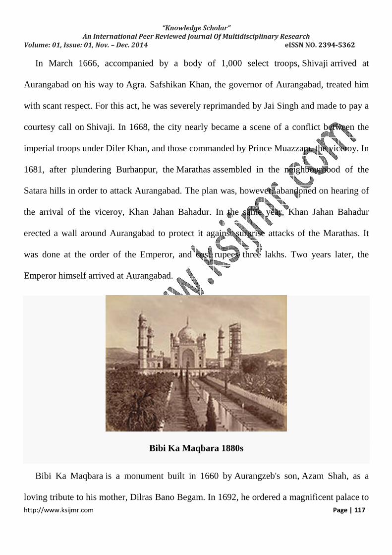
Bibi Ka Maqbara 1880s
Bibi Ka Maqbara is a monument built in 1660 by Aurangzeb's son, Azam Shah, as a
loving tribute to his mother, Dilras Bano Begam. In 1692, he ordered a magnificent palace to

“Knowledge Scholar”
An International Peer Reviewed Journal Of Multidisciplinary Research
Volume: 01, Issue: 01, Nov. – Dec. 2014 eISSN NO. 2394-5362
http://www.ksijmr.com Page | 118
be erected near the great reservoir to the north of the city - the ruins of which are now to be
seen in the Killa Ark. A fortified wall was thrown round the suburb of Begampura in 1696
A. D. Shortly after the death of Aurangzeb, the city of Aurangabad slipped from the hands of
the Moghals. In 1720, Nizam-ul-Mulk Asif Jah, a distinguished General of Aurangzeb with
the intention of founding his own dynasty in the Deccan, arrived at Aurangabad. He paid a
visit to Delhi in 1723, but returned in 1724 [clarification needed], defying the orders of
Emperor Muhammad Shah. Nizam Ali Khan Asaf Jah II transferred his capital from
Aurangabad to Hyderabad in 1763.
Street View Aurangabad 1868
The Emperor ordered Mubariz Khan, the Subhedar of the Deccan to oppose the Nizam. A
battle was fought near Sakharkherda, subsequently called Fatehkherda, in which Murbariz
Khan was defeated and killed. Raghoji, a young scion of the house of the Jadhavs of

“Knowledge Scholar”
An International Peer Reviewed Journal Of Multidisciplinary Research
Volume: 01, Issue: 01, Nov. – Dec. 2014 eISSN NO. 2394-5362
http://www.ksijmr.com Page | 119
Sindkhed who fought on the side of the Moghals was also killed. Incensed at the support lent
by the Jadhavs to Mubariz Khan, the Nizam despatched a posse of troops to Deulgaon to
capture the Jadhav family. But being informed of the design the family escaped to Satara and
sought asylum with Chhatrapati Shahu. At the intervention of Shahu the Jagir was restored
back to the Jadhavs.
In 1853, Aurangabad was the scene of a conflict between the contingent troops and a
body of Arab mercenaries (Chaush) belonging to Mansing Rav, the Raja of Devalgaon. The
Arabs placed the Raja under restraint, and threatened his life because their pay was in
arrears. Brigadier Mayne, commanding the station, being apprised of the situation, marched
out in the first week of October, with the 5th regiment cavalry, 6th regiment infantry, and a
battery of artillery to Jasvantpura, just outside the Roshangate, where the Arabs had posted
themselves. After a stiff resistance, the Arabs were defeated and dispersed and the Raja was
released. In the action that was fought the Contingent lost 15 killed and 40 were wounded.
Among those killed was Lieut. Boswell, and among those wounded Lieut. Vaughan, and
Captain Parker. Both of them succumbed to their wounds later.
“Knowledge Scholar”
An International Peer Reviewed Journal Of Multidisciplinary Research
Volume: 01, Issue: 01, Nov. – Dec. 2014 eISSN NO. 2394-5362
http://www.ksijmr.com Page | 120
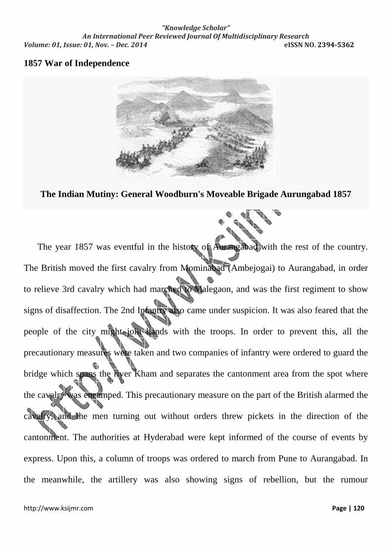
1857 War of Independence
The Indian Mutiny: General Woodburn's Moveable Brigade Aurungabad 1857
The year 1857 was eventful in the history of Aurangabad with the rest of the country.
The British moved the first cavalry from Mominabad (Ambejogai) to Aurangabad, in order
to relieve 3rd cavalry which had marched to Malegaon, and was the first regiment to show
signs of disaffection. The 2nd Infantry also came under suspicion. It was also feared that the
people of the city might join hands with the troops. In order to prevent this, all the
precautionary measures were taken and two companies of infantry were ordered to guard the
bridge which spans the river Kham and separates the cantonment area from the spot where
the cavalry was encamped. This precautionary measure on the part of the British alarmed the
cavalry, and the men turning out without orders threw pickets in the direction of the
cantonment. The authorities at Hyderabad were kept informed of the course of events by
express. Upon this, a column of troops was ordered to march from Pune to Aurangabad. In
the meanwhile, the artillery was also showing signs of rebellion, but the rumour

“Knowledge Scholar”
An International Peer Reviewed Journal Of Multidisciplinary Research
Volume: 01, Issue: 01, Nov. – Dec. 2014 eISSN NO. 2394-5362
http://www.ksijmr.com Page | 121
of Bombay troops marching towards Aurangabad had a quieting effect. The men of the
cavalry also returned to their posts.
The Pune force was under the command of General Woodburn, and consisted of three
troops of, the 14th Hussars under Captain Gall, Captain Woodcombe's battery of European
artillery, and the 24th Bombay infantry under Colonel Folliot. Upon his arrival, General
Woodburn marched straight to the encampment of the 3rd Cavalry, and the disaffected
regiment was ordered out to a dismounted parade. The rissaldar of the first troop was
directed to call out the names of the revolutionaries, and commenced by giving the name of
the senior jamadar, who ordered his men to load their carbines. By this time the General with
his staff and the English officers were mixed up with the disaffected troops, and hence the
guns could not be used to put down the latter. In the confusion that followed, some of the
troopers broke away, ran to their horses and fled away. The guns were fired upon them and
the Hussars were sent in pursuit; but several of them managed to escape. A dafadar of the
cavalry, Mir Fida Ali by name, fired a shot at his commanding officer, Captain Abbott. For
this act of his, he was tried by a drum-head, court-martial led and hanged. The court-martial
continued its sittings, and 24 of these brave men were condemned, of whom 21 were, shot
and 3 mercilessly blown away from guns. About two-thirds of the regiment which had
remained quiet was marched to Edalabad and recruited to its full strength by men from the
other three regiments of the cavalry. Subsequently the third cavalry served throughout the
campaign under Sir Hugh Rose.
“Knowledge Scholar”
An International Peer Reviewed Journal Of Multidisciplinary Research
Volume: 01, Issue: 01, Nov. – Dec. 2014 eISSN NO. 2394-5362
http://www.ksijmr.com Page | 122
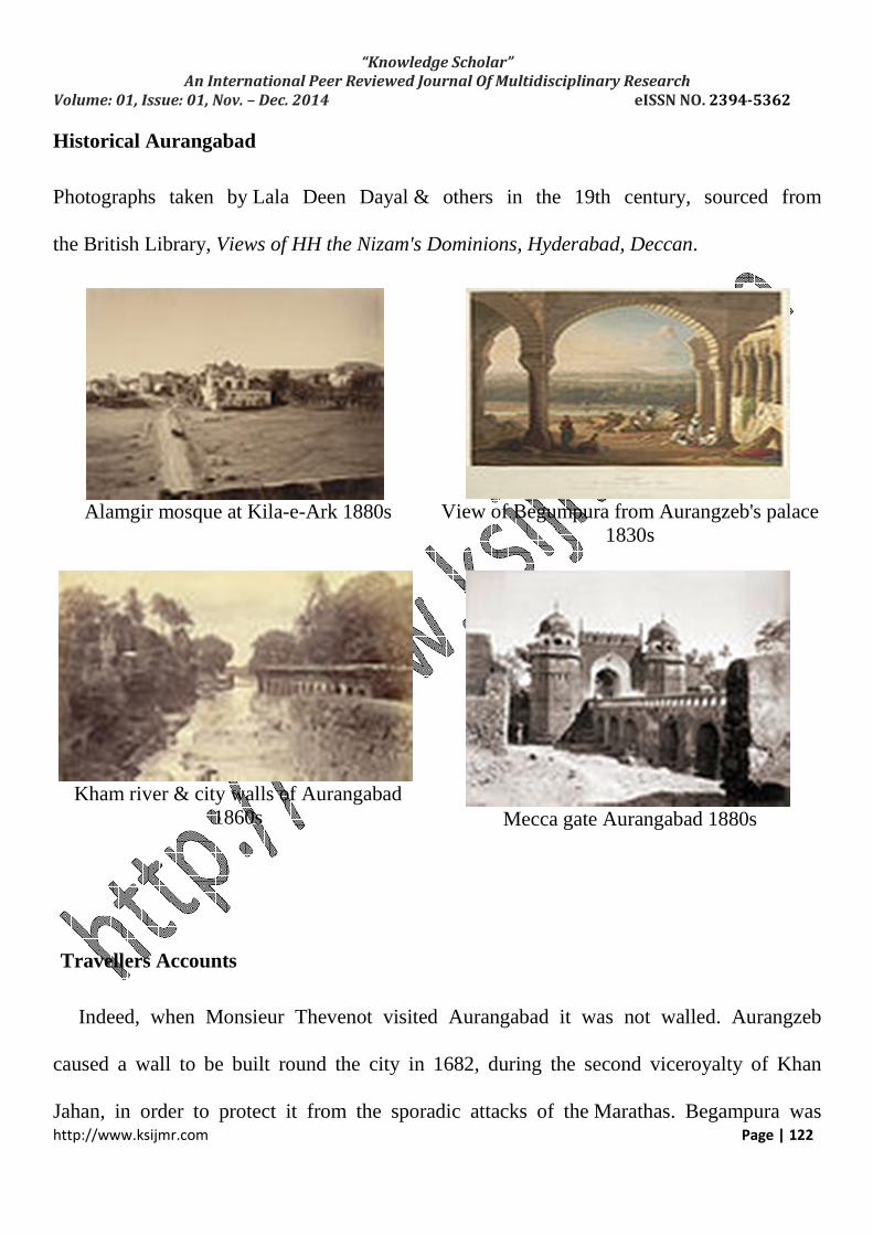
Historical Aurangabad
Photographs taken by Lala Deen Dayal & others in the 19th century, sourced from
the British Library, Views of HH the Nizam's Dominions, Hyderabad, Deccan.
Alamgir mosque at Kila-e-Ark 1880s
View of Begumpura from Aurangzeb's palace 1830s
Kham river & city walls of Aurangabad 1860s
Mecca gate Aurangabad 1880s
Travellers Accounts
Indeed, when Monsieur Thevenot visited Aurangabad it was not walled. Aurangzeb
caused a wall to be built round the city in 1682, during the second viceroyalty of Khan
Jahan, in order to protect it from the sporadic attacks of the Marathas. Begampura was

“Knowledge Scholar”
An International Peer Reviewed Journal Of Multidisciplinary Research
Volume: 01, Issue: 01, Nov. – Dec. 2014 eISSN NO. 2394-5362
http://www.ksijmr.com Page | 123
similarly fortified in 1696. The city wall is terraced, and is of solid masonry. It is of no great
height, at places not more than fourteen feet. The battlements are loopholed for musketry,
and the merlins over the gateways and at certain places along the wall, are
machicolated. Semicircular bastions surmounted by towers, occur at each flanking angle, and
at regular intervals along the works. The total length of the wall is a little over six miles. The
wall has not been able to survive the ravages of time and lies practically in rains. It was
pierced with thirteen gateways, exclusive of a small postern wicket. The four principal gates
faced the cardinal points and consisted of the Delhi gate on the north, the Jalna gate on the
east, the Paithan gate on the south, and the Mecca gate on the west. Besides these, there were
the Jaffar, Khirki, Barapul, Mahmud, Roshan, Khizi, Khadgar, Mada and Kumhar gates. The
Barapul had also been walled up for some time; and at a distance of three-fourth mile from it,
the city road runs through a large squarestone gateway, called Barkul, ascribed to Malik
Ambar. The town has spilt much beyond the fortifications.
Dr. Bradley in his ‘Statistics of the City of Aurangabad’ gives a picturesque description of
the city and its environs as he viewed it from the tower upon the corner bastion at the north-
east angle of the city wall: "Below is seen the town partly lying in the hollow and partly
covering the high grounds rising all round, except towards the north-east and south-west,
which is the direction of a valley where a perennial stream meanders. The buildings are
neatly concealed in thick foliage, and were it not for a dome or minaret peering out here and
there, the observer might imagine that he was gazing upon a forest. Beautiful clumps of
mango and tamarind trees, upon the outskirts increase the illusion. Seldom is a more varied

“Knowledge Scholar”
An International Peer Reviewed Journal Of Multidisciplinary Research
Volume: 01, Issue: 01, Nov. – Dec. 2014 eISSN NO. 2394-5362
http://www.ksijmr.com Page | 124
and beautiful landscape than is here presented; and the palms and minarets scattered about
the town, confer a character peculiarly eastern upon the scenery. Looking westward beyond
the city walls, the... cantonment is seen occupying a large space of ground. Further in the
distance two or three isolated bills observed cutting the horizon. On the summit of one of
them stands the remarkable fortress of Daulatabad; and behind it the bluff headland of the
northern range fades way into misty indistinctness".
Bibi K Maqbara
Bibi Ka Maqbara is a maqbara located in Aurangabad, Maharashtra, India. It was
commissioned by the sixth Mughal Emperor Aurangzeb in the late 17th century in the
memory of his first wife, Dilras Banu Begum (posthumously known as Rabia-ud-Daurani). It
bears a striking resemblance to the famous Taj Mahal, the mausoleum of his
mother, Mumtaz Mahal. Aurangzeb was not very interested in architecture, though he had
built the small, but elegant, Pearl Mosque at Delhi. The Bibi Ka Maqbara was the largest
structure that he had to his credit.
The comparison to the Taj Mahal has often obscured its very own considerable
charm. Due to its strong resemblance to the Taj Mahal, it is also called the Dakkhani Taj (Taj
of the Deccan). Bibi Ka Maqbara is the principal monument of Aurangabad and its historic
city. An inscription found on the main entrance door mentions that this mausoleum was

“Knowledge Scholar”
An International Peer Reviewed Journal Of Multidisciplinary Research
Volume: 01, Issue: 01, Nov. – Dec. 2014 eISSN NO. 2394-5362
http://www.ksijmr.com Page | 125
designed and erected by Ata-ullah, an architect and Hanspat Rai, an engineer respectively.
Ata-ullah was the son of Ustad Ahmad Lahauri, the principal designer of the Taj Mahal.
History
Bibi ka Maqbara is believed to be built between 1651 and 1661 C.E. According to the
"Tarikh Namah" of Ghulam Mustafa, the cost of construction of the mausoleum was Rs.
6,68,203-7 (Rupees Six Lakh, Sixty Eight Thousand, Two Hundred and Three & Seven
Annas) -- Aurangzeb allocated only Rs. 7,00,000 for its construction. An inscription found
on the main entrance door mentions that this mausoleum was designed and erected by Ata-
ullah, an architect and Hanspat Rai, an engineer respectively. The marble for this mausoleum
was brought from mines near Jaipur. According to Tavernier, around three hundred carts
laden with marbles, drawn by at least 12 oxen were seen by him during his journey from
Surat to Golconda. The mausoleum was intended to rival the Taj Mahal, but, the decline in
architecture and proportions of the structure (both due to the severe budgetary constraints
imposed by Aurangzeb) had resulted in a poor copy of the latter.
Structure
Bird's eye view of the Bibi Ka Maqbara

“Knowledge Scholar”
An International Peer Reviewed Journal Of Multidisciplinary Research
Volume: 01, Issue: 01, Nov. – Dec. 2014 eISSN NO. 2394-5362
http://www.ksijmr.com Page | 126
The mausoleum is laid out in a Charbagh layout and stands at the centre of a huge
enclosure measuring approximately 458 m. N-S X 275 m. E-W. Baradaris or pillared
pavilions are located at the centre of north, east and western part of the enclosure wall. The
high enclosure wall is crenellated with pointed arched recesses and bastions at regular
intervals. The recesses are divided by pilasters, crowned with small minarets. The
mausoleum is built on a high square platform with four minarets at its corners, which is
approached by a flight of steps from the three sides. A mosque is found to the west of the
main structure, which was a later addition caused by the Nizam of Hyderabad, resulting in
closure of the entrance from the west side.
Entry to the mausoleum is through a main entrance gate on its south, which has foliage
designs on brass plate on wood covering from the exterior. After passing through the
entrance a small tank is provided and a low profile screen wall leads to the main structure.
The screened pathway has a series of fountains at its centre.
The mausoleum is encased with marble up to the dado level. Above the dado level, it is
constructed of basaltic trap up to the base of dome; the latter is again built of marble. A fine
plaster covers the basaltic trap and given a fine polished finish and adorned with fine stucco
decorations. The mortal remains of Rabia Daurani are placed below the ground level
surrounded by an octagonal marble screen with exquisite designs, which can be approached
by a descending flight of steps. The roof of this chamber that corresponds to the ground level
of the mausoleum is pierced by an octagonal opening and given a low barricaded marble
screen. This makes the tomb viewable from the ground level through this octagonal opening.

“Knowledge Scholar”
An International Peer Reviewed Journal Of Multidisciplinary Research
Volume: 01, Issue: 01, Nov. – Dec. 2014 eISSN NO. 2394-5362
http://www.ksijmr.com Page | 127
The mausoleum is crowned by a dome pierced with trellis works and accompanying panels
decorated with flower designs.
Architecture
In the form of a hexagon and angles are ornamented with minarets. Bibi-ka-maqbara was
built in 1660 by prince Azam Shah in the memory of his mother, Dilras Banu Begam. In
1720, Nizam-ul-Mulk Asif Jah, a distinguished General of Aurangzeb with the intention of
founding his own dynasty in the Deccan, arrived at Aurangabad and made it his capital. He
paid a visit to Delhi in 1723, but returned in 1724. Nizam Ali Khan Asaf Jah II transferred
his capital from Aurangabad to Hyderabad in 1763
Panchakki
Panchakki also known as the water mill, takes its name from the mill which used to grind
grain for the pilgrims. This monument located inAurangabad, Maharastra, displays the
scientific thought process put in medieval Indian architecture. It was designed to generate
energy via water brought down from a spring on a mountain. The building, attached to the
dargah of Baba Shah Musafir a Sufi saint is located in a garden near the Mahmud
Darvaza and consist of a mosque, a madrissa, a kacheri, a minister's house, a sarai and
houses for zananas.

“Knowledge Scholar”
An International Peer Reviewed Journal Of Multidisciplinary Research
Volume: 01, Issue: 01, Nov. – Dec. 2014 eISSN NO. 2394-5362
http://www.ksijmr.com Page | 128
Panchakki fountain, Aurangabad.
History
Most of the buildings in the dargah complex (including Panchakki) were erected by
Turktaz Khan, a noble on the staff ofNizam-ul-Mulk Asaf Jah in about 1695 A. D. The
oblong reservoir in front of the mosque and fountains were added 20 years later by Jamil Beg
Khan. Dating back to the 17th century, this ingenious water mill was designed to use the
energy generated by flowing water from a nearby spring to turn the large grinding stones of
the flour mill. Shah Mosafar died in Hijri1110. This water mill was used to grind grain for
the pilgrims and disciples of saints as well as for the troops of the garrison.
“Knowledge Scholar”
An International Peer Reviewed Journal Of Multidisciplinary Research
Volume: 01, Issue: 01, Nov. – Dec. 2014 eISSN NO. 2394-5362
http://www.ksijmr.com Page | 129
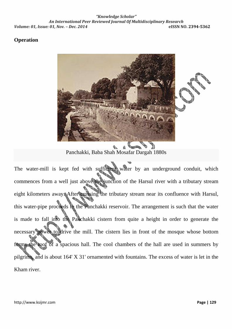
Operation
Panchakki, Baba Shah Mosafar Dargah 1880s
The water-mill is kept fed with sufficient water by an underground conduit, which
commences from a well just above the junction of the Harsul river with a tributary stream
eight kilometers away. After crossing the tributary stream near its confluence with Harsul,
this water-pipe proceeds to the Panchakki reservoir. The arrangement is such that the water
is made to fall into the Panchakki cistern from quite a height in order to generate the
necessary power to drive the mill. The cistern lies in front of the mosque whose bottom
forms the roof of a spacious hall. The cool chambers of the hall are used in summers by
pilgrims, and is about 164' X 31' ornamented with fountains. The excess of water is let in the
Kham river.

“Knowledge Scholar”
An International Peer Reviewed Journal Of Multidisciplinary Research
Volume: 01, Issue: 01, Nov. – Dec. 2014 eISSN NO. 2394-5362
http://www.ksijmr.com Page | 130
A fine view of the Kham river can be had from the windows of this hall. There is also a
cenotaph to the spiritual preceptor of Baba Musafir Shah and a tomb to his disciple Baba
Shah Mahmood and a few other graves. A huge banyan tree on the southern margin of the
reservoir provides shade and adds beauty to the whole scene. In the North-West corner,
adjacent to the cistern, is the water mill driven entirely by water power. It is said that in the
olden days, grain could be ground without physical effort.
The country here exhibits one of the most picturesque landscapes about Aurangabad. The
Kaula nala skirts the garden, and is first crossed by an old bridge with pointed arches and
then by a second bridge which spans it lower down. The walls of Begampura are to the right
and the city walls are to the left, while Shah Musafir's garden is between the latter and the
river bank. The garden walls descend down to the bed of the nala; and the dargah and the
accompanying buildings, with the cisterns and the fountains that are interspersed, blend
picturesquely with the garden vegetation.
Recent
An 18th century library, housing manuscripts and a number of precious books has been
reopened after 70 years here (Aurangabad). The library treasured about 100,000 books and
writing pieces till Indian independence (1947). However, it was closed down in the 1970s
due to administrative reasons due to which many of the library books were shifted
to Hyderabad. The library presently houses 2,500 books on various subjects related to

“Knowledge Scholar”
An International Peer Reviewed Journal Of Multidisciplinary Research
Volume: 01, Issue: 01, Nov. – Dec. 2014 eISSN NO. 2394-5362
http://www.ksijmr.com Page | 131
history, law, medicine, Sufism, religion and philosophy in Arabic, penned by philosophers,
saints and scholars in Urdu and Persian language.
Neher water system
Nahr water system provided clean water for the people of Aurangabad and its suburbs. It
was created by Malik Ambar who founded the town under the name Khadki and was later
expanded by Aurangzeb in order to facilitate the military activity that became prevalent
under Mughal rule during the 17th century.
Kham river Aurangabad 1860s
“Knowledge Scholar”
An International Peer Reviewed Journal Of Multidisciplinary Research
Volume: 01, Issue: 01, Nov. – Dec. 2014 eISSN NO. 2394-5362
http://www.ksijmr.com Page | 132
History
The first aqueduct in Aurangabad was designed in 1612 by Malik Ambar in order to
address the shortage of water caused by the lack of reservoirs and natural water reserves in
the area. Despite the surrounding landscape, which made it difficult to construct the
aqueducts supporting pillars, the construction went ahead.
The reason for the construction of the aqueduct was the discovery of a subterranean water
supply in the mountainous valleys north of Aurangabad. The consequent construction of
the waterway provided a stable water supply for a population of around seven lakhs (around
seven hundred thousand people), with the city of Aurangabad receiving enough fresh water
to prevent the shortages that had previously occurred. The aqueduct was named Khair-E-Jari.
The construction of such aqueducts continued from 1612 until 1803 with two more
aqueducts constructed by engineers such as Malik Ambar, Shah Mehmood of Panchakki and
Shah Ali Nahri.
Malik Ambar's design was not well received and it was described by Vazir Mullah
Mohammad as imaginary and preposterous. However, Malik Ambar managed to construct it
within fifteen months, at half the estimated cost.
Mughal era water works
The Aurangabad Gazetteer of 1884 states: "The supply of water is abundant. The Ganda or
Kham river washes the western walls and the Bayan Khan nalla, passes through the centre of

“Knowledge Scholar”
An International Peer Reviewed Journal Of Multidisciplinary Research
Volume: 01, Issue: 01, Nov. – Dec. 2014 eISSN NO. 2394-5362
http://www.ksijmr.com Page | 133
the town. Besides these streams, aqueducts convey water from the hills by means of stone
conduits and the supply is distributed through innumerable pipes and fountains. In
Aurangzeb's time, a large marsh or tank extended the whole length of the northern wall, but
the dampness proved unhealthy and he ordered the portion immediately in front of his palace
to be filled in and converted into fields. The remainder is known as the Khizri talao and is
just beyond the Delhi gate. The Kanval or Loti talao was fed by a spring and was confined in
the hollow between the palace of Aurangzeb and the Mecca gate, but the band was purposely
destroyed to save the town from being flooded.
The town of Aurangabad receives its water supply from springs or wells connected with
small underground masonry pipes. The principal water courses are fourteen in number, with
the most important amongst them being the canal that drew its water from the river near
Harsul.
Nahr-e-Ambari water course
The city of Aurangabad had a number of water sources that supplied the city. These were
deemed necessary as the city had a large military population to support. The courses that
have been recorded are:
1. A canal that branched at Gaumukh. One of these branches provided water to Shah
Ganj and the surrounding area whilst the other branch passed theBarakul gate and
provided water to the Naukonda palace, Juna bazaar and the suburbs of Chauk and

“Knowledge Scholar”
An International Peer Reviewed Journal Of Multidisciplinary Research
Volume: 01, Issue: 01, Nov. – Dec. 2014 eISSN NO. 2394-5362
http://www.ksijmr.com Page | 134
Gul Mandi. One of the syphons has been damaged which is preventing water from
flowing through it.
2. The Panchakki waterpipe began at a well which was situated above a junction between
the Harsul river and a tributary. It provided water to the Panchakki reservoir.
3. The Begampura canal, the canal near the Mahomedan garden and the river in between
the walls of Aurangabad and the Begampura suburb.
4. The Palsi water pipe which originated from a well near the village of Palsi. The water
was carried through a 252 foot long dam to a cistern, where it was then directed to the
Baijipura suburb and the Sadar Talukdar garden. At present the pipe is blocked with
silt, with the result being that only a small amount of water can flow through in the
wet season.
5. The Shah Ali Nahr commenced from a well near Devalgaon and supplies a cistern
attached to the shrine of Shah Ali
6. An open irrigation channel takes water from a dam near the Aurangabad cantonment
7. A pipe from Suker supplied two areas with water.
8. Latchman Doss Bairagi's pipe, to the north of Baijapura
9. Lall Munkirar's pipe, which drew its water from a tank north of Baijipura
10. Dul Badul's pipe, near the village of Garkala. There was also a pipe which led from
the same village and supplied water to the cavalry lines.
11. A small pipe which began at Chuasur gardens and also supplied the cavalry lines.

“Knowledge Scholar”
An International Peer Reviewed Journal Of Multidisciplinary Research
Volume: 01, Issue: 01, Nov. – Dec. 2014 eISSN NO. 2394-5362
http://www.ksijmr.com Page | 135
12. Two pipes, one of which began in the village of Devlai whilst the other began in the
Sattara hills. These two pipes united south of the cavalry lines.
Of the water courses listed above, four still supply water to the city of Aurangabad.
Nizam era water works
The construction of the first modern water supply system began in 1932 at the request of
the Nizam and was completed in 1933, at a cost of Rs. 35,50,00. (350,000 rupees) A settling
tank with a capacity of 4.64 lakh (464,000) gallons was installed near the Gaumukh service
reservoir and the distributary system was expanded.
Due to the rapidly increasing population, another water supply system was constructed
at a cost of Rs. 30,56,579 (a little over 300,000 rupees). The Harsul and Kham rivers were
tapped, a reservoir constructed in the Osmanpura area, a filtration system was installed to
purify the water and the distributary system was enlarged (although there was a proposal to
overhaul the entire system rather than enlarge it)
Refrences:-
• Bibi Ka Maqbara. (2014, September 29). Retrieved October 30, 2014, from http://en.wikipedia.org/wiki/Bibi_Ka_Maqbara
• History of Aurangabad, Maharashtra. (2014, August 23). Retrieved September 25, 2014, from http://en.wikipedia.org/wiki/History_of_Aurangabad,_Maharashtra
• eher water system. (2014, August 11). Retrieved September 4, 2014, from http://en.wikipedia.org/wiki/Neher_water_system
• Panchakki. (2014, September 27). Retrieved October 11, 2014, from http://en.wikipedia.org/wiki/Panchakki


![Scanned by CamScanner · Why was Robert Clive appointed as the first Governor of Bengal? [4] Was the in-fighting between Aurangzeb's successors the most important reason for the [14]](https://static.fdocuments.in/doc/165x107/5e74308e7a039640bb1c3803/scanned-by-camscanner-why-was-robert-clive-appointed-as-the-first-governor-of-bengal.jpg)