AUGUST 2011 Jane Addams Memorial Tollway (I-90) … · I-90 TRANSIT VALUE PLANNING STUDY Draft...
51
Jane Addams Memorial Tollway (I-90) Transit Value Planning Study KENNEDY EXPRESSWAY TO ROCKFORD AUGUST 2011 DRAFT - For Review Purposes Only
Transcript of AUGUST 2011 Jane Addams Memorial Tollway (I-90) … · I-90 TRANSIT VALUE PLANNING STUDY Draft...
Jane Addams Memorial Tollway (I-90) Transit Value Planning Study KENNEDY EXPRESSWAY TO ROCKFORD
AUGUST 2011
DRAFT - For Review Purposes Only

I -90 TR AN SIT VALUE PLA N NIN G ST U DY Draft
Illinois Tollway i
TABLE OF CONTENTS
1. INTRODUCTION ........................................................................................................................................... 1
1.1 BACKGROUND ................................................................................................................................................ 1 1.1.1 Tollway Study ......................................................................................................................................... 4 1.1.2 RTA Study ............................................................................................................................................... 5
1.2 PURPOSE OF STUDY ......................................................................................................................................... 6 1.3 STUDY PROCESS .............................................................................................................................................. 6
1.3.1 Meeting 1 – June 7, 2011 ....................................................................................................................... 6 1.3.2 Meeting 2 – July 11, 2011 ...................................................................................................................... 7
2. EXISTING AND PROPOSED CORRIDOR TRANSIT SERVICES............................................................................ 8
2.1 EXISTING RAIL AND BUS SERVICES ...................................................................................................................... 9 2.1.1 Metra Commuter Rail ............................................................................................................................ 9 2.1.2 Pace Suburban Bus ............................................................................................................................... 10
2.2 METRA STAR LINE PROPOSAL ......................................................................................................................... 12 2.3 METRA EXPRESS BUS ALTERNATIVE .................................................................................................................. 14 2.4 PACE I-90 MARKET EXPANSION PROPOSAL ........................................................................................................ 17
2.4.1 Service Elements .................................................................................................................................. 17 2.4.2 Potential Peak Hour Service Level ........................................................................................................ 18 2.4.3 Preliminary Transit Ridership Estimate ................................................................................................ 19 2.4.4 Preliminary Transit Operating Cost Estimate ....................................................................................... 19
2.5 ROCKFORD COMMUTER SERVICES PROPOSAL ..................................................................................................... 20
3. COST REDUCTION STRATEGIES .................................................................................................................. 21
4. CORRIDOR TRANSIT SERVICE STRATEGY .................................................................................................... 23
4.1 SYSTEM CONTEXT .......................................................................................................................................... 23 4.2 PRELIMINARY “HYPOTHESIS” ........................................................................................................................... 23 4.3 STAKEHOLDER INPUT ..................................................................................................................................... 26 4.4 MARKET ASSESSMENT.................................................................................................................................... 27
4.4.1 Evaluation of I-90 Travel Patterns........................................................................................................ 27 4.4.2 I-355 Corridor Transit Study ................................................................................................................. 29
4.5 REFINED SERVICE STRATEGY ................................................................................ ERROR! BOOKMARK NOT DEFINED.
5. INFRASTRUCTURE REQUIREMENTS ........................................................................................................... 36
5.1 DESIGN IMPLICATIONS FOR I-90 RECONSTRUCTION PROJECT ................................................................................. 36 5.2 FEATURES TO BE DETERMINED IN DESIGN PHASE ................................................................................................ 39 5.3 OTHER FACILITIES .......................................................................................................................................... 42
6. CONCEPTUAL COST ESTIMATE ................................................................................................................... 45
7. PRELIMINARY TRANSIT RIDERSHIP ESTIMATES .......................................................................................... 46
8. PRELIMINARY TRANSIT OPERATING COST ESTIMATES ............................................................................... 47
9. NEXT STEPS ............................................................................................................................................... 48
I -90 TR AN SIT VALUE PLA N NIN G ST U DY Draft
Illinois Tollway 1
1. INTRODUCTION
This report describes the process, methodology, and results of work conducted by the Illinois Tollway (Tollway), in coordination with the Regional Transportation Authority (RTA) and other stakeholder agencies, to refine transit options in the Jane Addams Memorial Tollway (I-90) corridor.
1.1 Background
The Jane Addams Memorial Tollway (I-90) is a 77-mile segment of the Illinois Tollway system extending from near the Wisconsin border to the Kennedy Expressway (see Figure 1.1). This northwest corridor serves travelers from various communities including Rockford, Elgin, Schaumburg, Rosemont, and Chicago. Drivers use the route for over 165,000 trips per day east of the Fox River, and over 35,000 trips per day west of the Fox River. I-90 carries commuter and long-distance commercial traffic, as well as heavy volumes of weekend travel in summer and fall.
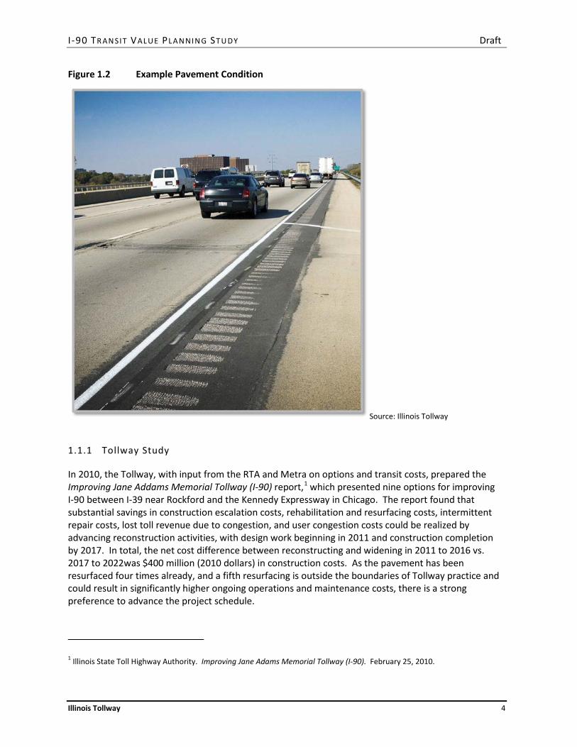
Most of the I-90 infrastructure is more than 50 years old. Since it was originally built in the 1950s, residential and commercial growth has strained parts of I-90 beyond its capacity, increasing delays and weakening economic activity. Although the pavement has been periodically resurfaced and repaired, most of I-90’s pavement is near the end of its useful life (see Figure 1.2).
The Tollway’s multi-year Congestion-Relief Program (CRP) has already delivered significant improvements to I-90, including reconstruction and widening of 16 miles from Newburg Road to Rockton Road near the Wisconsin border, construction of a new I-90/I-39 interchange at Cherry Valley, and completion of Open Road Tolling at all five mainline toll plazas. While these improvements have provided congestion relief and reduced travel times, additional improvements are needed between I-39 and the Kennedy Expressway to address the corridor’s aging pavement and to meet traveler’s needs now and in the future. Future needs include an additional travel lane in each direction, increasing from two to three lanes in each direction between I-39 and the Elgin Toll Plaza and from three to four lanes in each direction between the Elgin Toll Plaza and the Kennedy Expressway.
The current CRP includes funding for pavement rehabilitation and resurfacing between Newburg Road and the Kennedy Expressway through 2015 at a cost of nearly $300 million (2010 dollars). Intermittent repairs at additional cost are also expected to be needed to maintain the pavement in acceptable condition. Reconstruction would take place beyond the CRP horizon of 2016, with work on the various segments between 2018 and 2021.
Over the last two decades, several proposals have been advanced to introduce fixed guideway transit service in the I-90 corridor. The Metra Suburban Transit Access Route, or STAR Line, proposal has received the most detailed and recent study. The 55-mile route, connecting Joliet to O'Hare International Airport, combines two dedicated transportation corridor segments. The 19-mile Northwest Corridor Segment would run from the O’Hare Transfer station on the Metra North Central Service (NCS) Line to the I-90 median, where it would serve the communities of Des Plaines, Elk Grove Village, Arlington Heights, Rolling Meadows, Schaumburg, and Hoffman Estates. At the intersection with the CN Railroad (the former Elgin, Joliet and Eastern (EJ&E) Railroad) near IL-59 and the Prairie Stone development, the 36-mile Outer Circumferential Corridor Segment would run along the railroad corridor to Joliet. Metra is in the final stages of completion of an Alternatives Analysis of the STAR Line,
I -90 TR AN SIT VALUE PLA N NIN G ST U DY Draft
Illinois Tollway 2
which included a detailed evaluation and comparison of rail service and Express Bus Service (EBS) along the route.
The segment of I-90 between Randall Road in Elgin and River Road in Rosemont is the primary focus of the Transit Value Planning Study. Based on stakeholder input, this area is somewhat larger than the segment between IL-59 and O’Hare that was the primary focus of the STAR Line Alternatives Analysis. The study also considers implications of transit services that operate to locations further west, including areas around Elgin and Rockford.

I -90 TR AN SIT VALUE PLA N NIN G ST U DY Draft
Illinois Tollway 3
Figure 1.1 I-90 Corridor Map
Source: RTA, Illinois Tollway
I -90 TR AN SIT VALUE PLA N NIN G ST U DY Draft
Illinois Tollway 4
Figure 1.2 Example Pavement Condition
Source: Illinois Tollway
1.1.1 Tollway Study
In 2010, the Tollway, with input from the RTA and Metra on options and transit costs, prepared the Improving Jane Addams Memorial Tollway (I-90) report,1 which presented nine options for improving I-90 between I-39 near Rockford and the Kennedy Expressway in Chicago. The report found that substantial savings in construction escalation costs, rehabilitation and resurfacing costs, intermittent repair costs, lost toll revenue due to congestion, and user congestion costs could be realized by advancing reconstruction activities, with design work beginning in 2011 and construction completion by 2017. In total, the net cost difference between reconstructing and widening in 2011 to 2016 vs. 2017 to 2022was $400 million (2010 dollars) in construction costs. As the pavement has been resurfaced four times already, and a fifth resurfacing is outside the boundaries of Tollway practice and could result in significantly higher ongoing operations and maintenance costs, there is a strong preference to advance the project schedule.
1 Illinois State Toll Highway Authority. Improving Jane Adams Memorial Tollway (I-90). February 25, 2010.

I -90 TR AN SIT VALUE PLA N NIN G ST U DY Draft
Illinois Tollway 5
The report also found that the additional right-of-way, bridge expansions, striping, lighting, intelligent transportation systems, utilities, and utility relocations needed to accommodate either STAR Line alternative, Express Bus Service (EBS) or rail service, would increase the cost of the I-90 reconstruction and add lanes project by $667 million to $810 million, depending on the alternative. The EBS option assumed that buses would operate in the new fourth (inside) lane between up to nine stations located in the median between IL-59 and Rosemont. The rail option assumed that trains would operate in the median between IL-59 and O’Hare. In addition, $525 million or $1,100 million would be required for stations, parking lots, track, rolling stock, and other elements needed to make the EBS or rail service operational, respectively.
1.1.2 RTA Study
In 2011, the RTA, in coordination with the Tollway, prepared the I-90 Transit Options Analysis report,2 which assessed the financial impact and potential innovative delivery alternatives for transit options being considered as part of the Tollway’s I-90 rehabilitation and expansion project. The report evaluated two transit options similar to those above. The EBS option included the reconstruction of the current three lanes and the addition of a fourth managed lane between the Prairie Stone Complex in Hoffman Estates and River Road in Rosemont, with median stations and associated access points to the managed lane. The rail option included the reconstruction of the current three lanes, the addition of a fourth managed lane, and the construction of tracks and stations in the median. Under both transit options, the managed lane would operate with “dynamic tolling” whereby the incremental price of using the lane (above that of the other three lanes in each direction) would vary to maintain operating speeds above a minimum standard, such as 45 to 50 miles per hour. Each transit option was compared to a baseline scenario in which the fourth lane would operate in the same manner as the other lanes.
Using traffic and revenue forecasts prepared by Wilbur Smith Associates, the study found that the managed lanes could generate net revenue (after operating and maintenance expenses) with a present value of $1.1 billion (2009 dollars) over a 50-year period beginning in 2020. On average, this amounts to about $20 million per year in current dollars.
Assuming the same 16,000 boardings per day as the STAR Line option, the EBS option would generate fare revenue of $5.7 million per year (2010 dollars), compared to $16.0 million for the rail option. Based on operating and maintenance costs provided by Metra, the EBS option would cost $3.6 million per year to operate, compared to $29.2 million for the rail option. Other bus services were assumed to operate in the corridor and provide connections to these services, but are not included in these cost estimates. The net present value of the EBS transit operation would be an additional $43 million (2009 dollars) over the same 50-year period, compared to an operating shortfall of $363 million for the rail option.
Using capital cost estimates provided by Metra, the study found that the EBS option would cost $3.4 billion (2010 dollars), compared to $4.1 billion for the rail option. Even with its lower capital and operating costs and its net operating profit, the EBS option would still require additional funding of more than $2.2 billion, compared to $3.4 billion for the rail option. The report discussed strategies for
2 Regional Transportation Authority. I-90 Transit Options Analysis. Draft January, 2011. Prepared by KPMG, LLP.

I -90 TR AN SIT VALUE PLA N NIN G ST U DY Draft
Illinois Tollway 6
filling the funding gap, including federal funding programs and potential commercial structures for private delivery.
The report concluded that the EBS option was the most cost-effective transit option and that it would benefit from additional value engineering. Several opportunities to reduce cost estimates were identified, including removal of EBS passing lanes at stations, reduction in planned station infrastructure, and reduced level of feeder bus service.
1.2 Purpose of Study
The purpose of the I-90 Transit Value Planning Study is to develop a transit alternative and conceptual cost estimate that uses a managed lane to accommodate a bus system with a reduced footprint as compared to the EBS option evaluated in the Metra STAR Line Alternatives Analysis.
1.3 Study Process
The I-90 Transit Value Planning Study was conducted through a series of workshop meetings of the I-90 Corridor Transit Planning Committee. The Committee included representatives of the Tollway (staff and consultants), the RTA and its service boards (CTA, Metra, and Pace), the Illinois Department of Transportation (IDOT), the Chicago Metropolitan Agency for Planning (CMAP), the Rockford Metropolitan Agency for Planning (RMAP), the Northwest Municipal Conference (NWMC), and municipalities in the corridor, including Chicago, Schaumburg and Hoffman Estates.
1.3.1 Meeting 1 – June 7, 2011
The purpose of the first meeting of the I-90 Corridor Transit Planning Committee, held on June 7, 2011, was to define a representative transit operating strategy that uses a managed lane to accommodate a bus system with a reduced footprint as compared to the EBS option evaluated in the Metra STAR Line Alternatives Analysis.
Background on the I-90 reconstruction project was provided, including the EBS and rail transit options that have been previously evaluated in the STAR Line Alternatives Analysis. Typical cross sections and station plans were presented.
A summary of travel patterns from previous market analysis studies was provided, existing transit services in the corridor were described, and a recent Pace proposal for expanded express bus services, local circulators, and park-and-ride facilities in the corridor was summarized. A preliminary concept for transit operations with a reduced footprint in the corridor was outlined for discussion. This “hypothesis” concept defined a potential running way treatment, transit operating concept, station locations, and priority access assumptions. These assumptions would be used to identify transit infrastructure requirements and cost estimates for the I-90 reconstruction project.
I -90 TR AN SIT VALUE PLA N NIN G ST U DY Draft
Illinois Tollway 7
1.3.2 Meeting 2 – July 11, 2011
The purpose of the second meeting of the Committee was to present and gain concurrence on a proposed concept for transit operations in the I-90 corridor based on comments received at Meeting 1 and subsequent work.
The design characteristics of the planned managed lane and a design strategy for roadway typical sections that would accommodate a phased implementation of transit services in the corridor were presented for discussion. A recent CMAQ funding application by Pace for express bus, arterial, and call-and-ride services along I-90 between Randall Road and Rosemont, which is generally consistent with the “hypothesis” transit service concept presented at Meeting 1 was adopted as a placeholder for the transit service that would operate initially in the managed lane. Several ideas for park-and-ride facility sites at five locations, including Randall Road, IL-25, Beverly Road, IL-59, and Barrington Road were also discussed.

I -90 TR AN SIT VALUE PLA N NIN G ST U DY Draft
Illinois Tollway 8
2. EXISTING AND PROPOSED CORRIDOR TRANSIT SERVICES
The I-90 corridor has evolved into one of the most intensively developed activity corridors in the Chicago metropolitan region. Reflecting strong growth over the last 50 years, traffic has increased more than 400 percent along portions of I-90 since 1959. The northwest suburbs contain a major concentration of employment, including headquarters or regional offices of major national or international corporations. Population and employment projections suggest continued intensification of residential and commercial activity. This section describes the existing and proposed transit services in the corridor.
Services along I-90, generally bounded by River Road on the east, the Metra Union Pacific Northwest (UP-NW) Line on the north, Randall Road on the west, and the Metra Milwaukee District West (MD-W) Line on the south are the focus of this analysis. Consideration is also given to proposed transit services operating between this area and the Rockford area. Figure 2.1 shows a portion of the RTA system map covering the primary study area, delineating existing Metra commuter rail and Pace Suburban Bus routes as described in Section 2.1 below.
Figure 2.1 Existing RTA Transit Services
Source: RTA System Map, January 2011.
I -90 TR AN SIT VALUE PLA N NIN G ST U DY Draft
Illinois Tollway 9
2.1 Existing Rail and Bus Services
This section describes the existing rail and bus transit services in the primary study area. With major regional transit centers at Rosemont (CTA station at River Road), Schaumburg (Northwest Transportation Center, or NWTC), and Elgin (downtown Metra station) and a major concentration of activity around the I-90 / IL-53 / I-290 system interchange in Schaumburg, a distinction is made between services operating between these locations where appropriate.
2.1.1 CTA Rail
The CTA Blue Line provides heavy rail transit service between O’Hare International Airport, downtown Chicago, and Forest Park with stops at 34 stations. The service runs 24 hours per day with headways of as little as 3 to 4 minutes between trains (15 to 20 trains per hour in each direction) during peak commuting periods. The frequent service provides more than 100 trains in each direction on weekdays.
The Rosemont station at River Road is a major connection point with suburban bus services. Eleven Pace routes serve this station, including Routes 221, 223, 230, 284, 325, 326, 332, 606, 610, 616, 637. In 2010, average weekday ridership at Rosemont was 4,451 entries, or about 3.6 percent of the 122,057 average weekday entries along the entire Blue Line. This is approximately one-half of the 8,921 entries at the O’Hare station and corresponds to the average ridership at stations on the northwest segment of the Blue Line between the Grand and O’Hare stations.
2.1.2 Metra Commuter Rail
Commuter rail service to communities located north of I-90 is provided by the Metra Union Pacific - Northwest (UP-NW) Line. Service extends from Ogilvie Transportation Center in downtown Chicago to Harvard, with 21 intermediate station locations. In 2006, typical weekday boardings on the UP-NW Line were approximately 34,250, with ridership remaining steady over the preceding decade. Boardings clearly reflect a commuter use pattern, with nearly 79 percent of inbound boardings occurring in the morning peak period, and 74 percent of outbound boardings occurring in the afternoon peak period.
Commuter rail service to communities located south of I-90 is provided by the Metra Milwaukee District - West (MD-W) Line. Service extends from Union Station in downtown Chicago to Big Timber Road in Elgin, with 20 intermediate station locations. In 2006, typical weekday boardings on the MD-W Line were approximately 22,350, with ridership remaining steady over the preceding decade. Boardings on this line also clearly reflect a commuter use pattern, with just over 78 percent of inbound boardings occurring in the morning peak period, and 76 percent of outbound boardings occurring in the afternoon peak period in that same year.
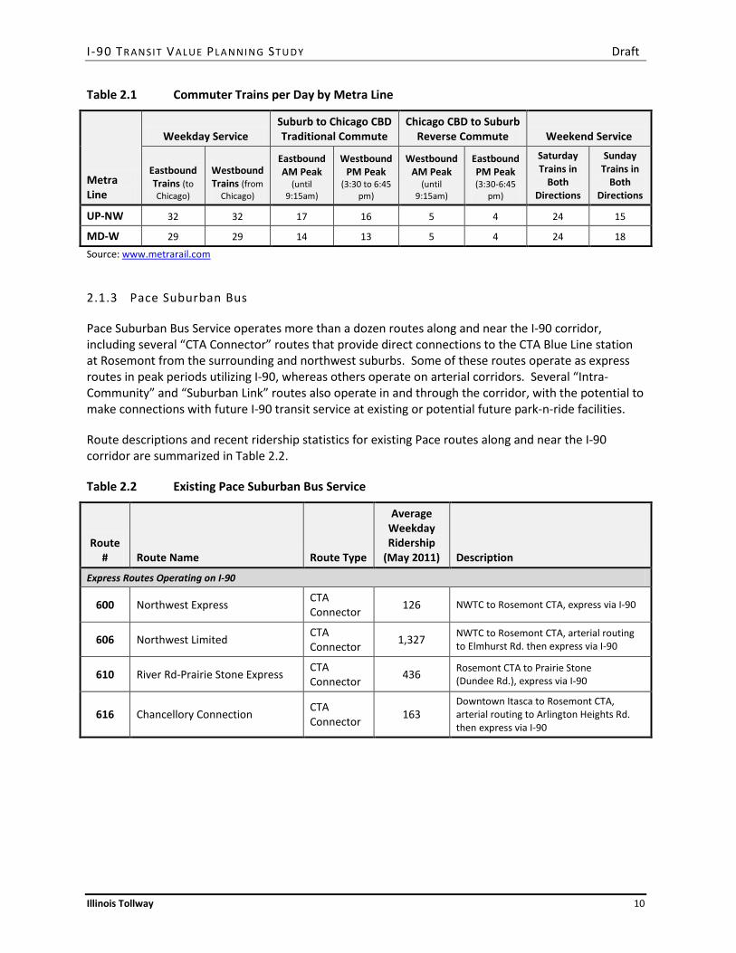
Like the rest of the Metra system, service on the UP-NW and MD-W Lines is oriented toward downtown Chicago, and functions primarily to move suburban workers to and from jobs in downtown Chicago on weekdays. As Table 2.1 highlights, service is focused primarily on traditional work trip commutes with inbound morning peak period service and outbound afternoon peak period service, although off-peak and weekend service is also provided.
I -90 TR AN SIT VALUE PLA N NIN G ST U DY Draft
Illinois Tollway 10
Table 2.1 Commuter Trains per Day by Metra Line
Metra Line
Weekday Service Suburb to Chicago CBD Traditional Commute
Chicago CBD to Suburb Reverse Commute Weekend Service
Eastbound Trains (to Chicago)
Westbound Trains (from
Chicago)
Eastbound AM Peak
(until 9:15am)
Westbound PM Peak
(3:30 to 6:45 pm)
Westbound AM Peak
(until 9:15am)
Eastbound PM Peak (3:30-6:45
pm)
Saturday Trains in
Both Directions
Sunday Trains in
Both Directions
UP-NW 32 32 17 16 5 4 24 15
MD-W 29 29 14 13 5 4 24 18
Source: www.metrarail.com
2.1.3 Pace Suburban Bus
Pace Suburban Bus Service operates more than a dozen routes along and near the I-90 corridor, including several “CTA Connector” routes that provide direct connections to the CTA Blue Line station at Rosemont from the surrounding and northwest suburbs. Some of these routes operate as express routes in peak periods utilizing I-90, whereas others operate on arterial corridors. Several “Intra-Community” and “Suburban Link” routes also operate in and through the corridor, with the potential to make connections with future I-90 transit service at existing or potential future park-n-ride facilities.
Route descriptions and recent ridership statistics for existing Pace routes along and near the I-90 corridor are summarized in Table 2.2.
Table 2.2 Existing Pace Suburban Bus Service
Route # Route Name Route Type
Average Weekday Ridership
(May 2011) Description
Express Routes Operating on I-90
600 Northwest Express CTA Connector 126 NWTC to Rosemont CTA, express via I-90
606 Northwest Limited CTA Connector 1,327 NWTC to Rosemont CTA, arterial routing
to Elmhurst Rd. then express via I-90
610 River Rd-Prairie Stone Express CTA Connector 436 Rosemont CTA to Prairie Stone
(Dundee Rd.), express via I-90
616 Chancellory Connection CTA Connector 163
Downtown Itasca to Rosemont CTA, arterial routing to Arlington Heights Rd. then express via I-90

I -90 TR AN SIT VALUE PLA N NIN G ST U DY Draft
Illinois Tollway 11
Table 2.2 Existing Pace Suburban Bus Service (continued)
Route # Route Name Route Type
Average Weekday Ridership
(May 2011) Description
Arterial Routes Serving the CTA Blue Line Station, Rosemont
221 Wolf Road CTA Connector 873 Wolf Rd. north to Willow Rd.
(Prospect Heights)
223 Elk Grove Rosemont Station CTA Connector 1,769 Elk Grove loop route via Busse/Devon
230 South Des Plaines CTA Connector 475 United HQ via downtown Des Plaines
325 25th Avenue CTA Connector 519 25th Ave. south to Cermak Rd.
326 West Irving Park CTA Connector 288 Norridge via Irving Park Rd.
332 River-York Roads CTA Connector 481 Oak Brook via Irving Park Rd. and York Rd.
Arterial Routes Serving the Northwest Transportation Center, Schaumburg
208 Golf Road CTA Connector 1,953 Linking NWTC to Davis St. CTA (Evanston)
554 Elgin-Streamwood-Schaumburg Suburban Link 147 NWTC west to downtown Elgin via
Golf Rd., Barrington Rd., IL-19
696 Woodfield-Arlington Hts Randhurst
Suburban Link 341 NWTC to Randhurst Mall via downtown
Arlington Heights
757 Northwest Connection CTA Connector 174 NWTC to Elk Grove via Busse/Devon
905 Schaumburg Trolley Intra-Community 22 Local loop route accessing NWTC
Arterial Routes Serving Elgin
543 Dundee Intra-Community 344 Downtown Elgin to East Dundee via IL-25
550 Big Timber-Randall Rd Intra-Community 185 Downtown Elgin to NW Corporate Park via
Big Timber Rd. and Randall Rd.
552 North State-Spring Hill Mall Intra-Community 361 Downtown Elgin to West Dundee via IL-31
Source: www.rtams.com and RTA System Map (January 2011).
Based on current Pace on-line schedules for the routes utilizing I-90 to provide peak hour express service, the approximate number of Pace buses operating per hour per direction on I-90 is estimated in Table 2.3. Bus counts were estimated for the east (Rosemont to Schaumburg) segment and the west segment (Schaumburg to Elgin).

I -90 TR AN SIT VALUE PLA N NIN G ST U DY Draft
Illinois Tollway 12
Table 2.3 Current Buses per Hour per Direction on I-90, East and West Segments
Buses per Peak Hour
Westbound Buses per Peak Hour
Eastbound
East Segment (Rosemont CTA to NWTC-Schaumburg)
Morning Peak (6:00-9:00 a.m.) 8 6
Evening Peak (3:00-6:00 p.m.) 6 8
West Segment (NWTC-Schaumburg to Elgin)*
Morning Peak (6:00-9:00 a.m.) 2 1
Evening Peak (3:00-6:00 p.m.) 1 2 Source: HNTB * Current express service extends west only to Prairie Stone (Beverly Road).
2.2 Metra STAR Line Proposal
The 55-mile Suburban Transit Access Route, or STAR Line, has been proposed to supplement Metra’s established ”hub-and-spoke” passenger rail service, by providing a circumferential connection extending from Joliet to O’Hare airport. Completion of the STAR Line would enable connections between four existing “spoke” services, including the North Central Service (NCS), Milwaukee District-West (MD-W), Union Pacific-West (UP-W) and BNSF lines. The STAR Line would also enable connections to and between several major business and employment centers, in addition to hospitals, colleges and universities. Projected ridership in 2030 on the STAR Line is estimated to be 16,000 daily or 4.8 million annual passenger trips, not including ridership on connecting bus services or other routes in the corridor.
Figure 2.2 depicts the proposed alignment of STAR Line service, extending north from Joliet for approximately 36 miles along the CN (former Elgin, Joliet and Eastern, or EJ&E) railroad corridor through several western suburbs. The line would turn east in Hoffman Estates near the I-90/IL-59 interchange and continue east approximately 19 miles to O’Hare airport in the median of the reconstructed I-90 Tollway. The locally preferred alternative provides for stations along the I-90 corridor at the following locations, listed from west to east:
• Prairie Stone business park (Hoffman Estates) • Barrington Road (Hoffman Estates) • Roselle Road (Schaumburg) • IKEA (Schaumburg) • Golf Road (Rolling Meadows) • Arlington Heights Road (Arlington Heights) • Busse Road (Elk Grove Village) • Elmhurst Road (Des Plaines) • O’Hare Transfer (Rosemont) • River Road (Rosemont)

I -90 TR AN SIT VALUE PLA N NIN G ST U DY Draft
Illinois Tollway 13
Figure 2.2 Proposed Metra STAR Line Alignment
Source: www.metrarail.com
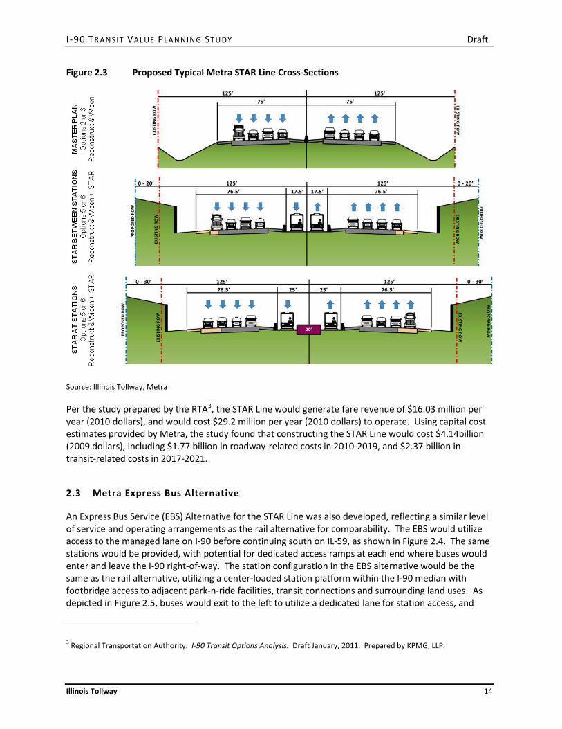
Constructing the STAR Line in the median of I-90 in conjunction with planned lane capacity improvements would require widening of the right-of-way from the existing 250 feet to 290 feet between stations and to 310 feet at station locations. As shown in Figure 2.3, commuter trains would serve center platforms in the median of I-90, which would require footbridge access to adjacent park-n-ride facilities, transit connections and surrounding land uses.
Park-n-ride facilities would be provided near the Tollway, readily accessible from interchange locations, and to the extent feasible local communities would be encouraged to provide walkable activity centers near the station locations. Some communities, including Schaumburg, have undertaken planning studies to identify transit-oriented development opportunities in proximity to potential STAR Line stations, demonstrating a commitment to transit supportive land uses in the I-90 corridor.
I -90 TR AN SIT VALUE PLA N NIN G ST U DY Draft
Illinois Tollway 14
Figure 2.3 Proposed Typical Metra STAR Line Cross-Sections
Source: Illinois Tollway, Metra
Per the study prepared by the RTA3, the STAR Line would generate fare revenue of $16.03 million per year (2010 dollars), and would cost $29.2 million per year (2010 dollars) to operate. Using capital cost estimates provided by Metra, the study found that constructing the STAR Line would cost $4.14billion (2009 dollars), including $1.77 billion in roadway-related costs in 2010-2019, and $2.37 billion in transit-related costs in 2017-2021.
2.3 Metra Express Bus Alternative
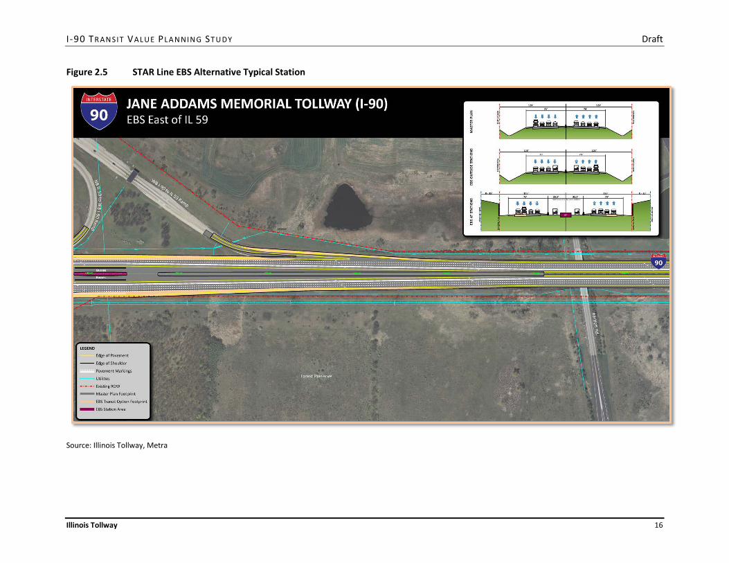
An Express Bus Service (EBS) Alternative for the STAR Line was also developed, reflecting a similar level of service and operating arrangements as the rail alternative for comparability. The EBS would utilize access to the managed lane on I-90 before continuing south on IL-59, as shown in Figure 2.4. The same stations would be provided, with potential for dedicated access ramps at each end where buses would enter and leave the I-90 right-of-way. The station configuration in the EBS alternative would be the same as the rail alternative, utilizing a center-loaded station platform within the I-90 median with footbridge access to adjacent park-n-ride facilities, transit connections and surrounding land uses. As depicted in Figure 2.5, buses would exit to the left to utilize a dedicated lane for station access, and
3 Regional Transportation Authority. I-90 Transit Options Analysis. Draft January, 2011. Prepared by KPMG, LLP.

I -90 TR AN SIT VALUE PLA N NIN G ST U DY Draft
Illinois Tollway 15
then merge back into the managed lane after departing the station, requiring long tapers and associated right-of-way. Projected ridership in 2030 on the EBS is estimated to be 16,000 to 24,000 daily or 4.8 to 7.2 million annual passenger trips, not including ridership on connecting bus services or other routes in the corridor.
Figure 2.4 EBS Alternative Alignment and Station Locations
Source: Metra
I -90 TR AN SIT VALUE PLA N NIN G ST U DY Draft
Illinois Tollway 16
Figure 2.5 STAR Line EBS Alternative Typical Station
Source: Illinois Tollway, Metra
I -90 TR AN SIT VALUE PLA N NIN G ST U DY Draft
Illinois Tollway 17
Per the study prepared by the RTA4, the EBS alternative would generate fare revenue of $5.7 to $8.6 million per year (2010 dollars), and would cost between $3.6 and $6.7 million per year (2010 dollars) to operate. Using capital cost estimates provided by Metra, the study found that implementing the EBS alternative would cost $3.37 billion (2009 dollars), including $1.77 billion in roadway-related costs in 2010-2019, and $1.60 billion in transit-related costs in 2017-2019.
2.4 Pace I-90 Market Expansion Proposal
Pace Suburban Bus has proposed an I-90 Corridor Transit Access Improvement Project, to be implemented in conjunction with the planned widening of I-90. Construction and vehicle procurement would occur in 2014-2015, and operations would commence in 2015-2016. An application for federal Congestion Mitigation and Air Quality (CMAQ) funding from the Chicago Metropolitan Agency for Planning (CMAP) was submitted in June 2011 and has been included on CMAP’s list of recommended CMAQ projects for public comment.
As described in the application, the project would entail serving various new and expanded markets in the I-90 corridor with new and expanded express bus service (west to Randall Road), marketing, local distribution (Call-n-Ride service), new transit vehicles, construction of new park-and-ride lots, and improvements to bus facilities in Schaumburg and Rosemont. The project, which is aligned with Pace’s Vision 2020 Plan, would improve air quality and reduce congestion in the I-90 corridor through a mode shift to transit, and provide service to new markets that will be affected by the lengthy road reconstruction project.
2.4.1 Service Elements
The elements of the proposal are summarized as follows:
I-90 Express Routes
• Route 600 Northwest Express, an existing uni-directional peak only express service between Rosemont (Blue Line CTA station) and Schaumburg (NWTC), would be expanded to bi-directional, all day operation Monday through Saturday.
• Route 605 Randall Road Elgin-Rosemont Blue Line Express and Route 607 Randall Road Elgin-Schaumburg would be two new all-day routes operating Monday through Saturday, operating between a park-and-ride facility at Randall Road near I-90 with stops at various park-and-rides along I-90.
• Route 610 River Road-Prairie Stone Express, an existing peak only express between Rosemont (Blue Line CTA station) and Sears corporate headquarters at Prairie Stone in Hoffman Estates, would be expanded to include more reverse service and a stop at a new park-and-ride facility at IL-59 and I-90.
4 Regional Transportation Authority. I-90 Transit Options Analysis. Draft January, 2011. Prepared by KPMG, LLP.

I -90 TR AN SIT VALUE PLA N NIN G ST U DY Draft
Illinois Tollway 18
Distributor and Call-n-Ride Services
• Route 604 Palatine-Schaumburg Express and Route 608 Addison-Schaumburg would be two new weekday routes, providing arterial route connections north and south via IL-53.
• Route 609 Barrington Road Hoffman Estates Call-n-Ride would be a new weekday distributor route connecting with several Pace routes at a new Barrington park-and-ride, and providing connections to nearby office parks and retail businesses.
• Route 611 North Schaumburg Call-n-Ride would be a new Monday through Saturday distributor route connecting with several Pace routes at the NWTC, and providing connections to nearby office parks and retail businesses.
• Route 612 Des Plaines Oasis Call-n-Ride would be a new Monday through Saturday distributor route connecting with the new Elgin-Rosemont express route and several Pace routes, providing connections to nearby office parks and retail businesses.
Park-n-Ride Facilities
Park-and-ride facilities would be created near I-90 at Randall Road, IL-25, IL-59 and Barrington Road, each providing 150 parking spaces and direct connections to new I-90 bus routes. Based on additional market analysis and funding availability, additional lots could be added at IL-31, the downtown Elgin bus terminal and in the Dundee/Carpentersville area.
Marketing
To assist in better developing the market for proposed services, five percent of total project funds would be allocated to marketing efforts.
2.4.2 Potential Peak Hour Service Level
Based on information contained in the Pace I-90 market expansion proposal, the potential number of Pace buses operating per hour per direction on I-90 is estimated in Table 2.4. Bus counts were estimated for the east (Rosemont to Schaumburg) segment and the west segment (Schaumburg to Elgin).
Table 2.4 Potential Buses per Hour per Direction on I-90 - East and West Segments
Buses Per Peak Hour
Westbound Buses Per Peak Hour
Eastbound
East Segment (Rosemont CTA to NWTC-Schaumburg)
Morning Peak (6:00-9:00 a.m.) 15 12
Evening Peak (3:00-6:00 p.m.) 12 15
West Segment (NWTC-Schaumburg to Elgin)
Morning Peak (6:00-9:00 a.m.) 8 8
Evening Peak (3:00-6:00 p.m.) 8 8 Source: HNTB
I -90 TR AN SIT VALUE PLA N NIN G ST U DY Draft
Illinois Tollway 19
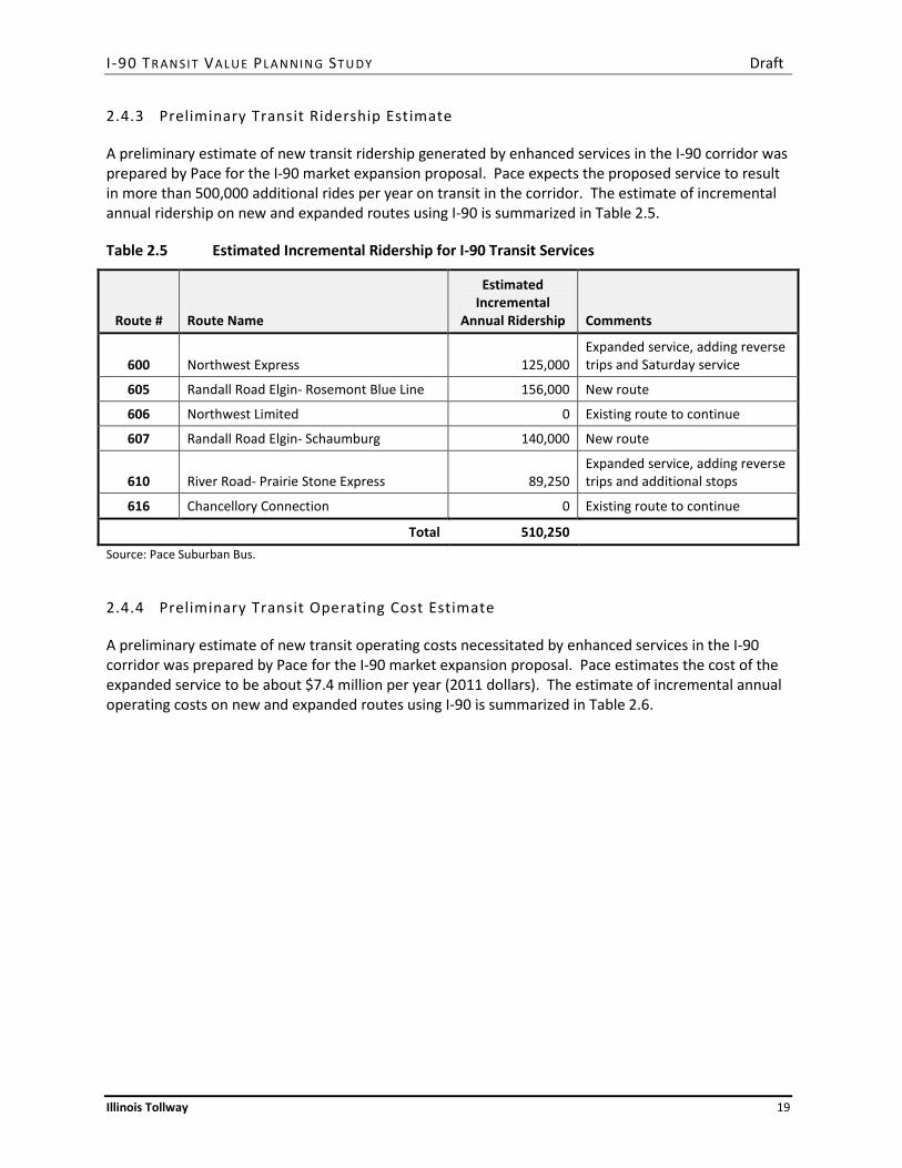
2.4.3 Preliminary Transit Ridership Estimate
A preliminary estimate of new transit ridership generated by enhanced services in the I-90 corridor was prepared by Pace for the I-90 market expansion proposal. Pace expects the proposed service to result in more than 500,000 additional rides per year on transit in the corridor. The estimate of incremental annual ridership on new and expanded routes using I-90 is summarized in Table 2.5.
Table 2.5 Estimated Incremental Ridership for I-90 Transit Services
Route # Route Name
Estimated Incremental
Annual Ridership Comments
600 Northwest Express 125,000 Expanded service, adding reverse trips and Saturday service
605 Randall Road Elgin- Rosemont Blue Line 156,000 New route
606 Northwest Limited 0 Existing route to continue
607 Randall Road Elgin- Schaumburg 140,000 New route
610 River Road- Prairie Stone Express 89,250 Expanded service, adding reverse trips and additional stops
616 Chancellory Connection 0 Existing route to continue
Total 510,250 Source: Pace Suburban Bus.
2.4.4 Preliminary Transit Operating Cost Estimate
A preliminary estimate of new transit operating costs necessitated by enhanced services in the I-90 corridor was prepared by Pace for the I-90 market expansion proposal. Pace estimates the cost of the expanded service to be about $7.4 million per year (2011 dollars). The estimate of incremental annual operating costs on new and expanded routes using I-90 is summarized in Table 2.6.

I -90 TR AN SIT VALUE PLA N NIN G ST U DY Draft
Illinois Tollway 20
Table 2.6 Estimated Incremental Operating Costs for I-90 Transit Services
Route # Route Name
Estimated Incremental
Annual Operating Costs Comments
600 Northwest Express $672,000 Expanded service, adding reverse trips and Saturday service
605 Randall Road Elgin- Rosemont Blue Line $3,100,000 New route
606 Northwest Limited $0 Existing route to continue
607 Randall Road Elgin- Schaumburg $3,000,000 New route
610 River Road- Prairie Stone Express $290,000 Expanded service, adding reverse trips and additional stops
616 Chancellory Connection $0 Existing route to continue
Subtotal $7,062,000
Marketing Cost $353,100 5% of operating costs
Total $7,415,100 Source: Pace Suburban Bus.
2.5 Rockford Commuter Services Proposal
The Rockford Mass Transit District (RMTD) is considering commuter-oriented service from Rockford to employment centers in the I-90 corridor.5 Peak period service would be provided between the Downtown Transit Center and an East Side park-and-ride facility in Rockford and the Northwest Transportation Center (NWTC) in Schaumburg, with stops in Belvidere (at a proposed park-and-ride at either the Tollway Oasis or Wal-Mart), the Big Timber Road Metra station in Elgin, and the Prairie Stone business park. The service schedule would be timed to connect to peak period Metra trains from the Big Timber Road Metra station to downtown Chicago, and the buses would circulate in Schaumburg to provide access to the Woodfield area.
5 NICTI Alternatives Analysis Briefing Paper: Rockford Bus Service to Chicago Area. Prepared for the Northern Illinois Commuter Transportation Initiative (NICTI). Prepared by Transystems. May 17, 2011.

I -90 TR AN SIT VALUE PLA N NIN G ST U DY Draft
Illinois Tollway 21
3. COST REDUCTION STRATEGIES
The need to identify a less capital-intensive strategy to provide transit services in the I-90 corridor resulted in consideration of the opportunities created by the operation of transit services that would use the managed lane for only a part of their route. One guiding premise was that transit services could be more effective boarding and alighting passengers at residential and employment activity centers, which are generally located along arterial streets in the corridor. More of these concentrations of activity could be potentially served by deviating bus routes from the I-90 right-of-way. After operating along arterial streets for a portion of the route, transit services would enter I-90 and use the managed lanes as needed to reduce travel time and improve schedule reliability. Finding the optimal balance between arterial operation and Tollway operation to maximize potential ridership would be a key element of service design.
By removing transit facilities from the median of I-90, and thereby reducing right-of-way requirements and utility relocations, one of the main drivers of the cost of the STAR Line EBS alternative could be substantially reduced. Figure 2.5 in the previous section illustrates the long taper and additional EBS footprint needed to accommodate a typical bus platform in the median of I-90.
The main implication of this change in strategy would be the reconfiguration of transit services as routes that combine arterial operating segments with non-stop segments using portions of I-90. Arterial segments could incorporate bus rapid transit (BRT) features, including limited stops with enhanced passenger facilities, traffic signal priority, queue jump bypass lanes, real-time bus arrival information, branded vehicles, and other amenities, to reduce travel times, improve reliability, and increase competitiveness with the automobile. These features are proposed for 24 arterial corridors around the region as part of Pace’s Arterial Bus Rapid Transit (ART) initiative, including segments of Golf Road, Touhy Avenue, Mannheim Road, IL-83, Thorndale Road, Algonquin Road, IL-59, and Randall Road in the study area. None of these segments are among the six corridors that Pace considers to be among the highest priorities for near-term implementation.6
Arterial route segments may stop or terminate at rail stations along the Metra UP-NW or MD-W lines. Using these existing facilities could increase ridership on transit services in the I-90 corridor by improving reverse-commute connections. Rail station areas are also generally among the more walkable areas in the northwest suburbs, with relatively transit-supportive land uses and development patterns.
Park-and-ride facilities near I-90 interchanges would supplement arterial bus stops. In some cases, park-and-ride facilities could be located on Tollway property or remnant parcels around interchanges. In other cases, park-and-ride facilities could be constructed on parcels along arterial streets close to I-90 or in parking lots shared with commercial developments. These strategies are consistent with the approach used to develop Pace park-and-ride facilities along expressway and tollway corridors elsewhere in the region. All park-and-ride facilities would be the responsibility of the RTA or its service boards.
6 Pace Suburban Bus Service. Arterial Rapid Transit Study. Final Report, September 4, 2009.

I -90 TR AN SIT VALUE PLA N NIN G ST U DY Draft
Illinois Tollway 22
Phased implementation was identified as another strategy to reduce capital and operating costs. The transition from existing transit services to a higher future service level, including potentially rail service, could be conducted over time. Point-to-point service options, connections with other transit services, peak- and off-peak service frequency, hours of operation, and levels of investment could evolve as travel markets develop, such that transit services always meet RTA and service board performance requirements. To support phased implementation, continual performance monitoring, customer and non-user feedback, market analysis, and service planning will be needed to identify new opportunities, establish priorities, allocate capital and operating resources, and fine-tune service schedules.

I -90 TR AN SIT VALUE PLA N NIN G ST U DY Draft
Illinois Tollway 23
4. CORRIDOR TRANSIT SERVICE STRATEGY
A preliminary transit service strategy was developed as a placeholder for future transit services in the study area. The strategy builds on existing services and previous planning in the corridor, and applies the cost reduction strategies described in Section 3. The strategy is intended to represent the range of likely transit services that would operate along the I-90 corridor. As such, it was used to identify the most important opportunities to provide design features as part of the I-90 reconstruction project that would support or enhance likely future transit services.
While any new transit services would receive more detailed market analysis during the service planning process, consideration was given in the development of the strategy to “future-proof” the I-90 design by incorporating features that would support a wide range of potential transit service options.
4.1 System Context
Vision 2020: the Blueprint for the Future, Pace’s strategic framework for suburban transit service, envisions a network of express bus services on expressways and tollways that provide long-distance connections between regional activity centers. Regional transit centers would be provided at locations where there is a concentration of employment and other activities. The CTA Blue Line station at River Road in Rosemont, the Northwest Transportation Center in Schaumburg, and the Elgin Metra station already serve as some of these regional transit centers.
Pace has implemented elements of the express bus network by expanding commuter-oriented services between the southern suburbs and the Rosemont area along I-294 and between Plainfield, Bolingbrook, and the Chicago Medical District along I-55. These routes combine stops at transit centers and rail stations, arterial service, stops at park-and-ride facilities, and non-stop expressway or tollway segments to serve important commuter markets that are not well-served by Metra or CTA rail services.
Pace is in the process of enhancing service on I-55 by introducing bus-on-shoulder (BOS) operations to improve travel time and reliability. The agency has also pursued, in partnership with the Tollway and other agencies, federal funding opportunities for managed lanes along I-294. The I-90 reconstruction project provides the next major opportunity to implement a key element of the suburban express bus network.
4.2 Preliminary “Hypothesis”
A preliminary service concept was presented at the first meeting of the I-90 Corridor Planning Council on June 7, 2011. The “hypothesis” offered for discussion suggested that:
1. Transit services would operate primarily in a managed lane in each direction, located in a new travel lane closest to the inside median barrier, separated from general traffic by lane markings. The managed lane would be shared with traffic paying a toll surcharge that varies to maintain a speed threshold of 45 to 50 mph. Continuous access would allow buses (and other traffic) to enter and exit the managed lane as desired to avoid congestion. Buses may not necessarily operate in the managed lane during uncongested periods.

I -90 TR AN SIT VALUE PLA N NIN G ST U DY Draft
Illinois Tollway 24
2. To reduce the footprint needed for EBS, passenger boarding and alighting activity would occur at stations outside the Tollway right-of-way. Transit facilities may include park-and-ride lots near interchanges, bus stops along arterial segments of routes that use I-90 for part of the trip, and Metra stations where reverse commute connections may be possible.
3. Routes would generally converge at the east end of the corridor at the Rosemont CTA station. Other stations would not correspond directly with the locations evaluated in the STAR Line Alternatives Analysis.
4. Major areas served by some or all of the routes in the corridor would include Woodfield, Elgin, Arlington Heights, and Prairie Stone. Because of the large concentration of activity in the Woodfield area, it is expected that all or most of the routes would deviate onto arterial streets in the middle of the corridor. Arterial services along Golf Road and/or Algonquin Road between Plum Grove Road and Arlington Heights Road would serve potential trip origins and destinations more effectively than a station in the I-90 median.
5. To minimize weaving operations to and from the managed lanes, direct access ramps to and from arterial streets could be provided at selected locations along the managed lanes. The ramps could be used by both transit vehicles and other managed lanes traffic. Because of the large share of transit vehicles that would divert to arterial streets in the Woodfield area, priority locations include Plum Grove Road and Arlington Heights Road.
6. The transit services in the I-90 corridor would be designed as a first phase in the development of a larger suburb-to-suburb express bus system that includes transit hubs at major suburban activity centers, including the Rosemont/O’Hare area, the Woodfield/Schaumburg area, and the Oak Brook area. Point-to-point services would operate along suburban arterial, expressway, and tollway corridors, typically serving at least two of these hubs to allow trips between a large number of origin-destination pairs with as few transfers as possible.
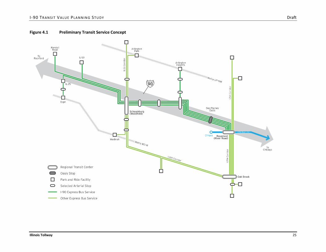
The service concept is depicted in Figure 4.1. The concept shows potential services that would operate at least in part on I-90 in green. A lighter shade of green is used to depict potential connections in other expressway and tollway corridors as a means of illustrating the context of I-90 services within a larger suburban express bus system. Together, the services describe the range of potential transit vehicle movements that should be accommodated in the design of the I-90 reconstruction project. Route priorities, service levels, and stop patterns will be defined through more detailed market analysis and service planning studies as services are implemented over time.
I -90 TR AN SIT VALUE PLA N NIN G ST U DY Draft
Illinois Tollway 25
Figure 4.1 Preliminary Transit Service Concept

I -90 TR AN SIT VALUE PLA N NIN G ST U DY Draft
Illinois Tollway 26
4.3 Stakeholder Input
Stakeholders provided comments on the concept during the discussion at Meeting 1. Comments included:
1. Consider extending managed lanes as far west as Randall Road.
2. Consider accommodation of bus services to/from Rockford.
3. Add accommodations for express bus routes along Barrington Road (north to Harper College or beyond, south to Alexian Brothers Medical Center or beyond).
4. Add accommodation for commuter services to the Elk Grove Village industrial area from the west.
5. Although the STAR Line is not considered to be financially viable in the near term, design the managed lanes so as not to preclude construction of STAR Line rail stations and tracks in the future. Build toward the long-term vision of rail in the corridor.
6. Provide managed lane access from Prairie Stone at IL-59 to the east.
7. Provide managed lane access to Schaumburg to Plum Grove Road from the west.
8. Provide managed lane access from Arlington Heights Road to the east.
9. Consider maintaining a park-and-ride facility at the Des Plaines Oasis site, even if the connection with the Elgin-O’Hare Western Bypass (EOWB) project requires closure of the motorist service facility.
10. Streamline access to the Rosemont CTA station from the managed lanes, including at a minimum automation of the bus-only gate system between the eastbound River Road toll plaza and the station to reduce delays currently associated with manually opening the gate.
11. Develop the transit operating concept to support phased implementation in the short-, medium- and long-term.
12. Consider bus-on-shoulder (BOS) operations on the inside shoulder and/or the outside shoulder with enhanced express bus services during the I-90 reconstruction period. Outside BOS could include direct access to adjacent park-and-ride lots (for buses only) at some of the access points discussed above.
A refined concept based on Pace’s CMAQ application was presented at Meeting 2. Additional comments on the concept included:
1. To accommodate express bus service between Rockford and the northwest suburbs, a park-and-ride facility should be considered at the Belvidere Oasis.
2. To accommodate proposed rail service between Rockford and Chicago, the accommodation of rail in the typical section west of IL-25 should be considered.

I -90 TR AN SIT VALUE PLA N NIN G ST U DY Draft
Illinois Tollway 27
3. The market analysis element of the project should focus on prioritizing park-and-ride locations along the corridor. It is also important to ensure that transit routes provide direct connections to jobs.
4. The development of an in-line station should be considered at the Des Plaines Oasis location as a mid-term improvement. The design of this facility will need to be coordinated with interchange plans for the EOWB project.
5. While not specifically required for Pace’s project proposal, a park-and-ride facility and direct access ramps (if warranted) should remain under consideration at Arlington Heights Road.
6. An in-line station near Meacham Road in Schaumburg should be considered as a mid-term improvement. The station design could support the transit-oriented development initiative around the proposed STAR Line station and potentially replace the Pace Northwest Transportation Center.
7. No specific accommodations for transit service to O’Hare Airport are needed as part of the I-90 reconstruction project. Transit connections via the CTA Blue Line at Rosemont are considered to be adequate for the foreseeable future.
8. It was noted that single-ride transit use is much preferred. Studies have shown that use of transit drops off significantly if more than two transfers are required.
4.4 Market Assessment
Information on travel patterns and transit opportunities in the I-90 corridor were obtained from a number of studies conducted in the corridor over time, including the 1998 RTA Northwest Corridor Transit Feasibility Study Market Analysis, origin-destination studies of I-90 traffic using I-PASS data, and market studies conducted by Pace and other agencies. This section presents recent and relevant information obtained from two assessments of travel patterns and transit opportunities based on 2010 CMAP work trip tables.
4.4.1 Evaluation of I-90 Travel Patterns
An analysis of travel patterns was conducted as part of the I-90 Transit Value Planning Study to develop a preliminary assessment of the relative magnitude of origin-destination markets that could be served by park-and-ride facilities or arterial transit services in the vicinity of each existing interchange or likely potential transit access point along I-90. The number of 2010 home-based work trips beginning or ending around each of an expanded set of potential station locations was evaluated using GIS procedures. Travel patterns were derived from CMAP’s 2010 baseline home-based work trip table.
Locations evaluated along I-90 include the Rosemont CTA station, the Des Plaines Oasis, Arlington Heights Road, Golf Road, IL-53, Meacham Road, Plum Grove Road, Roselle Road, Barrington Road, IL-59, Beverly Road, IL-25, IL-31, Randall Road, IL-47, US-20, Genoa Road in Belvidere, and State Road in Rockford. To provide a rough and comparable representation of the potential park-and-ride, transit, and walk access and egress options around each location, circular buffers of 3 miles radius for access and ½ mile for egress were used. To provide a rough and comparable representation of the connecting
I -90 TR AN SIT VALUE PLA N NIN G ST U DY Draft
Illinois Tollway 28
transit market at Rosemont, stations on the CTA Blue Line between O’Hare and the Medical District were included as potential origins and destinations for trips to and from the I-90 locations as well.
The result is not a ridership estimate, but a comparison of the relative size of the origin-destination travel markets that could be well-served by transit service at each location. The results were used to help to prioritize station locations and access points in the corridor, subject to further analysis and refinement during the service planning process.
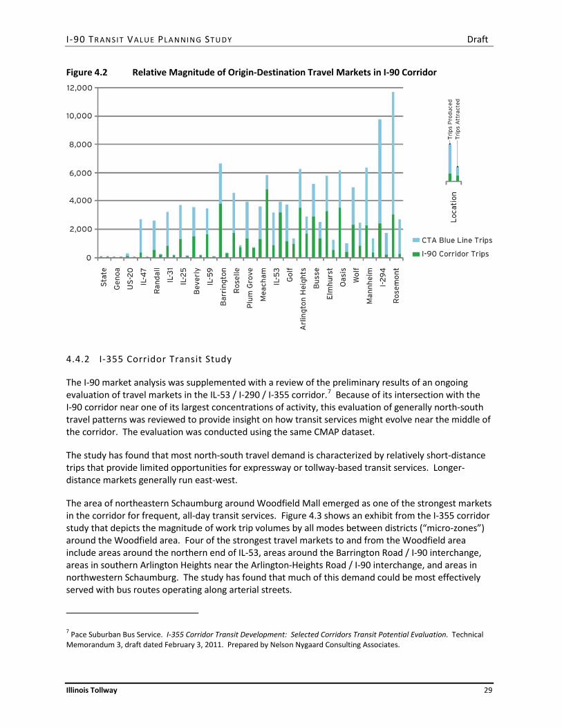
Figure 4.2 summarizes the results of the analysis. Trips Produced reflects all work trips with a residence within 3 miles of the station and a workplace within ½ mile of any other station. Trips Attracted reflects all work trips with a workplace within ½ mile of the station and a residence within 3 miles of any other station.
The results indicate the relative strength of the travel markets from residential areas east of Arlington Heights Road to employment destinations in other parts of the corridor. With the exception of the area around Barrington Road, there are typically about twice as many trips between the relatively more densely developed locations in the segment between Rosemont and Arlington Heights Road than other locations further west. These general patterns persist when trips that can be served via the CTA Blue Line are included.
With the highest trip volume to employment destinations elsewhere in the corridor and relatively long trip lengths indicated by a near-doubling of volumes when areas along the CTA Blue Line are included, a park-and-ride facility near the I-90 interchange at Barrington Road could be an effective supplement to other transit facilities in the area, such as the Barrington and Hanover Park Metra stations.
The results also indicate the relative strength of the travel markets from residential areas along the corridor to employment destinations near the IL-53 / I-290 / I-90 interchange. With a peak around Meacham Road, the locations in southern Arlington Heights, Rolling Meadows, and Schaumburg typically attract about twice as many trips as other locations in the primary study area. This general pattern persists when trips that can be served via the CTA Blue Line are included.
Additional analysis of the origin-destination travel patterns at specific locations in the corridor will be needed during transit project development and service planning to identify the feasibility and program requirements of park-and-ride facilities and other transit elements in the corridor.
I -90 TR AN SIT VALUE PLA N NIN G ST U DY Draft
Illinois Tollway 29
Figure 4.2 Relative Magnitude of Origin-Destination Travel Markets in I-90 Corridor
4.4.2 I-355 Corridor Transit Study
The I-90 market analysis was supplemented with a review of the preliminary results of an ongoing evaluation of travel markets in the IL-53 / I-290 / I-355 corridor.7 Because of its intersection with the I-90 corridor near one of its largest concentrations of activity, this evaluation of generally north-south travel patterns was reviewed to provide insight on how transit services might evolve near the middle of the corridor. The evaluation was conducted using the same CMAP dataset.
The study has found that most north-south travel demand is characterized by relatively short-distance trips that provide limited opportunities for expressway or tollway-based transit services. Longer-distance markets generally run east-west.
The area of northeastern Schaumburg around Woodfield Mall emerged as one of the strongest markets in the corridor for frequent, all-day transit services. Figure 4.3 shows an exhibit from the I-355 corridor study that depicts the magnitude of work trip volumes by all modes between districts (“micro-zones”) around the Woodfield area. Four of the strongest travel markets to and from the Woodfield area include areas around the northern end of IL-53, areas around the Barrington Road / I-90 interchange, areas in southern Arlington Heights near the Arlington-Heights Road / I-90 interchange, and areas in northwestern Schaumburg. The study has found that much of this demand could be most effectively served with bus routes operating along arterial streets.
7 Pace Suburban Bus Service. I-355 Corridor Transit Development: Selected Corridors Transit Potential Evaluation. Technical Memorandum 3, draft dated February 3, 2011. Prepared by Nelson Nygaard Consulting Associates.

I -90 TR AN SIT VALUE PLA N NIN G ST U DY Draft
Illinois Tollway 30
Figure 4.3 Home-Based Work Trip Volumes between Districts in the IL-53/I-290/I-355 Corridor
Source: Draft I-355 Technical Memorandum 3, Figure 2.
I -90 TR AN SIT VALUE PLA N NIN G ST U DY Draft
Illinois Tollway 31
Based in part on these travel patterns, four corridors in the primary study area emerged among the strongest candidates for development of fixed-route bus services. The corridors, all along arterial streets, include:
• Dundee Road – Arlington Heights Road, between IL-53 / Dundee and Arlington Heights / I-90 • Busse Road – Higgins Road, between Busse / Devon and Barrington / Higgins • Golf Road – Meacham Road – Schaumburg Road, between Golf / Busse and near Schaumburg /
Barrington • Busse Road – Algonquin Road – New Wilke Road, between Busse / Devon and the Arlington
Park Metra station.
4.5 Refined Transit Service Concept
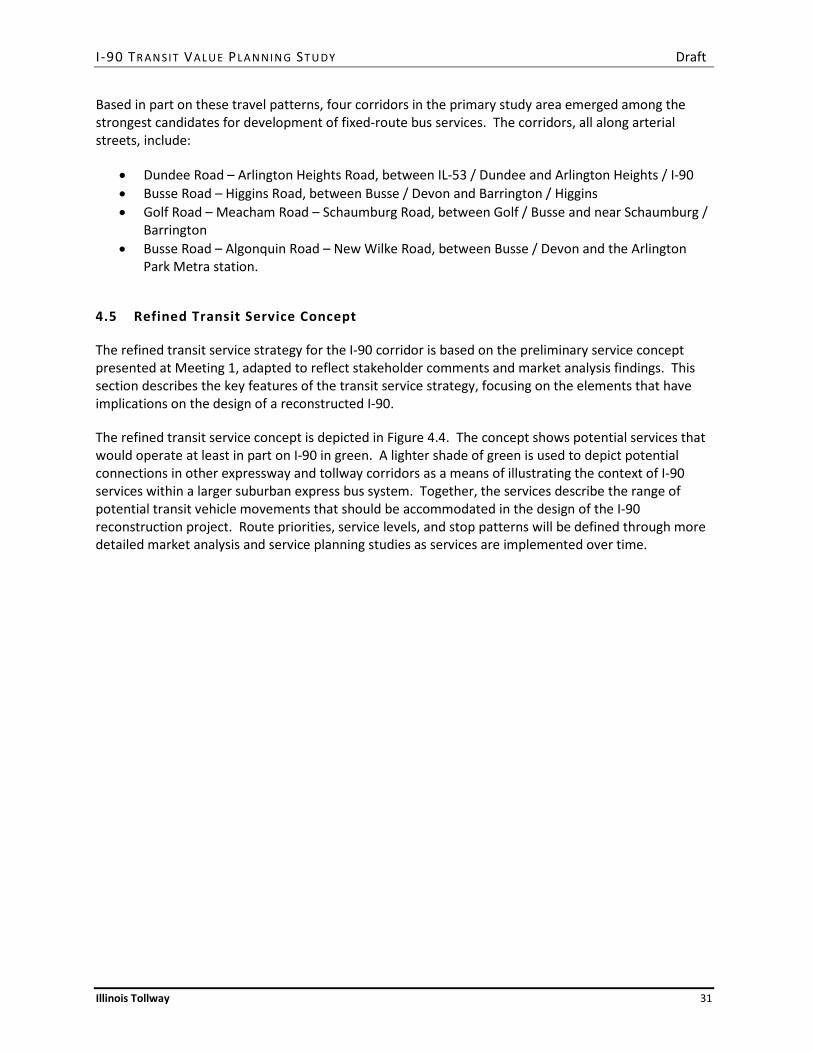
The refined transit service strategy for the I-90 corridor is based on the preliminary service concept presented at Meeting 1, adapted to reflect stakeholder comments and market analysis findings. This section describes the key features of the transit service strategy, focusing on the elements that have implications on the design of a reconstructed I-90.
The refined transit service concept is depicted in Figure 4.4. The concept shows potential services that would operate at least in part on I-90 in green. A lighter shade of green is used to depict potential connections in other expressway and tollway corridors as a means of illustrating the context of I-90 services within a larger suburban express bus system. Together, the services describe the range of potential transit vehicle movements that should be accommodated in the design of the I-90 reconstruction project. Route priorities, service levels, and stop patterns will be defined through more detailed market analysis and service planning studies as services are implemented over time.
I -90 TR AN SIT VALUE PLA N NIN G ST U DY Draft
Illinois Tollway 32
Figure 4.4 Refined Transit Service Concept
I -90 TR AN SIT VALUE PLA N NIN G ST U DY Draft
Illinois Tollway 33
4.5.1 Managed Lanes
Transit services are assumed to operate primarily in a managed lane in each direction, located in a new travel lane closest to the inside median barrier, separated from general traffic by lane markings. The managed lane would be shared with traffic paying a toll surcharge that varies to maintain a speed threshold of 45 to 50 mph. Continuous access would allow buses (and other traffic) to enter and exit the managed lane as desired to avoid congestion. Buses may not necessarily operate in the managed lane during uncongested periods.
4.5.2 Arterial Operations
The market analysis results confirm the primacy of the Woodfield area in Schaumburg as an anchor for transit service in the middle portion of the I-90 corridor. The results also confirm that this area may be more effectively served using bus services that make at least several stops along arterial streets than with an express bus service that makes limited stops in the I-90 median. Accordingly, the service strategy assumes that express bus services operating on I-90 will deviate onto arterial streets to serve the greater Woodfield area.
Because of the large number of potential employment destinations, commercial developments, and arterial bus route connections in southern Arlington Heights, an eastern deviation point at Arlington Heights Road is assumed for services operating on I-90. Most of the routes operating in the I-90 corridor east of Arlington Heights Road would enter or leave I-90 at this point to serve the Woodfield area in Schaumburg. Some routes for which a connection to the Woodfield area would be less desirable, such as direct services between Barrington Road and Elk Grove Village or Rosemont, may remain on I-90 without stopping.
Plum Grove Road is assumed as a western deviation point for services operating on I-90. The proposed interchange at Plum Grove Road provides an opportunity to improve connections between the Woodfield area and the western portion of the corridor, both for general traffic and transit services. As above, most of the routes operating in the I-90 corridor west of Plum Grove Road would enter or leave I-90 at this point to serve the Woodfield area in Schaumburg. Some routes for which a connection to the Woodfield area would be less desirable, such as direct services between Barrington Road and Elk Grove Village or Rosemont, may remain on I-90 without stopping.
Express bus services would operate on arterial streets between Arlington Heights Road and Plum Grove Road via Golf Road and potentially Algonquin Road. Service on Algonquin Road would provide direct service to Pace headquarters, which could potentially also serve as a park-and-ride facility near the Arlington Heights Road /I-90 interchange. This facility could include a new parking structure shared with Pace employees.
The convergence of express and arterial bus routes on Golf Road (and potentially Algonquin Road) provides an opportunity to implement elements of the bus rapid transit (BRT) features, including limited stops with enhanced passenger facilities, traffic signal priority, queue jump bypass lanes, real-time bus arrival information, branded vehicles, and other amenities, that are proposed as part of Pace’s Arterial Bus Rapid Transit (ART) initiative. While this segment of Golf Road is not currently one of Pace’s highest priorities for near-term implementation, this relatively short segment could provide an opportunity to test and evaluate BRT elements before adopting them more widely elsewhere.

I -90 TR AN SIT VALUE PLA N NIN G ST U DY Draft
Illinois Tollway 34
North-south services to and from the Woodfield area may operate along Meacham Road, potentially with express segments along IL-53, I-290, and/or I-355. With a major intersection of arterial-running bus routes near Golf /Meacham in Schaumburg, there may be some benefit to relocating the Northwest Transportation Center to provide connections with other local transit services in a manner that minimizes the extra travel time needed to deviate from these arterial corridors.
4.5.3 Passenger Facilities
Passenger boarding and alighting is assumed to occur at a mix of on-street arterial bus stops and off-street park-and-ride facilities. Park-and-ride facilities are assumed to be provided at up to 12 locations in the corridor, including:
• Rockford – A park-and-ride facility may be provided on the east side of Rockford as a stop for express bus services between the Rockford area and the primary study area.
• Belvidere – A park-and-ride facility may be provided either at the Belvidere Oasis or near the Wal-Mart on Genoa Road to accommodate express bus services between the Rockford area and the primary study area.
• Randall Road – A park-and-ride facility may be provided near the I-90 interchange.
• Big Timber Road – The existing Metra park-and-ride facility may serve as a stop for express bus services on I-90.
• Elgin – The existing Metra station, regional transit center, and park-and-ride facility may serve as a terminal for express bus services on I-90.
• IL-25 – A park-and-ride facility may be provided near the I-90 interchange. A site on Tollway property within the interchange has been considered in the past and is a candidate location for the facility.
• Beverly Road – A park-and-ride facility may be provided near the I-90 interchange. Due to its proximity and overlapping market, this facility may be redundant with the IL-59 park-and-ride. The potential development of a single facility in the vicinity of the Prairie Stone business park should be considered.
• IL-59 – A park-and-ride facility may be provided near the I-90 interchange. There is an opportunity to provide connections at this facility with employer shuttles, bus routes, or other local circulation services in and around the Prairie Stone business park.
• Barrington Road – A park-and-ride facility may be provided near the I-90 interchange. There is an opportunity to provide connections at this facility with several proposed arterial bus routes serving the Higgins Road corridor, the Barrington Road corridor, and other areas.
• Arlington Heights Road – A park-and-ride facility may be provided near the I-90 interchange. The Pace Headquarters site near the intersection of Arlington Heights Road and Algonquin Road is a candidate location for the facility.
I -90 TR AN SIT VALUE PLA N NIN G ST U DY Draft
Illinois Tollway 35
• Des Plaines Oasis – A park-and-ride facility may be provided on or near the site of the existing motorist service facility. The site design and arterial access to this facility will need to be developed in coordination with the Elgin-O’Hare Western Bypass (EOWB) project.
• Rosemont – The existing CTA station, regional transit center, and park-and-ride facility will serve as the terminal for many of the express bus services on I-90. Bus access improvements, including at a minimum automation of the bus-only gate system between the eastbound River Road toll plaza and the station is assumed to be provided to reduce delays currently associated with manually opening the gate.
Off-street park-and-ride facilities may include connections with other transit services, car sharing services, bicycle parking, pedestrian and bicycle trail connections, and other features to support reverse commute egress to surrounding employment destinations.
Together with the arterial stops, these facilities provide considerable flexibility in the design of point-to-point transit services that may use the I-90 managed lanes for at least part of the route.
4.5.4 Transit Priority Features
The refined service strategy assumes that opportunities to reduce travel times or improve schedule reliability will be incorporated as appropriate during the I-90 reconstruction project design phase, the project development process for facilities outside of Tollway right-of-way, and the transit service planning process. Features that could improve the performance of transit services include:
• Direct Access Ramps – Direct ramps between the managed lanes and arterial streets may improve roadway performance at certain locations in the corridor by reducing weaving movements and associated traffic flow disturbances. If direct ramps are provided, they could benefit both transit vehicles and general traffic.
• Transit Signal Priority – Along arterial segments and at I-90 interchanges, transit signal priority may improve transit schedule adherence providing buses with additional green time under certain conditions.
• Queue Jump Bypass Lanes – Along arterial segments and at I-90 interchanges, queue jump bypass lanes may reduce transit travel times and increase reliability by allowing buses to move to the head of the queue at traffic signals.

I -90 TR AN SIT VALUE PLA N NIN G ST U DY Draft
Illinois Tollway 36
5. INFRASTRUCTURE REQUIREMENTS
This section describes the implications of the refined transit service strategy on the infrastructure needed in the I-90 corridor.
5.1 Design Implications for I-90 Reconstruction Project
The implementation of the Pace I-90 Market Expansion Proposal in the short term and the refined service concept in the longer term requires that the I-90 reconstruction project include the general features described in this section. The physical, operational, economic, and financial feasibility of these features will be evaluated during the I-90 design phase. More detail on the characteristics of each feature will also be developed during the I-90 design phase.
5.1.1 Managed Lanes
Express bus services operating on I-90 will benefit from the travel time savings and reliability improvements provided by a managed lane in each direction. The new fourth lane to be constructed in each direction maybe operated as a managed lane with a “congestion priced” toll surcharge. Electronic toll collection and enforcement systems will be provided at frequent intervals along the managed lane section. The managed lane will be separated from general traffic lanes by a 2-foot wide painted buffer. Transit vehicles are assumed to enter and leave the managed lane as needed to avoid congestion.
The Tollway currently assumes that the managed lanes will provide continuous ingress and egress, and that no direct ramp access will be provided to or from the center lanes. The costs and benefits of changes to managed lanes access, both in the form of access restrictions to certain areas and access enhancements through direct ramps, will be evaluated during the I-90 reconstruction project design phase. Decisions as to whether access restrictions or direct ramps are warranted and feasible at specific locations will be made based on traffic simulation analysis conducted during the design phase.
The transit vehicle movements between arterial streets and I-90 that are needed to accommodate the routes included in the refined transit service concept will be considered in the design of any access restriction or access enhancement features.
5.1.2 Adjusted Typical Section
Preliminary concepts for short term, mid-term and long term use of the I-90 right-of-way by transit vehicles have been developed, building from the Tollway standard roadway cross-section as depicted in Figure 5.1. The intent of this phasing plan is to accommodate design flexibility for a range of potential future transit plans in a manner that reduces the need for subsequent roadway reconstruction.

I -90 TR AN SIT VALUE PLA N NIN G ST U DY Draft
Illinois Tollway 37
Figure 5.1 Tollway Standard Roadway Cross-Section
In the short term, buses will operate in congested areas in the 14-foot wide managed lane to be provided in each direction. In order to accommodate transit service enhancement in later phases, the inner shoulder to be provided in both directions should be at least 17.5 feet in width, as depicted in Figure 5.2. In total, these changes add 4.5 feet of width to the typical cross-section on each side of the centerline. While this additional width can generally be accommodated in the Tollway right-of-way, some additional structures, bridge modifications, and utility relocations will be required.
Figure 5.2 Short Term Roadway Cross-Section
In the mid-term, a second managed lane could be accommodated on the inside shoulder, in order to increase capacity during congested periods. Use of this inner-most managed lane could be restricted to transit vehicles, as depicted in Figure 5.3, or made available to all traffic using the managed lane.
Figure 5.3 Mid-Term Roadway Cross-Section
In the long term, fixed rail transit could be accommodated in the median of I-90, within the area previously occupied by the inside shoulder and the managed lane. Highway capacity would be replaced by adding an additional outside travel lane in both directions, necessitating an expansion of the right-of-way, as depicted in Figure 5.4. At station locations, the center platform would be accommodated by reducing the width of the inside shoulder, as depicted in Figure 5.5.
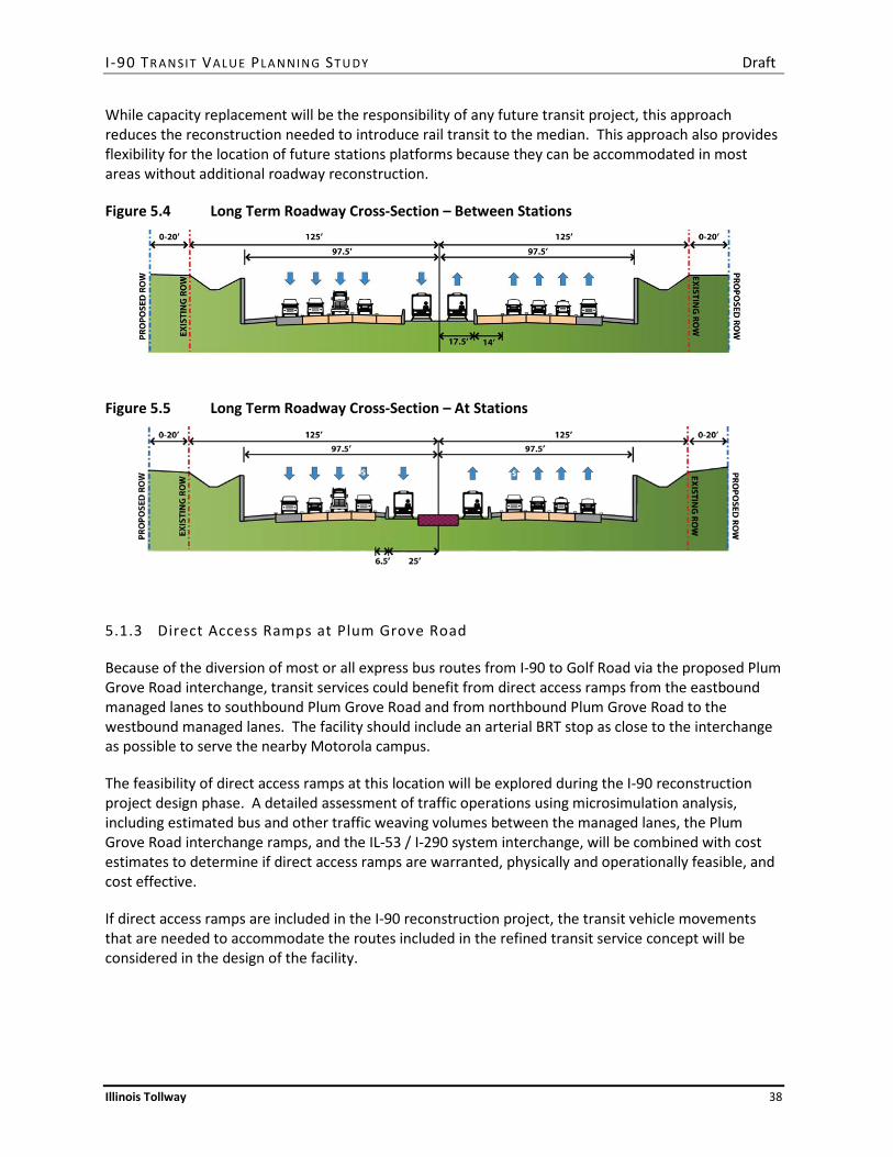
I -90 TR AN SIT VALUE PLA N NIN G ST U DY Draft
Illinois Tollway 38
While capacity replacement will be the responsibility of any future transit project, this approach reduces the reconstruction needed to introduce rail transit to the median. This approach also provides flexibility for the location of future stations platforms because they can be accommodated in most areas without additional roadway reconstruction.
Figure 5.4 Long Term Roadway Cross-Section – Between Stations
Figure 5.5 Long Term Roadway Cross-Section – At Stations
5.1.3 Direct Access Ramps at Plum Grove Road
Because of the diversion of most or all express bus routes from I-90 to Golf Road via the proposed Plum Grove Road interchange, transit services could benefit from direct access ramps from the eastbound managed lanes to southbound Plum Grove Road and from northbound Plum Grove Road to the westbound managed lanes. The facility should include an arterial BRT stop as close to the interchange as possible to serve the nearby Motorola campus.
The feasibility of direct access ramps at this location will be explored during the I-90 reconstruction project design phase. A detailed assessment of traffic operations using microsimulation analysis, including estimated bus and other traffic weaving volumes between the managed lanes, the Plum Grove Road interchange ramps, and the IL-53 / I-290 system interchange, will be combined with cost estimates to determine if direct access ramps are warranted, physically and operationally feasible, and cost effective.
If direct access ramps are included in the I-90 reconstruction project, the transit vehicle movements that are needed to accommodate the routes included in the refined transit service concept will be considered in the design of the facility.

I -90 TR AN SIT VALUE PLA N NIN G ST U DY Draft
Illinois Tollway 39
5.1.4 Direct Access Ramps at Arlington Heights Road
Because of the diversion of most or all express bus routes from I-90 to Golf Road via the Arlington Heights Road interchange, transit services could benefit from direct access ramps from the westbound managed lanes to northbound Arlington Heights Road and from southbound Arlington Heights Road to the eastbound managed lanes. However, the configuration of the Arlington Heights Road interchange and adjacent land uses places some challenging physical constraints on the design of this facility.
The feasibility of direct access ramps at this location will be explored during the I-90 reconstruction project design phase. A detailed assessment of traffic operations using microsimulation analysis, including estimated bus and other traffic weaving volumes between the managed lanes, the Arlington Heights Road interchange ramps, and the IL-53 / I-290 system interchange, will be combined with cost estimates to determine if direct access ramps are warranted, physically and operationally feasible, and cost effective.
If direct access ramps are included in the I-90 reconstruction project, the transit vehicle movements that are needed to accommodate the routes included in the refined transit service concept will be considered in the design of the facility.
5.1.5 Rosemont Access Improvements
The higher transit service level on I-90 will require access improvements at the CTA Rosemont station. Current Pace bus services exit I-90 just beyond the River Road toll plaza payment booths, then use the toll plaza access road to reach the CTA station. A sliding gate is in place between the access road and the CTA park-and-ride lot to prevent unauthorized access to eastbound I-90. Bus operators must leave their vehicles to manually unlock the gate.
At a minimum, automation of the gate is needed to accommodate more frequent service and to reduce travel times. One option includes using I-PASS or another transponder to trigger opening of the gate via a gantry over the toll plaza access road. The specific solution at this location will be evaluated in more detail during the design phase.
Depending on the outcome of detailed traffic simulation analysis during the design phase, more elaborate access improvements may be warranted and feasible, such as direct access ramps from I-90 to River Road. If any such features are included in the I-90 reconstruction project, the transit vehicle movements that are needed to accommodate the routes included in the refined transit service concept will be considered in the design of the features.
5.2 Features To Be Determined in Design Phase
The transit operations associated with the refined transit service concept could benefit from additional features within the Tollway right-of-way that may be included as part of the I-90 reconstruction project. However, the physical, operational, economic, and financial feasibility of these features will not be determined until the results of the traffic simulation analysis and more detailed construction cost estimates are available during the project design phase.
I -90 TR AN SIT VALUE PLA N NIN G ST U DY Draft
Illinois Tollway 40
If any of these features are included in the I-90 reconstruction project, the transit vehicle movements that are needed to accommodate the routes included in the refined transit service concept will be considered in the design of the features.
5.2.1 Belvidere Oasis Park-and-Ride Facility
The commuter-oriented service from Rockford to employment centers in the I-90 corridor under consideration by the Rockford Mass Transit District (RMTD) includes a stop in Belvidere. One proposed location would be at a park-and-ride facility at the Belvidere Oasis. An alternative location has been proposed at the Genoa Road Wal-Mart shopping center.
The feasibility of a facility at this location will be evaluated during the design phase and compared to the merits of one or more alternative locations. Considerations will include the required size of the parking lot, site plan options that may or may not involve construction on Tollway property, the need to control access to the Tollway from arterial streets, the need to facilitate convenient access by local transit vehicles, the need to facilitate efficient access to and from I-90, and the need to accommodate terms of the Oasis concession agreement with regard to facility access and layout.
5.2.2 IL-25 Park-and-Ride Facility
A park-and-ride facility near the IL-25 / I-90 interchange is included in the Pace proposal and the refined service concept. The facility could serve as a last stop before entering the Tollway on the arterial route segment from downtown Elgin to I-90.
A site on Tollway property within the interchange has been considered in the past and is a candidate location for the facility. The site is located along the two-way access road between the IL-25 intersection and the interchange ramps and is accessible to northbound and southbound IL-25, as well as eastbound and westbound I-90.
As layout plans for the IL-25 interchange are developed in the design phase, the feasibility of constructing a park-and-ride facility on this site will be evaluated. Considerations include the level of traffic control at the driveway to the Tollway access road, the required size of the parking lot, drainage issues, and construction phasing.
5.2.3 Potential Des Plaines Oasis Transit Facility
The Pace I-90 Market Expansion Proposal includes a park-and-ride facility and a connection with local transit services at the Des Plaines Oasis. This facility could support an effective strategy for serving the concentration of employment in Elk Grove Village and other communities on the western side of O’Hare International Airport.
However, the design of the facility is challenged by the need to control access to the Tollway from arterial streets, the need to facilitate convenient access by local transit vehicles, and the need to accommodate terms of the Oasis concession agreement with regard to facility access and layout. Furthermore, the proposed alignment of the Elgin-O’Hare Western Bypass project includes a system
I -90 TR AN SIT VALUE PLA N NIN G ST U DY Draft
Illinois Tollway 41
interchange with I-90 at the location of the Oasis. Current plans suggest that the Oasis would need to be removed to accommodate the project.
Options for the development of a transit facility at the Oasis site will be evaluated in the design phase. A short-term option will involve its use during the I-90 reconstruction period as generally outlined in the Pace proposal. A longer-term option will involve the development of a new transit facility on the land currently occupied by the Oasis. The facility could include an in-line passenger station within the I-90 median or a transit facility on one side of the Tollway accessible via bus-only ramps, potentially direct from the managed lane.
If such a facility is determined to be feasible, the transit vehicle movements that are needed to accommodate the routes included in the refined transit service concept, as well as park-and-ride access and local circulation routes, will be considered in the design of the facility.
5.2.4 Potential Direct Access Ramps
Express bus services in the refined transit service concept may benefit from the potential travel time savings provided by direct access ramps between the managed lanes and park-and-ride facilities or arterial streets at other locations in the corridor. However, the transit service frequency may not be sufficient to justify construction of the facilities for transit benefits alone. If direct access ramps are determined to be warranted and feasible at locations where express bus routes would enter and leave I-90 based on a combination of transit and general traffic considerations, the transit vehicle movements that are needed to accommodate the routes included in the refined transit service concept will be considered in the design of the facility.
The potential for direct access ramps that accommodate the movements of the routes reflected in the refined transit service concept will be evaluated during the I-90 reconstruction project design phase. To provide operational flexibility for other transit services that could eventually be desirable, potential additional movements are also listed for each location. If these additional movements are warranted and feasible based on general traffic considerations, the accommodation of transit vehicles should be reflected in the design of the facilities. In many cases the additional movements may be accommodated in the design of the intersection between the ramp and the arterial street. Potential locations for additional direct access ramps include:
• IL-25 – Ramp from eastbound managed lane to northbound and/or southbound IL-25 (depends on location of park-and-ride facility). Ramp from northbound and/or southbound IL-25 to eastbound managed lane. Ramp from westbound managed lane to northbound and/or southbound IL-25. Ramp from northbound and/or southbound IL-25 to westbound managed lane. Potentially also ramps between eastbound and westbound managed lanes and the direction of IL-25 opposite the park-and-ride facility. If the park-and-ride facility is located within Tollway right-of-way along the two-way road segment under the existing interchange configuration, this additional feature would not be required.
• Beverly Road – Ramp from eastbound managed lane to northbound or southbound Beverly Road (depends on location of park-and-ride facility).

I -90 TR AN SIT VALUE PLA N NIN G ST U DY Draft
Illinois Tollway 42
Ramp from northbound or southbound Beverly Road to eastbound managed lane. Ramp from westbound managed lane to northbound or southbound Beverly Road. Ramp from northbound or southbound Beverly Road to westbound managed lane. Potentially also ramps between eastbound and westbound managed lanes and the direction of Beverly Road opposite the park-and-ride facility.
• IL-59 – Ramp from eastbound managed lane to northbound or southbound IL-59 (depends on location of park-and-ride facility). Ramp from northbound or southbound IL-59 to eastbound managed lane. Ramp from westbound managed lane to northbound or southbound IL-59. Ramp from northbound or southbound IL-59 to westbound managed lane. Potentially also ramps between eastbound and westbound managed lanes and the direction of IL-59 opposite the park-and-ride facility.
• Barrington Road – Ramp from eastbound managed lane to northbound or southbound Barrington Road (depends on location of park-and-ride facility). Ramp from northbound or southbound Barrington Road to eastbound managed lane. Ramp from westbound managed lane to northbound or southbound Barrington Road. Ramp from northbound or southbound Barrington Road to westbound managed lane. Potentially also ramps between eastbound and westbound managed lanes and the direction of Barrington Road opposite the park-and-ride facility.
• Elmhurst Road – Ramp from eastbound managed lane to southbound Elmhurst Road. Ramp from northbound Elmhurst Road to westbound managed lane. Potentially also ramps from eastbound managed lane to northbound Elmhurst Road, from southbound Elmhurst Road to westbound managed lane, from westbound managed lane to southbound Elmhurst Road, from northbound Elmhurst Road to eastbound managed lane, from westbound managed lane to northbound Elmhurst Road, and from southbound Elmhurst Road to eastbound managed lane.
• Elgin-O’Hare Western Bypass (EOWB) Project – Ramp from eastbound managed lane to southbound EOWB Ramp from northbound EOWB to westbound managed lane. Potentially also ramps from westbound managed lane to southbound EOWB and from northbound EOWB to eastbound managed lane.
• I-294 System Interchange – Potentially ramps between northbound and southbound I-294 and eastbound and westbound I-90.
5.3 Other Facilities
Express bus services in the refined transit service concept will require facilities outside of Tollway right-of-way. These elements of the I-90 transit system will be studied and provided by other agencies,

I -90 TR AN SIT VALUE PLA N NIN G ST U DY Draft
Illinois Tollway 43
including the RTA, its service boards, and the Rockford Mass Transit District. It is important that the implementation details of these elements are coordinated with the Tollway as needed.
5.3.1 Schaumburg Area Arterial BRT Elements
The convergence of express and arterial bus routes on Golf Road (and potentially Algonquin Road) provides an opportunity to implement elements of the bus rapid transit (BRT) features, including limited stops with enhanced passenger facilities, traffic signal priority, queue jump bypass lanes, real-time bus arrival information, branded vehicles, and other amenities, that are proposed as part of Pace’s Arterial Bus Rapid Transit (ART) initiative. While this segment of Golf Road is not currently one of Pace’s highest priorities for near-term implementation, this relatively short segment could provide an opportunity to test and evaluate BRT elements before adopting them more widely elsewhere.
North-south services to and from the Woodfield area may operate along Meacham Road, potentially with express segments along IL-53, I-290, and/or I-355. With a major intersection of arterial-running bus routes near Golf /Meacham in Schaumburg, there may be some benefit to relocating the Northwest Transportation Center to provide connections with other local transit services in a manner that minimizes the extra travel time needed to deviate from these arterial corridors.
5.3.2 Park-and-Ride Facilities
New park-and-ride facilities may be provided at the following locations. Site planning studies will be needed to evaluate the feasibility of alternative location options, the required size of the parking lot, the efficiency and convenience of transit and automobile access and egress, opportunities to provide connections with other local transportation modes, cost estimates, and funding options.
• Rockford – A park-and-ride facility may be provided on the east side of Rockford as a stop for express bus services between the Rockford area and the primary study area.
• Belvidere – A park-and-ride facility may be provided either at the Belvidere Oasis or near the Wal-Mart on Genoa Road to accommodate express bus services between the Rockford area and the primary study area.
• Randall Road – A park-and-ride facility may be provided near the I-90 interchange. An important feasibility consideration will be whether this facility should be replaced with the Big Timber Road Metra park-and-ride facility as a terminal for express bus services.
• IL-25 – A park-and-ride facility may be provided near the I-90 interchange. A site on Tollway property within the interchange has been considered in the past and is a candidate location for the facility.
• Beverly Road – A park-and-ride facility with connections to local transit services and other transportation options may be provided near the I-90 interchange. An important feasibility consideration will be whether this facility should be combined with the IL-59 facility to provide a single transit facility in the area of the Prairie Stone business park.
I -90 TR AN SIT VALUE PLA N NIN G ST U DY Draft
Illinois Tollway 44
• IL-59 – A park-and-ride facility with connections to local transit services and other transportation options may be provided near the I-90 interchange.
• Barrington Road – A park-and-ride facility with connections to several proposed arterial bus routes serving the Higgins Road corridor, the Barrington Road corridor, and other areas may be provided near the I-90 interchange.
• Arlington Heights Road – A park-and-ride facility may be provided near the I-90 interchange. The Pace Headquarters site near the intersection of Arlington Heights Road and Algonquin Road is a candidate location for the facility.

I -90 TR AN SIT VALUE PLA N NIN G ST U DY Draft
Illinois Tollway 45
6. CONCEPTUAL COST ESTIMATE
Preliminary cost estimates have been developed for various elements of the I-90 reconstruction project that are required solely to accommodate the implementation of the Pace I-90 Market Expansion Proposal in the short term and the refined service concept in the longer term. The elements are described in Section 5.1. All capital costs are expressed in 2011 dollars.
• Adjusted Typical Section: The Tollway has included in its Capital Plan, Move Illinois: The Illinois Tollway Driving the Future, an adjusted typical section to accommodate short term and long term transit solutions. The adjustment is for I-90 from the Kennedy Expressway to Mill Street near Cherry Valley, Illinois. The estimated cost for this adjustment is $207 million which includes additional pavement width, shoulder width, drainage modifications, and engineering. The short term roadway cross section is shown in Figure 5.2.
To implement the long term roadway cross section, approximately $6.5 million per mile is needed to be added to the transit costs to replace the highway capacity that is removed when the shoulder and inner lane are removed for fixed rail transit. The typical sections for this are shown in Figures 5.4 and 5.5.
• Direct Access Ramps: For consideration of direct access ramps to and from the inner lanes, two elements are considered. The first is modification to the crossroad bridge to accommodate an intersection with the ramp as well as structure modifications, and this element is estimated to cost approximately $20 million at each location. The second is the ramp itself, and is estimated to cost approximately $12 million per ramp. The combined result is that direct access ramps to and from a crossroad would cost approximately $44 million per location. This cost includes engineering, additional right-of-way, utility relocations, and construction.
• Rosemont Access Improvements: To provide an automatic gate for access to the Rosemont CTA station from I-90, the cost is estimated to be $170,000. This cost includes an automatic gate, a security camera, and related items to provide power and fiber optic cable access from the plaza control building. However, as stated above, a detailed operational analysis is needed to be performed to determine the best solution at this location, which is beyond the scope of this study.

I -90 TR AN SIT VALUE PLA N NIN G ST U DY Draft
Illinois Tollway 46
7. PRELIMINARY TRANSIT RIDERSHIP ESTIMATES
A range of potential future transit service levels have been proposed in the I-90 Corridor, resulting in the following range of ridership estimates:
• STAR Line Rail Alternative: 16,000 daily boardings, or 4.8 million annual boardings, not including ridership on connecting bus services or other routes in the corridor.
• STAR Line EBS Alternative: 16,000 to 24,000 daily boardings, or 4.8 to 7.2 million annual boardings (a potential range based on applying conservative to aggressive ridership assumptions), not including ridership on connecting bus services or other routes in the corridor.
• Pace I-90 Market Expansion: 510,250 annual incremental boardings (above existing express bus route ridership) on multiple proposed routes, not including ridership on connecting bus services or other routes in the corridor.
As more detailed service planning of the routes reflected in the refined transit service concept is conducted, ridership estimates for the proposed services will be prepared.

I -90 TR AN SIT VALUE PLA N NIN G ST U DY Draft
Illinois Tollway 47
8. PRELIMINARY TRANSIT OPERATING COST ESTIMATES
The range of potential future transit service levels proposed in the I-90 Corridor also results in the following range of operating cost estimates:
• STAR Line Rail Alternative: $29.2 million per year (2010 dollars), not including cost of connecting bus services or other routes in the corridor.
• STAR Line EBS Alternative: $3.6 to $6.7 million per year (2010 dollars) (a potential range based on applying conservative to aggressive ridership assumptions), not including cost of connecting bus services or other routes in the corridor.
• Pace I-90 Market Expansion: $7.42 million per year (above existing express bus route operations) on multiple proposed routes, not including cost of connecting bus services or other routes in the corridor.
As more detailed service planning of the routes reflected in the refined transit service concept is conducted, operating cost estimates for the proposed services will be prepared.
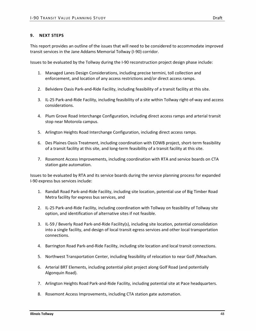
I -90 TR AN SIT VALUE PLA N NIN G ST U DY Draft
Illinois Tollway 48
9. NEXT STEPS
This report provides an outline of the issues that will need to be considered to accommodate improved transit services in the Jane Addams Memorial Tollway (I-90) corridor.
Issues to be evaluated by the Tollway during the I-90 reconstruction project design phase include:
1. Managed Lanes Design Considerations, including precise termini, toll collection and enforcement, and location of any access restrictions and/or direct access ramps.
2. Belvidere Oasis Park-and-Ride Facility, including feasibility of a transit facility at this site.
3. IL-25 Park-and-Ride Facility, including feasibility of a site within Tollway right-of-way and access considerations.
4. Plum Grove Road Interchange Configuration, including direct access ramps and arterial transit stop near Motorola campus.
5. Arlington Heights Road Interchange Configuration, including direct access ramps.
6. Des Plaines Oasis Treatment, including coordination with EOWB project, short-term feasibility of a transit facility at this site, and long-term feasibility of a transit facility at this site.
7. Rosemont Access Improvements, including coordination with RTA and service boards on CTA station gate automation.
Issues to be evaluated by RTA and its service boards during the service planning process for expanded I-90 express bus services include:
1. Randall Road Park-and-Ride Facility, including site location, potential use of Big Timber Road Metra facility for express bus services, and
2. IL-25 Park-and-Ride Facility, including coordination with Tollway on feasibility of Tollway site option, and identification of alternative sites if not feasible.
3. IL-59 / Beverly Road Park-and-Ride Facility(s), including site location, potential consolidation into a single facility, and design of local transit egress services and other local transportation connections.
4. Barrington Road Park-and-Ride Facility, including site location and local transit connections.
5. Northwest Transportation Center, including feasibility of relocation to near Golf /Meacham.
6. Arterial BRT Elements, including potential pilot project along Golf Road (and potentially Algonquin Road).
7. Arlington Heights Road Park-and-Ride Facility, including potential site at Pace headquarters.
8. Rosemont Access Improvements, including CTA station gate automation.

I -90 TR AN SIT VALUE PLA N NIN G ST U DY Draft
Illinois Tollway 49
9. Des Plaines Oasis, including coordination with Tollway and EOWB project on short-term and long-term feasibility of a transit facility at this site, and identification of alternative/complementary strategies for serving the Elk Grove Village area employment concentration as needed.
Issues to be evaluated by the Rockford Mass Transit District (RMTD) during the service planning process for expanded I-90 express bus services include:
1. Rockford East Side Park-and-Ride Facility, including site location and connections with other RMTD services.
2. Belvidere Oasis Park-and-Ride Facility, including coordination with Tollway on the feasibility of a transit facility at this site, and feasibility of one or more alternative locations if not feasible.
3. RTA Transit Connections, including coordination with RTA and its service boards on connections with future transit services in the I-90 corridor.