August 13, 2012 7:00 PM AGENDA2B1FDA13-2F94-4097-8D07... · Aikijujutsu (soft) which is the...
278
CITY COMMISSIONERS OF THE CITY OF WILDWOOD Mayor/Commissioner – Ed Wolf – Seat 1 Mayor Pro-Tem/Commissioner – Ronald Allen – Seat 5 Pamala Harrison-Bivins – Seat 2 Don C. Clark – Seat 4 Robby Strickland – Seat 3 Bill Ed Cannon – City Manager August 13, 2012 7:00 PM PLEASE TURN OFF ALL CELL PHONES AND PAGERS Persons with disabilities needing assistance to participate in any of these proceedings should contact the City Clerk’s Department, ADA Coordinator, at 352-330-1330, Ext. 102, forty-eight (48) hours in advance of the meeting. F.S.S. 286.0105A - If a person decides to appeal any decision made by the Commission with respect to any matter considered at this meeting, they will need a record of the proceedings, and that for such purpose they may need to ensure that a verbatim record of the proceedings is made, which record includes the testimony and evidence upon which the appeal is to be based. The City of Wildwood DOES NOT provide this verbatim record. City Hall Commission Chamber - 100 N. Main Street, Wildwood, FL 34785 AGENDA 1. TIMED ITEMS AND PUBLIC HEARINGS a. None 2. REPORTS AND PUBLIC INPUT / SPECIAL PRESENTATION(S) a. Special Presentations 1. None b. City Manager 1. August 22-25, 2012 (Wednesday-Saturday) City Manager attending Florida League of Cities Conference 2. August 30, 2012 – City Health Plans Open Enrollment c. City Attorney 1. d. City Clerk 1. e. Commission Members 1. f. Public Forum (10 minute time limit) 1. * Quasi Judicial Hearing
-
Upload
duongkhuong -
Category
Documents
-
view
214 -
download
0
Transcript of August 13, 2012 7:00 PM AGENDA2B1FDA13-2F94-4097-8D07... · Aikijujutsu (soft) which is the...

CITY COMMISSIONERS OF THE CITY OF WILDWOOD Mayor/Commissioner – Ed Wolf – Seat 1
Mayor Pro-Tem/Commissioner – Ronald Allen – Seat 5
Pamala Harrison-Bivins – Seat 2
Don C. Clark – Seat 4
Robby Strickland – Seat 3
Bill Ed Cannon – City Manager
August 13, 2012 7:00 PM
PLEASE TURN OFF ALL CELL PHONES AND PAGERS
Persons with disabilities needing assistance to participate in any of these proceedings should contact the City Clerk’s Department, ADA Coordinator, at 352-330-1330, Ext. 102, forty-eight (48) hours in advance of the meeting.
F.S.S. 286.0105A - If a person decides to appeal any decision made by the Commission with respect to any matter considered at this meeting, they will need a record of the proceedings, and that for such purpose they may need to ensure that a verbatim record of the proceedings is
made, which record includes the testimony and evidence upon which the appeal is to be based. The City of Wildwood DOES NOT provide this verbatim record.
City Hall Commission Chamber - 100 N. Main Street, Wildwood, FL 34785
AGENDA
1. TIMED ITEMS AND PUBLIC HEARINGS
a. None
2. REPORTS AND PUBLIC INPUT / SPECIAL PRESENTATION(S)
a. Special Presentations
1. None
b. City Manager 1. August 22-25, 2012 (Wednesday-Saturday) City Manager attending Florida League of Cities
Conference
2. August 30, 2012 – City Health Plans Open Enrollment
c. City Attorney 1.
d. City Clerk 1.
e. Commission Members 1.
f. Public Forum (10 minute time limit) 1.
* Quasi Judicial Hearing

P a g e | 2
Commission Meeting Agenda August 13, 2012
g. Notes and Reports 1. FYI – Letter from Fla. Department of Economic Opportunity – Completed its review of our
adopted Comprehensive Plan Amendment submitted June 26, 2012 and identified no provision
necessitating a challenge of the ordinances adopting the amendments (Attachment) pg. 5
2. FYI - Karate Classes to begin September 5, 2012 at Community Center; FREE Self-Defense Class
for Women (Attachment) pg. 6-7
3. FYI – Florida League of Cities congratulating Mayor Wolf on 35-years of service to the COW and
will be recognized at the 86th FLC Annual Conference in Hollywood, FL and at a COW Commission
Meeting in Sept. or Oct. (Attachment) pg. 8
4. FYI – Results of Police Department’s Evidence Vault Inspection (Attachments) pg. 9-10
3. NEW BUSINESS – ACTION REQUIRED
a. MINUTES
1. Minutes of Special Called First Budget Workshop held on July 18, 2013 (Attachments – Staff
Recommends Approval) pg. 11-14
2. Minutes of Regular Meeting held on July 23, 2012 (Attachments – Staff recommends approval)
pg. 15-22
b. ORDINANCES FIRST READING ONLY (READ ONLY – NO VOTE)
1. First reading of Ordinance No. O2012-23 amending the Land Development Regulations to be
consistent with the amendments to the Comprehensive Plan (Attachments) pg. 23-178
c. RESOLUTIONS FOR APPROVAL
1. Resolution No. R2012-08 - Taking advantage of a unique purchasing opportunity for the water
meter replacement project by piggybacking a bid from Panama City and authorize the Mayor to
execute the contract between Utility Metering Solutions and the City of Wildwood in the amount
of $129,448.00 and authorize the purchase of 1,598 R900i transmitters and 1,880 R900i meters
from Sunstate Meter & Supply, Inc. in the amount of $687,845.00. (Attachments – Staff
Recommends Approval) pg. 179-206
2. Resolution No. R2012-09 – Approving the Bylaws of the Wildwood Area Historical Association
(Attachments – Staff Recommends Approval) pg. 207-211
3. Resolution No. R2012-10 - Authorizing The Mayor And City Clerk to execute a Memorandum Of
Agreement between the City Of Wildwood and the Florida Department Of Transportation for the
maintenance of state road rights-of-way by the COW(Attachments – Staff Recommends
Approval) pg. 212-216
4. Resolution No. R2012-11, recognizing City Government Week October 21 through 27, 2012 and
encouraging all citizens to support the celebration and corresponding (Attachments – Staff
Recommends Approval) pg. 217-225
5. Resolution No. R2012-12, determining certain property (1994 GMC Pick-up) surplus and
determining manner of disposal (Attachments – Staff Recommends Approval) pg. 226-228

P a g e | 3
Commission Meeting Agenda August 13, 2012
6. Resolution No. R2012-13, determining certain property (Auto Ordinance Corp Submachine Gun)
surplus and determining manner of disposal (Attachments – Staff Recommends Approval)
pg. 229-230
d. APPOINTMENTS
1. None
e. CONTRACTS AND AGREEMENTS
1. Request approval of the Utility Maintenance Agreement Between the City of Wildwood and
Brute Properties, Inc. (Attachments – Staff Recommends Approval) pg. 231-236
f. FINANCIAL
1. Bills for Approval (Attachments – Staff Recommends Approval) pg. 237-239
2. Request approval for TAW Orlando Service Center, Inc. to repair reuse pump #2 at a cost of
$7,301.29 and authorize the rental of a mobile crane for $750 (Attachments – Staff Recommends
Approval) pg. 240-244
3. Request approval to purchase a new replacement Flygt submersible pump and electrical cable
from Xylem Water Solutions USA in the amount of $7,537.60 to replace failed pump at the
Peter’s Street Pump Station (Attachments – Staff Recommends Approval) pg. 245-249
4. Request approval of Data-Flow Systems’ proposal dated July 18, 2012 in the amount of $2,512.00
to upgrade existing communications radios to meet with the new “narrow-banding” Federal
Communication Commission (FCC) compliance standards and authorize staff to purchase up to
five (5) new radios if needed at a cost of $975.00 each (Attachments – Staff Recommends
Approval) pg. 250-254
5. (TABLED 7/9 & 7/23) Request approval to purchase new copy machine to replace the
Administration Dept. copier, which is near it’s life expectancy. Staff recommends Konica Minolta
C654 at a total cost of $14,491(purchase) or $14,112 (3-yr. lease w/$400 upfront for surge
protection & relocate old copier) (Attachments – Board Option) pg. 255-264
g. GENERAL ITEMS FOR CONSIDERATION
1. Update on current CDBG Grant regarding funds still available and request for direction from the
Commission on how those funds should be used (David Grimm to address) (Attachments) pg.
265-266
2. Letter/CEN (Contract Expiration Notification) from FDOC with “DRAFT” Contract #WS728 (the 1st
crew/Public Works) asking whether or not we would like to renew this contract (Attachments –
Staff Recommends Approval) pg. 267-273
3. Review/approval requested of the University of Florida (Bureau of Vital Statistics) Population
Estimate for the City of Wildwood (Attachments – Staff Recommends Approval) pg. 274-275
4. Discussion/Decision on future use of Former Head Start building at 610 Jackson Street which has
been vacated by Mid Florida Community Services (Attachments – Board Option) pg. 276-278
P a g e | 4
Commission Meeting Agenda August 13, 2012
4. ADJOURN
IMPORTANT DATES (No Attachments)
a. August 14, 2012 - (Tuesday) Primary Election Republican State & Local (US Senator, Public Defender, Property Appraiser, BOCC Dist. 3, State Committeewoman) – ALL Day various polling locations
b. August 14, 2012 - (Tuesday) Langley Medical Services Ribbon Cutting – 4:00 PM – Sumterville c. August 14, 2012 – (Tuesday) Wildwood Area Historical Association Meeting – 6:30 PM – Baker
House – 6106 CR 44A, Wildwood d. August 16, 2012 – (Thursday) Wildwood Springs Community Development District - Public
Hearing to adopt proposed budget for FY 2013 – 1:00 PM – Wildwood Community Center e. August 17, 2012 (Friday) Second Budget Workshop – 9:00 AM – 12:00 PM – Commission
Chamber f. August 22-25, 2012 (Wednesday-Saturday) City Manager attending Florida League of Cities
Conference g. September 3, 2012 (Monday) - Labor Day Holiday – All City Offices Closed except Police
Department

2. g. 1. Page 1 of 1

Wildwood Karate !! Want to learn Karate ( GoJu Ryu ) Aiki-jitsu ,Ju-Jitsu, Arnis, Kobudo
Nisei Tenchi Budo
For More info contact:
Sensei Yogi Diaz, Instructor Ph: 352-301-8229
Email: [email protected]
Wildwood Community Center
6500 Powell Road (CR 139)
Wildwood,FL 34785
2nd FLOOR
Free!!! Women !
Self-defense !
We offer classes in :
Arnis De Mano ( Filipino Martial Arts ), Goju Ryu, Judo, Ju-Jitsu, Tai-Jitsu, Self-Defense with & without Weapon
and Women Self-Defense Class!!
Each One Teach One !! i2i No Contract !!
Time: 4:30pm to 9pm Days: Monday, Wednesday & Friday
Children 5 and Up,Teens,Adults
Class will Start on
09/05/12
Se habla español
2. g. 2. Page 1 of 2

Come and be a part of our Wildwood Karate Family! Have fun while learning martial arts and self-defense techniques, getting a workout, improving concentration and building confidence! Check out our classes for both adults and children 5 and up. Boys and girls are welcome. Please call me with any questions. Okinawa Goju Ryu Karate-do: Translates into English as 'Okinawa hard/soft empty-hand way'. Traditional Goju Ryu is a non-sport system practiced for real self-defense situations, health, longevity and self-discovery. The byproduct of this is a complete self-defense system using grappling, punching, kicking, knee and elbow strikes and open-handed techniques. The emphasis is on close-combat fighting, with focus on manipulation of joints and vital points, strangulation, throwing techniques and ground fighting. You will also learn many important foundations. Aiki-jitsu & Ju-jitsu: is a form that can be broken into three styles: Jujutsu (hard/ soft); Aiki no Jutsu (soft); and Aikijujutsu (soft) which is the combination of the former two. Modern Japanese Jujutsu and Aikido are both styles that originate in Aikijujutsu. It emphasizes "an early neutralization of an attack”. Like other forms of Jujutsu, it emphasizes throwing techniques and joint manipulations to effectively control, subdue, or injure an attacker. Of particular importance is the timing of a defensive technique to either blend or neutralize an incoming attack's effectiveness and use the force of the attacker's movement against them. Ju Jitsu is formed from two ideograms Ju the various meanings of which are suppleness, flexibility, pliancy, gentleness and Jitsu meaning technique or art. So Ju Jitsu means the art of suppleness or flexibility. As most Ju Jitsuka (a student of Ju Jitsu) know, there is nothing "gentle" about the martial art. What Ju is conveying is that Ju Jitsu does not use strength against strength; it uses the opponent’s strength and force of attack as a weapon against him, thus enabling a stronger or bigger attacker to be subdued. Garimot Arnis de Mano: is a Filipino Martial Arts developed by Gat Puno (Chieftain) Abon "Garimot" Baet. He is the 5th generation inheritor of his family art. Garimot Arnis is a system composed of three basic parts: Arnis (weapons), Buno (wrestling), and Hilot (healing). The defining characteristic of the system is in keeping yourself safe. This is done by meticulously studying the footwork, angles, and distancing of largo mano (long hand) to keep yourself out of your opponent's range while keeping him in your range. In corto (close) range, the opponent's ability to attack must be shut down as quickly as possible, through a disarm, lock, or manipulation of the opponent's body, which sets up the finish. Above all, knowledge of hilot allows you to keep yourself healthy by helping to fight illness and injuries, especially injuries caused during Arnis and Buno training.
"Garimot" (from Paeteno slang "garaymot," meaning "absorber") was the fighting nickname of Gat Puno's father Felipe. Gat Puno took the name in his father's honor, and used it to name his family's system. Garimot Arnis consists of many styles. Children & Adults will Learn: Discipline, Respect & Responsibility • Learn Fighting Skills • Make Friends • Build Self-Confidence • Great Workout! Promote Safety • Belt Promotions • Fun & Exciting • Stress Reliever • Bi-yearly Tournaments FREE Women’s Self Defense: A hand’s on program that is designed to give you the ability to respond effectively in a realistic attack situation. We will educate you on personal protection, environmental awareness, home security and practical self-defense techniques. The Women’s Self Defense Class will educate you on how to keep you and your Family safe inside and outside your home. Whether you are in a group or all alone, you will get a foundation of knowledge to call upon when you have no other choice but to fight back to survive. Violence Against Women The abuse of women and girls is endemic in most societies around the world. One in Three women will be raped, beaten, coerced into sex or otherwise violated in her lifetime.
There is no age limit, but women under 18 must be accompanied by an adult.
Women’s Self Defense Classes are FREE !!!
All you need to do is pre-register.
2. g. 2. Page 2 of 2

2. g. 3. Page 1 of 1

2. g. 4. Page 1 of 2

2. g. 4. Page 2 of 2

Page 1 of 4
CITY COMMISSION CITY OF WILDWOOD, FLORIDA
BUDGET WORKSHOP/SPECIAL MEETING JULY 18, 2012 – 9:00 A.M.
CITY HALL COMMISSION CHAMBER
The City Commission of the City of Wildwood Florida met in Special Session, July 18, 2012 at 9:00 a.m. Present were: Mayor Wolf, Commissioners Bivins, Clark, Allen, and Strickland. Also present were: City Manager Cannon, City Clerk Jacobs, Assistant City Clerk Roberts, Police Chief Reeser. The meeting was called to Order. 1. TIMED ITEMS AND PUBLIC HEARINGS
None
2. REPORTS AND PUBLIC INPUT / SPECIAL PRESENTATION(S)
a. City Manager b. City Attorney - None c. City Clerk - None
d. Commission Members
e. Public Forum (10 minute time limit) f. Notes and Reports 3. NEW BUSINESS – ACTION REQUIRED a. MINUTES b. ORDINANCES FIRST READING ONLY (READ ONLY – NO VOTE) - None c. RESOLUTIONS FOR APPROVAL - None
d. APPOINTMENTS - None e. CONTRACTS AND AGREEMENTS - None
f. FINANCIAL
Discussion: FY2012-2013 Base Budget and requested enhancements and personnel. Mayor Wolf – during this meeting hit the high points of the proposed budget and then at the second workshop there may be more solid numbers for the Commission to make decisions on. CM Cannon – referred to the summary Joseph provided as the first page of the budget. Expressed gratitude to Joseph for work he has done and for helping him learn what is expected in Florida. Noted this is a bare bones budget and no special projects have been included. He wants to see where the grants are coming from to take care of the expensive needs and then can meet to discuss those. The operating expenditures have been estimated. Any Capital enhancements, supplies, maintenance or repair that are included are those deemed mandatory. Two numbers he likes are the General Fund contingency at $658,000 and the Enterprise Fund contingency at $501,000. Recommended that the Enterprise Fund
3. a. 1. Page 1 of 4
Page 2 of 4
Minutes Page 2 July 18, 2012
contingency be at half a million to meet the percentage of funds to show the City is capable of making payments on funding. Noted the population estimates included in the packet which is now showing at 6,928 for Wildwood. CC Jacobs – regarding ad valorem tax, noted that the calculations are now electronic. Noted that the City could approve the Rollback rate or the Adjusted Rollback rate of 4.1936. Noted that Brownwood would not be reflected in the taxes until 2014. Noted the adjusted rollback rate comes about when the City does not meet the amount of tax expected from the previous year’s rate. Motion by Commissioner Bivins, second by Commissioner Allen to tentatively approve the 4.1936 adjusted rollback rate. Motion carried by unanimous vote. CM Cannon referred to Revenues on page 21. Noted that some revenues come through the State and are based on what the State projects to be the City’s share. CM Cannon referred to Expenditures for any questions from the Commission. Referred to Page 52 regarding the Short and Long term Debt. Reviewed and suggested that the two State Revolving loans 1 and 2 should probably continue as is. However the City may want to look at refinancing the longer termed loans. Noted the Angie Brewer Company is seeking grant funds for projects and possibly the longer termed loans can be included. Will send the Commission some of the emails between Angie Brewer and the City Manager. Would like to improve the debt service. Referred to Enhancement requests. After additional numbers are available the Commission can discuss and decide what will be funded. Will bring back recommendations to next Budget workshop. Mayor Wolf questioned why the Police Department is suggesting an ATV for Brownwood instead of the golf cart. Noted that the golf cart would seem the best fit for Brownwood and the golf cart dealer there may provide one as advertisement. PC Reeser noted that the decision is entirely up to the Commission, but wanted to point out that an ATV could be used for other situations. The number of hours of coverage at the substation was discussed. After additional discussion Commissioner Allen asked the City Manager to review further and that additional information be brought to the Second Budget workshop. PC Reeser to gather further information of cost and pictures of golf cart and ATV for the second budget workshop. CM Cannon referred to Page 58 – Personnel requests. Mayor Wolf expressed that HRC is not a Department Head but works under the City Manager. Doesn’t know where this Senior Management is coming from since this is not a management position.
CC Jacobs indicated that the Human Resource Coordinator position was created to oversee HR needs and performs department head duties such as budgeting for the department. Mayor Wolf indicated that the Commission would have never filled the position at a Department Head Salary and the Human Resource Coordinator is there to
3. a. 1. Page 2 of 4

Page 3 of 4
Minutes Page 3 July 18, 2012
serve the employees. This is not a Senior Management position for FRS. CC Jacobs indicated that although FRS gives guidelines that must be met to be considered, the Commission determines what positions are designated to the Senior Management class of FRS. It is the position that is designated, not the employee. Noted that when he leaves, if a person is hired with the same title he has they would automatically be in the Senior Management class of FRS. Noted that we have been following what the Commission has said that no other positions are to be placed in Senior Management and that when a Senior Management position is vacated that it would not be filled. Mayor Wolf noted that the HRC position was filled a year or so ago and asked what is requiring the person to be at City Hall after 7:00 p.m., and why a part time person is being asked for when it wasn’t necessary it in the past. We need HR here first thing in the morning because that is when many issues come up. CC Jacobs noted that when HR was separated from ACC Roberts, Risk Management was transferred to HR also. ACC Roberts noted that she was able to call on the Deputy Clerks to assist with filing and reviewing forms, the previous City Manager specifically stated that Risk Management was to go to the HRC also. Commissioner Allen indicated he has been in the office and the HRC is not here at 9 a.m. This needs to be referred to the City Manager for review to be addressed and brought back to the Commission. Mayor Wolf noted that the hours of operation have been addressed. Commissioner Allen expressed that he can’t see approving the requests from the HRC pertaining to pay increase. CM Cannon noted he will check on this and it appears she does need some part time help. In response to a question from Mayor Wolf, CM Cannon indicated his understanding is there is a person in the police department. PC Reeser indicated if the person were to go part time in HR, then he would need an additional part time person to make up the loss. Commissioner Allen asked that the HRC requests be further reviewed by the City Manager and provide information at the second budget workshop including recommendation for an increase but not as much as being asked for. Page 59 – Police Department personnel change requests. CC Jacobs noted that four officers were previously approved with two hired in June and two will begin in October. These are two additional officers. Increases to the entry pay for police supervisors and dispatchers are being requested. It was noted there is one current employee in each of the supervisors’ positions that will have to be brought up to the increased amount. CM Cannon noted a “complaint” against the police department for a ticket received past the overpass. PC Reeser indicated many don’t know that area is in the City.
Commissioner Clark noted a complement to the police department from a resident in Parkwood Manor who appreciated the number of times the police patrol the park. Mayor Wolf noted the same person contacted him.
3. a. 1. Page 3 of 4

Page 4 of 4
Minutes Page 4 July 18, 2012
Mayor Wolf noted the increase requested for an employee in the Utilities Department and asked that the City Manager look at all request carefully. CM Cannon noted there are a few requests for individual employees that he is reviewing and is in the process of gathering information to provide to the Commission. Mayor Wolf noted that property insurance may be higher this year. CM Cannon indicated the health insurance is looking good at this time. Probably the biggest cost is the prescriptions. CC Jacobs noted that most of the contingency is from cash being brought forward from reserves.
Mayor Wolf requested that the City Manager look into and take care of the George Whitaker issue. AVT Law evidently has not notified the City Manager but has made calls to Yelvington. We have had the jake brake problem with the Yelvington drivers in the past. Mr. Whitaker works at night. Mayor Wolf requested that the City check on local preference for upcoming projects and if necessary to have a resolution or ordinance drafted. ACC Roberts was asked to research for ordinance or resolution related to local preference. CM Cannon noted that a memo was sent out regarding deadline of agenda items being received in the City Manager’s office. CM Cannon indicated he will send out the spread sheet on meter financing to the Mayor and Commission.
Mayor Wolf requested City Manager and staff to collect additional information needed for the second budget workshop including current cost of living percentage, marketplace pay rates, costs of equipment, etc. City Manager to make recommendations regarding enhancements and personnel requests for the second budget workshop.
g. GENERAL ITEMS FOR CONSIDERATION - None
4. ADJOURNMENT Upon a motion by Commissioner Clark, second by Commissioner Bivins the meeting was adjourned. CITY COMMISSION CITY OF WILDWOOD, FLORIDA S E A L ATTEST: Ed Wolf, Mayor Joseph Jacobs, City Clerk
3. a. 1. Page 4 of 4

Page 1 of 8
CITY COMMISSION CITY OF WILDWOOD, FLORIDA
REGULAR MEETING JULY 23, 2012 – 7:00 P.M.
CITY HALL COMMISSION CHAMBER The City Commission of the City of Wildwood Florida met in Regular Session, July 23, 2012 at 7:00 p.m. Present were: Mayor Wolf, Commissioners Bivins, Clark, Allen and Strickland. Also present were: City Manager Cannon, City Clerk Jacobs, City Attorney Blair, Assistant City Clerk Roberts, Police Chief Reeser, Development Services Director Peavy, Utility Director Phillips and AVT Law. The meeting was called to Order followed by an invocation and Pledge of Allegiance to the American Flag. 1. TIMED ITEMS AND PUBLIC HEARINGS
a. 7:00 PM – PUBLIC HEARING – SECOND FINAL READING – Ordinance No. O2012-18, an ordinance amending the adopted Interlocal Service Boundary and Joint Planning Agreement (ISB/JPA) Planning Services Sub-Agreement with Sumter County to reflect current planning conditions and to update the ISB Map and JPA Future Land Use Map to be consistent with the pending Comprehensive Plan Amendment (Attachments – Staff Recommends Approval) O2012-18 was introduced. DSD Peavy indicated there were questions at the last meeting so this was tabled and asked if the City Attorney needs to address some of those questions before action is taken. Commissioner Strickland indicated he had not gotten answers to all his questions. He and the City Attorney have corresponded through emails but didn’t receive answers on questions he sent today. He wanted to know whether the City and the Villages are in compliance with the agreements to date and whether utility tax and annual payments are up to date. Noted the Annexation part was not a big issue. CA Blair indicated the annexation had nothing to do with the agreements, the only thing about annexation was the requirement for the Villages to annex 400 acres of commercial property into the City as a part of the consideration for the City not fighting with the Villages as to who would provide water and sewer in certain areas. Understands there are still 47 acres of non-residential to be annexed into in the City, and the Villages is working on a proposal to the City. Steve Roy indicated that it is being looked at and Jason and Melanie have been working on a proposal also. The Villages are not outside of a time frame on this issue. The Villages worked with the State legislature to have enacted a provision for the City to have authority to have a utility tax for outside the City limits areas.
Commissioner Strickland expressed concern that he has not seen all of the agreements and that the City approved the JPA only to have other agencies drag their feet and now want the City to approve changes quickly. CA Blair explained that the Commission and staff took a long hard look at the agreements before they were approved because it was a big thing to give up. The five mile service area is only if you can get the services there. The City didn’t have the ability to do that and the Commission felt it was in the best interest to approve the agreements
DRAFT
3. a. 2. Page 1 of 8

Page 2 of 8
Minutes Page 2 July 23, 2012
and give the Villages the right to serve in that area. On the question of annexation, the reason she didn’t believe the Baker property was one that annexation could be forced on because of other issues such as the configuration of the property in that area. We would have to meet the consent portion of the Statute. The JPA doesn’t give us any authority and is not an agreement with the people on that property or own that property. The City does need to look at the compliance issue for both the Villages and the City. DSD Peavy noted that staff has reviewed the agreements and in the agreements there is an area that is defined by a legal description so UD Phillips has directed Kimley-Horn to map the area out. Have received that but haven’t been able to review it or have the Villages review it. Mayor Wolf asked that Development Services be the ones who meet with Kimley-Horn. DSD Peavy indicated that CC Jacobs has provided the numbers that are coming in from the Villages. We will be monitoring the agreements. Moving forward with the JPA and modified map will not affect any of those other obligations. Delay of approving this will affect the ability to provide correct numbers for the 10 Year water supply plan due within next two years. Persons who annexed or wanted to can’t until the JPA is adopted. Meeting opened to the Public for public hearing. No comments were received. Motion by Commissioner Allen, second by Commissioner Clark to adopt Ordinance No. O2012-18, an ordinance amending the adopted Interlocal Service Boundary and Joint Planning Agreement (ISB/JPA) Planning Services Sub-Agreement with Sumter County to reflect current planning conditions and to update the ISB Map and JPA Future Land Use Map to be consistent with the pending Comprehensive Plan Amendment on second final reading. Motion carried by unanimous vote. b. 7:00 PM – PUBLIC HEARING – FIRST READING - Ordinance No. O2012-22; an ordinance amending the Comprehensive Plan Amendment to Implement the Interlocal Service Boundary and Joint Planning Area with Sumter County. Staff is requesting approval for transmittal of Ordinance No. O2012-22 to the reviewing agency for comments (Attachments – Staff Recommends Approval) O2012-22 introduced and meeting opened to the Public for public hearing. No comments were received. Mayor Wolf noted on page 17 the data and analysis regarding one or two wastewater treatment plants. DSD Peavy at this time we have an opinion from the City Engineer that probably there should be two plants. Not sure where the second plant will go whether at Landstone or somewhere else. Will need to enter into a new utility agreement with Landstone because there or some requirements in the original agreement that cannot be met by either the City or Landstone. Motion by Commissioner Clark, second by Commissioner Bivins to approve transmittal of Ordinance No. O2012-22 to the reviewing agency for comments. Motion carried by unanimous vote.
Minutes Page 3
DRAFT
3. a. 2. Page 2 of 8

Page 3 of 8
July 23, 2012 2. REPORTS AND PUBLIC INPUT / SPECIAL PRESENTATION(S)
a. City Manager 1) Tablets for Commission. The budget for these will run from $3200 to $4000. These would be used to provide the agendas to the Commission. Would like direction how to proceed. Noted there is money in this year’s budget. Commissioner Allen noted that Apple products do not get viruses and android does. Would recommend Apple products. Motion by Commissioner Allen, second by Commissioner Bivins to proceed toward goal of providing I Pads. Motion carried by unanimous vote. 2) Police Station – need a professional consultant to assist with this endeavor. Would like authorization to prepare and advertise for request for qualifications for this assistance. Wants to explore funding and PC Reeser made contact with Rural Development who will meet with the City. Motion by Commissioner Clark, second by Commissioner Bivins to proceed to advertise Request for Qualifications. Motion carried by unanimous vote.
3.f. 3) Copier – defer until next meeting for further staff review of machines.
Motion by Commissioner Allen, second by Commissioner Strickland to table until next meeting. Motion carried by unanimous vote.
2.f.2) Budget Comparison for June 30, 2012. Information. b. City Attorney
1) Request for direction as to whether or not the City wants to schedule a closed meeting to discuss potential settlement of Chambers and Harvey cases (NO Attachments)
Commissioner Allen asked if this had to come before the Commission for approval or can the insurance company settle without Commission approval. CA Blair gave an opinion that the City go with the recommendation of the Insurance Company on certain types of litigations. CA Blair to provide insurance issue updates to Commission quarterly.
c. City Clerk - None
d. Commission Members Strickland – regarding I Pads. How will the agenda get out ahead of time for review and how much paper will be saved. AVT Law – one suggestion is that the I Pads be at City Hall for the agenda to be uploaded and then the Commissioners pick those up for reviewing and return after the Commission meeting. It was noted that they could not be delivered as the paper agendas are. CM Cannon noted that a memo has gone out that the deadline for agenda items will be the Friday a week before the Commission meetings.
Minutes
DRAFT
3. a. 2. Page 3 of 8

Page 4 of 8
Page 4 July 23, 2012
Wolf – With Brownwood being in the City of Wildwood, the other areas shouldn’t be neglected and would like to push code enforcement. CM Cannon noted that a meeting is scheduled this week on that subject. Allen – requested an update on the house that was to be demolished on Huey Street. DSD Peavy noted that the problem is ownership of the property, and the County is not delaying. The demolition process has begun by the County through the owner. Can’t force the owner to pay if they don’t have the money. Jason McHugh went through the City today to list properties that can be discussed at the meeting. Commissioner Bivins noted a house on 2nd Street that has a roof half gone. Commissioner Allen requested an update after the meeting.
e. Public Forum (10 minute time limit)
1) Larry Green – Care4Kids, a 501c3, non-profit organization which is all about helping people. Is a licensed ordained minister, but his ministry is in the community. When they have an event they serve a hot meal and give out grocery bags to take home as well give the children toys, candy, books, snow cones, etc. They are funded by businesses and individuals. An event is scheduled on this Saturday at Wells Fargo property from 12 to 3. Not present to ask for funds but to issue a public invitation to the Commission and all to attend the event. They work with the School board, the Sheriff’s Department and Health Department all of which provide information as to those in need in the community. They also get calls from those agencies for assistance. They are working with Carolyn Ford on the annual Back to School Bash. Provided information packet for file. Appreciation was expressed to Larry Green for his work and involvement in the community. 2) Norvel Scott – had the opportunity to work with Blue Moon Ranch while president of the Wildwood Community Development Center. A Program was set up to have kids go to the ranch and learn about horses. When discussed with the City Commission they expressed concern about faith verses religion so he went to the businesses to raise funds. Waste Management was one of those. Today 15 kids were to be at Blue Moon Ranch, but there was a bump in the road, there were no funds. Waste Management had talked with the City Attorney and they donated $1000 to the City and he has an issue with that since he was the one who met with Waste Management concerning kids attending camp. Talked with the City Manager and he understands the City Manager is following the City Attorney. His question is why the money is going to the Parks & Recreation Department when it was not the P&R Department that went out and solicited the funding, it was him. Why can’t the money go to the ranch for the children to attend camp?
Minutes Page 5 July 23, 2012
DRAFT
3. a. 2. Page 4 of 8
Page 5 of 8
Mayor Wolf indicated Mr. Scott’s problem is with Waste Management, and the letter he read explained why Waste Management didn’t want to get into donating to private groups. CA Blair noted she told Waste Management that it seemed most appropriate for them to make a donation directly to the organization and not through the City. Mr. Scott – based on the email the $1000 is to be set aside for future youth programs or events that serve the community. Wouldn’t sending underprivileged children to camp serve the community? Mayor Wolf suggested that the money be sent back to Waste Management or be put against the Martin Luther King Day or Christmas parade events, which would benefit anyone who chooses to go. Mr. Scott expressed concern that the Mayor seems to close eyes on issues with Youth. In the budget hearing the Mayor stated lets provide a 24/7 service to Brownwood because we need to let the community know that the presence of the police department is in Brownwood and they are going to serve the people. We are the only part of the only City I know of that does not have a youth program, a community recreation center on the West side of town. I am an advocate for children. There are no summer programs for the youth to attend. So if you tell me you advocate for children why isn’t there a City summer program, why isn’t there a community recreation center on the West side of town, why do we not have a facility for the youth to play on. Stated the Mayor during the budget workshop talked about surplus money. Why some of the surplus can’t be used for the youth. Stated he will get up at every meeting to challenge the City. Mayor Wolf – if Blue Moon wants to provide this for underprivileged kids, let Blue Moon do it. If the kids like horses let them join the Girl Scouts when school starts because the Girl Scout camp has horses. There are more than 15 underprivileged kids and if this is going to be done the children should be selected lottery style. If he sponsored a child he would expect lottery style selection. Mr. Scott ended by stating that he tried to do a good thing by soliciting donations for the kids and it seems like it failed and he will put that on the lap of the City.
f. Notes and Reports
1) FYI – Findings, conclusions and recommendations of inspections and cleaning of ground storage tanks, hydro-pneumatic tanks and elevated storage tanks required by Fla. Admin. Code every five years (Attachments) 2) Budget Comparison Report for month ending June 30, 2012 (9-months) (Attachments) 3) FYI – Appraisal on the Baker House (Attachments)
Minutes Page 6 July 23, 2012
DRAFT
3. a. 2. Page 5 of 8

Page 6 of 8
CA Blair reported that a title search has been ordered because the Villages search did not encompass the property with the Baker House. A Contract is ready. 4) FYI – NOTICE OF PUBLIC HEARINGS – The Villages of Lake Sumter Large Scale Land Use Amendment Transmittal and Rezoning (Attachment)
5) FYI – Second Quarter 2012 work accomplished by the Public Works Department (Attachments)
3. NEW BUSINESS – ACTION REQUIRED a. MINUTES
1) Minutes of Regular Meeting held on July 9, 2012 (Attachments – Staff recommends approval)
Motion by Commissioner Strickland, second by Commissioner Bivins to approve the minutes as typed. Motion carried by unanimous vote.
b. ORDINANCES FIRST READING ONLY (READ ONLY – NO VOTE) – NONE c. RESOLUTIONS FOR APPROVAL – NONE d. APPOINTMENTS–NONE
e. CONTRACTS AND AGREEMENTS 1) Agreement between the Villages Operating Company to provide a Police sub-station at Brownwood and the City of Wildwood to provide Police presence at Brownwood for a term of twenty-five (25) years (Attachments – Staff Recommends Approval)
CA Blair indicated that changes requested were made.
In response to questions from Commission Strickland, PC Reeser indicated that the HVAC maintenance is only for the one office. Motion by Commissioner Allen, second by Commission Strickland to approve Agreement between the Villages Operating Company to provide a Police sub-station at Brownwood and the City of Wildwood to provide Police presence at Brownwood for a term of twenty-five (25) years. Motion carried by unanimous vote.
f. FINANCIAL 1) Bills for Approval (Attachments – Staff Recommends Approval)
Motion by Commissioner Allen, second by Commissioner Bivins to pay the bills. Motion carried by unanimous vote.
2) Request approval to make repairs on pond liners at the RIB site to remain
in compliance with the FDEP operating permit for the WWTP. Staff received two Minutes Page 7 July 23, 2012
DRAFT
3. a. 2. Page 6 of 8

Page 7 of 8
proposals to complete the work and recommends awarding the project to Erosion Control Systems of Florida in the amount of $3,500 (Attachments – Staff Recommends Approval)
Motion by Commissioner All, second by Commissioner Clark to approve the request to make repairs on liners at the RIB site and award the project to Erosion Control Systems of Florida with the low quote of $3,500. Motion carried by unanimous vote.
3) Request for approval to purchase new Color Digital Imaging System with
monthly maintenance contract to replace aging City Hall administration B & W copier (Attachments – Staff Recommends Approval)
CM Cannon covered under Reports from City Manager. g. GENERAL ITEMS FOR CONSIDERATION
1) Pilot Club of Sumter County, Inc.’s request to use City sidewalks for their 19th Annual Pilot Brain Power Walk to benefit Alzheimer and other brain related disorders on Saturday, October 6, 2012. Commission has approved this event in prior years. (Attachments – Board Staff Recommends Approval)
Motion by Commissioner Clark, second by Commissioner Bivins to approve the Pilot Club of Sumter County, Inc.’s request to use City sidewalks for their 19th Annual Pilot Brain Power Walk to benefit Alzheimer and other brain related disorders on Saturday, October 6, 2012.Motion carried by unanimous vote. 2) Providence One Partners seeks approval of the revised Site Plan for Providence ILF at Turkey Run which incorporates street names into the development and omitted in version approved by Commission Dec. 12, 2011 (Attachments – Staff Recommends Approval) Mayor Wolf asked for update on the back road connection since there are so many churches planned for the road. DSD Peavy indicated the City would have to do it on their own. All property owners were contacted several times, but one wanted compensation. Mayor Wolf noted traffic lights will be needed along the road if all the churches planned are built. Turkey Run agreed to right of way in the original DA, but could not get it from other property owners. Once the improvements are made to 462 it should relieve some of the traffic back up. They are correcting the intersection of 462 and 121. Motion by Commissioner Allen, second by Commissioner Bivins approve the revised Site Plan for Providence ILF at Turkey Run which incorporates street names into the development and omitted in version approved by Commission Dec. 12, 2011. Motion carried by unanimous vote. 3) Request from Carolyn Ford with God’s Glory Ministries for permission to use the City’s parking lot located behind the Gazebo for their 4th Annual Back to
Minutes Page 8 July 23, 2012
DRAFT
3. a. 2. Page 7 of 8

Page 8 of 8
School Bash on Saturday, August 4th, from 1 to 5 PM (Attachments – Board Option) Motion by Commissioner Allen, second by Commissioner Bivins to approve the Request from Carolyn Ford with God’s Glory Ministries for permission to use the City’s parking lot located behind the Gazebo for their 4th Annual Back to School Bash on Saturday, August 4, from 1 to 5 PM. Motion carried by unanimous vote.
4) Request for Commission input on the definition/procedure that constitutes a “Change of Use” in order to be able to draft an ordinance which will add the language to the City’s Code (Attachments – Board Option) DSD Peavy – there are many scenarios that come up with this. There is currently no definition. Using the water usage as the base is seems the best way to determine “Change of Use”. There is a problem when ERU’s are not needed by the new business and there is a credit. Mayor Wolf noted this may need a workshop. UD Phillips explained that if a business had paid for 10 ERU’s and then sold the property and another business came in and needed 15 ERU’s, the new business would have to pay for the additional 5 ERU’s because they need more the plant’s capacity. DSD Peavy indicated this would be the most fair and is consistent with other cities. No action necessary.
4. ADJOURN Upon a motion by Commissioner Allen and second by Commissioner Bivins the meeting was adjourned. CITY COMMISSION CITY OF WILDWOOD, FLORIDA S E A L ATTEST: Ed Wolf, Mayor Joseph Jacobs, City Clerk
DRAFT
3. a. 2. Page 8 of 8

SUBJEC REQUES
CONTRA BUDGET
Annua Capita N/A
HISTORY On JuneCommissan affectconsisten The high
E In In E M M
Staff reco
Jason McDevelopm
CITY
CT: Ord
STED ACTIO
W
ACT: EffeMan
T IMPACT:
al al
Y/FACTS/ISS
11, 2012 Osion. Ordinated party. Tnt with the a
lights of the
Elimination ofncreased flexncreased flex
Elimination ofMethodology Minor edits fo
ommends ap
cHugh ment Service
Y COMMIS
dinance O2
ON:
Work SessioRegular Mee
N/A ective Date: naging Divis
FUNDING SEXPENDITU
UES:
Ordinance O2ance O2012-The City is mendments
changes to
f the 30% rexibility in mixxibility in thef concurrencfor traffic im
or clarificatio
pproval of O
es Coordina
SSION OF
EXECUT
2012-23 Am
on (Report Oeting
__________sion / Dept:
SOURCE: URE ACCO
2012-15 am-15 became now require to the Com
the LDRs in
eduction in mxed use cene required mcy for transp
mpact studieson and renum
Ordinance O2
ator
F THE CI
TIVE SUMM
mending th
Adopt
Only) DAT S
Vend____ Term
UNT:
mending the effective on
ed to amenprehensive
nclude the fo
maximum deters (MUCs)ix of uses inortation ands mbering
2012-23.
ITY OF W
MARY
he Land De
tion of Ordin
TE OF MEETSpecial Meet
dor/Entity: mination Date
Comprehenn July 25, 20nd the LandPlan.
ollowing:
evelopment p)
n the mixed ud public scho
WILDWOO
evelopmen
nance O20
TING: Ating
e:
nsive Plan w012 after nod Developm
potential
use categoriools facilities
OD
nt Regulati
012-23
August 13, 2
was adoptedo challenge wment Regula
ies s
ions
2012
by the City was filed by tions to be
3. b. 1. Page 1 of 156

Ordinance No. O2012-23 2012 LDR Amendments
1 of 2
ORDINANCE NO. O2012-23
AN ORDINANCE OF THE CITY OF WILDWOOD FLORIDA; AMENDING THE LAND DEVELOPMENT REGULATIONS OF THE CITY OF WILDWOOD, FLORIDA IN CONFORMANCE WITH THE LOCAL COMPREHENSIVE PLAN; PROVIDING FOR CODIFICATION; PROVIDING FOR CONFLICT; AND PROVIDING FOR AN EFFECTIVE DATE.
WHEREAS, the City adopted Ordinance O2012-15 amending the local
comprehensive plan on June 11, 2012; WHEREAS, Ordinance O2012-15 became effective July 25, 2012; and WHEREAS, the City is required to modify the Land Development Regulations to
implement the amendments to the local comprehensive plan.
NOW, THEREFORE, BE IT ENACTED AND ORDAINED, by the City Commission of Wildwood, Florida, as follows:
SECTION 1. The amendments to the Land Development Regulations are shown in the attached “Exhibit A.” The amendments are attached hereto and are shown with strikethrough for deletions and underline for additions.
SECTION 2. All ordinances or parts of ordinances in conflict herewith, be, and the same are hereby repealed.
SECTION 3. If any section, sentence, clause or phrase of this Ordinance is held to be invalid or unconstitutional by a Court or competent jurisdiction, then said holding shall in no way effect the validity of the remaining portions of said Ordinance. SECTION 4. This Ordinance shall be effective upon adoption during the second and final reading by the City of Wildwood City Commission.
3. b. 1. Page 2 of 156
Ordinance No. O2012-23 2012 LDR Amendments
2 of 2
DONE AND ORDAINED this day of , 2012, by the City Commission of the City of Wildwood, Florida. CITY COMMISSION CITY OF WILDWOOD, FLORIDA
S E A L ATTEST: Ed Wolf, Mayor Joseph Jacobs, City Clerk First Reading: Second Reading: Approved as to form: Jerri A. Blair, City Attorney
3. b. 1. Page 3 of 156
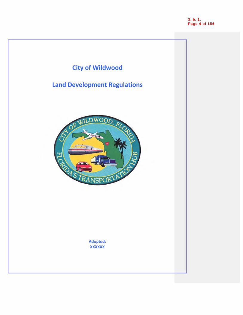
City of Wildwood
Land Development Regulations
Adopted: XXXXXX
3. b. 1. Page 4 of 156

City of Wildwood Land Development Regulations
i
City of Wildwood Land Development Regulations
City of Wildwood, Florida
PREFACE
Key Officials
City Commissioners: Ed Wolf……………………………………………………………………………………………………………………………………...Mayor Ronald B. Allen……………………………………………………………………………………………………………..Mayor Pro Tem Pamala Bivins……………….……………………………………………………………………………………………….Commissioner Robby Strickland…………………………………………………………………………………………………………….Commissioner Don C. Clark…………………………………………………………………………………………………………………….Commissioner Staff: City Manager………………………………………………………………………………………………………..............Robert SmithBill Ed Cannon City Attorney……………………………………………………………………………………………………………………..Jerri A. Blair City Clerk…………………………………………………………………………………………………………………………Joseph Jacobs
3. b. 1. Page 5 of 156

City of Wildwood Land Development Regulations
ii
City of Wildwood Land Development Regulations
City of Wildwood, Florida
PREFACE
Numbering System The numbering system utilized within this Code is similar to that used by other local governments in the state of Florida. This alphanumeric system starts with the Chapter as a numerical character. The next number, also a numerical character, pertains to a section within the Chapter. At the outset of each Chapter, all sections contained within that Chapter are listed. The remaining characters relate to the subsections. In many instances, sections have multiple subsections. Subsections contain both numerical and alphabetic characters.
Example: 3.7(B)(2)(a)(i) Chapter 3.7(B)(2)(a)(i) section 3.7(B)(2)(a)(i) subsection Page numbers are found at the bottom of each page. The page numbering system is a prefix system based on the Chapters contained in this Code. The number to the left of the hyphen indicates the Chapter number while the number to the right represents the number of pages in that Chapter.
Example: 3‐17 Chapter 3, Page 17
3. b. 1. Page 6 of 156

City of Wildwood Land Development Regulations
iii
City of Wildwood Land Development Regulations
PREFACE
TABLE OF CONTENTS
General Provisions……..……………………………………………………….........................................................Chapter 1 Definitions………………………………………………………………………………………………………………………………….Chapter 2 Zoning………………………………………………………………………………………………………………………………………..Chapter 3 Site Plan Requirements..…………………………………………………………………………………………………………….Chapter 4 Subdivision Regulations……………………………………………………………………………………………………………..Chapter 5 Technical Standards………..………………………………………………………………………………………………………….Chapter 6 Concurrency Management……………...…………………………………………………………………………………………Chapter 7 Planned Developments………………………………………………………………………………………………………..…….Chapter 8
APPENDICIES Ordinances Repealed Table State Law Reference Table Fee Schedule
SUPPLEMENTAL DOCUMENTS
Design District Standards Water Details Sewer Details
3. b. 1. Page 7 of 156

City of Wildwood Land Development Regulations
1‐1
Chapter 1 GENERAL PROVISIONS AND PROCEDURES
1.1. Statement of intent. 1.2. General Code provisions. 1.3. General development provisions. 1.4. Building and demolition permits. 1.5. Development Services Director and Building Services Director. 1.6. Project Review Committee. 1.7. Planning and Zoning Board. 1.8. Board of Adjustment. 1.9. Annexation. 1.10. Plat vacation and right‐of‐way abandonment procedures. 1.11. Appeals. 1.12. Fees, charges and expenses. 1.13. Quasi‐judicial proceedings. 1.14. Project approval process. 1.15. Project Annexation and rezoning review schedule. 1.16. Supplemental regulations. 1.17. Traffic impact studies. 1.1. Statement of intent.
(A) The regulations and requirements contained herein have been made in accordance with the City of Wildwood comprehensive plan, with reasonable consideration, among other things, to the prevailing land uses, natural and historic resources, growth characteristics, and the character of the respective districts and their peculiar suitability for particular uses, and to encourage the most appropriate use of land throughout the City. (B) In their interpretation and application, the provisions of this Code shall be the requirements to:
(1) Promote the public health, safety and general welfare; (2) Protect the character and maintain the stability of residential, commercial, industrial, agricultural, educational, cultural, recreational, historical and environmental areas within the City; (3) Provide densities needed to accommodate the projected population and to provide nonresidential uses at intensities which meet the needs of City residents; (4) Protect natural and environmentally significant resources; (5) Provide adequate open spaces and recreation facilities which meet the needs of the residents; (6) Promote transportation choices to reduce traffic congestion and to improve mobility; (7) Define the powers and duties of the boards and appointed administrative officers; (8) Provide adequate public facilities and services, and ensure that new development is served with necessary services and improvements without being a burden on the taxpayers of the City; (9) Ensure that all future development approvals and permits for both new and existing projects comply with this Code.
(C) It is not intended by this Code to interfere with or annul any existing lawful easements, covenants or other agreements between parties.
3. b. 1. Page 8 of 156

City of Wildwood Land Development Regulations
1‐2
1.2. General Code provisions.
(A) Effective date. This Code shall take effect upon adoption by the City Commission. (B) Vested rights. Notwithstanding any provision of this Code to the contrary, in order to be considered vested, a project must have been issued a development order. Projects which have received approval prior to the effective date may be developed and completed according to the preexisting requirements; however, the approved development order shall not be substantially amended after the effective date except to conform to the regulations established herein. In cases where a Planned Unit Development approval has expired and has not been granted an extension by the City Commission, the project shall be required to conform to the regulations established herein. Any applicant or developer claiming vested rights must do so on a form provided by the Development Services Department. Failure to claim such vested rights at the time of any application wherein vesting might be an issue shall cause any vested rights which might otherwise be in existence to be waived. (C) Unlawful alteration. It shall be unlawful for any person to change or amend, by addition or deletion, or to insert or delete pages or portions thereof, or to alter or tamper with any part or portion of this Code in any manner whatsoever, which will cause the law of the City to be misrepresented thereby. (D) Amendments. This Code may be amended provided, however, that no amendments shall become effective until a public hearing has been held. Each proposed amendment shall be submitted to the Development Services Director for review by the Project Review Committee and Planning and Zoning Board. Amendments are subject to approval by City Commission. Public notice regarding the time, place and date of the hearing shall be published per the Florida Statutes. (E) Supplemental documents. Supplemental documents and manuals to this Code may be amended by City staff from time to time. Such amendments may occur without adhering to section 1.2 (D) above to allow for innovations in construction and land development practices and new technologies provided that the intent of the regulation, restriction or allowance does not contradict the intentions of this Code. (F) Saving clause. If any part or provision of this Code or application thereof to any person or circumstances are adjudged invalid by any court of competent jurisdiction, such judgment shall be confined in its operation to the part, provision or application directly involved in the controversy in which such judgment shall have been rendered and shall not affect or impair the validity of the remainder of this Code or the application thereof to other persons or circumstances. The City Commission hereby declares that it would have enacted the remainder of this Code even without any such part, provision or application. (G) Officers’, employees’ liability. No provision of this Code designating the duties of any City officer or employee shall be so construed as to make such officer or employee liable for any fine or penalty for failure to perform such duty. (H) Statutory references. Any statutory references, herein this Code, are the 2010 Florida Statutes, as amended. 1.3. General development provisions.
(A) Conformity with regulations. Following, and upon adoption of, this Code:
(1) The regulations contained within this Code shall be adhered to be all lands contained within the municipal limits of the City of Wildwood. (2) No building, structure, or land shall be used or occupied except in conformity with all of the regulations specified by this Code for the districts in which said building, structure, or land is located or is to be located.
3. b. 1. Page 9 of 156

City of Wildwood Land Development Regulations
1‐3
(3) No building or structure or part thereof shall be erected, constructed, reconstructed, moved, or structurally altered except in conformity with all of the regulations specified by this Code for the district in which it is located. (4) No building or other structure shall be erected or altered in such a manner as to:
(a) Exceed the permitted density or intensity provisions; (b) Occupy a greater portion of the lot area than allowed; or (c) Otherwise is contrary to the provisions of this Code.
(5) In all development activities, the applicant is required to take measures to preserve all natural, archeological, and historic features which will add attractiveness and value to the remainder of the property and the City in general. These features include trees, water resources, environmentally significant lands, archeological and historic areas and structures, and similar community assets.
(B) Permit required. (1) No site plan or subdivision shall be approved, no plat shall be recorded, nor shall any building permit, certificate of occupancy, or any other type of development order or permit be executed, unless the project meets all the requirements of, and has been approved in accordance with, this Code. The City Commission or any aggrieved person may have recourse to the remedies in law and equity necessary to ensure compliance with the provisions of this Code. The City shall have the authority to conduct inspections of any project undertaken under this Code. (2) Subdivisions and site plan review and approval shall be as specified in the individual Chapters of this Code. (3) A building permit is required as specified in section 1.4 of this Chapter.
(C) Certificate of occupancy required. (1) Building occupancy. No new building or addition shall be used or occupied in whole or in part, nor there be any change of occupancy, change in use, or change in nature of a use, until after the Building Services Director or the City designated building official issues an appropriate certificate of occupancy. (2) Contents of certificate of occupancy. A certificate of occupancy shall contain the recognized street address of the subject property and the common name of the property. A certificate of occupancy shall also contain the nature of the occupancy, the number of occupants permitted, and the maximum floor loading when it is limited, if applicable. (3) Issuance. Prior to issuance of a certificate of occupancy, the City shall require copies of all applicable permits from outside agencies such as the Florida Department of Environmental Protection, the Southwest Florida Water Management District, Florida Department of Transportation and Sumter County. A certificate of occupancy shall be issued by the Building Services Director or the City designated building official.
(D) Concurrency review required. Certain applications may be subject to concurrency reviews pursuant to Chapter 7. A determination will be made as to the environmental, technological and fiscal impacts of the proposal on public services and facilities and the measures necessary to offset any adverse impacts and to promote positive impacts as required by state law. The assessment of positive and negative impacts will use the best available information. The applicant is encouraged, and in some cases required, to provide information that will assist in accurately assessing impacts. The City may require additional analyses as needed.
3. b. 1. Page 10 of 156
City of Wildwood Land Development Regulations
1‐4
1.4. Building and demolition permits.
(A) Permit requirements. No building or other structure shall be erected, moved, added to, structurally altered, demolished or otherwise significantly changed without a building permit which was lawfully issued by the Building Services Director or City designated building official. (B) Requirements for issuance of building permits.
(1) No building shall be erected on a lot or parcel of land subject to regulation of this Code, nor shall any building permit be issued, unless one or more of the following conditions exists:
(a) The lot or parcel is within a subdivision for which a final plat has been approved by the City Commission, and the required improvements have been installed and accepted by the City; (b) The lot or parcel is within a subdivision for which a final plat has been approved by the City Commission, a surety bond for construction improvements has been posted, and there is ongoing construction of the required improvements; (c) The lot or parcel abuts a public street which has been dedicated to the City and accepted by the City Commission, or the street is shown on a legally recorded subdivision plat, or unless a waiver has been obtained by the Development Services Director allowing such construction and the parcel otherwise meets City Codes; or (d) A variance has been granted pursuant to the provisions within this Code.
(2) The following requirements must be met prior to issuance of a building, demolition, or renovation permit for building, moving, adding to, structurally altering or otherwise significantly changing any building:
(a) Necessary improvements must be provided and paid for by applicant; (b) All exaction and impact fees for water, sewer, etc. must be paid and appropriate agreements must be approved. Proof of payment of all applicable County impact fees shall be provided; (c) Building permits shall be refused if stormwater management site characteristics or other standards are not met; and (d) Any performance or other bonds required by law must be posted.
(C) Application for a building, renovation or demolition permit. All applications for building, renovation or demolition permits, along with the appropriate fee shall contain plans drawn to scale showing the following:
(1) Actual dimensions and shape(s) of the lot(s) to be built upon. (2) The exact sizes, dimensions, shapes, and locations of buildings already located on the lot. (3) The locations, shapes, sizes, and dimensions of the proposed buildings or alterations to be furnished in duplicate at 1/4" = 1 foot scale. (4) Other information which the Building Department deems necessary to determine conformance with, and provide for the enforcement of, this Code, the City Building Code(s) and Florida Statutes.
(D) Permits from other agencies. All owners of buildings or structures, both public and private, shall comply with any and all federal, state, and local ordinance, laws regulation, rules or other requirements. (E) Asbestos abatement.
(1) No person may conduct an asbestos survey, develop an operation maintenance plan, or monitor and evaluate the asbestos abatement unless trained and licensed as an asbestos consultant as required by state law. All contractors or owners applying for demolition or renovation permits of public or private buildings or structures shall comply with all applicable codes and ordinances, to include asbestos regulations as required by F.S. Chapter 469.
3. b. 1. Page 11 of 156

City of Wildwood Land Development Regulations
1‐5
(2) No person may prepare an asbestos abatement specification unless trained and licensed as an asbestos consultant as required by Florida statute. (3) No person may conduct asbestos abatement work unless licensed by the Department of Business and Professional Regulation or such other agency as designated by Florida statute as the licensing agency for asbestos contractors.
1.5. Development Services Director and Buildings Services Director.
(A) The manager of the Development Services Department is hereby appointed as the Development Services Director and shall be responsible for the coordination and enforcement of certain provisions of this Code. (B) The duties and responsibilities of the Development Services Director shall include:
(1) Receiving development applications, reviewing the same for completeness and presenting them to applicable members of the review boards or committees; (2) Processing all development applications to ensure compliance with the Code and acting on all applications that do not require approval of a review committee or the City Commission. The approvals are limited to minor site plans, minor lot splits, temporary use permits, special event permits and home occupational licenses; (3) Issuing those development permits that have been approved by the City Commission, Planning and Zoning Board, or Board of Adjustment; (4) Present staff recommendations and act as the liaison between the City Commission and the Planning and Zoning Board; and (5) Serve as the Project Review Committee Coordinator.
(C) The manager of the Building Services Department is hereby appointed as the Building Services Director and shall be responsible for the coordination and enforcement of certain provisions of this Code. However, the City Commission may designate the powers of the Building Services Director to another building official or department such as the Sumter County Building Department. (D) The duties and responsibilities of the Building Services Director shall include:
(1) Receiving permit applications, reviewing the same for completeness and presenting them to applicable members of the review boards or committees; (2) Issue building permits and certificates of occupancy; (3) Receiving, investigating and processing any complaints submitted regarding violations of this Code; (4) Giving notice, in writing, to such violators and the owners of the parcel of land on which the violation occurred, indicating the nature of the violation, stating what action needs to be taken to remedy the violation, and informing the violator of the penalties for continuing to violate the Code; (5) Notifying the Board of Adjustment and the City Commission of any violation and providing the members with copies of any pertinent correspondence; and (6) Act as the liaison between the Board of Adjustment and the City Commission.
(E) Should the City Commission designate the powers of the Building Services Director to another building official or department, the City Commission may delegate some or all of the responsibilities listed in section 1.5(D) to the Development Services Director.
3. b. 1. Page 12 of 156
City of Wildwood Land Development Regulations
1‐6
1.6. Project Review Committee (PRC)
(A) Purpose. The purpose of the Project Review Committee (PRC) is to gather information to aid staff in presenting projects and to serve in an advisory capacity to the Planning and Zoning Board regarding certain proposed projects. Meetings of the PRC are not public hearings and are held for the purpose of reviewing a proposed project’s compliance with the technical requirements of the Code. (B) Duties and responsibilities. The Project Review Committee shall be responsible for reviewing certain applications with respect to their conformance to the rules and regulations as established in this Code. After review, the PRC may determine substantial changes are necessary to meet the regulations of this Code. In such cases the applicant shall resubmit the application to the office of Development Services Director. Upon determination the project is in conformance with this Code, the PRC shall recommend the Planning and Zoning Board hear the project, along with conditions if necessary. Recommendations, conditions and plans will be forwarded to the Planning and Zoning Board. The PRC shall review and make recommendations to the Planning and Zoning Board on the following applications:
(1) Planned developments; (2) Site plans; (3) Preliminary plans; (4) Improvement plans; and (5) Final plats.
(C) Project Review Committee Coordinator. The Development Services Director shall be the liaison between the PRC and the Planning and Zoning Board and shall act as the Project Review Committee Coordinator. The PRC Coordinator shall have the following duties:
(1) Receive all applicable applications and review each application for completeness. The applicant shall be notified of the PRC meeting within seven (7) days of the application being deemed sufficient; (2) Process all applicable applications to ensure compliance with this Code. The application shall be forwarded to the appropriate members of the PRC for their review; and (3) Present the recommendations of the PRC to the Planning and Zoning Board.
(D) Membership. (1) The PRC may consist of the following members who may be present when their expertise is necessary for determination of needs of a project:
(a) City Manager or authorized representative; (b) Development Services Director; (c) Public Works Director; (d) City Engineer; (e) Water Department Director; (fe) Wastewater DepartmentUtilities Director; (gf) Building Services Director; (hg) Police Chief; (ih) Fire Chief; (ji) Representative of the applicable utility providers (electric, gas, etc); and (kj) Representative from Sumter County; and (k) Representative from the Sumter County School Board.
(2) The PRC shall meet on a monthly basis provided the need is present to hold such meetings. An attempt should be made to have those persons present who have expertise necessary to determine issues concerning the project.
3. b. 1. Page 13 of 156
City of Wildwood Land Development Regulations
1‐7
(3) Members of the PRC are required provide review comments in writing to the Project Review Committee Coordinator in advance of the meeting.
1.7. Planning and Zoning Board.
(A) Establishment. A Planning and Zoning Board is hereby established for the City of Wildwood. The Planning and Zoning Board shall be appointed by the City Commission. No member of the Planning and Zoning Board shall be a paid or elected official or an employee of the City of Wildwood. (B) Duties. The Planning and Zoning Board shall be responsible for the following duties and responsibilities:
(1) Hear and make recommendations to the City Commission on site plans, preliminary and improvement plans, and final plats in accordance with the standards and procedures required by this Code; (2) Hear and make recommendations to the City Commission on all proposed zoning amendments and conditional use permits; (3) Make the final determination on requests for variances and special exceptions; and (4) The City Commission may, by resolution, designate members of the Planning and Zoning Board to perform the functions of the Board of Adjustment. If the City Commission so elects, the term of office of the member of the Planning and Zoning Board shall run concurrently with said member's term of office on the Board of Adjustment.
(C) Local Planning Agency. In addition to its other duties listed above, the Planning and Zoning Board shall serve as the Local Planning Agency for comprehensive planning and other land use issues as required by Florida statute. (D) Comprehensive plan amendments. The Local Planning Agency shall review all proposed comprehensive plan amendments and make recommendations to the City Commission based on the following being presented at the hearing:
(1) Justification of the proposed amendment has been adequately presented; (2) The proposed amendment is not inconsistent with the goals, objectives and policies of the comprehensive plan; (3) The proposed amendment should not be considered urban sprawl or exemplify an energy inefficient land use pattern; (4) The proposed amendment will not have an adverse effect on environmentally sensitive systems; and (5) The proposed amendment will not adversely affect transportation, potable water, sewer, schools or other public facilities without providing remedies to correct the system or facility.
(E) Special Magistrate. In lieu of a Planning and Zoning Board, the duties of the Planning and Zoning Board may be conferred by the City Commission to a Special Magistrate. 1.8. Board of Adjustment. (A) Establishment and purpose. A Board of Adjustment is hereby established for the City of Wildwood for the purpose of acting as a board to review and decide appeals and Code Enforcement cases. This Board shall be appointed by the City Commission. The Board shall be appointed for three (3) years. (B) Powers and duties. The Board of Adjustment shall have the following duties and responsibilities:
(1) To hear and decide appeals in cases where it is alleged that there is an error in any order, requirement, decision, or determination made by an authorized City official while enforcing the
3. b. 1. Page 14 of 156
City of Wildwood Land Development Regulations
1‐8
City development codes and standards. Appeals shall be made in accordance with the provisions of this Code. The Board may modify, affirm, or reverse the official's action; and (2) To hear and take action on Code Enforcement cases.
(C) Hearing schedule. Board of Adjustment hearings will be held as needed. (D) Special Magistrate. In lieu of a Board of Adjustment, the duties of the Board of Adjustment may be conferred by the City Commission to a Special Magistrate. 1.9. Annexation. (A) Purpose and intent. The intent of this section is to provide for proper procedures to be adhered to for property owners desiring to be incorporated into the jurisdictional limits of the City of Wildwood. (B) Application procedure. Petitioners seeking to be annexed shall submit an application to the office of the Development Services Director. The Development Services Director shall review the application and make a recommendation to the City Commission in the form of a staff report. (C) Public hearings required. The City will publish written notice and hold public hearings as required by Florida statute for all voluntary annexations. (D) Involuntary annexation. Should the City determine to initiate the annexation of a parcel of land that is contiguous and compact without a submitted application from the property owner, the City shall follow the procedures set forth by Florida statute. 1.10. Plat or lot vacation and right‐of‐way abandonment. (A) Purpose and intent. The intent of this section is to provide formal procedures for proper abandonment of land dedicated to the public or recorded as official plats in the public records of Sumter County. (B) Application procedure.
(1) The appropriate application shall be submitted to the office of the Development Services Director. Petitions shall be accepted only if required information has been submitted and appropriate fees paid. In the case of a right‐of‐way abandonment, each adjoining property owner must submit a petition and fee, unless the abandonment is initiated by the City. Should any adjoining property owner not agree with the abandonment request, the other petitioners may still request it from the City Commission, which has sole authority to decide on abandonment. If the request is for the vacating of a plat or lot, a title opinion of an attorney at law licensed in Florida or a certification by an abstractor or a title company that the property is owned fee simple by the person(s) making application and certificates showing that all state and local taxes have been paid must be submitted. (2) The Development Services Director shall review the application to verify the request is within the City's jurisdiction as outlined in applicable state law or interlocal agreements and schedule it for consideration by the City Commission. (3) Public notice shall be given prior to the hearing and the immediate adjoining property owners as shown on the latest Sumter County tax roll shall be given notice by certified mail, return receipt requested. Public notice shall also be placed in the legal section of the local newspaper as required in F.S. § 177.101(4). (d) The City Commission will conduct a public hearing on the request to determine the advisability of said vacation or abandonment. If approved, the Commission shall adopt a resolution stating such approval.
3. b. 1. Page 15 of 156

City of Wildwood Land Development Regulations
1‐9
(e) The City shall file the resolution with the Clerk of the Court in Sumter County for recording in the Official Records of Sumter County. The proof of publication of public notice shall also be recorded. A certified copy of said resolution shall be forwarded to the Sumter County Board of County Commissioners as required by F.S. § 177.101.
1.11. Appeals. (A) Any decision of the Development Services Director, Building Services Director, a Building Inspector, or a Code Enforcement Officer may be appealed to the Board of Adjustment within 30 days of the date of the decision. (B) Any person, department, board, or bureau of the City, City taxpayer, business, or other body or individual aggrieved by any decision of the Board of Adjustment, Planning and Zoning Board, or City Commission, which was made pursuant to this Code, may seek review and relief from a court of record in the manner provided by the laws of the State of Florida and the United States government. Such an appeal must set forth that the subject decision of the board or Commission (whichever is applicable) is illegal, in whole or in part, specify the grounds of the illegality, and be filed in the appropriate court within 30 days after the board's or Commission's decision which is being appealed. 1.12. Fees, charges and expenses.
The City Commission shall establish a fee schedule, charges and expenses and a collection procedure for development applications, building permits, appeals, variances, conditional uses, special exceptions, and other permits and matters pertaining to these Land Development Regulations. This fee schedule, charges, and expenses shall be included as an Appendix of this Code and posted in the offices of the Development Services Director and Building Services Director. The schedule may be altered or amended, only by resolution of the City Commission. Until all applicable fees, charges, and expenses have been paid in full, no action shall be taken on any application or appeal. All fees and charges are non‐refundable, and such statement shall be placed on any and all applicants for action submitted to the City. 1.13. Quasi‐judicial proceedings. (A) The following rules for conduct shall be utilized for all quasi‐judicial proceedings within the City of Wildwood:
(1) Oral and written communications between staff and members of the public shall be permitted and encouraged. (2) The following standards shall apply and shall be listed on the initial notices mailed to surrounding landowners and the published notices:
(a) All oral and written communications concerning the case, between Board members on the one hand, and the applicant or the public on the other hand, are prohibited by Florida law, unless made at the hearing on the case. (b) The staff report on the case shall be sent to the Board members and be available to the general public at least five (5) days prior to the hearing on the case; (c) Workshop meetings at which staff and the board discuss quasi‐judicial cases shall be prohibited. (d) All oral or written communications between staff and the Board members, other than the written staff report, are prohibited. Attorneys for the Board may render legal
3. b. 1. Page 16 of 156
City of Wildwood Land Development Regulations
1‐10
opinions when requested by the Board members, but shall not engage in factual determinations or advocate one party's position over another, except to the extent necessary to respond fully to a purely legal question. (e) All written communications received by Board members concerning a pending case shall be immediately turned over to staff and should not be read further once identified as pertaining to a pending case. All such communications shall be included in the file maintained by staff and available for public inspection but shall not be included in the staff report. The staff report, any petitions or other submissions from the public, and all other documents pertaining to the case shall also be kept in the file and available for public inspection. During its presentation, staff shall offer all such written communications into evidence, and they shall be received by the board as evidence, subject to any objections interposed by participants in the hearing. (f) All decisions by the Board shall be based on the evidence actually presented to the board at the hearing on the case, which shall include the staff report, testimony of all witnesses, and other evidence presented. Strict rules of evidence shall not apply, but evidence must be relevant to the issues before the Board, and hearsay should be avoided whenever possible. (g) The order of appearance at the hearing shall be as follows:
(i) Staff shall announce the case; (ii) The staff shall present its case; (iii) The applicant may present its case; (iv) Interested parties shall present their cases; (v) The applicant shall have an opportunity for rebuttal.
(h) All testimony shall be taken under oath or affirmation. Each witness may be cross examined after testifying by the applicant, staff, or other interested parties. Board members may interpose questions at any time during the examination or cross‐examination of the witness. At the conclusion of all testimony and legal argument, the case is closed to the public and discussion is reserved to the board. (i) Any motion upon which the Board votes in deciding the case shall contain specific findings of fact and conclusions of law indicating the factual and legal basis for the motion. These findings of fact and conclusions of law shall thereafter be incorporated into a written document stating the decision of the board on the case. (j) All evidence admitted at the hearing, and the original document setting forth the decision of the board, shall be maintained in a separate file constituting the record of the case. Upon approval thereof by the Board, the minutes of that portion of the meeting concerning the case shall be placed in the record. The record shall be kept in the custody of the clerk of the board at all times during the pendency of the case, and where there are multiple hearings on a single case, custody of the record should not be given to any board member, party or member of the public, until the case is fully concluded, except that any member of the public may examine the file in the office of the clerk at all reasonable times. Board members should not view the record until their particular board has issued a final decision on the case. Any member of the public may receive copies of the file upon payment of the appropriate fee. (k) These rules shall apply to all quasi‐judicial proceedings, which shall include but shall not be limited to rezoning cases, variances, Code Enforcement proceedings, special exception or conditional use permit hearings, appeals from determinations of zoning, building or other staff officials whose decisions are subject to appeal, subdivision or
3. b. 1. Page 17 of 156

City of Wildwood Land Development Regulations
1‐11
other development review hearings, and any other proceedings wherein a property owner applies for a permit or approval related to the use of his or her property, for which public hearings are required prior to issuance.
1.14. Project approval process. (A) Pre‐application conference. Pre‐application conferences with City staff may be required. However, instances in which pre‐application conferences are not required, they are strongly recommended to familiarize applicants with the development process and this Code. Any applicant seeking a pre‐application conference shall notify the office of the Development Services Director. (B) General approval process. The general approval processes for various types of project approvals are as follows:
(1) Annexation: (a) City Commission
(2) Comprehensive plan amendment: (a) Local Planning Agency (Planning and Zoning Board). (b) City Commission. (c) State agency review. (d) City Commission.
(3) Rezoning (Chapter 3): (a) Project Review Committee (required only for planned developments). (b) Planning and Zoning Board. (c) City Commission.
(4) Subdivisions (Chapter 5): (a) Preliminary plan (may be combined with (b) Improvement Plan at applicant’s risk):
(i) Project Review Committee. (ii) Planning and Zoning Board. (iii) City Commission.
(b) Improvement plan: (i) Project Review Committee. (ii) Planning and Zoning Board. (iii) City Commission.
(c) Final plat: (i) Project Review Committee. (ii) Planning and Zoning Board. (iii) City Commission.
(d) Minor lot split: (i) Development Services Director.
(5) Site plan (Chapter 4): (a) Project Review Committee. (b) Planning and Zoning Board. (c) City Commission.
(6) Minor site plan (Chapter 4) (a) Development Services Director.
(7) Conditional use permit (Chapter 3): (a) Project Review Committee.
3. b. 1. Page 18 of 156

City of Wildwood Land Development Regulations
1‐12
(b) Planning and Zoning Board. (c) City Commission.
(8) Variance or special exception use (Chapter 3): (a) Planning and Zoning Board.
(9) Developments of Regional Impact (DRIs). Developments of Regional Impact shall follow the procedures set forth by Florida statute.
1.15. Project Annexation and rezoning review schedule. (A) General. The Development Services Director shall maintain general review schedules for applications. This general review schedule shall be accessible to interested applicants. Applications requiring the approval of the Development Services Director or Building Services Director shall be processed and reviewed as expediently as possible. (B) Specific application review. The City shall maintain the following schedule for annexations, large scale comprehensive plan amendments, and rezonings not related to planned developments: Annexation 1st of the month ‐ Submittal cut‐off date Within seven (7) days ‐ Sufficiency letter – If deemed sufficient, applicant is notified of
hearing schedule 2nd Monday of month‐ City Commission hearing – First reading of ordinance 4th Monday of month‐ City Commission hearing – Public hearing on ordinance Large Scale Comprehensive Plan Amendment Cycles (if needed) 1st Cycle application deadlines: February 1st 2nd Cycle application deadlines: August 1st Off‐cycle large scale amendments may occur at the discretion of the Development Services Director. Small scale comprehensive plan amendment applications will be processed at the discretion of the Development Services Director. Rezoning (Not applicable to planned developments) 1st of the month ‐ Submittal cut‐off date Within seven (7) days ‐ Sufficiency letter‐ If deemed sufficient, applicant is notified of
hearing schedule 1st Tuesday of month ‐ Planning and Zoning Board public hearing 2nd Monday of month ‐ City Commission hearing – First reading of ordinance 4th Monday of month ‐ City Commission hearing – Public hearing on ordinance 1.16. Supplemental regulations. (A) In addition to the requirements in this Code, all development shall meet all applicable requirements of other regulatory agencies and of other City ordinances.
3. b. 1. Page 19 of 156

City of Wildwood Land Development Regulations
1‐13
(B) Water, sewer and reuse services. The developer shall be required to connect to the City of Wildwood water, sewer and reuse system, when deemed available by the City Manager. All such lines shall be of the size and other specifications as required by the City. (C) Closeout procedures.
(1) Prior to the acceptance of any privately or publically maintained improvements, a registered professional engineer must certify in writing that the improvements were completed in accordance with the approved Improvement Plans and construction specifications. The City will provide the required forms and closeout checklists through the PRC Coordinator. (2) The developer shall submit the required engineer’s certification and all items on the closeout checklist prior to acceptance of the improvements by the City. The City’s representative will, at the City’s option, perform a site inspection, review all record survey drawings and test reports, and verify that all other development approval requirements, fees, etc. have been satisfied. If deficiencies are noted in the closeout documents, the City will provide a written letter listing items that need to be corrected. Once all items have been satisfied the City will accept the constructed improvements. (3) The closeout procedures outlined above are required to be completed prior to the issuance of any certificate of occupancy for buildings associated with a development plan approval, the use of any constructed improvements by the general public, or the commencement of any warranty period required by the City.
1.17. Traffic impact studies. (A) Introduction and purpose. A traffic impact study (TIS) is an important tool in the overall development planning process. It provides information which allows the City to evaluate the impact of a development, with respect to the need for roadway/intersection capacity, operational and safety improvements. A TIS also helps establish mitigation measures for the impacts of a proposed development. (B) TIS required. The City of Wildwood eliminated transportation concurrency as a requirement for development approval, in accordance with Chapter 163.3180(1) F.S. However, the City recognizes the need to evaluate the impacts of proposed development to be able to demonstrate that the levels of service adopted can be reasonably met as required by the law. Accordingly, the City has chosen to continue to require a TIS as part of the development application process. The TIS must be prepared by a certified planner, licensed engineer or a qualified individual who has demonstrable knowledge and experience in transportation planning and engineering. A TIS is required, pursuant to the requirements of this section, for the following development applications:
(1) Planned developments; (2) Site plans; and (3) Subdivisions.
(C) Levels. The TIS level of analysis is determined by the estimated number of trips a proposed development will generate. Based on the number of net new trips, projects are classified as minimal, small, or large developments. “Minimal Developments” are defined as those developments that are projected to generate 15 or fewer PM peak hour trips at the site access(es) to the public roadway network. “Small Developments” are defined as all developments that are projected to generate 16 to 50 PM peak hour trips at the site driveway access(es) to the public roadway network. All developments that
3. b. 1. Page 20 of 156

City of Wildwood Land Development Regulations
1‐14
are not considered “Minimal Developments” or “Small Developments” are classified as “Large Developments”.
(1) Minimal developments. Applicants for “Minimal Developments” shall only be required to submit a letter to the City which justifies the development will generate 15 or fewer PM peak hour trips. (2) Small Developments. Applicants for “Small Developments” shall only be required to distribute traffic and analyze those roadway links nearest to the site access(es), unless the roadway that the driveway(s) connect to is defined as a “Segment of Concern”, meaning that the existing volume on that segment is greater than 85 percent of the service volume for that segment. If a “Small Development” is accessed via a “Segment of Concern” then the analyses should follow the same procedures as a “Large Development”. (3) Large Developments. Applicants for “Large Developments” shall distribute traffic on those roadway segments that the development accesses via site driveway access points and connect the development to the roadway network. Additionally, those roadway segments, and one segment beyond, that are within the transportation management system database adopted by the City and maintained by the Lake‐Sumter MPO and that are expected to experience traffic volumes in the peak direction that are great than or equal to five percent (5%) of the adopted level of service (LOS) volume in the peak direction and one (1) link beyond.
(D) Pre‐application meeting. A pre‐application methodology meeting with the City is required for all “Large Developments” and is recommended for all “Small Developments” to discuss and review the proposed methodology for the TIS and the operational traffic impact analysis that is required by the City. The attendees at the meeting are to include the transportation professional that will be completing the traffic analyses on behalf of the applicant, as well as the City. At this meeting a review of the requirements associated with the analysis will be discussed. The applicant should bring a site plan to the meeting as well as estimated trip generation and any materials supporting alternative analyses beyond the required analyses. (E) TIS guidelines. The following are suggested guidelines to be followed when preparing a traffic impact analysis for an application for development order. These suggested guidelines shall not be construed as a final methodology statement for all developments. The responsible transportation professional should recommend technical analysis methodologies based upon the specific project being proposed.
(1) A roadway link PM peak hour, peak direction level of service analysis as well as intersection analyses for PM peak hour conditions should be completed. Under certain circumstances, intersection analyses for AM peak hour conditions may be required. (2) Trip generation calculations should follow the currently published guidelines and methodologies provide by the Institute of Transportation Engineers (ITE) Trip Generation (latest edition) for completing PM peak hour calculations, unless otherwise specified and agreed to by the City. The PM peak hour of adjacent street traffic trip generation, if available, should be used to calculate trip generation for the proposed development. Alternative trip generation methodologies may be recommended and provided for City review and approval. It is recommended that these alternative methodologies or supporting data sets be provided to the City prior to the pre‐application methodology meeting in order to expedite the review and approval process of the overall analysis. (3) Methods and equations contained in the ITE Trip Generation Handbook should be used to calculate pass‐by and internal capture, where appropriate. (4) Net new external project traffic should be distributed onto the surrounding study area roadway network. The distribution of traffic should be based upon travel patterns reflected in
3. b. 1. Page 21 of 156

City of Wildwood Land Development Regulations
1‐15
existing traffic volume data, an approved Florida Standard Urban Transportation Model Structure (FSUTMS) model, knowledge of the local development, and/or knowledge of local travel patterns. (5) The study area roadway network should consider all collectors and arterials within the study area that are significantly impacted, and any adjacent roads that connect the development to collectors and arterials. (6) Roadways should be segmented based upon the Lake‐Sumter Metropolitan Planning Organization’s Transportation Management System database segmentation, unless otherwise directed by the City. (7) Roadway links are significantly impacted if the net new external PM peak hour project trips in the peak direction are five percent (5%) or more of the service volume (PM peak hour, peak direction) at the adopted LOS standard. All analyses are ultimately bounded by the Interlocal Service Boundary/Joint Planning Area of the City of Wildwood and Sumter County. No applicant, unless expressly required by the City, is expected to complete analyses at intersections or on segments outside of the bounds of the Interlocal Service Boundary/Joint Planning Area. (8) A significance test should be completed to determine the study area. Alternative calculations for roadway link service volumes are permitted if justified and completed in accordance with Florida Department of Transportation (FDOT) guidelines. A roadway link within the study area is considered to be significantly impacted if the net new external project traffic during the PM peak hour on a roadway link in the peak direction is estimated to be five percent (5%) or more of the service volume (PM peak hour, peak direction) at the adopted LOS standard. (9) Project traffic should be distributed to the study roadway segments. Distribution should either be completed using the latest FDOT District Five Central Florida Regional Planning Model or should be completed by hand using the gravity method and existing available traffic volume data and knowledge of the area. All information supporting the distribution must be submitted as part of the analysis as to allow for a thorough review of the assumptions and methods used to complete the distribution and assignment of project traffic. (9) A roadway segment capacity analysis shall be conducted for existing conditions and future traffic conditions. Future traffic conditions include the background (estimated background traffic volume at year of project buildout) plus project trips. (10) The most current traffic count data should be used in the TIS and is available on the MPO’s website www.lakesumtermpo.com or by contacting the MPO. (11) Buildout year background traffic is typically estimated by applying an appropriate historical growth rate to existing, collected peak season traffic volumes. Growth rates provided by the Lake‐Sumter MPO shall be used. (12) Alternative capacity analyses may be completed to more accurately reflect the service volumes for a particular portion of roadway. Approved methodologies include the ARTPLAN and HIGHPLAN software packages. (13) For roadway links that are determined to be significantly impacted by project traffic, an analysis of the major intersections along the links (including the intersections at the end of the study area) should be completed. Major intersections are defined as the crossings of Federal, State, or major County/City/Local roadways. Intersections at project entrances should be analyzed as well. Additions and omissions of intersections may be made at the direction of City staff. (14) The intersections should be analyzed for both the background (estimated background traffic volume at year of project buildout) and total (background traffic plus project trips) traffic conditions.
3. b. 1. Page 22 of 156

City of Wildwood Land Development Regulations
1‐16
(15) Intersection analyses should be performed by using Highway Capacity Software (HCS) with all updates installed or an approved version of Synchro. (16) For intersections projected to operate below the adopted level of service standard at project buildout, recommendations for improvements should be made. These improvements should return the intersection to a satisfactory level of service with total traffic volumes. (17) Turn lanes (left and right) warrants should be evaluated at all site entrances. Analyses should be completed in accordance with the requirements provided in NCHRP Report 457 “Evaluating Intersection Improvements: An Engineering Study Guide.” Should turn lanes be warranted as a result of these analyses the appropriate dimensions of taper, deceleration, and storage are to be calculated and included in accordance with the FDOT guidelines provided in Index 301. (18) To encourage the design and construction of interconnectivity of development and the sharing of transportation infrastructure, the City of Wildwood reserves the right to make special provisions pertaining to the aggregation of development in the conduct of the TIA. Analyses of the cumulative impacts of developments deemed by City staff to be physically adjacent or near to one another and are deemed to be part of a single, or unified, plan of development may be required.
3. b. 1. Page 23 of 156

City of Wildwood Land Development Regulations
2‐1
Chapter 2 DEFINITIONS AND INTERPRETATIONS
2.1. Interpretations of certain terms and words. 2.2. Definitions. 2.1. Interpretations.
(A) The terminology and words within this Code shall be interpreted as follows:
(1) The singular includes the plural and vice versa. (2) The masculine includes the feminine and neuter and vice versa. (3) The present tense includes the future. (4) The word "shall" is mandatory and the word "may" is permissive. (5) The word "person" includes an individual, child, firm, association, joint venture, partnership, estate, trust, syndicate, fiduciary, corporation, and all other groups or combinations. (6) The word "writing" includes handwriting, printing, word processed and all other methods and means of forming letters and characters upon paper. (7) The word "land" includes the words water, marsh, swamp, gross land area, and gross acre of land. (8) All words defined in this Code shall carry their customary meaning as found in Merriam‐Webster's latest published edition unabridged dictionary.
(B) Unless otherwise specified at the outset of a Chapter, the definitions listed in section 2.2 shall apply within this Code. (C) Any abbreviations or acronyms used within this Code are identified after the definition in parenthesis after the term below. 2.2. Definitions.
Accessory structure or use: means a structure or use that is located on the same parcel of
property as the principal structure or use and the use of which is incidental to the use of the principal structure. Accessory structures may not be used for human habitation. Examples of accessory structures include detached garages, carports, or storage sheds.
Administrator: Means the City Manager or his designee. Addition (to an existing building): Means any walled and/or roofed expansion to the perimeter
of a building in which the addition is connected by a common load‐bearing wall other than a fire wall. Any walled and/or roofed addition which is connected by a fire wall or is separated by independent perimeter load‐bearing walls is new construction.
Adult congregate care facility: See: ”assisted living facility.” Alley: A private or public paved passageway between buildings or a passageway permitting
access from a street to a garage or storage area. Alteration of building: Any change in the supporting members of a building (such as load
bearing walls, beams, columns and girders), any addition to a building or any change in a building resulting from the movement of the building from one location to another.
Alternative support structure: shall mean any manmade structure, except towers, including but not limited to buildings, power poles, light poles, clock towers, bell towers, steeples, water towers and the like, which allow for the attachment of antennas.
3. b. 1. Page 24 of 156

City of Wildwood Land Development Regulations
2‐2
Antenna: shall mean a device for radiating or receiving radio waves, including but not limited to all antennas integrated and used as a single unit, such as an antenna array.
Apartment or condominium building (ACB): means a structure containing multiple dwelling units in which other dwelling units are located above or below it, and which any architectural feature integral to its design is connected with at least two or more adjacent similar dwelling units. Units within apartment or condominium buildings are considered attached dwelling units.
Appeal: Means a request for a review of any decision or of the interpretation of any provision of this Code.
Applicant: A person who has submitted an application to the City. Archaeological site: means a property or location within the City which has yielded or may yield
information on the City's history or prehistory. Archaeological sites are evidenced by the presence of artifacts and features below the ground surface indicating the past use of a location by people.
Architect: Means an architect licensed to do business by the State of Florida. Area of shallow flooding: means a designated AO or AH Zone on the Flood Insurance Rate Map
(FIRM) with base flood depths from one to three feet where a clearly defined channel does not exist, where the path of flooding is unpredictable and indeterminate, and where velocity flow may be evident. Such flooding is characterized by ponding or sheet flow.
Area of special flood hazard: means the land in the floodplain within the City subject to a one‐percent (1%) or greater chance of flooding in any given year. This term is synonymous with the phrase “special flood hazard area.”
Arterial street: A street or roadway which is used primarily for fast or heavy volume traffic. As‐built plans: The final plans amended to include all locations, dimensions, elevations,
capacities, capabilities and materials, as actually constructed and installed. Assessed value: means the dollar value of an asset assigned by the Sumter County Property
Appraiser for the purposes of taxation. Assisted living facility (ALF): A facility where residents live in private units and receive assistance
with limited aspects of personal care, such as: taking medication, bathing, or dressing. Units do not contain private kitchens, and meals are provided from a common dining area. Staff is on duty 24 hours per day. This definition does not include nursing homes, convalescent centers, community residential homes, or independent living facilities.
Base flood: means the flood having a one percent chance of being equaled or exceeded in any given year (also called the “100‐year flood” and the “regulatory flood”).
Base flood elevation: means the water‐surface elevation associated with the base flood. Basement: means any portion of a building having its floor sub‐grade (below ground level) on all
sides. Big box: means a retail store in which the building footprint exceeds 50,000 square feet on a
single story. Billboard: means a sign, including the supporting sign structure, which has a signage area equal
to or greater than 675 square feet per sign face, in which event the size limitation established hereby shall be applied to each face individually and not to all faces cumulatively as long as the multiple sign faces are not stacked. Billboards shall include both off‐site advertising signs and on‐premises signs if the height and width restrictions set out herein.
Block: A piece or parcel of land which is usually surrounded by streets or possibly easements. Block perimeter: means the distance in feet around a block. Block perimeters are measured by
the amount (in feet) of parcel frontage on a street or easement. Board of Adjustment: The City of Wildwood Board of Adjustment as provided for within this
Code.
3. b. 1. Page 25 of 156

City of Wildwood Land Development Regulations
2‐3
Buffer: A natural or landscaped area which acts as a separation area between two or more land uses, parcels, buildings, stormwater management areas or paved areas.
Building: Any structure having a roof supported by columns or walls that is used or intended to be used for the enclosure, housing or shelter of animals, persons or property.
Building, alteration of: See "alteration of building." Building, front line of: See "front line of building." Building height: The vertical distance from the mean elevation of the finished grade of a
building to the highest point of the roof surface. Building height shall be stated in feet. Building Inspector: The Official designated by the Wildwood City Commission responsible for
enforcing the City building Code. Building, main or principal: See "main or principal building." Building permit: A formal notice of authorization required to be obtained from the City of
Wildwood before any new construction or major alteration or expansion of existing structures is allowed.
Building separation: The distance maintained between two principal buildings on a particular site.
Building Services Director: means the manager of the building services department, the City building official, or the designated City building official by the City Commission.
Building setback: The distance between a given lot line, normal water line, right‐of‐way line and any portion or part of any structure. This setback distance will vary depending upon the zoning district and the particular side (front, rear or side) of the structure relative to the lot line, water body, or right‐of‐way line.
Building setback line: A line which represents the required building setback for a given building on a given lot in a given zoning district.
Building site: A parcel of land upon which a building or structure has been, or is intended to be, constructed.
Business park: A parcel, multiple parcel site, or area of land designed to accommodate businesses and light industry in which different companies and businesses are grouped together and may include support uses such as hotels, restaurants, and convention centers.
Cemetery: An area or parcel of ground set aside for, and/or used for, burial of tombs or graves. Center line: An imaginary or real line which represents the middle of a street, road, highway or
alley and is parallel to the edges of said street, road, highway or alley. Child care facilities: Any place, operated by a person, society, agency, corporation, institution,
organization or any other group, which is compensated for housing children under 18 years of age for group care, without a transfer of legal custody, and such care is for less than 24 hours per day and is provided on a regularly scheduled basis.
City: The City of Wildwood, Florida. City Commission: The governing body of the City of Wildwood officially known as the Wildwood
City Commission, including the mayor and other Commission members. Clinic: A health facility or portion of a health facility where patients are not lodged overnight,
but are examined and/or treated by licensed dentists, physicians and/or other health care personnel. Club, private: See "private club." Code: The City of Wildwood Land Development Regulations (LDRs). Code of Ordinances: The Code of Ordinances of the City Wildwood, Florida. Collector street: A street which carries traffic from local streets to the arterial streets in
residential and business areas. Such streets serve as linkages between land access and mobility. Traffic volumes and speeds are usually moderate.
3. b. 1. Page 26 of 156

City of Wildwood Land Development Regulations
2‐4
Commission, City: See "City Commission." Community residential home: A dwelling unit licensed to serve clients of the department of
health and rehabilitative services, which provides a living environment for seven to fourteen unrelated residents who operate as the functional equivalent of a family, including such supervision and care by supportive staff as may be necessary to meet the physical, emotional, and social needs of the residents. Homes with six or fewer residents, which otherwise meet the definition of a community residential home, shall be deemed a single‐family unit and a noncommercial, residential use. See F.S. § 419.001 (a).
Comprehensive plan: The City of Wildwood comprehensive plan adopted by the City Commission and amendments thereto in compliance with the requirements of Florida statute.
Concurrency: A finding that the public facilities and services necessary to support a proposed development are available, or will be made available, concurrent with the impact of development.
Condominium: See “Apartment or condominium building.” Conforming lot: Any lawful lot which complies with the provisions of this Code and other
applicable City ordinances. Conservation easement: A right or interest in real property which is appropriate to retaining
land or water areas predominately in their natural, scenic, open or wooded condition, retaining such areas as suitable habitat for fish, plants, or wildlife, or maintaining existing land uses; and which prohibits or limits the activities as described in Florida statute.
Construction: Shall mean the building, assembling, expansion, modification, or alteration of the existing contours of the site, the erection of buildings or other structures, or any part thereof, or land clearing.
Construction, significant: means the installation of infrastructure on a project site such as roads, utility lines, or stormwater management areas which requires an approved site plan or preliminary plan pursuant to the requirements of this Code.
Construction, start of: The placing of construction materials in permanent position and fastened in a permanent manner, except that when demolition, excavation, or removal of an existing structure has been substantially begun preparatory to new construction, such excavation, demolition, or removal shall be deemed to be the start of construction provided that work shall be continuously carried on until the completion of the new construction involved. Start of construction shall include only work begun under a valid development permit. The phrase start of construction shall include the term erected.
Corner lot: A lot or parcel of land which is located at the intersection of, and abutting on, at least two (2) streets.
County: Sumter County, Florida. Cultural facility: means a building or structure that is used for programs or activities involving
arts or other endeavors that encourage the refinement or development of the mind. Cul‐de‐sac: A local, dead‐end street which has a turn‐around at the closed end and is used
primarily for access to the abutting properties. Customary home occupation: Any use permitted in this Code as a home occupation, which is
clearly incidental and secondary to the use of the principal structure, and which does not change the character of the principal structure, the lot on which the structure is situated, or the surrounding neighborhood and which:
(a) Is conducted entirely within the principal structure; or (b) Is conducted either within the principal structure or in an accessory structure and is the type of activity which could be considered a hobby occupation. (c) The hobby home occupation shall meet the home occupation criteria described in section 3.15 of the City of Wildwood Land Development Regulations.
Day care: see “child care facilities.”
3. b. 1. Page 27 of 156
City of Wildwood Land Development Regulations
2‐5
Datum: A reference surface used to ensure that all elevation records are properly related. The current national datum is the National Geodetic Vertical Datum of 1929, which is expressed in relation to mean sea level, or the North American Vertical Datum of 1988.
Density: means the maximum amount of dwelling units allowed on a project site. This relationship is identified on a unit per gross developable acre basis.
Developable land: means all lands not designated as Conservation on the Future Land Use Map of the Comprehensive Plan.
Developer: Any person who engages in or proposes to engage in development either as the owner or as the agent of an owner of property.
Development: means any man‐made change to improved or unimproved real estate, including, but not limited to, buildings or other structures, mining, dredging, filling, grading, paving, excavating, drilling operations, or storage of materials and other equipment.
Development of Regional Impact (DRI): A large development which meets the criteria set forth in Florida statute.
Development order: Means any order, permit or other official action of the City granting, or granting with conditions, an application for development.
District: A territorial division of the City for which the zoning regulations administered by the City (as established by this Code) governing the use of buildings and land.
Ditch: An artificial waterway for irrigation or stormwater conveyance. Drainage facility: Any component of the stormwater management system. Dwelling: Any building, or portion thereof, which is designed to be used, or is actually used, as
living quarters for one or more persons, families, or households. Such a building must be supported by, at a minimum, walls which are complete from the bottom floor to roof.
Dwelling, group: See "group home." Dwelling, single family detached: See "single family detached dwelling." Dwelling, single family attached: See “single family attached dwelling.” Dwelling, mobile home: See "mobile home." Dwelling, apartment or condominium: See "apartment/condominium building.” Dwelling unit: A room or group of rooms which is equipped for independent housekeeping and
is occupied, or is intended to be occupied, by not more than one person, household or family. Easement: A grant by the property owner to the public, a corporation, person or other legal
entity, of the use of a specific portion of land for a specific purpose. Elevated building: means a non‐basement building built to have the lowest floor elevated above
the ground level by foundation walls, posts, piers, columns, pilings, or shear walls. Enclosed use: A use which is located entirely within a structure. Endangered and threatened species: Flora and fauna as identified by the United States Fish and
Wildlife Service's "List of Endangered and Threatened Wildlife and Plants" in 50 CFR 17.11‐12; and fauna identified by the state game and fresh water fish Commission in section 39‐27.003‐004, Florida Administrative Code. Endangered species are so designated due to manmade or natural factors which have placed them in imminent danger of extinction while threatened species are so designated due to a rapid decline in number and/or habitat such that they may likely become endangered without corrective action.
Engineer or registered professional engineer: A professional engineer who is licensed to practice in the State of Florida.
Excavation: The reducing or lowering of the natural level of ground through removal of dirt, sand, peat or clay, for purposes other than that incidental to and on the same parcel as approved construction of any amount of dirt, sand, peat or clay and of less than 50,000 cubic yards of limerock or
Formatted: Indent: Left: 0", First line: 0.5"
Formatted: Indent: Left: 0", First line: 0.5"
3. b. 1. Page 28 of 156
City of Wildwood Land Development Regulations
2‐6
other minerals as long as blasting and lowering of groundwater in order to extract limerock are not involved.
Family: Any number of individuals living and cooking together as a single housekeeping unit whether related to each other or not.
Family cottage: An accessory use in accordance with section 3.7(B)(2)(a). Flood or flooding: means: (1) A general and temporary condition of partial or complete inundation of normally dry land areas from:
(a) The overflow of inland or tidal waters; (b) The unusual and rapid accumulation or runoff of surface waters from any source; or (c) Mudslides (i.e., mudflows) which are proximately caused by flooding as defined in paragraph (1)(b) of this definition and are akin to a river of liquid and flowing mud on the surface of normally dry land areas, as when earth is carried by a current of water and deposited along the path of the current.
(2) The collapse or subsidence of land along a shore of a lake or other body of water as the result of erosion or undermining caused by waves or currents of water exceeding anticipated cyclical levels or suddenly caused by an unusually high water level in a natural body of water, accompanied by a severe storm or by an unanticipated force of nature, such as a flash flood or an abnormal tidal surge or by some similarly unusual and unforeseeable event which results in flooding as defined in paragraph (1)(a) of this definition. Flood Boundary and Floodway Map (FBFM): means the official map of the City on which the
Federal Emergency Management Agency (FEMA) has delineated the areas of special flood hazard and regulatory floodways.
Flood Hazard Boundary Map (FHBM): means an official map of the City, issued by FEMA, where the boundaries of the areas of special flood hazard have been identified as only Approximate Zone A.
Flood insurance rate map (FIRM): Means an official map of the City on which the Federal Emergency Management Agency (FEMA) has delineated both the areas of special flood hazard and the risk premium zones applicable to the City.
Flood Insurance Study (FIS): means the official hydrology and hydraulics report provided by FEMA. The study contains an examination, evaluation, and determination of flood hazards, and, if appropriate, corresponding water surface elevations, or an examination, evaluation, and determination of mudslide (i.e., mudflow) and other flood‐related erosion hazards. The study may also contain flood profiles, as well as the FIRM, FHBM (where applicable), and other related data and information.
Floodplain: means any land area susceptible to being inundated by water from any source (see definition of “flooding”).
Floodplain management: means the operation of an overall program of corrective and preventive measures for reducing flood damage and preserving and enhancing, where possible, natural resources in the floodplain, including but not limited to emergency preparedness plans, flood control works, floodplain management regulations, and open space plans.
Floodplain Administrator: the individual appointed to administer and enforce the floodplain management regulations of the City. The Floodplain Administrator of the City of Wildwood is the Development Services Director.
Floodproofing: means any combination of structural and non‐structural additions, changes, or adjustments to structures, which reduce or eliminate flood damage to real estate or improved real property, water and sanitary facilities, structures and their contents.
3. b. 1. Page 29 of 156

City of Wildwood Land Development Regulations
2‐7
Floodway: means the channel of a river or other watercourse and the adjacent land areas that must be reserved in order to discharge the base flood without cumulatively increasing the water surface elevation more than a designated height.
Floodway fringe: means that area of the one‐percent (base or 100‐year) floodplain on either side of the regulatory floodway.
Floor: Means the top surface of an enclosed area in a building (including basement), i.e., top of slab in concrete slab construction or top of wood flooring in wood frame construction. The term does not include the floor of a garage used solely for parking vehicles.
Floor area: The gross horizontal area of all the floors in a building (including attics, basements and penthouses). It is measured from the exterior faces or columns of the exterior walls of a building.
Floor area ratio (FAR): means the ratio of a building’s gross floor area to the area of the lot on which the building is located. For example, a floor area ratio of 1.0 applied to a 20,000 square foot piece of property would permit a single‐story building of 20,000 square feet (20K/20K=1) or a building of any number of floors whose cumulative square footage does not exceed 20,000 square feet.
Freeboard: means the additional height, usually expressed as a factor of safety in feet, above a flood level for purposes of floodplain management. Freeboard tends to compensate for many unknown factors, such as wave action, blockage of bridge or culvert openings, and hydrological effect of urbanization of the watershed, which could contribute to flood heights greater than the heights, calculated for a selected frequency flood and floodway conditions.
Frontage or building frontage: means the front part of a building or piece of property that abuts a street.
Front of a building: The side of building that faces the primary street and contains the principal entrance.
Future Land Use Map (FLUM): The map within the future land use element of the comprehensive plan that delineates the City’s future land use designations pursuant to Florida statute.
Garage: an accessory building primarily used for the parking of one or more motor vehicle. Garage apartment: See “family cottages.” Geographic information system (GIS): is a system of hardware and software used for storage,
retrieval, mapping, and analysis of geographic data. Governing authority: The mayor and City Commission of Wildwood, Florida. Grade: The elevation of the ground surface. Guest house: See “family cottages.” Hardship or unnecessary hardship: Special and unique conditions of a property that distinguishes
it from other properties in the City. Handicapped person: Any person who, due to physical or severe mental disabilities, has
difficulty in obtaining access to a building. Hazard mitigation: Any activity which reduces the potential damage to a structure, property or
person resulting from a man‐made or natural disaster (for example, fire or hurricane). Highest adjacent grade: Means the highest natural elevation of the ground surface, prior to
construction, next to the proposed walls of a structure. Historic structure: means any structure that is: (1) Listed individually in the National Register of Historic Places (a listing maintained by the Department of Interior) or preliminarily determined by the Secretary of the Interior as meeting the requirements for individual listing on the National Register; (2) Certified or preliminarily determined by the Secretary of the Interior as contributing to the historical significance of a registered historic or a district preliminarily determined by the Secretary to qualify as a registered historic district;
3. b. 1. Page 30 of 156

City of Wildwood Land Development Regulations
2‐8
(3) Individually listed on the Florida inventory of historic places, which has been approved by the Secretary of the Interior; or (4) Individually listed on a local inventory of historic places in communities with historic preservation programs that have been certified either:
(a) By the approved Florida program as determined by the Secretary of the Interior, or (b) Directly by the Secretary of the Interior.
Home, mobile: See "mobile home." Home occupation: See "customary home occupation." Home owner’s association or property owner’s association (HOA)(POA): An organization in a
subdivision, condominium, or other similar development that makes and enforces rules for the properties in its jurisdiction.
Hotel: a commercial establishment providing lodging and, usually, meals and other services for the public, especially for travelers. This definition also includes motels.
Household: One or more persons, not necessarily related by blood, marriage or other legal action, who occupy a single dwelling unit and live as a single non‐profit housekeeping unit.
Independent living facility (ILF): A living arrangement in which people with special needs, especially seniors with disabilities, reside in independent living units which contain a private kitchen. The facility may provide help with everyday tasks such as bathing, dressing, and taking medication. This definition does not include assisted living facilities, nursing homes, or community residential homes.
Institution: The structure or land occupied by a group, cooperative, board, agency, or organization created for the purpose of carrying on functions of a public or semi‐public nature. Examples of an institution include a hospital, health clinic, school, church, fraternal order, civic club and orphanage.
Intensity: means the maximum amount of building square footage allowed on a project site. This relationship is identified in FAR.
Interior lot: A lot other than a corner lot or double frontage lot. Junk: Any worn out, cast off, or discarded article or material which is ready for destruction or
has been collected or stored for salvage or conversion to some use. Any article or material which, unaltered or unchanged, and without further reconditioning, can be used for its original purpose as readily as when new shall not be considered junk.
Junk yard: Place, structure or tract where junk, waste, discarded, salvaged or similar materials such as old metals, wood, lumber, glass, paper, rags, cloth, bagging, cordage, barrels, containers, etc., are bought, sold, exchanged, baled, packed, disassembled or handled, including auto wrecking yards, used lumber yards, house‐wrecking yards and yards or places for storage or handling of salvaged house wrecking and structural steel materials. This definition shall not include pawn shops and establishments for the sale, purchase or storage of usable second‐hand cars, stoves, refrigerators or similar household goods and appliances, nor shall it apply to the processing of used, discarded or salvaged materials as part of manufacturing operations.
Karst features: means physical features in limestone such as sinkholes, depressions, and solution tubes that act as conduits reducing the travel time of water through limestone as compared to soil or to limestone lacking karst features.
Landscaping: Living plant material and non‐living durable material used in outdoor environmental design that enhances the appearance of land.
Level of Service (LOS) standards: The number of units of capacity per unit of demand adopted by the City in the comprehensive plan.
3. b. 1. Page 31 of 156

City of Wildwood Land Development Regulations
2‐9
Loading area or loading zone: A space logically and conveniently located for bulk pickups and deliveries. Such areas may be off‐street or on‐street depending upon the City ordinances and the requirements of this Code.
Local Planning Agency: The City board designated by the City Commission as being responsible for preparing and administering the City's comprehensive plan.
Local street: A street which connects properties to collector streets. These roads provide service which is of low average traffic volume and of high land access for abutting properties.
Lodges: See “private club.” Lot: Any tract or parcel being the least fractional part of a subdivision having limited fixed
boundaries. A lot may be identified by an assigned number. Furthermore, a lot is capable of being lawfully occupied and utilized for a structure and/or use as defined in this Code.
Lot, corner: See "corner lot." Lot depth: The horizontal distance (excluding surface or ground depressions) between the front
lot line and the rear lot line. In some zoning districts this will be measured as the shortest such distance while in other districts it may be measured as the average such distance.
Lot, double frontage: See "double frontage lot." Lot frontage: That linear measurement of the lot line of a lot abutting on a street. Lot, interior: See "interior lot." Lot lines: The lines bounding a lot as defined in this Code. Lot, nonconforming: See "nonconforming lot." Lot of record: A lot which has been recorded in the office of the Sumter County clerk. This
includes lots which are part of a subdivision which has been so recorded. Lots created after July 25, 2011 that are not part of an approved development are not considered lots of record for the enforcement of this Code.
Lot width: The distance between the side lot lines, measured at point where the front setback is taken.
Main or principal building: The building in which the principal use of the lot is conducted. Maintenance: The action taken to restore or preserve the functional design or intent of any
facility, system, or structure. Manufactured home: means a building transportable in one or more sections which is built on a
permanent chassis under a federal building Code administered by the U.S. Department of Housing and Urban Development. Manufactured homes are designed to be used with or without a permanent foundation when connected to the required utilities. The term also includes park trailers, travel trailers, and similar transportable structures placed on a site for 180 consecutive days or longer and intended to be improved property.
Manufactured home park or subdivision: Means a parcel (or contiguous parcels) of land divided into two or more manufactured home lots for rent or sale.
Market value: means the building value, which is the property value excluding the land value and that of the detached accessory structures and other improvements on site (as agreed to between a willing buyer and seller) as established by what the local real estate market will bear. Market value can be established by an independent certified appraisal (other than a limited or curbside appraisal, or one based on income approach), Actual Cash Value (replacement cost depreciated for age and quality of construction of building), or adjusted tax‐assessed values.
Master plan: means a drawing or a set of drawings prepared by a registered professional engineer associated with site plan or subdivision approval in conformance with this Code.
Maximum buildout potential: means the maximum amount of residential units and/or nonresidential square footage allowed within a development.
Formatted: Indent: Left: 0", First line: 0.5"
3. b. 1. Page 32 of 156

City of Wildwood Land Development Regulations
2‐10
Mean sea level: Means the average height of the sea for all stages of the tide. It is used as a reference for establishing various elevations.
Medical office: A building used, or designed to be used, principally to provide health care treatment and services to the public.
Memorandum of Understanding or Agreement (MOU)(MOA): A project specific agreement between a developer or institution and the City Commission.
Mine: An area of land on which mining activities have been conducted, are being conducted, or are planned to be conducted, as the term is commonly used in the trade.
Mining: The reducing or lowering the natural level of ground through removal of limerock and overburden or minerals with the exception of dirt, sand, peat or clay, for purposes other than that incidental to and on the same parcel as approved construction of in excess of 50,000 cubic yards of limerock or other minerals. Blasting and lowering of ground water in order to extract limerock are mining activities.
Mining activities: means the extraction of minerals, ore, or other naturally occurring materials from the earth by whatever method, including the removal of overburden for the purpose of extracting and removing from site such underlying deposits, and all associated clearing, grading, construction, processing, transportation, and reclamation on the mine property, and includes the term "pre‐mining activity", but shall not be deemed to include activity associated with site surveying, environmental monitoring, mineral exploration, or the sinking or operation of test wells and similar activities.
Mixed use building: means a building which includes two or more use categories, one of which should be residential.
Mobile home: A movable dwelling unit constructed in a manufacturing facility designed and constructed to be towed on its own chassis and readily connected to utilities and is designed to be occupied year round. It may contain one or more components that can be retracted or separated for towing on their own chassis and subsequently expanded or reconnected to provide additional capacity. When used in this Code, the term mobile home shall also include manufactured homes.
Mobile home pad or stand: A foundation or fixed area for locating a single mobile home. Mobile home park: A parcel of land under single ownership which has been planned, designed
and developed for the placement of two or more mobile homes, appurtenant structures (or fixtures), and/or additions.
Mobile home subdivision: A parcel of land which has been planned as a subdivision exclusively for mobile homes or similar types of dwelling units (such as modular homes). Each dwelling unit's lot is designed to be individually owned.
Modular home: A dwelling which is similar to a mobile home but is designed to be transported from the manufacturing facility to a permanent site and occupied as a conventional single‐family dwelling unit.
Motel: see “hotel”. Multi‐family unit: Refers to an individual dwelling unit contained within either a single‐family
attached, apartment or condominium, or mixed use building. Multi‐modal infrastructure: Transportation infrastructure that accommodates multiple modes
such as sidewalks, bicycle lanes, bicycle parking facilities, path, streets, transit stops, transit lanes, and other similar features.
Net density: shall be calculated by excluding right‐of‐way, wetlands, stormwater management areas, environmental preservation areas, and common areas. Environmental preservation areas shall only be excluded if the land is designated as Conservation of the Future Land Use Map or dedicated to the City or other public agency through a conservation easement. Common areas such as parks, buffers,
Formatted: Indent: Left: 0", First line: 0.5"
3. b. 1. Page 33 of 156
City of Wildwood Land Development Regulations
2‐11
and landscaped areas shall only be excluded if publicly owned or committed to a Homeowner’s Association formed pursuant to Chapter 720, Florida Statutes.
New construction: Means structures for which the "start of construction" commenced on or after the effective date of this Code.
Nonconforming lot: A lot which does not conform to the provisions of this Code and/or other applicable City ordinances.
Nonconforming use: The use of any building, group of buildings, lot, or group of lots which was lawful at the time this Code was passed, but does not conform with the regulations of the district in which it is located.
Nonresidential building (NRB): means any structure not containing a residential dwelling unit or residential use.
Nursery: an establishment or area for the propagation, breeding, and early cultivation of plants which may be sold commercially.
Nursing home: A facility for patients who are recovering health and strength after illness or injury, or receiving long‐term care for chronic conditions, disabilities, or terminal illnesses. Facilities provide 24‐hour supervised nursing care and feature extended treatment that is administered by a skilled nursing staff. The residents do not live in private units and the residents typically do not leave the facility until well enough to do so. The facilities provide personal care, room, board, laundry service, and organized activities. This definition does not include community residential facilities, assisted living facilities, or independent living facilities. This definition does include convalescent centers and skilled nursing facilities.
Office: A building, room or space where clerical, professional or administrative activities are performed. Such a building, room or space may be the principal structure, a portion of the principal structure, an accessory structure or a portion of an accessory structure on a lot.
Open space: shall include wetlands, preservation areas, greenspace, and landscape buffers. Open space may include areas such as trails, plazas, courtyards, and other similar public areas. Open space may also include recreation areas and amenities provided said amenities or area is not enclosed with conditioned space. For purposes of meeting open space requirements of this Code, up to 50% of the drainage retention areas may be included in the open space calculation; however the amount of open space credit from drainage retention areas shall not exceed 50% of the total open space requirement. Open space shall not include areas within a right‐of‐way.
Owner: The person in who is vested the fee ownership, dominion, or title of property (i.e., the proprietor). This term may also include a tenant, if chargeable under his lease for the maintenance of the property, and any agent of the owner or tenant including a developer.
Parcel or parcel of land: A contiguous quantity of land in possession of, owned by, or recorded as property of the same claimant person in the public records of Sumter County, Florida, as of July 25, 2011 or as may be subsequently recorded pursuant to the Code.
Parking area or parking lot: means an area used for the temporary storage of vehicles. The owners or users of said vehicles may be charged fees for permitting their storage, but no vehicles are to be equipped, repaired, rented or sold in this area.
Parking space: A portion of a parking area which is clearly marked as being intended for the storage of one vehicle.
Permitted use: means a use which is lawful under the terms of this Code. Person: Any and all persons including any individual, firm, corporation, governmental agency,
business trust, estate, trust, partnership, association, two or more persons having a joint or common interest, or any other legal entity.
3. b. 1. Page 34 of 156

City of Wildwood Land Development Regulations
2‐12
Place of worship: A building or property used for conducting the services of a generally recognized church organization.
Planned development or planned unit development (PD)(PUD): A development project where the land is planned and developed as a single unit or series of programmed stages rather than individual parcels. Portions of the final development product may be retained by the owner or sold to individual purchasers.
Planning and Zoning Board: The City of Wildwood Planning and Zoning Board as provided for in this Code.
Premises: A parcel of land and any structures occupying the parcel of land. Principal building: See "main or principal building." Principal use: The actual primary function for which a lot and buildings upon it are used. Private club: A building or portion thereof, owned and/or operated by a corporation,
association, person, or group for a civic, educational, recreational, social or other public or semi‐public purpose.
Project: means improvements related to existing residential or nonresidential sites in which this Code requires a permit or application approval.
Recreational vehicle (RV): A vehicle similar to, but smaller than, a mobile home designed to serve as a temporary dwelling. It may be equipped with restroom facilities. These vehicles may be towed or may have the necessary automotive equipment to operate independent of another vehicle. Generally, this classification includes "campers," "travel trailers," and similar vehicles.
Recreational vehicle (RV) park: An area set aside primarily for temporary travel trailers, campers and other recreational vehicles. This facility is intended to provide temporary, non‐permanent water, sewer, and electrical hook‐ups for such vehicles in exchange for a specified rate of compensation.
Registered land surveyor: Means a registered land surveyor licensed by the State of Florida. Regulatory floodway: means the channel of a river or other watercourse and the adjacent land
areas that must be reserved in order to discharge the base flood without cumulatively increasing the water surface elevation more than a designated height.
Residential facility: Any residential facility licensed by HRS providing a family living environment including supervision and care necessary to meet the physical, emotional and social life needs of clients.
Rezoning: An official reclassification of the zoning district of a parcel of land in accordance with the procedures set forth in this Code.
Right‐of‐way (ROW): An area of land over which people and goods have the right to pass or travel. A public right‐of‐way grants passage to all and may grant the right to park registered vehicles in accordance with City parking restrictions. Public right‐of‐way is a form of easement dedicated to the City during subdivision or site plan for public use. Right‐of‐way is not part of the adjacent parcels; the right‐of‐way boundary usually coincides with adjacent parcel property lines.
Roadway: See "street." School: A building and/or property utilized for the purpose of providing formal primary,
secondary and/or post‐secondary education/training. Service street: A local street or alley used to provide rear‐yard access to businesses, institutions
and residences for the purpose of providing services (for example, garbage collection or delivery services).
Shallow flooding: see “area of shallow flooding.” Sidewalk: A concrete path constructed at a minimum of five (5) feet in width that is intended
for pedestrians and non‐motorized vehicles. Sidewalks may be located on private property or within a right‐of‐way.
3. b. 1. Page 35 of 156

City of Wildwood Land Development Regulations
2‐13
Side yard: The yard between the side of the principal building and the side lot line of the lot on which the building is situated.
Sign: Any display device which is designed to visually or graphically inform, or attract the attention of, persons passing by the device.
Significant construction: means the installation of infrastructure on an approved project site such as roads, utility lines, or stormwater management areas. Bonding or a letter of credit is required in cases where infrastructure improvements have not been fully completed.
Single family attached (SFA): means a dwelling unit connected to at least one adjacent dwelling unit by any architectural feature integral to its design or the design of its garage, excluding fences, posts, utility screen walls, stoops, driveways, walkways and air conditioning pads.
Single family detached (SF): means a traditional stand‐alone dwelling unit that houses a single family and shares no connection to another dwelling unit.
Site plan: The drawing(s) which put forth an applicant's proposal for the development of a particular piece of land that is certified by a registered professional engineer.
Sketch: means a rough drawing or set of drawings which illustrates features of a site. Special exception: A use that would not be appropriate generally or without restriction
throughout a zoning district but which, if controlled as to number, area, location or relation to the neighborhood, may be permissible in a zoning district as a special exception if specific provisions for such special exception are made in this Code.
Special flood hazard area: see “area of special flood hazard.” Spring: means a point where underground water emerges onto the Earth’s surface. Springshed: means those areas within ground and surface water basins that contribute to the
discharge of a spring. Start of construction: Includes substantial improvement, and means the date the building
permit was issued, provided the actual start of construction, repair, reconstruction, or improvement was within 180 days of the permit date. The actual start means the first placement of permanent construction of a structure on a site, such as the pouring of slabs or footings, installation of piles, construction of columns, or any work beyond the stage of excavation or the placement of a manufactured home on a foundation. Permanent construction does not include land preparation for this definition, such as clearing, grading and filling; nor does it include the installation of streets and/or walkways; nor does it include excavation for a basement, footings, piers or foundations or the erection of temporary forms; nor does it include the installation on the property of accessory buildings, such as garages or sheds not occupied as dwelling units or not part of the main structure.
Story: That portion of a building included between the surface of any floor and the surface of the next floor above it. In the event there is not a floor above the former, then the story is that portion of a building between the top floor and the ceiling above it. Generally, a story is no more than 15 feet high from bottom to top.
Street: A public or private thoroughfare which affords the principal means of access to abutting property. Alleys shall not be considered streets.
Street, arterial: See "arterial street." Street, collector: See "collector street." Street line: The public right‐of‐way line of a street. Street, local: See "local street." Street, service: See "service street." Structure: A man‐made object having a relatively stationary location on or in land or water
whether or not it is affixed to the land or on a permanent foundation.
3. b. 1. Page 36 of 156

City of Wildwood Land Development Regulations
2‐14
Subdivider: Any firm, corporation, partnership, person or other legal entity who, acting as a unit, voluntarily engages in or proposes to engage in, the division of a parcel (or parcels) of land into smaller parcels of land.
Subdivision: (a) The division of any parcel of land into three (3) or more contiguous lots for the purpose of building, development or transfer of ownership; or any division of a parcel of land requiring a new street or modification to an existing public street, or the provision of other public facilities or improvements, including but not limited to, drainage facilities and utilities. This term includes re‐subdivision and, when appropriate to the context, relates to the process of subdividing or to the land or area subdivided. (b) Subdivision shall not mean:
(1) The transfer of property by sale, gift, or testate or intestate succession from the property owner to his or her spouse or lineal descendants, provided that all required utilities are in place prior to the issuance of a development permit, (2) The transfer of property between tenants in common or joint tenants for the purpose of dissolving the tenancy in common or joint tenancy, (3) The sale or exchange of parcels of land between owners of adjoining properties provided that additional lots are not thereby created and that the parcels remaining are not reduced below the minimum sizes required by the Code.
Substantial damage: means damage of any origin sustained by a structure whereby the cost of restoring the structure to it’s before damaged condition would equal or exceed 50 percent of the market value of the structure before the damage occurred. This term also includes “repetitive loss” structures as stated in section 6.8.
Substantial improvement: Means any combination of repairs, reconstruction, alteration, or improvements to a structure, taking place during the life of a structure in which the cumulative costs equals or exceeds 50 percent of the market value of the structure. The market value of the structure should be:
(a) The appraised value of the structure prior to the start of the initial repair or improvement, or; (b) In the case of damage, the value of the structure prior to the damage occurring. For the purposes of this definition, "substantial improvement" is considered to occur when the first alteration of any wall, ceiling, floor, or other structural part of the building commences, whether or not that alteration affects the external dimensions of the structure. The term does not, however, include any project for improvement of a structure required to comply with existing health, sanitary, or safety Code specifications which are solely necessary to assure safe living conditions.
Tower: shall mean a structure, greater than thirty‐five feet (35’) in height (including any antennas attached thereto), which supports one or more antennas, not including however any amateur radio operator's antenna as licensed for that purpose by the Federal Communications Commission.
Transit ready: means a built environment that encourages and can accommodate transit and multi‐modal opportunities.
Travel trailer: See "recreational vehicle (RV)." Unenclosed use: A use which is not enclosed by a roof and at least three walls. Variance: A grant of relief from the requirements of this Code, in the manner provided for
variances in this Code (see section 3.12).
Formatted: Indent: Left: 0", First line: 0.5"
3. b. 1. Page 37 of 156

City of Wildwood Land Development Regulations
2‐15
Vertical mix: means the percentage of a development’s square footage devoted to multi‐story buildings
Watercourse: means a lake, river, creek, stream, wash, channel or other topographic feature on or over which waters flow at least periodically. Watercourse includes specifically designated areas in which substantial flood damage may occur.
Water surface elevation: means the height, in relation to the National Geodetic Vertical Datum (NGVD) of 1929 or the North American Vertical Datum (NAVD) of 1988, of floods of various magnitudes and frequencies in the floodplains of coastal or riverine areas.
Wetlands: Lands which are identified by being inundated or saturated by surface water or ground water at a frequency and duration sufficient to support, and that under normal circumstances do or would support, a prevalence of vegetation typically adapted for life in saturated soil conditions. The definition includes all contiguous and noncontiguous or isolated wetlands to waters, water bodies, and watercourses. Wetlands include, but are not limited to, swamp hammocks, hardwood hybrid hammocks, riverine cypress, cypress ponds, bogs, wet prairies, and freshwater marshes.
Wireless communications services: shall refer to pagers, cellular telephones, personal communication services, two‐way radio, broadcast and similar technologies, which use antennas or towers to facilitate the transmission of signals from one (1) location to another for the purpose of allowing one‐or two‐way communication of voice or electronic messages where either the sending or receiving units, or both, are free standing and not connected to any system of wires or cables used to transmit such messages.
Formatted: Indent: Left: 0", First line: 0.5"
3. b. 1. Page 38 of 156

City of Wildwood Land Development Regulations
3‐1
Chapter 3 ZONING
3.1. General. 3.2. Official Zoning Map. 3.3. Rezonings. 3.4. Zoning district standards. 3.5. Mixed use zoning district criteria. 3.6. Principal uses. 3.7. Accessory uses and structures. 3.8. Conditional uses. 3.9. Special exceptions. 3.10. Temporary uses. 3.11. Special events. 3.12. Variances. 3.13. Density bonuses. 3.14. Community residential homes. 3.15. Home occupation. 3.16. Mobile home parks. 3.17. Recreational vehicle (RV) parks. 3.18. Nonconforming lots, structures, and uses. 3.19. The Villages of Wildwood DRI zoning district. 3.20. Mining and excavation. 3.21. ReservedMixed use centers. 3.22. Reserved. 3.23. Reserved. 3.1. General. (A) Definitions. The definitions within Chapter 2 of this Code, unless otherwise defined within this subsection, are applicable to this Chapter. For purposes of this Chapter, the following definitions shall apply:
(1) Development: means a project which meets one (1) of the following thresholds: a) Single‐use residential project which contains 20 dwelling units or more; b) Single‐use nonresidential projects containing 75,000 square feet or more; or c) Mixed use projects containing more than 20 dwelling units or 75,000 square feet of nonresidential uses. (2) Developable land: means all lands not designated as Conservation on the Future Land Use Map of the Comprehensive Plan. (3) Excavation: The reducing or lowering of the natural level of ground through removal of dirt, sand, peat or clay, for purposes other than that incidental to and on the same parcel as approved construction of any amount of dirt, sand, peat or clay and of less than 50,000 cubic yards of limerock or other minerals as long as blasting and lowering of groundwater in order to extract limerock are not involved. (4) Mining: The reducing or lowering the natural level of ground through removal of limerock and overburden or minerals with the exception of dirt, sand, peat or clay, for purposes other than that incidental to and on the same parcel as approved construction of in excess of 50,000
3. b. 1. Page 39 of 156

City of Wildwood Land Development Regulations
3‐2
cubic yards of limerock or other minerals. Blasting and lowering of ground water in order to extract limerock are mining activities. (5) Mining activities: means the extraction of minerals, ore, or other naturally occurring materials from the earth by whatever method, including the removal of overburden for the purpose of extracting and removing from site such underlying deposits, and all associated clearing, grading, construction, processing, transportation, and reclamation on the mine property, and includes the term "pre‐mining activity", but shall not be deemed to include activity associated with site surveying, environmental monitoring, mineral exploration, or the sinking or operation of test wells and similar activities. (6) Maximum buildout potential: means the maximum amount of residential units and/or nonresidential square footage allowed within a project or development. (7) Project: means improvements to land, lots or structures in which this Code requires a permit or application approval. (8) Transit ready: means a built environment that encourages and can accommodate transit and multi‐modal opportunities. (9) Vertical mix: means the percentage of a development’s square footage devoted to multi‐story buildings
(BA) Establishment of zoning districts. For the purpose of promoting the health, safety, morals, and general welfare of the citizens, residents, and businesses of the City of Wildwood, the following zoning districts are hereby established in TABLE 3‐1. (BC) Permitted zoning districts. TABLE 3‐2 identifies the zoning districts which shall be allowed within the land use designations provided on the Future Land Use Map of the Comprehensive Plan. Planned developments are permitted pursuant to the regulations set forth in Chapter 8 of this Code. 3.2. Official Zoning Map. (A) Zoning map. The boundaries of the various zoning districts are shown on the official Zoning Map. The zoning map shall be maintained by the City through a GIS database and shall be made available to the public. All proposed changes to the district boundaries shall be heard by the Planning and Zoning Board and approved by the City Commission. (B) Interpretation of zoning district boundaries. Except as otherwise specifically provided, the abbreviations shown within district boundaries on the official Zoning Map indicates that district’s regulations pertaining to the district extent throughout the whole area surrounded by the boundary line. Where uncertainty exists as to the boundaries of districts as shown on the official Zoning Map, the provisions and rules below shall apply.
(1) Boundaries indicated as approximately following the center line of a street, highway, or alley shall be construed to follow such center line. (2) Boundaries indicated as approximately following platted lot lines shall be construed as following such lot lines. (3) Boundaries indicated as approximately following the City limits line shall be construed as following such a line. (4) Boundaries indicated as following shore lines shall be construed as following the mean high water line. (5) Distances concerning boundary lines not relative to street center lines or lot lines specifically indicated on the official zoning map, shall be determined by the Board of Adjustment.
(C) Boundary line disputes. In any instance where the boundary line of a zoning district is in dispute, the Development Services Director shall notify the Board of Adjustment. When notifying the Board, the
3. b. 1. Page 40 of 156

City of Wildwood Land Development Regulations
3‐3
Director shall request a public meeting to resolve the dispute and shall inform the Board of the reason they are unable to resolve the dispute. Upon receipt of a notice from the board of the day, time, and place of the meeting, the director shall notify the parties to the dispute, in writing, of the day, time, place and purpose of the public meeting. At this meeting, all parties will be given a proper amount of time to present their point of view on the dispute. (D) Zoning overlay map. A zoning overlay map is hereby established. The zoning overlay map shall be maintained by the City and shall delineate existing planned unit developments at time the Code was adopted. The zoning overlay map shall be amended to include all planned developments approved after the adoption of this Code as well delineate all mixed use centers pursuant to section 3.5(D). The zoning overlay map shall be made available to the public. 3.3. Rezonings. The regulations, restrictions, procedures, official zoning maps, and other material set out in these zoning regulations may from time to time be amended, supplemented, changed, or repealed. (A) Application.
(1) A zoning amendment may be proposed by the City Commission, the Planning and Zoning Board, the Board of Adjustment, any other department or board of the City of Wildwood, or any other person provided, however, that no such person shall propose an amendment for the rezoning of property which they do not own fee simple, except as agent, petitioner or attorney for an owner. Proof of such shall be in the form of a notarized authorization letter. (2) All proposals for zoning amendments shall be made by submitting an application for rezoning to the office of the Development Services Director. If the application is from anyone other than a City Official or Board, the payment of such fees as have been established by the City Commission shall be submitted.
(B) Review process. (1) Project Review Committee. The Project Review Committee shall review all planned development applications in accordance with Chapter 1, section 1.6 prior to the zoning amendment be heard by the Planning and Zoning Board. All other zoning amendments are exempt from mandatory review by the Project Review Committee. (2) Development Services Director review. The Development Services Director shall review all proposed rezonings and make recommendations to the Planning and Zoning Board in the form of a staff report. For planned developments, the findings of the Project Review Committee shall be included in the staff report. A copy of this report shall be available at the Development Services Department of the City of Wildwood five (5) days before the public hearing. (3) Planning and Zoning Board. All proposed zoning amendments shall be heard by the Planning and Zoning Board. Before making a recommendation concerning the proposed zoning amendment, the Planning and Zoning Board shall hold a public hearing to consider the proposed zoning amendment. The Planning and Zoning Board shall fix a reasonable time for the hearing, give public notice thereof, as well as due notice to parties involved. Public notice shall adhere to Florida statute. At the hearing, any party may appear in person or by agent or attorney. Within a reasonable time after a proposed zoning amendment is officially received by the Planning and Zoning Board, the Board shall submit its report and recommendation concerning the proposed amendment to the City Commission. The report and recommendations shall make note of staff’s recommendation. The Board’s report and recommendations are advisory only and shall not be binding upon the City Commission.
3. b. 1. Page 41 of 156

City of Wildwood Land Development Regulations
3‐4
(4) Report requirements‐‐rezoning. When pertaining to the rezoning of land, the report and recommendations shall show that the Board has studied and considered the proposed amendment in relation to the following, where applicable:
(a) Whether the proposed change is consistent with the comprehensive plan; (b) The existing land use pattern of the surrounding area; (c) The possibility of adversely affecting public facilities such as schools, utilities, streets, etc; (d) Whether changed or changing conditions make the passage of the proposed amendment necessary; (e) Whether the proposed change will adversely influence living conditions in the neighborhood; (f) Whether the proposed change will create or excessively increase traffic congestion or otherwise be a detriment to public safety; (g) Whether the proposed change will adversely affect property values in the adjacent area; (h) Whether the proposed change will be a deterrent to the improvement or development of adjacent property; and (i) Whether the proposed change will constitute a grant of special privilege to an individual owner as contrasted with the public welfare.
(5) City Commission. The City Commission shall hold a public hearing to consider the proposed zoning amendment. The City Commission shall fix a reasonable time for the hearing, give public notice thereof, as well as due notice to the parties involved. At the hearing any person may appear in person or by agent or attorney. The City Commission shall take final action on the proposed zoning amendment by either approving or denying the proposed amendment. The zoning amendment shall be adopted by ordinance. Appeals from the decision of the City Commission shall be filed in the court having jurisdiction over such matters.
3.4. Zoning district standards. (A) Applicability. Unless otherwise specified in this Code, the rules outlined below shall be used in applying the zoning district regulations. Upon annexation of a parcel of land into the City, the City shall begin the process of amending the Comprehensive Plan in accordance with Florida statute and include the annexed parcel on the Future Land Use Map and official Zoning Map. However, in the interim between the time when the area is annexed and the City Commission completes the comprehensive plan amendment and rezoning process the annexed parcel will retain the County land use and zoning designations until otherwise classified by the City. (B) Maximum buildout potential. The City shall ensure the maximum buildout potential allowed within the comprehensive plan is not exceeded. Unless permitted through the County prior to annexation into the City limits, the maximum buildout potential shall be determined as set forth below. Density is expressed as a unit per acre ratio; intensity is based on a floor area ratio. (1) Projects. A project’s maximum buildout potential shall be determined by multiplying the project’s developable land by the applicable density or intensity within the zoning district.
(2) Developments. A development’s maximum buildout potential shall be determined by assessing a 30% reduction from the amount of developable lands contained within the development site. The result of the 30% reduction in developable lands shall be multiplied by the applicable density or intensity within the zoning district.
Formatted: Indent: Left: 0"
3. b. 1. Page 42 of 156
City of Wildwood Land Development Regulations
3‐5
(3) Developments of Regional Impact. Developments of Regional Impact governed by a sub‐area policy within the comprehensive plan are exempt from the 30% reduction in determining the maximum buildout potential.
(CB) Mix of housing types required. All developments are encouraged to contain a mix of housing types to provide a variety of housing options within the City of Wildwood. All developments containing 500 or more single‐family detached residential units are required to contain one or more additional housing types. a residential use shall contain a minimum of two (2) housing types to provide a variety of housing choices. Developments containing a residential use that do not include at least two (2) different housing types shall not be granted subdivision or site plan approval. Housing types are inclusive of the following four categories:
(1) Single family detached; (2) Single family attached; (3) Apartment or condominium building; or (4) Dwelling units within a mixed use building.
(DC) Blending. Within a development’s internal boundary, the amalgamation of land uses (i.e., commercial, residential, etc), densities or intensities may be allowed regardless of where the geographic zoning boundary line is located provided that the development’s overall maximum buildout potential pursuant to sections 3.4(B) and 3.5(C) are not exceeded. This provision may be allowed only within developments that proceed through the zoning process as planned developments. (E) Density, intensity, and lot standards. TABLE 3‐4A through TABLE 3‐4D identifies district densities, intensities, and standards per zoning district. 3.5. Mixed use zoning district criteria. (A) General. Properties contained in a mixed use zoning district may be subject to the standards listed within this section. Developments greater than 10 acres in a mixed use zoning district, with the exception of Residential/Institutional/Office and Residential Mixed Use, are required to proceed through the development process as a planned development pursuant to Chapter 8 of this Code. Projects not considered developments are exempt from the requirements of this section. (B) Use percentages. Developments greater than 10 acres in a mixed use zoning district shall adhere to the requirements contained in TABLE 3‐5. The percentages depicted in TABLE 3‐5 relate to the percentage of the development’s acreage devoted to each use category after applying the requirements of section 3.4(B).. Projects not considered developmentsDevelopments less than 10 acres in a mixed use zoning district may develop as a mixed use or single‐use project which does not meet the requirements of TABLE 3‐5. (C) Determination of maximum buildout scenario. The City shall review mixed use developments in accordance with this section. After applying the requirements of section 3.4(B), Tthe maximum buildout scenario is determined by first deducting the intended acreage devoted to residential. The applicable density is then applied to the residential acreage to determine the amount of dwelling units allowed. The acreage devoted to residential is deducted prior to assessing the amount of nonresidential square footage. Applying the applicable intensity from the resulting remaining acreage will provide the maximum amount of nonresidential square footage allowed. While the intended percentages may vary, the percentage of residential and nonresidential uses must equal 100%. The amount of residential square footage contained within mixed use buildings does not count against the maximum allowable nonresidential building square footage.
For example:
3. b. 1. Page 43 of 156

City of Wildwood Land Development Regulations
3‐6
*100 acres of Oxford Neighborhood Mixed Use in which 35% residential is sought*
(100) x (70%) x (.35) x (7) = 171 245 dwelling units (100) x (70%) x (.65) x (.3) x (43560) = 594,594849,420 square feet of nonresidential
uses (D) Mixed use centers. Mixed use centers shall be delineated on the zoning overlay map. All developments in which a portion of a mixed use center encroaches upon shall proceed through the development approval process as planned developments in accordance with Chapter 8. The area of the development which lies within the mixed use center overlay is permitted to exceed the density and intensity allowed within the underlying zoning district to accommodate the standards below.
(1) Employment mixed use centers. Employment mixed use centers shall contain minimum densities of 12 units per acre and minimum intensities of .5 FAR. (2) Neighborhood mixed use centers. Neighborhood mixed use centers shall contain minimum densities of 10 units per acre and minimum intensities of .25 FAR.
(E) Expansion of mixed use centers. The City may allow a development containing a portion of a mixed use center to expand the boundary of the mixed use center within said development site. (F) Performance standards within mixed use centers. Developments within mixed use centers are intended to be transit ready, contain multi‐modal infrastructure, and utilize land, energy, and resources efficiently. The planned development agreement shall outline specific performance standards for developments contained within a mixed use center. At a minimum these standards shall include the following:
(1) Accommodations for transit infrastructure shall be provided; (2) Minimum parking standards shall be abolished and maximum parking standards shall be established; (3) Streets are to be designed in a grid network with block perimeters not exceeding 1,350 feet and designed to accommodate pedestrian and bicycle facilities; (4) Methods to utilize shared parking, loading and stormwater facilities where feasible; (5) Provisions for an open space system to create vibrant civic and social life such as parks, pedestrian plazas, public art and social gathering areas; and (6) Specific measures to reduce water and energy consumption.
3.6. Principal uses. (A) Uses established. The principal or main use(s) and associated structures of a property shall be allowed as one of the following:
(1) Permitted use. This use is hereby established as the general use(s) in the various zoning districts, as specified in TABLE 3‐6, and is a use of right when in compliance with the requirements of this Code. For instances where the intended use of the property is not specifically listed in TABLE 3‐6, the Development Services Director may make a determination as to whether or not the intended use is permitted in a particular zoning district. (2) Conditional use. This use is hereby established to conditionally allow specified uses as specified in TABLE 3‐6. Because of their unique characteristics, these uses are not permitted as a matter of right, special use or otherwise allowed by this Code. Process information and regulations are contained in section 3.8 of this Chapter. (3) Special exception use. This use is hereby established to allow uses not normally permitted in the various zoning districts. A special use is not a use of right and there is no presumption that it
3. b. 1. Page 44 of 156

City of Wildwood Land Development Regulations
3‐7
will be granted. Process information and regulations are contained in section 3.9 of this Chapter.
(B) The use regulations specified in this Code shall be considered as specific regulations governing the use of parcels and structures located on the parcels. 3.7. Accessory uses and structures.
(A) General. This use is hereby established to allow activities which are customarily incidental to the principal use, provided it meets the following general requirements:
(1) An accessory use is a use of right after a principal use is established on the property. Unless otherwise provided, no accessory use or structure is permitted on a parcel that does not contain the principal use or structure; (2) Accessory uses must comply with standards pertaining to the principal use unless specified otherwise in this Chapter; (3) Unless specified otherwise herein, accessory uses are intended to be for the principal use of residents, occupants, guests and employees of the parcel on which they are located and not for use by the general public. (4) Accessory uses may encroach into the side and rear setbacks established in TABLE 3‐6. However, a minimum of five (5) feet shall be provided between the accessory structure and the property line.
(B) Specified accessory uses and structures. The following uses and structures, provided they satisfy the general criteria set forth above, are specifically presumed to be accessory:
(1) All zoning districts. The following accessory uses are allowable in all zoning districts: (a) Detached or attached storage or utility buildings such as garages and sheds; (b) Swimming pools; (c) Greenhouses (noncommercial); (d) On site utilities which serve only the development which they are located; (e) Photovaltaic systems and solar thermal arrays provided they are intended to serve the principal structure solely; (f) Satellite dishes or antenna for private use; and
(2) Residential zoning districts. The following uses are allowable in all residential zoning districts: (a) Family cottages provided the following are met:
(i) No more than one family cottage may be allowed as an accessory dwelling unit to a lot containing a single family detached dwelling; (ii) Accessory family cottage may be attached to the principal structure or may be detached; (iii) The living area of an accessory structure shall be at least 400 square feet in size, and may be a maximum of 40% of the gross floor area of the principal structure not to exceed 1,200 square feet; (iv) Both the principal structure and the accessory family cottage must be conventionally constructed (site built) structures each with individual full bathrooms; (v) The accessory family cottage must be designed and located to be compatible with the appearance of the principal structure; (vi) The construction of an accessory family cottage must not create a parking or drainage problem, and must conform to all setback provisions of this Code;
3. b. 1. Page 45 of 156
City of Wildwood Land Development Regulations
3‐8
(vii) The principal structure and the accessory family cottage shall share the same access point or drive; (viii) The accessory family cottages shall not be sold, transferred, or conveyed as a residential unit separate and part from the principal dwelling unit; (ix) There shall be one address to the main structure only; and (x) There shall be one electric utility service meter; one water meter; one sewer connection and one trash pickup account for the site.
(b) Temporary real estate offices associated with subdivisions. (c) Private laundry, maintenance and mail distribution facilities; private community recreational and business office facilities associated with residential developments.
(3) Institutional, commercial, or industrial zoning districts. The following uses are allowable in all institutional, commercial and industrial zoning districts:
(a) One residential unit (conventional construction or Class A or Class B mobile home) for caretaker, security or maintenance facilities; and (b) Dining rooms, cafeterias, snack shops, day care and employee fitness centers for the exclusive use of employees, clients and guests, and not open to the general public.
3.8. Conditional uses.
(A) In general. This use conditionally allows specified uses that, because of their unique characteristics, are not permitted as a matter of right, special exception or otherwise allowed by this Code. Such conditional uses, unless properly controlled, pose potentially serious health, safety or welfare concerns to the community. Therefore, it is the intent of the City Commission to ensure, through available and reasonable methods, that the location, construction, operation, and maintenance of a conditional use produces minimal adverse effect on the environment and public health, safety, and welfare, and to fully balance the need for such conditional use with the broad interests of the public. A conditional use is not a use of right and there is no presumption that such a use will be granted. Principal uses only allowed as conditional uses are specified in TABLE 3‐6, and may be approved for a period of time as specified by the City Commission. (B) Application procedure. Written application shall be made to the City for a conditional use permit. In addition, the applicant shall provide the following information:
(1) A site plan in accordance with Chapter 4; and (2) A written statement specifically addressing the general requirements set forth in subsection 3.8(e) below.
(C) Hearing notice. Public notice must be provided at least ten (10) calendar days prior to the public hearing date. Public notice shall consist of advertisement in the legal section of a local newspaper, posting at City hall, posting at the U.S. Post Office, Wildwood Branch, and the posting of 8.5" × 11" placards supplied by the City at each property corner abutting the nearest roadway. If property corners are more than 300 feet apart, additional placards shall be posted at 300 foot intervals along the abutting roadway. Notice shall be mailed via certified mail to adjoining property owners, as designated on the Sumter County tax roll. (D) Hearing procedure. The procedure for review and approval of a conditional use permit request shall be in accordance with section 4.2 of this Code. (E) General requirements and conditions.
(1) Conditions and safeguards. In granting any conditional use permit, the Planning and Zoning Board may recommend and the City Commission may prescribe appropriate conditions and safeguards to ensure the public health, safety and welfare as well as compliance with the
3. b. 1. Page 46 of 156

City of Wildwood Land Development Regulations
3‐9
requirements of this Chapter and the Code in general. Such conditions may include time limits for the initiation and duration of the conditional use, specific minimum or maximum limits to regular Code requirements, or any other conditions reasonably related to the requirements and criteria of this Code. (2) Review criteria. When reviewing an application for a conditional use permit, the Planning and Zoning Board and City Commission shall consider the following requirements and criteria:
(a) The proposed use must comply with the Comprehensive Plan; (b) Allowance of the conditional use will not result in a decrease in neighboring property values; (c) The site plan illustrates environmental safeguards, adequate parking, loading and services areas which are located such that there is no adverse impact on adjoining properties; (d) Significant measures such as increased buffering, screening, or landscaping have been incorporated into the site plan to protect the adjoining property owners from adverse impacts such as visual, noise, odor, dust, and particulates; and (e) Alternative properties are not available in which a conditional use permit would not be necessary.
(F) Transfer or abandonment of a conditional use. (1) Conditional use permits may run with the owner or with the property. The City Commission shall, at the time of approval, specify whether the conditional use runs with the owner or the property. If it runs with the owner, ownership of a conditional use cannot be transferred to another party. (2) A conditional use permit that is not initiated within one (1) year of being granted shall not be established without a new application and public hearing in accordance with the procedures for such. A conditional use that is abandoned for a period of six (6) months or more shall not be reestablished without filing a new application with subsequent public hearing in accordance with the procedures for such.
3.9. Special exceptions. (A) General. A special exception is a use that would not be appropriate without restriction, but which, if controlled as to number, area, location or relation to the surrounding area, would promote the public health, safety and general welfare. Principal uses only allowed as special exceptions are specified in TABLE 3‐6. (B) Procedure. For the procedure for special exceptions allowing a home occupation, see section 3.15. For all other special exceptions, the following actions must be taken before the Planning and Zoning Board may grant a special exception:
(1) Application. A completed application form must be submitted to the Development Services Department. Before the application is processed the Development Services Department must verify the application is complete. Non‐refundable fees are to be submitted with the completed application. The application may require a site plan or sketch at the discretion of the Development Services Director. (2) Hearing notice. Public notice must be provided at least ten (10) calendar days prior to the public hearing date. Public notice shall consist of advertisement in the legal section of a local newspaper, posting at City hall, posting at the U.S. Post Office, Wildwood Branch, and the posting of 8.5" × 11" placards supplied by the City at each property corner abutting the nearest roadway. If property corners are more than 300 feet apart, additional placards shall be posted at
3. b. 1. Page 47 of 156

City of Wildwood Land Development Regulations
3‐10
300 foot intervals along the abutting roadway. Notice shall be mailed via certified mail to adjoining property owners, as designated on the Sumter County tax roll. (3) Review process. The Planning and Zoning Board shall have the power to hear and approve special exceptions as specifically authorized under the terms of these zoning regulations, to grant special exceptions with appropriate conditions and safeguards, or to deny special exceptions when not in harmony with the purpose and intent of these zoning regulations. In granting any special exception, the Board may prescribe appropriate conditions and safeguards to ensure compliance with the requirements of this Chapter and the Code in general. Such conditions may include time limits for the initiation of the special exception use, specific minimum or maximum limits, or any other conditions reasonably related to the requirements and criteria of this Code.
(C) Review criteria. When reviewing an application for a special exception other than for a home occupation permit, the board shall consider the following requirements and criteria:
(1) The proposed use must comply with the Comprehensive Plan; (2) Size, location or number of special exception uses in the area shall be limited so as to maintain the overall character of the district as intended by this Code; (3) Justification has been presented as to why the special exception should be granted; and (4) Allowance of the special exception use will not result in a decrease in neighboring property values.
(D) Transfer or expiration of special exceptions. (1) Special exceptions may run with the property and the ownership of a special exception use may be transferred to another party. (2) A special exception use that is not initiated within one (1) year of being granted shall not be established without a new public hearing in accordance with requirements of this Chapter. (3) A special exception use that is abandoned for a period of six (6) months or more shall not be reestablished without a new public hearing in accordance with the requirements of this Chapter.
(E) Special requirements. For those special exception uses listed below, the following additional special requirements shall apply:
(1) Kennels, animal rescue facilities. (Allowed in AG‐10 and AG‐5). A special exception may be granted provided the proposed site shall not abut a residential or mixed use zoning district. (2) Golf courses and driving ranges. (Allowed in R‐1, R‐2, R‐3, R‐4, R‐5). A special exception may be granted provided the golf course or driving range is a component of a residential subdivision. (3) Community residential home. (Allowed in IN, C‐1, C‐2, C‐2A, C‐3, CDT) A special exception may be granted under the following conditions:
(a) The proposed site shall not be located within a radius of 1,000 feet of another existing home with six or fewer residents. (b) At the time of home occupancy, the City shall be notified that the home is licensed by the licensing entity. (c) The proposed site shall be developed in accordance with the lot details for the R‐2 zoning district.
(4) Assisted living facility. (Allowed in R‐1, R‐2, R‐3, R‐4, R‐5, RMU, RM‐10, C‐1, C‐2, C‐2A, C‐3). A special exception may be granted under the following conditions:
(a) The proposed site shall front an arterial or collector road. (b) The proposed site shall utilize the lot requirements for the IN zoning district. (c) Proof of licensing by the appropriate jurisdictional agency will be required. (d) The facility shall be compatible with the adjacent area. (e) Additional buffering or screening may be required.
3. b. 1. Page 48 of 156
City of Wildwood Land Development Regulations
3‐11
(5) Independent living facility. (Allowed in R‐1, R‐2, R‐3, R‐4, R‐5, RMU, RM‐10, C‐1, C‐2, C‐2A, C‐3). A special exception may be granted under the following conditions:
(a) The proposed site shall front an arterial or collector road. (b) The proposed site shall utilize the lot requirements for the IN zoning district. (c) Proof of licensing by the appropriate jurisdictional agency will be required. (d) The facility shall be compatible with the adjacent area. (e) Additional buffering or screening may be required.
(6) Nursing home. (Allowed in C‐1, C‐2, C‐2A, C‐3, CDT). A special exception may be granted under the following conditions:
(a) The proposed site shall front an arterial or collector road. (b) The proposed site shall be developed in accordance with the lot details for the IN zoning district. (c) Proof of licensing by the appropriate jurisdictional agency will be required. (d) The facility shall be compatible with the adjacent area.
(7) Child care facility/ day care. (Allowed in R‐1, R‐2, R‐3, R‐4, R‐5, MHP, CDT). A special exception may be granted under the following conditions:
(a) The proposed site shall be a minimum of 15,000 square feet with a minimum lot width of 100 feet. (b) Proof of licensing by the appropriate jurisdictional agency will be required. (c) Additional buffering and screening may be required.
(8) Churches and places of worship. (Allowed in AG‐10, AG‐5, R‐1, R‐2, R‐3, R‐4, R‐5, MHP, RMU, RM‐10, C‐1, C‐2, C‐2A, C‐3) A special exception may be granted provided the proposed site utilize the lot details for the IN zoning district. (9) Cemeteries and mausoleums. (Allowed in AG‐5, AG‐10, R‐1, R‐2, R‐3, R‐4, R‐5, MHP, RMU, RM‐10, RIO) A special exception may be granted under the following conditions:
(a) The proposed site shall be a minimum of one acre. (b) Additional buffering or screening may be required.
(10) Private clubs and lodges. (Allowed in R‐1, R‐2, R‐3, R‐4, R‐5, MHP, RMU, RM‐10, RIO) A special exception may be granted under the following conditions:
(a) The proposed site shall utilize the lot details for the CN zoning district. (b) The facility shall be compatible with adjacent neighborhoods.
(11) Public buildings owned, operated, and used by a government entity. (Allowed in AG‐10, AG‐5, R‐1, R‐2, R‐3, R‐4, R‐5, MHP, RMU, RM‐10, C‐1, C‐2, C‐2A, C‐3) A special exception may be granted under the following conditions:
(a) The facility shall be compatible with adjacent development. (b) The proposed site shall be developed in accordance with the lot details for the PEU zoning district.
(12) Street and highway department garage or maintenance facility. (Allowed in AG‐10, AG‐5, RIO, C‐1, C‐2, C‐2A, C‐3) A special exception may be granted. However, additional buffering and screening may be required. (13) Service and repair shops for automobiles, small engines, and other similar uses. (Allowed in C‐1, C‐2, C‐2A, NMU‐4, NMU‐7, ECNMU‐7, CMU, CC, CDT). A special exception may be granted under the following conditions:
(a) The use and all associated activities must be in completely enclosed buildings. (b) Additional buffering and screening may be required.
(14) Retail and wholesale commercial establishments for, lumber, building and landscaping supplies, equipment, and other similar uses with potential outside storage. (Allowed in C‐2, C‐2A,
3. b. 1. Page 49 of 156

City of Wildwood Land Development Regulations
3‐12
NMU‐4, NMU‐7, ECNMU‐7, CMU, CC). A special exception may be granted under the following conditions:
(a) Any outdoor storage of goods must be: (i) Located contiguous either behind or flanking the principal structure; (ii) Be enclosed by a screen or other similar material; (iii) Be architecturally compatible with the principal structure.
(b) Additional buffering and screening may be required. (15) Motor vehicle, golf cart and similar sales. (Allowed in C‐2A, NMU‐4, NMU‐7, ECNMU‐7, CMU, CC, CDT). A special exception may be granted under the following conditions:
(a) The use and all associated activities must be in completely enclosed buildings. (b) Additional buffering and screening may be required.
(16) Storage facilities (indoor). (Allowed in NMU‐4, NMU‐7, ECNMU‐7, CMU, CC, CDT). A special exception may be granted under the following conditions:
(a) The use and all associated activities must be in completely enclosed buildings. (b) Additional buffering and screening may be required.
(17) Tower or wireless communication services. (Allowed in AG‐10, AG‐5, PEU, C‐3, M‐1, M‐2) A special exception use may be granted under the following conditions:
(a) A chain link fence, concrete wall or other fence or wall not less than six (6) feet in height from finished grade, shall be constructed around each tower. (b) Towers shall be set back from any residential zoning district a minimum of three (3) times the height of the installed tower. (c) Adequate buffering shall be required. (d) Any tower visible from a residential or mixed use zoning district should be disguised so as to not be recognizable as a telecommunications tower when viewed from the residential district. (e) Towers shall be so situated upon the site upon which they are erected to be no closer than the height of the tower from any boundary of the site. For example, a 100‐foot tower must be surrounded by at least 100 feet of property in all directions, as measured from the base of the tower, which property shall be owned by the same owner as the property upon which the tower situated. (f) Any tower upon which use has been abandoned for more than 180 days shall be removed upon 60 days' notice by the City unless usage resumes within the 60‐day period. (g) No signage of any type shall be allowed upon any tower erected, unless required by the Federal Aviation Administration. (h) Any lighting must be shielded to fall within the confines of the property, unless otherwise required by the Federal Aviation Administration. (i) All towers shall be designed and constructed in such a way as to permit and accommodate at least one (1) other provider of wireless communications services. Providers are required, before filing for a special exception for a tower or placement of an antenna on an alternative support structure, to investigate the possibility of co‐locating such facility on a tower or alternative support structure already in use by one (1) or more other providers of service. Each applicant for a tower or placement of an antenna on an alternative support structure, shall be required to certify in writing, as part of the application process, that it has investigated the possibility of co‐location and that there are no towers or alternative support structures reasonably available on which
3. b. 1. Page 50 of 156

City of Wildwood Land Development Regulations
3‐13
the applicant could co‐locate its antenna and reasonably meet its technical and service requirements.
3.10. Temporary uses. (A) General. Use established to allow temporary uses and activities not normally permitted in the various zoning categories or activities for which a permanent use is not desired. A temporary use is not a use of right and there is no presumption that it will be granted. No temporary use shall commence prior to the issuance of a temporary use permit. (B) Application procedure. Written application shall be made to the Development Services Department for a temporary use permit. In addition, the applicant may be required to provide a concurrency determination. All applicable fees shall be paid. (C) Hearing procedure. The review and approval of a temporary use permit request shall be in accordance with section 3.3. (D) Uses allowed and requirements.
(1) Medical hardship. A second principal residence on one (1) parcel of record may be allowed in cases of extreme medical hardship, such as where a temporary residence, which may be an RV or mobile home, is needed to house a caregiver or care receiver for a relatively short period of time.
(a) The maximum period for which approval may be given is three (3) years. The City Commission may approve multiple renewals of the temporary residence for additional terms not to exceed three years each. However, each renewal shall require a public hearing before the Planning and Zoning Board. (b) The second principal residence must be removed from the property within the time set forth in the temporary use permit as approved, but in no event later than ninety days of the expiration of the temporary use permit, or not later than ninety days after recovery or relocation of the person receiving care, whichever occurs first. (c) The caregiver and care receiver must reside on the property on a full‐time basis during the period prescribed herein. Occupants of the second principal residence shall be restricted to the caregiver or care receiver, the caregiver's or care receiver's spouse or partner, and the minor children of the caregiver or care receiver's spouse or partner. (d) A signed letter from a Florida licensed medical doctor or doctor of osteopathy, which shall include his or her license number, stating the requirement for continuous necessary medical care and oversight of the care receiver must accompany the application for recognition of hardship under this section. (e) The caregiver’s residence shall be connected to City water, wastewater, and reuse where available. (f) A site plan including existing and proposed improvements shall be submitted along with a completed application and concurrency determination/reservation application.
(2) On‐site security. An accessory residence on a nonresidential property in need of on‐site security or after hours monitoring may be allowed.
(a) The maximum period for which approval may be given is two (2) years. Each renewal shall require a new public hearing before the Planning and Zoning Board. (b) The residence shall be required to connect to City water, wastewater, and reuse where available.
3. b. 1. Page 51 of 156

City of Wildwood Land Development Regulations
3‐14
(c) A written statement from the applicant stating the requirement for after hours monitoring must accompany the application for temporary use.
3.11. Special events. (A) General. Use established to allow special events and public gatherings in a manner that protects the health, safety and welfare of the general public. Special events shall include the following:
(1) Temporary sales events ‐ Sales events including RV, auto and boat sales which are typically held in a tent or outdoors. (2) Seasonal sales events ‐ Sales of items that are seasonal in nature such as Christmas trees, pumpkins, fireworks, etc. (3) Community events ‐ Events that benefit the community including but not limited to carnivals, circuses, concerts, sporting events and city sponsored events. Religious and non‐profit community events shall also be included. (34) Non‐profit events ‐ Fundraising events for non‐profit organizations (i.e., bake sales, car washes, etc.). (4) Community events ‐ Events that benefit the community including but not limited to carnivals, circuses, concerts, sporting events and city sponsored events. Religious and non‐profit community events shall also be included.
(B) Application procedure. Written application shall be made to the Development Services Department for a special event permit. Application fee shall be required as listed in the fee schedule.
(1) Temporary sales events. Application shall include a sketch demonstrating adequate off‐street parking and loading and no undue disruption to or interference with normal traffic flow or rights of adjacent and surrounding properties. Site sketch shall show the placement of all items such as chairs, electrical cords, restroom locations, provisions for trash and any other information, as necessary. In addition to the application and site sketch, the following shall be submitted:
(a) If a tent will be used for the event, a copy of the flame‐retardant seal on the tent shall be provided. The applicant can obtain this information from the rental company or make a copy of the certification from the tent. (b) A notarized permission from the property owner stating dates, times and location of the event shall be submitted. (c) Copy of the State of Florida Department of Highway Safety and Motor Vehicles license. (d) Copy of State of Florida Department of Highway Safety and Motor Vehicles temporary “supplemental” application and permit for an off‐premises sale by a motor vehicle dealer (Form HSMV 86042).
(2) Seasonal sales events. Application shall include a sketch demonstrating adequate parking and loading and no undue disruption to or interference with normal traffic flow or rights of adjacent and surrounding properties. Site sketch shall show the placement of all items such as chairs, electrical cords, restroom locations, provisions for trash and any other information, as necessary. In addition to the application and site sketch, the following shall be submitted:
(a) If a tent will be used for the event, a copy of the flame‐retardant seal on the tent shall be provided. The applicant can obtain this information from the rental company or make a copy of the certification from the tent.
3. b. 1. Page 52 of 156
City of Wildwood Land Development Regulations
3‐15
(b) A notarized permission from the property owner stating dates, times and location of the event shall be submitted. (c) A copy of any applicable license required by the State of Florida.
(3) Community events. Application shall include a site sketch demonstrating adequate parking and loading and no undue disruption to or interference with normal traffic flow or rights of adjacent and surrounding properties. Site sketch shall show the placement of all items such as chairs, electrical cords, restroom locations, provisions for trash and any other information, as necessary. In addition to the application and site sketch, the following shall be submitted:
(a) If a tent will be used for the event, a copy of the flame‐retardant seal on the tent shall be provided. The applicant can obtain this information from the rental company or make a copy of the certification from the tent. (b) A notarized permission from the property owner stating dates, times and location of the event shall be submitted. (c) A copy of any applicable license required by the State of Florida. (d) Non‐profit organizations shall provide a copy of the 501(C)(3) exemption form.
(4) Non‐profit events. Applicant shall submit a notarized permission letter from the property owner stating the dates, times and location of the event along with a copy of the non‐profit 501(c)(3) exemption form.
(C) Restrictions and requirements. The maximum period for which approval may be given is 14 consecutive days. No special event shall be conducted for more that 28 out of any 365 days. The permit for a special event may be revoked immediately upon notice by the City, if the use creates a nuisance to the community or does not comply with these requirements. The Development Services Director may approve any application meeting the requirements and upon payment of any appropriate fees.
(1) Temporary sales events. Allowed in C‐3, AG‐5, AG‐10, and I. (a) Shall only occur on vacant property which is not part of a development or shopping center. (b) Site shall be a minimum of one (1) acre. (c) Site shall be adjacent to ingress and egress. Ingress and egress shall be clearly posted and marked on a 2’x 3’ sign in contrasting colors. (d) Temporary sales events shall not occur more than twice in a 12 month period and shall not exceed 14 days within a 12 month period. (e) All temporary sales events may operate from 7:00 a.m. to 11:59 p.m. daily.
(2) Seasonal sales events. Allowed in C‐3, AG‐5, AG‐10, and I. (a) Shall only occur on vacant property which is not part of a development or shopping center. (b) Site shall be a minimum of one (1) acre. (c) Site shall be adjacent to ingress and egress. Ingress and egress shall be clearly posted and marked on a 2’x 3’ sign in contrasting colors. (d) Seasonal sales events shall not occur more than twice in a 12 month period and shall not exceed 14 days within a 12 month period. (e) Seasonal sales events included in a community event such as a farmer’s market shall not be counted toward the maximum allowed. (f) All seasonal sales events may operate from 7:00 a.m. to 11:59 p.m. daily.
(3) Community events. Allowed in all zoning categories. (a) All community events, in residential areas, shall be limited to operation between 8:00 a.m. and 10:00 p.m., Sunday, Monday, Tuesday, Wednesday and Thursday and between 8:00 a.m. and 11:59 p.m. Friday and Saturday.
3. b. 1. Page 53 of 156

City of Wildwood Land Development Regulations
3‐16
(b) All community events in nonresidential areas may operate from 7:00 a.m. to 11:59 p.m. daily.
(4) Non‐profit events. Allowed in all zoning categories. (a) All non‐profit events may operate from 7:00 a.m. to 11:59 p.m. daily.
3.12. Variances.
(A) Conditions. A variance may only be granted where, owning to special conditions as outlined below in this section, a strict literal enforcement of the provisions will, in an individual case, result in unnecessary and undue hardship upon the owner of the subject property or structure or upon the applicant for the variance. To warrant a variance, the specific property or building must exhibit one or more of the special features identified below which are not generally characteristic of properties or structures in the zoning district:
(1) Substantial and exceptional narrowness, shallowness, geometry or small size of the property or buildings on said parcel of property inhibits the property from meeting the specifications set forth in this Code. (2) Substantial and exceptional topographical conditions. (3) Other substantial, extraordinary or exceptional situation(s) or condition(s) which are not generally prevalent in the zoning district as deemed appropriate by the Planning and Zoning Board.
(B) Procedure. Before the Planning and Zoning Board may grant a variance, the following actions must be taken.
(1) Application. A completed application must be submitted to the Development Services Department. Before the application is processed, the Development Services Department must verify that the application is complete. This application must also provide a discussion of why a variance is necessary and appropriate. (2) Hearing notice. Public notice must be provided at least ten (10) calendar days prior to the public hearing date. Public notice shall consist of advertisement in the legal section of a local newspaper, posting at City hall, posting at the U.S. Post Office, Wildwood Branch, and the posting of 8.5" × 11" placards supplied by the City at each property corner abutting the nearest roadway. If property corners are more than 300 feet apart, additional placards shall be posted at 300 foot intervals along the abutting roadway. The owner of the property for which the variance is sought, and the agent and/or applicant for the owner, if applicable, shall be notified by the City by certified mail of the day, time, and place of the public hearing. In making this notification, the City shall state staff’s recommendation, if any, on the variance. Notice shall be mailed via certified mail to adjoining property owners, as designated on the Sumter County tax roll. (3) Review process.
(a) A written staff report is to be prepared by the Development Services Director and submitted to the Planning and Zoning Board. This report shall contain a determination regarding the completeness of the application and any recommendation regarding the variance. A copy of this report shall be available at the Development Services Department of the City of Wildwood within five (5) days of the public hearing.
3. b. 1. Page 54 of 156

City of Wildwood Land Development Regulations
3‐17
(b) The Planning and Zoning Board is to conduct a public hearing on the variance application in a public place as specified by the Board. Any person may attend this hearing and provide reasonable and pertinent comments pertaining to the variance. (c) The Planning and Zoning Board must make a determination that a variance is appropriate and that the granting of the variance will not adversely affect the public interest. If the board determines that a variance is not appropriate, it must state its reasons. (d) The Planning and Zoning Board must provide written findings certifying that the board has complied with the specific rules governing individual variances and that satisfactory provisions and arrangements have been made concerning the following items (where applicable):
(i) Egress and ingress to the property and proposed structures thereon, including automotive and pedestrian safety and convenience, traffic flow and control, and access in case of fire or catastrophe. (ii) Parking and loading areas with particular reference to the factors mentioned above. (iii) The location, availability, and compatibility of utilities (i.e., sewer, water, reuse, electricity, gas, and telephone). (iv) Screening, buffering, open space and landscaping with reference to the type, dimensions, and character of the proposed lot(s), structure(s), and use(s). (v) The economic, fiscal, noise, odor, pollution, erosion, drainage, and public safety impacts of the variance upon adjoining properties, properties generally in the same zoning district, the community as a whole, and historic resources. (vi) General compatibility with adjacent properties and structures, other properties and structures in the district, and other properties and structures in the surrounding area and community at large.
3.13. Density bonuses. (A) General. Density bonuses, at the discretion of the City Commission, may be awarded as incentives for developers to provide certain aspects that benefit the community. Applicants seeking a density bonus shall notify the Development Services Director. (B) Affordable housing density bonus. Developments may achieve up to a 25% increase in the maximum allowable density in the respective zoning district in exchange for the construction of affordable housing units. Affordable housing is defined as housing meeting the needs of households with very low, low or moderate income where the monthly mortgage or rent expenses do not exceed thirty percent (30%) of the household’s monthly income. The City Commission may award a density bonus provided the following criteria are met:
(1) The development proceeds as a planned development; (2) The planned development agreement shall reserve at least 20% of the total housing units, not including the bonus units, for affordable housing; (3) The site plan clearly identifies the location of those units accounting for the affordable housing bonus; (4) The development is located along an identified transit corridor; (5) The development is located within a zoning district which allows a density of four (4) units per acre or greater;
3. b. 1. Page 55 of 156

City of Wildwood Land Development Regulations
3‐18
(6) Building size and massing, site layout and design, architectural characteristics, and landscaping features of the development are compatible with or enhance the surrounding land use character; and (7) The development is not considered a Development of Regional Impact.
(C) LEED Silver rating. Developments may achieve up to a 25% increase in the maximum allowable density or intensity in the respective zoning district in exchange for the development of Green Buildings. Green Buildings shall achieve LEED Silver rating or higher as defined by the United States Green Building Council (USGBC). The City Commission may award a density bonus provided the following criteria are met:
(1) The developer has submitted a letter of intent that communicates their commitment to achieve a LEED Silver rating or higher; (2) The development must provide documentation demonstrating the achievement of the rating prior to issuance of a certificate of occupancy; (3) Building size and massing, site layout and design, architectural characteristics, and landscaping features of the development are compatible with or enhance the surrounding land use character; and (4) The development is not considered a Development of Regional Impact.
3.14. Community residential homes. (A) State laws. Residents of community residential homes shall be limited to those classes of persons included in F.S. § 419.001, as amended. The owners and/or operators of any community residential home shall comply with all state laws, local ordinances, and regulations of the state, and any government or agency having jurisdiction over the location and/or operation of such homes. (B) Permitted. Community residential homes with one (1) to six (6) residents shall be permitted wherever single‐family dwellings are permitted and under the same conditions as single‐family dwellings, except for distance requirements established below. Community residential homes with 7 to 14 residents shall only be permitted wherever multi‐family dwellings are permitted and under the same conditions as other multi‐family dwellings, except for the distance requirements established below. Community residential homes with more than 14 residents shall only be permitted as indicated and under the additional conditions established below. Community residential homes shall be allowed in zoning districts pursuant to TABLE 3‐6. (C) Distance requirements. The following distance requirements shall be observed in the location of any community residential home:
TABLE 3‐14: MINIMUM DISTANCE REQUIREMENTS
Type of Facility
Number of Residents
Community Residential Homes
1 to 6*
Community Residential Homes 7 to 14*
Community Residential Homes Over 14**
1 to 6 1,000' 1,000' 1,000'
7 to 14 1,000' 1,200' 1,200'
Over 14 1,000' 1,200' 1,320'
Notes:
3. b. 1. Page 56 of 156

City of Wildwood Land Development Regulations
3‐19
*All distances are measured between principal structures. **Measured from the nearest property line of the existing facility to the nearest property line of proposed facility.
(D) Lot standards. All principal and accessory structures shall be located and constructed in accordance with the following requirements:
(1) Community residential homes with one (1) to six (6) residents shall comply with the lot standards for single family detached units of the district where located. (2) Community residential homes with 7 or more residents shall comply with the lot standards for apartment/condominium building of the district where located.
3.15. Home occupation.
(A) Any person desiring to conduct a home occupation shall apply to the Development Services Director for a permit. Such application shall be on a form provided by the City and shall include, but not be limited to, the following information:
(1) Name of applicant; (2) Location of residence wherein home occupation, if approved, will be conducted; (3) Total floor area of the residence; (4) A sketch showing floor plan and the area thereof to be utilized for the conduct of the home occupation; and (5) The nature of the home occupation sought to be approved.
(B) A non‐refundable fee is to be submitted with the completed application. The Development Services Department may require a preliminary concurrency review pursuant to section 7.2(B)(1). (C) Upon receipt of the required information, the Development Services Director shall either issue or deny a permit for such home occupation after an inspection of the residence wherein the proposed home occupation is to be conducted. (D) Any resident of the City shall have the right to object to the issuance of a home occupation permit and shall have the right to request a hearing before the Board of Adjustment. (E) No home occupation shall be permitted unless the following requirements are adhered to by the person engaged in the home occupation.
(1) No person other than members of the family residing on the premises and one (1) additional person shall be engaged in the home occupation; (2) The use of the dwelling unit for the home occupation shall be clearly incidental and subordinate to its use for residential purposes; (3) The following shall not be allowed as home occupations: beauty shops, barber shops, public dining facilities, antique or gift shops, photographic studios, fortune telling, outdoor repair, retail sales, taxi services, or child care facilities caring for more than five (5) children other than children related by marriage, blood or adoption; (4) No more than 20 percent (20%) of the floor area of the dwelling unit shall be used for the home occupation; (5) The conduct of the home occupation shall not cause any change in the outside appearance of the dwelling or premises except as provided by this section; (6) Only one (1) sign used in conjunction with the home occupation shall be visible from outside the dwelling unit. This sign shall conform to City standards; (7) No traffic shall be generated by a home occupation in significantly greater volumes than would normally be expected in a residential neighborhood; (8) All home occupations shall provide sufficient parking in accordance with the parking requirements of this Code. Any need for parking generated by the conduct of a home
3. b. 1. Page 57 of 156

City of Wildwood Land Development Regulations
3‐20
occupation shall be met on the premises of the lot, be provided off‐street, and be located somewhere other than in a required front yard; and (9) No equipment or process shall be used in a home occupation which creates noise, vibration, glare, fumes, odors, or electrical interference detectable off the lot.
(F) The Board of Adjustment shall have the power to revoke any home occupation permit if, after a hearing, they find the holder of the permit to be a nuisance. (G) Applicants who are denied a home occupation permit may appeal to the Board of Adjustment. 3.16. Mobile home parks.
(A) In addition to standards and requirements set forth elsewhere in this Code, no mobile home park shall be permitted unless the project conforms to the standards provided in this section. Mobile home park subdivisions shall follow the approval process outlined in the Chapter 5, while rental parks will follow the procedures for site plan approval outlined in Chapter 4. (B) Any mobile home park subdivision developer who desires to sell lots within a park's confines shall construct all streets and utilities to City specifications and shall in all other respects, comply fully with the City subdivision regulations while being allowed to follow lot sizes, setbacks, etc., as set forth in this Chapter. Mobile home rental parks that wish for the City to take over and maintain their streets, drainage system, etc. must also follow the requirements within the subdivision regulations. (C) The following requirements are for mobile home parks having a common real property ownership and renting lots to individual tenants. Mobile home parks that execute private ownership agreements must also follow these requirements.
(1) Mobile home stand. (a) Each mobile home shall be located on a stand that will permit each unit to be sufficiently supported and anchored as in compliance with the state standards for anchoring mobile homes. (b) Each approved mobile home stand shall be clearly defined by stakes or other markers which physically delineate the location of each stand within the mobile home park. (c) A skirt or apron shall surround each mobile home between the bottom of the unit and the ground. This skirt or apron shall be continually and properly maintained.
(2) Street or driveway improvements. All street or driveway improvements shall meet the requirements stipulated in the section of this Code addressing such improvements. (3) Street lighting. All streets shall be lighted at night or other periods of darkness in accordance with City standards. (4) Open space. A minimum of 15 percent of the land area within the mobile home park shall be designed for recreation and open space purposes. (5) Drainage. All mobile home parks must meet the drainage design and construction provisions specified in Chapter 6 of this Code. (6) Yard requirements. Mobile home lot shall have the following yard requirements:
(a) Front: 35 feet. (b) Side: 25 feet each side. (c) Rear: 25 feet.
(7) Parking and signs. (a) No parking areas or signs shall be permitted except in accordance with this Code. (b) No parking shall be allowed on any mobile home park access or circulation driveway.
3. b. 1. Page 58 of 156

City of Wildwood Land Development Regulations
3‐21
(8) Expansion of existing mobile home parks. Whenever the owner or operator of a mobile home park proposes to expand the existing mobile home park, the plans for such expansion shall be submitted and approved in the same manner as plans for a new mobile home park.
3.17. Recreational vehicle (RV) parks.
(A) Purpose. The purpose of this section, applying to recreational vehicle parks, travel trailer parks, and campgrounds, is to provide an environment in which recreational vehicles may be located to enhance the enjoyment of leisure time activities on a temporary basis, and to provide a means whereby the use occurring upon the land will be made more compatible with surrounding properties. The following provisions shall apply to RV parks permitted by this Code. (B) A campground or RV park shall include a parcel of land under unified management which has been planned, designed and constructed for the placement of recreational vehicles for temporary occupancy of spaces for recreational purposes. In no case shall a recreational vehicle be occupied as a living quarter for more than six months out of any 12‐month period. During the time that the recreational vehicle is not occupied as temporary or seasonal quarters, it may be stored and tied down on the recreational vehicle site. The affixing of a recreational vehicle to the ground by way of tie downs or other removable fasteners, and the attachment of additions by way of removable attaching devices, shall not render the recreational vehicle a permanent part of the recreational vehicle site. (C) A recreational vehicle shall include:
(1) Travel trailer. A vehicular, portable structure built on a chassis, designed as temporary living quarters for travel, recreation and vacation, having a body width of no more than 8 ½ feet and an overall body length not exceeding 40 feet when factory equipped for the road. (2) Pickup coach. A structure designed to be mounted on a truck chassis for use as temporary living quarters for travel, recreation and vacation. (3) Motor home. Portable temporary living quarters to be used for travel, recreation and vacation constructed as an integral part of the self propelled vehicle. (4) Camping trailer. A canvas or other collapsible folding structure, mounted on wheels, designed as temporary living quarters for travel, recreation and vacation use. (5) Park trailer. A transportable unit which has a body width not exceeding 14 feet which is built on a single chassis and is designed to provide seasonal or temporary living quarters when connected to utilities necessary for operation of installed fixtures and appliances. Units constructed to ANAI A‐19.5 shall not exceed 400 square feet. Units constructed to the U.S. Department of Housing and Urban Development standard shall not exceed 500 square feet. All measurements are to be taken along the exterior when in a setup mode. All "park trailers" must be set up and anchored as established by the Florida Building Codes.
(D) Master park plan permit. (1) A master park plan permit is required prior to any construction, extension, alteration or disturbance of the land or its natural features and vegetation. All proposed master park plans shall be reviewed in accordance with the Chapter 4. (2) Prior to the issuance of a master park plan permit, the plan must be approved by the City Commission. (3) No building permit shall be issued prior to the review and approval of the master park plan.
(E) General provisions. (1) RV parks shall be permitted uses in MHP, RMU, RMU‐10, and C‐3 districts pursuant to TABLE 3‐6.
3. b. 1. Page 59 of 156
City of Wildwood Land Development Regulations
3‐22
(2) As a condition of the master park plan approval, the following accessory uses may be permitted: Commercial and non commercial, low intensity recreation facilities, park offices, maintenance facilities, dumping stations, toilets, showers, laundry facilities, tourist oriented retail developments, such as retail sales establishments, personal service establishments, food service establishments, child care centers, RV model units, or sales and service establishments, mobile home, single family detached dwelling or single family attached dwelling, with a limit of two dwelling units maximum, for the exclusive use of the park management or caretaker, enclosed storage structures and storage garage facilities, with use limited to park residents only. No such structures shall be located within any required yard setback, any required perimeter buffer of the RV park, or any utility or drainage easement. (3) All permitted accessory uses are subject to the following limitations:
(a) Such uses shall be conducted solely for the convenience of the occupants and guests of the park, if the park is not zoned C‐3; (b) Such retail establishments shall be oriented to the interior of the park unless the park is located C‐3; and (c) Such uses and the parking areas primarily related to their operations shall not occupy more than five percent (5%) of the acreage of the park, except for non‐commercial, outdoor recreation facilities, unless the park is located in a commercial district.
(F) Specific provisions. All campgrounds and RV parks are subject to the following additional provisions: (1) All such parks shall contain a minimum of ten (10) acres; (2) There shall be a building setback of 150 feet from any road right‐of‐way for any commercial building or accessory building, unless the park is located in a commercial district; (3) Property adjacent to federal, state, or County highways shall maintain a minimum building setback of 50 feet from the highway right‐of‐way for any structure or RV. The minimum building setback for property adjacent to interior roads shall be 20 feet; (4) All RVs and additions must maintain a five (5) foot side setback and an eight (8) foot setback rear setback; (5) In parks allowing the use of "park trailers" or "park models" that were established prior to 1990, there shall be an area established for such "park trailers" or "park models" and for other trailers, RV's, and motor homes that are not used in a transient manner, but are placed in the RV park or campground for a period of three (3) months or more, separate from the area established for recreational units that are to remain placed in the park for less than three (3) months, so as to prevent intermingling of transient and non‐transient structures and vehicles; (6) In parks allowing the use of "park trailers" or "park models" that were established after 1990, there shall be an area established for such "park trailers" or "park models" separate from the area established for other types of recreational units so as to prevent intermingling; (7) A well‐maintained, landscaped buffer of a least five (5) feet is required around the perimeter of the park; (8) Each space shall contain a minimum of 2,400 square feet in area. The density of existing and future RV parks will not exceed ten (10)( spaces per acre of land; (9) Each space shall abut at least 20 feet on a paved roadway or street, which shall have an unobstructed width of 20 feet for two‐way drives and 12 feet for one‐way drives; (10) Adequate trash disposal facilities shall be provided with easy access from each site. (11) Each space shall be identified by a marker clearly visible at a minimum distance of 20 feet; (12) All additions and attachments located on individual spaces must be constructed to meet standard building codes. Such additions or attachments shall include carports, storage sheds, cabanas, screen rooms, pull‐out or tip‐out units, skirting and awnings, and shall be permitted in
3. b. 1. Page 60 of 156

City of Wildwood Land Development Regulations
3‐23
accordance with the requirements applicable to mobile home dwellings, except as qualified below:
(a) No such structure shall be attached to any RV having a vehicular body length less than 21 feet; (b) Such structures shall be designed to be removable. They may be attached to the RV and parking or patio pad; (c) No such structure shall be located within any required yard setback, any required perimeter buffer of the RV park, or any utility or drainage easement, and shall have no sewer or water connections; (d) No such structure shall be more than 10 feet wide, nor extended lengthwise beyond the front or rear of the RV. However, attachments may extend beyond the RV on units with a rear opening or irregular shaped lot where the placement of the attachment alongside the RV would result in an encroachment into the setback area; (e) In parks established prior to 1990, no such structure shall be allowed in the area of the park designated for transient vehicles; and (f) All structures in any park shall be properly permitted as required by state and local law.
(13) All "park trailers" or "park models" shall be required to obtain permits prior to set‐up or connection to utilities.
3.18. Nonconforming lots, structures, and uses. (A) Nonconforming lot size or structure size alone, when same was in lawful existence prior to the adoption of this Code, shall not constitute such a nonconforming use as to cause any of the provisions set forth herein to apply. (B) A nonconforming structure may be maintained and repairs and alterations may be made; however, in a building which is nonconforming as to use, no structural alterations shall be made except those required by law. Repairs, such as plumbing, the changing of partitions or other interior alterations, are permitted. The expense of any such work shall not exceed 50 percent of the assessed value of the building or structure. (C) Nothing in this Code shall prevent the reconstruction, repairing, rebuilding, and continued use of any nonconforming structure which existed before the adoption date of this Code and was damaged by fire, collapse, explosion, or acts of God wherein the expense of such work does not exceed 50 percent of the assessed value of the structure at the time such damage occurred. (D) A nonconforming use of land or structure shall not be extended or enlarged to occupy a greater area of land or structure than was occupied as of the date of adoption of this Code. (E) When a nonconforming use of land or structure has been abandoned for 180 days or longer, its future use shall revert to the uses permitted in the district in which said land is located. A nonconforming use shall be considered abandoned:
(1) When the intent of the owner to discontinue the use is apparent, or (2) When the characteristic equipment and furnishings of the nonconforming use have been removed from the premises and have not been replaced by similar equipment, unless other facts show intention to resume the nonconforming use, or (3) When it has been replaced by a conforming use.
(F) No nonconforming structure or land use shall be changed to another nonconforming use.
3. b. 1. Page 61 of 156

City of Wildwood Land Development Regulations
3‐24
3.19. The Villages of Wildwood DRI zoning district. (A) Intent. The purpose and intent of the Villages of Wildwood DRI zoning district (referred to in this section as “Zoning District”) is to create a customized district to reflect the unique characteristics of the Villages of Wildwood DRI. The Zoning District applies only to the Villages of Wildwood DRI, which is only a portion of and supports the larger Villages of Sumter DRI within Sumter County. The Zoning District is planned for a town center, office, commercial, institutional and other uses providing mostly nonresidential land uses which support the larger residential portion of the Villages of Sumter DRI. The Villages is a mature project with most of the residential units, street system, parks, recreation and amenities in place to serve its residents. For these reasons, the Wildwood portion needs to maintain continuity with the remainder of The Villages of Sumter DRI while also recognizing the Zoning District is a support to the much larger portions within Sumter County. Thus, any requirements must consider the Villages as a whole and not simply the portion within the City. For these reasons, these specified zoning provisions are needed to provide clarity and continuity for the future development of The Villages of Wildwood DRI. This Zoning District implements The Villages of Wildwood DRI future land use map category on the Comprehensive Plan Future Land Use Map. This Zoning District also supports the coherent, flexible and creative concepts of site planning displayed within The Villages which:
(1) Accomplish a more desirable community and environment than would be possible through the strict application of traditional zoning requirements. (2) Provide a stable community and environmental character compatible with surrounding areas and the character of the site. (3) Create functional and attractive developments. (4) Preserve the natural amenities of the land by providing scenic, functional and interconnected open areas. (5) Provide for an efficient use of land resulting in an optimum network of utilities and streets and thereby minimizing infrastructure, development and costs.
(B) Design standards. The Villages of Wildwood DRI will be developed consistent with the design standards contained in The Villages of Wildwood DRI Development Order adopted by resolution on November 10, 2008 (the DRI Development Order), the Memorandum of Agreement between the City of Wildwood, The Villages of Lake‐Sumter, Inc., and Acorn Investments, LLC, (MOA) and/or the Conceptual Master plan. The density, intensity, land uses and land use mix are provided in the DRI Development Order and Master plan. Lot size, setback requirements, right‐of‐way widths and other design standards are contained in the MOA with the City. These design standards provide the parameters that assure this development promotes compatibility with surrounding land uses, assure appropriate supporting infrastructure while minimizing public infrastructure costs, preserve and enhance the natural amenities of the land, conserve natural resources, and provide open spaces appropriate to the type of development proposed. It is the intent of this section to allow dialogue and flexibility of design standards within the master planning process between the developer and the approving authorities. (C) Code of ordinances. The Villages of Wildwood DRI will be developed and operate consistent with the general and permanent Ordinances of the City of Wildwood adopted on October 12, 1992 and effective on October 12, 1992. The following City of Wildwood Codes will not apply to The Villages of Wildwood DRI:
ARTICLE VII. PLANNING AND ZONING. Section 7‐3. Plats required for subdivisions.
Chapter 3 Advertising ARTICLE I. IN GENERAL
3. b. 1. Page 62 of 156
City of Wildwood Land Development Regulations
3‐25
Section 3‐1. Sound trucks and sound amplifying devices. Section 3‐2. Posting bills, etc. Section 3‐3. Placing banners, etc., across streets. Section 3‐4. Sign placement; visual standards. Chapter 4 ALCOHOLIC BEVERAGES ARTICLE I. IN GENERAL
Section 4‐2(a) Consumption and use in public places and on private property. Sec. 4‐5.(a) Sale prohibited near church or school. Sec. 4‐8.(b) Business hours. Chapter 9 HEALTH AND SANITATION Sec. 9‐13. Location of trailers used for human occupation, entertainment
or preparing meals. Chapter 11 LICENSES AND BUSINESS REGULATIONS ARTICLE VI. PEDDLERS AND SOLICITORS Sec. 11‐218. Transient merchants prohibited. Sec. 11‐223. Time limitation for stops for vending. Chapter 12 MOTOR VEHICLES AND TRAFFIC ARTICLE III. OPERATION OF VEHICLES Sec. 12‐57. Parades, processions; permits required; exception. Chapter 13 OFFENSES AND MISCELLANEOUS PROVISIONS ARTICLE IV. PUBLIC NUISANCES INFRINGING UPON RIGHT OF OTHERS TO
QUIET ENJOYMENT OF HOMES, BUSINESSES, OR OTHER PROPERTY
Sec. 13‐102.(4)a. DEFINITIONS Chapter 15 SOLID WASTE AND WEEDS ARTICLE II. REFUSE SERVICES Chapter 16 STREETS AND SIDEWALKS Sec. 16‐1. Excavations in streets ‐ ‐ Permit required. Sec. 16‐10. Prohibited uses within road right‐of‐way; permits; temporary
road closings. (a)(1), (a)(2), (a)(5), (b), (c) Chapter 18 TREES ARTICLE II. TREES ON PUBLIC PROPERTY DIVISION I. GENERALLY Sec. 18‐27. Street tree species to be planted. Sec. 18‐28. Spacing. Sec. 18‐29. Distance from curb and sidewalk. Sec. 18‐32. Public tree care. Sec. 18‐37. Arborist’s permit and insurance. Chapter 19 UTILITIES ARTICLE II. USE OF WATER AND SEWER SERVICES GENERALLY Sec. 19‐26. Connections with waterworks system required. Sec. 19‐27. Connections with sewer required. ARTICLE III. WATER DIVISION 3. RECLAIMED WATER Together with such amendments thereto or subsequent adopted codes addressing the same or substantially similar issues.
3. b. 1. Page 63 of 156

City of Wildwood Land Development Regulations
3‐26
(D) Layout. The Villages of Wildwood MOA will establish the minimum lot widths and size, building setbacks, impervious surface ratios and other design details consistent with the conceptual master plan. The design of The Villages of Wildwood DRI as adopted by the DRI Development Order provides for the needed roadway connections to both the remainder of The Villages of Sumter DRI and the City of Wildwood. (E) Implementation, maintenance, and enforcement. The Villages of Wildwood DRI shall be developed consistent with the following requirements:
(1) An approved conceptual master plan and design standards as specified in the MOA detailing specific layout and design features that deviate from the standards contained in the City’s Land Development Regulations. (2) A MOA between the developer and the City specifying the details of the responsibility for the provision of infrastructure and its maintenance. (3) Any areas within The Villages of Wildwood DRI designated as preservation areas for habitat enhancement, wetland enhancement, or as an expansion of an existing wildlife corridor, must be subject to a conservation easement as defined in F.S. § 704.06 and, if applicable, as required by a Water Management District Environmental Resource Permit or as required by a Wildlife Habitat Management Plan for a DRI with a third party entity approved by the City Commission. The third party entity may be a public entity or a non‐profit agency with long term experience in maintenance of conservation areas. (4) Plans for habitat enhancement, wildlife management programs, and wetlands enhancements must be designed by a certified biologist, must use best management practices, and meet the approval of the state agency with general or specific authority, jurisdiction and permitting over the usage. (5) A Community Development District (CDD) may be established and maintained with the duty and authority to implement and maintain the common areas, infrastructure, easements, contracts and agreements as required to comply with the approved master plan of development. Until the CDD is established, the developer/owner or property owner’s association established to assure such responsibilities shall be responsible for all implementation and maintenance necessary to comply with the approved master plan of development. (4) Failure of such parties to maintain the provisions of the approved master plan of development shall be a violation of this section and subject to Code compliance action.
(F) Open space. Open space requirements are waived within The Villages of Wildwood DRI Zoning District due to the project envisioned within the Zoning District and the level of open space provided overall within the larger The Villages of Sumter DRI. However, the Zoning District will include open space and public gathering areas consistent with the character of the other town centers within The Villages. While open space may be used for stormwater management, the primary goal is to foster natural areas, provide an opportunity to maintain or restore native habitats and to enhance the experience visitors and residents have of the area. (G) Design standards. The design standards for the Zoning District will be as established within the MOA with the City. The MOA may include a description of all design features that deviate from the standards contained in the City’s land development regulations and/or an alternate design manual that may be used in lieu of the City’s land development regulations for this project. Should the development requirements of a particular phase deviate from the standards in the MOA, then the developer may submit a request to modify the development standards for that particular phase. If approved, these design standard modifications shall be incorporated into the MOA approved with the site plan and/or plat for that phase of development as directed in the MOA. All of the design and development standards that deviate from the City’s land
3. b. 1. Page 64 of 156

City of Wildwood Land Development Regulations
3‐27
development regulations shall be incorporated into the MOA between the City and the developer that must be submitted and approved with the approval of the site plan and/or plat approval as directed in the MOA. 3.20. Excavation and mining. (A) Purpose and intent. Excavation and mining are permissible as conditional uses pursuant to TABLE 3‐6. It is the intent of this section to provide for such use in a manner which will have the least possible adverse impact to the community. As such, the City shall limit the potential location of such uses to the lands south of the Florida Turnpike and CR 468 and east of CR 501. (B) Permittee. Excavation and mining conditional use permits are issued jointly to the property owner and excavator designated therein. A change in owner or excavator shall be reported to the City Commission, in writing, by certified mail, within 30 days of such change by the new owner or excavator. (C) Improper activity.
(1) Circumvention. Subdivision of property for the purpose of circumventing the intent of the excavation limit requirements of this Chapter is specifically prohibited. (2) Dumping. Dumping of debris, trash, garbage, hazardous or contaminated materials is prohibited in any excavation not permitted for such under local and state laws, and said dumping shall be cause for suspension or revocation of the conditional use permit.
(D) Blasting. Blasting is considered a mining activity and is expressly prohibited as an excavation activity. (E) Pumping. Lowering the groundwater levels by pumping is considered a mining activity and is expressly prohibited as an excavation activity. (F) Development standards for excavation. As specified in section 3.8 approval, the Planning and Zoning Board may recommend and the City Commission may impose additional conditions than those listed in this section to safeguard the public’s interest.
(1) Buffers and screening. Unless specified otherwise in the conditional use permit, no excavation shall occur within 50 feet of adjoining property owned by others or the right‐of‐way of any public road or street, except no setback is required where a hill or elevation is removed to bring the level of the property into conformity with the natural elevations of the surrounding area. (2) Side slopes. The area being lowered shall be sloped at a rate of not more than 1 foot vertically to 3 feet horizontally (1’:3’). (3) Reclamation. Upon completion each excavation shall be reclaimed so as to permit use of the land in conformity with the existing land use zone and usage of the surrounding area.
(a) At a minimum, excavation activities, including location of pits, depths, cubic yards excavated and time constraints shall conform with any applicable FDEP Reclamation Plan. (b) Additional reclamation requirements may be specified by the City Commission.
(4) Notification of change. The City Commission is to be promptly notified of any significant change in any excavation operation which has received a conditional use permit.
(D) Development standards for mining. As specified in section 3.8 approval, the Planning and Zoning Board may recommend and the City Commission may impose additional conditions than those listed in this section to safeguard the public’s interest.
(1) Buffers and screening. Unless specified otherwise in the conditional use permit, the following shall apply:
(a) Except for monitoring wells and wildlife relocation activities, all mining activities shall maintain an activity separation as follows:
3. b. 1. Page 65 of 156

City of Wildwood Land Development Regulations
3‐28
(i) For limerock mining 100 feet from any public right‐of‐way or public or private easement for drainage, utility or road purposes; 200 feet from churches, schools, parks, hospitals, and/or similar public uses; and 100 feet from all other property lines. (ii) For other materials 100 feet from any public right‐of‐way, or public or private easement for drainage, utility or road purposes, 200 feet from churches, schools, parks, hospitals, and/or similar public uses; and 50 feet from all other property lines.
(b) Separations established by the approved site plan shall be marked in a manner acceptable to the City prior to initiation of any active phase of mining. Such markers shall remain until mining activities are concluded. (c) Mining activities conducted within 1,000 feet of a public road shall be screened from view from that road by an earth berm or other suitable device, installed by the mine operator, sufficient to provide 100 percent opacity to a minimum height of ten (10) feet. (d) When earth berms are used, the toe of slope nearest the public road shall be at least 25 feet from the edge of said road right‐of‐way. (e) Earth berms within 300 feet of a public road shall be constructed with slopes gentle enough to permanently support ground cover without any noticeable erosion. Promptly after construction, berms shall be permanently vegetated to present an attractive appearance and prevent soil erosion. Berms will be maintained in such condition for the duration of the mining activity.
(2) Aquifer drawdown. When dewatering is proposed, unless specified otherwise in the approval, the following aquifer protective measures shall be required for mining operations.
(a) Drawdown in the Upper Floridan Aquifer at property lines common with non‐mine property shall be limited to not more than 10 feet below the normal (baseline) seasonal water levels. During the review process and prior to issuance of the conditional use permit, the applicant will be required to demonstrate that sufficient quantities of water will be reintroduced into the aquifer to accomplish this. (b) To monitor the drawdown, the following is required:
(i) Monitoring wells and reports to adequately determine pre‐mining and current mining ground water levels for the life of the mine. (ii) These wells shall be installed into the Upper Floridan Aquifer and monitored at least six (6) months prior to any dewatering to obtain the baseline seasonal water levels. Generally, they shall be located between the active pit and the closest property boundaries. They shall be completed to depths capable of intercepting the affected aquifer for the purpose of monitoring drawdown at the mine's boundary.
(c) Simultaneous with the submission of a water use permit application for dewatering to SWFWMD, the number, location, size, depth (not less than the lowest drawdown levels), construction details and reporting requirements of proposed monitoring wells in the application shall be submitted to the City for approval. (d) The top of casing and/or measuring point of each well will be surveyed to the nearest 0.01 foot elevation, referenced to National Geodetic Vertical Datum (NGVD). (d) After installation and prior to dewatering, water levels in the monitor wells shall be recorded at least monthly. After dewatering commences, water levels shall be recorded no less than twice per month, unless specified otherwise in the approval. Automated
3. b. 1. Page 66 of 156
City of Wildwood Land Development Regulations
3‐29
recorders will be acceptable. All monitor well readings shall be reported to the nearest 0.1 foot on NGVD. (e) A staff gauge shall be installed in each active pit, referenced to NGVD, and read weekly to nearest 0.1 foot. (d) A totalizing, non‐resettable flow meter shall be installed at each dewatering discharge point and read on the last working day of each month. (e) Water levels in monitoring wells and active pits, and flow meter readings, shall be reported to the commission on a monthly basis, within ten (10) days of the end of each month. (f) Off‐site wells shall be protected as follows:
(i) Prior to commencing dewatering in any pit, all existing wells within ½ mile of the proposed perimeter of such pit shall be inventoried and cataloged, utilizing SWFWMD records and other means. Inventory shall be in accordance with SWFWMD regulations and furnished to the commission prior to dewatering. An inspection report shall also be furnished, by certified mail, to the respective property owner with instructions to report any disagreement with the report to the county. (ii) All complaints regarding mining impacts to off‐site wells within ½ mile of the property shall be investigated by the operator within five (5) days of notice and the results reported to the commission within five (5) days of investigation. (iii) In the event that the drawdown exceeds ten feet at the property boundaries, and upon the City’s determination of mining impact to an off‐site well attributed to the increased drawdown, the operator shall immediately take corrective action to eliminate the cause of the mining impact and also shall restore the affected well to the pre‐mining impact condition or better, at his expense. Such restoration shall be within 20 days of the City’s determination.
(3) Surface water management. Unless specified otherwise in the conditional use permit, the following requirements shall apply:
(a) All dewatering operations shall be conducted to maximize recharge to the aquifer via on‐site methods, and in compliance with SWFWMD regulations. For this purpose, on‐site means property described in the operating permit, or other contiguous property owned or controlled by the operator, where such discharge is permissible. (b) A minimum 50 foot undisturbed buffer shall be maintained around all jurisdictional wetlands requiring protection or mitigation, in which no mining activities may occur, except where said wetlands are mitigated in compliance with all permitting agencies' requirements. (c) Mining operations shall not result in any significant off‐site increase/decrease in surface water levels. Impacts to off site wetlands will be limited to that approved by permitting agencies.
(4) Blasting. All persons discharging or detonating any explosive device in connection with any mining operation in the City shall file a written report with the City Commission for each calendar month in which such activity occurs. The report shall show the results of all blasts conducted during the previous month, including but not necessarily limited to:
(a) Date, time and location of blast; (b) Number of holes and charge per hole; (c) Peak particle velocity in inches per second; (d) Frequency, if available.
3. b. 1. Page 67 of 156
City of Wildwood Land Development Regulations
3‐30
(e) Level of effect; and (f) Name and address of licensed blaster.
The report shall include an ampligraph for each blast which shall show the results in peak particle velocity in inches per second. These reports shall be certified and bear the seal of an engineer in the mining discipline or of a seismologist. (5) Traffic circulation. Unless specified otherwise in the conditional use permit, the following requirements shall apply:
(a) Adequate ingress and egress areas shall be provided on‐site so that loading operations, etc. do not require standing or stopping on public road right‐of‐ways; (b) Any haul road connection to any public road is to be constructed and maintained to the satisfaction of the applicable governing agency. (c) Interior devices or procedures shall be used to reduce the accumulation of limerock material and water on public roads, to the satisfaction of the applicable governing agency. Whenever, upon notice from the applicable governing agency, an accumulation of material or water from the mining operation renders the condition of a public road unacceptable, the operator shall promptly correct such condition, at his expense, in a manner acceptable to the applicable governing agency.
(6) Air pollution. Mining equipment shall be properly maintained and operated, and mining operations shall be conducted, to minimize air pollution. (7) Reclamation. Mined and other disturbed areas shall be reclaimed pursuant to the plan and schedule specified in the conditional use.
(a) At a minimum, mining activities, including location of pits, depths, cubic yards excavated and time constraints shall conform with any applicable FDEP reclamation plan. (b) Additional reclamation requirements may be recommended by the Planning and Zoning Board or imposed by the City Commission in the conditional use permit approvals. (c) Reclamation shall be deemed completed after the City Commission’s determination that the disturbed areas have been reclaimed in accordance with its approvals.
3.21. Reserved.Mixed use centers. (A) Intent. Mixed use centers are intended to promote and allow for compact and walkable development and redevelopment in suitable locations throughout the City. Developments within a mixed use center are permitted to, but are not required to, exceed the maximum density and intensity of the underlying zoning district. Developments which exceed the maximum density or intensity shall proceed through the planned development approval pursuant to Chapter 8 of this Code. (B) Boundary and expansion. Mixed use centers shall be delineated on the zoning overlay map. The City may allow a development containing a parcel that encroaches within a mixed use center to expand the boundary of the mixed use center within said development site. (C) Types.
(1) Employment mixed use centers. Developments within employment mixed use centers are encouraged to contain minimum densities of 12 units per acre and minimum nonresidential intensities of 0.5 FAR. The planned development agreement shall establish the maximum allowable dwelling units and nonresidential square footage permissible within the development. (2) Neighborhood mixed use centers. Developments within employment mixed use centers are encouraged to contain minimum densities of 10 units per acre and minimum nonresidential
3. b. 1. Page 68 of 156
City of Wildwood Land Development Regulations
3‐31
intensities of 0.25 FAR. The planned development agreement shall establish the maximum allowable dwelling units and nonresidential square footage permissible within the development.
(D) Performance standards within mixed use centers. Developments within mixed use centers which opt to exceed the maximum density or intensity of the underlying zoning district are intended to be transit ready, contain multi‐modal infrastructure, and utilize land, energy, and resources efficiently. The planned development agreement shall outline specific performance standards for developments contained within a mixed use center. At a minimum these standards shall include the following:
(1) Streets are to be designed in a grid network with walkable block perimeters; (2) Incorporation of pedestrian and bicycle facilities (3) Demonstration that the development is transit ready; (4) Unified architectural design; (5) Utilization of shared infrastructure including parking, loading and stormwater facilities; (6) Urban design features which create a vibrant civic and social environment such as trails, paths, parks, pedestrian plazas, public art, social gathering areas and other similar features; and (7) Methods to reduce water and energy consumption.
3.22. Reserved. 3.23. Reserved.
3. b. 1. Page 69 of 156

City of Wildwood Land Development Regulations
3‐32
TABLE 3‐1: Zoning Districts
District Abbreviation District Title
CON Conservation
AG‐5 Agricultural‐ 5
AG‐10 Agricultural‐10
R‐1 Low Density Residential
R‐2 Low‐Medium Density Residential
R‐3 Medium Density Residential
R‐4 Medium‐High Density Residential
R‐5 High Density Residential
MHP Mobile Home Park
RMU Residential Mixed Use
RM‐10 Residential Mixed Use ‐ 10
RIO Residential/Institutional/Office
IN Institutional
PEU Public, Educational, Utilities
C‐1 General Commercial ‐ Downtown
C‐2 General Commercial ‐ Neighborhood
C‐2A Commercial ‐ Mixed Use
C‐3 General Commercial ‐ Highway
NMU‐4 Neighborhood Mixed Use ‐ 4
NMU‐7 Neighborhood Mixed Use ‐ 7
ECNMU‐7 Employment Center Neighborhood Mixed Use ‐ 7
CMU Central Mixed Use
CC Community Commercial Mixed Use
CDT Downtown Mixed Use
BP Business Park Mixed Use
M‐1 Industrial
M‐2 Heavy Industrial
VIL‐WW The Villages of Wildwood DRI Notes:
The Villages of Wildwood DRI zoning district is subject to unique standards (see section 3.19)
Landstone Communities and Wildwood Springs DRIs will contain a PUD zoning consistent with their respective FLUM designation, Amended and Restated Development Order, and other agreements.
PUDs in existence prior to July 25, 2011 will retain their PUD zoning classification
3. b. 1. Page 70 of 156
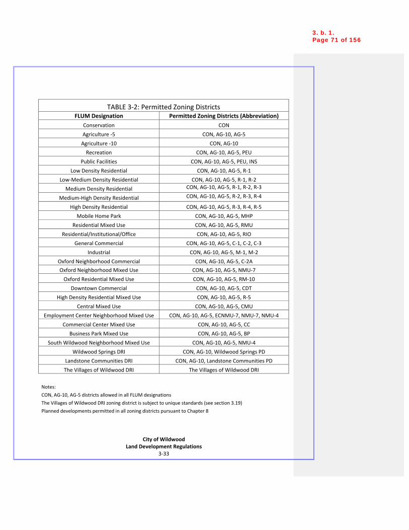
City of Wildwood Land Development Regulations
3‐33
TABLE 3‐2: Permitted Zoning Districts FLUM Designation Permitted Zoning Districts (Abbreviation)
Conservation CON
Agriculture ‐5 CON, AG‐10, AG‐5
Agriculture ‐10 CON, AG‐10
Recreation CON, AG‐10, AG‐5, PEU
Public Facilities CON, AG‐10, AG‐5, PEU, INS
Low Density Residential CON, AG‐10, AG‐5, R‐1
Low‐Medium Density Residential CON, AG‐10, AG‐5, R‐1, R‐2
Medium Density Residential CON, AG‐10, AG‐5, R‐1, R‐2, R‐3
Medium‐High Density Residential CON, AG‐10, AG‐5, R‐2, R‐3, R‐4
High Density Residential CON, AG‐10, AG‐5, R‐3, R‐4, R‐5
Mobile Home Park CON, AG‐10, AG‐5, MHP
Residential Mixed Use CON, AG‐10, AG‐5, RMU
Residential/Institutional/Office CON, AG‐10, AG‐5, RIO
General Commercial CON, AG‐10, AG‐5, C‐1, C‐2, C‐3
Industrial CON, AG‐10, AG‐5, M‐1, M‐2
Oxford Neighborhood Commercial CON, AG‐10, AG‐5, C‐2A
Oxford Neighborhood Mixed Use CON, AG‐10, AG‐5, NMU‐7
Oxford Residential Mixed Use CON, AG‐10, AG‐5, RM‐10
Downtown Commercial CON, AG‐10, AG‐5, CDT
High Density Residential Mixed Use CON, AG‐10, AG‐5, R‐5
Central Mixed Use CON, AG‐10, AG‐5, CMU
Employment Center Neighborhood Mixed Use CON, AG‐10, AG‐5, ECNMU‐7, NMU‐7, NMU‐4
Commercial Center Mixed Use CON, AG‐10, AG‐5, CC
Business Park Mixed Use CON, AG‐10, AG‐5, BP
South Wildwood Neighborhood Mixed Use CON, AG‐10, AG‐5, NMU‐4
Wildwood Springs DRI CON, AG‐10, Wildwood Springs PD
Landstone Communities DRI CON, AG‐10, Landstone Communities PD
The Villages of Wildwood DRI The Villages of Wildwood DRI
Notes:
CON, AG‐10, AG‐5 districts allowed in all FLUM designations
The Villages of Wildwood DRI zoning district is subject to unique standards (see section 3.19)
Planned developments permitted in all zoning districts pursuant to Chapter 8
3. b. 1. Page 71 of 156

City of Wildwood Land Development Regulations
3‐34
TABLE 3‐4: Density, Intensity, and Lot Standards
A
Residential Zoning Districts
Zoning District: AG ‐5 AG‐ 10 R‐1 R‐2 R‐3 R‐4 R‐5 MHP
Maximum Density (units per acre)
1/ 5 1/ 10 4 6 9 12 15 10
Minimum Density (units per acre)
4 6 9 12
Minimum Open Space (%) 40 40 DDS DDS DDS DDS DDS 15
Dwelling Unit Type: SFD SFD SFD SFA SFD SFA SFD SFA ACB SFD SFA ACB SFA ACB MH SFD
Minimum Living Area (Sq. ft)
750 750 750 750 750 750 750 750 600 750 750 600 750 600 750
Maximum Lot Coverage (%) 50 50
Minimum Lot Width (ft) 50 50 45 40 50 50
Minimum Setbacks (ft):
Front 35 35 30 30 30 30 8 30
Rear 25 25 15 15 15 15 8 15
Side 20 20 8 10
Minimum Building Separation (ft)
10 25 10 25 10 25 25 10 25 25 25 25 16 20
Abbreviations: Notes:
SFD ‐ Single Family Detached 1) Minimum building separation between two different unit types is 25 feet
SFA ‐ Single Family Attached 2) Density and intensity calculated pursuant to section 3.4B
ACB ‐ Apartment/Condominium Building 3) Minimum density waived for projects
MH ‐ Mobile Home DDS ‐ Design District Standards (Residential)
3. b. 1. Page 72 of 156

City of Wildwood Land Development Regulations
3‐35
TABLE 3‐4: Density, Intensity, and Lot Standards
B
Nonresidential Zoning Districts
Zoning District: C‐1 C‐2 C‐3 IN PEU M‐1 M‐2 CON
Maximum FAR 0.25 0.25 0.25 0.6 0.6 0.25 0.25
Maximum ISR (%) 75 70 75 60 60 70 70 5
Minimum Open Space (%) 15 20 20 20 20 20 20
Minimum Setbacks (ft):
Front 25 25 25 25 25 25
Rear 15 15 15 15 15 15
Side 15 15 10 10 15 15
Maximum Setbacks (ft):
Front 10
Rear
Side 12
Maximum Building Separation (ft):
24
Notes:
1) No side or rear setback required if abutting a railroad right‐of‐way
2) FAR intensity calculated pursuant to section 3.4B
23) Maximum front setback within C‐1 district may be extended to 20 feet if a café, public courtyard, quasi‐public or similar social gathering area is provided 34) Side setbacks within C‐1 district may be modified if a public courtyard or similar gathering area is provided, vehicular access from main street is needed to access rear or side parking, or where
right‐of‐way or alley exists
45) Setback requirements waived if developing under section 3.21
3. b. 1. Page 73 of 156

City of Wildwood Land Development Regulations
3‐36
TABLE 3‐4: Density, Intensity, and Lot Standards
C Mixed Use Zoning Districts
Zoning District: RMU RMU ‐10* RIO NMU‐4 ECNMU‐7 NMU‐7
Maximum Density (units per acre)
5 10 15 4 7 7
Minimum Density (units per acre)
5 3 5 5
Minimum Open Space (%)
25 25 25 40 25 25
Maximum FAR 0.5 0.3 0.5 0.3
Maximum ISR (%) 60 80 60 60 60
Building Type: SFD SFA MH NRB SFD SFA ACB MUB NRB SFD SFA ACB NRB SFD SFA ACB MUB NRB SFD SFA ACB MUB NRB SFD SFA ACB MUB NRB
Minimum Living Area (Sq. ft)
750 750 750 750 750 600 750 750 600 750 750 600 750 750 600 750 750 600
Minimum Lot Width (ft)
75 75 75 40 75 75 40 40 40
Maximum Lot Coverage (%)
40 40 40 40 40 40 40 40
Minimum Setbacks (ft):
Front 25 25 25 25 30 25 20 30 25 30 30 30
Rear 15 15 15 15 15 15 15 20 15 15 15 15
Side 10 10 10 10 5 10 10 15 10 5 5 5
Maximum Front Setback (ft)
15 15 15 15 15 15 15 15 15 15 15
Minimum Building Separation (ft)
10 10 10
Abbreviations: Notes:
SFD ‐ Single Family Detached 1) Setback requirements waived if developing under section 3.21 within a MUC; minimum density waived for projects
SFA ‐ Single Family Attached 2) * ‐ Density dependant upon distance to MUC‐ Extent of project within a 1/4 mile ‐ 10 du/acre; within
ACB ‐ Apartment/Condominium Building 1/2 mile ‐ 7 du/acre; further than 1/2 mile ‐ 5 du/acre
MH ‐ Mobile Home 3) Minimum building separation between two different building types is 25 feet
MUB ‐ Mixed Use Building 4) Maximum front setback within NMU‐4, ECNMU‐7 and NMU‐7 may be extended if a café,
NRB ‐ Nonresidential Building public courtyard, quasi‐public or similar social gathering area is provided
MUC ‐ Mixed Use Center
Formatted Table
Formatted: Font: 7 pt
Formatted: Font: 7 pt
Formatted: Font: 7 pt
Formatted: Font: 7 pt
Formatted: Font: 7 pt
Formatted: Font: 7 pt
Formatted: Font: 7 pt
Formatted: Font: 7 pt
Formatted: Font: 7 pt
Formatted: Font: 7 pt
Formatted: Font: 7 pt
Formatted: Font: 7 pt
Formatted: Font: 7 pt
Formatted: Font: 7 pt
Formatted: Font: 7 pt
Formatted: Font: 7 pt
Formatted: Font: 7 pt
Formatted: Font: 7 pt
Formatted: Font: 7 pt
Formatted: Font: 7 pt
Formatted: Font: 7 pt
Formatted: Font: 7 pt
Formatted: Font: 7 pt
Formatted: Font: 7 pt
Formatted: Font: 7 pt
Formatted: Font: 7 pt
Formatted: Font: 7 pt
3. b. 1. Page 74 of 156
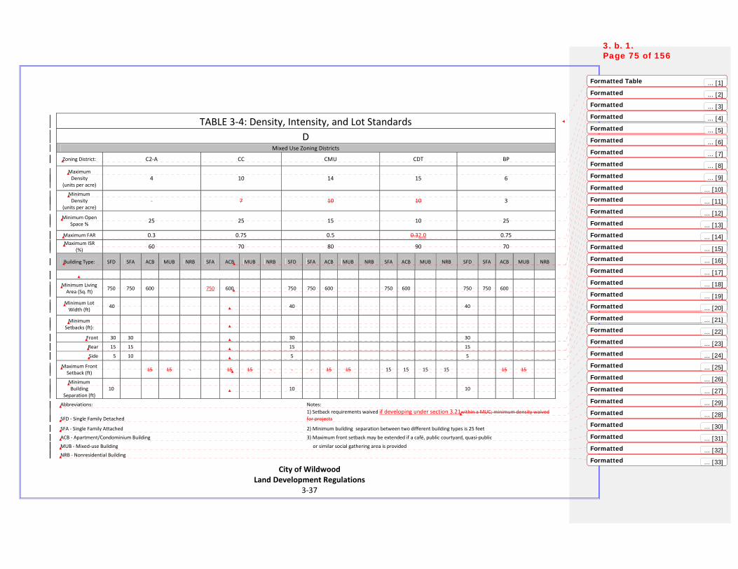
City of Wildwood Land Development Regulations
3‐37
TABLE 3‐4: Density, Intensity, and Lot Standards
D Mixed Use Zoning Districts
Zoning District: C2‐A CC CMU CDT BP
Maximum Density
(units per acre) 4 10 14 15 6
Minimum Density
(units per acre) 7 10 10 3
Minimum Open Space %
25 25 15 10 25
Maximum FAR 0.3 0.75 0.5 0.32.0 0.75
Maximum ISR (%)
60 70 80 90 70
Building Type: SFD SFA ACB MUB NRB SFA ACB MUB NRB SFD SFA ACB MUB NRB SFA ACB MUB NRB SFD SFA ACB MUB NRB
Minimum Living Area (Sq. ft)
750 750 600 750 600 750 750 600 750 600 750 750 600
Minimum Lot Width (ft)
40 40 40
Minimum Setbacks (ft):
Front 30 30 30 30
Rear 15 15 15 15
Side 5 10 5 5
Maximum Front Setback (ft)
15 15 15 15 15 15 15 15 15 15 15 15
Minimum Building
Separation (ft) 10 10 10
Abbreviations: Notes:
SFD ‐ Single Family Detached
1) Setback requirements waived if developing under section 3.21within a MUC; minimum density waived
for projects
SFA ‐ Single Family Attached 2) Minimum building separation between two different building types is 25 feet
ACB ‐ Apartment/Condominium Building 3) Maximum front setback may be extended if a café, public courtyard, quasi‐public
MUB ‐ Mixed‐use Building or similar social gathering area is provided
NRB ‐ Nonresidential Building
Formatted Table ... [1]
Formatted ... [2]
Formatted ... [3]
Formatted ... [4]
Formatted ... [5]
Formatted ... [6]
Formatted ... [7]
Formatted ... [8]
Formatted ... [9]
Formatted ... [10]
Formatted ... [11]
Formatted ... [12]
Formatted ... [13]
Formatted ... [14]
Formatted ... [15]
Formatted ... [16]
Formatted ... [17]
Formatted ... [18]
Formatted ... [19]
Formatted ... [20]
Formatted ... [21]
Formatted ... [22]
Formatted ... [23]
Formatted ... [24]
Formatted ... [25]
Formatted ... [26]
Formatted ... [27]
Formatted ... [28]
Formatted ... [29]
Formatted ... [30]
Formatted ... [31]
Formatted ... [32]
Formatted ... [33]
3. b. 1. Page 75 of 156

City of Wildwood Land Development Regulations
3‐38
MUC ‐ Mixed Use Center
TABLE 3‐5: Mixed Use Zoning District – Use Percentages Zoning District: C‐2A NMU‐4 NMU‐7 ECNMU‐7 CMU CC CDT BP
Use Category:
Residential:
Minimum Percentage 35 35 35 20 20 10
Maximum Percentage 6080 6080 6080 5075 30 60
Institutional, Government, and Tourism, Civic, and Recreational:
Minimum Percentage 5 5 5 5 5
Maximum Percentage 1030 1030 1030 10 30
Commercial Office and Business Park:
Minimum Percentage 150 150 150 250 25 20
Maximum Percentage 2540 3040 2540 50 60 60
Commercial Retail:
Minimum Percentage 205 205 205 15 10 5
Maximum Percentage 3040 4040 3040 50 30 55
Minimum Vertical Mix Percentage*
50 50 50 25 75
Maximum Percentage of Square Footage Devoted to Single Story Buildings*
75 75 75 25
Notes:
1) * Square footage devoted to single use, residential buildings is excluded from the calculation Developments less than 10 acres may proceed as a single use and are not required to adhere to this Table 2) Residential square footage within the CDT designation shall not exceed 30% of the total built square footage 3) Nonresidential uses are permitted in RM‐10 but total acreage devoted to nonresidential uses shall not exceed 10% of the total acreage.
Formatted Table
Formatted Table
Formatted Table
3. b. 1. Page 76 of 156

City of Wildwood Land Development Regulations
3‐39
3. b. 1. Page 77 of 156
plaw
Typewritten Text
plaw
Typewritten Text
plaw
Typewritten Text
plaw
Typewritten Text
plaw
Typewritten Text
plaw
Typewritten Text
plaw
Typewritten Text
plaw
Typewritten Text
plaw
Typewritten Text
plaw
Typewritten Text
plaw
Typewritten Text
plaw
Typewritten Text
plaw
Typewritten Text
plaw
Typewritten Text
plaw
Typewritten Text
plaw
Typewritten Text
plaw
Typewritten Text
plaw
Typewritten Text
plaw
Typewritten Text
plaw
Typewritten Text
THIS PAGE HAS BEEN INTENTIONALLY LEFT BLANK
plaw
Typewritten Text
plaw
Typewritten Text
plaw
Typewritten Text

City of Wildwood Land Development Regulations
3‐40
P: Permitted Use C: Conditional Use
S: Special Exception Use
TABLE 3‐ 6: Allowable Principal Use Matrix
Zoning District
Conservation Uses CON AG‐5
AG‐10
R‐1
R‐2
R‐3
R‐4
R‐5
MHP RMU RM‐10
RIO IN PEU C‐1
C‐2
C‐2A
C‐3
NMU‐4
NMU‐7
ECNMU‐7
CMU CC CDT BP M‐1
M‐2
Wetlands, forested lands, pastures, environmental habitat, karst areas, open water, and lands set aside to be protected
P P P P P P P P P P P P P P P P P P P P P P P P P P P
Agricultural Uses CON AG‐5
AG‐10
R‐1
R‐2
R‐3
R‐4
R‐5
MHP RMU RM‐10
RIO IN PEU C‐1
C‐2
C‐2A
C‐3
NMU‐4
NMU‐7
ECNMU‐7
CMU CC CDT BP M‐1
M‐2
Citrus/ field crop production P P
Keeping and/ or grazing of livestock
P P
Agricultural product transfer station
P P
Silviculture P P
Aquiculture P P
Horticulture, greenhouses and nurseries (commercial)
P P P P P P P P P P P P P
Muck farms P P
Commercial hog farm, chicken ranches, cattle feed lots, fish farms, bait farms and other AG related commercial type uses
P P
Kennels for breeding purposes
S S
Animal rescue facility S S
Exotic animals such as poisonous snakes, reptiles, primates, lions, tigers, bears, alligators and other potentially dangerous animals
C C
3. b. 1. Page 78 of 156
City of Wildwood Land Development Regulations
3‐41
Residential Uses CON AG‐5
AG‐10
R‐1
R‐2
R‐3
R‐4
R‐5
MHP RMU RM‐10
RIO IN PEU C‐1
C‐2
C‐2A
C‐3
NMU‐4
NMU‐7
ECNMU‐7
CMU CC CDT BP M‐1
M‐2
Single family detached (SFD) P P P P P P P P P P P P P P P
Single family attached (SFA) P P P P P P P P P P P P P P
Apartment or condominium building (ACB)
P P P P P P P P P P P P P
Dwelling unit located above the ground floor in a mixed use building (MUB)
P P P P P P P P P
Community club house, pool or other amenities associated with residential projects
P P P P P P P P P P P P P P P P P
Independent living facility (ILF)
S S S S S S S P P S S S S P P P P P P P
Mobile home (MH) P P P P
Recreational vehicle park (RV)
P P
Home occupations S S S S S S S S S S S S S S S S S S S
Institutional, Governmental, Tourism,
Civic and Recreational Uses CON
AG‐5
AG‐10
R‐1
R‐2
R‐3
R‐4
R‐5
MHP RMU RM‐10
RIO IN PEU C‐1
C‐2
C‐2A
C‐3
NMU‐4
NMU‐7
ECNMU‐7
CMU CC CDT BP M‐1
M‐2
Public recreation facility or park
P P P P P P P P P P P P P P P P P P P P P P P P
Bed and breakfast C C C C C C C C C C P P P P P P P P P P P
Hotels and motels P P P P P P P P P
Golf courses and driving ranges
S S S S S P P P P P P P P P P
Commercial recreation facility such as skating rinks, movie theatres and other similar uses
P P P P P P P P P P P P P
Health clubs and fitness centers
P P P P P P P P P P P P P
Community residential home
P P P P P P P P P P S S S S S P P P P P S P
Assisted living facility (ALF) S S S S S S S P P S S S S P P P P P P P
Nursing home P P S S S S P P P P P S P
Child care facilities/ Day care
S S S S S S P P P P P P P P P P P P S P
Professional, business and technical schools
P P P P P P P P P
3. b. 1. Page 79 of 156

City of Wildwood Land Development Regulations
3‐42
Institutional, Governmental, Tourism,
Civic and Recreational Uses CON
AG‐5
AG‐10
R‐1
R‐2
R‐3
R‐4
R‐5
MHP RMU RM‐10
RIO IN PEU C‐1
C‐2
C‐2A
C‐3
NMU‐4
NMU‐7
ECNMU‐7
CMU CC CDT BP M‐1
M‐2
Public schools and private schools offering curricula similar to that of public schools
P P P P P P P P P P P P P P P P P P P P P P P
Colleges and universities containing dormitories
P P P P P P P P P
Churches and places of worship
S S S S S S S S S S P P S S S S P P P P P P P
Museums and other cultural facilities
P P P P P P P P P P P P P P P P
Hospitals C C C C C C C C C C
Veterinary clinic or temporary pet boarding
P P P P P P P P P P P P P P P P
Cemeteries and mausoleums
S S S S S S S S S S S P P
Funeral homes, crematories and other similar service establishments
P P P P P P P P P P P P P P
Private clubs and lodges S S S S S S S S S P P P P P P P P P P P
Public buildings owned, operated, and used by a government entity such as city hall, city hall annexes. police and fire stations, libraries, post office, and other similar uses
S S S S S S S S S S P P P S S S S P P P P P P P P P
Street and highway department garage or maintenance facility
S S S P S S S S P P
Utility facilities such as electric sub stations, wastewater treatment plants, well sites, and other similar uses
P P P P P
3. b. 1. Page 80 of 156

City of Wildwood Land Development Regulations
3‐43
Commercial Office and Business Park Uses CON
AG‐5
AG‐10
R‐1
R‐2
R‐3
R‐4
R‐5
MHP RMU RM‐10
RIO IN PEU C‐1
C‐2
C‐2A
C‐3
NMU‐4
NMU‐7
ECNMU‐7
CMU CC CDT BP M‐1
M‐2
Business or technology park P P P P P P P P P P
Medical or dental office P P P P P P P P P P P P P P
Professional service establishments and offices
P P P P P P P P P P P P P P P
Banks, credit unions, and financial institutions
P P P P P P P P P P P P P
Commercial Retail Uses CON AG‐5
AG‐10
R‐1
R‐2
R‐3
R‐4
R‐5
MHP RMU RM‐10
RIO IN PEU C‐1
C‐2
C‐2A
C‐3
NMU‐4
NMU‐7
ECNMU‐7
CMU CC CDT BP M‐1
M‐2
Retail sales establishments such as department, electronic, office supply, grocery and other similar stores
P P P P P P P P P P P P P
Restaurants and cafés (without alcohol consumption or sales)
P P P P P P P P P P P P P
Bar, tavern, restaurants or cafés serving alcohol (on site consumption)
P P P P P P P P P P P P
Liquor Store (sales of hard alcohol for off‐site consumption)
P P P P P P P P P P P
Copy centers P P P P P P P P P P P P P P
Beauty shop, dry cleaning, pet grooming, and other similar personal service establishments
P P P P P P P P P P P P P
Specialty shops such as antique shops, art showrooms, boutiques, and other similar shops
P P P P P P P P P P P P P
Service and repair shops for automobiles, small engines, and other similar uses
S S S P S S S S S S P P
Retail and wholesale commercial establishments for lumber, building and landscaping supplies, farm equipment and other similar uses with potential outside storage of products
S S P S S S S S P P
3. b. 1. Page 81 of 156
City of Wildwood Land Development Regulations
3‐44
Commercial Retail Uses CON AG‐5
AG‐10
R‐1
R‐2
R‐3
R‐4
R‐5
MHP RMU RM‐10
RIO IN PEU C‐1
C‐2
C‐2A
C‐3
NMU‐4
NMU‐7
ECNMU‐7
CMU CC CDT BP M‐1
M‐2
Auto dealership, golf cart, and similar sales
P P S P S S S S S S P
Convenience store P P P P P P P P P P P P P
Fuel stations P P P P P P P P P P P P P
Storage facilities (indoor) P P P P P S S S S S S P P
Industrial Uses CON AG‐5
AG‐10
R‐1
R‐2
R‐3
R‐4
R‐5
MHP RMU RM‐10
RIO IN PEU C‐1
C‐2
C‐2A
C‐3
NMU‐4
NMU‐7
ECNMU‐7
CMU CC CDT BP M‐1
M‐2
Wholesaling, warehousing, bulk storage, or distribution establishments and similar uses
P P
Research laboratories and associated activities
P P
Light manufacturing, assembling, processing, packaging or fabricating
P P
Outdoor storage yards and similar uses such as junkyards, scrap yards and salvage yards
P P
Building or landscape contractor with on site equipment storage
P P P
Concrete or asphalt plants P
Concrete block plant P P
Manufacturing of nonhazardous materials
P P P
Manufacturing or warehousing of chemicals, fertilizers, hazardous, or biohazardous materials
C C
Explosives manufacturing or storage
C C
Paper and pulp manufacturing
P P
Petroleum refining C
Electric, gas, or energy generating facility
P P P P
Solid waste transfer stations C C
Landfills C C
3. b. 1. Page 82 of 156

City of Wildwood Land Development Regulations
3‐45
Industrial Uses CON AG‐5
AG‐10
R‐1
R‐2
R‐3
R‐4
R‐5
MHP RMU RM‐10
RIO IN PEU C‐1
C‐2
C‐2A
C‐3
NMU‐4
NMU‐7
ECNMU‐7
CMU CC CDT BP M‐1
M‐2
Tower and wireless communication services
S S S S S S
Mining and excavation C
3. b. 1. Page 83 of 156

City of Wildwood Land Development Regulations
4‐1
Chapter 4 SITE PLAN REGULATIONS
4.1. General. 4.2. Procedures for review of site plans. 4.3. Minor site plans. 4.4. Required information. 4.1. General. (A) Purpose and intent. It is the purpose of these site plan regulations to promote and protect the health, safety, comfort, economy, order, appearance, convenience and general welfare of the citizens of the City of Wildwood. To do so requires the harmonious, orderly and progressive development of land within the municipal boundaries. Similarly, the intent of these regulations is as follows:
(1) To assure the project is compatible with the surrounding area and that it will serve to enhance the general character of the area and the City; (2) To assure that adequate provisions are made for vehicular traffic access, ingress, egress, internal circulation and parking, traffic control, pedestrian and bicycle movement and safety, and emergency vehicle access; (3) To assure that adequate screening and buffering where necessary are provided between the project and contiguous properties; (4) To assure that adequate provisions are planned for public facilities and services necessary to the maintenance of the health and welfare of the residents of the project; (5) To assure the adequate provisions have been made for light, air, access, and privacy in the arrangement of buildings as they relate to other improvements, to public roads/streets, to internal roads, to parking areas, to recreation areas, to sidewalks, and to contiguous properties; (6) To assure that the natural qualities and characteristics of the land will be preserved, and that the project site will be appropriately landscaped and provisions established for the maintenance of the same; (7) To assure that adequate recreation space will be provided within projects and that provisions are made for the supervision and maintenance thereof; (8) To assure that the aesthetics and architectural details of the project are compatible with the surrounding area and serve to enhance the character of the area; (9) To assure the prevention of haphazard, premature, or scattered land development; (10) To assure safety from fire, panic, crime, and other dangers, and to promote health and the general welfare; (11) To provide adequate drainage and to assure protection from flooding hazards and ensure proper water management; (12) To assure the protection of the natural and scenic resources of the City, including surface waters, and groundwater recharge areas; and (13) To promote development patterns that encourages the use of alternative forms of transportation.
(B) Jurisdiction. Regulations established herein shall be applied to all lands within the municipal limits of the City of Wildwood and shall be construed to be minimum requirements of the City. Each developer or applicant for site plan approval should be aware that there may be additional regional, state, federal, or County requirements which must be complied with and over which the City has no jurisdiction. The
3. b. 1. Page 84 of 156

City of Wildwood Land Development Regulations
4‐2
developer or applicant should make every effort to contact other agencies to determine their requirements to avoid a waste of time and money in complying with this Code. (C) Disputes. To aid in the prevention of disputes and litigation in connection with this Code, it is hereby established as a policy of this Code and of the City Commission that the City Engineer shall decide all questions, difficulties and disputes of whatever nature which may arise relative to the interpretation of this Code concerning any plans which have been presented or construction which may be taking place, and that his ruling shall be final unless specifically overruled by the City Commission. (D) Expiration of approvals. The approval of the site plan shall be valid for a period of 12 months. If the applicant has not obtained a permit for construction of the site within 12 months, and if an extension of time has not been approved by the City Commission on a demonstration of good cause, approval shall be automatically revoked and the applicant must reapply under the provisions of this Code or any subsequent code then in effect. (E) Developer’s agreement. Prior to approval of a site plan, a developer’s agreement may be required if deemed necessary by the City Manager. 4.2. Procedures for review of site plans. (A) Site plan required. An approved site plan is required prior to the issuance of a building permit. It shall be unlawful for any person to construct, erect or alter a building or structure or to develop, change or improve land for which a site plan is required except in accordance with an approved site plan. (B) Applicability. The procedures contained in this Chapter will be used for the review of the following:
(1) All nonresidential projects including public buildings and facilities; (2) Apartment or condominium projects (multi‐family); (3) Mobile home parks (rental); (4) Recreational vehicle parks/campgrounds (master park plan); (5) Projects involving land development without structures, such as parking lots, stormwater ponds or any other improvements to the site. Such projects may not require review by the Planning and Zoning Board or the City Commission as determined by the Development Services Director; (6) Projects involving new construction, the alteration or conversion of any existing structure into a nonresidential or multi‐family residential facility which involves a change where there is a need for upgrading of the site through parking requirements, drainage improvements, fire flow, etc; (7) Any developments permitted under conditional uses in Chapter 3.
(B) Pre‐application conference. A pre‐application conference is recommended for interested applicants wishing to submit a site plan. The pre‐application conference may avoid heavy expenditures of time, effort and money only to find, unnecessarily, that costly changes are required by the City to make the proposed plans conform to its requirements. Interested applicants are recommended to submit as much information (i.e. detailed plans) in advance of the pre‐application conference to aid in the process. (C) Review of site plans.
(1) Purpose. The purpose of a site plan is to permit complete and accurate presentation of technical data and engineering drawings in such a manner as to allow complete review and evaluation of the proposed development to the provisions of this Code and its impact upon both the site and surrounding areas. (2) Application. Applications seeking site plan approval shall submit an application to the office of the Development Services Director; appropriate fees shall be paid at the time of submittal.
3. b. 1. Page 85 of 156
City of Wildwood Land Development Regulations
4‐3
(3) Review process. Site plans shall be subjected to the review and approval processes outlined in section 1.14 of this Code.
4.3. Minor site plans. (A) Purpose. Minor site plans are required for residential and nonresidential development that has been determined by the Development Services Director to have which is limited in their potential for off‐site impacts. Minor site plans may be approved by the Development Services Director. Due to the limited off‐site impacts, submittals are not required to provide all required information listed in section 4.4 below. However, interested applicants are required to confer with the Development Services Director on the information that is required for minor site plan approval. (B) Applicability. Minor site plans may include the following:
(1) Single‐family detached and attached dwelling units or minor appurtenances thereto, such as private swimming pools and screen enclosures. (2) Additions to existing structures that are less than 50 percent (50%) of the total square footage of the existing structure and do not exceed 2,500 square feet. (3) For changes in use without addition to existing structures but require other on site improvements such as stormwater or parking improvements. (4) Accessory structures used for storage purposes only that adhere to the following criteria:
(a) Shall not exceed 600 square feet; (b) Height is restricted to one story; (c) Must be of similar construction and architectural style as the primary structure; (d) Shall be a permanent structure constructed on a foundation having either a concrete slab or stem wall and meet the minimum requirements of the Florida Building Code; (e) Must meet all applicable zoning regulations; and (f) Shall only be utilized for storage use.
4.4. Required information. (A) Site plans shall be prepared on sets of sheets sized 24 inches by 36 inches (24”x36”). A key map or sheet must be provided for easy navigation through the individual sheets. (B) Minimum requirements. The applicant shall have a registered professional engineer prepare the plans and calculations in conformance with the format, design and improvement standards required by these regulations and the requirements of other regulatory agencies. All site plans are required to meet the City’s design district standards. (C) General development and proposed improvements. Plans shall contain the following information at a minimum:
(1) General information. Provide the following general information: (a) Name of project; (b) Statement of intended use of site; (c) Legal description of the property and size of parcel in acres or square feet; (d) Name, address and telephone number of the owner or owners of record; (e) Name, address and telephone number of the owner's (or owners') agent; (f) Name, address, signature and registration of the professionals preparing the plan(s); (g) Date, north arrow and scale, number of sheets; the scale (sufficient to depict all site features at a clearly legible scale) shall be designated on all sheets;
3. b. 1. Page 86 of 156

City of Wildwood Land Development Regulations
4‐4
(h) Vicinity map showing relationship of proposed development to the surrounding streets and thoroughfares shall be at a scale of not less than 1 inch equals 1,000 feet; (i) Bearings and distances of boundary lines with a heavy line. Also provide the linear dimensions of the site; and (k) Easements, right‐of‐way dedications and reservations.
(2) Buildings and structures. Provide the following information concerning buildings and structures:
(a) Intended use; (b) Number of stories and height of the building(s); (c) Number of dwelling units and density calculated per section 3.4(B); (d) If a restaurant, show number of seats and occupancy load; (e) Projected number of employees; and (f) Nonresidential square footage for proposed development calculated per section 3.4(B); and (g) Building elevations.
(3) Zoning. Zoning district(s) on and adjacent to the tract; (4) Public sites, if any. Identification of the location, size, and purpose of all public sites, if any, to be reserved, conveyed or dedicated for or to the City or public, including, but not limited to, parks, playgrounds or other public uses; (5) Setbacks. Building setback lines, where applicable, shall be shown; (6) Soils. A soil classification map drawn on the face of the plan for comparison with proposed development activities shall be provided and shall indicate soil classifications on the plan; (7) Transportation and mobility network on and adjacent to the tract. Identification of existing and proposed streets on and adjacent to the tract, including: the name, right‐of‐way width and location; approximate grades and gradients; cross‐sections of typical road sections; type, width and elevation of surfacing; and legally established centerline elevations, transit stops, sidewalks, paths, curbs, gutters, culverts, etc. Locations of all median openings in the vicinity and access points on both sides of all abutting roadways must also be shown. If applicable, similar information for alleys must be provided; (8) Utilities on and adjacent to tract. Identification of existing and proposed utilities on and adjacent to the tract to be subdivided, including but not limited to: the location, size and invert elevation of sanitary or storm sewers and reuse lines; location and size of water mains; and location of any gas lines, fire hydrants, electric and telephone poles, and streetlights. Also provide fire flow demand calculations; Utilities are required to be underground unless determined to be detrimental to the public’s health, safety, and welfare. (9) Topography. Existing topographic conditions on the property being developed and extending 25 feet beyond the property line including surface water elevations and date recorded; (10) Other conditions on tract. Existing and proposed watercourses, wetlands, preservation areas, wooded areas, houses, barns, shacks and other significant features on and adjacent to the tract; (11) Other conditions on adjacent lands. Approximate direction and gradient of grounds slope, including any embankments or retaining walls; character and location of buildings, railroads, power lines, towers, and other adverse influences; (12) Proposed public improvements, if any. Proposed public improvements, highways or other major improvements planned by public authorities for future construction on or near the tract;
3. b. 1. Page 87 of 156

City of Wildwood Land Development Regulations
4‐5
(13) Limits of floodplain. Indicate flood elevation of 100‐year flood as established by the Federal Emergency Management Agency, Flood Insurance Rate Map. The actual acreage within the floodplain shall be listed; (14) Stormwater management system. Indicate the flow direction and location of detention and retention areas; (15) Dredge and fill. If any dredging or filling operation is intended in development of the area, application shall be made to the official responsible for dredge and fill permits. No such work will be done prior to issuance of such permit from the water management district; (16) Erosion control. Provision for the adequate control of erosion and sediment, indicating the location and description of the methods to be utilized during and after all phases of clearing, grading and construction; (17) Landscaping. Provide a landscaping plan including any proposed irrigation system and detailed plant material for all common areas and buffers if applicable; (18) Solid waste. Location and access provisions for refuse service, including pad screening, fencing and landscaping. (19) Boundary survey. A boundary survey of the lands to subject to the site plan performed and prepared under the responsible direction and supervision of a professional surveyor; (20) Tree survey. A tree survey listing, by type, all trees containing a DBH greater than ten (10) inches. DBH is to be measured at a height of 4 feet, 6 inches (4’‐6”) above the existing grade; (21) Aerial photograph. An aerial photograph with the source and date of the photograph; and (22) Phasing. Planned phases, if any, are to be shown. Each phase shall be designed to stand on its own if subsequent phases are not developed.
(D) Additional analyses. The following studies, documentation, and forms shall be provided in addition to the requirements set forth by section 4.4(C).
(1) Traffic impact study (TIS). The applicant shall submit an up‐to‐date TIS unless determined by the City that the proposed development will not have a traffic impact which justifies such an analysis. The TIS must be prepared by a qualified professional. All traffic impact analyses shall be conducted in conformance with the most recent version of the Lake‐Sumter MPO Traffic Impact Study (TIS) guidelines.pursuant to section 1.17 of this Code. The TIS shall be conducted no earlier than one (1) year prior to the submittal date; (2) Environmental assessment. A professionally conducted survey of native vegetative communities shall be required for all proposed developmentundeveloped sites. The Development Services Director may waive this requirement in situations where the site has been previously developed. This survey shall be conducted by an ecologist, biologist, or similar professional and shall include an inventory of wildlife, as well as state and federally listed endangered and threatened animal and plant species, and species of special concern. The assessment shall be conducted no later than one (1) year prior to the submittal date. The environmental assessment shall address at a minimum:
(a) Wildlife and listed species populations within the proposed development site; (b) The feasibility and availability of onsite management and protection of identified wildlife and listed species; and (c) The appropriateness of mitigating the impacts of development by the relocation of the listed species to an acceptable off‐site location, in the event that on‐site protection is shown to be ineffective;
(3) Supplemental applications. The following supplemental applications are also required: (a) Sign application and (b) Tree removal permit.
3. b. 1. Page 88 of 156

City of Wildwood Land Development Regulations
4‐6
(4) Stormwater calculations. The applicant’s engineer shall provide the stormwater calculations for the area subject to the site plan that demonstrate compliance with these regulations, and with the regulations of the water management district; (5) Agreements. Copies of any and all executed agreements with the City tied to the property subject to the site plan (i.e. PD, developer’s, development, MOU, etc); (6) Agency permits. A list and status of all applicable permits from other agencies required for the development; and (7) Preliminary concurrency determination. An application for preliminary concurrency determination pursuant to section 7.2(B)(2).
(E) Additional required legal submittals where facilities are dedicated to the public. The approval of the site plan wherein facilities are dedicated to the City shall be made only pursuant to certification of adequacy of the following list of required submittals by the City Manager and City Attorney, as appropriate:
(1) Bonds. The approval of any site plan shall be subject to the applicant guaranteeing the installation and maintenance of the required improvements, where facilities are to be conveyed to the City, by filing a performance bond or bonds executed by an approved surety company in the amount of 120 percent of the construction costs. Costs for construction shall be determined by an estimate by the applicant's engineer, or a copy of the actual construction contracts as provided. The amounts of the performance and maintenance bond must be approved as adequate by the director of public works and/or the City Engineer. In all cases where public improvements are installed, a two‐year maintenance bond in the amount of 20 percent of the construction costs must be submitted. In lieu of a surety, a cashier’s check or certified check may be used as the form of guaranty when accompanied by a maintenance bond agreement. The certificate of occupancy shall not be issued until the maintenance bond is approved. At the conclusion of the two‐year (2‐year) maintenance period the developer may petition the City to release the maintenance bond. The City will inspect the public improvements and issue a determination of any public improvements covered by the bond that are in need of repair. Upon verification that all repairs have been made, the City will release the maintenance bond. (2) Title certificate. A certificate of ownership, signed by a licensed attorney‐at‐law or an abstract company, in form approved by the City Attorney, and showing:
(i) Parties executing the site plan are owners of the land; (ii) All mortgages, liens or other encumbrances; (iii) That all taxes and assessments are paid to date; (iv) Description of site plan is correct; and (v) No conflicting rights‐of‐way, easements or plat exist.
(3) As‐built surveys. The City shall not accept improvements nor issue a certificate of occupancy until three (3) copies of as‐built plans are submitted to the City and reviewed, and determined to be consistent with this Code, in accordance with the closeout procedures outlined in section 1.16(C) of these regulations.
3. b. 1. Page 89 of 156

City of Wildwood Land Development Regulations
5‐1
Chapter 5 SUBDIVISION REGULATIONS
5.1. General. 5.2. Procedure for subdividing land 5.3. Minor lot split. 5.4. Preliminary plan submittal requirements. 5.5. Improvement plan submittal requirements. 5.6. Final plat submittal requirements. 5.7. Completion and inspection of improvements. 5.8. Gated communities. 5.9. Model homes. 5.1. General. (A) Purpose and intent. It is the purpose of these subdivision regulations to promote and protect the health, safety, comfort, economy, order, appearance, convenience and general welfare of the citizens of the City of Wildwood. To do so requires the harmonious, orderly and progressive development of land within the municipal boundaries. Similarly, the intent of these regulations is as follows:
(1) To establish standards of subdivision design which encourage the development of sound neighborhoods and the creation of healthy living environments; (2) To prevent traffic hazards and to provide safe and convenient mobility, both vehicular and pedestrian, in new land development; (3) To provide public open spaces in new land development through the dedication or reservation of land for recreational, educational, and other public purposes; (4) To maintain accurate land records for the convenience and protection of the public and for adequate identification and permanent location of real estate boundaries; (5) To aid in the coordination of land development within the corporate limits of the City in accordance with an orderly physical pattern and to discourage haphazard, premature, uneconomic or scattered land development; (6) To assure that the citizens and taxpayers of the City will not have to bear the cost resulting from haphazard subdivision of land and the lack of authority to require installation by the developer of adequate and necessary physical improvements and to that end, to assure to the purchaser of land in the subdivision that necessary improvements of lasting quality have been installed; (7) To serve as a tool for the implementation of the goals of the comprehensive plan; (8) To ensure that public facilities are available concurrent with the impact of the subdivision; and (9) To promote development patterns that encourages the use of alternative forms of transportation.
(B) Jurisdiction. Regulations established herein shall be applied to all lands within the municipal limits of the City of Wildwood and shall be construed to be minimum requirements of the City. Each developer or applicant for subdivision approval should be aware that there may be additional regional, state, federal, or County requirements which must be complied with and over which the City has no jurisdiction. The developer or applicant should make every effort to contact other agencies to determine their requirements to avoid a waste of time and money in complying with this Code. No subdivision shall be
3. b. 1. Page 90 of 156

City of Wildwood Land Development Regulations
5‐2
platted or recorded, nor any building permit issued, unless the subdivision meets all requirements of these regulations and has been approved in accordance with the requirements hereinafter provided. (C) Disputes. To aid in the prevention of disputes and litigation in connection with this code, it is hereby established as a policy of this Code and of the City Commission that the City Engineer shall decide all questions, difficulties and disputes of whatever nature which may arise relative to the interpretation of this Code concerning any plans which have been presented or construction which may be taking place, and that his ruling shall be final unless specifically overruled by the City Commission. (D) Expiration of approvals. The approval of the preliminary plan or improvement plan shall be valid for a period of 12 months. If the applicant has not obtained final plat approval within said 12 months, and if an extension of time has not been approved by the City Commission on a demonstration of good cause, approval shall be automatically revoked and the applicant must reapply under the provisions of this code or any subsequent code then in effect. If the project is phased, the final plat approval must be obtained for each new phase within 12 months of the date of plat approval of the previous phase. 5.2. Procedure for subdividing land. (A) Stages. All submittals of plans and applications will be made to the Development Services Department. There shall be three (3) stages for the approval of all subdivision plats. The City will allow applicants to combine the first two stage of the subdivision approval process at the applicant’s risk. These stages are intended to permit full and adequate review by the City in order to ensure and protect the public interest. These two stages are hereby established:
(1) Preliminary plan; (2) Improvement plan; and (3) Final plat
(B) Pre‐application conference. A pre‐application conference is recommended for interested applicants wishing to record a plat. The pre‐application conference may avoid heavy expenditures of time, effort and money only to find, unnecessarily, that costly changes are required by the City to make the proposed plans conform to its requirements. Interested applicants are recommended to submit as much information (i.e. detailed plans) in advance of the pre‐application conference to aid in the process. (C) Review of preliminary plan. (1) Purpose. The purpose of the preliminary plan is to provide for an initial review of the subdivision proposal and the basic development concepts prior to proceeding with the detailed phases of the improvement plan.
(2) Application. Interested developers shall submit an application to the Development Services Department; appropriate fees shall be paid at the time of submittal. (3) Review process. Each preliminary plan shall be subjected to the review and approval processes outlined in section 1.14 of this Code.
(D) Review of improvement plans. (1) Purpose. The purpose of the improvement plan is to permit complete and accurate presentation of technical data and engineering drawings in such a manner as to allow complete review and evaluation of the proposed development to the provisions of this Code and its impact upon both the site and surrounding areas. Construction shall not begin until the applicant has received improvement plan approval. (2) Application. Interested applicants shall submit an application to the Development Services Department; appropriate fees shall be paid at the time of submittal. (3) Review process. Each improvement plan shall be subjected to the review and approval processes outlined in section 1.14 of this Code.
3. b. 1. Page 91 of 156
City of Wildwood Land Development Regulations
5‐3
(E) Review of final plat. (1) Purpose. The purpose of the final plat is to ensure the preparation, completion and recording of a final plat map and its accompanying legal documentation and the review and approval of final technical submittals and engineering drawings. (2) Application. Interested subdividers shall submit and application to the Development Services Department; appropriate fees shall be paid at the time of submittal. (3) Review process. A final plat shall be subjected to the review and approval process as outlined in section 1.14 of this Code. (4) Recording of final plat. The mylar, or equivalent material copy, of the approved final plat will be retained by the City for the purpose of recording with the Clerk of the Courts of Sumter County after approval by the City Commission. All fees and documents required by the Clerk for filing and recording of the approved final plat shall be transmitted through the Development Services Department to the County Clerk when final approval is received. No plat of lands in Wildwood subject to this Code shall be recorded, whether as an independent instrument or by attachment to another instrument entitled to record, unless and until such plat has been approved by the City Commission.
5.3. Minor lot split. (A) Applicability. The division of a single existing lot into two (2) legally separate lots, in lieu of complying with section 5.2, the subdivider may conform to the procedural requirements set out in this section. Minor lot splits shall not apply to a subdivision into more than two (2) lots or additional lot splits on contiguous land or within the same existing subdivision. The purpose of a minor lot split is to negate the need to plat a parcel into two (2) separate parcels via the formal subdivision process. The lot subject to the minor lot split cannot be part of or be created by a previous lot split. (B) Application required. A subdivider shall apply to the Development Services Director on an application form for the division of a single existing lot into two lots, stating the applicant’s plans for development with the following minimum criteria:
(1) A plan prepared by a registered professional engineer or surveyor showing the lot size, location of proposed buildings, location of easements, names of bordering streets, applicable building setbacks, names and locations of all bodies of water, wetlands and all other waterways and watercourses abutting or encroaching upon subject property. This plan must also show existing buildings and lot dimensions; (2) A brief description of all utilities and City services, including sewers, potable water facilities, reuses, fire hydrants, electric and telephone poles, streetlights, storm drains and any other utilities or services relevant to the maintenance of subject properties; (3) A listing of the names and addresses of the record owners abutting subject property; and (4) A boundary survey of the lands subject to this procedure, as existing (i.e., prior to the proposed lot split) and as proposed (i.e., after the proposed lot split), performed and prepared under the responsible direction and supervision of a professional surveyor and mapper shall be certified to and submitted to the City. Said surveys shall include the depiction of existing improvements thereon.
(C) Procedure. Once the application is determined to be complete, the Development Services Director shall review the request for compliance with this Code. The Development Services Director may require an applicant to follow the standard subdivision procedure contained in this Chapter if it may be determined that the summary procedure is being utilized by an applicant in order to defeat the objectives of subdivision.
3. b. 1. Page 92 of 156

City of Wildwood Land Development Regulations
5‐4
5.4. Preliminary plan. (A) Required submittals for preliminary plan. The preliminary plan shall be drawn on sheets sized 24”x36”, and shall show the following:
(1) Title block. The title block shall be placed on each sheet and shall contain the following information:
(a) Proposed subdivision name; (b) Section, township, and range of the property; and (c) Date of preparation.
(2) General information. Provide the following general information: (a) Scale and north arrow; (b) Vicinity map showing relationship between area proposed for development and surrounding properties, streets and landmarks (at a scale of not less than one inch (1”) equals 1,000 feet); (c) Legend showing information such as zoning, acreage to subdivided, number of lots, phase number, datum, etc; (d) Tabulations of open space, density, intensity, etc; (e) Legal description and tax identification of the lands to be subdivided; (f) Certification of registered professional engineer and/or surveyor; (g) Contact information of the property owner, surveyor, and engineer;
(3) Boundary lines. Bearings and distances of boundary lines with a heavy line; (4) Zoning and design district standards. Zoning district(s) on and adjacent to the tract to be subdivided; Indicate all setbacks, buffers, and other features, demonstrating compliance with the design district standards where applicable; (5) Transportation network on and adjacent to the tract. Identification of existing and proposed streets on and adjacent to the tract to be subdivided, including: the name, right‐of‐way width and location, existing easements on the property and location of all existing driveways and median openings within 100 feet; (6) Lots, blocks. The lot lines, lot dimensions, lot numbers and block numbers shall be shown; (7) Natural features. Identification of lakes, marshes or swamps, watercourses and other pertinent features as shown on a recent aerial photo. Also include the location of all trees containing a DBH greater than ten (10) inches. (8) Topography. Contours at a minimum of five‐foot intervals for the tract being subdivided and extending 25 feet beyond the property line including surface water elevations and date recorded. (9) Utilities. Identify the proposed source of water, sewer, gas and electricity. Utilities are required to be underground unless determined to be detrimental to the public’s health, safety, and welfare. (10) Drainage concept plan. Indicate the general flow direction and location of retention areas; (11) Other. Identification of existing and proposed improvements including buildings on the tract; proposed and existing easements.
5.5. Improvement plan submittal requirements. (A) The improvement plan, application, and other materials shall, where applicable, include existing conditions and proposals, include notes whenever possible to explain, verify or identify additional
3. b. 1. Page 93 of 156

City of Wildwood Land Development Regulations
5‐5
information that is important to the understanding of the site and the plan of development, and, at a minimum, depict, show, identify, or otherwise provide the information contained in section 5.5(C). (B) Improvement plans shall be prepared on sheets sized 24 inches by 36 inches (24”x36”). A key map or sheet must be provided for easy navigation through the individual sheets. (C) Minimum requirements. The applicant shall have a registered professional engineer prepare the plans and calculations in conformance with the format, design and improvement standards required by these regulations and the requirements of other regulatory agencies. All submittals shall contain the following at a minimum:
(1) Title block. The title block shall be placed on the bottom of each sheet, in the lower right hand corner, and should contain the following information:
(a) Proposed subdivision name; (b) Section, township, and range of the property; and (c) Date of preparation.
(2) General information. Provide the following general information: (a) Scale and north arrow; (b) Vicinity map showing relationship between area proposed for development and surrounding properties, streets and landmarks (at a scale of not less than one inch equals 1,000 feet); (c) Legend showing information such as zoning, acreage to be subdivided, number of lots, phase number, datum; (d) Legal description and tax identification of the lands to be subdivided; (e) Certification of registered professional engineer; (f) Contact information of the property owner, surveyor, and engineer;
(3) Boundary lines. Bearings and distances of boundary lines with a heavy line; (4) Zoning. Zoning district(s) on and adjacent to the tract to be subdivided; (5) Easements. Location, width and purpose of existing and proposed easements and rights‐of‐way; (6) Dedication and reservations. All parcels of land proposed to be dedicated or reserved for public use such as roads, easements, parks, sidewalks, bike or pedestrian trails, shall be indicated on the plat. (7) Public sites, if any. Identification of the location, size, and purpose of all public sites, if any, to be reserved, conveyed or dedicated for or to the City or public, including, but not limited to, parks, playgrounds or other public uses; (8) Lots, blocks. The lot lines, lot dimensions, lot numbers and block numbers shall be shown; (9) Setbacks. Building setback lines from side, front and rear, where applicable shall be shown; (10) Soils. A soil classification map drawn on the face of the plan for comparison with proposed development activities shall be provided and shall indicate soil classifications on the plat. (11) Transportation network on and adjacent to the tract. Identification of existing and proposed streets on and adjacent to the tract to be subdivided including: the name, right‐of‐way width and location; approximate grades and gradients; cross‐sections of typical road sections; type, width and elevation of surfacing; and legally established centerline elevations, transit stops, sidewalks, paths, curbs, gutters, culverts, etc. Locations of all median openings in the vicinity and access points on both sides of all abutting roadways must also be shown. If applicable, similar information for alleys shall be provided; (12) Utilities on and adjacent to tract. Identification of existing and proposed utilities on and adjacent to the tract to be subdivided, including but not limited to: the location, size and invert
3. b. 1. Page 94 of 156

City of Wildwood Land Development Regulations
5‐6
elevation of sanitary or storm sewers and reuse lines; location and size of water mains; and location of any gas lines, fire hydrants, electric and telephone poles, and streetlights; (13) Private sites, if any. Identification of the location, size, and purpose of all nonpublic or private sites, if any, including, but not limited to, private roads, drainages systems, recreational facilities, outparcels, gates and guardhouses (if a gated community is indicated), and common areas. (14) Topography. Contours at a minimum of one‐foot (1’) intervals for the tract being subdivided and extending 25 feet beyond the property line including surface water elevations and date recorded; (15) Other conditions on tract. Existing and proposed watercourses, wetlands, wooded areas, houses, barns, shacks and other significant features on and adjacent to the tract to be subdivided; (16) Other conditions on adjacent lands. Approximate direction and gradient of grounds slope, including any embankments or retaining walls; character and location of buildings, railroads, power lines, towers, and other nearby nonresidential land uses or adverse influences; owners of adjacent unplatted land; for adjacent platted land refer to subdivisions plat by name, recordation date, and number, and show approximate percent of buildup, typical lot size and dwelling type; (17) Proposed public improvements, if any. Proposed public improvements, highways or other major improvements planned by public authorities for future construction on or near the tract; (18) Limits of floodplain. Indicate flood elevation of 100‐year flood as established by the Federal Emergency Management Agency, Flood Insurance Rate Map. The actual acreage above the 100‐year flood elevation shall be listed; (19) Stormwater management system. Full and complete details for the construction of the stormwater management system; (20) Landscaping. Provide a landscaping plan including any proposed irrigation system and detailed plant material for all common areas and buffers if applicable; (21) Boundary survey. A boundary survey of the lands to be platted performed and prepared under the responsible direction and supervision of a professional surveyor; (22) Tree survey. A tree survey listing, by type, all trees containing a DBH greater than ten (10) inches. DBH is to be measured at a height of 4 feet, 6 inches (4’‐6”) above the existing grade; (23) Aerial photograph. An aerial photograph with the source and date of the photograph; and (24) Phasing. Planned phases, if any, are to be shown. Each phase shall be designed to stand on its own if subsequent phases are not developed.
(D) Additional analyses. The following studies, documentation, and forms shall be provided in addition to the requirements set forth by section 5.4(C).
(1) Traffic impact study (TIS). The applicant shall submit an up‐to‐date TIS unless determined by the City that the proposed development will not have a traffic impact which justifies such an analysis. The TIS must be prepared by a qualified professional. All traffic impact analyses shall be conducted in conformance with the most recent version of the Lake‐Sumter MPO Traffic Impact Study (TIS) guidelines. pursuant to section 1.17 of this Code. The TIS shall be conducted no earlier than one (1) year prior to the submittal date; (2) Environmental assessment. A professionally conducted survey of native vegetative communities shall be required for all proposed development sites. This survey shall be conducted by an ecologist, biologist, or similar professional and shall include an inventory of wildlife, as well as state and federally listed endangered and threatened animal and plant
3. b. 1. Page 95 of 156

City of Wildwood Land Development Regulations
5‐7
species, and species of special concern. The assessment shall be conducted no later than one (1) year prior to the submittal date. The environmental assessment shall address at a minimum:
(a) Wildlife and listed species populations within the proposed development site; (b) The feasibility and availability of onsite management and protection of identified wildlife and listed species; and (c) The appropriateness of mitigating the impacts of development by the relocation of the listed species to an acceptable off‐site location, in the event that on‐site protection is shown to be ineffective.
(3) Preliminary concurrency determination. An application for preliminary concurrency determination pursuant to section 7.2(B)(2). (4) Supplemental applications. The following supplemental applications are also required:
(a) Sign application, if applicable; and (b) Tree removal permit.
(5) Stormwater calculations. The subdivider’s engineer shall provide the stormwater calculations for the area to be subdivided. (6) Covenants. A draft copy of any proposed protective covenants or deed restrictions shall be submitted. (7) HOA documents and/or maintenance agreement. An agreement outlining the supervision and maintenance of all common areas within the subdivision. (8) Agreements. Copies of all executed agreements tied to the property being subdivided (i.e. PD, developer’s, development, etc). (9) Agency permits. A list and status of all applicable permits from other agencies required for the development. Improvement plan approval and authorization to begin construction activities shall not be granted until the applicant has provided copies of all other applicable permits to the City. (10) Performance Bond. A The approval of any site plan shall be subject to the applicant guaranteeing the installation and maintenance of the required improvements, where facilities are to be conveyed to the City, by filing a performance bond or bonds executed by an approved surety company in the amount of 120 percent of the construction costs, including landfill. Costs for construction shall be determined by an estimate by the applicant's engineer, or a copy of the actual construction contracts as provided.
5.6. Final plat submittal requirements. (A) Clerk of Court review. The office of the clerk of the circuit court shall have the opportunity to review the plat for conformity to F.S. Chapter 177 prior to consideration for approval. The draft of the final plat shall be drawn with black drawing ink on regular paper using sheets sized 24 inches by 30 inches (24” x 30”) at a scale of sufficient size to show all detail and otherwise meeting the requirements for the final plat in sections B and C below. (AB) Requirements for final plat. The required submittals, meeting the legal requirements of platting, of the final plat shall consist of a fully executed correct plat map, meeting all state and City standards, final engineering drawings and auxiliary submittals, and all required legal instruments. The final plat shall be drawn with black drawing ink on mylar, using sheets sized 24 inches by 30 inches (24”x30”) at a scale of sufficient size to show all detail. Each sheet shall have a marginal line completely around the sheet placed to leave three‐inch (3”) binding margin on the left and one‐inch (1”) margin on the other three sides. Final plats shall meet all the requirements of F.S. Chapter 177 including those requirements mandated by the clerk of the circuit court in section A above, and shall be so certified by the land
Formatted: Font: Italic
3. b. 1. Page 96 of 156

City of Wildwood Land Development Regulations
5‐8
surveyor. The final plat shall constitute only that portion of the approved improvement plan which the applicant proposes to record and develop at the time; provided, however, that such portion conforms to all requirements of these regulations. Five (5) copies, one (1) of which shall be mylar, of the final plat shall be submitted. (BC) Additional required submittals. This approval of the final plat shall be made only pursuant to certification of adequacy of the following list of required submittals by the City Engineer or Public Works Director and City Attorney as appropriate.
(1) "As‐built" construction drawings. Three (3) copies of these "drawings" shall be submitted to the Development Services Director. The sheet size shall be 24 inches by 36 inches (24”x36”) unless another size is approved. In lieu of "as‐built" construction drawings one of the following may be submitted: escrow agreement; performance bond; developer's surety company completion bond; or developer's cash completion bond. (2) Maintenance bond. In all cases where public improvements are installed, a two‐year maintenance bond in the amount of 20 percent (20%) of the construction costs must be submitted. In lieu of a surety, a cashier’s check or certified check may be used as the form of guaranty when accompanied by a maintenance bond agreement. The amounts of the performance and maintenance bond must be approved as adequate by the Public Works Director and/or the City Engineer. At the conclusion of the two‐year (2‐year) maintenance period the developer may petition the City to release the maintenance bond. The City will inspect the public improvements and issue a determination of any public improvements covered by the bond that are in need of repair. Upon verification that all repairs have been made, the City will release the maintenance bond. (3) Preliminary concurrency determination. An application for preliminary concurrency determination pursuant to section 7.2(B)(2). (4) Covenants. Any protective deed covenants to be placed on the property shall be notarized and in a form suitable for recording. (5) Title certificate. A certificate of ownership, signed by a licensed attorney‐at‐law or an abstract company, in accordance with Florida statute in a form approved by the City Attorney. (6) Letters of service. Letters will be submitted by all appropriate utility companies stating that all easements are adequate. (7) HOA documents and/or maintenance agreement. An agreement outlining the supervision and maintenance of all common areas within the subdivision. (8) Permits. Copies of all applicable permits (i.e. driveway, SWFWMD, County, FDOT, etc) shall be provided. (9) Agreement. No plat shall be approved without an executed developer’s or development agreement, if such agreement is required by the City Manager.
(CD) Clerk of Court recording. Within the legal timeframe, the approved plat shall be submitted to the Clerk of Court for recording with recording fee, and at the time of recording, the following shall be submitted to the Clerk for their distribution:
(1) Original final plat. The mylar copy of the final plat is to be contained within the Clerk’s original plat book. (2) Copy of final plat. An additional copy of the final plat will be retained by the Clerk as public record.
5.7. Completion and inspection of improvements.
3. b. 1. Page 97 of 156

City of Wildwood Land Development Regulations
5‐9
(A) Completion of improvements. All physical improvements (including all utilities) shall be installed in accordance with the approved improvement plan. If field conditions, or other circumstances, necessitate changes to the proposed improvements, the applicant must submit revised drawings to the City for approval prior to construction. The improvements may be completed in one of two ways:
(1) All of the required improvements shall be completed prior to the filing of the final plat for approval; (2) Or, with the City Commission's approval, the developer, in lieu of completing the improvements as stated above, shall furnish a surety performance bond to the Commission for and on behalf of the City. The bond should be sufficient to cover the cost of all improvements required to be installed by the subdivider. The actual construction and installation of such improvements shall be done immediately after approval of the final plat, or at such a time as may be established by the City Commission. (3) The accurate location of all monuments and permanent reference monuments (PRM) shall be located on all block corners if rectilinear, and at all PCs and PTs, if curvilinear, but in no case more than 1,000 feet apart. All lot corners shall be marked with three‐fourth inch I.D. iron pipes, three‐fourth inch iron rods, two (2) feet long or concrete monuments, two feet long, minimum. Markers shall be installed prior to submission of and approval of the final plat and shall conform to locations indicated on the approved improvement plan.
(B) Inspection. (1) After required improvements have been installed, a registered professional engineer shall submit certification in the format required by the City that the improvements have been constructed according to approved plans and specifications. (2) The City Engineer and City inspectors may inspect all construction subject to these regulations. The City Engineer shall have the authority to reject materials and work when not in conformity with the approved plans and specifications. (3) Laboratory tests are to be made by a duly licensed testing laboratory at the developer's expense. Copies of all test reports shall be submitted to the City Engineer's office. Laboratory tests or field measurements are required for, but not limited to, the following:
(a) Subgrade and shoulders. Width, depth, density and bearing; (b) Base. Width, depth, density, bearing and crown; (c) Surface course. Width, depth, extraction, composition and stability; (d) Concrete. Compression strength; (e) Water mains. Pressure test and bacteriological clearance; (f) Gravity sanitary sewer‐‐Infiltration/exfiltration, air testing; and (g) Sanitary force mains‐‐Pressure test.
(4) Prior to final inspection by the City, and the start of the two (2) years of maintenance by developer, the developer's engineer shall submit a statement to the City Engineer that all materials used met the approved specifications and that the tests and measurements performed by him met the requirements of the plans and specifications.
5.8. Gated communities. (A) Provisions. It is recognized by the City that there exists a market demand for the development and establishment of residential subdivisions which restrict access by the general public through the utilization of entryway gates and other restricted access points. As Florida law generally prohibits the use of public funds for private use, the utilization of such gates and restricted access points as a means of limiting access by the public requires, inter alia, that the roadways, street lights, drainage systems
3. b. 1. Page 98 of 156
City of Wildwood Land Development Regulations
5‐10
(which includes, without limitation, stormwater detention/retention areas and under drains), sidewalks, and certain other subdivision infrastructure and improvements be privately owned and maintained. Further, the City recognizes that the public's interest is served only if gated communities and the components of its community subdivision infrastructure are designed, constructed, and maintained in accordance with the applicable provisions of the Code. As such, provided the community subdivision infrastructure is privately owned and maintained consistent with the requirements of this Code and such other applicable City codes and state law and upon approval of the City, proposed residential subdivisions may be developed and maintained as a gated community and existing residential subdivisions (i.e., platted of record) may be converted to and maintained as a gated community. Notwithstanding the foregoing, failure to so comply after approval is obtained may result in, without limitation, the removal of the gates or prohibiting the closure of the gates. (B) Prohibitions. It is recognized by the City that the approval of gated communities may provide a hindrance to the goals of the comprehensive plan in terms of providing development that promotes transit and interconnectivity. Therefore, gated communities shall not be approved if one of the following criteria is met:
(1) The subdivision’s primary access intersects a planned or existing transit route; or (2) By approving a gated community, the City has compromised transportation and infrastructure interconnectivity with existing developments or the ability of future vacant tracts to interconnect.
5.9. Model homes. (A) Except as otherwise provided for in this section, no building permit shall be issued until such time as a certificate of completion has been issued by the City Engineer and final plat approval has been obtained. A developer may be allowed to obtain one (1) building permit for a model home for each 40 lots located within a proposed subdivision prior to the issuance of a certificate of completion by the City Engineer and final plat approval. Notwithstanding the permitted rate for model homes, the maximum number of building permits for model homes to be allowed in any one (1) subdivision shall not exceed ten (10). In addition, the following shall apply for lots where model homes are allowed:
(1) The lots upon which the model homes are constructed shall be located within 300 feet of an active and approved fire hydrant; (2) Main sewer and water lines for said lots shall be installed by the developer and be subject to review and approval by the City; (3) The lots shall have a minimum of 20‐foot wide emergency access road extending from a paved public street to within 50 feet of the proposed structure, as approved by the City Engineer; and (4) A certificate of occupancy will not be issued on any model home permitted by this section until the City Engineer has issued a certificate of completion.
3. b. 1. Page 99 of 156
City of Wildwood Land Development Regulations
6‐1
Chapter 6 TECHNICAL STANDARDS
6.1. General. 6.2. Potable water. 6.3. Sanitary sewer and reuse. 6.4. Drainage and stormwater management. 6.5. Roads and sidewalks. 6.6. Parking and loading areas. 6.7. Wetlands protection. 6.8. Flood protection. 6.9. Springs protection. 6.10. Tree protection. 6.11. Archaeological sites. 6.12. Design District Standards. 6.13. Wellhead protection. 6.1. General. (A) Purpose and intent. These standards shall apply to regulate development allowed by this Code. The intent of these technical standards are to promote development that is aesthetically pleasing, compatible with the community character of the City of Wildwood, properly served with necessary public facilities and services, compatible with neighboring uses, and minimizes adverse impacts to natural resources. (B) Phased development. Projects subjected to phasing shall be improved and designed so that each phase of development may function on its own if subsequent phases are not developed. (C) Agreements. It is the intent of the City Commission to encourage a stronger commitment to comprehensive and capital facilities planning, ensure the provision of adequate public facilities for development, encourage the efficient use of resources, and reduce the economic cost of development, all in conformity with and to carry out the purposes of the comprehensive plan and land development regulations. Written agreements are encouraged and may be required by the City Manager prior to, or concurrently with, applying the technical standards contained in this Chapter within a proposed development site. These agreements should determine at a minimum the responsibility and timing for provision of infrastructure and services, maintenance of improvements, payment of applicable City impact fees and other similar development issues. Any such agreements or contracts shall be reviewed by all department heads and the City Attorney prior to adoption by the City Commission. 6.2. Potable water. This section covers the requirements for installing water systems which includes the furnishing, installing, laying, jointing, and testing of all water lines, hydrants, fittings, valves and appurtenances, including necessary service connections required for a complete system as shown on the drawings and specified herein. The work shall also include such connections, reconnections, relocations, temporary services, abandonments, and all other provisions in regard to existing water service operations and modifications required to perform the new work. (A) General requirements.
3. b. 1. Page 100 of 156

City of Wildwood Land Development Regulations
6‐2
(1) All work shall be proven to be in first class condition and constructed properly in accordance with the drawings and specifications. All defects and leaks disclosed by the tests shall be remedied and re‐tested. (2) The entire potable water system for each project shall be shown on a master plan. The master plan shall indicate the general locations of all easements, mains, valves, hydrants, services and service laterals with respect to the proposed development improvements and the existing water systems. Main sizes shall be indicated on the master plan. (3) All materials shall be free from defects impairing strength and durability, and be of the best commercial quality for the purpose specified. (4) All pipe, valves, fire hydrants and fittings shall be clearly marked with the name or trademark of the manufacturer, the batch number, the location of the plant, strength designation and pressure rating. (5) All pipe shall be laid on an unyielding foundation with uniform bearing under the full length of the barrel of the pipe. Suitable excavations shall be made to receive the bell of each pipe. The spigot end of the pipe shall abut the base of the socket of the adjacent pipe in such a manner that there will be no gaps along the perimeter of the mating halves. Just before jointing the pipe, the mating ends shall be thoroughly cleaned of all dirt, debris, and foreign material. The pipe shall be jointed in accordance with the recommendations of the manufacturer of the pipe and gasket. In all jointing operations, the trench must be dewatered when joints are made, and kept dewatered until sufficient time has elapsed to assure sufficient hardening of the jointing material, or as may be required. The pipe shall not be driven down to grade by striking it with a shovel handle, timber, rammer, or other unyielding object. (6) Assembly of joints. Assemble all joints in accordance with recommendations of the manufacturer. If a lubricant is required to facilitate assembly, it shall have no detrimental effect on the gasket or on the pipe when subjected to prolonged exposure. Proper jointing may be verified by rotation of the spigot by hand or with a strap wrench. If unusual jointing resistance is encountered, or if the insertion mark does not reach the flush position, disassemble the joint, inspect for damage, re‐clean the joint components, and repeat the assembly steps. Note that fitting bells may permit less insertion depth than pipe bells. (NOTE: When mechanical equipment is used to assemble joints, care should be taken to prevent over‐insertion). (7) Cleaning. All necessary precautions shall be taken to prevent the entrance of mud, sand or other obstructing material into the pipeline. As the work progresses, the interior of the water main shall be cleaned of all dirt, jointing material, and superfluous materials of every description. Prior to final inspection, the contractor shall flush all water lines constructed under this contract with clean water to assure complete removal of all debris and foreign materials. (8) Bedding and backfill. Immediately after the pipe has been jointed and inspected, sufficient backfill shall be performed to protect the pipe adequately from injury and movement in accordance with the City of Wildwood details and specifications. Pipe bedded in compacted granular backfill shall not be supported on blocking, wedges, bricks, or anything except the bedding material. Where concrete cradle or encasement is required, the pipe shall be supported on solid concrete blocks or pre‐cast concrete saddles which shall become part of the completed cradle or encasement. Where no other bedding is indicated, pipe shall be placed on a shaped bed of undisturbed material.
(B) Potable water system construction. (1) The contractor shall install warning tape or stenciled lettering on pipe and early warning tape 12” to 18” above top of pipe.
3. b. 1. Page 101 of 156
City of Wildwood Land Development Regulations
6‐3
(2) Water valves two inches (2”) through 12 inches shall be Mueller (or approved alternative) resilient seat gate valve, modified wedge disc type, suitable for direct earth burial, suitable for mechanical joint and to comply with AWWA specifications. Water valves 1‐1/2” or smaller shall be gate valves, bronze body 200 psi working pressure wedge disc, in full compliance with Fed. Specification WWV‐54, Type 1, Class A. Valves 14” and larger shall be butterfly valves. Valves deeper than five feet (5’) will require valve nut extensions which must be welded and one‐piece. (3) All valves shall be fitted with a cast iron valve box and cover. Valve boxes shall be long enough to reach from the valve to finished ground level and shall be installed as recommended by the manufacturer. They shall have suitable barrel and shaft extension sections to cover and protect the valve bonnet section. Extension sections fabricated by one piece of ductile iron shall be allowed. No more than one (1) shaft extension shall be used in any one (1) valve installation. Valve box extensions shall be by the same manufacturer as valve box or ductile iron pipe. (4) Valve boxes shall be installed in vertical alignment and positioned to facilitate the operation of the valve with a standard valve wrench. The box shall be installed as shown on the drawings and shall be set on firmly packed soil and bricks so as to prevent settlement and to prevent bearing on the valve or the main at any point. (5) Fire hydrants shall be blocked by concrete or mega‐lug restraints on the back side of the hydrant to prevent movement due to water pressure thrust. Gravel shall be placed around the base of the hydrant to insure complete drainage of the hydrant when closed. See City of Wildwood Water Details. (6) Connections to existing water lines shall be where shown on the plans and shall be done as detailed on the plans or as directed by the City Engineer. Connection cannot occur until clearance has been obtained by FDEP. Connection of new to existing mains shall be performed in a normal accepted method for connecting mains and shall be done without unduly disrupting service. All connections regardless of how done are subject to the approval of the City Engineer as to method, time, and location. To ensure adequate backflow prevention and accountability of water use, the contractor shall install a temporary jumper connection until such time as the new line is cleared by FDEP. (7) After pressure testing has been accomplished, the contractor shall disinfect all potable water lines of all sizes and material. (8) The contractor shall furnish all equipment and materials necessary to do the work of disinfecting, and shall perform the work in accordance with the procedure outlined in the AWWA Specifications C‐651 and C‐600. The use of chlorine tablets for disinfection purposes shall not be allowed. The dosage shall be such as to produce not less than 10 ppm after a contact period of not less than 24 hours. After treatment, the line shall be flushed with clean water until the residual chlorine content is within the range of 0.2 to 4.0 ppm. (9) After disinfection has been accomplished, samples of water for bacteriological analysis shall be collected and tested by an independent testing laboratory approved by the State of Florida and the City. Should these samples or subsequent samples prove to be unsatisfactory, the piping shall be disinfected until satisfactory samples are obtained. Official certificates of the tests shall be submitted to the City. Samples shall be taken on two (2) consecutive days. (10) It is the intent of this section to insure that all parts of the work, including but not being limited to: pipe, fittings, joints, valves, hydrants, and any other appurtenances are subjected to disinfection as described herein. To achieve this, all methods of disinfection shall be approved by the City and FDEP.
3. b. 1. Page 102 of 156

City of Wildwood Land Development Regulations
6‐4
(C) Potable water system design. (1) The design requirements for privately‐owned systems shall be the same as for systems that will be City owned. (2) Two inch (2”) water mains shall be polyvinylchloride (PVC) or higher density polyethylene (HDPE) directional bore. Three inch (3″) to 12″ water mains shall be polyvinylchloride (PVC), HDPE directional bore, or ductile iron pipe (DIP). All PVC pipe shall be potable water blue, have identifying tape and locating wire on top. PVC pipe shall meet requirements of ANSI/AWWA C‐900, DR18. All HDPE pipe shall be color coded blue striping and locating wire on top. HDPE pipe shall meet requirements of ANSI/AWWA C906, DR‐9 and DR‐11. (3) 14″ to 36″ water mains shall be PVC or DIP. PVC pipe shall meet requirements of ANSI/AWWA C905, DR18. (4) Two inch (2”) water mains shall not be used unless all other methods to serve the customer are infeasible. When used, two inch (2”) water mains shall be limited to the equivalent of four (4) residential customers, eight (8) on looped mains. Dead end two inch (2") water mains shall not exceed 200' in length nor shall they be used to loop a fire main. Two inch (2") water mains shall not be installed in commercial or industrial subdivisions. (5) Where fire hydrants or fire systems are to be installed the minimum size water main installed shall be eight inches (8″). All hydrant connections off the water mains shall be six inches (6”) in diameter, ductile iron pipe. (6) Fittings used with PVC mains shall be cast iron conforming to the requirements of ANSI Specification A21.10 with mechanical joints. Fittings shall have a minimum pressure rating of 150 psi and shall be provided with cement linings complying with ANSI Specification A21.4 or latest revision. Fittings shall be tar‐coated outside. Where valves are fitted directly to a mainline "tee", the tee is to be a trinity valley (or equal) mechanical joint anchoring tee. (7) Taps on PVC water mains shall be full bodied tapping sleeves. (8) Design calculations, prepared by a registered professional engineer, shall be submitted to the City for review concurrent with the plans that demonstrate that the proposed potable water system is capable of providing the required fire hydrant flow (minimum 1,000 gpm) plus peak customer demand flow at all parts of the system while maintaining a minimum residual pressure of 20 psi in all parts of the system. The design calculations shall demonstrate the expected operating pressures for the water system. The working pressures within the system shall not exceed the pressure class of the pipe with a 1.5 safety factor. All pressure connections on the existing system used for calculation purposes shall be based upon a recent fire hydrant flow test, water treatment plant operating data, etc. (9) All water mains, other than individual service lines shall be looped. (10) Fire hydrants shall be provided in all new developments, and shall be spaced no greater than 500’. (11) A minimum distance shall be maintained of seven and a half feet (7 ½ ′) to the left, right and front of the hydrant and four feet (4′) to the rear from any obstruction such as fences, buildings, trees, etc. This requirement applies to Fire Department Connections (FDC) as well. (12) Fire hydrants to be in full compliance with AWWA specification NO. C‐502‐54 or latest revision thereto. Hydrants to be compression type as manufactured by Kennedy Muller or approved equal, factory painted red, and are to be equipped with one 4 ½ inch steamer nozzle and two 2 ½ inch hose nozzles (nozzle threads to be National Standard). All hydrants to be traffic models with two piece barrels and stems and with breakaway joints, dry top design and 5 ¼ inch main valve opening.
3. b. 1. Page 103 of 156

City of Wildwood Land Development Regulations
6‐5
(13) Water services shall be installed at property corners and may be either single or double type services for subdivision lots, both residential and commercial. (14) Minimum size service pipe for three (3) or more meters on one service connection shall be two inches (2"). (15) Meters shall be installed as specified in the City of Wildwood Standard Details. Water meters for commercial, industrial, or other uses shall be sized by a registered professional engineer. (16) Water meters shall be located at the right‐of‐way line and on the property owner's side of the right‐of‐way line. (17) Service lines to meter from main shall be Polyethelene (Class 200) conforming to AWWA C‐901 latest edition, unless otherwise approved by the City. All service lines shall be provided with an approved backflow prevention device. (18) All water service piping under pavement shall be sleeved with a casing. Where casings or sleeves are called for casing or sleeve material shall be steel, DIP, PVC or HDPE or other material as approved by the City.
6.3. Sanitary sewer and reuse. This section covers the requirements for installing sanitary sewer systems which includes the furnishing, installing, laying, jointing, and testing of all sewer lines, manholes, fittings and appurtenances, including necessary service connections required for a complete system as shown on the drawings and specified herein. The work shall also include such connections, reconnections, relocations, temporary services, abandonments, and all other provisions in regard to existing sewer operations and modifications as required. (A) General requirements.
(1) All work shall be proven to be in first class condition and constructed properly in accordance with the drawings and specifications. All defects and leaks disclosed by tests shall be remedied and re‐tested. (2) The entire sanitary sewer system for each project shall be shown on a master plan. The master plan shall indicate the general locations of all easements, mains, valves, services and service laterals with respect to the proposed development improvements and the existing sewer systems. All main sizes shall be indicated on the master plan. (3) Excavation and backfill, seeding and mulching, dewatering, clearing and grubbing, cleanup and other related site work for sanitary sewer construction are specified in FDOT Standard Specifications for Road and Bridge Construction, latest edition. (4) All materials shall be free from defects impairing strength and durability and be of the best commercial quality for the purpose specified. (5) All pipe and fittings shall be clearly marked with the name or trademark of the manufacturer, the batch number, the location of the plant, strength designation, and pressure rating. Where ductile iron pipe is to be installed in the system, the words "Epoxy Coated" or "Epoxy Lined" shall be clearly marked on the pipe. (6) All pipe shall be laid on an unyielding foundation with uniform bearing under the full length of the barrel of the pipe. Suitable excavations shall be made to receive the bell of each pipe. The spigot end of the pipe shall abut the base of the socket of the adjacent pipe in such a manner that there will be no gaps along the perimeter of the mating halves. Just before jointing the pipe, the mating ends shall be thoroughly cleaned of all dirt, debris, and foreign material. The
3. b. 1. Page 104 of 156
City of Wildwood Land Development Regulations
6‐6
pipe shall be jointed in accordance with the recommendations of the manufacturer of the pipe and gasket. In all jointing operations, the trench must be dewatered when joints are made, and kept dewatered until sufficient time has elapsed to assure sufficient hardening of the jointing material, or as may be required. The pipe shall not be driven down to grade by striking it with a shovel handle, timber, rammer, or other unyielding object. (7) Assembly of joints. Assemble all joints in accordance with recommendations of the manufacturer. If a lubricant is required to facilitate assembly, it shall have no detrimental effect on the gasket or on the pipe when subjected to prolonged exposure. Proper jointing may be verified by rotation of the spigot by hand or with a strap wrench. If unusual jointing resistance is encountered, or if the insertion mark does not reach the flush position, disassemble the joint, inspect for damage, re‐clean the joint components, and repeat the assembly steps. Note that fitting bells may permit less insertion depth than pipe bells. (8) Cleaning. All necessary precautions shall be taken to prevent the entrance of mud, sand or other obstructing material into the pipeline. As the work progresses, the interior of the water main shall be cleaned of all dirt, jointing material, and superfluous materials of every description. Prior to final inspection, the contractor shall flush all water lines constructed under this contract with clean water to assure complete removal of all debris and foreign materials. (9) Bedding and backfill. Immediately after the pipe has been jointed and inspected, sufficient backfill shall be performed to protect the pipe adequately from injury and movement in accordance with the City of Wildwood details and specifications. Pipe bedded in compacted granular backfill shall not be supported on blocking, wedges, bricks, or anything except the bedding material. Where concrete cradle or encasement is required, the pipe shall be supported on solid concrete blocks or pre‐cast concrete saddles which shall become part of the completed cradle or encasement. Where no other bedding is indicated, pipe shall be placed on a shaped bed of undisturbed material.
(B) Sanitary sewer system construction. (1) Sanitary sewer manholes shall be constructed in accordance with the City of Wildwood Standard Details. (2) Installation of precast manholes shall comply with the manufacturer's recommendations. Precast concrete sections shall be set so the manhole will be vertical and with sections in true alignment. Joint surfaces of the base or previously set section shall have an O‐ring installed in the recess or shall be sealed with pre‐molded plastic joint sealer equal to "Ramnek"®. If "Ramnek" is used, joints shall be pre‐primed and wrapped on the exterior to provide a sealed manhole. (3) All holes in sections used for their handling shall be thoroughly plugged with Embeco 167 and 381 Mortar, non‐shrinking grout, or approved equal applied and cured in strict conformance with the manufacturer's recommendations so that there will be zero leakage through openings and around pipes. The grout or mortar shall be finished smooth and flush with the adjoining interior and exterior manhole wall surfaces. (4) Manhole frames and covers shall be set to conform accurately to the finished ground or pavement surface as established by the contract drawings, unless otherwise directed by the City Engineer. Frames shall be set concentric with the manhole base and adjusted to grade. (5) All inverts shall follow the grades of the pipe entering the manholes. Changes in direction of the sewer and entering branch or branches shall be laid out in smooth curves of the longest possible radius which is targeted to the centerlines of adjoining pipelines. Regardless of differences in entrance and exit elevations, flow channels for all pipes are to be formed to
3. b. 1. Page 105 of 156

City of Wildwood Land Development Regulations
6‐7
present a smooth transition of flow and shall be subject to the approval of the City. Flow channels shall be constructed in accordance with the City of Wildwood Standard Details. (6) Unless otherwise approved by the City, service lines from the property line to the collection sewer shall be at a minimum depth of three feet (3') at the property line and shall be laid to straight alignment and uniform slope compliant with FDEP regulations. All service lines shall be at least six inches (6") in diameter. Cleanouts shall be provided as determined by the engineer of record, but shall not be spaced greater than 125’. (7) All caps and plugs shall be braced, staked, anchored, wired on, or otherwise secured to the pipe to prevent leakage under the maximum anticipated thrust conditions from internal abnormal operating conditions or pressures from water or air. (8) Ductile iron pipe may be used in lieu of concrete encasement where water line crosses sewer lines with less than six inches (6”) vertical clearance, with a length of pipe centered at the point of crossing, so as to locate joints at a maximum distance from the water line. (9) Unless otherwise specified, force mains shall be installed in accordance with AWWA C‐600, latest. 492.2.7. All installed force mains constructed of PVC shall be installed with a solid copper locating wire as specified on the City of Wildwood Standard Details. (10) Where force mains are cresting a hill and air release valves are to be installed, install force main at minimum 48" cover to facilitate proper ARV installation. (11) The contractor shall install early warning tape 12” to 18” above all force mains. (12) Provide air release valves in high spots of force mains as shown on the drawings or as directed. If obstructions are encountered during construction that cause a dip and a consequent sharp rise in the force main, then an air release valve shall be installed at the newly created high point upstream from the dip. Payment therefore will be in accordance with the unit price set forth in the proposal. (13) All valves shall be fitted with a cast iron valve box and cover. Valve boxes shall be long enough to reach from the valve to finished ground level and shall be installed as recommended by the manufacturer. They shall have suitable barrel and shaft extension sections to cover and protect the valve bonnet section. Extension sections fabricated by cutting pieces of pipe shall be allowed. No more than one (1) shaft extension shall be used in any one (1) valve installation. (14) Valve boxes shall be in vertical alignment and so positioned as to facilitate operation of the valve with a standard valve wrench. The box shall be installed as shown on the drawings and shall be set on firmly packed soil or bricks so as to prevent settlement and to prevent bearing on the valve or the main at any point. Valves shall be set vertically so that the stem forms a vertical line. Care shall be taken to keep out dirt and sand, and no valve shall be operated until it has been cleaned of sand, grit, or other foreign material. (15) The contractor shall furnish and install all supports necessary to hold the piping and appurtenances in a firm, substantial manner at the lines and grades indicated on the drawings or specified. (16) All bends, tees, and other fittings in forcemains buried in the ground shall be mechanically restrained. (17) All force main piping shall be subjected to hydrostatic testing in accordance with Section 481.5.2.6 ‐ "Hydrostatic Testing" of C‐600‐latest. Pressure tests shall be at 150 psi minimum for a minimum of two (2) hours duration. No pipe installation will be accepted if leakage is greater than the formula or five (5) psi.
(C) Sanitary sewer system design. (1) The design requirements for privately‐owned systems shall be the same as for systems that will be City owned.
3. b. 1. Page 106 of 156
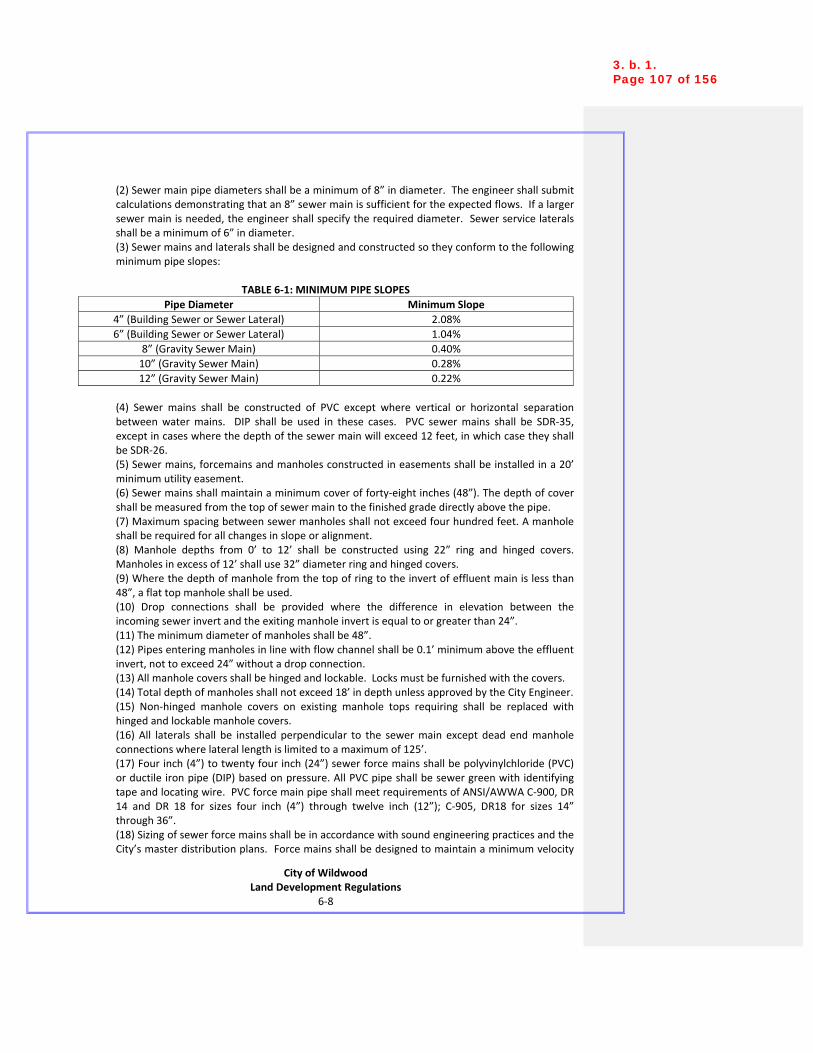
City of Wildwood Land Development Regulations
6‐8
(2) Sewer main pipe diameters shall be a minimum of 8” in diameter. The engineer shall submit calculations demonstrating that an 8” sewer main is sufficient for the expected flows. If a larger sewer main is needed, the engineer shall specify the required diameter. Sewer service laterals shall be a minimum of 6” in diameter. (3) Sewer mains and laterals shall be designed and constructed so they conform to the following minimum pipe slopes:
TABLE 6‐1: MINIMUM PIPE SLOPES
Pipe Diameter Minimum Slope
4” (Building Sewer or Sewer Lateral) 2.08%
6” (Building Sewer or Sewer Lateral) 1.04%
8” (Gravity Sewer Main) 0.40%
10” (Gravity Sewer Main) 0.28%
12” (Gravity Sewer Main) 0.22%
(4) Sewer mains shall be constructed of PVC except where vertical or horizontal separation between water mains. DIP shall be used in these cases. PVC sewer mains shall be SDR‐35, except in cases where the depth of the sewer main will exceed 12 feet, in which case they shall be SDR‐26. (5) Sewer mains, forcemains and manholes constructed in easements shall be installed in a 20’ minimum utility easement. (6) Sewer mains shall maintain a minimum cover of forty‐eight inches (48”). The depth of cover shall be measured from the top of sewer main to the finished grade directly above the pipe. (7) Maximum spacing between sewer manholes shall not exceed four hundred feet. A manhole shall be required for all changes in slope or alignment. (8) Manhole depths from 0’ to 12’ shall be constructed using 22” ring and hinged covers. Manholes in excess of 12’ shall use 32” diameter ring and hinged covers. (9) Where the depth of manhole from the top of ring to the invert of effluent main is less than 48”, a flat top manhole shall be used. (10) Drop connections shall be provided where the difference in elevation between the incoming sewer invert and the exiting manhole invert is equal to or greater than 24”. (11) The minimum diameter of manholes shall be 48”. (12) Pipes entering manholes in line with flow channel shall be 0.1’ minimum above the effluent invert, not to exceed 24” without a drop connection. (13) All manhole covers shall be hinged and lockable. Locks must be furnished with the covers. (14) Total depth of manholes shall not exceed 18’ in depth unless approved by the City Engineer. (15) Non‐hinged manhole covers on existing manhole tops requiring shall be replaced with hinged and lockable manhole covers. (16) All laterals shall be installed perpendicular to the sewer main except dead end manhole connections where lateral length is limited to a maximum of 125’. (17) Four inch (4”) to twenty four inch (24”) sewer force mains shall be polyvinylchloride (PVC) or ductile iron pipe (DIP) based on pressure. All PVC pipe shall be sewer green with identifying tape and locating wire. PVC force main pipe shall meet requirements of ANSI/AWWA C‐900, DR 14 and DR 18 for sizes four inch (4”) through twelve inch (12”); C‐905, DR18 for sizes 14” through 36”. (18) Sizing of sewer force mains shall be in accordance with sound engineering practices and the City’s master distribution plans. Force mains shall be designed to maintain a minimum velocity
3. b. 1. Page 107 of 156

City of Wildwood Land Development Regulations
6‐9
of two feet per second. Provide design calculations showing the pressures designed for the forcemain system. The working pressures within the system shall not exceed the pressure class of the pipe with a 1.5 safety factor. (19) Fittings shall be DIP fittings for DIP and PVC pipe installations.
(D) Reuse. Reuse water mains shall be constructed to the same specification and requirements as potable water mains, with the exception that all reuse water mains shall be colored purple.
6.4. Drainage and stormwater management. (A) General.
(1) No person shall conduct a development or redevelopment activity, subdivide, make any change in the use of land, construct any stormwater management system or structure, or change the size of an existing structure without obtaining approval from the City as provided herein. (2) Approval of the stormwater management plans shall be contingent on approval of any required permit from the Southwest Florida Water Management District Management District (SWFWMD), FDOT, or any other agency with regulatory jurisdiction over the project; however, approval by another government agency will not result in automatic approval of the stormwater management plans by the City. (3) The stormwater management system is required to be designed by a registered professional engineer. (4) The system shall provide for drainage of lots, streets, roads, and other public areas as well as handling any runoff from adjacent areas that naturally flows into the subject area. (5) The drainage system shall be designed for long life, low maintenance cost, and ease of maintenance. (6) Peak rate and volume attenuation. Peak discharge rate and volume attenuation shall be as required in the SWFWMD regulations and in these regulations. (7) Development within flood prone areas (100‐year flood). All development within flood prone areas, as delineated on the official national flood insurance program, flood insurance rate maps, or the latest and best information available, shall comply with the requirements of SWFWMD and the criteria in the flood hazard regulations section of this Code.
(B) Water quality. (1) All stormwater water management systems are required to treat the required pollution abatement volume prior to discharge to receiving waters. (2) The pollution abatement volume and treatment method varies depending on the size and location of the site and shall be as required by SWFWMD. (3) The design engineer shall demonstrate that the treatment requirements of the SWFWMD are met by the proposed stormwater system design. (4) Water quality pollution abatement volume shall not be required in stormwater management systems that have zero discharge up to and including the 100‐year, 24‐hour storm event.
(C) Retention/detention pond requirements. (1) For projects having drainage areas less than or equal to five (5) acres, calculations may be based on the rational method (Q=CIA). The design criteria shall be based on the latest available Intensity‐Duration Curves published by FDOT for Zone 7. (2) For projects having drainage areas greater than five (5) acres, the Soil Conservation Service (SCS) methodology shall be used. The rainfall distribution utilized shall be the SCS Type II, Florida
3. b. 1. Page 108 of 156

City of Wildwood Land Development Regulations
6‐10
Modified 24‐Hour, Antecedent Moisture Condition II. The design engineer shall submit complete copies of all input parameters, supporting calculations, assumptions, and documentation pertaining to the design for review by the City. (3) All data used for soil permeability or infiltration analyses shall be signed and sealed by a registered professional engineer. If infiltration is considered in the design of any retention/detention pond, signed and sealed geotechnical field data and laboratory results must be provided as part of the design calculations. A minimum of two (2) soil borings shall be provided within each retention/detention pond. The minimum depth of the soil boring shall be six feet (6’) below the proposed pond bottom elevation. (4) For open basins, the water retention/detention facility shall be sized to fully retain the post development runoff volume minus pre‐development runoff volume for the 25‐year, 24‐hour storm event. Post developed discharge rates shall be maintained at or below the 25‐year, 24‐hour pre development discharge rate. (5) For a project or portion of a project in a closed basin, the water retention/detention facility shall be sized to fully retain the post‐development runoff volume for the 100‐year, 24‐hour storm event. (6) In all cases of stormwater discharges, the post development discharge to downstream properties shall not cause adverse off‐site impacts and the discharges shall be limited to the pre‐development rate, and general flow pattern. (7) A minimum freeboard of six inches (6”) above the design high water elevation shall be provided for all retention/detention ponds. The design high water elevation is defined as the expected peak stage elevation expected for the 100‐year, 24‐hour storm event. (8) The project engineer shall submit drainage calculations demonstrating that stormwater retention basins will fully recover the total design storm volume within 14 days following the design rainfall event. For ponds not able to recover the design volume within 14 days, the pond volume shall be increased to retain the post‐development minus pre development runoff volume and peak discharge rate from a second 25‐year, 24‐hour design storm in an open basin, or the post‐development minus pre‐development runoff volume from a second 100‐year, 24‐ hour design storm if in a closed basin. (9) All assumed drainage calculation parameters must be listed and supported by conventional methods. All geotechnical parameters must be supported by signed and sealed geotechnical field data and laboratory results. Calculations must be presented in a format acceptable to the City. The final determination on the suitability of assumed parameters is at the sole discretion of the City Engineer.
(D) Fencing requirements. (1) Wet ponds. Fencing shall be required unless the side slopes have a maximum steepness of five‐to‐one (5:1) for at least four feet (4’) below the control elevation in the pond. Below this elevation, the side slopes may be increased to two‐to‐one (2:1). (2) Dry ponds. Fencing shall be required when the side slopes are steeper than four‐to‐one (4:1). Dry ponds shall be a maximum of ten feet (10’) deep, measured from pond bottom to top of bank. (3) When provided, fencing shall be six feet (6’) high with a twelve feet (12’) wide flat access berm adjacent to the inside perimeter of the fence.
(E) Storm sewer and culvert design. (1) Types and requirements. Where drainage pipes are utilized, the following standards apply:
(a) Storm sewers shall be of reinforced concrete or other FDOT approved material, subject to additional approval by the City, and have a minimum diameter of 18 inches or
3. b. 1. Page 109 of 156

City of Wildwood Land Development Regulations
6‐11
equal. An inlet or manhole is required at each change of alignment or grade. Minimum pipe diameters may be reduced to 12 inches in grassed areas not subject to vehicular traffic when the primary purpose of the storm sewer is to accommodate open space drainage; (b) Where any storm pipe terminates at an earthen slope a mitered end section and concrete collar, or approved equal, is required; (c) The following maximum lengths of pipe shall be used when spacing access structures of any type:
TABLE 6‐2
Pipe Diameter Maximum Pipe Length
Less than 18 inches 300 feet
24 to 36 inches 400 feet
42 inches and larger 500 feet
(F) Conveyance System Design storm (minimum).
TABLE 6‐3
Facility Frequency and Duration
Principal arterial bridges and evacuation routes 100‐year 24 hours
Canals, ditches, swales, storm drains or culverts for drainage external to the development
25‐year 24 hours
Canals, ditches, swales, storm drains or culverts for drainage internal to the development
10‐year 24 hours
(1) The design frequency for major drainage systems may be increased if deemed necessary by the City to protect known flooding conditions in upstream or downstream properties or to comply with other regulations. (2) Design tailwater. All storm sewer systems and culverts shall be designed taking into consideration the tailwater of the receiving facility or water body. The tailwater elevation used shall be based on the tailwater elevation of the receiving water body at the peak time of the design storm. Alternatively, the tailwater may be assumed to be the design high water elevation of the receiving water body for the design storm. (3) The hydraulic gradient line for the storm sewer system shall be computed taking into consideration the design tailwater on the system and the energy losses associated with entrance into and exit from the system, friction through the system, and turbulence in the individual manholes, catch basins, and junctions within the system. (4) The design criteria to be utilized for the design of pavement drainage shall be as follows:
3. b. 1. Page 110 of 156

City of Wildwood Land Development Regulations
6‐12
TABLE 6‐4
Arterial streets 10‐year, 24‐hour, hydraulic gradient line 1.0 foot
below the gutter flowline
Collector and local streets 10‐year, 24‐hour, hydraulic gradient line 0.5 feet
below the gutter flowline
(G) Erosion protection. Standard practices shall be used to prevent erosion and the depositing of soil off‐site pursuant to the requirements of the FDEP Generic Permit for Stormwater Discharge from Large and Small Construction Activities. (H) Maintenance.
(1) A written operation and maintenance plan shall contain information per SWFWMD regulations as the minimum criteria that shall be accepted by the City. (2) The installed stormwater system shall be maintained by the legal entity responsible for maintenance. All permit applications shall contain documentation sufficient to demonstrate that the operation and maintenance entity is the legal entity empowered and obligated to perpetually maintain the stormwater management facilities. (3) The stormwater management system to be maintained by the legal entity shall have adequate easements, in accordance with this Code, to permit the City to inspect and, if necessary, to take corrective action should the legal entity fail to maintain the system properly.
6.5. Roads and sidewalks. (A) General. Roads within a subdivision or other development are classified as either public roads or private roads.
(1) Private roads. (a) All private roads are required to be designed, constructed and paved to City specifications within dedicated, rights‐of‐way within the subdivision and within rights‐of‐way adjacent to the subdivision boundary which are accessed by the subdivision roads. (b) A Home Owner's Association or other quasi‐governmental entity shall be created to perpetually own and maintain the road and drainage system. (c) The developer shall be required to design and construct to City specifications, at a minimum one (1) paved road from the subdivision to the nearest paved, public roadway with legal access, if such a road does not already exist. (d) Minimum right‐of‐way width for private roads shall be 60 feet. A 50 foot right‐of‐way is allowed if curb and/or gutter are installed and a five foot utility easement is provided on each side of the right‐of‐way. Inverted crown roadways are allowable on privately maintained roadways classified as local residential.
(2) Public roads. (a) As part of the review and approval of a public road subdivision, the City shall require that roads be designed, constructed and paved to City specifications within dedicated, unimproved public rights‐of‐way within the subdivision and within rights‐of‐way adjacent to the subdivision boundary which are accessed by the subdivision roads.
3. b. 1. Page 111 of 156

City of Wildwood Land Development Regulations
6‐13
(b) If a paved, public road on public right‐of‐way does not exist adjacent to the proposed subdivision, the developer shall construct a paved road within a public right‐of‐way, to the proposed subdivision. (c) A minimum of 60 foot right‐of‐way is required, unless excepted by this section, in order to provide adequate drainage and safe access. A 50 foot right‐of‐way may be allowed by the City if curb and gutter is installed and a five foot (5’) utility easement is provided on each side of the right‐of‐way.
(B) Design standards. (1)Cul‐de‐sac diameters to the right‐of‐way line shall not be less than 120 feet with a pavement radius of 40 feet for residential subdivisions and shall not be less than 120 feet to the right‐of‐way line with a pavement radius of 45 feet for commercial or industrial subdivisions. (2) Dead end rights‐of‐way with a cul‐de‐sac at the terminal end shall not exceed 1,500 feet. (3) Corner radii at the intersection of the two (2) rights‐of‐way shall be not less than 25 feet. Minimum edge of pavement radii shall be 40 feet for residential subdivisions and 50 feet for commercial or industrial subdivisions. (4) Sight distance shall be provided at all intersections and driveways as recommended in AASHTO Policies and FDOT Site Impact Handbook. (5) A paved approach apron shall be constructed where a non‐paved drive or road intersects with a paved road. Driveway grade shall be a maximum of ten percent (10%) for commercial and 25 percent (25%) for residential. (6) Roadway centerline radii in residential subdivisions shall be designed to accommodate the minimum design speed of 25 mph for local streets and 35 mph for subdivision collector roads. Advisory speed signs in accordance with the MUTCD shall be used at curves to warn motorists about road conditions. Sign location shall be approved by the City. Minimum centerline radii and other geometric design criteria shall be in accordance with Chapter 16 of the FDOT Manual of Uniform Minimum Standards for Design, Construction and Maintenance for Streets and Highways (“Green Book”), latest edition.
(C) Driveway access. (1) No driveway shall be located within the sight triangle at the corners of the intersection of any two (2) or more roads. Driveway placement and minimum driveway spacing, consistent with traffic safety requirements, will be determined on a case‐by‐case basis by the City. Residential driveway to corner lots shall be located no closer than the lesser of ½ of the lot width or 50 feet, and it shall be placed on a minor street. Driveway restriction areas shall be graphically shown on final plats for corner lots in compliance with this section. (2) No portion of the driveway apron may extend beyond the frontage of the property being served by the driveway (i.e., it may not encroach into the frontage of adjacent property), unless shared access is mandated as a provision of the development approval or by agreement between adjoining property owners. (3) All existing driveway aprons are required to be upgraded to current construction standards and specifications at such time as a new home, or commercial building or any other structure is to be constructed or a mobile home is placed or replaced. (4) Minimum driveway spacing shall conform to the following requirements:
(a) Adjacent properties under the same ownership shall be considered as a single property for application of driveway spacing or for driveway permits. Applicants may include a request that properties be considered individually for permitting purposes but the request must be specifically included in the permit and a sketch included that details the lot configurations and driveway placement.
3. b. 1. Page 112 of 156

City of Wildwood Land Development Regulations
6‐14
(b) Residential driveways shall not exit onto collector or arterial roadways if alternate access is available. Also, in residential subdivisions, any road connecting different phases or units to a major collector road shall be treated as a collector facility. If alternate access is not available, residential driveways shall comply with spacing requirements for nonresidential access below:
TABLE 6‐5: RESIDENTIAL DRIVEWAY ACCESS STANDARDS
(c) Nonresidential access onto collectors or arterial roadways shall comply with the following table:
Median Position Access Allowed
Minimum (Feet)
Restrictive Approaching Intersection
Right In/Out 115
Restrictive ApproachingIntersection
Right In Only 75
Restrictive Departing Intersection
Right In/Out 230
Restrictive DepartingIntersection
Right Out Only 100
Without Restrictive ApproachingIntersection
Full Access 230
Without Restrictive ApproachingIntersection
Right In Only 100
Without Restrictive Departing Intersection
Full Access 230
Without Restrictive DepartingIntersection
Right Out Only 100
3. b. 1. Page 113 of 156

City of Wildwood Land Development Regulations
6‐15
TABLE 6‐6
(d) Any roadway classified under the State Access Classification System shall meet FDOT Access Management Standards for that roadway.
(D) Pavement design.
(1) All roadway or street construction must meet the requirements of the State of Florida Manual of Uniform Minimum Standards for Design, Construction and Maintenance of Streets and Highways, and all construction will meet the minimum requirements of the FDOT Standard Specifications for Road and Bridge Construction (latest edition) unless otherwise specified herein. (2) Sod shall be provided on all unpaved areas in the rights‐of‐way. For residential subdivisions, a 24” strip of sod at the edge of all pavement and/or backs of curbing may be provided. (3) Concrete shall have a minimum compressive strength of 3,000 psi if not noted otherwise.
TABLE 6‐7: ROW WIDTH
Notes: This table applies for new construction. Maintenance projects shall attempt to satisfy these requirements as deemed practical. * Shoulder may be eliminated when curb and gutter is provided. ** Sidewalk widths and locations shall comply with the design district standards. Bike lanes may also be required. *** ROW may be reduced to 50’ on local residential streets provided curb and gutter drainage is installed and a 5’ utility easement is provided adjacent to each side of the right of way.
Speed Limit (MPH)
Spacing (Feet)
35 or less 245
36‐45 440
Over 45 660
Street Type
ROW Width Roadway Lane Widths
Width of Pavement
Paved Shoulder* Sidewalk **
Local Residential
60'*** 2‐10' 20' 4' **
Residential Collector
80' 2‐12' 24' 6' **
Local Commercial
60' 2‐12' 24' 6' **
Collector 100' 2‐12' 24' 6' **
3. b. 1. Page 114 of 156

City of Wildwood Land Development Regulations
6‐16
TABLE 6‐8: PAVEMENT THICKNESS ‐ TYPICAL SECTION
Notes: * The width of the base material shall extend six inches (6”) beyond the edge of pavement if curb and gutter is not provided. ** The width of the subgrade material shall extend twelve inches beyond the edge of pavement if curb and gutter is not provided, or six inches (6”) beyond the back of curb.
(E) Sign and pavement markings. (1) Signing and marking plans shall be required by the City that show size, location, materials, and message of all devices. (2) The design engineer shall design the project plans providing for installation of signs as per the requirements of this Code. Street signs at every intersection are required. Stop signs and stop bars requiring vehicles to stop are required on the minor street at all intersections. All stop signs shall be high intensity grade. Signs establishing maximum speed limit are required on major roads at intervals not to exceed 2,000 feet and at the beginning and end of major roads within the subdivision. The speed limit shall be determined by the project engineer in accordance with Section 316.183 and 316.18, Florida Statutes, and the Manual of Uniform Minimum Standards for Design, Construction and Maintenance for Highways, Roads, and Streets in Florida, Florida D.O.T., latest edition. Design speed shall be 25 mph minimum for local streets and 35 mph minimum for subdivision collector streets. Curve signs with advisory speed shall be installed at all curves with centerline radii less than 180 feet. Dead end signs shall be erected at the beginning intersection of all discontinuous roads. No outlet signs shall be erected at the entrance intersection when this intersection is the only outlet from a street network. (3) All sign sizes, colors, mounting heights, etc. shall be in accordance with the MUTCD, latest edition. If decorative sign posts are approved by the City for a private or public road, the signs shall still comply with the MUTCD requirements. (4) All pavement markings Private or Public Roads shall be lead free thermoplastic in accordance with FDOT specifications. Stop bars shall be 24 inches wide. All other pavement marking dimensions shall comply with the MUTCD and FDOT Standard Index latest revision.
Road Classification
Pavement (Type SP)
Base (Limerock) LBR 100
Stabilized Subgrade (LBR 40)
Local Residential
1.25" 8" 12"
Residential Collector
1.50" 10" 12"
Local Commercial
1.50" 10" 12"
Collector 2.50" 10" 12"
3. b. 1. Page 115 of 156

City of Wildwood Land Development Regulations
6‐17
6.6. Parking and loading areas. (A) Requirements.
(1) For every use, activity, building, or structure permitted by and erected in accordance with this Code, there shall be provided sufficient space for access of off‐street pedestrians, parking, circulation, loading and unloading of vehicles, regardless of whether the users are patrons, guests, customers, clients or otherwise, to an establishment, activity, or place or residence. When any use is expanded, accessory off‐street parking and loading shall be provided in accordance with these regulations. In addition, as a part of the building permit and site plan approval processes for every new or enlarged building, structure, or use, there shall be submitted for review and approval a parking lot and landscaping design and layout. (2) All accessory parking facilities, whether provided in fulfillment of or in excess of the requirements of this Code, shall be located on property zoned the same as, or in a less restrictive zoning district than, the principal use served by the parking, as defined in this Code. (3) Off‐street parking spaces shall be so arranged that no automobile shall have to back into a City street, except for one‐ and two‐family residential uses in a residential district. (4) Residential developments. Off‐street parking shall be provided as set forth in TABLE 6‐3. (5) Nonresidential developments. Off‐street parking shall be provided as set forth in TABLE 6‐4. (6) A one‐car garage or carport and driveway combination shall count as two (2) off‐street parking spaces, provided the driveway measures a minimum of 18 feet in length between the face of the garage or carport door and the sidewalk, or 25 feet to the curb line. (7) Where housing for the handicapped, elderly, ACLF, nursing homes, or similar use is being built these standards shall be relaxed where the need for reduced parking can be demonstrated by the project planner. In no case shall there be less than one (1) parking space per four (4) dwelling units. Where these standards are relaxed, the City shall require that additional parking is provided at the owner's expense if the building's use is changed. A notation to this effect shall be required on the site plan. (8) Where the total number of off‐street parking spaces required are not immediately required for a particular use, a phased development plan may be permitted requiring that only a portion of the parking area be completed initially, subject to the following regulations:
(a) The site plan shall clearly indicate both that portion of the parking area to be paved initially and the total parking needed to provide the number of spaces required; (b) The drainage plan shall provide for adequate drainage of both the partial and total parking areas; (c) The portion of the parking area which is not paved initially shall be planted with a ground cover to prevent erosion; (d) Any change of use on a site to a use which requires more parking spaces than are provided on the site shall require submission of a new site and drainage plan showing the required parking spaces. (e) Each shop or store shall have a rear or side entrance that is accessible to a loading area and service drive. Service drives shall be a minimum of 24 feet in width and shall be in addition to and not part of the drives or circulation system used by the vehicles of shoppers or emergency vehicles. The arrangement of truck loading and unloading facilities for each shop or store shall be such that in the process of loading or unloading, no truck will block or extend into any other private or public drive or street used for circulation. Loading and delivery zones shall be clearly marked, buffered and screened.
3. b. 1. Page 116 of 156

City of Wildwood Land Development Regulations
6‐18
(f) Where sidewalks occur in parking areas, parked vehicles shall not overhang the sidewalk unless an additional two feet (2’) per side is provided in order to accommodate such overhang.
(B) Joint parking facilities. Off‐street parking facilities for different buildings, structures, or uses, or for mixed uses, may be provided and used collectively or jointly in any zoning district in which separate off‐street parking facilities for each constituent use would be permitted, subject to the following conditions:
(1) A written agreement is executed by the parties assuring the perpetual joint usage of common parking for any combination of uses or buildings. This agreement shall be approved by the City Attorney and City Commission. (2) The Planning and Zoning Board shall approve such joint usage of common off‐street parking. In making a determination, the Planning and Zoning Board shall consider whether the joint usage will result in a public nuisance, inconvenience, hazard, or adversely affect the public health, safety or welfare. (3) Unless a site specific parking analysis is approved by the City, the total requirements for off‐street parking in a joint parking facility shall be the sum of the requirements of the various uses computed separately.
(C) Storage area standards for uses with drive‐in facilities. (1) Space requirements. All business and commercial uses with drive‐in service facilities shall provide a storage area for waiting vehicles according to the following minimum standards.
(a) Restaurants: Five (5) vehicles for each service lane. (b) Financial institutions: Five (5) vehicles for each regular service lane; three (3) vehicles for each automated service lane. (c) Full service car washes and automotive services (except gasoline sales): Five (5) vehicles for each service lane. (d) Groceries, drugstores, package good, cleaners, gasoline sales and other uses not specifically listed: Three (3) vehicles for each service lane.
(D) Size of spaces (minimum size). (1) Each off‐street parking space shall at a minimum measure ten feet (10’) in width by 20 feet (20’) in length. Parking space size may be reduced to increase internal landscaping and provide parking for compact cars as stated in the design district standards. Parking spaces for the physically handicapped shall comply with the requirements of the Florida Building Code. (2) Pavement markings in parking lots shall be six inches (6”) wide minimum.
(E) Parking areas. (1) All parking areas and access shall be paved, except as listed below. Alternative parking area improvement standards may be accepted, if the applicant demonstrates that such standards better reflect local and project conditions. (2) The following businesses shall provide paved parking for all employees, and shall comply with the requirements of the American Disabilities Act, latest edition. All other vehicular parking may be on grass areas or grass pavement systems. The perimeter of a grass parking lot shall be delineated with railroad ties or wheel stops or, other means as may be approved by the City Engineer for:
Churches; private clubs or lodges or community centers; new and used motor vehicle sales and leasing including automobiles, trucks and commercial tractor/trailer units; sales and leasing of new and used motor homes and recreational vehicles; sales of new and used manufactured homes (mobile homes); sales of new and used farm tractors or equipment; or new and used construction equipment.
3. b. 1. Page 117 of 156
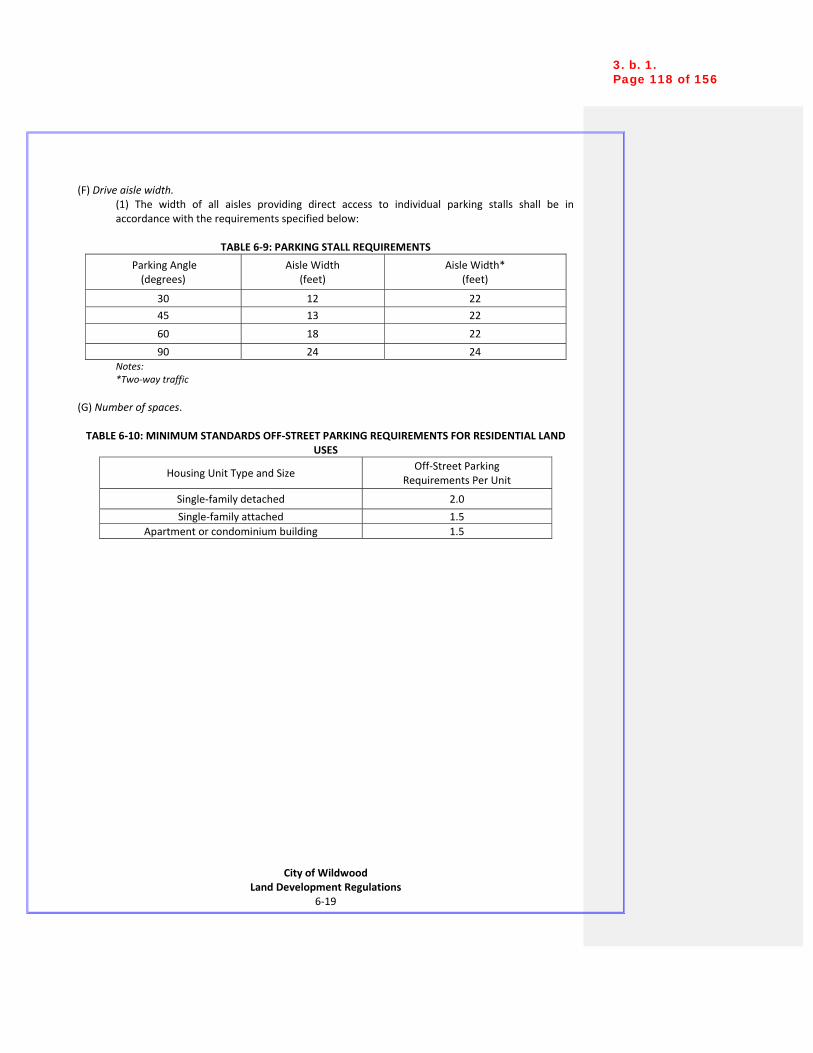
City of Wildwood Land Development Regulations
6‐19
(F) Drive aisle width. (1) The width of all aisles providing direct access to individual parking stalls shall be in accordance with the requirements specified below:
TABLE 6‐9: PARKING STALL REQUIREMENTS
Parking Angle (degrees)
Aisle Width (feet)
Aisle Width* (feet)
30 12 22
45 13 22
60 18 22
90 24 24 Notes: *Two‐way traffic
(G) Number of spaces.
TABLE 6‐10: MINIMUM STANDARDS OFF‐STREET PARKING REQUIREMENTS FOR RESIDENTIAL LAND
USES
Housing Unit Type and Size Off‐Street Parking
Requirements Per Unit
Single‐family detached 2.0
Single‐family attached 1.5
Apartment or condominium building 1.5
3. b. 1. Page 118 of 156

City of Wildwood Land Development Regulations
6‐20
TABLE 6‐11: MINIMUM STANDARS FOR OFF‐STREET PARKING REQUIREMENTS FOR NONRESIDENTIAL
LAND USES
Nonresidential Land Use Required Off‐Street Parking Spaces Per Indicated Area
1. Assembly operations 1.0 Per 650 sq. ft. GFA
2. Bowling alley 3.0 Per lane
3. Car wash 5.0 Per washing lane
4. Church/Synagogue 1.0 Per 3 seats
5. Fiduciary institutions 1.0 Per 300 sq. ft. GFA
6. Hotel 1.0 Per guest room plus
1.0 Per employee
7. Industrial 1.0 Per 675 sq. ft. GFA
8. Library 1.0 Per 300 sq. ft. GFA
9. Manufacturing 1.0 Per 625 sq. ft. GFA
10. Medical center 1.0 Per 250 sq. ft. GFA
11. Assisted Living / Skilled Nursing Facility 1.0 Per 3 beds plus 0.5 per employee
12. Retail use less than 100,000 sq. ft. GLA 4.0 Per 1,000 sq. ft. GLA
13. Nightclub/Bar 1.0 Per 3 seats
14. Offices 3.0 Per 1,000 sq. ft. GFA
15. Research 1.0 Per 1,000 sq. ft. GFA
16. Restaurant 1.0 Per 4 seats
Fast‐food establishments 1.0 Per 75 sq. ft. GFA
17. Mixed Use Shopping center
Under 400,000 sq. ft. GLA 3.5 Per 1,000 sq. ft. GLA
Over 400,000 sq. ft. GLA 3.0 Per 1,000 sq. ft. GLA
18. Storage areas 1.0 Per 2,000 sq. ft. GLA
19. Theater 1.0 Per 4 seats
20. Warehouse 1.0 Per 3,000 sq. ft. GFA
21. Loading spaces for all business, industrial, warehouse use
1.0 Per 25,000 GFA
Notes TABLE 6‐10 and 6‐11: When determination of the number of parking spaces required by this exhibit results in a requirement of a fractional space, any fraction of one‐half or less may be disregarded, while a fraction in excess of one‐half shall be counted as one parking space. Irrespective of any other requirement of this section, each and every separate and individual store, office or other business shall be provided with at least one off‐street parking space. Requirements for attached units include provisions for guest parking. Alternative parking standards may be proposed, if the applicant demonstrates that such standards better reflect local and project conditions. In order to justify alternative parking standards a site specific parking analysis must be prepared and submitted to the City for review and approval as part of the project.
3. b. 1. Page 119 of 156

City of Wildwood Land Development Regulations
6‐21
6.7. Wetlands protection. (A) Purpose and intent. The City shall ensure the protection of natural functions of wetlands. The purpose of this section is to avoid loss or degradation of wetland functions, to minimize unavoidable degradation or loss of wetland functions and to require mitigation that fully offsets any unavoidable loss or degradation of wetland functions. In addition, it is the purpose of this section to ensure that development activities that cause the unavoidable degradation or loss of wetland function are in the public interest and fully offset any degradation or loss of wetland functions through sustainable mitigation. It is hereby unlawful for any person to engage in any activity which will remove, fill, drain, dredge, clear, destroy or alter any wetland or wetland buffer without obtaining a permit from the appropriate jurisdictional agencies. (B) Wetland delineation required. Wetlands shall be delineated pursuant to Rule 62‐340.300, F.A.C. The location of wetlands shall be identified accordingly at the time of site plan or improvement plan. All preserved wetlands shall be placed within a conservation easement. (C) Buffer required. All development will be required to be clustered away from all wetland areas on the site and an upland buffer will be provided adjacent to the wetlands. Within required wetland buffers, there shall be no placement of impervious surfaces. Native vegetation shall be retained and/or installed in order to protect wetland and surface water environmental features. A natural upland buffer from the edge of the wetland shall be maintained to the following standards:
(1) The buffer width shall maintain 15’ minimum from the edge of the wetland; and (2) The overall wetland buffer within a project or development site shall maintain 25’ average from the edge of the wetland.
(D) Minimization. Avoidance of loss of wetland function and wetland habitat is of the highest priority. The owner shall avoid loss of wetland function and wetland habitat by implementing practicable design alternatives to minimize adverse impacts to wetlands. The adverse impacts remaining after practicable design modifications have been made shall be offset by mitigation as required by the Southwest Florida Water Management District. A development activity cannot cause a net adverse impact on wetland functions, wetland habitat, or surface water functions, if such activity is not offset by mitigation. (E) Mitigation plan required. The alteration of wetland areas is prohibited unless no other alternative exists. If alteration is necessary after it is proven that no other alternative exists, it shall be accompanied by a mitigation plan pursuant to the mitigation requirements of the Southwest Florida Water Management District. The purpose of mitigation is to ensure that the ecological value and extent of the wetlands is maintained in conformance with district regulations. The plan must provide the City with assurances that the mitigation plan will be maintained. (F) Passive recreation. Passive recreation activities such as, but not limited to boardwalks, fishing piers, boat docks, and pervious nature trails may be allowed within a wetland or wetland buffer. (G) Prohibitions. To ensure the protection of wetlands, the following prohibitions apply:
(1) No new parcels of land shall be created which consist entirely of wetlands unless such parcel will be dedicated to the public or remain in private ownership with a permanent conservation easement;
(2) Wetlands and required wetland buffers shall not be included within any platted lots or blocks;
(3) Septic tanks shall not be permitted within 50 feet from the edge of a wetland; (4) Commercial and industrial uses which store hazardous materials or wastes shall be not
permitted in or within 50 feet from the edge of a wetland.
3. b. 1. Page 120 of 156

City of Wildwood Land Development Regulations
6‐22
6.8. Flood protection. (A) Purpose. It is the purpose of this section to save lives, promote the public health, safety and general welfare, and minimize public and private losses due to flood conditions in specific areas by provisions designed to:
(1) Restrict or prohibit uses which are dangerous to life, health, safety and property due to water or erosion hazards, which result in damaging increases in erosion or in flood heights and velocities; (2) Require that uses vulnerable to floods including facilities which serve such uses be protected against flood damage throughout their intended life span; (3) Control the alteration of natural floodplains, stream channels, and natural protective barriers which are involved in the accommodation of flood waters; (4) Control filling, grading, dredging and other development which may increase erosion or flood damage; and (5) Prevent or regulate the construction of flood barriers which will unnaturally divert floodwaters or which may increase flood hazards to other lands.
(B) Basis, applicability and objectives. The areas of special flood hazard identified by the Federal Emergency Management Agency in the Flood Insurance Study (FIS) for the City of Wildwood with the accompanying maps and other supporting data, and any subsequent revisions thereto, are adopted by reference and declared to be a part of this section. This section shall apply to all areas of special flood hazard within the jurisdiction of the City of Wildwood. The objectives of this section are to:
(1) Protect human life, health and to eliminate or minimize property damage; (2) Minimize expenditure of public money for costly flood control projects; (3) Minimize the need for rescue and relief efforts associated with flooding and generally undertaken at the expense of the general public; (4) Minimize prolonged business interruptions; (5) Minimize damage to public facilities and utilities such as water and gas mains, electric, telephone and sewer lines, roadways, and bridges and culverts located in floodplains; (6) Maintain a stable tax base by providing for the sound use and development of flood prone areas in such a manner as to minimize flood blight areas; and (7) Ensure that potential homebuyers are notified that property is in a flood hazard area.
(C) Definitions. The following definitions shall apply only to this section of this Chapter. (1) Appeal: means a request for a review of the Floodplain Administrator’s interpretation of any provision of this section or a request for a variance. (2) Building: see “Structure”. (3) Development: means any man‐made change to improved or unimproved real estate, including, but not limited to buildings or other structures, mining, dredging, filling, grading, paving, excavating, drilling operations, or storage of materials or equipment. (4) Encroachment: means the advance or infringement of uses, plant growth, fill, excavation, buildings, permanent structures or development into a floodplain, which may impede or alter the flow capacity of a floodplain. (5) Existing construction: means, for the purposes of floodplain management, structures for which “the start of construction” commenced before July 25, 2011. Existing construction, means for the purposes of determining rates structures for which the “start of construction” commenced before January 1, 1975. This term may also be referred to as “existing structures”.
3. b. 1. Page 121 of 156

City of Wildwood Land Development Regulations
6‐23
(6) Existing manufactured home park or subdivision: means a manufactured home park or subdivision for which the construction of facilities for servicing the lots on which the manufactured homes are to be affixed (including at a minimum the installation of utilities, the construction of streets, and either final site grading or the pouring of concrete pads) is completed before July 25, 2011. (7) Floodplain management regulations: means this section and other zoning ordinances, subdivision regulations, building codes, health regulations, special purpose section, and other applications of police power which control development in flood‐prone areas. This term describes Federal, State of Florida, or local regulations in any combination thereof, which provide standards for preventing and reducing flood loss and damage. (8) Free of obstruction: means any type of lower area enclosure or other construction element will not obstruct the flow of velocity water and wave action beneath the lowest horizontal structural member of the lowest floor of an elevated building during a base flood event. This requirement applies to the structures in velocity zones (V‐Zones). (9) Functionally dependent use: means a use that cannot be used for its intended purpose unless it is located or carried out in close proximity to water, such as a docking or port facility necessary for the loading and unloading of cargo or passengers, shipbuilding or ship repair. The term does not include long‐term storage, manufacture, sales, or service facilities. (10) Hardship (as related to variances from this section): means the exceptional difficulty associated with the land that would result from a failure to grant the requested variance. The City requires that the variance is exceptional, unusual, and peculiar to the property involved. Mere economic or financial hardship alone is not exceptional. Inconvenience, aesthetic considerations, physical handicaps, personal preferences, or the disapproval of one’s neighbors likewise cannot, as a rule, qualify as an exceptional hardship. All of these problems can be resolved through other means without granting a variance, even if the alternative is more expensive, or requires the property owner to build elsewhere or put the parcel to a different use than originally intended. (11) Highest adjacent grade: means the highest natural elevation of the ground surface, prior to the start of construction, next to the proposed walls of a structure. (12) Lowest adjacent grade: means the lowest elevation, after the completion of construction, of the ground, sidewalk, patio, deck support, or basement entryway immediately next to the structure. (13) Lowest floor: means the lowest floor of the lowest enclosed area (including basement). An unfinished or flood resistant enclosure, used solely for parking of vehicles, building access, or storage, in an area other than a basement, is not considered a building’s lowest floor, provided that such enclosure is not built so as to render the structure in violation of the applicable nonelevation design standards of this section. (14) New construction: means, for floodplain management purposes, any structure for which the “start of construction” commenced on or after July 25, 2011. The term also includes any subsequent improvements to such structures. For flood insurance rates, structures for which the start of construction commenced on or after December 31, 1974 and includes any subsequent improvements to such structures. (15) Principally above ground: means that at least 51 percent of the actual cash value of the structure is above ground. (16) Program deficiency: means a defect in the City’s floodplain management regulations or administrative procedures that impairs effective implementation of those floodplain management regulations or of the standards required by the National Flood Insurance Program.
3. b. 1. Page 122 of 156

City of Wildwood Land Development Regulations
6‐24
(17) Public safety and nuisance: means anything which is injurious to safety or health of the entire community or a neighborhood, or any considerable number of persons, or unlawfully obstructs the free passage or use, in the customary manner, of any navigable lake, river, bay, stream, canal, or basin. (18) Reasonably safe from flooding: means base flood waters will not inundate the land or damage structures to be removed from the SFHA and that any subsurface waters related to the base flood will not damage existing or proposed buildings. (19) Remedy a deficiency or violation: means to bring the regulation, procedure, structure or other development into compliance with State of Florida, Federal, or local floodplain management regulations; or if this is not possible, to reduce the impacts of its noncompliance. Ways the impacts may be reduced include protecting the structure or other affected development from flood damages, implementing the enforcement provisions of this section or otherwise deterring future similar violations, or reducing Federal financial exposure with regard to the structure or other development. (20) Structure: means, for floodplain management purposes, a walled and roofed building, including gas or liquid storage tank that is principally above ground, as well as a manufactured home. (21) Substantial improvement: means any reconstruction, rehabilitation, addition, or other improvement of a structure, the cumulative cost of which equals or exceeds 50 percent of the market value of the structure before the “start of construction” of the improvement. This term includes structures that have incurred “substantial damage” regardless of the actual repair work performed. This term does not, however, include any repair or improvement of a structure to correct existing violations of State of Florida or local health, sanitary, or safety code specifications, which have been identified by the local code enforcement official prior to the application for permit for improvement, and which are the minimum necessary to assure safe living conditions. This term does not include any alteration of a historic structure, provided that the alteration will not preclude the structure’s continued designation as a historic structure. (22) Violation: means the failure of a structure or other development to be fully compliant with the requirements of this section. A structure or other development without the elevation certificate, other certifications, or other evidence of compliance required in this section is presumed to be in violation until such time as that documentation is provided.
(D) Disclaimer of liability. The degree of flood protection required by this section is considered reasonable for regulatory purposes and is based on scientific and engineering consideration. Larger floods can and will occur on rare occasions. Flood heights may be increased by man‐made or natural causes. This section does not imply that land outside the areas of special flood hazard or uses permitted within such areas will be free from flooding or flood damages. This section shall not create liability on the part of the City Commission of the City of Wildwood or by any officer or employee thereof for any flood damages that result from reliance on this section or any administrative decision lawfully made thereunder. (E) Violation. Violation of the provisions of this section or failure to comply with any of its requirements, including violation of conditions and safeguards established in connection with grants of variance or special exceptions, shall be punishable for a non‐criminal violation. Any person who violates this section or fails to comply with any of its requirements shall, upon adjudication therefore, be fined not more than $500, and in addition, shall pay all costs and expenses involved in the case. Each day such violation continues shall be considered a separate offense. Nothing herein contained shall prevent the Floodplain Administrator from taking such other lawful actions as are necessary to prevent or remedy any violation.
3. b. 1. Page 123 of 156

City of Wildwood Land Development Regulations
6‐25
(F) Administration. The Floodplain Administrator shall ensure all development sites within areas of special flood hazard adhere to the requirements of this section. (G) Duties and responsibilities of the floodplain administrator. Duties of the administrator shall include, but are not be limited to:
(1) Review permits and development applications to assure sites are reasonably safe from flooding; (2) Require copies of additional federal, State of Florida, or local permits, especially as they relate to Sections 161.053; 320.8249; 320.8359; 373.036; 380.05; 381.0065; and Chapter 553, Part IV, Florida Statutes, be submitted along with site plan and final plat applications and maintain such permits on file with the development permit; (3) Notify adjacent communities, the Florida Department of Community Affairs – Division of Emergency Management ‐ NFIP Coordinating Office, the Southwest Florida Water Management District, the Federal Emergency Management Agency, and other Federal and/or State of Florida agencies with statutory or regulatory authority prior to any alteration or relocation of a watercourse; (4) Assure that the flood‐carrying capacity within the altered or relocated portion of any watercourse is maintained; (5) Verify and record the actual elevation (in relation to mean sea level) of the lowest floor (A‐Zones) of all new and substantially improved buildings, in accordance with subsections 6.8(H)(2)(a) and (b). (6) Verify and record the actual elevation (in relation to mean sea level) to which the new and substantially improved buildings have been flood‐proofed, in accordance with subsection 6.8(H)(2)(b). (7) Review certified plans and specifications for compliance. When flood‐proofing is utilized for a particular building, certification shall be obtained from a registered professional engineer or architect certifying that all areas of the building, together with attendant utilities and sanitary facilities, below the required elevation are water tight with walls substantially impermeable to the passage of water, and use structural components having the capability of resisting hydrostatic and hydrodynamic loads and the effects of buoyancy in compliance with subsection 6.8(H)(2)(b). (8) Interpret the exact location of boundaries of the areas of special flood hazard. When there appears to be a conflict between a mapped boundary and actual field conditions, the Floodplain Administrator shall make the necessary interpretation. The person contesting the location of the boundary shall be given a reasonable opportunity to appeal the interpretation as provided in this section; (9) Coordinate all change requests to the FIS, FIRM and FBFM with the requester, State of Florida, and FEMA, and (10) Where base flood elevation is utilized, obtain and maintain records of lowest floor and floodproofing elevations for new construction and substantial improvements in accordance with subsections 6.8(H)(2)(a) and (b), respectively.
(H) Provisions for flood hazard reduction. (1) General standards. In all areas of special flood hazard, all development sites including new construction and substantial improvements shall be reasonably safe from flooding, and meet the following provisions:
(a) New construction and substantial improvements shall be designed or modified and adequately anchored to prevent flotation, collapse, and lateral movement of the
3. b. 1. Page 124 of 156
City of Wildwood Land Development Regulations
6‐26
structure resulting from hydrodynamic and hydrostatic loads, including the effects of buoyancy; (b) Manufactured homes shall be anchored to prevent flotation, collapse, and lateral movement. Methods of anchoring may include, but are not limited to, use of over‐the‐top or frame ties to ground anchors. This standard shall be in addition to and consistent with applicable State of Florida requirements for resisting wind forces; (c) New construction and substantial improvements shall be constructed with materials and utility equipment resistant to flood damage; (d) New construction and substantial improvements shall be constructed by methods and practices that minimize flood damage; (e) Electrical, heating, ventilation, plumbing, air conditioning equipment and other service facilities, including duct work, shall be designed and/or located so as to prevent water from entering or accumulating within the components during conditions of flooding; (f) New and replacement water supply systems shall be designed to minimize or eliminate infiltration of flood waters into the systems; (g) New and replacement sanitary sewage systems shall be designed to minimize or eliminate infiltration of flood waters into the systems and discharges from the systems into flood waters; (h) On‐site waste disposal systems shall be located and constructed to avoid impairment to them or contamination from them during flooding; (i) Any alteration, repair, reconstruction or improvements to a building that is in compliance with the provisions of this section shall meet the requirements of “new construction” as contained in this section; (j) Any alteration, repair, reconstruction or improvements to a building that is not in compliance with the provisions of this section, shall be undertaken only if said non‐conformity is not furthered, extended, or replaced; (k) All applicable additional Federal, State of Florida, and local permits shall be obtained and submitted to the Floodplain Administrator along with the application for development permit. Copies of such permits shall be maintained on file with the development permit. State of Florida permits may include, but not be limited to, the following:
(i) Southwest Florida Water Management District: in accordance with Chapter 373.036 Florida Statutes, Section (2) (a) – Flood Protection and Floodplain Management; (ii) Department of Community Affairs: in accordance with Chapter 380.05 F.S. Areas of Critical State Concern, and Chapter 553, Part IV F.S., Florida Building Code; (iii) Department of Health: in accordance with Chapter 381.0065 F.S. Onsite Sewage Treatment and Disposal Systems; and
(l) Standards for subdivision proposals and other new proposed development (including manufactured homes):
(i) Such proposals shall be consistent with the need to minimize flood damage; (ii) Such shall have public utilities and facilities such as sewer, gas, electrical, and water systems located and constructed to minimize or eliminate flood damage; and
3. b. 1. Page 125 of 156

City of Wildwood Land Development Regulations
6‐27
(iii) Such proposals shall have adequate drainage provided to reduce exposure to flood hazards.
(m) When proposed new construction and substantial improvements are partially located in an area of special flood hazard, the entire structure shall meet the standards for new construction. (n) When proposed new construction and substantial improvements are located in multiple flood hazard risk zones or in a flood hazard risk zone with multiple base flood elevations, the entire structure shall meet the standards for the most hazardous flood hazard risk zone and the highest base flood elevation.
(2) Specific standards. In all A‐Zones where base flood elevation data have been provided (Zones AE, A1–30, A (with base flood elevation), and AH) the following provisions, in addition to those set forth in subsection 6.8(H)(1) shall apply:
(a) Residential construction. All new construction and substantial improvement of any residential building (including manufactured home) shall have the lowest floor, including basement, elevated to no lower than one foot (1’) above the base flood elevation. Should solid foundation perimeter walls be used to elevate a structure, there must be a minimum of two openings on different sides of each enclosed area sufficient to facilitate automatic equalization of flood hydrostatic forces in accordance with standards of subsection 6.8(H)(2)(c). (b) Nonresidential construction. All new construction and substantial improvement of any commercial, industrial, or nonresidential building (including manufactured home) shall have the lowest floor, including basement, elevated to no lower than one foot (1’) above the base flood elevation. All buildings located in A‐Zones may be flood‐proofed, in lieu of being elevated, provided that all areas of the building components, together with attendant utilities and sanitary facilities, below the base flood elevation plus one foot are water tight with walls substantially impermeable to the passage of water, and use structural components having the capability of resisting hydrostatic and hydrodynamic loads and the effects of buoyancy. A registered professional engineer or architect shall certify that the standards of this subsection are satisfied using the FEMA Floodproofing Certificate. Such certification along with the corresponding engineering data, and the operational and maintenance plans shall be provided to the Floodplain Administrator. (c) Enclosures below the lowest floor. New construction and substantial improvements that include fully enclosed areas formed by foundation and other exterior walls below the lowest floor shall be designed to preclude finished living space and designed to allow for the entry and exit of floodwaters to automatically equalize hydrostatic flood forces on exterior walls.
(i) Designs for complying with this requirement must either be certified by a registered professional engineer or architect or meet or exceed the following minimum criteria:
(1) Provide a minimum of two openings on different sides of each enclosed area having a total net area of not less than one (1) square inch for every square foot of enclosed area subject to flooding; (2) The bottom of all openings shall be no higher than one foot (1’) above adjacent interior grade (which must be equal to or higher in elevation than the adjacent exterior grade); and
3. b. 1. Page 126 of 156

City of Wildwood Land Development Regulations
6‐28
(3) Openings may be equipped with screens, louvers, valves, or other coverings or devices provided they provide the required net area of the openings and permit the automatic flow of floodwaters in both directions.
(ii) Fully enclosed areas below the lowest floor shall solely be used for parking of vehicles, storage, and building access. Access to the enclosed area shall be minimum necessary to allow for parking of vehicles (garage door), limited storage of maintenance equipment used in connection with the premises (standard exterior door), or entry to the living area (stairway or elevator); and (iii) The interior portion of such enclosed area shall not be finished or partitioned into separate rooms.
(d) Standards for manufactured homes and recreational vehicles. (i) All manufactured homes that are placed, or substantially improved within Zones A1‐30, AH, and AE, on sites (i) outside of an existing manufactured home park or subdivision, (ii) in a new manufactured home park or subdivision, (iii) in an expansion to an existing manufactured home park or subdivision, or (iv) in an existing manufactured home park or subdivision on which a manufactured home has incurred “substantial damage” as the result of a flood, the lowest floor be elevated on a permanent foundation to no lower than one foot above the base flood elevation and be securely anchored to an adequately anchored foundation system to resist flotation, collapse, and lateral movement. (ii) All manufactured homes to be placed or substantially improved in an existing manufactured home park or subdivision that are not subject to the provisions of subsection 6.8(H)(2)(d)(i) must be elevated so that either:
(1) The lowest floor of the manufactured home is elevated to no lower than one foot above the base flood elevation, or (2) The manufactured home chassis is supported by reinforced piers or other foundation elements of at least an equivalent strength that are no less than 36 inches in height above the grade and securely anchored to an adequately anchored foundation system to resist flotation, collapse, and lateral movement.
(iii) All recreational vehicles must either: (1) Be on the site for fewer than 180 consecutive days, (2) Be fully licensed and ready for highway use (a recreational vehicle is ready for highway use if it is on its wheels or jacking system, is attached to the site only by quick disconnect type utilities and security devices and has no permanently attached additions), or (3) Meet all the requirements for new construction, including anchoring and elevation standards in accordance with subsections 6.8(H)(2)(d)(i) and (ii).
(e) Adequate drainage paths around structures shall be provided on slopes to guide water away from structures within Zone AH. (f) Standards for waterways with established base flood elevations, but without regulatory floodways. Located within the areas of special flood hazard established in subsection 6.8(B), where streams exist for which base flood elevation data has been provided by the Federal Emergency Management Agency without the delineation of the regulatory floodway (Zones AE and A1–30), the following provisions, in addition to those set forth in subsections 6.8(H)(2) (a) through (e), shall apply:
3. b. 1. Page 127 of 156

City of Wildwood Land Development Regulations
6‐29
(i) Until a regulatory floodway is designated, no new construction, substantial improvements, or other development including fill shall be permitted within the areas of special flood hazard, unless it is demonstrated that the cumulative effect of the proposed development, when combined with all other existing and anticipated development will not increase the water surface elevation of the base flood more than one foot at any point within the City. (ii) Development activities which increase the water surface elevation of the base flood by more than one foot (1’) may be allowed, provided that the developer or applicant first applies – with the City’s endorsement – for a conditional FIRM revision, and receives the approval of the Federal Emergency Management Agency (FEMA).
(g) Standards for waterways with established Base Flood Elevations and Floodways. Located within areas of special flood hazard established in subsection 6.8(B), are areas designated as floodways. Since the floodway is an extremely hazardous area due to the high velocity of flood waters which carry debris, potential projectiles and have significant erosion potential, the following provisions, in addition to those set forth in 6.8(H)(2) (a) through (e), shall apply:
(i) Prohibit encroachments, including fill, new construction, substantial improvements and other developments within the regulatory floodway unless certification (with supporting technical data) by a registered professional engineer is provided through hydrologic and hydraulic analyses performed in accordance with standard engineering practice demonstrating that encroachments would not result in any increase in flood levels during occurrence of the base flood discharge. (ii) Development activities including new construction and substantial improvements within the regulatory floodway that increase the base flood elevation may be allowed, provided that the developer or applicant first applies, with the City’s endorsement, for a conditional FIRM revision, and receives the approval of FEMA. (iii) When fill is proposed, in accordance with the permit issued by the Florida Department of Health, within the regulatory floodway, the development permit shall be issued only upon demonstration by appropriate engineering analyses that the proposed fill will not increase the water surface elevation of the base flood in accordance with subsection 6.8(H)(2)(g)(i).
(3) Specific standards for A‐Zones without base flood elevations and regulatory floodways. Located within the areas of special flood hazard established in subsection 6.8(B), where there exist A Zones for which no base flood elevation data and regulatory floodway have been provided or designated by the Federal Emergency Management Agency, the following provisions shall apply:
(a) Require standards of subsection 6.8(H)(1). (b) Require that all new subdivision proposals and other proposed developments (including proposals for manufactured home parks and subdivisions) greater than 50 lots or five (5) acres, whichever is the lesser, include within such proposals base flood elevation data. Standards set forth in subsection 6.8(H)(2) shall apply. (c) The Floodplain Administrator shall obtain, review, and reasonably utilize any base flood elevation and floodway data available from a Federal, State of Florida, or any
3. b. 1. Page 128 of 156

City of Wildwood Land Development Regulations
6‐30
other source, in order to administer the provisions of this section. When such data is utilized, provisions of 6.8(H)(2) shall apply. The Floodplain Administrator shall:
(i) Obtain the elevation (in relation to the mean sea level) of the lowest floor (including the basement) of all new and substantially improved structures; (ii) Obtain, if the structure has been floodproofed in accordance with the requirements of 6.8(H)(2)(b) the elevation in relation to the mean sea level to which the structure has been floodproofed; and (iii) Maintain a record of all such information.
(d) Notify, in riverine situations, adjacent communities, the appropriate state agency, and the Southwest Water Management District prior to any alteration or relocation of a watercourse, and submit copies of such notifications to FEMA. (e) Assure that the flood carrying capacity within the altered or relocated portion of any watercourse is maintained. (f) Manufactured homes shall be installed using methods and practices that minimize flood damage. They must be elevated and anchored to prevent flotation, collapse, and lateral movement. Methods of anchoring may include, but are not limited to, use of over‐the‐top or frame ties to ground anchors. This requirement is in addition to applicable State of Florida and local anchoring requirements for resisting wind forces. (g) When the data is not available from any source, in accordance with standard set forth in 6.8(H)(3)(b) of this section, the lowest floor of the structure shall be elevated to no lower than three feet (3’) above the highest adjacent grade. Standards set forth in 6.8(H)(2) shall apply.
(4) Standards for AO‐Zones. Located within the areas of special flood hazard established in subsection 6.8(B), are areas designated as shallow flooding areas. These areas have flood hazards associated with base flood depths of one to three feet (1’‐3’), where a clearly defined channel does not exist and the path of flooding is unpredictable and indeterminate; therefore, the following provisions, in addition to 6.8(H)(1), apply:
(a) All new construction and substantial improvements of residential structures in all AO Zones shall have the lowest floor, including basement, elevated above the highest adjacent grade at least as high as the depth number specified in feet on the Flood Insurance Rate Map plus one foot. If no flood depth number is specified, the lowest floor, including basement, shall be elevated to no less than two feet (2’) above the highest adjacent grade. (b) All new construction and substantial improvements of nonresidential structures shall:
(i) Have the lowest floor, including basement, elevated above the highest adjacent grade at least as high as the depth number specified in feet on the Flood Insurance Rate Map. If no flood depth number is specified, the lowest floor, including basement, shall be elevated to at least two feet (2”) above the highest adjacent grade, or (ii) Together with attendant utility and sanitary facilities be completely floodproofed to no less than one foot (1’) above that level to meet the floodproofing standard specified in subsection 6.8(H)(4)(b)(i).
(c) Adequate drainage paths around structures shall be provided on slopes to guide water away from structures. (d) Fully enclosed areas below the lowest floor that are subject to flooding shall meet the non‐elevation design requirements of 6.8(H)(2).
3. b. 1. Page 129 of 156

City of Wildwood Land Development Regulations
6‐31
6.9. Springs protection. (A) Purpose and intent. The City acknowledges the importance of protecting groundwater and surface water resources. The intent of this section is to require development to be designed and constructed in a manner that minimizes adverse impacts to springs and groundwater quality and preserves aquifer recharge. (B) Mapping and data. The City shall map the location of any springs identified by the Florida Department of Environmental Protection. The City shall collect and evaluate able information about the resource such as the spring’s magnitude, extent of the springshed, and its hydrogeology. (B) Buffers required. All development will be required to be clustered away from all spring heads and spring runs. A natural upland buffer shall be provided adjacent to the spring head and associated spring runs. Within the required buffer, there shall be no placement of impervious surfaces. The natural upland buffer shall be maintained to the following standards:
(1) A 150 foot wide minimum buffer is required from the ordinary high water line of a spring head; (2) A 50 foot wide minimum buffer is required from the ordinary high water line of a spring run; (3) The buffer areas shall be planted with the native plants and grasses recommended in the Florida Friendly Landscaping guidelines provided by the Florida Friendly Yard and Neighborhood program; and (4) The buffer shall be designed to accommodate a vegetated swale to provide filtering of stormwater runoff.
(C) Springs protection plan required. If a spring head or spring run is located on a development site, a springs protection plan is required prior to site plan or subdivision approval. The springs protection plan shall address the following: (1) Establish the area encompassing the springshed;
(2) The identification of karst features. A 50’ foot buffer is required from all karst features; (3) Drainage basins with direct surface water discharge into a spring head or spring run shall provide Outstanding Florida Waters 1.5 times water treatment criteria as required by the Southwest Florida Water Management District. (4) Irrigated turf grass will be restricted from spring head and spring run buffers and limited to a maximum of 50% of the open space in drainage basins with direct surface water discharge into a spring head or spring run. (5) Implement a water quality monitoring program that provides yearly sampling and testing of surface and groundwater quality. Prior to any construction activities, baseline sampling is required. The results shall be reported to the applicable regulatory agency and to the Development Services Director; and (6) List the best management practices (BMPs) to be utilized within the development. The City encourages the BMPs contained within the Protecting Florida’s Springs Manual‐Land Use Planning Strategies and Best Management Practices in developing the spring’s protection plan. The following BMPs shall be incorporated at a minimum: (a) The clearing of native vegetation within the buffer areas is prohibited;
(b) Maximizing preservation of natural areas and use of drought tolerant and native or approved non‐invasive and drought‐tolerant plant landscaping that is compatible with and characteristic of the natural environment, climate, and soils of City. (c) Elimination of the use of fertilizers within the buffers and creation of a fertilizer free zone that minimizes groundwater and surfaced water pollution; (f) Irrigation practices that conserve water within the springshed;
3. b. 1. Page 130 of 156

City of Wildwood Land Development Regulations
6‐32
(g) An open space system that minimizes impervious surface to provide for aquifer recharge; (h) Using clustering and other forms of conservation development approaches that minimize overall impact; (i) Using vegetated swales, shallow retention areas, and small basin drainage areas that help to improve stormwater water quality and mimic pre‐development hydraulic conditions; and (j) Utilizing domestic waste treatment and disposal systems which maximize removal of nitrogen and minimize contamination of groundwater.
6.10. Tree protection. (A) Purpose. The purpose of this section is to establish rules and regulations in conformance with Ordinance No. 594 adopted by the City Commission on April 14, 2008 governing the protection of trees and native vegetation within the City of Wildwood, to encourage the proliferation of trees and native vegetation as well as their replacement within the City, in recognition of their importance and their meaningful contribution to a healthy, beautiful and safer community attributable to their carbon dioxide absorption, oxygen production, dust filtration, wind and noise reduction, soil erosion protection, wildlife habitat, surface drainage improvement, beautification and aesthetic enhancement of improved and vacant lands, and the general promotion of the health, safety, welfare and well‐being of the community. (B) Tree City USA program. The City of Wildwood desires to be an active participant of the Tree City USA program as set forth by the National Arbor Day Foundation. The City shall adopt and enact administrative procedures necessary to meet the standards, as specified by the Arbor Day Foundation, to be a recognized participant in this program. (C) Applicability. The terms and provisions of this section shall apply to all trees and native vegetation located on real property as follows:
(1) All real property upon which any designated protected, specimen or historic tree is located; (2) All vacant and undeveloped property; (3) All property that is redeveloped; (4) The yard areas of all developed property, excluding developed and owner‐occupied single‐family detached or attached dwellings; and (5) All trees and native vegetation located within any street right‐of‐way, parks and other public places of the City
(D) Exceptions. (1) The following are exempt from the provisions of this section:
(a) Trees and native vegetation located on properties with existing owner‐occupied single‐family detached or attached dwelling lots; (b) Trees and native vegetation located within the proposed building and driveway footprint of previously platted but unimproved single‐family detached or attached dwelling lots. (c) Trees and native vegetation located in state‐licensed, governmental and commercial plant or tree nurseries or botanical gardens in which the trees are planted for the sale or intended sale to the general public in the ordinary course of business; (d) Trees and native vegetation in active commercial operation for bona fide agricultural purposes; (e) Trees, which due to natural circumstances are no longer viable and are in danger of falling;
3. b. 1. Page 131 of 156

City of Wildwood Land Development Regulations
6‐33
(f) Trees, which are too close to existing structures so as to endanger such structures; (g) Trees that interfere with utility services, create unsafe vision clearance or constitute a safety hazard as determined by the Development Services Department; (h) Trees that occur in the location of planned or future public utility services or public roads; (i) Trees with a diameter breast height (DBH) of less than ten (10) inches. (j) Trees that lie within jurisdictional wetlands or other natural areas that will be placed in a permanent conservation easement or tract, or that obtain a permit to impact and mitigate the wetland.
(2) Agricultural uses. Any property zoned or used for agriculture, or for single‐family or two‐family residential purposes, which is effectively cleared of trees under the above exemptions, shall not be eligible for changes to a more intensive land use for a period of three (3) years after the site is cleared. (3) Noxious species. The following types of trees are considered undesirable, noxious or invasive and shall be exempt from the provisions of this section:
(a) Australian Pine (Casuarina); (b) Cajeput or Punk Tree (Melaleuca quinquenervia); (c) Chinaberry (Melia azedarch); (d) Ear Tree (Enterlobium cyclocarpum); (e) Eucalyptus (Eucalyptus); (f) Florida Holly or Brazilian Pepper (Schinus terebinthifloius); (g) Paper Mulberry (Broussonetia papyrifora); (h) Silk Oak (Grevillea robusta); (i) Chinese Tallow Tree (sapium sebiferum); (j) Mimose (Albizzia julibrissin); (k) Poisonwood or Florida Poison Tree (Metopium toxiferum); and (l) Any other tree defined as undesirable, noxious or invasive by the State of Florida.
(4) Special exceptions due to emergencies. During a period of an emergency such as a hurricane, tropical storm, tornado, or flood, the requirements of this section may be waived by the Development Services Department. The removal of all trees destroyed or harmed during such an emergency by natural forces which are beyond saving or which are a hazard to public safety shall be exempt from the provisions of this section for a period of thirty days following such occurrence, provided that the Development Services Department is notified of the intended removal at least twenty‐four hours prior to the removal.
(E) Definitions. The following definitions shall apply only to this section of this Chapter: (1) Abusive pruning. Cutting of the branches or trunk of a tree in a manner that will substantially reduce the overall size of the tree area or destroy the natural shape or appearance of the tree. Topping and removal of more than ¼ of the crown of a tree in any twelve month period are abusive pruning practices; (2) Buildable area. The portion of the site on which a structure or improvement may be erected; (3) Canopy tree. A tree having an average mature spread or crown over thirty feet; (4) Development. Any proposed material change in the use or character of land, including but not limited to the placement of any structure or site improvement on land. When appropriate to the context, development may refer to the act of issuing any building permit; (5) Diameter breast height (DBH). The diameter of a tree as measured four‐foot, six‐inches (4’‐6”) above the finished grade;
3. b. 1. Page 132 of 156

City of Wildwood Land Development Regulations
6‐34
(6) Drip line. A vertical line that runs from the outermost circumference of the tree branches and extends to the ground; (7) Drought tolerant. Various plant species that survive on natural rainfall without the need for supplemental irrigation after establishment; (8) Historic tree. Any tree, except undesirable, noxious or invasive, with a diameter breast height (DBH) of thirty‐six inches or larger; (9) Indigenous. Species of plant or vegetation, which is native to the State of Florida; (10) Invasive species. Any non‐indigenous species that crowds out or takes over native species habitats; (11) Landscaping. Landscaping shall consist of any of the following or combination thereof: Living material such as but not limited to, grass, ground covers, shrubs, vines, hedges, and trees. Landscaping may include, for accent purposes, nonliving material such as, but not limited to, rocks, mulch, pebbles, decorative walls or fences, but excluding paving; (12) Native vegetation. Self‐supporting, indigenous species of plants, reasonably capable of growing and surviving in the climatological areas of the City; (13) Noxious. Any non‐indigenous species that crowds out or takes over native species habitats. (14) Park trees. “Park trees” are defined as trees, shrubs, bushes, and all other woody vegetation in public parks and all areas owned by the City; (15) Person. The term “person” shall include individual, partnership, corporation, association, or other legal entity, and shall include the plural as well as the singular; (16) Protected tree. Any tree, except undesirable, noxious or invasive, with a diameter breast height (DBH) of ten (10) inches or larger; (17) Removal. The term “removal” shall include remove, removing, or actual displacement or effective displacement through damaging. (18) Site. That parcel of land for which any permit from the City is sought; (19) Street trees. “Street trees” are defined as trees, shrubs, bushes, and all other woody vegetation on rights‐of‐way on either side of all lanes, streets, avenues, or ways within the City; (20) Specimen tree. Any tree, except undesirable, noxious or invasive, with a diameter breast height (DBH) of eighteen inches or larger; (21) Tree. A woody or fibrous perennial plant with an upright trunk which normally grows, or is capable of growing, in the central and north‐central area of Florida to an overall height of a minimum of fifteen feet and to a minimum DBH (diameter breast height) of not less than four (4) inches as measured four feet, six inches (4’‐6”) above the existing grade; (22) Topping. The severe cutting back of limbs or trunks within the crown of a tree so as to remove the normal canopy and alter the natural growth habit of the tree; (23) Yard. The open space on the same lot with a principal building which is unoccupied by buildings or paving;
3. b. 1. Page 133 of 156

City of Wildwood Land Development Regulations
6‐35
(F) City Tree Board. There is hereby created and established a City Tree Board for the City of Wildwood, Florida, which shall be the Wildwood Improvement Committee, a previously established official committee created by the Mayor and City Commission with a complimentary mission to that of a ‘Tree Board’.
(1) Board appointments. Appointments to the Tree Board will be made by majority vote of the City Commission and shall serve at their pleasure. The size of the membership of the board is not restricted and the City Commission may make replacement or additional appointments at any time. (2) Compensation. Members of the Tree Board shall serve without compensation. (3) Tree Board duties and responsibilities. It shall be the responsibility of the Tree Board to study, investigate, counsel, and develop and/or update annually, and administer a written plan for the care, preservation, pruning, planting, replanting, removal or disposition of trees and shrubs in parks, along streets, around City buildings and in other public areas. Such plan will be presented annually, by August 1, to the City Commission and, upon their acceptance and approval, shall constitute the official comprehensive tree plan for the City of Wildwood, Florida, for each fiscal year (October 1 to September 30 of the following year). (4) Tree Board operation. The Tree Board shall choose its own officers, make its own rules and regulations, and keep minutes of its meetings. A majority of the members present shall be a quorum for the transaction of business. (5) Interference with Tree Board. It shall be unlawful for any person to prevent, delay, or interfere with the actions of the City Commission as recommended by the City Tree Board, or any of its agents, or servants, while engaging in and about the planting, cultivating, mulching, pruning, de‐rooting, spraying or removal of any street tree, park tree, or trees on private grounds, as authorized in this section. (6) Review by City Commission. The City Commission shall have the right to review the conduct, acts, and decisions of the Tree Board. Any resident may appeal any decision or ruling in connection with the City tree program to the City Commission who may hear the matter and make the final decision.
(G) Tree and native vegetation protection. (1) During construction and development, all reasonable steps necessary to prevent destruction or damage to trees and native vegetation shall be taken. Unless otherwise authorized by a tree removal permit, trees and native vegetation destroyed or receiving major damage must be replaced by trees and vegetation of equal environmental value, as specified by the Development Services Department, before occupancy or use. (2) During construction, unless otherwise authorized by a tree removal permit, no excess soil, additional fill, equipment, liquids, or construction debris shall be placed within the drip line of any tree that is required to be preserved in its original location. (3) No attachments or wires other than those of a protective and non‐damaging nature shall be attached to any tree during construction or development. (4) Unless otherwise authorized by the tree removal permit, no soil shall be removed from within the drip line of any tree that is to remain in its original location. (5) Protective barriers and measures:
(a) All protective barriers shall be installed and maintained for the period of time beginning with the commencement of any land clearing or building operations and ending with the completion of the permitted clearing or building construction work on the site;
3. b. 1. Page 134 of 156

City of Wildwood Land Development Regulations
6‐36
(b) The applicants for a tree removal permit shall, at the time of application, designate an on‐site representative for the installation and maintenance of all tree and shrub protective barriers. The representative shall be responsible for supervising the removal of all existing vegetation permitted to be removed. The representative shall be on‐site at all times during the vegetation clearing operations; (c) The circumference of an area to be preserved shall be protected during land development and construction by placing 2‐inch by 2‐inch (2”x2”) wood stakes a maximum of 20 feet apart around the perimeter and by tying fluorescent ribbon, survey flagging, etc., from stake to stake along the perimeter of the areas to be preserved.; and (d) When protection of individual trees is required, a protective barrier shall be placed around the perimeter of the base at a distance not less than the drip line unless otherwise specified in writing by a certified arborist.
(H) Permits. No person, directly or indirectly, shall cut down, destroy, remove, move, or effectively destroy through damaging, a protected tree, specimen tree, or historic tree, without first obtaining a tree permit. (I) Application. Permits required by this section shall be obtained by making application for the permit through the Development Services Department. The application shall include a written statement specifying the location of the property, the expected land use, and indicate the reasons for the removal, relocation, or replacement of trees thereon. The application shall be accompanied by two (2) copies of a legible site plan drawn to a minimum scale of 1‐inch equals 20‐feet (1”=20’) unless, in the discretion of the Development Services Department, it has been determined that a lesser detailed scale site plan of the area involved, either in whole or in part, will be sufficient for the purposes of this section, in which case an appropriate substitution shall be acceptable. Aerial photographs having a minimum scale of 1‐inch equals 50‐feet (1’=50’) may be substituted at the discretion of the Development Services Department if adequate site plan information is supplied on the aerial photographs. (J) Site plan information. Site plans submitted in connection with applications for permits required by this section shall include the following information, which shall be summarized in legend form on the plan:
(1) Location of all existing or proposed structures, improvements, and site uses, properly dimensioned, and referenced to property lines, setback and yard requirements, and spatial relationships; (2) Existing and proposed site elevations, grades, and major contours; (3) Location of existing and proposed utility services; (4) The common or botanical names, sizes, and locations of all trees on the site greater than or equal to 10” DBH, designating those as well as areas of native vegetative cover which are respectively to be retained, removed, relocated, or replaced. Groups of trees or native vegetation which are all within close proximity may be designated as “clumps” with the predominate type, estimated number and average DBH noted.
(K) Alternate site plan information. If there are no trees or native vegetation located on the site to be developed which are required to be protected under the provisions of the section, the applicant shall so state in their application for permit. If such statement is substantiated by a field inspection of the site by the Development Services Department, the applicant shall be relieved of the necessity of supplying unnecessary or unimportant information. (L) Application processing and review. Upon receipt of a completed application, the Development Services Department shall examine, review, and respond. A field inspection of the site will be performed if deemed necessary. The application shall also be referred to other City departments or other governmental agencies as may be necessary or required in order to determine whether any adverse
3. b. 1. Page 135 of 156
City of Wildwood Land Development Regulations
6‐37
effects will be incurred as to the general welfare of the public, adjacent properties or public services and facilities. Following any necessary on‐site inspections by the Development Services Department and comments received from appropriate departments or other governmental agencies, the permit application will be approved, disapproved, approved with conditions, or deemed not required in accordance with the provisions of this section. The Development Services Department may, at its sole discretion, require the applicant to provide supportive data from a licensed arborist or other professional to substantiate the information provided on the application or to provide additional information deemed necessary by the City. (M) Tree removal requirements. No tree permit shall be issued allowing for the removal of trees unless one of the following conditions exists:
(1) The tree is located in the buildable area or yard area where a structure or improvement is to be placed and it unreasonably restricts the permitted use of the property and:
(a) The tree cannot reasonably be relocated elsewhere on the property. (b) The tree cannot be reasonably relocated off‐site because of the age, type, or size of the tree.
(2) The tree is diseased, injured, in danger of falling, too close to existing or planned structures, interferes with existing or planned utility service, creates unsafe vision clearance or conflicts with other ordinances or regulations as determined by the Development Services Department. (3) It is in the welfare of the general public that the tree be removed for a reason other than set above.
(N) Tree relocation or replacement requirements. (1) Pursuant to an application for a tree permit, the applicant is encouraged and allowed, where practical, to relocate a tree to an appropriate new location on the site. The relocation of a tree shall be performed in accordance with accepted forestry practices after evaluating the species, size, quality, and number of trees. (2) An applicant may be required to replace a tree being removed with another tree to be located elsewhere on the site. All replacement trees shall be of a type that will attain an overall height at maturity of at least fifteen (15’) feet and a DBH of at least four (4”) inches, and shall be a minimum of eight (8’) in overall height with a DBH of two (2”) inches when planted. (3) All replacement trees must be indigenous to the State of Florida and selected from the list of “Official Tree Species for Wildwood, Florida” as described in section 6.10(S).
(O) Permit conditions. (1) As a condition of issuing a tree permit for the removal and subsequent replacement of trees to meet the provisions of this section, the Development Services Department will review the species, condition, and location of all trees proposed for removal, and direct the applicant regarding the replacement of trees on either a one‐for‐one basis or an inch‐for‐inch basis, depending on the contributory value of the of the individual trees in relation to the development of the site. (2) The replacement basis will be determined upon consideration given to the species, age, size, structure, durability, health and canopy mass of trees proposed for removal, and whether the site plan could reasonably be modified to preserve those trees proposed for removal, if they are deemed to be of high value. (3) If it is determined that it is not reasonable or practical to relocate or replace trees on the site, the Development Services Department shall designate an appropriate public location within the City for the relocation or replacement of said trees. The City may, at its sole discretion, require a commensurate monetary payment in lieu of relocated or replacement trees.
3. b. 1. Page 136 of 156

City of Wildwood Land Development Regulations
6‐38
(P) Issuance. If the Development Services Department, based on its findings and recommendations from staff, is satisfied that the work of removing, relocating or replacing trees and shrubs, described in the application for permit and site drawings filed therewith, conform to the requirements of this section and other applicable laws, the approved permit will be forwarded for issuance to applicant. Payment of all applicable permit fees is required at the time the permit is issued. (Q) Dead or diseased trees on private property. The City shall have the right to cause the removal of any dead or diseased trees on private property within the City, when such trees constitute a hazard to life and property, or harbor insects or disease which constitutes a potential threat to other trees within the City. The City will notify in writing the owners of such trees. Said owners, at their own expense, shall comply with removal within sixty days after the date of service of notice. In the event of failure of owners to comply with such provisions, the City shall have the authority to remove such trees and charge the cost of removal and disposal to the owners or otherwise recoup costs by any approved City code enforcement avenue available. (R) Trees on public property and right‐of‐ways.
(1) Tree care. The City shall have the right to plant, prune, maintain and remove trees, plants and shrubs within the lines of all streets, alleys, avenues, lanes, squares and public grounds, as may be necessary to insure public safety or to preserve or enhance the symmetry and beauty of such public grounds. The City Tree Board may recommend removal of any tree or part thereof which is in an unsafe condition or which by reason of its nature is injurious to sewers, electric power lines, cable, gas lines, water lines or other public improvements or is affected with any injurious fungus, insect or other pest. This section does not prohibit the planting of street trees by adjacent property owners providing that the selection and location of said trees is approved by the Development Services Department. (2) Tree toping. It shall be unlawful as a normal practice for any person, firm, or City department to top any street tree, park tree or other tree on public property. Topping is defined as the severe cutting back of limbs to stubs larger than three inches (3”) in diameter within the tree’s crown to such a degree so as to remove the normal canopy and disfigure the tree. Trees severely damaged by storms or other causes, or certain trees under utility wires or other obstructions where other pruning practices are impractical may be exempt from this section at the recommendation of the Development Services Department. (3) Pruning and corner clearance. Every owner of any tree overhanging any street or right‐of‐way within the City shall prune the branches so that such branches shall not unduly obstruct the light from any street lamp or obstruct the view of any street intersection and so that there shall be a clear space of eight feet (8’) above the surface of the sidewalks and thirteen feet above street surfaces. Said owners shall remove all dead, diseased, or dangerous trees, or broken and decayed limbs, which constitute a menace to the safety of the public. The City shall have the right to prune any tree or shrub on private property when it interferes with proper spread of light, or interferes with visibility of any traffic control device or sign on passage of vehicles up to a height of thirteen feet above the road surface. The City shall also have the right to sever roots that interfere with public or private underground utilities, in utility easements or on City streets or public property. (4) Spacing of street trees. The spacing of street trees will be in accordance with the three species classes listed in this section, and no trees may be planted closer together than the following:
(a) Small trees, fifteen feet; (b) Medium trees, thirty feet;
3. b. 1. Page 137 of 156

City of Wildwood Land Development Regulations
6‐39
(c) Large trees, fifty feet, except in special plantings designed or approved by the Tree Board.
(5) Distance from curb and sidewalk. Subject to clear zone requirements, the distance trees may be planted from curbs and sidewalks shall be in accordance with the three (3) species size classes listed in this section, and no trees may be planted closer to any curb or sidewalk than the following:
(a) Small trees, two feet (2’); (b) Medium trees, three feet (3’); (c) Large trees, four feet (4’), unless as part of a special project designed or approved by the Tree Board.
(6) Distance from street corners, fire hydrants and underground utilities. No street tree shall be planted closer than twenty feet from any street corner, as measured from the point of nearest intersecting curbs or curb lines. No street tree shall be planted closer than fifteen feet from any fire hydrant. No tree shall be planted in a location where the roots at maturity might reasonably be expected to interfere with existing, future or projected utility lines. (7) Telephone, cable, electric, water, wastewater and gas utilities. No tree shall be planted without first requesting a “locate” of underground lines by the respective utility(s). Only tree species classified as small trees shall be planted under existing overhead utility lines. (8) Abusive pruning and topping. Abusive pruning or topping, as defined in section 6.10(E), of any trees preserved or installed to meet the provisions of this section shall be a violation of this section.
(S) Official tree species. The following list constitutes the official tree species for the City of Wildwood. No species other than those included in this list may be planted as street trees, park trees or as trees planted in other public places. Trees not included in the official tree species list will be considered by the Development Services Department for use in landscaping on private property provided they are drought tolerant and are not invasive or noxious.
TABLE 6‐12: Tree Species
Small Trees Medium Trees Large Trees
Dahoon Holly Dogwood Bald Cypress
Jerusalem Thorn Cabbage Palm Winged Elm
Chickasaw Plum Redbud Red Maple
Bottlebrush Golden Rain Tree Laurel Oak
Pindo Palm American Holly Live Oak
Cherry Laurel Loblolly Bay Washington Palm
Ligustrum Pumpkin Ash Sweetgum
Yaupon Holly Crepe Myrtle Date Palm
Drake Elm
Magnolia
6.11. Archaeological sites. (A) Intent. The intent of this section is to protect and perpetuate the natural and cultural heritage of significant historic and/or archaeological sites and structures for the benefit, education and enjoyment of future generations. To protect the public interest in historic and/or archaeological sites and structures from adverse activities, land uses, excavations, construction, destruction and other impacts, and to prevent the unnecessary removal of historic structures or archaeological artifacts.
3. b. 1. Page 138 of 156

City of Wildwood Land Development Regulations
6‐40
(B) Prohibited activity. Within the City of Wildwood, it shall be unlawful for any person, group, organization or agency to knowingly and/or willfully damage, alter, destroy, deface, renovate, relocate, excavate or otherwise disturb any known or designated historic or archaeological resource without prior and appropriate authorization from the City Commission and from any additional state or federal regulatory agency with applicable jurisdiction. (C) Archaeological survey requirement. Within the City of Wildwood, any person(s), company, organization or governmental agency engaged in or promoting activities which unearth, uncover, or otherwise reveal any suspected archaeological site, burial, artifact, or other remains, shall be required to immediately notify the City Manager's office as to the nature, size and exact location of the suspected find. In addition, the City Manager shall have authority to request an archaeological survey from a representative of an authorized agency or qualified archaeologist before development in any area known or documented to contain historic resources. An archaeological survey is required if the development meets one of the following criteria:
(1) The site is listed on the National Register of Historic Places; (2) The site is within a district listed on the National Register of Historic Places; or (3) The site has been identified and designated by the City, following a professionally conducted survey or study, to be of local importance (whether or not it is to be submitted for inclusion of the Florida Master Site File or for consideration for the National Register of Historic Places).
(D) Commencing construction. If the presence of historic resources is confirmed, all activities, permits and/or exemptions associated with that portion of subject site shall be temporarily suspended until initial site inspection, subsequent evaluation and site release to continue work is issued by the City Manager. Construction shall not begin until the state has determined the archeological significance of the discovery and the restrictions which shall be imposed on development. Development may continue in areas which will not impact the site of the discovery. All subsequent excavations, removals, preservations, designations, displays or mitigation concerning a potential, known, or designated archaeological site, must be approved by the City Commission upon recommendation by the Department of State. 6.12. Design District Standards. (A) Intent. In order to implement the policies of the comprehensive plan and to enhance an attractive physical built and natural environment within the City, the City shall maintain design requirements for all developments, residential and nonresidential, as stated herein. The City of Wildwood Design District Standards are supplemental documents of this Code intended to promote imagination, innovation and variety by focusing on design principles and encouraging creative solutions which serve the following purposes:
(1) Promote high quality growth that will create a sense of place and community through the use of design and building materials; (2) Encourage a diversity of housing styles, shapes and materials in order to create variety in the streetscape; (3) Ensure that different building types are integrated architecturally in order to give the project a harmonious appearance; (4) Encourage local characteristics and the creation of visual richness through architectural materials and details; (5) Cultivate civic pride and community spirit by maximizing the positive impact of growth and by creating a public realm and providing social gathering areas such esplanades, plazas, and courtyards to add interest and variety to the townscape.
3. b. 1. Page 139 of 156

City of Wildwood Land Development Regulations
6‐41
(6) Ensure that building facades are designed to a human‐scale, for aesthetic appeal, pedestrian comfort, and compatibility with the design character of the project; (7) Ensure that the massing of larger commercial buildings is softened in a variety of ways, including the use of projecting and recessed sections, to reduce their apparent overall bulk and volume; (8) Provide a safe and attractive pedestrian streetscape and environment; (9) Design buildings for multiple uses, with the integration of offices and/or residential units; and (10) Project and enhance property values within the community.
(B) Applicability. The City of Wildwood design district standards shall determine the applicability of the requirements as well as any possible exemptions to the requirements. All properties shall be contained within one of the following design districts:
(1) Highway; (2) Downtown; (3) Community; (4) Neighborhood; (5) Industrial; or (6) Residential
(C) Components. The Design District Standards shall address the following at a minimum: (1) Delineation of districts; (2) Configuration of blocks of lots; (3) Building orientation and placement; (4) Building design; (5) Circulation and access; (6) Neighborhood design; (7) Requirements for energy efficiency; (8) Sidewalks and streetscape; (9) Multi‐modal provisions; (10) Signage; (11) Landscaping; and (12) Maintenance standards.
6.13. Wellhead protection. (A) Intent. The intent of this section is to protect existing and proposed public wellfields from the possibility of contamination by controlling the type of uses within the vicinity of such wellfields. (B) Wellhead protection zone (WPZ). The area within a 500 foot radius of any public well utilized for public potable water wells is hereby defined as a wellhead protection zone (WPZ). The City shall protect WPZs through the following measures:
(1) Regulated uses. The following uses will not be permitted within a WPZ unless adequate measures are implemented to ensure wellhead protection to the satisfaction of the City Engineer, FDEP, SWFWMD and other appropriate City officials:
(a) Sanitary or industrial landfills or other surface impoundments; (b) Wastewater treatment plants, percolation ponds and similar facilities, except for single‐family residential on‐site wastewater disposal facilities (septic systems);
3. b. 1. Page 140 of 156

City of Wildwood Land Development Regulations
6‐42
(c) Facilities that produce, use, or store hazardous materials at or above established threshold amounts listed in Title III of the Superfund Amendments and Reauthorization Act of 1986, 42 U.S.C. a. 11001 et seq. (SARA) and the Florida Hazardous Materials Emergency Response and Community Right‐to‐Know Act of 1988, F.S. Chapter 252, Part II (Florida Substance List); (d) Junkyards or salvage operations; (e) Borrow pits or mines; (f) Activities that require the storage, use, or transportation of restricted substances, agricultural chemicals, petroleum products, hazardous toxic waste, medical waste, etc; (g) Excavation of waterways or drainage facilities that intersect the water table. Stormwater management systems constructed under SWFWMD permits and not discharging contaminants are exempt. (h) Feedlots or other commercial animal facilities.
(2) Within 200 feet of any public well the following criteria shall apply: (a) Existing wells.
(i) No septic systems shall be installed; (ii) All existing development not currently connected to central water and sewer shall be required to connect within one (1) year after being notified that such facilities are available.
(B) Future wells. There shall be no development within the radius. (3) Sewer mains and surface water treatment systems shall not be located within 100 feet of any public well. (4) New well fields. To avoid possible contamination, the City shall not permit new well fields without conducting environmental analyses which consider known and potential pollution sources within the area of influence of the proposed well.
3. b. 1. Page 141 of 156

City of Wildwood Land Development Regulations
7‐1
Chapter 7 CONCURRENCY MANAGEMENT
7.1. General provisions. 7.2. Administration of concurrency review and approval. 7.3. Level of Service standard (LOS). 7.4. Measurement of Level of Service standard. 7.5. School concurrency. 7.6. Application process of proportionate fair‐share program. 7.75. Appeal procedures. 7.86. Reserved. 7.1. General provisions. (A) Purpose and intent. Public facilities and services needed to support development shall be available concurrent with the impacts of such development pursuant to this Chapter. Concurrency is a finding that the public facilities and services necessary to support a proposed development are available, or will be made available, concurrent with the impact of development. The provisions of this section are designed to provide a systematic process for the review and evaluation of all proposed development for its impact on basic public facilities and services in order to meet the requirements of concurrency. (B) Concurrency requirement. No final development order shall be granted for a proposed development until there is a finding that all public facilities and services included in this Chapter have sufficient capacity at or above their adopted LOS to accommodate the impacts of the development, or that improvements necessary to bring facilities up to their adopted LOS will be in place concurrent with the impacts of the development, as defined herein. Transportation and public schools facilities are not subject to the concurrency requirements of this Chapter. The public facilities subject to concurrency include the following:
(1) Potable water; (2) Sanitary sewer; (3) Recreation; (4) Transportation; (54) Solid waste; and (65) Drainage (stormwater).; and (7) Public schools
(C) Monitoring concurrency. The Concurrency Management System (CMS) shall measure the potential impact of any development activity upon the minimum acceptable Level of Services established in section 7.3 and shall determine the amount of available capacity for all facilities and services and assign reservation through issuance of a building permit signifying capacity availability. If the applicant increases the intensity or density of the project proposal during any stage in the development approval process, a new concurrency evaluation and subsequent certificate will be required. On or before October 1st of each year, the Development Services Department shall develop a concurrency baseline statement which shall be effective for one (1) year after its issuance. The baseline statement shall include the public facilities subject to concurrency. 7.2. Administration of concurrency review and approval.
3. b. 1. Page 142 of 156

City of Wildwood Land Development Regulations
7‐2
(A) Concurrency review. The City shall perform a concurrency review for development applications, except as provided in subsection 7.2(C). The Development Services Department shall be responsible for conducting all concurrency reviews as required by this Chapter. Concurrency reviews shall be initiated upon receipt of a concurrency determination application form provided by the City. The application shall include an application fee. Each concurrency determination application will be reviewed on a first‐come, first‐served basis. For development that requires one (1) or more public facilities which are provided by entities other than the City (such as public schools and transportation), the City shall condition the issuance of any final development order on the availability of such public facilities. (B) Concurrency stages.
(1) Preliminary concurrency review. The Development Services Department shall review proposed projects early in the development approval process to notify applicants of any potential concurrency issues. The Development Services Department shall notify the applicant of any potential capacity issues. At this stage, concurrency reservation is not required. The Development Services Department shall review the following development applications for a preliminary concurrency review:
(a) Comprehensive plan amendment; (b) Rezonings (non planned developments) and special exceptions; and (c) Planned developments.
(2) Preliminary concurrency determination. A preliminary concurrency determination is a specific concurrency determination for a project. All applications for a preliminary concurrency determination will be reviewed in accordance with this Chapter. At this stage, concurrency reservation is recommended. The Development Services Department shall conduct a preliminary concurrency review and determine if any of the public facilities subject to concurrency have sufficient capacity to accommodate the impacts of the development. Preliminary concurrency determination shall be required for:
(a) Site plans (multi‐family residential and nonresidential); (b) Conditional uses; and (c) Subdivisions.
(3) Concurrency reservation. The issuance of a preliminary concurrency certificate may be accompanied with a concurrency reservation, should the applicant chose to reserve concurrency. The concurrency reservation shall be issued in writing by the Development Services Director and shall include the public facilities for which the concurrency is being reserved in accordance with this Code and other City regulations. Reservation of potable water and sanitary sewer concurrency may require an approved developer’s agreement at the discretion of the City Manager. (4) Final concurrency determination. A certificate of final concurrency must be obtained prior to approval of a building permit which authorizes construction of a new building, expansion of an existing building, increase the intensity of use, or change of use which requires a new certificate of occupancy. Prior to the issuance of a certificate of final concurrency, all impact fees must be paid to the appropriate agency and a concurrency reservation is needed. A final concurrency certificate is valid for one (1) year from approval. While the final concurrency certificate is valid, the applicant must obtain a building permit within the specified said timeframe. The final certificate of concurrency then will be valid as long as the building permit is active. (5) Project phasing/timing of improvements. Public facility improvements associated with a phased development may likewise be phased; however, a schedule shall be established for the construction of all public improvements as necessary to accommodate the entire development prior to the issuance of a building permit. The schedule of facility improvements shall ensure
3. b. 1. Page 143 of 156

City of Wildwood Land Development Regulations
7‐3
that all facility improvements necessary to accommodate the impacts of the development (or portion thereof) for which a certificate of occupancy has been applied shall be in place prior to the issuance of the certificate. Under no circumstances shall the final certificate of occupancy be issued for a project unless all facility improvements required by the development permit or development agreement have been completed. (6) Project deferrals/development moratoriums. If, at any time the City's inventory of public facilities capacities indicates that a public facility has dropped below its adopted level of service, then the City shall cease to issue development permits for projects which would impact the deficient facility(s) or area of facility operations, as defined within this Chapter. Such a suspension or moratorium on the issuance of development permits shall continue until such time as the adopted LOS standard is reestablished or the comprehensive plan is amended to reflect a lower, acceptable community standard for the facility(s) in question. (7) Concurrency denials. In the event that the City's concurrency review reveals that the proposed development would generate public facility impacts beyond that which can be absorbed by available capacity, the City shall ensure that there is a financial or other legally binding commitment to ensure that public facilities necessary to correct the anticipated deficiency will be in place concurrent with the impacts of the proposed development. Should the City and/or a developer be unable to provide such assurances, the project shall be denied. Projects denied due to failure to meet requirements, but for which all other land development requirements have been met, shall be placed on a prioritized list for approval once facility improvements have been made. (8) Capacity reservation for public purpose. The City may reserve capacity for a particular land area or specific land use, providing such reservation is in accord with a specific development or redevelopment which serves an overriding public purpose. Any such capacity reservations shall be noted in the annual report on public facilities and capacities made available to the City Commission and the public each October.
(C) Exemptions. The following are exempt from concurrency determination: (1) Existing nonresidential buildings proposed to be modified, altered or repaired, unless the modification will increase square footage and or increase the intensity of use. Where existing projects (residential or nonresidential) seek expansion which will increase the number of dwelling units or square footage for nonresidential projects, only the net increase or expansion shall be subject to concurrency review; (2) Vested subdivision plats proposed to be modified, unless modification creates additional lots; (3) Development with a final development order proceeding to completion; (4) Replacement of existing residential units unless there is an increase in number of units; (5) All additions and renovations to residential buildings that do not increase the number of dwelling units; (6) All renovations to nonresidential buildings that do not increase the number of square feet of any use and do not introduce a new use; (7) Permits for individual single family detached dwelling units not located within a subdivision.
(D) Assignability and transferability. A certificate of concurrency or a concurrency determination shall run with the land and shall transfer to a successor in interest to the original applicant upon written disclosure of such transfer to the Development Services Department. A transferee applicant must also assume in writing on form acceptable to the City Attorney all commitment, responsibilities, and obligations of the prior applicant, including all special conditions of the certificate of concurrency determination.
3. b. 1. Page 144 of 156

City of Wildwood Land Development Regulations
7‐4
7.3. Levels of Service. (A) Minimum Levels of Service. The following Levels of Service which shall be used for concurrency review(s) are adopted for traffic circulation, potable water, sanitary sewer, recreation and open space, solid waste and drainage in the capital improvements element of the comprehensive plan and are established as follows:
TABLE 7‐1: POTABLE WATER
Potable Water LOS
1 ERU 300 gpd
TABLE 7‐2: SANITARY SEWER
Sanitary Sewer LOS
1 ERU 250 gpd
TABLE 7‐3: RECREATION
Recreation Facility LOS
Neighborhood Parks 2 acres per 1,000 population
Community Parks 3 acres per 1,000 population
Regional Parks 5 acres per 1,000 population
TABLE 7‐4: TRANSPORTATION
Roadway Classification LOS
FIHS (SR 35/US 301, SR 44, Florida’s Turnpike) Established by FDOT
Principal Arterial D
Minor Arterial D
Collector D
TABLE 7‐54: SOLID WASTE
Solid Waste LOS
1 Person 2.04 lbs/day
3. b. 1. Page 145 of 156

City of Wildwood Land Development Regulations
7‐5
TABLE 7‐65: DRAINAGE (STORMWATER)
Stormwater facilities shall be designed to accommodate the water quality and quantity standards that follow:
Water Quantity: Peak post‐development runoff shall not exceed peak pre‐development runoff rates for the 25‐year, 24‐hour storm in open basins. The entire post‐developed runoff volume for the 100‐year, 24‐hour storm shall be contained onsite for projects within closed basins.
Water Quality: Treatment of stormwater runoff shall be required for all development, redevelopment and, when expansion occurs, existing developed areas. The stormwater treatment system or systems can be project specific, serve sub‐areas within the City or be a system to serve the entire City. Regardless of the area sewed and in accordance with Chapter 17‐25, F.A.C., the stormwater treatment systems must provide a level of treatment for the runoff from the first one (1) inch of rainfall for projects in drainage basins of 100 acres or more, or as an option for projects with drainage basins less than 100 acres, for the first one‐half (1/2) inch of runoff in order to meet receiving water quality standards of Chapter 17‐302, Section 17‐302.500, F.A.C. Stormwater discharge facilities shall be designed so as to not lower receiving water quality or degrade the receiving water body below the minimum conditions necessary to assure the suitability of water for the designated use of its classification as established in Chapter 17‐302, F.A.C. It is intended that the standards in these citations are to apply to all development and redevelopment and that any exemptions or exceptions in these citations including project size thresholds, are not applicable
TABLE 7‐7: PUBLIC SCHOOLS
DISTRICT‐WIDE
TYPE OF SCHOOL LEVEL OF SERVICE
Special purpose 100% of DOE student enrollment
School‐in‐the‐Workplace Charter 100% of DOE charter
BY PLANNING AREA
TYPE OF SCHOOL LEVEL OF SERVICE
Elementary 90% of DOE permanent capacity
Middle 90% of DOE permanent capacity
K‐8 90% of DOE permanent capacity
K‐12 90% of DOE permanent capacity
6‐12 90% of DOE permanent capacity
High 90% of DOE permanent capacity
Special purpose 100% of DOE student enrollment
School‐in‐the‐Workplace Charter 100% of DOE charter
3. b. 1. Page 146 of 156

City of Wildwood Land Development Regulations
7‐6
(B) Transportation facilities level of service. The level of service standards on transportation facilities listed in Table 7‐6 are not regulatory or subject to concurrency review. The standards shall provide a basis for the City to monitor congestion, coordinate needed improvements, and make recommendations on development applications where applicable.
TABLE 7‐6: TRANSPORTATION FACILITIES LEVEL OF SERVICE
Roadway Classification LOS
FIHS (SR 35/US 301, SR 44, Florida’s Turnpike) Established by FDOT
Principal Arterial D
Minor Arterial D
Collector D
7.4. Measurement of Level of Service standards. (A) Potable water. Potable water concurrency shall be determined by:
(1) Adding the total capacity of existing facilities for the relevant facilities that will serve the proposed development, together with any additional capacity to be provided by new facilities that will become available at the time a building permit is required for the proposed development; (2) Subtracting from that number the existing average daily demand as set forth in the average of the last six (6)months operations report produced by the water department; (3) Further subtracting any capacity that has been reserved through the execution of a developer’s agreement, measured by using the adopted LOS of 300 gallons per day per home or equivalent residential unit (ERU).
(B) Sanitary sewer. Sanitary sewer concurrency shall be determined by: (1) Identifying the capacity of the wastewater treatment plant that will serve the proposed development based on the permitted capacity of the relevant facility, together with any additional capacity to be provided by new facilities that will be available at the time a building permit is required for the proposed development; (2) Subtracting from that number the existing average daily demand as set forth in the average of the last six (6)months operations report produced by the wastewater department; (3) Further subtracting any capacity that has been reserved through the execution of a developer’s agreement, measured by using the adopted LOS of 250 gallons per day per home or equivalent residential unit (ERU).
(C) Equivalent residential unit (ERU) determination for potable water and sanitary sewer. Potable water and sanitary sewer connection fees shall be based upon ERU factors (see TABLE 7‐8) which shall be calculated and imposed based solely upon relevant factors which affect proportionate share of the capital costs of the water and sewer system. The ERU factors shall be applied and imposed in the following manner:
(1) One (1) equivalent residential connection (ERU) shall, for the purposes of this section have an assigned value of 1.000. One (1) Water ERU is hereby established and determined to be equal to flow of three hundred (300) gallons per day (GPD) and one Wastewater ERU is determined to be equal to flow of two hundred fifty (250) gallons per day (GPD).
3. b. 1. Page 147 of 156

City of Wildwood Land Development Regulations
7‐7
(2) The equivalent residential unit determination for the following uses have been determined based upon historical statistical data (for each type of establishment ERU is determined by multiplying the number of units in the establishment times the ERU factor). This list is not all inclusive and shall be used for planning purposes only. If the proposed use is not listed it shall be the responsibility of the project engineer/applicant to meet with City officials to discuss the flow rates. It shall be the responsibility of the project engineer/applicant to determine and certify the water and wastewater uses for all projects.
TABLE 7‐8: ERU CONVERSION FACTORS
Type of Use Basis of Factor Factor
Residential
Single Family Residence (single family detached or attached) Per Unit 1.000
Multi‐Family (1 or 2 Bedroom apartment or condominium) Per Unit 0.833
Multi‐Family (3+ Bedroom apartment or condominium) Per Unit 1.000
Mobile Home (1 or 2 Bedrooms) Per Unit 0.667
Mobile Home (3+ Bedrooms) Per Unit 0.833
Nonresidential
ACLF Per Bed 0.550
Bar or Lounge Per Seat 0.150
Barber/Beauty Shop/Salon Per Chair 0.900
Church/Auditorium/Theatre Per Seat 0.017
Gas Station Per Restroom 1.500
Hospital Per Bed 0.833
Laundromat Per Machine 1.330
Medical Office Per Doctor 0.833
Motel/Hotel Per Room 0.500
Nursing Home Per Bed 0.400
Office/Retail Per 1,000 Square Feet 0.334
Restaurant/Cafe Per Seat 0.150
RV Park/Campground Per Rental Space 0.500
Service Station Per Bay 0.250
Warehouse Per 1,000 Square Feet 0.200
3. b. 1. Page 148 of 156

City of Wildwood Land Development Regulations
7‐8
(D) Solid waste. Solid waste concurrency shall be determined by:
(1) Identifying the total capacity of the Sumter County transfer station together with any additional capacity to be provided by new facilities that will be available at the time a building permit is required for the proposed development. (2) Subtract the project demand using the adopted LOS of 2.04/lbs per person per day.
(E) Stormwater drainage. The City shall require developments to meet the requirements of this Code and to obtain permits from Southwest Florida Water Management District during the development approval process. A copy of the approved permit shall be supplied to the City by the applicant. (F) Recreation and open space. Adequate capacity of parks and recreational facilities shall apply only to development permits, or those portions of development permits, which propose residential development. Concurrency shall be determined through the project data pertaining to the proposed development under consideration which shall be provided by the applicant, and which shall, at a minimum, contain the total number of residential dwelling units proposed by type. The Development Services Department shall evaluate the impact of the proposed development and determine whether the development generates the need for a neighborhood park, community park, or regional park in accordance with the adopted LOS. If the required facilities are not provided on‐site, a binding developer’s agreement shall provide for alternative provision within one (1) year of the start of home construction on the project site. (G) Transportation. Transportation capacity shall be determined on a segment by segment basis. Capacity for segments will be based on FDOT's Generalized Two‐Way Peak Hour capacity tables. The procedure for the initial measuring of highway capacities is the Generalized Two‐Way Peak Hour Volumes, in Florida DOT's most current Level of Service Manual. The measurement of capacity may also be determined by substantiation in the form of engineering studies or other data. Traffic analysis techniques must be technically sound and justifiable. The transportation capacity for each segment is:
(1) The segment's existing peak hour; or (2) The segment's new roadway capacity if facility expansion for the segment is proposed and if:
(a) At the time the development order or permit is issued, the facility expansion is under construction; or (b) Included in the City's, Sumter County’s or FDOT's adopted 5‐year schedule of capital improvements and is scheduled to be in place or under actual construction not more than three (3) years after issuance of the project's first building permit or its functional equivalent; or (c) At the time a development order or permit is issued, the facility is the subject of a binding executed agreement which requires the facility to be in place or under actual construction no more than three (3) years after the issuance of the project's first building permit or its functional equivalent; (d) The segment is the subject of a proportionate fair‐share agreement. In such case, the segment capacity increase reflected in the proportionate fair‐share agreement shall be available only to the parties to a proportionate fair share agreement.
(H) Traffic impact studies. A traffic impact study (TIS) shall be prepared by an individual with an engineering or planning degree with responsible transportation planning experience and must be a registered professional engineer (PE) or certified through the American Institute of Certified Planners (AICP). The TIS shall utilize the established methodology of the Lake‐Sumter MPO. A TIS is required for the following development applications: (1)Comprehensive plan amendments; (2) Rezonings, planned developments and special exceptions;
Formatted: Indent: Left: 0"
3. b. 1. Page 149 of 156
City of Wildwood Land Development Regulations
7‐9
(3) Site plans and conditional uses; and (4) Subdivisions. 7.5. School concurrency. (A) Intent. The intent of this section is to implement the requirements of F.S. § 163.3177 as set forth in the Interlocal Agreement for Public School Facility Planning entered into by the City and the Sumter County School Board on September 13, 2006. Pursuant to the agreement, the Sumter County School Board is responsible for ensuring adequate capacity exists for public schools. (B) School concurrency required. All developments containing residential units shall be reviewed by the Sumter County School Board for concurrency at the time of site plan or final plat. Pursuant to section 7.2(B), no building permit shall be approved without a certificate of school concurrency from the Sumter County School Board. (C) Calendar of events. Pursuant to the Interlocal Agreement, the City shall meet the targeted deadlines established in TABLE 7‐9.
TABLE 7‐9: CALENDAR OF KEY ANNUAL DEADLINES (SCHOOL COORDINATION)
February 1 City growth report provided to School Board.
April 15 Staff working group meeting regarding enrollment projections and any proposed amendments to the school‐related elements of the comprehensive plan, provisions and to review monitoring and evaluation of school concurrency report.
June 30 School Board provides tentative educational facilities plan to City.
July 30 City provides School Board with comments, if any, on tentative educational facilities plan
September 1 School Board’s adoption of educational facilities plan
September 1 Update of Five‐Year Capital Facilities Plan adopted into City’s comprehensive plan
7.6. Application process of proportionate fair‐share program. (A) Proportionate fair‐share program. Upon identification of a lack of capacity to satisfy transportation concurrency, an applicant may choose to satisfy transportation concurrency through the proportionate fair‐share program as set out in this Chapter. Prior to submitting an application for a proportionate fair‐share agreement, the applicant shall attend a pre‐application meeting with City staff to discuss eligibility, application submittal requirements, potential mitigation options and related issues. Representatives from Sumter County, the Lake‐Sumter MPO, FDOT and adjoining municipalities will also be notified and invited to participate in the pre‐application meeting if the project has implications for facilities operated and maintained by the respective agencies. Eligible applicants shall submit an application to the City containing the following:
(1) Name, address and phone number of owner(s), developer and agent; (2) Property location, including parcel identification numbers; (3) Legal description and survey of property; (4) Project description, including type, intensity and amount of development;
3. b. 1. Page 150 of 156

City of Wildwood Land Development Regulations
7‐10
(5) Phasing schedule, if applicable; (6) Description of requested proportionate fair‐share mitigation method(s); (7) Copy of concurrency application; (8) Copy of the project's traffic impact analysis; (9) Location map depicting the site and affected road network.
(B) Application review. Within ten (10) business days, development services staff shall review the application and certify that the application is sufficient and complete. If an application is determined to be insufficient, incomplete or inconsistent with the general requirements of the proportionate fair‐share program, then the applicant shall be notified in writing of the reasons for such deficiencies within ten (10) business days of submittal of the application. If such deficiencies are not remedied by the applicant within 30 days of receipt of the written notification, then the application shall be deemed abandoned. The City may, at its discretion, grant an extension of time not to exceed 60 days to cure such deficiencies, provided that the applicant has shown good cause for the extension and taken reasonable steps to affect a cure. Pursuant to F.S. § 163.3180(16)(e), proposed proportionate fair‐share mitigation for development impacts to facilities on the strategic intermodal system (SIS) requires concurrence of the Florida Department of Transportation (FDOT). If a SIS facility is proposed for proportionate fair‐share mitigation, the applicant shall submit evidence of an agreement between the applicant and the FDOT for inclusion in the proportional fair‐share agreement. When an application is deemed sufficient and complete, a proposed proportionate fair‐share agreement will be prepared by the City, County or applicant and delivered to the appropriate parties for review, including a copy to the FDOT for any proposed proportionate fair‐share mitigation on a SIS facility, no later than 60 days from the date at which the application was determined to be sufficient and no fewer than 14 days prior to the City Commission meeting when the agreement will be considered. 7.57. Appeal procedures. (A) Appeal process. An applicant for a certificate of concurrency may file an appeal with the Board of Adjustment of any decision made by the Development Services Director within 30 days from the date the action was taken. All such appeals shall state the reasons why such an appeal is being taken. The Development Services Director shall schedule the hearing of the appeal in front of the Board of Adjustment within 30 days following receipt of the application. The Development Services Director must review the appeal and prepare a report which contains the Director’s findings and recommendation. (B) Board of adjustment hearing. All appeals shall be heard at a meeting of the Board of Adjustment. All interested parties shall have a right to appear before the Board of Adjustment and address specific concerns related to the appeal. All such hearings shall be conducted in compliance with the rules of procedure for the Board of Adjustment. The time and place schedules for hearing shall be given to the applicant in writing. The final decisions of the Board of Adjustment must be reached within 60 days following the receipt of the appeal by the Development Services Department. 7.86. Reserved.
3. b. 1. Page 151 of 156

City of Wildwood Land Development Regulations
8‐1
Chapter 8
PLANNED DEVELOPMENTS 8.1. Intent. 8.2. Procedure. 8.3. Required documentation and analyses. 8.4 Conceptual plan. 8.5. Project phasing. 8.6. Planned development agreement. 8.7. Types. 8.1. Intent. The standards and procedures of this Chapter are intended to promote design flexibility and to permit planned diversification and integration of uses and structures. The City Commission shall have authority to establish limitations and regulations for the project to protect the public’s health, safety and welfare. In doing so, planned developers are intended to:
(1) Promote more efficient and economic uses of land; (2) Encourage compatible and harmonious development of contiguous lands; (3) Promote home ownership opportunities for all residents of the community; (4) Provide flexibility and variety to meet changing needs, technologies, economics, and consumer preferences; (5) Be totally controllable based on the needs of the City, in terms of the impact on the proposed site and surrounding neighborhoods; (6) Require uses of land which reduce transportation needs as well as conserve energy and natural resources; (7) Preserve to the greatest extent possible, and utilize in a harmonious fashion, existing landscaping features and amenities; (8) Provide for more usable and suitably located recreational facilities, open spaces and scenic areas, either commonly owned or publicly owned; (9) Lower development and building costs by permitting smaller networks of infrastructure and the use of more economical building types and shared facilities; (10) Permit the combining and coordinating of architectural styles, building forms, and building relationships within a development; and (11) Administer mixed use developments in conformance with the goals and objectives of the comprehensive plan.
8.2. Procedure. (A) Pre‐application conference. A pre‐application conference is mandatory for all applications for planned developments. The purpose of the pre‐application conference is for the applicant to become familiar with City requirements and expectations and to encourage an efficient application process. Applicants are encouraged to provide pertinent information to the Development Services Director in advance of the meeting. The Development Services Director shall determine the appropriate persons and parties to be in attendance at the pre‐application conference.
3. b. 1. Page 152 of 156

City of Wildwood Land Development Regulations
8‐2
(B) Application. An application for planned development is required for all planned development proposals. The application shall be submitted to the office of the Development Services Director and include supporting documents and analyses specified on the application. If the application is from anyone other than a City official or board, the payment of such fees as have been established by the City Commission shall be submitted. (C) Sufficiency. The Development Services Director shall review the application for completeness. Upon determination of completeness, the applicant shall be given notice of the Project Review Committee meeting within seven (7) days of the meeting. (D) Project Review Committee. The Project Review Committee shall review all applications for planned development. The Project Review Committee shall review the application in accordance with section 1.6(B) of this Code. All comments of the Project Review Committee shall be included in the staff report and presented to the Planning and Zoning Board. (DE) Planning and Zoning Board. The Planning and Zoning Board shall hold a duly noticed public hearing to consider the application for planned development no sooner than 30 days from the final Project Review Committee meeting date. The Planning and Zoning Board shall review the proposed amendment and make recommendations to the City Commission in accordance with section 3.3(B)(23) of this Code. (EF) City Commission. The City Commission shall hold a duly noticed public hearing and shall approve, approve with conditions, or deny the application in accordance with section 3.3(B)(5) of this Code. (GF) Approval. The City Commission may approve a PD only after substantial, competent evidence has been presented that allows the Commission to make the following findings:
(1) The request is consistent with the comprehensive plan and the future land use map; (2) The proposed project will not substantially devalue or prevent reasonable use and enjoyment of the adjacent properties; (3) Adequate public facilities are available or an agreement has been established that will provide these improvements in a reasonable time frame; (4) Granting the application will not allow a type or intensity that is premature or out of character in relationship to the vision of the surrounding area; and (5) Whether the proposed change will constitute a grant of special privilege to the applicant.
(HG) Zoning overlay map. In accordance with the section 3.2(D), the City shall maintain a zoning overlay map that illustrates the various planned developments throughout the City. After City Commission approval of a planned development the zoning overlay map shall be modified to include the planned development. The zoning overlay map shall be available for public inspection and shall include, at a minimum, the following:
(1) Boundary of the planned development; (2) The name of the planned development; and (3) The ordinance number and adoption date.
8.3. Required documentation and analyses. (A) The application for planned development shall require accompanying documentation and/or analyses in support of the application. Such documentation and analyses shall include:
(1) Traffic impact study (TIS). The applicant shall submit a TIS unless determined by the City that the proposed development will not have a traffic impact which justifies such an analysis. The TIS must be prepared by a qualified professional. All traffic impact analyses shall be conducted in conformance with the most recent version of the Lake‐Sumter MPO Traffic Impact Study (TIS)
3. b. 1. Page 153 of 156

City of Wildwood Land Development Regulations
8‐3
guidelines.pursuant to section 1.17 of this Code. The TIS shall be conducted no later than one (1) year prior to the submittal date. (2) Environmental assessment. A professionally conducted survey of native vegetative communities shall be required for all proposed planned development sites. This survey shall be conducted by an ecologist, biologist, or similar professional and shall include an inventory of wildlife, as well as state and federally listed endangered and threatened animal and plant species, and species of special concern. The assessment shall be conducted no later than one (1) year prior to the submittal date. The environmental assessment shall address at a minimum:
(a) Wildlife and listed species populations within the proposed development site; (b) The feasibility and availability of onsite management and protection of identified wildlife and listed species; (c) The appropriateness of mitigating the impacts of development by the relocation of the listed species to an acceptable off‐site location, in the event that on‐site protection is shown to be ineffective.
(3) Preliminary concurrency analysis. In addition to the TIS, the applicant shall prepare a preliminary concurrency analysis that calculates the projected demands generated by the proposed project and shall state the availability of such facilities in relation to the project. The Development Services Department shall review the preliminary concurrency analysis in accordance with subsection 7.2(B)(1). (4) Map series. The applicant shall provide a series of maps as required on the application for planned development. (5) Any additional documentation or analyses required on the application for planned development or determined during the pre‐application conference.
8.4. Conceptual plan. (A) The application for planned development shall be accompanied by a conceptual plan of the proposed project. The purpose of the conceptual plan is to provide the City with general information with respect to the type, character, scale and intensity, as well as the phasing of the proposed project in order for the City to evaluate the potential impacts of the project and to demonstrate the suitability of the site. The level of detail contained within the conceptual plan will be determined during the pre‐application conference at the discretion of the Development Services Director, but the following information, at a minimum, shall be included on the conceptual plan:
(1) Legal description of the property; (2) Map illustrating the location of the project in context with the City; (3) The zoning of parcels adjacent to the project; (4) Density and intensity of land uses and their location throughout the site with tabulations by acreage and percentages thereof; (5) Location of all recreation facilities, open spaces and preservation areas with tabulations by acreage and percentages thereof; (6) The number, type and location of residential buildings and dwelling units; (7) The square footage and location of all nonresidential buildings; (8) The internal transportation network and facilities including provisions for pedestrian, multi‐modal and transit where applicable; (9) Identification of the adjacent external transportation network; (10) Location of nearest potable water, sanitary sewer, and reuse lines in relation to the project;
3. b. 1. Page 154 of 156

City of Wildwood Land Development Regulations
8‐4
(11) In the case of plans which call for project to take place over a period of years or in phases, a schedule showing the time within which application for final approval is intended to be filed for each phase of the project; (12) Applicable zoning district(s); and (13) Any additional data, plans or specifications pertinent to the proposed project determined at the pre‐application conference.
8.5. Project phasing. (A) Intent. It is the intent of this Code that, to the extent possible, each approved planned development is carried through to completion in the manner in which it is approved; therefore, each phase of the project will be expected to follow the development program. These phases shall be so located, designed and arranged that, should for any reason the full planned development not be developed, the completed portion will be self contained. (B) Consistency. All such phases shall, in their timing, nature, intensity and location, be determined to be consistent with the larger planned development and to contribute to its completion in a unified manner. Where such consistency cannot be achieved, it will be necessary to seek approval of modifications to the planned development. (C) Public facilities and infrastructure. To ensure that all needed improvements, public facilities and infrastructure will be provided for each phase of construction,
(1) All public facilities and infrastructure needed to support the project phase shall be planned, designed and in place before any building permits can be issued in each phase of the planned development. (2) The density and intensity contained within a single phase may exceed the maximum allowable density and intensity allowed; however, the total density and intensity for the planned development as a whole shall not exceed the maximum allowable density and intensity.
8.6. Planned development agreement. (A) Adoption by ordinance. The planned development agreement shall by adopted by ordinance by the City Commission. The planned development agreement shall be a governing document of the development and shall set the guidelines by which a planned development is developed. (B) Components. The planned development agreement shall contain the following at a minimum:
(1) Name of property, applicant, or petitioner; (2) Legal description of the property; (3) Statistical information such as:
(a) Total acreage of the site; (b) The number of residential units per dwelling type (single family detached, single family attached, apartment/ condominium units, units within a mixed use building); (c) The number of nonresidential land uses by type and size (gross square footage) to be allowed; and (d) The minimum amount of open space acreage to be retained.
(4) A phasing schedule for the proposed project (or for each phase, if applicable); (5) A statement providing a detailed listing of the performance standards to be adhered to by the planned development including standards for building setbacks, lot frontages, residential densities, floor area ratios, impervious surface ratios, building heights, right‐of‐way widths and other standards which may be applicable to the proposed development;
3. b. 1. Page 155 of 156
City of Wildwood Land Development Regulations
8‐5
(6) A statement indicating the project’s adherence to the design district standards. Any deviation from those standards shall be specifically stated in the agreement; (7) Measures for water and energy conservation; (8) Applicable environmental considerations such as habitat and wetland preservation, wetland buffer areas, and mitigation strategy; (9) Access and transportation considerations; (10) Entity responsible for maintenance of open space and common areas; (11) Demonstration of internal and external interconnectivity for infrastructure, open space and environmental systems; and (11) Expiration date of the agreement.
(C) Expiration. If no significant construction has started on the approved planned development within 24 months after approval, the planned development agreement shall lapse and be of no further effect. If a planned development agreement lapses under the provisions of this Chapter, the planned development agreement shall be void. Planned development agreements associated with Developments of Regional Impact may be for a period of five (5) years. (D) Request for extension. The City Commission may extend the planned development agreement for periods of up to 12 months provided the applicant can demonstrate why said development was delayed under the original approval. 8.7. Types. (A) Residential planned developments (RPD). Residential planned developments shall be allowed in all single use residential future land use map designations except for Agriculture‐10 and Agriculture‐5. (B) Commercial/industrial planned developments (CIPD). Commercial/industrial planned developments shall be allowed in all single use nonresidential future land use map designations. (C) Mixed use planned developments (MUPD). All properties with a mixed use designation on the future land use map, with the exception of properties designated as Residential/Institutional/Office (RIO) or Residential Mixed Use (RMU) must proceed through the development process as a planned development.
3. b. 1. Page 156 of 156

CITY OF WILDWOOD
CITY COMMISSION REPORT Commission Meeting Date:
Subject: Water Meter Upgrades
Submitted By: Bruce H. Phillips, PE, PLS, Utility Director
Department: Utility Department
Staff Recommendation (Motion Ready):
Recommend approval to “piggy back” onto the contract between the City of Panama
City, Fl. and XtraLight Manufacturing, Ltd. dba Utility Metering Solutions (UMS) in
response to RFP PC 12-106 and authorize the Mayor execute the attached contract in the
amount of $129,448.00 and authorize the purchase of 1,598 R900i transmitters and 1,880
R900i meters from Sunstate Meter & Supply, Inc. in the amount of $687,845.00.
BACKGROUND:
The City of Wildwood has approximately 4,162 water meters in service, during the
workshop on “The State of The Utilities”, staff presented information regarding the
accuracy of these meters and the man hours required each month to read the meters.
FINDING, CONCLUSIONS AND RECOMMENDATIONS:
FINDINGS:
The system contains the following:
Total number of meters in system 4,162±
Neptune R900i Radio Read (AMR) meters 684±
Neptune meters requiring retrofit to AMR 1,598±
Meters requiring replacement (varying mfg.) 1,880±
SCOPE OF WORK
Upgrade 1,598 Neptune meters to R900i technology
Replace 1,880 non-Neptune meters with Neptune R900i meters
Electronic transfer and integration of meter data for 3,478 accounts
Capture GPS locations on all 4,162 accounts
Provide graphical mapping for MRX system
Tax exempt financing from SunTrust at 2.475%
100% complete within 120 days from NTP
3. c. 1. Page 1 of 28
plaw
Typewritten Text
plaw
Typewritten Text
plaw
Typewritten Text
plaw
Typewritten Text
August 13, 2012
plaw
Typewritten Text
plaw
Typewritten Text
plaw
Typewritten Text
plaw
Typewritten Text
plaw
Typewritten Text
plaw
Typewritten Text
plaw
Typewritten Text
plaw
Typewritten Text
plaw
Typewritten Text

Costs
Sunstate Meter & Supply, Inc. $687,845
UMS $129,448
Total $817,293
CONCLUSIONS:
The City has been buying from Sunstate Meter & Supply, Inc. since 1979
and Sunstate has been supplying Neptune meters to the City since 1998.
Sunstate Meter & Supply, Inc. is the only representative supplier of
Neptune meters, parts, service distribution and equipment in the State of
Florida.
Therefore, the City, on October 10, 2011 declared Sunstate Meter &
Supply, Inc. as a sole source supplier for Neptune meters installed within
the City’s Utility Service Area. At this time the investment and technology
in Neptune meters ($335,000) will be lost if the City does not continue
with Neptune meters.
Neptune meters and its R900i technology are considered state of the art.
The existing technology being utilized with the City’s “hand held” AMR
reading units exists in approx. 684 existing meters. This project will be
retrofitting approximately 1,598 existing meter with new R900i registers
and approximately 1,880 meters will be replaced with new R900i meters.
Existing meters require approximately 120 man hours/month to read.
Upon completion of the contract all 4,162± meters will be read on the
same day. This will provide time for other maintenance issues within the
system to be taken care of, such as valve exercising, hydrant flushing, etc.
Staff will adjust the meter reading date to coincide with time required to
process the billing so that all utility bills can be mailed on the first of
every month, providing the same due date and delinquent date each and
every month.
All future new installations will be required to be Neptune R900i meters.
Five meters were tested for accuracy; these meters represented a cross-
section of manufactures and age of installed meters, therefore providing a
good representation of the meters in the field. (Attached are the results of
those tests.)
By piggybacking on Panama City’s November, 2011 RFP, the City of
Wildwood receives a lower unit price from UMS than if the City were to
issue its own RFP. Wildwood benefits from quality pricing because
Panama City’s bid covered 22,000 meters while Wildwood’s system only
has 4,162 meters.
This project enhances the City’s water conservation efforts and improves
overall customer service as a result of 24/7 leak detection and backflow
detection capability.
Each R900i transmitter provides 96 days’ worth of stored hourly meter
reading data to assist in potential billing disputes.
3. c. 1. Page 2 of 28

Improved meter reading accuracy will eliminate “Estimated” reads and
also reduce the number of work orders related to “High Bill” inquiries.
LEGAL REVIEW:
The contract has been presented to the City Attorney for her review and comment.
RECOMMENDATIONS:
Staff recommends approval of the UMS contract, subject to final legal review, and
authorization to purchase the materials from Sunstate Meter & Supply, Inc.
FISCAL IMPACT:
Based on the information attached the cost of the project is $817,293
100% tax-exempt financing by SunTrust for 10 years at 2.475%.
Debt Service is estimated at $93,300/year payable in semi-annual installments of
approximately $46,400.
First payment is not due until 6 months after issuance of Notice to Proceed for the
project.
Increased accuracy is estimated between 2% and 5%.
Assuming the minimum 2% increase in accuracy, the additional revenue
generated (1st year estimated at $94,716; 10
th year estimated at $103,589) is
sufficient to pay the debt service.
ALTERNATIVES:
Continue with the existing system by budgeting for 200 meter replacements and new
installations/year. Should this method of upgrading continue, it will take approximately
19 years to replace the existing meters. Industry standard for meter replacement is
approximately every 10 years.
SUPPORT MATERIAL:
Copy of contract
UMS Insurance Certificate
Unit price sheet
Revenue and debt service spread sheet
Meter Accuracy test results
SunTrust “Lease Purchase Financing – Water Meter Replacement” dated July 27,
2012.
Letter dated June 29, 2012 from Terry Gullett, Territory Manager, Neptune
Technology Group, Inc.
Letter dated June 29, 2012 from Brandon Segrest, Product Marketing Manager –
Systems Hardware, Neptune Technology Group, Inc.
Meter Count for City of Wildwood – Neptune Meter, dated June 29, 2012.
Resolution R2011-25 declaring Sunstate Meter & Supply, Inc. as a sole source
supplier of Neptune meters and equipment.
3. c. 1. Page 3 of 28

RESOLUTION NO. R2012-08
A RESOLUTION OF THE CITY COMMISSION OF THE CITY OF WILDWOOD, FLORIDA A UNIQUE PURCHASING OPPORTUNITY FOR THE REPLACEMENT OF WATER METERS PROJECT; PROVIDING FOR AN EFFECTIVE DATE.
WHEREAS, the City o f Wildwood is in the process of replacing water
meters throughout the City; and,
WHEREAS, the City of Wildwood could piggy back on a bid received by Beulah, Alabama of July , 2012 however, if the City of Wildwood piggy backs with a bid for Panama City, Florida of December 2011, the City would save approximately $25,000.00 by utilizing the Panama City, Florida bid; and,
WHEREAS, the City determines that this is a unique purchasing opportunity with a proposed contractor, Utility Metering Solutions.
NOW THERE FORE, BE IT RESOLVED, by the City Commission of the City of Wildwood, Florida:
SECTION 1. The City of Wildwood shall piggy back the Utility Metering Solutions proposal to perform the required work for the replacement of water meters for Panama City, Florida of December, 2011 in the amount of $129,448.00.
SECTION 2. The Utility Metering Services proposal is hereby accepted by the City of Wildwood. Utility Metering Services shall enter into an agreement with the City to replace the water meters within the City of Wildwood.
PASSED AND RESOLVED, this day of , 2012. SEAL CITY COMMISSION
CITY OF WILDWOOD, FLORIDA ATTEST:
Joseph Jacobs, City Clerk BY: Ed Wolf, Mayor
C:\Users\bphillips\Documents\Resolutions\Reso unique purchase meter replacement.doc
3. c. 1. Page 4 of 28

Page 1 of 11
Utility Automatic Meter Reading System City of Wildwood (“CITY”) XtraLight Manufacturing, Ltd. 100 North Main Street DBA Utility Metering Solutions (“XLM”) Wildwood, FL 34785 8812 Frey Road Houston, TX 77034 1) Project Description (“Work”)
The Work consists of upgrading and automating CITY’s existing water metering system as outlined in Schedule B. The Work shall be performed for a total cost of $129,448 and XLM agrees to provide its professional services to CITY at the same unit pricing that XLM provided in its recently awarded contract with the City of Panama City, FL (awarded in December 2011 as a result of a publically advertised competitive bid process). XLM shall be responsible for any damage or leaks that occur inside the water meter box resulting from meter removal or installation and any damage incurred inside the meter box will be repaired promptly at the expense of XLM. However, XLM is not liable for damages outside of the water meter box, either on the water distribution side or on the client side, incurred from the meter replacement process (i.e. shutoff, temporary outage, and restart of water service).
2) Water Shutoff
XLM shall be responsible for shutting off the water to each meter serviced as well as notifying each water utility client of the shutoff. CITY hereby agrees to assist XLM in notifying the individual water utility clients. CITY will mail advance notice to customers of the upcoming water meter change out in their neighborhood. The XLM installation team will knock on the doors of residential clients before starting work and will leave notification on each door when work is completed. For large commercial clients, special efforts will be made to ensure minimum disruption to their water needs. To prevent any damage to the system, XLM will schedule these large commercial replacements directly with the clients. The responsibility for plumbing fixtures inside of each facility belongs to each water utility client and not to XLM.
3) Responsibility
XLM shall perform or cause to be performed the Work and all other services described in this Agreement and shall remain responsible for all services performed, whether by XLM or its subcontractors or others on its behalf, throughout the term of this Agreement. If XLM fails to comply with CITY’s standards, XLM shall perform again, at its own expense, any and all Work required to be re-performed as a direct or indirect result of such failure. Any review, approval, acceptance or payment for any and all of XLM’s performance by CITY shall not relieve XLM of its responsibility for the services performed. XLM shall be responsible for initiating, maintaining, and supervising all safety precautions and programs in connection with this Agreement. XLM shall be responsible for the disposal of all equipment and materials removed or replaced through its performance of the Work in accordance with all applicable laws and regulations regarding such disposal, except those items designated by CITY as non-disposable. Replaced water meters will be the property of CITY and will be turned over by XLM to CITY in a prescribed manner agreed to by both parties.
4) Inspections
All materials, equipment and workmanship shall be subject at all times to inspection by CITY or its designated representatives, and XLM will be held strictly to the true intent of this Agreement with regard to quality of materials, workmanship, and the diligent execution of the Work. XLM shall allow CITY access to all parts of the Work, and shall furnish such information and assistance as is required to make a complete and detailed inspection or inspections. XLM shall, upon CITY’s request, remove or uncover such portions of the finished Work as CITY may direct. After the examination, XLM shall restore said portion of the Work to the standard required by this Agreement. If the Work thus exposed or examined proves acceptable, the expenses of uncovering or removing and the replacing of the parts removed shall be the responsibility of CITY and such uncovering, removing and replacing shall be deemed to be an excusable event of delay, if a delay in completion is caused thereby. If the Work so exposed or examined has not been performed in accordance with this Agreement, the expense of uncovering, removing and replacing any portion of the Work necessary to comply with this Agreement shall be borne by XLM and requests for a time extension or claims for delay will not be granted.
3. c. 1. Page 5 of 28

Page 2 of 11
5) Supervision
In order to ensure project quality, XLM shall furnish a competent and adequate staff as necessary for the proper administration, coordination and supervision of the Work; organize the procurement of all materials and equipment so that they will be available at the time they are needed for the Work; and ensure that an adequate force of skilled workmen are available to complete the Work in accordance with all requirements of this Agreement. XLM shall be solely responsible for site safety and for all construction means, methods, techniques, sequences, and procedures and for coordinating all portions of the Work under this Agreement. CITY reserves the right to reject any sequences or procedures proposed by XLM in connection with the Work which might constitute or create a hazard to the Premises, or to persons or property, or which will result in schedule delays or additional costs to CITY.
6) Coordination
XLM shall consult with the personnel designated by CITY in order to coordinate the Work and shall not permit any act that will interfere with the performance of CITY’s business activities at the Premises without the prior written approval of CITY. Further, XLM shall consult with CITY regarding the coordination of the Work with any other work being performed by other Companies at the Premises. XLM shall perform the Work under this Agreement in such a manner so as not to harm the structural integrity of CITY’s operating systems, except as approved previously by CITY.
7) Changed Conditions
Should XLM encounter subsurface or latent physical conditions at the Premises which differ materially from those ordinarily encountered and generally recognized as inherent in work of the character provided for in this Agreement, XLM shall give written notice to CITY before any such condition is disturbed or further disturbed. No claim of XLM under this provision will be allowed unless XLM has given the required notice. CITY will promptly investigate and, if it is determined that the conditions materially differ from those which XLM should reasonably have been expected to discover or anticipate, CITY and XLM will negotiate and make every effort to agree to a change order to address the unforeseen conditions. If such changed conditions cause an increase or decrease in XLM’s cost or time of performance, the parties may negotiate a mutually acceptable alternative solution.
8) Project Schedule
XLM and CITY shall participate in regularly scheduled Project Status Meetings throughout the term of this Agreement and the frequency of these meetings will vary as directed by CITY. XLM agrees to perform the Work with such sufficient equipment and forces to substantially complete the Work within 120 days from receipt of official Notice to Proceed (NTP). The Work shall be 100% completed within 150 days from NTP and the NTP will only be executed once XLM has been provided with the most current and accurate billing data in an acceptable format as listed herein:
- Account number - Old serial number - Meter size - Previous read - Read sequence order - Route number - Service address
Information must be correct, verified by XLM and CITY, and in read-route sequence prior to the start of installation. Extensions of time will be allowed for delays arising from unforeseeable causes beyond the control and without the fault or negligence of XLM. A request for an extension of time must be made by XLM in writing to CITY within fifteen (15) calendar days after the unforeseen condition manifests itself to XLM. In the case of a continuing cause of delay, only one (1) request is necessary. Failure to perform the contract as outlined in the conditions for a period of three (3) consecutive months without the written authorization of CITY will be cause for termination of the contract.
3. c. 1. Page 6 of 28

Page 3 of 11
9) Utility Billing Data
CITY is responsible for providing XLM with the most accurate, current billing data needed in order for XLM to successfully install the new metering system. CITY must provide current billing data to XLM prior to the start of installation. CITY is responsible for ensuring the accuracy of the data and for incurring all costs associated with providing this data to XLM. CITY and/or CITY’s billing software provider is responsible for providing XLM with the proper file format that is needed to insure the merging of the change out data back into the billing system. XLM will provide CITY’s billing software provider an electronic file of meter change out data at which time CITY and/or CITY’s software provider will be responsible for merging the information back into the billing system. XLM will be responsible for providing accurate meter change out data collected during the installation of the new meters. XLM will not be held liable for inaccurate data received from CITY nor will XLM be held liable for any problems arising due to CITY’s inability to provide XLM with accurate data. CITY is responsible for all costs associated with merging the change out data back into CITY’s billing system. XLM assumes no responsibility nor does XLM make any warranty, expressed or implied, in regards to CITY’s billing software system and/or the Neptune software. Upon completion of the Work and acceptance by CITY, all costs associated with ensuring and/or upgrading CITY’s billing system to function with the Neptune software rest strictly with CITY.
10) Compensation for Delay
Certain risks and uncertainties in connection with the Work are assumed by XLM as a part of this Agreement and are included in XLM’s compensation. XLM, except as otherwise specified herein, shall bear all loss or damage for hindrances or delays during the progress of any portion of the Work. XLM shall be entitled to payment from CITY only for those actual damages, costs, or expenses which are directly attributable to delays in the performance of the Work which are caused by CITY.
11) Location and Access
CITY shall provide sufficient space for the installation and operation of the Work for the term of this Agreement, including access to office space with a telephone line, if necessary to allow XLM to perform required maintenance, monitoring, and training services. CITY shall provide access for XLM and its employees or subcontractors to install, adjust, inspect, maintain, and repair the Work in accordance with the terms of this Agreement during regular business hours, or such other reasonable hours as may be requested by XLM and acceptable to CITY. Additionally, CITY shall also provide adequate, secured storage location and facilities for the disposal of old meters which are removed by XLM.
12) Insurance & Bonding
XLM shall purchase, maintain, and provide evidence of insurance coverage throughout the duration of this Agreement. XLM may not commence performance of the Work or other services under this Agreement until all required insurance is obtained and evidence of it is received and approved by the CITY. Failure of XLM to obtain or keep such insurance in force shall constitute an “Event of Default” as specified below, and in addition to the remedies provided herein, the CITY reserves the right to stop the Work until evidence of the requisite coverage is provided.
13) Hazardous Materials
XLM’s obligations expressly exclude any Work or services of any nature associated or connected with the identification, abatement, cleanup, control, removal, or disposal of hazardous materials or substances, including but not limited to asbestos or PCBs, in or on the Premises. CITY hereby warrants and represents that, to the best of the CITY’s knowledge, there is no asbestos or hazardous material that will in any way affect XLM’s Work. Should XLM become aware of or suspect the presence of any hazardous materials, XLM shall have the right to stop work in the affected area immediately and notify CITY.
3. c. 1. Page 7 of 28

Page 4 of 11
14) Warranties
XLM warrants that all equipment designed, procured, fabricated, and installed pursuant to this Agreement is new, in good and proper working condition and is of merchantable quality and fit for the particular purposes of CITY. Further, XLM shall deliver to CITY for inspection and approval all written warranties from the equipment manufacturers and shall pursue rights and remedies against the manufacturer in the event of an equipment malfunction, improper or defective function, or defects in parts, workmanship, or performance. XLM makes no warranty, expressed or implied, on equipment designed, procured, fabricated, and/or installed by the CLIENT or a company other than XLM. Further, XLM is responsible for the labor and material cost to replace any water meters that fail within ninety (90) days from the date of installation. After ninety (90) days, the manufacturer’s warranty is in place and the installation of replacement water meters will be CITY’s responsibility. XLM shall be responsible for managing all warranty activity during the first twelve (12) months following beneficial use of each completed route’s meters after which time, all warranties shall be transferable and extend to CITY.
15) Events of Default by CITY
These shall include – Any failure to make payments to XLM in accordance with the provisions of Schedule C, provided that XLM is not in default in its performance under the terms of this Agreement; Any representation or warranty furnished by CITY in this Agreement that proves to be false or misleading in any material respect when made; Any other material failure by CITY to perform or comply with the terms and conditions of this Agreement. If an Event of Default by CITY occurs, XLM shall exercise the remedies as provided for in Schedule A.
16) Events of Default by XLM
These shall include – Any failure to provide sufficient personnel, equipment or material in accordance with the provisions of this Agreement and within the time specified by this Agreement; Any failure to meet the project installation schedule due to a reason or circumstance within XLM’s reasonable control; Any failure to promptly re-perform, within a reasonable time, Work or services that were rejected as defective or nonconforming; Any lien or encumbrance by any subcontractor, laborer, materialman or other creditor of XLM; Any change in ownership or control of XLM without the prior approval of CITY, which shall not be unreasonably withheld; Any material misrepresentation, whether negligent or willful and whether in the inducement or in the performance, made by XLM to CITY. If an Event of Default by XLM occurs, CITY shall exercise the remedies as provided for in Schedule A.
17) Liability
XLM shall not be liable under this Agreement in an amount in excess of its excess comprehensive insurance policy limits. XLM will be responsible for any special, indirect, or consequential damages arising in any manner from the Work or Services. Neither party will be responsible to the other for damages, loss, injury, or delay caused by conditions that are beyond the reasonable control, and without the intentional misconduct or negligence, of that party. Such conditions include, but are not limited to: acts of God; acts of Government agencies; strikes; labor disputes; fire; explosions or other casualties; thefts or vandalism (prior to acceptance); riots or war; acts of terrorism; or unavailability of parts, materials or supplies.
18) Indemnity
Without any abrogation of its right to sovereign immunity, the CITY understands that it will be fully responsible for all risks and liability for the use and operation of the equipment after it takes control of the equipment and for any injury or death of persons or damage to property within the limits of its sovereign immunity arising out of its use or operation of the equipment. XLM shall indemnify and hold harmless the CITY, its employees, agents and assigns against any claim caused solely by the negligence of XLM, its employees, agents or assigns. Further, XLM shall indemnify and hold harmless the CITY, its employees, agents and assigns against all claims, actions, damages, liabilities, and expenses including attorneys’ fees, arising out of or related to any claims of patent infringement and any claims of construction or materialman’s liens made by any subcontractor or materialman. XLM and the CITY agree that XLM shall be responsible only for such injury, loss, or damage caused by the intentional misconduct or the negligent act or omission, by XLM its employees, agents or assigns.
3. c. 1. Page 8 of 28

Page 5 of 11
19) Modifications
Additions, deletions, and modifications to this Agreement may be made following the mutual written agreement of XLM and CITY without the need for a separate bidding process. The parties contemplate that such modifications may include but are not limited to the installation of additional improvement measures, energy conservation measures, water conservation measures, facility improvement measures, and/or other operational efficiency improvements or furnishing of additional services in any location dictated by CITY. These modifications may take the form of additional phases of work or modifications to the original scope of Work or Services which are deemed by CITY to be beneficial.
20) Complete Agreement This Agreement, when executed, and any other exhibits or attachments referred to in this Agreement, shall constitute the entire agreement between the Parties and this Agreement may not be amended or modified except by a written agreement signed by the Parties hereto. This Agreement and the construction and enforceability thereof shall be interpreted under the laws of the State of Texas.
City of Wildwood (“CITY”) Xtralight Manufacturing Ltd.
DBA Utility Metering Solutions (“XLM”)
Signature: Signature:
Printed Name: Printed Name: Jerry H. Caroom
Title: Title: Chief Executive Officer
Date: Date:
3. c. 1. Page 9 of 28

Page 6 of 11
Schedule A – Alternative Dispute Resolution (ADR) Language
All Disputes In the event that any dispute or claim related to construction or the contracts should arise between any of the parties to this Agreement, each party agrees to exercise good faith efforts to resolve the matter fairly, amicably, and in a timely manner. The parties shall consider litigation as a last resort, to be employed only when ADR methods fail. To this end, the parties agree to take affirmative steps to communicate effectively, to keep lines of communication open, and to handle all disputes in a reasonable and businesslike manner, which may include the use of a dispute resolution board. Mediation: Disputes under $50,000 Each party to any dispute under $50,000 agrees, upon the request of any other party to the dispute, to submit the matter to mediation. The parties shall first confer informally with one another to attempt to resolve the dispute. The mediator shall be a person the parties agree is unbiased and qualified to understand the dispute and make the determinations that are required. Methods of ADR: Disputes over $50,000 Each party to any dispute over $50,000 agrees, upon the request of any other party to the dispute, to submit the matter to ADR, in a form to be determined by agreement of the parties. The parties shall first confer informally with one another to attempt to resolve the dispute. In the event that the assistance of an unbiased neutral is required, the parties shall meet and come to an agreement as to what form the ADR should take and who the unbiased neutral should be. Forms of ADR that may be utilized include, but are not limited to, mediation and mini-trials, but do not include formal arbitration. The unbiased neutral may be a professional mediator, an attorney, an architect, an engineer, a board composed of two (2) or more qualified persons, or any person(s) the parties agreed is unbiased and qualified to understand the dispute and make the determinations that may be required.
City of Wildwood (“CITY”) Xtralight Manufacturing Ltd. DBA Utility Metering Solutions (“XLM”)
Signature: Signature:
Printed Name: Printed Name: Jerry H. Caroom
Title: Title: Chief Executive Officer
Date: Date:
3. c. 1. Page 10 of 28
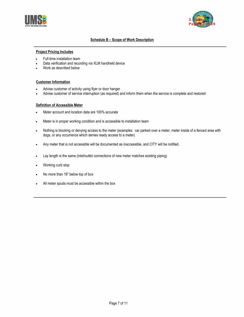
Page 7 of 11
Schedule B – Scope of Work Description
Project Pricing Includes
Full-time installation team Data verification and recording via XLM handheld device Work as described below
Customer Information
Advise customer of activity using flyer or door hanger Advise customer of service interruption (as required) and inform them when the service is complete and restored
Definition of Accessible Meter
Meter account and location data are 100% accurate
Meter is in proper working condition and is accessible to installation team
Nothing is blocking or denying access to the meter (examples: car parked over a meter, meter inside of a fenced area with dogs, or any occurrence which denies ready access to a meter)
Any meter that is not accessible will be documented as inaccessible, and CITY will be notified.
Lay length is the same (inlet/outlet connections of new meter matches existing piping)
Working curb stop
No more than 18” below top of box
All meter spuds must be accessible within the box
3. c. 1. Page 11 of 28

Page 8 of 11
Schedule B – Scope of Work Description
Water Meter Retrofit Scope Verify address.
Advise customer of work crew presence.
Remove meter box lid along with any dirt and debris from the inside of the meter box.
Verify meter number on meter and service order on hand to ensure that they match.
Notify CITY of need to replace broken meter boxes (or lids) if required.
Install new AMR device
Confirm there are no leaks in the meter box and that the meter is operating correctly.
Ensure that customer is aware that work is completed.
Replace box lid, remove any debris, rake around the meter box, and leave customer's yard as it was found.
Input the following data into XLM hand-held device and/or CITY work order:
- meter reading
- new radio transmitter identification number (obtained via barcode scanners on the handhelds)
- Addition work required (new lid, etc.)
Water Meter Exchange Scope Verify address.
Advise customer of work crew presence.
Inform customer that their water supply will be shut off for the change out.
Remove meter box lid along with any dirt and debris from the inside of the meter box.
Verify meter number on meter and service order on hand to ensure that they match.
Notify CITY of need to replace broken meter boxes (or lids) if required.
Shut off water supply to the meter.
Remove the meter and protect the entrance/exit piping from contamination. Plugs or caps from new meter shall be installed on meter that was removed.
Discard old meter gaskets and install new meter and gaskets.
After new meter and AMR device are installed, open water supply very slowly to avoid any surge or water hammer that might cause damage.
Open the customers hose bib to flush the line.
Confirm there are no leaks in the meter box and that the meter is operating correctly.
Close customer’s hose bib.
Ensure that customer is aware that work is completed and service is restored.
Replace box lid, remove any debris, rake around the meter box, and leave customer's yard as it was found.
Input the following data into XLM hand-held device and/or CITY work order:
- old meter serial number
- old meter final reading
- new meter serial number
- new meter reading
- new radio transmitter identification number
- Additional work required (new lid, etc.)
Line breaks or leaks that occur due to the installation within the meter box will be repaired at XLM’s expense.
3. c. 1. Page 12 of 28

Page 9 of 11
Schedule B – Scope of Work Description
Data Capture & Exchange Scope:
Data listed above will be captured electronically and downloaded to a flat file using the layout file previously provided by CITY. All required data fields must be populated in the file. CITY will be responsible for: 1) procuring the necessary data interface program from its utility billing system provider, and 2) uploading data into its utility billing system.
Items Not Covered in Scope:
Leaks on CITY or customer side prior to exchanging meter.
Inaccessible meters as described above, and:
Meters that cannot be located Meter buried in concrete or asphalt Meter in vault or inside locked facility Meter spuds / riser fittings in concrete, asphalt or state
of disrepair Obstruction of meter (roots, vegetation, fences, etc.) Prevention of service (animals, customer, etc.) Different lay-lengths.
Required Assistance from CITY:
Advise customers within work area using combination of mailers and/or door hangers Accurate meter account data from billing system (including locations) Correction of items turned over during installation Dedicated CITY point of contact
Scope Exemptions/Exceptions: Pricing is based upon work during normal working hours (8AM -5PM), including scheduled weekends.
Any work exceeding that which is based upon normal working hours such as specified below will only be paid based on an approved change order executed prior to the work being undertaken.
1. Work exceeding 8 hours per day or on non-scheduled weekends or holidays will be billed at 1½ times the unit price.
2. Additional piping work, excessive excavation, concrete removal, tree and shrub removal, etc., will be billed at repair unit price of $90/hour.
3. Material purchased by XLM will be billed at Cost plus 15%.
City of Wildwood (“CITY”) Xtralight Manufacturing Ltd. DBA Utility Metering Solutions (“XLM”)
Signature: Signature:
Printed Name: Printed Name: Jerry H. Caroom
Title: Title: Chief Executive Officer
Date: Date:
3. c. 1. Page 13 of 28
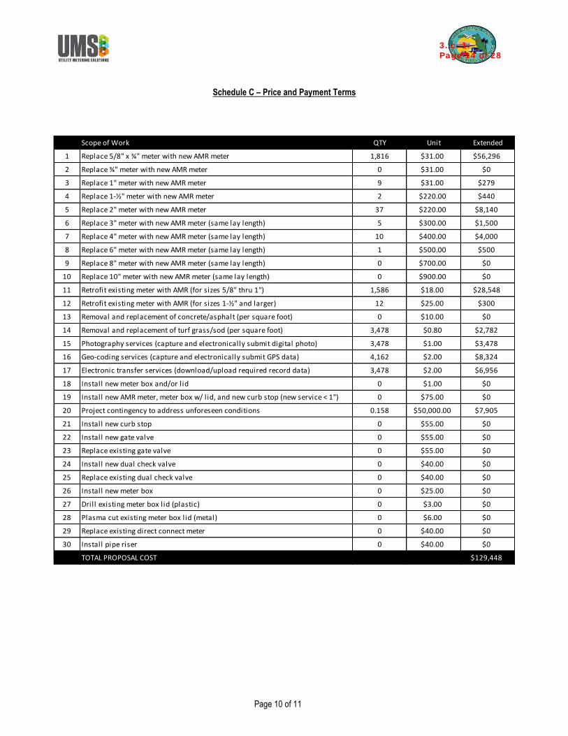
Page 10 of 11
Schedule C – Price and Payment Terms
Scope of Work QTY Unit Extended
1 Replace 5/8" x ¾" meter with new AMR meter 1,816 $31.00 $56,296
2 Replace ¾" meter with new AMR meter 0 $31.00 $0
3 Replace 1" meter with new AMR meter 9 $31.00 $279
4 Replace 1-½" meter with new AMR meter 2 $220.00 $440
5 Replace 2" meter with new AMR meter 37 $220.00 $8,140
6 Replace 3" meter with new AMR meter (same lay length) 5 $300.00 $1,500
7 Replace 4" meter with new AMR meter (same lay length) 10 $400.00 $4,000
8 Replace 6" meter with new AMR meter (same lay length) 1 $500.00 $500
9 Replace 8" meter with new AMR meter (same lay length) 0 $700.00 $0
10 Replace 10" meter with new AMR meter (same lay length) 0 $900.00 $0
11 Retrofit existing meter with AMR (for sizes 5/8" thru 1") 1,586 $18.00 $28,548
12 Retrofit existing meter with AMR (for sizes 1-½" and larger) 12 $25.00 $300
13 Removal and replacement of concrete/asphalt (per square foot) 0 $10.00 $0
14 Removal and replacement of turf grass/sod (per square foot) 3,478 $0.80 $2,782
15 Photography services (capture and electronically submit digital photo) 3,478 $1.00 $3,478
16 Geo-coding services (capture and electronically submit GPS data) 4,162 $2.00 $8,324
17 Electronic transfer services (download/upload required record data) 3,478 $2.00 $6,956
18 Install new meter box and/or l id 0 $1.00 $0
19 Install new AMR meter, meter box w/ l id, and new curb stop (new service < 1") 0 $75.00 $0
20 Project contingency to address unforeseen conditions 0.158 $50,000.00 $7,905
21 Install new curb stop 0 $55.00 $0
22 Install new gate valve 0 $55.00 $0
23 Replace existing gate valve 0 $55.00 $0
24 Install new dual check valve 0 $40.00 $0
25 Replace existing dual check valve 0 $40.00 $0
26 Install new meter box 0 $25.00 $0
27 Drill existing meter box lid (plastic) 0 $3.00 $0
28 Plasma cut existing meter box lid (metal) 0 $6.00 $0
29 Replace existing direct connect meter 0 $40.00 $0
30 Install pipe riser 0 $40.00 $0
TOTAL PROPOSAL COST $129,448
3. c. 1. Page 14 of 28

Page 11 of 11
Schedule C – Price and Payment Terms
Payment Invoicing Prior to commencing work, XLM will submit a “Mobilization Invoice” to CITY in the amount of 10% of the contract price. Thereafter, XLM will submit monthly invoices to CITY at the unit prices contained herein and with quantities based upon actual work performed. Invoices will be due and payable within thirty (30) days. Final payment shall be made to XLM upon successful completion of a final walkthrough and the resolution of any punchlist items as noted by the CITY. Payments may be withheld on account of any breach of this Agreement by XLM and claims by any involved third parties (including suppliers), but only to the extent that written notice has been provided to XLM and XLM has failed, within fifteen (15) days of the date of receipt of such notice, to provide adequate security to protect CITY from any loss, cost, or expense related to such claims. Other Public Entities CITY and XLM understand and acknowledge that the terms, conditions, and pricing reflected in this contract may be enjoyed by any other state agency or subdivision, including the executive departments, the Legislature, the judicial branch, and independent establishments of the state; counties and municipalities; and corporations primarily acting as instrumentalities or agencies of the state, counties, or municipalities (hereinafter collectively referred to as "governmental agency"), upon mutual agreement of that governmental agency and XLM. To the extent it is consistent with the applicable statutes and laws as well as its bylaws and procedures, a governmental agency wishing to utilize the terms, conditions, and pricing reflected in this contract, may utilize the selection process employed by CITY as an additional justification for its actions. Provided, however, that any governmental agency electing to utilize the terms, conditions, and pricing reflected in this contract shall deal directly with XLM in all respects, and CITY will in no way be involved in or assume any liability as a result of any utilization of this contract, in whole or in part, by another governmental entity. Moreover, each governmental agency shall be responsible for its own purchases and shall assume total responsibility and liability for its own project, independent of CITY, and at its own discretion. In no event shall CITY be held liable for any costs or damages incurred by another governmental agency as a result of any future utilization of the terms, conditions, and/or pricing reflected herein by another governmental agency.
City of Wildwood (“CITY”) Xtralight Manufacturing Ltd. DBA Utility Metering Solutions (“XLM”)
Signature: Signature:
Printed Name: Printed Name: Jerry H. Caroom
Title: Title: Chief Executive Officer
Date: Date:
3. c. 1. Page 15 of 28

3. c. 1. Page 16 of 28
City of Wildwood - Expedited Completion of Neptune R900i Automatic Metering Initiative
Scope of Work QTY Unit Extended Unit Extended TOTAL
1 Replace 5/8" x ¾" meter with new AMR meter 1,816 $189.50 $344,132 $31.00 $56,296 $400,428
2 Replace 1" meter with new AMR meter 9 $262.86 $2,366 $31.00 $279 $2,645
3 Replace 1-½" meter with new AMR meter 2 $394.99 $790 $220.00 $440 $1,230
4 Replace 2" meter with new AMR meter 37 $494.04 $18,279 $220.00 $8,140 $26,419
5 Replace 3" meter with new AMR meter (same lay length) 5 $1,746.65 $8,733 $300.00 $1,500 $10,233
6 Replace 4" meter with new AMR meter (same lay length) 10 $2,160.00 $21,600 $400.00 $4,000 $25,600
7 Replace 6" meter with new AMR meter (same lay length) 1 $3,345.00 $3,345 $500.00 $500 $3,845
8 Retrofit existing meter with AMR (for sizes 5/8" thru 1") 1,586 $165.00 $261,690 $18.00 $28,548 $290,238
9 Retrofit existing meter with AMR (for sizes 1-½" and larger) 12 $330.00 $3,960 $25.00 $300 $4,260
10 Removal and replacement of turf grass/sod (per square foot) 3,478 $0.00 $0 $0.80 $2,782 $2,782
11 Photography services (capture and electronically submit digital photo) 3,478 $0.00 $0 $1.00 $3,478 $3,478
12 Geo-coding services (capture and electronically submit GPS data) 4,162 $0.00 $0 $2.00 $8,324 $8,324
13 Electronic transfer services (download/upload required record data) 3,478 $0.00 $0 $2.00 $6,956 $6,956
14 Project contingency to address unforeseen conditions 0.158 $0.00 $0 $50,000.00 $7,905 $7,905
15 MRX920 Version II Mobile Data Collector (With Laptop) 1 $12,950.00 $12,950 $0.00 $0 $12,950
16 MRX920 On-Site Training 1 $2,000.00 $2,000 $0.00 $0 $2,000
17 MRX920 GIS Mapping Software Module 1 $4,000.00 $4,000 $0.00 $0 $4,000
18 Software Interface with ADG (price to be confirmed by City) 1 $4,000.00 $4,000 $0.00 $0 $4,000
TOTAL PROPOSAL COST $687,845 $129,448 $817,293
Sunstate Meter UMS
UMS Confidential 7/30/2012
3. c. 1. Page 17 of 28

City of Wildwood - Expedited Completion of Neptune R900i Automatic Metering Initiative
City's Annual W&S Revenue = $4,735,789 O&M Savings ($) = $25,000 Project Cost = $817,293
Improved Meter Accuracy (%) = 2.0% O&M Savings Term = 10 years Amortization Term = 10 years
Billable Usage Increase ($) = $94,716 M&R Funds = $10,000 Interest Rate = 2.475%
Annual Escalation = 1.0% M&R Funding Term = 10 years Ongoing Service = $0
A B C D = A + B + C E F G = E + F H = D - G
Year Billable Usage O&M M&R Total P&I Ongoing Total Annual Cumulative
Increase Savings Funds Benefit Payment Service Cost Difference Difference
1 $94,716 $25,000 $10,000 $129,716 $93,262 $0 $93,262 $36,453 $36,453
2 $95,663 $25,250 $10,000 $130,913 $93,262 $0 $93,262 $37,651 $74,104
3 $96,620 $25,503 $10,000 $132,122 $93,262 $0 $93,262 $38,860 $112,964
4 $97,586 $25,758 $10,000 $133,343 $93,262 $0 $93,262 $40,081 $153,045
5 $98,562 $26,015 $10,000 $134,577 $93,262 $0 $93,262 $41,314 $194,359
6 $99,547 $26,275 $10,000 $135,822 $93,262 $0 $93,262 $42,560 $236,919
7 $100,543 $26,538 $10,000 $137,081 $93,262 $0 $93,262 $43,818 $280,738
8 $101,548 $26,803 $10,000 $138,352 $93,262 $0 $93,262 $45,089 $325,827
9 $102,564 $27,071 $10,000 $139,635 $93,262 $0 $93,262 $46,373 $372,200
10 $103,589 $27,342 $10,000 $140,931 $93,262 $0 $93,262 $47,669 $419,869
Total $990,937 $261,555 $100,000 $1,352,492 $932,623 $0 $932,623 $419,869
Column
A
B
C
E
F
Financial Component Brief Description of Financial Component
Billable Usage Increase Installing more accurate meters will increase billable usage and reduce % of unaccounted water
O&M Savings Installing AMR technology will reduce meter reading cost and improve customer service
Maintenance and Repair (M&R) Funds Current funding level for City's annual meter replacement and/or in-house AMR conversion
P&I Payment Annual principal and interest (P&I) obligation based upon term and rate shown at top of page
Ongoing Service Annual cost to calibrate large C&I meters, manage leak detection program, other service, etc.
UMS Confidential 7/17/2012
3. c. 1. Page 18 of 28
City of Wildwood - Meter Accuracy Test Results
Meter Information 15.00% 70.00% 15.00% Weighted
Low Medium High Average
1 Rockwell - 37758464 36.64% 98.19% 98.24% 88.97%
2 Precision - S330386 78.98% 102.92% 101.41% 99.10%
3 Badger - 96135451 69.17% 101.11% 99.80% 96.12%
4 Hays - 17788603 0.00% 0.00% 0.00% 0.00%
5 Precision - J031494 97.03% 103.19% 102.29% 102.13%
56.36% 81.08% 80.35% 77.26%
Meter Accuracy at Various Flows
Page 1 of 1
3. c. 1. Page 19 of 28

3. c. 1. Page 20 of 28

3. c. 1. Page 21 of 28

3. c. 1. Page 22 of 28

3. c. 1. Page 23 of 28

3. c. 1. Page 24 of 28

June 29, 2012
Mr. Bruce Phillips
Director of Utilities
City of Wildwood
Dear Mr. Phillips,
Please note that Sunstate Meter and Supply is the sole Authorized Neptune
Distributor for sales, service and warranty of Neptune water products and
AMR systems for the State of Florida.
The geographical are of responsibility assigned to them includes all Counties
within the State of Florida.
Type: Classes of customers exclusively assigned are: Municipalities, private
water companies, contractors, and plumbers.
Hence, our distributor is required to maintain sufficient inventory of Neptune
products to provide customer field servicing. Sunstate Meter and Supply has
sold and supported Neptune products for many years in the Florida Market
and they provide a high level of sales and service to the customer. Therefore,
we encourage Utilities in the State of Florida to purchase Neptune products
through Sunstate Meter and Supply, Inc.
Please feel free to contact me if you have any questions or concerns. I can be
reached at 407-493-5385.
Regards,
Terry Gullett
Terry Gullett
Territory Manager
Neptune Technology Group Inc.
3. c. 1. Page 25 of 28

June 29, 2012
Bruce Phillips Director of Utilities City of Wildwood 100 North Main Street Wildwood, Fl. 34785
Subject: Neptune Meter Reading System Dear Mr. Phillips: The purpose of this letter is to inform you of the proprietary nature of Neptune’s meter reading products. The R900 transmits in the 910-920 unlicensed frequency band via a proprietary protocol. This protocol is unique to Neptune and can only be interpreted and read by the receiver technology utilized in the CE5320 handheld, MRX920 mobile data collector, and R900 GPRS Gateway. Only products purchased from Neptune are compatible with the R900s deployed throughout your system. Maintaining proprietary communications between the R900 and our data collection devices allows us to (1) ensure that the system performs to your expectations, (2) ensure that your utility can utilize new features rolled out in our software which are hardware dependent, and (3) ensure that we can provide your utility with prompt and knowledgeable customer support. I hope that this answers all of your questions. I want to thank you for being a valued Neptune customer. If you have any additional questions then please do not hesitate to let me know. Sincerely,
Brandon Segrest Brandon Segrest Product Marketing Manager – Systems Hardware
CC: Terry Gullett CC: Jeff Kimbrough
3. c. 1. Page 26 of 28

Updated: 6/29/2012 – Approx. investment to date $335,000.00 Meter Count for City of Wildwood – Neptune Meter 5/8 x ¾ Neptune T10 Meter
734 – Neptune Direct Read Meters
742 – Neptune Proread Meters
646 – Neptune R900i Radio Read
1” Neptune T10 Meter
1 – Neptune Direct Read
68 – Neptune Proread
12 – Neptune R900i Radio Read
1 ½” Neptune T10 Meter
13 – Neptune Proread
4 – Neptune R900i Radio Read
2” Neptune T10 Meter
3 – Neptune Direct Read
25 – Neptune Proread
11 – Neptune R900i Radio Read
2” Neptune Tru Flo Compound Meter
4 – Neptune R900i Radio Read
3” Neptune HP Turbine Meter
1 – Neptune Direct Read
3” Neptune Tru Flo Compound Meter
1 – Neptune Direct Read
2 – Neptune Proread
5 – Neptune R900i Radio Read
4” Neptune Tru Flo Compound Meter
2 – Neptune Direct Read
2- Neptune Proread
3 – Neptune R900i Radio Read
6” Meter – 2 total in system
10”x2” Fire Service Compound – (2) Direct Read Neptune in System
3. c. 1. Page 27 of 28

3. c. 1. Page 28 of 28
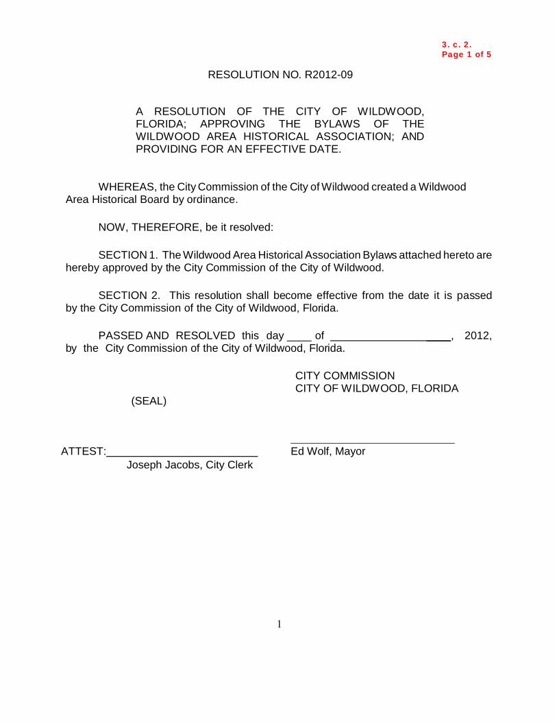
RESOLUTION NO. R2012-09
A RESOLUTION OF THE CITY OF WILDWOOD, FLORIDA; APPROVING THE BYLAWS OF THE WILDWOOD AREA HISTORICAL ASSOCIATION; AND PROVIDING FOR AN EFFECTIVE DATE.
WHEREAS, the City Commission of the City of Wildwood created a Wildwood Area Historical Board by ordinance.
NOW, THEREFORE, be it resolved:
SECTION 1. The Wildwood Area Historical Association Bylaws attached hereto are
hereby approved by the City Commission of the City of Wildwood.
SECTION 2. This resolution shall become effective from the date it is passed
by the City Commission of the City of Wildwood, Florida.
PASSED AND RESOLVED this day ____ of ____, 2012, by the City Commission of the City of Wildwood, Florida.
(SEAL)
CITY COMMISSION CITY OF WILDWOOD, FLORIDA
ATTEST: Ed Wolf, Mayor
Joseph Jacobs, City Clerk
1
3. c. 2. Page 1 of 5

BYLAWS
ARTICLE I - NAME
The name of this organization shall be The Wildwood Area Historical Association. The
organization will be referred to as WHA.
ARTICLE II - PURPOSE
Its object shall be the promotion of historical studies through the encouragement of research,
teaching, and publication; the collection and preservation of historical documents and artifacts;
the dissemination of historical records and information; the broadening of historical knowledge
among the general public; and the pursuit of kindred activities in the interest of history of the
Wildwood, Florida area.
ARTICLE III - MEMBERSHIP
Membership in the WHA shall be open to any person interested in history of the Wildwood area
on the payment of one year's dues. Any member whose dues are in arrears shall be dropped from
the roll. Members who have been so dropped may be reinstated at any time by the payment in
advance of one year's dues. The Wildwood Area Historical Board may elect honorary members
of the WHA, and such honorary members shall be exempt from payment of dues. Nonmembers
may participate in program sessions of the WHA but may not be members of standing
committees of the WHA. All members may participate in all activities of the WHA without
regard to race, sex, national origin, or religion.
ARTICLE IV - LEGAL STATUS
The WHA shall be a group of volunteers acting under the direction of the City of Wildwood
Historical Board. It is organized exclusively for educational purposes, and any net earnings shall
not inure to the benefit of its members, officers, or any other private persons but shall be the
possession of the City of Wildwood, Florida. Any funds collected by the WHA shall be
maintained in a separate account by the City of Wildwood solely for use to promote the specific
purposes of the WHA. Unless specifically designated otherwise, all funds collected by the WHA
shall be used to further the goal of historic preservation. Funds may be designated for use for a
single purpose or project. Any funds so designated shall be used for that purpose only and such
funds shall be included and maintained as a subcategory in the WHA account.
ARTICLE V - MEETINGS
The WHA shall hold regular meetings. The Wildwood Area Historical Board may call special
meetings, or cancel any meeting, if extraordinary circumstances warrant.
3. c. 2. Page 2 of 5

ARTICLE VI - OFFICERS
Section 1. The Wildwood Area Historical Board shall serve as the board for the WHA. The
members of the board shall annually elect a president, vice president, secretary, and treasurer
from among the board members and may create and fill other offices, as the board deems
necessary. In the event the president is not available to attend a meeting, the vice president shall
perform his duties.
Section 2. Should the office of President for any reason become vacant, the Vice-President shall
succeed forthwith to the office of President and shall serve until the end of the term for which he
or she was originally designated to be President.
ARTICLE VII - Wildwood Area Historical Board
Section 1. The Wildwood Area Historical Board shall have seven members appointed by the City
of Wildwood Commission. Each member of the Wildwood Area Historical Board shall serve a
three-year term. A member may serve more than one term including consecutive terms.
Section 2. A majority (4) of the Wildwood Area Historical Board shall constitute a quorum of
that body. Board meetings shall follow procedures mandated by these bylaws, and otherwise
normally adhere to Roberts Rules of Order.
Section 3. The Wildwood Area Historical Board shall have general charge of the affairs of the
WHA.
Section 5. The Wildwood Area Historical Board shall decide upon the time and place of an
annual meeting of the WHA and shall set other meetings of the WHA as it deems appropriate.
Section 6. The Wildwood Area Historical Board shall determine all classes of dues and shall
report changes in such at an annual meeting.
Section 7. The Wildwood Area Historical Board may conduct other business that is consistent
with these bylaws.
ARTICLE VIII - AMENDMENTS
The Wildwood Area Historical Board, may propose amendments to these bylaws. The Wildwood
Area Historical Board must submit such proposed amendments to the City Commission for
approval.
3. c. 2. Page 3 of 5

ARTICLE IX- MEETINGS
Section 1. The Secretary shall make all arrangements for an annual meeting and any other
meetings deemed necessary. The Secretary shall provide the City of Wildwood Clerk’s office
with notice of any such meeting. The Secretary must submit his or her recommendations to The
Wildwood Area Historical Board.
Section 2. Memberships and reinstatements may be accepted at any meeting of the WHA or
Wildwood Area Historical Board.
ARTICLE X - DUTIES OF OFFICERS
Section 1. The President shall preside at the official meetings of the WHA and The Wildwood
Area Historical Board and shall appoint committees and perform all other duties specified by
these bylaws.
Section 2. The Vice-President shall serve in the absence of the President.
Section 3. The Secretary shall take minutes of meetings of the Board, submit all records to be
maintained by the City of Wildwood Clerk’s office, inform persons of their appointment to
committees and advise them of their duties, send minutes of meetings to members concerned,
publish transactions that merit the attention of members, make arrangements for meetings of the
WHA, and develop and put into effect any programs suggested by The Wildwood Area
Historical Board. The Secretary, in an annual report, shall include information on all elections,
and on actions taken by The Wildwood Area Historical Board. The Secretary shall also be
responsible for keeping track of all items loaned or donated.
Section 4. The Treasurer shall handle collection of all dues and donations and keep records of
each, keep records of what sub-accounts monies shall be deposited to, turn in money to the City
Clerk for deposit, and give financial reports at each Board meeting and the Annual meeting and
whatever else is necessary with the financial records.
ARTICLE XI- COMMITTEES
Section 1. Each WHA Committee shall be made up of volunteers from the members of the
WHA. The Wildwood Area Historical Board shall appoint the chairperson of all WHA
committees. Only members of the WHA in good standing may serve on any permanent or
recurring committee. The Wildwood Area Historical Board shall invite the chairs of all WHA
committees to attend the meetings of The Wildwood Area Historical Board and to present to it
written reports summarizing the activities of their committees. The committee chairs are to file
such reports with the Secretary, for deposit in the WHA archives through the City of Wildwood
Clerk’s office.
Section 2. The Wildwood Area Historical Board may, by an ordinary motion, recommend the
establishment of temporary or ad hoc committees representing the WHA.
3. c. 2. Page 4 of 5

Section 3. The WHA shall have the following permanent committees:
a. The Membership Committee.
This committee has the duty of recruiting new members and encouraging former
members to rejoin the WHA.
b. Annual Wildwood Christmas Parade
Responsible for the planning and implementation of the Annual Wildwood
Christmas Parade
c. Town Plat/Layout
Responsible for the recording of the original City layout and buildings
d. Books, Famous People, Written history, Cemeteries, Genealogy, Religious History
Collecting the thoughts, stories, and the personal histories of the people who made
up the Wildwood Area.
e. Baker House
Responsible for the preservation of the Baker Family Home.
f. Railroad History
Responsible for the research and writing the history of the Railroad in the
Wildwood Area.
g. Collections/photos
Responsible for the cataloging of the City of Wildwood’s Historical Collection,
including old photos and negatives.
h. Police, Fire and City Government History
Responsible for the research and recording the history of the Police and Fire
Departments. This also includes the history of the City Officials, from
Commissioners, Mayors and other City employees who had an impact on the
Wildwood Area.
i. Publicity
Responsible for promoting activities of the WHA.
ARTICLE X—MEMBERSHIP YEAR.
Section 1. Each person who pays dues to become a member of the Wildwood Historical
Association shall be a member in good standing for the membership year in which dues are paid.
Section 2. The membership year shall extend from October 1 of each year to September 30 of
the following year.
ARTICLE XI—FISCAL YEAR.
Section 1. The fiscal year for the Wildwood Historical Association shall be from October 1 of
each year to September 30 of the following year.
Section 2. On or before May 1 of each year, the Treasurer shall present the City Manager with a
proposed budget for the next fiscal year.
3. c. 2. Page 5 of 5

RESOLUTION NO. R20012-10
A RESOLUTION OF THE CITY COMMISSION OF THE CITY OF WILDWOOD, FLORIDA AUTHORIZING THE MAYOR AND CITY CLERK TO EXECUTE A MEMORANDUM OF AGREEMENT BETWEEN THE CITY OF WILDWOOD AND THE FLORIDA DEPARTMENT OF TRANSPORTATION FOR THE MAINTENANCE OF STATE ROAD RIGHTS-OF-WAY BY THE CITY; SETTING FORTH AN EFFECTIVE DATE
WHEREAS, the City of Wildwood has an interest in the maintenance of roadway, roadside areas, and median strips, on that part of the State Highway System within the limits of the City of Wildwood, or adjacent to; and WHEREAS, the City of Wildwood recognizes the need for entering into an agreement with the Florida Department of Transportation which establishes the responsibilities of each party; NOW, THEREFORE, BE IT RESOLVED:
1. That the Mayor and City Clerk of the City of Wildwood are hereby authorized to execute that “Memorandum of Agreement – Highway Maintenance” between the CITY and the FLORIDA DEPARTMENT OF TRANSPORTATION, and mutually agreed upon renewals or extensions, a copy of which is attached hereto and incorporated herein by reference.
2. That this Resolution shall take effect immediately upon its adoption.
DONE AND RESOLVED, this __13th__ day of August , 2012, in regular session, by the City Commission of the City of Wildwood, Florida.
CITY COMMISSION CITY OF WILDWOOD, FLORIDA S E A L Ed Wolf, Mayor ATTEST: Joseph Jacobs, City Clerk H:\Clerk, Finance Department\Resolutions\RESOLUTIONS 2\R2009\R2009-16.MOU-FDOT-RdMaint..doc
3. c. 3. Page 1 of 5

STATE OF FLORIDA DEPARTMENT OF TRANSPORTATION
CONTRACT RENEWAL 375-020-23
CONTRACTS ADMINISTRATION OGC - 04/06
Contract No.: APM80 Renewal: (1st, 2nd, etc.) 1st
Financial Project No(s): 427194-1-78-01
County(ies): City of Wildwood
This Agreement made and entered into this day of , by and between the State of (This date to be entered by DOT only.)
Florida Department of Transportation, hereinafter called "Department", and
hereinafter called "Contractor".
City of Wildwood
WITNESSETH:
WHEREAS, the Department and the Contractor heretofore on this 10th
day of September 2009
(This date to be entered by DOT only)
entered into an Agreement whereby the Department retained the Contractor to perform Routine Maintenance,
; and
WHEREAS, said Agreement has a renewal option which provides for a renewal if mutually agreed to by both parties and subject to the same terms and conditions of the original Agreement;
NOW, THEREFORE, this Agreement witnesseth that for and in consideration of the mutual benefits to flow each
to the other, the parties agree to a renewal of said original Agreement for a period beginning the 1st day of October ,2012 and ending the 30th day of September, 2015 at a cost of $ 15,372.00
All terms and conditions of said original Agreement shall remain in force and effect for this renewal.
IN WITNESS WHEREOF, the parties have executed this Agreement by their duly authorized officers on the day,
month, and year set forth above. City of Wildwood
Name of Contractor
Contractor Name and Title
STATE OF FLORIDA DEPARTMENT OF TRANSPORTATION BY:
District Secretary or Designee (Signature)
BY: Authorized Signature
Name of Surety
City State
By:
(SEAL)
Title:
Legal:
Fiscal:
Approval as to Availability of Funds
Florida Licensed Insurance Agent or Attorney-In-Fact (Signature)
Date
Countersigned:
Florida Licensed Insurance Agent Date
3. c. 3. Page 2 of 5

STATE OF FLORIDA DEPARTMENT OF TRANSPORTATION
E-VERIFY 375-040-68
PROCUREMENT 06/11
Contract No: Financial Project No(s): Project Description: Vendor/Consultant acknowledges and agrees to the following: Vendor/Consultant : 1. shall utilize the U.S. Department of Homeland Security’s E-Verify system to
verify the employment eligibility of all new employees hired by the Vendor/Consultant during the term of the contract; and
2. shall expressly require any subcontractors performing work or providing services pursuant to the state contract to likewise utilize the U.S. Department of Homeland Security’s E-Verify system to verify the employment eligibility of all new employees hired by the subcontractor during the contract term.
Company/Firm:
Authorized Signature: Title: Date:
3. c. 3. Page 3 of 5
plaw
Typewritten Text
plaw
Typewritten Text
APM80
plaw
Typewritten Text
427194-1-78-01
plaw
Typewritten Text
Highway Roadside & Median Strip Maintenance
plaw
Typewritten Text
The City of Wildwood Florida
plaw
Typewritten Text
Mayor
plaw
Typewritten Text
plaw
Typewritten Text
plaw
Typewritten Text
plaw
Typewritten Text
plaw
Typewritten Text
Ed Wolf
plaw
Typewritten Text

Rev. 05/2011
STATE OF FLORIDA SUBSTITUTE FORM W-9
Mail or fax to: Chief Financial Officer Department of Financial Services Bureau of Accounting, 200 East Gaines Street Tallahassee, FL 32399-0354 PHONE: (850) 413-5519 FAX: (850) 413-5550
PART 1: Vendor Information IRS Name (as shown on your income tax return) Business Name: Doing Business As (DBA) Primary Address (Address where Form 1099 should be mailed) Attention of
In Care of
Street Address
P.O. Box
City
State/Province Zip Code (+4 if known)
Country & Postal Code, if other than U.S. PART 2: Taxpayer Identification Number (TIN)
Enter your TIN here: (DO NOT USE DASHES)
Taxpayer Identification Type (check appropriate box): Federal Employer Identification Number (FEIN) OR Social Security Number (SSN)
PART 3: Business Designations (Select only one) If Business Designation with Asterisks (*) is selected, please answer question below:
S Corporation*
Governmental Entity
Individual
Nonresident Alien
Partnership*
Foreign Corporation or Entity
Sole Proprietor
Not for Profit
C Corporation
Trust or Estate
Non-corporate Rental Agent
Indian Tribal Government
Limited Liability Company (LLC):
Disregarded Entity C Corporation
S Corporation* Partnership*
* Is 80% or more of the pass-through entity owned by a government entity that is required to withhold under Section 3402(t)(1), a tax exempt entity or a foreign government? Yes or No
PART 4: Certification Statement
Under penalties of perjury, I certify that: 1. The number shown on this form is my correct taxpayer information (or I am waiting for a number to be issued to me) AND 2. I am subject to backup withholding
OR I am not subject to backup withholding because: a) I am exempt from backup withholding b) I have not been notified by the Internal Revenue Service (IRS) that I am subject to backup withholding as a result
of failure to report all interest or dividends, OR c) the IRS has notified me that I am no longer subject to backup withholding AND
3. I am a U.S. citizen or other U.S. person (including U.S. resident alien)
Certification Instructions: To certify the statement above, sign and complete your information below as preparer.
Preparer’s Name (Please Print)
Preparer’s Title (required for business entities – Please Print)
Signature Date
Email (if available) Telephone Number ( ) -
3. c. 3. Page 4 of 5

Rev. 05/2011
Florida Substitute Form W‐9 Instructions
The State of Florida must obtain your correct taxpayer information that will be used to determine whether you will receive a Form 1099 for payments made to you by an agency of the State of Florida. This taxpayer information is collected on the Florida Substitute Form W‐9, and includes a Taxpayer Identification Number (TIN), IRS Name, and other related information. Beginning January 1, 2013, the State will also use this form to determine if your payments from the State are subject to 3 Percent Federal Withholding. The information provided on this form must match the information on file with the Internal Revenue Service (IRS) for Federal income tax reporting and will be verified through the IRS TIN Matching Program. IRS regulations require the State of Florida to take backup withholding from future payments made to you if you fail to provide the information requested. All vendors doing business with the State of Florida must complete the Substitute Form W‐9. Due to specific requirements on Florida’s Substitute Form W‐9, an IRS Form W‐9 will not be accepted. Vendors located outside the United States that do not have a TIN issued by the U.S. Government should contact the Vendor Management Section at (850) 413‐5519. NOTE – This form can only be used if you do not have internet or e‐mail access. Other than this exception, all Substitute Form W‐9s should be filed electronically by visiting the Vendor Portal website at https://flvendor.myfloridacfo.com. Part 1: Vendor Information
1. IRS Name: This should be the name as it appears on your Federal income tax return, and may be either an individual name or a business name. Do not abbreviate names unless they are registered that way with the IRS.
2. Business Name: Doing Business As (DBA): List any “Doing Business As” names that will be doing business with the State of Florida. If you do not have DBAs, leave this field blank.
3. Primary Address: This is the address where Form 1099s and any other related correspondence should be mailed. Part 2: Taxpayer Identification Number (TIN) and Type
1. Enter Your TIN: Enter either your Social Security Number (individuals) or your Federal Employer Identification Number (FEIN). Do Not include dashes.
2. Taxpayer Identification Type: Select the appropriate box to indicate whether the TIN you have provided is your SSN or FEIN.
Part 3: Business Designations 1. Business Designation: Select the appropriate box. If you are unsure of which box to check, contact your income tax
preparer for assistance. Note: If you select a business designation with an asterick (*) next to it (partnerships and S‐corporations), you must complete the 80% ownership question at the bottom of Part 3.
Part 4: Certification Statement 1. Certification Statement: Select the appropriate box regarding backup withholding. You should check “I am subject to
backup withholding” only if you have been notified by the IRS that you are subject to backup withholding or you have been notified by the State of Florida that your TIN on file is incorrect and the State will perform backup withholding on future payments. Payers must generally withhold 28% of taxable interest, dividends and certain other payments to a payee that is subject to backup withholding. If you are unsure of your backup withholding status, contact your tax advisor for assistance.
2. Preparer’s Name: Fill in the preparer’s name, title, signature, email address (if available), date and phone number. The preparer should be an executive of the organization and someone who can answer questions that may arise relating to the Substitute Form W‐9.
Mail or fax the completed form to: Chief Financial Officer Florida Department of Financial Services Bureau of Accounting / Vendor Management Section 200 East Gaines Street Tallahassee, FL 32399‐0354 Phone: (850) 413‐5519 Fax: (850) 413‐5550
3. c. 3. Page 5 of 5

RESOLUTION NO. R2012-11
A RESOLUTION OF THE CITY OF WILDWOOD, FLORIDA RECOGNIZING CITY GOVERNMENT WEEK, OCTOBER 21-27,2012 AND ENCOURAGING ALL CITIZENS TO SUPPORT THE CELEBRATION AND CORRESPONDING ACTIVITIES.
WHEREAS, city government is the government closest to most citizens, and the one with the most direct daily impact upon its residents; and WHEREAS, city government is administered for and by its citizens, and is dependent upon public commitment to and understanding of its many responsibilities; and WHEREAS, city government officials and employees share the responsibility to pass along their understanding of public services and their benefits; and WHEREAS, Florida City Government Week is a very important time to recognize the important role played by city government in our lives; and WHEREAS, this week offers an important opportunity to spread the word to all the citizens of Florida that they can shape and influence this branch of government which is closest to the people; and WHEREAS, the Florida League of Cities and its member cities have joined together to teach students and other citizens about municipal government through a variety of different projects and information; and WHEREAS, Florida City Government Week offers an important opportunity to convey to all the citizens of Florida that they can shape and influence government through their civic involvement. NOW, THEREFORE BE IT RESOLVED BY THE CITY OF WILDWOOD AS FOLLOWS: Section 1. That the City of Wildwood does encourage all citizens, city government officials and employees to do everything possible to ensure that this week is recognized and celebrated accordingly. Section 2. That the City of Wildwood does encourage educational partnerships between city government and schools. Section 3. That the City of Wildwood does support and encourage all city governments to actively promote and sponsor "Florida City Government Week." DONE AND RESOLVED, this 13th day of August , 2012, in regular session, by the City Commission of the City of Wildwood, Florida. CITY COMMISSION CITY OF WILDWOOD, FLORIDA S E A L By: ATTEST: Ed Wolf, Mayor Joseph Jacobs, City Clerk
3. c. 4. Page 1 of 9
1
301 South Bronough Street, Suite 300 w Post Office Box 1757 w Tallahassee, FL 32302-1757 (850) 222-9684 w Fax (850) 222-3806 w Web site: www.flcities.com
TO: City Managers & City Clerks (Please share with your public information officer or
whomever coordinates this program for your city)
FROM: Sharon G. Berrian, Associate Director, Membership Development
DATE: July 31, 2012
RE: Celebrate Florida City Government Week (FCGW)-- October 21-27, 2012
(See the bottom of this memo if you would like FCGW buttons and/or bumper stickers.)
This year’s Florida City Government Week is October 21-27, 2012 and the Florida League of Cities wants to
encourage every city to take an active part in promoting their city through civic education and volunteerism. This is a great opportunity to speak to schools and civic groups, host an open house at city hall, or reach out to civic clubs and community organizations to explain city structure and function or helping others learn by serving charitable organizations in your community. Florida City Government Week is part of an ongoing effort sponsored by the Florida League of Cities (FLC) to raise public awareness about the services that cities perform and to educate the public on how city government works. Cities are encouraged to involve their local schools, businesses, media and civic clubs in planning City Government Week activities. Cities provide a higher level of service than most governments, and generally receive a higher approval rate than any other level of government, and yet, many residents are unaware of how city services impact their lives. Through Florida City Government Week, the League hopes to heighten the public’s awareness of city government’s role in enhancing the quality of life in communities. This packet includes several ideas for celebrating the week. Because we recognize the tough state of the economy, most of these ideas are no to low cost to the city. We have also enclosed Media and PR Tips, a sample press release, a sample letter-to-the-editor, a sample resolution and evaluation form for your use.
PLEASE ALSO NOTE THAT WE HAVE A SMALL AMOUNT OF BUTTONS AND BUMPER STICKERS AVAILABLE FOR YOUR USE. THESE ITEMS WILL BE MADE AVAILABLE UPON REQUEST, UNTIL OUR LIMITED SUPPLY IS EXAUSTED.
Please email your requests for buttons and bumper stickers and send your adopted FCGW resolution to Gail Dennard at the League ([email protected]). Thank you.
3. c. 4. Page 2 of 9

2
CITIES CELEBRATE FLORIDA CITY GOVERNMENT WEEK
Here are some low cost ways to celebrate the week, some of which can be ongoing activities:
· Set up exhibits at local shopping malls or other public places with information on your city government and its services.
· Sponsor a heritage day focusing on the history of the city and its government. This could be coordinated with a local historic group and include community workshops/speakers on selected historical city government events, buildings, parks, facilities and people.
· Involve businesses, sorority and fraternal organizations. Offer to send a speaker to their meetings to discuss current city issues or volunteer your time! Enlist their help in celebrating Florida City Government Week.
· Contact your local library; advise them of the week's activities. Ask if you can make available at their information desk details on celebrating Florida City Government Week.
· Work with senior citizens groups to find innovative ways to involve seniors in city government. Encourage seniors to volunteer their time with the city.
· Send speakers to senior citizen-related activities/events to tell them about the special week.
· Sponsor an essay contest for city residents. Instead of using cash as a prize, the winner’s prize could be acting as “Mayor/City Commissioner for a day” or “City Manager for a day” or “Volunteer your time to a special cause on their behalf.”
· Sponsor a poster contest for area children related to a particular city government issue, e.g., recycling, water conservation, fire or police services, recreation and parks, transportation, planning, etc. This idea could also focus on careers in city government. Or, host a competition to seek the best solution to a city government problem. Instead of a monetary award, winners could receive a certificate, an article in your local paper and recognition of students and teachers at city council meetings.
· Offer tours of city hall and other city facilities. Stagger tours to allow for small group interaction with city staff or city volunteers. For school groups, limit the focus of the tour to one aspect of city government, work with teachers to prepare students in advance and plan follow-up activities.
· Coordinate ongoing or new partnership programs with schools to stage something special during the week--student "mock" city council meetings (election of a Junior “student-based” city council) or "mock" code enforcement hearings, shadowing of city officials and staff, guest speakers from city government addressing school groups, city government career day, recognition of students and teachers at a city council meeting, volunteer or beautification projects at city sites, dedication of (or special events staged at) recreational facilities shared by cities and schools, recycling or environmental-related student activities, etc.
· Get acquainted with local school personnel and encourage opportunities for integrating city government into the school curriculum (the League has lesson plans on its website-see the link below). Another idea— key city government terms and definitions could be supplied for use in English classes (many can be found in the teacher handbook; math classes could address the city budget or could be exposed to the computer technology used in all aspects of city government today; and, of course, there could be more
3. c. 4. Page 3 of 9

3
integration of the local government curriculum into all the social studies classes (government, civics, history, geography, economics).
· Share the League's model booklet with teachers—“My City: I’m Part of It, I’m Proud of it”, containing lessons and activities about city government. Share it with your local schools. (Also available on the Internet, http://www.floridaleagueofcities.com
· Use the League’s ABC booklet, an educational supplement for elementary teachers, grades 2-5. Share it with your local schools. (Also available on the League’s website)
· It’s easy to develop a teachers' packet from your city that could be placed on your website, instead of incurring costly printing and mailing costs. Here are some ideas: offer a list of available speakers from city government; a list of resource materials available on city government; information on any special educational programs or services provided by your city (such as internships, mentor programs, volunteer opportunities etc.); and a "fact sheet" on the city government. This material could also include the city budget, organizational chart, copies of council meeting agendas, etc.
· Encourage schools to study the significance of your city’s name, history, flag and/or logo design.
· Create an "adopt-a-school" program. Various departments of city government could "adopt" a school, or department within the school, to share information and plan speaking engagements to students that would enhance learning about a particular aspect of city government.
· Encourage a school City Government Club or Youth Council to study community issues that involve municipal services, volunteer opportunities and citizen participation in decision-making. Visit the League’s Resource page on the Website for ideas on developing a Youth Council.
· Working in coordination with a middle or high school, create an advisory committee of students to study a particular city government issue of importance to teenagers (for example, recreation or volunteerism) and prepare a formal report with recommendations to council. Or, include student representation on an existing citizen committee, commission or board studying an issue of consequence to teens. Make a formal announcement of these appointments during Florida City Government Week.
3. c. 4. Page 4 of 9

4
FLORIDA CITY GOVERNMENT WEEK
There are several steps that can be taken to promote and publicize your city’s project. A list of suggestions follows:
Get the local media involved from the beginning!
Be sure to designate a contact person for your project who can be reached by the media during city hours and after.
Write a guest editorial that talks about Florida City Government Week and the
importance of cities, and submit it to your newspaper(s) opinion page editor for use during Florida City Government Week. (Check with your newspaper on deadlines.)
Schedule an editorial board meeting with your local newspaper(s) to formally discuss your
city and the city’s involvement with Florida City Government Week. (Note: This meeting should occur at least one or two weeks prior to Florida City Government Week.)
Notify the education reporter or one that covers city activities for your local newspaper.
Invite the reporter to sit in on or be a part of any meetings you have with the school. Keep reporters informed of your activities. Send the local newspaper(s), television and
radio station(s) a media advisory to alert them to upcoming activities and a press release(s) to publicize your activities. (A sample press release in enclosed.)
Send a letter-to-the-editor of your local newspaper(s). (A sample letter is provided.
Please amend as necessary. Be sure to verify the deadline and requirements for submission.) As you coordinate this project with school officials, the supervisor of elections, your
PTO/PTA, and other groups, encourage them to assist you in generating publicity. Consider scheduling an interview about your project on the local television or radio talk
show and/or your cable-access channel. Highlight your activities on your city website, with a link to FLC’s website. Be sure to put
your website address on ALL communications with the media. (This can also be done on your social media sites, if you have them.)
If you conduct this event during Florida City Government Week, you can publicize the
significance of hosting your project during this week, which focuses on citizen participation and pride in city government. Your event can be coordinated with other Florida City Government Week activities. And don’t forget to stress the importance of students understanding the election process—especially this year!
A post-press release may be issued. Be sure to send thank you letters to the newspaper reporter/editor if you receive favorable
press on the event. Don’t forget to plan for and take good quality photos (both black and white and color - no
Polaroid’s) for reprint in local publications and for dissemination. The Florida League of Cities would be interested in these photos for possible use in their publications. (See Summary and Evaluation of Activities Sheet)
3. c. 4. Page 5 of 9

5
City Sample Press Release
News Contact: _______ (name) FOR IMMEDIATE RELEASE _______ (phone) (or date)
(Name of City) CELEBRATES FLORIDA CITY GOVERNMENT WEEK:
(DATE) The City of __________ will be sponsoring Florida City Government Week October 21-27, 2012. Florida City Government Week activities are being celebrated around the theme, “My City: I'm Part of It, I'm Proud of It”. Because city government is the government closest to most citizens, and the one with the most direct daily impact upon its residents, municipal officials feel they have a responsibility to pass along their understanding of public services and their benefits. "We are very excited about the upcoming events," said Mayor/City Manager _______. "We believe that through this event, (name of city) has a timely opportunity to help Florida’s residents become more informed about the services of our city governments which, in turn, will lead to more knowledgeable citizen participation in the future. It is a responsibility that we take very seriously." Events planned for the week are (list activities, date, time, and locations). Cities across Florida will be celebrating City Government Week, sponsored by the Florida League of Cities (FLC), to showcase and celebrate cities and the many services they provide. The League is the official organization of the municipal governments in Florida, designed and established to meet and serve the needs of Florida’s municipalities and their citizens. [It would be good to get a quote from school officials or other groups that you involved in the project.]
Note: Please include specific information about your city, keeping information to the point and brief. Press releases are more effective when limited to one or two pages. Also, you may want to follow up with phone calls to your local media representatives to personally invite them to your city’s event. If the public is invited to an event say so and provide relevant details.
3. c. 4. Page 6 of 9

6
Sample Resolution Florida City Government Week 2012
A RESOLUTION OF THE CITY OF ________ RECOGNIZING CITY GOVERNMENT WEEK, OCTOBER
21-27,2012 AND ENCOURAGING ALL CITIZENS TO SUPPORT THE CELEBRATION AND CORRESPONDING ACTIVITIES.
WHEREAS, city government is the government closest to most citizens, and the one with the most direct daily impact upon its residents; and WHEREAS, city government is administered for and by its citizens, and is dependent upon public commitment to and understanding of its many responsibilities; and WHEREAS, city government officials and employees share the responsibility to pass along their understanding of public services and their benefits; and WHEREAS, Florida City Government Week is a very important time to recognize the important role played by city government in our lives; and WHEREAS, this week offers an important opportunity to spread the word to all the citizens of Florida that they can shape and influence this branch of government which is closest to the people; and WHEREAS, the Florida League of Cities and its member cities have joined together to teach students and other citizens about municipal government through a variety of different projects and information; and WHEREAS, Florida City Government Week offers an important opportunity to convey to all the citizens of Florida that they can shape and influence government through their civic involvement. NOW, THEREFORE BE IT RESOLVED BY THE CITY OF _________ AS FOLLOWS: Section 1. That the City of _________ does encourage all citizens, city government officials and employees to do everything possible to ensure that this week is recognized and celebrated accordingly. Section 2. That the City of _________ does encourage educational partnerships between city government and schools. Section 3. That the City of __________ does support and encourage all city governments to actively promote and sponsor "Florida City Government Week."
PASSED AND ADOPTED by the City of _______________.
3. c. 4. Page 7 of 9
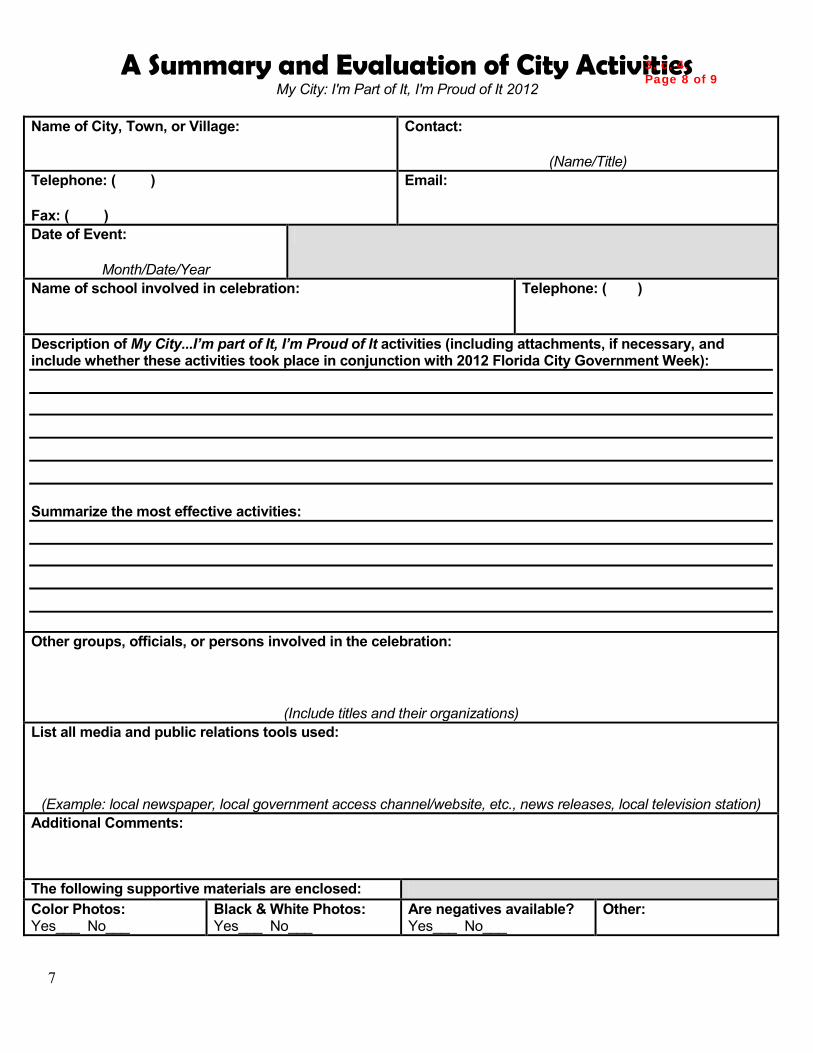
7
A Summary and Evaluation of City Activities My City: I'm Part of It, I'm Proud of It 2012
Name of City, Town, or Village: Contact:
(Name/Title) Telephone: ( ) Fax: ( )
Email:
Date of Event:
Month/Date/Year
Name of school involved in celebration:
Telephone: ( )
Description of My City...I’m part of It, I’m Proud of It activities (including attachments, if necessary, and include whether these activities took place in conjunction with 2012 Florida City Government Week):
Summarize the most effective activities:
Other groups, officials, or persons involved in the celebration:
(Include titles and their organizations) List all media and public relations tools used:
(Example: local newspaper, local government access channel/website, etc., news releases, local television station) Additional Comments:
The following supportive materials are enclosed:
Color Photos: Yes___ No___
Black & White Photos: Yes___ No___
Are negatives available? Yes___ No___
Other:
3. c. 4. Page 8 of 9

8
Sample Letter to the Editor Florida City Government Week
To the Editor: During the week of October 21-27, 2012 (CITY NAME) will join other cities across Florida in celebrating Florida City Government Week. This week has been set aside to recognize the many services city governments provide and their contribution to a better quality of life in Florida. Our theme, “My City: I’m Part of It, I’m Proud of It” pays tribute to the role citizens play in making our cities great. City government is truly government of, by and for the people---the people who are making the decisions about our community are your neighbors, business owners and community leaders. City government is administered for and by its citizens and is dependent upon public commitment to carry out its responsibilities. Furthermore, students across the state learn information about state and national government, while information on city government is sometimes barely highlighted. Every citizen deserves the right to know about the local impact of government decision-making. This is a unique opportunity to teach students and adults about the form of government that affects them daily. During this week, we want to recognize the role city government plays in our lives from public safety to trash collection to promoting our community’s culture and recreation. We hope you will join us in this celebration and learn more about your city and how it operates for you. Sincerely, Mayor___________________________ Note: If you are sponsoring Florida City Government Week Activities, you will want to include information on those events and include an invitation to the public to attend those events.
3. c. 4. Page 9 of 9

1
RESOLUTION NO. R2012-12
A RESOLUTION OF THE CITY COMMISSION OF THE CITY OF WILDWOOD, FLORIDA DETERMINING THAT CERTAIN PROPERTY IS SURPLUS; DETERMINING THE MANNER OF DISPOSAL OF SAID PROPERTY; PROVIDING FOR AN EFFECTIVE DATE
WHEREAS, the City of Wildwood is the owner of certain property that was previously deemed seized and forfeited property and declared as evidence for the Police Department and, WHEREAS, the seized and forfeited property as described can further be described as:
One (1) 1994 GMC Pickup truck, VIN# 2GTEC19KXR1526175
Mileage – 260,200; Condition - Poor
WHEREAS, on June 21, 2012, under case number 2012-CA-000732, Circuit Judge Hallman ruled the ownership of the vehicle to be turned over to City of Wildwood Police Department, pursuant to Sections 932.701 through 932.704, and
WHEREAS, the vehicle does not have any useful benefit to the City of Wildwood Police
Department, and WHEREAS, the vehicle can be utilized by the Sumter County Sheriff’s Office,
the property as identified is hereby declared surplus for reasons of disposition. NOW, THEREFORE, BE IT RESOLVED, BY THE CITY COMMISSION OF THE CITY OF WILDWOOD, FLORIDA, THAT: 1. The vehicle identified as property is hereby declared surplus property.
2. The vehicle identified as property is to be transferred to the Sumter County Sheriff’s Office.
This Resolution shall take effect immediately upon its final adoption by the City Commission of
the City of Wildwood. DONE AND RESOLVED, this 13th day of August, 2012, in regular session, by the City Commission of the City of Wildwood, Florida. CITY COMMISSION CITY OF WILDWOOD, FLORIDA S E A L Ed Wolf, Mayor ATTEST: Joseph Jacobs, City Clerk
3. c. 5. Page 1 of 3
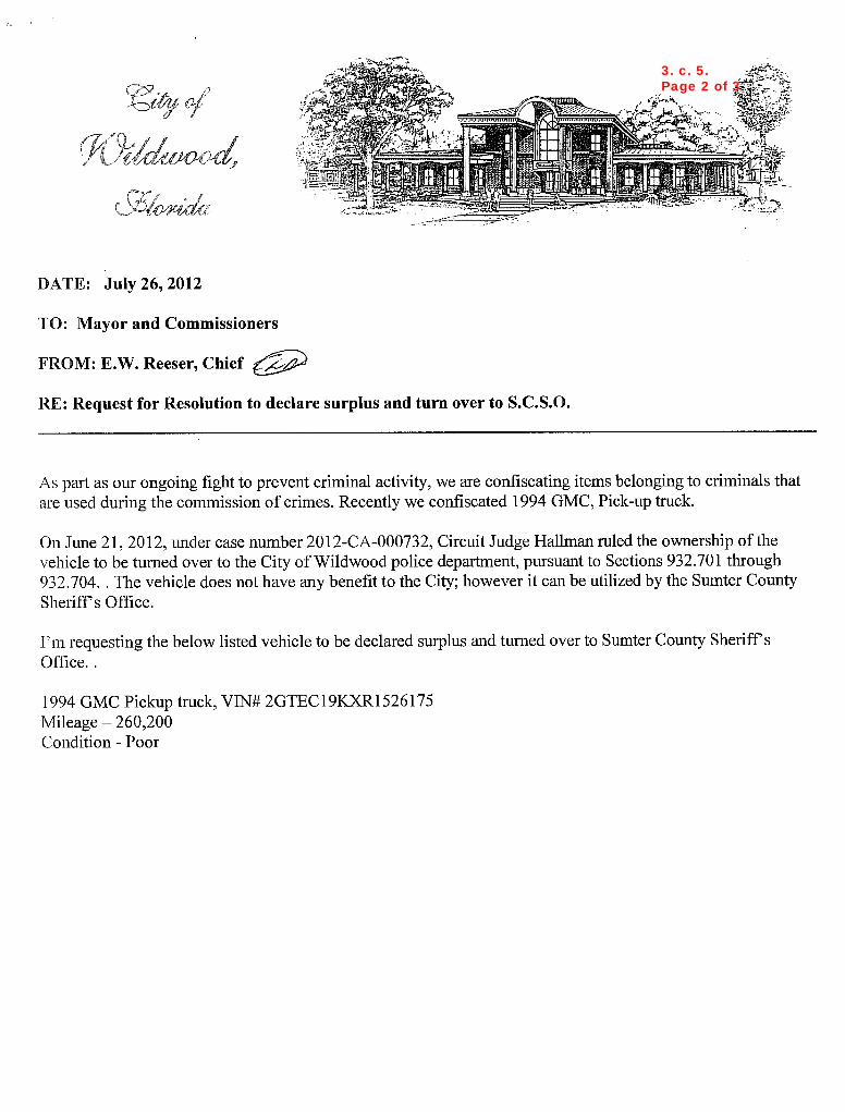
3. c. 5. Page 2 of 3

3. c. 5. Page 3 of 3

1
RESOLUTION NO. R2012-13
A RESOLUTION OF THE CITY COMMISSION OF THE CITY OF WILDWOOD, FLORIDA DETERMINING THAT CERTAIN PROPERTY IS SURPLUS; DETERMINING THE MANNER OF DISPOSAL OF SAID PROPERTY; PROVIDING FOR AN EFFECTIVE DATE
WHEREAS, the City of Wildwood is the owner of certain property that has been seized as evidence by the Wildwood Police Department; and, WHEREAS, the property as described can further be described as: 1 Auto Ordinance Corp. Submachine Gun, 45 caliber, Model M1A1, Serial # - 330540
WHEREAS, the Chief of Police has determined that the weapon is not suited for and
cannot be used for Police Service, the property as identified is hereby declared surplus for reasons of disposition. NOW, THEREFORE, BE IT RESOLVED, BY THE CITY COMMISSION OF THE CITY OF WILDWOOD, FLORIDA, THAT: 1. The item identified as property is hereby declared surplus property.
2. The item identified as property is to be disposed of by sale to a Licensed Federal Firearms Dealer approved by The Chief of Police.
3. This Resolution shall take effect immediately upon its final adoption by the City Commission of the City of Wildwood.
DONE AND RESOLVED, this 13th day of August, 2012, in regular session, by the City Commission of the City of Wildwood, Florida. CITY COMMISSION CITY OF WILDWOOD, FLORIDA S E A L Ed Wolf, Mayor ATTEST: Joseph Jacobs, City Clerk
3. c. 6. Page 1 of 2

3. c. 6. Page 2 of 2

“1”
UTILITY MAINTENANCE AGREEMENT BETWEEN THE CITY OF WILDWOOD, FLORIDA AND BRUTE PROPERTIES, INC.
This agreement, effective this ____ day of __________, 2012, made and entered into by
and between the City of Wildwood, Florida, a Florida municipal corporation (hereinafter called
"City"), and Brute Properties, Inc. (hereinafter called “Brute”).
W I T N E S S E T H:
WHEREAS, City is a regional water and wastewater provider; and,
WHEREAS, Brute owns in fee simple certain real property in Sumter County, Florida, at
8484 CR 127, Wildwood, FL (hereinafter referred to as “The Property”); and,
WHEREAS, Brute desires to procure services, including, but not limited to, water, and
wastewater from the City for the Property described in Exhibit “A”; and,
WHEREAS, Brute is developing the property as a concrete block plant; and,
WHEREAS, the property is located near the City’s right-of-way on NE 44th Drive,
Wildwood, Florida; and,
WHEREAS, the City of Wildwood desires to provide wastewater and water service to
Brute’s property; and,
WHEREAS, the parties desire to enter into an agreement setting forth the mutual
understandings and undertakings regarding the furnishing of said services, including, but not
limited to, water and wastewater services for the Property; and,
WHEREAS, this Agreement and all stipulations and covenants made herein are
acknowledged to be subject to the approval of every County, Regional, State and Federal
regulatory agency having jurisdiction of the subject matter of this Agreement; and,
NOW, THEREFORE, in consideration of the mutual covenants and undertakings of City
and Brute and other good and valuable considerations, these parties covenant and agree with
each other as follows:
3. e. 1. Page 1 of 6

“2”
1. Brute will be responsible for payment of all City connection and TIE fees as
defined by City ordinance.
2. Brute will provide the City with the site of the point of connection, between the
City water and wastewater systems and the systems located on the Brute property. The point of
connection shall be at a site approved by the City at or near the City’s right-of-way on NE 44th
Drive. The point of connection is to be on Brute’s property. The point of connection for the
water system shall be on Brute’s side of the water meter. The point of connection for
wastewater shall be on Brute’s side of a City manhole out. Brute shall provide the City with any
easements necessary to obtain access to and around the points of connection. Brute shall also
provide the City with any easement necessary to extend the City’s lines from the City right-of-
way on NE 44th Drive to the Brute property.
3. Brute understands and agrees that it shall be fully responsible for any and all
maintenance of its water and wastewater systems on its side of the points of connection and
shall be fully responsible to comply with all City, state and federal requirements in maintaining
such systems. If a need for pretreatment arises, Brute will be responsible for all costs
associated with its development, design and maintenance to City, state and federal
specifications.
4. City shall have the right to promulgate from time to time reasonable rules and
regulations relating to the furnishing of water service and wastewater collection service to
consumers within the Property encompassed by this Agreement. Such rules and regulations
may relate to, but are not limited to, rates, deposits, and connection charges and the right to
discontinue services under certain conditions. The water and wastewater rates to be charged
by City to said customers shall be the rates now or hereafter charged to other customers within
the area of service of the Brute Property. Brute hereby acknowledges and agrees that rates are
subject to change at any time by City. Brute further acknowledges that it shall be subject to City
ordinances related to water and wastewater services.
3. e. 1. Page 2 of 6

“3”
5. City, shall not be liable or responsible for maintenance or operation of any pipes,
pipelines, valves, fixtures or equipment other than the lines on the City’s side of the point of
connection and the meter.
6. Brute shall keep:
(a) All wastewater lines, service lines, connections and necessary fixtures
and equipment on the premises in good order and condition; and
(b) Water lines, connections and necessary fixtures on Brute’s side of the
water meter in good order and condition. The sale of water by City to Brute shall occur at
Brute's side of the entire meter installation, but the obligation for the maintenance of the lines
shall be set forth above and in applicable City regulations. Brute shall be responsible for all
maintenance of lateral wastewater lines to the point of connection to the City’s wastewater line.
7. No water from City's water distribution system shall be used or disbursed by
Brute or its agents, through fire hydrants or water mains, or by any person, firm, corporation or
agency, public or private, unless adequate provisions have first been made for compensating
City for such water, as provided for within the City's Ordinance.
8. Any temporary cessation or interruptions of the furnishings of water and
wastewater service to the Property described herein at any time caused by Act of God, fires,
strikes, casualties, accidents, power failures, necessary maintenance work, breakdowns,
damaged equipment or mains, civil or military authority, riots or other cause beyond the control
of the City shall not constitute a breach of the provisions contained herein nor impose liability
upon the City by the Brute, his successors and assigns.
9. If any section, subsection, sentence, clause, phrase or portion of this Agreement
is for any reason held invalid or unconstitutional by any court of competent jurisdiction, such
portion shall be deemed a separate, distinct and independent provision and such holding shall
not affect the validity of the remaining portions hereof.
10. It is mutually agreed that the City shall be held harmless from any and all liability
3. e. 1. Page 3 of 6

“4”
for damages if City's obligations under this Agreement cannot be fulfilled as a result of any
ruling or order by any other governmental or regulatory agency having jurisdiction over the
subject matter hereof; and in such event, this Agreement shall be null and void and
unenforceable by either party regarding that portion of the Brute Property for which City cannot
perform its obligations.
11. Until all of Brute’s obligations under this agreement are met, the City may refuse
services or terminate all service to Brute’s property.
12. Neither party shall be responsible for damages or delays caused by events
beyond the control of the party and which could not have been reasonably anticipated or
prevented (hereinafter “Force Majeure”). For purposes of this Agreement, Force Majeure
includes, without limitation: fire; flood; hurricane; tornado; earthquake; windstorm; sinkhole;
unavailability of materials, equipment or fuel; war; declaration of hostilities; terrorist act; civil
strife; strike; labor dispute; epidemic; archaeological excavation; government-declared
moratorium; or act of God. If a party is delayed in any work pursuant to this Agreement for
occurrence of an event of Force Majeure, the date for action required or contemplated by this
Agreement shall be extended by the number of days equal to the number of days such party is
delayed. The party seeking to be excused based on an event of Force Majeure shall give written
notice of the delay indicating its anticipated duration. Each party shall use its best efforts to
rectify any conditions causing the delay and will cooperate with the other party.
13. Whenever either party desires to give notice to the other, it shall be given by
written notice, sent by prepaid, certified, United States, mail, with the return receipt requested,
addressed to the party for whom it is intended, at the place specified as the place for giving
notice, which shall remain until it shall have been changed by written notice in compliance with
the provisions of this paragraph. For the present, the parties designate the following as the
respective places for the giving of notice:
CITY OF WILDWOOD FOR BRUTE
3. e. 1. Page 4 of 6

“5”
City Manager Brute Properties, Inc. 100 N. Main Street 8484 CR 127 Wildwood, Florida 32785 Wildwood, FL 32785
Notice so addressed and sent by prepaid certified mail, with return receipt requested,
shall be deemed given when it shall have been so deposited in the United States mail.
IN WITNESS WHEREOF, the parties hereto have caused these presents to be executed
on the day and year indicated below:
Signed, sealed and delivered in the presence of: ATTEST CITY OF WILDWOOD ____________________________ BY:__________________________ Joseph Jacobs, City Clerk Mayor Ed Wolf
DATE:_________________________
BRUTE PROPERTIES, INC. ___________________________ WITNESS By: ___________________________ Its: WITNESS C:\Documents and Settings\User\My Documents\AAA-LISA DOCS\COW-LAP\Brute Properties\maitenance.agreement
3. e. 1. Page 5 of 6

“6”
EXHIBIT A
LEGAL DESCRIPTION THE EAST 626.13 FEET OF THE NORTH 208.71 FEET OF THE NORTHEAST ¼ OF THE SOUTHWEST ¼ OF SECTION 32, TOWNSHIP 18 SOUTH, RANGE 23 EAST, SUMTER COUNTY, FLORIDA. LESS THE EAST 25 FEET OF THE SOUTHWEST ¼ OF SECTION 32, TOWNSHIP 18 SOUTH, RANGE 23 EAST.
3. e. 1. Page 6 of 6

CITY COMMISSION-LEGISLATIVE DEPARTMENT
1 Ronald B Allen Reimbursement Travel Expense 31.08$
2 Insight 8 - Cloud Ipads 3,882.64$
CITY MANAGER-EXECUTIVE DEPARTMENT
3 Payroll July 29, 2012 Pay Period - 2 Employees 6,245.50$
4 Dept of Management Services Telephone Service 5.28$
5 EGP Monthly Copier Maintenance Contract 38.07$
6 Mitel Telephone Maintenance City Manager 527.55$
7 Office Depot Office Supplies 3.11$
CITY CLERK-FINANCIAL & ADMINISTRATIVE DEPARTMENT
8 Payroll July 29, 2012 Pay Period - 4 Employees 10,187.25$
9 Besco Electric Supply Company Light Bulbs 58.44$
10 Alice Borrack Personal Vehicle Use 50.53$
11 Dart Electronics, Inc Fire Alarm Monitoring 37.42$
12 Dept of Management Services Telephone Service 5.50$
13 EGP Monthly Copier Maintenance Contract 38.06$
14 Federal Express Postage 45.29$
15 IMS Software Maintenance 413.00$
16 Office Depot Office Supplies 66.07$
17 Oracle Elevator Regular Quarterly Service 210.37$
18 Progress Energy Electric Service 2,297.88$
19 Staples Office Supplies 99.22$
20 Unifirst Rugs 24.12$
21 Villages Technology Solutions Group All Departments - General Fund 40.00$
22 Waste Management Tipping Fee 40 Yd. and 6 Yd. 667.79$
23 Wildwood Ace Hardware Paint 2.25$
DEVELOPMENT SERVICES
24 Payroll July 29, 2012 Pay Period - 4 Employees 6,824.02$
25 Dept of Management Services Telephone Service 5.28$
26 EGP Monthly Copier Maintenance Contract 38.07$
27 Melanie Peavy Reimburse SD Card Purchase 14.23$
HUMAN RESOURCES
28 Payroll July 29, 2012 Pay Period - 1 Employees 2,010.15$
29 Dept of Management Services Telephone Service 5.28$
30 EGP Monthly Copier Maintenance Contract 46.43$
31 Federal Express Postage 58.91$
32 Payroll July 29, 2012 Pay Period - 30 Employees 60,342.07$
33 Best-Way Auto Glass Windshield 220.00$
34 Central Florida Solutions Group, Inc Polo Shirts 108.00$
35 Dana Safety Supply, Inc Training Baton w/Velcro Carrier 96.00$
36 Dept of Management Services Telephone Service 43.23$
37 EGP Monthly Copier Maintenance Contract 158.01$
38 Mouser Electronics Molex Headers & Wire Housings, Terminals 60.72$
39 Office Depot Office Supplies 19.81$
40 Sumter County Clerk of Court Recording of Satisfaction /Order Liens-Davies,Jones 18.50$
41 Sumter County Tax Collector Title Transfer 78.00$
42 John Walker Boot Reimbursement 75.00$
43 Paul Valentino Boot Reimbursement 75.00$
44 Video Surveillance Outdoor Camera, Net Gear, Video Recorder 2,566.94$
45 Wildwood Ace Hardware Flex Tech,PVC,Fasteners,Outlet, Receptacle, Etc 111.71$
BILLS FOR APPROVAL
City of Wildwood, Florida
August 13, 2012
POLICE DEPARTMENT
3. f. 1. Page 1 of 3
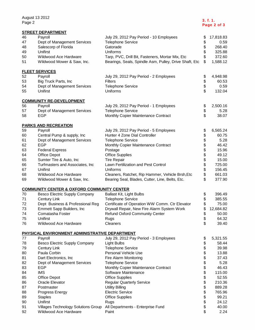
August 13 2012
Page 2
STREET DEPARTMENT
46 Payroll July 29, 2012 Pay Period - 10 Employees 17,818.83$
47 Dept of Management Services Telephone Service 0.59$
48 Salescorp of Florida Gatorade 268.40$
49 Unifirst Uniforms 325.88$
50 Wildwood Ace Hardware Tarp, PVC, Drill Bit, Fasteners, Mortar Mix, Etc 372.60$
51 Wildwood Mower & Saw, Inc. Bearings, Seals, Spindle Asm, Pulley, Drive Shaft, Etc 1,588.12$
FLEET SERVICES
52 Payroll July 29, 2012 Pay Period - 2 Employees 4,948.98$
53 Big Truck Parts, Inc Filters 60.53$
54 Dept of Management Services Telephone Service 0.59$
55 Unifirst Uniforms 132.04$
COMMUNITY RE-DEVELOPMENT
56 Payroll July 29, 2012 Pay Period - 1 Employees 2,500.16$
57 Dept of Management Services Telephone Service 5.28$
58 EGP Monthly Copier Maintenance Contract 38.07$
PARKS AND RECREATION
59 Payroll July 29, 2012 Pay Period - 5 Employees 6,565.24$
60 Central Pump & supply, Inc Hunter 4 Zone Dial Controller 60.75$
61 Dept of Management Services Telephone Service 5.28$
62 EGP Monthly Copier Maintenance Contract 46.42$
63 Federal Express Postage 15.96$
64 Office Depot Office Supplies 49.12$
65 Sumter Tire & Auto, Inc Tire Repair 15.00$
66 Turfmasters and Associates, Inc Lawn Fertilization and Pest Control 725.00$
67 Unifirst Uniforms 156.45$
68 Wildwood Ace Hardware Cleaners, Ratchet, Rip Hammer, Vehicle Brsh,Etc 661.03$
69 Wildwood Mower & Saw, Inc. Bearing Seal, Blades, Cutter, Line, Belts, Etc. 377.90$
COMMUNITY CENTER & OXFORD COMMUNITY CENTER
70 Besco Electric Supply Company Ballast Kit, Light Bulbs 396.49$
71 Century Link Telephone Service 385.55$
72 Dept Business & Professional Reg Certificate of Operation WW Comm. Ctr Elevator 75.00$
73 Emmett Sapp Builders, Inc Drywall Repair, New Fire Alarm System Work 12,684.82$
74 Comatasha Foster Refund Oxford Community Center 50.00$
75 Unifirst Rugs 64.32$
76 Wildwood Ace Hardware Cleaners 39.40$
PHYSICAL ENVIRONMENT ADMINISTRATIVE DEPARTMENT
77 Payroll July 29, 2012 Pay Period - 3 Employees 5,321.55$
78 Besco Electric Supply Company Light Bulbs 58.44$
79 Century Link Telephone Service 39.98$
80 Paula Corbin Personal Vehicle Use 13.88$
81 Dart Electronics, Inc Fire Alarm Monitoring 37.43$
82 Dept of Management Services Telephone Service 5.28$
83 EGP Monthly Copier Maintenance Contract 46.43$
84 IMS Software Maintenance 115.00$
85 Office Depot Office Supplies 52.55$
86 Oracle Elevator Regular Quarterly Service 210.36$
87 Postmaster Utility Billing 889.28$
88 Progress Energy Electric Service 765.96$
89 Staples Office Supplies 99.21$
90 Unifirst Rugs 24.12$
91 Villages Technology Solutions Group All Departments - Enterprise Fund 40.00$
92 Wildwood Ace Hardware Paint 2.24$
3. f. 1. Page 2 of 3

August 13 2012
Page 3
WATER DEPARTMENT
93 Payroll July 29, 2012 Pay Period - 10 Employees 16,416.00$
94 B & M Equipment Drum Roller Rental 142.48$
95 Brenntag Liquid Chlorine 973.56$
96 Dept of Management Services Telephone Service 2.65$
97 Federal Express Postage 5.32$
98 Southern Analytical Laboratories Environmental Testing 225.00$
99 Sunstate Meter & Supply, Inc. Chamber Assem 753.08$
100 Terminix Monthly Pest Control 27.00$
101 The Dumont Company, Inc Clear Flow 1,158.75$
102 Unifirst Uniforms 402.10$
103 Wildwood Ace Hardware Poly Film, Bungee Cords, Paint, Ratchets, Key, Etc 237.13$
104 Wildwood Mower & Saw, Inc. Blades, Belts, Spark Plugs 75.80$
WASTEWATER DEPARTMENT
105 Payroll July 29, 2012 Pay Period - 13 Employees 26,534.79$
106 B & D Industrial - Simco Tech Buna-n-Spider 241.46$
107 Bill Gregory Excavating, Inc Vac Truck for Manholes 480.00$
108 Century Link Telephone Service 69.27$
109 Century Manufacturing Corporation Lift Station Degreaser 132.72$
110 Dept of Management Services Telephone Service 3.00$
111 Erosion Control Systems Line Repairs Plant and CR 121 Pond 3,500.00$
112 Federal Express Postage 5.32$
113 Fort Bend Services, Inc Polymer 2,880.00$
114 HD Supply Electrical Fuses 162.50$
115 HD Supply WaterWorks CPG PVC 48.56$
116 MMD Computer Center, Inc Checked all Camera Computer Equipment 720.00$
117 Odyssey Manufacturing Hypochlorite Solutions 2,477.66$
118 Port Consolidated Chv Meropa 320/35 LB Pail 478.13$
119 Progress Energy Electric Service 20,767.48$
120 Staples Office Supplies 15.48$
121 Sumter County Tax Collector Register Title and Tag 130.10$
122 Unifirst Uniforms 938.58$
123 VWR Acetate Buffer, Nitrogen Standard 258.23$
124 Wildwood Ace Hardware Fuse, Wasp Spray, Padlock, Surge Suppress, Etc 130.86$
125 Wildwood Mower & Saw, Inc. Blades, Gaskets, Diaphragm, Belts 80.93$
GREENWOOD CEMETERY
ATTORNEYS/CONSULTANTS/SURVEYORS
126 Kimley-Horn & Associates, Inc Engineers 74,636.16$
FUEL INVENTORY
127 Stone Petroleum Products, Inc Unleaded and Diesel Gasoline 12,273.19$
TOTAL 323,490.58$
CITY COMMISSION
CITY OF WILDWOOD, FLORIDA
S E A L
ATTEST:_______________________ Ed Wolf, Mayor
Joseph Jacobs, City Clerk
3. f. 1. Page 3 of 3
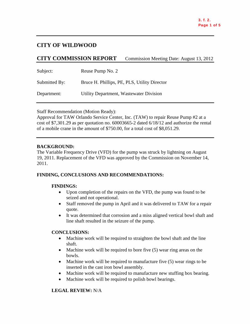
CITY OF WILDWOOD
CITY COMMISSION REPORT Commission Meeting Date: August 13, 2012
Subject: Reuse Pump No. 2
Submitted By: Bruce H. Phillips, PE, PLS, Utility Director
Department: Utility Department, Wastewater Division
Staff Recommendation (Motion Ready):
Approval for TAW Orlando Service Center, Inc. (TAW) to repair Reuse Pump #2 at a
cost of $7,301.29 as per quotation no. 60003665-2 dated 6/18/12 and authorize the rental
of a mobile crane in the amount of $750.00, for a total cost of $8,051.29.
BACKGROUND:
The Variable Frequency Drive (VFD) for the pump was struck by lightning on August
19, 2011. Replacement of the VFD was approved by the Commission on November 14,
2011.
FINDING, CONCLUSIONS AND RECOMMENDATIONS:
FINDINGS:
Upon completion of the repairs on the VFD, the pump was found to be
seized and not operational.
Staff removed the pump in April and it was delivered to TAW for a repair
quote.
It was determined that corrosion and a miss aligned vertical bowl shaft and
line shaft resulted in the seizure of the pump.
CONCLUSIONS:
Machine work will be required to straighten the bowl shaft and the line
shaft.
Machine work will be required to bore five (5) wear ring areas on the
bowls.
Machine work will be required to manufacture five (5) wear rings to be
inserted in the cast iron bowl assembly.
Machine work will be required to manufacture new stuffing box bearing.
Machine work will be required to polish bowl bearings.
LEGAL REVIEW: N/A
3. f. 2. Page 1 of 5

RECOMMENDATIONS:
Staff recommends approval of TAW quotation no. . 60003665-2 dated 6/18/12
and authorize the rental of a mobile crane in the amount of $750.00.
FISCAL IMPACT:
Funding source is Wastewater Repair and Maintenance, Account no. 401-0035-535.0460
with an unencumbered balance as of July 1, 2012 of $31,082.34
Less Peter’s Street LS ($7,537.60)
Less Radio narrow banding ($2,862.00)
Less Disk Filter Backwash Pump Motor ($ 919.63)
Unencumbered Balance $19,763.11
ALTERNATIVES:
Pump is required to maintain WWTP permit operational conditions.
SUPPORT MATERIAL:
Spreadsheet of quotations received and narrative of work required.
TAW quotation No. 60003665-2
C:\Users\bphillips\Documents\Agenda Items\Reuse Pump #2 7-24-12.doc
3. f. 2. Page 2 of 5

3. f. 2. Page 3 of 5
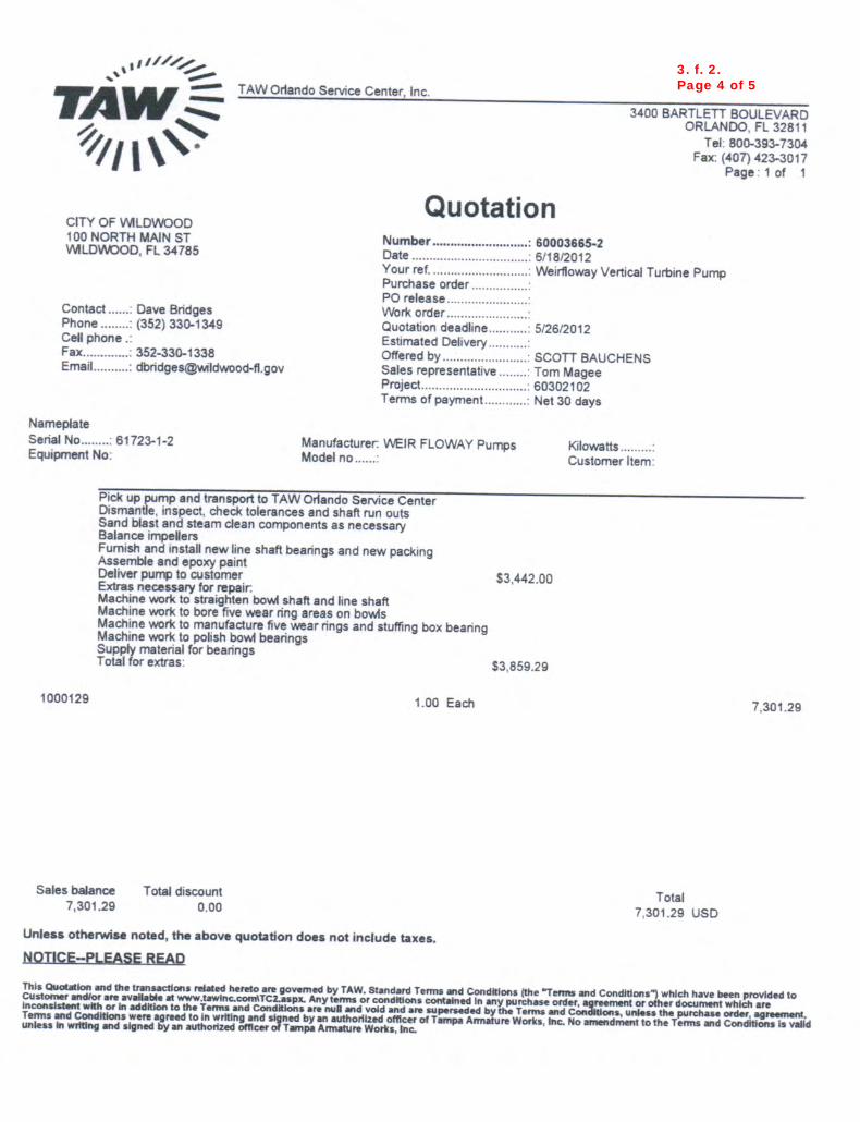
3. f. 2. Page 4 of 5

3. f. 2. Page 5 of 5

CITY OF WILDWOOD
CITY COMMISSION REPORT Commission Meeting Date: August 13, 2012
Subject: Peter’s Street Wastewater Lift Station (Station #6)
Submitted By: Bruce H. Phillips, PE, PLS, Utility Director
Department: Utility Department, Wastewater Division
Staff Recommendation (Motion Ready):
Recommend approval to purchase a new replacement Flygt submersible pump and
electrical cable from Xylem Water Solutions USA, Inc. in the amount of $7,537.60.
BACKGROUND:
The Peter’s Street pump station is a major re-pump station in the City’s wastewater
collection system. It pumps directly to the WWTP and receives flow from:
Oak Street pump station (Station #4)
Charlotte Pipe pump station (Station #7)
FINDING, CONCLUSIONS AND RECOMMENDATIONS:
FINDINGS:
In October, 2011 the City Commission, by resolution, declared Flygt
pumps as a sole source manufacturer.
The Peter’s Street station is a duplex station (contains 2 pumps)
One of the pumps in the station has failed
Staff has removed the failed pump and delivered it to Xylem for repair
estimate
Station is operating with existing pump and an under rated spare pump.
CONCLUSIONS:
Cost to repair existing pump is estimated at $5,761.00 and will have a 1
year warranty.
Existing pump model is no longer being manufactured.
New model pump with same pumping conditions and upgraded
technology costs $7,537.60 and carry’s a 5-year prorated warranty.
LEGAL REVIEW:
Not Applicable
3. f. 3. Page 1 of 5

RECOMMENDATIONS:
Staff’s recommendation is to proceed with the purchase of a new pump to
take advantage of the new technology and extended warrantee.
FISCAL IMPACT:
Wastewater Dept. budget Repair & Maintenance with an unencumbered balance of
$31,082.34 as of June 30, 2012.
ALTERNATIVES:
Authorize Xylem to rebuild the outdated pump at an estimated savings of $1,776.60.
SUPPORT MATERIAL:
Estimate #R2012-APO-0254, in the amount of $5,761.00, dated 7/3/12
from Xylem Water Solutions USA, Inc.
Quote #2012-APO-1222, in the amount of $7,537.60, dated 7/5/12 from
Xylem Water Solutions USA, Inc.
C:\Users\bphillips\Documents\Agenda Items\Peter's St pump replacement 7-19-12.doc
3. f. 3. Page 2 of 5

3. f. 3. Page 3 of 5

3. f. 3. Page 4 of 5

3. f. 3. Page 5 of 5

CITY OF WILDWOOD CITY COMMISSION REPORT Commission Meeting Date: August 13, 2012
Subject: Wastewater and Water Communication Radios Submitted By: Bruce H. Phillips, PE, PLS, Utility Director Department: Utility Department
Staff Recommendation (Motion Ready): Approve Data-Flow Systems proposal dated July 18, 2012 in the amount of $2,512.00 to upgrade existing communications radios to Federal Communication Commission (FCC) compliance standards and authorize staff to purchase up to five (5) new radios if needed at a cost of $975.00 each.
BACKGROUND: The FCC has required all radios to comply with its “narrowbanding” requirements by January 1, 2013. Data-Flow Systems is presently the supplier of the City’s wastewater pump station SCADA systems. FINDING, CONCLUSIONS AND RECOMMENDATIONS: FINDINGS:
• City has thirty-eight (38) wastewater pump stations equipped with communications radios; staff has concluded there are fifteen (15) in non-compliance with the FCC narrow banding regulations.
• City has six (6) water pump stations equipped with communication radios; staff has concluded there is only one (1) in non-compliance with the FCC narrow banding regulations.
CONCLUSIONS:
• Total number of re-bandings required is therefore sixteen (16).
• Total number of new licenses required is sixteen (16).
• An additional five (5) radios are recommended for purchase. It is anticipated, due to the age of the existing radios, there will be 20 to 25% failure of existing radios to accept the new re-banding.
LEGAL REVIEW: Not Applicable RECOMMENDATIONS:
3. f. 4. Page 1 of 5

Staff recommends proceeding with the re-banding by Data-Flow Systems. FISCAL IMPACT: Wastewater Department
• 15 re-bandings @$70.00 ea. $1,050.00
• 15 new licenses @ $10.00 ea. $ 150.00
• Prorated travel $1,173.00 TOTAL Wastewater Dept. $2,373.00
Water Department
• 1 re-banding @ $70.00 ea. $ 70.00
• 1 new license @ $10.00 ea. $ 10.00
• Prorated travel $ 59.00 TOTAL Water Dept. $ 139.00 GRAND TOTAL $2,512.00
Should an existing radio be defective and not able to accept the narrowbanding a replacement radio will be required at a cost of $975.00 each. ALTERNATIVES: None SUPPORT MATERIAL:
• Memo dated from July 18, 2012 from Robert Valentech, Wastewater Coordinator.
• Data Flow Systems revised Quote No. 120723-01-rw, dated July 23, 2012. C:\Users\bphillips\Documents\Agenda Items\narrow banging of Radios 7-19-12.doc
3. f. 4. Page 2 of 5

3. f. 4. Page 3 of 5

SCADA SOLUTIONS SINCE 1981 - www.dataflowsys.com
Data Flow Systems, Inc. • 605 John Rodes Blvd. • Melbourne, Florida 32934 • PH: 321.259.5009 • FAX: 321.259.4006
July 23, 2012 Quote No. 120723-01-rw Mr. Bobby Valentich City of Wildwood Email: [email protected] Re: Narrowbanding Services Quote Dear Mr. Valentich:
Thank you for this opportunity to offer our products and services for the above referenced project. It considers the following:
A. There are 4 critical stations that need to be maintained on line, these stations all use BPR back packs for communications.
B. All other stations can be maintained without communications for a limited time.
C. The DFS stations currently report to a DFS TACII system which is polled by a Trihedral central.
D. The utility currently has a mix of crystal and synthesized radios. (The BPRs are slightly different between the two depending upon which radio was used so we cannot simply swap out radios amongst the BPRs in the field, we will need to update and test each BPR with its own radio here).
• Recommended Actions:
1. Send to DFS 2 RIMs (modules) and 5 BPRs (including spares if needed) from non critical stations. You can run the stations without a BPR they will simply be offline. Of course I cannot speak to how Trihedral handles this but at the TACII system they will show offline after sufficient errors are logged. If needed we can send you 5 scrap BPRs to be used as temporary place holders in stations that you remove the initial BPRs from (obviously not the critical statiions). Depending on how the PCU/BPR is installed it may make it easier for you to simply secure the PCU as currently installed using a non functional BPR.
2. DFS shall tune both RIMs to Narrow band as well as the 5 BPRs. When returned the utility can change out the RIM at the central and replace the 4 BPRs at the 4 priority stations. This will leave one spare of narrow band for the CTU radio and a BPR as a spare for the critical stations. You can then send us the remaining units for update, test and narrow banding at your convenience although understanding that they will likely be offline until retuned.
3. Assuming that we get blocks of 4 BPRs and 2 RIMs (seed set) then we should be able to rework and retune these once received here in 5 working days and return them to the utility for installation and exchange with another set until all have been completed.
3. f. 4. Page 4 of 5

SCADA SOLUTIONS SINCE 1981 - www.dataflowsys.com
Data Flow Systems, Inc. • 605 John Rodes Blvd. • Melbourne, Florida 32934 • PH: 321.259.5009 • FAX: 321.259.4006
This quote includes one day onsite, that would be the day that the narrow band radios are installed for the first time which would affect the priority stations. Especially given that we cannot "dial in" from here and observe any unexpected problems that may result during the initial placement at the priority stations. We could also return here with the next seed set once removed from the priority station to facilitate the next set. All services offered are compatible with the City of Wildwood’s existing radio telemetry system. This 2 page quotation includes, and is limited to, the following:
• Bill of Materials:
(1) Onsite Services & Travel $1,232.00
Narrowband adjustment from 25 kHz to 12.5 kHz $70.00 each
FCC Licensing Update $10.00 per site
(5) Replacement Radio ($975 each) $4,875.00 This item has been added to the quote as requested as I understand someone from DFS verbally quoted this. A replacement radio may be required if the existing radio is defective and cannot accept the narrowbanding adjustment. This will only be provided if required and if the existing equipment can interface with the new radio.
• Quotation Notes:
1. All items shipped will be billed at the time of shipment. Freight charges will be added.
2. Only those items and services specifically listed above in the Bill of Materials are included in this quotation.
3. This quotation assumes that DFS existing insurance provider(s) and the coverage afforded by DFS’s existing insurance policies are acceptable. In the event that you require that we change insurance provider(s), acquire additional coverage, and/or amend the terms of our existing policies, DFS reserves the right to void and withdraw this Quotation and replace it with an amended quote which contemplates and provides for the recovery of the cost associated with analyzing and complying with your insurance requirements. Policy information can be found at http://www.dataflowsys.com/company/documents/insurance-coverage.pdf
The quotation does not include shipping charges or any applicable taxes. Lead-time is 4-5
weeks ARO. Payment terms are NET 30. This quote will be honored for 90 days. Please contact me at 321-259-5009 with any questions or comments. Sincerely,
Data Flow Systems, Inc Randy E. Wyatt Inside Sales Manager Email: [email protected]
3. f. 4. Page 5 of 5

3. f. 5. Page 1 of 10
plaw
Typewritten Text
plaw
Typewritten Text
Staple Finisher
plaw
Typewritten Text
plaw
Typewritten Text
CASH PURCHASE OPTION:
plaw
Typewritten Text
plaw
Typewritten Text
- Ocala
plaw
Typewritten Text
plaw
Typewritten Text
(Price includes Surge Protection $150 and relocate of old copier $250)
plaw
Typewritten Text

3. f. 5. Page 2 of 10
plaw
Typewritten Text
Staple Finisher
plaw
Typewritten Text
LEASE OPTION:
plaw
Typewritten Text
(Lease option total price does not include surge protection ($150) and relocation of old copiers to other departments ($250). These are paid up-front costs when leased ($400 total). 3-Yr. Lease is only $21 more than cash price)
plaw
Typewritten Text
plaw
Typewritten Text
plaw
Typewritten Text
**
plaw
Typewritten Text
plaw
Typewritten Text
**
plaw
Typewritten Text
plaw
Typewritten Text
plaw
Typewritten Text
plaw
Typewritten Text
plaw
Typewritten Text
plaw
Typewritten Text
plaw
Typewritten Text
plaw
Typewritten Text
plaw
Typewritten Text
plaw
Typewritten Text
- Ocala
plaw
Typewritten Text
plaw
Typewritten Text
plaw
Typewritten Text
plaw
Typewritten Text
plaw
Typewritten Text
plaw
Typewritten Text
plaw
Typewritten Text
plaw
Typewritten Text
plaw
Typewritten Text
plaw
Typewritten Text

City Commission and City Manager
The City needs a new well-constructed and technologically savvy copier to be housed within the
mailbox/copy/supply room. The walkway needs a 36-inch path through this room to remain ADA
compliant. If the equipment is larger than the current copier, this walkway will no longer be handicap
accessible. For this reason, the Canon had to be removed from the list of options. In addition, the
Canon paper path appeared to have several possible places to jam. This was confirmed by the
user/demonstrator, whom was not the salesperson.
All copiers will scan, print and copy. Consideration was given to whether the extra cost was necessary to
include the Fax capability. It has been determined that the Fax boards add an additional cost to the
copier that we could not utilize immediately. A telephone line would be necessary at the copier. The
installation of this line would create an additional (set-up) cost, for (almost) out-dated technology.
Standard Fax machines are inexpensive in comparison to adding this component.
For the last 25 years we have done business with EGP INC. They have provided a quality, well-made
copier. As for service problems, I can recall only once when one of our three Kyoceras have had a
problem with service, it was not specified that a loaner was preferred over waiting for a part to arrive,
thus the machine was out of service. A loaner was not provided until it was requested.
Pam Law and Alice Borrack have travelled to see the copiers outlined on the price quote sheet provided.
Kyocera’s standard programming was found to have user-friendly technology and software, with more
applications than our current copier. The display was full color and easy to follow. The equipment
appeared sturdy and well made, with all pieces and drawers moving fluidly. The drawers were
constructed with plastic. There were no toner leaks noted. EGP pricing includes DMS Link Software, a
Work Flow Application, added at no charge ($390.00 value) for two PCs. This application allows end
users to direct scanned files to specific folder without potential loss of the file. In addition, it creates
searchable (WORD) OCR scans. The paper path was short. No HOT areas noted. All manufactures,
except Kyocera provide the encryption capability for security and hard drive erasure. Kyocera charges
for this particular software which is usually used for HIPPA purposes. The demo was very impressive.
Ricoh claims to have OCR technology which would allow the scans to become a searchable/editable
document in MS Word, Excel and Outlook. We received no validation of this statement, on reviews of
their product or during the demo. The initial virtual software demo would not load. There was no time
to re-visit the program for a second attempt. The display was gray-scale and easy to follow. The
construction and standard programming of the Ricoh is similar to the copier which we currently have
but had a very long paper path past HOT areas which included a fuser that would need to be moved
during certain jam situations. The drawers were constructed with metal. The toner was leaking into the
core of the machine. The demo was unimpressionable.
3. f. 5. Page 3 of 10

Xerox touted their measures of security and a 'print-shop style’ print engine. The construction of the
Xerox, is similar to the copier which we had BEFORE our current machine. The display was gray-scale
and easy to follow. The drawers were constructed with metal. The toner was leaking into the core of
the machine. It also had a very long paper path past HOT areas which included a fuser that would need
to be pulled/removed during certain jam situations. Standard programming was found to have user-
friendly technology and software, similar to applications on our current copier. The Xerox showroom
specialist had difficulty operating the copier and the software. The demo was unimpressionable.
Konica Minolta’s standard programming was found to have user-friendly technology and software, with
more applications than our current copier. The display was full color and easy to follow. The equipment
appeared sturdy and well made, with all pieces and drawers moving fluidly. The drawers were
constructed with plastic, not quite as rigid as Kyocera but are covered under the maintenance. The
SCANPATH application allows (all copier connected) end users to direct scanned files to specific folder
without potential loss. In addition, it creates searchable and editable PDF’s Word, Excel and SharePoint
documents from scans. The paper path was short. No HOT areas noted. There were no toner leaks
noted. The salesperson tried to jam the machine without success. He tore the page in half and laid it
back into the drawer, both sides ran through the copier without event. Also tore 2/3 of feed edge off
and then sent crumpled paper through the copier without event. This machine had the best color
printing quality. The demo was very impressive.
3. f. 5. Page 4 of 10

3. f. 5. Page 5 of 10
3. f. 5. Page 6 of 10

3. f. 5. Page 7 of 10

3. f. 5. Page 8 of 10

Company (Low-High Price Quote) FUJI XEROX KONICA MINOLTA KYOCERA RICO AFICIO
SIZE - HEIGHT (CURRENT EQP 50") 53.9 45.5 52.9 48.5
SIZE - WIDTH (CURRENT EQP 60") 84.7 25.5 42.9 29.5
SIZE - DEPTH (CURRENT EQP 32") 31 31.5 28.5 33.5
Copier Mfg Date (*updated operating system or retrofit) MAR 2010* FEB 2012 MAY 2011 MAR 2010
Description WC7775P C654 TA6550ci C6501SP
RETAIL (Base equipment) 34,100.00$ 32,828.00$ 32,954.00$ 36,855.00$
QUOTE Plus Install and Surge 12,679.00$ 14,491.00$ 15,406.00$ 17,087.00$
Does not include Software Upgrade 1,716.00$ N/A 899.00$ N/A
QUOTE (less FAXBOARD,add ADV FINISHER) 12,142.00$ 14,091.00$ 15,156.00$ 16,817.00$
3-YR LEASE OPTION Monthly Paym/Total Paid $351.90 / $12,668.40 $392.00 / $14,112.00 $415.17 / 14,946.12 $525.51 / $18,918.36
5-YR LEASE OPTION Monthly Paym/Total Paid PROVIDED 48 MONTH $281.82 / $16,909.20 $290.01 / $17400.60 $351.92 / $21,115.20
RELOCATE OLD EQUIPMENT IN UTILITIES DEPT 537.00$ 250.00$ INCLUDED 135.00$
MAINTENANCE BASE (MINIMUM COPY CHG) our avg 14,000 none none 5,000 B/W = $32.50 25,000 B/W = $88.52
COST PER COPY B/W 0.0049 0.0058 0.0065 0.0049
COST PER COPY COLOR 0.049 0.049 0.05 0.045
OTHER MAINTENANCE, Surge Suppression 150.00$ 250.00$ 135.00$
Add Job Programs to meet our specific needs UNK INCLUDED INCLUDED UNK
OTHER MAINTENANCE, INCLUDED 5 Yr Software Svc staples
SOFTWARE INCLUDED $ SCANPATH DMS LINK AUTOSTORE
search $ SCAN-PC Dtop PRO Y Y Y
edit $ ADDITIONAL COST Y $ UPGRADE TO LINK 4 Y
SOFTWARE LICENSING: NUMBER OF PC/Seat
OPERATIONS or ADDITIONAL COSTS
SCAN-PC Desktop PRO
for 25 stations for
$1716.00, can be added
to lease
Software is on copier
and available to anyone
connected to the copier
DMS LINK for 2 Stations
Included; UPGRADE to
DMS LINK 4 for $899.00
Software is on copier
and available to anyone
connected to the copier
3. f. 5. Page 9 of 10

Company (Low-High Price Quote) FUJI XEROX KONICA MINOLTA KYOCERA RICO AFICIO
USER FRIENDLY (personal*rating) ***** ***** ***** *****
ARRAY of PRE-PROGRAMMED FUNCTIONS *** **** ***** ***
Easy To Read COPIER DISPLAY **** ***** ***** ***
SCAN, PAGES PER MINUTE single/duplex 80 / 50 90/180 120 /200 85 / 85
SINGLE PASS SCANNER NOT AVAILABLE Y Y Y
STANDARD MEMORY - RAM / HD 2-GB / 80-GB 2-GB / 250 GB 2-GB / 320 GB 2-GB / 320 GB
WARM-UP 28 SECONDS 22 SECONDS 60 SECONDS 70 SECONDS
PAPER CAPACITY 3010 3500 4000 3300
PAPER PATH - FEW DEVIATIONS (personal*rating) ** ***** ***** ***
NO HOT AREAS IN PAPER PATH (personal*rating) ** ***** ***** **
COPIES PER MINUTE color / black 50/75 60/65 60/65 60/65
FINISHER (Staple Capacity) 100 100 100 50
FINISHER, BOOKLET OPTION NOT AVAILABLE 911.00$ INCLUDED
SERVICE 6-hr guarantee 4-hr guarantee 4-hr guarantee
2-hr average 2-hr average
Based on : State of Florida Brevard County Price Quote City of Fellsmere
3. f. 5. Page 10 of 10

3. g. 1. Page 1 of 2

LEE
ST
MIL
L S
T
JAC
KS
ON
ST
PIT
T S
T
ROSS ST
N M
AIN
ST
/N U
S 3
01
FO
UR
TH
ST
FIF
TH
ST
N O
LD W
IRE
RD
OAK ST
MOSS ST
KILGORE ST/C-44A
WILSON ST
DENHAM ST
STONE ST
SE
CO
ND
ST
PE
RR
Y S
T
MADDOX ST
CLEVELAND AVE/C-466A
LAWRENCE ST
TH
IRD
ST
FLORIDA ST
TERRY ST
PENNSYLVANIA STKNIGHT AVE
OR
AN
GE
ST
GEORGIA STEVANS ST
JARRELL AVE
ALABAMA ST
LION ST
456744A4567466AUV35
UV35
£¤301
Pitt-Stone Drainage Improvements
K:\OC
A_Ci
vil\14
2173
045-P
itt-Sto
ne_D
raina
ge Im
prove
ments
\CAD
D\GI
S\Dr
ainag
e Imp
rovem
ents_
Prior
ity.m
xd - 8
/2/20
12 10
:16:18
AM -
jessic
a.ridd
le
I
Contact: Richard V. Busche, P.E.1823 SE Fort K ing Street, Sui te 200Ocala, Florida 34471Phone: (352) 438-3000
LegendProposed Overlay- Priority 2
Existing Sidewalk
Proposed Sidewalk
Project Area
12 ft Roadway
Proposed Overlay- Priority 1
3. g. 1. Page 2 of 2

3. g. 2. Page 1 of 7

3. g. 2. Page 2 of 7

3. g. 2. Page 3 of 7
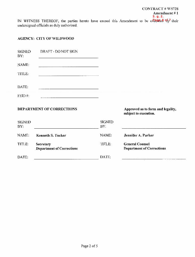
3. g. 2. Page 4 of 7

3. g. 2. Page 5 of 7

3. g. 2. Page 6 of 7
plaw
Typewritten Text
plaw
Typewritten Text
plaw
Typewritten Text
plaw
Typewritten Text
plaw
Typewritten Text
NO CHANGES IN COST
plaw
Typewritten Text
plaw
Typewritten Text

3. g. 2. Page 7 of 7

3. g. 3. Page 1 of 2

3. g. 3. Page 2 of 2
plaw
Oval
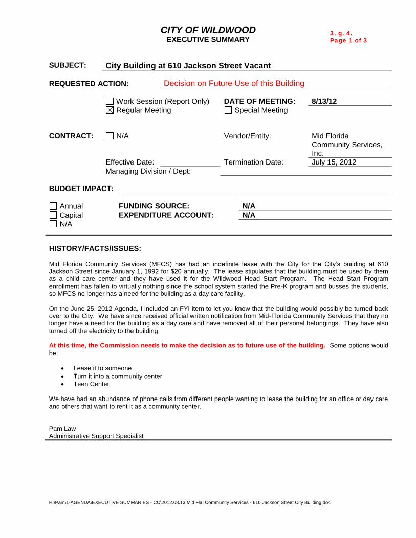
CITY OF WILDWOOD EXECUTIVE SUMMARY
H:\Pam\1-AGENDA\EXECUTIVE SUMMARIES - CC\2012.08.13 Mid Fla. Community Services - 610 Jackson Street City Building.doc
SUBJECT: City Building at 610 Jackson Street Vacant REQUESTED ACTION: Decision on Future Use of this Building Work Session (Report Only) DATE OF MEETING: 8/13/12
Regular Meeting Special Meeting
CONTRACT: N/A Vendor/Entity: Mid Florida Community Services, Inc.
Effective Date: Termination Date: July 15, 2012
Managing Division / Dept:
BUDGET IMPACT:
Annual
FUNDING SOURCE:
N/A
Capital EXPENDITURE ACCOUNT: N/A
N/A
HISTORY/FACTS/ISSUES: Mid Florida Community Services (MFCS) has had an indefinite lease with the City for the City’s building at 610 Jackson Street since January 1, 1992 for $20 annually. The lease stipulates that the building must be used by them as a child care center and they have used it for the Wildwood Head Start Program. The Head Start Program enrollment has fallen to virtually nothing since the school system started the Pre-K program and busses the students, so MFCS no longer has a need for the building as a day care facility. On the June 25, 2012 Agenda, I included an FYI item to let you know that the building would possibly be turned back over to the City. We have since received official written notification from Mid-Florida Community Services that they no longer have a need for the building as a day care and have removed all of their personal belongings. They have also turned off the electricity to the building. At this time, the Commission needs to make the decision as to future use of the building. Some options would be:
Lease it to someone
Turn it into a community center
Teen Center We have had an abundance of phone calls from different people wanting to lease the building for an office or day care and others that want to rent it as a community center. Pam Law Administrative Support Specialist
3. g. 4. Page 1 of 3

3. g. 4. Page 2 of 3

CITY OF WILDWOOD EXECUTIVE SUMMARY
H:\Pam\1-AGENDA\EXECUTIVE SUMMARIES - CC\2012.06.25 Mid Fla. Community Services - 610 Jackson Street City Building.doc
SUBJECT: Lease on City Building at 610 Jackson Street Possibly Being Terminated REQUESTED ACTION: Information only at this time Work Session (Report Only) DATE OF MEETING: 6/25/12
Regular Meeting Special Meeting
CONTRACT: N/A Vendor/Entity: Mid Florida Community Services, Inc.
Effective Date: Termination Date: July 15, 2012 ??
Managing Division / Dept:
BUDGET IMPACT:
Annual
FUNDING SOURCE:
N/A
Capital EXPENDITURE ACCOUNT: N/A
N/A
HISTORY/FACTS/ISSUES: Mid Florida Community Services (MFCS) has had an indefinite lease with the City for the City’s building at 610 Jackson Street since January 1, 1992 for $20 annually. The lease stipulates that the building must be used by them as a child care center and they have used it for the Wildwood Head Start Program. In 2007, Sumter County Schools began a VPK (Voluntary Pre-K) program at the schools which had a devastating effect on the Wildwood Head Start program that year. The City allowed MFCS to hold the building vacant for one year to allow for the adjustment and the following year (2008), the Head Start program was up and running again on Jackson Street. Since that time, it has been struggling to keep enrollment up not only due to the VPK program itself at the schools but the additional fact that those children could be transported to and from school on the school busses making it much more convenient for the parents. Commissioner Bivins had been told by an employee of the Head Start program that this was their last year and that they would not be using the building after the end of this school year. Commissioner Bivins asked me if we had received any notification from MFCS of this fact and we had not. I contacted Michael Georgini, the Executive Director of MFCS and he verbally verified that Head Start would no longer be using the building, but they really didn’t want to lose the building and were hoping to find something else to use it for. I reminded him that the lease stipulated it must be used as a child care center for them to continue to hold it. He did then say that they would be vacating it but could not give me a date. On June 6, 2012 I received a phone call from Chris Bayes at MFCS that they would have the playground equipment moved and all of their equipment out of the building by July 15, 2012. We have still not received anything in writing from MFCS of this fact, so I am hesitant to say it’s definitely going to be available for sure. If they do vacate and the lease is terminated, the Commission will need to determine what they want to do with the building. We have had several inquiries from various people for use of the building. This will be brought back to you at a future meeting for a decision on what the Commission wants to do with the building, but I wanted to give you a heads up on the situation should you be contacted about using the building. Pam Law Administrative Support Specialist
3. g. 4. Page 3 of 3