
Attribution of the river flow growth in the Plata Basin
15
INTERNATIONAL JOURNAL OF CLIMATOLOGY Int. J. Climatol. 31: 2234–2248 (2011) Published online 22 September 2010 in Wiley Online Library (wileyonlinelibrary.com) DOI: 10.1002/joc.2228 Attribution of the river flow growth in the Plata Basin Moira E. Doyle a,b * and Vicente R. Barros a,b a Centro de Investigaciones del Mar y la Atm´ osfera (CIMA/CONICET-UBA) Buenos Aires, Argentina b Departamento de Ciencias de la Atm´ osfera y los Oc´ eanos. FCEN. Universidad de Buenos Aires. Buenos Aires, Argentina ABSTRACT: A regression approach was used to quantitatively estimate the attribution of the notable growth in the river flows of the Plata Basin during 1960–1999. The study was conducted in seven large basins that account for most of the Plata River discharge. Annual rainfall integrated over each basin and annual river flows at their closing points were used for the analysis. The contribution of rainfall changes during each of the three phases of El Ni˜ no-Southern Oscillation to total rainfall change in these basins was also calculated. The two main drivers for the generalized growth of the river flows were the increased precipitation and the decreased evaporation attributable to land use change, including deforestation of natural forest and crop switch from sugarcane and coffee trees to soybean. Other evaporation changes played a minor role. There was a north-south gradient in the respective importance of each driver, with land use change having greater weight in the northern basins and the precipitation increase in the southern ones. Thus, in the northern part of the Upper Paran´ a Basin, despite the negative trend in precipitation there was a strong augment of the river flow caused by land use change. The contribution to the positive trend of the stream flows in the middle of the Plata Basin came from both land use change and increased precipitation. Finally, in the south, the Uruguay River flow change was basically due to the precipitation trend that was not only observed during the El Ni˜ no phase, but also during the Neutral phase. Only in the Middle Paraguay Basin was the shift to more frequent and intense El Ni˜ no events that took place in the 1970s an important factor in the contribution of precipitation to streamflow trends. Copyright 2010 Royal Meteorological Society KEY WORDS Plata Basin; trends; land use change; precipitation; river flow Received 2 February 2010; Revised 19 August 2010; Accepted 21 August 2010 1. Introduction The Plata Basin, stretching over 3.2 million km 2 , is the fifth largest basin of the world (Figure 1); its two main tributaries are the Paran´ a River with a huge basin of 2.6 million km 2 , including 1 million km 2 from the Paraguay Basin, and the Uruguay River. Located at the heart of the most developed region of South America, the Plata Basin has abundant water resources, used to produce most of the regional electricity and to sustain agriculture. Harvests and livestock supply most of the food for the countries in the region, and also generate their main export income. Water resources in the Plata Basin are therefore crucial for the sustainable development of the region and in a context of climate change justify growing attention. During the first half of the 20th century, the flow of the Paran´ a, Paraguay and Uruguay Rivers had a tendency to decrease. This behaviour was reversed during the sec- ond half, especially since the 1970s when an important positive change was observed (Garc´ ıa and Vargas, 1997; * Correspondence to: Moira E. Doyle, Dto. Cs. De la Atm´ osfera y los Oc´ eanos, Ciudad Universitaria, Pabell´ on II, 2do piso, 1428 Buenos Aires, Argentina. E-mail: [email protected] Genta et al., 1998; Kr¨ uger et al., 1998). The mean dis- charge to the Plata Basin as a whole increased 35% from 1951–1970 to 1980–1999 (Berbery and Barros, 2002), improving power generation, navigation and other uses of water resources. However, there were also some nega- tive impacts because large floods became more frequent. Should these high mean flows remain or not in the near future is an important issue because the return to the early 1960s mean flows would have important negative conse- quences. Therefore, understanding the cause of such a remarkable change, apart from its academic value, is of important practical interest. One possible driver of this change could be land use change. During the past century, agriculture has expanded through deforestation of the Atlantic Forest, an ecosystem that stretched along the entire southern coast of Brazil and extended into a great part of the Paran´ a and Paraguay Basins. According to Tucci (2003), forest-like cover in the states of Sao Paulo and Paran´ a, situated in the middle of the Paran´ a Basin, decreased from approximately 70% in 1907 to less than 8% in 1990. In these states, there were additional land use changes starting at the end of the 1960s, mainly the substitution of sugarcane and coffee trees for soybean. Deforestation took place, as well, in eastern Paraguay where natural forest cover declined from 45% in 1960 to 15% in 1990 with an accelerated Copyright 2010 Royal Meteorological Society
Transcript of Attribution of the river flow growth in the Plata Basin
INTERNATIONAL JOURNAL OF CLIMATOLOGYInt. J. Climatol. 31: 2234–2248 (2011)Published online 22 September 2010 in Wiley Online Library(wileyonlinelibrary.com) DOI: 10.1002/joc.2228
Attribution of the river flow growth in the Plata Basin
Moira E. Doylea,b* and Vicente R. Barrosa,b
a Centro de Investigaciones del Mar y la Atmosfera (CIMA/CONICET-UBA) Buenos Aires, Argentinab Departamento de Ciencias de la Atmosfera y los Oceanos. FCEN. Universidad de Buenos Aires. Buenos Aires, Argentina
ABSTRACT: A regression approach was used to quantitatively estimate the attribution of the notable growth in the riverflows of the Plata Basin during 1960–1999. The study was conducted in seven large basins that account for most of thePlata River discharge. Annual rainfall integrated over each basin and annual river flows at their closing points were usedfor the analysis. The contribution of rainfall changes during each of the three phases of El Nino-Southern Oscillation tototal rainfall change in these basins was also calculated.
The two main drivers for the generalized growth of the river flows were the increased precipitation and the decreasedevaporation attributable to land use change, including deforestation of natural forest and crop switch from sugarcane andcoffee trees to soybean. Other evaporation changes played a minor role. There was a north-south gradient in the respectiveimportance of each driver, with land use change having greater weight in the northern basins and the precipitation increasein the southern ones. Thus, in the northern part of the Upper Parana Basin, despite the negative trend in precipitation therewas a strong augment of the river flow caused by land use change. The contribution to the positive trend of the streamflows in the middle of the Plata Basin came from both land use change and increased precipitation. Finally, in the south,the Uruguay River flow change was basically due to the precipitation trend that was not only observed during the El Ninophase, but also during the Neutral phase.
Only in the Middle Paraguay Basin was the shift to more frequent and intense El Nino events that took place in the1970s an important factor in the contribution of precipitation to streamflow trends. Copyright 2010 Royal MeteorologicalSociety
KEY WORDS Plata Basin; trends; land use change; precipitation; river flow
Received 2 February 2010; Revised 19 August 2010; Accepted 21 August 2010
1. Introduction
The Plata Basin, stretching over 3.2 million km2, isthe fifth largest basin of the world (Figure 1); its twomain tributaries are the Parana River with a hugebasin of 2.6 million km2, including 1 million km2 fromthe Paraguay Basin, and the Uruguay River. Locatedat the heart of the most developed region of SouthAmerica, the Plata Basin has abundant water resources,used to produce most of the regional electricity and tosustain agriculture. Harvests and livestock supply mostof the food for the countries in the region, and alsogenerate their main export income. Water resources inthe Plata Basin are therefore crucial for the sustainabledevelopment of the region and in a context of climatechange justify growing attention.
During the first half of the 20th century, the flow ofthe Parana, Paraguay and Uruguay Rivers had a tendencyto decrease. This behaviour was reversed during the sec-ond half, especially since the 1970s when an importantpositive change was observed (Garcıa and Vargas, 1997;
* Correspondence to: Moira E. Doyle, Dto. Cs. De la Atmosfera y losOceanos, Ciudad Universitaria, Pabellon II, 2do piso, 1428 BuenosAires, Argentina. E-mail: [email protected]
Genta et al., 1998; Kruger et al., 1998). The mean dis-charge to the Plata Basin as a whole increased 35% from1951–1970 to 1980–1999 (Berbery and Barros, 2002),improving power generation, navigation and other usesof water resources. However, there were also some nega-tive impacts because large floods became more frequent.Should these high mean flows remain or not in the nearfuture is an important issue because the return to the early1960s mean flows would have important negative conse-quences. Therefore, understanding the cause of such aremarkable change, apart from its academic value, is ofimportant practical interest.
One possible driver of this change could be land usechange. During the past century, agriculture has expandedthrough deforestation of the Atlantic Forest, an ecosystemthat stretched along the entire southern coast of Brazil andextended into a great part of the Parana and ParaguayBasins. According to Tucci (2003), forest-like cover inthe states of Sao Paulo and Parana, situated in the middleof the Parana Basin, decreased from approximately 70%in 1907 to less than 8% in 1990. In these states, therewere additional land use changes starting at the end ofthe 1960s, mainly the substitution of sugarcane and coffeetrees for soybean. Deforestation took place, as well, ineastern Paraguay where natural forest cover declinedfrom 45% in 1960 to 15% in 1990 with an accelerated
Copyright 2010 Royal Meteorological Society

ATTRIBUTION OF THE RIVER FLOW GROWTH IN THE PLATA BASIN 2235
Figure 1. The Plata Basin, main rivers, hydrological stations andsub-basins: (Ia) upper, (Ib) middle and (Ic) lower Paraguay; (IIa) north-ern upper, (IIb) southern upper, (IIc) middle, (IIc′) northern middleand (IId ) lower Parana; (III) Iguazu; (IV) Uruguay. Gauging sta-tions: (1) Ladario, (2) Asuncion, (3) Corrientes, (4) Itaipu, (5) Jupia,(6) Paso de los Libres, (7) Salto Caxias and (8) Salto Grande. Thisfigure is available in colour online at wileyonlinelibrary.com/journal/joc
rate at the end of the century (Coronel et al., 2006).The cerrado, a savanna type that covered approximatelyhalf of the northern part of the Parana Basin in 1960,was gradually converted to annual crops (sugarcane andsoybean) and by 2000, only a small percentage in patchyareas had survived (Volpi, 2008). Since deforestationusually leads to increased flow in rivers as a result ofincreased runoff (Sahin and Hall, 1996), at least part ofthe river flow increase since 1970 should be expected tobe the consequence of deforestation.
In most of the Plata Basin, the increase of streamflowswas observed in rainfall data as well. There were positivetrends in precipitation over most of the subtropical SouthAmerica, east of the Andes, including the middle andsouth of the Plata Basin during the 1960–1990 periodwith a steep increment in the 1970s (Castaneda andBarros, 1994; Barros et al., 2000, 2008). However, in thenorthern and central part of the Plata Basin, the mean ofthe 1980–1999 spatial-averaged precipitation increasedwith respect to 1951–1970 merely 16% compared witha discharge growth of 35% (Berbery and Barros, 2002).This different percent increment is not by itself proofof river-flow trends being caused by deforestation orany other process reducing evaporation. Indeed, theanalysis of interannual and longer time variability ofthe components of the hydrological cycle in the PlataBasin reveals an amplified percent response of dischargesto changes in precipitation (Berbery and Barros, 2002;Tucci, 2003).
Both positive precipitation trends and land use changehave likely contributed to the growth of the river flowsof the Plata Basin since the 1970s. However, it is not
clear how much each of these two processes and a pos-sible evaporation trend caused by climatic factors havecontributed to the discharge changes of the Plata River.Hence, the purpose of this article is to quantitativelyestimate the main drivers that have contributed to theincrease of river discharge in the Plata Basin during thesecond half of the 20th century.
Nowadays, especially since the 1980s, there is a goodcoverage of rainfall and hydrological observations overmost of the Plata Basin. However, there are only a fewrecords in the northern sector of the Plata Basin startingin the 1960s or earlier. The lack of long climate andhydrological records in the catchments of the Paranaand Paraguay Rivers hinders the study of the causesof the strong streamflow trend that took place duringthe last four decades of the 20th century. Even worseis the case of other meteorological long-term records,such as temperature, humidity, wind and radiation, thatare frequently used for evaporation estimates, and ofwhich a great part of the basin was practically void.This data constraint limits the applicability of modellingtools to the study of long-term evaporation and otherhydrological trends as a function of climate variabilityand land use change, unless they are accompaniedwith some speculative assumptions. As an alternativeapproach, this study makes use of the few data availableto construct statistical relationships consistent with long-term hydrological balances to infer from them the maindriver contributions to the observed river flow changes.
The relative contribution of land use change andprecipitation trends is not the only aspect of the growthof the Plata Basin river flows not yet understood.Another issue is the climate forcing of the precipitationtrends that eventually contributed to the changes in theriver flows. In most of the Plata Basin, and especiallyin its middle sector, there is a clear signal of theEl Nino-Southern oscillation (ENSO) with more (less)than average precipitation in El Nino (La Nina) phase(Ropelewski and Halpert, 1987; Aceituno, 1988; Raoand Hada, 1990). The positive (negative) Pacific decadaloscillation (PDO) phase, related to high (low) El Ninoactivity (Mantua et al., 1997; Zhang et al., 1997) startedits last positive phase in the 1970s and lasted, at least,until the end of the century. Hence, the PDO phasecould be a factor favouring precipitation in the region.In fact, Haylock et al. (2006) found that the change to agenerally more negative Southern Oscillation Index (SOI)was associated with rainfall trends in a larger regionincluding the Plata Basin. Therefore, it is likely that thechange in the PDO phase could have also contributed tothe streamflow growth since the 1970s.
The article is structured in seven sections: data isdescribed in Section 2; hydro-climatological aspectsof the Plata Basin are addressed in Section 3. As abackground, Section 4 revisits the issue of rainfall anddischarge trends. The attribution of the discharge trendsis discussed in Section 5. Section 6 addresses the issue ofhow much of the rainfall changes in the main basins of
Copyright 2010 Royal Meteorological Society Int. J. Climatol. 31: 2234–2248 (2011)

2236 M. E. DOYLE AND V. R. BARROS
the Plata are attributable to changes in the ENSO phases.Concluding remarks are presented in Section 7.
2. Data
There are few locations with long enough discharge mea-surements to address the problem of trends or inter-decadal changes. Although this is a severe restrictionto conduct a geographically more detailed study, a fewstations at the closing points of the large basins wereavailable (Table I).
The three most important sub-basins of the Plata Basin,both in terms of their catchment area and runoff arethe Parana, Paraguay and Uruguay (Figure 1). The upperParaguay River, basin Ia in Figure 1, extends from itscatchments to the border between Paraguay and Brazil,and includes the world’s largest wetland, the Pantanal.The lag between flood peaks in the south and thenorth of the Pantanal is about 4 months and this hasa major influence on the flow regime of the ParaguayRiver. The middle Paraguay River (basin Ib) stretchesinside Paraguay to its confluence with the Pilcomayoat Asuncion. The lower Paraguay River flows from thispoint until its outlet into the Parana River at Corrientes(basin Ic). Two gauging stations were selected in theParaguay River: Ladario at the outlet of the Pantanalin the upper Paraguay and Asuncion. Ladario flowswere calculated from the river levels with a ratingcurve based on measurements taken in 1996 for thestudy of the navigation system of the Paraguay andParana Rivers (Hidroservice–Louis Berger–EIH, 1996).Asuncion discharges were available from the hydrauliclaboratory of the National Administration of Navigationand Ports of Paraguay.
The Upper Parana River (basin IIa and IIb) extendsfrom its catchments to the confluence with one of itsmain tributaries, the Iguazu River. It has two long-term series of discharges available: at Jupia, closingpoint for the northern part of the basin (IIa), and atItaipu immediately before the juncture with the IguazuRiver. The Salto Caxias gauging station is near theoutlet of the Iguazu River (basin III ) on the Parana.Natural discharges of these Brazilian gauging stationswere obtained from the Operador Nacional do SistemaEletrico (ONS). The middle Parana (basin IIc), whichlies between the meeting with Iguazu River and the city
Table I. Streamflow stations.
Station Latitude Longitude River
Ladario 19°00′S 57°35′W ParaguayAsuncion 25°16′S 57°38′W ParaguayCorrientes 27°27′S 58°49′W ParanaItaipu 25°24′S 54°36′W ParanaJupia 20°48′S 51°37′W ParanaSalto Caxias 25°33′S 53°30′W IguazuSalto Grande 31°19′S 57°57′W Uruguay
of Santa Fe (Argentina), has a broad, complex floodplainextending 600 km that receives the discharge of its maintributary, the Paraguay River. Immediately downstreamof the confluence of the Parana and Paraguay Rivers isthe gauging station of Corrientes, Argentina. Data forthis station, provided by the Argentine Water ResourceSecretary, were used to analyse the northern sector ofthis basin (IIc′). For the sake of simplicity, hereafterthis northern sector of the river and of the basin willbe referred to as Middle Parana River and Middle ParanaBasin, respectively. Downstream of Corrientes, gaugingstations are either unable to represent the dischargebecause the river diverges in various branches not gaugedor do not have long enough records. This sector of theParana River does not receive important runoffs and is notdiscussed in this article. The Lower Parana (IId ) flows ina gentle sloping plain and meets with the Uruguay Riverto form the Plata River.
The Uruguay River originates in southern Brazil nearthe Atlantic coast and together with the Parana Rivercontributes to the bulk of the Plata River stream-flow (basin IV ). For the Uruguay River, only twoseries with long records were available. Discharges mea-sured at Salto Grande were selected for this studybecause the other available series was at Paso de losLibres, only 150 km upstream. Salto Grande time seriesis available from the Argentine Water Resource Sec-retary http://www.mecon.gov.ar/hidricos/mapashidricos/mapageneral.htm
Total monthly precipitations for the 1960–1999 periodwere obtained from the Argentine National Meteoro-logical Service, the Brazilian National Water Agency(ANA) and the Global Historical Climatology Network(GHCN) (Vose et al., 1992). Only monthly series withless than 10% missing data that successfully tested forhomogeneity were included in the analysis. They are dis-tributed as follows: 33 in Argentina, 10 in Uruguay, 12in Paraguay and 24 in Brazil, all of them within thePlata Basin. Monthly data were then interpolated to a3° × 3° grid using the Kriging method (Cressie, 1991).Given that there are very few long-term series avail-able north of 22 °S and west of 49 °W, this region wascompleted using the Willmott and Matsuura (2001) inter-polated database. However, it is expected that part oftheir data in this region results from the application ofinterpolation/extrapolation schemes rather than from realdata.
As most of the flows in the Upper Parana andParaguay Rivers reflect the annual rainfall regime, i.e.considerably more abundant precipitation during thewarm months, yearly data both in streamflows andrainfall were computed from October to September.
Monthly gridded maximum and minimum surface tem-perature means over the Plata Basin were taken from theClimate Research Unit of the University of East Anglia,data UEA CRU TS2p1 http://iridl.ldeo.columbia.edu/SOURCES/.UEA/.CRU/.TS2p1/.dataset documentation.html. They were used to calculate the areal monthly and
Copyright 2010 Royal Meteorological Society Int. J. Climatol. 31: 2234–2248 (2011)

ATTRIBUTION OF THE RIVER FLOW GROWTH IN THE PLATA BASIN 2237
Table II. Mean annual precipitation over basins and river flows and their difference in m3/s. (1960–1999). The percentage withrespect to precipitation is given in brackets. More details in the text.
River Station Precipitation Discharge Difference
Paraguay Ladario 10 380 1360 (13) 9020 (87)Asuncion – 3320 –Asuncion–Ladario 14 300 2000 (14) 12 300 (86)
Parana Jupia 19 770 6710 (34) 13 060 (66)Itaipu – 11 090 –Itaipu–Jupia 18 040 4380 (24) 13 660 (76)Corrientes – 18 420 –Corrientes–Asuncion–Itaipu–Salto Caxias 8060 2570 (32) 5480 (68)
Iguazu Salto Caxias 3670 1440 (40) 2230 (60)Uruguay Salto Grande 12 650 5230 (41) 7420 (59)
annual mean temperature, and the mean daily tempera-ture range for each sub-basin. In addition, monthly meantemperature interpolated and documented by Matsuuraand Willmott (2009), known as the Delaware Univer-sity dataset, was used to cross check the UEA CRUtemperature data. Both datasets rely on few stations,especially in the northwest of the Plata Basin and it isnot clear if they were checked for urban growth andother sources of inhomogeneity. Correlations betweenDelaware and UEA CRU mean annual temperatures, ona sub-basin level, vary between 0.77 in the Pantanal toover 0.90 in the southern basins. This indicates consis-tency between both datasets, but at the same time reflectscertain uncertainty.
Monthly mean sea-surface temperatures for region ElNino 3.4 were used to analyse the relationship betweenENSO phases and precipitation. Months were classifiedas belonging to El Nino (La Nina) phase if the anomalyof a 5-month running mean was above (below) 0.4 °C(−0.4 °C) for a minimum period of 6 months, relative tothe base period 1950–1979 (Trenberth, 1997). Monthsnot included in any of these two events were classifiedas part of the Neutral phase.
3. Hydro-climatological features of the Plata Basin
In the north of the Plata Basin, rainfall has monsoonfeatures, i.e. it is considerably more abundant during thewarm part of the year (October–March). This regime isalso observed in the west of the basin, namely in the westof Paraguay and in west and central Argentina. However,in the middle of the Plata Basin, where a great part ofthe streamflow of the principal rivers originates, rainfallis more evenly distributed throughout the year (Grimmet al., 2000). This fact, together with the delay in theParaguay River flows with respect to the monsoon rainfallin the Pantanal region (Hamilton, 1999; Collischonnet al., 2001; Bertoni et al., 2003) and the small averageslope of the terrain of less than 0.05 m/km in the restof the Paraguay Basin, contributes to modify the ParanaRiver regime from typically monsoonic in the north toone with a moderated annual cycle in the south.
Precipitations shown in Table II are averages over thebasins corresponding to the closing point stations indi-cated in column 2 and depicted in Figure 1. Their val-ues are presented in a nonconventional form, namely inm3/s to facilitate their comparison with river streamflows.Thus, the annual mean precipitation values for each basinwas multiplied by the corresponding area extension anddivided by the seconds in a year.
Precipitation (P ) over a basin in a given period isdistributed as follows:
P = R + E + I + S (1),
where R stands for the runoff to the river includingits superficial and sub-superficial components, E forevaporation, I for deep infiltration and S for the storageor reduction of water in the different components of thebasin such as soil, lakes, brooks and rivers and eventuallydam lakes.
When averaging over several decades, the contributionto the main river streamflow is basically given by thebasin runoff. Therefore, considering that deep infiltrationis rather small and that for long-term averages the meanstorage tends to be negligible, the annual average evap-oration can be approximated by the difference betweenaveraged precipitation and the contribution to the mainriver stream flow:
E = P − R (2).
Despite the fact that there are many dams upstreamfrom Itaipu affecting the Parana River flow, their storagecapacity is not enough to alter the long-term meanstorage of the basin. However, the comparison betweenregulated and natural monthly flows in Itaipu indicatesthat the regulation upstream from this location, in general,transfers flows from summer to winter and spring. Inaddition, the long-term net water transfer from the warmto the cold semester can be important in most of thePlata Basin because of the monsoon rainfall regime andbecause great part of the Plata Basin has small slopeswith slow superficial runoffs that cause net water transfersfrom the rainy to the drier semesters. These conditions
Copyright 2010 Royal Meteorological Society Int. J. Climatol. 31: 2234–2248 (2011)

2238 M. E. DOYLE AND V. R. BARROS
hamper the use of the hydrological balance to infer long-term mean evaporation at seasonal scale and limit it tothe annual scale.
To assess the contribution to streamflows of basins thatare in the middle of a river course, differences betweenstreamflows at the output and input of the basin werecalculated. Since in this study these differences are takenover 20- to 40-year periods, the effect of the time lagbetween the flow at the input and output of the basinscan be neglected.
As expected, according to the north–south temperaturegradient, the share of precipitation used in evaporationis in general larger in the more tropical regions of thebasin, than in the southern area, ranging from 87% inthe Upper Paraguay and 66% in the northern UpperParana to 59% in the Uruguay Basin (Table II). However,this is also in part due to the different slopes of thebasins that control the runoff speed and consequentlythe time that water is exposed to evaporation. Slopesin the Paraguay Basin are considerably smaller than inthe eastern part of the Plata Basin where, however, theyare no greater than 0.3 m/km (Coronel et al., 2006).This feature favours a slow water runoff and enhancesthe already high evaporation, resulting from the hightemperatures of this subtropical region. Consequently,the evaporation/precipitation ratio is high over the wholebasin with values ranging from 50 to almost 90%. Hence,the precipitation fraction that runs off to the rivers israther small, and the changes in evaporation may lead toimportant percent changes in the runoff. As evaporation iscritically dependent on the vegetation cover, this featureof the Plata Basin makes land use change an importantand potential factor that can alter river flows. Evidencesof this impact are discussed in Section 5.
4. Precipitation and river streamflow trends
4.1. Precipitation trends
As mentioned earlier, there have been trends and changesin annual rainfall during the last decades of the pastcentury over southeastern South America. In most ofthe southern part of the Plata Basin, i.e. in Argentina,Uruguay and southern Brazil, positive trends startedduring the 1960s and continued during the followingfour decades, while in the central stretch of the PlataBasin, there was a steep positive trend concentratedmostly during the 1970s (Barros et al., 2000, 2008). Thiswas also documented for the states of Sao Paulo andParana in Brazil (Kruger et al., 1998) and for the UpperParaguay (Collischonn et al., 2001), where there was anabrupt trend concentrated in a 10-year period with a laterdecline.
In this article, these changes are illustrated in a moregeneral form as trends over the four decades integrated inthe Plata Basin, as a background for the discussion on theattribution of river streamflow trends. Figure 2 shows thatthere were positive changes in the annual precipitation inmost of the Plata Basin in the 1960–1999 period, except
Figure 2. Annual rainfall linear trends in mm/year for the 1960–1999period. This figure is available in colour online at wileyonlinelibrary.
com/journal/joc
over the northeastern sector of the Upper Parana Basinand in some parts of the Pantanal, where trends werenegative. The most positive trends, over 8 mm/year, werein the middle Parana Basin. Rainfall trends integratedover the basins, in m3/s, are shown in Table III. They area good description of the evolution of integrated rainfallover the basins with the exception of those calculated forthe Pantanal and the northern Upper Parana Basins, wherethere was a maximum in the early 1980s. However, trendsin the Pantanal should be considered with caution sinceduring the 1960s and 1970s, precipitation observationswere scarce.
4.2. River streamflow trends
As in the case of rainfall, some mean annual streamflowspresented rapid changes referred to, by some authors, asjumps. For instance, a study by Eletrobras in 1995, quotedby Tucci (2003), discusses a jump in 1975 in the UpperParana flows, upstream of Itaipu. Actually, most of theParana and the Paraguay discharge records show trendsconcentrated over a short period of 10–15 years aroundthe 1970s, while in the Uruguay River, consistent withprecipitation changes, the trend extended over the fourdecades.
As a general overview of hydrological changes in thePlata Basin, like in the case of precipitation, Table III alsopresents discharge trends over the 40-year period. Riverflows between 1960 and 1999 have been increasing in theParana, Paraguay, Iguazu and Uruguay Rivers. All trendsare statistically significant except in the Uruguay River,that nonetheless is strongly positive. The growth of theannual flow was such that, in all cases except Jupia, bythe end of the century, streamflows were near or above40% of their initial value in 1960s. The Paraguay and
Copyright 2010 Royal Meteorological Society Int. J. Climatol. 31: 2234–2248 (2011)

ATTRIBUTION OF THE RIVER FLOW GROWTH IN THE PLATA BASIN 2239
Table III. Annual trends for the 1960–1999 period (m3/s/year). Percentage of the trend integrated over the 40-year period withrespect to the mean value is given in brackets.
Basin (Station) Precipitation Discharge Difference
Pantanal (Ladario) 12 (5) 23∗ (62) −9 (−4)Paraguay (Asuncion) – 61∗ (73) –Middle Paraguay (Asuncion–Ladario) 33 (9) 41∗ (82) −8 (−3)Northern Upper Parana (Jupia) −21 (−4) 28 (17) −49 (−15)Upper Parana (Itaipu) – 106∗ (38) –Southern Upper Parana (Itaipu–Jupia) 43 (10) 78∗ (66) −35 (−10)Middle Parana (Corrientes) – 197∗ (43) –Middle Parana (Corrientes–Asuncion–Itaipu–Salto Caxias) 33 (16) 7 (11) 26 (9)Iguazu (Salto Caxias) 18∗ (20) 24∗ (66) −6 (−13)Uruguay (Salto Grande) 52 (16) 45 (34) 7 (4)
∗ Values significant at the 95% level.
Iguazu Rivers had the highest percent increments, 63%at Ladario, 74% at Asuncion and 96% at Salto Caxias.
5. Attribution of the streamflow trends
Precipitation determines the runoff not only by its surplusover evaporation, storage and infiltration but also becausethese processes are dependent on precipitation in severalways. For instance, evaporation is a function of manyvariables but, when precipitation is below the potentialevapotranspiration for long periods of time, it stronglyvaries with it. However, when the soil is sufficiently wet,water uptake is assumed to be equal to potential evapo-transpiration, which is a function of temperature and othermeteorological variables that are in many cases related toprecipitation. Besides, because precipitation is also asso-ciated with cloudiness, in certain cases precipitation maylead to less evaporation due to the reduction of solarradiation. In addition, vegetation cover controls evapora-tion and its changes may be also related to precipitationand its seasonal and interannual variability. Annual stor-age, the water accumulated in the different parts of thebasin, including human-managed dams is also a functionof annual precipitation. All these relationships betweenprecipitation and other processes do not allow inferringthe attribution of river-flow changes in long-term peri-ods through a simple hydrological balance based only onprecipitation and discharge data, because the sources ofthe evaporation change would not be identified.
Considering the many and complex ways that precip-itation enters in Equation (1), a general approximationcan be written as
Fi = f (Pi) + Oi (3)
where F stands for the contribution of the basin to theriver flow resulting from runoff, f(P) is a function ofprecipitation, O stands for all the processes or part of theprocesses that are independent of precipitation and i forthe year.
Figure 3 shows the discharges or contributions of eachbasin to the river flow at its closing point as a function of
total precipitation over the basin; linear adjustments arealso shown. Fitting other models like second order, log,potential or exponential do not improve the explainedvariance and in general accounts for less variance thanthe linear model. Thus, the linear fitting was retained forthe following steps:
Fi = a × Pi + b + εi (4)
In Equation 4, Pi accounts not only for the direct effectof precipitation by its excess over evaporation, storageand infiltration, but also for the part of these processesthat are linearly dependent on it. The slope of the linearregression, a, describes the fraction of any possiblechange in precipitation that, including all processesrelated with it, generates changes in river flow. εi
accounts for all the processes or part of the processes thatare linearly independent on precipitation and contributeto control the runoff. The intercept of the line is given byb. The parameter a varies from 0.23 in the north to 0.9in the south, reflecting the higher mean temperature, andin the case of the Paraguay River, the slower runoff thatimplies a higher potential evapotranspiration level andconsequently a smaller fraction of the rainfall apportionto the rivers.
Table IV includes the parameters of the linear regres-sion and the explained variance (R2). The poorest adjust-ment is for the Pantanal Basin, where the slow runoff maytransfer precipitation water from one year to the next;the percentage of precipitation that reaches the river isthe smallest, Table II, and consequently the variability ofother factors may have large impact on the river flow. Inaddition, rainfall data is scarce and its mean annual esti-mates may include some errors. The best fittings are inthe basins with rapid flows, namely those of the Iguazuand the Uruguay Rivers, in which discharge also has thelargest percent of precipitation, Table II.
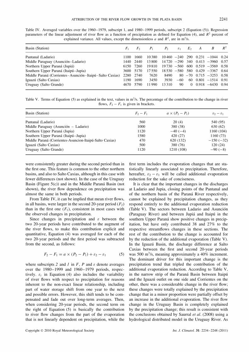
To examine the contribution of the rainfall-independentprocesses which contribute to runoff, εi , to the long-termtrends of river flows, their time series for each basin arepresented in Figure 4. εi evolves differently in each basin.In the northern ones, it increases with time but not always
Copyright 2010 Royal Meteorological Society Int. J. Climatol. 31: 2234–2248 (2011)

2240 M. E. DOYLE AND V. R. BARROS
Figure 3. Annual river flows (m3/s) as a function of annual precipitation (m3/s). Linear adjustments are shown. (a) Ladario, (b) Asuncion minusLadario, (c) Jupia, (d) Itaipu minus Jupia, (e) Corrientes minus Itaipu minus Salto Caxias minus Asuncion, (f) Salto Caxias and (g) Salto Grande.
during the same time period: in Jupia (Figure 4(d))augments during the 1960–1980 period, in the basinbetween Jupia and Itaipu (Figure 4(e)) it starts in 1970and in the two Paraguay Basins (Figure 4(b) and (c))between 1970 and 1990. In Salto Caxias (Figure 4(f)),the trend in εi only appears in the 1990s, while inthe Uruguay River (Figure 4(a)) and in the Paranasection between Itaipu and Corrientes (Figure 4(g)) there
are no trends at all. Except in these two basins, therest of them present a common feature: positive ε
mean values in the second 20-year period of the fourdecades and a negative one in the first (Table IV).Figure 5 exemplifies this feature showing streamflowsas a function of basin precipitation for the two 20-yearperiods in Jupia (Figure 5(b)) and Ladario (Figure 5(a))showing that for a given precipitation, the river flows
Copyright 2010 Royal Meteorological Society Int. J. Climatol. 31: 2234–2248 (2011)
ATTRIBUTION OF THE RIVER FLOW GROWTH IN THE PLATA BASIN 2241
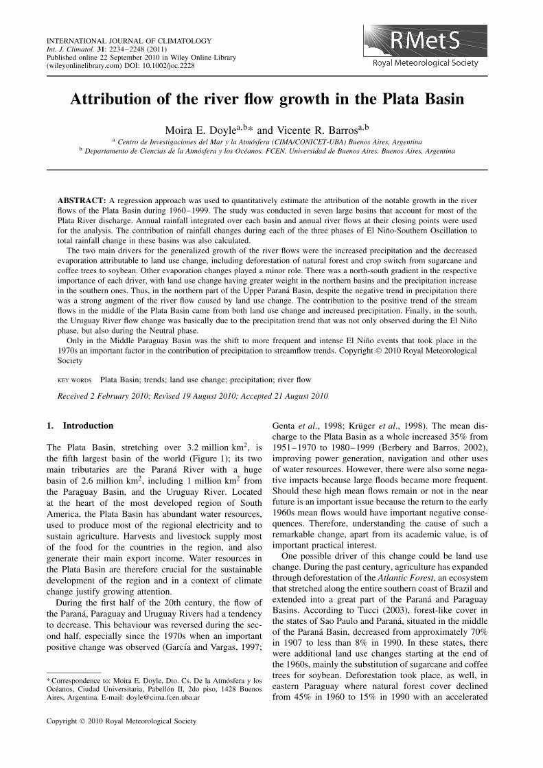
Table IV. Averaged variables over the 1960–1979, subscript 1, and 1980–1999 periods, subscript 2 (Equation (5)). Regressionparameters of the linear adjustment of river flow as a function of precipitation as defined for Equation (4), and R2 percent of
explained variance. All values, except the dimensionless a and R2, are in m3/s.
Basin (Station) F1 F2 P1 P2 ε1 E2 A B R2
Pantanal (Ladario) 1100 1660 10 380 10 460 −240 290 0.231 −1044 0.24Middle Paraguay (Asuncion–Ladario) 1440 2440 13 800 14 720 −290 340 0.413 −3960 0.57Northern Upper Parana (Jupia) 6150 7260 19 810 19 730 −560 600 0.519 −3569 0.58Southern Upper Parana (Itaipu–Jupia) 3600 5170 17 550 18 530 −580 580 0.429 −3367 0.64Middle Parana (Corrientes–Asuncion–Itaipu–Salto Caxias) 2280 2740 7620 8490 80 −70 0.715 −3253 0.58Iguazu (Salto Caxias) 1190 1690 3450 3930 −60 60 0.801 −1514 0.91Uruguay (Salto Grande) 4670 5790 11 990 13 310 90 0 0.918 −6430 0.94
Table V. Terms of Equation (5) as explained in the text, values in m3/s. The percentage of the contribution to the change in riverflows, F2 − F1 is given in brackets.
Basin (Station) F2 − F1 a × (P2 − P1) ε2 − ε1
Pantanal (Ladario) 560 20 (4) 540 (95)Middle Paraguay (Asuncion – Ladario) 1000 380 (38) 630 (62)Northern Upper Parana (Jupia) 1120 −40 (−4) 1160 (104)Southern Upper Parana (Itaipu–Jupia) 1580 420 (27) 1160 (73)Middle Parana (Corrientes-Asuncion-Itaipu-Salto Caxias) 470 620 (132) −150 (−32)Iguazu (Salto Caxias) 500 380 (76) 120 (24)Uruguay (Salto Grande) 1120 1210 (108) −90 (−8)
were consistently greater during the second period than inthe first one. This feature is common to the other northernbasins, and also to Salto Caxias, although in this case withfewer differences (not shown). In the case of the UruguayBasin (Figure 5(c)) and in the Middle Parana Basin (notshown), the river flow dependence on precipitation wasalmost the same in both periods.
From Table IV, it can be implied that mean river flows,in all basins, were larger in the second 20-year period (F2)than in the first one (F1), consistent in most cases withthe observed changes in precipitation.
Since changes in precipitation and ε between thetwo 20-year periods have contributed to the augment ofthe river flows, to make this contribution explicit andquantitative, Equation (4) was averaged for each of thetwo 20-year periods and the first period was subtractedfrom the second, as follows:
F2 − F1 = a × (P2 − P1) + ε2 − ε1 (5)
where subscripts 2 and 1 in F , P and ε denote averagesover the 1980–1999 and 1960–1979 periods, respec-tively. εi in Equation (4) also includes the variabilityof river flows with respect to precipitation for reasonsinherent to the non-exact linear relationship, includingpart of water storage shift from one year to the nextand possible errors. However, this shift tends to be com-pensated and fade out over long-term averages. Then,when considering 20-year periods, the second term onthe right of Equation (5) is basically the contributionto river flow changes from the part of the evaporationthat is not linearly dependent on precipitation, while the
first term includes the evaporation changes that are sta-tistically linearly associated to precipitation. Therefore,hereafter, ε2 − ε1 will be called additional evaporationreduction for the sake of conciseness.
It is clear that the important changes in the dischargesat Ladario and Jupia, closing points of the Pantanal andof the northern basin of the Parana River respectively,cannot be explained by precipitation changes, as theyrespond entirely to the additional evaporation reduction(Table V). The sectors between Ladario and Asuncion(Paraguay River) and between Jupia and Itaipu in thesouthern Upper Parana show positive changes in precip-itation, but have only contributed 38 and 27% to therespective streamflows changes in these sections. Therest of the contribution to the change is accounted forby the reduction of the additional evaporation (Table V).In the Iguazu Basin, the discharge difference at SaltoCaxias between the first and second 20-year periodswas 500 m3/s, meaning approximately a 40% increment.The dominant driver for this important change is theprecipitation trend that tripled the contribution of theadditional evaporation reduction. According to Table V,in the narrow strip of the Parana Basin between Itaipuand the Iguazu outlet on one side and Corrientes on theother, there was a considerable change in the river flow;these changes were totally explained by the precipitationchange that in a minor proportion were partially offset byan increase in the additional evaporation. The river flowchange in the Uruguay Basin is completely explainedby the precipitation change; this result is consistent withthe conclusions obtained by Saurral et al. (2008) using ahydrological distributed model in the Uruguay River. As
Copyright 2010 Royal Meteorological Society Int. J. Climatol. 31: 2234–2248 (2011)
2242 M. E. DOYLE AND V. R. BARROS
Figure 4. Annual difference between observed river flows and those estimated with a linear function of precipitation (m3/s). (a) Ladario,(b) Asuncion minus Ladario, (c) Jupia, (d) Itaipu minus Jupia, (e) Salto Caxias, (f) Corrientes minus Itaipu minus Salto Caxias minus Asuncion
and (g) Salto Grande.
a synthesis, it can be concluded that the general patternof change in the river flows responded to a decrease inthe additional evaporation in the north of the Plata Basinand an increase in the precipitation in the south.
The additional evaporation may result from changes inmeteorological conditions or ground conditions. Beingan area where winds are relatively weak, humidity,
temperature and radiation are the remaining meteorolog-ical variables to be considered. A difficulty frequentlyencountered in assessing evaporation is the absenceof adequate observations of these meteorological vari-ables; hence, some formulas were developed to assesspotential evapotranspiration as a function of mean tem-perature, daily temperature range (DTR) or both plus a
Copyright 2010 Royal Meteorological Society Int. J. Climatol. 31: 2234–2248 (2011)

ATTRIBUTION OF THE RIVER FLOW GROWTH IN THE PLATA BASIN 2243
Figure 5. Annual river flows (m3/s) as function of annual precipitation (m3/s). Linear adjustments for the 1960–1979 period (grey triangle) andfor 1980–1999 (black circle). (a) Ladario, (b) Jupia and (c) Salto Grande.
geographical estimate of solar radiation (Thornthwaite,1948; Blaney and Criddle, 1950; Turc, 1961; Hargreaveset al., 1985; Asanuma and Kamimera, 2004). Thesemethods were tested by different authors and in general,give a good estimate of the annual mean evapotranspi-ration some of them with a 10% error (Xu and Singh,1998).
In the five basins where additional evaporationaccounts for a major or important fraction of the changes
in the river flows, the differences between the mean tem-peratures averaged over each of the two 20-year periodswere very small. They range between −0.2 and 0.1 °C,with the exception of the Upper Parana Basin, where thewarming was 0.5 °C. DTR changes were always negative,ranging from −0.1 to −0.4, but the trends were nei-ther significant nor spatially homogeneous as reported byVincent et al. (2005). Although, as a first-order approx-imation, these temperature changes seem small to make
Copyright 2010 Royal Meteorological Society Int. J. Climatol. 31: 2234–2248 (2011)

2244 M. E. DOYLE AND V. R. BARROS
Table VI. Terms of Equations (8) and (9) as explained in the text, values in m3/s. The percentage of the contribution to thechange in the river flows, F2 − F1 is given in brackets.
Basin (Station) E2 − ε1 c × (T2 − T1) δ2 − δ1 e× (DTR2− DTR1) γ2 − γ1
Pantanal (Ladario) 540 (95) 10 (2) 530 (93) 160 (29) 380 (66)Middle Paraguay (Asuncion–Ladario) 630 (62) 60 (6) 570 (56) 170 (17) 470 (45)Northern Upper Parana (Jupia) 1160 (104) 490 (44) 670 (60) 300 (27) 860 (77)Southern Upper Parana (Itaipu–Jupia) 1160 (73) 60 (3) 1100 (70) 190 (12) 970 (61)Iguazu (Salto Caxias) 120 (24) 0 120 (24) 20 (4) 100 (20)
an important contribution to the river flow growth, thisassumption was checked following the same procedureapplied to precipitation. Thus, a linear approximation wasassumed:
εi = c × Ti + d + δi (6)
εi = e × DTRi + f + γi (7)
This means a two-step linear regression, which is justifiednot only because it allows to pack all processes linearlyrelated to precipitation in the first step but also becausein this way the lower quality of temperature data doesnot contaminate the regression model described by Equa-tion (4). After averaging Equations (6) and (7) for eachof the two 20-year periods, the first period is subtractedfrom the second obtaining:
ε2 − ε1 = c × (T2 − T1) + (δ2 − δ2) (8)
ε2 − ε1 = e × (DTR2 − DTR1) + (γ2 − γ1) (9)
Table VI presents each term of Equations (8) and (9) forupper and middle Paraguay, upper Parana and IguazuBasins. In general, the contribution of mean temperaturechanges to river flow changes is considerably lowerthan the contribution of nonlinear temperature processesrepresented by the second term on the right side ofEquation (8). The exception is the northern Upper Paranawhere this contribution reaches 44% of the flow changenonlinearly dependent on precipitation. The contributionto the river flow changes by the daily temperature rangechange is higher than in the case of temperature, butstill considerably lower than that of the remaining term(Table VI).
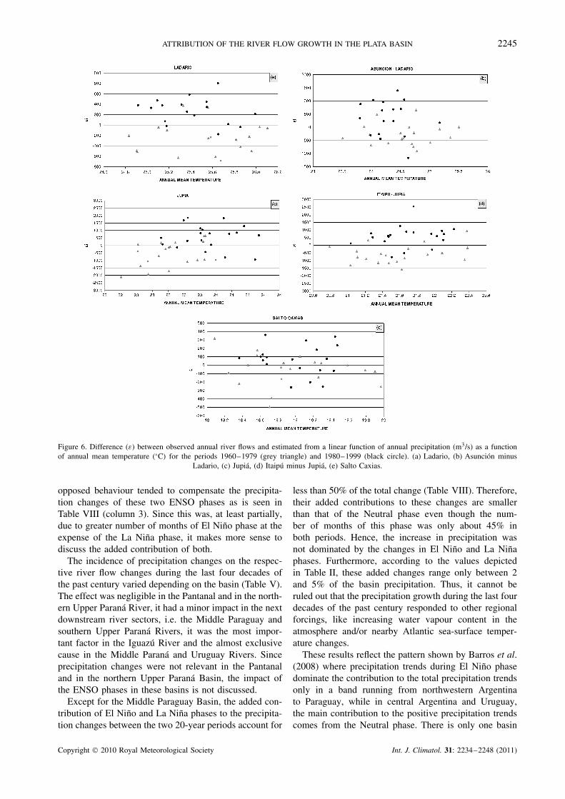
The low explained variance (R2) of the linear regres-sions for each sub-basin indicates that ε has a weak lineardependence on temperature and DTR. In the Pantanal,temperature only explains 2% of the additional evapora-tion and DTR 18%; in the Middle Paraguay Basin, thevariance explained by temperature and DTR are 0.03 and0.11, respectively. R2 is somewhat higher in the case oftemperature in the Northern Upper Parana, 0.19, but it isstill similar for DTR, 0.10; for the Middle Upper Paranathey are very low, 0.07 and 0.05 and for the Iguazu evenlower, 0.02 in both cases.
The above is confirmed by Figures 6 and 7 which showthe ε values for the two 20-year periods as a functionof temperature and DTR, respectively. It is clear that
the main changes in ε are time dependent, (Figure 4)and are reflected on the overall differences between thetwo periods with almost independence of the temperaturevariables, except from a weak dependence in some cases.Results shown in Figures 6 and 7 and Table VI imply thatmost of the contributions to river flow augment betweenthe two 20-year periods that were not explained byrainfall changes were not caused by change in the otherclimate variables. Therefore, they should be attributed tothe remaining process, i.e. changes in evapotranspirationrelated to the vegetation cover, which modify runoffand vary the time that water could be available forevaporation. Table VII summarizes the estimated valuesand ranges of the contribution of the drivers to the riverflow increase.
6. The ENSO phases and streamflow trends
It is well known that anomalous precipitations in south-eastern South America, a region that includes the PlataBasin, are related to ENSO phases, generally with morerainfall during El Nino and less during La Nina. It isalso known that averaged flows during El Nino eventswere greater than those during La Nina episodes in theUruguay River (Robertson and Mechoso, 1998), as wellas in the Parana River (Berri et al. 2002).
The number of months defining the positive andnegative phases of ENSO was higher (lower) for ElNino (La Nina) during the 1980–1999 period than during1960–1979, namely 87 (49) versus 72 (61). Thus, ElNino months became more frequent during the second20-year period at the expense of La Nina months.Consequently, the number of months of the Neutral phasepractically did not change, being 107 months in the first20-year period and 104 in the second, which representsabout 45% of the total months in each case.
To assess the streamflow changes originated by rainfalltrends caused by ENSO changes, precipitation was aver-aged over each basin considering separately El Nino, LaNina and Neutral phases. Because of the longer (shorter)period of the El Nino (La Nina) phase during 1980–1999,more (less) precipitation should be expected in this periodthan in 1960–1979 as indeed was observed (Table VIII).In addition to the change in the number of months of eachof this two ENSO phases, changes in the mean monthlyrainfall could also have contributed to their different pre-cipitation in each period. But, whatever the cause, this
Copyright 2010 Royal Meteorological Society Int. J. Climatol. 31: 2234–2248 (2011)
ATTRIBUTION OF THE RIVER FLOW GROWTH IN THE PLATA BASIN 2245
Figure 6. Difference (ε) between observed annual river flows and estimated from a linear function of annual precipitation (m3/s) as a functionof annual mean temperature (°C) for the periods 1960–1979 (grey triangle) and 1980–1999 (black circle). (a) Ladario, (b) Asuncion minus
Ladario, (c) Jupia, (d) Itaipu minus Jupia, (e) Salto Caxias.
opposed behaviour tended to compensate the precipita-tion changes of these two ENSO phases as is seen inTable VIII (column 3). Since this was, at least partially,due to greater number of months of El Nino phase at theexpense of the La Nina phase, it makes more sense todiscuss the added contribution of both.
The incidence of precipitation changes on the respec-tive river flow changes during the last four decades ofthe past century varied depending on the basin (Table V).The effect was negligible in the Pantanal and in the north-ern Upper Parana River, it had a minor impact in the nextdownstream river sectors, i.e. the Middle Paraguay andsouthern Upper Parana Rivers, it was the most impor-tant factor in the Iguazu River and the almost exclusivecause in the Middle Parana and Uruguay Rivers. Sinceprecipitation changes were not relevant in the Pantanaland in the northern Upper Parana Basin, the impact ofthe ENSO phases in these basins is not discussed.
Except for the Middle Paraguay Basin, the added con-tribution of El Nino and La Nina phases to the precipita-tion changes between the two 20-year periods account for
less than 50% of the total change (Table VIII). Therefore,their added contributions to these changes are smallerthan that of the Neutral phase even though the num-ber of months of this phase was only about 45% inboth periods. Hence, the increase in precipitation wasnot dominated by the changes in El Nino and La Ninaphases. Furthermore, according to the values depictedin Table II, these added changes range only between 2and 5% of the basin precipitation. Thus, it cannot beruled out that the precipitation growth during the last fourdecades of the past century responded to other regionalforcings, like increasing water vapour content in theatmosphere and/or nearby Atlantic sea-surface temper-ature changes.
These results reflect the pattern shown by Barros et al.(2008) where precipitation trends during El Nino phasedominate the contribution to the total precipitation trendsonly in a band running from northwestern Argentinato Paraguay, while in central Argentina and Uruguay,the main contribution to the positive precipitation trendscomes from the Neutral phase. There is only one basin
Copyright 2010 Royal Meteorological Society Int. J. Climatol. 31: 2234–2248 (2011)

2246 M. E. DOYLE AND V. R. BARROS
Figure 7. As Figure 6, but for mean annual daily temperature range.
Table VII. Estimated contribution (%) to the river flow growth from 1960–1979 to 1980–1999.
Basin (Station) Precipitationrelated
Other climatevariables
Landuse
Pantanal (Ladario) 5 6–17 43–56Middle Paraguay (Asuncion–Ladario) 38 27–44 69–77Northern Upper Parana (Jupia) −4 27–44 60–67Southern Upper Parana (Itaipu–Jupia) 27 3–12 61–70Middle Parana (Corrientes–Asuncion–Itaipu–Salto Caxias) >100 <0Iguazu (Salto Caxias) 76 0–4 20–24Uruguay (Salto Grande) >100 <0
where the precipitation increase during El Nino andLa Nina phases was greater than during the Neutralphase, i.e. in the Middle Paraguay Basin. However, itsimpact on the river flow change, according to Table VIII,Equation (5) and the value of a (Table IV), was 230 m3/s,which was merely 23% of the streamflow increment.In the rest of the Plata Basin, the precipitation trendsassociated with ENSO changes were not important in thestreamflow changes of the last four decades of the 20thcentury.
7. Concluding remarks
The great enhancement of river flows in the Plata Basinduring the last four decades of the 20th century wasdriven by three factors: a positive trend in precipitationover most of the basin, a negative evaporation trend thathas a land use change footprint and a minor contributionfrom changes of other climate variables. As seen inTable VII, the relative contribution of these drivers variesthroughout the basins.
Copyright 2010 Royal Meteorological Society Int. J. Climatol. 31: 2234–2248 (2011)

ATTRIBUTION OF THE RIVER FLOW GROWTH IN THE PLATA BASIN 2247
Table VIII. Difference of the integrated precipitation (m3/s) for the indicated basins from 1960–1979 to 1980–1999 for El Ninoand La Nina phases and precipitation change rate of El Nino plus La Nina with respect to the total precipitation change.
Basin (Station) Nino Nina Nino + Nina Rate(%)
Middle Paraguay (Asuncion–Ladario) 1320 −760 560 66Southern Upper Parana (Itaipu–Jupia) 1490 −1080 410 40Middle Parana (Corrientes–Asuncion–Itaipu–Salto Caxias) 770 −390 380 45Iguazu (Salto Caxias) 360 −190 170 35Uruguay (Salto Grande) 1162 −581 581 45
In the northern part of the Upper Parana Basin, land usechange including deforestation was the main driver thatcompensates and overweighs the negative rainfall trend,but it is likely that changes in climate variables, otherthan precipitation, played a complementary role. Thisresult is consistent with the deforestation process (Volpi,2008) during the last decades of the past century that ledto less evapotranspiration as pastures and crops replacednatural vegetation. In the southern Upper Parana Basin,land use change was also the dominant driver in the riverflow increase, but in this case, the positive precipitationtrend also contributed although in minor proportion. Inthis sense, this basin presented an intermediate behaviourbetween the northern part of the Upper Parana and south-ernmost basins where rainfall trends were the dominantdriver in the river flow enhancement. The attribution toland use change in the southern Upper Parana Basin isconsistent with the substitution of sugarcane and coffeetrees for soybean that took place in Brazil (Tucci, 2003)and the deforestation in eastern Paraguay (Coronel et al.,2006).
In the Pantanal, where poor data availability is animportant source of uncertainty, it seems that the domi-nant driver was also land use change, although perhapswith some contribution from changes in climate variables,other than precipitation. In fact, this region underwent arapid transformation from a natural state to large-scalecattle raising. In the Middle Paraguay Basin, both landuse change and a positive precipitation trend contributedto the river flow growth.
In the southernmost basins here considered, the MiddleParana and Uruguay Basins, changes in the river flowwere caused by precipitation trends with an insignificantcontribution from land use change. In the case of theIguazu Basin, there was an intermediate situation with amajor contribution from the rainfall trend and to a lesserdegree from land use change.
The change of the PDO to a positive phase that tookplace in the mid 1970s was accompanied by more fre-quent and intense El Nino events. However, in the south-ern Upper Parana, Middle Parana, Uruguay and IguazuBasins, where rainfall trends contributed appreciably tothe river flow growth, precipitation changes caused byEl Nino and La Nina phases were not higher than thoseproduced by the Neutral phase. The Middle Paraguaywas the only basin where the impact of El Nino and LaNina phases on precipitation was important, resulting ina considerable contribution to the river flow growth.
In the southern basins, Middle Parana, Iguazu andmiddle Uruguay, the relative importance of trends duringENSO phases was less significant, due to the incidenceof other forcing processes. One of them could be thesouthern shift of the South Atlantic High’s westernborder, likely related to climate change (Di Luca et al.,2006), that brought about higher summer rainfall overthese basins (Barros et al., 2008).
These results have implications for the assessment ofnear future streamflows. On the one hand, it can be arguedthat the fraction of river flow changes owed to land usechange may not vary substantially in the future, becausethere is little room left for great changes. On the other,in the basins where precipitation played a dominant rolein the river flow growth, except in the Middle ParaguayBasin, changes related to ENSO interdecadal variabilitywere not the main cause of rainfall trends, and thereforethis interdecadal variability would not be a source ofmajor changes.
Evaporation changes were only assessed indirectlythrough temperature, precipitation and streamflows dueto the lack of other meteorological data. This is a sourceof uncertainty, particularly in regions where temperatureobservations were scarce. The use of hydrological modelsis an alternative and important approach to the issuesaddressed here. They have obvious advantages, but alsoserious limitations given the scarcity of data in largeareas of the Plata Basin. Thus, the use of complementaryapproaches like the one developed here helps to increaseconfidence in results obtained from models. This is thecase of the Uruguay River, where Saurral et al. (2008)using a distributed model arrived to the same conclusionsas in this article.
Acknowledgements
The research leading to these results has received fundingfrom the European Community’s Seventh FrameworkProgramme (FP7/2007-2013) under Grant Agreement N°
212492; UBACYT grant X033.
ReferencesAceituno P. 1988. On the functioning of the Southern Oscillation in
the South American sector. Part I: surface climate. Monthly WeatherReview 116: 505–524.
Asanuma J, Kamimera H. 2004. Long-term trends of the PanEvaporation as an index of the global hydrological change.Symposium on Water Resource and Its Variability in Asia in the21st Century. Epochal, Tsukuba. Japan.
Copyright 2010 Royal Meteorological Society Int. J. Climatol. 31: 2234–2248 (2011)

2248 M. E. DOYLE AND V. R. BARROS
Barros V, Castaneda E, Doyle M. 2000. Recent precipitation trendsin southern South America to the east of the Andes: an indicationof a mode of climatic variability. In Southern Hemisphere Paleoand Neoclimates Key – Sites, Methods, Data and Models, Springer:Berlin.
Barros V, Doyle M, Camilloni I. 2008. Precipitation trends insoutheastern South America: relationship with ENSO phases andwith low-level circulation. Theoretical and Applied Climatology 93:19–33.
Blaney HF, Criddle WD. 1950. Determining water requirements inirrigated areas from climatological and irrigation data. USDA SoilConservation Service Tech., Paper No. 96, pp. 48.
Berbery EH, Barros V. 2002. The hydrologic cycle of the La Platabasin in South America. Journal of Hydrometeorology 3: 630–645.
Berri GJ, Ghietto MA, Garcıa NO. 2002. The influence of ENSO inthe flows of the Upper Parana River of South America over the past100 years. Journal of Hydrometeorology 3: 57–65.
Bertoni JC, Maza JA, Paoli CU. 2003. Inundaciones y drenaje urbanoen la Argentina (Urban floods and drainage in Argentina).Inundacoes Urbanas na America do Sul (Urban Floods in SouthAmerica), Tucci CEM, Bertoni JC (eds). Brazilian Water ResourcesAssociation: Porto Alegre, Brazil.
Castaneda ME, Barros V. 1994. Las tendencias de la precipitacion enel Cono sur de America al Este de los Andes (Precipitation trends inthe south cone of South America east of the Andes). Meteorologica19: 23–32.
Collischonn W, Tucci CEM, Clarke RT. 2001. Further evidence ofchanges in the hydrological regime of the River Paraguay: part ofa wider phenomenon of climate change? Journal of Hydrology 245:218–238.
Coronel G, Menendez A, Chamorro L. 2006. Fisiografıa e hidrologıade la Cuenca del Plata (Physiography and hydrology of La Platabasin). In El Cambio Climatico en la Cuenca del Plata, Barros V,Clarke R, Silva Dias P (eds). CIMA-CONICET: Buenos Aires;81–92.
Cressie NC. 1991. Statistics for Spatial Data, John Wiley and Sons:New York.
Di Luca A, Camilloni I, Barros V. 2006. Sea-level pressure patterns inSouth America and the adjacent oceans in the IPCC AR4 models. In8th International Conference on Southern Hemisphere Meteorologyand Oceanography. AMS. 235–244.
Garcıa NO, Vargas W. 1997. The temporal climatic variability in theRio de la Plata basin displayed by river discharges. Climate Change102: 929–945.
Genta JL, Perez-Iribarren G, Mechoso CR. 1998. A recent increasingtrend in the streamflow of rivers in southeastern South America.Journal of Climate 11: 2858–2862.
Grimm AM, Barros VR, Doyle ME. 2000. Climate variability insouthern South America associated with El Nino and La Nina events.Journal of Climate 13: 35–58.
Hamilton SK. 1999. Potential effects of a major navigationproject (Paraguay-Parana Hidrovıa) on inundation in the Pantanalfloodplains. Regulated Rivers: Research and Management 15:289–299.
Haylock MR, Peterson TC, Alves LM, Ambrizzi T, Anunciacao YMT,Baez J, Barros VR, Berlato MA, Bidegain M, Coronel G, CorradiV, Garcia VJ, Grimm AM, Karoly D, Marengo JA, Marino MB,Moncunill DF, Nechet D, Quintana J, Rebello E, Rusticucci M,Santos JL, Trebejo I, Vincent LA. 2006. Trends in total and extremeSouth American rainfall in 1960–2000 and links with sea surfacetemperature. Journal of Climate 19: 1490–1512.
Hargreaves GH, Samani ZA. 1985. Reference crop evapotranspirationfrom temperature. Applied Engineering in Agriculture 1(2): 96–99.
Hidroservice–Louis Berger–EIH. 1996. Estudios de FactibilidadTecnica y Economica de Obras de Ingenierıa a Corto, Mediano yLargo Plazo Hidrovıa de los Rıos Paraguay y Parana (Technicaland economic feasibility study for the short, medium and longterm engineering. Waterway of the Parana-Paraguay rivers). DigitalReport for Intergovernmental Committee of the Waterway of theParana-Paraguay Rivers, Buenos Aires.
Kruger C, Kaviski E, Muller I. 1998. Analise de estacionariedade deseries hidrologicas na bacia incremental de Itaipu. (Analysis of thestationarity of hydrological series in the incremental basin of Itaipu).Revista Brasileira de Recursos Hıdricos 3(4): 51–71.
Mantua NJ, Hare SR, Zhang Y, Wallace JM, Francis RC. 1997. APacific interdecadal climate oscillation with impacts on salmonproduction. Bulletin of the American Meteorological Society 78:1069–1079.
Matsuura K, Willmott CJ. 2009. Terrestrial Air Temperature: 1900-2008 Gridded Monthly Time Series, Version 2.01. Department ofGeography, University of Delaware. Available from http://climate.geog.udel.edu/∼climate/html pages/archive.html. [accessed Novem-ber 2009].
Rao VB, Hada K. 1990. Characteristics of rainfall over Brazil: annualvariations and connections with the Southern Oscillation. Theoreticaland Applied Climatology 42: 81–91.
Ropelewski CH, Halpert MS. 1987. Global and regional scaleprecipitation patterns associated with the El Nino/SouthernOscillation. Monthly Weather Review 115: 1606–1626.
Robertson AW, Mechoso CR. 1998. Interannual and decadal cycles inriver flows of southeastern South America. Journal of Climate 11:2570–2581.
Sahin MJ, Hall MJ. 1996. The effects of afforestation and deforestationon water yields. Journal of Hydrology 178: 293–309.
Saurral RI, Barros VR, Lettenmaier DP. 2008. Land use impact on theUruguay River discharge. Geophysical Research Letters 35: L12401,DOI: 10.1029/2008GL033707.
Thornthwaite CW. 1948. An approach toward a rational classificationof climate. Geographical Review 38: 55–94.
Trenberth KE. 1997. The definition of El Nino. Bulletin of the AmericanMeteorological Society 78: 2271–2777.
Tucci CEM. 2003. Variabilidade climatica e o uso do solo na baciabrasileira do Prata (Climate variability and land use in the BrazilianPlata basin). In Clima e Recursos Hıdricos no Brasil (Climate andWater Resources in Brazil), ABRH , 9. Tucci CEM, Braga BPF (eds).Associacion Brasilera de Recursos Hidricos: Porto Alegre, Brazil,pp 163–242.
Turc L. 1961. Estimation of irrigation water requirements, potentialevapotranspiration: a simple climatic formula evolved up to date.Annales Agronomique 12: 13–49.
Vincent LA, Peterson TC, Barros VR, Marino MB, Rusticucci M,Carrasco G, Ramirez E, Alves LM, Ambrizzi T, Berlato MA,Grimm AM, Marengo JA, Molion L, Moncunill DF, Rebello E,Anunciacao YMT, Quintana J, Santos JL, Baez J, Coronel G,Garcia J, Trebejo I, Bidegain M, Haylock MR, Karoly D. 2005.Observed trends in indices of daily temperature extremes in SouthAmerica 1960–2000. Journal of Climate 18: 5011–5023.
Volpi G. 2008. Brazil case study. In Themba Report Contribution to theGallagher Report (Report Authors Jeremy Woods and Mairi Black).UK. Available from http://www.renewablefuelsagency.gov.uk/sites/renewablefuelsagency.gov.uk/files documents/Themba Local landuse change impacts and opportunities.pdf. [accessed September2010].
Vose RS, Schmoyer RL, Steurer PM, Peterson TC, Heim R, Karl TR,Eischeid J. 1992. The Global Historical Climatology Network : Long-term MonthlyTemperature, Precipitation, SeaLevel Pressure, andStation Pressure Data, ORNL/CDIAC-53, NDP-041. CarbonDioxide Information Analysis Center, Oak Ridge NationalLaboratory: Oak Ridge.
Willmott CJ, Matsuura K. 2001. Terrestrial air temperature andprecipitation monthly and annual time series (1950–1999) Version1.02. (http://climate.geog.udel.edu/∼climate) [accessed November2009].
Xu CY, Singh VP. 1998. Dependence of evaporation on meteo-rological variables at different time-scales and intercomparisonof estimation methods. Hydrological Processes 12: 429–442,DOI: 10.1002/(SICI)1099-1085(19980315)12:3<429::AID-HYP581>3.0.CO;2-A.
Zhang Y, Wallace JM, Battisti D. 1997. ENSO-like interdecadalvariability: 1900–1993. Journal of Climate 10: 1004–1020.
Copyright 2010 Royal Meteorological Society Int. J. Climatol. 31: 2234–2248 (2011)