Attachment-O-Alameda-Point-Specific-Plan
137
-
Upload
alamedapointinfo -
Category
Documents
-
view
213 -
download
1
description
Specific Plan provides detailed description of plans. Similar to Community Plan, Attachment F.
Transcript of Attachment-O-Alameda-Point-Specific-Plan


LE ENTS
INTRODUCTION PAGE TRANSPORTATION , CIRCULATION , AN1 . Plan Purpose 1 -
PARKING
Project Location and Plan Area 1 - IntentLand Ownership Public Street System
1.4 Plan Objectives Transit SystemProject Description 5.4 Ferry ServiceAuthority 1 - Pedestrian and Bicycle SystemsRelationship to Existing Plans and Facilitiesand Regulations Transit Hub and TransportationPrior Alameda Point Plans and Management Coordinatorthe Community 5.7 Truck Routes
ParkingPLAN BACKGROUND Phasing of Transportation Improvements
IntroductionUTILITIES AND IN CTUREDevelopment ConsiderationsIntroduction
lAND USE GradingStorm Drainage and Water Quality
I ntrod uction Sanitary SewerIntent Water Supply and DistributionLand Use Program Energy
3.4 Historic Resources Solid Waste DisposalAffordable Housing 3.. Phasing of Utility SystemsPermitted Uses
DEVELOPMENT STANDARDSOPEN AND CONSERVATION
4..IntentIntentBuilding Type GlossaryNeighborhood Parks
Community Parks Building Heights4.4 Linear Open Space 4.. 7.4 Development Standards 7..
Seaplane Lagoon Waterfront Park Parking Standards 7 -
Alameda Point Sports Complex 4.. Environmental SustainabilityEnterprise Regional Park Building Strategies 7..
Conservation of Natural Resources

TS (CONTINUED)
IMPLEMENTATION PAGE
Introduction 8..Fiscal Neutrality
Public Facilities Financing SourcesImplementation Proposal for KeyPublic Improvements 8..Phasing 8..Maintenence and Operations 8..
8.7 Public Transit
Other Services
PLAN REVIEW
Entitlement Process 9..Relationship to CEQASubdivision Mapping Process 9..
9.4 Use Permits 9..Design ReviewHistoric Preservation Review Process 9..
9.7 Density Bonus 9..Amendments to the Specific Plan 9..Conformance Determinations 9..Hearing Notice 9..Matters of InterpretationSeverability 9..Specific Plan Compliance and Enforcement 9..
3..
6..6..
7..7..7..
LIS F T BL SLand Use SummaryPermitted Uses by Land Use CategoryParks and Open SpaceWastewater Facility CapacityProjected Wastewater FlowsSolid Waste ProjectionsDevelopment StandardsAllowable Building TypesParking StandardsImplementation Proposal forKey Public Improvements
PAGE
6..
6..7..7..7 -

~~~
,,==
uuu,u=,u
u,"""==
u,w_,,
u=-=
,-"-,,",
""='"
'"
UJ
a:
..
LL
L
I
I-
'"
1 "i
e: i CD
D. I
"=u
=m
"u=" '"=
"==
,='u ""=
'-"
N ('
f' CO
CD CD CD CD
'u'==
u'U_"'=
U' ==
"==
-=""""'-'",
,,,,==
""",=f"'
"=''=
"-'=
-,,.,,,,,,=
=,,,"",=
,=-=
=,u_-=
-=
-==
,-,,,=,,,"'=
"==
="''""uu""'""="""'"'=
"m ,="""",,
! c.t'CO
(j ~~~~~~~
J I
I I' I' I' I' I' I' I' I' I' I' I'
e: I::1 1-1. 01 :: I e: i
1-1
CJ I
e: 1
e:1 LLI E
ro E
ZI Q
):! Q) E
--I 1;
c;.. w
t)C I ;:
CU
. U5 ;:
U) (j U
);:U)
, (I 2 0.
(j
e: I OJ.- Q
) '- Q)
CJ I
Cl3:
i .-
Q) CU
OU
)$"O1-10 O
JC'(I
:: 1
19 :0 (3
, -
.- CU ;:
I o.!! e:
XC
UO
Q)
:: I
U)
U)o.
1 .. N (V
"' L!(01 CD CD CD CD CD
G :
e: 1 .. ..
D. I
;:: 5
o i
:: I. ()
.3m0: t)
z' 0.-
- i 0. 0.
i"'"'
I Q)
CJ I
ell-e: I g'
Q) (I
e: 1'- 0. 0.
C l;g
zlci O
JOJ
1"0 "0 "0
CJI
(I S S
1-1 aJO
Jz I '(1- 35(1
WIO
OJ::gs
::1 ;:.0 0
D.I =
"0 ~ ~
E=
e:e:01 cuci3 $
.. ILL
w
i cb x.. I - (I Q
)=.- I
OJ"Q
OJ
I .
:: .roE
c, U
) 0 ..(j
, ..
r-., l"
(I Q)
0. 0.
Q) OJ OJ
Q) 0. e: .
0. ;: '6 :Q
;: ='
I- OJ
OJ (I e:
e: 0.'- - co
Q) 0..- ;:
:Q cu .-
;g I- 'S I
I- OJei OJOJ (I E
OJ e:
Q) E
e:'62:Q OJE
:0 = co '
0 0
=ciL
LO
Jcuooci 0
. ;:;: (9;:
(I = =
"0 :! '"O
EE
Q)C
foe:cuco"O$::,+
,+'20
:: :...
(."5"5E 3: OJ
::
:2 :2 w .3
a ..N
(V "' L
! CD I' co 0) .. ..
I' I' I' I' I' I' I' I' I' I'
' N (' "'
1 N N
N
I. (10Cf LL
0: (IQ5 .
zl
ff
GI 5
U)
-g =
co cu -ge:
() Cf 0.
IX I ' c .
, ~ cu 'zl
"Q 0.
e:1 15 15
..I (I 0 D
. i (9 LL
1 '" '; "?
iNN N
I N (V
"' L! CD
coI .J .J .J .J .J .J
I- I
e: I::1e:1 W
i eI I
zl
01 o I ~
c I 0 Z
I 3: e:1
Q)
cu O
ILL
~"Ocog,
e: I Q) ro 0 0. co 0.
D.I
()o. O;:..E
CJ!
z,U)cuQ
) 2 .2' E cu 0
0. cu Q) 0 (I 0.
,0(9Z0U
)U)
1 .. N (V "' L! CD
.q 1 .J .J .J .J .J .J
::\
:: I ()
I :s
;:1 W
i e:10:
l .
e: I 0
..!
D. I
0) I 0)
I- e: o GI
D. z
eI -
z~1
I- D. I
i co
, 0)
I (V "' "'
I L! L! L!
ON
"'CD CD I' I' co co .... ..
L! L! L! L! L! L! L! L! L!
U)
c: -+
0
Q) 0
EQ
)
(. -
o.ZC
U CU O
0. -
a; co
Q)
U)
Q)
;; .-:: ;:
e:
'(
Q).)
o._Q) 0Cf
Q)o. $
0U)0.
:; CU~ 0---
"0"00::; 0. 0
Q)
coU)
Q). Q)
E ()
Q) rf - e:
()
1: 0. Cf
2:;"5 co e:.3 B Q
)"02(I e: 0 - .. 0
e:::OJ5.80;:.. OCUO
U)-
..() cu - 0: co 't Q) coS
co :!
&$ U
5 . 1: 2
1:' Q) .1: ;:.
0. . Q) 0. cu 0
0. e: 0.
cu () ::U5 $
$ 0
ii
a .. NI .. N (V "' L! CD I' co 0) .. .. .,
I I. I
J,J, J, J, J, J, J,
1 L! L! L! L! L!

, \,.)
.. c
/Justrative Plan
\/:
'0'
:- \\
j f" J
-..
-- w .. 1 ;iri:,
.. "' .... !j ...
. -A
, , ,') , / "'. . '" - ..' ;" ..",'-""'
I-r '''l:a.
.. "' ,,. .
.i",..:
= - ::.' , ' - ..
L.
.. -
r", .
: . "', , - ' .- "... . -- - ... - ) . 'j
. c ::. I -
- - .- " ,..
" I
, ,
, r. ,;.;. .
"" ',
fii of.
"" ' '-
! t 11 -" '
.. '
11 (
:. -'
f",;O:
"" . ' "''
i t
OAKLftJ'1J f!.$TUA/bY
\ '
oW.
" -
- - r ,J.
=- .. --'\
., - r ,.- 1 ." ..
.. "'
r; l'
?"' .
"1 " e: 6. Q;
0, '-liP ",p J't. '" 4 f$..o.\(\4
""
!l
=:-::-= --
r j. ..J0 ' l1f1-L,II .J. \Ofl
; I
SEAPLANELA GOO N
SAN FRANCISCO BAY
Alameda Poi n Specific P I a n
FERRY../TERMINAL
"".-, .
"1-
. tJ'
;-r -
. ..: .,
y i 111 r!:
\.
--vC'ii
. :;
w;
- '
Yo""
'!'
'-Tj
: ',,,
): 1-
' .
68. ,
-'
;..t t. e!11 -
\,
, I
.; -! . ,
I' "'
:" .:-' . "",
1i-
, ..
o . & D \ . i' !i
.: (I
",
I :=.
::;'
:r',
Not to ScaleNorth

an achievable vision
The Naval Air Station 997 after 6
US. theuse.
the area now Alameda Point been discussed but litle
progress resultedof the
contaminated soil and
environmental Naval Air Station was declared
must be cleaned
contaminants
human health
and
In order to
laws to
for
Without
to come.
and
are the
environment if quo
costs
for
either
New
The

transformed and not be resources.
contamination.cleaned
New Alameda Point water, sewer, storm wil not
the
The
new andand will allow for
wil natural resources and
It wil all Alamedans with recreation and
wil mixed transit-oriented
in the heart of the Area. The Alameda Point Plan offers
modesserved
to the rest of Alameda bike and
sidewalks and tf7e via BART and buses. The
many sustainable methods for water and energy
as residents wilAlameda Point wi! be
of convenient recreation and entertainment
near homes. An has been
tree- lined streets residents. and are
within easy distance. New will also create
commutes for some Other Alamedans wil be
the cluster of activities and close
open well as created
the Alameda Point.
All Alamedans
reclaimed for
some former NAS
wi!
where
This set
Point Plan.
Point
way of life in the
make
benefits
Introduction
and
enhances
that led
Plan
for

3: Land Use identifes the
of/he new land uses. It shows how the
densities and intensities
mixed use , transit-
oriented and lists
uses.
and Conservation on the
andchamc rof e open space and elements of the new
and amenities are
illustrated and conservation of natural
of Public lands addressed.
Circulation and
that will facilitate
addresses all
of the modes around.
shown tmnsit facilities the
for and on-street and in open spaces are
introduced. The many functions of new muft-modal
that is intended to attract numbers transit
users The transit
described.
6. Utilties and Infrastructure maps out new
that needed for storm
and gas and
and flood
telecommunications. technical theseforThe
solutions is offered.
that wi!
and character of
standards that
codifed.
illustrated.
that
construction
identified and
future
and historic
Plan when
future
9: Plan


1 PLAN PURPOSE
This Alameda Point Specific Plan ("Specific Plan ) is aplan to redevelop a
portion of the former Naval Air Station Alameda ("former NAS Alameda ) that
the United States of America , acting by and through the U.S. Navy ("Navy
has decommissioned. The Navy is expected to convey the land to the
Alameda Reuse and Redevelopment Authority ("ARRA" ) in the near term.
This Specific Plan , once adopted by the voters of the City of Alameda , will
reflect the City s commitmentto a successful public/private partnership for
the redevelopment of the former NASAlameda. A companion document , the
Alameda Point Community Plan, when adopted by the voters of the City of
Alamedaasa nl3W Chapter 11tothe General Plan , will address the unique
general plan goals and policies for the "Plan Area " as defined in Section
below. This Specific Plan is consistent with and implements the goals and
policies of the General Plan , including the Alameda PointCommunity Plan.
In the Alameda Point Community Plan and in this Specific Plan , the intent
is to create acolntemporary, balanced mix of homes , workplaces and
associated amenities that benefit future residents and workers of the Plan
Area and the City. The Project wil provide a sustainable neighborhood
with compact , transit-oriented development and ample parks and open
space , multiple transit opportunities , and energy efficient infrastructure and
services. This Specific Plan combines detailed development plans with
environmental policies , programs and goals to create a project which is a
desirable place to live , work and play.
2 PROJECT LOCATION AND PLAN AREA
The City of Alameda occupies an approximately 12.4 square mile island
immediately \Nest of the City of Oakland across the Oakland-Alameda
Estuary (the "Est.uary ), and east of San Francisco across San Francisco
Bay (the "Bay ). At the western end of the City of Alameda is the 1 734-
acre decommissioned former NAS Alameda of which the Plan Area is a
part. This Speciik Plan uses the terms "Plan Area" and "Alameda Point"
interchangeably to describe the 918 acres of uplands and 166 acres of

submerged lands that are the subject of this Specific Plan , as depicted on
Figure 2: Plan Area.
The Plan Area extends across the lands between the Estuary on the
northern edge of the island and the Bay on the southern edge and spans
from the northwestern tip of the island to Main Street which forms the
eastern boundary. In addition , the Plan Area includes the submerged lands
within Seaplane Lagoon and immediately south of Seaplane Lagoon. As
described in greater detail in Chapter 2: Plan Background the Plan Area is
generally flat and is occupied by structures and other vestiges of the military
activities that have taken place there over the past 61 years. The existing
roadways and infrastructure are aged and most must be replaced. The
remaining portion of the former NAS Alameda , to the southwest of the Plan
Area , is not a part of this Specific Plan.
LAND OWNERSHIP
The former NAS Alameda has been owned by the Navy, except for a small
portion of land thatthe Navy leased from the City. When the base closure
process is complete , the Navywill transfer the land within its ownership
in the Plan Area (and certain other lands not a part of this Specific Plan)
to the ARRA. The ARRA intendsio selland/or lease the Plan Area to an
experienced . private master developer for redevelopment.
4 PLAN OBJECTIVES
Redeveloping an underutilized part of the City with new jobshomes , services , open space and recreation.
Providing a long-term revenue stream to the City s general fundthat will support future City services , while avoiding future lossesto the City from the need to maintain and operate the former NASAlameda in its current , dilapidated fashion.
Avoiding negative impacts to City funds by requiring fiscal neutrality.
Enhancing the clean up effort provided by the Navy throughremediation of contaminants not addressed in the Navy plansuch as lead , asbestos and contaminants in soil below relocatedroadways and demolished buildings.
Facilitating the clean up of toxic contaminants consistent withfederal and state laws that are protective of human health and theenvironment.
Eliminating blight , including abandoned buildings , incompatible landuses , depreciated or stagnant property values , and inadequate ordeteriorated public improvements , facilities and utilities.
Reducing the impact of the automobile and energy consumption by:(1) facilitating public transit opportunities to and within the Plan Areato the extent feasible; (2) providing a system of bikeways , parksand pedestrian paths to facilitate access to parks , recreationalareas and the waterfront from all parts of western Alameda; and(3) implementing a Transportation Demand Management ("TDM"program that will reduce Alameda Point Project-related traffc andassociated noise and air quality impacts.
Advancing the application of State laws and policies designed toencourage infill development in order to minimize vehicle milestraveled and to promote accessibility to transit , both significant inthe reduction of greenhouse gas emissions.
Providing transit options and facilitating transit usage through

(' -- --.. " .. -.', -.... - "".. .'.. ..'...~~~
1"', 1' , If EJfffWtJrl
-,,
=w'ST IfQRIE'i
CW A,
.". . ,.
'ir -A -
. '
(!IG :.
-. ' .. -.. "") ,. "
W:HIjJ
. '.: '..
'I,
- - . . '" ' . " .. ... '
.. 'P ;; . if
- "' " . -,-, " .- - . '- ,- .., " .
! - u
.. . \.. , j:..;;,
,c:
- .. ._' , "' .. "
d.,
- - , .. ;.; "'
i'.
...._- " \. ,..
.EQ , h
.. 00 ""
:;:, ,
u'
.-,:' ", - :". " ; " _ ,--
'=: UJ... /l)w"J1Y E,
..' ,,' ' ' ' , ., ., .,
).. '2-
. ,,. -' ,,, ;"
h"' '
';-" ::\.\.- .. ' " ' - -
-.L -. ,
'1I.'1 . '
.. - .. - '"
tr '
' - - :" :'..
I '
, - . "
I.
.. .. "" .. .. -"'
!:n'n-
;; '..'
rr t.
:/'." ' ..
B '
-"'
o ."',01:1.";
.. - ;;
' if ",o
:. .
i,J t
. , , ...
.I'
""-: ,. -: == .,,:" . " ,
l _.
. '.' ,. ,---; "' '; .. ,. "."'"," " ,-.. ' . .,, , .. :.
i' ...-
-- ' ::: = .....
'on,;!,,,.
. , "'
I"" '
; "", -
' t.
:. -..,- '
;. i ..'" r
!!' "" "..
/I
"_. .. !
'7P; : 1
-" .. - ._.- " ., ,....- -\.
.L
-: ,-.-.-
"!J
- _.=-._.
Figure / 2: Plan Area
.-.
I '
.t.
SEAPLANELAGOON
f& li!M&Il&J&r EMJK
Not to ScaleNorth
Alameda Poi n Specific P I an

e: -$t5"O(f ;: e: Q)
-s ro ..;: Q)
co$CU
"O
ciEe: "0
(f e: CD
e:CD e: t5
CU ()
OJ 0.
35 4- (f
:: e: 0 2 E
35 .
OJQ
)OJ .. '00 -
CD
"O
g'E:: 0 .-
CD
"0U
"O"O
:; CD 0.
CU 5'.. -
c: :S ,!; 3:
e: .g ..
a..Qw
co ;: e: ,
OJ Q
) CU ,
Q) (.
co .! :;
0. -
OJ '
e: $
(. - '+
co co
o .. (I 8.
Q) 0. ~o U
"0 U (I
e: .-c: .- -+
:! E
"0 -
e: -C
D co
1: CD
0.o $ ..
.. - CD
Q)
OJ .c .;
0) (f (fe:
e: "0
o .-Q) .-
1: OJ
..
CD
"0co e:
e: co
CU 0
(. Q)
;: -0 1: 'C
U,Q
OJ C
U 0. ,-
.- -
co E "0 .
OJ 0.
Q)
e: 0 e: .-coC
DI
CD ;: Q) Q)
0. CD
Q) ~
"0 .; ..
0. cO
(j
.8 ;:(f Q) 00
:; := ~
U -
CU
"0
'+
o ;:0. -
0. .-:: 0(f e: ~0. -
Q) e:
"0 ,-
"0 (fe: CU
CU
e:(f '0. Ci E
co 0e: '+
;: "0
co e:
$ E
CD
Q)
e: "0
OJ
e: :S
:Q
:;
o :;0. CU
0. (I
"0 '
,- :; Q)
0. ;:0. ..
S: e:0. ;:CU CU
"0 OJ
Q) Q)
E ~
co -
:: ci
:: Q)
o E
OJ
:: 0:
o '+0. 0
~ -
(I Q)
Q) 0.
CU
~0. ..
(I ~Q
) $0. CU
"0 ..e: 0:
CU
e:(f CU
~ -
0. 0.
CU
Q)
0. ~OJ ..
e: ~
:. c:
:: - .. ;: CD
- -
(f -
,- Q) (I
O..W
(I Q)
Q)
:; -
ro CU
:: e:
cr .
:: U
.. (I
1; .0. 0.
CU
"0"0 Q
) co 'C
D
CU ;:
:: t5
OJ co
e: S; (f .0. CU
0. t5
.-
(I Q)
"0 e: 0.
e: Q) "0
co g- $f? (.e: ..
CU ::
0. e:
e: "' .co
:2 e: E
co ~0. $
:! ::
3: CU
- OJ
Q) ~
U -
U ~
CU :!
C $
co .-
:a 1:
:J Q)
0.
OJ 0
e: U
(3 0.:=
e: (j;g
~ $
e: 0 '+
CD -
"0 e: N
co CU
(.
f?Q.
e: -g
co CU
C !!
.; 'co '.: .l ..
Q) e:
"0 S; (5
e '0. (.10 :;
'+
OJ E
S: 0
(f "0
:: '+
o 0
.! 8. '0. "0
:: e:
(f co
OJ (f
e: (f
;: CD CD
1i E
o 0
LL ~
.8 (f -C
D e:
:: Q)
e: E
Q) Q)
iD E;
0. 0.
a3 .:Q "0
:: co
(f -O
J e:e: Q)
:; E
co Q)
CD
a3 Q.
(9
e: OJ:=
e:..:= E .-
.g 0.
:' 0.
0... E; CD
o.-
.-
Q) ;: 0
U "0 ..
CD ,- 't
;: c $
",,+0t'CD 0 :: U
:E
O1::
OJ (f e: ::
e: Q) OJ 0.
S; 8
::"Oo."O
,-
co Q) E
"0 0. ;: 0
e: Q) -
CU co ;: 0.
OJ$:;c
e: '+ C
U
- 0 CD e :;
(. (f 0. 't ,-
Q)-g
0. 'S; CU $
.- (3 -g
o C
e: 0
Q '
IQ
.i (I
.- -g ':: e E
~ E
- 0
~ U
"3 0, e:
o ::e: E
Q) 0
"0 -
e: (Ico ce: Q)
Q E
co
U 0.
-g ,
OJ $
S: '
CU
"0"S
:;
U)
0. OJ
:: -
Q):S
S: g :f
Q) C
D 0.
:S 0. C +o
0. Q) U
'0 co 0. 1i 0:
(f
g-'
oo Q)
60:o::!0. '-
"0 X
Q)ll
~'+
0. -
CU
(f"+
o..-(f
"0 0:
Q) (f
e: cuo:g
tcz.g8..g
CD 0.
0.0. CD
CD - 0. "0
(I~cu.2
(5 3: CD E
Q)~
:5::c::g1;o.R
;;cg
..
(I Q)
OJcu
EU
5S: "0 U
0. O
J Q) U
0 .-c: E
co CD
0:;:ro
U 0: ..
ti'0"0 (fe: ::CU .-
;: .io "0
e: e:
CD
(fC
U (f
U ::
.. ~
Q) CU
OJ (f
S:
Q) ..
:: OJ
"0 "0 '6e: "0
co co
OJ ;:
S: ..
e: ;:Q) :!
.. f? E
Q) E
.; 0
U)
(f (f
CD
Q)
:; u
r: 'C
D 0.
CU "0
CD CU
c: (IO
J e:c: CU
"0 ::S; 2
tl
:: =
U U
e: .Q
) '+C
U e:
~ ,-
- t
(I 0
Q) 0.
.- 0.
(5 (f0. Q)
"0 E
c :.C
U Q
)
!! E
CU CU ;:
o (I :!e: .!
Q) -
Q) -
3: CU ;:
-0 ..CD e: ~
..
CU
c'Q) +- e: e:
e: Q)
co 1i 0.
..
Q) Q)
CU
OJ ,-
e: Q)
,- -
-a Q) .-
U)
0.
:S (I .Q
) 0S; 0.
CD
en ..
roro0. ~ ,-(3 -
fA -5
:: CU
CD
e:
'--
e: 0:
:' E; 0: :.
0. CD 0
'+ .! ;:
o -
- E
(f 0 U
'+
(f "0
;: $ ~:!
CU
.CD ..
Q) e: 2
CD
(fOJ Q)
OJ (f (f
a3 ;: Q)
OJ '
e: Q)
OJ e:
CU CU
.. U
e: OJ
W '(f ;:o .$:: Q)
(f e:
CO
;: Q)
OJ e:
Q) (f
-:
1i e: ~Q
) 0.
o "0
CD ;:
-0 :!"0 (I"' e:Q
) ,c: -0 ..Q
)
;: ,
9 C
'5
00 Q
) -+0. "0
ro ~
..
f?':J :! ,:: CU
0. .; $

5 PROJECT DESCRIPTION
The Alameda Point Specific Plan proposes the development of a new
transit-oriented mixed-use community with commercial , residential , civic
community and open space land uses within the Plan Area, The community
will consist of residential neighborhoods and workplaces adjacent to a
new ferry terminal. The Specific Plan allows fora maximum of 4 346
new residential units , plus 186 Collaborative Housing units which may
be relocated , and the reuse of existing residential buildings for up to 309
residential units in the historic district; 350 000 square feet of retail uses
and 3 182 000 square feet of other commercial and business park uses
(including adaptive reuse of existing structures) and up to 260,000 square
feet of civic uses; together with approximately 600 marina boat slips and
approximately 145 acres of parks and open space and three large existing
piers (collectively, the " Project"). See Figure 1: Land Use.
New housing will consist of multiple building types ranging from
condominium and apartment residences to single-family detached houses.
Residential neighborhoods will be constructed in a dense , walkable
environment near the ferry terminal and parks. Some of the existing housing
in the historic district will beadaptively reused orrelocated, The commercial
areas allow for office uses , vertically integrated mixed uses and business
park uses , ranging from professional offices , to personal and business
services , hotels and retail uses. The new workplaces will contribute jobs that
improve the City s job-housing balance, Civic uses include an upgraded fire
station , branch library, post offce , city services , a school and community
center facilities, A preservation , mixed-use district wil be established in
which development is subject to special regulations.
The community will be served by a variety of different types of parks and
open spaces , natural areas and landscaped streets, Public parks will be
maintained and irrigated. They will include tot lots , sports fields and greens.
Recreationalopportunitieswill include shoreline access , passive and active
play in these areas. A large , approximately 60-acre Sports Complex for
community and regional use will be located in the northwest part of the
community. Public access and related water-oriented amenities are planned
on the shoreline of the Plan Area, An extension of the Bay Trail is proposed
to be located along the Plan Area shoreline , subject to resource agency
restrictions. Features may include vista points with seating, trails and water-
oriented uses such as a bait shop and boat rental or storage.
Transportation improvements are central to the new development. In
Seaplane Lagoon , a new ferry terminal will be developed as the centerpiece
of a new transit hub, Buildings containing multiple land uses are planned
adjacent tothe terminal. A transportation coordinator will be hired to monitor
and increase transit effectiveness for residents and workers in the Plan
Area. Car share vanpools , a mandatory residentand business transit pass
and other transit and parking measures and incentives will be implemented.
Piers within Seaplane Lagoon may also continue to be used. for maritime
and aircraft carrier museum purposes,
Tree- lined streets are designed to be pedestrian friendly and all wil have
sidewalks on one or both sides. Main streets will have bike lanes in

:: 1:
13 s:c: cu
"0 c:
'+
Cf -J
35 :: I.
2'2Q. 0
.. (' :+
'+ ..
o 0 C
C -
CD '
OJ
c: 1:
CU
5 0.
:;
OJ U
co ~
U -
c: C/
c::E
'5 0
.. ;: CU 0. I.(I 2
"0 c: Q.
CD OJ
~ o...I- 0 0
OJ
~ ,
I- en
:S O
J ~
s; CU
O
J ~O
J 0. 0. C
U 0
ai 'c: C
U
(j .. ..
:; "0
c: Cf (I e
CD E
:S OJ (I
C) en "t
c: ;:
(I co O
J ,-"0
13
c: () I-CU :.
iU "0
3: c: C
U ~
'+ c: ..
.5 t; E
;: OJ
OJ "0 t)
:S
.9 0.
CO "0 L!
:;
OJ I.
C:"O
co CD
Q.:;
E -
Cf OJ cu:.
C:..:;
OJC
D
;:
(j c: - ,
CO
"""-c: OJ 0
OJ '
(1""0.0.0.
c: - c: 0: c:.gB
c: :; ;:
CU 2J
0. E
ijCD
..c: c:
co~~t:..O
J 0.
:;roC
f"O""
r5 ,;: "0 2 15 -g
.Q C
. OJ r5 '
cu-C
D2
OJ"O
:: .. .: .:=
0 CD
::;: .. (5 ..
Cf
Cf"O
0. _
c: -O
Jos:.-
OJ (I co 0. - ,
Cf .. c: 0
CD ..
c.:5.ft5C
:"O0 _
Q...
a. 0. '- :; 0. (I (I
OJ E
:= 0.
s:
Cft-..
"0 '+
ff 0 .s"0 6
CD :;
CD
CU
Q
(. ,
e +: r:
0. :: I."0
ff
.. _..
c: c: 0CD OJ
E E CD
0. 0. (I
.Q 0
CD (j 1: '
;: :; s: ::CD CD C\
"O-J
~ -
, s:
C:(V
~ ,2 I. 3: ro 2 ;:;: Q.o)
..
(j C\
CU Cf ..
,- c: 0 Q(j 0 U 'g;o"O
""c: .. ::
cu,ECf (I (I
'E'Ecu-
"0 "0
c: c: ::
$EJro
U)
Cf c: C/
Cf 1:
- OJ
c: C
f ,
::
OJ :: -:
OJ (I
0. co
OJ O
J E:
c: E .5
"0 OJ Q.
:: c:
13 '(3 -:c: ff cO
(I c: I.:: "0 Q.
Cf c:
cu cu ..
OJ 0
c: OJ
.Q
ro c. 0. .-C
f .O
J~E
0 U '
3: 0.(.U
)
'0 :: a:
en g 6)E
;: O
J cu 0. 20. 0. Q.
0. OJ co cu
o.o0: c..9 0
(9 OJ (j
:5 '.9 &c: cu C\
a: a:
.g 6)
(3 Q)
OJ ..
0. Q.
U)
OJ ..
~ 0
.. 1:
'+
Q. s:
-t ,c: t5
:; 1:
cu 0OJ .;
0. s:O
J :5 '+
I.o 2
1: OJ ..
E 0
Cf cu
0: a:
.. 0a.
- ..
oo -I
Z :;
.. a:
a: c:
;: OJ
0: E
0: c: ,co (ja: 'O
J :5
1 Alameda General Plan , including the Alameda PointCommunity Plan
Previously, General Plan Chapter 9 governed the development policies for
the Plan Area as well as other portions of the former NAS Alameda. Now
the adoption of the Alameda Point Community Plan will amend the City
General Plan by adding a new Chapter 11: Alameda Point Community
Plan that addresses solely thePlan Area. The new General Plan land use
designation for the Plan Area will be "Alameda Point Specific Plan. " The
Alameda Point Community Plan identifies the types of land uses in the
Plan Area and the policies guiding its implementation. The former Chapter
9 will continue to address lands outside the Plan Area previously governed
by that chapter. This Specific Plan is consistent with the General Plan
including the new Alameda Point Community Plan.
Biological Opinion
In 1999 , a Biological Opinion was issued to the Navy by the U.S. Fish
and Wildlife Service in response to the Navy s request for consultation
regarding the disposal of former NAS Alameda by the Navy and the
1996 Community Reuse Plan. (See Section 2 below. ) A subsequent
Biological Opinion based on this Specific Plan will be required,
State Lands Commission
In 1850 , the State of California received ownership of tidal and submerged
lands and beds of navigable waters ("Public Trust Lands ) within its
boundaries. The State Lands Commission is chC1rged by law with
protecting existing and former tidal and submerged lands for particular
uses of Statewide public benefit , such as navigation , fisheries , maritime-
related facilities , hospitality visitor-serving uses and ecological uses. The
City of Alameda was granted ownership and management of its Public
Trust Lands for what eventually became portions of Alameda Point by acts
of the State legislature in 1913 and 1917, Subsequent legislation (in 2000)
enacted the Naval Air Station Alameda Public Trust Exchange Act to allow
the exchange of specific non-Trust land for equivalent value Trust land to
improve public access to and use of the waterfront lands and to facilitate
the productive reuse of the former NAS Alameda (the "Exchange ). This
Exchange may occur on a phased basis. The permitted land uses on
Public Trust lands are regulated by State law.
4 San Francisco Bay Conservation and DevelopmentCommission (BCDC)
The Bay Conservation and Development Commission is a regional
commission and State planning agency that shares jurisdiction over land
use on all submerged lands and lands subject to tidal action within San
Francisco Bay. BCDC's jurisdiction is a 100-foot wide band around the
edge of the Bay, BCDC requires permits for levee maintenance , extraction
of materials and placement of fill in areas under its jurisdiction. BCDC'
San Francisco Bay Plan (the "Bay Plan ) contains BCDC policies to which
the Project will be subject. Implementation of this Specific Plan will be
consistent with the Bay Plan by allowing marine-related activities and by
maximizing waterfront access to the public. BCDC , the U. S. Geological
Survey, and the Intergovernmental Panel on Climate Change have
projected a rise in sea level that will affect shoreline properties and will

alter historical benchmarks and mitigations for flooding, wind and wave
run-up and other tidal zone hazards.
5 Alameda Point Zoning OrdinanceConcurrently with the adoption of this Specific Plan by the voters of the
City of Alameda, the City s Zoning Ordinance will be amended to reflect
a new zoning district for the Plan Area
, "
Alameda Point Specific Plan.
Real property shall be used , and buildings and other improvements shall
be erected , constructed , enlarged , altered , moved , occupied or used in
accordance with this Specific Plan. The new land use districts for the
Plan Area are as shown on Figure 1: Land Use in this Specific Plan.
All districts carry an "Alameda Point" or "AP-" prefix. The uses include
AP-Preservation Mixed Use , AP-Mixed Use , AP-Residential Medium
AP-Residential Medium High , AP-Residential High , AP-Commercial
AP-Business Park , and AP- Public Trust. Chapter 3: Land Use explains
the types of use in each district and Chapter 7: Development Standards
provides standards for the uses within each district. The regulations set
forth in this Specific Plan provide the exclusive development standards for
Alameda Point. These standards will be supplemented by a Pattern Book
of design guidelines that will control architecture , landscaping, signage
lighting, public art, rooftop appurtenances , plant materials and the like,
In addition , Historic Resources Design Guidelines will be prepared for
development within the historic district and historic resources. Design
review processes and standards are regulated by Chapter 9: Plan Review.
6 Community Improvement Plan for the Business andWaterfront Improvement Project
A small portion of land in the northeast corner of the Plan Area falls
within a redevelopment area established by the City as the Business and
Waterfront Improvement Project (the "BWIP Plan ), The development
program described by this Specific Plan does not require an amendment to
the BWIP Plan.
7 Alameda Point Community Improvement Plan for theAlameda Point Improvement Project
The Plan Area is within a redevelopment area established by the Alameda
Point Community Improvement Plan for the Alameda Point Improvement
Project (the "APIP Plan
8 Alameda Airport Land Use Compatibility Plan(ALUCP)
A review of the 1986 ALUCP that regulates permissible land uses around
airports indicates that the Plan Area is outside both the General Referral
Area and the Height Referral Area as mapped for Oakland International
Airport. The former NAS Alameda was removed from the ALUCP after it
was decommissioned.
National Historic Preservation Act
Section 106 of the National Historic Preservation Act requires federal
agencies to consider the effects of their actions on properties listed on or
eligible for listing on the National Register of Historic Places. In 1999 , the

Advisory Council on Historic Preservation , the Navy and the California
State Historic Preservation Office ("SHPO" ) signed a Memorandum
of Agreement that described a preservation strategy for areas within
he former NAS Alameda, That preservation strategy made certain
assumptions about the scope and nature of the redevelopment program
at Alameda Point. As part of the Navy transfer process , the Navy intends
to propose a Programmatic Agreement to be entered into by the. Navy and
the SHPO that would consider the reuse proposed in this Specific Plan and
replace the existing Memorandum of Agreement.
PRIORALAMEDA POINT. PLANSAND THE COMMUNITY PLANNINGPROCESS
The former NAS Alameda (and therefore the Plan Area) has been the
subject of multiple planning and re- planning efforts in the past. The most
recent development program for the Plan Area is the December 2008
Redevelopment Master Plan for Alameda Point" (the "RMP"). The RMP
focuses on the reuse of the Plan Area . and is a comprehensive plan for Plan
Area redevelopment. This Specific Plan is based upon theHMP. The history
of Alameda Point development and community planning is summarized
below.
1 Naval Air Station Alameda Plan (NAS Alameda)In 1938 , the US Navy s Bureau of Yards and Docks devised and
implemented a plan for Alameda Point to accommodate 1 000 people and
house up to 200 aircrafts. NAS Alameda was formally commissioned and
occupied in 1940. This base plan was organized around primary crossing
north-south and east-west axes and surrounding buildings , significant
portions of which are a part of the current plan. Most of the buildings were
designed in the Streamline Moderne style. A number of those structures
that remain are being considered for reuse; others will be demolished.
2 Community Reuse Plan (CRP)
In 1996 , one year prior to decommissioning of the former NAS Alameda
a Community Reuse Plan ("CRP") created a new vision for civilian reuse
of the base. Prepared by the Base Reuse Advisory Group for the Alameda
Reuse and Redevelopment Agency CARRA" ), the plan called for over
700 housing units , and approximately 7 million square feet of commercial
and civic buildings to house 17 000 jobs within the Plan Area and adjacent
properties now known as Bayport , Alameda Landing and Coast Guard
Housing.
3 Alameda Point Preliminary Development Concept(PDC)
In 2006 , the ARRA commissioned and accepted a Preliminary
Development Concept ("PDC" ), a study which addressed most of the Plan
Area. It was not adopted or approved by the ARRA , so, while instructive
it does not regulate the reuse of the Plan Area, This plan provided for

800 new housing units , 3.4 million square feet of commercial space , as
many as 9 000 jobs , a town center with retail and approximately 149 acres
of open space and waterfront promenades. It included identification of
an historic district. Transportation strategies focused on improved transit
usage. Important elements of the PDC , such as expansive waterfront
parks and a gridded street system , have been captured in the current
design,
4 Alameda Point Station Area Plan
Another study, funded by the Metropolitan Transportation Agency, was
conducted in 2008 for the City of Alameda. It has no regulatory standing,
as the ARRA took no formal action upon it. It presented alternatives with
varying numbers of housing units , and therefore a range of auto trips
generated , to examine theTelationship between land use and peak hour
traffc. It was " intended to inform the community s discussion about land
use density and transportation at Alameda Point" . The study concluded
that a higher density, more transit-oriented , more diverse , mixed use
development pattern could be accomplished at Alameda Point without
significant increases in traffc as compared with a lower density, less
transit-oriented development pattern envisioned in the 2006 PDC. The
Station Area Plan informed the preparation of this Specific Plan.
5 Alameda Point Redevelopment Concept PlanIn September 2008 , a Redevelopment Concept Plan was produced that
benefited from further community involvement during another set of public
workshops. Workshops were held in August 2007 (200+ attendees),
December 2007 (250+ attendees) and August 2008 (250+ attendees). The
full spectrum of urban planning issues was addressed in these workshops
and the outcome of that dialogue was reflected in a Redevelopment
Concept Plan,
6 Alameda Point Redevelopment Master PlanFollowing release of the September 2008 Redevelopment Concept Plan
eleven public meetings were held with eleven City boards or commissions
to gather additional public feedback on the Plan, With that input , SCC
Alameda Point LLC prepared the December 2008 Draft Redevelopment
Master Plan, The Redevelopment Master Plan embodied the wisdom
gained from prior design concepts and public dialogues about the future
of Alameda Point. It is also based on technical knowledge gained from
numerous Plan Area background studies regarding the many physical
conditions that create opportunities or constraints. The Plan included a
land use master plan , comprehensive transportation plans , sustainability
strategies and an infrastructure plan for new water, sewer, storm drainage
electricity and gas systems. The technical background that enabled the
preparation of the Redevelopment Master Plan and this Specific Plan are
summarized in Chapter 2: Plan Background.


INTRODUCTION
This SpecificPlanarticulates avision for a transit-oriented neighborhood
that is based on detailed analysis of site conditions and other technical
development concerns that affect the feasibility of development. Following
is a summary ofthe key development considerations that have informed the
preparation of this Specific Plan.
DEVELOPMENT CONSIDERATIONS
Alameda has a history of transit-oriented development. . The City
experienced its earliest momentum with the arrival of the Transcontinental
Railroad in 1886 , and today s travelers , in the same fashion as those in
the early 1900s , are a short ferry ride away from San Francisco. From the
earliest days of the City s existence , developers oriented land use towards
public transportation , making Alameda a walkable city before the automobile
became popular. A collection of retail shops with upper-story apartments
overlooked the Park St. Streetcar line , with density tapering down as one
moved away from the corridor. Thereisa clear opportunity at Alameda
Point to continue to ameliorate traffc congestion and encourage pedestrian
and multi-modal travel by adding more transit options,
The City of Alameda s desire to redevelop Alameda Point has created an
opportunity for reuse of a large piecebfwell-situated land, The Plan Area is
considered infill development because the infrastructure for development is
pre-existing and the area is within a central Bay Area city. Redevelopment
of the Plan Area can be accomplished without unduly taxing the region
natural. and man-made resources. The large scale of the Plan Area gives the
City and the people of Alameda a unique chance to re-invent the Plan Area
using a new standard of sustainable growth and to devise an enhanced
mixed use living environment and healthier lifestyles for future Alamedans.
The special character of the Plan Area has elicited substantial public input
for each of several prior public planning processes focused on Alameda
Point. Because of this extensive participation , there is a "database" of
concerns and interests that has been a valuable resource for the preparation
of this Specific Plan, This Specific Plan has incorporated many of the
themes expressed during these public meetings.
The Plan Area offers extraordinary, broad , long-range views of much of the
rest of the Bay Area because it extends out into the Bay at a central location.
Verba Buena Island , San Francisco , the Oakland-Bay Bridge and the Golden
Gate Bridge appear to be a stone s throwaway to the west and to the east
the City of Oakland and the East Bay Hills form a distinctive backdrop.
The existence in the Plan Area of numerous historic structures creates an
opportunity to revitalize such resources and share with future generations
the unique role that Alameda played in U, S. military history. Other
opportunities include the presence within the Plan Area of tenants whose
mission is the assistance of those in need , businesses and recreation
enterprises , as described in Section 7 below.

Countervailing all of these opportunities are several significant technical
considerations that have been the focus of much analysis in order to ensure
that reuse of the Plan Area is technically and financially feasible. These are
detailed below
Geotechnical Conditions
The existing topography of the Plan Area Includes a slight, east-west
rrdge located at approximately Midway Avenue from which the Plan Area
generally slopes either to the south towards the Seaplane Lagoon or to
the north towards the Oakland Estuary. Stormwater from the Northwest
Territories area drains toward the Estuary. Overall, the Plan Area is gently
sloped and tYPically has gradients of less than one percent. See Figure
1: Geotechnical Conditions.
Plan Area soils are composed of surface and near-surface layers of sandy
and silty unengineered fill , underlain by Young Bay Mud that is , In turn
underlain by Yerba Buena mud (Old Bay Mud). The presence of Young
Bay Mud and unengineered fill can result in differential settlement when
structures are placed upon it unless building and soil engineering solutions
are used to minimize the settlement. The strategy for sOil stabilization and
building foundation design wil vary by location according to the depth of
the Young Bay Mud layer and the intensity of land use that is planned.
Flood Plain Inundation and Sea Level Rise
A large portion of Alameda Point lies just above water In 1984 , a study
by the U.S Army Corps of Engineers determined that certain portions
::\; ..; . :?, ' -.'"".
";.'f'
lIll'
,(/"" , "".. - \ ..
1: '
,\ """
')\1\.. t4- rii J"'2i:::
., '! 0" Ir
j;.
1 '- i
- ::,
' . i I
.. \., ,
IV.
.. - )., - . - ..
I "'i'
---...
ii "
Figure 2- 1: Geotechnical Conditions
Legend Not to ScaleNorth
Plan Area BoundaryYoung Bay Mud
Area at Risk of Liquefaction
of Alameda s west end , most notably along the waterfront, would be
susceptible to flood damage in the event of a 1 DO-year flood In addition
topographic studies revealed that contiguous inland areas are at risk given
the potential for sea level rrse Mapping of the latest projected sea level
rise is underway at the U.S. Geological Survey. Other sources of potential
flooding include high tide events, wind and wave run-up, and localized
storm water runoff impacts. See Figure 2: 100-year Flood Plam and Sea
Level Rise.
Alameda Point Specific Plan
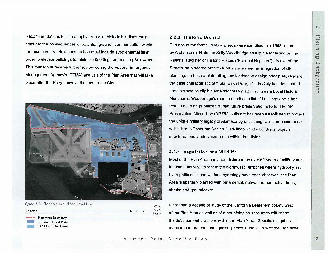
Recommendations for the adaptive reuse of historic buildings must
consider the consequences of potential ground floor inundation within
the next century. New construction must include supplemental fill in
order to elevate buildings to minimize flooding due to rising Bay waters.
This matter will receive further review during the Federal Emergency
Management Agency s (FEMA) analysis of the Plan Area that will take
place after the Navy conveys the land to the City.
. . ~~~
It
~~~
' h
. _
' f
. .. ).: .
:f"
- -..;. -- :::...::'. - , ':,
ill"
.. . ..\'\ '--- - ."..
I :f 'i'\ .
f-' I 9;'
-- .. . -= ..
IkD- - 'I, '! '; \0
'. ;; ""., -- -;;\
..." 1 e '1\.ci.. -
,.fl. .. 2t
b -31 ,1b .
.. '4--
.. .,
"l..
j!'
" x.
.' ' '''
fi 11 "0" JJ
.-
Figure 2: Floodplains and Sea Level Rise
Legend Not to ScaleNorth
Plan Area Boundary- IOO-Year Flood Plain
/8" Rise in Sea level
Historic DistrictPortions of the former NAS Alameda were identified in a 1992 report
by Architectural Historian Sally Woodbndge as eligible for listing on the
National Register of Historic Places ("National Register ) Its use of the
Streamline Moderne architectural style, as well as integration of site
planning, architectural detailing and landscape design principles , renders
the base characteristic of "Total Base Design." The City has designated
certain areas as eligible for National Register listing as a Local Historic
Monument. Woodbridge s report describes a list of buildings and other
resources to be prioritized during future preservation efforts The AP-
Preservation Mixed Use (AP-PMU) district has been established to protect
the unique military legacy of Alameda by facilitating reuse , in accordance
with Historic Resource Design GUidelines , of key buildings , objects
structures and landscaped areas within that district.
Vegetation and Wildlife
Most of the Plan Area has been disturbed by over 60 years of military and
industrial activity Except in the Northwest Territories where hydrophytes
hydrophitic soils and wetland hydrology have been observed , the Plan
Area is sparsely planted with ornamental , native and non-native trees
shrubs and groundcover.
More than a decade of study of the California Least tern colony west
of the Plan Area as well as of other biological resources will inform
the development practices within the Plan Area Specific mitigation
measures to protect endangered species in the vicinity of the Plan Area
Alameda Point Specific Plan

will be developed through a federal Endangered Species Act Section
7 consultation process and incorporated into the Project's regulatory
agreements.
2 2 5 Soil and Groundwater Contamination
Most of the Plan Area has been used for industrial activities , some areas
since the early 1800s. Historic site uses include two landfills , a municipal
airfeld, an army base , an oil refinery, various manufacturing facilties and
the Naval Air Station. These earlier operations have resulted in soil and
groundwater contamination.
The Navy is cleaning up the former NAS Alameda under the oversight of
federal and State environmental regulatory agencies. The objective of the
cleanup activities is to reduce contaminants to levels that are protective of
human health and the environment, and that are acceptable for residential
or commercial reuse within their respective designated areas. Additional
cleanup will continue , as needed, to meet State and federal requirements
for the anticipated land uses.
California Public Trust Doctrine
California s Public Trust doctrine protects the rights of the public with
regard to the State s waterways , including current and former tide and
submerged lands , by delineating permitted uses of that land Trust lands
belong to the public and are to be used to promote public rather than
exclusively private purposes. Navigation , fisheries , commerce, hotels,
water-oriented recreation , public recreation facilities , playgrounds , parks
and open space are among the activities permitted on Public Trust lands.
Housing and offces not related to a Trust use are not permitted on Trust
lands.
There are currently over 1000 acres of reclaimed tide and submerged
lands within former NAS Alameda that are currently subject to the Public
Trust. In 2000 , the NAS Alameda Public Trust Exchange Act (SB 2049)
authorized a reconfiguration of these Trust lands. This exchange was
, "
. ,. r '
, '-.,
Ie '
.';; ?; "
1/-
".
:J::::.Ii:.
;.; , . ' ""'
: k
' ' ...
" 1
,. ,
:;r,'
:- .
r--ir "'
, / -- :;,
tpr J -' f'te:
:"! - \"".y ::'-' ' , ". .
I ,
- , :: '. \" - .--=-- .
" I"
, ", "
--c-
: ";..
11 :
,- - -. -
J.;!i.
:.' ..
a.. _
'j ...
T1 tl
:: t... J-
, -='
I'rj'l
..
1),
. /
- - 't
.. ,"
iI
..
1';1 ;,.:: I
. ".: -
;I J';J
..-..
Figure 3: California Public Trust Lands Following Exchange
Legend Not to ScaleNorth
Plan Area BoundaryPublic Trust Following Exchange
Alameda Point Specific Plan

sought so that valuable waterfront lands could be placed under the Trust
in exchange for lifting the Trust from certain interior lands in order to allow
for contiguous development. This exchange , which will occur upon the
Navy s conveyance of the former NAS Alameda to the City, is shown on
Figure 3: Public Trust Lands Following Exchange, It will result in more
developable land adjoining existing Alameda development and more
water-oriented land uses near the Bay and Estuary. The City of Alameda
will act as a trustee of the Trust lands for all former NAS Alameda land
including the Plan Area.
Primary Existing TenantsThe ARRA has a Lease in Furtherance of Conveyance and is the Navy
master tenant. Some of the ARRA's tenants provide supportive housing or
have existing businesses in buildings in the Plan Area but in locations that
are not compatible with the Specific Plan s proposed Land Use Plan, This
Specific Plan allows for the relocation of ARRA's current tenants within the
Plan Area, In addition , the Maritime Administration currently leases Piers
and 2 for marine-related industrial uses , and the Hornet Foundation leases
Pier 3 , where the USS Hornet is moored and open to the public as the
USS Hornet Museum. The land use program described in Chapter 3: Land
Use allows these uses to continue.


INTRODUCTION
This Specific Plan provides a comprehensive land use plan for the
redevelopment of approximately 918 acres of existing land and
approximately 166 acres of submerged land defined by the Plan Area
boundary and a distinctive way-of-life. The land use program includes a
maximum of 4 346 new residential units , plus 186 Collaborative Housing
units which may be relocated , and the reuse of existing residential buildings
for up to 309 residential units; up to 350 000 square feet of retail uses
and 3 182 000 square feet of other commercial and business park uses
(including up to 500 000 sqLJare feet ofadaptively reused space) and up to
260 000 square feetfor civic/institutional uses; together with approximately
600 marina boat slips , approximately 145 acres of parks and open space
and three large existing piers. This chapter sets out the land use plan and
program as well as the uses permitted in each district within the Plan Area.
INTENT
The intent ofthis Specific Plan is to create a newtransit-oriented
neighborhood that respects the character and charm of Alameda.
Implementation of the Alameda Point Specific Plan will create new and
distinct urban districts anda pedestrian-friendly neighborhood. The
Specific Plan allows for redevelopment ofthe historic core of the former
NAS Alameda with civic, commercial , residential and community-oriented
amenities , while creating new land uses within a network of new streets
utilities , transit systems and parks. The Specific Plan provides for new
housing in a central location in the Bay Area and is intended to improve
Alameda s job/housing balance by allowing for job growth in the Plan
Area. It supports State policies regarding infill development and affordable
housing, The Specific Plan expands Alameda s parks , public recreation and
open space opportunities especially along the waterfront and demonstrates
sustainability through diversity of land uses , transportation alternatives and
building and infrastructure design. The result of this Plan is to replace a
large underutilized part of the City of Alameda that is currently comprised of
dilapidated buildings , poor roadways , weedy open areas and unused and
inaccessible shoreline, The Specific Plan will replace the former military
uses with a vibrant , mixed use , transit-oriented infill community that takes
advantage of its Alameda waterfront location and responsibly pursues a
fiscally neutral and sustainable Project that is a benefit to the City as a
whole,
It is the intent of this Specific Plan to allow reasonable flexibility in land uses
density and intensity of use , and land use district boundaries. This flexibility
is needed to respond to future changes in market conditions , to ensure that
the City is able to pursue superior reuse and development opportunities in
accordance with the economic development goals of the Specific Plan , and
to accommodate public and. quasi-public uses,
Two special districts are at the heart of the Plan Area: the AP-PMU -
Preservation Mixed Use neighborhood with its north-south axis of existing
buildings and public spaces and the AP-MU - Mixed Use hub along West
Atlantic Avenue, (See Figure 2: Plan Area) The primary intent of the

AP-PMU district is to facilitate reuse of existing buildings and places
consistent with Historic Resource Design Guidelines. The AP-PMU district
occupies much of the north side of the Plan Area and extends down the
historic axis to the new Seaplane Lagoon Waterfront Park. The range of
uses - residential , commercial and civic - will make this area eclectic. The
other mixed-use district (AP-MU) will surround the new ferry terminal , with
key retail and dining establishments oriented towards West Atlantic Avenue
and the Seaplane Lagoon. It will be dense , mixed-use and a truly transit-
oriented district, with the majority of its housing located within a quarter mile
of the ferry terminal.
Around these two districts are located a series of neighborhoods connected
by radial , tree- lined boulevards and local parks with a wide range of housing
types , including single-family homes , duplexes , townhouses and apartments
-- less dense than the AP-MU district. Ground floor spaces for retail , cafes
and restaurants are encouraged in the AP-C district and in the buildings
fronting the Seaplane Lagoon Waterfront Park in the AP-RH district. In the
AP-RM areas , single family housing (AP-RM) would predominate.
Contributing to Alameda s jobs/housing balance are two business park
campus (AP-BP) districts , one located just south of the AP-MU district and
its transit services and a second to the south of the existing Bachelors
Enlisted Quarters building, These areas would be appropriate for a large
single employer or multiple smaller ones, Maritime uses, hotels and other
leisure time uses , from bait shops to restaurants , may be located along the
Seaplane Lagoon shoreline in the AP- , AP-MU and AP-PT districts. Other
uses include the approximately 60-acre regional Sports Complex proposed
on the northern edge of the Plan Area.
The character of the Plan Area is reinforced by the presence of parks and
open space throughout the heart of the area and along its edges. A linear
park and the network of smaller internal neighborhood parks are connected
to the larger perimeter amenities. The Seaplane Lagoon Waterfront Park
is linked by trails to a marina and to the three existing large piers at which
the U. S. Hornet and other vessels are docked. A large park is located
on the Bay s edge. Shoreline access is proposed along all waterfront
edges including around the Northwest Territories where public trust uses
are allowed. The large proposed Sports Complex on the Estuary will be a
magnet that attracts sports enthusiasts.
This Specific Plan , the Alameda Point Pattern Book for project design
guidelines and mandated Historic Resource Design Guidelines for the
Historic District (each as defined in Chapter 9: Plan Review) provide
the fundamental land use regulations for Alameda Point. Chapter 7:
Development Standards regulates site planning, building scale and parking
standards. Where the Specific Plan and the Alameda Municipal Code are
inconsistent, the Specific Plan shall prevail. The following is a description
of the various land use districts within the Plan Area. Table 2: Permitted
Uses by Land Use Category defines the precise uses that are permitted or
conditionally permitted in each district.

LAND USE PROGRAM
The Plan Area s land use programincludes workplaces , schools , homes
shopping and services , civic facilities , parks , a marina , piers , public
Table 1: Land Use Summary sets forth:
A range of residentialunitsallowedin each district , such thatthetotal numberbf units at build-out shallbewithinthe range;recreation and open space. Figure 1: Land Use iliustratesJhelocation
and relationship of all the primary land use areas , including open space The permissible residential density per net acre in each districtsuch thatthe average density per net acre within that district atbuild-outshall bewithinthat range;
and the street system within the Plan Area. Table 3-1:LandUse Summary
quantifies the density and intensity of the proposed uses. The Land UseThe maximum allowable non-residential square footage in eachdistrict; and
The aggregate number of acres devoted to each district in the PlanArea.
Program described in the text, tables and diagrams willserve8sthemain
reference for all future planning decisions and implementation activities in
Alameda Point. Each of the land use districts have the appellation " AP"
Variations in the size , configuration anddevelopment program for each of thesedistricts are permitted pursuant to Chapter9: Plan Review (regarding density transfersdensity bonuses , changes in use , minorchanges in district boundaries and historicpreservation );
A fire station , branch library and the existingwestern branch of the City s administrativeoffices will be accommodated within the PlanArea.Existing occupied and unoccupied housingstock may be relocated or reused,
AP- PMU: Preservation Mixed Use
AP- RM: Residential Medium

\ \ , , - .
Legend
Plan Area Boundary
AP- PMU: Preservation Mixed UseAP-MU: Mixed UseAPoORM Residential MediumAP-RMH: Residential Medium HighAP-RH: Residential HighAP-C: CommercialAP-BP: Business ParkAP-PT: Public Trust
'\1
---. \
Ground Floor RetailFuture Park Dedication
Figure 3- 1: Land UseNote: Ground floor retail is encouraged where shown.
Alameda
. .-
" f" . 7"
" .
.I)
-- -' "... ,. ..
rt:
""
- 1/:
. , .. - - .. .. j;- ,,". ';.
:'i;. z-'
..
r.' : Ji
' :
i1-
'' : -
A, .: fIr '
-... ,---
I!.
..
ftiZ- r:gj'
. ' . " '" '... .. " ":
'I .t .r
.. "' .. ..""
"' .. .I
..'
1"' -
OAKLAND
..."'.
't "
ljSrUA
""1
'fu
, "
I /
-----
: r
-:-- :::"_--=:::::"::- - -- , -- - -- =- - , :': - , :::.==---" ": :: : :: ': , '" ''" " " ' ,!.__-- _-- :' : :: '----- , ,---- :.::.-;-: y---', --- , , ===- , ," /:,,"-- .---:--______
1 r -
', ' ," --------" "
J" ,
_____
:: I
" --- ::--q ,- --- ------
, J;:'
--- "
- r---
' " ----- - -
I ,
.:_ '. :.. ' " \:---'
1'
. ------- "' ' ,----,--- /
"I ,
.. , , .. " " )'
.1 1 "" L \"J,..:, r.ul1'1 "'10' "'''I
'1 Pftf' .t! t I tl
:; ----
r. "",,
liE .l J,MS
~~~ "-- ,,----- =- "- .:
.i,
,:" : :-------- = _.
",r
I I t"= -..
. .: : .. "
I. '(
"'''
r ...;r.
.. ,.
: I 0 I t'
/ ,
I I
! ". ....
I _t QI
: ' '
",,,. :!i"::,r./
,$' ., " ,
I oj-
"" ",. =======.: -:===:_
,c_ f:
" ' /"
- I
:: ::
I, _I ' r I
!.-
..i' to .
:' -.
L-
------- ----
L__- --
- ,
SAN
- .
FRANCISCO
Not to ScaleNorth
Poi n Specific P I a n

Exceptions to these regulations are set forth in Chapter 9: Plan Review.
net acre" is calculated by excluding rights-of-way, parks and public open
spaces from a gross acre.
Figure 1: Land Use also shows lands within the Plan Area where future
park dedication is planned. Until the lands are dedicated or reserved for
public park purposes , the underlying land use district shall apply, The
Specific Plan adopts this strategy because the final boundary line locations
for such parks have not yet been determined and flexibility is needed until
more precise development plans are known and the land is subdivided.
1 Alameda Point - Preservation Mixed Use (AP-PMU)
The approximately 133-acre AP-PMUdistrict is a mixed use district
permitting a wide range of uses and compatible new construction in
accordance with the process established in Section9. 6. This district
provides a broad range of uses in order to facilitate the reuse of historic
and contributing buildings. This area would playa significant role in
community "place making" and may include a community center, church
and civic uses such as fire department , a branch library, educational
facilities , a post offce , a museum and other cultural facilities, In addition
other uses are contemplated here such as live-work housing, residential
uses a hostel or hotel , workplaces for start-ups or small businesses , and
personal and work-related services such as a barber shop or copy center
bakery, delicatessen , cafe , day care facilities and the like. Neighborhood
and community parks as well as educational institutions are permitted
in this district. Many of these uses may occupy historic NAS Alameda
buildings , thereby enhancing the character of the entire Plan Area.
To the extent that a parcel located in the AP-PMU district is located on
lands that will be or are Public Trust lands pursuant to the Naval Air Station
Alameda Public Trust Exchange Act ("Exchange Act" ), the use of such
parcel shall be limited to uses permitted or conditionally permitted in the
AP-PTdistrict described below. Housing and other uses inconsistent
with the Exchange Act will not be permitted on Public Trust lands, The
Planning Department of the City shall keep a publicly available record of
parcels that are subjecUo the Exchange Act in theAP-PMU, In areas that
are or will not be within the Public Trust , AP-PMU dwelling units will range
on average from 4. 1 to 17.0 dwelling units per acre,
2 Alameda Point - Mixed Use (AP- MU)
This district permits the integration of residential , public, instiutional
and commercial uses and a new ferry terminal and transit hub. A mix of
high density housing, local-serving retail such as a grocery store , and
workplaces are permitted here to create a vibrant environment. Uses
may be vertically or horizontally integrated. The preferred location of a
grocery store is at the corner of Main and West Atlantic Avenues (see
Figure 2: Plan Area), to be convenient for residents of Alameda Point
and adjoining neighborhoods, In both residential and commercial buildings
retail , restaurantsand/or services for locals and transit users may occupy
a portion of the ground floor frontage. Within the AP-PMU district Figure
1: Land Use shows where ground floor retail uses are permitted on West
Atlantic Avenue or across from the transit terminal. Along West Atlantic

Avenue , once ground floor retail uses are established in a building, retail
may expand in the upper floors. Day-to-day shopping and service needs
of residents could be met with an array of retail and service commercial
uses , such as pharmacies , cleaners , book stores , sporting goods stores
electronic appliance stores and hardware stores within ground floor space
or in commercial blocks. Home repairs , garden and furnishing needs could
be met at larger format retail stores. Neighborhood parks are permitted in
this approximately 29-acre district. AP-MU dwelling units will range from a
minimum of 30. 1 to a maximum of 70.0 dwelling units per acre,
3 Alameda Point.. Residential Medium (AP- RM)
(4. 1 - 17.0 du/ac)
Residential uses in the AP-RM district will be primarily for single family
detached homes but may also include denser formats such as courtyard
housing or housing around a mews. Other innovative site plans for single
family housing types that use a shared driveway and common greens are
also permitted in the RM areas. Duplexes , triplexes or large town homes or
condominiums up to three stories in height would be permitted , reflecting
the high end of the density range in this district. The Plan Area s AP-
districts account for approximately 127 acres distributed throughout the
Plan Area. RM units will range on average from a minimum of 4.0 to a
maximum of 17.0 dwelling units per acre. Neighborhood and community
parks as well as elementary, middle and high schools are permitted in this
district.
4 Alameda Point - Residential Medium High (AP-RMH)
(17. 1 - 30.0 du/ac)This district , located along Main Street may include duplexes , town homes
live-work units as well as single family detached homes. Clustered housing
or housing that shares common open space and/or a driveway is also
permitted in the RMH district. Duplexes , large and small townhomes
and tuck under housing types of up to three stories in height typify this
density range. AP-RMH areas account for approximately 40 acres in the
Plan Area, RMH units will range on average from a minimum of 17. 1 to a
maximum of 30.0 dwelling units per acre. Neighborhood and community
parks as well as elementary, middle and high schools are permitted in this
district.
5 Alameda Point - Residential High (AP-RH)
(30. 1 - 70. 0 du/ac)Multi-family housing up to five stories in height is a permitted use
in this district. Multi-family housing is intended here , in apartments
condominiums , flats and housing with garage podiums or embedded
garages within the residential block, AP-RH areas account for
approximately 27 acres , although additional RH housing will be found
in the AP-MU district. RH units will range on average from a minimum
of 30. 1 to a maximum of 70. 0 dwelling units per acre. Residential
development within the AP-RH district shall at all times allow at least 30.
units per acre. Neighborhood and community parks as well as elementary,
middle and high schools are permitted in this district. Ground floor retail
and water-oriented services are permitted in the ground floor of buildings

in the AP-RH district , as shown in Figure 1: Land Use.
6 Alameda Point - Commercial (AP-
(\P-C areas comprise approximately 13 acres of the Plan Area, Permitted
commercial uses will include a variety of uses such as offices, stores for
home furnishings or home repairs , shops , personal or business services
art galleries , vocational schools , banks , general office , medical/dental
offices , clinics , cafes and restaurants. Neighborhood parks are permitted
in this district. Residential uses are also conditionally permitted in the
AP-C district , and are subject to the development standards for AP-RMH
housing,
7 Alameda Point - Business Park (AP-BP)
Permitted uses in this approximately 63-acre district include research
offices , laboratories , multi-tenant, storage , maritime industry and services
multi-tenant , vocational schools , government facilities , warehousing
and/or distribution uses with ancillary office space. Light manufacturing
and assembly are permitted with a Use Permit. Potential uses include
scientific , technical and research oriented industries such as in the fields
of electronics , aerospace , biotechnology and computer hardware and
software. An existing power sub-station may be relocated to this area,
Live/work uses are permitted in the AP-BPdistrict.
8 Alameda Point - Public Trust (AP"PT)
The AP-PT district comprises approximately 350 acres of unsubmerged
lands and approximately 166 acres of submerged lands, This designation
applies to several sites within the Plan Area , including the upland edges
of Seaplane Lagoon , Enterprise Park along the Bay s edge , the regional
Sports Complex site and the Northwest Territories, Please see Chapter
4: Open Space and Conservation where the locations of these proposed
uses are illustrated. The AP-PT district has been designed so that land
uses on real property within the district will be consistent with the Naval
Air Station Alameda Public TrustExchange Act (the "Exchange Act"
after the completion of the land exchange contemplated therein. Under
the Exchange Act and this Specific Plan , allowed uses are described as
follows:
The establishment, improvement, and conduct of harbor, and for the
construction, maintenance, and operation thereon of wharves, docks
piers, slips, quays, warehouses, factories, storehouses, equipment
parking areas, streets, highways, bridges, pedestrian ways, landscaped
areas, public bUildings, public assembly and meeting places, convention
centers, parks, museums, playgrounds, public recreation faciliies
(including, without limitation, public golf courses, marinas, restaurants
hotels, commercial recreation facilties, entertainment facilties and
attractions), and any other utilites, structures, and appliances, provided
the facilties are incidental to, or necessary or convenient for, the
promotion, benefit, and accommodation of the purposes of the public
trust. "
Shoreline public access will be provided in all AP-PT areas. The AP-

District also encompasses the waters , piers and submerged lands in the
Seaplane Lagoon and extends to the south. Until the precise location of
the ferry terminal and transit hub is finalized along the edge of Seaplane
Lagoon , the underlying AP-PT district regulations shall apply to AP-
lands fronting Seaplane Lagoon , and the City will defer the reservation of
such lands for public park purposes,
Approximately 60 acres within the AP-PT district is intended for a Sports
Complex to meet growing regional and city-wide recreational needs and to
provide better access to the waterfront for residents. Indoor and outdoor
active and passive public recreation facilities are permitted in this district.
Types of new sports facilities that are permitted include: football , lacrosse
soccer, softball , baseball , tennis , volleyball , BMX/mountain biking,
basketball , bocce and indoor/outdoor swimming. Other similar sports
facilities are permitted. The scale of the facility would allow Alameda to
host citywide and regional tournaments in a number of sports, The existing
gym is permitted to remain and may be reused for indoor activities,
Similarly, the existing skate park would remain. Picnicking, informal
outdoor gathering and playgrounds and landscaped areas are permitted.
Ancillary uses including a cafe , food kiosks , restrooms , maintenance
buildings and storage are permitted. See Figure 6: Sports Complex for a
conceptual illustration of the Sports Complex facilities.
4 HISTORIC RESOURCES
In addition to the uses permitted by right in each land use district, any use
permitted in the AP-PMU district may be permitted in any historic building
or structure outside of the AP-PMU but in the Historic District , as defined in
Section 6 below, provided that a Use Permit is obtained for such use. If
the subject structure is demolished or if alteration (as defined in Section
6) occurs in a manner inconsistent with the Historic Resources Design
Guidelines , all future land uses of the property on which the building or
structure is located must comply with the underlying district regulations. If
a building or structure is damaged but not destroyed by fire , Act of God or
other casualty, the building or structure may be rebuilt and used for the land
use allowed by the Use Permit , if any, granted pursuant to this section and
Section 9.4, For additional development regulations pertaining to historic
resources , see Sections 7.4, , 7. and 6 below,
AFFORDABLE HOUSING
Alameda Point will incorporate housing which is affordable to all income
ranges , including very low, low and moderate income households , by
incorporating a mix of housing types , efficient land use and supporting
amenities. The mix of affordable housing types to be provided in the Plan
Area shall be consistent with California redevelopment law.
During the base reuse process , the City made a long term commitment to a
collaborative of advocates for the homeless , women and children in need
and veterans. At the present time , an approximately 120-unit collaborative

of former homeless residents , staff and volunteers occupy buildings in
the Plan Area, Also on-site is a facility for families in need as well as a
housing program with single beds for veterans in transition. A more efficient
consolidated land use program is intended to accomplish the objectives of
the original commitment and also achieve the City s overall redevelopment
goals. A new group of facilities to serve the homeless population , help
women and children in need and support veterans in transition is planned.
New affordable housingunitswill be reasonably dispersed throughout
the phases of development, and. may be located in. exclusively affordable
buildings. Affordable housing will. be constructed so that it is coordinated
with the overall residential construction program. New and rehabilitated
affordable housing will be comparable in design , exterior appearance and
overall quality of construction to market rate units. Affordable residential
units at Alameda Point will include group living, duettownhomes, attached
town homes and multi-family apartment and condominium developments,
6 PERMITTED USES
To describe the character of this new community, Section 3: Land Use
Program provided a generalized description of the land uses. The location
of each use is shown on Figure 1: Land Use. This section s purpose is
to provide a more detailed, systematic matrix of the uses permitted within
each of the land use districts listed below and described in Section 3. The
following symbols used in Table 2: Permited Uses by Land Use Category
indicate if the use is permitted and the type of permit , if any, required for a
given use type within a specific land use designation:
Permitted
Permitted in ground floor only, except as noted under AP-MU above
Permitted with Use Permit approved by Planning Director
Not Permitted
The abbreviations used in Table 2 shall correspond to the following land
use designations:
AP-PMU: Preservation Mixed Use
AP-MU: Mixed Use
AP-RM: Residential Medium
AP-RMH:Residential Medium High
AP-RH: Residential High
AP-C: Commercial
AP-BP: Business Park
AP-PT: Public Trust

The following additional regulations will apply:
Land uses shown in the matrix as "Permitted" shall require a non-discretionary, ministerial building department staff clearanceconfirming that the use is permitted by this Chapter 3,
The text of this Specific Plan should be interpreted so that thebroadest scope of uses is permitted and ambiguities should beresolved in favor of flexibility in land use.
Accessory uses incidental to the permitted uses are Permitted,Proposed uses not listed on Table 2: Permitted Uses by Land UseCategory may be permitted upon determination by the PlanningDirector that such uses are of similar density, intensity and characterto a permitted use with a use permit.
TABLE 2 : PERMITTED USES BY LAND USE CATEGORY, ALAMEDA POINT
AP-
Community Gardens, including Roof Gardens
Natural Resources Preservation
Bed & Breakfast Inns
Home Occupations

TABLE 2 : PERMITTED USES BY LAND USE CATEGORY, ALAMEDA POINT (CONTINUED)
AP-BP AP-
Live/Work Units
Multi- Family Rowhouse, Duplexes , Triplexes
Multiple-Family Dwellings (condos, multi-family flats, apartmentstownhouses)
Private Recreation Facilities
Residential Care Facilities (6 or fewer persons)
Residential Sales Offces
Senior Citizen/Congregate Care Housing
Single-Family Dwellings
21 Supportive Housing, Group Residential Facilities P
City Corporation Yards
Community Center/Meeting Centers
Clubs, Lodges and Fraternal Organizations
Cultural Exhibits and Museums
Fire Station , Paramedics
Government Offces and Facilities
Hospital , Urgent & Emergency Care, Clinics Facilities
Libraries
Places of Worship
Public Administrative Facilities
Police Community Field Offces, Parking lots
Post Offces
Public Utility Distribution & Transportation Facilities
Public Utility Installations (major)
Tourist Information Facilities

TABLE 2: PERMITTED USES BY LAND USE CATEGORY, ALAMEDA POINT (CONTINUED)
AP-PMU AP- AP- AP-RMH AP- AP- AP- AP-
Pub
Public Schools, Trade/Vocational Schools
Antiques, Bookstore , Galleries
Apparel Stores, Shoe Store and Repairs
Bakeries, Confectionery Stores
Bicycle Shops/Rental
Camera/Photographic Supply, Cell Phone Stores
Consignment Shops, Thrift Shops
Computer and Software Stores
Concession Stands /Kiosk Businesses
Convenience Stores w/o Fuel Pumps
Deli , Cafe , Coffee Shop, Ice Cream Parlors
Department Stores (10,000 SF maximum)
Drug Stores and Pharmacies
Florist Shops/Stands
Furniture and Home Furnishings Stores
Garden Supply and Retail Nurseries
Gas Stations
Gift, Novelty, and Souvenir Shops
Grocery, Supermarket, Health Food Stores
Hardware Stores (10 000 SF maximum)
Hobby, Toy, Crafts and Game Shops
Home Appliance/Electronics Stores and Repairs
Jewelry Stores
Liquor Stores , Wine Shops
Luggage, Fabrics and Leather Goods Stores

TABLE 3-2 : PERMITTED USES BY LAND USE CATEGORY, ALAMEDA POINT (CONTINUED). AP- AP- AP-
62 Music usicallnstruments Stores, Video Stores News Dealers and Newsstands
Pet Shops , Animal Grooming
SpecialtyjVariety Stores
Sporting Goods Stores (10 000 SF maximum)
Stationery, Party Supply Stores
Vision and Eyeglass Centers
Art/Music/Rehearsal/Dance/Martial Arts Studios
Barber Shops/Beauty Salons/Manicurists
Child Day Care Facilities (7 or more persons)
Dry Cleaning and Laundry w/o Plant
Dry Cleaning/Dyeing Plants
Equipment Rentals (light)
Exterminators
Fabric, Upholstery Shops, Tailors
Home Maintenance Services/Supplies (less than 1O 000SF)
Interior Decorating Services
Laundromats
Locksmiths
Medical/Dental Offces
Mortuaries
Pet Day Care
Pet Boarding/Kennels
Spa Retreat/Day Spas
Spiritualist Readings

TABLE 3-2 : PERMITTED USES BY LAND USE CATEGORY, ALAMEDA POINT (CONTINUED)
AP-PMU AP- AP- AP- RMH AP- AP- AP- AP-
Travel Agencies
Treatment Centers (substance abuse w/o overnight facilities)
Veterinary Offces, Clinics
Advertising Services
Auto Sales Showroom/Lots
Auto Repairs and Servicing
Banks/ Financial/ Insurance Institutions
Blacksmiths
Blueprinting and Photostating Services
Brewery/ Distilleries
Building Maintenance Services
Business Equipment Rentals and Sales
Carwashes
100 Catering Services
101 Cold Storage
102 Commercial Art /Graphic/Lithography Design Services
103 Computer and Data Processing Services
104 Contractors Yards
105 Copying/Printing; Courier/Delivery Services
106 Equipment Manufacturing/ Machine Shops
107 General Offces
108 Incubator Offces
109 Laboratories
110 Light Manufacturing
111 Motion Picture/Recording Studios

TABLE 3-2 : PERMITTED USES BY LAND USE CATEGORY, ALAMEDA POINT (CONTINUED)
AP-RMH AP- AP- AP- AP-
112 Photoengraving/Fin ish ing/Photography Services
113 Plant and Landscaping Maintenance Services
114 Postal and Mailbox Rental Services
115 Publishing Plants
116 Research & Development
117 Sign Services, Vending Machines Sales and Rentals
118 Warehouses
119 Sustainable Technologies 120 Amusement Arcades and Games (indoor facilities)
121 Bowling Alleys
122 Hotels, Hostels
123 Hotel Condominium/Timeshares
124 Indoor Sports Facilities
125 Movie Theaters/Playhouses
126 Night Clubs, Bars , Taverns, and Lounges
127 Restaurants
128 Sidewalk Cafes Associated with Restaurants
129 Automobile Parking for Transit Uses
130 Car Sharing Lots/Garages
131 Ferry Terminal/Transit Center
132 Recycling Facilities (small collection facilities)
133 Taxi Stands

TABLE 3-2 : PERMITTED USES BY LAND USE CATEGORY, ALAMEDA POINT (CONTINUED)
AP-RMH AP- AP- AP- AP-
135 Fine Arts
136 Furniture/Woodwork, Metal Shops
137 Mixed Media
138 Performing Arts
139 Textile Arts
140 Bait Shops
141 Boat Rental
142 Boat Repair
143 Boat Storage
144 Commercial Marina
145 Gas Docks
146 Marine Supplies
147 Marine Equipment Sales/Repairs
148 Ship Chandleries
149 Water-related Industries
150 Water-related Offces
151 Water-related Retail Services and Sales
152 Naval Uses
Notes: Areas within the AP-Public Trust are subject to Public Trust uses,
Supermarkets over 10 000 sq. ft, are only allowed in AP-Commercial district
Ground floor uses shown inAP-RMH may only occur along the Main Street frontage , except for personal services for AP-RMH residents,
Sustainable technologies may range from solar farms to neighborhood waste management sites and must be compatible with surrounding uses.


INTENT
The Alameda Point open space system will serve as the framework for
the entire Plan Area and wil enhance connectivity within it. Approximately
145 acres of parks and open space are proposed. SeeTableA-1:)Parks
and Open Space. The intent of this Specific Plan is to offer extensive
shoreline park improvements of citywide and regional value, open space
pedestrian and bicycle trails as well as internal neighborhood-serving parks.
An elliptical park will mark the Plan Area s eastern gateway, from which
a series of tree- lined boulevards form a network of walking routes to the
multiple parks embedded in the neighborhoods and at Seaplane Lagoon, All
residences are designed to be located within a five-minute walk of parkland,
See Figure 1: Open Space Framework.
The open space framework provides land for park and recreation facilities
sufficient in size and amenities to meet the requirements of the Plan Area.
The parkland required by this Specific Plan exceeds the requirements of
both a state law known as the Quimby Act , California Government Code
section 66477 , and provisions of the City s subdivision ordinance, The
Quimby Act authorizes cities to require up to 5 acres of parkland per 1 000
residents at the time land is subdivided. At project build-out , approximately
57 acres of Quimby-required parkland would be required. As shown in Table
1: Parks and Open Space the Project will provide approximately 61 acres
of new parkland , plus. the approximately 24-acre Enterprise. Park and the
approximately 60-acre Sports Complex. Total park acreage is approximately
145 acres.
Prime open space components available to the general public will include
a .Iongshorel ine park fronting Seaplane Lagoon similar to San Francisco
Marina Green; the grand landscaped north-south historic axial open space
INT
Component Approximate Acres
12,
17,
23,
24,
60,
Enterprise Regional Park
Sports Complex
of the former NAS Alameda; neighborhood parks for active and passive
recreation; two new community parks; and a new approximately60-acre
multi-purpose regional Sports Complex. These are all woven together with a
network of off-street trails and on-street sidewalks, The Plan accommodates
large-floorplate indoor sports facilities in several locations.
Each of these public amenities is described below and illustrative plans
are provided, The Plan Area landscape design guidelines wil be prepared
during a public planning process that provides a "Pattern Book" for the Plan
Area , so the facilities and range of uses in each park will be re-evaluated by
the public. Because the park concepts may be changed. duringthafprocess

.- j. --.-.-\- _._,-,-,_.- -' -='-'-'-' j'! )
1/)
, I
-1.!.. L-""
.. "
LegendPlan Area Boundary
Sports ComplexCommunity ParkLinear ParkNeighborhood ParkSeaplane Lagoon Waterfront Park
Enterprise Regional Park
View Corridor
.. .. /:::""
Z"" I;:-:' .(h t:-. 04. it
. " ", ... ' .. :: .' -". - " .jj.' ,.
A.. --
.. ' , ..,
f ' - . "" n
. -
Ii: i' f:,
... . ' " . ' '
:: f.
. .. ", "" ." "" ", ... "
r,'
' "' ' ... ,;"' .. ... //'"
40; I .. .
" ':.. "'
\i ' t
.-- j""-.
l"' !
.._..-..-
c:.
"""
t',,
, _
8t1....
SAN FRANCISCO BAY
Figure /: Conceptual Open Space Framework (ILLUSTRATIVE ONLY)
Alameda Poi n Specific
J4KLAND ESTUARY
._0
r..-
&IMIMjg1M(j(f(ffl
i: "
.. . '_._' -:. ..
fI .L -
P I a n
/ ""' ...
i.
. /,'" .. '\
I, ..
, -
0: ". ,I.
-- '\ - "\ .:
;;"'.. T
4'!:I .
~~~
at.0i''-ll .,.Wfl,
" . Jfl
, j(...,,
' :. U-
",". '
i" '!. m:i
i:1
, .
/iJ
",
f:;.
..-
..r
"' ..,.
r. '''J:1
, -
, .P. J
. ' ' \
. . 'I"
\.. ,-"
fjo
'',.""
I '.
...
Not to Scale
North

the drawings showing suggested facilities and amenities provided in this
chapter are illustrative only.
NEIGHBORHOOD PARKS
Gateway ParkAn ellptical , 1 to 2-acre park will mark the eastern gateway into the Plan
Area from West Atlantic Avenue, From this signature neighborhood park
six street axes will radiate outward into the development , terminating
at a series of other neighborhood parks. The main feature of this park
will be a full size Navy jet mounted on a pedestal and visible from all six
approaching streets. Formal trees , walkways and a plaza will surround the
ascending jet with benches , flagpoles , interpretive signage and plaques
which explain the significance and history of the former military base site
and memorialize local miltary heroes and be a key display of public art for
this part of the Plan Area, See Figure 4-
Typical Neighborhood ParkThe typical neighborhood park is intended to include a universally
accessible children s play area Neighborhood parks will be approximately
two acres , on average. A gazebo and/or shade structure with picnic tables
and associated barbecues will be included near the play area for family
-2 -
""
I .
...... :.::.. . : : .'" , .", .,. . . ".. "''' /'.. ';.
..J - . r .
, ;
::' :J/
" ".. .':. .. .... , '" , . ..
11 .
.. . .
.I 5
. "
9 "
1))'"'-t
J,
- ..
t1.
"" .. ", .....:.
Figure 2: Gateway Park (ILLUSTRATIVE ONLY)
Gateway Park - Proposed Elements
Jet Monument Colorful Plant BedsHistoric Naval Flags TurfInterpretive Plaque 10. Permeable PavingStairs SidewalkRamp 12. Seat WallBenches 13, Tree GrovePedestrian Lights
convenience. An informal , irregular turf area will be included for non-
programmed play, spontaneous events and small gatherings,
Smaller parks , typically approximately 1 acre in size , are intended to serve
the immediate neighborhood residents Improvements will include a small
play area with play components separated for 2-5 year olds and 5-12 year
olds, Benches and tables will be provided, See Figure 4-
Alameda Point Specific Plan

. '-.
I ",
:""
0 J!.
(i
;:" . . "" : ' ::. ..
Neighborhood Park - Proposed Elements
14,
Children s Play Area (2-5 year olds)Children s Play Area (5- 12 year olds)Sand and Water Play
Gazebo Shade StructurePicnic Tables
Barbeque GrillsPermeable PavingOpen MeadowSidewalkSpecial Entry Paving
Rain Garden IOn site Water RetentionTree GroveColorful Plant BedsPedestrian Bridge
,...\ . , \.--'
Figure 3: Neighborhood Park (ILLUSTRATIVE ONLY)
. .' * ' ." --. .. - ,- . .
Ii .
5 .,
. -
" f
';" ..
T.
':
. l;' .o
;' -- ..--- -
COMMUNITY PARKS
A wide range of active and passive recreation will be possible in the
two community parks. One approximately 9-acre park is planned In the
northeast part of the Plan Area, It could include community or cultural
facilities. Large playing fields could be coupled with basketball courts , an
open meadow and children s play areas. The other community-scale park
(approximately 8 acres) adjoins the Bachelor Enlisted Quarters; several
playing fields can be built in this location. Parking, restrooms , hardscape
areas , exercise stations and varied landscaped areas will also be part of the
program for the community parks. Facilities planning and landscape design
will be sensitive to and subject to Historic Resource Design Guidelines.
Both parks could act as a core location for everyday community gatherings.
A large destination children s play area could provide a variety of play
amenities for 2-5 and 5 -12 year olds, The play areas will be universally
accessible and could provide both active and imaginative play opportunities.
Group picnic facilties could be provided with a shade structure , barbecue
area and restroom facilities, See Figure 4-
Alameda Point Specific Plan

' -, ' , ,
.. 1 1 4
G3-
,."'. .. " !
2'\r: :r
: . " :
:/1,I -'
, "
1 ,
-"', '
'"I" 12
J::
-- - -(- .- - - .. ; \. ; - - -- \ ::) - --
ft G) . I J
. .: .
'V' 3'
. . - , " ') "
1:.
'"
I , " I.
.... - - :"-.. ;:' _ ""-
zf ' 4 '
''' ' ;-- ---- .--
: 1
:-
I .
' ' ,". ,.-
J I
. ""
. &J ' I .' --"7 .,-
, . " '.. \
8 2
" . . . '
1 . " I , I. '1 .
:. .._
.i_
....,
. l
,,- -;, - : -:, :-'
" 6 ,
: '"." .. " ",,.,, . " ;":"': /" . " ..
tN"
-... ' -
tr 1, JlY -"1i- -
......
"i-'.'
. ' - '"
AI.4
,. ".,
Figure 4' Community Park (IllUSTRATIVE ONLY) LINEAR OPEN SPACE
Community Park - Proposed ElementsThis linear open space corridor forms a continuum between the Estuary and
Seaplane Lagoon. The open space areas in this corridor are interspersed with
II.
Parkmg Lot (30 Spaces)Group Picnic FacilitiesRestroom FaciltiesChildren s Play Area (2..5 year olds)Children s Play Area (5- 12 year olds)
Sand and Water Play AreaPermeable PavingOpen MeadowRain Garden IOn-site Water RetentionSpecial Entry Paving
Tree GroveColorful Plant BedLarge Open GreenInformal Picnic Area
existing historic buildings that a pedestrian could visit while walking from the
Estuary to the Lagoon. Open spaces in this area will act as local gathering
places on a day-to-day basis but wil be of civic and regional interest.
Landscaped areas will be commingled with various civic uses such as aIS,
16.
17.
18,
19.
20.
Basketball CourtsPerimeter Walking Jogging TrailPedestrian BridgeExercise StationPublic ArtAdmiral' s House
branch library, community center, post offce or chapel. Parade-ground-size
areas , areas for ceremonies and smaller, more intimate gathering places with
seating and a variety of landscaped areas could be possible here, Facilties
planning and landscape design in the linear park wil be sensitive to and
subject to Historic Resource Design Guidelines. A conservation easement
may be established in this area as an incentive to preserve the linear open
space
Alameda Point Specific Plan

.., --..
'1
.. - - ':. :.
1"-
\. , .
.s - z J.
,) ... .. -
10
-- '. ,.
0.
"-""--
3 -
Figure 5: Seaplane Lagoon Waterfront Park (ILLUSTRATIVE ONLY)
SEAPLANE LAGOON WATERFRONTPARK
Seaplane Lagoon. Proposed Elements
This approximately 23-acre shoreline park framing the edge of Seaplane
Lagoon wil incorporate many water-oriented amenities and activities,
Pedestrian walks and bicycle paths will link the ferry terminal and such
facilities as vista points, kinetic sculpture, a water-oriented amphitheater
seatinglrest areas , a wave terrace and the like. The large piers , at which
the USS Hornet Museum is located and the MARAD Ready Reserve Fleet
and other former batteships are currently docked , may become a part of
this community open space , and public access to the piers may be provided,
See FIgure 4-
10.
Seaplane Lagoon
Pedestrian Walk (10' wide)Bike Path (12' wide)PiersKayak AccessWave Terrace PlazaKinetic Public ArtOpen MeadowNative Planting
Rip-rap
Alameda Point Specific Plan
Vista Points withInterpretive Signage
Coastal Tree GroveRain GardenColorful Plant BedsSeating Rest AreaFerry
12,
16,
.. .., ., .

ALAMEDA POINT SPORTS COMPLEX
The proposed Alameda Point Sports Complex will be a city and regional
resource, Two different plans for the complex , with or without an aquatic
center, are currently being considered, The complex will offer social , physical
and educational opportunities, The complex will contribute to meeting the
recreational needs of the City and residents of Alameda Point. Its shoreline
will include the Bay Trail and passive areas for the enjoyment of the
estuarine environment.
The envisioned public recreation facilities will serve to attract more Alameda
and Bay Area residents to the waterfront. The existing. gymnasium may
anchor the Sports Complex facilities that will be approximately 60 acres,
Recreation opportunities could start in the early morning and continue
into late evenings for individuals and sports leagues , and will be both
active and passive in nature, Recreational uses could include a renovated
gymnasium with indoor basketball , a multi-use building, soccer/football/
lacrosse fields , a number of softball/Little League fields , tennis courts , bocce
courts , basketball courts , a swimming center, sand volleyball , playgrounds
for younger children , and a BMX/mountain biking area, Informal and group
picnic areas along with a network of trails and walking paths that may link to
the Bay Trail , are also planned, Parking is currently proposed to be located
in the lots to the immediate south and just west of the gymnasium,
The Sports Complexcouldbeacenter for senior activities , tournaments
entertainment events and spectator sports, and would become a regional
destination for amateur sporting events, A comprehensive ilustrative
proposal has been developed for the Sports Complex, See Figure 4-
ENTERPRISE REGIONAL PARK
At Enterprise Park along the Bay shoreline , formal and informal outdoor
areas may be provided, This park is approximately 24 acres in size, As
the property of the East Bay Regional Park District , parking, restrooms
hardscape areas , vista points and varied landscaped areas may also be part
of the program.
CONSERVATION OF NATURALRESOURCES
Given the disturbed nature of the majority of the Plan Area , the only part of
the Plan Area in. whichhydrophytes , hydrophytic soils or wetland hydrology
have been observed is the Northwest Territories, If future biological
evaluations of the Northwest Territories establish the presence of threatened
or endangered species , cooperative consultations with the U,S, Army Corps
of Engineers , U,S, Fish and Wildlife Service and the California Department
of Fish and Game will be undertaken to conserve such natural habitats as
are warranted to protect the species,

""ro ..
.. .?-
1 I;
\:
Ji
'!
(0 i 0 or -
. . . - ! '
,380' "".,- c r 1: "" -', J I
r . C 79
( -- -.
- I(.oJ 0 "I'
' ,., \
0'"I r rt
(i '1'
,--
Oakland / AlamedaEstuary
-.-.
h '
,-..- .. "-
J -
.... '-
Q3 ,.
.. ..
f'-300I G Q -
, '
- C , GV
..
l,
;; - ,
QJ
. . ... ,... ....... .. -
-- 1."..11..,
- -. ?! '
Figure 6: Sports Complex
Sports Complex (alt 01) - Proposed Elements
10.
II.12,
13,
14.
15,
Football/Lacrosse field (160' x 360'Warm up fieldsRestroom/concessions storage buildingSoccer field (210' x 330'Parking (200 spaces)
Maintenance Building with storage yardParki ng (73 spaces)Parking (97 spaces)Group picnicShoreline trailRestroom/concessions storage buildingSoftball/baseball fieldsPlay areaCentral green lawn area
BMXlmountain bike skills park
16,
17,
20,21,22,23,24.
26.
28,
Group picnic with shade structureSand volleyball pitTennis courtParking (158 spaces)
SWimming complex
Existing guard shackEntry greenParking (225 spaces)
Multi-use buildingGymnasiumExisting parkingInformal picnicExisting skate parkBasketball cou rts
Alameda Poi n
.. . -.
O,klood1 Ar,moG
0 0
"., - (9 r
"".. "'''''y-- - --
(I.4! -: \2 . 'f 'l.."'J
...- -'" ' , ' . - ..
180' "" 21
.. ./. ., .... . ',. '
0- 'I /
- ""
I r I
/ "
(1 Of""
!(0;:, :t.
' ..
(0,,
, .. "'. '
'0'
" ,"""'
Q. " " " ,0 : I
.. - .. '
, 0
'"
I rt
( \
\. f I 0J "
""=
,- "' I!.
.' ) ..
"., G "'
-- ....",.... /.. , .,
0; ....""..,. e
- ::
Sports Complex (alt 02) . Proposed Elements
10,
II.12,
13.
15,
Football/Lacrosse field (160' x 360'Warm up fieldsRestroom/concessions storage buildingSoccer field (210' x 330'Parking (200 spaces)
Maintenance Building with storage yardParking (73 spaces)
Parking (97 spaces)Group picnicShoreline trailRestroom/concessions storage buildingSoftball/baseball fieldsPlay areaCentral green lawn area
BMXlmountain bike skils park
!C
-.."'-
Specific P I a n
17,
18,
22,23,24.25,26.27.28.
Group picnic with shade structureSand volleyball pitTennis courts
Parking (81 spaces)Existing guard shackEntry greenParking (225 spaces)
Multi-use buildingGymnasiumExisting parkingInformal picnicExisting skate parkBasketball courts


INTENT
The circulation system within the Plan Area is a network of interconnected
tree-lined , streets , trails and bikeways designed to facilitate pedestrian
bicycle and vehicle access to all portions of the PlanArea. This network
will connect to the Project's multi-modal ferry terminal , and other on-site
transit facilities including shutte/bus routes and stops and a Bus Rapid
Transit system. The primary objective is to create calm streets that
engender a pedestrian . and. bicycle-friendly environment. To that end , the
streets proposed in this chapter are unique to Alameda Point and shall be
implemented in the Plan Area. . The on-site street and trail system joins
the existing City street system on the eastern edge and northern edges
of the PlanArea , providing pedestrian, vehicular and transit accesstd the
remainder ofthe City street grid system. These connections and related
improvements will enable the entire City of Alameda to more effectively
combat regional traffic congestion.
This chapter provides a comprehensive , multi-faceted menu of
transportation strategies that complement, support and are integrated
with the land use strategies in the Specific Plan. The primary integrated
land use and transportation strategy is that Alameda POintisa transit-
oriented community, Transit-orientedcdmmunities concentrate housing and
employment in compact , highly walkable , diverse mixed-use neighborhoods
with direct and convenient access to high quality public transportation.
This development strategy provides residents and workers a choice of
transportation mode , particularlyforcommuting, The mix of uses in close
proximity provides for everyday needs so that people are . not required . to
drive long distances and add to local congestion, The menu of innovative
transportation strategies that can be implemented at Alameda Point such
as shuttles to BART, car-sharing, guaranteed ride home programs , and
eco-passesmake alternatives to the automobile not only convenient , but
attractive choices,
Transit-oriented communities in Northern California have demonstrated
reductions in single-occupancy vehicle usage. They have been shown to
generate approximately half of the automobile commute traffic generated by
conventional development , reducing the regional impacts of work trips. They
retain more trips internal to the development thereby reducing the localized
impacts ofrunning errands going to lunch , and school and shopping trips.
The compact neighborhoods and connected walkable design of the street
system promote easier walking and bicycling.
The benefitsoftransit-oriented communities go beyond reducing traffc.
They include improved air quality; increased productivity with less time
wasted in congested environments; improved health by encouraging
physical activity; reduced energy consumption; increased social interaction
with neighbors , and overall improvement to the quality of life of Island
residents and employees. Upon implementation , the transportation
strategies will provide additional and improved transit options for existing
residents of Alameda,
The combination of transportation strategies that will be most effective
forAlamedaPoint are dependent on the specific type and phasing of
development , continuous monitoring, and refinement , and require a

comprehensive analysis of the development's impacts. Therefore , based on
the environmental analysis required prior to subdivision of the Plan Area
the appropriate initial strategies will be selected to properly address Project
impacts and will be conditioned through the subdivision map approval
process. Beyond the environmental analysis, the overall transportation
strategy includes monitoring and refinement during each phase of
development to maximize the effectiveness of the strategy,
PUBLIC STREET SYSTEM
A hierarchy of streets , named by the developer, with various capacities
functions and character is proposed to serve the transportation needs of
Alameda Point: boulevards , connectors , local streets and alleys. The new
network will connect all of the Plan Area s zones to one another and to the
public open space network throughout the site. The intent is to retain the
scale of the proposed streets while ensuring public health and safety. Street
landscaping will include trees , shrubs and groundcover, Wherever feasible
the street landscape areas wil incorporate vegetative-swales and related
storm drainage features. See Figure 1: Street System,
In order to create pedestrian friendly streets that support a compact
neighborhood , streets will be designed to operate at speeds of 25 mph
or less. Figure 1: Street System illustrates the street pattern and
classifications for Alameda Point.
BoulevardsThe primary boulevard , West Atlantic Avenue , will extend from existing
Ralph Appezzato Memorial Parkway. It will adopt a distinctive character
within the Plan Area , and will become a walking environment that also
serves cars , bicycles , transit and Bus Rapid Transit (BRT), With a total
right-of-way of 120 feet , West Atlantic Avenue will be 88 feet curb-to-curb.
It will have 16-foot wide sidewalk/landscaped edges , two 8-foot parking
zones , two 5-foot bike lanes , two 10-foot vehicular travel lanes , a 38-foot
median with dedicated lanes for transit , and 7-foot landscape buffers
that will double as vegetative swales. Landscaping will be located on the
perimeter and within the median. See Figure 2: West Atlantic Avenue.
Typical internal boulevards that connect key open space areas will be 66
feet curb-to-curb within an 86-foot right-of-way. These boulevards will be
comprised of 10-foot sidewalk/landscape edges , two 8-foot parking lanes,
two 5-foot bike lanes , two 10-foot vehicular lanes , and a 16-foot median
that also acts as a vegetative-swale, See Figure 3: Typical Boulevard.
Waterfront ParkwayThe waterfront parkway will be 28 feet curb-to-curb within a 48-foot right-
of-way, A 9-foot and a 10-foot lane provide for vehicular travel , with an
foot parking lane containing periodic tree planters on the inbound edge

/' ', . "', '"
.. "i
. - " - ,
LegendPlan Area Boundary
Primary Street AccessSecondary Street Access
West Atlantic AvenueTypical BoulevardWaterfront Parkway
Connector StreetLocal Street *
Connector Street at Open SpaceOne Way Local Street at Open SpaceAlley
* Roadway widths subject to revision in the AP. PMU
Figure 5- 1: Street System
t--
c '
ROW120'86'48'60'55'50'38'20'
.1 \
, '
Alameda
.. . ' - .. ... ." - ."
. II
.. ... .. . " ;.-.' - -.. ..
Yf i
. .. ..
"'-;i
j;,
"i,,',:c
). , )
:I,-I ., f1'
.. - "- .:.
'i -4 !.c),
.. ,,,
I -
, \
. -I ..r
r r
c:i -
L-,-,
SAN FRANCISCtJ iMY
Poi n Specific
- -- --
(JAKE, /f,
j) ,
ESTUARY
&mdJIMmJM(f(f(f1K
- .
C" .
.. -; $ -: ,
I;;: '.. '* r., ''1'
;''' " ' - .. " .\ '
.- . L lJ .tf1't.- t'f"..
.t 11 r. ;tl!.1' -
i '
.. '-.-.
r-
----_. ! -". -.. -"
Ii
,.. :.
Pia n
Not to Scale
North

SIDEWALK!LANDSCAPE
16' 25'
CURB-TO.CURB
10'
25'
CURB TO-CURB
BRT SIDEWALK!TRAVEL PKG LANDSCAPE
16'
CURB-TO-CURB CURB-TO-CURB
RIGHT-Of-WAY
MEDIAN WIBIO-SWALE
16'
10'
25' 10'
CURB-TO-CURB
86'
RIGHT-OF-WAY

only. The inbound edge will provide a 20-foot landscaping and pedestrian
zone. Outside the right-of-way, the waterfront side will include a 14-foot
landscaped edge that serves as a stormwater basin , a 10-foot Class 1
bike trail , a landscape buffer that varies in width , and an 8-foot paseo for
pedestrians only. See Figure 4: Waterfront Parkway.
ConnectorsThese streets primarily connect neighborhoods and local streets extend
from them. The typical connector will be 34 feet curb-to-curb within a 60-
foot right-of-way. Two 5-foot sidewalks border 8-foot landscape/vegetative-
swale areas, Ten-foot vehicular lanes will be joined by 8-foot parking
zones on both sides, Along bicycle routes , connectors may employ shared
lanes designated with "sharrows , pavement markings that identify where
bicyclists should ride to avoid automobile doors opening into the path of
the bicyclists. See Figure 6: Typical Connector,
Typical connectors adjacent to open spaces will be 27 feet curb-to curb
within a 50-foot right-of-way. The inbound edge will provide a 5-foot
sidewalk bordered by an 8-foot landscape/vegetative swalestrip,
open space edge will provide a 7-foot sidewalk bordered by a 5-foot
landscape/vegetative swale strip. Eight-and ten-foot vehicular lanes will
be bounded by an 8-foot parking zone on the inbound edge only, AClass
bike trail may adjoin the right-of way on the open space edge. See Figure
5: Connector at Open Space.
2.4 Local StreetsThe typical local street will be 32 feet curb-to-curb within a 55-foot right-
of-way. It will be comprised of a 5-foot sidewalk and 5-foot landscape/
vegetative-swale edge on one side and a 5-foot sidewalk and 8-foot
landscape/vegetative swale edge on the other side. Nine-foot vehicular
lanes will bejoined by 8-foot parking zones on both sides, See Figure 5-
Typical Local Street.
One-way local streets bordering open space will be 26 feet curb-to-curb
within a 38-footright-of-way. Five-foot sidewalks border irrigated 7-foot
landscaping areas that serve as vegetative swales. Two 7 -foot parking
zones and one 12-foot travel lane serve parking and vehicular travel. The
sidewalk and landscaping area on the open space edge is outside of the
right-of-way. See Figure 7: One- Way Local Street at Open Space.
5 Alleys
Alleys will be 16 feet wide within a 30-foot right-of-way, There will be two-
foot hardscapeor load-bearing landscape strips on both edges to meet
fire access requirements. Alleys may be privately owned, See Figure 5-
Alley.

cC f-
CI
:5 5 fi IL
0C
:'r
..
Co 0
g:
?(-! "'I
g: i1 I
'" 0
" ,.:: .
() 0f- 6 LO

60'RIGHT-OF-WAY
OPEN SPACE TRAVEL I PKG
12'
12' 26' 12'
CURB-TO-CURB
36'
RIGHT-OF-WAY

13' 32'
CURB- TO-CURB
55'
10'
RIGHT-Of.WAY
SETBACKSETBACK RIGHT-Of-WAY

TRANSIT SYSTEMS
Alameda Point will be transit-oriented and designed so that residents
workers and visitors can take maximum advantage of transit options, Amulti-
faceted transportation strategy is proposed , with a transit hub created within
the AP- Mixed Use area that serves multiple modes of travel. See Figure
10: Transit-Oriented Development.
1 Shuttes and Bus Rapid TransitIn addition to AC Transit bus service to and from the Plan Area to various
destinations along their routes , one of the primary transportation strategies
is a dedicated shutte connecting Alameda Point to the 12th Street BART
Station and downtown Oakland, This strategy will occur withthefirst
phase of development. At the major on-site shuttle stops car-sharing, park
and ride lots , and bike-sharing services will be located to further reduce
the need for private automobiles,
The shuttle service will eventually "evolve" to a Bus Rapid Transit (BRT)
service connecting the Plan Area to the 12th Street BART Station and
in later phases , the FruitvaleSART Station. Ultimately, BRTservice is to
include dedicated transit lanes along. major thoroughfares in Alameda to
enable efficient and more competitive cross- island travel. of benefitting. the
entire Island's population, Where BRT travels in lanes with automobiles
queue jump lanes" maybe provided at signalized intersections to allow
BRT vehicles to bypass automobile queues and remain. competitive . in
terms of travel time, BRT signature stations may provide amenities similar
to light rail stations , including shelters and real-time travel information.
Alternative main routes for across- island BRT system with partially
dedicated transit lanes that have been considered include the former
Beltline right-of-way running along the northern edge of Alameda as well
astherouteofthe historic Southern PacificRailway sRed Car system
Lincoln Avenue.
FERRY SERVICE
A new ferry terminal will be constructed and a multi-modal transit hub will
be located at Seaplane Lagoon with frequent , high-speed ferry service
between Alameda and San Francisco. This service will eliminate the ferry
stop on the northern edge ofthe Plan Area in the Oakland-Alameda Estuary,
Regular ferry service from . Alameda . is. consistent with. the Bay Area Water
Emergency Transportation Authority s (WETA)Regional FerryPlan, Future
connections to other regional ferry destinations may also be possible.
PEDESTRIAN AND BICYCLE SYSTEMSAND FACILITIES
Strong pedestrian and bicycle connections throughout Alameda Point and
especially to transit stops will be provided. All streets wil be equipped with
safe , attractive. and. desirable pedestrian routes , and.granderrouteswillbe
provided near open space and the waterfront. .Boulevards willhave.raised
medians as pedestrian refuges. Short blocks and mid-block pedestrian
passageways through long blocks will invite walking. Blocks longer than 450
feet will include a pedestrian passageway, All sidewalks in theProjectwili
be 5 feet or wider.

_'_0___'
.-.- -,- - -.-.-'\,,-
o 1l
LegendPlan Area Boundary
Mitchell Mosley, Stargell Avenue ExtensionsBicycle RouteDedicated Transit Right-of-Way &/or Q..Jumpers
Eco.. Pass
Ferry Services
BRT Service to 12th St, & Fruitvale BART
Car Share Pods
Bicycle Share Pods
Ridematch & Rideshare
Guaranteed Ride Home
Parking Strategies
Figure 5- 10: Transit-Oriented Development
Alameda
"" "" " - . ',. 1 -
..
(Ii
;:' , ..;..
,J' "
"' " "
I ,
,., "'--, . '"..
"" I'
.. ..' . ., -' " "' --- .... - .. ,
1-.' "'
, .,
" ";,r
,y/- '
A.':""
,.. - ' ' . ,
I..
..
tJ' ",
..'- ., .
JL"
"'"" ' . , .. - ' ,--
J..
. ,, ' '
- i: r
! l
'l.J
Oil/MD 1f& lJ);
9i
....
6'''",-"
!B!J /I&j,(j(((fm
---.. ..
-6 .
;-
Il llf1if ES0' D,jj'
Poi n
.. .L
Specific P I a n
..(. '.,
'f..
'\,
1 ,,
\(, ,..., ' " . - ' "'. "'.-
-I, -
/!;q-. , . .
.. t:I " t ,
,. , "" .\ . - "'
\L I "
' .
,h''1' .
..
liI
I " t.
.\'. .,
".;1:1"f
, ' .. !.."'*
\ l
, 10
': - \ ' -: _!:
J -
,:;';. , :
trt
- , ; .:- ,: -
\ d!
..: -:.
" 't
.,' :\;
r I .
:".1-- to -:-i
.. II -
'-"
Not to ScaleNorth

The Plan Area s streets will include a network of bike lanes and bike trails
whichwil be integrated into open space area plans and the bicycle network,
Figure 11: Bicycle and Pedestrian Network shows the bike lanes and
trails that will be provided. Secure short-term and long-term. bicycle parking
(including bicycle lockers), and potentially bicycle stations (attended bike
parking, service and sales), will be provided at the ferry terminal where
educational , safety and encouragement programs wil also be provided, All
schools , community centers , retail areas , public parks and workplaces will
include bike racks and/or lockers. A bicycle way-finding map and signage will
be provided, Large employers will be obligated to provide facilities for bicycle
and pedestrian commuters,
TRANSIT HUB AND TRANSPORTATIONMANAGEMENT COORDINATOR
The goal of the City s General Plan Transportation Element and the Alameda
Point Community Plan is to reduce trips generated by new commercial and
residential development. The proposed concentrated mix of jobs , housing,
schools , retail and services in the Plan Area and transit options allows
residents to remain in the Plan Area for most needs such as childcare
school drop-off, daily errands , shopping, recreation and dining, Many
residents may also work in the Plan Area given the mix of jobs and housing
within Alameda Point. Transitservices , including ferry, shuttles and BRT
locatedatanew multi-modaltransit hub at Seaplane LagoonwilLinclude
ticketing, a taxi stand , possibly a casual carpool loading area , convenience
retail , travel information , a nearby car-sharing service and a bicycle station
that may include a bicycle-share service. Office space for a Transportation
ManagementCoordinator will be provided in the Plan Area. Signagewill be
created to inform people of the presence of these facilities and services.
Non-auto travel options will be promoted in a number of ways. Assessments
paid by all homeowners and. businesses will entitle all residents and
employees to an Eco-Pass" for access to all transit modes provided by the
Project. Also , an Alameda PointTransportation Management Coordinator
will be paid to assist residents , workers and employers in planning their
trips , work with transportation providers to benefit Alamedans , conduct
annual transportation Ufai , rs" organize ride-matching and vanpool programs
administer incentive programs to increase transit usage and the like. The
Transportation Coordinator will evaluate. each program s effectiveness and
fine-tune. programs. and. add. additional.strategies to better meet needs
minimize Project impacts
, .
best meet congestion and VMT reduction
goals , and maximize effectiveness of various programs. The feasibility
and timing for implementing and funding concepts will be developed in a
Transportation Demand Management Plan (UTDMP" ). This plan wil address
the recommendations ofthe environmental assessment prior to the first
phase of development. Thefollowing. menu of strategieswill. be included in
the TDMP approved with the first master final map:
Car-Sharing program
Bicycle-Share program
Guaranteed Ride Home program
Resident and Employee Ridematching/Ridesharing program
New tenant/resident orientation of transportation alternatives and

.. , ,.
l.'
~~~' .. :... .. . ..,.
':lht.S:'
...
10:4 .,'1 ;:
:,. . - ',', ' ...
'lx1t l, .'f.
' . . .. ". :
r., "
"" .... , ' . "-'. "
I. ..,
, "
.I"" '1" ;
, , - .,'
. Si
' , "';'
", !f
" - " .. - .. . ;.. , ,,
' 1l
' ........ ...... - - . ..... ......
;Z ,
: " "::::::..::: - - . . . ,. " '''''' '''''''::. ,. - - - ",
J. -t
..".....- ---- .... - " . -" " ........ .. - - ..,. . . ... ....... ---- .,. "' , .. .
..moo
.. .,
. I
. '''''''''' /' .. " ' .; ..
.. ""4 '''' 1' '
./
"- k
l'
; - , . ., '. . ....... . ' ..
1:... ..:- -!P
, -.. '" .. ,'\'\ .
r.- :L --
:-....
1 "
. ', " : ...",.......... '
-M . r - . - f JJ
., :' ,.- "", ..,.. ....... :.
\tl lt ' I
...... . '.... -- : ""''' ':' :''
Wt! I!I
''- ".. ,
:1 1 , I' ; ,."
: . ' . -:::-"'. .. - ,. ........: .
i.....,: .
. ....... :..., -
-I.
.' "'" :-.......
1\
.. ,--- , ' . . - '.. .
I. , QUA
:1 \ J:i '''
;:'A , ,-u
' .
J. '4/, . v.
..
.t I..
":. :'" .
I '
, . , .: "
I '
....
07 ,
., \ '
oi
: .
07
.. ' ." : .. ,-
&fM/MlE
-!-
I..
... ..
I' ...
......... .: ..
LL .
ta.'I'
, .\ \j .
NOI&
-1,
L ..
LegendMain Pedestrian Network and TrailsBicycle Routes and TrailsBay Trail
Nil.A D
-..
ESTUA
.. ...- .( -
BAY
. r: ..ft-.\
---_
l._-
" '
SAN FRANCISCO
Figure 5- J J; Bicycle and Pedestrian Network
Alameda Poi n
Not to ScaleNorth
Specific P I a n

available services
New employee commute options orientation program
On-site transportation management and commute alternativesoffice
Transportation alternatives information package to every newhousehold
Market-based additional parking options and pricing
Satellite telework center
The TDMP may also include:
Rebates for new vanpool participants
Employer sponsored van pools
Carpool Incentive Program
Carpool to College Program
Schoolpool Program
Employers will work with the Transportation Management Coordinator to
develop individual transportation demand management plans tailored to
their employee s specific needs and to provide alternative transportation
incentives such as preferential parking for carpools and vanpools , internal
ride-matching services , Eco-Passes , car-share service membership, flexible
work hours and remote work site options and site amenities and/or services
that encourage walking and bicycling and reduce the need to travel for daily
errands.
TRUCK ROUTES
New truck routes will extend along the north and east sides of the Plan
Area, These routes will serve uses intheAP-PMU District , AP-PT District
the northerly AP-BP District and. other points west. Also , a truck route will
run along the eastern edge of the Plan Area on Main Street as shown in the
TransportationElemeniandtheAlameda Point Community Plan , with routes
extending into the. Plan Area to serve uses in the AP-BP District and the
shoreline. near the .Iarge piers. on Seaplane Lagoon, . Truck routes have. been
selected to avoid residential areas. See Figure 12: Truck Routes.
PARKING
This Specific Plan calls for parking spaces to be located on-street , in
designated lots or structures , and on private properties accessed through
streets and alleys. Because of its concentrated mixed-use design and its
infill location , Alameda Point is expected to generate less traffic and parking
demand than conventional suburban developments and the required amount
of parking will be lower than for conventional development. Parking will
be regularly monitored to determine the appropriate cost for parking in
the Plan Area, The Specific Plan establishes off-street parking ratios for
residential and non-residential uses that apply only within Alameda Point
and the zoning ordinance (Section 30- 6) will be amended accordingly. See
Chapter 7: Development Standards. The standards set forth in Chapter 7
are differentiated by building and/or land use type for residential , commercial


and retail. Parking standards for civic uses will be determined on a case-by-
case basis,
The intention of the parking standards and modifications to the City
zoning requirements for off-street parking and loading is to provide
sufficient parking, but to be very efficient and flexible in its allocation and
management. The parking standards for Alameda Point are appropriate for
urban , transit oriented , mixed use developments, The compact , walkable
and transit-oriented characteristics of Alameda Point that reduce traffic will
also reduce the demand for parking. A Parking Management Plan will be
a part of the TDMP, and may be amended from time to time, The TDMP
will provide a comprehensive implementation and management strategy,
including required Transportation Demand Management strategies that help
reduce parking demand. Strategies for providing and managing parking may
include the following:
Allowing shared parking between complementary non-residentialuses , and providing for the implementation of parking districts thatallow property owners to fund and manage shared parking facilities
Public parking pricing strategies to manage short-term and longterm parking demands , and possibly graduating to dynamic pricingin retail- intensive districts to maintain the availability of parkingspaces
Preferential parking for rideshare and alternative fuel vehicles
Allowing parking management strategies such as valet parking forretail and restaurant uses
Allowance of mechanical lift parking in residential development
Car-sharing and bike-sharing pods at strategic locations
Encouraging transit use by providing a Guaranteed Ride Homeprogram to Eco-Pass holders for family emergencies
Developing a parking availability and guidance program
Instituting residential parking permit programs in neighborhoodspotentially impacted by spillover parking or adjacent neighborhooddemand
Enforcing off-street.andon-street parking time limits to manageshort-term and long-term parking needs
Collaboration between the Transportation Management Coordinatorand employers to develop parking incentives and/or disincentivessuch as parking fees and parking cashout
Managing parking cost as a strategy to meet the congestionvehicle miles traveled (VMT), and vehicle use targets developed aspart ofthe transportation impact mitigations
Annual transportation survey of employees and traffic monitoringsurveys of all modes to evaluate and efficiently manage the TDMprogram
Annual residential and employee parking survey to evaluate andeffciently manage the TDM Program.
PHASJNG OF TRANSPORTATIONIMPROVEMENTS
The proposed land use plan for Alameda Point includes five phases of
redevelopment, as described in Chapter 8: Implementation. The TDMP
which is required to be developed and approved by the City prior to the first
phase of development will include a detailed implementation and operations
plan for each phase of the transportation strategy. Prior to the approval of

each subsequent phase of the development, the City and developer may
amend the TDMP for the next phase to better serve the Plan Area and
respond to program monitoring results and recommendations prepared by
the Transportation Management Coordinator. The following preliminary
transportation phasing plan is proposed for coordination with the land use
phases. The following timing and phasing may be amended through the
TDMP process,
Phase The following transportation strategies will be implemented during the first
phase of redevelopment:
Every homeowner and every business pays annual fees entitlingthem to an "Eco-Pass" unlimited transit pass
Ferry service from Main Street Terminal
15-minute headway dedicated shutte service to the 12th StreetBART station during weekday commute hours
Car-sharing facilities
Publicly available bicycle-share stations
On-site Alameda Point Transportation Coordinator to presentadvertise and support programs from the following menu of TDMmeasures through all phases of the development:
Ridematch and rideshare services
Guaranteed Ride Home program
Promotion of preferential parking for rideshare andalternative fuel vehicles as provided by individual propertyowners
Parking guidance and information system
Eco-Pass program
Internet kiosk available at Coordinator s offce
Other incentive programs such as carpool/vanpoolincentives (i.e. 30 day fuel subsidies), schoolpool , etc.
Promotional and planning services that includetransportation options orientation , commute alternativesplanning for employers , and information packages , andwebsite
Preferential parking spaces for rideshare and alternative fuelvehicles within any shared parking facilities
Shared parking facilities as developed by individual propertyowners or through parking districts established by property owners
Parking Management Plan for Phase 1 development
Traffic and transit use monitoring program , coordinated by theTransportation Management Coordinator and used to adjust andrefine the measures in the menu of strategies.
Pedestrian-oriented street and building design
Alameda Point bicycle facilities and parking
Multi-modal wayfinding system
Annual transportation survey of employees and traffic monitoringsurveys of all modes to evaluate and efficiently manage the TDMprogram
Annual residential and employee parking survey to evaluate andefficiently manage the TDM program,

Phase 2
During Phase 2 , the following transportation strategies and improvements
will be added to Phase 1 strategies:
Commencement of construction of the ferry terminal and transit hub
Transit improvements and street extensions as necessary toinclude enhanced bicycle and pedestrian facilities
Car-sharing facilities expanded
Bicycle-share program expanded (addition of bike-share "pods" aswarranted by demand)
TDM programs expanded as determined through monitoring andrefinement of programs
Pricing for on-street parking (meters) in retail areas
Potential residential. permit parking program starting with neighborhoods immediately adjacent to the transit hub , as warranted bydemonstrated parking spillover
Parking Management Plan review and update
Annual transportation survey of employees and traffic monitoringsurveys of all modes to evaluate and efficiently manage the TDMprogram
Annual residential and employee parking survey to evaluate andefficientlymanagetheTDM Program.
Phase 3
During Phase 3 , the following transportation strategies and improvements
will be added to the strategies for Phase 1 and 2:
Construction of Ferry Terminal and transit hub at Seaplane Lagoonto be completed
Shuttle or Bus Service on 10- 15 minute head ways to 12th Streetand Fruitvale BART stations during weekday commute hoursincluding real time transit information at stops , queue jump lanestransit shelters , and transit signal priority
Initial improvements to Cross Alameda Trail
Dedicated bicycle station installed at the ferry terminal
Car-sharing facilities expanded (if needed)
Bicycle-share program expanded (additional pods as warranted bydemand)
TDM programs expanded as determined through monitoring andrefinement
Parking Management Plan review and update
Annual Transportation Survey of Employees and traffic monitoringsurveys of all modes to evaluate and efficiently manage the TDMprogram,
Annual Residential and Employee Parking survey to evaluate andeffciently manage the TDM Program.

Phases 4 and 5
During Phases Four and Five , the following transportation strategies and
improvements will be added to the Phases 1 , 2 , and 3:
Bus Rapid Transit Service on 10- 15 minute headways to the 12thStreet BART station during weekday commute hours , includingdedicated right-of-way through much of the network
Completion of Cross Alameda Trail
Car-sharing facilities expanded (if needed)
Bicycle-share program expanded (additional pods as warranted bydemand)
TDM programs expanded as determined through monitoring andrefinement
Parking Management Plan review and update
Annual transportation survey of employees and traffc monitoringsurveys of all modes to evaluate and efficiently manage the TDMprogram
Annual residential and employee parking survey to evaluate andefficiently manage the TDM Program.


INTRODUCTION
This chapter describes the backbone utilty and infrastructure systems
needed for the redevelopment of the Plan Area. The existing water, sewer
and storm drainage systems were built by the Navy about 60 years ago
and have been maintained and operated by the local utility providers
since the former NAS Alameda was decommissioned in 1997. All of these
systems are deteriorated , do notmeettoday s construction or performance
standards and are in various states of disrepair. Newdevelopment cannot
rely on the existing infrastructure without updating the systems to current
code requirements, Additionally, the locations of the existing utility facilities
generally are not in alignment with the proposed new roadwayframework
which has been redesigned as an urban grid system with smaller blocks
to serve a tight knit , pedestrian oriented development. For all ofthese
reasons , new systems for storm drainage , sewage removal , potable and
recycled water, energy transmission , and telecommunications are needed,
All of these proposed systems will be constructed to current standards while
integrating sustainable development and. green infrastructure strategies
when feasible,
To a.ccomplish this , most of the aging existing systems must be excavated
and removed or abandoned in place and new planned infrastructure
components installed in the new rights-of-way or roadway alignments as
required to serve each phase of the development. Bay mud and other soil
stability issues will need tbbe addressed prior to installation of the new
infrastructure , and in some cases subsurface infrastructure will require
special facilities to protect maintenance workers from existing soil or ground
water contamination, Also , some new elevations for the Plan Area must
be established to provide flood protection , so grading is explained in this
chapter as well.
GRADING
As described in Chapter 2: Plan Background the Plan Area is encumbered
by various geotechnical and flooding conditions, The existing geotechnical
conditions affecting portions of the Plan Area include subsidence of young
Bay Mud , liquefiable soils and shoreline stability. Additionally, the Plan Area
has areas subject to flooding, associated with high tidal events , wind/wave
run-up and stormwater run-off, which will be increased should the sea level
rise due to climate change. . Base flood elevation ("BFE" ) as defined in this
Plan takes into account tidal elevations , wind and wave run-up, sea level
rise due to climate change assumptions and stormwater run-off.
1. Prelim inaryGrading Concepts
A number of grading concepts may be implemented to ensure that (a)
ground floors of buildings are elevated above the BFE , (b) development
areas are removed from the flood zone andlor (c) buildings must meet
flood insurance minimum grade requirements. Grading solutions may
vary from area to area and may differ for existing buildings and new
construction. Final grading plan(s) shall meet the Federal Emergency
Management Agency standards for flood protection , and meet all other
applicable City standards not inconsistent with this Specific Plan.
The preliminary grading concept proposes the addition of soil to raise new

construction development areas in order to address the geotechnical and
flooding conditions. These areas will require fill material to raise elevations
to or above the BFE. Fill material may be generated from a variety of
sources , ranging from off-site sources to the reuse of on-site pavement
and base rock , but all fill and fill compaction will meet geotechnical
and environmental standards by the various permittng agencies with
jurisdiction,
For historic resources , a field survey of the lowest floor elevations was
conducted for the majority of the existing buildings. A number of these
structures were found to have lowest floors above the current BFE and
would not need to be raised for flood protection, While some roadways
in the Historic District are below BFE , in order to maintain the integrity of
the core area in the Historic District , roadways within the AP-PMU are not
proposed to be raised , unless they are adjacent to new construction areas,
Raising the profiles and reconstructing these roadways north of Midway
Avenue (see Figure 2: Plan Area) is considered infeasible due to the
underlying geotechnical conditions compounded by potential impact to the
existing contributing historic buildings and the Historic District. Emergency
access to these areas in a severe flooding event will be provided.
Phasing of Plan Area Grading
The mass grading operations will be phased as closely as possible to
coincide with the phasing of the Project. Each phase of the mass
grading operation will consider the following items:
Earthwork balance
Required timing of corrective geotechnical operations
Required timing of abandoning of existing infrastructure and constructionof new infrastructure that presents phasing considerations for the gradingoperation , such as maintaining access and utility service to surroundingexisting buildings
Hauling routes
Surcharge of the stored material
Clean Water Program Best Management Practices
Noise and dust control
STORM DRAINAGE AND WATERQUALITY
1 Existing ConditionsThe Navy installed a majority of the existing storm drainage system at
Alameda Point about 60 years ago. Since former NAS Alameda s closure
in 1997 , the City of Alameda has been responsible for the maintenance of
the existing storm drain system, The existing pipes range in size from 4"
to 48" with varying degrees of deterioration. Alameda Point has a total of
33 existing storm drain outfalls to the surrounding waters , 20 of which are
located along Plan Area s shorelines discharging to the Oakland Estuary,
the Seaplane Lagoon and the San Francisco Bay. The existing flap gates
on the outfalls are in various states of disrepair. Some outfalls have broken
or missing flap gates and are therefore ineffective,

The existing storm drain system is mainly a gravity system. A pump station
was moreJecentlyinstalied adjacent to Main Streetnear the Big Whites,
The pump station was installed to reduce nuisance flooding on low areas
of Main Street adjoining the Plan Area,
The Plan Area is nearly flat and mostly impervious. Flooding problems
do exist in the Plan Area. As discussed in the Plan Area Grading section
of this plan , above , high tide conditions inundate the low lying areas.
Specifically, the areas directly adjacent to the Seaplane Lagoon and the
areas surrounding the Main Gate flood in high tide conditions, The existing
storm drain system does not provide any water quality treatment prior to
discharging.
Proposed Facilities
The proposed stormwater management concept for Alameda Point is
the construction of a new storm drainage system. The proposed system
integrates new pipelines , structures and outfalls designed to meet City
of Alameda Flood Control standards along with water quality features
designed to provide stormwater treatment consistent with the Alameda
Countywide Clean WaterProgram.
1 Flood Control System
A new storm drain system is proposed at Alameda Point. This system will
replace the existing system of pipelines and outfalls. The design criteria
for the proposed storm drainage system comply with the City of Alameda
Standard Subdivision and Design Criteria (April 1965) and Hydrology and
Hydraulics Griteria Summary for Western Alameda County, The major
components of the storm drain system for the Plan Area are depicted on
Figure 1: Proposed Storm Drainage System.
The proposed system is designed to efficiently collect and convey
stormwater flows to the nearest outfall. The majority of the proposed
outfalls will utilize the same existing outfall locations , but in most cases
will have a larger discharge pipe with a new flap gate. New outfalls have
also been proposed where necessary for the stormwater volumes. The
proposedoutfaliflowlinEjdepths are anticipated to range approximately
11 feet below the proposed finish ground. The proposed Project will
reducethe amountofimpervioussurface based on existing conditions and
thus reduce the historicflow into the San Francisco Bay and the Oakland
Estuary, Thegoalof the Plan Area grading and storm drain design is to
maintain finish ground elevations ata minimum while ensuring the Plan
Area is above the Base. Flood Elevation. The Plan Area is generally divided
into four Drainage Management Areas (DMA) as briefly described below:
DMA 1 - Seaplane. Lagoon Watershed
This DMAinciudes the areas thatdrain into the Seaplane Lagoon.
Generally, this includes the development areas directly east and north of
the Seaplane Lagoon and south of Midway Avenue. These areas will be
collected and conveyed by a new system of gravity pipelines ranging in
size from 12 to 72 inches in diameter, which will outlet to the Seaplane
Lagoon,

rAf
LegendProposed Storm Drain Pipeline
Figure 6- 1: Storm Drainage System
, f
..
Alameda
..;-.. -: -... -.. .
. II
, """,. - '\."'/
-r r"
;..",. -""
""1"
, /
,I
;T"
''-.; ; ". ;. -,.. ,
' 0 J....
.. , .. ,
Ji '
,. '
, I
. ."" -
24"
..
u1J 'UU('
Lnnjln
- -
L-,
Poi n Specific
5-Y
.--
P I a n
"' -.. ."). . . ." .'! '
f r,j
l' --1
--' .
/ . I
.. -
0'
--,, " (. -.-
'b
'' -,
'c "' '0 "'
.'L-
"f,
' ... , ''
Co t.
" . "",
11\8
' .""
1\ 14 /:
:- Ie
;?
P'
\ .'--
, l!l --
,.- ...
18' ' I
;;"'
r-
,""
Ll,
''' '..-. .',
, U
.'.
S". ,Il..
!o'l 'lP ilJ?/
\..\ ' . .
;r;.
I .:
- t _
-\.
f "
.,... ,.. ... . \ '
r:.
1 ?)IJ
J)"
Not to Scale
North

DMA 2 - Oakland Inner Harbor Watershed
This DMA includes the AP-PMU District north of Midway Avenue which
currently drains into the Oakland Inner Harbor, The existing storm drain
system within this DMA is proposed to be replaced with a new system of
pipelines ranging in size from 12 to 48 inches in diameter discharging to
the Oakland Inner Harbor.
DMA 3 Southeastern Watershed
This DMA includes development and open space areas in the southeast
portion of the Project. These areas will be collected and conveyed by a
new system of gravity pipelines ranging in size from 12 to 48 inches in
diameter to the San Francisco Bay.
DMA 4 -Northwest Territories
This DMA includes development and open space areas in the Northwest
Territories, Storm waters in these areas will be collected and conveyed
by a new system of gravity pipelines ranging in size from 12 to 48 inches
in diameter discharging into the Oakland Inner Harbor and San Francisco
Bay.
2 Water Quality
Stormwater run-off is a significant source of pollutants throughout the San
Francisco Bay watershed, Alameda County has established the Alameda
Countywide Clean Water Program (ACCWP) as required by Provision
3 of the countywidemunicipalstormwaterNational Pollutant Discharge
Elimination System (NPDES) permit. The C.3 Stormwater Technical
Guidance handbook provides prescriptive requirements for incorporating
post-construction stormwater control measures into new development
and redevelopment projects. Similarly, as a result of the City of Alameda
maritime assets , the City places a high priority on water quality issues.
Alameda Pointwill implement a network of water quality Integrated
Management Practices (" IMP' ) including Plan Area design practices and
post-construction water quality control measures, A range of practices and
measures may be implemented to mitigate the potential post-construction
impacts from the Project on the surrounding beneficial uses of the San
Francisco Bay. These enhancements are intended to improve post-
construction stormwater quality.
The design practices for reducingstormwater pollutants and increases in
run-off include:
Reduce the amount of existing impervious surfaces, The existing PlanArea is roughly 95% impervious surface. The proposed Project willreduce the amount of the impervious surface to approximately 70%.The Project includes approximately 145 acres of new parks and openspace areas , in addition to landscape strips on the roadways and frontand backyard landscaping;
The compact urban design of the Project proposes to cluster thedevelopment in the areas surrounding the Seaplane Lagoon;
Incorporating narrow streets , driveways and sidewalks consistent withthis Specific Plan; and
The development footprint and roadways will employ water qualityIMP' s to enhance stormwater runoff to the maximum extent practicable.
Development within the Plan Area will implement a variety of source

control and stormwater treatment measures to prevent pollutant
discharge at the source, Such measures will meet or exceed the Alameda
Countywide Clean Water Program standards. These facilities will be sized
and designed to comply with the hydraulic design criteria presented in
the municipal stormwater permit's Provision C. 3d. Stormwater treatment
measures may include , but are not limited to , the following, as defined by
Provision C.
Vegetated Swales
Bio-Swales
Media Filters
Tree Well Filters
Flow-through Planter Boxes
Pervious Pavement
Bio-Retention Areas
4 SANITARY SEWER
Existing Conditions
6.4. 1 Existing On-Site Sewer System
The Navy began the installation of the existing sanitary sewer facilities
for Alameda Point approximately 60 years ago. Since the closure of the
former NAS Alameda, the City has been responsible for maintaining the
existing sanitary sewer system to serve the existing uses, The existing
on-site sewer facilities include pipelines , structures , pump and lift stations.
The system still remains functional , but in many places there are service
concerns , such as locations where the deteriorated condition of the
sanitary sewer pipes allows flow from groundwater infiltration. Also
portions of the system have grease build-up, Sewers are located under
buildings and outside of proposed rights-of-way, The majority of the
existing system is not built to City standards.
2 Existing Off-Site Sewer Facilities
EBMUD has constructed off-site infrastructure that conveys wastewater
from Alameda Point to the EBMUD Wastewater Treatment Plant at the
eastern landing of the Bay Bridge. See Figure 2: Existing Off-Site
Sanitary Sewer Systems. The existing Pump Station 1 at the Main Gate
of Alameda Point is the main discharge terminus of the on-site sanitary
sewer system for the Plan Area. From Pump Station 1 , a 20-inch force
main conveys the wastewater to a series of 3 siphons that cross under
the Oakland Estuary, These siphons then connect to a large trunk main
that flows to the EBMUD Wastewater Treatment Plant. Based upon the
EBMUD design reports , these off-site facilities have varying available
existing capacities for Alameda Point as shown on Table 1: Wastewater
Facifity Capacity.
3 Existing Wastewater Treatment
EBMUD is responsible for the wastewater treatment system for the City,
including Alameda Point. The Plan Area is located within the EBMUD NAS

0" ':; :i"
:,. - .. ....:'
.l,:J..
"' :,,"), ..
7.
::
'III
''' ..
f'" ,
" _
O -
:."\
. c .!; d; 4,,
" .
I '. '.i: 'f
"," . /
I.
. A iI
/ )" " " ':"' : ;,
'I " ,,
"' '" ,"" ",/.;';;;'
-.f J.:; -:,;iA
""
J;
.. ", " ' ,,, . "
'ff'
:. ..;;
It"
..
01 )r..
;/ ,
(1f"" Cf;
' ..' .. ' ..
..a'
" 'I,
'" . /
P,.i.:A i..
"; .
: 'W.. , ;,r,!' I .
1.
-. / /) ""'
1'
...
" T!li
': .
t;,:
..:;,. '-
. 0/"
""
. I
... , - ,,, ' "
7- "/ !'J,
,:; : '''"
J!J/'"1
;; ,,
:J$&
~~~
.r; i,
.., ..
'I" . " r, "I' -1;'
11i
' ,-- . .'
'!J-' .;l'/-J;" "''",
c,., - '7';J:
I"' ,. =tr 1'; ,'"j1;j',
l% '
, "':,
.J.
., ';y,
'V ":i ; r;
- .~~~ . .. ! ..;.... ...',
I '
"' "
"i."
!.. . ..""
f,
" , ' , '" " .
,"" .r
,,,,,," - " " . , ,
't
,,,. :. ' ....
"!i" I
" , " ' ,
.x,
!: ..-" - "
li"""(1
"' - !'.. ''
' &c
. " , ' , . ,, ,. . ,,- ',,''" j
.jo't1 " t. J.
:" ,
lift!
:; iG'
.: --" (' ,
1.,7.X ,
' " .. $"
,.ii
" "'--
.U ' ",I. * .
' . , ,"," "
1%. 0:' ,
" ," ,.. " ' ,", ,,' -
" 'l
, , , .. ..'. ", , " ;" "", " ,"' y. "".
if'
j-' , ".'\ , , - ... : ",, " "', " ,"'." .... ' '
I, I'" ,
'''' .. " ,'" ' '"' ...
,c
'" -;
;:r;,,"'if;: !f""
:/ ' .. ' ,
'1 "'
'') . / . .. ;. :, .;
i;:-
'" . ,,
It""'"
,,, . "," " " '.:' ' " ,..
"" 'i:J
.:.,
1/",,0
. ' ' +,. , ,. "" .... . " ,,, , , " . ", '' ,", ' , .;, . ' . ,. '" j .. ..,- ,, " ,.
lik.
. " " .."", " ... ; ' " , .", "" ...." , . ... \ " -
I."
' ..
. 4,, ,.1
'" ,, "" . ' . ,"- .. ' , - , .. ". " ' -... -.' . " "
. i
",""
;"i:
-:"
2 ",' .
, ' '" ..
C'
-: ,. """, " ..,,,. j" '-
iii."'''4"
'" ';
. 'Y
" " " . ,' ,,
/1, .
" /' '" . "
I'"
,. , . . '!j"
1 .,
, , "" " ::
"-.u.
- , ':, ,;",",;.
5fr' ' Co M
jfill,
.. ; ;, ./ " "
""0, ;s
. '" " _. ' ,
r'
..... ' - - .. , -' , , " ,
.t ,
" ,, ' , " , , .. -- ..
i '
. .- ".. ,.
jC '
-' '" ., ...\" .- .
ItJ'Jfwr'
Figure Existing Off-Site Sanitary Sewer Systems
Alameda
TABLE 6-1 : WASTEWATER FACILITY CAPACITY, ALAMEDA POINT
Off-Plan Area Wastewater Conveyance Facility
Pump S-'ation 1 (at Main Gate)
Available Capacity for Alameda Point
7.5 MGD
2a-inch Force Main
Oakland Esuary Crossing - 3rd Siphon
12.1 MGD
0 MGD
Alameda sub-basin. In March 2000 , EBMUD , the City, and the Port of
Oakland signed the Wastewater Interceptor Agreement. This agreement
established a wastewater treatment allocation of 9,53 million gallons per
day (MGD) to the NAS Alameda sub-basin, The allocation is sufficient to
meet the flows generated by the Project proposed by this Specific Plan , as
described below.
Sewer Flow Generation
Using the City s current calculation methodologies , the projected
wastewater flows from the Plan Area at build out are shown in Table 6-
Projected Wastewater Flows, Further reductions to both non-residential
and residential uses will be pursued through the implementation of
sustainable technologies and water conservation , as more particularly
described in Chapter 7: Development Standards,
Point Specific P I a n
I 2"
, ..

---
LegendProposed Lift StationProposed Pump StationI I Existing Pump StationProposed Sanitary Sewer Pipeline
Figure 3; Sanitary Sewer System
J/
, '
I IJ .
Alameda
' ..' ""'" .. .. -
l.
...- ..:-
t\ ..
. L 1Jl.mVLllUl(---r1
. - ' ..-
EX -
- -
Ii "'"" ", 0'; .,
':-
'L '" t; b.
t... 6.'
', ..
Ii" c.
", .! ",.
\ 'Ifo"'
. '!, "-" .... .. ;. .. ":/" )
. -', I
:. .. ....
I '1 '
.. . -:
1:,24"
J;'
' 'C
. ' ---
JJI'I
..
"" -" 4-
Poi n Specific P I a n
- 1
lL-
Not to Scale
r.
, '" .
I'
..
L..
- t
. .
I,.
lit.
1t' 1 ,
; . ..
f.i;2'
..I". "f
North

TABLE 6-2 : PROJECTED WASTEWATER FLOWS, ALAMEDA POINT
Non-Residential 0 MGD
Total
3 Proposed Facilities
1 Proposed Plan Area Sewer System
This Plan proposes toreplace the existing sanitary sewer facilities with
new pipelines , pump and lift stations on a phased basis, The proposed
sanitary sewer system will be a public system. The sewer mains will be
located within the public right-of-way and range in size from 8 to 36 inches
in diameter and will meet City minimum pipeline slope requirements, Aside
from Pump Station 1 , the existing pump stations and lift stations will not
be incorporated into the proposed system. These stations do not fit into
the current land plan and do not meet the required needs of capacity
and sizing, New pump stations and lift stations are proposed in suitable
locations, The proposed sanitary sewer system schematic is depicted on
Figure 3: Proposed Sanitary Sewer System.
For the AP-PMU District , where the roadways are within areas of
inundation , the proposed sanitary sewer system will be constructed to the
extent feasible within the existing roadway and in a manner that reduces
the potential for floodwaters to infiltrate into the manholes. This will
likely include water tight manhole covers to be installed in these areas.
Additionally, Pump Station 1 will need to be retrofitted for flood proofing,
2 Off-Site Sewer Facilities & Treatment
The Project will not require an upsizing of the existing Pump Station 1 to
accommodate the Plan Area. Additionally, based on available capacities
for the Plan Area indicated by EBMUD , all other off-site facilities and the
wastewater treatment allocation have adequate capacities,
5 WATER SUPPLY AND DISTRIBUTION
Existing ConditionsEBMUD is responsible for operating and maintaining the existing potable
water system at the Plan Area through an agreement with the City.
EBMUDhassupplied water service to the Plan Area since 1941. There
were two distinct existing water systems at former NAS Alameda , a potable
water system and a dedicated fire protection system. The dedicated fire
protection system was designed to provide a very large fire flow in a
very short time period, Two elevated storage tanks , used to supply the
dedicated fire flow, have since been removed from the Plan Area, The
Alameda Fire Department has determined that the existing potable water
system provides adequate fire flows for the current uses at Alameda Point.
Therefore , the dedicated fire protection system has already been placed
out of service and will be completely abandoned as Alameda Point is

redeveloped,
Water is supplied to Alameda Point by EBMUD, Alameda Point historically
received water from EBMUD via three existing metering stations located
on Main Street. The City of Alameda has since installed meters to specific
buildings. The existing potable water system still remains functional
however in some places there are service concerns. Also , existing water
mains are located under buildings and outside of proposed right of ways.
Most of the existing system is not built to City or EBMUD standards.
2 Supply and Demand
1 Potable Water
EBMUD will continue to serve the site in accordance with regulations
governing municipal utility districts and EBMUD's regulations, The Plan
Area does not constitute a new area to be served , but rather a change in
use of an existing service. According to theNAS Alameda Community
Base Reuse Plan , previous studies by the Navy indicate that the former
NAS Alameda was consuming approximately 2,8 million gallons per day
(MGD) as an average daily demand for potable water. The estimated
water demand projection at buildout of the Project is approximately 2.
MGD , less than the Navy s prior use within the Plan Area. This Plan
proposes a range of sustainable strategies to achieve reductions in water
consumption , from the use of recycled water for irrigation to the building
methods described in Chapter 7: Development Standards. The water
demand for the Project proposed by this Specific Plan will be calculated by
EBMUD , taking into consideration sustainable strategies to reduce water
consumption. See Chapter 7: Development Standards for a discussion of
water conservation strategies.
2 Recycled Water
Currently, there is not a source of recycled water near Alameda Point.
EBMUD is planning and implementing the East Bayshore Recycled Water
Project. This multi-phased project is planned to supply an annual average
of 2.5 MGD of recycled water from EBMUD's waste water recycling plant
to portions of Alameda, Construction of such facilities is planned within the
next 5 to 10 years. Therefore , the recycled water may not be immediately
available for the initial phases of the Specific Plan but will be available for
distribution prior to the Plan Area s build-out.
3 Proposed Facilities
1 Potable Water System
A new system of pipelines and appurtenances is proposed at Alameda
Point. Distribution pipelines will connect to and extend from the existing
water facilities at Main Street. The proposed distribution pipelines will be
constructed within the proposed right of ways and will range in size from
8 to 16 inches, To protect the historic resources in the AP-PMU district
the proposed facilities shall be located in the existing roadway areas to
the extent feasible. Final design and sizing of the proposed system will be
implemented with EBMUD. The proposed potable water system schematic

is depicted on Figure 4: Proposed Potable Water System.
2 Recycled Water System
All Alameda Point recycled water facilities (pipeline and related
appurtenances) shall be installed within the newly constructed roadways.
The recycled water system schematic is depicted on Figure 6-5: Proposed
Recycled Water System, To protect the historic resources in the AP-PMU
district , the facilities shall be located in the existing roadways to the extent
feasible,
ENERGY
Existi ngCon d iti onsAlameda Municipal Power and Pacific Gas & Electric (PG&E) are currently
responsible for the existing electrical and gas systems , respectively,
serving the existing uses. Electricity and gas are currently provided by
facilities located adjacent to Main Street and Atlantic Avenue, There is a
large existing overhead electric transmission line on the east side of Main
Street. This pole line connects to the existing sub-station at the Alameda
Point East Gate. The electrical and gas distribution facilities within
Alameda Point do not meet current standards or codes, The telephone and
communication systems do not meet current standards or codes and are
located outside the proposed rights-of-way.
2 Proposed FacilitiesThe conceptual electrical , gas , telephone and communication designs for
Alameda Point incorporate entirely new underground systems withinthe
Plan Area, Anentirelyneweledrical system will connect to the existing
sub-station which is proposed to remain at the East Gate offormer NAS
Alameda. All of the proposed facilities will be constructed underground
within proposed rights-of-way in a common trench. Additionally, there
will likely be redundant communication facilities installed due to multiple
potential service providers. To protect the historic resources in the
AP-PMU district , the proposed facilities shall be located in the existing
roadway areas to the extent feasible,

I) -
LegendProposed Potable Water Pipeline
Figure 4: Potable Water System
" .. ) j
Alameda
-'L
;;.
l' , t-
'" "' "' ""
c; I ". 1;
. '" &. .. . \) '
Q, '"
!,. !, "
L. l
'" \; :-: .--
;. e' e.
- :-- ,- .. .... ,.
't
. - , .. '".- '. ,
t '
. "" ..
:P i. -.
" ,
J "' ..0" 16"
. , .,........,
16"
- j
rvl!.. J' . I
II
r IC
IJ-
i= - , L1\ .,
i -L-,
rm ulJfolnJ1
' j
12 12" -
1,
Iff-
- -
lj-
'/', (/_"".. .
Poi n Specific P I a n
.. ; :; ::
i.. ..
.. :.-, ..
.' I
.".
"'1.
.. -
16'
_.._ ,-
- 12'
.. ,
Not to Scale
-;
lUl
"'-'
.. i ..
..
I.
:..-
12'
I""Ii-
16"' ""
0) ,
. , " . ' -:
I :... t
I :LI.
I ,12"
' -. "...,, , ,
North

-- "-
1.
---
LegendProposed Recycled Water Pipeline
Figure 5: Recycled Water System
J I
Alameda
' -.., ..
, 'J .. I"
", - .. " -\.
12"
Poi n
/.'
- 12"il!:
Specific
"I, '''' tf,
"'. ..;" (' ;'
l;".rh Ie..
'" " "" ,':..
..' II
. .- .-. .. /" - ..' .., . " .
It.f ..8...8 ..
.-..""
'" I ..
."
:k \fJ';J.- J\ .jF)'-2.... t: l. "'. 12' . 'D 1' 0,
. '"
: 'b t:
-'
t;C1
, 1'
, '
i ",4.1'
" ,,
-roO
r,:") 1 \1;1i .b'li
12'
. -
L__- 12' -.
Jt. Fit._
I n 12'
12' 12'
- - ., ....,... .,.
:",01.
12'
(....
12"
12"12'
.. _
12'-0' " .
"I'
12"'8'"
' '~~~
'I. ,.:- ,,21-"
- , - - .: . , .
'-'r
12'
4 '.!
;.. ... ' ..
.:" L.
I $
12"
12"
12'
Not to Scale
North
P I a n

Landfill 22,443
Total 656 Tons Per Year
545 Tons Per YearOVERALL TOTAL
7 SOLID WASTE. DISPOSAL
Non-recyclable , non-hazardous waste is primarily collected and taken from
the City to the DavisStreettransfer station , before it is disposed at the
Altamont Landfill.
....
Disposal. of solid waste and recycled materials generated
by Alameda Point is currently provided through a franchise agreement.
is the intentofthe Cityto continue agreements ofthat typeintheJuture for
solid waste disposal and recycling services at Alameda Point.
The solid waste generation calculations include two components
construction and demolition waste and municipal solid waste generated by
residences and businesses, Thewaste generation calculations in Table
3 are based upon factors provided by the California Integrated Waste
Management Board and the federal Environmental Protection Agency.
Each household is assumed to have 2.35 persons and commercial waste
is calculated on a square footage basis. It is a goal of the Project to comply
with Measure D , as described in Chapter 7: Development Standards,
8 PHASING OF UTILITY SYSTEMS
The capacities of all proposed utility systems , including storm drainage
sanitary sewer, potable water, recycled water and dry utility systems will be
designed for the entire. Plan Area. These systems will be built in phases,
but a design capacity that accommodates the ultimate residential and non-
residential build out will be maintained, The construction of the new system
will be phased in a manner that closely coincides with the phasing of the
development. Due to the phased nature of the Project, existing usages will
be kept in service during construction of the new infrastructure systems.
Temporary connections of the existing system to the proposed system will
be required as the construction of the entire Project is built out. The utility
and. infrastructure. requirement for the Northwest Territories will be further
developed. once the. particular land uses for that area are confirmed,


INTENT
The urban design vision for Alameda Point is a vibrant , transit-oriented
environmentally sustainable community that embraces the San Francisco
Bay and the history of the former NASAlameda, This is achieved in part
with standards for building design along streets and adjacent to parks or
open spaces, The development standards articulated in this chapter control
the primary influences over the character of that public realm. They will
result in safe , comfortable and pleasing residential streets with a strong
pedestrian orientation by placing the living areas on the street frontage. With
commercial and mixed-use structures , the goal is to line sidewalks , plazas
and public spaces with lively uses that activate the public domain.
This chapter, read together with the other provisions of this Specific
Plan , provides the controlling standards for the site planning and scale of
residential and non-residential buildings in the Plan Area, The definitions
and standards in this chapter supersede the development standards in
the Alameda Municipal Code for the Plan Area. These standards will be
complemented by the Alameda Point Pattern Book (defined in Chapter 9
below) providing guidelines for at least architectural features , landscaping
palettes , lighting features , rooftop appurtenances , public art , signage styles
and sustainability measures that supplement the regulations provided herein
and by the Historic Resources Design Guidelines (described in Section 9.
which provide guidelinesJor alteration , demolition and new construction
of historic resources. The Alameda Point Pattern Book and the Historic
Resources Design Guidelines are further described in Chapter 9: Plan
Review.
For development standards not addressed in this Specific Plan or design
guidelines not addressed in the Pattern Book or the Historic Resources
Design Guidelines , the standards found in the Alameda Municipal Code shall
prevail. Where there is a conflict among this Specific Plan , the Pattern Book
the Historic Resources Design Guidelines and the Alameda Municipal Code
the text of this Specific Plan shall prevail.
A mixture of uses and building types may occur in each land use area , as
indicated in Chapter 3: Land Use. While this chapter illustrates residential
uses on a block-by-block basis , there is no requirement that a block must
be occupied solely by one type of use or one type of housing product. Other
residential prototypes that can be designed consistent with these standards
are allowed. Commercial and business park building types are shown on
lots that mayor may not occupy an entire block. This chapter does not
address civic uses because they have unique programmatic needs and
the potential for unique site planning and architectural statements Section
2 establishes maximum Plan Area height limits and Section 3 defines
the standards for this Project. Section 4 contains the standards , as
summarized in Table 1: Development Standards, With the standards are
drawings that illustrate what is intended. Section 7. 5 contains the Project'
parking standards , summarized in Table 3: Parking Standards. Section
6 addresses environmental sustainability strategies,

BUILDING HEIGHTS
The maximum height allowed in the Plan Area is 65 feet , with the following
exceptions: (i) the western-most property in the Plan Area zoned AP-RM has
a maximum height of 40 feet , (ii) rooftop architectural and iconic features
such as clock towers , may exceed the prevailing height limit.
BUILDING TYPE GLOSSARY
The site specific development standards for the types of buildings expected
in the Plan Area are defined below and described in Table 1: Development
Standards, They differ somewhat from existing City building standards in
order to achieve more livable streets and an active public domain,
Building Stories - Limits the number of stories for particular building types.
This allows height variation based on differing floor to floor dimensions , even
among buildings of the same building type. Plan Area maximum building
heights are identified in Section 7.
Maximum Floor Area Ratio (FAR) - Limits the amount of buildable floor
area as a ratio to its given parcel. "Buildable floor area" means net building
floor area (i.e. , excluding parking, mechanical , HVAC and natural ventilation
areas , balconies/decks , elevator shafts , and storage.
Density Measures the number of dwelling units per net acre. Rights-of-
way, parks and public open spaces are excluded from the calculation , while
semi-private spaces such as courtyards , access easements , alleyways , and
paseos are included,
Minimum Lot Area - Limits the minimum size of a lot. Lot area is the total
extent of surface , measured in a horizontal plane , within the lot lines.
Parking - Sets parking locational requirements and provides guidelines for
the access of parking areas.
Frontage Provides guidelines for the configuration of the front fagade of a
structure along, at minimum , the first two floors , including the ground floor.
Front Setback - Establishes a line , parallel with and measured from
the front property line , defining the limits of a parcel in which no building,
accessory building, or structure may be located above the ground , except
porches and stoops, It also sets a limit upon the maximum distance from the
front property line allowed for certain building types,
Rear Setback - Establishes a line , parallel with and measured from the
back property line , defining the limits of a parcel in which no building,
accessory building, or structure may be located above the ground.
Entry - Provides guidelines for the creation of an external designated
covered space that leads to the entrance of a residence such as a porch or
a stoop.

DEVELOPMENT STANDARDS
1 Standards for New ConstructionTable 1 provides the development standards for new construction in the
Plan Area. Table 2 shows the allowable building types by land use zone,
The intent is that each zone would have a range of building types built in it to
provide architectural diversity and varying housing opportunities. Additional
residential prototypes are allowed and may be incorporated into any zone
that allows matching building standards of Table 7-
2 Standards for Historic Resources Buildingsand Structures
Often historic structures are abandoned or demolished because it is too
difficult or costly to meet current zoning, building code or other development
standards. Typical zoning and development standards are intended
primarily for new construction , have few exceptions and/or little flexibility
and act as a disincentive for reuse of historic resources, In addition , there
are unique construction problems inherentto alteration and reuse of historic
buildings that are not addressed by typically applicable uniform building
codes. The State Historic Building Code , which aims to provide for cost-
effective preservation while still preserving building safety, should be applied
to Alteration of historic resources consistent with Section 6. Any New
Construction (as defined in Section 9, 6) that is part of the reuse design must
meet City building code standards.
In order to incentivize reuse of historic resources withinthePlanArea , this
section provides more flexible site development standards for reuse of
historic resources within the Historic District if:
Any historic building or structure in the Historic District would
no longer be allowed under current codes with its present use
or configuration , including lot area , dimensional requirements
or parking requirements and the building or structure could not
easily be retrofitted to comply with the existing standards by
type of use without variances , vacating right-of-way, purchasing
adjacent property, or removing portions ofthe existing building; or
The original . use of the building no longer functions in the current
environment or would create negative secondary impacts to the
surrounding uses if utilized for its original use,
In such instances , lot size , building height and bulk and setbacks
requirements shall be waived upon a showing by the applicant that the
waiver is necessary to enable economic reuse of the building. In addition
the provisions of Section 3.4 regarding use shall apply. Additional incentives
for historic reuse are described in Section 3 of this Specific Plan,
All other regulations of the underlying district shall continue to bein full
force and effect , except where these provisions supersede or provide an
alternative to such regulation. In addition , the provisions of the Historic
Resources Design Guidelines shall apply to Alteration of historic resources
as further set forth in Section 6 ofthis Specific Plan,

TABLE 7-1 : DEVElOPMENT STANDARDS, ALAMEDA POINT
FAR 1.00 1.0 1.0 1.50 1.50 1.50
NET DENSITY I 10 du/acre 20 du/acre 17 du/acre 25 du/acre 25 du/acre 30 du/acre 40 du/acre 50 du/acre 70 du/acre
000 ft2000 ft2
1,400 ft2 000 ft2 000 ft200 ft2 650 ft2
MINIMUM LOT AREA varies varies(2 units) (6 units) (3 units)
Surface Surface Surface Surfacebelow below below below
Alley-loadedAlley- loaded Alley-access Alley-access Alley-access Alley-access Alley-access
grade and grade and grade and grade andPARKING I or side drive above grade above grade above grade above grade
garageor carport garage ga ra ge garage garage garage
structu re structure structure structurescreened screened screened screened
from street from street from street from street
Minimum Minimum Minimum Minimum Minimum Minimum Minimum Minimum Minimum50% of 50% of 80% of 80% of 80% of 70% of 80% of 80% of 80% of
primary primary primary primary primary primary primary primary primaryFRONTAGE facade facade facade facade facade facade facade facade facade
within 5' of within 5' of within 5' of within 5' of within 3' of within 5' of within 5' of within 3' of within 4' ofminimum minimum minimum minimum minimum minimum minimum minimum minimum
front setback front setback front setback front setback front setback front setback front setback front setback front setback
none (at
FRONT SETBACK 110' minimum 110' minimum I 6' minimum I 6' minimum property I 6' minimum I 6' minimum I 4' minimum I 4' minimum I 5' minimum I 0' maximumline
REAR SETBACK n/a n/a n/a n/a
Minimum Minimum
Minimum Minimum Minimum Minimum Minimum Minimum 36 ft2 36 ft2
36 ft2 36 ft2 36 ft2 36 ft2 36 ft2Minimum
36 ft2individual individual
covered covered covered covered covered50 ft2 single
covered entry for entry forcovered ground floor ground floor I Corner lobby I Corner lobby
ENTRY entry or entry or entry or entry or entry orentry per
entry orunits, lobby units, lobby preferred preferred
minimum minimum minimum minimum minimum minimum6-unit required for required for
70 ft2 front 70 ft2 front 70 ft2 front 70 ft2 front 70 ft2 front module 70 ft2 front upper floor upper floorporch porch porch porch porch porch units, corner units , corner
preferred preferred

AP-PMUPRESERVATION
MIXED USE
AP-MUMIXED USE
AP-RM
RESIDENTIAL
MEDIUM
AP-RMH
RESIDENTIAL
MEDIUM HIGH
AP-RH
RESIDENTIAL HIGH
AP-C
COMMERCIAL
AP-BP
BUSINESS PARK
AP-PT
PUBLIC TRUST
SINGLEFAMilY
DETACHED
TABLE 7-2: ALLOWABLE BUILDING TYPES, ALAMEDA POINT
DUPLEXlARGETOWN-HOUSE
LIVE WORK TUCKUNDER
MULTI-FAMilYFLATS
MULTI-FAMILY
EMBEDDEDGARAGE
lOWDENSITY
COMMER-CIAL
HIGHDENSITY
COMMER-CIAL
SMALLTOWN-HOUSE

SINGLE- FAMILY DETACHED
2 story
FAR
NET 10 du/acre
MINIMUM 000 sqft
Alley- loaded or side drive garage
Minimum 50% of primary facade within 5' ofminimum front setback
10' minimum
15' minimum
Minimum 36 sqft covered entry or minimum;70 sqft front porch

DUPLEX
3 story
20 du/acre
000 sqft for 2 units
Alley- loaded garage or carport
Minimum 50% of primary facade within 5' ofminimum front setback
10' minimum
4' minimum
Minimum 36 sqft covered entry or minimum;70 sqft front porch

LARGE TOWNHOUSE
3 story
17 du/acre
1 ,400 sqft
Alley-access garage
Minimum 80% of primary facade within 5' ofminimum front setback
6' minimum
REAR 4' minimum
Minimum 36 sqft covered entry or minimum;70 sqft front porch

SMALL TOWNHOUSE
HEIGH! 3 story
FAR
NET DENSITY 25 du/acre
MINIMUM LOT AREA 000sqft
FRONTAGE
Alley-access garage
Minimum 80% of primary facade within 5' ofminirnumfront setback
6' minimum
4' minimum
Minimum 36 sqft covered entry or minimum;70 sqft front porch

LIVE WORK
3 story
1.20
25 du/acre
MINIMUM 1000 sqft
Alley-access garage
Minimum 80% of primary facade within 3' ofminimum front setback
REAR 4' minimum
none (at property line)
Minimum 36 sqft covered entry or minimum;70 sqft front porch

TUCK UNDER
3 story
30 du/acre
200 sqft for 6 units
Alley-access garage
Minimum 70% of primary facade within 5' ofminimum front setback
6' minimum
REAR 4' minimum
Minimum 50 sqft single covered entry per 6-unitmodule

MULTI- FAMILY FLATS
3 story
40 du/acre
650 sqft for 3 units
Alley-access garage
Minimum 80% of primary facade within 5' ofminimum front setback
6' minimum
4' minimum
Minimum 36 sqft covered entry or minimum;70 sqft front porch
MULTI- FAMILY
5 story
50 du/acre
Varies
Alley-access or underground garage
Minimum 80% of primary facade within 3' ofminimum front setback
4' minimum
n/a
Minimum 36 sqft individual entry for ground floorunits , lobby required for upper floor units , cornerpreferred

EMBEDDED GARAGE
5 story
70 du/acre
Varies
Above grade parking structure fully screenedfrom street
Minimum 80% of primary facade within 4' ofminimum front setback
4' minimum
REAR n/a
Minimum 36 sqft individual entry for ground floorunits , lobby required for upper floor units , cornerpreferred


HIGH DENSITY COMMERCIAL
4 story
Below grade and structure screen from street
0' maximum
n/a
Corner lobby preferred

PARKING STANDARDS
ParkingThe following standards for parking reinforce the twin intentions of the
Plan (i) to provide sufficient but efficient parking and (ii) to emphasize
pedestrian activity and transit use,
TABLE 7..3: PARKING STANDARDS, ALAMEDA POINT
Embedded Garage (70 dufacre) Maximum 1.5 spaces per unit
Multi-Family (50 dufacre) Maximum 1.5 spaces per unit
Multi-Family Flats (40 dufacre) Maximum 1.25 spaces per unit
Tuck Under Housing (30 dufacre) Maximum 1.25 spaces per unit
Residential Live Work Units (25 dufacre) Maximum 1.25 spaces per unit
Small Townhouse (25 dufacre) Maximum 1.75 spaces per unit
Duplex Large Townhouse(17 dufacre)
Maximum 2,0 spaces per unit
Single-FamilyDetached (4 dufacre) Maximum 2,0 spaces
Other Residential (BEQfBig Whites/Ranchettes Houses)
Maximum 2,0 spaces
Guest parking: 0, 2 spaces per unit inaddition to standard. Credit on-streetparking towards guest parking requirement.
Guest parking: 0, 2 spaces per unit inaddition to standard. Credit on-streetparking towards guest parking requirement,
Guest parking: 0, 2 spaces per unit inaddition to standard. Credit on-streetparking towards guest parking requirement.
Guest parking: 0, 2 spaces per unit inaddition to standard. Credit on-streetparking towards guest parking requirement.
Guest parking: 0, 2 spaces per unit inaddition to standard, Credit on-streetparking towards guest parking requirement.
Guest parking: 0, 2 spaces per unit inaddition to standard, Credit on-streetparking towards guest parking requirement.
Guest parking: 0. 2 spaces per unit inaddition to standard. Credit on-streetparking towards guest parking requirement,
Guest parking on-street. Tandem parkingallowed.
Guest parking on-street.Tandem parking allowed,

TABLE 7-3: PARKING STANDARDS, ALAMEDA POINT (CONTINUED)
Commercial
Commercial 1.5 FAR
Commercial 0.5 FAR
Commercial Re-Use
Commercial (Industrial/Manufacturing)
Commercial Others
Minimum: 2,75 spaces per 1 000 SF
Maximum: 3, 25 spaces per 1 000 SF
Parking greater than 3. 0 spaces per 1 000SF requires use permit. Shared parkingpermitted upon use permit, Industrial andmanufacturing uses may provide less thanminimum requirement upon use permit.
Mixed-use Retail
Ground floor retail under 5 000 SF exempt from on-siteparking requirements
Retail;: 5 000 SF:
Minimum: 2.8 spaces per 1 000 SF Maximum: 3,0 per000 SF
Retail under 20 000 SF: 2,8 per 1 000 SF
Retail;: 20 000 SF:
Minimum: 3, 0 spaces per 1 000 SF
Maximum: 3,25 spaces per l OOO SF
Minimum: 8 spaces per 1 000 SF
Maximum: 18 spaces per 1 000 SF
Shared parking permitted upon use permit,Valet parking permitted upon use permit.
Shared parking permitted upon use permit,
Retail
Commercial Retail Shared parking permitted upon use permit,
Restaurant
Civic
Fire , EMS
Ferry Station
Church
Library
Schools
City Hall
Park
Refer to Alameda Municipal Code,as herein amended
Refer to Alameda Municipal Code, as hereinamended
Sports Complex
(I) Maximum parking standards for residential uses are the average maximum for an individual
development. Individual units may have more or fewer spaces than the average as long as the total
number of spaces does not exceed the maximum,
(2) Upon application to the Planning Director with review of the Transportation Commission, the
Planning Director may allow. under the Conformance Determination process described in Chapter
9: Plan Review. transfers of parking rights from one area to another so that the maximum parking
standard may be exceeded over a particular area. T o accomplish such transfer, the "sending
area shall record a covenant reducing the maximum parking requirement for the area while the
receiving" area shall record a covenant evidencing the new increased parking maximum allowed on
the area after the transfer, The form of covenant shall be approved by the Planning Director at the
time the Conformance Determination is made.
Additional Notes:- Required handicapped parking is in addition to the standards in the table above,
- Spaces may be covered. uncovered or enclosed (garage).

Alameda Zoning Ordinance Section 30-7: Off Street Parking and Loading
Requirements governs parking in Alameda. Table 3: Parking Standards
supersedes Alameda Municipal Code Chapter 30 , Sections 7, 1 through 7.4
and Section 7,6 for this Plan Area. In addition , the following modifications to
other sections of Chapter 30-7 shall apply to the Plan Area:
1. Notwithstanding Section 30- 7 (Separate or Combined Use of
Facilities), shared parking must be within 1 200 feet of the parcels that
generate the demand. Further, the Specific Plan allows a reduction in total
parking requirements where shared parking between complementary uses
within the same development or an aggregate of separate developments
within the same district is implemented.
Notwithstanding Section 30- 8 (Location of Parking Spaces and
Prohibited Parking Areas), residential parking may be located on the same
parcel generating the parking demand or on a separate parcel. Guest
parking isallowed , in whole or in part, on streets within a 1 200 foot walking
distance of the use.
Required non-residential use parking, in whole or in part, is allowed within
private or public parking facilities available to the general public or through
private agreement within a 1,200 foot walking distance of the. use generating
the demand.
Surface parking lots are not allowed between retail buildings and boulevard
street frontages,
Non-residential parking is allowed in districts that contain a mix of residential
and non-residential uses, Parking in these districts may be a combination of
on-street and off-street parking facilities.
Notwithstanding Section 30- 9 (Parking Dimensions and Access),
for tandem parking, mechanical lifts may be employed for both residential
and non-residential uses.
The maximum two-way driveway width is 20 feet (15 feet for one-way
driveway) for multi-family residential development. The maximum curb cut
width , including flares , shall not exceed 30 feet for multi-family residential
uses. The maximum driveway width is 22 feet for non-residential uses.
The maximum curb cut width , including flares , shall not exceed 32 feet for
commercial uses,
Notwithstanding Section 30- 10 (Landscaping), the design
landscaping and layout of surface parking areas will be established in the
Alameda Point Pattern Book or, in the Historic District , in accordance with
the Historic Resources Design Guidelines as applicable,
Notwithstanding Section 30- 11 (Design Review), the design
landscaping and layout of surface parking areas will be established in the
Alameda Point Pattern Book , or the Historic Resources Design Guidelines
as applicable.
Notwithstanding Section 30- 14 (Off-Street Loading Space),
multiple buildings as part of a single development project may share loading

spaces.
Notwithstanding Section 30- 15 (Bicycle , Motorcycle and
Pedestrian Facilities), bicycle parking is defined as bicycle racks , storage
lockers , and/or secure valet or check- in facilities , and the following:
Retail: One third of the required bicycle parking spaces for retail usesare to be located in visible areas within parking garages or otherwiseprotected from the elements. If retail uses have street frontage , onethird of the spaces (or a maximum of eight), in the form of racks , shallbe located on the sidewalk in front of the building(s).
Office: One half of the required bicycle parking spaces for office usesare to be located in visible areas within parking garages or otherwiseprotected from the elements.
Ferry Terminal: Transit centers or terminals within Alameda Point willprovide bicycle parking at 4% of the daily home-based boardings (ora minimum of twenty bicycle parking spaces), One quarter of thesespaces shall be lockers , valet or check- in secured parking.
Pedestrian walkways that cross non-residential surface parking or driveway
areas shall be clearly marked through the use of "high-contrast" paving
material , and shall meet accessibility requirements for persons with
disabilities.
Notwithstanding Section 30- 16 (Surface Improvements of Parking
Areas), the design , landscaping and layout of surface parking areas will be
established in the Alameda Point Pattern Book as applicable,
Notwithstanding Section 30- 17 (Illumination of Parking Areas), the
design , landscaping and layout of surface parking areas will be established
in the Alameda Point Pattern Book or, in the Historic District, in accordance
with the Historic Resources Design Guidelines as applicable.
10. Notwithstanding Section 30- 18 (Use and Extension of Non-
Conforming Driveways and Perimeter Landscaping), the design
landscaping and layout of surface parking areas will be established in the
Alameda Point Pattern Book or, in the Historic District , in accordance with
the Historic Resources Design Guidelines as applicable.
11. Notwithstanding Section 30- 19 (Adjustments for Senior and
Affordable Housing Developments), parking standards for senior housing or
assisted living housing are established at 0.40 spaces per unit plus guest
parking at 0.2 spaces per unit , and guest parking is allowed on-street.
Parking in AP. PMU
In order to incentivize reuse of historic resources within the Plan Area
this section provides more flexible parking standards for reuse of historic
resources within the Historic District. Parking requirements set forth in this
Specific Plan or otherwise in the Alameda Municipal Code shall be waived
upon a showing by the applicant that the parking needed to serve the
development can be accommodated through a combination of off-street and
on-street parking .or that construction of required parking is required to be
waived to enable economic reuse of the building.

ENVIRONMENTAL SUSTAINABILITYBUILDING STRATEGIES
The Alameda Point development is intended to meet or exceed current
state and local mandates with respect to reduction in greenhouse gas
emissions and conservation of resources under developer control. For
example , the Alameda Point development:
1. Implements state policies designed to encourageinfil development
order to minimize vehicle miles traveled and to promote accessibility to
transit , both significant in the reduction of greenhouse gas emissions, The
Project achieves these goals by:
Clustering homes and mixed uses adjac nt to a new ferry terminal andtransit hub and developing pedestrian and bicycle corridors providingaccess to these transit nodes;
Locating parks , bikeways and walkways in proximity to public schoolsand residential areas and as connectors to commercial areas topromote physical activity and community interaction;
Providing linkages via transit to the major job centers in the regionthrough development of on-site transit including shuttle service to BARTand development of a ferry terminal;
Encouraging transit uses through use of the Eco-Pass which requiresmonthly purchase by r sidents and business of transit passes,
2, Will seek out strategic partnerships to incorporate sustainable sources
of energy, Reduction of site potable water demand can b achieved
through a range of different approaches including use of water-efficient
technology, use of recycled water and landscaping controls. Reduction
in energy usage can be achieved by, among other techniques , taking
advantage of Alameda s moderate weather (which imposes generally low
heating requirements with passiv heating opportunities in the winter and
natural ventilation and passive cooling through the remainder of the year),
right-sizing heating and cooling systems , incorporating advanced insulation
practices and incorporating passive solar heating.
Water Resource Conservation
The Project promotes water conservation through the following:
TheEBMUD East Bayshore Recycled Water Project is planned tosupply an average of 2.5 MGD of recycled water from EBMUD'wastewater recycling plant to portions of Alameda. Alameda Pointwill connect to the EBMUD recycled water supply and construct arecycled wat r pipeline distribution system. Recycled water may not beavailable immediatelyforthe initial phases of development , but will beavailable for distribution prior to build-out;
Native and droughttolerantplants will be used in landscaping to helpreduce the need for watering;
Natural drainage and storm water capture will be incorporatedthroughout the site to meet regional water quality requirements in anenvironmentally respectful manner;
Large open space areas will reduce impervious surfaces and thusreduce . heat and energy demand;
Fewer private yards associated with the proposed higher-densityresidential units will reduce water demand;
Water efficient fixtures will be utilized for residential and commercialtoilets , faucets , appliances and showers; and
Metering or other mechanisms by local utilities will give users feedbackon their consumption, Education of residents to maximize water useefficiency measures , reuse and recycling will promote further waterconservation,

Energy Resource Conservation
Reducing energy demand is one of the most effective ways of reducing
the carbon footprint of residential homes. There are many opportunities
to significantly reduce the demand profie through good design and
responsible development, particularly in a climate like Alameda that is ideal
for natural ventilation and passive cooling. The Project encourages energy
efficiency through the following:
Design for cross ventilation to maximize passive cooling;
Provide high insulation values in walls and ceilings and efficient doubleglazing;
Require builders to use Energy Star rated appliances in homes;
Orient lots to achieve passive solar design and to create potential foractive solar applications , where feasible;
Consider opportunities for solar hot water heating and solar electricityboth on individual units and through larger installations on site;
Assess the feasibility of natural ventilation in new commercial andresidential construction and rehabilitation of historic buildings retainedat Alameda Point; and
In commercial buildings , incorporate natural lighting strategies andrequire high efficiency lighting to reduce electrical lighting demand,
3. Diverting a significant amount of waste away from landfills and using
recyclable materials will reduce the overall impact of the Project on the
environment and is encouraged , including:
Use of materials locally and from sustainable sources;
In construction , use of recycled materials , including recycled aggregatebase , asphalt , and concrete for roadways , parking lots , sidewalks andcurbs;
Recycling and sorting of construction waste; and
Design criteria allowing for segregation and recycling of waste to helpAlameda divert more waste from landfills by providing facilities forsegregating and sorting of waste into commingled dry recyclables (Le.paper, plastic , textiles , glass , etc. ), compostable (Le, food and gardenwaste); and non-recyclable/recoverable waste with a goal of meetingthe diversion rate set forth in Measure D.
4. Use of sustainable architectural , site planning design , and construction
standards for all structures in the community is encouraged in a manner
that results in an integrated approach to green buildings and helps steer
the designs away from expensive green measures and toward cost-
effective solutions. Recommended measures include:
Applying standards set forth in Build It Green (Green Rated) or LEEDfor residential and commercial construction , and;
Incorporating cost-effective sustainability concepts into design andconstruction standards to reduce construction , operating and life-cyclecosts compared to conventional practices in the home building industry.
To implement the sustainability goals described in this section , the Pattern
Book shall include guidelines , goals and requirements for sustainable
design in both community and individual building design,


INTRODUCTION
The development program described by this Specific Plan for Alameda Point
requires the implementation of the following key elements:
A phased program of street , transportation , public safety andutility improvements necessary to support the redevelopment ofAlameda POint including provisions for establishing all necessarypublic rights-of-way and public utility easements , construction oftransit improvements such as the ferry terminal and transit hub , andupgrades to the local fire station , as well as certain off-site streetutility and. transportation upgrades to offset the Project's impacts onCity infrastructure and facilities;
Commercial , residential and business park development consistentwith the criteria outlined in this Specific Plan and hazardousmaterials remediation for each developed use consistent withapplicable federal and State laws;
Reuse of key historic resources;
Development of affordable housing. for very low, low, and moderateincome households;
Development of pedestrian and bicycle paths and public amenitiessuch as a branch library, public parks and an elementary school;
Establishment of major recreational open space amenities suchas the Alameda Point sports Complex , Enterprise Park and theSeaplane Lagoon. marina;
Flood protection and geological hazard management facilities asrequired to develop the components of the Specific Plan; and
Consummf3tion of the " land swap" pursuant to the Naval Air Station
Alameda Public Trust Exchange Act.
The regulations governing implementation of the Project and these key
elements are discussed in prior chapters of this Specific Plan , such as
Chapter 3: Land Use , Chapter 4: Open Space and Conservation , Chapter
5: Transportation, Circulation and Parking, Chapter 6: Utiities and
Infrastructure. Multiple chapters also cover some of the implementation
strategies described in this Specific Plan. For example , implementation of
public works projects is described in Chapter Chapter 6 and this Chapter
8: Implementation. This chapter focuses primarily on the proposed public
and private programs and financing strategies required to implement the
Specific Plan. The next chapter Chapter 9: Plan Review describes the
process by which applications for development approvals submitted after the
adoption of this Specific Plan are reviewed.
A significant capital facilities program is required to support development
of Alameda Point consistent with this Specific Plan, Specifically, all of the
major utility systems at Alameda Point are obsolete , requiring replacement.
Improved connections to utility service providers may also be needed. New
methods of providing essential services , such as solar power, recycled
water and the like will require further infrastructure and capital funding. The
proposed development relies on a pedestrian-oriented "block plan" that
establishes a new and more accessible road network to allow access to all
pf3rts of Alameda Point , as well as sidewalks and street features to ensure
that a pedestrian and bicycle friendly neighborhood scale community is

developed. Adding to the public amenities of Alameda Point are regional
transit connections, trails , public parks and public art features that will make
the community distinctive and ensure a balance of commerce , housing and
community life as Alameda Point develops,
The following discussion provides an overview of the financing plan for
public facilities at Alameda Point , focusing on the sources and uses of
capital and the funding for operation and maintenance.
2 FISCAL NEUTRALITY
The Project is designed to be fiscally self-sufficient for all public facility and
infrastructure construction , relying on private funding sources , as well as
tax , fee and assessment revenues generated by the development of the
Project. The capital funding of the Project does not require taxes , fees or
assessment revenue Jrom residents , businesses or property owners from
outside the Plan Area. In addition , under the public facilities financing plan
described in Section 8.4 , the City s cost of providing municipal services wil
be offset by the revenues generated by the proposed Project over the life of
the Project , so thatthedevelopment program described in this Specific Plan
wil achieve the City s established policy of "fiscal neutrality.
3 PUBLIC FACiliTIES FINANCINGSOURCES
Public infrastructure improvements will be financed through capital
provided by the property developer and private capital funding sources
redevelopment tax increment, land sale revenue , and a newly-created
Community Facilities District ("CFD" ) with jurisdiction only over the Plan
Area. Some facilities , such as utility infrastructure , may be financed with
funds from the utility provider, which in turn are financed through connection
charges , development fees and utility bills charged to end users.
Other facilities constructed to benefit the Project, such as off-site road
improvements , affordable housing, adaptive reuse of historic resources and
regional transit provided by the Project, may also be constructed , operated
and maintained with a variety of funding sources in addition to those already
mentioned, The funds for these uses may come from redevelopment funds
bonds , private capital , funding obtained through imposition of use charges
fees State and federal grants (including state and federal transportation
funding sources and local match), and tax credits , among others, After the
adoption of this Specific Plan , when necessary, the developer of Alameda
Point will prepare a financing plan for City concurrence that will detail the
sources and uses of funds for the implementation of the Project. The
financing plan will also match the availability of funding to meet Project
needs over time through a coordinated phasing plan.

It is anticipated that at the outsetthedeveloper will provide capital for
construction , supplemented and/or reimbursed by bonds secured by a
special tax lien placed on the property through formation of the CFD. The
CFD must be formed before bonds can be issued to support infrastructure
development and , therefore , creation of a CFD and approval to issue bonds
will be necessary conditions for development. These bonds will be secured
and serviced by a special tax levied on individual parcels within the Plan
Area. Redevelopment financing may also be available, Alameda Point is
within a redevelopment area and under the jurisdiction of the Community
Improvement Commission of the City of Alameda (the "CIC"). The CIC
is expected to permit the use of redevelopment tax increment dollars for
improvement projects in Alameda Point. It is anticipated that the developer
will fund the initial costs of infrastructure improvements and will then be
reimbursed through designated public and private financing mechanisms.
Affordable housing facilities also may receive funding assistance from a
number of government programs , including redevelopment tax increment
set-aside funds, Community Development Block Grant/HOME funds
low- income tax credits and State multi-family housing financing programs.
The availability of such funding and assistance is affected by a number
offactors , including funding availability and the design of the affordable
housing and demographics of residents.
4 IMPLEMENTATION PROPOSAL FORKEY PUBLIC IMPROVEMENTS
The table below Table 1: Implementation Proposal for Key Public
Improvements sets forth the anticipated responsibilities for the funding and
construction of public facilities and infrastructure construction and the related
maintenance or operation obligations. The implementation strategy in Table
1 may be modified from time to time by the City, subject to the terms of
any statutory Development Agreement (Government Code section 65864
et seq. ), as it is the intent of this Specific Plan that the City and developers
of the Project be afforded flexibility to respond to future changes in market
conditions and to ensure that the City and developers are able to pursue
superior reuse and development opportunities.

TABLE 8-1 : IMPLEMENTATION PROPOSAL FOR KEY PUBLIC IMPROVEMENTS, ALAMEDA POINT
Maintenance
Navy, Developer Navy, ARRA, City
Site Grading Developer Developer, PA, TIF N/A
On-Site Street Landscaping,Lighti ng
City
Developer Developer, PA, TIF City
WETA
Off-Site TransportationImprovements includingQueue Jump Lanes (for busesat Webster/Posey tubes andFruitvale bridge)
Developer Developer, PA, TIF City
Developer, PA, TIFAC Transit, Developer, Private
DeveloperShuttle Services
On-Site Pedestrian BicycleDeveloper Developer, PA, TIF City
Trails and Facilities
Regional Sports Park Complex Developer, PA, TIFDeveloper, Community
DeveloperAssociation , City
N/A
, City
, City
City, PA, regional transportationfunds
Transportation AssessmentUser Fees , regional
transportation funds
Community Association , PA
, City
Developer, CommunityAssociation, User Fees, PA
State, School District, PA

TABLE 8-1: IMPLEMENTATION PROPOSAL FOR KEY PUBLIC IMPROVEMENTS , ALAMEDA POINT (CONTINUED)
Developer, PA, TIF City , City
Developer, PA, TIF City , City
Developer, PA, TIF City
Developer, federal , state and Community Associationlocal funds, grants and tax City, Developer Developer, PA, Conservation
incentives Easement Holder
LibraryDeveloper
Facilities
Developer
Developer
Flood Protection Facilities Developer
Historic Resources
Developer
Developer
Key for Terms Used in Table 8-
AC Transit Alameda Contra Costa Transit DistrictACWMA = Alameda County Waste Management Authority
ARRA = Alameda Redevelopment and Reuse Authority
Community Association = Private master community association established by the landownerDeveloper = Developer of Plan Area
GHAD = Geological Hazard Abatement DistrictO. Bonds = General Obligation Bonds
Navy = U, S, Navy
PA = Property assessment , tax, fee or charge imposed only on property owners within the Plan
Area , such those imposed by a Community Facilities District. Assessment District, Landscaping and
Lighting District, Municipal Services District. Flood Control District, Geologic Hazard Abatement
District, benefits assessment. and other public finance mechanisms
School District = Alameda Unified School District
SP = Service Provider
TIF = Tax Increment Financing
Transportation Assessment = An assessment to Fund transportation and transit servicesUser Fees = Fees and other charges paid by users of a service
WETA = Water Emergency Transportation Authority

PHASING
The Project is expected to be developed in five phases, It is anticipated
that build-out will occur over a period of many years in response to market
demand and according to a logical and orderly extension of roadways
infrastructure , utilities , public transportation and other public services,
and provision of open space and public amenities. The phasing of
development of housing units and non-residential square footage may occur
independently, Table 2: Alameda Point Proposed Phasing Plan describes
the proposed sequencing of development for the Project.
Initial construction of each phase will include grading, geotechnical and
hazardous material remediation as required and installation of backbone
utility improvements and roadways required for the applicable phase of the
development. Additional infrastructure , public transportation facilities and
public services , utilities and amenities will be constructed as needed to
serve development in each phase.
536 539 000
Infrastructure will be phased in accordance with the anticipated needs of the
overall development plan , using existing funding as efficiently as possible
to minimize debt service costs while ensuring that duplicative efforts are
minimized. Development of the AP-PMU will occur concurrent with the other
phases,
MAINTENANCE AND OPERATIONS
It is anticipated that a combination of additional Project generated funds
will be used to cover the full cost of maintenance and operation of public
facilities and services, On-going maintenance of public facilities and public
services within the Plan Area may be funded through a combination of
Project property and special taxes , assessments , Community Association
fees and assessments , Municipal Service Districts assessments , area
of benefit district levies , parking fees and charges within the Plan Area
transportation assessments , and/or other public financing mechanisms for
maintenance and services,
Management of geological conditions and flood control may be by a CFD
Geological Hazard Abatement District ("GHAD" ), or flood control district. A
flood control district could be created with jurisdiction over the Plan Area,
Some maintenance and operations functions will be performed by City staff
and reimbursed from these special assessments and/or fees, Roadway,
utility improvements , police , fire , library and other municipal services wil be
operated and maintained through existing utility and public funding sources.

7 PUBLIC TRANSIT
A transportation assessment is proposed for the Project to fund
transportation improvements and ongoing transit operations, A new ferry
terminal and transit hub will be constructed as part of the Project with
construction commencing on or before Phase 2 and service anticipated
early in Phase 3. Each resident and employee of Alameda Point will receive
an "Eco-Pass" under a transportation program which will allow unlimited
use of the public transit provided by the Project. In the early phases of the
Project, the transportation assessment, supplemented by other funds as
determined by the developer, will fund operation of an Alameda Point transit
service or shuttle to the 12th Street BART station and Downtown Oakland
to supplement existing AC Transit service as well as other transportation
services and programs described in Chapter 5. The developer may
choose to contract with a private shuttle operator or AC Transit to provide
the additional transit services. If AC Transit provides the services , then
the Alameda Point "Eco-Pass" could. potentially be traded in for an AC
Transit "Easy Pass , which could provide access to the entire AC Transit
network including the express buses to San Francisco. In the later stages
of the development , the funds generated by the transportation assessment
will increase and the Project will be able to fund more extensive transit
services that wil include a connection to the Fruitvale BART station. Prior
to the issuance of a certificate of occupancy for new construction in the
first phase of the development , the developer wil establish an Alameda
Point Transportation Management Association CTMA" ) to oversee and
manage the transportation services and programs provided by the Project
as described in Chapter 5, The TMA will include a board of directors
which represent the program users and property owners at Alameda Point.
The Alameda Point TMA may choose to merge with the Alameda Landing
TMA to create more cost effective and extensive transportation services
for western Alameda, The TMA will hire an Alameda Point Transportation
Demand Coordinator (the ' 'TDC'), who will oversee implementation of the
Alameda Point transportation programs and strategies, The TDC , under
direction of the TMA Board , will monitor and analyze the effectiveness of the
programs and traffc conditions , including understanding and managing the
traffic impacts of the development of Alameda Point on the rest of the City,
The TDC will evaluate which transportation programs are most successful
at alleviating traffic impacts and addressing the needs of Alameda Point
residents and businesses , and will communicate with transit service
providers to adjust programs as necessary to minimize traffic impacts and
maximize the use of alternative modes of transportation by Project residents
and businesses.

OTHER SERVICES
Police and fire protection within the Plan Area will be provided by the City
of Alameda. The Specific Plan provides for a joint public safety facility in
the AP-PMU District. A library is also planned for the new community and
a western branch of the City s administrative offices are expected to be
located in the AP-PMU District. Library facilities and equipment will be paid
for initially by the Developer, with on-going operations and maintenance
costs paid for by the CFD or the City.
Students who live in Alameda Point will attend Alameda Unified School
District (AUSD) schools. The closest schools to the Plan Area , and those
that now serve students living in Alameda Point , are Miller Elementary,
Woodstock Elementary, Chipman Middle School and Encinal High School.
The Specific Plan allows for a new elementary school and for day care
services to be funded through school mitigation fees , bonds and other
sources of school funds,


ENTITLEMENT PROCESS
The City of Alameda will administer the provisions ofthe Alameda Point
Specific Plan in accordance with the City of Alameda s General Plan
including the Alameda Point CommunityPlan , and state and federal law,
This Specific Plan s chapters procedures , regulations , standards and
specifications shall supersede the relevant provisions of the Alameda
Municipal Code as they currently exist or may be amended . in the future,
Topics not covered by the Specific Plan , the Alameda Point Pattern Book
and the Historic ResourceOesign Guidelines are regulated by the Alameda
Municipal Code. Where the Specific Plan and the Alameda Municipal Code
are inconsistent, the Specific Plan shall prevail.
As required by California Government Code section 65454 , this Specific
Plan is consistent with the City s General Plan , including the Alameda Point
Community Plan and the General Plan s Land Use Map.
2 RELATIONSHIP TO CEQA
This Specific Plan is being adopted by the voters of the City of Alameda
through the initiative process. The California Environmental QualityAct
CEQA" ) does not apply to the adoption of specific plans enacted by the
voters by initiative,
Subsequent discretionary project approvals required by this Specific Plan
will require appropriate environmental review under CEQA, Itis anticipated
that the CIC or the City will prepare an environmental impact report in
connection with (i) any proposed development program for the Plan Area
described ina Disposition and Development Agreement entered into by the
CIC , ARRA, City and/or a developer, (ii) a master or other tentative map
application filed by a developer of the Plan Area , or (iii) other discretionary
approvals subject to CEQA. After the completion and certification of such
environmental impact report, exemptions from CEQA may be applicable
to future development in the Plan Area and it is the intent of the voters
that such exemptions be utilized to the fullest extent permitted by law, For
example , any residential development project , including any subdivision , or
any zoning change that is undertaken to implement and is consistent with
a specific plan for which an environmental impact report has been certified
is exempt from CEQA , subject to certain exceptions more particularly
described in Government Code section 65457, Similarly, the Plan Area
is subject to the Alameda Point Community Plan , Public Resources Code
section 21083,3 provides an additional exemption for certain projects
consistent with a community plan for which an environmental impact report
has been certified,
3 SUBDIVISION MAP PROCESS
This section describes the regulations for subdivision of land within the
Plan Area. Except as set forth in this Specific Plan , the provisions of the
Alameda MunicipalCode shall govern the processing and approval of
subdivision maps.
No preliminary plan shall be required prior to the filing of a tentative map,
vesting tentative map or parcel map within the Plan Area.

Tentative Maps and Vesting Tentative Maps
Land within the Plan Area may be subdivided and developed pursuant to
a tentative map or vesting tentative map for any purpose that is consistent
with the California Subdivision Map Act. As used in this section , a "vesting
tentative map" shall mean a tentative map for subdivision that shall have
printed conspicuously on its face the words "Vesting Tentative Map" at the
time it is filed in accordance with the Subdivision Map Act. The first master
tentative map application submitted by a developer within the Plan Area
shall include a proposed Master Grading, Demolition and Infrastructure
Plan ("MGDIP" ) for the Plan Area.
A tentative map application shall be prepared in accordance with the
Alameda Municipal Code. An application for a vesting tentative map
shall be filed in the same form , shall be subject to the same submittal and
content requirements and shall be processed in the same manner as set
forth in the Alameda Municipal Code fora tentative map, except that at the
time a vesting tentative map is filed it shall have printed conspicuously on
its face the words "Vesting Tentative Map,
Upon the adoption ofthis Specific Plan , the City s Planning Directorwill
act as the City s "Advisory Agency, " as defined by California Government
Code section 66415 , with respect to subdivisions within the Plan Area
and is assigned the responsibility for approving, conditionally approving
or denying an application for a tentative map, vesting tentative map or
parcel map within the Plan Area, pursuant to Government Code section
66474,7, In addition , the City Council will , by ordinance within sixty (60)
days after the receipt of the first tentative map application for the Plan
Area , designate at least two other City employees qualified to review future
subdivision map applications , each of whom may also act individually
as the City s Advisory Agency in the event the Planning Director is not
available, The Planning Director and the two other persons designated by
the City Council pursuant to this paragraph shall be referred to herein as
the "First Tier Advisory Agency." An application for a tentative map, vesting
tentative map, parcel map, and/or lot line adjustment shall be submitted
to the Planning Department and the Planning Director shall make the
determination of completeness.
Within 50 days of receipt of a complete application , the First Tier Advisory
Agency shall set the map for hearing before the First Tier Advisory Agency
or refer the map to the Planning Board. The First Tier Advisory Agency
may only refer a map to the Planning Board if the map is (i) a residential
subdivision of more than 500 dwelling units , (ii) a subdivision of land where
the intended use is 500 000 or more square feet of non-residential space
(iii) a master tentative map that requires the preparation of a MGDIP, or
(iv) part of an overall application for a development project that requires
(A) a Use Permit or (B) a Conformance Determination pursuant to section
9 below. The intent is that the First Tier Advisory Agency will review and
approve smaller tentative and vesting tentative maps , parcel maps , lot
line adjustments , map extensions , and modifications of approved maps.
Map extensions shall be governed by Government Code section 66452.
provided that the initial term of a subdivision map shall be 36 months as
authorized by Government Code section 66452.6(a) and this Specific Plan.

To accomplish the purposes of this section , the Planning Board is also
designated as an "Advisory Agency" pursuant to Government Code section
66474, 7 with respect to subdivisions within the Plan Area and is assigned
the responsibility for approving, conditionally approving or denying
applications referred to the Planning Board by the First Tier Advisory
Agency or that originate with the Planning Board pursuant to the provisions
of this section,
The First Tier Advisory Agency, or the Planning Board , as applicable
shall approve , conditionally approve, or disapprove. the tentative map
within fifty (50) days of the date the Planning Director s recommendation
is transmitted to the First Tier Advisory Agency or Planning Board , as
applicable. The First Tier Advisory Agency, or the Planning Board , as
applicable , shall take action within the time period described in and shall
otherwise comply with the requirements of Government Code section
66452. 1. The provisions of Government Code section 66452.4 shall apply
to any tentative map application.
Appeal of the decision of the First TierAdvisory Agency may be taken to
the Planning Board , and any decision of the Planning Board may be taken
to the City Council , by any party authorized by Government Code section
66452. 5 and such appeal shall be governed by the provisions of that
section,
Lot Line Adjustments
Except as provided in Section 1 above , the Alameda Municipal Code
shall govern applications for and processing of lot line adjustments within
the Plan Area, The First Tier Advisory Agency established in Section 9,
is assigned the sole responsibility for approving or denying an application
for a lot line adjustment within the Plan Area.
Final Maps
Upon the adoption of this Specific Plan , any subdivider within the Plan
Area may file with the City Council for approval a final map in substantial
conformance with the approved or conditionally approved tentative map or
vesting tentative map, if any, after required certificates or statements on
the map have been signed and , where necessary, acknowledged.
The City Council will , at the meeting at which it receives the map or, at
its next regular meeting after the meeting at which it receives the map,
approve the map if it satisfies the requirements of the Subdivision Map Act.
With respect to any rights to appeal provided in this Section , fees
shall be collected from persons appealing or filing an appeal for expenses
incurred by the City pursuant to Government Code section 66452.5(f),
4 USE PERMITS
If a land use may be permitted with a Use Permit approved by the Planning
Director pursuant to Table: Permitted Uses the Planning Director
shall approve or conditionally approve the Use Permit when the proposed
use: (i) is compatible with uses and intensities adjacent to the property, (ii)
is in substantial conformance with the General Plan, the Alameda Point
Community Plan , and this Specific Plan , and (iii) will not cause damage
hazard , nuisance or other detriment to persons or property in the vicinity,
Applications for a Use Permit shall be in the form required by section 30-
21.5 of the Alameda Municipal Code.
An application for any Use Permit may be approved by the Planning
Director, notwithstanding any provision of Section 30-21.3 of the Alameda
Municipal Code. The Planning Director may make approval conditional and
may refer applications to the Planning Board.
Notice of a hearing before the Planning Director or Planning Board shall
be given pursuant to subsection 30-21,7 of the Alameda Municipal Code
except that notice shall be given to all properties within 300 feet of the
subject property and in accordance with Government Code Section 65091,
In addition , a summary description of the application shall be included in any
required notice. The hearing shall be held in the place designated by the
Planning Director in the notice of hearing within a reasonable time consistent
with State law.
The Planning Director shall consider all evidence received by the office on
the application and consider such evidence when making a decision on the
appl ication.
The applicant , a member of the public, or a member of the Planning Board
or City Council may appeal the decision of the Planning Director by filing
a notice of appeal with the Planning Board within ten (10) days after the
decision of the Planning Director. Appeal may also be taken of any decision
of the Planning Board to the City Council. Appeals shall be heard by the
Planning Board or City Council pursuant to Section 30-25 of the Alameda
Municipal Code. Fees shall be collected from persons appealing or filing an
appeal for expenses incurred by the City in accordance with State law.
DESIGN REVIEW
After the adoption of this Specific Plan , a comprehensive set of design
guidelines , known as the "Alameda Point Pattern Book" or "Pattern Book
shall be established for the Plan Area. The Pattern Book wil establish
the " look and feel" of the community and will include conceptual designs
and urban design standards showing basic design features and unifying
principles including streetscapes , right-of-way and park furniture , courtyards
color schemes , landscape design for public and private open spaces

park amenities , and architectural concepts including building materials
and landscaping for various building types , including residential buildings
commercial buildings , offce park buildings , and mixed-use buildings. The
Pattern Book will also include a menu of guidelines , goals and requirements
for (i) energy and water resource conservation , and (ii) sustainable
architecture , site planning and construction standards,
Once adopted , the design guidelines contained in the Alameda Point Pattern
Book will supersede the City s Design Review Manual for the Plan Area
and all future design review procedures and standards will be governed by
this Specific Plan and the Pattern Book exceptforthe review and approval
process for "Alteration" of certain historic resources or "New Construction
within the AP- PMU district which shall be governed by Section 6 below.
In no event will the Pattern Book conflct with this Specific Plan , including
without limitation , the specified development standards and densities herein,
If there is any conflct between this Specific Plan and the Pattern Book, the
Specific Plan will control. Notwithstanding any provision of this Specific
Plan , on and after November 3 , 2030 , the Pattern Book shall no longer
apply to the Plan Area and , thereafter, the City s ordinary design review
procedures shall apply within the Plan Area; provided that the Planning
Board may extend the life of the Pattern Book by one or more five (5) year
term(s) after a duly noticed public meeting.
Process for Adoption of Alameda Point Pattern Book
After the adoption of this Specific Plan , a developer (other than a
governmental entity) may submit to the Planning Board an application
for adoption or amendment of the Alameda Point Pattern Book. An
application for adoption or amendment of the Alameda Point Pattern Book
is an application for issuance of a development permit applicable to future
development of the Plan Area by the developer and shall be a quasi-
adjudicative approval filed in accordance with the procedures set forth
below, The approval of the Pattern Book shall be subject to the Permit
Streamlining Act , Government Code section 65920.
The process for the adoption of the Pattern Book is intended to be
accomplished through a community- informed process. The applicant shall
submit a proposed Pattern Book to the Planning Board for approval. The
application for the Pattern Book shall consist of a letter from the developer
of the Plan Area requesting approval by the Planning Board and ten (10)
copies of the proposed Pattern Book. The proposed Pattern Book shall
address all of the mandatory elements described in the first paragraph of
Section 5 and such other matters as the developer may determine, The
proposed Pattern Book will be available for review and/or purchase (at cost)
at the City s Planning Department.
The Planning Board shall hold at least two (2) public meetings to hear
comments on the proposed Pattern Book within ninety (90) days after the
date the applicant submits its application for the draft Pattern Book to the
Planning Board. Notice of the public meetings shall be sent to the applicant
and any interested person who requests writing notice of such meetings
and be advertised in a newspaper with citywide circulation at least fifteen
(15) calendar days prior to the date of the meetings. Notice of the meetings

shall also be posted in the manner of other meetings of the Planning Board.
If reasonably feasible , the proposed Pattern Book shall be made available
on the City s website. The applicant may make changes to a pending
application based on public comments , with the approval of the Planning
Director,
After receiving public comments on the proposed Pattern Book, the Planning
Board will adopt , or adopt with changes , or deny the final Pattern Book at
a regularly scheduled Planning Board meeting, not later than one hundred
twenty (120) days after the date the applicant submits its application for the
draft Pattern Book to the Planning Board. Prior to the adoption of the final
Pattern Book or any amendment thereto , the Planning Board must find that
the proposed design guidelines and development standards in the Pattern
Book are in substantial conformance with the goals , intent and regulations
of this Specific Plan, If the Planning Board denies the final Pattern Book
within thirty (30) days thereafter the Planning Board will issue a written
determination to the applicant citing the specific reasons for the denial.
The applicant, a member of the public , or a member of the City Council may
appeal the decision of the Planning Director by filing a notice of appeal with
the Planning Director within ten (10) days after the decision of the Planning
Board. Appeals shall be heard by the City Council pursuant to section 30-
25 of the Alameda Municipal Code. Fees shall be collected from persons
appealing or filing an appeal for expenses incurred by the City in accordance
with State law.
Significant and substantial revisions to the overall design scheme for the
Pattern Book will follow the process outlined above, Notices shall be given
in accordance with Section 9, 10 below,
Design Approval Process
Once the Alameda Point Pattern Book is approved by the Planning Board
or City Council , all future design review approvals in the Plan Area will
be ministerial approvals , unless an application for a development project
is inconsistent with the Pattern Book. As to each ministerial approval
the function of City staff at the time an application for building permit is
submitted will be to ensure conformance with the Specific Plan and Pattern
Book design standards prior to issuing building permits.
If an application for a development project within the Plan Area is
inconsistent with the Pattern Book , the proposed design shall be subject to
the Conformance Determination process described in Section 9 below.

6 HISTORIC PRESERVATION REVIEWPROCESS
Summary
This Specific Plan seeks to protect Alameda s unique military legacy by
facilitating the reuse of key historic buildings , objects , structures , and
landscaped areas within the Plan Area. The Specific Plan recognizes
the important role of the former NAS Alameda in the City s history and
encourages preservation and reuse of historic buildings , structures , open
space , and landscape elements in the Plan Area in order to promote the
City s cultural , educational , and economic vitality today and for future
generations. At the same time , the Specific Plan , in designating certain
areas for new construction , recognizes that rehabiliation and/or repair of all
historic resources within the former NAS Alameda is not feasible and that
certain portions of the Plan Area must be redeveloped in order to permitthe
revitalization contemplated by this Specific Plan. This section mandates the
creation of HistoricResource Design Guidelines and establishes specific
procedures for project Teview that apply to the alteration and demolition of
historic resources as well as new construction within the HistoricOistrict.
This section supersedes the historical preservation provisions of the
Alameda MunicipalCode , including, without limitation Chapter XIII , Article
VII.
1 The terms historicresource" and "resource" areusedthroughoutto
describe any building,. object , structure or landscape feature evaluated
as either contributing to the HistoricOistrict or as historically significant
individually. The terms refer to both existing resources and resources that
are not currently recognized but may be recognized in the future.
Background
FormerNAS Alameda which was constructed beginning in 1938 , includes
a series of older. buildings and other features that are associated with
American military history during and following World War II. As the result
of an initial National Historic Preservation Act ("NHPA" ) Section 1 06
consultation. between the Navy, the State Office of Historic Preservation
and .the City that resulted in a Memorand um of Agreement (1999 MOA), the
City previously designated aportion of the former NASAlameda as a local
historic district , known as the Alameda Naval Air Station Historic District
Historic District"). The HistoricOistrictand its contributing Tesources as
currently designated are depicted in Figure 1: Historic Resources. It is
anticipated that the Historic District boundaries and/or final list of contributing
resources may be revised. duringthefinal. N HPA Section 106 consultation
priorto Navy transfer of the former NAS Alameda property and that such
revisionswil be memorialized ina final agreement (together the 1999 MOA
and final agreement are referred to as the "Consultation Agreements ). If
, such changes (revised boundary and/or listof contributing resources)
shall apply tothis Specific plan and be documented and referred to as
the "Historic District" , and the City shall make any conforming changes
to its local Historic . District. All resources not specifically designated as
contributing under the Consultation Agreements shall be deemed non-
contributing elements , which are not historic resources,
Following base closure , most ofthebase smilitary buildings have been
vacant and many may be economically and functionally obsolete. Potential

- ....
r -":112 \-4200
1.- -
., ,.
te relocaled
'''- ----':-=--- -'\
0 ..31 : ;1 1 A \ ,,:/J
".;' ..
1 .
.. I = 'V
eo 6.
/ '''__
01
'" "' ..,,
.11
!! 135 - 137 t.
..
tt
6,'1
.. ..\
J;; ' 115r:
, ..
QQc- aL_-
1 t= 130 . I OoDC OQUQD ..7!' 116 - , 0 OOO
N "" ..,. I .
:: --------- .---
114 I -I .
92
.. -
GI
..
1-
C:::t77 I
I ~
134
-.- ,;.:,:
-'1-
ff I ' ' '1
": -
39 ,
:I '
- - -- - - -- - -- - - - - - - - -
Legend
- - -
Local Historic District
r::- AP-Preservation Mixed Use district
Contributing Buildings Proposed to Remain
C: Other Buildings Proposed to Remain
C: Contributing Buildings May Be Removed
Figure 9- 1: Historic Resources
01'
Not to Scale
Alameda Point Specific Plan
1,,
., -
North

flood inundation places many structures at risk, as described in Chapter 2:
Plan Background. In addition , due to changes in the Uniform Building Code
virtually all of the subject buildings are not in conformance with the current
codes for structural integrity, mechanical , electrical , plumbing and fire. The
potential for reusing many of these buildings has been compromised.
The AP-PMU district is the primary location in this Specific Plan for the
preservation and reuse of buildings , structures , landscapes , and views. It
contains the cross-axial open space at the heart of the Historic District
around which historic buildings are arrayed. The following factors led to the
establishment of the AP-PMU district:
The desire to protect what typifies Alameda s unique military legacy;
The historic value of the central axial open space corridors in theAP-PMU and the buildings arranged around them;
The concentrated. and efficient arrangement of historic buildingsin the AP-PMU exempliiesthecharacter defining features ofthe Historic District and, due to the scale and relationship of thebuildings , the AP-PMU more easily lends itself reuse;
The diversity of uses that the AP-PMU can accommodate; and
The need to provide space outside the AP-PMU for newconstruction that will subsidize and support the costs to preservebuildings within the AP-PMU ,
The Specific Plan concentrates . on preserving historic resources within the
AP-PMU. Outside theAP-PMU , the Specific Plan sets forth an alteration
process and provides incentives for reuse , but clearly anticipates that
demolition and new construction will take place,
IncentivesThis Specific Plan promotes the preservation of historic resources through
the use of preservation incentives, The Specific Plan encourages the use
of federal tax credits and conservation easements by the property owner
for qualifying structures and landscapes, Incentives to be made available
by the City for preservation shall include Mills Act and other property tax
abatement , Community Development Block Grant funds and rehabilitation
loans , if available. In addition , the City shall provide technical assistance
including fee waivers, permit streamlining, referrals to private sector
consultants and contractors , and coordination with nonprofit and other local
agencies, In addition to the development standards for reuse set forth in
Chapter 7: Development Standards the State Historic Building Code shall
be applicable in its entirety to development of historic resources within the
Plan Area,
Historic Resource Design Guidelines
HistoricResource Design Guidelines ("HRDG" ) will be prepared as part of
the Consultation Agreements and will provide guidance for the rehabilitation
of historic resources within the AP-PMU and the Historic District. The HRDG
will contain a detailed inventory of all historic resources and important
character-defining features as well as detailed guidelines for the Alteration
of historic resources , compatible New Construction , and the treatment
of historic materials. A landscape plan guiding the maintenance and
adaptation of historic landscape areas will also be included. In addition , the
HRDG will establish criteria for new construction and alteration of non-

contributing structures within the AP-PMU in order to maintain the historic
character of the AP-PMU, Amendment of the HRDG is subject to the
procedures set forth in Section 9,
5 Review ProcessApplications for the Alteration of historic resources within the Historic District
and applications for New Construction in the AP-PMU will be reviewed
for conformance with the HRDG. Applications for new construction will
be reviewed for conformance with the Pattern Book design guidelines
established for the Project (see Section 5). Applications for demolition shall
be evaluated pursuant to Section 6 of this Specific Plan.
Alteration , New Construction and Demolition within the Historic District
shall be reviewed and approved solely as provided for in this Specific Plan.
These actions are defined as follows:
Alteration " is defined here as any addition , or exterior modification
improvement, repair, or replacement of character-defining elements
which alter or change the original materials or appearance of an historical
resource , including, but notlimitedto , massing, roof forms , porches , finish
materials, windows , and decorative details. The addition and alteration
of awnings and signs excluding historically designated signs , interior
modifications , improvements or repairs , removal of trees or landscaping
(except that removal of landscaping features specifically identified as
contributing resources shall be subject to the Demolition requirements
in Section 2) and ordinary maintenance or repair that does not
involve changes in materials or exterior design or appearance are not
included in this definition, As used herein , the term Alteration also includes
rehabilitation or "the act or process of making possible a compatible use for
a property through repair, alterations , and additions while preserving those
portions or features which convey its historical , cultural , or architectural
values. " 2
New Construction" is defined here as the addition of a new building or
structure. "Demolition" is defined here as the demolition or destruction of the
entirety of a building, structure , site or historic landscape feature.
Applications for Historic ResourcesAlteration
Alteration of historic resources within the Historic District requires design
review and approval. All applications for Alterations within the Historic
District shall be submitted to the City Planning Department and shall contain
the following information:
Name , signature , and address of the applicant and of all personsowning any interest in the property included in the application.
Location of the subject property (address or vicinity).
Legal description of property,
Specific Plan land use district designation(s) of the property,
Description of the proposed facility or use , including architectural
2 National Park Service , Secretary of the Interior s Standards for the
Treatment of Historic Properties With Guidelines for Rehabilitating,
Restoring, and Reconstructing Historic Buildings , (62) 1995,

and site development drawings to scale,
Written statementdescribing the request and explaining how eachof the required findings can be made,
Such other forms and documents as are necessary to determineconformance with the provisions of the Specific Plan,
Upon submittal of a complete application , if the Planning Director deems
that the proposed Alteration is in substantial conformance with the City
General Plan (including the Alameda Point Community Plan), this Specific
Plan and the HRDG , the Planning Director shall approve the application.
If the Planning Director concludes that an Alteration is not in substantial
conformance with the HRDG and the City s General Plan and this Specific
Plan , the Director shall , within thirty (30) daysofthe date the application is
deemed complete , refer the matter to the . Historical Advisory Board (HAB)
for recommendation to the Planning Board. HAB shall set the matter for
a public meeting to be held within forty-five (45) days following the date of
the referral from the Planning Director and , based on the findings set forth
below, shall recommend that the application be approved , conditionally
approved or denied. Notwithstanding Alameda Municipal Code section
13-21. , HAB shall transmit its recommendation to the Planning Board on
the next business day following the public hearing. The matter shall be set
for public hearing at the next available regularly scheduled meeting of the
Planning Board but in all cases shall be heard within fifty (50) days after
the Planning Board receives the HAB's recommendation. The Planning
Board shall have discretion to approve , conditionally approve or deny the
application; provided that the Planning Board shall approve the application if
it can make the findings below.
ALTERATION FINDINGS
Approval of the application is substantially consistent with theGeneral Plan and the Alameda Point Specific Plan; and
The proposed Alteration is (i) substantially consistent with theHRDG or the Secretary of Interior s Standards or (ii) one or more ofthe following findings can be made:
The resource is noncontributing or the resource no longer
meets local , state or national criteria as an historic resource,
The resource no longer exhibits the distinctive features
finishes and construction techniques or examples of
craftsmanship that characterize an architectural style or
historic property.
The resource has been substantially damaged by fire
earthquake , flood or other Act of God.
The resource has become a detriment to the community
and the condition making the resource a detriment to the
community cannot be readily cured,
Alteration that does not conform to the HRDG is necessary
in the interest of public health , safety or general welfare,
Ordinary maintenance or repair involves a change in design
material or appearance such that the resource can no
longer convey its historic significance,
For Alterations within the AP-PMU , the Alteration is
reasonably required in order to provide utility services
flood protection or other subdivision map act required
improvements to the Project; or for Alterations outside of
the AP-PMU , the applicant has determined that the
Alteration is required in order to provide utility services
flood protection or other subdivision map act required
improvements to the Project.
Physical constraints , such as geotechnical , flooding or other
environmental conditions render Alteration in accordance
with the HRDG impracticable,
Alteration conforming with the H RDG is not economically
viable applying reasonable investor criteria (e, , the
investor will not receive a reasonable rate of return or
cost to rehabilitate cannot be recovered through market-rate
lease or sale) after taking into account the available
preservation incentives described in Section 3 of this
Specific Plan.
The resource is located outside the AP-PMU and the
proposed Alteration will allow for a use permitted or
conditionally permitted by the Specific Plan.
The resource is located outside the AP-PMU and the
proposed Alteration is reasonably required in order to
implement the goals and objectives of this Specific Plan
or to carry ouiPublic Trust, USFWS or NMFS or other State
or federal law objectives or requirements.
The determination of the Planning Board may be appealed to the City
Council per Alameda Municipal Code section 30-25, If appealed , the City
Council shall have discretion to approve , conditionally approve or deny the
application; provided that the City Council shall approve the application if
it can make the findings set forth above with respect to the application for
Alteration.
In no event may the HAB , Planning Board or City Council insert any
condition of approval that would restrict the applicant from using federal
historic tax credits for rehabilitation of historic resources without the consent
of the applicant. Incentives for reuse shall be provided consistent with
Section 3 above.
Demolition
Demolition of historic resources that have been or shall be approved for
demolition by the Consultation Agreement or that are located outside of the
AP-PMU is permitted by right. The application shall be submitted to the
Building Department for issuance of the demolition permit. Demolition of
historic landscape features within the AP-PMU that are diseased or present
a danger to public health safety and welfare do not require a permit and
may be removed by right upon provision of a written report to the Planning
Director detailing the intended removal.
Except as provided above , applications for Demolition of historic resources
within the AP-PMU shall be submitted to the City Planning Department and
shall contain the following information:

Name , signature , and address of the applicant and of all personsowning any interest in the property included in the application.
Location of the subject property (address or vicinity).
Legal description of property.
Specific Plan land use district designation(s) of the property.
Written statement describing the request and explaining how eachof the required findings can be made.
Demolition Plans.
Within 30 days of receipt of a complete application for demolition of historic
resources within the AP-PMU , the. Planning Director shall forward the
application for public hearing before the Planning Board, The Planning
Board shall set the matter for public hearing at the next regularly scheduled
hearing of the PlanningBoardand within fifty (50) days after the Planning
Board receives the application. Based on the findings set forth below
the Planning Board shall recommend that the application be approved
conditionally approved or denied. The Planning Board shall have discretion
to approve , conditionally approve or deny the application; provided that
the Planning Board shall approve the application if itcan make the findings
below:
DEMOLITION FINDINGS
Approval of the application is substantially consistent with the
General Plan and the Alameda Point SpecificPlan;and
One or more of the following findings can be made:
The resource no longer exhibits the distinctive features
finishes and construction techniques or examples of
craftsmanship that characterize an architectural style or
historic property such that the resource no longer meets
local , state or national criteria as an historic resource.
The resource has been substantially damaged by fire
earthquake , flood or other Act of God.
The resource has become a detriment to the community
and the condition making the resource a detriment to the
community cannot be readily cured.
Demolition is necessary in the interest of public health
safety or general welfare.
Ordinary maintenance or repair involves a change in design
material or appearance such that the resource can no
longer convey its historic significance,
For Demolitions within the AP-PMU , the Demolition is
reasonably required in order to provide utility services
flood protection or other Subdivision Map Act required
improvements to the Project.
Physical constraints , such as geotechnical , flooding or other
environmental conditions , render rehabilitation
impracticable.
Alteration conforming to the HRDG is not economically
viable applying reasonable investor criteria (e. , the
investor will not receive a reasonable rate of return or cost

to rehabilitate cannot be recovered through market-rate
lease or sale) after taking into account preservation
incentives described in Section 3 of this Specific Plan,
The determination of the Planning Board may be appealed to the City
Council per Alameda Municipal Code section 30-25, If appealed , the City
Council shall have discretion to approve , conditionally approve or deny the
application; provided thatthe City Council shall approve the application if
it can make the findings set forth above with respect to the application for
Demolition.
Applications for Non-Historic ResourcesAlteration
Alteration of non-contributing resources inside the AP-PMU requires
design review and approval in accordance with the process and timing
set forth in Section 1. above, Outside the AP-PMU , Alteration of
non-contributing historic resources requires design review and approval in
accordance with the process set forth in Section 2 above,
Demolition
Demolition of non-contributing resources is permitted by right. The
demolition application shall be submitted to the Building Department for
issuance of a demolition permit.
Applications for New Construction
Application for New Construction in the
Ap. PMU
Within the AP-PMU , each application for New Construction requires design
review and approval in accordance with the Pattern Book. In addition , new
construction shall be reviewed for compatibility with historic resources under
the HRDG. All applications for New Construction within the AP-PMU shall be
submitted to the City Planning Department and shall contain the following
information:
Name , signature , and address of the applicant and of all persons
owning any interest in the property included in the application,
Location of the subject property (address or vicinity).
Legal description of property.
Specific Plan land use district designation(s) of the property.
Description of the proposed facility or use , including architectural
and site development drawings to scale,
Written statement describing the request and explaining how each
of the required findings can be made.
Such other forms and documents as are necessary to determine
conformance with the provisions of the Specific Plan.
Upon submittal of a complete application , if the Planning Director deems that
the proposed New Construction is in substantial conformance with Pattern
Book and the HRDG , the Director shall approve the application and issue

a decision within thirty (30) days of the date the application was deemed
complete. If the Planning Director concludes that the proposed New
Construction is not in substantial conformance with the Pattern Book and the
HRDG , the Director shall , within thirty (30) days of the date the application
is deemed complete, refer the matter to the Historical Advisory Board (HAB)
for recommendation to the Planning Board. HAB shall set the matter for
public meeting within forty-five (45) days following the date of the referral
from the Planning Directorand , based on the findings set forth below, shall
recommend that the application be approved , conditionally approved or
denied, HAB shall transmit its recommendation to the Planning Board on
the next business day following the public hearing, The matter shall be
set for public hearing at the next available regularly scheduled meeting of
the Planning Board within fifty (50) days after the Planning Board receives
the HAB's recommendation. The Planning Board shall have discretion to
approve, conditionally approve or deny the application; provided that the
Planning Board shall approve the application if it can make the findings
below.
NEW CONSTRUCTION FINDINGS
Approval of the application is substantially consistent with the
Alameda General Plan and this Specific Plan; and
One or more of the following findings can be made:
New Construction conforms to the HRDG or NewConstruction that does not conform with the HRDG isnecessary in the interestof public health , safety or generalwelfare.
Physical constraints , such as geotechnical , flooding orother environmental conditions , render New Construction inaccordance with the HRDG impracticable.
New Construction that does not conform to the HRDG isreasonably required to implement the requirements of otherState or federal objectives or requirements.
Application for New Construction outside the
AP- PMU
Outside the AP-PMU , applications for New Construction require design
review and approval in accordance with the Pattern. Book pursuant to the
process setforth in Section 9.
DENSITY BON.
When an applicant seeks a density bonus for a housing development
within the Plan Area , the City shall provide the applicant with incentives or
concessions for the production of housing units and child care facilities as
described in Government Code section 65915.

AMENDMENTS TO THE SPECIFICPLAN
This Specific Plan is being adopted by the voters of the City of Alameda.
This Specific Plan may only be amended in accordance with the Alameda
Point Revitalization Initiative.
Conformance Determinations are not amendments and may be approved
by the City s Planning Director, Planning Board or City Council , as described
below in Section 9,
CONFORMANCE DETERMINATIONS
1 Purpose
The purpose of a Conformance Determination is to determine whether a
proposed development or use that constitutes a minor variation from Specific
Plan provisions is consistent with the Specific Plan and may proceed without
an amendment to the Specific Plan, A proposed minor variation shall be
found consistent if it substantially conforms to the standards , regulations
and guidelines of the Specific Plan , the Alameda Point Community Plan
and the General Plan. Where appropriate , a Conformance Determination
may be combined with a Use Permit. An application for a Conformance
Determination shall be a quasi-adjudicative approval filed in accordance with
the procedures set forth below, The Permit Streamlining Act , Government
Code section 65920 et seq. , shall apply to applications for Conformance
Determinations,
Minor variations may be approved for a proposed development or use for
the following aspects of the Specific Plan:
Allowance of a use not listed in Table 2: Permited Uses by Land
Use Category, if the proposed use , and proposed size and intensityof the proposed use , does not adversely affect other uses permittedin the applicable land use district described in Chapter 3: LandUse.
Minor changes in the size and location of public facilities , but no netreduction in City-owned lands designated for public park purposesand/or recreational uses and opened to the public for public parkpurposes and/or recreational uses.
Modifications to the Pattern Book or the HRDG.
Transfer of residential unit density from one or more designatedareas to other areas , provided that (i) the overall total number ofresidential units permitted by this Specific Plan is not exceededand (ii) no more than twenty percent (20%) of the maximum numberof residential units permitted within a land use district shown onFigure: Land Use is transferred to another land use district.
Changes to numbers or letters establishing or referencing textsections or figures , including references to state laws or AlamedaMunicipal Code sections , or interpretations of Specific Plan text toclarify clerical or other similar errors.
Increases in maximum FAR pursuant to Table 1: DevelopmentStandards,
Modifications to street routes and locations , travel lane width , curbtypes , curb radii , and sidewalk and verge locations and sizes.These modifications also require the review of the application bythe Fire Department and City s Department of Public Works.

Modifications to the park and public space designs adopted inthe Pattern Book. These modifications also require review of theapplication by the City Parks Department.
Transfers of employment-generating use density from one or moreareas to other areas , so long as (i) no more than twenty percent(20%) of developmentsquare footage from one area is transferredto another area and(ii) such variations shall not result in anincrease of the total square footage identified for that use in theSpecific Plan.
10. Transfers of land use designations from one area within AlamedaPoint to another area , so long as such changes do not require asubsequent or supplemental environmental impact report pursuantto Public Resources Code section 21166.
11, Minor adjustments in the boundaries of the land use designationsillustrated in Figure 3- 1: Land Use. Boundary changes that resultin an increase or reduction of less than twenty percent (20%) ofthe land area of the land use designation as shownon Figure 3-shall be deemed a minor variation , so long as such changes do notrequire a subsequent or supplemental environmental impact reportpursuant to Public Resources Code section 21166.
Variations from the signage requirements of the Alameda MunicipalCode.
12,
13. Transfers of parking rights pursuant to Table 3: ParkingStandards,
Minor deviations from Table 7-1: Development Standards thatresult in development consistent with the Project's intent to create aped estri a n frie nd Iy en viro n m ent.
14.
Variations from the planned Land Use Program , including transfers of
housing units or employment-generating density, may require mitigation of
potential adverse impacts such as utility infrastructure capacity, traffic or
parking. Transfer of development intensity and land uses as provided for in
this section as well as minor adjustments to the boundaries of the land use
designations , are intended to provide flexibility in the implementation of the
Specific Plan.
Appropriate AuthorityThe Planning Director is the "Appropriate Authority" to hear and decide
applications for a Conformance Determination as provided in this Section
9. Notwithstanding the foregoing, the Planning Director shall have the
discretion to refer an application for a Conformance Determination to the
Planning Board for a noticed public hearing and determination. In such
case , the Planning Board shall become the "Appropriate Authority," If the
Conformance Determination is combined with a Use Permit , the decision-
making body for the Use Permit shall be the same decision-making body for
the Conformance Determination.
Submittal RequirementsAll applications for a Conformance Determination shall contain the following
information in addition to any standard permit application requirements
required by the Alameda Municipal Code:
Name , signature , andaddress of the applicant and of all personsowning any interest in the property included in the application.
Location of the subject property (address or vicinity).
Legal description of property.
Specific Plan land use district designation(s) on the property.

Description of the proposed facility or use.
Written statement describing the request and explaining how eachof the required findings can be made.
Such other forms and documents as are necessary to determineconformance with the provisions of the Specific Plan,
If appropriate , a site plan illustrating the use , developmentstructure(s), building(s), or modification(s) of standards , as
applicable, Site plans must be drawn to a scale satisfactory to andin the number of copies prescribed by the Appropriate Authority.
Required Findings
The Appropriate Authority, acting upon any Conformance Determination
request as provided in this section , shall approve , approve with conditions
or deny the request based on findings as specified below, In order to
approve a proposed development or use , the Appropriate Authority must
make all of the following findings for the development or use , as proposed or
subject to specified conditions:
1. If the proposed development or use varies from the Specific Plansuch variation is minor in nature.
The development or use is substantially consistent with thegeneral plan , Alameda Point Community Plan , Specific Plan andsubstantially conforms to the standards , regulations , and guidelinesof the Specific Plan and otherapplicable City ordinances.
The development or use will not adversely affect public healthsafety, or welfare.
Public HearingsThe Planning Director shall have the discretion to hold a public hearing
regarding the Conformance Determination, If the determination is referred
to the Planning Board , a public hearing shall be conducted,
6 Time Limit
If the Planning Director is the "Appropriate Authority, " the Planning Director
or his or her designee shall act on an application for a Conformance
Determination within 60 days from the date of receipt of an application
and all required submittals. If the Planning Director refers the matter to
the Planning Board as the "Appropriate Authority, " the Planning Board will
publish notice of its public hearing within sixty (60) days from the date of
receipt of an application and all required submittals. Any public hearing shall
commence within thirty (30) days from the date of publication of the notice.
7 Appeals
The applicant, a member of the public, or a member of the City Council
may appeal the decision of the Appropriate Authority by filing a notice of
appeal with the Planning Director within ten (10) days after the decision of
the Appropriate Authority, Appeals of the Planning Board's decisions , acting
as the Appropriate Authority or as a reviewing body of the decision of the
Planning Director pursuant to this section , may also be taken to the City
Council. Appeals shall be subject to section 30-25 of the Alameda Municipal
Code. Persons requesting an appeal shall pay a fee to the City in an
amount necessary to recover the City s costs of processing the appeal.

10 HEARING NOTICE
Any public hearing required by this Chapter shall be noticed in the manner
provided in the City s Zoning Ordinance and , if applicable , Government
Code section 65091. The City shall notify the applicant and any interested
parties of the final action taken on the application by first class mail.
11 MATTERS OF INTERPRETATION
Every effort has been made to provide policies and regulations that are
clear; however, interpretations will be necessary when specific and unusual
circumstances arise. The Planning Director is responsible for interpretation
of the Specific Plan,
If any situation arises in the implementation of the Specific Plan that is not
addressed by specific site development regulations , or, if an issue , condition
or situation arises that is not clearly addressed in the Specific Plan , the
Planning Director shall provide an interpretation based on such City goals
policies , plans , ordinances and requirements as are most closely related to
the subject matter of the issue or situation to be interpreted.
The approved Specific Plan is intended to be interpreted and applied in
favor of the purposes and intent of this Specific Plan and the Alameda
Point Revitalization Initiative. If the Director nevertheless determines that a
conflict exists between the Specific Plan and the Alameda Municipal Code
the provisions of the Specific Plan shall take precedence.
Administrative interpretations of the Planning Director pursuant to this
Section 11 may be appealed by the applicant to the Planning Board.
12 SEVERABILITY
If any provision of this Specific Plan is found to be unconstitutional or
otherwise invalid by any court of competent jurisdiction , such invalidity
shall not affect the remaining provisions of this Specific Plan which can be
implemented without the invalid provision , and , to this end , the provisions of
this Specific Plan are declared to be severable,
13 SPECIFIC PLAN COMPLIANCE ANDENFORCEMENT
No building permit, grading permit , land use discretionary permit, or other
permit for a land use subject to the provisions of the Specific Plan may be
approved if it is found to be inconsistent with the Specific Plan,
The Planning Director is responsible for enforcing the provisions of the City
Zoning Ordinance and the Specific Plan. The regulatory elements of the
Specific Plan are enforceable pursuant to the enforcement requirements of
the Alameda Municipal Code.