Attachment K: Natural Resources Inventory Memorandum
60
Attachment K: Natural Resources Inventory Memorandum
Transcript of Attachment K: Natural Resources Inventory Memorandum

Attachment K:Natural Resources Inventory
Memorandum

81 Mosher Street Baltimore, MD 21217 Phone 410.728.2900 Fax 410.728.2834 www.rkk.com
1
Rummel, Klepper & Kahl, LLP (RK&K) conducted a Natural Resources Inventory (NRI), including wetlands and waters delineation, walk-through forest stand characterization, and tree survey within the project study areas in April 2017. The project is located along 14 miles of US 29 in Montgomery County, Maryland. The Montgomery County Department of Transportation (MCDOT), in coordination with the Federal Transit Administration (FTA), is proposing a new, 14-mile BRT service along US 29 from the Burtonsville Park and Ride to Silver Spring Transit Center. The project includes new BRT service along existing travel lanes and shoulders; design and construction of eleven station stops along the corridor; implementation of Transit Signal Priority (TSP) at several signalized intersections; and improvements to landscapes, sidewalk, and bicycle facilities. The proposed US 29 BRT Improvements Project service plan includes two routes: 1) Briggs Chaney Park and Ride to Silver Spring Transit Center via Lockwood Drive/ Stewart Lane, and 2) Burtonsville Park and Ride directly to Silver Spring Transit Center (Appendix A, Figure 1). Supplemental information supporting the NRI is included in Appendices A through E, as follows: Appendix A: Figures Appendix B: Photographic Record Appendix C: Tree Inventory Table Appendix D: Agency Correspondence Appendix E: Natural Resources Figures BACKGROUND INFORMATION
RK&K environmental scientists conducted a desktop investigation of mapped information prior to beginning the field investigation. The desktop investigation of the available mapped information identified site topography; vegetative cover; non-tidal waters and wetlands and their associated buffers; 100-year floodplain; and hydric and highly erodible soils. Mapped resources reviewed for this project included:
• The United States Geologic Survey (USGS) Geographic Information System (GIS) Quadrangle Mapping
• The United States Department of Agriculture, Natural Resource Conservation Service (USDA-NRCS) Web Soil Survey (WSS) for Montgomery County, Maryland
• Federal Emergency Management Agency (FEMA) GIS data • Maryland Department of Natural Resources (MDNR) Wetlands and Waters GIS data
Date:
July 27, 2017
To: Joana Conklin – Montgomery County Department of Transportation (MCDOT)
From: Sarah Falcone – RK&K
CC: Erron Ramsey, Greg O’Hare, and Michelle Harden – RK&K
Re: US 29 Bus Rapid Transit Corridor Planning Study – Natural Resources Inventory

US 29 Bus Rapid Transit Corridor Planning Study July 2017 NRI Memorandum Page 2 of 6
2
• U.S. Fish and Wildlife Service (USFWS) National Wetlands Inventory (NWI) GIS data Letters requesting database review for rare, threatened and endangered (RTE) species, fisheries resources, and cultural resources were sent by RK&K to the following agencies:
• Maryland Department of Natural Resources Wildlife and Heritage Section (MDNR-WH)
• Maryland Department of Natural Resources Project Review Division (MDNR-PRD) • U.S. Fish and Wildlife Service (USFWS) • Maryland Historical Trust (MHT)
Desktop investigation results are summarized below: Topography The elevations within the project study areas range from approximately 226 to 494 feet. The topography within the project study areas is characterized as relatively flat, and gently sloping (Appendix A, Figure 2). Geology and Soils The project study areas are located within the Piedmont Plateau Physiographic Province. This province is composed of hard, crystalline igneous and metamorphic rocks and extends from the inner edge of the Coastal Plain westward to Catoctin Mountain, the eastern boundary of the Blue Ridge Province. Bedrock in the eastern part of the Piedmont consists of schist, gneiss, gabbro, and other highly metamorphosed sedimentary and igneous rocks of probable volcanic origin. The rocks of the western part of the Piedmont are diverse and include phyllite, slate, marble, and moderately to slightly metamorphosed volcanic rocks. Gently undulating plains underlain by un-metamorphosed bedrock of Triassic red shale, siltstone, and sandstone occur in three areas in the western Piedmont. The USDA-NRCS Web Soil Survey for Montgomery County identified 10 mapped soil units within the study areas, as shown in Appendix A, Figures 3a-3k, with two soils classified as predominately non-hydric, and eight soils classified as non-hydric. (Table 1).
Table 1: Mapped Soils
Map Unit Symbol Map Unit Name *K-Factor **Hydric
Rating Hydrologic Soil Group
Drainage Class
1C Gaila silt loam, 8 to 15 percent slopes 0.43 5 B Well drained
2B Glenelg silt loam, 3 to 8 percent slopes 0.37 0 C Well drained
2C Glenelg silt loam, 8 to 15 percent slopes 0.37 0 B Well drained
2UC Glenelg-Urban land complex, 8 to 15 percent slopes 0.28 0 B Well drained
57B Chillum silt loam, 3 to 8 percent slopes 0.49 0 B Well drained
57C Chillum silt loam, 8 to 15 percent slopes 0.49 0 B Well drained

US 29 Bus Rapid Transit Corridor Planning Study July 2017 NRI Memorandum Page 3 of 6
3
Map Unit Symbol Map Unit Name *K-Factor **Hydric
Rating Hydrologic Soil Group
Drainage Class
59B Beltsville silt loam, 3 to 9 percent slopes 0.49 0 C Moderately
well drained
61UB Croom-Urban land complex, 0 to 8 percent slopes 0.20 0 D Well drained
67UB Urban land-Wheaton complex, 0 to 8 percent slopes -- 5 D --
400 Urban land -- 0 D -- *Erodibility Coefficient – Value assigned to soil types by NRCS. K > 0.35 are considered to be highly erodible soils **Hydric Rating – Value is based on the percentage of hydric soils within the soil type. Non-hydric soils have a value of 0, predominantly non-hydric soils have a value between 0 and 33, partially hydric soils have a value between 33 and 66, predominantly hydric soils have a value between 66 and 99, and hydric soils have a value of 100. 100-Year Floodplain Approximately 45,911 square feet (SF) of Federal Emergency Management Agency (FEMA) 100-year floodplains fall within the project study areas at Station Stop 4 – Burnt Mills, according to Montgomery County FEMA GIS data (Appendix A, Figures 3a-3k). Construction and operations of the project would not have an impact on the existence of 100-year floodplains in the study corridor. The US 29 BRT Project meets the requirements of Executive Order (EO) 13690, Establishing a Federal Flood Risk Management Standard and a Process for Further Soliciting and Considering Stakeholder Input. Wetlands and Waters of the United States The project is located within the Anacostia River Watershed (hydrologic unit code 02140205), and waterways in the surrounding area are designated as Use Class IV. The NWI mapping and MDNR GIS wetland mapping do not identify any wetlands or waterways within the project study areas (Appendix A, Figures 3a-3k). Rare, Threatened, and Endangered Species Requests for information on the presence of fisheries resources and RTE species were sent to the Maryland Department of Natural Resources Project Review Division (MDNR-PRD) and Wildlife and Heritage Section (MDNR-WH) on April 3, 2017. MDNR-WH responded in a letter dated April 26, 2017 that there are records of the Acuminate Crayfish (Cambarus acuminatus), a species with In Need of Conservation status in Maryland, documented along the project study corridor at the US 29 crossings over Northwest Branch and Paint Branch. It is encouraged that best management practices for erosion and sediment control are adhered to during any work near these stream crossings in order to reduce the likelihood of adverse impacts to the Acuminate Crayfish and other important aquatic species in these streams. MDNR-PRD responded in a letter dated May 4, 2017 that the project crosses an unnamed tributary to Paint Branch which is classified as a Use I stream, and the Northwest Branch of the Anacostia River which is classified as a Use IV stream, and that in general, no in-stream work may occur in Use I streams from March 1 through June 15 and in Use IV streams from March 1 through May 31. USFWS online database confirmed on March 22, 2017 that no federally proposed or listed threatened or endangered species are known to occur in the project study areas. Agency correspondence documents can be found in Appendix D.

US 29 Bus Rapid Transit Corridor Planning Study July 2017 NRI Memorandum Page 4 of 6
4
The proposed project will include construction near the Anacostia River at Station Stop 4— Burnt Mills, and near an unnamed tributary to the Paint Branch at Station Stop 7— Stewart Lane. While it is not anticipated for the US 29 BRT Improvements Project to cross either of these streams, any shifts in the proposed limits of disturbance that would require in-stream work would occur outside of the restricted time windows for spawning fish in Use I and Use IV streams. Additionally, best management practices for erosion and sediment control would be adhered to during any work near these stream crossings in order to reduce the likelihood of adverse impacts to the Acuminate Crayfish and other important aquatic species in these streams. Cultural Resources A letter initiating the Section 106 process for the US 29 BRT Improvements Project was sent to the Maryland Historical Trust (MHT) on April 25, 2017. This letter requested concurrence on the Area of Potential Effect (APE), identified historic resources along the study corridor, and determined a finding of No Adverse Effect. MHT concurred with the No Adverse Effect finding in a letter sent on May 25, 2017. WETLANDS/WATERS OF THE U.S. DELINEATION – Field Investigation/Results RK&K conducted wetlands and waters delineation within the project study areas in April 2017. No wetlands or waters were identified. FIELD INVESTIGATIONS WETLANDS/WATERS OF THE U.S. DELINEATION - Methods A team of two environmental scientists delineated waters of the U.S., including wetlands, within the project study areas. Wetlands were delineated in accordance with the U.S. Army Corps of Engineers Wetlands Delineation Manual, Y-87-I (Environmental Laboratory, 1987); U.S. Army Corps of Engineers. 2010. Regional Supplement to the Corps of Engineers Wetland Delineation Manual: Eastern Mountains and Piedmont Region Version 2.0, ed., ERDC/EL TR-10-20. Vicksburg, MS: U.S. Army Engineer Research and Development Center Routine wetland determination methods with onsite inspection were used to determine the presence of wetlands in the project study areas. Waters of the U.S., other than wetlands, were delineated using the limits defined in 33 C.F.R. § 328. The boundaries of non-tidal waters of the U.S. other than wetlands were set at the ordinary high water mark (OHW). The OHW was determined in the field using physical characteristics established by the fluctuations of water (e.g., change in plant community, changes in the soil character, shelving) in accordance with U.S. Army Corps of Engineers Regulatory Guidance Letter No. 05-05. Clean Water Act jurisdiction of delineated features was determined in accordance with the June 5, 2007 joint guidance issued by U.S. Environmental Protection Agency and U.S. Army Corps of Engineers following the U.S. Supreme Court’s decision in the consolidated cases Rapanos v. United States and Carabell v. United States (Rapanos); and the January 19, 2001 joint guidance issued by U.S. Environmental Protection Agency and U.S. Army Corps of Engineers following U.S. Supreme Court’s decision in Solid Waste Agency of Northern Cook County v. U.S. Army Corps of Engineers (SWANCC). FOREST STAND CHARACTERIZATION AND TREE SURVEY – Field Investigation
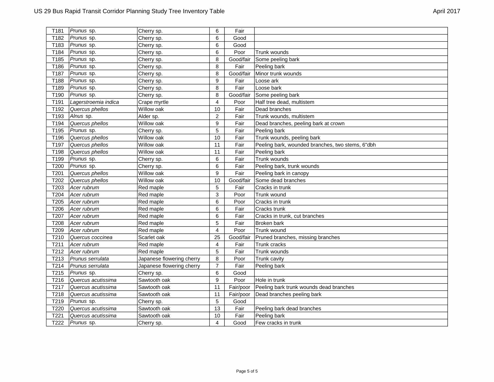
RK&K did not identify any forest stands within the project study areas. Two hundred and twenty-two individual trees were identified, including six significant trees (≥ 24 inches diameter at breast height (DBH)) and six specimen trees (≥ 30” DBH).

US 29 Bus Rapid Transit Corridor Planning Study July 2017 NRI Memorandum Page 5 of 6
5
FOREST STAND CHARACTERIZATION AND TREE SURVEY - Methods
The investigation methods for the forest stand characterization and tree survey were based on the Montgomery County Code Chapter 22A, using methodology described in the Environmental Guidelines, Guidelines For Environmental Management Of Development In Montgomery County (Maryland-National Capitol Park and Planning Commission (M-NCPPC), 2000); and Trees, Approved Technical Manual ((MNCPPC), 1992). The Trees, Approved Technical Manual defines a forest as “a biological community dominated by trees and other woody plants covering a land area of 10,000 square feet or greater. Forest includes (1) areas that have at least 100 trees per acre with at least 50% of those having a two-inch or greater diameter at 4.5 feet above the ground and larger; and (2) forest areas that have been cut but not cleared. Forest does not include orchards.” A characterization of forest types and overall conditions was completed for the project study areas using a Walk-Through Forest Stand Analysis datasheet. The forest characteristics recorded include the type of forest community; dominant species in the canopy, understory and herbaceous layer; dominant canopy size class; percent canopy closure; stand successional stage; downed woody debris; invasive species present; invasive species percent cover; and general stand conditions. An inventory of all stand-alone trees ≥ 6” DBH, including significant (≥ 24 inches DBH) and specimen (≥ 30” DBH or 75% of the size of the state champion) trees, was completed within the project study areas. The inventory also included all trees within the state right-of-way (ROW) regardless of size. The tree species, DBH, and condition were recorded for each of the inventoried trees. The condition of each tree was assessed by an ocular estimation of growth form, visible signs of decay, live crown ratio, and indications of disease or insect infestation. Each inventoried tree was numbered consecutively. Data obtained from the field reconnaissance was collected using an iPad and external GPS receiver. FOREST STAND CHARACTERIZATION AND TREE SURVEY – Results Inventoried Trees RK&K inventoried 222 trees, including six significant trees (≥ 24 inches DBH) (Table 2) and six specimen trees (≥ 30” DBH) (Table 3) within the project study areas. Photographs of the project study areas are located in Appendix B, information regarding inventoried trees is summarized in the Tree Inventory Table in Appendix C, and the locations of the trees are displayed on the Natural Resources Figures in Appendix E.
Table 2. Significant Trees Tree ID Scientific Name Common Name DBH Condition
T89 Quercus phellos Willow oak 26 Fair T103 Quercus phellos Willow oak 28 Good/fair T104 Quercus rubra Northern red oak 26 Good/fair T105 Picea abies Norway spruce 25 Fair T148 Quercus coccinea Scarlet oak 27 Fair/poor T210 Quercus coccinea Scarlet oak 25 Good/fair
Table 3. Specimen Trees
Tree ID Scientific Name Common Name DBH Condition T96 Quercus alba White oak 39 Good T98 Quercus alba White oak 39 Good/fair T99 Quercus rubra Northern red oak 32 Good/fair
T117 Acer saccharinum Silver maple 55 Fair/poor

US 29 Bus Rapid Transit Corridor Planning Study July 2017 NRI Memorandum Page 6 of 6
6
T118 Acer saccharinum Silver maple 52 Fair
T119 Fraxinus pennsylvanica Green ash 32 Good/fair
Tree impacts will be avoided and minimized to the greatest extent practicable using tree protection measures as specified in the Maryland-National Capital Park and Planning Commission (M-NCPPC) Trees Approved Technical Manual and the Montgomery County Roadside Tree Protection Law. Tree protection measures may include tree protection fencing, root pruning, branch pruning, and supplemental watering. Critical Root Zone (CRZ) impacts will be limited to one third or less of the total CRZ when possible.
The US 29 BRT Project will be exempt from Forest Conservation Plan submittal requirements under the Montgomery County Chapter 22A - Forest Conservation Law (Section 22A-5e and 22A-9), as a county highway Capital Improvements Project (CIP). Impacts to trees within state and county road ROW will be mitigated in accordance with the Montgomery County Roadside Tree Protection Law and the Maryland Roadside Tree Law. Tree removal within state road ROW will be mitigated 1:1, with the installation of one tree for every tree removed, in accordance with Maryland Department of Natural Resources (DNR) requirements. The Montgomery County Roadside Tree Protection Law requires payment of $500 into the Montgomery County Department of Transportation (MCDOT) street tree planting fund for removal of roadside trees designated on a MCDOT street tree inventory or >6” DBH within the county road ROW, and planting of one tree within the immediate vicinity of the project area as mitigation for the roadside tree removal. An additional fee of $250 is required for each replacement tree that cannot be planted within the immediate vicinity of the project area. A mitigation planting plan will be developed for tree replacement within the study areas where possible during the final project design stages for review and approval by MCDOT.

Appendix A: Figures

US 29 BRT Improvements Project
²
Figure 1 - Vicinity Map
_̂
ProjectLocation
0 7,000 14,0003,500
April 2017
1 inch = 7,000 feet
LEGEND
Proposed Station Locations
Briggs Chaney Route
Burtonsville Route

US 29 BRT Improvements Project
²
Figure 2 - USGS Map
_̂
ProjectLocation
0 7,000 14,0003,500
April 2017
1 inch = 7,000 feet
LEGEND
Proposed Station Locations
Briggs Chaney Route
Burtonsville Route
BELTSVILLE AND KENSINGTONQUADRANGLES MARYLAND
7.5 MINUTE SERIES (TOPOGRAPHIC)

Station 4
Station 9
Station 3
Station 7
Station 6
Station 5
Station 8
Station 2
Station 11
Station 10
US 29 Bus Rapid Transit Corridor Planning Study
April 2017
Environmental Map - Key SheetFigure 3a
0 5,000 10,0002,500
1 inch = 5,000 feet
²
Environmental MapFigure 3
LEGEND
Study Area
DNR Waters
DNR Wetlands
NWI Wetlands
FEMA 100-Year Floodplain
SSURGO Soils
US 29 Bus Rapid Transit Corridor Planning Study
0 100 200 300 40050
1 inch = 200 feet
April 2017
²
bStation 2 - Fenton Street
57B

Environmental MapFigure 3
LEGEND
Study Area
DNR Waters
DNR Wetlands
NWI Wetlands
FEMA 100-Year Floodplain
SSURGO Soils
US 29 Bus Rapid Transit Corridor Planning Study
0 100 200 300 40050
1 inch = 200 feet
April 2017
²
cStation 3 - University Boulevard
57B
Environmental MapFigure 3
LEGEND
Study Area
DNR Waters
DNR Wetlands
NWI Wetlands
FEMA 100-Year Floodplain
SSURGO Soils
US 29 Bus Rapid Transit Corridor Planning Study
0 100 200 300 40050
1 inch = 200 feet
April 2017
²
dStation 4 - Burnt Mills
57B

Environmental MapFigure 3
LEGEND
Study Area
DNR Waters
DNR Wetlands
NWI Wetlands
FEMA 100-Year Floodplain
SSURGO Soils
US 29 Bus Rapid Transit Corridor Planning Study
0 100 200 300 40050
1 inch = 200 feet
April 2017
²
eStation 5 - Oak Leaf Drive
57B
Environmental MapFigure 3
LEGEND
Study Area
DNR Waters
DNR Wetlands
NWI Wetlands
FEMA 100-Year Floodplain
SSURGO Soils
US 29 Bus Rapid Transit Corridor Planning Study
0 100 200 300 40050
1 inch = 200 feet
April 2017
²
fStation 6 - White Oak Transit Center
57B

Environmental MapFigure 3
LEGEND
Study Area
DNR Waters
DNR Wetlands
NWI Wetlands
FEMA 100-Year Floodplain
SSURGO Soils
US 29 Bus Rapid Transit Corridor Planning Study
0 100 200 300 40050
1 inch = 200 feet
April 2017
²
gStation 7 - Stewart Lane
57B

Environmental MapFigure 3
LEGEND
Study Area
DNR Waters
DNR Wetlands
NWI Wetlands
FEMA 100-Year Floodplain
SSURGO Soils
US 29 Bus Rapid Transit Corridor Planning Study
0 100 200 300 40050
1 inch = 200 feet
April 2017
²
hStation 8 - Tech Road
57B
Environmental MapFigure 3
LEGEND
Study Area
DNR Waters
DNR Wetlands
NWI Wetlands
FEMA 100-Year Floodplain
SSURGO Soils
US 29 Bus Rapid Transit Corridor Planning Study
0 100 200 300 40050
1 inch = 200 feet
April 2017
²
iStation 9 - Briggs Chaney Park & Ride
57B

Environmental MapFigure 3
LEGEND
Study Area
DNR Waters
DNR Wetlands
NWI Wetlands
FEMA 100-Year Floodplain
SSURGO Soils
US 29 Bus Rapid Transit Corridor Planning Study
0 100 200 300 40050
1 inch = 200 feet
April 2017
²
jStation 10 - Castle Ridge
57B

Environmental MapFigure 3
LEGEND
Study Area
DNR Waters
DNR Wetlands
NWI Wetlands
FEMA 100-Year Floodplain
SSURGO Soils
US 29 Bus Rapid Transit Corridor Planning Study
0 100 200 300 40050
1 inch = 200 feet
April 2017
²
kStation 11 - Burtonsville Park & Ride
57B

Appendix B: Photographic Record

US 29 Bus Rapid Transit (BRT) Corridor Planning Study – April 2017 Photographic Record
Station 2 – Fenton Street, facing north
Station 3 – University Boulevard, facing south

US 29 Bus Rapid Transit (BRT) Corridor Planning Study – April 2017 Photographic Record
Station 4 – Burnt Mills, facing north
Station 5 – Oak Leaf Drive, facing north

US 29 Bus Rapid Transit (BRT) Corridor Planning Study – April 2017 Photographic Record
Station 6 – White Oak Transit Center, facing west
Station 7 – Stewart Lane, facing north

US 29 Bus Rapid Transit (BRT) Corridor Planning Study – April 2017 Photographic Record
Station 8 – Tech Road, facing northwest
Station 9 – Briggs Chaney Park & Ride, facing southeast
US 29 Bus Rapid Transit (BRT) Corridor Planning Study – April 2017 Photographic Record
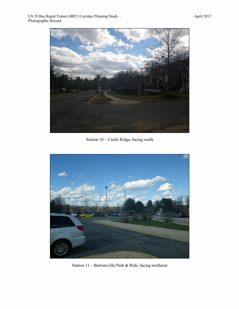
Station 10 – Castle Ridge, facing south
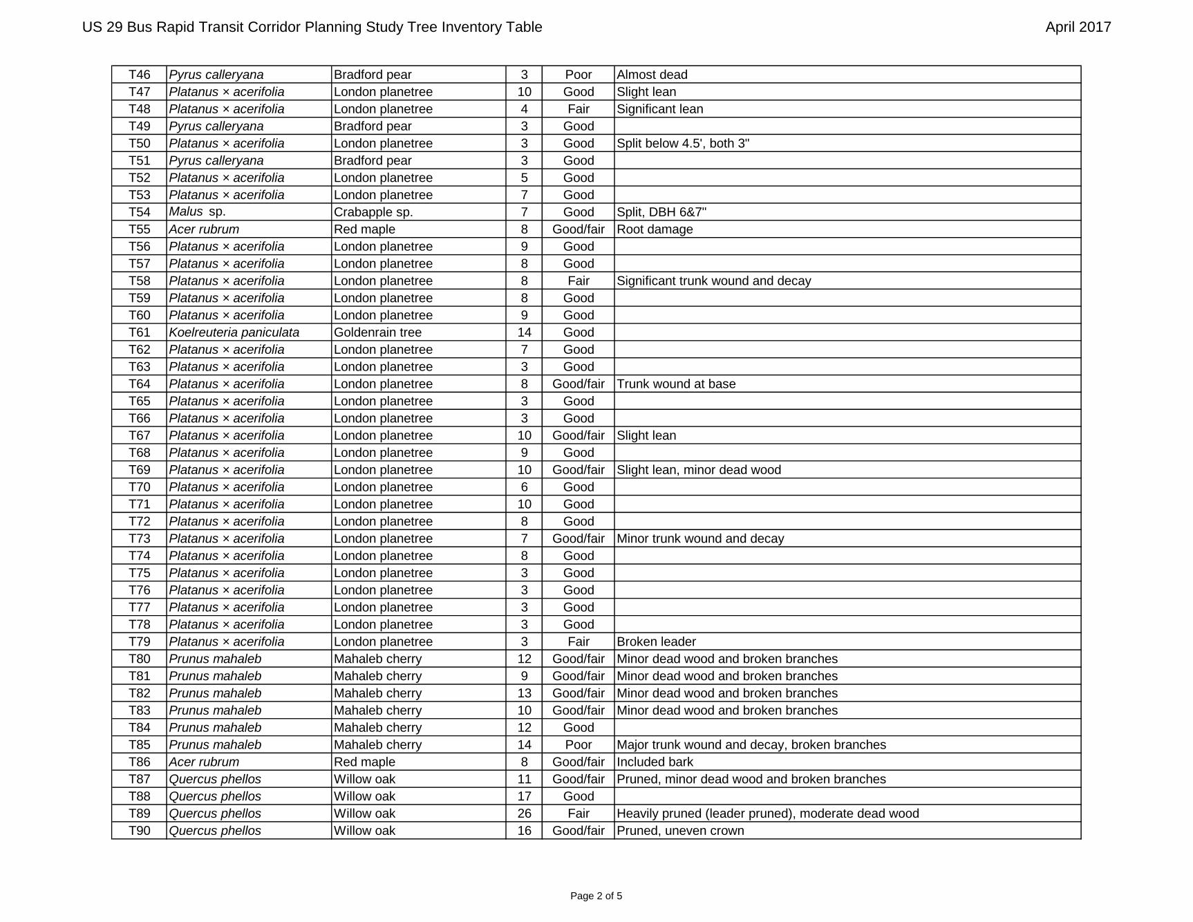
Station 11 – Burtonsville Park & Ride, facing northeast

Appendix C: Tree Inventory Table

US 29 Bus Rapid Transit Corridor Planning Study Tree Inventory Table April 2017
Tree ID Scientific Name Common Name DBH Condition CommentsT1 Koelreuteria paniculata Goldenrain tree 15 Good Pruned
T2 Koelreuteria paniculata Goldenrain tree 12 Good Pruned
T3 Koelreuteria paniculata Goldenrain tree 12 Fair Crack in base of trunk
T4 Koelreuteria paniculata Goldenrain tree 14 Good Pruned
T5 Koelreuteria paniculata Goldenrain tree 16 Good/fair Moderate dead wood
T6 Koelreuteria paniculata Goldenrain tree 16 Fair Significant dead wood
T7 Koelreuteria paniculata Goldenrain tree 16 Good/fair Pruned, minor dead wood
T8 Koelreuteria paniculata Goldenrain tree 3 Good
T9 Koelreuteria paniculata Goldenrain tree 14 Good Pruned
T10 Koelreuteria paniculata Goldenrain tree 10 Good/fair Pruned , minor dead wood
T11 Koelreuteria paniculata Goldenrain tree 14 Good/fair Pruned , moderate dead wood
T12 Koelreuteria paniculata Goldenrain tree 20 Good/fair Pruned , minor dead wood
T13 Betula sp. Birch sp. 18 Good Pruned
T14 Juniperus virginiana Eastern redcedar 15 Fair Minor dead wood and broken branches
T15 Juniperus virginiana Eastern redcedar 23 Fair Minor trunk wound, uneven crown, minor broken branches
T16 Acer rubrum Red maple 8 Good
T17 Juglans nigra Black walnut 4 Good/fair Pruned, minor broken branches, split below 4.5', DBH 3 and 4
T18 Platanus occidentalis Sycamore 11 Good/fair Suckering
T19 Platanus occidentalis Sycamore 9 Good/fair
T20 Lagerstroemia indica Crape myrtle 2 Good
T21 Lagerstroemia indica Crape myrtle 2 Good
T22 Lagerstroemia indica Crape myrtle 2 Good
T23 Lagerstroemia indica Crape myrtle 2 Good
T24 Lagerstroemia indica Crape myrtle 2 Good
T25 Lagerstroemia indica Crape myrtle 2 Good
T26 Lagerstroemia indica Crape myrtle 2 Good
T27 Lagerstroemia indica Crape myrtle 2 Good
T28 Lagerstroemia indica Crape myrtle 2 Good
T29 Lagerstroemia indica Crape myrtle 2 Good
T30 Lagerstroemia indica Crape myrtle 2 Good
T31 Lagerstroemia indica Crape myrtle 2 Good
T32 Malus sp. Crabapple sp. 20 Good Pruned
T33 Platanus × acerifolia London planetree 8 Good
T34 Platanus × acerifolia London planetree 6 Good
T35 Juniperus virginiana Eastern redcedar 6 Good Multistem (4), btwn 5&6"
T36 Juniperus virginiana Eastern redcedar 9 Good Multistem (3 main)
T37 Juniperus virginiana Eastern redcedar 9 Good Multistem (4 main), btwn 6&9"
T38 Platanus × acerifolia London planetree 8 Good
T39 Platanus × acerifolia London planetree 9 Good
T40 Lagerstroemia indica Crape myrtle 3 Good Multistem (3)
T41 Lagerstroemia indica Crape myrtle 3 Good Multistem (3), btwn 2&3"
T42 Platanus × acerifolia London planetree 6 Good
T43 Lagerstroemia indica Crape myrtle 3 Good Multistem (3)
T44 Lagerstroemia indica Crape myrtle 3 Good Multistem (3), btwn 2&3"
T45 Platanus × acerifolia London planetree 6 Good
Page 1 of 5
US 29 Bus Rapid Transit Corridor Planning Study Tree Inventory Table April 2017
T46 Pyrus calleryana Bradford pear 3 Poor Almost dead
T47 Platanus × acerifolia London planetree 10 Good Slight lean
T48 Platanus × acerifolia London planetree 4 Fair Significant lean
T49 Pyrus calleryana Bradford pear 3 Good
T50 Platanus × acerifolia London planetree 3 Good Split below 4.5', both 3"
T51 Pyrus calleryana Bradford pear 3 Good
T52 Platanus × acerifolia London planetree 5 Good
T53 Platanus × acerifolia London planetree 7 Good
T54 Malus sp. Crabapple sp. 7 Good Split, DBH 6&7"
T55 Acer rubrum Red maple 8 Good/fair Root damage
T56 Platanus × acerifolia London planetree 9 Good
T57 Platanus × acerifolia London planetree 8 Good
T58 Platanus × acerifolia London planetree 8 Fair Significant trunk wound and decay
T59 Platanus × acerifolia London planetree 8 Good
T60 Platanus × acerifolia London planetree 9 Good
T61 Koelreuteria paniculata Goldenrain tree 14 Good
T62 Platanus × acerifolia London planetree 7 Good
T63 Platanus × acerifolia London planetree 3 Good
T64 Platanus × acerifolia London planetree 8 Good/fair Trunk wound at base
T65 Platanus × acerifolia London planetree 3 Good
T66 Platanus × acerifolia London planetree 3 Good
T67 Platanus × acerifolia London planetree 10 Good/fair Slight lean
T68 Platanus × acerifolia London planetree 9 Good
T69 Platanus × acerifolia London planetree 10 Good/fair Slight lean, minor dead wood
T70 Platanus × acerifolia London planetree 6 Good
T71 Platanus × acerifolia London planetree 10 Good
T72 Platanus × acerifolia London planetree 8 Good
T73 Platanus × acerifolia London planetree 7 Good/fair Minor trunk wound and decay
T74 Platanus × acerifolia London planetree 8 Good
T75 Platanus × acerifolia London planetree 3 Good
T76 Platanus × acerifolia London planetree 3 Good
T77 Platanus × acerifolia London planetree 3 Good
T78 Platanus × acerifolia London planetree 3 Good
T79 Platanus × acerifolia London planetree 3 Fair Broken leader
T80 Prunus mahaleb Mahaleb cherry 12 Good/fair Minor dead wood and broken branches
T81 Prunus mahaleb Mahaleb cherry 9 Good/fair Minor dead wood and broken branches
T82 Prunus mahaleb Mahaleb cherry 13 Good/fair Minor dead wood and broken branches
T83 Prunus mahaleb Mahaleb cherry 10 Good/fair Minor dead wood and broken branches
T84 Prunus mahaleb Mahaleb cherry 12 Good
T85 Prunus mahaleb Mahaleb cherry 14 Poor Major trunk wound and decay, broken branches
T86 Acer rubrum Red maple 8 Good/fair Included bark
T87 Quercus phellos Willow oak 11 Good/fair Pruned, minor dead wood and broken branches
T88 Quercus phellos Willow oak 17 Good
T89 Quercus phellos Willow oak 26 Fair Heavily pruned (leader pruned), moderate dead wood
T90 Quercus phellos Willow oak 16 Good/fair Pruned, uneven crown
Page 2 of 5

US 29 Bus Rapid Transit Corridor Planning Study Tree Inventory Table April 2017
T91 Quercus phellos Willow oak 21 Good Pruned
T92 Quercus phellos Willow oak 13 Fair Uneven crown, many broken branches
T93 Quercus phellos Willow oak 16 Good/fair Pruned, uneven crown
T94 Quercus phellos Willow oak 16 Good/fair Pruned, uneven crown
T95 Liriodendron tulipifera Tulip poplar 23 Fair/poor Broken leader, moderate broken branches, vines, lean
T96 Quercus alba White oak 39 Good Flag hung on barbed wire
T97 Juglans nigra Black walnut 9 Fair Pruned, uneven crown, vines
T98 Quercus alba White oak 39 Good/fair Minor broken branches, vines
T99 Quercus rubra Northern red oak 32 Good/fair Lean, vines
T100 Koelreuteria paniculata Goldenrain tree 4 Good/fair Minor trunk wound and decay
T101 Quercus phellos Willow oak 21 Fair Heavily pruned, uneven crown
T102 Quercus phellos Willow oak 19 Good Willow oak?
T103 Quercus phellos Willow oak 28 Good/fair Pruned, exposed roots
T104 Quercus rubra Northern red oak 26 Good/fair Pruned, minor broken branches
T105 Picea abies Norway spruce 25 Fair Lean, moderate dead wood and broken branches, pruned
T106 Quercus phellos Willow oak 11 Good
T107 Quercus phellos Willow oak 5 Good
T108 Quercus phellos Willow oak 7 Good
T109 Quercus phellos Willow oak 5 Good
T110 Quercus phellos Willow oak 6 Good
T111 Quercus rubra Northern red oak 5 Good
T112 Quercus rubra Northern red oak 12 Good
T113 Quercus rubra Northern red oak 14 Good
T114 Juniperus virginiana Eastern redcedar 8 Fair Twin, smaller dbh 6", uneven crown, lean, vines
T115 Juniperus virginiana Eastern redcedar 8 Fair Multistem (3) - 6", 8", 4" dbh, vines, uneven crown
T116 Acer rubrum Red maple 10 Good/fair Sapsucker holes
T117 Acer saccharinum Silver maple 55 Fair/poor Heavily pruned (pruned leader), exposed roots, included bark, dead wood
T118 Acer saccharinum Silver maple 52 Fair Vines into crown, heavily pruned, dead branches
T119 Fraxinus pennsylvanica Green ash 32 Good/fair Pruned, minor dead wood, exposed roots
T120 Prunus sp. Cherry sp. 5 Good
T121 Prunus sp. Cherry sp. 5 Good
T122 Prunus sp. Cherry sp. 6 Good
T123 Prunus serrulata Japanese flowering cherry 7 Good
T124 Prunus serrulata Japanese flowering cherry 6 Good
T125 Prunus serrulata Japanese flowering cherry 6 Fair
T126 Prunus serrulata Japanese flowering cherry 6 Good
T127 Prunus serrulata Japanese flowering cherry 5 Good
T128 Prunus serrulata Japanese flowering cherry 6 Good/fair
T129 Prunus serrulata Japanese flowering cherry 6 Fair Trunk hole
T130 Prunus serrulata Japanese flowering cherry 5 Fair Trunk wounds
T131 Prunus serrulata Japanese flowering cherry 5 Good/fair
T132 Prunus serrulata Japanese flowering cherry 5 Good
T133 Prunus serrulata Japanese flowering cherry 5 Good/fair Trunk wounds
T134 Prunus serrulata Japanese flowering cherry 5 Good
T135 Prunus serrulata Japanese flowering cherry 5 Good
Page 3 of 5

US 29 Bus Rapid Transit Corridor Planning Study Tree Inventory Table April 2017
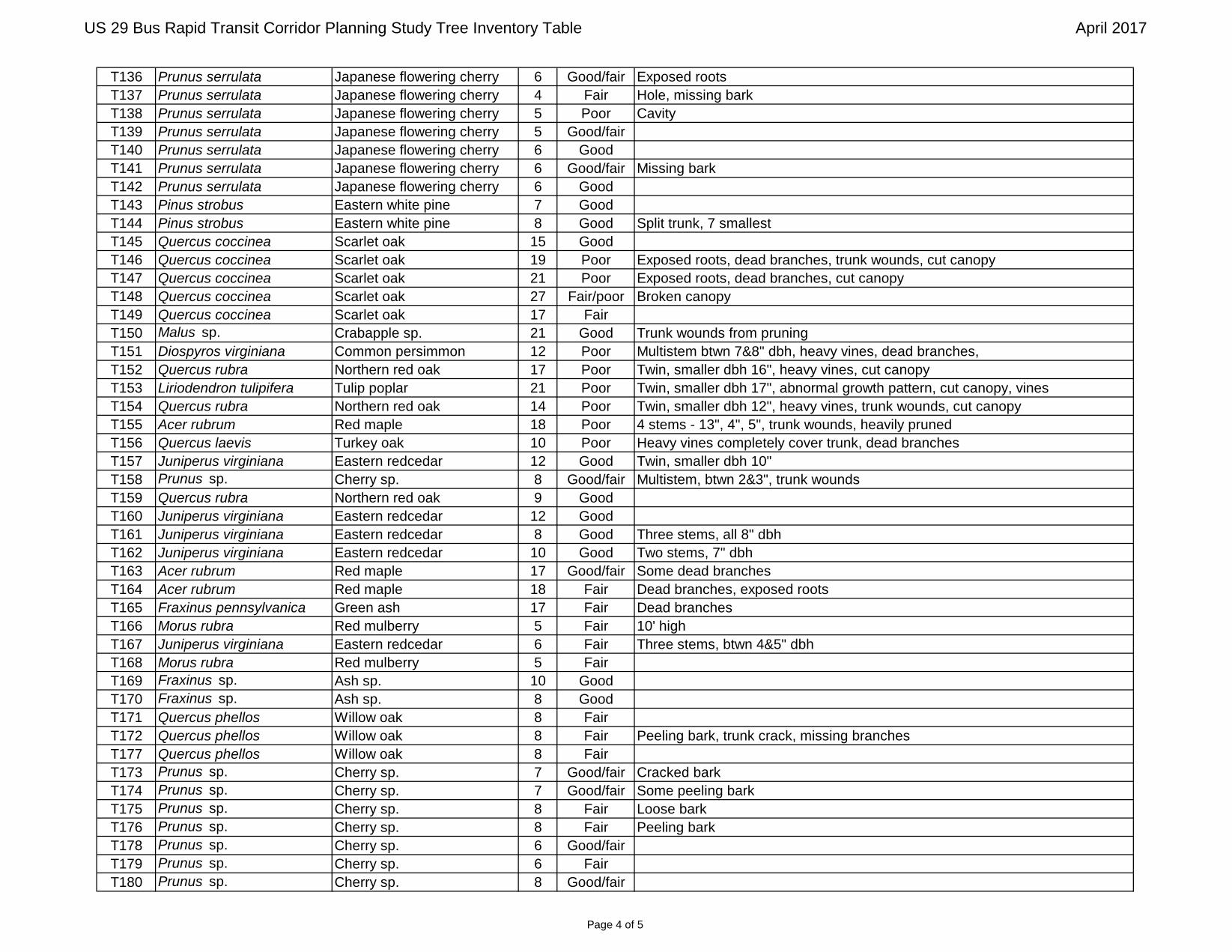
T136 Prunus serrulata Japanese flowering cherry 6 Good/fair Exposed roots
T137 Prunus serrulata Japanese flowering cherry 4 Fair Hole, missing bark
T138 Prunus serrulata Japanese flowering cherry 5 Poor Cavity
T139 Prunus serrulata Japanese flowering cherry 5 Good/fair
T140 Prunus serrulata Japanese flowering cherry 6 Good
T141 Prunus serrulata Japanese flowering cherry 6 Good/fair Missing bark
T142 Prunus serrulata Japanese flowering cherry 6 Good
T143 Pinus strobus Eastern white pine 7 Good
T144 Pinus strobus Eastern white pine 8 Good Split trunk, 7 smallest
T145 Quercus coccinea Scarlet oak 15 Good
T146 Quercus coccinea Scarlet oak 19 Poor Exposed roots, dead branches, trunk wounds, cut canopy
T147 Quercus coccinea Scarlet oak 21 Poor Exposed roots, dead branches, cut canopy
T148 Quercus coccinea Scarlet oak 27 Fair/poor Broken canopy
T149 Quercus coccinea Scarlet oak 17 Fair
T150 Malus sp. Crabapple sp. 21 Good Trunk wounds from pruning
T151 Diospyros virginiana Common persimmon 12 Poor Multistem btwn 7&8" dbh, heavy vines, dead branches,
T152 Quercus rubra Northern red oak 17 Poor Twin, smaller dbh 16", heavy vines, cut canopy
T153 Liriodendron tulipifera Tulip poplar 21 Poor Twin, smaller dbh 17", abnormal growth pattern, cut canopy, vines
T154 Quercus rubra Northern red oak 14 Poor Twin, smaller dbh 12", heavy vines, trunk wounds, cut canopy
T155 Acer rubrum Red maple 18 Poor 4 stems - 13", 4", 5", trunk wounds, heavily pruned
T156 Quercus laevis Turkey oak 10 Poor Heavy vines completely cover trunk, dead branches
T157 Juniperus virginiana Eastern redcedar 12 Good Twin, smaller dbh 10"
T158 Prunus sp. Cherry sp. 8 Good/fair Multistem, btwn 2&3", trunk wounds
T159 Quercus rubra Northern red oak 9 Good
T160 Juniperus virginiana Eastern redcedar 12 Good
T161 Juniperus virginiana Eastern redcedar 8 Good Three stems, all 8" dbh
T162 Juniperus virginiana Eastern redcedar 10 Good Two stems, 7" dbh
T163 Acer rubrum Red maple 17 Good/fair Some dead branches
T164 Acer rubrum Red maple 18 Fair Dead branches, exposed roots
T165 Fraxinus pennsylvanica Green ash 17 Fair Dead branches
T166 Morus rubra Red mulberry 5 Fair 10' high
T167 Juniperus virginiana Eastern redcedar 6 Fair Three stems, btwn 4&5" dbh
T168 Morus rubra Red mulberry 5 Fair
T169 Fraxinus sp. Ash sp. 10 Good
T170 Fraxinus sp. Ash sp. 8 Good
T171 Quercus phellos Willow oak 8 Fair
T172 Quercus phellos Willow oak 8 Fair Peeling bark, trunk crack, missing branches
T177 Quercus phellos Willow oak 8 Fair
T173 Prunus sp. Cherry sp. 7 Good/fair Cracked bark
T174 Prunus sp. Cherry sp. 7 Good/fair Some peeling bark
T175 Prunus sp. Cherry sp. 8 Fair Loose bark
T176 Prunus sp. Cherry sp. 8 Fair Peeling bark
T178 Prunus sp. Cherry sp. 6 Good/fair
T179 Prunus sp. Cherry sp. 6 Fair
T180 Prunus sp. Cherry sp. 8 Good/fair
Page 4 of 5
US 29 Bus Rapid Transit Corridor Planning Study Tree Inventory Table April 2017
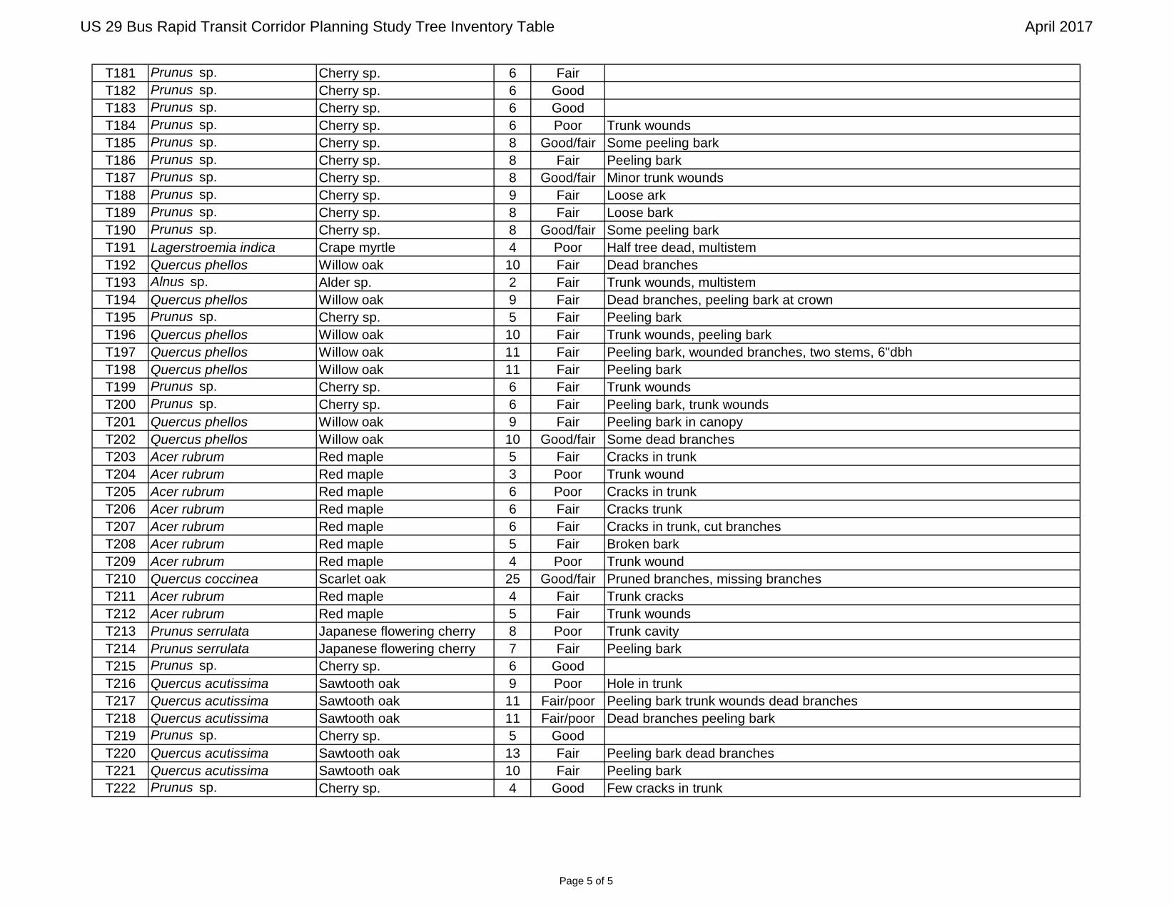
T181 Prunus sp. Cherry sp. 6 Fair
T182 Prunus sp. Cherry sp. 6 Good
T183 Prunus sp. Cherry sp. 6 Good
T184 Prunus sp. Cherry sp. 6 Poor Trunk wounds
T185 Prunus sp. Cherry sp. 8 Good/fair Some peeling bark
T186 Prunus sp. Cherry sp. 8 Fair Peeling bark
T187 Prunus sp. Cherry sp. 8 Good/fair Minor trunk wounds
T188 Prunus sp. Cherry sp. 9 Fair Loose ark
T189 Prunus sp. Cherry sp. 8 Fair Loose bark
T190 Prunus sp. Cherry sp. 8 Good/fair Some peeling bark
T191 Lagerstroemia indica Crape myrtle 4 Poor Half tree dead, multistem
T192 Quercus phellos Willow oak 10 Fair Dead branches
T193 Alnus sp. Alder sp. 2 Fair Trunk wounds, multistem
T194 Quercus phellos Willow oak 9 Fair Dead branches, peeling bark at crown
T195 Prunus sp. Cherry sp. 5 Fair Peeling bark
T196 Quercus phellos Willow oak 10 Fair Trunk wounds, peeling bark
T197 Quercus phellos Willow oak 11 Fair Peeling bark, wounded branches, two stems, 6"dbh
T198 Quercus phellos Willow oak 11 Fair Peeling bark
T199 Prunus sp. Cherry sp. 6 Fair Trunk wounds
T200 Prunus sp. Cherry sp. 6 Fair Peeling bark, trunk wounds
T201 Quercus phellos Willow oak 9 Fair Peeling bark in canopy
T202 Quercus phellos Willow oak 10 Good/fair Some dead branches
T203 Acer rubrum Red maple 5 Fair Cracks in trunk
T204 Acer rubrum Red maple 3 Poor Trunk wound
T205 Acer rubrum Red maple 6 Poor Cracks in trunk
T206 Acer rubrum Red maple 6 Fair Cracks trunk
T207 Acer rubrum Red maple 6 Fair Cracks in trunk, cut branches
T208 Acer rubrum Red maple 5 Fair Broken bark
T209 Acer rubrum Red maple 4 Poor Trunk wound
T210 Quercus coccinea Scarlet oak 25 Good/fair Pruned branches, missing branches
T211 Acer rubrum Red maple 4 Fair Trunk cracks
T212 Acer rubrum Red maple 5 Fair Trunk wounds
T213 Prunus serrulata Japanese flowering cherry 8 Poor Trunk cavity
T214 Prunus serrulata Japanese flowering cherry 7 Fair Peeling bark
T215 Prunus sp. Cherry sp. 6 Good
T216 Quercus acutissima Sawtooth oak 9 Poor Hole in trunk
T217 Quercus acutissima Sawtooth oak 11 Fair/poor Peeling bark trunk wounds dead branches
T218 Quercus acutissima Sawtooth oak 11 Fair/poor Dead branches peeling bark
T219 Prunus sp. Cherry sp. 5 Good
T220 Quercus acutissima Sawtooth oak 13 Fair Peeling bark dead branches
T221 Quercus acutissima Sawtooth oak 10 Fair Peeling bark
T222 Prunus sp. Cherry sp. 4 Good Few cracks in trunk
Page 5 of 5

Appendix D: Agency Correspondence


Tawes State Office Building – 580 Taylor Avenue – Annapolis, Maryland 21401 410-260-8DNR or toll free in Maryland 877-620-8DNR – dnr.maryland.gov – TTY Users Call via the Maryland Relay
17-MIS-167 May 4th, 2017
Sarah Falcone
RK&K 3501 Concord Road, Suite 100
York, PA 17402
Subject: Fisheries Information for US 29 Bus Rapid Transit Corridor Planning Study, MCDOT CIP# 0501318, Montgomery County Maryland
Dear Ms. Falcone;
The above referenced project has been reviewed to determine fisheries species near the proposed project. The proposed
activities include construction of 10 stations along a corridor and the modification of existing platform at the southernmost station.
The project looks like it crosses an unnamed tributary to Paint Branch which is classified as a Use I stream, and the
Northwest Branch of the Anacostia River which is classified as a Use IV stream. In general, no in-stream work may occur
in Use I streams between March 1st through June 15th and in Use IV streams between March 1st through May 31st of any given year, to protect spawning fish.
DNR has documented many resident fish species from both Paint Branch and the Anacostia and its tributaries by our
Maryland Biological Stream Survey. MBSS data can be accessed via the MDDNR web page at
http://streamhealth.maryland.gov, allowing access to resource surveys.
If you have any further questions, please feel free to contact me at 410 260-8736.
Sincerely;
Christopher Aadland
Environmental Review Program

Online Certification Letter
Today's date:
Project:
Dear Applicant for online certification:
Thank you for using the U.S. Fish and Wildlife Service (Service) Chesapeake Bay Field
Office online project review process. By printing this letter in conjunction with your project
review package, you are certifying that you have completed the online project review process
for the referenced project in accordance with all instructions provided, using the best
available information to reach your conclusions. This letter, and the enclosed project review
package, completes the review of your project in accordance with the Endangered Species
Act of 1973 (16 U.S.C. 1531-1544, 87 Stat. 884), as amended (ESA).This letter also provides
information for your project review under the National Environmental Policy Act of 1969
(P.L. 91-190, 42 U.S.C. 4321-4347, 83 Stat. 852), as amended. A copy of this letter and the
project review package must be submitted to this office for this certification to be valid. This
letter and the project review package will be maintained in our records.
Based on this information and in accordance with section 7 of the Endangered Species Act
(87 Stat. 884, as amended; 16 U.S.C. 1531 et seq.), we certify that except for occasional
transient individuals, no federally proposed or listed endangered or threatened species are
known to exist within the project area. Therefore, no Biological Assessment or further
section 7 consultation with the U.S. Fish and Wildlife Service is required. Should project
plans change, or if additional information on the distribution of listed or proposed species
becomes available, this determination may be reconsidered.
This response relates only to federally protected threatened or endangered species under our
jurisdiction. For additional information on threatened or endangered species in Maryland,
you should contact the Maryland Wildlife and Heritage Division at (410) 260-8573. For
information in Delaware you should contact the Delaware Division of Fish and Wildlife,
Wildlife Species Conservation and Research Program at (302) 735-8658. For information in
the District of Columbia, you should contact the National Park Service at (202) 339-8309.
The U.S. Fish and Wildlife Service also works with other Federal agencies and states to
minimize loss of wetlands, reduce impacts to fish and migratory birds, including bald eagles,
and restore habitat for wildlife. Information on these conservation issues and how
development projects can avoid affecting these resources can be found on our website
(www.fws.gov/chesapeakebay)
We appreciate the opportunity to provide information relative to fish and wildlife issues, and
thank you for your interest in these resources. If you have any questions or need further
assistance, please contact Chesapeake Bay Field Office Threatened and Endangered Species
program at (410) 573-4527.
Sincerely,
Genevieve LaRouche
Field Supervisor
USFWS Chesapeake Bay Field Office -- Online certification letter https://www.fws.gov/chesapeakebay/endsppweb/ProjectReview/onlinelett...
1 of 1 3/22/2017 4:20 PM

March 22, 2017
United States Department of the InteriorFISH AND WILDLIFE SERVICE
Chesapeake Bay Ecological Services Field Office177 Admiral Cochrane DriveAnnapolis, MD 21401-7307
Phone: (410) 573-4599 Fax: (410) 266-9127http://www.fws.gov/chesapeakebay/
http://www.fws.gov/chesapeakebay/endsppweb/ProjectReview/Index.html
In Reply Refer To:Consultation Code: 05E2CB00-2017-SLI-0974Event Code: 05E2CB00-2017-E-01801 Project Name: US 29 BRT Improvements Project
Subject: List of threatened and endangered species that may occur in your proposed projectlocation, and/or may be affected by your proposed project
To Whom It May Concern:
The enclosed species list identifies threatened, endangered, proposed and candidate species, aswell as proposed and final designated critical habitat, that may occur within the boundary of yourproposed project and/or may be affected by your proposed project. This species list fulfills therequirements of the U.S. Fish and Wildlife Service (Service) under section 7(c) of theEndangered Species Act (Act) of 1973, as amended (16 U.S.C. 1531 ).et seq.
New information based on updated surveys, changes in the abundance and distribution ofspecies, changed habitat conditions, or other factors could change this list. Please feel free tocontact us if you need more current information or assistance regarding the potential impacts tofederally proposed, listed, and candidate species and federally designated and proposed criticalhabitat. Please note that under 50 CFR 402.12(e) of the regulations implementing section 7 of theAct, the accuracy of this species list should be verified after 90 days. This verification can becompleted formally or informally as desired. The Service recommends that verification becompleted by visiting the ECOS-IPaC website at regular intervals during project planning andimplementation for updates to species lists and information. An updated list may be requestedthrough the ECOS-IPaC system by completing the same process used to receive the enclosed list.
The purpose of the Act is to provide a means whereby threatened and endangered species and theecosystems upon which they depend may be conserved. Under sections 7(a)(1) and 7(a)(2) of theAct and its implementing regulations (50 CFR 402 ), Federal agencies are required toet seq.utilize their authorities to carry out programs for the conservation of threatened and endangeredspecies and to determine whether projects may affect threatened and endangered species and/ordesignated critical habitat.
A Biological Assessment is required for construction projects (or other undertakings having

03/22/2017 Event Code: 05E2CB00-2017-E-01801 2
similar physical impacts) that are major Federal actions significantly affecting the quality of thehuman environment as defined in the National Environmental Policy Act (42 U.S.C. 4332(2)(c)). For projects other than major construction activities, the Service suggests that a biologicalevaluation similar to a Biological Assessment be prepared to determine whether the project mayaffect listed or proposed species and/or designated or proposed critical habitat. Recommendedcontents of a Biological Assessment are described at 50 CFR 402.12.
If a Federal agency determines, based on the Biological Assessment or biological evaluation, thatlisted species and/or designated critical habitat may be affected by the proposed project, theagency is required to consult with the Service pursuant to 50 CFR 402. In addition, the Servicerecommends that candidate species, proposed species and proposed critical habitat be addressedwithin the consultation. More information on the regulations and procedures for section 7consultation, including the role of permit or license applicants, can be found in the "EndangeredSpecies Consultation Handbook" at:
http://www.fws.gov/endangered/esa-library/pdf/TOC-GLOS.PDF
Please be aware that bald and golden eagles are protected under the Bald and Golden EagleProtection Act (16 U.S.C. 668 ), and projects affecting these species may requireet seq.development of an eagle conservation plan(http://www.fws.gov/windenergy/eagle_guidance.html). Additionally, wind energy projectsshould follow the wind energy guidelines (http://www.fws.gov/windenergy/) for minimizingimpacts to migratory birds and bats.
Guidance for minimizing impacts to migratory birds for projects including communicationstowers (e.g., cellular, digital television, radio, and emergency broadcast) can be found at:http://www.fws.gov/migratorybirds/CurrentBirdIssues/Hazards/towers/towers.htm;http://www.towerkill.com; andhttp://www.fws.gov/migratorybirds/CurrentBirdIssues/Hazards/towers/comtow.html.
We appreciate your concern for threatened and endangered species. The Service encouragesFederal agencies to include conservation of threatened and endangered species into their projectplanning to further the purposes of the Act. Please include the Consultation Tracking Number inthe header of this letter with any request for consultation or correspondence about your projectthat you submit to our office.
Attachment(s):
Official Species List
USFWS National Wildlife Refuges and Fish Hatcheries
Wetlands

03/22/2017 Event Code: 05E2CB00-2017-E-01801 1
Official Species ListThis list is provided pursuant to Section 7 of the Endangered Species Act, and fulfills therequirement for Federal agencies to "request of the Secretary of the Interior information whetherany species which is listed or proposed to be listed may be present in the area of a proposedaction".
This species list is provided by:
Chesapeake Bay Ecological Services Field Office177 Admiral Cochrane DriveAnnapolis, MD 21401-7307(410) 573-4599

03/22/2017 Event Code: 05E2CB00-2017-E-01801 2
Project SummaryConsultation Code: 05E2CB00-2017-SLI-0974
Event Code: 05E2CB00-2017-E-01801
Project Name: US 29 BRT Improvements Project
Project Type: TRANSPORTATION
Project Description: Implementation of a bus rapid transit (BRT) system along US 29. Elevenstation locations will be added along 14 miles of roadway.
Project Location: Approximate location of the project can be viewed in Google Maps:
https://www.google.com/maps/place/39.07787592604663N76.94226229095962W
Counties: Montgomery, MD
Endangered Species Act SpeciesThere is a total of 0 threatened, endangered, or candidate species on your species list. Species onthis list should be considered in an effects analysis for your project and could include speciesthat exist in another geographic area. For example, certain fish may appear on the species listbecause a project could affect downstream species. See the "Critical habitats" section below forthose critical habitats that lie wholly or partially within your project area. Please contact thedesignated FWS office if you have questions.
Critical habitats
There are no critical habitats within your project area.

03/22/2017 Event Code: 05E2CB00-2017-E-01801 3

03/22/2017 Event Code: 05E2CB00-2017-E-01801 1
USFWS National Wildlife Refuges And FishHatcheriesAny activity proposed on lands must undergo a 'CompatibilityNational Wildlife RefugeDetermination' conducted by the Refuge. Please contact the individual Refuges to discuss anyquestions or concerns.
There are no refuges or fish hatcheries within your project area.
03/22/2017 Event Code: 05E2CB00-2017-E-01801 1
WetlandsImpacts to and other aquatic habitats may be subject to regulation under SectionNWI wetlands404 of the Clean Water Act, or other State/Federal statutes.
For more information please contact the Regulatory Program of the local U.S. Army Corps of.Engineers District
There are no wetlands within your project area.

Appendix E: Natural Resources Figures

US 29Bus Rapid Transit
Natural Resources
April 2017
0 200 400100 Feet
É
!( Significant/Specimen Trees
Inventoried Trees <24" DBH
Critical Root Zone
Study Area
DNR Waters
DNR Wetlands
NWI Wetlands
FEMA 100-Year Floodplain
SSURGO Soils Page 1 of 10Fenton Street

US 29Bus Rapid Transit
Natural Resources
April 2017
0 200 400100 Feet
É
!( Significant/Specimen Trees
Inventoried Trees <24" DBH
Critical Root Zone
Study Area
DNR Waters
DNR Wetlands
NWI Wetlands
FEMA 100-Year Floodplain
SSURGO Soils Page 2 of 10University Boulevard

US 29Bus Rapid Transit
Natural Resources
April 2017
0 200 400100 Feet
É
!( Significant/Specimen Trees
Inventoried Trees <24" DBH
Critical Root Zone
Study Area
DNR Waters
DNR Wetlands
NWI Wetlands
FEMA 100-Year Floodplain
SSURGO Soils Page 3 of 10Burnt Mills

US 29Bus Rapid Transit
Natural Resources
April 2017
0 200 400100 Feet
É
!( Significant/Specimen Trees
Inventoried Trees <24" DBH
Critical Root Zone
Study Area
DNR Waters
DNR Wetlands
NWI Wetlands
FEMA 100-Year Floodplain
SSURGO Soils Page 4 of 10Oak Leaf Drive

US 29Bus Rapid Transit
Natural Resources
April 2017
0 200 400100 Feet
É
!( Significant/Specimen Trees
Inventoried Trees <24" DBH
Critical Root Zone
Study Area
DNR Waters
DNR Wetlands
NWI Wetlands
FEMA 100-Year Floodplain
SSURGO Soils Page 5 of 10White Oak Transit Center

US 29Bus Rapid Transit
Natural Resources
April 2017
0 200 400100 Feet
É
!( Significant/Specimen Trees
Inventoried Trees <24" DBH
Critical Root Zone
Study Area
DNR Waters
DNR Wetlands
NWI Wetlands
FEMA 100-Year Floodplain
SSURGO Soils Page 6 of 10Stewart Lane

US 29Bus Rapid Transit
Natural Resources
April 2017
0 200 400100 Feet
É
!( Significant/Specimen Trees
Inventoried Trees <24" DBH
Critical Root Zone
Study Area
DNR Waters
DNR Wetlands
NWI Wetlands
FEMA 100-Year Floodplain
SSURGO Soils Page 7 of 10Tech Road

US 29Bus Rapid Transit
Natural Resources
April 2017
0 200 400100 Feet
É
!( Significant/Specimen Trees
Inventoried Trees <24" DBH
Critical Root Zone
Study Area
DNR Waters
DNR Wetlands
NWI Wetlands
FEMA 100-Year Floodplain
SSURGO Soils Page 8 of 10Briggs Chaney Park-And-Ride

US 29Bus Rapid Transit
Natural Resources
April 2017
0 200 400100 Feet
É
!( Significant/Specimen Trees
Inventoried Trees <24" DBH
Critical Root Zone
Study Area
DNR Waters
DNR Wetlands
NWI Wetlands
FEMA 100-Year Floodplain
SSURGO Soils Page 9 of 10Castle Ridge

US 29Bus Rapid Transit
Natural Resources
April 2017
0 200 400100 Feet
É
!( Significant/Specimen Trees
Inventoried Trees <24" DBH
Critical Root Zone
Study Area
DNR Waters
DNR Wetlands
NWI Wetlands
FEMA 100-Year Floodplain
SSURGO Soils Page 10 of 10Burtonsville Park-And-Ride

US 29 Bus Rapid Transit Corridor Planning Study Tree Inventory Table April 2017
Page 1 of 5
Tree ID Scientific Name Common Name DBH Condition CommentsT1 Koelreuteria paniculata Goldenrain tree 15 Good Pruned
T2 Koelreuteria paniculata Goldenrain tree 12 Good Pruned
T3 Koelreuteria paniculata Goldenrain tree 12 Fair Crack in base of trunk
T4 Koelreuteria paniculata Goldenrain tree 14 Good Pruned
T5 Koelreuteria paniculata Goldenrain tree 16 Good/fair Moderate dead wood
T6 Koelreuteria paniculata Goldenrain tree 16 Fair Significant dead wood
T7 Koelreuteria paniculata Goldenrain tree 16 Good/fair Pruned, minor dead wood
T8 Koelreuteria paniculata Goldenrain tree 3 Good
T9 Koelreuteria paniculata Goldenrain tree 14 Good Pruned
T10 Koelreuteria paniculata Goldenrain tree 10 Good/fair Pruned , minor dead wood
T11 Koelreuteria paniculata Goldenrain tree 14 Good/fair Pruned , moderate dead wood
T12 Koelreuteria paniculata Goldenrain tree 20 Good/fair Pruned , minor dead wood
T13 Betula sp. Birch sp. 18 Good Pruned
T14 Juniperus virginiana Eastern redcedar 15 Fair Minor dead wood and broken branches
T15 Juniperus virginiana Eastern redcedar 23 Fair Minor trunk wound, uneven crown, minor broken branches
T16 Acer rubrum Red maple 8 Good
T17 Juglans nigra Black walnut 4 Good/fair Pruned, minor broken branches, split below 4.5', DBH 3 and 4
T18 Platanus occidentalis Sycamore 11 Good/fair Suckering
T19 Platanus occidentalis Sycamore 9 Good/fair
T20 Lagerstroemia indica Crape myrtle 2 Good
T21 Lagerstroemia indica Crape myrtle 2 Good
T22 Lagerstroemia indica Crape myrtle 2 Good
T23 Lagerstroemia indica Crape myrtle 2 Good
T24 Lagerstroemia indica Crape myrtle 2 Good
T25 Lagerstroemia indica Crape myrtle 2 Good
T26 Lagerstroemia indica Crape myrtle 2 Good
T27 Lagerstroemia indica Crape myrtle 2 Good
T28 Lagerstroemia indica Crape myrtle 2 Good
T29 Lagerstroemia indica Crape myrtle 2 Good
T30 Lagerstroemia indica Crape myrtle 2 Good
T31 Lagerstroemia indica Crape myrtle 2 Good
T32 Malus sp. Crabapple sp. 20 Good Pruned
T33 Platanus × acerifolia London planetree 8 Good
T34 Platanus × acerifolia London planetree 6 Good
T35 Juniperus virginiana Eastern redcedar 6 Good Multistem (4), btwn 5&6"
T36 Juniperus virginiana Eastern redcedar 9 Good Multistem (3 main)
T37 Juniperus virginiana Eastern redcedar 9 Good Multistem (4 main), btwn 6&9"
T38 Platanus × acerifolia London planetree 8 Good
T39 Platanus × acerifolia London planetree 9 Good
T40 Lagerstroemia indica Crape myrtle 3 Good Multistem (3)
T41 Lagerstroemia indica Crape myrtle 3 Good Multistem (3), btwn 2&3"
T42 Platanus × acerifolia London planetree 6 Good
T43 Lagerstroemia indica Crape myrtle 3 Good Multistem (3)
T44 Lagerstroemia indica Crape myrtle 3 Good Multistem (3), btwn 2&3"
T45 Platanus × acerifolia London planetree 6 Good

US 29 Bus Rapid Transit Corridor Planning Study Tree Inventory Table April 2017
Page 2 of 5
T46 Pyrus calleryana Bradford pear 3 Poor Almost dead
T47 Platanus × acerifolia London planetree 10 Good Slight lean
T48 Platanus × acerifolia London planetree 4 Fair Significant lean
T49 Pyrus calleryana Bradford pear 3 Good
T50 Platanus × acerifolia London planetree 3 Good Split below 4.5', both 3"
T51 Pyrus calleryana Bradford pear 3 Good
T52 Platanus × acerifolia London planetree 5 Good
T53 Platanus × acerifolia London planetree 7 Good
T54 Malus sp. Crabapple sp. 7 Good Split, DBH 6&7"
T55 Acer rubrum Red maple 8 Good/fair Root damage
T56 Platanus × acerifolia London planetree 9 Good
T57 Platanus × acerifolia London planetree 8 Good
T58 Platanus × acerifolia London planetree 8 Fair Significant trunk wound and decay
T59 Platanus × acerifolia London planetree 8 Good
T60 Platanus × acerifolia London planetree 9 Good
T61 Koelreuteria paniculata Goldenrain tree 14 Good
T62 Platanus × acerifolia London planetree 7 Good
T63 Platanus × acerifolia London planetree 3 Good
T64 Platanus × acerifolia London planetree 8 Good/fair Trunk wound at base
T65 Platanus × acerifolia London planetree 3 Good
T66 Platanus × acerifolia London planetree 3 Good
T67 Platanus × acerifolia London planetree 10 Good/fair Slight lean
T68 Platanus × acerifolia London planetree 9 Good
T69 Platanus × acerifolia London planetree 10 Good/fair Slight lean, minor dead wood
T70 Platanus × acerifolia London planetree 6 Good
T71 Platanus × acerifolia London planetree 10 Good
T72 Platanus × acerifolia London planetree 8 Good
T73 Platanus × acerifolia London planetree 7 Good/fair Minor trunk wound and decay
T74 Platanus × acerifolia London planetree 8 Good
T75 Platanus × acerifolia London planetree 3 Good
T76 Platanus × acerifolia London planetree 3 Good
T77 Platanus × acerifolia London planetree 3 Good
T78 Platanus × acerifolia London planetree 3 Good
T79 Platanus × acerifolia London planetree 3 Fair Broken leader
T80 Prunus mahaleb Mahaleb cherry 12 Good/fair Minor dead wood and broken branches
T81 Prunus mahaleb Mahaleb cherry 9 Good/fair Minor dead wood and broken branches
T82 Prunus mahaleb Mahaleb cherry 13 Good/fair Minor dead wood and broken branches
T83 Prunus mahaleb Mahaleb cherry 10 Good/fair Minor dead wood and broken branches
T84 Prunus mahaleb Mahaleb cherry 12 Good
T85 Prunus mahaleb Mahaleb cherry 14 Poor Major trunk wound and decay, broken branches
T86 Acer rubrum Red maple 8 Good/fair Included bark
T87 Quercus phellos Willow oak 11 Good/fair Pruned, minor dead wood and broken branches
T88 Quercus phellos Willow oak 17 Good
T89 Quercus phellos Willow oak 26 Fair Heavily pruned (leader pruned), moderate dead wood
T90 Quercus phellos Willow oak 16 Good/fair Pruned, uneven crown

US 29 Bus Rapid Transit Corridor Planning Study Tree Inventory Table April 2017
Page 3 of 5
T91 Quercus phellos Willow oak 21 Good Pruned
T92 Quercus phellos Willow oak 13 Fair Uneven crown, many broken branches
T93 Quercus phellos Willow oak 16 Good/fair Pruned, uneven crown
T94 Quercus phellos Willow oak 16 Good/fair Pruned, uneven crown
T95 Liriodendron tulipifera Tulip poplar 23 Fair/poor Broken leader, moderate broken branches, vines, lean
T96 Quercus alba White oak 39 Good Flag hung on barbed wire
T97 Juglans nigra Black walnut 9 Fair Pruned, uneven crown, vines
T98 Quercus alba White oak 39 Good/fair Minor broken branches, vines
T99 Quercus rubra Northern red oak 32 Good/fair Lean, vines
T100 Koelreuteria paniculata Goldenrain tree 4 Good/fair Minor trunk wound and decay
T101 Quercus phellos Willow oak 21 Fair Heavily pruned, uneven crown
T102 Quercus phellos Willow oak 19 Good Willow oak?
T103 Quercus phellos Willow oak 28 Good/fair Pruned, exposed roots
T104 Quercus rubra Northern red oak 26 Good/fair Pruned, minor broken branches
T105 Picea abies Norway spruce 25 Fair Lean, moderate dead wood and broken branches, pruned
T106 Quercus phellos Willow oak 11 Good
T107 Quercus phellos Willow oak 5 Good
T108 Quercus phellos Willow oak 7 Good
T109 Quercus phellos Willow oak 5 Good
T110 Quercus phellos Willow oak 6 Good
T111 Quercus rubra Northern red oak 5 Good
T112 Quercus rubra Northern red oak 12 Good
T113 Quercus rubra Northern red oak 14 Good
T114 Juniperus virginiana Eastern redcedar 8 Fair Twin, smaller dbh 6", uneven crown, lean, vines
T115 Juniperus virginiana Eastern redcedar 8 Fair Multistem (3) - 6", 8", 4" dbh, vines, uneven crown
T116 Acer rubrum Red maple 10 Good/fair Sapsucker holes
T117 Acer saccharinum Silver maple 55 Fair/poor Heavily pruned (pruned leader), exposed roots, included bark, dead wood
T118 Acer saccharinum Silver maple 52 Fair Vines into crown, heavily pruned, dead branches
T119 Fraxinus pennsylvanica Green ash 32 Good/fair Pruned, minor dead wood, exposed roots
T120 Prunus sp. Cherry sp. 5 Good
T121 Prunus sp. Cherry sp. 5 Good
T122 Prunus sp. Cherry sp. 6 Good
T123 Prunus serrulata Japanese flowering cherry 7 Good
T124 Prunus serrulata Japanese flowering cherry 6 Good
T125 Prunus serrulata Japanese flowering cherry 6 Fair
T126 Prunus serrulata Japanese flowering cherry 6 Good
T127 Prunus serrulata Japanese flowering cherry 5 Good
T128 Prunus serrulata Japanese flowering cherry 6 Good/fair
T129 Prunus serrulata Japanese flowering cherry 6 Fair Trunk hole
T130 Prunus serrulata Japanese flowering cherry 5 Fair Trunk wounds
T131 Prunus serrulata Japanese flowering cherry 5 Good/fair
T132 Prunus serrulata Japanese flowering cherry 5 Good
T133 Prunus serrulata Japanese flowering cherry 5 Good/fair Trunk wounds
T134 Prunus serrulata Japanese flowering cherry 5 Good
T135 Prunus serrulata Japanese flowering cherry 5 Good
US 29 Bus Rapid Transit Corridor Planning Study Tree Inventory Table April 2017
Page 4 of 5
T136 Prunus serrulata Japanese flowering cherry 6 Good/fair Exposed roots
T137 Prunus serrulata Japanese flowering cherry 4 Fair Hole, missing bark
T138 Prunus serrulata Japanese flowering cherry 5 Poor Cavity
T139 Prunus serrulata Japanese flowering cherry 5 Good/fair
T140 Prunus serrulata Japanese flowering cherry 6 Good
T141 Prunus serrulata Japanese flowering cherry 6 Good/fair Missing bark
T142 Prunus serrulata Japanese flowering cherry 6 Good
T143 Pinus strobus Eastern white pine 7 Good
T144 Pinus strobus Eastern white pine 8 Good Split trunk, 7 smallest
T145 Quercus coccinea Scarlet oak 15 Good
T146 Quercus coccinea Scarlet oak 19 Poor Exposed roots, dead branches, trunk wounds, cut canopy
T147 Quercus coccinea Scarlet oak 21 Poor Exposed roots, dead branches, cut canopy
T148 Quercus coccinea Scarlet oak 27 Fair/poor Broken canopy
T149 Quercus coccinea Scarlet oak 17 Fair
T150 Malus sp. Crabapple sp. 21 Good Trunk wounds from pruning
T151 Diospyros virginiana Common persimmon 12 Poor Multistem btwn 7&8" dbh, heavy vines, dead branches,
T152 Quercus rubra Northern red oak 17 Poor Twin, smaller dbh 16", heavy vines, cut canopy
T153 Liriodendron tulipifera Tulip poplar 21 Poor Twin, smaller dbh 17", abnormal growth pattern, cut canopy, vines
T154 Quercus rubra Northern red oak 14 Poor Twin, smaller dbh 12", heavy vines, trunk wounds, cut canopy
T155 Acer rubrum Red maple 18 Poor 4 stems - 13", 4", 5", trunk wounds, heavily pruned
T156 Quercus laevis Turkey oak 10 Poor Heavy vines completely cover trunk, dead branches
T157 Juniperus virginiana Eastern redcedar 12 Good Twin, smaller dbh 10"
T158 Prunus sp. Cherry sp. 8 Good/fair Multistem, btwn 2&3", trunk wounds
T159 Quercus rubra Northern red oak 9 Good
T160 Juniperus virginiana Eastern redcedar 12 Good
T161 Juniperus virginiana Eastern redcedar 8 Good Three stems, all 8" dbh
T162 Juniperus virginiana Eastern redcedar 10 Good Two stems, 7" dbh
T163 Acer rubrum Red maple 17 Good/fair Some dead branches
T164 Acer rubrum Red maple 18 Fair Dead branches, exposed roots
T165 Fraxinus pennsylvanica Green ash 17 Fair Dead branches
T166 Morus rubra Red mulberry 5 Fair 10' high
T167 Juniperus virginiana Eastern redcedar 6 Fair Three stems, btwn 4&5" dbh
T168 Morus rubra Red mulberry 5 Fair
T169 Fraxinus sp. Ash sp. 10 Good
T170 Fraxinus sp. Ash sp. 8 Good
T171 Quercus phellos Willow oak 8 Fair
T172 Quercus phellos Willow oak 8 Fair Peeling bark, trunk crack, missing branches
T177 Quercus phellos Willow oak 8 Fair
T173 Prunus sp. Cherry sp. 7 Good/fair Cracked bark
T174 Prunus sp. Cherry sp. 7 Good/fair Some peeling bark
T175 Prunus sp. Cherry sp. 8 Fair Loose bark
T176 Prunus sp. Cherry sp. 8 Fair Peeling bark
T178 Prunus sp. Cherry sp. 6 Good/fair
T179 Prunus sp. Cherry sp. 6 Fair
T180 Prunus sp. Cherry sp. 8 Good/fair
US 29 Bus Rapid Transit Corridor Planning Study Tree Inventory Table April 2017
Page 5 of 5
T181 Prunus sp. Cherry sp. 6 Fair
T182 Prunus sp. Cherry sp. 6 Good
T183 Prunus sp. Cherry sp. 6 Good
T184 Prunus sp. Cherry sp. 6 Poor Trunk wounds
T185 Prunus sp. Cherry sp. 8 Good/fair Some peeling bark
T186 Prunus sp. Cherry sp. 8 Fair Peeling bark
T187 Prunus sp. Cherry sp. 8 Good/fair Minor trunk wounds
T188 Prunus sp. Cherry sp. 9 Fair Loose ark
T189 Prunus sp. Cherry sp. 8 Fair Loose bark
T190 Prunus sp. Cherry sp. 8 Good/fair Some peeling bark
T191 Lagerstroemia indica Crape myrtle 4 Poor Half tree dead, multistem
T192 Quercus phellos Willow oak 10 Fair Dead branches
T193 Alnus sp. Alder sp. 2 Fair Trunk wounds, multistem
T194 Quercus phellos Willow oak 9 Fair Dead branches, peeling bark at crown
T195 Prunus sp. Cherry sp. 5 Fair Peeling bark
T196 Quercus phellos Willow oak 10 Fair Trunk wounds, peeling bark
T197 Quercus phellos Willow oak 11 Fair Peeling bark, wounded branches, two stems, 6"dbh
T198 Quercus phellos Willow oak 11 Fair Peeling bark
T199 Prunus sp. Cherry sp. 6 Fair Trunk wounds
T200 Prunus sp. Cherry sp. 6 Fair Peeling bark, trunk wounds
T201 Quercus phellos Willow oak 9 Fair Peeling bark in canopy
T202 Quercus phellos Willow oak 10 Good/fair Some dead branches
T203 Acer rubrum Red maple 5 Fair Cracks in trunk
T204 Acer rubrum Red maple 3 Poor Trunk wound
T205 Acer rubrum Red maple 6 Poor Cracks in trunk
T206 Acer rubrum Red maple 6 Fair Cracks trunk
T207 Acer rubrum Red maple 6 Fair Cracks in trunk, cut branches
T208 Acer rubrum Red maple 5 Fair Broken bark
T209 Acer rubrum Red maple 4 Poor Trunk wound
T210 Quercus coccinea Scarlet oak 25 Good/fair Pruned branches, missing branches
T211 Acer rubrum Red maple 4 Fair Trunk cracks
T212 Acer rubrum Red maple 5 Fair Trunk wounds
T213 Prunus serrulata Japanese flowering cherry 8 Poor Trunk cavity
T214 Prunus serrulata Japanese flowering cherry 7 Fair Peeling bark
T215 Prunus sp. Cherry sp. 6 Good
T216 Quercus acutissima Sawtooth oak 9 Poor Hole in trunk
T217 Quercus acutissima Sawtooth oak 11 Fair/poor Peeling bark trunk wounds dead branches
T218 Quercus acutissima Sawtooth oak 11 Fair/poor Dead branches peeling bark
T219 Prunus sp. Cherry sp. 5 Good
T220 Quercus acutissima Sawtooth oak 13 Fair Peeling bark dead branches
T221 Quercus acutissima Sawtooth oak 10 Fair Peeling bark
T222 Prunus sp. Cherry sp. 4 Good Few cracks in trunk