Attachment 1: Barwon Water Mains Water Supply & … · Attachment 2: CoGG - Stormwater Management...
38
I Attachment 1: Barwon Water Mains Water Supply & Sewerage Services
-
Upload
dangkhuong -
Category
Documents
-
view
215 -
download
0
Transcript of Attachment 1: Barwon Water Mains Water Supply & … · Attachment 2: CoGG - Stormwater Management...

��
��
����������������� ��I
Attachment 1: Barwon Water Mains Water Supply & Sewerage Services

��
��
����������������� ��II

��
��
����������������� ��III

��
��
����������������� ��IV
��
��
����������������� ��V
Attachment 2: CoGG - Stormwater Management
Armstrong Creek - Stormwater Management Policy
Some of the most profound opportunities for sustainable urban development occur in the early or strategic phases of the planning process. This section outlines water cycle management objectives and standards to be used to inform the planning process for the Armstrong Creek urban growth area. The stormwater management policy for the Armstrong Creek growth area is multi-facited, providing performance based objectives for general stormwater management, responsible water use, flood protection and measures to protect the health and amenity of waterway ecosystems. Precinct Structure Plans (PSPs), Subdivisions and Development will all be assessed according to the extent to which the objectives outlined in this policy are satisfied. This policy also provides guidance on standards to be employed to meet objectives. Policy - General The primary aim of the urban stormwater management system is to ensure stormwater generated from developed catchments causes minimal nuisance, danger and damage to people, property and the environment. This requires the adoption of a multiple objective approach, considering issues such as:
• ecosystem health, both aquatic and terrestrial; • flooding and drainage control; • public health and safety; • economic considerations; • recreational opportunities; • social considerations; • aesthetic values.
The above issues have been developed into a list of broad stormwater management Objectives. All of the objectives and their respective standards presented below may not be relevant in all circumstances and individual objectives may need to be expanded to highlight site-specific issues. All sites will be assessed on a case-by-case basis.
��
��
����������������� ��VI
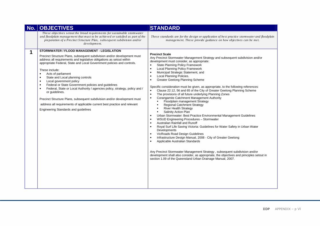
No. OBJECTIVES STANDARD These objectives setout the broad requirements for sustainable stormwater
and floodplain management that must to be achieved or satisfied as part of the preparation of a Precinct Structure Plan, subsequent subdivision and/or
development.
These standards are for the design or application of best practice stormwater and floodplain management. These provide guidance on how objectives can be met.
1 STORMWATER / FLOOD MANAGEMENT - LEGISLATION
Precinct Structure Plans, subsequent subdivision and/or development must address all requirements and legislative obligations as setout within appropriate Federal, State and Local Government policies and controls. These include: • Acts of parliament • State and Local planning controls • Local government policy • Federal or State Government policies and guidelines • Federal, State or Local Authority / agencies policy, strategy, policy and /
or guidelines. Precinct Structure Plans, subsequent subdivision and/or development must
address all requirements of applicable current best practice and relevant
Engineering Standards and guidelines
Precinct Scale Any Precinct Stormwater Management Strategy and subsequent subdivision and/or development must consider, as appropriate: • State Planning Policy Framework • Local Planning Policy Framework • Municipal Strategic Statement, and • Local Planning Policies. • Greater Geelong Planning Scheme Specific consideration must be given, as appropriate, to the following references: • Clause 22.12, 56 and 65 of the City of Greater Geelong Planning Scheme • The provisions of all future underlying Planning Zones • Corangamite Catchment Management Authority
� Floodplain management Strategy � Regional Catchment Strategy � River Health Strategy � Salinity Action Plan
• Urban Stormwater: Best Practice Environmental Management Guidelines • WSUD Engineering Procedures – Stormwater • Australian Rainfall and Runoff • Royal Surf Life Saving Victoria: Guidelines for Water Safety in Urban Water
Developments • VicRoads Road Design Guidelines • Infrastructure Design Manual, 2008 - City of Greater Geelong • Applicable Australian Standards Any Precinct Stormwater Management Strategy , subsequent subdivision and/or development shall also consider, as appropriate, the objectives and principles setout in section 1.09 of the Queensland Urban Drainage Manual, 2007.
��
��
����������������� ��VII
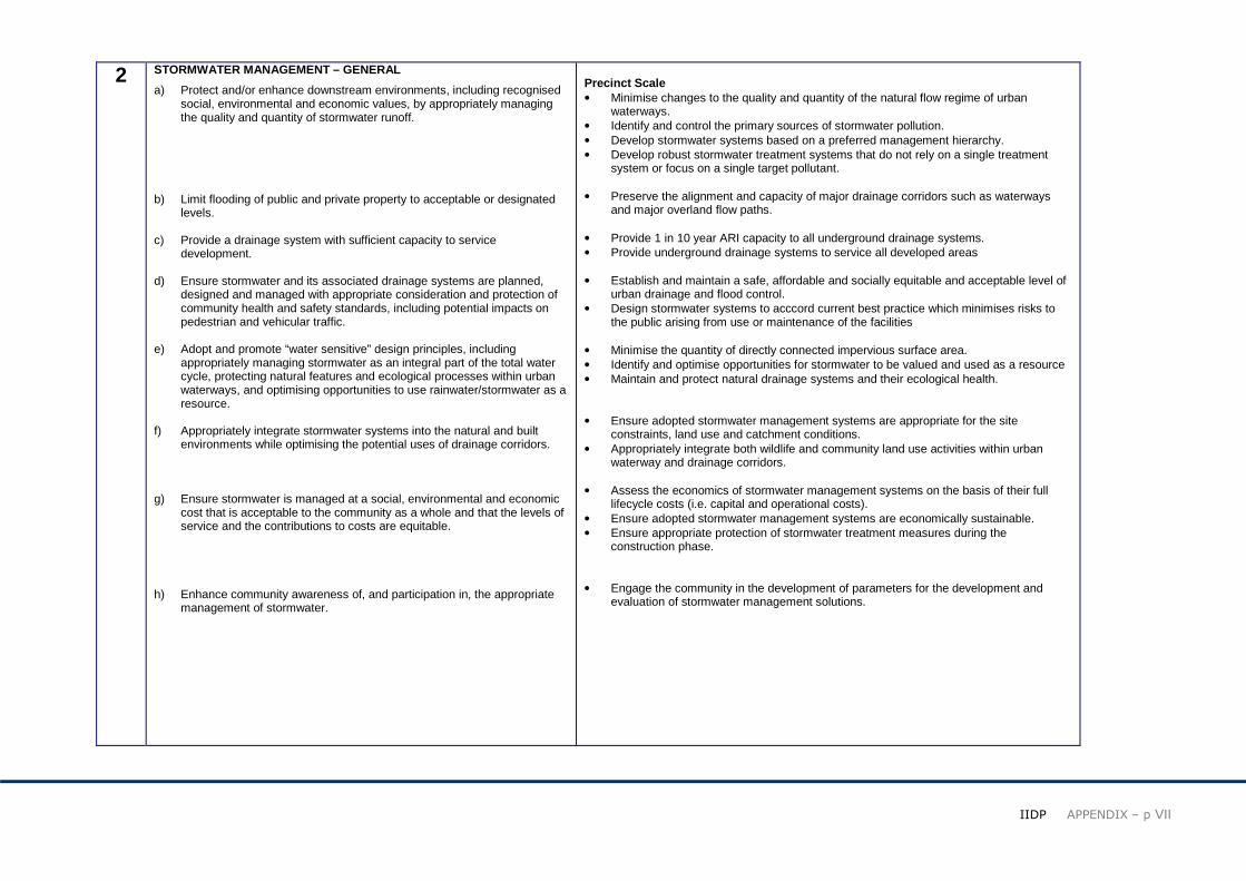
2 STORMWATER MANAGEMENT – GENERAL
a) Protect and/or enhance downstream environments, including recognised social, environmental and economic values, by appropriately managing the quality and quantity of stormwater runoff.
b) Limit flooding of public and private property to acceptable or designated
levels. c) Provide a drainage system with sufficient capacity to service
development. d) Ensure stormwater and its associated drainage systems are planned,
designed and managed with appropriate consideration and protection of community health and safety standards, including potential impacts on pedestrian and vehicular traffic.
e) Adopt and promote “water sensitive” design principles, including
appropriately managing stormwater as an integral part of the total water cycle, protecting natural features and ecological processes within urban waterways, and optimising opportunities to use rainwater/stormwater as a resource.
f) Appropriately integrate stormwater systems into the natural and built
environments while optimising the potential uses of drainage corridors. g) Ensure stormwater is managed at a social, environmental and economic
cost that is acceptable to the community as a whole and that the levels of service and the contributions to costs are equitable.
h) Enhance community awareness of, and participation in, the appropriate
management of stormwater.
Precinct Scale • Minimise changes to the quality and quantity of the natural flow regime of urban
waterways. • Identify and control the primary sources of stormwater pollution. • Develop stormwater systems based on a preferred management hierarchy. • Develop robust stormwater treatment systems that do not rely on a single treatment
system or focus on a single target pollutant. • Preserve the alignment and capacity of major drainage corridors such as waterways
and major overland flow paths. • Provide 1 in 10 year ARI capacity to all underground drainage systems. • Provide underground drainage systems to service all developed areas • Establish and maintain a safe, affordable and socially equitable and acceptable level of
urban drainage and flood control. • Design stormwater systems to acccord current best practice which minimises risks to
the public arising from use or maintenance of the facilities • Minimise the quantity of directly connected impervious surface area. • Identify and optimise opportunities for stormwater to be valued and used as a resource • Maintain and protect natural drainage systems and their ecological health. • Ensure adopted stormwater management systems are appropriate for the site
constraints, land use and catchment conditions. • Appropriately integrate both wildlife and community land use activities within urban
waterway and drainage corridors. • Assess the economics of stormwater management systems on the basis of their full
lifecycle costs (i.e. capital and operational costs). • Ensure adopted stormwater management systems are economically sustainable. • Ensure appropriate protection of stormwater treatment measures during the
construction phase. • Engage the community in the development of parameters for the development and
evaluation of stormwater management solutions.
��
��
����������������� ��VIII
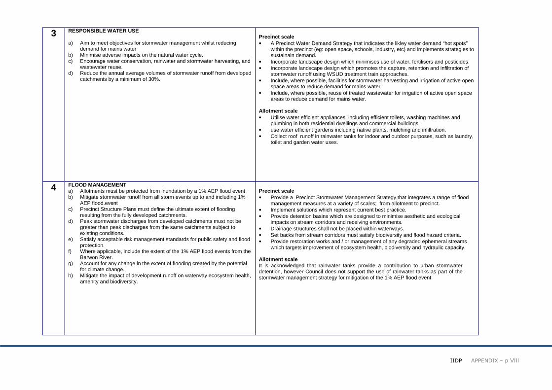
3 RESPONSIBLE WATER USE a) Aim to meet objectives for stormwater management whilst reducing
demand for mains water b) Minimise adverse impacts on the natural water cycle. c) Encourage water conservation, rainwater and stormwater harvesting, and
wastewater reuse. d) Reduce the annual average volumes of stormwater runoff from developed
catchments by a minimum of 30%.
Precinct scale • A Precinct Water Demand Strategy that indicates the likley water demand “hot spots”
within the precinct (eg: open space, schools, industry, etc) and implements strategies to sustainain demand.
• Incorporate landscape design which minimises use of water, fertilisers and pesticides. • Incorporate landscape design which promotes the capture, retention and infiltration of
stormwater runoff using WSUD treatment train approaches. • Include, where possible, facilities for stormwater harvesting and irrigation of active open
space areas to reduce demand for mains water. • Include, where possible, reuse of treated wastewater for irrigation of active open space
areas to reduce demand for mains water. Allotment scale • Utilise water efficient appliances, including efficient toilets, washing machines and
plumbing in both residential dwellings and commercial buildings. • use water efficient gardens including native plants, mulching and infiltration. • Collect roof runoff in rainwater tanks for indoor and outdoor purposes, such as laundry,
toilet and garden water uses.
4 FLOOD MANAGEMENT a) Allotments must be protected from inundation by a 1% AEP flood event b) Mitigate stormwater runoff from all storm events up to and including 1%
AEP flood.event c) Precinct Structure Plans must define the ultimate extent of flooding
resulting from the fully developed catchments. d) Peak stormwater discharges from developed catchments must not be
greater than peak discharges from the same catchments subject to existing conditions.
e) Satisfy acceptable risk management standards for public safety and flood protection.
f) Where applicable, include the extent of the 1% AEP flood events from the Barwon River.
g) Account for any change in the extent of flooding created by the potential for climate change.
h) Mitigate the impact of development runoff on waterway ecosystem health, amenity and biodiversity.
Precinct scale • Provide a Precinct Stormwater Management Strategy that integrates a range of flood
management measures at a variety of scales; from allotment to precinct. • Implement solutions which represent current best practice. • Provide detention basins which are designed to minimise aesthetic and ecological
impacts on stream corridors and receiving environments. • Drainage structures shall not be placed within waterways. • Set backs from stream corridors must satisfy biodiversity and flood hazard criteria. • Provide restoration works and / or management of any degraded ephemeral streams
which targets improvement of ecosystem health, biodiversity and hydraulic capacity. Allotment scale It is acknowledged that rainwater tanks provide a contribution to urban stormwater detention, however Council does not support the use of rainwater tanks as part of the stormwater management strategy for mitigation of the 1% AEP flood event.
��
��
����������������� ��IX
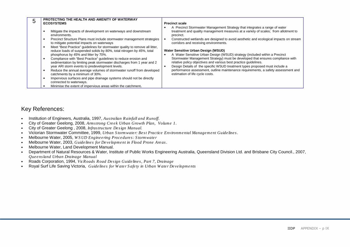
5 PROTECTING THE HEALTH AND AMENITY OF WATERWAY ECOSYSTEMS • Mitigate the impacts of development on waterways and downstream
environments. • Precinct Structure Plans must include stormwater management strategies
to mitigate potential impacts on waterways • Meet “Best Practice” guidelines for stormwater quality to remove all litter,
reduce loads of suspended solids by 80%, total nitrogen by 45%, total phosphorus by 45% and litter by 70%.
• Compliance with “Best Practice” guidelines to reduce erosion and sedimentation by limiting peak stormwater discharges from 1 year and 2 year ARI storm events to predevelopment levels.
• Reduce the annual average volumes of stormwater runoff from developed catchments by a minimum of 30%.
• Impervious surfaces and pipe drainage systems should not be directly connected to waterways.
• Minimise the extent of impervious areas within the catchment.
Precinct scale • A Precinct Stormwater Management Strategy that integrates a range of water
treatment and quality management measures at a variety of scales; from allotment to precinct.
• Constructed wetlands are designed to avoid aesthetic and ecological impacts on stream corridors and receiving environments.
Water Sensitive Urban Design (WSUD) • A Water Sensitive Urban Design (WSUD) strategy (included within a Precinct
Stormwater Management Strategy) must be developed that ensures compliance with relative policy objectives and various best practice guidelines.
• Design Details of the specific WSUD treatment types proposed must include a performance assessment, outline maintenance requirements, a safety assessment and estimation of life cycle costs.
Key References: • Institution of Engineers, Australia, 1997, Australian Rainfall and Runoff. • City of Greater Geelong, 2008, Armstrong Creek Urban Growth Plan, Volume 1. • City of Greater Geelong , 2008, Infrastructure Design Manual. • Victorian Stormwater Committee, 1999, Urban Stormwater: Best Practice Environmental Management Guidelines. • Melbourne Water, 2005, WSUD Engineering Procedures: Stormwater • Melbourne Water, 2003, Guidelines for Development in Flood Prone Areas. • Melbourne Water, Land Development Manual. • Department of Natural Resources & Water, Institute of Public Works Engineering Australia, Queensland Division Ltd. and Brisbane City Council., 2007,
Queensland Urban Drainage Manual • Roads Corporation, 1994, VicRoads Road Design Guidelines, Part 7, Drainage • Royal Surf Life Saving Victoria, Guidelines for Water Safety in Urban Water Developments

��
��
����������������� ��X
Drainage Catchment Plan: Armstrong Creek Urban Growth Area Major Catchments

��
��
����������������� ��XI
ARMSTRONG CREEK -
Digital Terrain Model And Minor Drainage Catchment
��
��
����������������� ��XII
Attachment 3: Council of Greater Geelong & VicRoads – Road Network & Cycle Access ways
VicRoads – ARTERIAL ROADS
The Minister for Planning’s Assessment of the Environment Effects Statement for
Section 3 of the Geelong Ring Road determined that strategic recognition should be
provided in the Greater Geelong Planning Scheme for future links from the Geelong
Ring Road to the Princes Highway West and to the Surf Coast Highway (considering
and compatible with a future link to the Bellarine Peninsula).
VicRoads has been implementing the Minister’s decision by undertaking a planning
study, in consultation with stakeholders, to define alignment and land requirements for:
� Princes Highway West Link (Section 4B), from the Geelong Ring Road to the
Princes Highway West, and
� Surf Coast Highway Connection (Section 4C), from the Realigned Anglesea
Road to the Surf Coast Highway, compatible with the Armstrong Creek Urban
Growth Plan’s planning objectives.
The above road links are shown in Attachment 1.
In conjunction with Council, VicRoads is examining a possible East-West Connection,
extending from the Surf Coast Highway to the Barwon River compatible with the
Armstrong Creek Urban Growth Plan’s planning objectives and a future link to the
Bellarine Peninsula. This can also be seen in Attachment 1.
This paper covers (in two sections) the details of the latter two future arterial roads,
which are located within the confines of the Armstrong Creek Urban Growth Area.
A) SURF COAST HIGHWAY CONNECTION
Traffic modelling has indicated that traffic volumes on the Surf Coast Highway
Connection are expected to be in the range 12,000 - 20,000 vehicles per day in year
2021 with the Armstrong Creek Urban Growth Area fully developed, indicating that the
Connection will, for the foreseeable future, be predominantly utilised to support local and
regional trips and movements within and to/from the Armstrong Creek Urban Growth
Area as it is developed.
The Surf Coast Highway Connection (Section 4C) has been planned, in consultation
with the City of Greater Geelong, as a medium speed (80 km/hr) arterial road with
limited at-grade signalised intersections, controlled access and initially as a four lane
divided roadway. Provision has been made for future widening to six lanes if necessary
(including dedicated public transport lanes), with a possible long-term interchange at
Surf Coast Highway that makes provision for a grade separation of the Geelong-
Warrnambool railway line.
The route defined for the Surf Coast Highway Connection provides for a possible new
passenger railway station at Waurn Ponds, a pedestrian extension of Rossack Drive into
the railway station and connections from the Armstrong Creek Urban Growth Area
internal road network. The route is located close to the railway line to provide one
general transport corridor and to maximise land use availability for the growth area, as
well as minimising aboriginal and post-settlement cultural heritage impacts as
determined from specialist investigations.

��
��
����������������� ��XIII
The alignment of the Surf Coast Highway Connection is within the planning scheme
Development Plan Overlay gazetted as part of Amendment C113 to the Greater
Geelong Planning Scheme to protect a wide corridor in which the future road link could
be developed.
Within the Armstrong Creek Urban Growth Area a fully directional interchange has been
allowed for at the Surf Coast Highway, as part of a possible future ultimate development.
The alignment for this interchange was determined in consultation with the City of
Greater Geelong and provides for a single elevated grade separation of Surf Coast
Highway over the Geelong-Warrnambool railway line and a possible future East West
Connection to the Bellarine Peninsula.
An alternative interchange arrangement, with the Surf Coast Highway Connection
located approximately 150 metres further south and having two elevated grade
separations was considered, but not supported, as it did not maximise land use
proposals associated with the Armstrong Creek Urban Growth Plan.
The type cross section adopted for the Surf Coast Highway Connection, as well as the
cross section for the ultimate development of Surf Coast Highway within the limits of the
Armstrong Creek Urban Growth Area, are shown in Attachment 2.
A reservation, setting out the land required for the Surf Coast Highway Connection, has
been defined based on ultimate 6 lane development, with provision for bicycle lanes,
landscaping, noise amelioration and water sensitive road design (drainage) measures
as necessary. The reservation plans have been provided to Council.
The Surf Coast Highway Connection reservation is approximately 4.2 km long and
varies in width between 75 and 90 metres. The ultimate development cross section for
the 3.8 km length of Surf Coast Highway, within the limits of the Armstrong Creek Urban
Growth Area, is 60 metres wide.
It is intended to include a Public Acquisition Overlay in the Greater Geelong Planning
Scheme to reserve the land required for the Surf Coast Highway Connection.
The estimated construction cost for the development of the Surf Coast Highway
Connection (initial four lanes divided roadway development with at-grade intersections)
is $72 million (2008 dollars).
Whilst State Government funding has been provided for the current planning study to
define the alignment and land requirements for the Surf Coast Highway Connection,
there has been no commitment to funding the construction of the Surf Coast Highway
Connection, nor is there a timeframe for commencement.
B) POSSIBLE EAST WEST CONNECTION FROM THE SURF COAST HIGHWAY TO
THE BELLARINE PENINSULA.
VicRoads has carried out a preliminary investigation to assist in defining the alignment
and land requirements for a possible future East-West Connection, from the Surf Coast
Highway to the Barwon River, within the confines of the Armstrong Creek Urban Growth
Plan and consistent with its land use planning objectives.
Traffic modelling has indicated that traffic volumes on a possible East West Connection,
between the Surf Coast Highway and the Barwon River, would be in the order of 20,000
- 24,000 vehicles per day in year 2021 with the Armstrong Creek Urban Growth Area
fully developed. The possible East West Connection would predominantly be utilised to
support local and regional trips and movements within and to/from the Armstrong Creek
Urban Growth Area as it is developed.
VicRoads considers construction of an East-West Connection, from the Surf Coast
Highway to the Bellarine Peninsula, to be a long term proposal and aligned more with
the need to service future land use change and to support local and regional trips.
��
��
����������������� ��XIV
The corridor for the possible future connection has been aligned adjacent to the
Geelong-Warrnambool railway line, utilising the Reserve Road alignment and crossing
the Barwon River at the only feasible location, being a relatively narrow section
immediately outside the Lake Connewarre State Game Reserve, at the bottom end of
Wilson’s Road.
The possible East West Connection has been planned, in consultation with the City of
Greater Geelong, as a medium speed (80 km/hr) arterial road, with limited at-grade
signalised intersections, controlled access and initially as a four lane divided roadway.
Provision has been made for future widening to six lanes, with a possible future
interchange at Barwon Heads Road.
The type cross section adopted for the possible East West Connection, as well as the
cross section for the ultimate development of Barwon Heads Road within the limits of
the Armstrong Creek Urban Growth Area, are shown in Attachment 2.
A reservation, setting out the land required for the possible East West Connection, has
been defined as part of Councils land use planning strategy based on ultimate 6 lane
development, with provision for bicycle lanes, landscaping, noise amelioration and water
sensitive road design (drainage) measures as necessary, as well as a possible ultimate
development interchange at Barwon Heads Road.
The possible East West Connection reservation is approximately 4.5 km long and
generally of 75 metres in width. The ultimate development cross section for the 5.8 km
length of Barwon Heads Road, within the limits of the Armstrong Creek Urban Growth
Area, is 60 metres wide.
It is intended that land required for the East West Connection, east of Surf Coast
Highway, be protected in the Greater Geelong Planning Scheme within the confines of
the Armstrong Creek Urban Growth Area as part of precinct planning activities.
There has been no detailed planning for the East West Connection, east of the Barwon
River. The City of Greater Geelong has included a potential transport corridor for the
route in its Geelong Eastern Boundary Review. Detailed planning would require
commitment to an additional planning study and budget.
There has been no commitment regarding responsibility for the development of the
possible East West Connection, east of the Surf Coast Highway, nor is there a
timeframe for commencement of construction.
C) OTHER ROADS
VicRoads will liaise with Council, local community groups and other stakeholders
concerning proposals to truncate sections of local roads and to discuss the impacts on
the surrounding local road network arising from the construction of the new arterial
roads.
DUNCAN ELLIOTT REGIONAL DIRECTOR, SOUTH WESTERN VICTORIA VICROADS February 2009

��
��
����������������� ��XV

��
��
����������������� ��XVI
��
��
����������������� ��XVII
City of Greater Geelong – COLLECTORS ROADS
BACKGROUND:
In January 2008 a road network workshop was held with VicRoads, Developers and Council staff to develop a consistent position on the road network plan that will service the Armstrong
Creek area. The workshop’s main outcome was the utilisation of the existing one mile road grid (1.6km), however to avoid large four lane roads through the development and imporve
pedestrian and public amenity this one mile grid would be broken down into a grid of half mile collector roads (2 lane, if possible).
This strategy has since been refined through further development with VicRoads, relating to the proposed East West Link Rd, and within Council relating to the general functionality and
connective of the network.
The final Road Network Plan is shown on the following pages, including preliminary road cross sections.
ROAD DESIGN - GHD
GHD was engaged by Council to prepare preliminary cross sections for various road types within the development, then evaluate the full cost to deliver the proposed road network.
The attached Road Network Plan reflects GHD’s final plan adopted by the City of Greater Geelong, including the colour coding of the various road cross sections that integrate the
abutting native vegetation (existing road reserve) into the future transport corridor.

��
��
����������������� ��XVIII
��
��
����������������� ��XIX

��
��
����������������� ��XX

��
��
����������������� ��XXI
TRAFFIC MODELLING – VEITCH LISTER
The below traffic modelling summary is an extract from the Veitch Lister report titled “Phase 1 Traffic Modelling report - Armstrong Creek Movement and Access Infrastructure Feasibility”
INTRODUCTION
Veitch Lister Consulting Pty Ltd (VLC) was engaged by the City of Greater Geelong to
assist it in its finalisation of plans for the Armstrong Creek Urban Growth Area.
This assistance is provided in two phases:
� Phase 1 - Development and assessment of a base level of transport
infrastructure provision; and
� Phase 2 - Sensitivity testing of public transport servicing levels and resultant
road network changes
This report focuses on Phase 1.
LAND USE ASSUMPTIONS
The Council has advised that modeling is to occur on the basis that the Armstrong
Creek Urban Growth Area is fully developed by 2019. The Council has also provided
an overview of the demographic data which is presented in Figure 6-1.
Figure 6-1: Armstrong Creek Demographic Overview

��
��
����������������� ��XXII
The data presented in Figure 6-1 above has been supplemented by information
contained within the Armstrong Creek Urban Growth Plan Volume 1, Public Exhibition
Version, 16 October, 2006 and, more particularly, the Armstrong Creek Urban Growth
Plan Volume 2: Precinct Plans, Public Exhibition Version, 16 October 2006.
VLC has modelled Armstrong Creek for the year 2021. With respect to surrounding
areas the model retains assumptions made in 2004 on the extent of development and
the population expected to be in place in 2021.
ROAD NETWORK ASSUMPTIONS
Modeling has been undertaken on the assumption that by 2021 the Geelong Ring Road
Sections 1, 2, 3, 4A and 4B have been constructed. This is a logical assumption given
that these road improvements are either currently under construction or funds are
currently committed for their construction.
With respect to the Anglesea Road deviation, Geelong Ring Road Section 4C, and the
possible extension of Section 4C to the Bellarine Highway or Geelong-Portarlington
Road, there is no such commitment. However, there is strong support from Blue Circle
Southern Cement and the Department of Primary Industries for the Anglesea Road
deviation to occur in the short to medium term and previous traffic modeling has
indicated that the need for the Geelong Ring Road Section 4C and its extension relate
mainly to the development of Armstrong Creek. Accordingly, it has been assumed that
these road network improvements will also be in place by 2021.
Figure 6-2 and 6-3 both show the road network assessed in this report. Figure
6-2 shows the assumed capacity of each road, whereas Figure 6-3 shows the assumed
free flow speeds.
Figure 6-2: Armstrong Creek Road Network Assumed Capacities
Figure 6-3: Armstrong Creek Road Network Assumed Free Flow Speeds

��
��
����������������� ��XXIII
MODEL RESULTS
Modeling was undertaken in two stages. In the first stage, the road network modelled
was similar to that shown in Figure 4-2 (refer full report – original concept 800m grid
network). Select-link analysis was undertaken during this stage to provide an
understanding of vehicular movement through and within the Armstrong Creek Urban
Growth Area. The results of this first stage of modeling are not presented in this report.
The results were used, however, to refine the proposed connectivity of the road network.
As a result of this work, the road network was refined as shown on Figures 4-3, 6-2 and
6-3.
As discussed in Section 4.5 (refer full report), two options for the road network were
modelled – with and without a road link to Rossack Drive. The modelled outputs for 24
hrs on a normal weekday for each option are presented in Figures 6-4 and 6-5.
CONCLUSIONS
The modeling outputs indicate a good distribution of traffic from the development area
with most roads carrying a volume of traffic that is consistent with their intended place in
the road hierarchy.
Exceptions are:
� Reserve Road, west of Drews Road. This collector road forms part of the
most direct route between Grovedale and the Bellarine Peninsula
� Boundary Road, between Surf Coast Highway and Barwarre Road. This
collector road provides an important access function for the Principal Activity
Centre and, therefore, higher traffic volumes are to be expected.
The modeling of the Rossack Drive link indicates that significant volumes of through
traffic will not be introduced to the Rossack Drive area. This outcome is very different to
previous modelling of a more direct link undertaken for VicRoads which indicated that
Rossack Drive would become the preferred route between Armstrong Creek and the
Geelong Ring Road. If Council wishes to consider this link further, it is recommended
that sensitivity testing be undertaken as the consequences for residents of the Rossack
Drive area could be significant.
RECOMMENDATIONS
The modelling undertaken assumes that Armstrong Creek will be fully developed by
2021 and that growth in the surrounding areas will occur at rates considered reasonable
in 2003. 2021 is a short to medium term planning horizon and consideration should be
given to longer term growth, particularly in the Torquay area. It is recommended that, in
order to establish ultimate road reserve widths for Anglesea Road, Ghazeepore Road,
the Surf Coast Highway and Horseshoe Bend Road, modelling be undertaken that
assumes full development of the Torquay/Jan Juc and Spring Creek Structure Plan
areas.
The modelling of the Rossack Drive link has yielded very different results to modelling
undertaken previously for VicRoads on a more direct link. If Council intends to seriously
consider this link it is recommended that further modelling be undertaken to identify the
sensitivity of use of the link to its alignment and other road network characteristics.
The modelling undertaken assumes that the only public transport improvement on
existing conditions is the extension of the rail service to a new station in the vicinity of
Rossack Drive. Further modelling should be undertaken to identify the effects of
additional public transport improvements, in particular new bus services that will
undoubtedly be put in place to service the growth area.

��
��
����������������� ��XXIV
��
��
����������������� ��XXV

��
��
����������������� ��XXVI
City of Greater Geelong - PEDESTRIAN & CYCLING PATHS
PURPOSE:
The purpose of including pedestrian and cycling paths within the framework of infrastructure
planning is to meet the objectives set out in the Armstrong Creek Urban Growth Plan 1 for the
need to link the new urban centres, railway stations, schools and key community facilities with
a web of leisure trails and more direct walking and cycling paths that contribute to the
formation of a healthy and integrated community.
A high standard network of paths was encouraged to have a walkable / cycling community
that does not rely on motor vehicles as a primary mode of transport.
ASSUMPTIONS:
The primary assumption used for the development of the Pedestrian / Cycling Network Plan
are detailed below.
� The Armstrong Creek Urban Growth Plan – Framework Plan, detailing recreational trails,
is seen as concept only and does not reflect new road network development and a web
network within the growth area.
� Movement of people from their home to railway stations, activity centres, schools,
employment areas and open space facilities is a key design criteria
� All recreational trail construction is assumed to be constructed of asphalt or concrete at a
width of 3m. This is seen as an appropriate standard for a high use shared paths catering
for cyclists, pedestrians, dog walkers, wheel chairs, etc, as well as the asset life cycle
needs of such paths.
� It is assumed that approx. 50% of the developed recreation trails will include dedicated
path lighting to improve amenity (these sites are yet to be determined and will be based
on high profile / usage paths within the growth area).
� All costs associated with connecting the recreation trails directly with local sporting and
community facilities as not cover within this pedestrian and cycling network plan.
� All costs associated with the provision of road crossings are assumed to be addressed as
part of subdivsion road design and construction, and must be considered during detailed
design of all new roads.
CONSTRAINTS / RISKS:
The primary constraints and risk associated with the development and delivery of this
network plan are details below:
� The cost of asphalt being impacted by increasing market cost of oil.
� The trails will need to include flexibility associated with their exact location,
particularly relating to conflicts with flora and cultural heritage sites, and integration
with precinct road and footpath networks.
� Intersection and road crossing will need to have a strong focus on encouraging the
movement of pedestrians and cyclist through these conflict points. This will
maximise the attractiveness of these paths for both social and commuter users.
DELIVERY:
One of the essential components to the effective delivery of the proposed pedestrian and
cycling network will be the ability to deliver key links early in the development of these new
communities. This means that rather than rollout small segments of the network as
development occurs, early triggers should be established to deliver larger section of the
network as early as possible. This will be essential in establishing community behaviour and
discourage the reliance of households on motor vehicle usage.
This rollout will need to be a key consideration during the preparation of Precinct Structure
Plans and the staging for infrastructure delivery.
CRITICAL INFRASTRUCTURE:
The critical component of the pedestrian and cycling network wil most certainly be the
Armstrong Creek corridor. This is the growth area’s name sake and will be the most notable
feature that links the community from east to west (similar to the Barwon River trails). Early
establishment of this corridor is linked to a higher likelihood of success in developing a
healthy and non-vehicle reliant community. The second critical corridor within the growth
area will be the Barwarre Road urban forest path. This path will provide an essential north
south link from the southern tip of the growth area, past the major activity centre, right
through to Marshall Railway Station.
��
��
����������������� ��XXVII

��
��
����������������� ��XXVIII
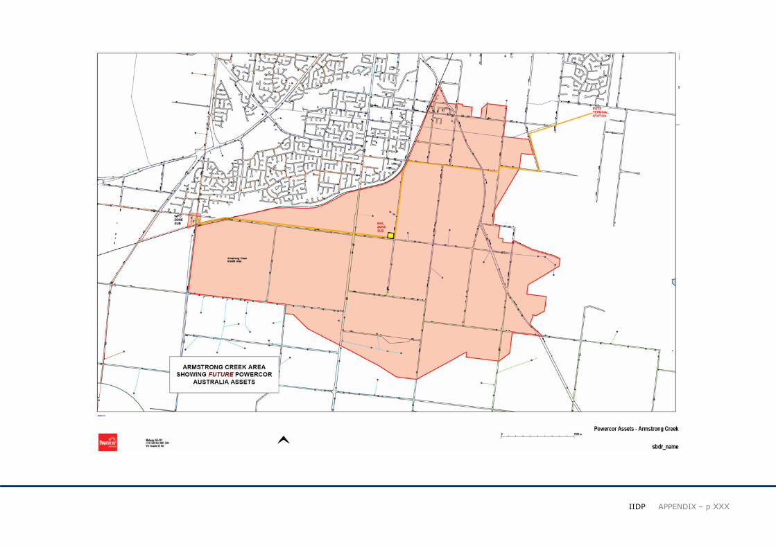
Attachment 4: Powercor - Electricity Network Plan POWERCOR DISTRIBUTION NETWORK
Powercor operates the 66kV subtransmission lines that commence at the Geelong
Terminal Station in Cox Rd, Norlane and supply Zone Substations throughout the
Geelong Region. In turn, predominantly overhead inter-connected 22kV feeders from
these Zone Substations supply local towns and areas.
Powercor has an ongoing 10-year Plan to upgrade the Network to meet expected load
growth and improve reliability throughout the Region.
WAURN PONDS GROWTH CORRIDOR
The Waurn Ponds growth corridor, encompassing the Armstrong Creek urban area
south to Torquay, is the major growth area in the Geelong Region. This area is currently
supplied by 22kV feeder lines from the Waurn Ponds Zone Substation at the corner of
Hams Road and Ghazeepore Road. The existing load demands on the Zone Substation
provide limited scope for the continuing load growth.
To meet the load growth in the area, Powercor as part of its 10 year development plan,
is upgrading the transformer capacity at this Zone Substation in 2008 with a further
upgrade planned for 2009.
The Armstrong Creek urban area initial load developments will be supplied by 22kV
interconnected feeder lines, two from the Waurn Ponds Zone Substation and one from
the Geelong East Zone Substation that are either adjacent to, or pass through the
developer owned land parcels.
The feeder lines from the Waurn Ponds Zone Substation currently supply the Torquay
area and are nearing capacity while the feeder from the Geelong East Zone Substation
is currently less loaded. These feeder lines will be reconfigured to distribute the load
across the network to meet the initial load growth. The tracts of developer subdivisions
in Armstrong Creek will need to be connected to these feeder backbones.
Feeder developments on the eastern side of Armstrong Creek will take account of future
Vic Roads plans for Barwon Heads Road.
Powercor’s next stage of development is to establish the new Torquay Zone Substation
for the Torquay/Jan Juc and coastal area load which in turn provides capacity back in
the existing feeder lines which pass through the Armstrong Creek development.
A second 66kV subtransmission line is required for the Torquay Zone Substation
reliability and this line is planned to be constructed as a second circuit by overbuilding
the existing powerline on Anglesea Road between Waurn Ponds and Torquay.
It is important that the coordination of this new line at the Waurn Ponds end occurs with
Vic Roads and Blue Circle Cement due to the planned realignment of Anglesea Road.
EAST GEELONG TERMINAL STATION
The new East Geelong Terminal Station is planned to be established on SPAusnet
owned land at the corner of Woods Road and Coppards Road, St Albans Park. This
new Terminal Station is required in the medium to long term to cater at transmission
level for load growth in the southern part of the Geelong Region including the Armstrong
Creek urban growth area.
It is important that the coordination of this new Terminal Station and 66kV overhead
subtransmission lines occurs with Vic Roads in regards to future line routes for the East
West road link.
� ��
����������������� ��XXIX
MARSHALL ZONE SUBSTATION
Ultimately it is planned to establish a Marshall Zone Substation around the intersection
of Boundary Road and Barrwarre Road in Armstrong Creek depending on load
developments. This Zone Substation would be supplied via overhead subtransmission
lines from the East Geelong Terminal Station and the Waurn Ponds Zone Substation.
The powerline line routes to Marshall Zone Substation will be investigated considering
also opportunities for developing these in line with the planned East West road link and
the North South transit corridor.
John Garvey,
Powercor Australia – Geelong Branch,
June 2008
� ��
����������������� ��XXX

� ��
����������������� ��XXXI
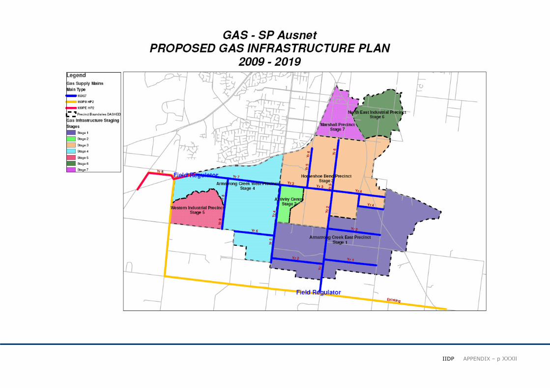
Attachment 5: SP AusNet Gas - Infrastructure Plan SP Ausnet has provided a preliminary concept for the supply of natural gas to the proposed Armstrong Creek Urban Growth Area based on the information provided by the City of
Greater Geelong.
Based on the planning information provided (approximately 22,000 dwellings) it has been determined that a 180mm supply main grid will be required to service the growth area. These
new mains will require the installation of two new field regulators from one from the existing Transmission Pipeline along Lower Duneed Road and one from the existing 160mm main in
Mount Duneed.
Our gas design plan shows how SP AusNet could construct a central grid of core supply mains that enables mains to be extended from a central location to the various new estates being
established by the multiple developers that will be acquiring parts of Armstrong Creek.
Servicing of the Marshall and North East Industrial Precincts are assumed to be via connection to, or extension fo the existing gas network in the area. Currently there is limited supply
capacity available from this network. Connection from this area to the proposed Armstrong Creek gas main grid will be required to provide additional supply capacity in the future.
Councils planning arrangements for Armstrong Creek are not confirmed and the arrangements SP AusNet is proposing are reasonably flexible. At this time we believe this is the best
way for SP AusNet to meet the planning needs of the Armstrong Creek stakeholders.
The information provided by SP Ausnet is for planning purposes only and is not to be regarded as an offer or commitment to complete the proposed works at this time.
Paul O’Brien
Senior Project Consultant
SP AusNet – Melbourne
February 2009
� ��
����������������� ��XXXII

� ��
����������������� ��XXXIII
Attachment 6: Victorian Department of Transport - Railway Station Footprints & Public TransportINTRODUCTION
The Armstrong Creek Urban Growth Area is currently serviced via both heavy rail and
bus services that utilise the:
� Geelong-Warrnambool railway line
� Marshall railway station, and
� The Torquay-Geelong bus services
The aim of the public transport strategy is to provide Armstrong Creek with the best
opportunities for the future community to be non-reliant on the family car. This requires
the development of user friendly pedestrian and cycle paths and the provision of high
amenty bus stops and services, railway stations and carparking and end of line public
transport facilities.
MARSHALL STATION
The Marshall railway station, located on Marshaltown Road, has been flagged as
providing two critical roles during the life the development and the initiation of
community behaviour changes.
The stations initial role will provide park and ride facility, and a well connected railway
station, that can serve the needs of the early stages of development.
The stations long term role will be a neighbourhood station that includes moderate park
and ride facilities, and a much greater focus around the provision of neighbour amenities
and high levels of pedestrian and cycling connectivity. This may include provision of
mixed use shops (i.e: corner store, café, etc) along with a significant bus terminal for
connection to Armstrong Creek, Geelong, Barwon Heads and Torquay.
In relation to the first stage of infrastructure provision at Marhall Station, the Department
of Transport (DoT) is focused around the provision of 1,000 additional carparking
spaces, involving the acquisition of approximately 4 hectares of farm land.
The exact footprint for this station is still being finalised by the DoT, but a concept layout
is reflected on the attached map.
ARMSTRONG CREEK (WAURN PONDS) STATION
A new railway station has been proposed as part of the planning for Armstrong Creek
and has been included within the Armstrong Creek Urban Growth Plan as a critical new
asset for the future Armstrong Creek community, the existing urban areas north of the
railway line and the local region.
The new station will be located at the southern end of Rossack Drive and approximately
500m east of Gazepoore Road, and will incorporate station interfaces on both the
northern and southern sides of the existing railway line.
The new station is still contingent on the future funding and will require ongoing lobbying
to highlight the short and long term community benefits of such a project.
The proposed first stage of the stations development would see a car park and minor rail
facilities developed on the northern side (Waurn Ponds) to service the established urban
area and broader park and ride users. This would accommodate approximately 1,200
car spaces.
The long term development of the station would see the construction of a southern car
park to serve the new Armstrong Creek community. This would include another 1,300
car spaces and provide high quality park and ride, bus terminal and station facilities. It
would also look to integrate the station with the proposed Local Activity Centre and
provide a sense of place and destination for all user groups and the local community
(e.g.: shops, cafes, pedestrian and cycle paths, etc).
ARMSTRONG CREEK NORTH-SOUTH TRANSIT CORRIDOR
The development of the north-south transit corridor has been an integrated part of the
Armstrong Creek Urban Growth Plan from the starts of the plans development and is
seen as a critical piece of strategic planning for the future heavy rail needs of the
Armstrong Creek and Torquay communities.

� ��
����������������� ��XXXIV
The transit corridor runs from the intersection of Reserve Road and Barwarre Road in
the north, through the Major Activity Centre and then south the Lower Duneed Road. For
much of the corridors length it runs in parallel with the proposed urban forest (open
space) that hugs the western side of Barwarre Road.
The Department of Transport (DoT) sees this corridor as playing a critical role in the
provision of long term opportunities for heavy rail to Torquay and avoid the need to retro
fit such a project through the middle of a future community.
The corridor has been flagged by the DoT as serving two primary functions during its
life. The first being an integrated transit bus corridor between Marshall Station and
central Armstrong Creek to link the new community with heavy rail services.
This first stage of development would see the corridor for the provision of bus services.
This stage will require a range of design consideration to determine the level of
integration with the new road network and its ultimate transition to heavy rail (e.g.: grade
separation)
Long term the corridor would be transformed into a heavy rail transport link between
Torquay, Geelong and Melbourne. This stage of development is likely to require the new
railway line to be “sunk” into the ground to provide appropriate noise attenuation and
public amenity.
In both the short and long term phases of the corridors development, the Major Activity
Centre would include a transport node. This means the development of an appropriate
bus terminal in stage one, and then a full railway station in the ultimate arrangement. In
both these cases the station would be design around a local walking / cycling user group
and not provide large scale carparking facilities.
ADJUSTMENT TO THE TRANSIT CORRIDOR ALIGNMENT
As part of the Independent Panel review for amendment C138, the panel recommend
the adjustment of the Major Activity Centre boundary (eastern side) to reflect a kink in
the alignment to define its eastern boundary. This adjustment has made it through to the
Framework Plan currently before the Minister for Planning for approval.
Long term this kink presents a problem for the provision of heavy rail due to design
curve requirements..
At the southern end of the corridor, the panel confirmed the inclusion of two options
south of Armstrong Creek (waterway) due to the uncertainty relating to future links to
Toquay. The two options reflected in the Framework Plan include an alignment abutting
Surf Coast Hwy (eastern side) and one 750m east of the Surf Coast Hwy.
The Interagency Working Group (IIWG), including the DoT and representatives from
Surf Coast Shire evaluated these two issues during a June 2008 workshop, with a aim
of resolving these corridor problems.
The workshop determined that the corridor alignment should maintain a straight north-
south alignment until Lower Duneed Road and allow future planning by Surf Coast Shire
and the DoT to evaluate the best route south of this point.
The reasons noted for this straight alignment were:
• Grade and upgrade issues associated with the Lower Duneed Road / Surf Coast
Hwy intersection
• Access control along Surf Coast Highway
• The possibility of a future Torquay station being located west of Surf Coast Highway
• The distance form the current Torquay urban growth boundary (approximately 7km)
In relation to the “kinked” corridor alignment through the Major Activity Centre the DoT
confirmed the need to meet a minimum of 80kmh design speed for any future heavy rail
alignment.
The adjustment of these corridor issues is shown in the attached map, Proposed Rail
Alignment and Footprints.

� ��
����������������� ��XXXV

� ��
����������������� ��XXXVI
Armstrong Creek Railway Station
Concept Layout Design (GHD)

� ��
����������������� ��XXXVII
Armstrong Creek Railway Station
Concept Activity Centre Design (GHD)
* The above aerial sketch is a view of the proposed station activity centre from the the south-west (conecept only)
� ��
����������������� ��XXXVIII
Attachment 7: Telstra - Telecommunications
Telstra has engaged an Armstrong Creek working party within Telstra, which consists of the Urban Development Group, a local area representative and also our fundamental planning
manager to provide telecommunications support to the Armstrong Creek development plan. As the development is not due to break ground until 2009, this analysis is a preliminary
feasibility study.
The study consists of two components for the provision of copper and also Telstra Velocity (fibre to the home). The Armstrong Creek Urban Development Plan covers sites in the
following Exchange Service Area’s:
� Belmont.(BELM)
� Grovedale.(GROX)
� Mt Duneed(MTDU)
� Most of the residential development will be in the Mt Duneed exchange area.
The Grovedale exchange is the site for any Telstra Velocity (fibre to the home) developments in the area. This decision is on the basis that sufficient floor space can be made available in
the exchange to accommodate for Telstra Velocity equipment and sufficient power will be available via a power up-grade taking place currently. Telstra Velocity is available to developers
for a cost which can range anywhere between $2500- $5000 per lot depending on the size and location of the development.
Standard copper deployment (non-Velocity) developments will be done by the technology of the day from the relevant existing Exchange Service Area’s. Under Telstra’s Universal
Service Obligation, Telstra will deploy copper services to the area at no cost to the developer; this will be to provision for standard fixed telephone lines and the availability for ADSL
availability for residents. Depending on the current broadband debate and recent change in government, fibre to the node (FTTN) may become an option if available in the future.
Currently, without the developer requirements and a full staging plan and timelines, it is too early to say what the exact planning brief will be for the site and Telstra looks forward to
establishing this with Council as the development progresses. We are undergoing an internal strategy on offering Telstra Velocity to developers within Armstrong Creek, as we are
committed to ensuring that developers have every ability to take advantage of this future ready technology.
Julian Nachmias Urban Development Manager (Vic/SA/NT) Telstra December 2007