Atmospheric InstrumentationM. D. Eastin Atmospheric Instrumentation: An Overview.
15
Atmospheric Instrumentation M. D. Eastin Atmospheric Instrumentation: An Overview
-
Upload
mercy-baldwin -
Category
Documents
-
view
228 -
download
1
Transcript of Atmospheric InstrumentationM. D. Eastin Atmospheric Instrumentation: An Overview.

Atmospheric Instrumentation M. D. Eastin
Atmospheric Instrumentation: An Overview

Atmospheric Instrumentation M. D. Eastin
Meteorological Instrumentation: A Brief HistoryEarly Weather and Climate Observations:
• Early civilizations (e.g., Egypt, Maya, Vikings, Chinese, Polynesia) were known to monitor local weather/climate patterns and pass this information from one generation to the next through stories, art, religion, and architecture
• Influenced agricultural (food)• Influenced movement and migration (nautical travel)• Influenced site selection for town/cities (access / stability)
• Aristotle (Greek – 350 BC) is considered the “founder” of meteorology
• Wrote Meteorologica where he described the hydrological cycle• Book served as the primary reference for centuries
• Pomponius Mela (Roman – 25 AD) formalized a climate zone system
• Varahamihira (India – 500 AD) wrote Brihatsamhita - first formal description of the seasonal cycle and the formation of clouds/rain
• Al-Dinawari (Muslim – 900 AD) wrote Book of Plants - first formal description of the application of meteorology to agriculture
Atmospheric Instrumentation M. D. Eastin
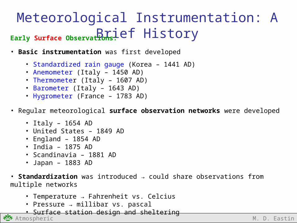
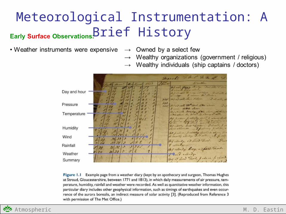
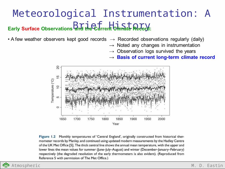
Meteorological Instrumentation: A Brief HistoryEarly Surface Observations:
• Basic instrumentation was first developed
• Standardized rain gauge (Korea – 1441 AD)• Anemometer (Italy – 1450 AD)• Thermometer (Italy – 1607 AD)• Barometer (Italy – 1643 AD)• Hygrometer (France – 1783 AD)
• Regular meteorological surface observation networks were developed
• Italy – 1654 AD• United States – 1849 AD• England – 1854 AD• India – 1875 AD • Scandinavia – 1881 AD• Japan – 1883 AD
• Standardization was introduced → could share observations from multiple networks
• Temperature → Fahrenheit vs. Celcius• Pressure → millibar vs. pascal• Surface station design and sheltering
Atmospheric Instrumentation M. D. Eastin
Meteorological Instrumentation: A Brief History
Atmospheric Instrumentation M. D. Eastin
Meteorological Instrumentation: A Brief History
Atmospheric Instrumentation M. D. Eastin
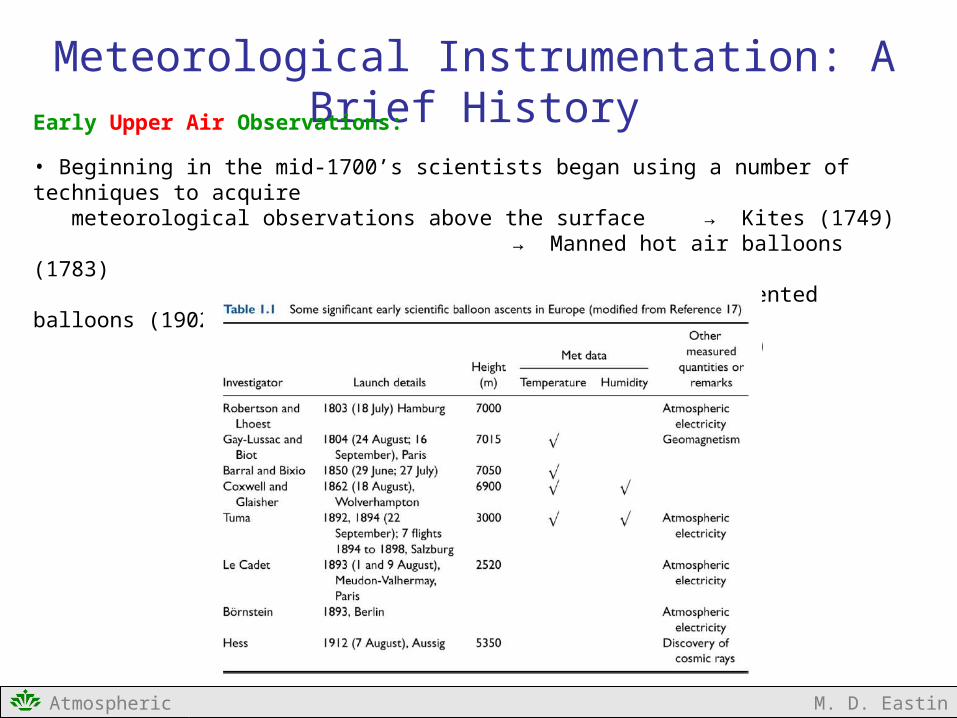
Meteorological Instrumentation: A Brief HistoryEarly Upper Air Observations:
• Beginning in the mid-1700’s scientists began using a number of techniques to acquire meteorological observations above the surface → Kites (1749)
→ Manned hot air balloons (1783)→ Unmanned instrumented balloons (1902)→ Radiosonde (1930)

Atmospheric Instrumentation M. D. Eastin
Meteorological Instrumentation: A Brief HistoryEarly Radar Observations:
1904 Christian Hulsmeyer developed a device that could remotely detect ships beyond the human visual range – the first “radar” device
1917 Nikola Tesla outlined how a “radar” device could be used for tracking ships bytransmitting pulses at regular intervals
1930s Pulsing “radar” developed by British, German, French, and U.S. militaries fordefense – the Allies thought the Germans were developing “death rays”
1940s Science of radar meteorology was born during World War II
1940 A “radio detection and ranging” (radar) device was developed by the U.S. Navy
1941 A 10-cm (S-Band) defense radar along the southern coast of England – the sameradar used to track German fighters / bombers – was used to track a thunderstormwith large hail over a distance of 7 miles.
1943 First operational weather radar – Panama Canal Zone
1957 First operational weather radar network in U.S. (66 WSR-57 radars)
Atmospheric Instrumentation M. D. Eastin
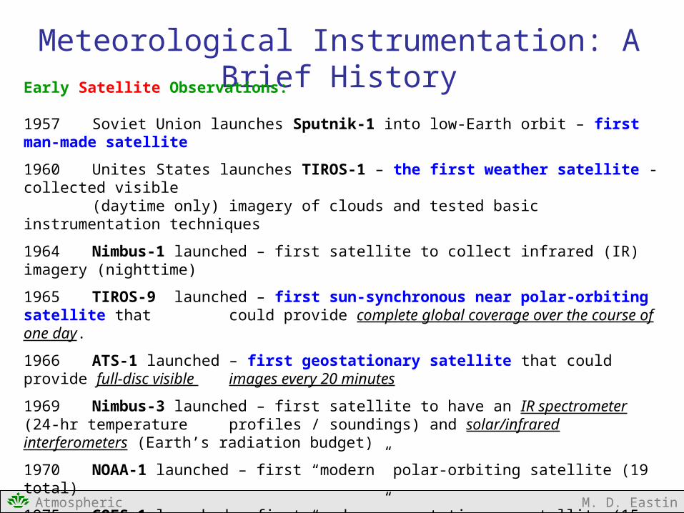
Meteorological Instrumentation: A Brief HistoryEarly Satellite Observations:
1957 Soviet Union launches Sputnik-1 into low-Earth orbit – first man-made satellite
1960 Unites States launches TIROS-1 – the first weather satellite - collected visible(daytime only) imagery of clouds and tested basic instrumentation techniques
1964 Nimbus-1 launched – first satellite to collect infrared (IR) imagery (nighttime)
1965 TIROS-9 launched – first sun-synchronous near polar-orbiting satellite that could provide complete global coverage over the course of one day.
1966 ATS-1 launched – first geostationary satellite that could provide full-disc visible images every 20 minutes
1969 Nimbus-3 launched – first satellite to have an IR spectrometer (24-hr temperature profiles / soundings) and solar/infrared interferometers (Earth’s radiation budget)
1970 NOAA-1 launched – first “modern” polar-orbiting satellite (19 total)
1975 GOES-1 launched – first “modern” geostationary satellite (15 total)
Atmospheric Instrumentation M. D. Eastin
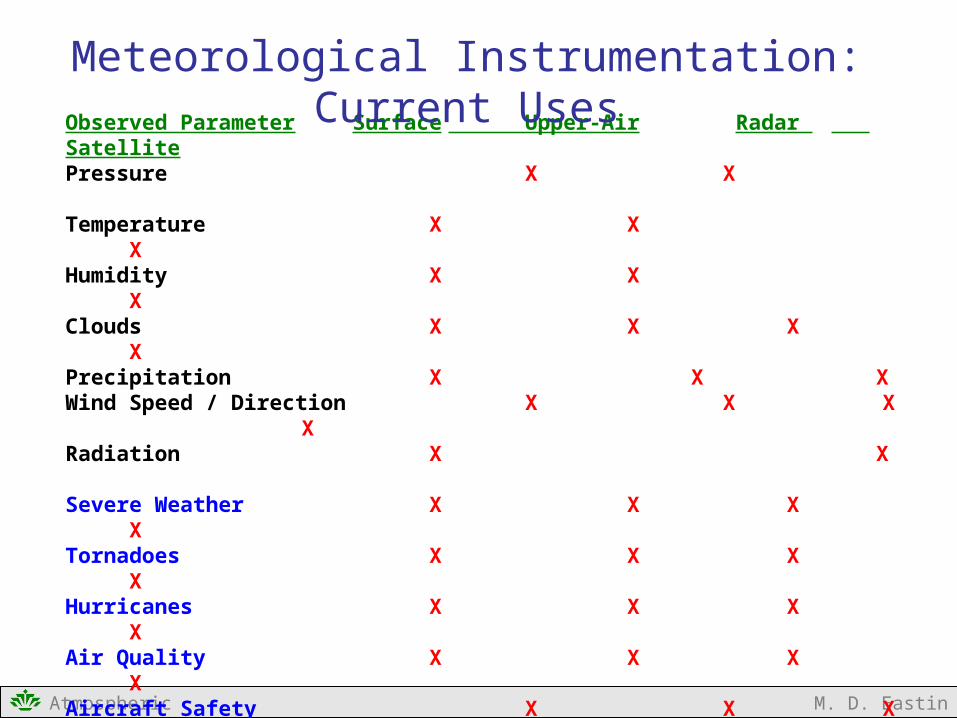
Observed Parameter Surface Upper-Air Radar SatellitePressure X XTemperature X X XHumidity X X XClouds X X X XPrecipitation X X XWind Speed / Direction X X X XRadiation X X
Severe Weather X X X XTornadoes X X X XHurricanes X X X XAir Quality X X X XAircraft Safety X X X XWinter Weather X X X XClimate Change X X X X
Data assimilation into X X X X numerical weather and climate models
Meteorological Instrumentation: Current Uses

Atmospheric Instrumentation M. D. Eastin
Example of a Modern Surface System
NOAAASOS
Station(operational)Precipitation
Amount(heated)
(tipping bucket)
Wind Speed / Direction(cup anemometer)
(wind vane)
TemperatureHumidity
(aspirated)
Cloud Height(ceilometer)
Visibility
PrecipitationType
Lightning
Pressure
Electronics(Transmitter)

Atmospheric Instrumentation M. D. Eastin
Example of a Modern Surface System
DavisVantage
Pro-2Station
(research)
PrecipitationAmount
(tipping bucket)
Wind Speed / Direction(cup anemometer)
(wind vane)
TemperatureHumidity
(aspirated)
Solar and UV Radiation(radiometers)
Electronics(Transmitter)

Atmospheric Instrumentation M. D. Eastin
Example of a Modern Upper-Air System
Receiving Antenna
Balloon Inflation Area
HeliumTanks
GPSAntenna
TemperatureSensor
HumiditySensor
PressureSensor
(inside case)
TransmittingAntenna
Vaisala Sounding Systemand
RS-92 Sonde

Atmospheric Instrumentation M. D. Eastin
Examples of Modern Radar Systems
NOAANEXRADS-band10.5 cmDoppler
NCARDoppler
on WheelsX-band3.2 cm
Doppler
NOAA-WP3D X-band / 3.2 cmDoppler
-15 0 15 30 45
0 5 10 15 20 25 Range (km)
ReflectivityFactor (dBZ)

Atmospheric Instrumentation M. D. Eastin
Examples of Modern Satellite Systems

Atmospheric Instrumentation M. D. Eastin
How Do These Instruments Work?
Starting next time…
1.Principles of Measurement and Instruments
2.Surface Measurement Systems
3.Sounding Measurement Systems
4.Precipitation Radar Systems
5.Satellite Systems