Kruger National Park Visitor's Guide & Atlas. ISBN 9781770262577

ATLASof
PARK COUNTYMONTANA
© 2013 - Park County - Montana

Livingston - Tony Demin
Yellowstone River - Alyssa Smith
Roundup Parade - Shawn Raecke
I II
The Atlas of Park County, Montana is designed to support economic development, planning, tourism promotion and educational purposes. It presents a fact-based portrait of Park County’s socioeconomic and demographic characteristics, natural resources, land use and infrastructure. It will serve as a community resource for local officials, teachers, the business community, landowners and visitors alike. In the future the atlas will serve as a baseline for measuring change in the county over time.
Production of the atlas was made possible through a partnership between Park County and the non-governmental organization Future West. The project was directed by the Park County Planning and Development Board and the Park County Planning Department. Funding was provided by Park County, the Park County
Community Foundation, The Community Closet, Lewis Wilks, Frank Schroeder, and the Gallatin Area Planning Grant Program. Without the generous support of all of these organizations and individuals, this project would not have been possible.
Mapping and design services were provided by Gage Cartographics, and many photographers donated their images including students from Raeann Nilan’s Park High School photography class. Photo credits are included with each photograph. All of these high-quality images and maps helped to capture the many special qualities and assets of Park County; the authors are deeply appreciative of those who contributed their photographic talents. Printing services were provided with consideration by Printing for Less in Livingston.
In addition to the acknowledgments cited above, many other individuals and organizations provided information and materials used in the development of the atlas. They include the Park County GIS Department; Montana Department of Fish, Wildlife and Parks; Park County Commission; Park County Fire Warden Greg Coleman; Park County Historian Jerry Brekke; archaeologist Dr. Larry Larhen; Charlie Eubank of Eubank Land Inc.; Peter Fox; Robyn Egloff of Egloff Design; and Headwaters Economics. Data sources are included with all charts and graphs.
This atlas is available in print edition from the Park County Planning Department. Plans also call for the creation of an on-line interactive version that will be posted on the Planning Department website. To inquire about copies, call the Park County Planning Department at (406) 222 4102.
Acknowledgements

Downtown Livingston - Norm Miller
MCD Photography
Wilsall Rodeo - Shawn Raecke
Yellowstone River - Tony Demin
III IV
“The more homogenized human culture becomes, it seems, the deeper interest individuals take in what makes them unique: nationality, creed, family heritage.” (Roger Downey in “Riddle of the Bones”, 2000)
By definition, an atlas is a book of maps and charts, or a book of illustrations or diagrams on any subject, which sometimes contains textual information.
The Atlas of Park County, Montana is all of the above. It continues a tradition began in 1801 when Siksika headsman Ac ko mok ki (“Old Swan”) sketched in the snow his perspective of a cultural and spatial “map” of the Missouri River drainage for Peter Fidler, a Hudson Bay Company cartographer. Fidler passed the information along to British cartographer Aaron Arrowsmith, who in turn created the map of western America used by the Lewis and Clark expedition. During the period July 12-15, 1806, Captain William Clark mapped the Corps of Discovery route through the Gallatin Valley and over a mountain pass trail that Sacajawea recalled from her childhood. The Corps arrived on the banks of the Yellowstone River at the location of today’s Livingston, Montana. Clark’s
hand-drawn maps Nos. 48 and 49, contained in the Atlas of the Lewis and Clark Expedition, documents his eastward travel across present-day Park County, Montana.
Atlas tradition continued when the United States Geological Survey (USGS) was created in 1879 to provide “classification of the public lands, and examination of the geological
structure, mineral resources, and products of the national domain.” John Wesley Powell, the agency’s second director, was determined to create some 7,000 individual topographical maps and geologic atlas folios of the United States. The Livingston, Montana Folio, 1894, holds the distinction of being “Folio 1” of 227 geologic atlases published by USGS between 1894 and 1945. Over time, a number of public and private-sector maps of Park County have appeared in atlases designed for specific informational needs. Themes identifying roads, watersheds, land development, demographics, and economic transitions have expanded information. Cartography has evolved from etching delineations on lithographic stone to a technology of computer-assisted design software enhanced by Global Positioning System satellites and extensive geographic database resources.
The Atlas of Park County, Montana takes advantage of modern technology to present our on-going spatial relationship with the land we belong to, our past, our present and our future.
The authors of this atlas have made every attempt to provide factual, accurate information, and comments should be submitted to the Park County Planning Department to help ensure continued accuracy for future publications.
Introduction
Park County - Chris Boyer
V VI
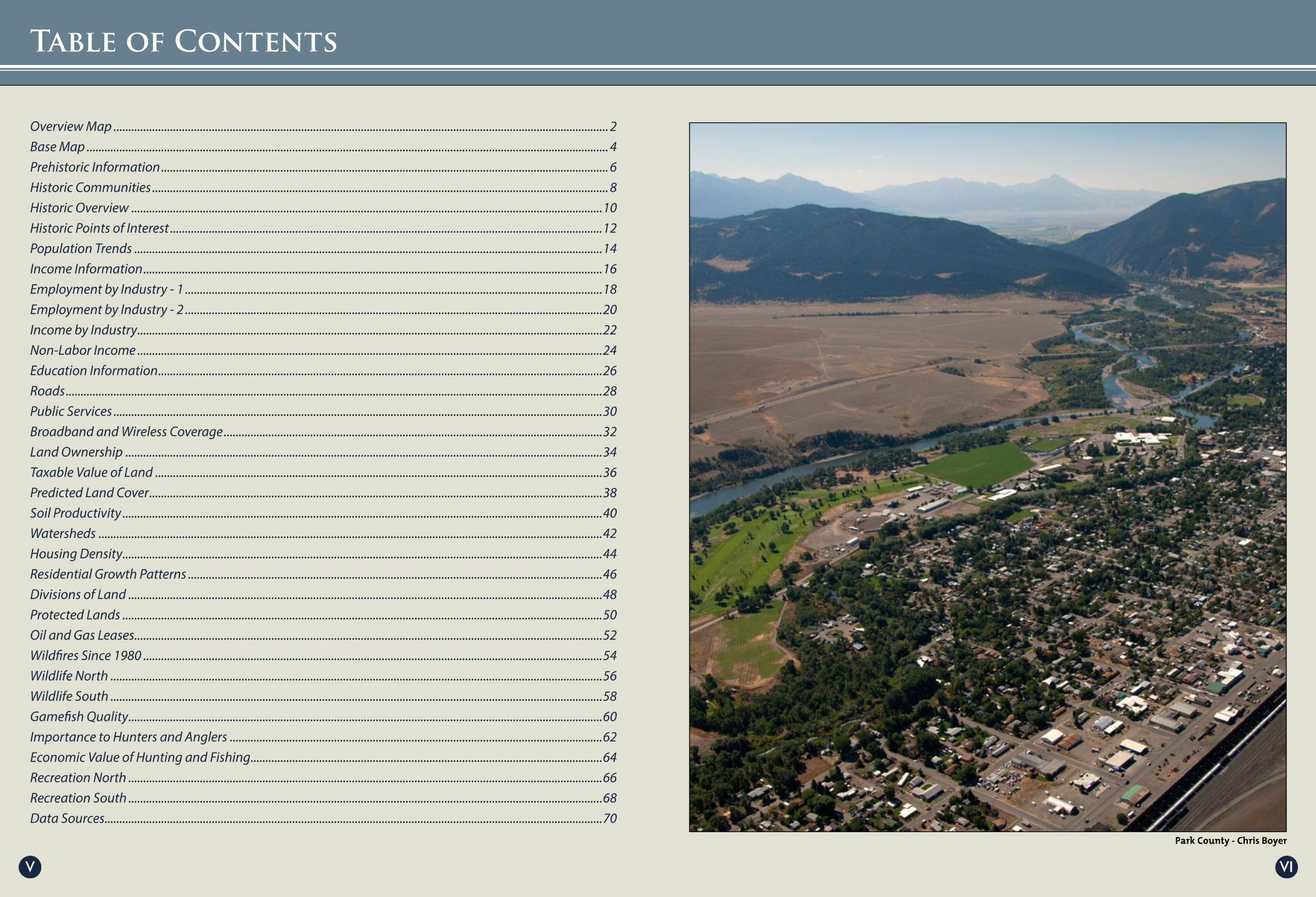
Overview Map ...................................................................................................................................................................... 2Base Map ............................................................................................................................................................................... 4Prehistoric Information ...................................................................................................................................................... 6Historic Communities ......................................................................................................................................................... 8Historic Overview ..............................................................................................................................................................10Historic Points of Interest .................................................................................................................................................12Population Trends .............................................................................................................................................................14Income Information ..........................................................................................................................................................16Employment by Industry - 1 ............................................................................................................................................18Employment by Industry - 2 ............................................................................................................................................20Income by Industry ............................................................................................................................................................22Non-Labor Income ............................................................................................................................................................24Education Information .....................................................................................................................................................26Roads ....................................................................................................................................................................................28Public Services ....................................................................................................................................................................30Broadband and Wireless Coverage ...............................................................................................................................32Land Ownership ................................................................................................................................................................34Taxable Value of Land ......................................................................................................................................................36Predicted Land Cover ........................................................................................................................................................38Soil Productivity .................................................................................................................................................................40Watersheds .........................................................................................................................................................................42Housing Density .................................................................................................................................................................44Residential Growth Patterns ...........................................................................................................................................46Divisions of Land ...............................................................................................................................................................48Protected Lands .................................................................................................................................................................50Oil and Gas Leases .............................................................................................................................................................52Wildfires Since 1980 ..........................................................................................................................................................54Wildlife North .....................................................................................................................................................................56Wildlife South .....................................................................................................................................................................58Gamefish Quality ...............................................................................................................................................................60Importance to Hunters and Anglers .............................................................................................................................62Economic Value of Hunting and Fishing ......................................................................................................................64Recreation North ...............................................................................................................................................................66Recreation South ...............................................................................................................................................................68Data Sources .......................................................................................................................................................................70
Table of Contents

1 2
Overview Map
Wilsall - Rob Park
Cooke City - Josh Gage
Paradise Valley - Norm Miller
43
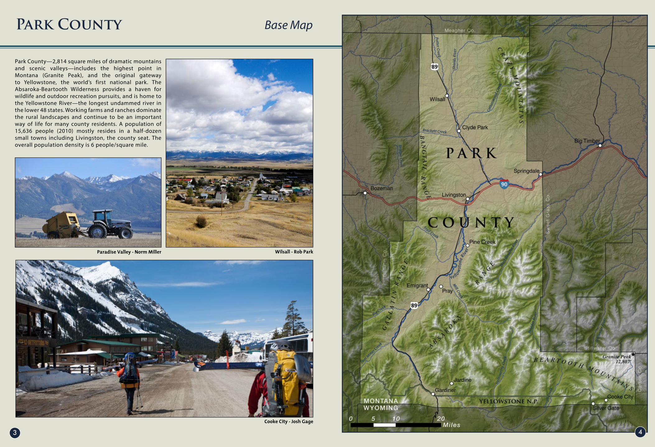
Park County—2,814 square miles of dramatic mountains and scenic valleys—includes the highest point in Montana (Granite Peak), and the original gateway to Yellowstone, the world’s first national park. The Absaroka-Beartooth Wilderness provides a haven for wildlife and outdoor recreation pursuits, and is home to the Yellowstone River—the longest undammed river in the lower 48 states. Working farms and ranches dominate the rural landscapes and continue to be an important way of life for many county residents. A population of 15,636 people (2010) mostly resides in a half-dozen small towns including Livingston, the county seat. The overall population density is 6 people/square mile.
Park County Base Map

Clovis Artifacts - Anzik Site
Anzick Clovis Site - Tim Urbaniak
5 6
The prehistory record of Park County began more than 11,000 years ago when a small group of Late Ice Age hunters and gatherers buried a two-year-old child and more than 100 stone and antler artifacts in a sandstone outcrop near present-day-Wilsall in northern Park County. The site has provided the earliest radiocarbon dates for human activity in Montana.
Approximately 10,000 years ago, hunter-gatherer peoples began to increase in numbers and practiced a seasonal way of life relative to the elevation and available resources. The “Good Camp on the Great Bend of the Yellowstone” (known as the Myers-Hindman Site: 24PA504) has provided evidence of these seasonal patterns for the past 9,000 years. The Mountain Branch of the Shoshoni, known as the “Sheepeaters” or “Eaters of Meat” represented the last remnants of the pedestrian, hunting-gathering lifestyle in Park County.
The transition from prehistory to history in Park County paralleled European colonization of the eastern United States in the 1600s to include scattering of natives from traditional lands (disease, warfare and resource competition), and the adoption of the horse and rifle in the 1700s. Based on the original 1851 treaty, all of Park County was once part of the Apsaalooke (Crow) Reservation.
Park County Prehistoric Information

Construction of the Roosevelt Arch
Clark City - Original Livingston Townsite
Bannock Tribe
87
Written history of the Yellowstone River drainage began in today’s Park County, Montana at 2:00 p.m. Tuesday, July 15, 1806. Captain William Clark noted the arrival of the Corps of Discovery on banks of a river called “Elk River” by Crow Indians and “Roche Jaune” by the French. For nearly 60 years afterward, knowledge of this remote region was little known to those east of the Mississippi River. But in 1863, gold was discovered at Emigrant Gulch in southern Park County. For two decades, from 1863-1883, Park County history paralleled the full spectrum of Montana Territory history. Interaction between gold rush miners, Native Americans, the military, stockmen and town builders took place at a rate one historian described as “too fast-paced to be termed an evolution.” During this period, Park County saw the establishment of the Crow Indian Reservation south of the Yellowstone River and the first government agency for the tribe at Mission Creek; the arrival of Bozeman Trail emigrants and the first cattle drive from Texas; and the survey and establishment of the nation’s first national park on the county’s southern edge.
The arrival of the Northern Pacific Railroad in 1883 marked a settlement-era watershed. Livingston, properly platted and planned, was constructed at the ancient Big Bend of Yellowstone trail nexus to serve as the home of Northern Pacific’s repair shops and as the travel gateway to Yellowstone National Park. In February 1887, Park County was created from the “east side” of Gallatin County and included large portions of present-day Sweet Grass, Stillwater, and Carbon counties. Extractive industries related to precious metals, coal, and timber remained an early economic focus of the new county, but tourism and agriculture were rapidly emerging.
Park County Historic Communities (1913)

Livingston Depot in 1902
Early Chico miners
Park County Women - 1890s
109
By 1900, the Shields River Valley in northern Park County was well on its way to creating its agricultural identity. Shunned for its lack of silver and gold in the early years, new wealth was emerging from the fertile soils in the valley. Large sheep operations moved into the foothills of the Crazy Mountains and the Enlarged Homestead Act of 1909 triggered a heady settlement era. The town of Clyde Park and unincorporated community of Wilsall emerged as agricultural headquarters along the newly built Shields Branch railroad line. The drought of 1919 launched Park County and Montana into a 20-year economic depression.
World War II ended the depression and the national post-war boom of housing, credit, babies, and disposable income began to change Park County’s economic and residential profile. Automobiles, highway systems, and roadside accommodations replaced railroad travel. Yellowstone became a popular family vacation destination and tourism became a primary industry. As more middle-class leisure time became available, tourism evolved beyond a once-in-a-lifetime vacation trip to recurring pursuits of outdoor recreation. Throughout the 1950s and
early 1960s, Livingston’s identity shifted from being the home of Northern Pacific’s repair shops to being the “Trout Capital of the World.” As the railroad’s service and employee numbers declined, a new colonialism began. Like the homestead influx of the early 1900s, it was land-based, but with a difference. The notion of making a living from the land was replaced by marketing which targeted ownership of the land itself or at least ownership of a small piece of the “Last Best Place.” Divided parcels of agriculture land became worth more than what the land could produce. An influx of diverse (and often transitional) landowners altered neighborhood identities. Landowner trends of the 1970s, however, were not a new circumstance in Park County history, but a continuation of cultural and technological change which had been ongoing since the beginning of the Crow Reservation period. At the threshold of the 21st-century, Park County retained most of the resources noted with awe in the journals of William Clark, Jim Bridger, and Bozeman Trail emigrants—many of them have provided a living to some 400 generations of humankind.
Park County Historic Overview

Mike Inman
1211
The following map identifies the location and description of 20 significant historic sites in Park County.
1 – Independence Mining District: Independence grew to a town of 400 in the late 1880s and early 1890s.The high-altitude mines at the headwaters of the Boulder River prospered until the financial panic of 1893 and had a resurgence after 1900 at Solomon City (Cowles Camp), three miles above Independence.
2 – Emigrant Cemetery: Established as a family cemetery by William H. Lee in 1881 after the death of his infant daughter, Ellen, the Emigrant Cemetery was donated to the public in 1898 and continues to serve the community.
3 – Anzick Site: Some 11,000 years ago a small group of Late Ice Age hunters and gatherers buried a two-year-old child and more than 100 stone and antler artifacts in a sandstone outcrop near present day-Wilsall in northern Park County. This site has provided the earliest radiocarbon dates for human activity in Montana.
4 – Stole Bison Kill Site 24PA079: As early as 1200 A.D., the historic Shoshoni people occupied the Upper Yellowstone area and processed bison at this location very near the “buffalo road “ that Capt. William Clark followed to the Yellowstone in 1806. Fifty-eight years later the Bozeman Trail Wagon Road (Willow Creek Road) passed within a hundred yards of this site.
5 – Myers Hindman Site 24PA504: Located near a large spring, the “Good Camp on the Big Bend of the Yellowstone,” revealed more than 9,000 years of human use on nine settlement sites—ranging from paleoindian hunters and gatherers to modern use as a sheepherder’s camp.
6 – Emigrant Bison Kill Site: Commonly known as a “buffalo jump” the Emigrant Bison Kill site is one of several found throughout the Paradise Valley. Communal bison hunting, incorporating drive lines, corrals and jumps, provided the essential food for pre-horse, pedestrian hunters and gatherers.
7 – Hunter’s Hot Springs: Claimed by Dr. Andrew Hunter in 1864 and later developed by the Hunter family for medicinal bathing, Hunter’s Hot Springs became a nationally famous hot springs resort and early Park County community. Little evidence remains of the historic grandeur once found here.
8 – Benson’s Landing: Benson’s Landing was Park County’s second community which arose around the site of the Yellowstone River ferry crossing, which provided river-crossing to Fort Parker in 1869.
9 – Livingston: The City of Livingston was platted in December 1882 by the Northern Pacific Railway as the site of the company’s repair shops located midway on the rail line between St. Paul, Minnesota, and Tacoma, Washington.
10 – Fort Parker Crow Indian Agency: The Fort Laramie Treaty of 1868 established the Crow Indian Reservation and the first government agency for the tribe, Fort Parker, built in 1869. The agency moved to the Stillwater River in 1875, but all lands south and east of the Yellowstone River remained the Crow Reservation until it was ceded in 1882. (Subsequently, the agency relocated for a final time to Big Horn County.)
11 – Main Boulder Ranger Station: The Main Boulder Ranger Station was constructed as a one-room cabin by U.S. Forest Ranger Harry S. Kaufman in 1905 and expanded as Kaufman’s family grew. The historic dwelling, eligible for the National Historic Register, was restored in 1991 and is available for visitor tours.
12 – Cooke City: Began in 1877 as a mining camp named Shoo-Fly, Cooke evolved to Cooke City, the headquarters of Park County’s wealthiest mining district, the New World. Now the eastern gateway to Yellowstone National Park, Cooke City is Park County’s oldest business community.
13 - Chico Cemetery: In 1864, on a grass-covered, glacial moraine at the mouth of Emigrant Gulch in Montana Territory, a group of gold rush miners laid to rest one of their own at a place that would come to be known as Chico Cemetery, which continues in use.
14 – Yellowstone City: Gold rush miners established Park County’s earliest townsite in 1864. At the time, Yellowstone City represented the eastern-most townsite in Montana Territory. After just a few years, the town was relocated and renamed Chico — present-day Old Chico. The greatest part of Yellowstone City was consumed by gold dredging in the late 1940s.
15 – Chico Hot Springs: So named after Chico Hot Springs Hospital, the resort began to prosper in the early 20th century. Present day Old Chico served as a mining community from 1866 to the 1950s.
16 – Aldridge, Montana: In Paradise Valley, the Upper Yellowstone River divided mining interests. Precious metals were dominant east of the river in the rugged Absaroka Mountains. Seams of coal lay west of the river in a belt extending to Cokedale near Livingston. Although the Red Streak Mountain coal company received a charter to mine Cinnabar Mountain during Montana’s first territorial legislature in 1864, coal mined at Aldridge and processed in Horr didn’t take place until after the Park Branch Railroad was built in 1883.
17 – Trail Creek: The Trail Creek road route, a prehistoric travel corridor, provided a primary access from the Gallatin to the Yellowstone drainage. From the time Bozeman and Fort Ellis were established on the Gallatin, the road served miners, stockmen, and expeditions exploring Yellowstone National Park. Trail Creek coal mine development began in the late 19th and early 20th centuries.
18 – Cokedale: The ruins of coke ovens mark the historic site of Cokedale. Anaconda Copper Mining Co. smelters demanded coked coal, which was supplied in part by Park County’s coal country Cokedale, Aldridge and the Trail Creek mines. Labor strife and a shift to hydroelectric technology ended the need for low-grade coal in the early 1900s.
19 – Siebeck Island: Siebeck Island (present-day Ninth Street Island) has been the geologic hub of an important trail nexus since prehistoric times. The Old North, Arapaho (or Mountain), Bannock (Yellowstone Plateau), and Sioux Crossing trails meet here.
20 – Clyde Park and Wilsall: The communities of Clyde Park and Wilsall (eight miles north) remain the historical centers of northern Park County agriculture. Two important trail systems emerge from the west to the two communities. The Blackfeet trail followed Brackett Creek and was used by Jim Bridger guiding wagon trains west. The Flathead trail followed Flathead Creek to connect with the Old North Trail seven miles north of present-day Wilsall.
Park County Historic Points of Interest

Norm Miller Shawn Raecke
Fleshman Creek - Eubank Creative Inc.
1413
Total population growth (or decline) is the sum of natural change (births and deaths) and in-migration (domestic and international). From 1970 to 2010, the population in Park County grew from 11,364 to 15,587, a 37% increase. From 2000 to 2011, the population grew by 160 people, a 2% increase.
Park County Population Trends

Downtown Livingston - David Ng
Wilsall Mercantile - Rob Park
Grazing Cattle - Norm Miller
Outfitter String - Park County Photo
1615
Household income is a measure commonly used by the United States government and private institutions. Each household is measured by the income of every resident over the age of 15. Income includes wages and salaries, unemployment insurance, disability payments, child support payments received, regular rental receipts, as well as any personal business, investment, or other kinds of income received routinely.Note that “per capita income” can be
misleading because it is calculated using totalpopulation including those people receiving non-labor related income and not just the labor force as in “average earnings per job.” Per capita income in Park County is slightly below the state average. Median household income is also below the state average.
People are counted as unemployed if they are at least 16 years old, are without a job and available for work, and have recently made specific efforts to find employment.The unemployment rate is the number of unemployed as a percent of the entire labor force. The unemployment
rate has long been identified as an indicator of the overallhealth of the nation and economy. An unemployment rate below 4% is considered by many experts to be a good sign.
Poverty status is determined by comparing annual income to a set of dollar values called poverty thresholds that vary by family size, number of children and age of householder. If a family’s before-tax money income is less than the dollar value of their threshold, then that family and every individual in it are considered to be in poverty. For people not living in families, poverty status is determined by comparing the individual’s income to his or her poverty threshold. The poverty rate in Park County is below both the state and national rates of poverty.
Park County Income Information
R-Y Timber - Rob Park
Livingston - Rob Park Yellowstone’s Edge RV Park - Rob Park
Cattle Branding - Tony Demin
1817
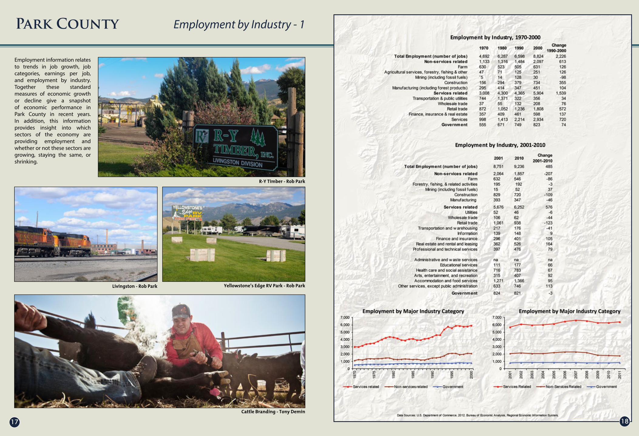
Employment information relates to trends in job growth, job categories, earnings per job, and employment by industry. Together these standard measures of economic growth or decline give a snapshot of economic performance in Park County in recent years. In addition, this information provides insight into which sectors of the economy are providing employment and whether or not these sectors are growing, staying the same, or shrinking.
Park County Employment by Industry - 1

Montana Whitewater Company - Rob Park
RY Timber - Rob Park
Park Street, Livingston - Tony Demin
Shawn Raecke
2019
This graph describes historical employment change by industry. Industries are organized according to three major categories: non-service related, services related and government. Employment includes both wage and salary jobs and business proprietors. The employment data are organized according to the Standard Industrial Classification System and reported by place of work. The data ending in 2000 is from the Bureau of Economic Analysis which switched to organizing industry-level data according to the newer North American Industrial Classification System in 2001.
From 1970 to 2000, Park County jobs in the non-service related industries grew from 1,133 to 2,097, a 85% increase, while services industries grew from 3,008 to 5,904, a 96% increase. During this same period, jobs in the government sector grew from 555 to 823, a 48% increase. From 1970 to 2000, the three industry sectors that added the most new jobs were services (1,936 new jobs), retail trade (936 new jobs) and construction (578 new jobs). From 2001 to 2010, jobs in non-services related industries shrank from 2,064 to 1,857, a 10% decrease. Government jobs during this period dropped from 824 to 821. Meanwhile, jobs in the services-related industries grew from 5,676 to 6,252. From 2001 to 2010, the three industry sectors that added the most new jobs were real estate, rental, leasing, finance and insurance and other services.
Park County Employment by Industry - 2

Livingston - Tony Demin
Emigrant - Rob Park
Bailey Klawitter
2221
The following figures describe historical personal income by industry (in real terms). Industries are organized according to three major categories: non-services such as farm, mining and manufacturing; services-related such as retail trade, finance, insurance and real estate; and government including federal, state and local government employment. From 1970 to 2000, personal income in non-services-related industries grew by 3% to $41.9 million. During that same period, personal income in services related industries grew by 50% -- from $101.8 million to $152.4 million. Personal income from the government sector increased by 84% to $35.3 million.
Between 2001 and 2010, personal income from non-service related industries shrank from $46 million to $41 million (in real terms)—an 11% decrease. Personal income from services-related industries grew from $156 million to 158 million, a 1% increase. During the same period, personal income from government jobs grew from $35 million to $42 million, a 20% increase.
Park County Income by Industry

Concert at Pine Creek - Steve Horan
Sacajawea Park - Steve Horan
Yellowstone River - Steve Horan
2423
In many counties, non-labor income can be one of the largest components of personal income and also the largest source of new income. With the baby-boom generation reaching retirement age, it is likely that non-labor income will continue to be a growing source of personal income. Non-labor income consists of: dividends, interest, and rent; money earned from investments; and transfer payments (including government retirement and disability insurance benefits and medical payment, such as Medicare and Medicaid, and unemployment insurance benefits). All of these are grouped under the category of non-labor income in Park County, and they represent a significant source of income for local residents.
Park County Non-Labor Income

Wilsall Football - Shawn Raecke
Springdale School - Rob Park
Gardiner High School - Shawn Raecke
Park High Graduation -Tony Demin
2625
The following charts illustrate education trends and statistics for Park County schools, including school enrollment, graduation rates, education attainment and test scores. Park County ranks high against the state’s average for graduation rates, education enrollment, as well as 4th and 8th grade test scores. Gardiner in particular reached 100% graduation rates from 2005 through 2009, well above the State average of approximately 80%. Park County’s education system strives to keep children involved in activities throughout the year by offering a variety of indoor and outdoor activities, as well as parent/child opportunities at local civic centers and other community organizations.
Community agencies, such as the Park County Community Foundation and the Park County Pathway Coalition, continue to enhance early childhood development through quality prenatal programs, parent education opportunities and strong preschool/daycare programs and access. The Park County Pathway Coalition is a partnership between many of the organizations that serve Park County’s families with young children including the Park County Health Department, Livingston Health Care, Learning Partners and many of the community daycares and preschools.
Park County Education Information

Interstate 90 - Norm Miller Norm Miller
Shawn Raecke
Highway 540 - Tony Demin
2827
The following map depicts various roads throughout Park County. It includes Interstate 90, US/state highways, paved and unpaved county roads, as well as paved and unpaved private roads and driveways. Only the more commonly used roads were identified by name.
History illustrates that many of today’s roads were once used as game trails, followed by hunters and gatherers and were eventually used by wagons as people travelled from place to place. The current Interstate 90 East follows the Old North Trail route of first Americans. Interstate 90 West follows the same route Captain William Clark followed over the Bozeman Pass. US Highway 89 South, identified as the prehistoric Bannock Trail, came of age as an automobile road in 1914 and was called the Yellowstone Trail.
According to the Park County GIS Department, there are more than 250 miles of designated federal and state highways, and more than1,000 miles of county and private roads. Harsh winters and wet springs make road maintenance more difficult, and the heightened use of many of the major roads during the tourism season adds unique challenges to developing long-term planning and maintenance strategies.
Park County Roads

Halsey Kordonowy
Bailey Klawitter
Steve Horan
Park County Search and Rescue - Park County Photo
3029
Government facilities such as post offices, schools and airports, along with emergency services such as ambulance, fire, sheriff and police departments, are all important elements of Park County’s infrastructure. Most of these services are associated with communities like Clyde Park, Gardiner, Cooke City or Livingston, although there are a number of rural fire district stations. County high schools include facilities in Shields Valley, Livingston and Gardiner. Most communities have emergency medical and law enforcement services though Livingston Memorial Hospital is the county’s primary hospital facility. Livingston and Gardiner have small airports and other rural landing strips are scattered throughout the county.
Park County Public Services
Deborah Monaghan
Shawn Raecke
3231
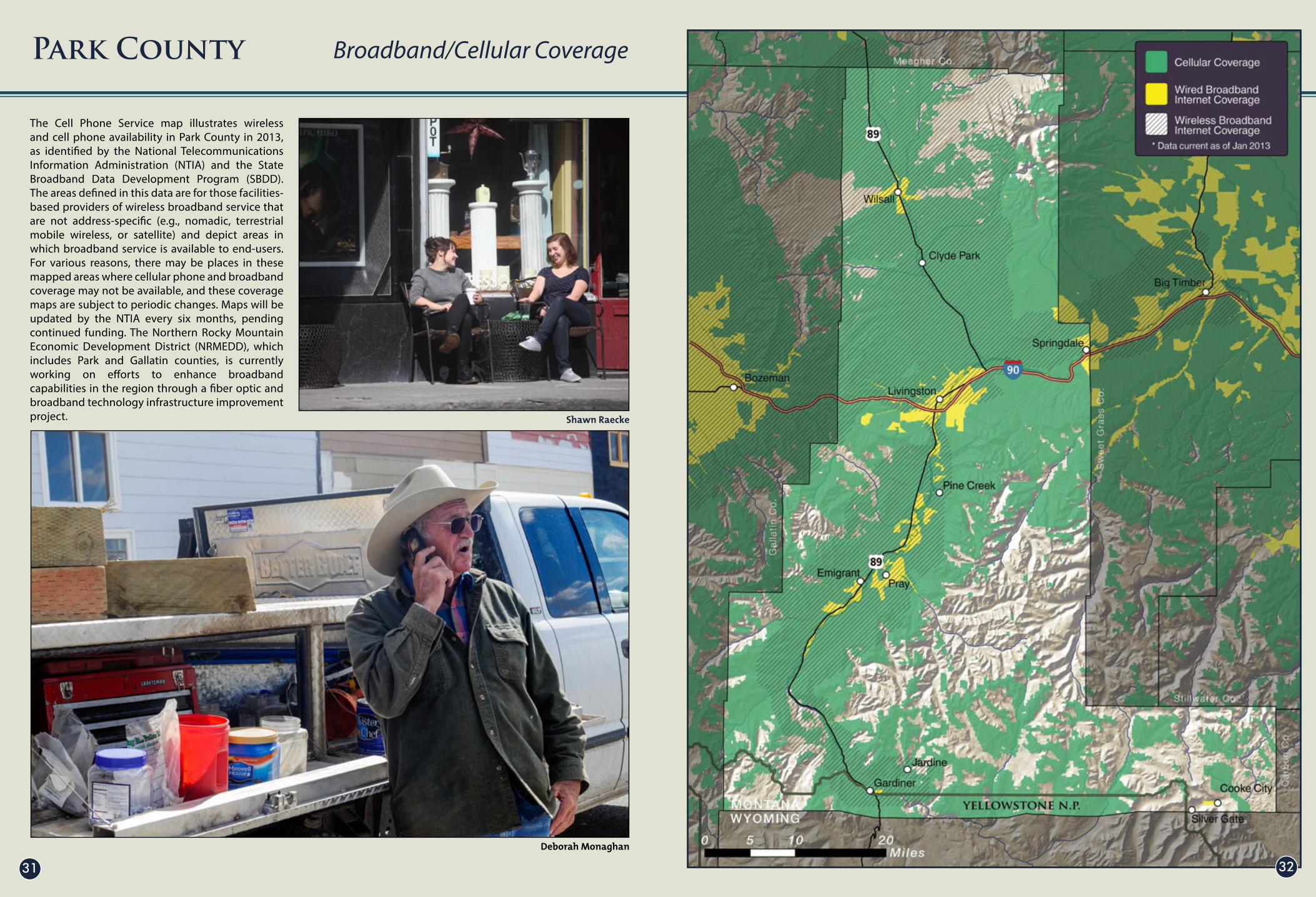
The Cell Phone Service map illustrates wireless and cell phone availability in Park County in 2013, as identified by the National Telecommunications Information Administration (NTIA) and the State Broadband Data Development Program (SBDD). The areas defined in this data are for those facilities-based providers of wireless broadband service that are not address-specific (e.g., nomadic, terrestrial mobile wireless, or satellite) and depict areas in which broadband service is available to end-users. For various reasons, there may be places in these mapped areas where cellular phone and broadband coverage may not be available, and these coverage maps are subject to periodic changes. Maps will be updated by the NTIA every six months, pending continued funding. The Northern Rocky Mountain Economic Development District (NRMEDD), which includes Park and Gallatin counties, is currently working on efforts to enhance broadband capabilities in the region through a fiber optic and broadband technology infrastructure improvement project.
Park County Broadband/Cellular Coverage

Gardiner Ranger Station - Rob Park
Park County Photo
3433
The land ownership map depicts the major categories of land ownership and management in Park County. Public lands include National Forest, National Wildlife Refuges, Bureau of Land Management lands, National Park lands, and state lands. When combined, these public lands cover about 57% of Park County. The rest is in private ownership. While most public lands are in the more mountainous and or forested portions of the county like the Absaroka Mountains, private lands are mostly found in the river valleys like the Shields and Yellowstone valleys.
Park County Land Ownership

Suce Creek Property - Mike InmanLivingston - Dennis Glick
Paradise Valley - Mike Inman
3635
The following charts show the taxable value of property in Park County from 1999 to 2012, and average residential property prices from 2003 to 2013. Taxable value is a measure of the total value of property in the county, including residential and commercial property, agricultural land and timber. Following trends over time and accounting for inflation, these charts show trends in property values and are an indication of the tax capacity, or the amount that can be derived from property taxes for local government services. The lower chart also provides an indication of real estate trends over time with the highest average sale price for residential properties in the past decade occurring during 2009.
Park County Taxable Value of Property

Paradise Valley - Norm Miller
Gallatin Range - Steve Horan
Bozeman Pass - Mike Inman
Lodgepole Pine - Josh Gage
3837
Analyzing satellite imagery, the United States Geologic Survey has created predicted land-cover maps that depict the most-likely vegetation type to be found at a certain spot. The classification does not confirm this vegetation exists, but provides an overall picture of the types of vegetation that dominate an area. The extensive forest and shrubland steppe cover indicates a large landscape that is in a generally natural and undeveloped state. Steppe is defined as semi-arid grass-covered plain. Developed areas and areas in agricultural production are generally focused in and around existing communities and in the valley floors, where soil productivity is generally rated higher. Riparian areas are those vegetative communities relating to or located on the banks of a river or stream or are identified along major water bodies.
Park County Predicted Land Cover Types

Paradise Valley - Jamie Cahoon
Shields Valley in 1916
Pray - David Ng John Deere - Mike Inman
4039
The following graph depicts soil productivity throughout Park County. Park County has a rich history of agricultural production and was once rated one of the most-productive agricultural areas (Shields Valley) in the county by the Dallas Symposium in 1916. Today, much of Park County is classified as moderate to lower productivity, with the Shields Valley yielding the highest overall productivity classification. The high elevation terrain throughout the County constricts the more productive soils to the valley floors. Both the Shields Valley and Paradise Valley are characterized by irrigation pivot lines, cattle ranches, hay and alfalfa production and other agricultural crops.
Park County Soil Productivity

Campfire Lake - Josh Gage
Pine Creek Falls - Josh Gage Tony Demin
4241
A hallmark of Park County is its internationally known rivers and blue-ribbon trout fishery. The Yellowstone River flowing out of Yellowstone National Park is a critically important water resource for communities, agriculture, recreation, and fish and wildlife. The Shields River is also heavily used for irrigation and well-known for its excellent trout fishing. These rivers and watersheds are monitored and carefully managed by local watershed groups working in collaboration with landowners and local, state and federal agencies.
Park County Watersheds

Livingston - Norm Miller
Mill Creek - David Ng Sleeping Giant Subdivision - Google Image
4443
As of July 2011, the population of Park County was 15,587 with a population density of six people per square mile. Fifty-three percent of county residents lived in “urban” housing in a half-dozen communities; the remaining 47 percent were rural dwellers. Average household size is 2.3 people. Owner-occupied houses totaled 4,534. Renter-occupied apartments numbered 2,294. The estimated median house or condo value in 2009 was $207,949.
Park County Housing Density

Livingston - Halsey Kordonowy Pray - Rob Park
Paradise Valley - Rob Park
North Livingston - Tony Demin
4645
This sequence of maps depicts residential growth patterns in Park County over a 100-year period. In general, growth was concentrated in or near communities through the first half of the last century. In more recent years, much of the new growth has occurred outside of cities and towns in rural landscapes, particularly near rivers, public lands, and state highways and the interstate. While the population of Park County grew by 43% since between 1970 and the year 2000, the amount of land developed increased by 293% reflecting the shift to more rural residential subdivisions. Residential growth slowed significantly during the recent recession, but new housing starts are now on the upswing in Park County although it is
too soon to know if future rates and patterns of growth will reflect those of the recent past.
Park County Residential Growth Patterns

South Fork Deep Creek - Rob Park
Arrowhead Acres Major Subdivision - Google Image
Caledonia Development - Google Image
4847
The following map depicts land divisions in Park County, some dating back to the early 1900s. This information was provided by the Montana Natural Resource Information Systems (NRIS) and includes divisions of land from the 2000 census. This particular data set includes plats filed prior to July 1, 1974; Certificates of Survey (COS) from July 1, 1974 to 2000; and subdivision plats from July 1, 1974 to 2000. This data set is not comprehensive and only reflects divisions of land that were included in the NRIS State Library data set.
State law requires Park County to review all subdivisions under the Montana Subdivision and Platting Act (MSPA) and ensure that proposed subdivisions have adequate access, address public health and safety issues, and mitigate potential impacts to agriculture, agriculture water users, public health and safety, local services, the natural environment, wildlife and wildlife habitat. Divisions of land, such as family transfers and boundary line adjustments are exempt from review as a subdivision.
Park County Divisions of Land

Elbow Lake - Josh Gage
Absaroka Mountains - Tony Demin
5049
Many of the private and publicly managed lands in Park County benefit from some degree of natural resource stewardship. Because of their outstanding natural values, some of these lands may rank higher depending on the amount of protections already in place. Conservation easements on private land also benefit from a higher degree of protection through voluntary agreements made between landowners and the entity holding the easement. Though certain land uses are prohibited, in many cases resource-uses such as cattle grazing, or recreational activities such as hunting and fishing, are still allowed. In general though, these areas are protected for their natural or agricultural values, watershed functions, fish and wildlife habitat concerns, or unique recreational opportunities.
Park County Protected Lands

North of Wilsall - Rob Park
Oil and Gas Exploration in northeast Montana - Eubank Creative Inc.
5251
This map depicts the last oil and gas leasing period starting around 2005 and ending in 2009, when the majority of leases were obtained in Park County. Each red square represents a section where energy companies obtained at least one oil and/or gas lease. Because the mineral estate is separate from the surface estate in many cases, for any one section of land there can be multiple mineral owners who have the right to produce the minerals underneath the surface.
The majority of the oil and gas leases obtained during this leasing period were for a primary term of five years; if no production had been obtained, the oil and gas leases would expire by their own terms. During the primary term of the oil and gas leases, there was a handful of test wells drilled in Park County, all of which have been abandoned.
The information obtained to generate this map came from public records such as the Park County Clerk and Recorder’s Office, the Montana Department of Natural Resources & Conservation, and U.S. Department of the Interior Bureau of Land Management.
Park County Oil and Gas Leases

Paradise Valley Grass Fire 2012 - Park County Photo
Emigrant Fire 2013 - Josh Gage
Pine Creek Fire 2012 - Park County Photo
Park County Photo
5453
The following graphic depicts all documented wildfire activity in Park County since 1980. Over a million acres have burned over the past 30-plus years with 26 of the 34 documented fires occurring since the year 2000. Wildfires can burn hotter and faster than historic fires due to high fuel loads and historic fire suppression management practices. Combined with an increase in development in rural parts of the county, wildfire has become an increasingly significant public health and safety concern.
Park County has 8 fire districts and 10 widely distributed fire stations. The men and women who serve as fire fighters are predominantly volunteer and typically are the first to respond to wildfire events in the county. The county relies upon state and federal aid when managing significant wildfire events, with fire-fighting costs reaching into the millions of dollars.
Park County Wildfires Since 1980

Yellowstone Cutthroat Trout
PronghornGolden Eagle 5655
ThE SHIELDS VALLEY1 - The Shields Valley supports an unusually high concentration of golden eagles.
2 - The Shields River has one of the best-preserved native Yellowstone cutthroat trout populations in the state.
3 - One of the largest mountain goat populations (Crazy Mountains) in the lower 48 United States, with excellent viewing opportunities from many backcountry trails.
4 - Largest antelope population in the county ranging from 1,500 to 2,000 antelope.
5 - Elk population of over 5,000, with the majority occurring on the west side of the valley.
6 - Cottonwood Reservoir (and other wetlands) provide important staging, resting, and viewing areas for migratory waterfowl and shorebirds.
THE I-90 CORRIDOR7 - The Livingston area is the home of a large year-round Canada goose population of several hundred birds.
8 - Several pairs of bald eagles nest along this stretch of the Yellowstone River and lower Shields River.
9 - Seasonally, black bears, mountain lions and moose are seen within the city limits of Livingston.
Park County Wildlife Areas of Interest - North
Grizzly Bear
Bighorn Sheep
Moose 5857
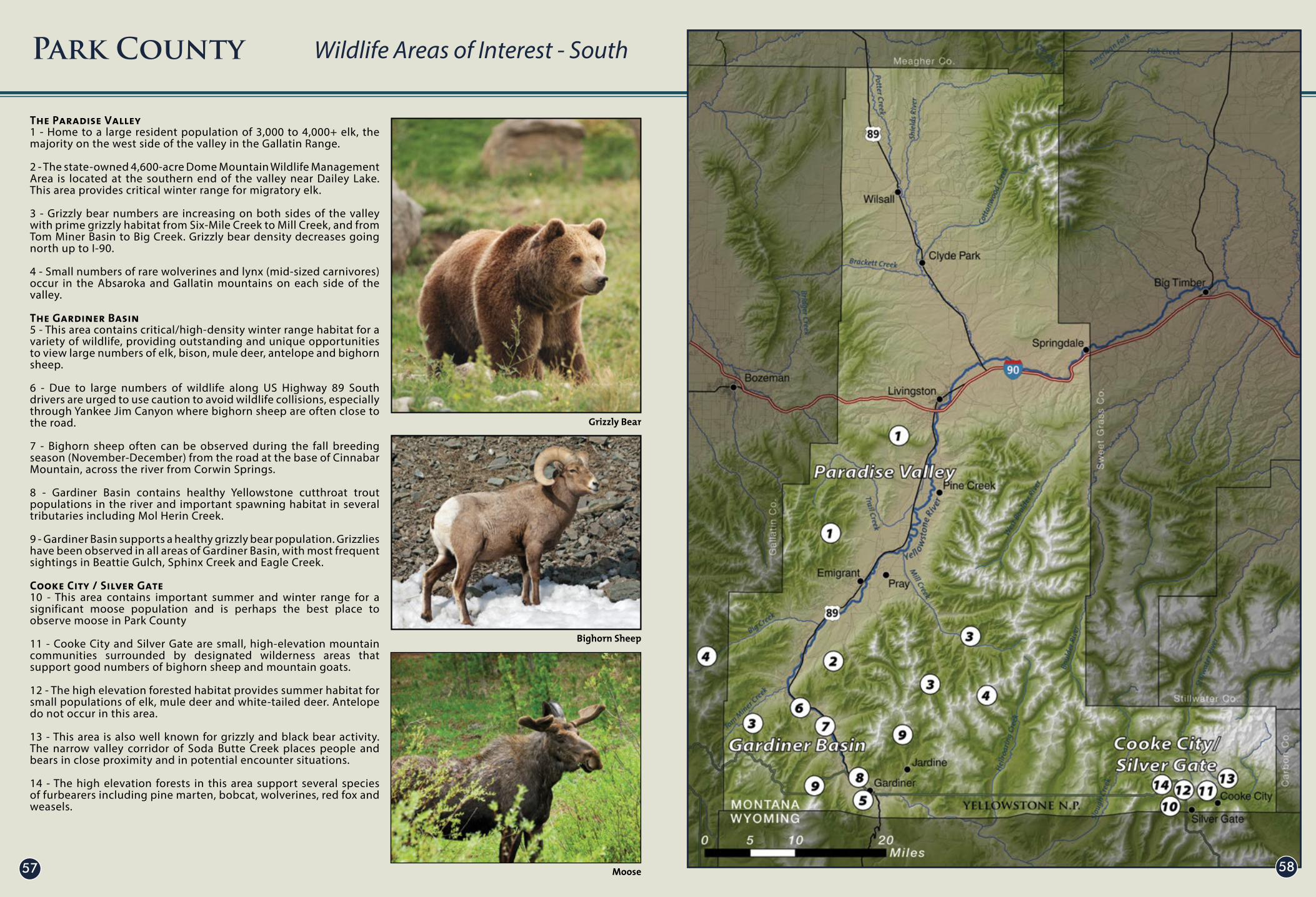
The Paradise Valley1 - Home to a large resident population of 3,000 to 4,000+ elk, the majority on the west side of the valley in the Gallatin Range.
2 - The state-owned 4,600-acre Dome Mountain Wildlife Management Area is located at the southern end of the valley near Dailey Lake. This area provides critical winter range for migratory elk.
3 - Grizzly bear numbers are increasing on both sides of the valley with prime grizzly habitat from Six-Mile Creek to Mill Creek, and from Tom Miner Basin to Big Creek. Grizzly bear density decreases going north up to I-90.
4 - Small numbers of rare wolverines and lynx (mid-sized carnivores) occur in the Absaroka and Gallatin mountains on each side of the valley.
The Gardiner Basin5 - This area contains critical/high-density winter range habitat for a variety of wildlife, providing outstanding and unique opportunities to view large numbers of elk, bison, mule deer, antelope and bighorn sheep.
6 - Due to large numbers of wildlife along US Highway 89 South drivers are urged to use caution to avoid wildlife collisions, especially through Yankee Jim Canyon where bighorn sheep are often close to the road.
7 - Bighorn sheep often can be observed during the fall breeding season (November-December) from the road at the base of Cinnabar Mountain, across the river from Corwin Springs.
8 - Gardiner Basin contains healthy Yellowstone cutthroat trout populations in the river and important spawning habitat in several tributaries including Mol Herin Creek.
9 - Gardiner Basin supports a healthy grizzly bear population. Grizzlies have been observed in all areas of Gardiner Basin, with most frequent sightings in Beattie Gulch, Sphinx Creek and Eagle Creek.
Cooke City / Silver Gate10 - This area contains important summer and winter range for a significant moose population and is perhaps the best place to observe moose in Park County
11 - Cooke City and Silver Gate are small, high-elevation mountain communities surrounded by designated wilderness areas that support good numbers of bighorn sheep and mountain goats.
12 - The high elevation forested habitat provides summer habitat for small populations of elk, mule deer and white-tailed deer. Antelope do not occur in this area.
13 - This area is also well known for grizzly and black bear activity. The narrow valley corridor of Soda Butte Creek places people and bears in close proximity and in potential encounter situations.
14 - The high elevation forests in this area support several species of furbearers including pine marten, bobcat, wolverines, red fox and weasels.
Park County Wildlife Areas of Interest - South

Brown Trout - Eubank Creative Inc.
Kenzie Holmes
6059
Park County is world famous for its exceptional trout fishery. Its rivers, streams, and lakes are home to a number of cold-water game species including Yellowstone cutthroat trout, rainbow trout, brown trout, brook trout, and mountain whitefish.
The Game Fish Quality map depicts the relative quality of 46 cold and warm water game fish populations available to anglers in Montana. Streams are classified according to fish species size and abundance, the number of sport fish species found there, and the presence of unique fishing opportunities. Class I waters in Park County, such as the Yellowstone River, rank in the top 3% of Montana’s sport fisheries: Class II and Class III streams fall within the next 22%.
Park County Gamefish Quality

Shields Valley - Beth Madden
Absaroka Mountains - Josh Gage
Yellowstone River - Eubank Creative Inc.
Mike Inman
6261
This data represents information gathered from hunters and anglers at public meetings across Montana during the period June 2007–October 2008. The information represents areas identified by hunters and fishermen as being important for hunting and angling opportunities. The darker shading represents higher importance to the hunting and fishing community. The data were collected by the Theodore Roosevelt Conservation Partnership in cooperation with sportsmen groups.
Park County Importance to Hunters/Anglers

Yellowstone River - Eubank Creative Inc.
Dennis Glick
Paradise Valley - Mike Inman
Yellowstone River - Mike Inman
6463
The outstanding hunting and fishing opportunities in Park County are both culturally and economically important. The data in these pie charts are estimates derived largely from hunter and angler surveys conducted by the Montana Fish, Wildlife and Parks (MTFWP). The primary source of the hunting data is MFWP’s Hunt Planner Harvest and Hunting Reports – the year 2012 for upland game birds, elk, mule and white-tailed deer, pronghorn antelope, and moose. The primary source of the fishing data is the MFWP 2011 Montana Statewide Angling Pressure report.
Park County Economic Value of Hunting/Fishing

Cokedale Raceway - Paul Bussi Crazy Mountains - Dennis Glick
Yellowstone Boat Float - Shawn Raecke
Absaroka Mountains - Josh Gage
6665
Park County is an outdoor recreation paradise. There are myriad opportunities to pursue your favorite outdoor activities, no matter whether you like to hike, bike, cross-country ski, golf or row. You can ride a horse, all-terrain vehicle (ATV) or snowmobile. You can be a hunter or angler, or just view nature through a camera or binoculars. You can go backpacking in the wilderness or enjoy camping from your vehicle or cabin.
Hundreds of miles of trails and forest roads on the Gallatin National Forest provide access to scenic mountain lakes, deep woods, and wildflower-filled meadows. Some of these can be accessed by motorized vehicles, while others are restricted to hikers or people on horseback. In the winter, these same trails provide skiers and snowmobilers with both groomed and ungroomed snow sport opportunities.
The rivers, streams and lakes of Park County are famous for their excellent fishing, primarily for trout but also in some places for warm-water species like walleye. These same waters make for excellent boating, including white-water rafting, kayaking or rowing a drift boat on the Yellowstone, or fishing from a motor boat on Dailey Lake in Paradise Valley.
Park County Recreation Opportunities North

Black Mountain - Josh Gage
67 68
There are ample camping opportunities on public lands including developed campgrounds such as Pine Creek on the Gallatin National Forest, as well as hundreds of thousands of acres of backcountry where you can pitch a tent and savor the solitude of some of America’s wildest mountain ranges including the Gallatin, Crazy and Absaroka. National Forest maps, available from the Gallatin National Forest offices in Livingston and Gardiner, are an excellent source of information on all of these public land recreational opportunities. The Gallatin National Forest and Montana Department of Fish, Wildlife and Parks websites are filled with useful information, maps and contacts.
In addition to these public land recreational opportunities, privately owned campgrounds and tourist cabins, guest ranches and outfitter and guide services are scattered throughout the county. The Livingston Chamber of Commerce is a good source of information on these many outdoor-oriented businesses. For hunters and anglers, many landowners welcome responsible sportsmen and women on their property through programs like the Department of Fish, Wildlife and Parks Block Management Program, as well as outfitted or fee hunting and fishing including the famous spring creeks of Paradise Valley.
Finally, Park County is the original gateway to the world’s first and perhaps most beloved national park – Yellowstone. The Yellowstone Visitor Center in Mammoth on the northern edge of the park is an excellent place to learn about the wonders of Yellowstone and the many ways to explore and enjoy it. Together with the national forest and other public lands, the rivers, stream and lakes, and the wide-open spaces preserved by farms and ranches, Park County has something for everyone who enjoys outdoor pursuits in a natural environment.
Park County Recreation Opportunities South

Livingston - Tony Demin
Yellowstone River - Tony Demin69 70
Data sources for each map are listed below. Some data sources are the same across all maps and will be listed below.
General Datasets:Elevation and topography data - USGS National Elevation Datasethttp://ned.usgs.gov/
Streams Rivers and Lakes - Montana Natural Resources Information System (NRIS)http://nris.mt.gov/gis/
Transportation: Roads, highways and interstate - Montana NRIShttp://nris.mt.gov/gis/
County and State Boundaries - Montana NRIShttp://nris.mt.gov/gis/
Prehistoric Information - page 6Prehistoric Information was provided by Dr. Larry Lahren
Historic Communities - page 8Historic places were highlighted by Park Count Historian Jerry Brekke
Historic Overview - page 10Historic locations were highlighted by Park Count Historian Jerry Brekke
Historic Points of Interest - page 12Historic points of interest were highlighted by Park Count Historian Jerry Brekke
Population Trends - page 14Charts and graphs were derived from Headwaters Economics Economic Profile Systemhttp://headwaterseconomics.org/tools/eps-hdt
Income Information - page 16Charts and graphs were derived from Headwaters Economics Economic Profile Systemhttp://headwaterseconomics.org/tools/eps-hdt
Employment by Industry 1- page 18Charts and graphs were derived from Headwaters Economics Economic Profile Systemhttp://headwaterseconomics.org/tools/eps-hdt
Employment by Industry 2- page 20Charts and graphs were derived from Headwaters Economics Economic Profile Systemhttp://headwaterseconomics.org/tools/eps-hdt
Income by Industry - page 22Charts and graphs were derived from Headwaters Economics Economic Profile Systemhttp://headwaterseconomics.org/tools/eps-hdt
Non-labor Income - page 24Charts and graphs were derived from Headwaters Economics Economic Profile Systemhttp://headwaterseconomics.org/tools/eps-hdt
Education Information - page 26Provided in part by Ted Madden, Executive Director of the Park County Community Foundation
Roads - page 28Data on roads comes from the Montana Department of Transportation via Montana NRIShttp://nris.mt.gov/gis/
Public Services - page 30Public services sites were selected from a database maintained by the Park County GIS Department
Broadband and Cellular Coverage - page 32Data on the distribution of broadband and cellular coverage comes from
Montana Broadbandhttp://mtbroadband.org/
Land Ownership - page 34Land ownership data comes from Montana NRIShttp://nris.mt.gov/gis/
Taxable Value of Property - page 36Taxable value information comes from Montana Department of Revenue. Residential sales information come from Montana MLS via Awe Real Estate
Predicted Land Cover Types - page 38Predicted land cover types were derived from USGS GAP analysis datahttp://gap.uidaho.edu/index.php/nw-gap/land-cover/
Soil Productivity - page 40Soil productivity was inferred from USDA SSURGO datahttp://soils.usda.gov/survey/geography/ssurgo/
Watersheds - page 42Watershed boundaries come from the USGS National Hydrography Datasethttp://nhd.usgs.gov/
Housing Density - page 44Housing density was calculated from Montana Department of Revenue Computer Assisted Mass Appraisalhttp://geoinfo.montanastatelibrary.org/data/msdi/cadastral/
Residential Growth Trends - page 46Residential growth data comes from Montana Department of Revenue Computer Assisted Mass Appraisalhttp://geoinfo.montanastatelibrary.org/data/msdi/cadastral/
Divisions of Land - page 48Divisions of land were mapped by the Park County GIS Department
Protected Lands - page 50Protected lands data comes from Montana NRIShttp://nris.mt.gov/gis/
Gas Leases - page 52Provided by Charlie Eubank of Eubank Land Energy, Inc
Wildfires Since 1980 - page 54Wildfire information was provided by the Gallatin National Forest
Wildlife Areas of Interest North - page 56Information provided from the Park County Wildlife Brochure; developed by the Park County Planning Department, Members of the Park County Planning and development Brochure, Montana Fish, Wildlife and Parks, and the National Parks Conservation Association, Yellowstone Field Office.
Wildlife Areas of Interest South - page 58Information provided from the Park County Wildlife Brochure; developed by the Park County Planning Department, Members of the Park County Planning and development Brochure, Montana Fish, Wildlife and Parks, and the National Parks Conservation Association, Yellowstone Field Office.
Gamefish Quality - page 60Gamefish quality information come from Montana Fish Wildlife and Park Crucial Areas Planning Systemhttp://fwp.mt.gov/gis/maps/caps/
Importance to Hunters and Anglers - page 62Data on hunter angler importance was acquired through surveys and analysis conducted by the Teddy Roosevelt Conservation Partnership
Economic Value of Hunting and Fishing - page 64Graphs and charts were provided by Doris Fischer - Montana Fish Wildlife and Parks
Recreation Opportunities North - page 66Data on block management areas was provided by Montana Fish Wildlife and Parks - Data on Forest Service recreation sites was provides by the Gallatin National Forest
Recreation Opportunities South - page 68Data on block management areas was provided by Montana Fish Wildlife and Parks - Data on Forest Service recreation sites was provides by the Gallatin National Forest and Custer National Forest
Park County Data Sources