ASX Announcement ASX : LBY 26th February, 2014 Maiden ...target the deeper Moranbah Coal Measures....
31
Unit B3, 431 Roberts Road Subiaco WA 6008 Telephone:+61 89287 4488 Facsimile: +61 89388 8862 ABN: 98 103 348 947 | Email: [email protected] | Website: www.libertyresources.com.au ASX Announcement ASX : LBY 26th February, 2014 Maiden Inferred Resource – Bowen Basin EPC 1949 Liberty Resources is pleased to provide further information regarding the exploration target, the proposed exploration activities and the JORC Code Table 1. The company has received the following updated report with further details from Al Maynard & Associates (AM&A). This report estimates an Inferred Resource of approximately 104 million tonnes of coal within a depth suitable for conventional open pit mining within the Bowen Basin. These resource estimates are based on data compiled from 40 drill holes drilled by previous explorers over the last 50 years and a further 8 holes drilled by Liberty in 2013. This data was modelled by AM&A by gridding the seam depths, seam thicknesses and coal contents from the drill logs using an Inverse Distance Squared (ID 2 ) algorithm. The raw coal quality results of samples collected from the recent Liberty drill holes from the upper Fort Cooper Coal Measures (FCCM) as tested by independent consultants Tradd Pty Ltd (Licensee of the Barrow Process) are reported by Tradd as from DH07: IM% Ash% VM% VM% FC % CSN % Vitrinite Rv, max (ad) (ad) (ad) (daf) (ad) (ad) (mmf) 1.4 63.6 10.0 38.7 25.0 1 67.8 1.36 From this Tradd’s Barrow Process testing achieved the following results: Yield Ash Combustible Recovery CSN (ad) (ad) (ad) (ad) 35.5% 9.5% 84% 7.5 to >9 A further 11 drill holes are planned, to be drilled as an approximate 2km x 2km grid. The planned drill holes will pass through the Fort Cooper Coal Measures to extend these resources and also target the deeper Moranbah Coal Measures. For personal use only
Transcript of ASX Announcement ASX : LBY 26th February, 2014 Maiden ...target the deeper Moranbah Coal Measures....
Unit B3, 431 Roberts Road
Subiaco WA 6008
Telephone:+61 89287 4488
Facsimile: +61 89388 8862
ABN: 98 103 348 947 | Email: [email protected] | Website: www.libertyresources.com.au
ASX Announcement ASX : LBY 26th February, 2014
Maiden Inferred Resource – Bowen Basin EPC 1949 Liberty Resources is pleased to provide further information regarding the exploration target, the
proposed exploration activities and the JORC Code Table 1. The company has received the following
updated report with further details from Al Maynard & Associates (AM&A).
This report estimates an Inferred Resource of approximately 104 million tonnes of coal within a
depth suitable for conventional open pit mining within the Bowen Basin. These resource estimates
are based on data compiled from 40 drill holes drilled by previous explorers over the last 50 years
and a further 8 holes drilled by Liberty in 2013. This data was modelled by AM&A by gridding the
seam depths, seam thicknesses and coal contents from the drill logs using an Inverse Distance
Squared (ID2) algorithm. The raw coal quality results of samples collected from the recent Liberty
drill holes from the upper Fort Cooper Coal Measures (FCCM) as tested by independent consultants
Tradd Pty Ltd (Licensee of the Barrow Process) are reported by Tradd as from DH07:
IM% Ash% VM% VM% FC % CSN % Vitrinite Rv, max
(ad) (ad) (ad) (daf) (ad) (ad) (mmf) 1.4 63.6 10.0 38.7 25.0 1 67.8 1.36
From this Tradd’s Barrow Process testing achieved the following results:
Yield Ash Combustible Recovery CSN
(ad) (ad) (ad) (ad)
35.5% 9.5% 84% 7.5 to >9
A further 11 drill holes are planned, to be drilled as an approximate 2km x 2km grid. The planned
drill holes will pass through the Fort Cooper Coal Measures to extend these resources and also
target the deeper Moranbah Coal Measures.
For
per
sona
l use
onl
y

Unit B3, 431 Roberts Road
Subiaco WA 6008
Telephone:+61 89287 4488
Facsimile: +61 89388 8862
ABN: 98 103 348 947 | Email: [email protected] | Website: www.libertyresources.com.au
The proposed drilling campaign planned for the 2014 field season is aimed at generating further
JORC Code (2012) compliant resource estimates in the Fort Coopers and Moranbah Coal Measures.
Liberty is compiling coal liberation and production cost data to determine economic cut-off
parameters in preparation for further evaluation studies.
Updated Exploration Target Estimate An additional Exploration Target to the Inferred Resource within the range of 350 to 465 million
tonnes of coal is also estimated by AM&A within EPC 1949 by extrapolating the Inferred Resource
modelling into areas within the EPC where the historic drill data showed continuation of the seams
but the coal content of these seams could not be properly determined from the logs. The range of
coal qualities observed within the Bowen Basin from similar FCCM to that found at EPC1949 are as
follows and are adopted for this Exploration Target:
IM % Ash % VM % VM % FC% TS % CSN % Vitrinite Rv. Max
(ad) (ad) (ad) (daf) (ad) (ad) (ad) (mmf)
1.3 -2.5 41-64 10-21 27-39 25-43 0.5-0.6 1.5 65-90 1.05-1.36
The potential quantity and quality of this Exploration Target estimate is conceptual in nature as
there has to date been insufficient exploration work completed to estimate a Mineral Resource and
it is uncertain if further exploration will result in the estimation of a Mineral Resource.
Further drilling, geophysical logging and sampling meeting the standards required by the JORC Code
(2012) is required to convert these Exploration Targets to resources. AM&A however point out that
any further exploration cannot be guaranteed to produce any further resources but the Liberty
drilling has however confirmed the existence and quality of the seams intersected by drilling which
corresponds generally with the historic logging used to estimate the Exploration Target. The 2014
drilling program planned by Liberty will enable Liberty to determine the qualities of all the coal
seams and their suitability as thermal, coking or in-situ gasification and provide economic
parameters for further economic and mining studies.
For
per
sona
l use
onl
y

Unit B3, 431 Roberts Road
Subiaco WA 6008
Telephone:+61 89287 4488
Facsimile: +61 89388 8862
ABN: 98 103 348 947 | Email: [email protected] | Website: www.libertyresources.com.au
For enquires please contact: Andrew Haythorpe Managing Director Telephone +61 8 9287 4488 Nina Hughes Native Title/Project Coordinator Telephone +61 8 9287 4406 Further information on Liberty Resources Limited can be obtained from its web site at www.libertyresources.com.au
About Liberty Resources LIBERTY RESOURCES immediate priority is to evaluate its new discovery of coking coal in the Bowen Basin, Queensland. The company’s long term goal is to produce low cost, clean energy and fertiliser, from coal. The benefits of the coal to gas to fertiliser project are numerous and will include the treatment of saline water, lowering the cost of living in communities, the creation of skilled jobs, and the production of low cost electricity, fertiliser and gas.
For
per
sona
l use
onl
y

Liberty Resources Limited – AM&A - IGR
AL MAYNARD & ASSOCIATES Pty Ltd
Consulting Geologists
www.geological.com.au ABN 75 120 492 435
9/280 Hay Street, Tel: (+618) 9388 1000 Mob: 04 0304 9449
SUBIACO, WA, 6008 Fax: (+618) 9388 1768 [email protected]
Australia
Australian & International Exploration & Evaluation of Mineral Properties
INDEPENDENT COAL SEAM
INFERRED RESOURCE
AND
EXPLORATION TARGET ESTIMATES
REPORT
ON
EPC1949
FOR
LIBERTY RESOURCES LIMITED
PREPARED FOR:
Liberty Resources Limited
Authors Phil Jones BAppSc(App Geol), MAIG, MAusIMM;
Allen Maynard BAppSc(Geol), MAIG, MAusIMM
Company Al Maynard & Associates Pty Ltd
Date 14th
February, 2014
Revised 24th
February, 2014
For
per
sona
l use
onl
y

Liberty Resources Limited – AM&A - IGR
Liberty IGR Executive Summary Page 1
EXECUTIVE SUMMARY
This Independent Coal Seam Exploration Inferred Resource and Target Estimates
Report has been prepared by Al Maynard & Associates (“AM&A”) at the request of
Mr A. Haythorpe, Chairman and Managing Director of Liberty Resources Limited
(“Liberty” or “Company”) to provide an opinion of the exploration potential of the
Company‟s coal project located in the Bowen Basin in central Queensland (Figure 1).
Figure 1: Project Location.
The project area is located less than 200 kilometres, by nearby rail line, west from the
coal port facilities at Mackay on the central Queensland coast.
The Project has been drilled by various owners to explore for coal and Coal Seam Gas
and to determine the Project‟s economic potential.
The Company has 100% tenure over the Project through an Exploration Permit Coal
(EPC 1949) covering 9 sub-blocks for an approximate area of 28.5 km2 and of this
area Liberty holds 17 km2 of non-overlapping ground (Figure 2).
For
per
sona
l use
onl
y

Liberty Resources Limited – AM&A - IGR
Liberty IGR Executive Summary Page 2
Figure 2: Tenement location map showing boundary with pre-existing RTZ tenement (SW).
Approximately half of the Liberty EPC overlaps a pre-existing mineral tenement
owned by RTZ who have pre-emptive rights on any coal in this overlapping area so
for this report all coal estimates are split along the boundary shown in Fig. 2 with the
RTZ ground to the southwest of the diagonal line.
Based on available mainly historic drilling results and some limited Liberty drilling,
an Inferred Resource estimate for various coal in seams within the Vermont and Fort
Coopers Coal Measures is estimated to be 104 million tonnes with an additional
Exploration Target within the range of 350 to 465 million tonnes of coal within EPC
1949 after excluding the area covered by the pre-existing RTZ tenement. The coals
have ranks of 0.5-2.5% Rv. Note that this Exploration Target range is conceptual in
nature and future work may or may not define a resource.
AM&A have recommended further drilling and beneficiation testing to enable the
eventual conversion of at least part of this Exploration Target estimate to a resource
and better define the Inferred resource.
Liberty have advised AM&A that they have planned, during the forthcoming 2014
exploration season, a further 11 drill holes on an approximate 1km x 1km grid,
depending on accessibility, which will pass through the Fort Cooper Coal Measures
to extend these resources and also target the deeper Harrow Creek and Dysart seams
within the Moranbah Coal Measures.
For
per
sona
l use
onl
y

Liberty Resources Limited – AM&A - IGR
Liberty Resources IGR Contents Page i
TABLE OF CONTENTS
1.0 Preamble ............................................................... 1
2.0 Background Information......................................... 3
2.1 Introduction .................................................................................................... 3 2.2 Geology .............................................................................................................. 3
2.2.1 Regional Geology ....................................................................................... 3 2.2.1 Local Geology ............................................................................................. 5 Fort Cooper Coal Measures (FCCM) .................................................................... 5 Moranbah Coal Measures (MCM) ......................................................................... 5
2.3 Coal Quality ....................................................................................................... 5
2.3.1 Moranbah Coal Measures ........................................................................... 5 2.3.2 Fort Cooper Coal Measures ........................................................................ 5
2.4 Previous exploration .......................................................................................... 6
Utah Development Company (UDC)......................................................................... 7 BP ............................................................................................................................... 7 Bowen Central Coal Pty Ltd (Aquila Resources Ltd. ) ............................................. 7 Arrow Energy............................................................................................................. 7
Liberty Drilling ........................................................................................................ 8
3.0 Coal Seam Modelling – Exploration Target Estimates ........................................................................ 9
4.0 Conclusions .......................................................... 17
5.0 Recommendations ............................................... 18
6.0 Selected References ............................................. 19
ABBREVIATIONS ........................................................... 19
JORC Code, 2012 Edition – Table 1 Report. .................. 20
List of Figures
Figure 1: Project Location. ..................................................................................................................... 1
Figure 2: Tenement location map showing boundary with pre-existing RTZ tenement (blue). ............... 2
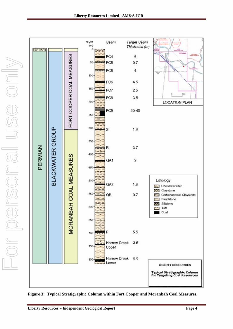
Figure 3: Typical Stratigraphic Column within Fort Cooper and Moranbah Coal Measures. .............. 4
Figure 4: Drill hole location plan showing RTZ overlapping tenement. ................................................. 6
Figure 5: Liberty drill hole locations. ..................................................................................................... 8
Figure 6: Interpreted seam areas – Anticline axis approximately along RTZ tenement boundary. ...... 11
Figure 7: Typical cross section showing modelled seams. Note seams interpreted above topographic
surface. ................................................................................................................................................... 12
Figure 8: Modelled seam depths - colour coded as shown. .................................................................. 13
Figure 9: Modelled seam thickness (1000m radius) - colour coded as shown. ..................................... 14
For
per
sona
l use
onl
y

Liberty Resources Limited – AM&A - IGR
Liberty Resources IGR Contents Page ii
List of Tables
Table 1: Summary of drilling results from North to South. ..................................................................... 7
Table 2: Summary of drilling used in AM&A coal seam modelling. ....................................................... 9
Table 3: Summary of coal seam logged thicknesses. ............................................................................. 10
Table 4: Seam model parameters. ......................................................................................................... 12
Table 5: AM&A Inferred Resource Estimates. ...................................................................................... 15
Table 6: AM&A Exploration Target Estimates (Additional to Inferred Resource Estimate). ............... 16
Table 7: AM&A Previous, now superseded, Exploration Target Estimates January, 2014. ................. 17
For
per
sona
l use
onl
y
Liberty Resources Limited– AM&A-IGR
Liberty Resources - Independent Geological Report Page 1
The Directors, 18th
February, 2014
Liberty Resources Limited,
Unit B3, 431 Roberts Road
Subiaco WA 6008
Dear Sirs,
1.0 Preamble Al Maynard and Associates (“AM&A”) was engaged by Liberty Resources Limited
(“Liberty”) to prepare an Independent Coal Seam Exploration Target and Mineral resource
Estimate of the Company‟s coal exploration permit EPC 1949 in the Bowen Basin west of
Mackay in central Queensland.
Opinions are presented in accordance with the JORC Code (2012) guidelines and other
regulations that govern the preparation of these reports.
In the course of the preparation of this report, access has been provided to all relevant data
held by Liberty and various other technical reports and information quoted in the
bibliography. All reasonable endeavours to verify the accuracy and relevance of the database
have been conducted. Liberty has warranted to AM&A that full disclosure has been made of
all material in its possession and that information provided, is to the best of its knowledge,
accurate and true. None of the information provided by Liberty has been specified as being
confidential and not to be disclosed in this report. The authors are familiar with the structural
setting and mineralisation styles and targets within EPC 1949 project area. As recommended
by the Valmin Code, Liberty has indemnified AM&A for any liability that may arise from
AM&A‟s reliance on information provided by Liberty or known of but not provided by
Liberty.
This report has been prepared by Philip A. Jones BApp.Sc(App Geol), MAIG and MAusIMM
and Allen J. Maynard BApp.Sc(Geol), MAIG and MAusIMM, both geologists with over 35
years in the mining and exploration industry. The writers hold the appropriate qualifications,
experience and independence to qualify as an “Independent Experts” under the definitions of
the Valmin Code to provide such reports for the purpose of inclusion in public company
documents.
This report has been prepared in accordance with the relevant requirements of the Listing
Rules of the Australian Securities Exchange Limited (“ASX”), Australian Securities and
Investments Commission (“ASIC”) Regulatory Guidelines (“RGs”) 111 & 112 and the
Guidelines for Assessment and Valuation of Mineral Assets and Mineral Securities for
Independent Expert reports (the Valmin Code) which is binding on members of the
Australasian Institute of Mining and Metallurgy (“AusIMM”).
AM&A is an independent geological consultancy established 30 years ago and has operated
continuously since then. Neither AM&A nor any of its directors, employees or associates
have any material interest either direct, indirect or contingent in Liberty Resources Limited,
nor in any of the coal properties included in this report, nor in any other asset of Liberty
Resources, nor has such interest existed in the past. This report has been prepared by AM&A
strictly in the role of an independent expert. Professional fees payable for the preparation of
this report constitutes AM&A‟s only commercial interest in Liberty Resources. Payment of
fees is in no way contingent upon the conclusions of this report.
For
per
sona
l use
onl
y

Liberty Resources Limited– AM&A-IGR
Liberty Resources - Independent Geological Report Page 2
Yours faithfully,
(Signed)
Philip A. Jones BApp.Sc(App Geol), MAIG, MAusIMM.
Allen J Maynard BApp.Sc(Geol), MAIG, MAusIMM.
Competent Persons Statement
The information in this report which relates to Exploration Targets, Exploration Results, Mineral Resources or Ore Reserves is based on information compiled by Mr Allen Maynard, who is a Member of
the Australian Institute of Geosciences (“AIG”), a Corporate Member of the Australasian Institute of
Mining & Metallurgy (“AusIMM”) and independent consultant to the Company. Mr Maynard is the Director and principal geologist of Al Maynard & Associates Pty Ltd and has over 35 years of exploration
and mining experience in a variety of mineral deposit styles. Mr Maynard has sufficient experience which is relevant to the style of mineralisation and type of deposit under consideration and to the activity which
he is undertaking to qualify as a Competent Person as defined in the 2012 Edition of the “Australasian
Code for reporting of Exploration Results, Exploration Targets, Mineral Resources and Ore Reserves”.(JORC Code). Mr Maynard consents to inclusion in the report of the matters based on this
information in the form and context in which it appears.
For
per
sona
l use
onl
y

Liberty Resources Limited– AM&A-IGR
Liberty Resources - Independent Geological Report Page 3
2.0 Background Information
2.1 Introduction
Liberty Resources commissioned AM&A to estimate the coal potential, as Exploration Target
estimates, of various coal seams in the Rangal and Fort Cooper Coal Measures and compile a
report on these estimates. This was carried out by the authors of this report, Mr Philip A Jones
and Mr Allen J. Maynard of AM&A in January, 2014. Their conclusions and
recommendations are stated in this document. This revised (Feb, 2014) report includes
Inferred resource estimates.
The project, the subject of this report, comprises an EPC covering 9 sub-blocks covering a
total area of approximately 28.5 km2. Liberty Resources through their 100% owned
subsidiary Walloon Energy Pty Ltd holds a 100% equity stake in coal tenement EPC1949.
The granted tenement exclusively allows the Company to proceed with exploring over the
Project area other than the following:
Land over which previous exclusive possession acts have been granted as defined
under s.23B of the Native Title Act 1993 (Cwth). (Land where previous exclusive
possession acts have been granted and is now held or currently set aside for the benefit
of Aboriginals or Torres Strait Islanders or unallocated State land, and is occupied by
Aboriginal People or Torres Strait Islanders), is not included and
The Isaac River runs through the middle of the licence and is surrounded by a
Category B Environmentally Sensitive area, which covers approximately 70% of the
licence.
2.2 Geology
2.2.1 Regional Geology
Regionally, EPC1949m is located in the Western-Central Bowen Basin, where Permian strata
strike north-north-west and dip gently to the east off the Comet Ridge. The permit is located
on the western margins of the Taroom Trough within a heavily faulted and folded area.
The geology is complicated and largely unknown at present as the effects of multiple faults
associated with the Jellinbah Fault system, a strike slip, reverse fault system extending some
hundreds of kilometres through the middle of the Bowen Basin.
For
per
sona
l use
onl
y
Liberty Resources Limited– AM&A-IGR
Liberty Resources - Independent Geological Report Page 4
Figure 3: Typical Stratigraphic Column within Fort Cooper and Moranbah Coal Measures.
For
per
sona
l use
onl
y

Liberty Resources Limited– AM&A-IGR
Liberty Resources - Independent Geological Report Page 5
2.2.2 Local Geology
Fort Cooper Coal Measures (FCCM) Elsewhere in the Bowen Basin the FCCM seams are numerous and quite thick but with a high
proportion of stone partings within the seams.
Several companies are currently investigating the potential to exploit coal from within the
FCCM and the stratigraphically equivalent Fairhill Formation/Burngrove Formation further
south in the basin. Discrete coal plies within these thick seams frequently display good coking
properties.
Moranbah Coal Measures (MCM) The Moranbah Coal Measures are interpreted to occur at depth beneath the FCCM but the
exact depth to these coal measures will not be known until drilling is undertaken. The closest
analogue to the area of EPC 1949 where data is available on the MCM is the Eagle Downs
Mine (ML 70389) to the north of EPC 795 and 10km to the west.
Liberty‟s project area lies on the western, down-thrown side of the first major thrust marking
the Jellinbah Thrust Zone. Regionally, total vertical displacement across the Jellinbah Thrust
Zone is up to 400m.
Up to four major coal seams occur within the MCM in this part of the basin. The regional
trend is fewer and thicker coal seams in the west while there are more numerous but thinner
and higher rank seams on the east side of the basin.
Within EPC 1949, the depth to the top of the Dysart Seam towards the base of the MCM
could be as much as 500-550m.
2.3 Coal Quality
Coal seams in the Bowen Basin exhibit wide variations in rank and quality, reflecting both the
depositional and tectonic history of the basin. A broad trend of increasing rank from west to
east has long been recognised, and was used as a guide for coal exploration targets during the
late 1950s and early 1960s.
2.3.1 Moranbah Coal Measures
The Moranbah Coal Measures produce premium coking coals, typical of a delta plain
depositional system. The coals have ranks of 0.6-3.5% Rv. Typical Vitrinite content is 55-
75% and ash content is 5-15%.
2.3.2 Fort Cooper Coal Measures
The Fort Cooper Coal Measures outcrop in parts of the basin and were deposited in fluvial
environments. Typically the Fort Cooper Coal Measures are 0.5-2.5% Rv with a high vitrinite
content.
For
per
sona
l use
onl
y

Liberty Resources Limited– AM&A-IGR
Liberty Resources - Independent Geological Report Page 6
Figure 4: Drill hole location plan showing RTZ overlapping tenement.
2.4 Previous exploration
The Bowen Basin has been explored for coal for more than 50 years and some of this
exploration has included the Project area.
Most of the drilling within EPC 1949 has been shallow and restricted to the FCCM. The
following data was made available by Liberty:
8 Liberty holes Ft Coopers 8 geophysical logs
17 WSN holes Ft Coopers 8 Geophysical logs
30 „E‟ series holes Ft Coopers Geophysical & written logs
1 CSG well Ft Coopers + MCM 2 Geophysical Logs
For
per
sona
l use
onl
y
Liberty Resources Limited– AM&A-IGR
Liberty Resources - Independent Geological Report Page 7
Utah Development Company (UDC)
‘U’ Series- EPC 6
The Winchester South Area was first explored in the 1960s by Utah Development Company
as part of Authority to Prospect (ATP) 6C and later, ATP67C. Only shallow holes to
approximately 120m were drilled leading to only small resources of non-coking coal being
established with the ATP being relinquished in 1973.
BP
‘WSN’ Series- ATP 352
In 1980, the Queensland government invited applications from companies for the exploration
and subsequent development of the thermal coals at Winchester South. A joint venture
comprising BP Australia Ltd. (50%), Drayton Mining Development Proprietary Ltd. (25%)
and Westfield Ltd. (25%) submitted a tender. This tender was successful and on April 2nd
1981, it resulted in the awarding of ATP 352C.
Bowen Central Coal Pty Ltd (Aquila Resources Ltd. )
„E‟ Series Holes- EPC 830
In 2005-2006 Bowen Central Coal completed a regional drilling campaign of which 2 holes
were drilled on and just North of EPC1949. Logging of the holes including geophysical log
data indicated that the holes intersected Fort Cooper Coal Measures. Both holes were
geophysically logged.
Arrow Energy Arrow drilled CSG Well- PD025CR immediately south of EPC 1949, within the Arrow
ATP364P. This hole is located approximately on the axis of the anticline where the MCM
would be closest to surface. The MCM were intersected between 92.4m in this hole.
Table 1 summarises the drilling results by hole from north to south.
PD025CR
Formation Depth From
(m)
Depth To
(m)
Elevation
ASL (m)
Net Coal
(m)
Tertiary 0.0 18.0 176.45 0.0
Weathering 0.0 49.0 145.45 0.0
Fort Cooper Coal
Measures
49.0 92.4 145.45 21.2
Moranbah Coal
Measures
92.4 381.65 102.45 11.3
Depth From
(m)
Depth To
(m)
Elevation
ASL (m)
Net Coal
(m)
Base of Tertiary 0.0 18.0 176.45 0.0
Base of Weathering 0.0 49.0 145.45 0.0
Fort Cooper Coal
Measures
49.0 92.4 145.45 21.2
Moranbah Coal
Measures
92.4 599.45 102.45 15.2
Table 1: Summary of drilling results from North to South.
For
per
sona
l use
onl
y

Liberty Resources Limited– AM&A-IGR
Liberty Resources - Independent Geological Report Page 8
Liberty Drilling
Liberty drilled six effective holes on EPC 1949 in August, 2013 of which two cored holes,
DH05C and DH07C, were sampled for analysis
Figure 5: Liberty drill hole locations.
Independent coal assessors CMDA Pty Ltd in October, 2013 observed that the samples from
both holes have very similar raw coal properties suggesting consistent quality across the
For
per
sona
l use
onl
y

Liberty Resources Limited– AM&A-IGR
Liberty Resources - Independent Geological Report Page 9
deposit in at least the Northern area where the holes are located. Initial results indicated that a
high quality coking coal product can be produced from the seams tested.
The key parameters are high CSN, high vitrinite content, low phosphorus and relatively low
sulphur. It is likely further testing will confirm it could be classed a hard coking coal.
Using accepted industry techniques the predicted theoretical yield is relatively low.
Investigations into alternative methods to optimise yield suggest there is potential to improve
liberation and yield. There is potential to produce a 13% ash product for blending with lower
ash coals. The 10.5% ash product after washing compares well in a majority of parameters
with most Queensland coking coals.
CMDA recommended further drilling and laboratory test work to better determine potential
treatment processes, possible PCI by-products and thermal properties of the coal along with
market studies.
3.0 Coal Seam Modelling – Exploration Target Estimates
AM&A created a digital model of the coal seams identified in the drilling data provided to
estimate potential tonnages.
Only holes with acceptable lithology logs were used in the modelling, Table 2.
Company Series Number Litho Logs Geophysical Logs
Liberty DH 8 Yes Yes
Arrow PD 1 Yes Yes
Utah Development Co. U 11 Yes No
BP WSN 28 Yes Some
Total 48
Table 2: Summary of drilling used in AM&A coal seam modelling.
Most of the holes were short and intersected only part of the coal measures with the Liberty
(DH) and Utah (U) holes generally in the Rangal (Leichhardt and Vermont) Coal Measures
and the BP (WSN) holes in the Fort Cooper Coal Measures.
Although the stratigraphic logging appeared to be consistent within each hole series there is a
big difference in the quality of the logging between the different hole series reflecting the
differences in exploration targets at the time the holes were logged.
Generally the seams/stratigraphies could be readily correlated between adjacent holes, despite
the series, but there are a number of holes where the logging was ambiguous or inconsistent
with the surrounding holes so a “best fit” correlation was applied when linking these holes.
The biggest shortcoming in the drill hole logging is that it was difficult to determine a
consistent “definable” coal content for the different seams. The seam logs for many of the
seams range from banded carbonaceous shales/shales/coal with variable thicknesses of
included stone partings to solid coal. Table 3 summarises the logged coal thicknesses.
For
per
sona
l use
onl
y

Liberty Resources Limited– AM&A-IGR
Liberty Resources - Independent Geological Report Page 10
The thickest seam, Fort Cooper Seam 9 (FC9), contains highly variable quality coal bands
with numerous stone partings.
VMU VML FC4 FC5
SEAM COAL SEAM COAL SEAM COAL SEAM COAL
Count 5 5 9 9 10 10 9 9
Average
Thickness
(m) 4.31 3.66 4.75 2.79 4.34 2.01 3.36 1.13
Minimum
Thickness
(m) 0.91 0.91 1.52 0.31 2.00 1.23 1.22 0.20
Maximum
Thickness
(m) 7.10 6.10 9.20 5.20 9.00 3.90 6.70 2.52
FC6 FC7 FC8 FC9
SEAM COAL SEAM COAL SEAM COAL SEAM COAL
Count 5 5 5 5 10 10 12 12
Average
Thickness
(m) 2.62 1.44 4.77 2.57 7.21 2.33 31.02 11.65
Minimum
Thickness
(m) 0.50 0.45 1.83 1.75 0.50 0.05 15.20 4.95
Maximum
Thickness
(m) 7.50 4.03 7.00 3.50 12.50 5.47 46.50 28.19
Table 3: Summary of coal seam logged thicknesses.
The seam modelling method was as follows:
The available drill hole logs were compiled in a single spread sheet with a consistent
code for the seams. Where a stratigraphic name was logged for a seam it is was coded
with a standard stratigraphic code, where there was no stratigraphic code the seam was
simply coded as CO.
The holes were then loaded into MineMap© software and the seams correlated
between holes in 3D to create “wireframes” that extend to beyond the EPC and where
required above the ground where indicated by the drilling.
Interpreted seam outcrop maps were then created where the interpreted seam
wireframes intersect the surface. These outcrop maps were then split along the RTZ
tenement boundary and areas for each of the seams, in and out the Liberty side of the
EPC, were calculated.
For
per
sona
l use
onl
y

Liberty Resources Limited– AM&A-IGR
Liberty Resources - Independent Geological Report Page 11
Figure 6: Interpreted seam areas – Anticline axis approximately along RTZ tenement
boundary.
For
per
sona
l use
onl
y
Liberty Resources Limited– AM&A-IGR
Liberty Resources - Independent Geological Report Page 12
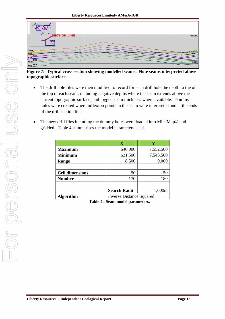
Figure 7: Typical cross section showing modelled seams. Note seams interpreted above
topographic surface.
The drill hole files were then modified to record for each drill hole the depth to the of
the top of each seam, including negative depths where the seam extends above the
current topographic surface, and logged seam thickness where available. Dummy
holes were created where inflexion points in the seam were interpreted and at the ends
of the drill section lines.
The new drill files including the dummy holes were loaded into MineMap© and
gridded. Table 4 summarises the model parameters used.
X Y
Maximum 640,000 7,552,500
Minimum 631,500 7,543,500
Range 8,500 9,000
Cell dimensions 50 50
Number 170 180
Search Radii 1,000m
Algorithm Inverse Distance Squared
Table 4: Seam model parameters.
For
per
sona
l use
onl
y
Liberty Resources Limited– AM&A-IGR
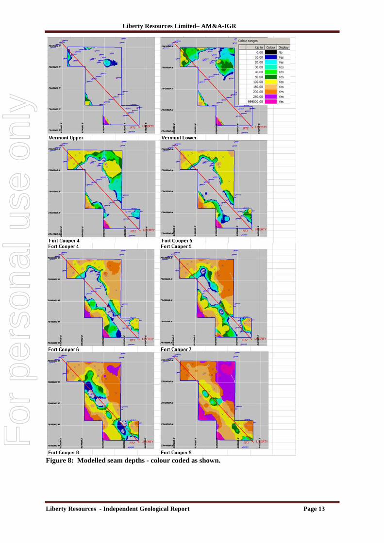
Liberty Resources - Independent Geological Report Page 13
Figure 8: Modelled seam depths - colour coded as shown.
For
per
sona
l use
onl
y
Liberty Resources Limited– AM&A-IGR
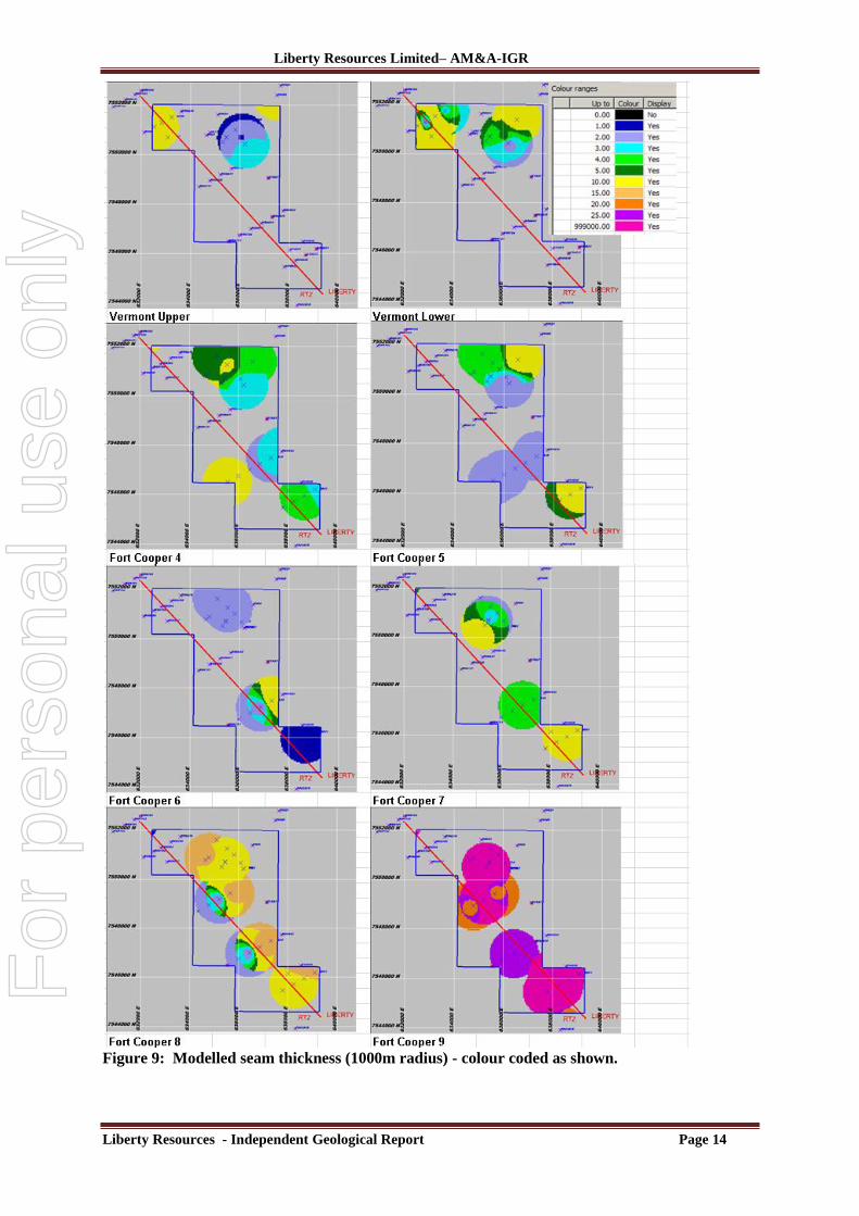
Liberty Resources - Independent Geological Report Page 14
Figure 9: Modelled seam thickness (1000m radius) - colour coded as shown.
For
per
sona
l use
onl
y
Liberty Resources Limited– AM&A-IGR
Liberty Resources - Independent Geological Report Page 15
The gridded cells were then interrogated where the depth was greater than zero metres
to calculate the seam tonnes using the cell‟s calculated seam thickness and the coal in
the seam using the modelled coal thickness.
AM&A determined that although the much of the data used in these tonnage estimates are
historic, up to 50 years old, the quality of the stratigraphic and lithological logging and seam
measurements cannot be independently verified, AM&A have determined that JORC Code
(2012) compliant Inferred resource estimates can still be estimated from this data within a
500m radius of a hole with both seam and coal thicknesses that can either be confirmed with
geophysical logs or there is detailed geological logging that correlates well with other nearby
holes. AM&A point out that since the historic data used for the estimates cannot be
independently verified these Inferred resource estimates are the least reliable category of
resource estimates and are not suitable for financial and mining studies.
The Inferred Resource estimates for the coal within each of the seams modelled are
summarised in Table 5.
Liberty Coal Density 1.40 Parting Density 2.50
Coal Million
Tonnes
Partings
Million
Tonnes
Seam Million
tonnes Area km2
Depth to
Top Seam
Thickness
Seam
Thickness
Coal
% Coal
Seam
VMU 1.4 0.0 1.4 0.5 12.4 2.0 2.0 100%
VML 7.5 17.1 24.6 2.6 31.1 4.7 2.1 44%
FC4 8.3 14.0 22.2 3.5 39.5 3.3 1.7 51%
FC5 6.3 24.5 30.8 3.9 59.6 3.6 1.2 32%
FC6 5.1 8.2 13.4 2.7 64.7 2.5 1.3 53%
FC7 8.4 12.6 20.9 2.3 65.3 4.9 2.6 54%
FC8 15.0 58.8 73.8 3.9 67.5 8.8 2.7 31%
FC9 52.4 145.2 197.6 2.9 111.7 32.6 12.8 39%
TOTAL
AVERAGE
104.4 280.4 384.8 22.4
72.2 15.2 6.0 43%
Table 5: AM&A Inferred Resource Estimates.
An additional Exploration Target was estimated by extrapolating the Inferred Resource
modelling into areas within the EPC where the historic drill data showed continuation of the
seams but the coal content of these seams could not be properly determined from the logs.
The Exploration Target estimates for the coal within each of the seams modelled are
summarised in Table 6. The Exploration Target tonnage estimates in this report are
For
per
sona
l use
onl
y

Liberty Resources Limited– AM&A-IGR
Liberty Resources - Independent Geological Report Page 16
conceptual in nature as they are based on extrapolations of wide spaced data points. Further
drilling, geophysical logging and sampling meeting the standards required by the JORC Code
(2012) is required to convert these Exploration Targets to resources. AM&A however point
out that any further exploration cannot be guaranteed to produce any further resources but the
Liberty drilling has confirmed the existence and quality of the seams intersected by their
drilling which corresponds generally with the historic logging.
Liberty have advised AM&A that they have planned, during the forthcoming 2014
exploration season, a further 11 drill holes on an approximate 1km x 1km grid, depending on
accessibility, which will pass through the Fort Cooper Coal Measures to extend these
resources and also target the deeper Harrow Creek and Dysart seams within the Moranbah
Coal Measures.
Liberty Coal Density 1.40 Parting Density 2.50
Coal Million Tonnes Seam Million tonnes
VMU 2 to 3 2 to 3
VML 12 to 16 43 to 57
FC4 18 to 24 48 to 64
FC5 13 to 17 66 to 88
FC6 18 to 24 49 to 65
FC7 39 to 52 93 to 124
FC8 49 to 66 244 to 326
FC9 198 to 263 839 to 1,118
TOTAL 350 to 465 1,384 to 1,845
Table 6: AM&A Exploration Target Estimates (Additional to Inferred Resource Estimate).
The range of coal qualities observed within the Bowen Basin from similar FCCM to that found at
EPC1949 are as follows and are adopted for this Exploration Target:-
IM % Ash % VM % VM % FC% TS % CSN % Vitrinite Rv. Max
(ad) (ad) (ad) (daf) (ad) (ad) (ad) (mmf)
1.3 -2.5 41-64 10-21 27-39 25-43 0.5-0.6 1.5 65-90 1.05-1.36
For
per
sona
l use
onl
y

Liberty Resources Limited– AM&A-IGR
Liberty Resources - Independent Geological Report Page 17
Previous Exploration Target Estimate
AM&A previously estimated an Exploration Target for the project in January 2014 using the
same drilling data, Table 7.
It was possible to include an Inferred Resource estimate in the latest modelling since more
data on coal contents within the seams was used, rather than estimating as done previously.
After allowing for the differences in the estimated coal contents in the seams, the only
significant differences are for the two Vermont Seams where a re-interpretation of several
holes changed Vermont seams to upper Fort Cooper seams reducing their total areas.
Seam Seam
Thickness (m)
*Estimated Coal %
Coal s.g.
Million Tonnes Coal Liberty
Million Tonnes Coal RTZ
Total Million Coal Tonnes
VMU 3.6 60% 1.40 13 to 17 4 to 6
17 to 23
VML 4.0 50% 1.40 18 to 24 7 to 9 25 to 33
FC4 4.7 65% 1.40 33 to 44 14 to 19 47 to 63
FC5 2.5 60% 1.40 19 to 25 9 to 12 27 to 37
FC6 5.3 60% 1.40 52 to 69 25 to 33 77 to 102
FC7 4.5 75% 1.40 61 to 81 32 to 43 93 to 124
FC8 6.9 60% 1.40 77 to 102 47 to 62 123 to 165
FC9 28.8 40% 1.40 206 to 275 140 to 186 346 to 462
Total 60.2 478 to 638 277 to 370 756 to 1,008
Table 7: AM&A Previous, now superseded, Exploration Target Estimates January, 2014.
4.0 Conclusions Liberty has identified an Inferred Resource of approximately 104.4 million tonnes of coal in
two Vermont and six Fort Cooper seams as well as an additional Exploration Target of coal in
the Vermont and Fort Cooper Coal Measures totalling 350 to 465 million tonnes within EPC
1949 after excluding the area covered by the pre-existing RTZ tenement.
Note that this Exploration Target range is conceptual in nature and future work may or may
not define a resource.
For
per
sona
l use
onl
y
Liberty Resources Limited– AM&A-IGR
Liberty Resources - Independent Geological Report Page 18
5.0 Recommendations AM&A recommend that Liberty continue its proposed drilling program within EPC
1949 eventually completing a 1000m x 1000m grid.
It is critical that these holes are properly drilled by experienced drillers and the
drilling, geophysical logging and sampling is supervised by a fully qualified and
experienced geologist to ensure that the data obtained from this drilling exceeds the
minimum requirements the JORC Code (2012).
Careful attention must be taken to ensure that the core and sample recovery in the coal
seams exceeds 95% and the analyses are carried out in an industry certified, ISO rated
laboratory.
Liberty have advised AM&A that they have planned, during the forthcoming 2014
exploration season, a further 11 drill holes on an approximate 1km x 1km grid,
depending on accessibility, which will pass through the Fort Cooper Coal Measures to
extend these resources and also target the deeper Harrow Creek and Dysart seams
within the Moranbah Coal Measures.
As well as the usual proximate analyses, it is highly recommended that the additional
coal preparation tests and market studies recommended by CDMA are also carried out
on representative samples. These analyses and tests should determine the coal
recoveries and costs, saleability and economic viability of each of the coal seams and
the whole Project.
For
per
sona
l use
onl
y

Liberty Resources Limited – AM&A - IGR
Liberty Resources - Independent Geological Report Page 19
6.0 Selected References
Anonymous; 25 November 2013, Confidential Liberty Resources Information
Memorandum, Liberty Resources
Anonymous; September 2011, PD025C & PD025CR Well Completion Report Bowen Basin
Moranbah Gas Project ATP364P, Arrow Energy
Anonymous; 1966, Various drill logs, Utah Development Company
Anonymous; 31 October 2013, Preliminary Appraisal of EPC 1949 Deposit Coal Quality,
CMDA Pty Ltd
Garling, R. 2014: Comments on Fort Cooper Coal Measures. Unpub. Rep By Tradd Pty Ltd
for Liberty Resources Ltd
Maynard, Jones, January 2014, Independent Coal Seam Exploration Target Estimate Report
on EPC1949, Al Maynard & Associates
Slater, R; Report on Partial Relinquishment 12 Sub-blocks Effective 8th
July 2009, Bowen
Central Coal
Wilton, J.R; Final Report Incorporating Final Relinquishment Report, Pacific Coal Pty
Limited
ABBREVIATIONS km kilometre
km2 square kilometre
m metre
M million
m2 square metre
m3 cubic metre
t tonne
For
per
sona
l use
onl
y
Liberty Resources Limited – AM&A - IGR
Liberty Resources - Independent Geological Report Page 20
JORC Code, 2012 Edition – Table 1 Report.
Section 1 Sampling Techniques and Data (Criteria in this section apply to all succeeding sections.)
Criteria Commentary
Sampling techniques
Most of the drilling used in the seam modelling historic, up to 50 years. Triangulation of seams based on geological and geophysical logs. The accuracy of the seam depths and thicknesses have been determined by AM&A as of sufficient accuracy for an Inferred Resource and Exploration Target estimate.
Only seam and coal ply thicknesses modelled, no coal quality data modelled.
Drilling techniques
All drilling described as diamond drilling.
Drill sample recovery
Core recovery not critical for many of the holes since geophysical logs were used to confirm depths and seam widths. Core recoveries in the remaining holes not recorded.
Since coal qualities have not been modelled only the core recoveries at the seam contacts are critical to determine accurate thicknesses.
There are no records of the core recoveries in the older holes.
Logging All the holes used in the modelling have lithological and/or stratigraphic logs to a level of detail sufficient to support the Resource estimation.
Sub-sampling techniques and sample preparation
Coal qualities were not modelled so sub-sampling not relevant. Where core qualities were tested in the most recent Liberty holes the entire drill core was sampled.
Quality of assay data and laboratory tests
Where proximate core qualities from the most recent Liberty holes are mentioned in the report, the laboratory that conducted the tests is industry certified and followed industry standard testing procedures.
Verification of sampling and assaying
No verification samples were collected. The coal quality was not modelled so verification samples not required.
No sample quality control measures were undertaken. The coal quality was not
modelled so quality control measures are not required.
The geophysical logs are continuous down the holes and clearly show density and electric responses that indicate coal seam contacts.
Location of data points
The accuracy of the surveying has not been determined by AM&A but is considered accurate enough for Inferred Resource and Exploration Target estimates.
All coordinates are in GDA94 grid.
The project area is generally flat with limited topographic variation.
Data spacing and distribution
The data points are on an approximate 500m x 2,500m grid in part in-filled to 400m apart.
The data spacing and distribution is sufficient to establish the degree of geological and grade continuity appropriate where used for an Inferred Resource estimate.
No grade compositing was applied.
Orientation of data in relation to geological structure
The grid spacing and drill orientation is appropriate for the orientation of the seams after regional structural displacement.
No sampling bias has been introduced by the drill hole orientation.
Sample security Coal qualities were not modelled for this reported resource estimate so sample
For
per
sona
l use
onl
y

Liberty Resources Limited – AM&A - IGR
Liberty Resources - Independent Geological Report Page 21
Criteria Commentary
security is not relevant or material for the resource estimate.
Audits or reviews
Since this resource estimate is only Inferred and will soon be superseded once the forthcoming exploration drilling program, there have been no independent audits or reviews of the sampling or data carried out. All of the historic data points used in this resource estimate will be progressively replaced by new drilling.
Section 2 Reporting of Exploration Results (Criteria listed in the preceding section also apply to this section.)
Criteria Commentary
Mineral tenement and land tenure status
Liberty has 100% tenure over the project area except for the area covered by a pre-existing RTZ tenement that covers approximately 50% of the total area of EPC 1949.
Aboriginal and Environmental conditions are included in the text but generally do not exclude further exploration or eventual underground mining.
Exploration done by other parties
A full list of references are included as part of the report.
Geology Permian coal seams, within Rangal and Fort Cooper Coal Measures, in the Bowen Basin.
Drill hole Information
48 diamond drill holes drilled by Liberty, Arrow, Utah Development and BP over approximately 50 years were used in the modelling.
Only holes with suitable geological logs were used, a number of historic holes were rejected.
Data aggregation methods
All seam thicknesses calculated from logged top and bottom of the seam using geologist logs or geophysical logs where available.
Stone partings were included in seam thicknesses.
“Visual” estimates of coal contents of seams (i.e. excluding stone partings) based on inspection of logs.
Relationship between mineralisation widths and intercept lengths
Since all the holes are drilled vertical, with only small deviations down the hole, and the coal seams are generally flat (no more than +/- 20 degrees) the seam intercepts are only marginally greater than true seam widths.
Diagrams Appropriate plans and sections included in report.
Balanced reporting
Only representative data points were used in the resource estimate. No data was excluded or included to bias results.
Other substantive exploration data
No other meaningful or material data that could affect the results is known to AM&A.
Further work Further drilling, logging, laboratory and processing tests are recommended to extend the resource estimate into the area currently covered by the Exploration Target.
Liberty have advised AM&A that they have planned, during the forthcoming 2014
exploration season, a further 11 drill holes on an approximate 1km x 1km grid,
depending on accessibility, which will pass through the Fort Cooper Coal Measures to
extend these resources and also target the deeper Harrow Creek and Dysart seams
For
per
sona
l use
onl
y
Liberty Resources Limited – AM&A - IGR
Liberty Resources - Independent Geological Report Page 22
Criteria Commentary
within the Moranbah Coal Measures.
Section 3 Estimation and Reporting of Mineral Resources (Criteria listed in section 1, and where relevant in section 2, also apply to this section.)
Criteria Commentary
Database integrity
Most of the data used in the coal seam tonnage estimates is from historic drilling. Where possible copies of original sources used to source data.
Site visits No site visit undertaken by the authors of this report.
Due to Tertiary overburden and farming activities none of the coal seams can be mapped at the surface.
Geological interpretation
The overall geological model fairly represents the geology of the seams. Due to the wide drill hole spacing and some difficulties in interpreting historical logs minor errors may have resulted in the interpretation but these errors would not significantly affect the tonnage estimates or affect the JORC Code category assigned.
Dimensions Regional drilling beyond the limits of EPC 1949 show that the seams extend well beyond the boundaries of EPC 1949 except where they outcrop as indicated in the maps included in the report.
Estimation and modelling techniques
The modelling technique used to estimate the seam coal tonnages is appropriate for the quality and density of the available data.
Two methods were used to estimate areas of each of the seams as a check and the areas calculated by both methods corresponded well.
Only tonnages were estimated by AM&A. Proximate analyses and processing test results mentioned in the report are provided as a general guide only.
Moisture All coal tonnages are based on assumed bulk densities that represent coal “air dried”.
Cut-off parameters
The seam thicknesses are based on geological and geophysical logs of coal seams.
Mining factors or assumptions
No mining factors or assumptions are made. A preliminary scoping study is planned for 2014 to determine economic and mining parameters.
Most of the modelled coal, because of its depth below the current topographic surface, would need to be mined using underground mining methods.
Metallurgical factors or assumptions
No metallurgical or recovery factors have been assumed. Only tonnes of in-situ coal estimated. Recovery/beneficiation studies on representative coal samples are planned during the forthcoming 2014 exploration program.
Environmental factors or assumptions
No environmental factors were considered for the reported tonnage estimates.
Current environmental restrictions noted in the report require approvals for drilling sites.
Given that there are several coal mines in the district and since most of the coal would need to be mined using underground mining methods it can be reasonably assumed that a suitable, environmentally approved site for the mine openings can be found within the tenement.
Bulk density All coal tonnages are based on assumed bulk densities that represent coal “air dried”. The assumed bulk densities are based on similar coals in the region.
Classification Due to the wide drill hole spacing and some difficulties in interpreting historical logs the tonnage estimates have been assigned JORC Code categories of Inferred Resources and Exploration Target which is not a resource. These Exploration Target estimates are only conceptual in nature and future exploration may or may not eventually convert all or part of these estimates to resources.
The resource estimate appropriately reflects the Competent Person’s view of the
For
per
sona
l use
onl
y

Liberty Resources Limited – AM&A - IGR
Liberty Resources - Independent Geological Report Page 23
Criteria Commentary
deposit.
Audits or reviews
Since this resource estimate is only Inferred and will soon be superseded once the forthcoming exploration drilling program has been completed, there have been no independent audits or reviews of the resource estimates carried out. The resource estimate was however reconciled against an earlier Exploration Target estimate.
Discussion of relative accuracy/ confidence
The tonnage estimates have been assigned a JORC Code category of Exploration Target which is not a resource. These estimates are conceptual in nature and reported as ranges to reflect the uncertainties and future exploration may or may not eventually convert all or part of these target estimates to resources.
The Inferred Resource estimates are based on generally unverified historic seam and coal thickness logs. These thicknesses are within the ranges of the same seams elsewhere in the Bowen Basin so AM&A considers that the Inferred JORC Category is appropriate for these estimates as an indication that the coal seams exist within the modelled areas but the reliability of the tonnage estimates is too low for use in financial and mining studies.
For
per
sona
l use
onl
y