ASTROBLEMES IN THE WILLISTON BASIN*1 - CSEG...
15
ASTROBLEMES IN THE WILLISTON BASIN*1 H. B. SAWATZKY** INTRODUCTION The Williston Basin is generally described as a rather simple, tectonically quiet, bowl-shaped depression filled with sediments ranging in age from Cambrian to Tertiary. The most pronounced unconformity occurs at the top of the Paleozoic. Glacial drift ranging in thickness from zero to approxi- mately 1000 feet, covers most of the north- ern half of the region. The Cedar Creek and Nesson anticlines exemplify the larger types of structure present in the Basin. This rather uniform, “layer-cake” environ- ment facilitates detailed study and correla- tion of rock units over wide areas as con- trasted with the difficulty of such work in more highly disturbed basins. The concerted exploration effort for hydro- carbons in the Basin during the late 1940’s and early 1950’s. following the Leduc oil discovery in Alberta, soon convinced explora. tionists, among them R. L. Milner and R. A. Bishop, that the dominant stencil super- imposed on this Basin’s sediments was related to Middle Devonian salt tectonics. Many excellent papers have been written on this subject since then. Most of the structural anomalies encoun- tered are at least partially affected by salt solution-collapse phenomena. One aspect of this process which has been treated rather lightly in the past, is the cause for com- mencement of local solution activity. The author is sufficiently familiar with a number of sombrero-shaped features resulting from multiple stage solution and collapse that have been adequately m~apped with the seis- mograph and penetrated with the drill to sufficient depth, to rule out any conventional reason for the initiation of the localized solution. From our knowledge of the extensive im- pact history of the moon and sister planets, (most recently we saw for the first time the pock-marked surface of Mercury as a result of the Mariner #lO by-pass) intuition, tells us that despite the masking effect of the at- mosphere and water, plus the various forces of erosion, there must exist both on the surface and within the subsurface of the earth, considerably more evidence of impact scars or astroblemes than has been dis- covered and documented so far. The main purpose of this paper is to out- line, with the aid of key maps, cross sec- tions and seismic record sections, the basic parameters which allow us to identify three subsurface structures in the Williston Basin as fossil impact craters (Viewfield, Saskat- chewan: T. 7, R. 8, W2M; Hartney, Manito- ba: T. 5, R. 24. WIM; Red Wing Creek, North Dakota: T148N.1OlW). It is hoped this will lend further credence to the idea expressed previously (Sawatzky, 1972) that astroblemes may be the primary reason for the existence of at least some of the som- brero features found in the Williston Basin to date. GENERAL Figure I shows the location of known and inferred impact sites in North America, including craters, fossil craters and pt’o- bable astroblemes. The outline of the Wil- liston Basin is indicated, as well as the location of the three features considered by *Presented at the C.S.E.G. National Convention, Calgary, Alberta, April 17, 1974. **Francana Oil and Gas Ltd., Calgary, Alberta. iManuscript received by the Editor, May 5, 1974. 23
-
Upload
hoangduong -
Category
Documents
-
view
221 -
download
0
Transcript of ASTROBLEMES IN THE WILLISTON BASIN*1 - CSEG...
ASTROBLEMES IN THE WILLISTON BASIN*1
H. B. SAWATZKY**
INTRODUCTION
The Williston Basin is generally described as a rather simple, tectonically quiet, bowl-shaped depression filled with sediments ranging in age from Cambrian to Tertiary. The most pronounced unconformity occurs at the top of the Paleozoic. Glacial drift ranging in thickness from zero to approxi- mately 1000 feet, covers most of the north- ern half of the region. The Cedar Creek and Nesson anticlines exemplify the larger types of structure present in the Basin.
This rather uniform, “layer-cake” environ- ment facilitates detailed study and correla- tion of rock units over wide areas as con- trasted with the difficulty of such work in more highly disturbed basins.
The concerted exploration effort for hydro- carbons in the Basin during the late 1940’s and early 1950’s. following the Leduc oil discovery in Alberta, soon convinced explora. tionists, among them R. L. Milner and R. A. Bishop, that the dominant stencil super- imposed on this Basin’s sediments was related to Middle Devonian salt tectonics. Many excellent papers have been written on this subject since then.
Most of the structural anomalies encoun- tered are at least partially affected by salt solution-collapse phenomena. One aspect of this process which has been treated rather lightly in the past, is the cause for com- mencement of local solution activity. The author is sufficiently familiar with a number of sombrero-shaped features resulting from multiple stage solution and collapse that have been adequately m~apped with the seis- mograph and penetrated with the drill to
sufficient depth, to rule out any conventional reason for the initiation of the localized solution.
From our knowledge of the extensive im- pact history of the moon and sister planets, (most recently we saw for the first time the pock-marked surface of Mercury as a result of the Mariner #lO by-pass) intuition, tells us that despite the masking effect of the at- mosphere and water, plus the various forces of erosion, there must exist both on the surface and within the subsurface of the earth, considerably more evidence of impact scars or astroblemes than has been dis- covered and documented so far.
The main purpose of this paper is to out- line, with the aid of key maps, cross sec- tions and seismic record sections, the basic parameters which allow us to identify three subsurface structures in the Williston Basin as fossil impact craters (Viewfield, Saskat- chewan: T. 7, R. 8, W2M; Hartney, Manito- ba: T. 5, R. 24. WIM; Red Wing Creek, North Dakota: T148N.1OlW). It is hoped this will lend further credence to the idea expressed previously (Sawatzky, 1972) that astroblemes may be the primary reason for the existence of at least some of the som- brero features found in the Williston Basin to date.
GENERAL
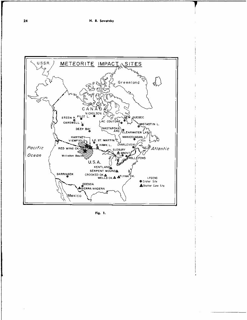
Figure I shows the location of known and inferred impact sites in North America, including craters, fossil craters and pt’o- bable astroblemes. The outline of the Wil- liston Basin is indicated, as well as the location of the three features considered by
*Presented at the C.S.E.G. National Convention, Calgary, Alberta, April 17, 1974.
**Francana Oil and Gas Ltd., Calgary, Alberta.
iManuscript received by the Editor, May 5, 1974.
23
H. 8. Sawatzky
2
P
c
v.;.S.R.) METEORITE IMPACJ&ilTES
‘oclfic
Iceon
KENTLAN”~ SFR1PFNT Mc?INrbA _ _ _. _ _. I-
BARRlN~OER CROOKED CK.A ~.._~ ; CK,A &LINN-CK. LEGEND 0 crater Sk
8 DESSA
CACIFDDb unncon Ashatter cane site
Fig. 1.

._ .--.---~~~-
Williston Bwin 15
EVOLUTION
FOSSIL CRATER Fig. 1.3.
the author to be buried fossil craters. The THE VIEW~ELD (SASKATCHEWAN) CRATER subsurface structures will be discussed in relation to known surface analogues. Figure 3 is a photograph of the Barringl 3r
Crater. This feature is approximately 3/ ‘4 -. ‘me we,, publlclzea Btarnnger crater I” Arizona is a” excellent example of the simple bowlshaped crater, displaying an ele- vated rim, which typifies impact excava- tions of less than two miles in diameter. The Carswell Lake feature in Northwestern Saskatchewan is a good example of the larger craters which, in addition to the outer rim, invariably display an elevated, highly disturbed central core. Figure la shows the evolution of a large fossil crater. A generalized stratigraphic chart represent- ing the regional geology in the study area is shown in Fig. 2.
of a mile in diameter (4150 feet) and 570 feet deep. Its age, estimated at 25,000 years, represents a. recent event on the geo- logical time scale.
For comparison, the structure at View- field, Saskatchewan, is shown in several illustrations. Figure 4 is a contoUr map Of
the top of the Mississippian, based on well control. A rather simple bowl-shaped depression approximately 1% miles in dia- meter is indicated. The present elevation of the rim is approximately 200 feet and a minimum crater depth of 600 feet is ex-

-
26 H. 8. s.r.trk” Willi.,on Borin
HESOLOlC j CENOZOIC ; .~.

H. 6. Sawotzky
Fig. 3.
pressed. However, neither of the wells near more is also essentially flat but the basal the center of the feature (‘13-29 and part of the Blairmore and the Jurassic event #1529) reached the Mississippian, and show pronounced slumping into the crater. empirically derived explosion crater equa- This is attributed to postimpact Middle tions (Baldwin, 1949) as well as detailed Devonian salt solution and collapse as well seismic data suggest that they may still be as a certain amount of differential com- several hundred feet short of this tax&. “action of the elastic section over the
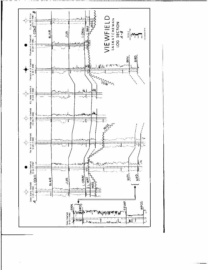
Figure 5 shows a log section across the crater pertaining to the wells highlighted on the previous figure. The impact is con- sidered to be of Jura-Triassic age since dis. turbed Mississippian limestone and dolomite is found sandwiched between Lower Wat- rous Red Beds (Triassic) on the periphery of the rim.
Figure 6 is a 300% C.D.P. seismic record section of an east-west line crossing the crater and passing by the wells indicated at the top of figure. The section has been flattened on the Second White Specks at 0.650 sec. However, this horizon displays a maximum depression over the crater of ap- proximately 35 feet The top of the Blair-
crater. The event labelled “Mississippian” and mapped as such, appears to represent the same up-to-the~rim position; however, as one proceeds across the crater it more accurately depicts the top of the Lower Watrous. The precise attitude of the Mis- sissippian is difficult to follow through the crater but appears to be suggested by the strong dips indicated between this horizon and the Devonian Birdbear event. In addi- tion to showing the crater profile, the Bird- bear displays several distinct dislocations. These are evident on all of the seismic lines associated with the impact area. The Prairie Evaporite event can be carried con- tinuously xi-oss the crater and owes its configuration to a certain amount of plastic

Willirton Basin
R.9 R.8 W ZM,
VIEWFIELD SASXITCHEWAN
STRUCTURE CONTOURS ON . ONLWLLL MISSISSIPPIAN HORIZON $ 01” L AI&NOONIO ,INCL”DING RIM,
* wm~,,,“““~“”
A-B LINE OF SECTION
Fig. 4.
I I I

Willirton Basin
Fig. 6.

32 H. B. Sowotrky
flow at the time of impact plus post-impact- t*Lower Blairmore solution. Some of the sag is no doubt due to the replacement of high velocity Mississippian sediments in the crater with relatively low velocity fill, The Cambro-Ordovician reflection can be car- related quite continuously and is believed to shows its regional character. Minor local wrinkles are attributed to differential velo- city effects.
A more detailed description of the View- field anomaly is give” in a” earlier paper (Sawatzky, 1972). There are presently 30 wells producing oil from the Mississippian horizon along the periphery of the rim at rates as high as 300 barrels per day, from gross pay sections of approximately 200 feet at optimum rim positions. Detailed, multi- fold seismic data were the key to develop- ment of this pool and chief aid in the inter- pretation.
THE HARTNEY MANITOBA CRATER
Figure 7 was compiled from the surface geological map of Saskatchewan (Whitaker & Pearson, 1972). It shows the location, size and general configuration of the Carswell Lake structure. It is located in the heart of the Athabasca formation which is predomi- nantly a flat lying fluviatile sandstone, with minor shale and conglomerate, believed to be Late Precambrian (Heilkianl in age. The preserved circular rim of this structure consists of intensely folded, marine stromatolitic dolomite known as the Cars- well formation. It is younger than the Athabasca formation and is unique to, the entire area. The ring, whose outline can readily be seen on photo mosaics, has a” inside diameter of approximately 18 miles, a” apparent width of about 3 miles and is expressed as a number of prominent ridges. Brecciated and highly disturbed Athabasca

Willirtm BDIi”
i
Manitoba I;{;;!; I
Seismic Confours On
Mississippian HOf izon
(Flattened on FAVVEL at 0.350 1 c I~ =“~“,o sets.
i
Upper De”onia”
bed Miss and/or oev?
I Fig. 8.
strata are located inside the dolomite ring and a core of granite gneiss is exposed at the center of the feature. This structure appears to have distinct similarities to the giant Vredefort Ring in South Africa des- crihed in detail by Dietz (1961).
For comparison purposes, the reader is requested to examine Figure 8 which illus- trates seismic contours on a horizon near the top of the Mississippian on the Hartney structure in Manitoba CT. 5-R. 24, Wl). The Favel (Manitoba equivalent of the Second White Specks or Greenhorn) was used as a datum at 0.350 sets. Due to a lack of diag- nostic seismic information only half of the anomaly is shown; however, a good appre ciation of its size and configuration is ob-
tained. Note the strong positive outer rim and the highly disturbed central core con- sisting of fractured and deformed Devonian and/or Mississippian rocks.
Figure 9 shows a log cross-section A-Al across the crater with respect to the wells highlighted on the previous figure. Datum for this section is the Favel. It illustrates the following pertinent facts:
1. The high rim well at $7-27-5-24.
2. The abrupt and complete excavation of the entire Mississippian plus con- siderable Upper Devonian section be- tween the #7-27 and #16-33 wells.
3. The pile-up of hundreds of feet of additional Devonian carbonates at the
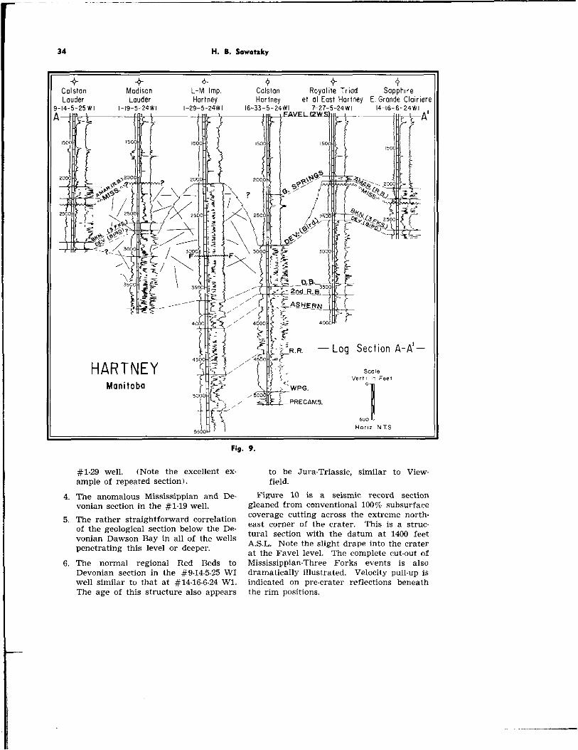
34 H. 8. Sovmtzky
-+ 0 Q -+ -+ + COlStOn Madison L-M Imp. COlStOn Royalile Triod Sapphire Lauder Lauder Hartney Hortney et III East Hortney E. Gronde Cloirien
-14-5-25Wl ,-19.5-24Wl I-29.5-NW, 16-3s5-24Wl 7.27.5-SW, 14-16.6-24Wl FI \ A’
nod ’
- Log Section A-A’-
Scale HARTNEY Manitoba
#1.29 well. (Note the excellent ex. to be Jura-Triassic, similar to View, ample of repeated section). field.
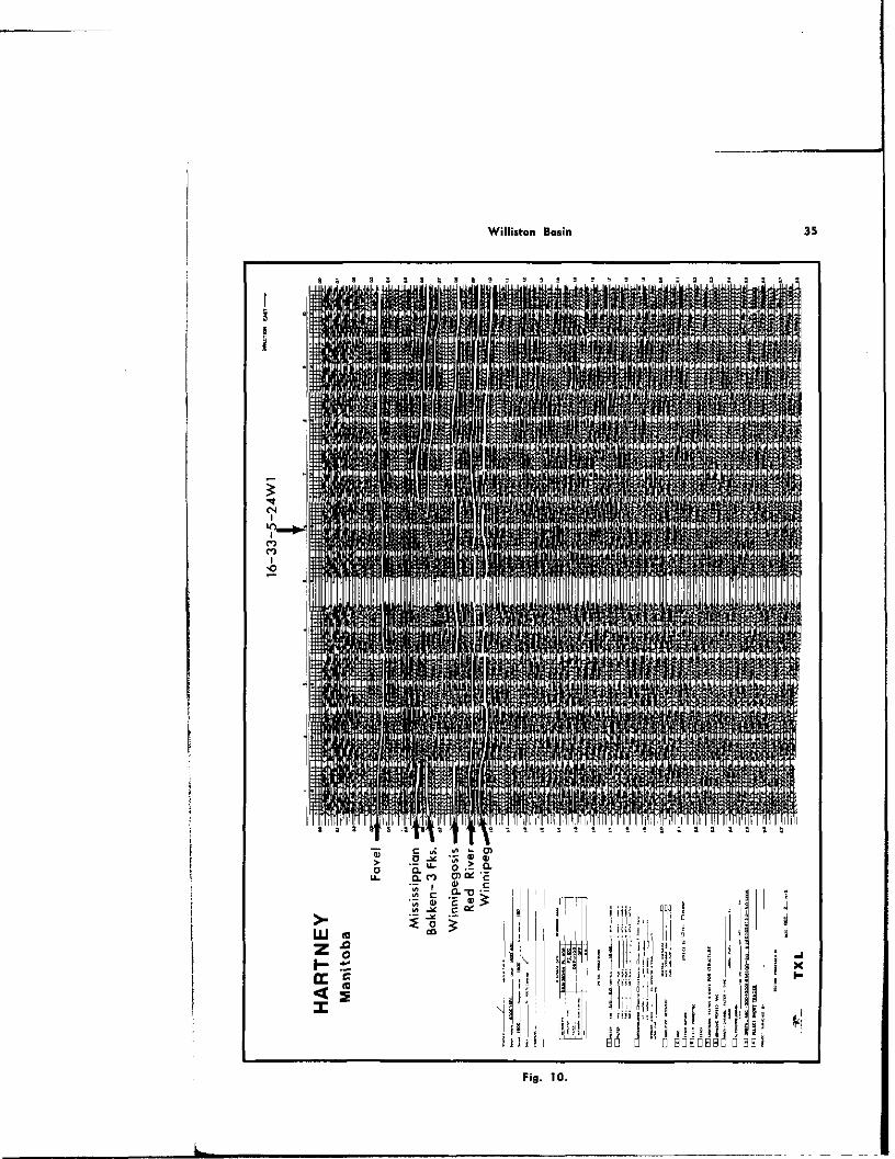
4. The anomalous Mississippian and De- Figure 10 is a seismic record section vonian section in the #l-l9 well. gleaned from conventional 100% subsurface
5. The rather straightforward correlation coverage cutting across the extreme north-
of the geological section below the De- east corner of the crater. This is a struC-
vonian Dawson Bay in all of the wells tural section with the datum at 1400 feet
penetrating this level or deeper. A.S.L. Note the slight drape into the crater at the Favel level. The complete cut-out of
6. The normal regional Red Beds to Mississippian-Three Forks events is also Devonian section in the #9.14-5.25 WI dramatically illustrated. Velocity pull-up is well similar to that at #14.X6-24 Wl. indicated on pre-crater reflections beneath The age of this structure also appears the rim positions.
Williston Bosh

RED WING CREEK North Dokoto
2s 27 2s 25 30 P9 IS-148N-98W
0 . ,ll.-~- ,3 14 ,s 16 II 12 33 9 3s 36 3I
4 3 z , 6 5 4 3 z / e
R- 102w R-law i
Fig. 11.
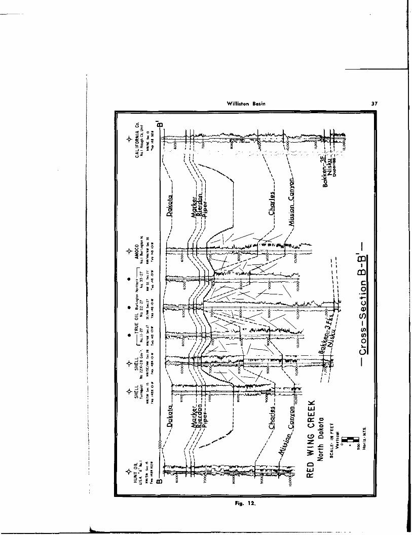
THE RED WING CREEK. (NORTH DAKOTA) ness variations in Charles salts that were CRATER no doubt affected at the time of impact as
Figure 11 shows the location of the wells well as during the post-impact period. Al.
pertinent to this struct~ure, as well as the though deformation extends into the Pre-
line of section B.Bl illustrated in Figure 12. Mississippian sediments, correlations can be
The producing wells are positioned on the readily made at and below the Bakken-Three
highly complex central rebound area as Forks interval. It is interesting to compare
shown on the log section. The discovery the cross-section of this anomaly with that of
well (True #222-27 Burlineton Northern Hartney and note the structural similarities.
SENW27.148N.lOlW) con&s approximate- ly 3000 feet of gross pay in what has been
Shatter cones, which according to the ex- perts are essential earmarks of an astro-
described as steeply dipping, intensely thrust bleme, have been recognized in the cores faulted Mission Canyon? carbonate. The in- from Red Wing Creek. ferred outer rim and crater profile on the left side of Figure 12 are based on seismic information. COMXSJSION
The age of this structure appears to be pi-e-Piper post-Minnekhata which places it
Two of the structures believed to be fossil
in approximately the same time interval as craters (Viewfield and Red Wing) have re-
Viewfield and Hartney. sulted in commercial oil production and pos- sibilities at the third (Hartney) in the autb.
The post-Piper horizons indicate drape or’s opinion, have not been sufficiently ex- over this feature; however, some of the dif- plored. It therefore behooves us to remain ferential relief appears to be related to thick- on the alert for this type of feature.
Willid.3” ml*;”
Fig. 13.

38 H. B. Sowotzky
Astroblemes in the subsurface may be classified as follows: The first, and most obvious, model would be the relatively well preserved fossil craters similar to the three just described.
In a terrestrial environment where major forces of erosion are constantly at work, it is also readily recognized that many actual craters have been completely obliterated to the point where only the much deeper radial fracture patterns remain. The original cause for anomalies of this nature might be very difficult to recognize, particularly if the interpreter is misled by subsequent structures such as solution-collapse fea- tures, discussed in more detail in the View- field paper.
The third category is perhaps the most elusive. What is the result of an impact in the open sea? Obviously the size of the bolide and water depth would be prime para. meters in attempting to predict the effect. However, one can visualize the case where the masking effect of the water would pre- vent the development of a conventional crater profile in the sea floor, but induce a strong radial fracture pattern which could become the focal point for future structural deformation.
To illustrate this latter situation in, the Williston Basin, the writer suggests that some of the radial anomalies resulting from dissolution of salt in the Prairie Evaporite formation have this kind of origin. Ex- amples of known radial solution features dating from the Devonian, Souris River, to relatively recent times have been cited in the references. In many instances no de- finite reason can be given for the commence- ment of local solution activity. It is here that we should let our intuition guide us and look to the stars for a possible explana- tion.
The author wishes to thank the Manage- ment of Francana Oil & Gas Ltd. for per- mission to publish this paper and would like to extend his appreciation, in particular, to Mr. W. E. Nicholson for drafting the il- lustrations. The writer is also Indebted to Mr. R. 0. Lindseth. President of Teknica
Resources for having reviewed the manu- script and making several valuable sug gestions.
REFERENCES
Baldwin, R. B., 1949. The Face of the Moon. Univ. Chicago Press, Chicago.
Bishop, R. A., 1954. Saskatchewan explora- tory progress and problems, in Western Canada Sedimentary basin. Am. Assoc. Petroleum Geologists, 414.485.
De Milk?, G., J. R. Shouldice, H. W. Wilson, 1964. Collapse structures related to Evaporites of the Prairie Formation, Sas. katchewan: Geol. Sot. America Bull., 75, 307.316.
Dence, M. R., 1972. The nature and signifi- cance of terrestrial impact structures. 24th Internat. Geol. Gong., Section 15, Planetology, 77.89.
Dietz, R. S., 1961. Astroblemes. Scientific American, August, 51%
Fahrig, W. F., 1961. The Geology of the Athabasca Formation. Geol. Survey Canada, Bull. ,#t%.
Gendzwill, D. 3. & Z. Hajnal, 1971. Seismic investigation of the Crater Lake Structure in Southeastern Saskatchewan: Can. Jour. of Earth Sciences, 8, 1514.1524.
Milner, R. L., 1956. Salt solution and sub. sidence structures, Wyoming, North Da. kota, and Montana. Am. Assoc. Petroleum Geologists Bull., c. 51, 1929.1947.
Sawatzky, H. B., 1972. Viewfield - A pro- ducing fossil crater? Jour. Can. sac. Exploration Geophysicists 8. 22.40.
Smith, D. G. and J. R. Pullen. The Huming- bird Structure of Southeast Saskatchewan. Jour. Can. Petroleum Geology, 15, 468.482.
Swenson, R. E., 1967. Trap mechanics in Nisku Formation of Northeast Montana. Am. Assoc. Petroleum Geologists Bull., 51, 1948.1958.
Whitaker, S. H. and D. E. Pearson, 1972. Geological Map of Saskatchewan. Dept. Min. Resources, Prov. Saskatchewan, Scale 1:267, 200.
Wilson, W., D. L. Surjik, and H. B. Sa. watzky, 1963. Hydrocarbon potential of the South Regina Area, Saskatchewan Dept. Min. Resources, Pro”. Saskatchewan, Rept. $76.