Assignment 001
3
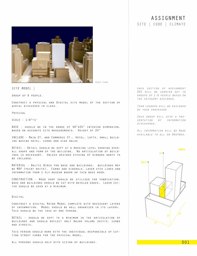
ASSIGNMENT 001 SITE | CODE | CLIMATE SITE MODEL | Group of 6 people. Construct a physical and Digital site model of the section of aerial discussed in class. Physical SCALE - 1/8”=1’ BASE - should be in the range of 40”x24” interior dimension, based on accurate site measurements. Height of 24” INCLUDE - Main ST. and Commerce ST., Hotel, Lofts, small build- ing behind hotel, curbs and side walks DETAIL - Detail should be kept at a massing level showing over- all shape and form of the building. No articulation of build- ings is necessary. Unless desired etching of windows wants to be included. MATERIAL - Baltic Birch for base and buildings. buildings may be MDF (paint white). Curbs and sidewalk, laser etch lines and information from 1 ply museum board or thin bass wood. CONSTRUCTION - Wood shop should be utilized for fabrication. base and buildings should be cut with beveled edges. Laser cut- ter should be used at a minimum. Digital Construct a digital Rhino Model complete with necessary layers of information. Model should be well organized in its layers. This should be the task of one person. DETAIL - should be kept to a minimum in the articulation of buildings and should reflect only major volume shifts, curbs and streets. This person should work with the individual responsible of cut- ting street curbs for the physical model. All persons should help with sizing of buildings. SITE 24” 40” 24” MAIN ST. COMMERCE RENZO PIANO each section of assignment 001 will be carried out in groups of 1-6 people based on the category assigned. Team leaders will be assigned by your professor Each group will give a pre- sentation of information discovered. All information will be made available to all on Dropbox.
-
Upload
dustin-white -
Category
Documents
-
view
215 -
download
1
description
arch, 3502
Transcript of Assignment 001
ASSIGNMENT
001
SITE | CODE | CLIMATE
SITE MODEL |
Group of 6 people.
Construct a physical and Digital site model of the section of aerial discussed in class.
Physical
SCALE - 1/8”=1’
BASE - should be in the range of 40”x24” interior dimension, based on accurate site measurements. Height of 24”
INCLUDE - Main ST. and Commerce ST., Hotel, Lofts, small build-ing behind hotel, curbs and side walks
DETAIL - Detail should be kept at a massing level showing over-all shape and form of the building. No articulation of build-ings is necessary. Unless desired etching of windows wants to be included.
MATERIAL - Baltic Birch for base and buildings. buildings may be MDF (paint white). Curbs and sidewalk, laser etch lines and information from 1 ply museum board or thin bass wood.
CONSTRUCTION - Wood shop should be utilized for fabrication. base and buildings should be cut with beveled edges. Laser cut-ter should be used at a minimum.
Digital
Construct a digital Rhino Model complete with necessary layers of information. Model should be well organized in its layers.This should be the task of one person.
DETAIL - should be kept to a minimum in the articulation of buildings and should reflect only major volume shifts, curbs and streets.
This person should work with the individual responsible of cut-ting street curbs for the physical model.
All persons should help with sizing of buildings.
SITE
24”
40”24”
MAIN ST.
COMMERCE ST.
RENZO PIANO
each section of assignment 001 will be carried out in groups of 1-6 people based on the category assigned.
Team leaders will be assigned by your professor
Each group will give a pre-sentation of information discovered.
All information will be made available to all on Dropbox.
ASSIGNMENT
001
SITE | CODE | CLIMATE
CONTEXT RESEARCH |
Group of 3-4 people
Historic Information - Do not solely rely on the internet, ac-tively seek out the information, use your resources in the Li-brary.
Colect information and images on the following categories: im-porant buildings (historical and contemporary), imporatnt data about Dallas, google street view images of Main st. and Commerce St. Basic info about DART.
Collect data and images on the immediate context of: program, public spaces, evolution of area (historic and Current),
Construct a highly layered digrammatic map sequence. Notate: Corridors _ Routes (bike and bus) _ Context _ Various types of Densities _ Pedestrian routes _ Connections to various areas, landmarks, social spaces _ Proximities _ Food _ Signage _ Green Space _ Void Space _ Temporal items _ Traffic_ Textures _ Sur-faces _ Heights
STREET ELEVATION | Scale 1/16”=1’
Draw a street elevation looking into the site. Extents of Draw-ing will be discussed in class.
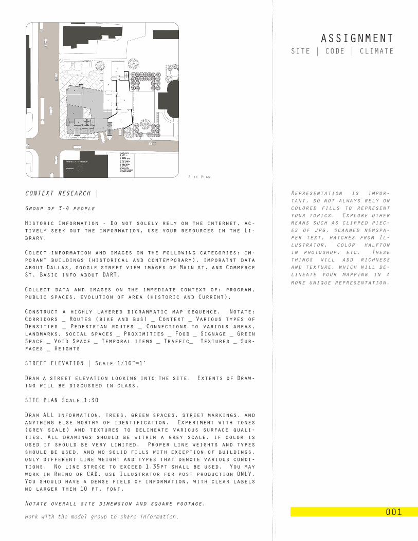
SITE PLAN Scale 1:30 Draw ALL information, trees, green spaces, street markings, and anything else worthy of identification. Experiment with tones (grey scale) and textures to delineate various surface quali-ties. All drawings should be within a grey scale, if color is used it should be very limited. Proper line weights and types should be used, and no solid fills with exception of buildings, only different line weight and types that denote various condi-tions. No line stroke to exceed 1.35pt shall be used. You may work in Rhino or CAD, use Illustrator for post production ONLY. You should have a dense field of information, with clear labels no larger then 10 pt. font.
Notate overall site dimension and square footage.
Work with the model group to share information.
Site Plan
Representation is impor-tant, do not always rely on colored fills to represent your topics. Explore other means such as clipped piec-es of jpg, scanned newspa-per text, hatches from Il-lustrator, color halfton in photoshop, etc. These things will add richness and texture, which will de-lineate your mapping in a more unique representation.
96
CAC.C
ASSIGNMENT
001
SITE | CODE | CLIMATE
CODE |
Code analysis will be conducted: collect, compile, and extract. Group of 1-2 people.
a printed and bound (spiral) document of all date collected.
Complete Building Code Analysis worksheet.
Select and extract important relevant data which will be useful for the entire class.
Print this data on individual sheets and pin-up on the studio wall for the class to use. Upload to Dropbox.
Composition and organization will be discussed in class.
CLIMATE |
Group of 4 people
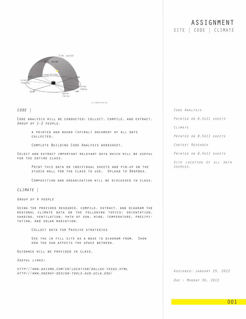
Using the provided resource, compile, extract, and diagram the regional climate data on the following topics: orientation, shading, ventilation, path of sun, wind, temperature, precipi-tation, and solar radiation.
Collect data for Passive strategies
Use the in fill site as a base to diagram from. Show how the sun affects the space between.
Guidance will be provided in class.
Useful links:
http://www.gaisma.com/en/location/dallas-texas.htmlhttp://www.energy-design-tools.aud.ucla.edu/
climateskin
Code Analysis
Printed on 8.5x11 sheets
Climate
Printed on 8.5x11 sheets
Context Research
Printed on 8.5x11 sheets
Site location of all data sources.
Assigned: January 25, 2012
Due : Monday 30, 2012


![Assignment 001 for graphic designer [rohit sharma]](https://static.fdocuments.in/doc/165x107/5463227aaf7959a4058b4d36/assignment-001-for-graphic-designer-rohit-sharma.jpg)