ASSESSMENT VARIABILITY OF ANNUAL DAILY MAXIMUM …umpir.ump.edu.my/12144/1/FKASA- NUR AZIRA AYUNI BT...
24
ASSESSMENT VARIABILITY OF ANNUAL DAILY MAXIMUM RAINFALL OF TERENGGANU, MALAYSIA NUR AZIRA AYUNI BT AB AZIZ Thesis submitted in fulfilment of the requirements for the award of the degree of Bachelor of Civil Engineering Faculty of Mechanical Engineering UNIVERSITI MALAYSIA PAHANG JUNE 2015
Transcript of ASSESSMENT VARIABILITY OF ANNUAL DAILY MAXIMUM …umpir.ump.edu.my/12144/1/FKASA- NUR AZIRA AYUNI BT...

ASSESSMENT VARIABILITY OF ANNUAL DAILY MAXIMUM RAINFALL OF
TERENGGANU, MALAYSIA
NUR AZIRA AYUNI BT AB AZIZ
Thesis submitted in fulfilment of the requirements
for the award of the degree of
Bachelor of Civil Engineering
Faculty of Mechanical Engineering
UNIVERSITI MALAYSIA PAHANG
JUNE 2015

v
ABSTRACT
Recently, major cities in Terengganu have been affected by problems related to flooding
incident. Meanwhile, extreme rainfall during northeast monsoon caused overflowing of
Terengganu River and flooding, which cause a lot of destruction of house and property. The
main objective of this study is to assess the variability of annual daily maximum rainfall.
Tropical Rainfall Measuring Mission (TRMM) satellite-based rainfalls from public domain
were used in this study. The daily satellite-based rainfall data for each major cities in
Terengganu were retrieved using Geographical Information System (GIS) technique. Gumbel
distribution functions were applied to estimate expected return period and probability of
extreme rainfall event. For annual daily maximum, the maximum depth at Kemaman,
Dungun, Marang, Hulu Terengganu, Kuala Terengganu, Setiu and Besut are 363.96mm
477.54mm, 332.45mm, 303.68mm, 347.85, 547.00mm and 398.44mm, respectively. For
annual monthly maximum, the maximum depth at Kemaman, Dungun, Marang, Hulu
Terengganu, Kuala Terngganu, Setiu and Besut are, 926.89mm, 826.65mm, 969.77mm,
982.86mm, 1005.00mm, 1079.45mm and 1216.51mm, respectively. Meanwhile, for annual
maximum rainfall, the maximum depth at Kemaman, Dungun, Marang, Hulu Terengganu,
Kuala Terengganu, Setiu and Besut are 3767.97mm, 4642.43mm, 7065.96mm, 6733.18mm,
6342.88mm, 4707.01mm and 4187.03mm. From Gumble distribution, estimate extreme daily
rainfall, probability and return period for 25 years in Kemaman, Dungun, Hulu Terengganu,
Marang, Kuala Terengganu, Setiu and Besut are 546.52mm, 556.13mm, 2666mm, 475.4mm,
496.27mm, 551.10mm and 551.10mm. Meanwhile, the return period for 50 years in
Kemaman, Dungun, Hulu Terengganu, Marang, Kuala Terengganu, Setiu and Besut are
632.93mm, 623.27mm, 5187.00mm, 545.93mm, 571.61mm, 635.28mm and 635.28mm.
Lastly, the return period for 100 years in Kemaman, Dungun, Hulu Terengganu, Marang,
Kuala Terengganu, Setiu and Besut are 179.33mm, 730.41mm, 10230.00mm, 616.46mm,
626.95mm, 719.45mm and 719.45mm. Based on the results acquired, every town has a daily
estimate extreme rainfall; probability and return period are different. These results may help
planning future development.

vi
ABSTRAK
Baru-baru ini, bandar-bandar utama di Terengganu telah dipengaruhi oleh masalah yang
berkaitan dengan kejadian banjir. Sementara itu, hujan yang melampau semasa monsun timur
laut disebabkan limpahan Sungai Terengganu dan banjir, yang menyebabkan banyak
kemusnahan rumah dan harta benda. Objektif utama kajian ini adalah untuk menilai
kepelbagaian hujan maksimum harian tahunan. Mengukur Hujan Misi (TRMM) hujan
berasaskan satelit tropika daripada domain awam telah digunakan dalam kajian ini. Harian
data hujan berasaskan satelit untuk setiap bandar utama di Terengganu telah diambil
menggunakan teknik Sistem Maklumat Geografi (GIS). Fungsi taburan Gumbel telah
digunakan untuk menganggarkan tempoh pulangan dijangka dan kebarangkalian peristiwa
hujan yang melampau. Untuk maksimum harian tahunan, kedalaman maksimum di
Kemaman, Dungun, Marang, Hulu Terengganu, Kuala Terengganu, Setiu dan Besut adalah
363.96mm 477.54mm, 332.45mm, 303.68mm, 347,85, 547.00mm dan 398.44mm, masing-
masing. Untuk maksimum bulanan tahunan, kedalaman maksimum di Kemaman, Dungun,
Marang, Hulu Terengganu, Kuala Terngganu, Setiu dan Besut adalah, 926.89mm, 826.65mm,
969.77mm, 982.86mm, 1005.00mm, 1079.45mm dan 1216.51mm, masing-masing.
Sementara itu, bagi hujan maksimum tahunan, kedalaman maksimum di Kemaman, Dungun,
Marang, Hulu Terengganu, Kuala Terengganu, Setiu dan Besut adalah 3767.97mm,
4642.43mm, 7065.96mm, 6733.18mm, 6342.88mm, 4707.01mm dan 4187.03mm. Dari
pengedaran Gumble, anggarkan hujan, kebarangkalian dan pulangan tempoh harian
melampau selama 25 tahun di Kemaman, Dungun, Hulu Terengganu, Marang, Kuala
Terengganu, Setiu dan Besut adalah 546.52mm, 556.13mm, 2666mm, 475.4mm, 496.27mm,
551.10mm dan 551.10mm. Sementara itu, tempoh masa selama 50 tahun di Kemaman,
Dungun, Hulu Terengganu, Marang, Kuala Terengganu, Setiu dan Besut adalah 632.93mm,
623.27mm, 5187.00mm, 545.93mm, 571.61mm, 635.28mm dan 635.28mm. Akhir sekali,
tempoh pulangan selama 100 tahun di Kemaman, Dungun, Hulu Terengganu, Marang, Kuala
Terengganu, Setiu dan Besut adalah 179.33mm, 730.41mm, 10230.00mm, 616.46mm,
626.95mm, 719.45mm dan 719.45mm. Berdasarkan keputusan yang diperolehi, setiap bandar
mempunyai hujan melampau anggaran harian; kebarangkalian dan tempoh pulangan adalah
berbeza. Keputusan ini boleh membantu merancang pembangunan masa hadapan.

vii
TABLE OF CONTENTS
Page
SUPERVISOR’S DECLARATION i
STUDENT’S DECLARATION ii
ACKNOWLEDGEMENTS iv
ABSTRACT v
ABSTRAK vi
TABLE OF CONTENTS vii
LIST OF TABLES x
LIST OF FIGURES xi
LIST OF SYMBOLS xii
LIST OF ABBREVIATIONS xiii
CHAPTER 1 INTRODUCTION
1.1 Background of the study 1
1.2 Problem Statement 3
1.3 Objective of the study 3
1.4 Scope of the Study 3
1.5 Significance of the Study 4
1.6 Thesis structure 4
CHAPTER 2 LITERATURE REVIEW & STUDY AREA
2.1 Introduction 5
2.2 Acquisition of Precipitation Data 5
2.2.1 Measurement of precipitation data 5
2.2.2 Tropical Rainfall Measuring Mission (TRMM) 6
2.2.3 Descriptive statistics 6
2.2.4 Gumbel Distribution Function 7

viii
2.3 Terengganu 7
2.3.1 Kemaman 8
2.3.2 Dungun 8
2.3.3 Hulu Terengganu 9
2.3.4 Marang 9
2.3.5 Kuala Terengganu 9
2.3.6 Setiu 9
2.3.7 Besut 9
2.4 Conclusion 10
CHAPTER 3 METHODOLOGY
3.1 Project Methodology 11
3.2 Hydro Climatology 12
3.3 Measurement of Rainfall 12
3.3.1 Tropical Rainfall Measuring Mission (TRMM) 12
3.3.2 Descriptive Statistics 13
3.3.3 Gumbel Distribution Function 14
3.3 Conclusion 14
CHAPTER 4 RESULTS & DISCUSSION
4.1 Introduction 15
4.2 Descriptive Statistics 15
4.2.1 Descriptive Statistics for Annual Daily Maximum Rainfall 15
4.2.2 Descriptive Statistics for Annual Monthly Maximum Rainfall 16
4.2.3 Descriptive Statistics for Annual Maximum Rainfall 17
4.3 Gumbel Distribution Function 18
4.3.1 Gumbel Distribution Function for Annual Daily Maximum 18
Rainfall at Kemaman
4.3.2 Gumbel Distribution Function for Annual Daily Maximum 19
Rainfall at Dungun
4.3.3 Gumbel Distribution Function for Annual Daily Maximum 20
Rainfall at Hulu Terengganu

ix
4.3.4 Gumbel Distribution Function for Annual Daily Maximum 21
Rainfall at Marang
4.3.5 Gumbel Distribution Function for Annual Daily Maximum 22
Rainfall at Kuala Terengganu
4.3.6 Gumbel Distribution Function for Annual Daily Maximum 23
Rainfall at Setiu
4.3.7 Gumbel Distribution Function for Annual Daily Maximum 24
Rainfall at Besut
4.4 Conclusion 24
CHAPTER 5 CONCLUSION
5.1 Introduction 25
5.2 Conclusion 25
5.3 Recommendation 27
REFERENCES 28
APPENDIXES 29

x
LIST OF TABLES
Table No. Title Page
4.1 Descriptive Statistic for Annual Daily Maximum Rainfall 15
4.2 Descriptive Statistic for Annual Monthly Maximum Rainfall 16
4.3 Descriptive Statistic for Annual Maximum Rainfall 17
4.4 Return Period for Kemaman 18
4.5 Return Period for Dungun 19
4.6 Return Period for Hulu Terengganu 20
4.7 Return Period for Marang 21
4.8 Return Period for Kuala Terengganu 22
4.9 Return Period for Setiu 23
4.10 Return Period for Besut 24
5.11 The historical extreme rainfall events of cities in Terengganu 25
5.12 Annual Maximum Rainfall, Annual Daily Maximum Rainfall, 26
Annual Monthly Maximum Rainfall

xi
LIST OF FIGURES
Figure No. Title Page
1.1 Flood in Kemaman 2
1.2 Road damaged due to floods 2
2.1 Topography Pattern of Terengganu 10
3.1 Flow chart of project methodology 11
3.2 Webpage TRMM Data 13
4.1 Gumbel Distribution Function for Kemaman 18
5.2 Gumbel Distribution Function for Dungun 19
5.3 Gumbel Distribution Function for Hulu Terengganu 20
5.4 Gumbel Distribution Function for Marang 21
5.5 Gumbel Distribution Function for Kuala Terengganu 22
5.6 Gumbel Distribution Function for Setiu 23
5.7 Gumbel Distribution Function for Besut 24

xii
LIST OF SYMBOLS
X Annual daily maximum rainfall,
M Mean of observed annual daily maximum rainfall,
σ Standard deviation of observed annual daily maximum rainfall,
F(x) Cumulative probability distribution
P(x) Probability distribution,
N Return periods of expected annual daily maximum rainfall.
yi Each score
Ӯ The mean or average
N The number of values
Ʃ Means we sum across the values

xiii
LIST OF ABBREVIATIONS
TRMM Tropical Rainfall Measuring Mission
GIS Geographical Information System

1
CHAPTER 1
INTRODUCTION
1.1 BACKGROUND OF THE STUDY
Most probably every year some part of Terengganu will expected of damage
caused by the flooding. In January 2015, Kemaman was flooded again. Floods in low-
lying areas in Kemaman following the heavy rain that fell in the high tides. In addition,
many roads were submerged and cause a road closed. In November 2014, Jalan Pantai
Batu Rakit in Kampung Pak Tuyu has suffered severe damage and the cause of the road
in the Kampung Pak Tuyu to city was disconnected.
Meanwhile, in the news stated that Terengganu hit by worst floods in three
decades. In December 2014, about 80 per cent of villages in Dungun had been flooded
since the first wave of floods on December 15 when Sungai Dungun overflowed due to
the high tide phenomenon.
The flood phenomenon has caused much damage and loss due to the rain that
often occurs is due to the high intensity of rain. Many have lost their homes and
possessions. Most of the people just left homeless after floods swept away all their
possessions. Damage to property was estimated to reach hundreds of millions of dollars
because of not only individuals, but also government agencies in the health sector such
as hospitals, police stations and health clinics as well as in the plantations have suffered
a loss. Floods that have caused a lot of damage has been caused flood victims is difficult
to get aid and the relevant authorities are also difficult to provide assistance to flood
victims.

2
Even though, injury and death are minimal, victim still suffered trauma and this
is according to the eyewitnesses from those who did site investigation work after floods
occurs. Most of the damaged houses were left without roofs and trees were uprooted
and fell on some of the houses. Figure 1.1 and 1.2 show some of the flood damaged
issues that happen recently in Terengganu.
Figure 1.1 ; Flood in Kemaman (Januari 2015)
Figure 1.2 : Road damaged due to floods.(December 2014)

3
1.2 PROBLEM STATEMENT
Recently, many infrastructure damage related to floods incident have been
concerning in the community. While most infrastructure design (i.e. the main road) has
taken into account the extreme rain information, there are still many roads were
submerged by the flood. This may be due to climate change, which has an effect on the
characteristics (i.e. depth, intensity, spatial and temporal variability) of the rainfall.
Therefore, it is necessary to estimate extreme rainfall information by the latest rainfall
information.
1.3 OBJECTIVE OF THE STUDY
The main objective of this study was to assess the variability of annual maximum
rainfall of Terengganu, Malaysia. The specific objectives are:
(a) To obtain daily satellite base rainfall for study area.
(b) To analysis annual maximum rainfall, annual daily maximum and annual
monthly maximum rainfall data.
1.4 SCOPE OF THE STUDY
In order to give a clear picture on how the study should be perform, the study has been
specified into certain scope:
(a) This study focused on rainfall of Terengganu. (Kemaman, Dungun, Marang,
Hulu Terengganu, Kuala Terengganu, Setiu and Besut).
(b) This study was conducted for period of 1998 – 2013.
(c) Data were collected from Tropical Rainfall Measuring Mission (TRMM)
satellite base rainfall from public domain.
(d) Obtain and analyse all the data using Descriptive Statistical Analysis and
Gumbel Distribution Function

4
1.5 SIGNIFICANCE OF THE STUDY
This study may give some benefits such as:
(a) Obtain the rainfall pattern in Terengganu and a different rainfall
characteristic.
(b) The proposed return periods of annual daily maximum rainfall of this study
can be used for upgrading such as the capacities of hydraulic structures of
Terengganu and also will help the engineers in addressing the hydrology
forecasting, development and flood control in future.
1.6 THESIS STRUCTURE
This thesis consists of five chapters. Chapter one presents an introduction of the
thesis. It states the study background, problem statement, objectives of study and lastly
scope of study. For chapter two, describe the study area of the research and comprises
the literature review that related and suitable for these thesis. Chapter three explain the
research methodology that used for planning research type of data collected and the
method of data analysis to be employed. For chapter four present the result that obtained
from the study area and discussed from analysis. Finally, chapter five comprises the
conclusion from the overall chapter and related some recommendation for future work
on research field.

5
CHAPTER 2
LITERATURE REVIEW &
STUDY AREA
2.1 INTRODUCTION
Rainfall was possibly the first hydrological phenomenon to have been recorded
by man as there are few simple rain gauges were found in India, China and Korea more
than a thousand years ago. In 300 B.C, India used rain gauges to determine tax
collections. Periods of high rainfall meant good crops and higher taxes; whereas low
rainfall meant poor crops and a tax break from the government. The first recorded
rainfall measurements and surface flow has been made by Perrault in the seventeenth
century, who compared measures rainfall to the estimated flow of the Seine River to
show that the two were related. In Malaysia, the first rainfall station was set up in
Kuching, Sarawak, in 1876 while in Peninsular Malaysia, the first rainfall station was
installed at Tanglin Hospital, Kuala Lumpur the following year. From this beginning,
hydrology played an increasingly important role in the assessment and development of
the country’s water resources. (Suhaila, 2014)
2.2 ACQUISITION OF PRECIPITATION DATA
2.2.1 Measurement of Precipitation Data
Precipitation is a primary sources of fresh water. The amount, intensity and
spatial distribution of precipitation are important inputs in many hydrological studies.

6
(Suhaila, 2014).Daily rainfall data of major cities in Terengganu (Kemaman, Dungun,
Marang, Hulu Terengganu, Kuala Terengganu, Setiu and Besut) were collected from
Tropical Rainfall Measuring Mission (TRMM) satellite base rainfall from public
domain. The data from TRMM for each major cities in Terengganu were retrieves using
Geographical Information System (GIS) technique.
2.2.2 Tropical Rainfall Measuring Mission (TRMM)
The Tropical Rainfall Measuring Mission (TRMM), is the first mission
dedicated to measuring tropical and subtropical rainfall through microwave and visible
infrared sensors, and includes the first space borne rain radar. Tropical rainfall
comprises more than two-thirds of global rainfall. It is the primary distributor of heat
through the circulation of the atmosphere. Understanding rainfall and its variability is
crucial to understanding and predicting global climate change. Our current knowledge
of rainfall is poor, especially over the oceans. By use of a low-altitude orbit of 217
miles (350 kilometres), TRMM's complement of state-of-the-art instruments will
provide more accurate measurements. These new measurements will increase our
knowledge of how rainfall releases heat energy to drive atmospheric circulation.
2.2.3 Descriptive Statistics
Descriptive statistical analysis for three types of data: i) annual rainfall, ii)
annual daily maximum rainfall and iii) annual monthly maximum rainfall. Descriptive
statistics deals with organization and summary of large scale data. It includes tables,
graphs and numbers to present raw data (Ott and Longnecker, 2010). We applied
descriptive statistics to rainfall data to examine its central tendency (mean, median and
mode), variability (standard deviation), symmetry (skewness) and peakedness
(kurtosis). (Ahammed, 2014)

7
2.2.4 Gumbel Distribution Function
Gumbel are commonly used for analysing return periods of annual daily
maximum rainfall. The result of Gumbel Distribution can be used for upgrading such
as the capacities of hydraulic structures. The famous statistician Emil Julius Gumbel
(1941) was probably, the first person who dealt extreme values of hydrological data in
organized way for conducting flood frequency analysis. Traditionally three extreme
value distributions: Fréchet, Weibull and Gumbel are commonly used for analysing
return periods of annual daily maximum rainfall.(Ahammed, 2014)The probability and
return periods of annual daily maximum rainfall were estimated using Eqs. (1), (2) and
(3) respectively:
F(x)=exp[-exp{-((x-µ)/σ)} ] (1)
P(x)=1- F(x) (2)
N=1/P(x) (3)
Where,
X = annual daily maximum rainfall,
Μ = mean of observed annual daily maximum rainfall,
σ = standard deviation of observed annual daily maximum rainfall,
F(x) = cumulative probability distribution,
P(x) = probability distribution,
N = return periods of expected annual daily maximum rainfall.
2.3 TERENGGANU
Terengganu is truly a tropical gateway. In the land where nature embraces
heritage, it will truly revitalize your senses. Welcome to Terengganu and discover
splendours of nature, the diversity of tradition and the fascination of heritage. There is
absolutely no place like Terengganu. Terengganu is generally fairly hot and humid all
year round, averaging from 28ºC to 30ºC in daytime and slightly cooler after sunset
Nevertheless, the sea breeze from South China Sea has somehow moderating the
humidity in offshore areas while the altitude and lush forest trees and plant has cooled

8
the mountain and rural areas. Terengganu have seven main cities such as Kemaman,
Dungun, Hulu Terengganu, Marang, Kuala Terengganu, Setiu and Besut.
Besides, Terengganu is a state in the east coast of Peninsular Malaysia that has
never missed a flooding event, which occurs between October and March every year
during the northeast monsoon period. The occurrence of flood at Dungun district
Terengganu state was due to a combination of physical factors such as elevation and its
close proximity to the sea apart from heavy rainfall experienced during monsoon period.
More than 70% of Terengganu was categorized as low-lying coastal area with an
altitude of less than 200 m altitude and 30% of the area was identified as vulnerable to
flash flood. Heavy rainfall during the north east monsoon season between October and
March resulted severe floods almost every year all over Terengganu, especially during
the months of November and December. Environmental damages due to floods include
the spread of diseases originating from dead rats and animals as well as contamination
of floodwater from sewers, animal feedlots, etc. (Gasim, 2007)
2.3.1 Kemaman
Kemaman is a district in Terengganu, on the east coast of Malaysia facing the
South China Sea. Kemaman district is bordered by Dungun district to the north and the
state of Pahang to the south and west. It is the southern gateway to the state of
Terengganu.
2.3.2 Dungun
Dungun is a coastal district of the Malaysian state of Terengganu. Kuala Dungun
is the capital of the district. Dungun is made up of eleven 'mukim', or sub districts:
Abang, Besol, Jengai, Jerangau, Kuala Dungun, Kuala Paka, Kumpal, Pasir Raja,
Rasau, Sura, and Hulu Paka.

9
2.3.3 Hulu Terengganu
Hulu Terengganu is a rather remote area in the state of Terengganu but became
known after the Kenyir Hydroelectric project. Now its man-made lake is well-known as
tourist destination.
2.3.4 Marang
Marang is a district in Terengganu, Malaysia. The district seat is the town of
Marang. The districts that border Marang are Kuala Terengganu and Kuala Nerus to the
north, Hulu Terengganu in the west, while Dungun is in the south. The eastern part of
the district is a stretch of coastline facing the South China Sea.
2.3.5 Kuala Terengganu
Kuala Terengganu is the smallest in terms of area, but it has the largest
population in Terengganu with a population of 406,317 in 2010.City status was awarded
to Kuala Terengganu with the title ‘Bandaraya Warisan Pesisir Air’ (English: Coastal
Heritage City) on 1 January 2008. Even though the city is not spared from modernity
and development, Kuala Terengganu still retains strong Malay influences that are
intermixed with other cultures from its long history as a port.
2.3.6 Setiu
Setiu is one of the districts in Terengganu, Malaysia. This district is bordered by
Besut to the north, Hulu Terengganu to the west, and on the south, Kuala Nerus. Setiu is
divided into seven mukim or sub district. The sub districts are Caluk, Gantung, Hulu
Nerus, Hulu Setiu, Merang, beach and lakes.
2.3.7 Besut
Besut is the northernmost district in the Malaysian state of Terengganu. It is
bordered by the state of Kelantan to the north and west and the South China Sea to the
10
east. It is the northern gateway to Terengganu. Kampung Raja is the district capital,
though Jerteh is more developed. Another major town is the fishing port of Kuala Besut.
There are other small towns and villages such as Jabi, Apal, and Tembila.
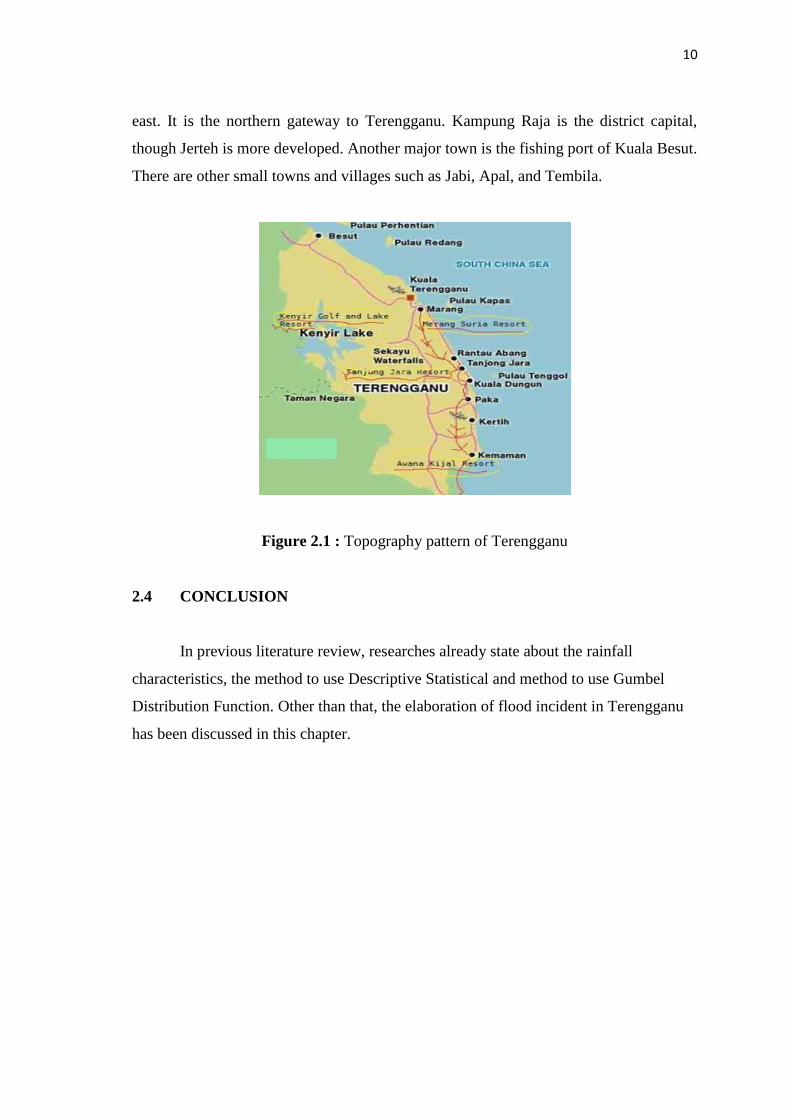
Figure 2.1 : Topography pattern of Terengganu
2.4 CONCLUSION
In previous literature review, researches already state about the rainfall
characteristics, the method to use Descriptive Statistical and method to use Gumbel
Distribution Function. Other than that, the elaboration of flood incident in Terengganu
has been discussed in this chapter.

11
CHAPTER 3
METHODOLOGY
3.1 PROJECT METHODOLOGY
Figure 3.1 : Flow Chart of project methodology

12
3.2 HYDRO CLIMATOLOGY
The term weather refers to the condition of the atmosphere at any particular time
and place. Weather is always changing. The climate of a particular region is the
composite of weather characteristics over many years. Climate reflects weather
variations, including extremes as well as averages, Elements of weather and climate
include precipitation, wind, temperature, humidity, air pressure and clouds. (Suhaila,
2014). The factors that produce weather and climate in any given location include:
(a) Altitude
(b) Prevailing winds
(c) Ocean currents
(d) Mountain barriers
(e) Distribution of land and water bodies
(f) Region of high and low atmospheric pressure
3.3 MEASUREMENT OF RAINFALL
3.3.1 Tropical Rainfall Measuring Mission (TRMM)
Daily rainfall data of major cities in Terengganu (Kemaman, Dungun, Marang,
Hulu Terengganu, Kuala Terengganu, Setiu and Besut) were collected from Tropical
Rainfall Measuring Mission (TRMM) satellite base rainfall from public domain. For
TRMM observatory and instruments, GSFC designed, built and tested the observatory
"in house" at its Greenbelt, Md., facility. At launch, the observatory weighed 7,920 lbs.
(3,600 kg). It is about 17 feet tall (approximately 5 meters) and 12 feet (3.6 meters) in
diameter. A gallium arsenide solar array/nickel cadmium battery power subsystem
provides 1,100 watts of load power to the satellite. (Rui, Earth Observatory).
The TRMM Microwave Imager (TMI) is a multi-channel radiometer, whose
signals in combination can measure rainfall quite accurately over oceans and somewhat
less accurately over the land. The TMI and PR data, will yield the primary precipitation
data sets. (Rui, Earth Observatory).

13
Figure 3.2 : Webpage TRMM data
3.3.2 Descriptive Statistics
Descriptive statistical analysis for three types of data: i) annual rainfall, ii)
annual daily maximum rainfall and iii) annual monthly maximum rainfall. Descriptive
statistics deals with organization and summary of large scale data. It includes tables,
graphs and numbers to present raw data (Ott and Longnecker, 2010). We applied
descriptive statistics to rainfall data to examine its central tendency (mean, median and
mode), variability (standard deviation), symmetry (skewness) and peakedness
(kurtosis). (Ahammed, 2014)The various statistical moments used in this study are
given below:
First moment (mean):
ӯ =Ʃ 𝑦𝑖
n
Second moment (variance):
𝑆2 =Ʃ (𝑦𝑖 − ӯ)2
n − 1
Third moment (skewness):
g =𝑛 Ʃ (𝑦𝑖 − ӯ)3
(n − 1)(𝑛 − 2)𝑠3
Fourth moment (kurtosis):
Ɣ2 = [ ( µ4)
(µ2)2 ] − 3

14
3.2.3 Gumbel Distribution Function
The famous statistician Emil Julius Gumbel (1941) was probably, the first
person who dealt extreme values of hydrological data in organized way for conducting
flood frequency analysis. Traditionally three extreme value distributions: Fréchet,
Weibull and Gumbel are commonly used for analysing return periods of annual daily
maximum rainfall. (Ahammed, 2014).Hence , the Gumbel distribution function (1941)
has been applied to predicting the return periods of expected extree rainfall events.
(Faisal, 2012). The probability and return periods of annual daily maximum rainfall
were estimated using Eqs. (1), (2) and (3) respectively.
𝐹(𝑥) = exp [− exp {− (x−µ
σ)} ] (1)
𝑃(𝑥) = 1 − 𝐹(𝑥) (2)
𝑁 =1
𝑃(𝑥) (3)
Where,
X = annual daily maximum rainfall,
Μ = mean of observed annual daily maximum rainfall,
σ = standard deviation of observed annual daily maximum rainfall,
F(x) = cumulative probability distribution,
P(x) = probability distribution,
N = return periods of expected annual daily maximum rainfall
3.3 CONCLUSION
In this chapter, it slightly briefs the preparation of collecting data, pre-
processing, processing and analysis the rainfall data into Gumbel Distribution Function.
At the end of this chapter, result is successfully achieved and shown.