Assessment the Performance of Roadway: A Study on Muradpur to Dewanhat Road, Chittagong, Bangladesh
13
Bangladesh Planning Research Conference (BPRC) 5-6 February 2016 Paper ID: 115 Department of Urban & Regional Planning Jahangirnagar University, Dhaka 1342, Bangladesh Assessment the Performance of Roadway: A Study on Muradpur to Dewanhat Road, Chittagong, Bangladesh Nasrin Akter Hashi 1 , Kazi Mahfuzur Rahman 2 , Md. Saifullahil-Azom 3 , Masuma Begum 4 Abstract Transportation makes the way of moving from one place to another between the cities and towns. It is called the organ of circulation of a city. The flow of the vehicles assumes the standard and importance of a road. Muradpur-Dewanhat road is the only Major and important road of Chittagong city which encompasses a huge number of vehicles every day. In this road some important intersections are Muradpur, Dui no. Gate, GEC and Dewanhat. This road links the city with Dhaka Chittagong Highway, Patenga sea beach, airport and many other important places. The traffic system of the city is dependent greatly on the performance of this road. Calculating level of service is the best way to understand the performance of a road. This study is mainly focused on the calculation of level of service of the road from through different types of survey like volume, speed and capacity. Again the performance of a road is greatly dependent on the geometric design of the intersections within that road. In this study an attempt to measure geometric design of the major intersections of the road is also taken. The analysis of the study reflects the actual condition of the Muradpur-Dewanhat link road. Improve the performance of this road some recommendations and proposals has been included which will help further decision making process in Chittagong city. Key words: Level of service, Volume, Speed, Capacity 1. Introduction Chittagong is the second largest, spread out town, and the largest international seaport in the country. It is called the business capital of Bangladesh from the after period of liberation war. Not only is that but Chittagong one of the key port cities in south Asia with a supreme touch with the Bay of Bengal. Surroundings with various natural beauties Chittagong is situated in the southern part of Bangladesh. Green countryside, hills, lakes, sea beaches etc. made this port city attractive to all sorts of people. About 6 million people live in this city. The population of this city is increasing with an alarming rate by the cause of high rate of Migration from the Northern part of the country mentioning Rangpur, Naoga, Rajshahi, Joyporhat, Gaibandha etc. the people of these areas here come to get employed by getting a good job within a short time (Daily Prothom-Alo, July 2012). The road from Muradpur to Dewanhat is one of the most important roads of this city. GEC Circle is one of the major intersections of this road as well as in Chittagong. It is the intersection of Zakir Hossain Road, O. R. Nizam Road and CDA Avenue. The traffic condition of the whole city is greatly dependent on the traffic of this road. Calculating LOS is the way to understand the traffic condition of a road. The Level of Service calculation analyzes the geometry of the road, peak hour traffic volumes and environmental conditions, including the lane and shoulder widths, amount of available passing, and the mix of vehicle types in order to calculate the performance rating (Hampshire Council- Good Practice Example , 2012).The concept has been applied to intersections, transit, potable water, sanitary sewer service, solid waste removal, drainage, and public open space and recreation facilities (Kulick, 2004). LOS can also be applied to surface streets, to describe major signalized intersections. So to understand the overall condition of the road calculating level of service is the best way. An attempt to measure geometric design and the level of service is done in the study. The overall transportation system of 1 GIS Coordinator, Blue Gold Program, Mott Macdonald 2 Urban Planner, Multi-purpose Disaster Shelter Project, Development Design Consultancy Limited. 3 Urban Planner, Multi-purpose Disaster Shelter Project, Development Design Consultancy Limited. 4 Urban Planner
-
Upload
kazi-mahfuzur-rahman -
Category
Engineering
-
view
21 -
download
4
Transcript of Assessment the Performance of Roadway: A Study on Muradpur to Dewanhat Road, Chittagong, Bangladesh

Bangladesh Planning Research Conference (BPRC) 5-6 February 2016 Paper ID: 115
Department of Urban & Regional Planning Jahangirnagar University, Dhaka 1342, Bangladesh
Assessment the Performance of Roadway: A Study on Muradpur to Dewanhat Road, Chittagong, Bangladesh
Nasrin Akter Hashi
1, Kazi Mahfuzur Rahman
2, Md. Saifullahil-Azom
3, Masuma Begum
4 Abstract Transportation makes the way of moving from one place to another between the cities and towns. It is called the organ of circulation of a city. The flow of the vehicles assumes the standard and importance of a road. Muradpur-Dewanhat road is the only Major and important road of Chittagong city which encompasses a huge number of vehicles every day. In this road some important intersections are Muradpur, Dui no. Gate, GEC and Dewanhat. This road links the city with Dhaka Chittagong Highway, Patenga sea beach, airport and many other important places. The traffic system of the city is dependent greatly on the performance of this road. Calculating level of service is the best way to understand the performance of a road. This study is mainly focused on the calculation of level of service of the road from through different types of survey like volume, speed and capacity. Again the performance of a road is greatly dependent on the geometric design of the intersections within that road. In this study an attempt to measure geometric design of the major intersections of the road is also taken. The analysis of the study reflects the actual condition of the Muradpur-Dewanhat link road. Improve the performance of this road some recommendations and proposals has been included which will help further decision making process in Chittagong city. Key words: Level of service, Volume, Speed, Capacity
1. Introduction Chittagong is the second largest, spread out town, and the largest international seaport in the country. It is called the business capital of Bangladesh from the after period of liberation war. Not only is that but Chittagong one of the key port cities in south Asia with a supreme touch with the Bay of Bengal. Surroundings with various natural beauties Chittagong is situated in the southern part of Bangladesh. Green countryside, hills, lakes, sea beaches etc. made this port city attractive to all sorts of people. About 6 million people live in this city. The population of this city is increasing with an alarming rate by the cause of high rate of Migration from the Northern part of the country mentioning Rangpur, Naoga, Rajshahi, Joyporhat, Gaibandha etc. the people of these areas here come to get employed by getting a good job within a short time (Daily Prothom-Alo, July 2012). The road from Muradpur to Dewanhat is one of the most important roads of this city. GEC Circle is one of the major intersections of this road as well as in Chittagong. It is the intersection of Zakir Hossain Road, O. R. Nizam Road and CDA Avenue. The traffic condition of the whole city is greatly dependent on the traffic of this road. Calculating LOS is the way to understand the traffic condition of a road. The Level of Service calculation analyzes the geometry of the road, peak hour traffic volumes and environmental conditions, including the lane and shoulder widths, amount of available passing, and the mix of vehicle types in order to calculate the performance rating (Hampshire Council- Good Practice Example , 2012).The concept has been applied to intersections, transit, potable water, sanitary sewer service, solid waste removal, drainage, and public open space and recreation facilities (Kulick, 2004). LOS can also be applied to surface streets, to describe major signalized intersections. So to understand the overall condition of the road calculating level of service is the best way. An attempt to measure geometric design and the level of service is done in the study. The overall transportation system of
1 GIS Coordinator, Blue Gold Program, Mott Macdonald 2 Urban Planner, Multi-purpose Disaster Shelter Project, Development Design Consultancy Limited. 3 Urban Planner, Multi-purpose Disaster Shelter Project, Development Design Consultancy Limited. 4 Urban Planner

Bangladesh Planning Research Conference (BPRC) 5-6 February 2016 Paper ID: 115
Department of Urban & Regional Planning Jahangirnagar University, Dhaka 1342, Bangladesh
Chittagong City is now in a dead lock so that sometimes it takes a lot of time to move one place to another. This paper is being ready for take a smooth look how the level of service can be occupied by the people.
2. Goals and Objectives The study road is the major thoroughfare in Chittagong city and it is important to find out the performance of the road. This study mainly focus on measuring the level of service of the study road and the geometric design at different intersections. Level of service is an important standard for measuring the transportation impacts of major development and changes to a city. Besides the main purpose of geometric design of a road is to provide safe and smooth traffic operation. Finally this study provides some recommendations for better performance of this road.
3. Methodology To evaluate the performance of the road from Muradpur to Dewanhat some sequential works were done by defining the objectives and goals of the study. Different documents were reviewed for different factors for calculating level of service and finding different methods for calculating speed, volume and capacity. Literature review was also conducted to find geometric design standard in our country and abroad and to categorize the level of service of the selected road. Two types of data were used in this study for analyzing the study road performance. Primary data was needed for understanding and analyzing geometric design of GEC intersection, cross-section of roads that intersected at GEC, speed of the vehicles in the road from Muradpur to Dewanhat, volume of traffic in this road and capacity of the road. Primary data was collected by conducting physical survey and volume counts with the instruments of stopwatch, tape, record book, pencil, eraser etc. Secondary data was needed to know about the standard categories of level of service and standard geometric design for a highway. In this study categories of level of service and geometric design standard for Bangladesh and abroad were the secondary data source. To analyze the collected primary & secondary data we first identified the factors which influence the level of service of a road. Two important factors were considered here which were travel speed and V/C ratio. (Kadiyali, 1978). After identifying the factors, flow of traffic or volume was counted at peak and off- peak hours. Volume counted by the following formula Volume (V) = Number of Vehicles (n) / Time (t) Manual method was used for counting volume as it is very cost effective and appropriate method for developing country like Bangladesh. It does not require skilled manpower in technical sector. Among many methods of measuring speed we used ‘Moving Observer’ method in this study for its few advantages. By using this method, flow and speed can be got at the same time. It gives mean values of flow and speed over a section. It is also economical in manpower. The formula for finding speed using this method is Speed= Length/ Total Journey Time Capacity of the road was calculated by the following formula- Capacity (C) = [1000 * speed (v)] / spacing (s); Spacing (s) = L+ [t*v*1000] /3600 (Kadiyali, 1978)
Bangladesh Planning Research Conference (BPRC) 5-6 February 2016 Paper ID: 115
Department of Urban & Regional Planning Jahangirnagar University, Dhaka 1342, Bangladesh
Using all above formula and methods we found a result which needed to compare with standard categories of level of service. Besides this all the factors responsible for the performance of the study road was analyzed in this step.
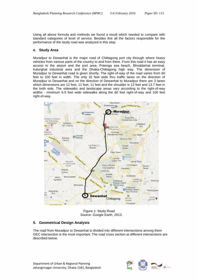
4. Study Area
Muradpur to Dewanhat is the major road of Chittagong port city through where heavy vehicles from various parts of the country to and from there. From this road it has an easy access to the airport and the port area, Potenga sea beach, Bhoddarhat terminal, Kalurghat industrial area and the Dhaka-Chittagong high way. The dimension of Muradpur to Dewanhat road is given shortly. The right-of-way of the road varies from 60 feet to 100 feet in width. The only 32 feet wide thru traffic lanes on the direction of Muradpur to Dewanhat and on the direction of Dewanhat to Muradpur there are 3 lanes which dimensions are 12 feet, 11 feet, 11 feet and the shoulder is 12 feet and 13.7 feet in the both side. The sidewalks and landscape areas vary according to the right-of-way widths - minimum 6.9 feet wide sidewalks along the 60 feet right-of-way and 100 feet right-of-way.
Figure 1: Study Road
Source: Google Earth, 2013.
5. Geometrical Design Analysis The road from Muradpur to Dewanhat is divided into different intersections among them GEC intersection is the most important. The road cross section at different intersections are described below.

Bangladesh Planning Research Conference (BPRC) 5-6 February 2016 Paper ID: 115
Department of Urban & Regional Planning Jahangirnagar University, Dhaka 1342, Bangladesh
The dimension of the footpath varies from 5‟10” to 20‟ in the study area. The lowest dimension of footpath is in the road section of Thgerpass to GEC both side of the road. And the largest footpath is in the right site cross section of 2no. Gate to GEC.
The dimension of drain varies from 2‟ to 9‟7”. The lowest dimension of the drain is in the left site of the road cross section of GEC to Tigerpass. And the largest dimension of the drain is the right site cross section of GEC to 2no. Gate.
The curb width is varies from 1‟ to 1‟6”.
Shoulder width varies from 7‟4” to 13‟7”. The lowest width of shoulder is the right site cross section of Tigerpass to GEC. And the highest width is the right site of GEC to Tigerpass. Only the link of GEC to Tigerpass has both side shoulders.
The lane width is varies from 10‟6” to 12‟. In some direction of the road it has two lane and some have three lane.
Carriage way width differs from 29‟1” to 57‟3”. The lowest is in the right site of Tigerpass to GEC road way and the largest is in the left side of the 2no. Gate to GEC.
Divider width of the road is differing from 1‟8” to 10‟. The lowest width is in the Tigerpass to GEC and the highest width is 2no. Gate to Muradpur direction.
The right of way of the road varies from 73‟ to 139‟. The largest carriage way of the road link is 2no. Gate to GEC. And the smallest carriage way is the link of Tigerpass to GEC.
Figure 2: GEC to Tigerpass Source: Field survey, 2013.
Figure 3: Tigerpass to Dewanhat
Source: Field survey, 2013
Figure 4: Tigerpass to GEC
Bangladesh Planning Research Conference (BPRC) 5-6 February 2016 Paper ID: 115
Department of Urban & Regional Planning Jahangirnagar University, Dhaka 1342, Bangladesh
Source: Field survey, 2013
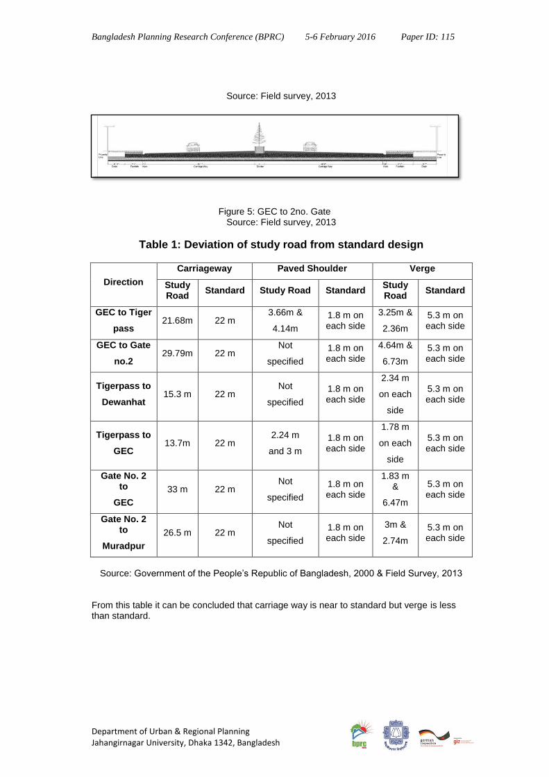
Figure 5: GEC to 2no. Gate Source: Field survey, 2013
Table 1: Deviation of study road from standard design
Direction
Carriageway Paved Shoulder Verge
Study Road
Standard Study Road Standard Study Road
Standard
GEC to Tiger
pass 21.68m 22 m
3.66m &
4.14m
1.8 m on each side
3.25m &
2.36m
5.3 m on each side
GEC to Gate
no.2 29.79m 22 m
Not
specified
1.8 m on each side
4.64m &
6.73m
5.3 m on each side
Tigerpass to
Dewanhat 15.3 m 22 m
Not
specified
1.8 m on each side
2.34 m
on each
side
5.3 m on each side
Tigerpass to
GEC 13.7m 22 m
2.24 m
and 3 m
1.8 m on each side
1.78 m
on each
side
5.3 m on each side
Gate No. 2 to
GEC
33 m 22 m Not
specified
1.8 m on each side
1.83 m &
6.47m
5.3 m on each side
Gate No. 2 to
Muradpur
26.5 m 22 m Not
specified
1.8 m on each side
3m &
2.74m
5.3 m on each side
Source: Government of the People’s Republic of Bangladesh, 2000 & Field Survey, 2013
From this table it can be concluded that carriage way is near to standard but verge is less than standard.

Bangladesh Planning Research Conference (BPRC) 5-6 February 2016 Paper ID: 115
Department of Urban & Regional Planning Jahangirnagar University, Dhaka 1342, Bangladesh
Figure 6: Geometric design of GEC intersection Source: Field Survey, 2013
6. Analysis of Level of Service In order to calculating the level of service we have to consider some factors. The following are the factors which might be considered:
Speed and travel time, including the operating speed and overall travel time consumed in traveling over a section of roadway.
Traffic interruptions or restrictions, with due consideration to the number of stops per mile, delays involved and the speed changes necessary to maintain pace in the traffic stream.
Freedom to travel with the desired operating speeds.
Driving comfort and convenience reflecting the roadway and traffic conditions in-so-far as they affect driving comfort and convenience of the driver.
Economy, with due consideration operating cost of the vehicle. Though all of these factors are essential for calculating level of service but often it is difficult to combine all of these factors due to lacking of accurate data. Therefore the Highway Capacity Manual (HCM) uses two factors. These are: (i) the ratio of the service volume to capacity (v/c ratio) (ii) travel speed (Kadiyali, 1978).

Bangladesh Planning Research Conference (BPRC) 5-6 February 2016 Paper ID: 115
Department of Urban & Regional Planning Jahangirnagar University, Dhaka 1342, Bangladesh
6.1. Volume-Capacity Ratio Calculation Manual methods are adopted to count volume of vehicles in this study. Vehicles from both Muradupur to Dewanhat direction and from Dewanhat to muradpur direction are counted at GEC intersection. Two peak hours and two off peak hours are selected for volume counts. And in these four hours different types of vehicles are counted. Then the volume is calculated.
Table 2: Volume at Different Sections of the Road from Muradpur to Dewanhat
Direction Volume (PCU/hour)
Working Day Holy Day
Muradpur to GEC 2274.85 1723.7
GEC to Muradpur 2051.3 1447.45
GEC to Dewanhat 2257.35 1840.6
Dewanhat to GEC 2309.1 1719.8
Source: Field Survey, 2013
Table 3: Capacities of Each Direction of the Road from Muradpur to Dewanhat
Name of the Direction Capacity
Muradpur to GEC 1279.54
GEC to Muradpur 1277.04
GEC to Dewanhat 1147.43
Dewanhat to GEC 1007.23
Source: Field Survey, 2013
Table 4: V/C ratio of Each Direction of the Road from Muradpur to Dewanhat
Name of the Direction V/C Ratio
Muradpur to GEC 0.64
GEC to Muradpur 0.73
GEC to Dewanhat 0.56
Dewanhat to GEC 0.50
Source: Field Survey, 2013
So, the average volume-capacity ratio of total road is,
6.2. Speed Calculation Moving observation method is selected to measure the speed of this road. Then the journey and running speed at different directions are calculated.

Bangladesh Planning Research Conference (BPRC) 5-6 February 2016 Paper ID: 115
Department of Urban & Regional Planning Jahangirnagar University, Dhaka 1342, Bangladesh
Table 5: Journey Speed of Each Direction of the Road
Name of the Direction Average Speed (kph)
Muradpur to GEC 19.34
GEC to Muradpur 17.81
GEC to Dewanhat 17.94
Dewanhat to GEC 15.45
Source: Field Survey, 2013
So average journey speed of the study road is,
kph
6.3. Evaluating Level of Service The speed of testing vehicle towards Muradpur to Dewanhat direction is 18.64 kph and Dewanhat to Muradpur direction is 16.63 kph. According to the speed Level of Service of this road is D category. The average v/c ratio is 0.61 which indicates the Level of Service of total road is D category. The maxilmum service fow rate of Muradpur to Dewanhat direction is 1600 vehicles per hour per lane. This means the level of service of the road is D category. For urban arterials the criteria for level of service are:
Level of Service Overall Speed (kph) V/C ratio Maximum Flow Rate
A ≥ 30 0 600
B ≥ 25 ≤ 0.1 1000
C ≥ 20 ≤ 0.3 1400
D ≥ 15 ≤ 0.7 1670
E ≥ 10 ≤ 1.0 2000
F ∞ poor
Source: Kadiyali, 1978
Table 6: Level of Service of Different Sections of Study Road
Name of the Direction Overall Speed
(K.P.H.) V/C ratio
Level of Service
Muradpur to GEC 19.34 0.64 D
GEC to Muradpur 17.81 0.73 D
GEC to Dewanhat 17.94 0.56 D
Dewanhat to GEC 15.45 0.50 D
Source: Field Survey, 2013
6.4. Factors Affecting Level of Service Level of service of this road is low. So performance of this road is not sufficiently good. The causes of low level of service of this road are described in below:

Bangladesh Planning Research Conference (BPRC) 5-6 February 2016 Paper ID: 115
Department of Urban & Regional Planning Jahangirnagar University, Dhaka 1342, Bangladesh
6.4.1. Land use The most dominant land use of the study area is commercial use of land. Major commercial buildings of this area are Chittagong Shopping Complex, Sanmar Ocean City, Central Plaza, Amin Center, different types of banks etc. In these commercial institutions there is much accumulation of people. This over population promotes too much pedestrian, much vehicular movement, much stall in the roadsides which are great factors to decrease the level of service of the road. Besides this there is lack of adequate parking facility for commercial institutes. On street parking is greatly used here. There are a reasonable amount of service institutes e.g. WASA, CNG refilling station etc which are also responsible for decrease in the speed of the vehicles. Sometimes the line of vehicles in filling stations takes place on the road and reduces the speed of other vehicles by narrowing the road. In the study area, there are two educational institutions (Bangladesh women association school and college at Dampara, Police lines school at dampara, Nasirabad boys school at GEC) that affects the LOS of this road greately. In the peak hour students of these institutions come out in the road to go or to return from institutions and cross the road haphazardly. As a result in the peak hour students join with the official, workers in the severe traffic congestion. Thus the LOS decreases. Besides, there are two speed breakers in front of each institution for the safety of students. These speed breakers reduce the speed of the road.
Figure 7: Land use pattern of Tigerpass to GEC
Source: Field Survey, 2013
6.4.2. Channelization Proper channelization of a road is very important part of an intersection. It increases the safety and efficiency of roads by reducing the conflicting points. In GEC intersection a traffic island, a roundabout; a roundabout in gate no. 2; six traffic islands and a roundabout in tiger pass are used for channelization. The conflicting points that cannot be solved by these islands are reduced by signalization. But sometimes the delay for signal increases for the
Bangladesh Planning Research Conference (BPRC) 5-6 February 2016 Paper ID: 115
Department of Urban & Regional Planning Jahangirnagar University, Dhaka 1342, Bangladesh
conflict among the vehicles of roads that intersected the road from Muradpur to Dewanhat. For these conflicts, congestion is created and as a result, signal delay time increases.
6.4.3. Number of Lanes and Lane Divider Lane width plays an important role in Level of Service of a road. In this road, there are three lanes at each of the carriage ways (From Muradpur to Lalkhan Bazar). The number of lanes is two at the section from Lalkhan Bazar to Dewanhat and Dewanhat to Lalkhan Bazar. But the volume of the study road is highest at the tiger pass (See appendix 1) and this large volume in relatively narrow carriage ways sometimes creates congestion which affects the level of service of this roads. These lanes have sufficient width but the lines that divide the lanes of the road are not clearly defined at the road (from Gate no. 2 to WASA circle and GEC to Gate No. 2 Circle). Lack of these divider lines the road sometimes looks like a single lane road. Thus the vehicles move and overtake haphazardly.
6.4.4. Behavioural problem Behavioral problem of both drivers and passengers is one of the reasons of low level of service of this road. Drivers do not will to obey the traffic rules. They are also not well-informed about the traffic rules. Though passengers have sufficient knowledge about rules but they are not so conscious to maintain these rules. They park their car along road side. For this reason often traffic congestion is created. Normal traffic flow is hampered. They also do not maintain speed limit. Sometimes drivers are forced to travel at much lower speeds than they desire Over-taking tendency of drivers causes terrible traffic congestion. Drivers often do not mend their vehicle properly. So sometimes car does not start or work properly and covers road which affects normal flow and after a few later it creates congestion. Some shop-keepers of the road side shop bring their goods and got down goods from pick-up by parking along road side which affects normal traffic flow. There is zebra crossing in almost all of the roads. But pedestrians do not use these zebra-crossing to cross the road. They are habituate to cross in the middle of the road. So drivers have to make stop their car which also hinders normal flow. It is also seen that some passengers park their car along road side for shopping along the road side shop or make gossiping which is inconvenient to flow of traffic.
6.4.5 Insufficient Bus stoppage There is not sufficient amount of bus stoppage in this road. This is also one of the main causes of low level of services of this road. Drivers also do not will to stop their bus at fixed place. They make get-on and get-down passengers haphazardly. For this reason the cars behind that bus cannot move and time being this situation turns into traffic congestion. Same attitude comes from the passengers also. They become impatient to stand in queue or at a fixed place. They try to stop bus at any place which makes inconvenience to other vehicles. There are bus stoppages along this road. One of these is located in Tiger pass. Two are located in GEC. But location of these stoppages is not proper. Because it is seen that bus
are not stopped and passengers also do not wait in these stoppages.
6.4.6 Parking
Parking as part of an overall transportation system is one of the crucial issues of our times. As the number of automobiles increases exponentially, the need to house them in close proximity creates a challenging design problem. So parking has become important in urban areas as the number of vehicles has increased in enormous rate. Parking lot is needed

Bangladesh Planning Research Conference (BPRC) 5-6 February 2016 Paper ID: 115
Department of Urban & Regional Planning Jahangirnagar University, Dhaka 1342, Bangladesh
otherwise there creates traffic jam. Proper position & function of parking lot gives a safe & efficient passage of automobiles. But it’s a great regret that there’s no well parking facility for the vehicles in the study area. As the study area is the most busy intersection point of the city, it should have well parking facility. So vehicles are placed here & there that often creates jam & trouble in peoples walk.
6.4.7. Small Motorized Vehicles Mobility is an important part of our daily life. But this has often disturbed by a large number of vehicles. Reason behind this is the increase of people & increases of vehicles according to their needs. Now-a-days number of private vehicles has increased in a high rate rather the number of public vehicles. This is another reason of traffic jam .The Passenger Car Unit (PCU) of a private vehicle is less than a public vehicle. The Passenger Car Unit (PCU) of a public vehicle can be equal of two or many private vehicle. It will be clear from the following chart showing the volume of different vehicles of this road at 8.30.to 8.40 AM.
Figure 8: Vehicles at 8:30 am to 8:40 am from Muradpur to Dewanhat
Source: Field Survey, 2013 From this pie chart it can be concluded that 57% of the total vehicle is CNG and car/jeep/Microbus/Pickup which needs greater space in roads but carry less people. So restriction or proper rules should be created in case of private vehicle. As it’s a reason for traffic jam.
6.4.8 Footpath
Footpath refers to one type of pedestrian walkway lying beside any major road. This type of walkway is mainly used for regulating and maintaining free movement of vehicles. In case of the study area i.e. the road from Muradpur to Dewanhat the footpath along two sides of the road are not continuous. Rather there are some breaks up and the shape and size of the footpath is not uniform all along the road. The footpaths are often seen blocked by the illegal tea stall and hawker. These phenomena occur disturbance in the movement of the huge pedestrian. The footpaths in this intersection are more blocked that other. In the Tigerpass section this phenomena is less common than other two intersections.
1%
6%
35%
22%
11%
17%
8%
0% 0%
Vehicles at 8.30 AM to 8.40 AM
Bus(2.5)
Minibus/Truck(2)
Car/Jeep/Microbus/Pickup(1)
CNG/Auto Rickshaw(.5)
Tempo/Human Hauler(.6)
Rickshaw/Van(.8)
motorcycle(.3)
Bicycle(.2)
Bangladesh Planning Research Conference (BPRC) 5-6 February 2016 Paper ID: 115
Department of Urban & Regional Planning Jahangirnagar University, Dhaka 1342, Bangladesh
In the road section from Gate No. 2 to GEC dustbins are also found on footpath. For these reasons people have been habituated to use vehicular road to walk and hinders the free movement of traffic.
7. Recommendation The performance of the road from Muradpur to Dewanhat is not satisfactory. The reasons for the unsatisfactory performance are found out. According these findings some recommendations are mentioned bellow:
Provision of parking for commercial area & restricted for getting down passengers in front of commercial space.
Educational institutes have to arrange their own parking space. They can use their field for parking purposes during break up of school.
Footpath should be enlarged in front of educational instructions.
Service of CNG Filling Station should be prohibited at peak hour.
Goods of various departmental stores should be loaded & unloaded at off-peak hour.
Buses should be stopped in front of passenger shed and this should be followed by strictly.
Railing should be provided along the footpath edge.
Provision of lanes for non-motorized vehicles.
Remove dustbins from footpath.
Fixation of separate space for tea stalls on footpath.
Proper management should be taken for zebra crossing, signal & lane divider by implementing traffic rules.
Increasing awareness to follow traffic rules among the general people.
8. Conclusion The road from Muradpur to Dewanhat plays a vital role in the traffic system of the Chittagong city. The overall traffic condition of the city is greatly dependent on the performance of this road. Good traffic condition of a road is ordeal without proper design of the intersections of that road. LOS is a scale which defines the operating conditions on highway. It is a measure of the restrictive effects of the increased volume, level of service as proposed by manual ranges from A to F, A is ideal level and F is worst level of service. This study aims at understanding the traffic condition of this road. To do this the geometric design of GEC circle is studied and then the level of service I of this road is analyzed. From this study it is found that the level of service is D which is not satisfactory. The reasons for being low level of service of this road are studied through field observation and related literature review. From this analysis it has been found that geometric design, commercial land use beside the road, lack of provision of parking and bus stop, a greater number of C.N.G and Car, absence of separate shoulder for Non-Motorized Vehicle(NMV), people behavior etc. are the main reason for being low level of service of this road. To reduce these problem proper designs of the intersections and management systems should be introduced. It can be introducing NMV lane, selecting places for footpath stall, installation of automatic devices for signalization etc. Proper steps should be taken to increase the speed of the road and remove the inappropriateness of cross section and geometric design of the intersection of this road.

Bangladesh Planning Research Conference (BPRC) 5-6 February 2016 Paper ID: 115
Department of Urban & Regional Planning Jahangirnagar University, Dhaka 1342, Bangladesh
9. References AASHTO, (2011), A Policy on Geometric Design of Highways and Streets, American Association of State Highway and Transportation Officials, USA. CDA, (2005) Detailed Area Plan, Chittagong, Bangladesh. Das, N 2006, Critical Analysis of Shyambazar Traffic Intersection Area, Kolkata: A Study of Visual Appropriateness, March, Kansas State University, Manhattan, Kansas FHA, (2001) Geometric Design Practices for European Roads, Dept. of Transportation, USA. Herbert, Halback, Dyer and Riddle, 2008, „Panama City Beach: Front Beach Road Streetscape Design Guidelines Manual‟, City of Panama City Beach. Highways, R. (1995) Geometric Design of RHD Roads, Chapter-2, pp. 2-5, Dhaka, Bangladesh. Highways, R. (1991) Report of the Task Force on Transport, Dhaka, Bangladesh. Kadiyali, L.R. (1978) Traffic Engineering & Transportation Planning, New Delhi, India. Kulick, B. C. (2004) The use of simulation to support major transportation planning decisions. Journal of 36th Winter simulation Conference. Newton D. & Curry M. (2014) California Has Officially Ditched Car-Centric ‘Level of Service’ http://la.streetsblog.org/2014/08/07/california-has-officially-ditched-car-centric-level-of-service/ Accessed on 20th September, 2014. William R. McShane and Roger P. Roess, 1990, Traffic Engineering, McGraw hill Publishers, USA. URL: http://www.lged.gov.bd/DistrictHome.aspx?districtID=11, Accessed on 20th January 2014. URL: http://www.worldclimateguide.co.uk/climateguides/bangladesh/chittagong.php, Accessed on 20th January 2014.
http://la.streetsblog.org/2014/08/07/california-has-officially-ditched-car-centric-level-of-service/


![[XLS]icdsbih.gov.inicdsbih.gov.in/admin/UploadFile/Patna District Priyojna... · Web viewTarapur Pyalapur Hidayatpur Chakchitu Saidpur Tola Bahadurpur Saidpur Muradpur Hidayatpur](https://static.fdocuments.in/doc/165x107/5afda3cf7f8b9a256b8be4a1/xls-district-priyojnaweb-viewtarapur-pyalapur-hidayatpur-chakchitu-saidpur.jpg)