ASSESSMENT REPORT ON DRILLING RED CLIFF EAST PROPERTY
47
ASSESSMENT REPORT ON DRILLING RED CLIFF EAST PROPERTY Located 24 kilometers northeast of Stewart, British Columbia in Skeena Mining Division NTS 104A/4W 56° 06’30’’ N LATITUDE 129° 53’10’’ W LONGITUDE Event Number: 4825324 On Behalf of Nanika Resources Ltd Vancouver, BC Report by Alojzy Walus, M.Sc., P. Geo. E-mail: [email protected] January 20, 2011
Transcript of ASSESSMENT REPORT ON DRILLING RED CLIFF EAST PROPERTY

ASSESSMENT REPORT ON DRILLING
RED CLIFF EAST PROPERTY
Located 24 kilometers northeast of
Stewart, British Columbia in Skeena Mining Division
NTS 104A/4W
56° 06’30’’ N LATITUDE 129° 53’10’’ W LONGITUDE
Event Number: 4825324
On Behalf of Nanika Resources Ltd
Vancouver, BC
Report by
Alojzy Walus, M.Sc., P. Geo. E-mail: [email protected]
January 20, 2011
ldegroot
Text Box
BC Geological Survey Assessment Report 32019
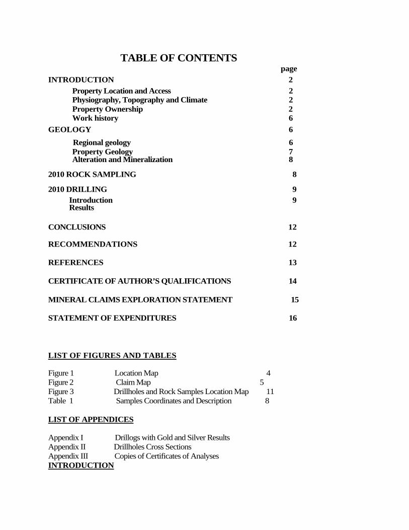
TABLE OF CONTENTS page
INTRODUCTION 2
Property Location and Access 2 Physiography, Topography and Climate 2 Property Ownership 2 Work history 6
GEOLOGY 6
Regional geology 6 Property Geology 7 Alteration and Mineralization 8
2010 ROCK SAMPLING 8 2010 DRILLING 9 Introduction 9 Results
CONCLUSIONS 12
RECOMMENDATIONS 12
REFERENCES 13
CERTIFICATE OF AUTHOR’S QUALIFICATIONS 14
MINERAL CLAIMS EXPLORATION STATEMENT 15
STATEMENT OF EXPENDITURES 16
LIST OF FIGURES AND TABLES
Figure 1 Location Map 4 Figure 2 Claim Map 5 Figure 3 Drillholes and Rock Samples Location Map 11 Table 1 Samples Coordinates and Description 8
LIST OF APPENDICES Appendix I Drillogs with Gold and Silver Results Appendix II Drillholes Cross Sections Appendix III Copies of Certificates of Analyses INTRODUCTION

2
Property Location and Access
The property is situated in the lower part of the American Creek Valley extending 3 kilometres up the creek from its confluence with Bear River. The claim area is centered on 56° 06’30’’N latitude and 129° 53’10’’ W longitude on NTS sheet 104 A/4. A map with marked location of the claims printed from ARIS database is presented on figure 1.
Access to the property is via Highway 37A from Stewart to the American Creek access road constructed by other exploration companies which bisects the middle of the property providing excellent access to the lower portions of the claims. Helicopter must be utilized to access higher areas of the property. A helicopter can be chartered a year round from Prism Helicopter base in Stewart.
Physiography, Topography and Climate
In general terms the property is typified by the precipitous slopes of the eastern Coast Mountains. Relief ranges from 150 m in the American Creek Valley to over 500 m near the western edge of the claim with a good portion of the property accessible on foot. Water supply is plentiful as many glacial run-off streams drain into American Creek and Bear River.
Vegetation varies from mature stands of western hemlock blue spruce and Douglas fir at the lower elevations to alder higher on the slopes. On the steeper slopes where avalanches are a frequent occurrence only a combination of slide alder, mountain ash, huckleberry, stinging nettle and devil’s club can exist.
The area receives heavy snowfall between the months of October and March with rainfall in the other months. Average precipitation is in the order of 250 centimeters of rainfall and 20 meters of snow. Due to the large snowfall, the surface exploration in the Stewart area is restricted to summer and early fall with the maximum rock exposure occurring in late August to October. However, the area of the confluence of American Creek and Bear River receives much less snow compare to surrounding areas.
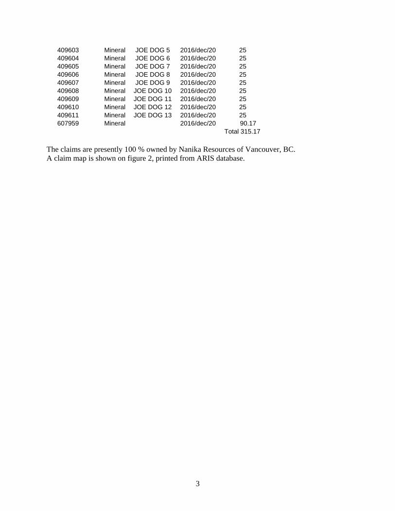
Property Ownership The Read Cliff East property consists of ten mineral claims totaling 315.17 hectares located 24 kilometres northeast of Stewart, BC. Relevant claim information is summarized below:
Tenure Number Type Claim Name Good Until Area (ha)
3
409603 Mineral JOE DOG 5 2016/dec/20 25 409604 Mineral JOE DOG 6 2016/dec/20 25 409605 Mineral JOE DOG 7 2016/dec/20 25 409606 Mineral JOE DOG 8 2016/dec/20 25 409607 Mineral JOE DOG 9 2016/dec/20 25 409608 Mineral JOE DOG 10 2016/dec/20 25 409609 Mineral JOE DOG 11 2016/dec/20 25 409610 Mineral JOE DOG 12 2016/dec/20 25 409611 Mineral JOE DOG 13 2016/dec/20 25 607959 Mineral 2016/dec/20 90.17
Total 315.17
The claims are presently 100 % owned by Nanika Resources of Vancouver, BC. A claim map is shown on figure 2, printed from ARIS database.

Figure 1 Location

5
Figure 2 Claim Map

6
Work History There was not much work done on these claims before 2009. The only reported work on the Joe Dog mineral claims 5 to 13 was initiated in 2005 by the former claim owner Jim Marx. The work included a seismic refraction survey conducted by Geophysicist Mike Powers along the 455 metres of cut line. The survey was to determine the depth of the bedrock and to estimate the potential volume of the gravel deposited along American Creek. In 2009, Nanika Resources conducted a geochemical program during which a total of 22 rock, 4 silt and 155 soil samples were collected. Of the 22 rock samples collected during this program, 10 samples returned significant metal values with up to 170 ppb for gold, 126.3 g/t for silver, 1.18 % for copper, 0.73 % for zinc and 0.27 % for lead. Four silt samples returned 314, 135, 344 and 98 ppb gold with silver values ranging from 0.2 to 2.0 ppm. Soil samples from a 250 meter long section of the soil contour line showed silver values ranging from 3.2 to 11.9 ppm along with significant values in copper, lead and zinc.
GEOLOGY
Regional Geology
The Red Cliff East property lies along the eastern edge of the Coast Crystalline Complex within the western boundary of the Bowser Basin. Rocks in the area belong to the Mesozoic Stuhini Group, Hazelton Group and Bowser Lake Group that have been intruded by plugs of both Cenozoic and Mesozoic age. Portions of the Stewart area are underlain by Triassic age Stuhini Group (Greig, C.F, 1994). The Stuhini Group rocks are either underlying or in fault contact with the Hazelton Group. These Triassic age rocks consist of dark gray, laminated to thickly bedded silty mudstone, and fine to medium grained and locally coarse-grained sandstone. Local heterolitic pebble to cobble conglomerate, massive tuffaceous mudstone and thick-bedded sedimentary breccia and conglomerate also form part of the Stuhini Group.
At the base of the Hazelton Group is the lower Lower Jurassic Marine (submergent) and non-marine (emergent) volcaniclastic Unuk River Formation. This is overlain at steep discordant angles by a second, lithologically similar, middle Lower Jurassic volcanic cycle (Betty Creek Formation), in turn overlain by an upper Lower Jurassic tuff horizon (Mt. Dilworth Formation). Middle Jurassic non-marine sediments with minor volcanics of the Salmon River Formation unconformably overlie the above sequence.
The lower Lower Jurassic Unuk River Formation forms a north-northwesterly trending belt extending from Alice Arm to the Iskut River. It consists of green, red and purple volcanic breccia, volcanic conglomerate, sandstone and siltstone with minor crystal and lithic tuff, limestone, chert and minor coal. Also included in the sequence are pillow lavas and volcanic flows.

7
In the property area, the Unuk River Formation is unconformably overlain by middle Lower Jurassic rocks from the Betty Creek Formation. The Betty Creek Formation is another cycle of trough filling sub-marine pillow lavas, broken pillow breccias, andesitic and basaltic flows, green, red, purple and black volcanic breccia, with self erosional conglomerate, sandstone and siltstone and minor crystal and lithic tuffs, chert, limestone and lava.
The upper Lower Jurassic Mt. Dilworth Formation consists of a thin sequence varying from black carbonaceous tuffs to siliceous massive tuffs and felsic ash flows. Minor sediments and limestone are present in the sequence. Locally pyritic varieties form strong gossans.
The Middle Jurassic Salmon River Formation is a late to post volcanic episode of banded, predominantly dark colored siltstone, greywacke, sandstone, intercalated calcarenite rocks, minor limestone, argillite, conglomerate, littoral deposits, volcanic sediments and minor flows. Overlying the above sequences are the Upper Jurassic Bowser Lake Group rocks. These rocks mark the western edge of the Bowser Basin and are also located as remnants on mountaintops in the Stewart area. These rocks consist of dark gray to black clastic rocks including silty mudstone and thick beds of massive, dark green to dark gray, fine to medium grained arkosic litharenite.
According to E.W. Grove, the majority of the rocks from the Hazelton Group were derived from the erosion of andesitic volcanoes subsequently deposited as overlapping lenticular beds varying laterally in grain size from breccia to siltstone. Alldrick’s work to the north of Stewart has shown several volcanic centers in the surveyed area. Lower Jurassic volcanic centers in the Unuk River Formation are located in the Big Missouri Premier area and in the Brucejack Lake area. Volcanic centers within the Lower Jurassic Betty Creek Formation are located in the Mitchell Glacier and Knipple Glacier areas.
The granodiorites of the Coast Plutonic Complex largely engulf the Mesozoic volcanic terrain to the west. East of these (in the property area), smaller intrusive plugs range from quartz monzonite to granite. Some are likely related to the late phase offshoots of the Coast plutonism, other is synvolcanic and Tertiary. Double plunging, northwesterly - trending synclinal folds of the Salmon River and underlying Betty Creek Formations dominate the structural setting of the area. These folds are locally disrupted by small east-over thrusts on strikes parallel to the major fold axis, cross-axis steep angled faults which locally turn beds, selective tectonization of tuff units and major northwest faults which turn beds.
Property Geology
The property area is underlain by volcanic and volcaniclastic rocks belonging to the Unuk River Formation of Lower Jurassic age. On the east side of American Creek, black argillites and/or tuffs are highly sheared and locally silicified. Rocks are exposed along an old logging road. Strike of the rocks appears to be north south with a steep dip to the west. On the west side of American Creek, the rocks are weakly sericite altered, green andesite tuffs with up to 5 % fine grained pyrite. Rocks are exposed along an exploration road extending up American Creek.
8
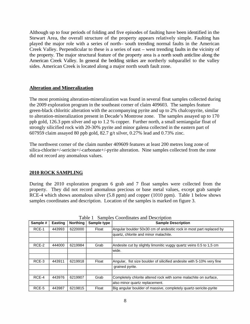
Although up to four periods of folding and five episodes of faulting have been identified in the Stewart Area, the overall structure of the property appears relatively simple. Faulting has played the major role with a series of north– south trending normal faults in the American Creek Valley. Perpendicular to these is a series of east – west trending faults in the vicinity of the property. The major structural feature of the property area is a north south anticline along the American Creek Valley. In general the bedding strikes are northerly subparallel to the valley sides. American Creek is located along a major north south fault zone.
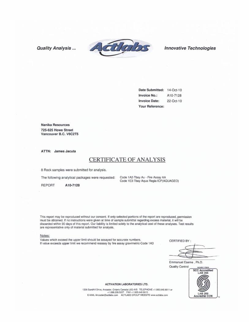
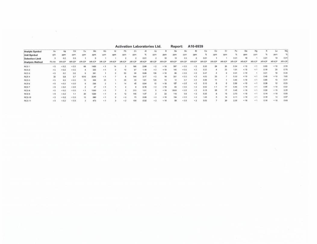
Alteration and Mineralization The most promising alteration-mineralization was found in several float samples collected during the 2009 exploration program in the southeast corner of claim 409603. The samples feature green-black chloritic alteration with the accompanying pyrite and up to 2% chalcopyrite, similar to alteration-mineralization present in Decade’s Montrose zone. The samples assayed up to 170 ppb gold, 126.3 ppm silver and up to 1.2 % copper. Further north, a small semiangular float of strongly silicified rock with 20-30% pyrite and minor galena collected in the eastern part of 607959 claim assayed 80 ppb gold, 82.7 g/t silver, 0.27% lead and 0.73% zinc. The northwest corner of the claim number 409609 features at least 200 metres long zone of silica-chlorite+/-sericite+/-carbonate+/-pyrite alteration. Nine samples collected from the zone did not record any anomalous values. 2010 ROCK SAMPLING During the 2010 exploration program 6 grab and 7 float samples were collected from the property. They did not record anomalous precious or base metal values, except grab sample RCE-4 which shows anomalous silver (5.8 ppm) and copper (1010 ppm). Table 1 below shows samples coordinates and description. Location of the samples is marked on figure 3.
Table 1 Samples Coordinates and Description Sample # Easting Northing Sample type Sample Description
RCE-1 443993 6220000 Float Angular boulder 50x30 cm of andesitic rock in most part replaced by
quartz, chlorite and minor malachite.
RCE-2 444000 6219984 Grab Andesite cut by slightly limonitic vuggy quartz veins 0.5 to 1,5 cm
wide.
RCE-3 443911 6219918 Float Angular, fist size boulder of silicified andesite with 5-10% very fine
grained pyrite.
RCE-4 443976 6219907 Grab Completely chlorite altered rock with some malachite on surface,
also minor quartz replacement.
RCE-5 443987 6219815 Float Big angular boulder of massive, completely quartz-sericite-pyrite
9
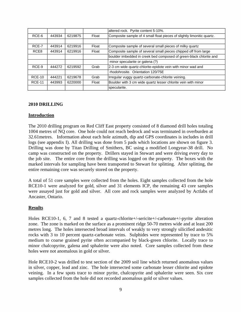
altered rock. Pyrite content 5-10%.
RCE-6 443934 6219875 Float Composite sample of 4 small float pieces of slightly limonitic quartz.
RCE-7 443914 6219916 Float Composite sample of several small pieces of milky quartz
RCE8 443914 6219916 Float Composite sample of several small pieces chipped off from large
boulder imbedded in creek bed composed of green-black chlorite and
minor specularite or galena (?)
RCE-9 444272 6219592 Grab 2-3 cm wide quartz-chlorite-epidote vein with minor wad and
rhodohrosite. Orientation 120/75E
RCE-10 444221 6219678 Grab Irregular vuggy quartz-carbonate-chlorite veining.
RCE-11 443993 6220000 Float Boulder with 3 cm wide quartz lesser chlorite vein with minor
specularite.
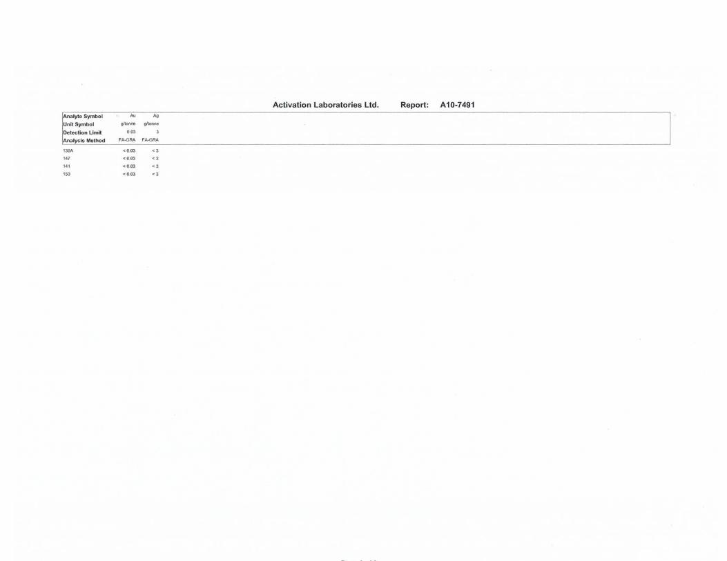
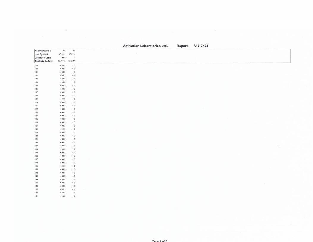
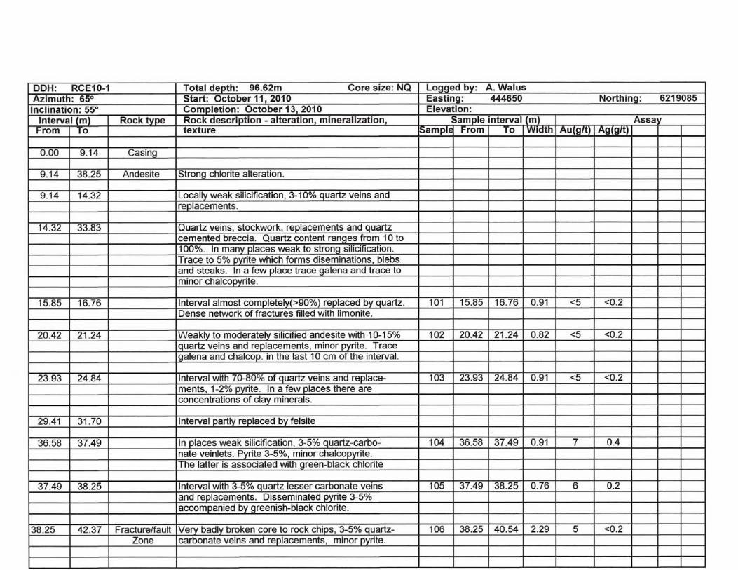
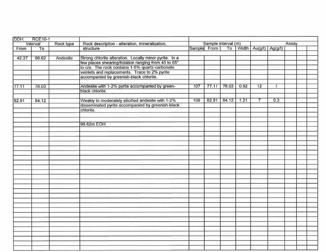
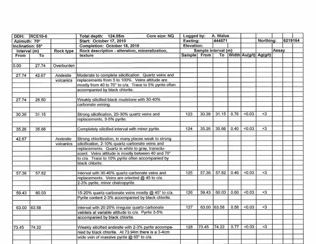
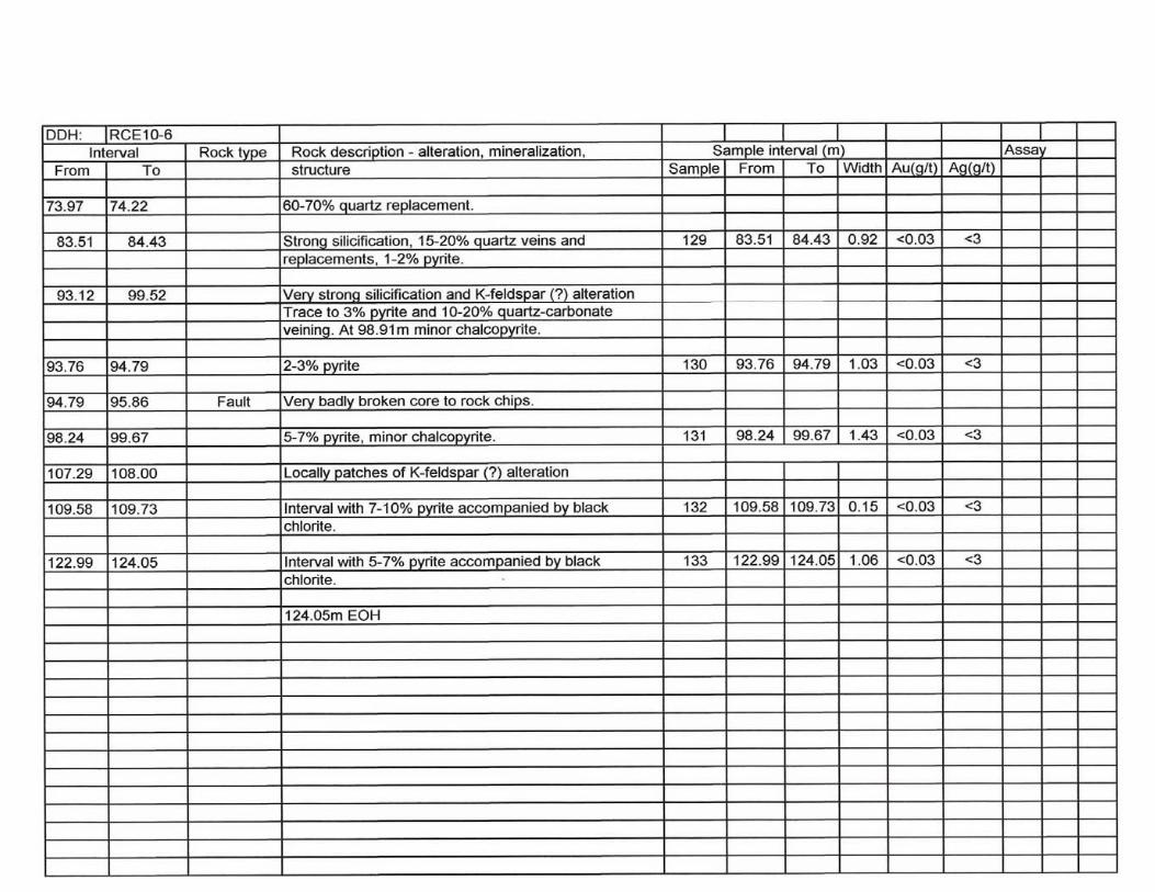
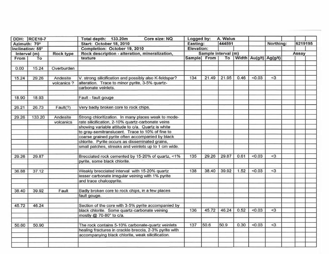
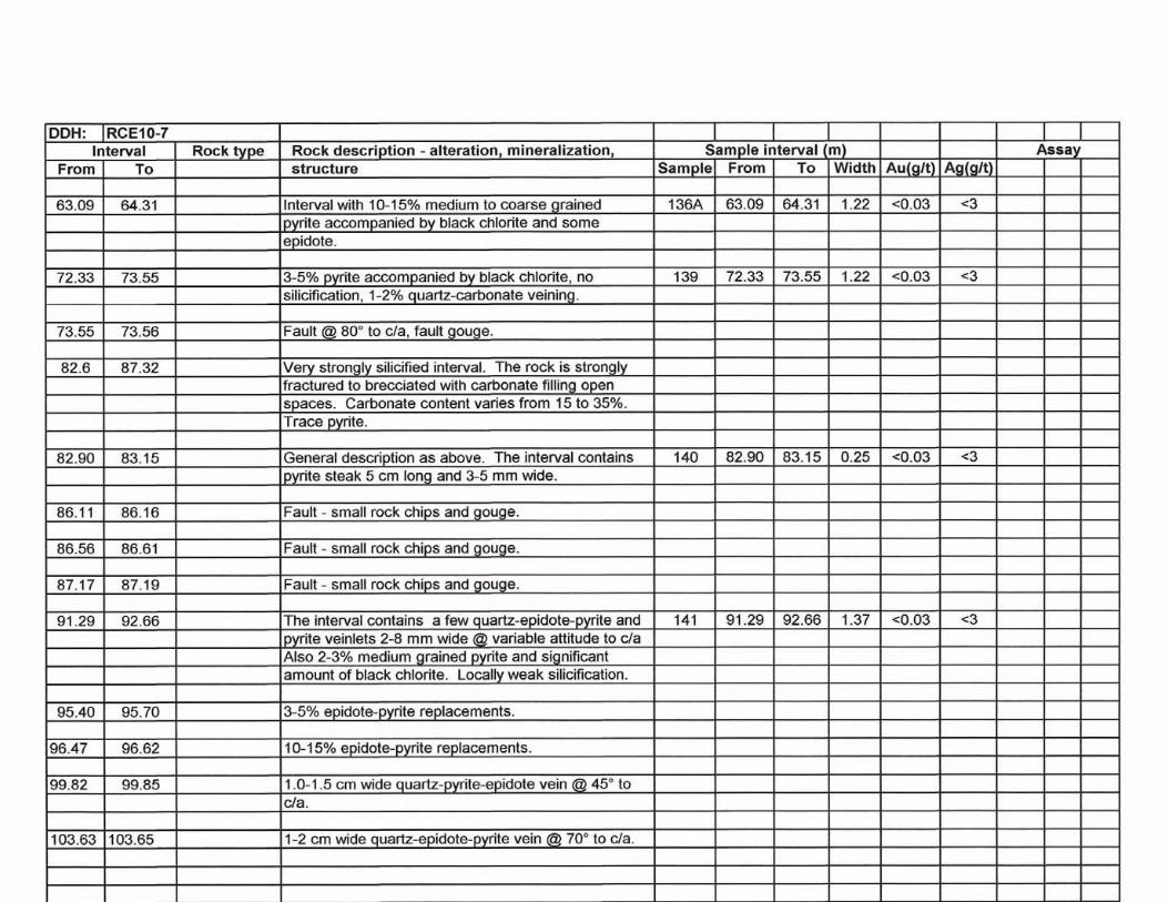
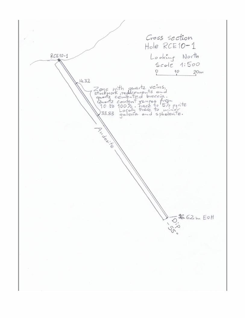
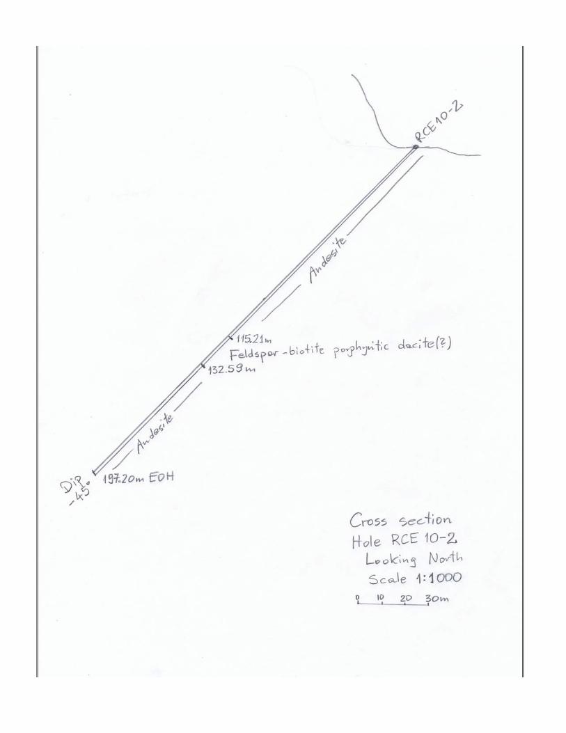
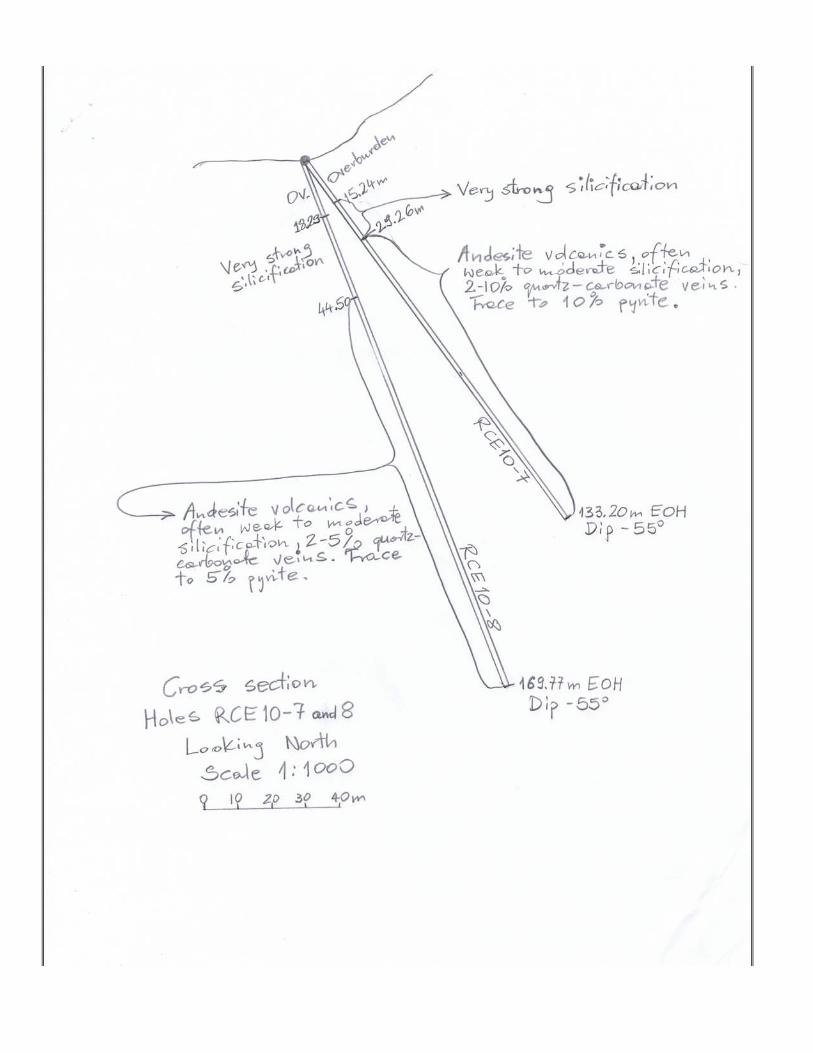
2010 DRILLING Introduction The 2010 drilling program on Red Cliff East property consisted of 8 diamond drill holes totaling 1004 metres of NQ core. One hole could not reach bedrock and was terminated in overburden at 32.61metres. Information about each hole azimuth, dip and GPS coordinates is includes in drill logs (see appendix I). All drilling was done from 5 pads which locations are shown on figure 3. Drilling was done by Titan Drilling of Smithers, BC using a modified Longyear-38 drill. No camp was constructed on the property. Drillers stayed in Stewart and were driving every day to the job site. The entire core from the drilling was logged on the property. The boxes with the marked intervals for sampling have been transported to Stewart for splitting. After splitting, the entire remaining core was securely stored on the property. A total of 51 core samples were collected from the holes. Eight samples collected from the hole RCE10-1 were analyzed for gold, silver and 31 elements ICP, the remaining 43 core samples were assayed just for gold and silver. All core and rock samples were analyzed by Actlabs of Ancaster, Ontario. Results Holes RCE10-1, 6, 7 and 8 tested a quartz-chlorite+/-sericite+/-carbonate+/-pyrite alteration zone. The zone is marked on the surface as a prominent ridge 50-70 metres wide and at least 200 metres long. The holes intersected broad intervals of weakly to very strongly silicified andesitic rocks with 3 to 10 percent quartz-carbonate veins. Sulphides were represented by trace to 5% medium to coarse grained pyrite often accompanied by black-green chlorite. Locally trace to minor chalcopyrite, galena and sphalerite were also noted. Core samples collected from these holes were not anomalous in gold or silver. Hole RCE10-2 was drilled to test section of the 2009 soil line which returned anomalous values in silver, copper, lead and zinc. The hole intersected some carbonate lesser chlorite and epidote veining. In a few spots trace to minor pyrite, chalcopyrite and sphalerite were seen. Six core samples collected from the hole did not recorded anomalous gold or silver values.
10
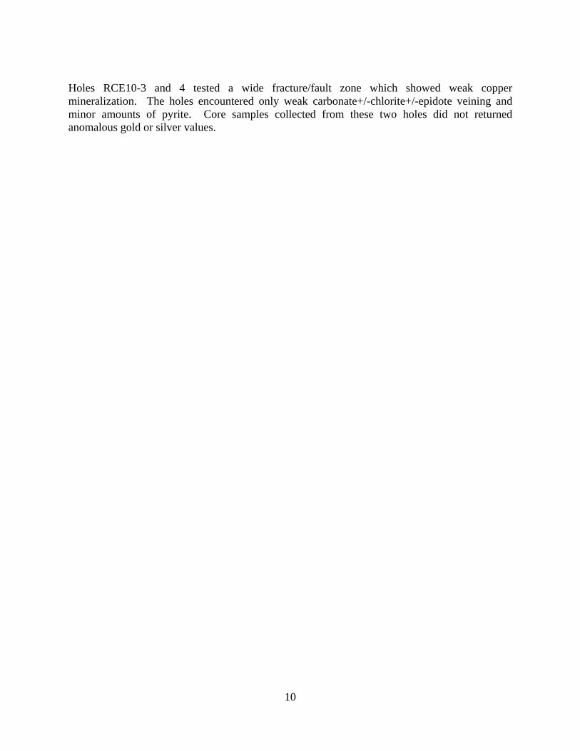
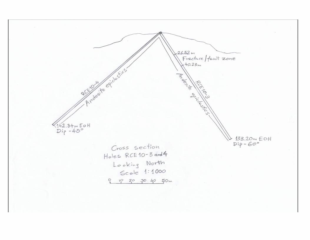
Holes RCE10-3 and 4 tested a wide fracture/fault zone which showed weak copper mineralization. The holes encountered only weak carbonate+/-chlorite+/-epidote veining and minor amounts of pyrite. Core samples collected from these two holes did not returned anomalous gold or silver values.

11
Figure 3 Drillholes and Rock Samples Location Map

12
CONCLUSIONS
The results from the core and rock samples obtained during the 2010 exploration program did not returned any anomalous precious metal values. One of the rock samples yielded anomalous silver (5.8 ppm) and copper (1010 ppm) values. RECOMMENDATIONS The recommended work on the Red Cliff East property includes the following:
1) More prospecting and soil sampling above a portion of the 2009 soil line which showed the most anomalous results.
2) An attempt should be made to explain the source of highly anomalous gold in the 2009 silt samples collected from creeks draining the western portion of the property. The cost of the recommended work is estimated at 20,000 dollars.
REFERENCES
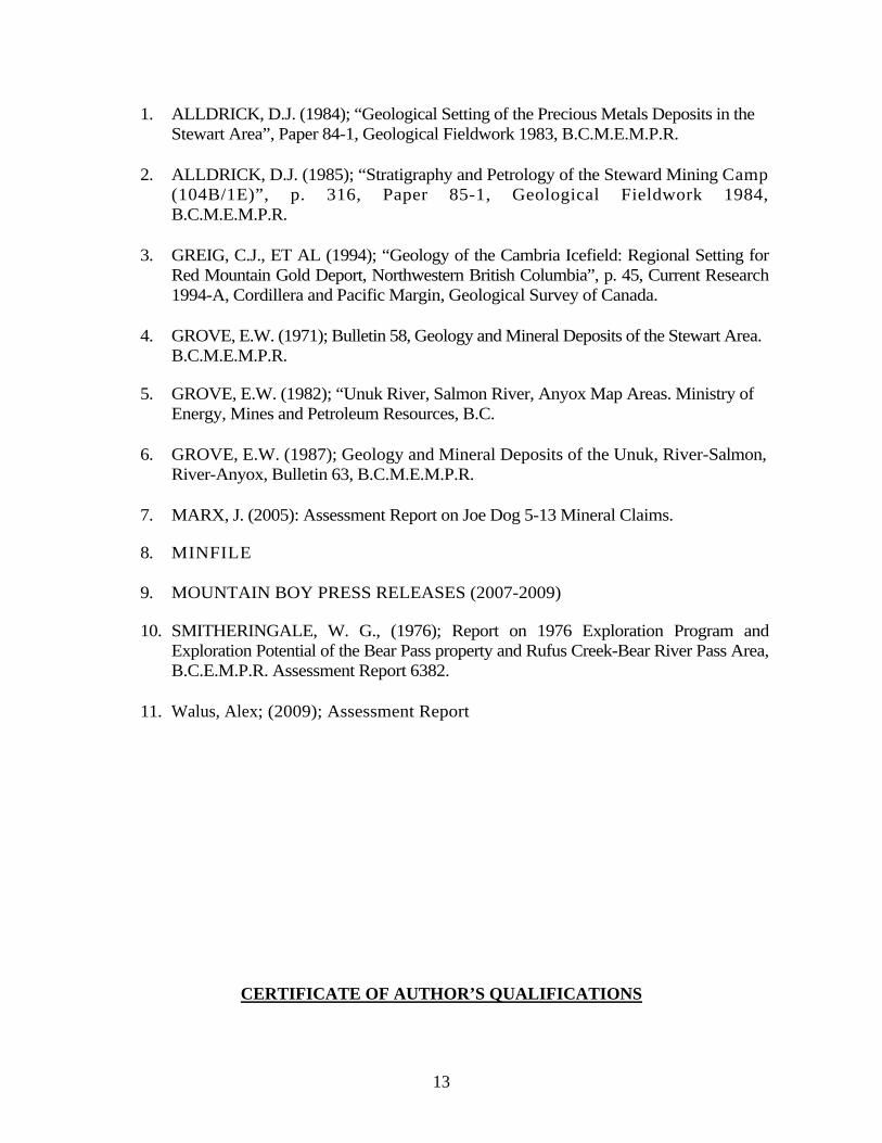
13
1. ALLDRICK, D.J. (1984); “Geological Setting of the Precious Metals Deposits in the Stewart Area”, Paper 84-1, Geological Fieldwork 1983, B.C.M.E.M.P.R.
2. ALLDRICK, D.J. (1985); “Stratigraphy and Petrology of the Steward Mining Camp (104B/1E)”, p. 316, Paper 85-1, Geological Fieldwork 1984, B.C.M.E.M.P.R.
3. GREIG, C.J., ET AL (1994); “Geology of the Cambria Icefield: Regional Setting for Red Mountain Gold Deport, Northwestern British Columbia”, p. 45, Current Research 1994-A, Cordillera and Pacific Margin, Geological Survey of Canada.
4. GROVE, E.W. (1971); Bulletin 58, Geology and Mineral Deposits of the Stewart Area. B.C.M.E.M.P.R.
5. GROVE, E.W. (1982); “Unuk River, Salmon River, Anyox Map Areas. Ministry of Energy, Mines and Petroleum Resources, B.C.
6. GROVE, E.W. (1987); Geology and Mineral Deposits of the Unuk, River-Salmon, River-Anyox, Bulletin 63, B.C.M.E.M.P.R.
7. MARX, J. (2005): Assessment Report on Joe Dog 5-13 Mineral Claims.
8. MINFILE
9. MOUNTAIN BOY PRESS RELEASES (2007-2009)
10. SMITHERINGALE, W. G., (1976); Report on 1976 Exploration Program and Exploration Potential of the Bear Pass property and Rufus Creek-Bear River Pass Area, B.C.E.M.P.R. Assessment Report 6382.
11. Walus, Alex; (2009); Assessment Report
CERTIFICATE OF AUTHOR’S QUALIFICATIONS

14
I, Alojzy Aleksander Walus, of 8546-164 Street, Surrey, in the Province of British Columbia, do hereby certify that:
1. I am a graduate of the University of Wroclaw, Poland and hold M.Sc. Degree in Geology. 2. I am a consulting geologist working on behalf of Nanika Resources. 3. I have worked in British Columbia from 1988 to 2010 as a geologist with several
exploration companies. 4. I am a member in good standing of the Association of Professional Engineers and
Geoscientists of the Province of British Columbia. 5. This report is based on my work completed on the Red Cliff East Property in the period
from October 9 to 27, 2010.
6. I authorize Nanika Resources to use information in this report or portions of it in any brochures, promotional material or company reports.
“Alojzy A. Walus” _____________________
DATED AT VANCOUVER, B.C., January 20, 2011 Alojzy A. Walus, P.Geo.
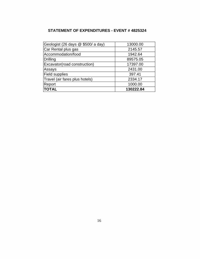
STATEMENT OF EXPENDITURES - EVENT # 4825324
Geologist (26 days @ $500/ a day) 13000.00 Car Rental plus gas 2145.57 Accommodation/food 1942.64 Drilling 89575.05 Excavator(road construction) 17397.00 Assays 2431.00 Field supplies 397.41 Travel (air fares plus hotels) 2334.17 Report 1000.00 TOTAL 130222.84
16
APPENDIX I
DRILLOGS WITH GOLD AND SILVER RESULTS


APPENDIX II
DRILLHOLES CROSS SECTIONS


APPENDIX III
ASSAY CERTIFICATES