ASSESSMENT OF THE ARBOREAL SPECIES DIVERSITY AND ... · Pantanal soils are generally influenced in...
16
ASSESSMENT OF THE ARBOREAL SPECIES DIVERSITY AND CORRELATION BETWEEN THE SPECIES DISTRIBUTION AND SOIL CHARACTERISTICS AMONG PARAGUAY RIVER ISLANDS, SECTION BETWEEN CACERES AND TAIMˆ ECOLOGICAL STATION, PANTANAL, BRAZIL Solange Kimie IKEDA CASTRILLON 1 Carolina Joana DA SILVA 2 JosØ Ricardo Castrillon FERNANDEZ 3 Ronaldo JosØ NEVES 4 Ingrid LEITE 5 Abstract This study assessed the diversity of trees in six islands of Paraguay River, between Caceres and Taimª Ecological Station in Pantanal, Brazil. These islands originated from two geomorphologic processes: meander neck rupture and sedimentation, which were compared. A Canonical Correspondence Analysis and a Cluster and Discriminant Analysis were used to determine the correlations between the abundance of tree species and the variables of soil attributes (chemical and textural properties). Geo-technologies such as remote sensing imagery and GPS were important tools used during this work. The group formed by the most frequent and abundant species in the islands Sapium obovatum, Psidium nutans and Laetia americana was positively correlated with soil properties that presented high values in the islands, such as magnesium and saturation of magnesium, aluminum, clay and silt. Key words: Diversity. Soil. Fertility. Flood. Resumo Avaliaªo da diversidade arbrea e correlaªo entre a distribuiªo das espØcies e as caracteristicas dos solos em ilhas do Rio Paraguai entre CÆceres e Estaªo Ecolgica de Taiamª, Pantanal Matogrossense, Brasil Este estudo avaliou a diversidade da vegetaªo arbrea em seis ilhas do rio Paraguai, entre CÆceres e a Estaªo Ecolgica de Taiamª, Pantanal Matogrossense. Foram comparadas ilhas formadas por dois processos geomorfolgicos: a partir do rompimento do colo do meandro do canal e de sedimentaªo. AnÆlise de CorrespondŒncia Cannica, AnÆlise de Cluster e Discriminante foram utilizadas para verificar as correlaıes entre a abundancia das espØcies arbreas e as variÆveis dos atributos do solo (propriedades qumicas e texturais). Geotecnologias como imagens de sensoriamento remoto e GPS foram ferramentas importantes na execuªo deste trabalho. O grupo formado pelas espØcies mais freqüentes e abundantes nas ilhas: Sapium obovatum, Psidium nutans e Laetia americana, correlacionou positivamente com atributos do solo que nas ilhas apresentaram altos valores, como magnØsio e saturaªo por magnØsio, alumnio trocÆvel, argila e silte. Palavras-chave: Diversidade. Solos. Fertilidade. Inundaªo. 1 Mato Grosso State University, CÆceres Campus, Assistant Professors at the Department of Biological Sciences. Av. Sªo Joªo s/n. Bairro Cavalhada. CEP: 78200-000. CÆceres-MT, Brasil. E-mail: [email protected] 2 Mato Grosso State University, CÆceres Campus, Assistant Professors at the Department of Biological Sciences. Av. Sªo Joªo s/n. Bairro Cavalhada. CEP: 78200-000. CÆceres-MT, E-mail: [email protected] 3 Federal Institute of Education, Science and Technology of Mato Grosso - CÆceres Campus. Assistant Professor. Av. dos Ramires S/N, Distrito Industrial - CEP: 78200-000. CÆceres-MT, Brasil. E-mail: [email protected] 4 Mato Grosso State University, CÆceres Campus, Assistant Professors at the Department of Geography. Av. Sªo Joªo s/n. Bairro Cavalhada. CEP: 78200-000. CÆceres-MT. E-mail: [email protected] 5 Mato Grosso State University, CÆceres Campus, Expert in Agrarian Residency. Av. Sªo Joªo s/n. Bairro Cavalhada. CEP: 78200-000. CÆceres-MT, Brasil. E-mail: [email protected] GEOGRAFIA, Rio Claro, v. 36, Nœmero Especial, p. 119-134, jun. 2011.
Transcript of ASSESSMENT OF THE ARBOREAL SPECIES DIVERSITY AND ... · Pantanal soils are generally influenced in...
ASSESSMENT OF THE ARBOREAL SPECIES DIVERSITY ANDCORRELATION BETWEEN THE SPECIES DISTRIBUTION AND
SOIL CHARACTERISTICS AMONG PARAGUAY RIVER ISLANDS,SECTION BETWEEN CACERES AND TAIMÃ ECOLOGICAL
STATION, PANTANAL, BRAZIL
Solange Kimie IKEDA CASTRILLON1
Carolina Joana DA SILVA2
José Ricardo Castrillon FERNANDEZ3
Ronaldo José NEVES4
Ingrid LEITE5
Abstract
This study assessed the diversity of trees in six islands of Paraguay River, between Caceresand Taimã Ecological Station in Pantanal, Brazil. These islands originated from two geomorphologicprocesses: meander neck rupture and sedimentation, which were compared. A CanonicalCorrespondence Analysis and a Cluster and Discriminant Analysis were used to determine thecorrelations between the abundance of tree species and the variables of soil attributes (chemicaland textural properties). Geo-technologies such as remote sensing imagery and GPS wereimportant tools used during this work. The group formed by the most frequent and abundantspecies in the islands Sapium obovatum, Psidium nutans and Laetia americana was positivelycorrelated with soil properties that presented high values in the islands, such as magnesium andsaturation of magnesium, aluminum, clay and silt.
Key words: Diversity. Soil. Fertility. Flood.
Resumo
Avaliação da diversidade arbórea e correlação entre a distribuição das espécies eas caracteristicas dos solos em ilhas do Rio Paraguai entre Cáceres e Estação
Ecológica de Taiamã, Pantanal Matogrossense, Brasil
Este estudo avaliou a diversidade da vegetação arbórea em seis ilhas do rio Paraguai,entre Cáceres e a Estação Ecológica de Taiamã, Pantanal Matogrossense. Foram comparadasilhas formadas por dois processos geomorfológicos: a partir do rompimento do colo do meandrodo canal e de sedimentação. Análise de Correspondência Canônica, Análise de Cluster eDiscriminante foram utilizadas para verificar as correlações entre a abundancia das espéciesarbóreas e as variáveis dos atributos do solo (propriedades químicas e texturais). Geotecnologiascomo imagens de sensoriamento remoto e GPS foram ferramentas importantes na execução destetrabalho. O grupo formado pelas espécies mais freqüentes e abundantes nas ilhas: Sapiumobovatum, Psidium nutans e Laetia americana, correlacionou positivamente com atributos do soloque nas ilhas apresentaram altos valores, como magnésio e saturação por magnésio, alumíniotrocável, argila e silte.
Palavras-chave: Diversidade. Solos. Fertilidade. Inundação.
1 Mato Grosso State University, Cáceres Campus, Assistant Professors at the Department of BiologicalSciences. Av. São João s/n. Bairro Cavalhada. CEP: 78200-000. Cáceres-MT, Brasil.E-mail: [email protected]
2 Mato Grosso State University, Cáceres Campus, Assistant Professors at the Department of BiologicalSciences. Av. São João s/n. Bairro Cavalhada. CEP: 78200-000. Cáceres-MT, E-mail: [email protected]
3 Federal Institute of Education, Science and Technology of Mato Grosso - Cáceres Campus. AssistantProfessor. Av. dos Ramires S/N, Distrito Industrial - CEP: 78200-000. Cáceres-MT, Brasil.E-mail: [email protected]
4 Mato Grosso State University, Cáceres Campus, Assistant Professors at the Department of Geography. Av.São João s/n. Bairro Cavalhada. CEP: 78200-000. Cáceres-MT. E-mail: [email protected]
5 Mato Grosso State University, Cáceres Campus, Expert in Agrarian Residency. Av. São João s/n. BairroCavalhada. CEP: 78200-000. Cáceres-MT, Brasil. E-mail: [email protected]
GEOGRAFIA, Rio Claro, v. 36, Número Especial, p. 119-134, jun. 2011.
120 GEOGRAFIA
Assessment of the arboreal species diversity and correlation between thespecies distribution and soil characteristics among Paraguay River islands,
section between Caceres and Taimã Ecological Station, Pantanal, Brazil
INTRODUCTION
The diversity of the Pantanal can only be understood considering a continentalapproach, since it is located among three large morpho-climatic and phyto-geographic domainsin South America: Cerrado, Chaco and Pre-Amazonia, and it behaves, from a phyto-geographicpoint of view, as a fragile zone of ecological tension (AB�SABER, 2006, p.65).
In Mato Grosso, Pantanal also has a flooded area characterized by a rich diversity ofhabitats, species and processes. The ecology of this region is determined by the flood pulsewhich depends on the geometry of the system, including the total quantity and periodicityof river discharges and its flow on flooded plains, the form of riverbeds, and the sedimentaryload (JUNK; DA SILVA, 1999, p.25).
The fluvial-morphological peculiarities of several rivers result in different intensities,flood durations, soil features and vegetation types, leading to the formation of distinctPantanal regions (ADÁMOLI, 1986, p.105). Additionally, Silva & Abdon (1998, p.1706) consideredthe geopolitical division to propose eleven sub-units named sub-watersheds or sub-regions:�Pantanal de Cáceres�, the region of this study; �Poconé�; �Barão de Melgaço�; �Paraguai�;�Paiaguás�; �Nhecolândia�; �Aquidauana�; �Miranda�; �Abobral�; �Nabileque� and �PortoMurtinho�.
Among the studies relating floristic and phyto-sociological composition to soil andvegetation at the Pantanal in Mato Grosso, those ones of Duarte (2007, p.110), carried outat �Pantanal de Barão de Melgaço�, and of Soares & Oliveira (2009, p.276), at �Pantanal deMiranda�, related edaphic factors to �paratudais�, formations with mono-dominance of Tabebuiaaurea Benth. & Hook.f ex. S. Moore. In addition, Salis (2006, p.239) studied the abundanceand the distribution of tree species, as well as their correlations to soil fertility in areas ofCerradão (savanna woodland) at the Pantanal in Mato Grosso do Sul State, while Cardoso etal. (2010, p.1034) reported that the conversion of native forests into pastures cultivated atPantanal reduces carbon storage in the soil.
Pantanal soils are generally influenced in their formation since they are originatedfrom the upland where Latosols, weathered soils and soils rich in aluminum oxides predominate(COUTO; OLIVEIRA, 2009, p.75). These soils have peculiarities due to its topographicallocation and the water regime to which they are subjected; these pedologic characteristicsmust be considered for their use and management (SOARES et al. 2006).
A geomorphologic partitioning of �Pantanal de Cáceres� was carried out by Assineand Silva (2009, p.190) and Silva (2010, p.19) using satellite images to recognize themorphological elements (active channels, point bars, levees, abandoned meanders, oxbowlakes, paleo-channels, channel rupture sites, avulsion etc.) that are important to understandthe diversity of soils and plant species in the area under study. Between the urban area ofCáceres and Taiamã Ecological Station at Paraguay River, Souza et al. (2007, p.35) verifiedislands formed from the meander neck rupture and from the sedimentation process.
The six islands investigated on the Paraguay River, between Cáceres and TaiamãEcological Station, constitute morphological elements composing the Pantanal landscape atCáceres, where Eutrophic Gley soil predominate, with clay presenting high cation exchangecapacity (SOARES et al., 2006).
OBJECTIVE
To compare the arboreal diversity among islands formed due to a meander neckrupture and sedimentation process, analyzing the correlations between arboreal speciesdistribution and variables of soil attributes.
121Ikeda Castrillon, S. K. / da Silva, C. J. /
Fernandez, J. R. C. / Neves, R. J. / Leite, I.v. 36, Número Especial jun. 2011
MATERIAL AND METHODS
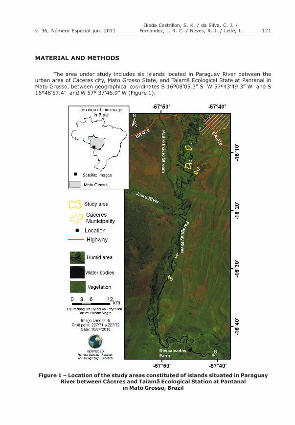
The area under study includes six islands located in Paraguay River between theurban area of Cáceres city, Mato Grosso State, and Taiamã Ecological State at Pantanal inMato Grosso, between geographical coordinates S 16º08�05.3� S W 57º43�49.3� W and S16º48�57.4� and W 57° 37�46.9� W (Figure 1).
Figure 1 � Location of the study areas constituted of islands situated in ParaguayRiver between Cáceres and Taiamã Ecological Station at Pantanal
in Mato Grosso, Brazil

122 GEOGRAFIA
Assessment of the arboreal species diversity and correlation between thespecies distribution and soil characteristics among Paraguay River islands,
section between Caceres and Taimã Ecological Station, Pantanal, Brazil
These islands are submitted to inundation during the flooding period and are situatedwithin the following geomorphologic compartments of Pantanal at Cáceres: Meander plainwith meandering channel, Meander plain with straight channel and Current depositional lobeof the Paraguay fan (SILVA, 2010, p.20).
Islands 1, 2 and 3, with coordinates in the central area between S 16°09�02.5" and W57°45�16.3"W, S 16°12�08.7" and W 57°45�23.9"W, and S 16°13�24.7" and W 57°43�59.4"respectively, are located in the compartment Meander plain with meandering channel andshow a sinuosity index ranging from 1.5 to 2.2. The islands in this compartment were formedas a result of the meandering dynamics of abandonment and creation of a new channel bythe Paraguay River from the rupture of the channel neck.
Islands 4 and 5 (geographical coordinates: S 16°27�59.5" and W 57°47�33.4", and S16°31�18.1" and W 57°48�49.5"W) are located in the Meander plain with straight channel,where Paraguay River channel differs from the previous compartment due to its low sinuosity(index ≤ 1.1) and the island formation is due to the deposition process.
Island 6 (geographical coordinates: 16°44�50.8"S and 57°40�59.3"W) is located in thecurrent depositional lobe of the Paraguay, where the Paraguay River is meandering butdifferently from that one of Meander plain with meandering channel, due to the lowersinuosity of the former. Its formation process is the same as that of islands 4 and 5,sediment deposition and consequent colonization by vegetation. Therefore the islands weregrouped in two categories due to its geomorphologic formation processes: channel neckrupture (islands 1, 2 and 3) and deposition (4, 5 and 6).
The digital processing of the images from TM Landsat 5 and HRC of CBERS 2B werecarried out using SPRING 4.3.3 (CÂMARA et. al., 1996) software, involving the steps ofrecording, color space transformation (RGB-IHS-RGB) according to Tu et al. (2001), cuttingof the areas under study, segmentation and classification of the investigated areas,discriminating three classes: Arboreal vegetation, Flooding fields and Water. Layouts wereprepared in ArcGis of Esri. A field survey was carried out to validate the classification ofimages, and check those classes which raised doubts during the interpretation step, using aGPS.
The thematic maps generated supported the selection of sites for the establishmentof 22 plots, distributed in edge and central areas, occupied by arboreal vegetation, asexemplified in figure 2. Plots had a size of 10m x 20m, totaling 200m2 per plot, considering forthis study all trees with DBH (Diameter at Breast Height) ≥ 5cm.
The floristic similarity among the islands was analyzed by an agglomerative classificationusing UPGMA (Unweighted Pair Groups Method using Arithmetic Averages) (JAMES;McCULLOCH, 1990, p. 129). The classification through UPGMA resulted in dendrograms basedon simple clustering and Euclidean distance of Sorensen�s similarity indexes, which indicatesthe hierarchies among the groups formed.
A hand auger was used to collect random samples from 15 points per plot at 0 to 20cm depth for analysis of the chemical and granulometric characteristics of the soils. Forwaterlogged soils, cuts were done using a machete at the established depth to allowcollections. Soil samples from each plot were homogenized to obtain a composite sample ofaround 500 g.
Soil samples were stored in plastic bags which were labeled and sent to �Agro Análise�Lab (Cuiabá, Mato Grosso) for the determination of the following attributes: hydrogen potential(pH in water), levels of potassium (K) (mg/dm3), phosphorus (P) (mg/dm3), calcium (Ca)(cmolc/dm3), magnesium (Mg) (cmolc/dm3), hydrogen (H) (cmolc/dm3), aluminum (Al) (cmolc/dm3), sum of bases (SB) (cmolc/dm3), cation exchange capacity (CEC) (cmolc/dm3), basesaturation (S) (%), organic matter (OM) (g/dm3), calcium (Ca) (%), magnesium (Mg) (%),potassium (K) (%), hydrogen (H) (%) and aluminum (Al) (%), and proportions of sand, siltand clay (g/Kg). The laboratory procedures followed the protocol of EMBRAPA (1997, p.3-180).

123Ikeda Castrillon, S. K. / da Silva, C. J. /
Fernandez, J. R. C. / Neves, R. J. / Leite, I.v. 36, Número Especial jun. 2011
Soil attributes among the islands were subjected to Lilliefors� normality test andevaluated by ANOVA (Analysis of Variance) and multiple comparison among means usingTukey�s test. After logarithmization (P and H) and removal of outliers (O.M.), the variableswithout normal distribution (sand, silt and clay) were assessed using Kruskal-Wallis test,followed by Dunn�s test, using the software BioEstat 5.0 (AYRES et al., 2003).
Correlations among arboreal species distribution and variables of soil attributes (chemicaland textural properties) were established using a mixed gradient analysis and evaluated bymeans of a Canonical Correspondence Analysis � CCA (TER BRAAK, 1987, p. 170). Currently,this multivariate analysis has been recommended when the objective is to obtain a closerrelationship between environmental variables and species abundance. The species matrixwas constituted by the number of individuals per species in each plot, using species withfive or more individuals.
The average of each variable was determined per species and considered an attributeassociated with the number of individuals (TER BRAAK, 1987, p. 170). The average ofvariables per species were considered to perform a cluster analysis according to the minimumvariance method, resulting in clusters of species based on dissimilarity, followed by discriminantanalysis using the XLSTAT system, version 2009 (trademark Addinsoft). For multivariateanalyses, data were standardized considering that the chemical and physical attributes ofthe soils studied in this work are constituted by units of different measures.
RESULTS AND DISCUSSION
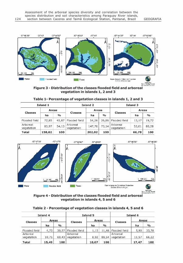
The classifications of fused remote sensing imagery, with medium resolution, allowedthe generation of thematic maps from the islands, distinguishing the classes Flooded fieldand Forest vegetation (Figures 3 and 4), and the estimate of the percentages of the areasin each mapped class, as shown in tables 1 and 2.
Figure 2 - Distribution of plots for surveying the tree species
124 GEOGRAFIA
Assessment of the arboreal species diversity and correlation between thespecies distribution and soil characteristics among Paraguay River islands,
section between Caceres and Taimã Ecological Station, Pantanal, Brazil
Figure 3 - Distribution of the classes flooded field and arborealvegetation in islands 1, 2 and 3
Figure 4 - Distribution of the classes flooded field and arborealvegetation in islands 4, 5 and 6
Table 2 - Percentage of vegetation classes in islands 4, 5 and 6
Table 1- Percentage of vegetation classes in islands 1, 2 and 3
125Ikeda Castrillon, S. K. / da Silva, C. J. /
Fernandez, J. R. C. / Neves, R. J. / Leite, I.v. 36, Número Especial jun. 2011
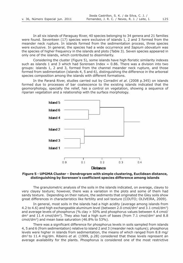
In all six islands of Paraguay River, 40 species belonging to 34 genera and 21 familieswere found. Seventeen (17) species were exclusive of islands 1, 2 and 3 formed from themeander neck rupture. In islands formed from the sedimentation process, three specieswere exclusive. In general, the species had a wide occurrence and Sapium obovatum wasthe species of higher frequency in the islands and plots (Table 3). Seven species appeared inonly one of the islands, which contributed to dissimilarity.
Considering the cluster (Figure 5), some islands have high floristic similarity indexessuch as islands 1 and 3 which had Sorensen Index = 0.86. There was a division into twogroups: islands 1, 2 and 3, formed from the channel meander neck rupture, and thoseformed from sedimentation (islands 4, 5 and 6), distinguishing the difference in the arborealspecies composition among the islands with different formations.
In the Paraná River, studies carried out by Corradini et al. (2008 p.345) on islandsformed due to processes of bar coalescence to the existing islands indicated that thegeomorphology, specially the relief, has a control on vegetation, showing a sequence ofriparian vegetation and a relationship with the surface morphology.
Figure 5 - UPGMA Cluster � Dendrogram with simple clustering, Euclidean distance,distinguishing by Sorensen�s coefficient species difference among islands
The granulometric analysis of the soils in the islands indicated, on average, clayey tovery clayey texture; however, there was a variation in the plots and some of them hadsandy texture. Depending on their nature, the sediments that originated the Gley soils showgreat differences in characteristics like fertility and soil texture (COUTO; OLIVEIRA, 2009).
In general, most soils in the islands had a high acidity (average among islands from4.2 to 4.6) and high exchangeable aluminum level (between 2.0 cmol/dm3 and 3.1 cmol/dm3)and average levels of phosphorus (% clay > 50% and phosphorus values between 4.4 cmol/dm3 and 11.4 cmol/dm3). They also had a high sum of bases (from 7.1 cmol/dm3 and 8.8cmol/dm3) and mean base saturation (46.8% to 53%).
There was a significant difference for phosphorus levels in soils sampled from islands4, 5 and 6 (from sedimentation) relative to island 2 and 3 (meander neck rupture); phosphoruslevels were higher in islands from sedimentation, the means of which ranged from 8.8 mg/dm3 to 11.4 mg/dm. Ribeiro et al. (1999, p.28) considered that these levels represent anaverage availability for the plants. Phosphorus is considered one of the most restrictive
126 GEOGRAFIA
Assessment of the arboreal species diversity and correlation between thespecies distribution and soil characteristics among Paraguay River islands,
section between Caceres and Taimã Ecological Station, Pantanal, Brazil
elements to plant growth and development according to the low available levels in naturaloccurrence.
A difference in the exchangeable aluminum level (Al) was detected only for island 6(from sedimentation), where the Al level was lower than in the remaining islands; however,exchangeable Al values were high in general. In Northern Pantanal, several studies on Gleysoils have identified extensive areas showing a large quantity of exchangeable aluminum(COUTO; OLIVEIRA, 2009).
According to Soares & Oliveira (2009), in the soil of �Pantanal de Miranda� aluminumconcentrations were high, causing toxicity; however, the negative effects of this elementfor vegetation are minimized by the presence of calcium and magnesium, present at highconcentration in the area; the same pattern occurs in the islands studied. Deforestation inthe Araguaia Watershed for extensive pasture implantation reduced the values of phosphorus,calcium and magnesium and increased the total acidity of soils (FARIA et al.,2010, p.523).
Gley soils at Pantanal occupy around 10% of the area along Paraguay, Taquari andsmaller rivers. Their characteristics are highly diversified, presenting moderately to highlyclayey textures and eutrophic, dystrophic and aluminate character (FERNANDES, et al.,2007). The soils in the islands are clayey and dystrophic.
From the 40 species found in the islands, after the removal of those with less than 5individuals, 27 species, with 1833 arboreal individuals, were used for multivariate analyses(Table 3).
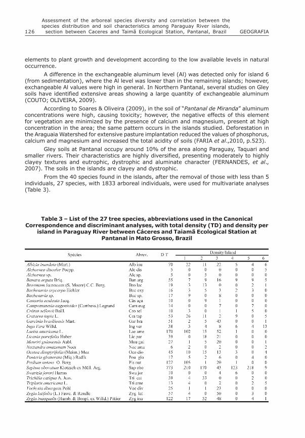
Table 3 � List of the 27 tree species, abbreviations used in the CanonicalCorrespondence and discriminant analyses, with total density (TD) and density per
island in Paraguay River between Cáceres and Taiamã Ecological Station atPantanal in Mato Grosso, Brazil
127Ikeda Castrillon, S. K. / da Silva, C. J. /
Fernandez, J. R. C. / Neves, R. J. / Leite, I.v. 36, Número Especial jun. 2011
Figure 6 - Clustering dendrogram (Dissimilarity, Euclidean distance and minimumvariation) related to the soil characteristics for each tree species in the
islands sampled in Paraguay River, between Cáceres andTaiamã Ecological Station in Mato Grosso, Brazil
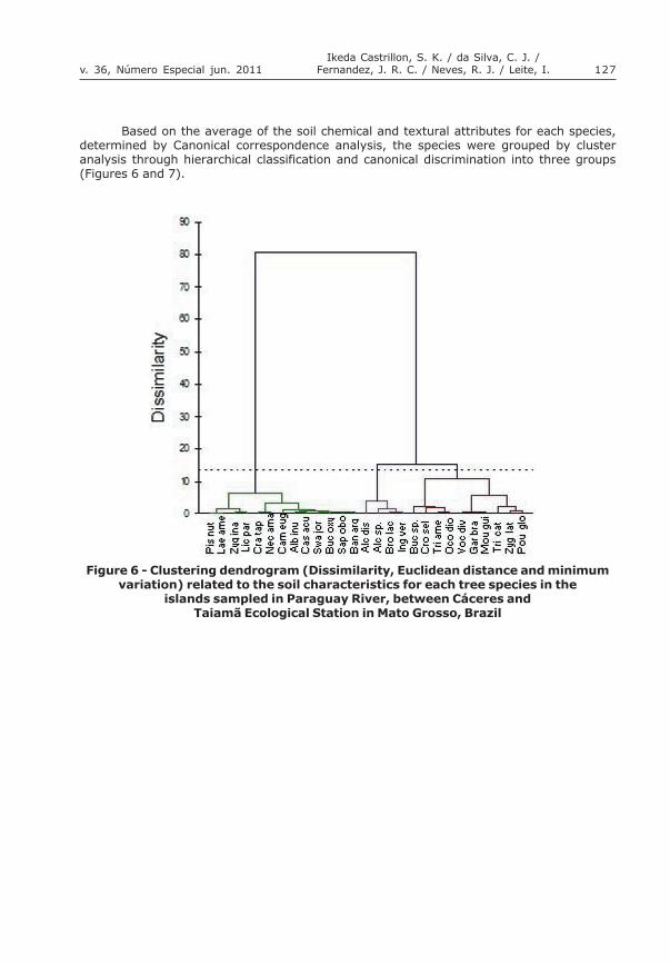
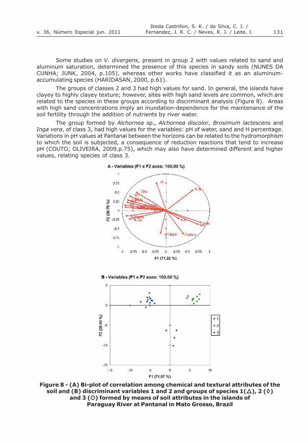
Based on the average of the soil chemical and textural attributes for each species,determined by Canonical correspondence analysis, the species were grouped by clusteranalysis through hierarchical classification and canonical discrimination into three groups(Figures 6 and 7).
128 GEOGRAFIA
Assessment of the arboreal species diversity and correlation between thespecies distribution and soil characteristics among Paraguay River islands,
section between Caceres and Taimã Ecological Station, Pantanal, Brazil
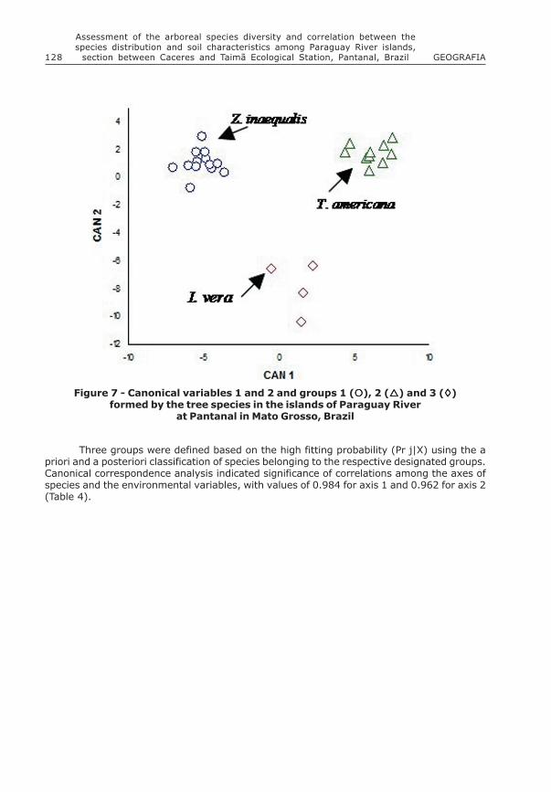
Three groups were defined based on the high fitting probability (Pr j|X) using the apriori and a posteriori classification of species belonging to the respective designated groups.Canonical correspondence analysis indicated significance of correlations among the axes ofspecies and the environmental variables, with values of 0.984 for axis 1 and 0.962 for axis 2(Table 4).
Figure 7 - Canonical variables 1 and 2 and groups 1 (!!!!!), 2 (!!!!!) and 3 (""""")formed by the tree species in the islands of Paraguay River
at Pantanal in Mato Grosso, Brazil

129Ikeda Castrillon, S. K. / da Silva, C. J. /
Fernandez, J. R. C. / Neves, R. J. / Leite, I.v. 36, Número Especial jun. 2011
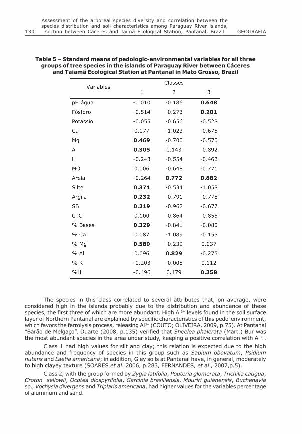
Class 1, with the group formed by the species Sapium obovatum, Psidium nutans,Laetia americana,Crataeva tapia, Banara arguta, Nectandra amazonum, Zygia inaequalis,Buchenavia oxycarpa, Casearia aculeata, Licania parvifolia, Campomanesia eugenioides andSwartzia jorori, had higher values of Mg percentage and Mg, Silt, Base and Al+ Saturation,Sum of Bases and Clay (Table 5).
Table 4 � Partial correlations between the original soil variables and Canonicalvariables 1 and 2 of tree species in the islands of Paraguay River
at Pantanal in Mato Grosso, Brazil
130 GEOGRAFIA
Assessment of the arboreal species diversity and correlation between thespecies distribution and soil characteristics among Paraguay River islands,
section between Caceres and Taimã Ecological Station, Pantanal, Brazil
The species in this class correlated to several attributes that, on average, wereconsidered high in the islands probably due to the distribution and abundance of thesespecies, the first three of which are more abundant. High Al3+ levels found in the soil surfacelayer of Northern Pantanal are explained by specific characteristics of this pedo-environment,which favors the ferrolysis process, releasing Al3+ (COUTO; OLIVEIRA, 2009, p.75). At Pantanal�Barão de Melgaço�, Duarte (2008, p.135) verified that Sheelea phalerata (Mart.) Bur wasthe most abundant species in the area under study, keeping a positive correlation with Al3+.
Class 1 had high values for silt and clay; this relation is expected due to the highabundance and frequency of species in this group such as Sapium obovatum, Psidiumnutans and Laetia americana; in addition, Gley soils at Pantanal have, in general, moderatelyto high clayey texture (SOARES et al. 2006, p.283, FERNANDES, et al., 2007,p.5).
Class 2, with the group formed by Zygia latifolia, Pouteria glomerata, Trichilia catigua,Croton sellowii, Ocotea diospyrifolia, Garcinia brasiliensis, Mouriri guianensis, Buchenaviasp., Vochysia divergens and Triplaris americana, had higher values for the variables percentageof aluminum and sand.
Table 5 � Standard means of pedologic-environmental variables for all threegroups of tree species in the islands of Paraguay River between Cáceres
and Taiamã Ecological Station at Pantanal in Mato Grosso, Brazil
131Ikeda Castrillon, S. K. / da Silva, C. J. /
Fernandez, J. R. C. / Neves, R. J. / Leite, I.v. 36, Número Especial jun. 2011
Some studies on V. divergens, present in group 2 with values related to sand andaluminum saturation, determined the presence of this species in sandy soils (NUNES DACUNHA; JUNK, 2004, p.105), whereas other works have classified it as an aluminum-accumulating species (HARIDASAN, 2000, p.61).
The groups of classes 2 and 3 had high values for sand. In general, the islands haveclayey to highly clayey texture; however, sites with high sand levels are common, which arerelated to the species in these groups according to discriminant analysis (Figure 8). Areaswith high sand concentrations imply an inundation-dependence for the maintenance of thesoil fertility through the addition of nutrients by river water.
The group formed by Alchornea sp., Alchornea discolor, Brosimum lactescens andInga vera, of class 3, had high values for the variables: pH of water, sand and H percentage.Variations in pH values at Pantanal between the horizons can be related to the hydromorphismto which the soil is subjected, a consequence of reduction reactions that tend to increasepH (COUTO; OLIVEIRA, 2009.p.75), which may also have determined different and highervalues, relating species of class 3.
Figure 8 - (A) Bi-plot of correlation among chemical and textural attributes of thesoil and (B) discriminant variables 1 and 2 and groups of species 1(!!!!!), 2 (""""")
and 3 (!!!!!) formed by means of soil attributes in the islands ofParaguay River at Pantanal in Mato Grosso, Brazil

132 GEOGRAFIA
Assessment of the arboreal species diversity and correlation between thespecies distribution and soil characteristics among Paraguay River islands,
section between Caceres and Taimã Ecological Station, Pantanal, Brazil
Nutrient interactions in the ATTZ (Aquatic Terrestrial Transition Zones) wereemphasized by Junk et al. (1989, p.110) and Junk and Da Silva (1999, p.25). According tothese authors, the productivity of flooded areas is the sum of aquatic and terrestrialproductivity. Based on the concept of flood pulse, growing plants in the terrestrial phaseabsorb nutrients from the soil and store them as organic matter. During the aquatic phase,the organic matter and the nutrients are transferred, serving as food base for aquaticorganisms, while the nutrients are absorbed by algae and aquatic macrophytes. The nutrientsreturn to the soil, fertilizing it for the terrestrial phase.
There is a lack of information about the specific correlations among different types ofsoils and diverse variations in forest formations. Variations in the structure and floristiccomposition related to the soil type were already detected in several studies (JACOMINE,2000, p.27). In the Pantanal studies correlating the species to the soil attributes are stillneeded; however, other factors may interfere synergistically with the distribution of thesespecies, such as for instance flooding.
CONCLUSIONS
Referring to floristic similarity, there was a division into two groups, originated fromtwo geomorphologic processes: the meander neck rupture in islands 1, 2 and 3, andsedimentation in islands 4, 5 and 6.
Most soils in the islands had a high acidity and a high exchangeable aluminum level,medium phosphorus levels, a high sum of bases and medium base saturation. The soils inthese islands are clayey and dystrophic.
The group formed by the most abundant species in the islands Sapium obovatum,Psidium nutans and Laetia americana, was correlated to the soil attributes that presenthigh values such as magnesium and saturation by magnesium, exchangeable aluminum, clayand silt.
NOTES
This paper is part of the Doctoral Thesis CASTRILLON, S. K. I. Avaliação dadiversidade arbórea das ilhas do rio Paraguai, entre Cáceres e a Estação Ecológicade Taiamã, Pantanal Matogrossense, Brasil, 2010, 94 f. Thesis (Doctorate) GraduateProgram in Ecology and Natural Resources, Universidade Federal de São Carlos, São Carlos/SP, 2010.
ACKNOWLEDGEMENTS
To �Fundação de Amparo a Pesquisa do Estado do Mato Grosso� (FAPEMAT) forsupporting this study (Process: 045/2007).
133Ikeda Castrillon, S. K. / da Silva, C. J. /
Fernandez, J. R. C. / Neves, R. J. / Leite, I.v. 36, Número Especial jun. 2011
REFERENCES
AB�SABER, A. Brasil: Paisagens de Exceção. O litoral e o Pantanal Mato- Grossense.Patrimônios Básicos. Cotia, SP: Ateliê Editorial, 2006. 182p.
ADÁMOLI, J.A. Fitogeografia do Pantanal. In: SIMPÓSIO SOBRE RECURSOS NATURAIS ESÓCIO-ECONÔMICOS DO PANTANAL, 1. Corumbá/MS, 1986. Anais... Corumbá: EmbrapaPantanal, p.105-106, 1986.
ASSINE, M. L.; SILVA, A. Contrasting fluvial styles of the Paraguay River in the northwesternborder of the Pantanal wetland, Brasil, Geomorphology, v. 113, p. 189 -199, 2009.
AYRES, M.; AYRES Jr.M.; AYRES, D.L.; SANTOS, A.S. dos. BioEstat 5.0: aplicações estatísticasnas áreas das ciências biológicas e médicas. Belém: Sociedade Civil Mamirauá/Brasília: CNPq/Conservation International, Manual do programa Bioestat, 2007. 324p.
CÂMARA, G.; SOUZA, R. C. M.; FREITAS, U. M.; GARRIDO, J. SPRING: integrating remotesensing and GIS by object-oriented data modelling. Comput Graph, v. 20, p. 395-403,1996.
CARDOSO, E. L.; SILVA, M. L. N.; SILVA, C. A., CURI, N.; DE FREITAS, D. A. F. Estoques decarbono e nitrogênio em solo sob florestas nativas e pastagens no bioma Pantanal Pesq.agropec. bras., Brasília, v.45, n.9, p.1028-1035, set. 2010.
CORRADINI, F. A.;STEVAUX, J. C.;FACHINI, M. P. Geomorfologia e distribuição da vegetaçãoripária na lha Mutum, rio Paraná - PR/MS. Geociências. São Paulo, v. 27, n.3, p.345-354.2008.
COUTO, E..G.; OLIVEIRA, V.A. The Soil Diversity of the Pantanal. In: JUNK, W.J., Da SILVA,C. J., NUNES DA CUNHA, C.; WANTZEN, K. M.. (Org.). The Pantanal of Mato Grosso:Ecology, biodiviersity and sustainable management of a large neotropical seasonal wetland.Sofia: Pensoft, p.71-102, 2009.
DUARTE, T.G. Florística, fitossociologia e relações solo-vegetação em florestaestacional semidecídual em Barão de Melgaço, Pantanal de Mato Grosso. 2007. 144p.(Tese de doutorado). Universidade Federal de Viçosa, Viçosa/MG.
EMBRAPA - EMPRESA BRASILEIRA DE PESQUISA AGROPECUÁRIA. Centro Nacional de Pesquisade Solos. Manual de métodos de análises de solo. 2.ed. Rio de Janeiro, 1997. 212 p.
FARIA A. F.G.; SANTOS A.C.;SANTOS T.M.;BATISTELA FILHO, F. Influencia do manejo dosolo nas propriedades físicas e química sem toposequência na bacia do Araguaia, Estado doTocantins. R. Bras. Ci. Solo, v. 34, p. 517-524, 2010.
FERNANDES, F. A.; FERNANDES, A. H. B. M.; SOARES, M. T. S; PELLEGRIN, L. A.; LIMA, I. B.T. de. Atualização do mapa de solos da planície pantaneira para o Sistema Brasileirode Classificação de Solos. Corumbá: EMBRAPA-CPAP, 6p. 2007. (Comunicado Técnico,61).
HARIDASAN, M. Nutrição mineral de plantas nativas do cerrado. Revista Brasileira deFisiologia Vegetal, v.12, n.1, p.54-64, 2000.
JACOMINE, P.K.T. Solos sob matas ciliares. In: RODRIGUES, R.R.; LEITÃO, H.F. (Ed.) Matasciliares: conservação e recuperação. São Paulo: Editora da Universidade de São Paulo,Fapesp. 2000. p. 27-31.
JAMES, F.C.; MCCULLOCH, C.E. Multivariate analysis in ecology and systematics: Panacea orPandora�s box. Annual Review of Ecology and Systematics, v.21, p.129-166, 1990.
JUNK, W.J.; BAYLEY, P.B.; SPARKS, R.E. The flood pulse concept in river-floodplain. CanadianSpecial Publication of Fisheries and Aquatic Science, v.106, p.110-127, 1989.

134 GEOGRAFIA
Assessment of the arboreal species diversity and correlation between thespecies distribution and soil characteristics among Paraguay River islands,
section between Caceres and Taimã Ecological Station, Pantanal, Brazil
JUNK, W.J.; DA SILVA, C.J. O conceito do pulso de inundação e suas implicações para oPantanal de Mato Grosso. In: SIMPÓSIO SOBRE RECURSOS NATURAIS E SÓCIO-ECONÔMICOSDO PANTANAL: MANEJO E CONSERVAÇÃO, 2. Corumbá/MS, 1996. Anais� Corumbá: EmbrapaPantanal, p.17-28, 1999.
NUNES DA CUNHA, C.; JUNK, W.J. Year-to-year changes in water level drive the invasion ofVochysia divergens in Pantanal grasslands. Applied Vegetation Science, v.7, p.103-110,2004.
RIBEIRO, A. C.; GUIMARÃES, P.T.G.; ALVAREZ, V.V.H. Recomendações para uso de corretivose fertilizantes em Minas Gerais. 5ª Aproximação. Viçosa-MG. 1999. 359p.
SALIS S.M.; ASSIS M.A.; CRISPIM S.M.A.; CASA GRANDE, J.C. Distribuição e abundância deespécies arbóreas em cerradões no Pantanal, Estado de Mato Grosso do Sul, Brasil. RevistaBrasileira de Botânica, v.29, n.3, p.339-352, 2006.
SILVA, A. Geomorfologia do megaleque do rio Paraguai, quaternário do PantanalMatogrossense, Centro-Oeste do Brasil, 2010. 127f. Tese (Doutorado) Programa de pós-graduação em Geociências e Meio Ambiente, Instituto de Geociências e Ciências Exatas,Universidade Estadual Paulista, Rio Claro/SP, 2010.
SILVA, J.S.V.; ABDON, M.M. Delimitação do Pantanal brasileiro e suas sub-regiões. PesquisaAgropecuária Brasileira, v.33, n.esp., p.1703-1711, 1998.
SOARES, A. F.; SILVA, J. S. V.; FERRARI, D. L. Solo da paisagem do Pantanal brasileiroadequação para o atual sistema de classificação. In: SIMPÓSIO DE GEOTECNOLOGIAS NOPANTANAL, 1. Campo Grande/MS, 2006. Anais� Campinas: Embrapa Informática Agropecuária,v. CD-ROM, p. 275-284, 2006.
SOARES, J. J.; OLIVEIRA, A. K. M. O Paratudal do Pantanal de Miranda, Corumbá-MS, Brasil,Revista Árvore, v.33, n.2, p.339-347. 2009.
SOUZA, C.A.; CUNHA, S. B. Pantanal de Cáceres - MT: Dinâmica das Margens do Rio Paraguai.Revista Eletrônica da Associação dos Geógrafos Brasileiros, Seção Três Lagoas, v.4,p.18-41, 2007.
TER BRAAK, C.J.F. The analysis of vegetation-environment relationships by canonicalcorrespondence analysis. Vegetatio, v. 69, p.69-77, 1987.
TU, T.; SU, S.; SHYU, H.; HUANG, P. S. Efficient intensity-hue-saturation-basead imagefusion with saturation compensation. Optical Engineering, v. 40, n. 5, p. 720-728, 2001.